Background and Organization of the Firms including ...
32
Background and Organization of the Firms including Registration and Age of the Firms GEOMARK is the pioneer in the Bangladesh market providing a full range multi-disciplinary Development work and ITES based geospatial solutions, Artificial intelligence engineering service, Architectural, Land escaping, Master Plan and Consulting Services. Name of the Firm : GEOMARK LIMITED. Year of Establishment : 2008 Trade License : 16764 (Dhaka City Corporation year 2008) for the Current Year No.05-04418 Income Tax TIN Number : 187-104-5516/sa-64 New TIN-532399846554 VAT Registration Number : 9111107552 Mailing Address : House-33, Road-12, Pisci Culture Housing Society, Mohammadpur, Dhaka-1207, Bangladesh Telephone Number : 02-8190464 E-mail : [email protected] Type of Organization : Private Limited CMS Number (ADB) 020374 Bank : Al-Arafah Islami Bank Limited. Dhaka Bank limited, One Bank Limited. Web Page : www.geomark.com.bd
Transcript of Background and Organization of the Firms including ...

Background and Organization of the Firms including
Registration and Age of the Firms GEOMARK is the pioneer in the Bangladesh market providing a full range multi-disciplinary
Development work and ITES based geospatial solutions, Artificial intelligence engineering
service, Architectural, Land escaping, Master Plan and Consulting Services.
Name of the Firm : GEOMARK LIMITED.
Year of Establishment : 2008
Trade License : 16764 (Dhaka City Corporation year 2008) for the
Current Year No.05-04418
Income Tax TIN Number : 187-104-5516/sa-64 New TIN-532399846554
VAT Registration Number : 9111107552
Mailing Address : House-33, Road-12, Pisci Culture Housing Society,
Mohammadpur, Dhaka-1207, Bangladesh
Telephone Number : 02-8190464
E-mail : [email protected]
Type of Organization : Private Limited
CMS Number (ADB) 020374
Bank : Al-Arafah Islami Bank Limited.
Dhaka Bank limited, One Bank Limited.
Web Page : www.geomark.com.bd
.
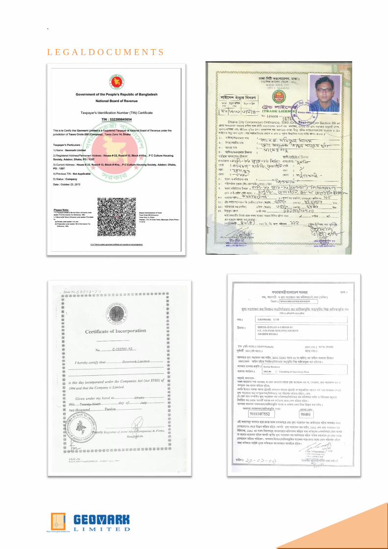
L E G A L D O C U M E N T S
.
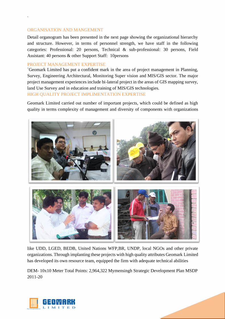
ORGANISATION AND MANGEMENT
Detail organogram has been presented in the next page showing the organizational hierarchy
and structure. However, in terms of personnel strength, we have staff in the following
categories: Professional: 20 persons, Technical & sub-professional: 30 persons, Field
Assistant: 40 persons & other Support Staff: 10persons
PROJECT MANAGEMENT EXPERTISE
`Geomark Limited has put a confident mark in the area of project management in Planning,
Survey, Engineering Architectural, Monitoring Super vision and MIS/GIS sector. The major
project management experiences include bi-lateral project in the areas of GIS mapping survey,
land Use Survey and in education and training of MIS/GIS technologies.
HIGH QUALITY PROJECT IMPLIMENTATION EXPERTISE
Geomark Limited carried out number of important projects, which could be defined as high
quality in terms complexity of management and diversity of components with organizations
like UDD, LGED, BEDB, United Nations WFP,BR, UNDP, local NGOs and other private
organizations. Through implanting these projects with high quality attributes Geomark Limited
has developed its own resource team, equipped the firm with adequate technical abilities
DEM- 10x10 Meter Total Points: 2,964,322 Mymensingh Strategic Development Plan MSDP
2011-20

.
PROFESSIONAL ACHIEVEMENT
GEOMARK LIMITED has put his best mark on Survey,
GIS, Mapping and Planning sector for those Award
Achieved national and international Organization as
follows
Under Urban Development and Directorate Geomark has
completed Mymensingh Strategic Development Plan
MSDP 2011-2031.has awardedUNHabitat, Fukuoka, Japan Asian
Townscape Award 2014, Japan Group photo
Asian Townscape Award 2014, Japan Group photo
1.PHOTO: ATA 2014 CERTIFICATE
PHOTO: ADB Best Team Award 2014
CERTIFICATE
Asian Townscape Award 2014, Japan
.
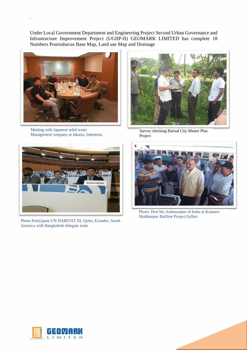
Under Local Government Department and Engineering Project Second Urban Governance and
Infrastructure Improvement Project (UGIIP-II) GEOMARK LIMITED has complete 18
Numbers Pouroshavas Base Map, Land use Map and Drainage
Photo Participant UN HABITAT III, Quito, Ecuador, South
America with Bangladesh delegate team
Photo: Hon’ble Ambassador of India at Kulaura-
Shahbazpur Railline Project,Sylhet.
Meeting with Japanese solid waste
Management company at Jakarta, Indonesia. Survey checking Barisal City Master Plan
Project

.
Photo: Presenting DND Lake Landscaping Design, Master
Plan Report to Mayor, Narayanganj City Corporation.
PHOTO: presentation on Noakhali Pouroshava Drainage
Master Plan, Chief Engineer Wahidur Rahman, MP
Noakhali,Pauroshava Mayor , Project Director Md Shafiqul
Islam Akhand and MD of GEOMARK LIMITED.
Meeting with Team Leader and Brg,Gen Habubur
Rahman at Payra Bridge, Lebukhali.,Patuakhali.
Waste management Development meeting with
Hon’bl Mayor of Gazipur City Corporation
Bangladesh Delegate urban forum 10. Abudhabi, U.A.E
.
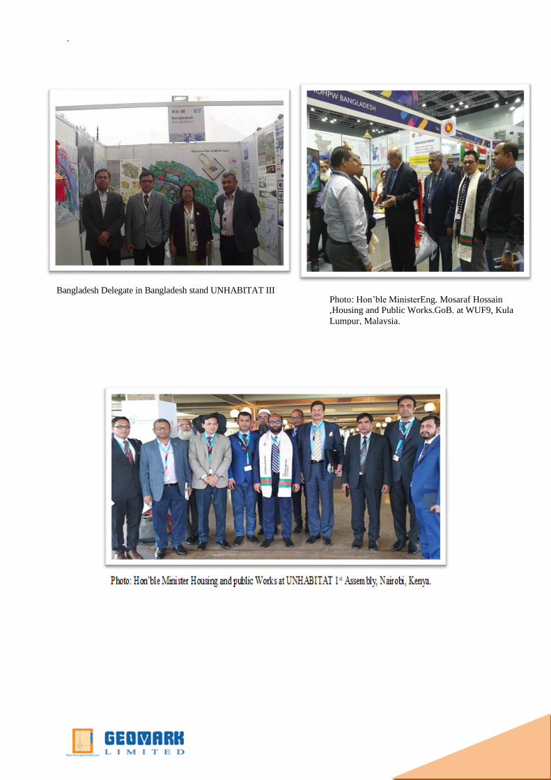
Photo: Hon’ble MinisterEng. Mosaraf Hossain
,Housing and Public Works.GoB. at WUF9, Kula
Lumpur, Malaysia.
Bangladesh Delegate in Bangladesh stand UNHABITAT III
.
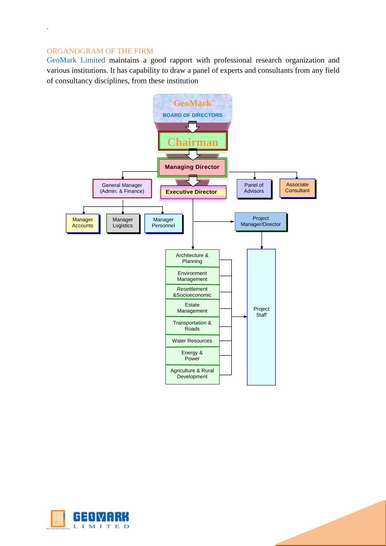
ORGANOGRAM OF THE FIRM
GeoMark Limited maintains a good rapport with professional research organization and
various institutions. It has capability to draw a panel of experts and consultants from any field
of consultancy disciplines, from these institution
GeoMark
BOARD OF DIRECTORS
Chairman
Manager Accounts
Manager Logistics
Manager Personnel
Managing Director
Executive Director
General Manager (Admin. & Finance)
Panel of Advisors
Associate Consultant
s
Project Manager/Director
Project Staff
Architecture & Planning
Environment Management
Resettlement &Socioeconomic
Estate Management
Transportation &
Roads
Water Resources
Energy & Power
Agriculture & Rural
Development

.
PROFESSIONAL RESOURCES
Geomark Limited has the dedicated & utmost professional in planning, design & construction.
The professional team members of Planning, Designing & construction are capable to provide
both conventional and innovative solutions that improve the health of public and the
environment while meeting or exceeding the regulatory standards.
PROFESSIONAL RESOURCES
Sl
No. Name Designation Qualification
Year of
Experience
1. Dr. ANM Safiqul Alam Managing
Director/GIS
Specialist
PhD in Geography 15Years
2. Rasheda Akter Director/Economist MSS in Economics 7 Years
3. Arc. Planner Aminul
Haque
Director /Design
Planning Specialist B .Arch,MIP 35 Years
4. Shahab Uddin Director /GIS
Specialist
MSc in Geography
and Environmental
Science
12 Years
5. Masudur Rahman Director(Corporate
sale)
Dip in Business
Development 20 years
6. Amal Roy Director/Senior
Structural engineer
B.Sc. in Civil
Engineering 20 Years
7. Abdullah Al Masum Senior Planner MURP 12 Years
8. Nasrin Khanom Economist M.S.S 10 Years
9. Mamunur Rushid Sociologist M.S.S 12 Years
10. Moushiur Rahman Architect Planner
B Sc in Architect,
MURP 10 Years
11. Touhiduzzaman Environmental
Expert
M Sc Environmental
Science 5 Years
12. Dilara Mehrab Arif Urban Planner BURP 7 Years
13. Elias Ahmed Urban Planner BURP 8 Years
14. Howlader Nazmul Huda Urban Planner BURP 6 Years
15. Sakhawat Hossen Saikat Urban Planner BURP 3 Years
16. Abdul Jalil Drafts man Diploma in CE 20 Years
17. Wazi Ullah Apu Multimedia and
Graphic Designer
Bachalor on
Multimedia and
Graphic Design
10 Years
18. Ali Karim IT Officer B.Sc. in CSE 5 Years
19. Md. Asaduzzaman Database
Administrator Diploma in CSE 2 Years
20. Md. Pervez Hossain
21. Md. Tarek Hasan CAD Operator
Diploma in
Architecture 5 Years
22. Md. Sagor Hossain Database Assistant Diploma in CSE 2 Years
23. Abdullah-al-Rafi
24. Aminul Islam
Surveyor Diploma in
Surveying 3 Years
25. Abul Hossain
26. Faruk Hossain
27. Abu Taher

.
28. Ibrahim Khan Office Manger B.Com 5 Years
29. Rubel Hossain
30. Md. Shakawat Hossain Accounts Manger B.Com Honours 4 Years
31. Md.Alamgir Kabir Law Expert B Com, LLB 20 years
ADVISORY COUNCIL
CONSULTANT
Sl
No. Name Designation Organization
1 Professor Nazrul Islam Chairman Center For Urban Studies(CUS)
2 Professor Dr. Nurul Islam
Nazem Secretary Center for Urban Studies(CUS)
3 Professor Dr. Sheikh
Tawhidul Islam Professor
Dept. of Geography and
Environmental ScienceJahangirnagar
University
4 Md. Moazzem Hossain
Sabuz
Asst.
Professor
Dept. Of Statistics
Jahangirnagar University
5 Dr. Mostofa Zaman Professor DEAN, Disaster and Management
,PSTU
6 Col. Shahriar Amin (Rtd,) Signal &
Bandwidth
Expert
Managing Director
Neelachol Housing Ltd.
7 Brigadier General Habibur
Rahman
National
Security
Expert
Ex Director ,Security ,NSI
8 Major Asadullah (Rtd.) Land
Management
Expert
Ex Project Manager
Jolshiri Abashon Ltd for Retired
Army of Bangladesh.
9 Md. Nurullah Municipality
Specialist Ex. Additional Chief Engineer, LGED
SL
No. Name Expertise Qualification
Year of
Experience
1 AB Siddiquie Ex. Project Director
UTIDP,LGED, Urban
Design & Planning
M.Sc. (Urban
Planning) 25years
2 Md. Nazrul Islam
Mollah
Drainage and Municipal
Services Expert
B.Sc. Engineering
in Civil 25 years
3 Dr. Bohonni Shikaha
Das Purukyasthaya Sociologist PhD. In Sociology 20 years
4 Dr. Azom Khan
Economist
PhD Economics
Professor
Jagnnath
University
20 Years
5 Arch. Planner Aminul
Haque Urban Design Expert B.Arch. MURP 30 years
6 Dr. Saiful Islam
Choudhury
Water Resource
Management B.Sc. Engineering 30 Years
.
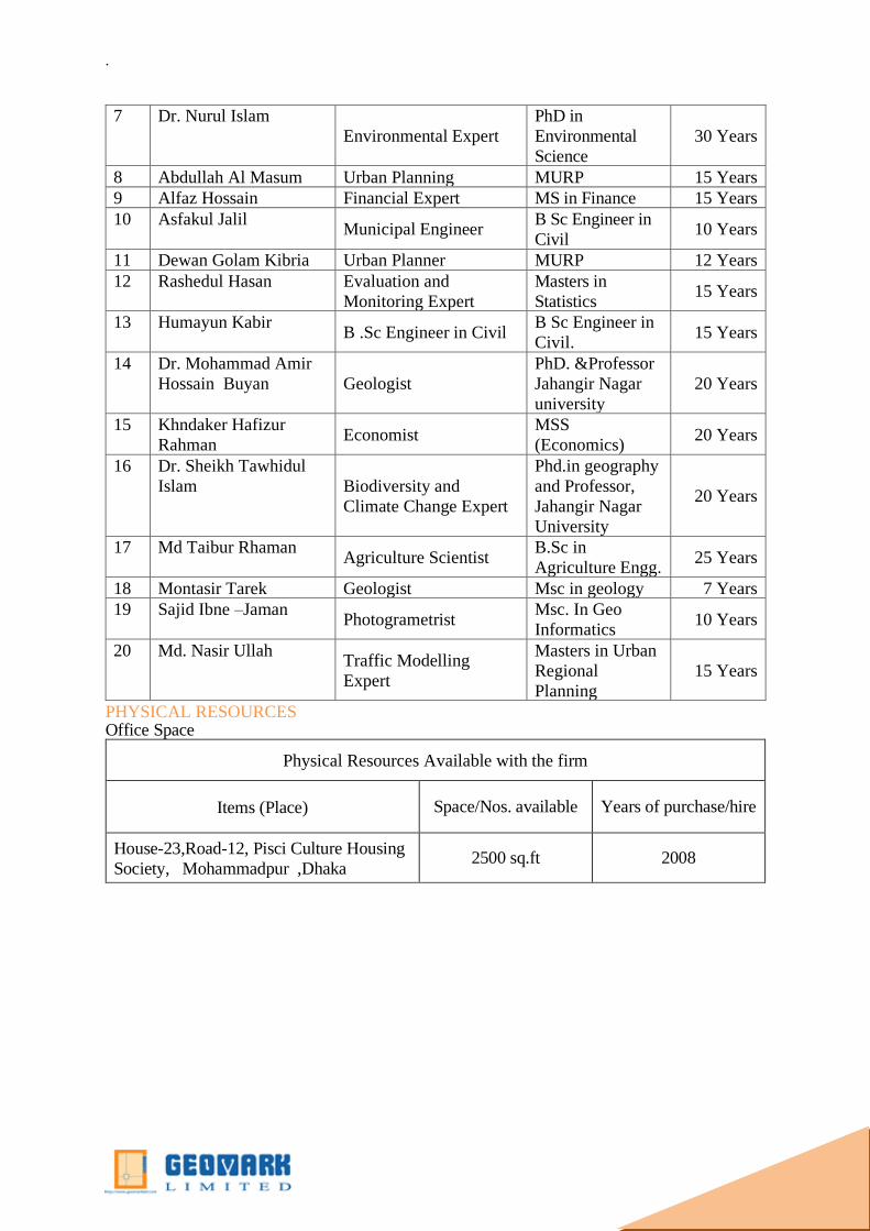
PHYSICAL RESOURCES Office Space
Physical Resources Available with the firm
Items (Place) Space/Nos. available Years of purchase/hire
House-23,Road-12, Pisci Culture Housing
Society, Mohammadpur ,Dhaka 2500 sq.ft 2008
7 Dr. Nurul Islam
Environmental Expert
PhD in
Environmental
Science
30 Years
8 Abdullah Al Masum Urban Planning MURP 15 Years
9 Alfaz Hossain Financial Expert MS in Finance 15 Years
10 Asfakul Jalil Municipal Engineer
B Sc Engineer in
Civil 10 Years
11 Dewan Golam Kibria Urban Planner MURP 12 Years
12 Rashedul Hasan Evaluation and
Monitoring Expert
Masters in
Statistics 15 Years
13 Humayun Kabir B .Sc Engineer in Civil
B Sc Engineer in
Civil. 15 Years
14 Dr. Mohammad Amir
Hossain Buyan Geologist
PhD. &Professor
Jahangir Nagar
university
20 Years
15 Khndaker Hafizur
Rahman Economist
MSS
(Economics) 20 Years
16 Dr. Sheikh Tawhidul
Islam Biodiversity and
Climate Change Expert
Phd.in geography
and Professor,
Jahangir Nagar
University
20 Years
17 Md Taibur Rhaman Agriculture Scientist
B.Sc in
Agriculture Engg. 25 Years
18 Montasir Tarek Geologist Msc in geology 7 Years
19 Sajid Ibne –Jaman Photogrametrist
Msc. In Geo
Informatics 10 Years
20 Md. Nasir Ullah Traffic Modelling
Expert
Masters in Urban
Regional
Planning
15 Years

.
Office Equipment
Physical Resources available with the firm
Items Space/Nos. available Years of
purchase/hire
Canon Plain Paper Copier 1 No. 2014
Spiral Binding Machine 1 No. 2014
Transport (for Head Office only)
Physical Resources available with the firm
Items Space/Nos. available Years of
purchase/hire
CAR, Reg No Dhaka metro GA-13-5032 4 seat 2004
CAR Reg.Dhaka metro GA-19-6777 4 seat 2010
Bike, Reg No Dhaka Metro -11-456 2 2009
Telephone, Fax & E-mail
Physical Resources available with the firm
Items Space/Nos. available Years of purchase/hire
Telephone Lines 1 2009
E-mail Address: [email protected]
m 2009
Panasonic FAX Machine 1 2009
Internet Connectivity: We have BTCL Optical Fiber internet connectivity, 1 MBPS with a real
IP address
Surveying/Mapping Equipment
Item Group and Name Key Tech. Spec. Qty
GPS:
1. CHC i80 (survey grade GPS) 120 Channels, RTK, mm-level accuracy 4
2. GARMIN handheld GPS 10-100-meter accuracy 6
Total Station:
Sokkia Set-2 with SDR-33 Data collection 3
Topcon RT 230 2
Kolida 445R 4
Plane Table Staffs 2
Eco Sounder Ascetic GPS 1
.
Hydro Current meter Water force measure 1
Leveling Instrument:
Sokkia Optical Auto Level 3
Topcon Optical Auto Level 2
South Optical Auto Level 2
Kollida Optical Auto Level 2
Unmanned Aerial vehicle (UAV)/Drone
Phantom -4 Version -2 IMU system 20 MBP camera 1
Night vision camera Sony RS234 1
Software Packages and Systems:
1. In Road Survey Total station survey data processing
software
2
2.Arc GIS 10.2.1 GIS mapping Licenced software 1
2. Auto CAD Land Develop 2i Total station & CAD data processing
software
2
3. Prism GPS data processing form Ashtech GPS 1
4. ERDAS Emagine ------------
Intergraph
Stereo plotting and Aerial Triangulation 1
5. ArcGDS ---------------- Geosoft 3D Image Processing 1
6 ScanEx Image Processor v.4.0 -------
---ScanEx
Orthophoto, Aerial Triangulation, DEM 1
7. Stereo Analyst for ArcGIS -----------
-- Intergraph/HEXAGON
Arc GIS Arc GIS Extension 1
8.Stereo Analyst for ArcGIS -----------
-- Intergraph/HEXAGON
Arc GIS Extension 1
09. SPSS 20 Statistical Package for Social Sciences
(SPSS)
2
10. Transcad Transportation Planning Software 1
10. Photomode Image processing Software 1
11. Hydrology Software Surface-Water Modeling System (SMS),
Groundwater Modeling System (GMS),
Watershed Modeling System (WMS)
1
.
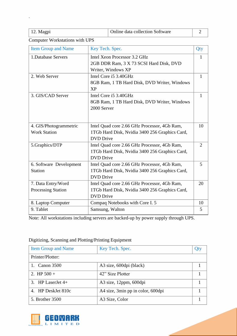
12. Magpi Online data collection Software 2
Computer Workstations with UPS
Item Group and Name Key Tech. Spec. Qty
1.Database Servers
Intel Xeon Processor 3.2 GHz
2GB DDR Ram, 3 X 73 SCSI Hard Disk, DVD
Writer, Windows XP
1
2. Web Server Intel Core i5 3.40GHz
8GB Ram, 1 TB Hard Disk, DVD Writer, Windows
XP
1
3. GIS/CAD Server Intel Core i5 3.40GHz
8GB Ram, 1 TB Hard Disk, DVD Writer, Windows
2000 Server
1
4. GIS/Photogrammetric
Work Station
Intel Quad core 2.66 GHz Processor, 4Gb Ram,
1TGb Hard Disk, Nvidia 3400 256 Graphics Card,
DVD Drive
10
5.Graphics/DTP
Intel Quad core 2.66 GHz Processor, 4Gb Ram,
1TGb Hard Disk, Nvidia 3400 256 Graphics Card,
DVD Drive
2
6. Software Development
Station
Intel Quad core 2.66 GHz Processor, 4Gb Ram,
1TGb Hard Disk, Nvidia 3400 256 Graphics Card,
DVD Drive
5
7. Data Entry/Word
Processing Station
Intel Quad core 2.66 GHz Processor, 4Gb Ram,
1TGb Hard Disk, Nvidia 3400 256 Graphics Card,
DVD Drive
20
8. Laptop Computer Compaq Notebooks with Core I. 5 10
9. Tablet Samsung, Walton 5
Note: All workstations including servers are backed-up by power supply through UPS.
Digitizing, Scanning and Plotting/Printing Equipment
Item Group and Name Key Tech. Spec. Qty
Printer/Plotter:
1. Canon 3500 A3 size, 600dpi (black) 1
2. HP 500 + 42” Size Plotter 1
3. HP LaserJet 4+ A3 size, 12ppm, 600dpi 1
4. HP DeskJet 810c A4 size, 3min pp in color, 600dpi 1
5. Brother 3500 A3 Size, Color 1

.
Scanner:
1. HP Scan Jet 4p 8.5”x14”, color scanner, 1200dpi 2
2.Cannon 345 24” Scanner Flat 1
3. Brother A3 Size 1
Survey Tools & Utilities:
1. Light Table 36”x 26”, local standard 2
2. Drafting Set Steadtler Professional Set 2
3. Map Cabinet 38” x 28”, 5 drawers 2

.
BACKGROUND OF THE FIRM
GEOMARK LIMITED is a brand name with specific focus to the Planning and IT Enabled
Services (ITES) specializing in the geospatial applications including Advance topographical
survey, consultancy on Engineering & Architectural Design, Drawing, Supervision, Planning,
Software, Data Entry , Webpage Development GIS, CAD, LIS, MIS, AM/FM, processing of
remote sensing data, digital mapping/surveying using GPS, geo-spatial and textual data
conversion, application software and web page/solutions development and so forth. Apart from
ITES, provides professional consulting services particularly for undertaking research and
development studies/projects covering and not limited to land, natural resources, environment,
urban/real estate development, infrastructure development, institution and organization studies,
land related legislation study, human resources development studies, general education related
studies, and so forth. .
Geomark Limited. Was founded in 1999 by a group of IT professionals and engineers having
long experiences in successful implementation of a large number of development studies and
consulting projects including GIS and ITES related assignments of various reputed clients has
successfully implemented software applications in many areas namely, Corporate, Business
and Production MIS; Geographic Information System; Land Information System, CAD
systems; Stock Portfolio and Fund Management System; Materials & Inventory; Record
Management; Data Entry Systems, Environmental Information Management; Web
applications development and so on. In 2007, Geomark Ltd got ownership Trade License from
Dhaka City Corporation and in 2012 AD Geomark Ltd achieved Joint Stock Company
Registration.
Geomark Limited. Is now backed by an expert panel of consultants and advisors, who are
drawn from professionals and Experts of the highest caliber from the respective
MISSION
Mission of the GEOMARK LIMITED is to improve the quality of mass people’s life by active
contribution in the thrust business sectors of Bangladesh through responsible application of
knowledge, skill and technology. Is committed to create a large pool of satisfied customers by
providing the highest level of service value, trust and goodwill. GEOMARK believes its
customers to get benefited, i.e. company is committed to be developed as a Customer Focused
Organization. So, surveying the interest of valued customers is our utmost priority. We have

developed an extremely qualified support staffs to meet the expectations and ensure the
customers’ satisfaction. We work as a team in every sense of the word.
However, our professional agents and brokers work with our high-ranking support staffs
always stay on top of the market and provide prompt, quality services to our clients. We are
however, continuously creating and developing business environment both at home and abroad.
We share our foreign partners’ technical experiences along with our business expertise to
develop a pool of satisfied customers after all.
VISSION
GEOMARK LIMITED will adopt strategies that ensure excellence in products, process and
services to make customer’s investment worthy. Use resources, adaptation of appropriate
technology effectively and efficiently to attain a high level of productivity in all its operations.
Encourage and assist in the qualitative improvement of services for its internal and external
customers.
Encourage an environment where personal growth and learning of the employee is assured.
SERVICES
GEOMARK is specializes in providing exceptional professional and efficient services in:
1. Advanced Topographic Surveying
2. GIS Mapping &Photogrammetric conversion
3. Urban Planning & Designing
4. Structural & Architectural Design
5. Software Development, Webpage Development and Data entry
6. Socioeconomic and other survey
7. Graphics and Multimedia 3D visualization.

URBAN PLANNING & DESIGNING
MISSION
Our Town Planning supports proposals and
strategies that further the principles of
planning, improve our quality of life and
promote the sustainable management of city
lives, natural resources and public
infrastructure. The aim is to consolidate urban
fabric and form to better utilize the land and
municipal servicing, effective public
transportation networks and mixed land-use
policies and successes.
SERVICES
Town Planning team specializes in providing exceptional professional and efficient services:
i. City Master Plan;
ii. Utility Network Plan
iii. Urban Design;
iv. Feasibility Study
v. Environmental Impact Assessment (EIA)
vi. Project Management; and
vii. Project Strategy Services to the development industry and individual project
developers/managers.
viii. Statutory Planning
ix. Project Feasibility
x. Strategic Planning: Structure Planning, Rezoning, Consolidations and
Subdivisions, Township Establishments
xi. Site Planning and Layout Design
xii. GPS Surveys & Data Capturing
xiii. Environmental Planning
xiv. Rural Settlement and Rural Development Planning

C O M P L E T E D W O R K
SL
No.
Name of the Project Name of the Client
1 Physical Feature Survey Work with RTK GPS,
Total Station & using 3D Image and Other Survey
for Area of Preparation of Development Plan for
Benapol-Jessore Highway Corridor Project.
DECODE -GEOMARK joint venture
Urban Development Directorate
(UDD)
2 Supplying of Mouza Map (C.S/R.S) at the project
director office of preparation of Development Plan
for Benapol-Jessore Highway Corridor”
Urban Development Directorate
(UDD)
3 Physical Feature Survey Work with RTK GPS,
Total Station & using 3D Image with Relevant
Supporting Other Survey for Area (Rural & Urban)
MSDP Project.
DECODE_BESTWAY-GEOMARK joint venture
Urban Development Directorate
(UDD)
4 Procurement And Supplying Of Mouza Map Of
Drls, Gob(Goods)For Mymensingh Sadar Upazila
&Bhurungamary Union Under Gauripur Upazila Of
Mymensingh District under Mymensingh Strategic
Development Plan (MSDP)
Urban Development Directorate
(UDD)
5 Supplying Of Digitized Mouza Map Of
Mymensingh Strategic Development Plan (MSDP)
project Area (hard Copy & Soft Copy) with
necessary Georefferencing By RTK GPS based
ground control point work programme .
Urban Development Directorate
(UDD)
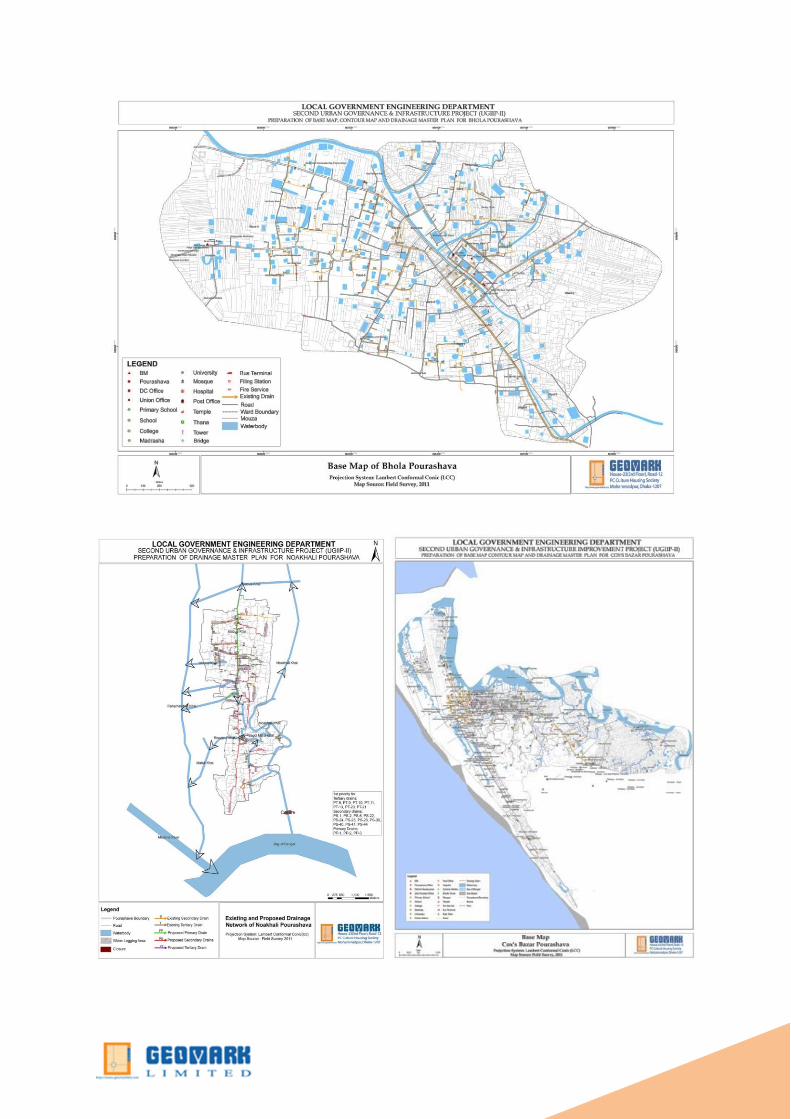
6 Preparation of Base Map, Contour Map and
Drainage Master Plan of 18 Pourashavas for
Borguna, Bhanga, Bhola, Bramonbaria, Chandpur.
Comilla Coxs
Bazar,Faridpur,Ghorasal,Jamalpur,Kalapara,Mirza
pur,Munshigonj,Porsuram,Rangamati,Rangpur,
Sonargoan, Sreepur.Pouroshava.
Under ADB, KfW& GIZ assisted
Second Urban Governance and
Infrastructure Improvement Project
(UGIIP-II)
Local Government Engineering
Department (LGED)

STRUCTURAL & ARCHITECTURAL DEPARTMENT
MISSION
Our Structural & Architecture is committed to
providing clients with innovative design
solutions for particular projects that result from
a highly investigative design process, a studied
analysis of traditional and unconventional
construction methods, and an ongoing
commitment to researching sustainable
technologies and resource efficient
construction methods. We provide consulting
service to owners of new projects and of
existing buildings, to construction management
firms, to engineering firms and to other
architects requiring specialist consulting.
SERVICES
We have experience, talents and capability to provide services in the following areas:
i. Pre-design services
ii. Site analysis
iii. Schematic design services
iv. Architecture
v. Interior design
vi. Urban design
vii. Restorations
viii. Renovations
ix. Programming
x. Existing facility
evaluation special
furnishing design
graphics
C O MP L E T E D W O R K
SL JOB NAME CLIENTS
1. Preparation of Layout Plan, Landscaping,
Beautification, Architectural Design with 3D model
of Duplex house at Boshila
Neelachol Housing Ltd.
2. Landscaping, Beautification, Architectural Design
and 3D Animation of DND Lake in Narayanganj
City Corporation
Narayanganj City Corporation
3. Preparation of Layout Plan, Structure plan with
Necessary Landscaping of Neelachol Riverine
Housing area beside Dhaka-Mawa Highway.
Neelachol Housing Ltd.
ADVANCE TOPOGRAPHIC & GEOLOGICAL SURVEY DEPARTMENT
MISSION
Our surveying teams and management offer a full range of professional land surveying services
and commit to deliver high quality service. Our mission is to provide our clients with a high
level of service through technical knowledge, hands on field experience, responsiveness, and
dependable delivery. The experience offered by our staff, training and continual assessment
ensure that we fulfill our commitment to delivering a quality service. In addition, our in-house
auditing of QA procedures and policies ensures the utmost accuracy and efficiency.
Our experienced staff, backed up by Senior Surveyors in the office, offers what we believe to
be the strongest Contract Surveying Team in the industry.
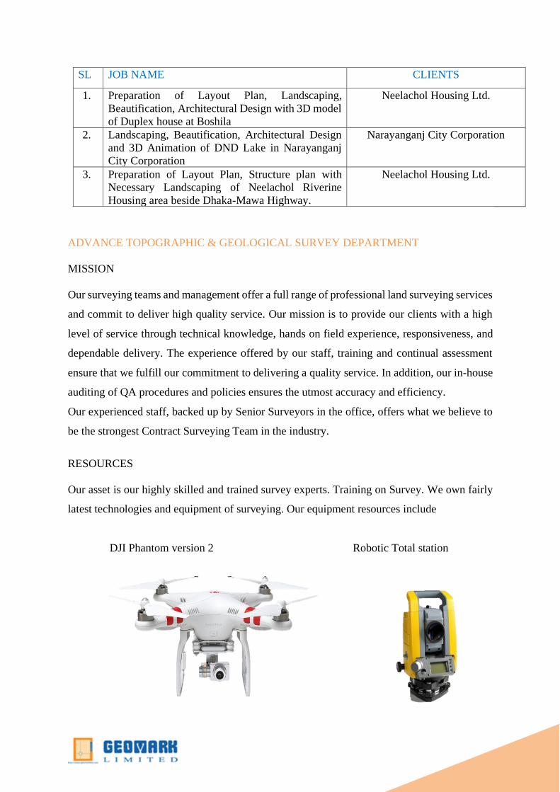
RESOURCES
Our asset is our highly skilled and trained survey experts. Training on Survey. We own fairly
latest technologies and equipment of surveying. Our equipment resources include
DJI Phantom version 2 Robotic Total station

Digital level machine
GNSS Equipment
Water Current meter
Rigel 3D Laser machine
FIG: Surveying Equipment
SERVICES
i. To conduct systematic geological mapping of our project Area.
ii. To investigate in detail such areas as are indicated by geological mapping to be
favorable for accumulation of industrial rocks, mineral fuel, ground water, and
other natural resources.
iii. To investigate in detail and conduct extensive geophysical, test drilling and
geochemical operation in order to evaluate the known mineral deposits.

iv. To conduct stratigraphic studies to identify, correlate and determine the
sequence of rock units in support of mapping and exploration programmers,
including age determination by fossils and other geo-chronological methods.
v. To conduct geological investigation in connection with construction of dams,
canals, tunnels, highways, bridges, new townships and other public construction
projects so as to advise the sponsoring agencies about geological feasibility of
such construction projects.
vi. To carry on geological and geophysical investigation, and geo-morphological
studies in marine and coastal areas.
vii. To undertake systematic sampling of mineral fuels and ground water resources
to carry out mineralogical and chemical analysis of the samples.
viii. To conduct research in various fields of geology for sustainable development.
ix. To assist various academic institutions in the field of education and research in
geo-science.
x. To advise the public and private organizations in all matters connected with
geology end resources of the earth.
xi. To advise the government in policy making related to mineral and water
resources, and environment.
xii. To delineate areas of arsenic contaminated ground water and to find out its
source and origin.
C O MP L E T E D W O R K
SL JOB NAME CLIENTS
1 Topographical & Hydrographical Survey of
Majhgram to Dhalarchar via Pabna New Railway
Line project.
Bangladesh Railway/SMEC, ACE
2 Topographical Survey of long section and cross
section and Horizontal Alignment of Railway
embankment in Kalukhali to BhatiapraRailway line
Bangladesh Railway /Kalpataru
Power Transmission Limited
(KPTL), India
3 Topographical Survey of Roads Under Second
Rural Infrastructure Improvement Project (RIIP-II)
Hifab International AB.
Local Government Engineering
Department (LGED)
5 GPS Survey of School Mapping and Digitization of
Secondary School of Dhaka for Nottingham
University research Project
Nottingham University
6 Feasibility Study for Water Management project of
Gungai Juri Haor Area. Habiganj.
Association with BETS and EPC
Joint venture.
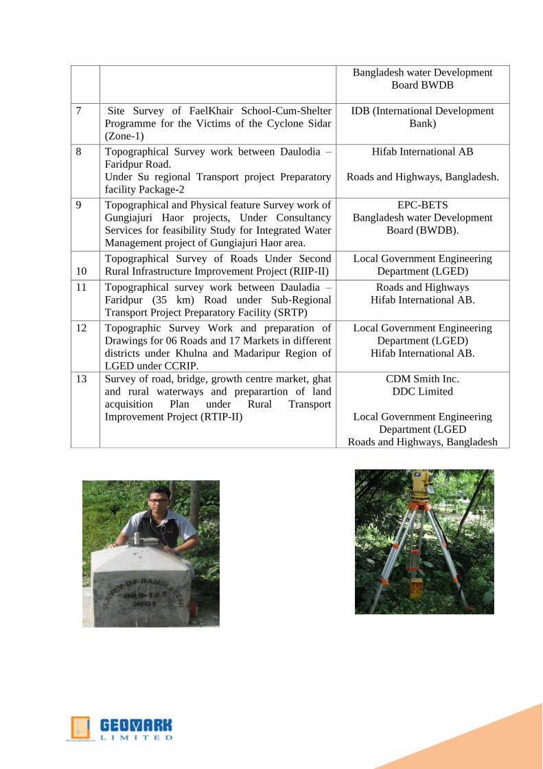
Bangladesh water Development
Board BWDB
7 Site Survey of FaelKhair School-Cum-Shelter
Programme for the Victims of the Cyclone Sidar
(Zone-1)
IDB (International Development
Bank)
8 Topographical Survey work between Daulodia –
Faridpur Road.
Under Su regional Transport project Preparatory
facility Package-2
Hifab International AB
Roads and Highways, Bangladesh.
9 Topographical and Physical feature Survey work of
Gungiajuri Haor projects, Under Consultancy
Services for feasibility Study for Integrated Water
Management project of Gungiajuri Haor area.
EPC-BETS
Bangladesh water Development
Board (BWDB).
10
Topographical Survey of Roads Under Second
Rural Infrastructure Improvement Project (RIIP-II)
Local Government Engineering
Department (LGED)
11 Topographical survey work between Dauladia –
Faridpur (35 km) Road under Sub-Regional
Transport Project Preparatory Facility (SRTP)
Roads and Highways
Hifab International AB.
12 Topographic Survey Work and preparation of
Drawings for 06 Roads and 17 Markets in different
districts under Khulna and Madaripur Region of
LGED under CCRIP.
Local Government Engineering
Department (LGED)
Hifab International AB.
13 Survey of road, bridge, growth centre market, ghat
and rural waterways and preparartion of land
acquisition Plan under Rural Transport
Improvement Project (RTIP-II)
CDM Smith Inc.
DDC Limited
Local Government Engineering
Department (LGED
Roads and Highways, Bangladesh

GIS, PHOTOGRAMETRIC& REMOTE SENSING, CADSTARL MAPPING
MISSION
GIS Mapping and Software Development unit is working with close collaboration with Town
Planning Team. Geographic Information System (GIS) are main fields
where we have built our expertise at international standard. It is note
that the pioneering professionals of GIS in Bangladesh are the core
resource personnel of our organization and its resource personnel has
participated in most of the large GIS projects in Bangladesh.
SERVICES
Our department is capable to provide the followings services to the
others SBUs of the Group & also to the other Govt. & Private
Organization.
i. repare Base map.
ii. Prepare relational Geo Database.
iii. Web Based Mapping service.
iv. Land information Management system (LIMS)
v. Space quality analysis.
vi. Analysis of Suitable location.
vii. Catchment/Service area Delineation.

viii. Shortest Route analysis.
ix. Address Geo Database.
x. 3D mapping
COMPLETED PROJECTS
SL JOB NAME CLIENTS
1 Preparation of Physical feature Survey Contour
Survey ,Socio Economic Survey and other survey
for Master Plan of
Shailkupa Pouroshava
Jibon Nagar Pouroshava
Kotcahndpur Pouroshava
Dorshona Pouroshava
Harinakundu Pouroshava
Jikorgacha Pouroshava
Bhanga Pouroshava
Kaliakoi Pouroshava
Mirzapur Pouroshava
Sub consultant with DDC Ltd.
Under Upazilla Town Infrastructure
Development Project (UTIDP)
Local Government Engineering
Department (LGED)
2 Preparation of Physical feature Survey Contour
Survey ,Socio Economic Survey and other survey
for Master Plan of
Shantahar Poroushava
Dupchanchia pouroshava
Kahalu Pouroshava
Nandigram Pouroshava
Sherpu Pouroshava
Sub consultant with AQUA
Consultant
Ltd.
Under Upazilla Town Infrastructure
Development Project (UTIDP)
Local Government Engineering
Department (LGED)
3 Community Map Development of Talab Camp
under MillatBihariCamp ,Mirpur,Dhaka.
Habitat for Humanity International –
Bangladesh.
4 Development of GIS Digital Map of service
providing of Area, Printing, IT Training, Software
Installation.
Shakti Foundation For
Disadvantaged Women of
Bangladesh.
5 Digital Survey Mapping and geo-referencing
(including report) of Sonapur Bazar, MaizdeePoura
Bazar and PouraBhaban of NoakhaliPourashava
Noakhali Pourashava
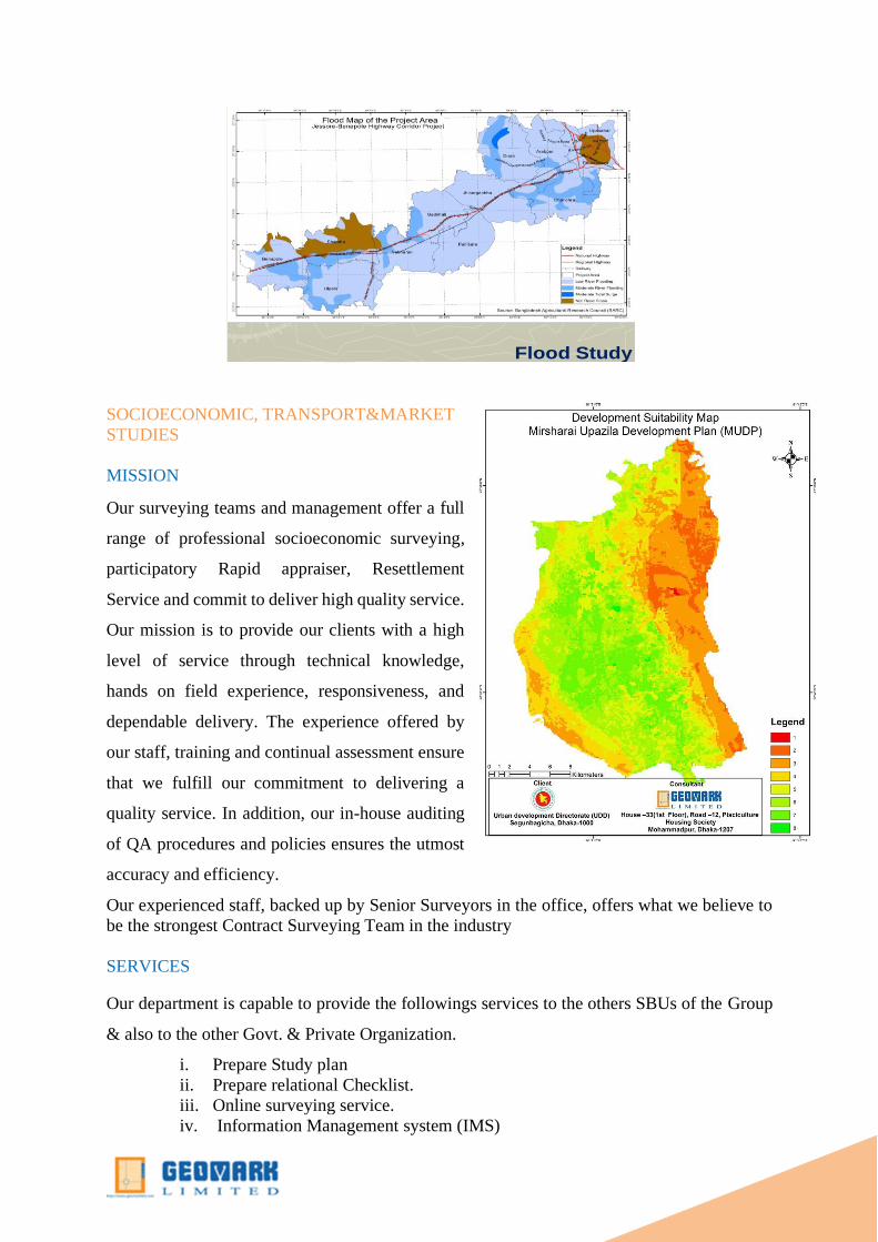
Flood Study
SOCIOECONOMIC, TRANSPORT&MARKET
STUDIES
MISSION
Our surveying teams and management offer a full
range of professional socioeconomic surveying,
participatory Rapid appraiser, Resettlement
Service and commit to deliver high quality service.
Our mission is to provide our clients with a high
level of service through technical knowledge,
hands on field experience, responsiveness, and
dependable delivery. The experience offered by
our staff, training and continual assessment ensure
that we fulfill our commitment to delivering a
quality service. In addition, our in-house auditing
of QA procedures and policies ensures the utmost
accuracy and efficiency.
Our experienced staff, backed up by Senior Surveyors in the office, offers what we believe to
be the strongest Contract Surveying Team in the industry
SERVICES
Our department is capable to provide the followings services to the others SBUs of the Group
& also to the other Govt. & Private Organization.
i. Prepare Study plan
ii. Prepare relational Checklist.
iii. Online surveying service.
iv. Information Management system (IMS)

v. Space quality analysis.
vi. Analysis of database.
vii. Catchment/Service area Delineation.
viii. Shortest method analysis.
ix. Address Database.
x. Quantities and Qualitative Survey
xi. Tabulation
xii. Report
SL Name of the Projects Clients
1 Data Collection, Data Entry in a customized software,
analysis and report for the Marketing Campaign.
TM International
2 Data Collection, Entry & Data Base Management for oil
distribution programme of adolescence girl in Barisal
division.
Innovation for Poverty Action
(IPA),USA
3 Field Monitoring and Data Collection & Entry in
Barisal division.
Save the Children USA and
Innovation for Poverty Action (IPA),
USA
4 Field Monitoring and Evaluation of Project works of
Kishoreekontha Program. in Barisal division.
Innovation for Poverty Action
(IPA),USA
5 Data Collection Entry and training management for the
Development and Maintenance of Web based social
Protection MIS project for whole Bangladesh.
United Nations World Food Program
(WFP)
6 Socio-Economic Survey Data Collection and Analysis Plan Bangladesh

Traffic Volume Counting Survey
Traffic Study