BABOOSIC LAKE WATERSHED PLAN PDATE...BABOOSIC LAKE WATERSHED PLAN UPDATE Nashua Regional Planning...
59
BABOOSIC LAKE WATERSHED PLAN UPDATE Nashua Regional Planning Commission 9 Executive Park Drive Merrimack, NH 03054 September 2014 Funding for this project was provided in part by a Watershed Assistance Grant From the NH Department of Environmental Services with Clean Water Act Section 604(b) funds from the U.S. Environmental Protection Agency.
Transcript of BABOOSIC LAKE WATERSHED PLAN PDATE...BABOOSIC LAKE WATERSHED PLAN UPDATE Nashua Regional Planning...

BABOOSIC LAKE WATERSHED PLAN UPDATE
Nashua Regional Planning Commission
9 Executive Park Drive
Merrimack, NH 03054
September 2014
Funding for this project was provided in part by a Watershed Assistance Grant
From the NH Department of Environmental Services with Clean Water Act
Section 604(b) funds from the U.S. Environmental Protection Agency.


Baboosic Lake Watershed Plan Update September 2014
i | P a g e
TABLE OF CONTENTS Executive Summary ............................................................................................................................................... 1
Introduction ........................................................................................................................................................... 2
Summary of Existing Water Quality Conditions ..................................................................................................... 2
Estimated Phosphorus Reductions ............................................................................................................................ 3
Phosphorus Load Reduction Achieved Between 2008 and 2013 .............................................................................. 5
Classification Definitions ....................................................................................................................................... 5
Site Sampling and Data ......................................................................................................................................... 5
Historical Data ....................................................................................................................................................... 6
Watershed Report Cards ....................................................................................................................................... 9
Summary of Water Quality ................................................................................................................................. 10
Additional Reductions through Remaining BMPs ................................................................................................... 10
Options for Further Reducing Phosphorus Loads ................................................................................................. 11
Homeowner and Volunteer BMPs .......................................................................................................................... 11
Soak Up the Rain Program .................................................................................................................................. 11
Municipal Operations and Maintenance Best Management Practices ................................................................... 12
Example Maintenance Schedule for BMPs ......................................................................................................... 14
Merrimack Existing Operations and Maintenance ............................................................................................. 15
Amherst Existing Operations and Maintenance ................................................................................................. 17
Regulations and Enforcement Procedures .............................................................................................................. 18
Existing Local Land Use Regulations: Merrimack ................................................................................................ 18
Existing Local Land Use Regulations: Amherst .................................................................................................... 19
Recommendations for Local Land Use Regulations ............................................................................................ 20
Opportunities for Future BMPs ............................................................................................................................... 21
Public Information and Education ........................................................................................................................ 22
Outreach Planning ................................................................................................................................................... 22
Existing Outreach Materials ................................................................................................................................ 22
Recommendations for Towns on Most Effective Outreach Programs and Messages ........................................ 24
Implementation, Monitoring and Assessment ..................................................................................................... 26
Installation of the Remaining BMPs ........................................................................................................................ 26
BMP Monitoring and Maintenance ......................................................................................................................... 27
Monitoring Schedule by BMP Type ..................................................................................................................... 29
Assessment.............................................................................................................................................................. 30

Baboosic Lake Watershed Plan Update September 2014
ii | P a g e
Impaired Waters Removal Process ..................................................................................................................... 32
Conclusion ........................................................................................................................................................... 33
References ........................................................................................................................................................... 34
Appendix A: Phosphorus Control Planning and Modelling ................................................................................... 36
Phosphorus Control Plan Outline ............................................................................................................................ 36
BMP Phosphorus Modeling Methodology .............................................................................................................. 38
Appendix B: Baboosic Lake Compiled BMPs ........................................................................................................ 41
Appendix C: Soak Up the Rain How to Guide and Assessment Sheet ................................................................... 45
What is SOAK? ......................................................................................................................................................... 45
How to Guide .......................................................................................................................................................... 45
SOAK Sites ............................................................................................................................................................... 48
Soak Up the Rain Property Assessment Field Sheet ................................................................................................ 52
Graphs, Maps and Tables
Table 1. Estimated Phosphorus Levels in Pounds ................................................................................................... 3
Table 2. BMP Site Locations and Estimated Phosphorus Reduction ...................................................................... 4
Table 3. Testing Sites and Seasonal Average Total Phosphorus ............................................................................. 6
Graph 1. Trend Analysis of Annual Average chlorophyll-a...................................................................................... 7
Graph 2. Trend Analysis of Annual Average Total Phosphorus ............................................................................... 8
Table 4. Median of Greater Than or Equal to 5 Samples for chlorophyll-a and Total Phosphorus .......................... 8
Table 5. Watershed Report Card Results ............................................................................................................... 9
Table 6. Remaining BMP Locations and Estimated Phosphorus Removal ............................................................ 10
Map 1. Baboosic Lake Drainage Areas ................................................................................................................. 13
Table 7. Responsible Party for Installation of Remaining BMPs .......................................................................... 26
Table 8. Responsible Party for Existing BMP and Monitoring Schedule ............................................................... 28
Map 2. Baboosic Lake Testing Sites ..................................................................................................................... 31

Baboosic Lake Watershed Plan Update September 2014
Nashua Regional Planning Commission 1 | P a g e
EXECUTIVE SUMMARY Baboosic Lake is a 222 acre body of water situated between the Town of Amherst and Town of Merrimack, New
Hampshire. The lake has approximately 139 year-round and seasonal homes located around its perimeter. Over
the past five years, the Baboosic Lake Association has implemented a series of Best Management Practices (BMPs)
on thirteen sites around the lake based on recommendations from the 2008 Baboosic Lake Watershed Based Plan.
The remaining sites could be completed with additional funding and support.
The objectives of this report are to provide an update to the 2008 Plan with a summary of the activities, data and
reports that have been developed in the last five years. Included in this report are updated water quality
information on existing phosphorus and a trend analysis of previous levels, a monitoring schedule and
identification of respective roles for BMP maintenance, and recommendations for existing regulations and
operating procedures.
The water quality data indicates a decrease in phosphorus over the last five years; however, according to NH DES
and the NH Lakes Lay Monitoring Program the lake remains impaired. Previous phosphorus levels demonstrate a
growing phosphorus concern from anthropogenic sources. As the water quality in the lake has deteriorated, the
Baboosic Lake Association and others have sought guidance and taken action to stop the trend of declining water
quality. Since 2008, thirteen of the seventeen recommended BMP sites have been constructed and the installation
of the Baboosic Lake Community Septic System was completed. The estimated pounds of phosphorus reduction
are approximately 40 pounds per year based on the original projections from the 2008 plan and estimated by CEI
in 2011. The remaining phosphorus load reduction needed is 29 pounds per year. The trend analysis and other
water quality data are provided to demonstrate the current lake health and emphasize the importance of
maintaining the BMPs to continue phosphorus reduction. The next steps for stakeholders around the lake are
centered on installing the remaining BMPs, increasing public outreach and education efforts, and maintaining the
existing BMPs.

Baboosic Lake Watershed Plan Update September 2014
Nashua Regional Planning Commission 2 | P a g e
INTRODUCTION The Nashua Regional Planning Commission (NRPC) received funding from the New Hampshire Department of
Environmental Services (NH DES) through the Section 604(b) of the Clean Water Act to provide an update on the
Baboosic Lake Watershed Based Plan, originally written in 2008, and the Baboosic Lake Stormwater Improvement
Project, written in 2013. This update does not supersede the original 2008 Plan or the 2013 plan or any other
preceding reports or recommendations but rather provides a progress report of existing phosphorus conditions in
Baboosic Lake, a status report on implementation actions originally identified in the 2008 Plan, options for further
reducing phosphorus loading to the Lake, public information and education opportunities, an implementation
schedule, and monitoring and assessment recommendations.
Over the course of the project, NRPC worked closely with municipal staff in Amherst and Merrimack, NH DES staff,
and the Baboosic Lake Association (BLA). Additional information and resources on water quality monitoring efforts,
educational campaigns and stormwater reduction techniques are available through NH DES and BLA.
SUMMARY OF EXISTING WATER QUALITY CONDITIONS Baboosic Lake is listed as impaired on New Hampshire’s 2012 list of Impaired Waterbodies for primary contact
recreation (i.e. swimming) due to high chlorophyll-a concentrations and Cyanobacteria (hepatoxic blue-green
algae) blooms. The Cyanobacteria bloom impairments are based on data collected in accordance with the NH DES
approved quality control standards. The data is available in the NH DES Limnology Center database. In the 2012
assessments, the DES removed the 303d List impairment to swimming (as measured by E. coli bacteria). For 2012,
the lake is considered fully supporting the E. coli bacteria criteria. It should be noted that the lake is still considered
impaired for cyanobacteria and chlorophyll-a. The 2012 list of Impaired Waterbodies also documents an
impairment to aquatic life due to elevated chlorophyll-a concentrations as a response to elevated phosphorus
concentrations. Phosphorus is the nutrient responsible for algal growth in most freshwater lakes, ponds and rivers.
Section 303 (d) of the Clean Water Act requires that States determine the Total Maximum Daily Loads (TMDLs) for
impaired waterbodies. A TMDL sets the maximum amount of a pollutant that a waterbody can receive and still
support designated uses. In 2011, the US Environmental Protection Agency (EPA) and NH DES issued a TMDL for
Baboosic Lake for phosphorus and bacteria. The TMDL identified an in-lake target for phosphorus that should
result in meeting the water quality standards. The analysis suggests that by reducing in-lake phosphorus value to
12 μg/L (a reduction of 35%) the chlorophyll-a will be reduced to levels that will once again support the swimming
use, result in acceptably few cyanobacteria blooms, and a chlorophyll-a concentration that will let the lake again
meet its target trophic condition.
Table 1 demonstrates the original target phosphorus load from the 2008 Baboosic Lake Watershed Plan at 69.5
pounds. Since 2008, 13 of the 17 BMP sites have been constructed and the Baboosic Lake Community Septic
System was installed. The estimated pounds of phosphorus reduction are approximately 40 pounds per year based
on the original estimates from the 2008 plan and estimated by CEI in 2011. There remaining phosphorus load
reduction is 29 pounds per year. An updated estimate for a phosphorus load reduction by CEI was available in 2014
at 10 pounds for the Carter Road BMPs.

Baboosic Lake Watershed Plan Update September 2014
Nashua Regional Planning Commission 3 | P a g e
Table 1. Estimated Phosphorus Levels in Pounds
2008 plan: Target phosphorus reduction needed 69.5
TMDL: Total maximum annual load to result in in-lake annual mean of total phosphorus concentration of 12 µg/L
115.2
2008 Plan: Estimated Phosphorus reduction achieved between 2008-2013
40.2
Remaining phosphorus reduction to meet the water quality requirements in 2008 plan
29.3
(AECOM, 2011a; Geosyntec, 2008)
According to the NH Lake Lay Monitoring Program (LLMP), Baboosic Lake water quality testing indicates a slight
reduction of phosphorus loading and a reduction in chlorophyll-a. However, episodic cyanobacteria blooms
suggest Baboosic Lake remains susceptible to short-term algal blooms and periods of reduced water quality. As the
lakeshore and the surrounding uplands are converted from forest landscapes to a more suburban area, more
nutrients could enter the lake and promote plant growth.
ESTIMATED PHOSPHORUS REDUCTIONS
The 2008 Watershed Plan sought to improve water quality conditions in Baboosic Lake and reduce the occurrence
of nuisance algal blooms. The Plan recommended targeting an in-lake total phosphorus concentration reduction of
five µg/L. The reduction would improve the lake to low mesotrophic status and significantly increase in-lake water
quality conditions such as water clarity, algal abundance and chlorophyll-a concentrations.
In the 2011 Watershed Management Plan (WMP), additional phosphorus reduction loads were recommended by
CEI on the incomplete BMP sites. The recommendations were to yield the same estimated phosphorus levels as
the 2008 plan but with alternative BMPs. The Table 2 indicates the site recommendation from CEI as “post WMP
site.” Pollutant removal calculations will be updated in the near future to assess the effectiveness of the installed
BMPs and identify additional load reductions.

Baboosic Lake Watershed Plan Update September 2014
Nashua Regional Planning Commission 4 | P a g e
Table 2. BMP Site Locations and Estimated Phosphorus Reduction
All Site Locations from the 2008 Watershed Plan
and the 2012 Implementation Status Report
Site
Location
Estimated P Load
Reduction, 2008 Plan (lbs.
/yr.)
CEI estimate total
pollutant removal in 2011
(lbs. /yr.)
Site #1: Four Seasons Park, Site A Merrimack 0.1 NA
Site #2: Four Seasons Park, Site B Merrimack 0.2 NA
Site #3: Amherst Town Beach, Bath House Amherst 0.1 NA
Site #4: Amherst Town Beach, Picnic Area Amherst 0.2 NA
Site #5: Lakeside Drive /Greenwood Drive (upper) Merrimack 0.1 0.1
Site #5: Lakeside Drive /Greenwood Drive (lower) Merrimack NA 0.1
Site #6: #24 Lakeside Drive Merrimack 0.1 0.1
Site #7: Jebb Road Merrimack 0.1 0.1
Site #8: #30 Lakeside Drive Merrimack 0.5 0.5
Site #9: Paul’s Boat Ramp Merrimack 0.1 NA
Site #10: North Jebb Road Merrimack 0.2 0.2
Site #10B: North Jebb and Jebb Roads (post WMP site) Merrimack NA 0.2
Site #11: #24 Greenwood Drive Merrimack 0.1 NA
Site #12: Lakeside Drive Merrimack 0.2 0.2
Site #13: Autumn Lane Merrimack 0.6 NA
Site #14: Carter Road Merrimack 0.1 10*
Site #14A: Miriam Road (post WMP site) Merrimack NA 0.1
Site #14B: Carter Road (post WMP site) Merrimack NA 0.1
Site #14C: Carter Road (post WMP site) Merrimack NA 0.1
Site #15: Walnut Hill Rd./ Clark Island Rd. Amherst 1.3 NA
Site #16: Shore Road Merrimack 0.1 0.1
Site #16A: Shore Road (post WMP site) Merrimack NA 0.1
Site #16B: Longa Road (50% complete) (post WMP site) Merrimack NA 0.1
Site #17: Hillside Road/ Broad Street Amherst 0.1 NA
Septic Systems
Community septic system - Phase 1 (11 homes) Amherst 11.66 NA
Community septic system - Phase 2 (10 homes) Amherst 10.56 NA
Community septic system - Phase 3 (13 homes) Amherst 13.64 NA
Community septic system - Phase 4 (9 homes) Amherst NA NA
Area A: Community septic system (31 homes) Amherst 32.78 NA
Area B: Community septic system (42 homes) Amherst 44.44 NA
Area C: Community septic system (34 homes) Amherst 35.86 NA
Area D: Community septic system (30 homes) Amherst 31.68 NA
Area E: Community septic system (30 homes) Amherst 31.68 NA
On-site Wastewater Management Program Amherst 7.3-14.7 NA
Land Use
Baboosic Lake Watershed: Fertilizer reduction
program Both Towns 1.5-3.3 NA
Various Agricultural Sites: Agricultural BMPs Both Towns NA NA
*data updated from CEI for 2014, see Table 6, page 12
Source (Geosyntec, 2008)

Baboosic Lake Watershed Plan Update September 2014
Nashua Regional Planning Commission 5 | P a g e
PHOSPHORUS LOAD REDUCTION ACHIEVED BETWEEN 2008 AND 2013
Based on the available water quality data, Baboosic Lake is considered a “transitional” lake that at times displays
phosphorus conditions typical of an enriched lake. The lake remains a borderline Oligotrophic/Mesotrophic lake.
Water quality data collected through the LLMP suggest the decreasing water quality has stabilized. The
classification ranges for this section refer to seasonal averages of phosphorus. Other assessments throughout the
Plan use summer medians unless otherwise specified. Phosphorus sample tests reveal a 1.2 ppb decrease in
seasonal average phosphorus throughout all sites on the lake over a two year period.
2010 Seasonal Average Phosphorus (ppb): 14.6 (range 7.2-64.7)
2012 Seasonal Average Phosphorus (ppb): 13.4 (range: 10.4– 19.0)
Source (Craycraft & Schloss, 2010)
CLASSIFICATION DEFINITIONS Oligotrophic lakes are considered “unproductive” pristine systems and are characterized by high water
transparency, low nutrient concentrations, low algae concentrations, minimal levels of aquatic plant “weed”
growth, and high dissolved oxygen concentrations near the lake bottom. Eutrophic lakes are considered “highly
productive” enriched systems characterized by low water transparency, high nutrient concentrations, high algae
concentrations, large stands of aquatic plants and very low dissolved oxygen concentrations near the lake bottom.
Mesotrophic lakes have qualities between those of oligotrophic and eutrophic lakes and are characterized by
moderate water transparency, moderate nutrient concentrations, moderate algae growth, moderate aquatic plant
“weed” growth and decreasing dissolved oxygen concentrations near the lake bottom (Craycraft & Schloss, 2010,
2010).
SITE SAMPLING AND DATA Sampling by the LLMP occurs throughout the season on Baboosic Lake at four deep water sites (Clarks, Center,
Sharks and Washer) and five near shore sites (Washer, Point, Moon Beam Cove, West Shore and Town Beach) to
reflect localized water quality impacts. It is important to note all of the near shore testing sites occurs on the
Amherst side of the lake to demonstrate the effectiveness of the community septic system. The phosphorus
concentrations remained low to moderate in the Lake but fell within the range of values that are considered
sufficient to stimulate an algal bloom. The water quality data continues to suggest the lake has improved overtime
as water transparency has increased and the amount of microscopic plant growth has decreased. Baboosic Lake
remains susceptible to short-term algal blooms and continues to experience short-term cyanobacteria blooms.
Table 3 shows average total phosphorus concentrations for the multiple sites around the lake; most are high
enough to elicit an algal bloom which can occur at 10 ppb.

Baboosic Lake Watershed Plan Update September 2014
Nashua Regional Planning Commission 6 | P a g e
Table 3. Testing Sites and Seasonal Average Total Phosphorus
Deep Water Sites 2010 NH Lakes Lay Report 2012 NH Lakes Lay Report
Summer Seasonal Average Total Phosphorus (ppb)
Clarks 13.0 (range 7.2-20.1) 13.7 (range: 10.4 – 16.2)
Center 16.8 (range 8.6-64.7) 13.0 (range: 11.3 – 15.7)
Sharks 13.2 (range 9.7-19.0) 12.9 (range: 11.0 – 16.1)
Washer 15.2 (range 9.3-31.7) 13.9 (range: 10.4 – 19.0)
Near Shore Sites 2010 Report July 30 Data, 2012 Report
(ppb)(approximate)
Washer NA 13
Point NA 19
MoonBeam Cove NA 22
West Shore NA 14.5
Town Beach NA 17
Phosphorus decreased at all sites from 2010-2012 except for Clarks, which increased slightly to 13.7 ppb but
ranged from 10.4-16.2. The Center site showed the largest decrease in the phosphorus range 8.6-64.7 ppb in 2010
to 11.3-15.7 ppb in 2012. It is important to note all of the near shore site phosphorus levels are higher than the
deep water sites except for Washer.
The 2010 and 2012 NH Lakes Lay Reports compares the surface and bottom total phosphorus levels at three sites:
Clarks, Center and Sharks. The reporting demonstrates higher total phosphorus concentrations at the bottom of
the lake compared to the surface. The August 24, 2012 deep water total phosphorus concentration reached 70.9
ppb at Sharks and was over six times higher than the surface water concentration at 11.3 ppb. Historically, the
Sharks site total phosphorus concentrations continuously exceed all other sites in 2010 at 52.0 µg/L and 70.9 µg/L
in 2012. The 18 µg/L increase is potentially due to an occurrence called internal nutrient loading.
Elevated deep water phosphorus concentrations are oftentimes associated with a phenomenon known as internal
nutrient loading; nutrients are “released” from the bottom sediments and become dissolved in the water column.
Elevated deep water phosphorus concentrations frequently support mid-lake algal populations such as those that
have historically been documented in Baboosic Lake.
HISTORICAL DATA The BLA and the LLMP, through the UNH Center for Freshwater Biology has collected chlorophyll-a and total
phosphorus summer median data since 1982. Historically, if chlorophyll-a levels were elevated then total
phosphorus levels were elevated. The nutrient phosphorus acts as a fertilizer for chlorophyll-a, which causes
blooms in the Lake. The blooms reduce dissolved oxygen levels in the water column, which reduces water quality
and alters wildlife habitat.
Graph 1 demonstrates chlorophyll-a levels since 1982. The graph indicates a historic low of chlorophyll-a in 1982 at
2.0 µg/L. The peak of chlorophyll-a occurred in 1997 at 17.0 µg/L during a seagull invasion from the Merrimack
Landfill. The situation occurred during the period of 1996-1999 and has since been resolved. Chlorophyll-a levels
have dropped over time but have not returned to 1995 levels. The graph also indicates the first three installation
phases of the community septic systems in 2005, 2008 and 2009. Since 2009, chlorophyll-a levels have stabilized

Baboosic Lake Watershed Plan Update September 2014
Nashua Regional Planning Commission 7 | P a g e
between 4 and 6 µg/L but 2013 data is not yet available and 2014 data is currently being collected. While the lake
has experienced improvement, historic phosphorus levels of 4 µg/L and lower have not been reached. Ideal levels
of chlorophyll-a are 5 µg/L and lower. Additionally, during the period of 1996-1998, dominant cyanobacteria
species increased from one species to three species presumably due to the elevated phosphorus during the seagull
invasion. Cyanobacteria are included in the current TMDL for the Lake and needs to be addressed in conjunction
with phosphorus. The Cyanobacteria bloom impairments are based on data collected in accordance with the NH
DES approved quality control standards. The data is available in the NH DES Limnology Center database.
Graph 1. Trend Analysis of Annual Average chlorophyll-a
Source (New Hampshire Department of Environmental Services, 2014)
Graph 2 demonstrates the total phosphorus levels since 1976-1977. Total phosphorus was tested at one location
on the lake every five years. Unfortunately, there is little to no phosphorus data during the period of peak
chlorophyll-a. Starting in 2000, three other sites were chosen for testing to gain more prospective on phosphorus
loading in different locations throughout the lake. The most elevated level of phosphorus occurred in 1985 at 23
µg/L. In 2000, the second highest phosphorus reading was recorded at 19.0 µg/L, just one year later from the
lowest reading of 9 µg/L in 1999. Since 2000, phosphorus levels have ranged from 9-18 µg/L in some spots. The
numeric (in-lake) water quality target for total phosphorus for Baboosic Lake is 12 μg/L, (AECOM, 2011a). Ideally,
total phosphorus would be below 12 µg/L consistently. 2011-2012 show a stabilizing of phosphorus at 13-14 µg/L.
As stated above, 2013 results are not yet available and 2014 results are still being collected.
0.0
2.0
4.0
6.0
8.0
10.0
12.0
14.0
16.0
18.0
1982 1984 1986 1988 1990 1992 1994 1996 1998 2000 2002 2004 2006 2008 2010 2012 2014
An
nu
al
Aver
age
Ep
ilim
net
ic C
hl-
a (
ug/L
) (M
ay
24-
Sep
t 15)
Year
BABOOSIC LAKE-1 CLARKS
BABOOSIC LAKE-2 CENTER
BABOOSIC LAKE-4 WASHER COVE
BABOOSIC LAKE-DEEP SPOT
Seagulls from Merrimack Landfill then routine daily cover.
Cyanobacteria Increases from One to Three Species
Phase 1 Complete (12 Homes)
Phase 2 Complete (10 homes + Added pre-rtreatment + De-nitrification)
Phase 3 Complete (Expand pre-rtreatment + De-nitrification + Clark Ave Sealed tanks, 13 homes)
Annual Data
Significant Events

Baboosic Lake Watershed Plan Update September 2014
Nashua Regional Planning Commission 8 | P a g e
Graph 2. Trend Analysis of Annual Average Total Phosphorus
Source (New Hampshire Department of Environmental Services, 2014)
Additionally, total phosphorus and chlorophyll-a median from greater than or equal to five samples are available
for 2010, 2012 and 2014 (thus far). The median indicates a slight decline in both levels thus far for 2014 at 5 µg/L
chlorophyll-a and 13 µg/L total phosphorus but remained consistent for the reports in 2010 and 2012 at 6 µg/L
chlorophyll-a and 14 µg/L total phosphorus. The median of five samples is not available for years prior to 2010.
Table 4. Median of Greater Than or Equal to 5 Samples for chlorophyll-a and Total Phosphorus
Year chlorophyll-a (µg/L) Total Phosphorus (µg/L)
2010 6 14
2012 6 14
2014 5 13
(all values are approximate)
Source (New Hampshire Department of Environmental Services, 2014)
0
5
10
15
20
25
1976 1978 1980 1982 1984 1986 1988 1990 1992 1994 1996 1998 2000 2002 2004 2006 2008 2010 2012 2014
An
nu
al
Av
era
ge
Ep
ilim
net
ic T
P (
ug
/L)
(Ma
y
24-S
ept
15
)
Year BABOOSIC LAKE-1 CLARKS2
BABOOSIC LAKE-2 CENTER2
BABOOSIC LAKE-4 WASHER COVE2
BABOOSIC LAKE-DEEP SPOT2
Seagulls from Merrimack Landfill then routine daily cover.
Cyanobacteria Increases from One to Three Species
Phase 1 Complete (12 Homes)
Phase 2 Complete (10 homes + Added pre-rtreatment + De-nitrification)
Phase 3 Complete (Expand pre-rtreatment + De-nitrification + Clark Ave Sealed tanks, 13 homes)
Annual Data
Significant Events

Baboosic Lake Watershed Plan Update September 2014
Nashua Regional Planning Commission 9 | P a g e
WATERSHED REPORT CARDS
Watershed Report Cards are created based on the 305(b)/303(d) lists. Each report card includes:
1. Report Card - A one-page summary of the overall use support for Aquatic Life, Primary Contact (e.g.,
swimming), Secondary Contact (e.g., boating), and Fish Consumption Designated Uses on every
Assessment Unit ID (AUID) within the HUC12.
2. HUC 12 Map - A map of the watershed with abbreviated labels for each AUID within the HUC12.
3. Assessment Details - Anywhere from one to 40 pages with the detailed assessment information for each
AUID in the report card and map.
Additional information regarding the report card and the 305(b)/303(d) lists can be found at the NHDES Watershed
Management Bureau. Baboosic Lake is included in the Baboosic Brook Watershed report card for the 2008, 2010
and 2012 reporting cycles. There are three relevant assessment units within the HUC12 report card number
010700060905: Baboosic Lake (i.e. the Lake), Amherst Town Beach, and the Camp Young Judaea Beach in Amherst.
Chlorophyll-a and its stressor Phosphorus only reported for Baboosic Lake (i.e. the lake) as total phosphorus for
the 2010 and 2012 reporting cycles.
Table 5. Watershed Report Card Results
Parameter Assessment Cycle Parameter Category * TMDL Schedule Source
Chlorophyll-a 2010 5-M 2011 Unknown
Total Phosphorus 2010 5-M 2011 Unknown
Chlorophyll-a 2012 4 A-M - Unknown
Total Phosphorus 2012 4 A-M - Unknown
* DES categories: 4A= Impaired/TMDL
M=Marginal Impairment
5=Impaired/TMDL needed
Source (New Hampshire Department of Environmental Services, 2012)
The Lake’s impairment status for chlorophyll-a and total phosphorus was changed from “5” to “4A” because a
TMDL was completed between the two reporting cycles. The water quality of the lake did not change; it is still
impaired. The TMDL quantified estimated load reductions needed for the lake to meet water quality standards.
No incremental change is noted in the chlorophyll-a and total phosphorus assessments between the assessment
cycles. Two years is a short time scale in the life of a lake. Long term reduction effects can take five years or more
to yield results.
Aquatic life is not evaluated for beach areas, therefore over four years, 2008-2012, the report card reports
insufficient data for aquatic life for the Amherst Town Beach and Camp Young Judaea sites but a poor rating for
the Baboosic Lake (i.e. the lake) site. Swimming remains a poor-severe rating for all three sites compared to
boating which receives a good rating over the four years and the most viable lake recreation opportunity. Fish
consumption is unchanged at a poor to marginal rating for all sites.

Baboosic Lake Watershed Plan Update September 2014
Nashua Regional Planning Commission 10 | P a g e
SUMMARY OF WATER QUALITY Based on previous reporting, the phosphorus contamination appears to be improving albeit marginally. The LLMP
recommends the BLA and individuals continue to reduce phosphorus loading by installing the remaining BMPs
outlined in the 2008 Plan and implementing a “Lake Friendly Lawn Care” educational campaign to local residents.
Additional phosphorus reduction efforts and continued data monitoring will be necessary to reach the 2008 Plan’s
goal of in-lake total phosphorus concentration reduction of five µg/L.
ADDITIONAL REDUCTIONS THROUGH REMAINING BMPS
The Compiled BMPs list at the end of the plan (Appendix B) is a comprehensive list of all the BMP
recommendations made from the 2008 Plan to this Update. All but four of the originally identified projects have
been completed. There are potential further phosphorus reductions, up to 10.8 pounds per year that can be
achieved through these remaining installations. In the 2015 Watershed Assistance Grants Pre-Proposal, Baboosic
Lake Watershed Management Plan Implementation Phase 3: Stormwater Improvements at Site #14, Carter Road,
CEI calculated phosphorus reductions in addition to the 2011 estimates in Table 2. Updated reductions are based
on conceptual plans for the site including the installation of much deeper catch basins, improved grading and
outlet protection of the existing outfall, and an activated sand filter to reduce dissolved phosphorus.
Table 6. Remaining BMP Locations and Estimated Phosphorus Removal
Remaining BMP Locations Estimated Phosphorus Removal (lbs. /yr.)
Site 9: Paul’s Boat Ramp .1
Site 13: Autumn Lane .6
Site 14: Carter Road 10*
Site 17: Hillside Road/Broad Street .1
Total 10.8
*based on updated conceptual plans from CEI, 2014
Source (Geosyntec, 2008)
Additionally, the Amherst community septic system has four remaining areas to be implemented. However, the
initial costs associated from switching to an individual septic system deterred additional participants. The
community septic system could potentially reduce additional phosphorus loading and the TMDL for hepatotoxic
cyanobacteria. The Town of Amherst is willing to investigate adding homes onto the system but would require
assistance to help new participants overcome the initial financial requirement.
The On-Site Waste Management Program has yet to be installed and could be a project for the BLA. Both towns
are hesitant to complete the project due to concerns from residents. The program would start with a survey and
GPS of information on the location, age and type of septic systems around the perimeter of the lake. This could
identify system failures and reduce repair costs. The phosphorus load reductions from this project are unknown.
No prospective or additional BMPs were identified beyond what was initially recommended to the BLA, towns or
NH DES since there are four remaining BMPs yet to be installed.

Baboosic Lake Watershed Plan Update September 2014
Nashua Regional Planning Commission 11 | P a g e
OPTIONS FOR FURTHER REDUCING PHOSPHORUS LOADS The actions of homeowners around the lake can contribute to the overall phosphorus loading. Homeowners are
encouraged by the BLA to use phosphorus free fertilizers on lawns to reduce anthropogenic phosphorus
contaminations. The Towns of Amherst and Merrimack can reduce phosphorus by altering operations and
maintenance schedules such as street sweeping to reduce sedimentation runoff in the spring. Additionally, the
towns can review agricultural and stormwater ordinances to reduce phosphorus loading through construction
practices.
HOMEOWNER AND VOLUNTEER BMPS
There are a number of resources available for homeowners to reduce stormwater runoff. The New Hampshire
Department of Environmental Services (NH DES) provides a stormwater booklet with Low Impact Development
(LID) techniques homeowners can install around their property. Additionally, Pennichuck Water Works from
Nashua, NH provides a stormwater manual for homeowners discussing the who, what and how of stormwater.
The 2008 Baboosic Lake Watershed Management Plan includes a chapter on “Options for Reducing Phosphorus
Loading to Baboosic Lake.” Geosyntec discusses LID techniques for Best Management Practices (BMP) to reduce
phosphorus accumulation into stormwater runoff. These LID recommendations are similar to those in NH DES or
Pennichuck Stormwater manuals and include bioretention cells, rain gardens, vegetated buffer strips and drop
inlet maintenance among others. Additionally, previous recommendations for phosphorus reduction include BMPs
for private, unpaved roads. Lastly, fertilizer use from lawn or agricultural practices has been identified as a source
of phosphorus on residential lakes in New Hampshire. Encouraging homeowners and farms to use BMPs and
phosphorus-free fertilizer through incentives can reduce site specific loads of phosphorus and contaminated
runoff.
SOAK UP THE RAIN PROGRAM The Soak Up the Rain (SOAK) program, administered by NH DES, collaborated with the BLA to identify potential
sites to implement voluntary LID options on private properties around the lake. Three sites were evaluated for
potential LID installations. The only consistent issue between the sites was sedimentation in runoff but it varied in
severity. All sites were directly on the lake and had access to the water via a beach or dock. All of the homeowners
had issues with sedimentation that originated from areas outside of the properties. The homeowners were
interested in recommendations from NH DES about options to mitigate stormwater on their property even if the
property did not have any BMPs implemented on it.
Site 1: Broadway Road, Amherst: The first site in Amherst was an older property with sedimentation issues
occurring from multiple locations. The largest sedimentation originates across the street and runs into the
driveway and yard.
Site 2: Jebb Road, Merrimack: The second site was a property in Merrimack with far less sedimentation issues than
the Broadway Road site. The property consisted of two houses: the main house and a smaller house. The largest
issue is a buried culvert at the second house which floods the yard.

Baboosic Lake Watershed Plan Update September 2014
Nashua Regional Planning Commission 12 | P a g e
Site 3: Scenic Vista Way, Merrimack: The last site visited was in Merrimack which was also affected by runoff from
other properties. The largest issue on the site is runoff from an upland stream, which collects sedimentation from
a dirt “camp road” with earthen berms created to divert runoff and then migrates into a storm drain at the base of
the garage on the property.
Unfortunately, no project was ever implemented but the Town of Merrimack Conservation Commission was
interested in the SOAK program and put up the How to Guide on their website. The How to Guide is written for
various groups to use as a starting point for implementing LID methods on any property. Appendix C further
explores how to implement a SOAK project, provides evaluations of sites in Amherst and Merrimack and provides a
SOAK evaluation sheet for future sites.
MUNICIPAL OPERATIONS AND MAINTENANCE BEST MANAGEMENT PRACTICES
Amherst and Merrimack have existing stormwater regulations and both reference the NH Stormwater Manual
produced by NH DES. The manual highlights stormwater in three sections: Stormwater and Anti-degradation, Post-
Construction Best Management Practices Selection, and Design and Erosion and Sediment Controls during
Construction.
Amherst and Merrimack are both Municipal Separate Stormwater Sewer Systems (MS4) permit communities and
must adhere to requirements set forth by the US EPA. The towns will be required to conform to the updated MS4
permit to be released in 2015. MS4s are located in “urbanized areas” defined by the Census Bureau that fall under
mandatory regulation through EPA Phase 2 Stormwater Management Regulations. The Baboosic Lake Drainage
map below (Map 1) shows the urbanized areas around the lake.
Map 1 illustrates the significant number of catch basins located around the lake and the higher level of
urbanization on the Merrimack side. Additionally, a number of the residences are located on private roads, which
limits the authority the towns have to perform appropriate road maintenance. Stormwater discharge locations
happen throughout the Merrimack side of the lake but are most heavily located in the Four Seasons sub
watershed. However, one important discharge location occurs next to Site 3 of the Soak Up The Rain program,
carrying heavy sediment from the forest area where it originates into the lake.
In Amherst, clustered development is on the southwest side of the lake in the Pavilion sub watershed. There is also
minimal development in the Clark Island and the Northwest sub watersheds. All of the catch basins are located in
the Pavilion sub watershed. Unlike Merrimack, Amherst has a town beach on Broadway Avenue, which is
maintained by the Amherst Recreation Department. It should be noted that the appearance of fewer BMP
installations in Amherst on the map is primarily due to differing levels of GIS data available at the municipal level.
The map is limited by data availability and does not include all of the BMP locations.

Bab
oo
sic
Lake
Wat
ersh
ed P
lan
Up
dat
e
Se
pte
mb
er 2
01
4
Na
shu
a R
egio
na
l Pla
nn
ing
Co
mm
issi
on
13
| P
ag
e
Map
1. B
abo
osi
c La
ke D
rain
age
Are
as
Sou
rce
(Geo
syn
tec,
20
08
; GR
AN
IT)
Baboosic Lake Watershed Plan Update September 2014
Nashua Regional Planning Commission 14 | P a g e
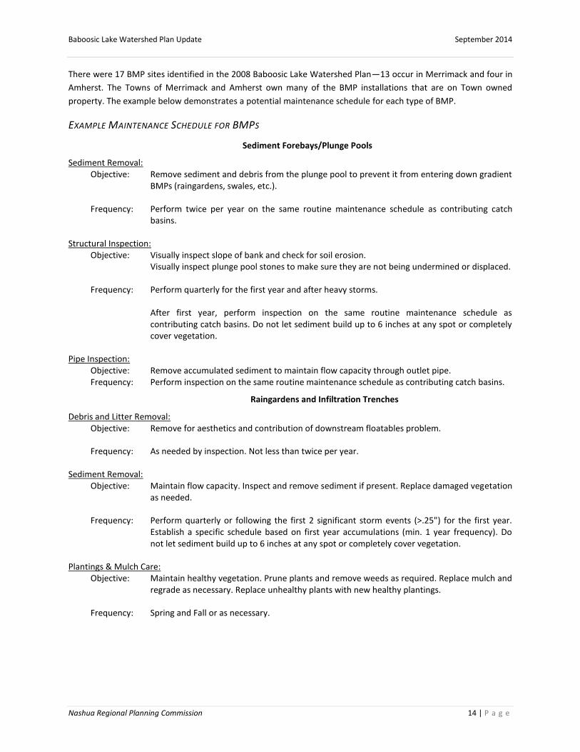
There were 17 BMP sites identified in the 2008 Baboosic Lake Watershed Plan—13 occur in Merrimack and four in
Amherst. The Towns of Merrimack and Amherst own many of the BMP installations that are on Town owned
property. The example below demonstrates a potential maintenance schedule for each type of BMP.
EXAMPLE MAINTENANCE SCHEDULE FOR BMPS
Sediment Forebays/Plunge Pools
Sediment Removal: Objective: Remove sediment and debris from the plunge pool to prevent it from entering down gradient
BMPs (raingardens, swales, etc.).
Frequency: Perform twice per year on the same routine maintenance schedule as contributing catch basins.
Structural Inspection: Objective: Visually inspect slope of bank and check for soil erosion.
Visually inspect plunge pool stones to make sure they are not being undermined or displaced.
Frequency: Perform quarterly for the first year and after heavy storms.
After first year, perform inspection on the same routine maintenance schedule as contributing catch basins. Do not let sediment build up to 6 inches at any spot or completely cover vegetation.
Pipe Inspection: Objective: Remove accumulated sediment to maintain flow capacity through outlet pipe. Frequency: Perform inspection on the same routine maintenance schedule as contributing catch basins.
Raingardens and Infiltration Trenches
Debris and Litter Removal: Objective: Remove for aesthetics and contribution of downstream floatables problem.
Frequency: As needed by inspection. Not less than twice per year.
Sediment Removal: Objective: Maintain flow capacity. Inspect and remove sediment if present. Replace damaged vegetation
as needed.
Frequency: Perform quarterly or following the first 2 significant storm events (>.25") for the first year. Establish a specific schedule based on first year accumulations (min. 1 year frequency). Do not let sediment build up to 6 inches at any spot or completely cover vegetation.
Plantings & Mulch Care: Objective: Maintain healthy vegetation. Prune plants and remove weeds as required. Replace mulch and
regrade as necessary. Replace unhealthy plants with new healthy plantings.
Frequency: Spring and Fall or as necessary.

Baboosic Lake Watershed Plan Update September 2014
Nashua Regional Planning Commission 15 | P a g e
Vegetated and Riprap Swales
Mowing and Vegetation Care: Objective: Minimize woody vegetation establishment/takeover to increase grass density and pollutant
removal.
Frequency: Mow yearly; Remove mowed material/clippings every other year. Do not cut grass below flow line.
Debris and Litter Removal: Objective: Remove for aesthetics and contribution of downstream floatables problem.
Frequency: As needed by inspection. Not less than twice per year.
Sediment Removal: Objective: Maintain flow capacity. Inspect and remove sediment. Inspect condition of check dams and
remove accumulated sediment behind check dams taking care not to undermine and damage riprap stone. Replace damaged vegetation as needed.
Frequency: Perform quarterly or following the first 2 significant storm events (>.25") for the first year. Establish a specific schedule based on first year accumulations (min. 1 year frequency). Do not let sediment build up to 6 inches at any spot or completely cover vegetation.
Structural Integrity: Objective: Minimize erosion and channelization of stormwater. Inspect swale for signs of scouring
particularly near high velocity areas (e.g. pipe discharge). Re-grade as needed. Replace riprap and vegetation in areas where scour is observed.
Frequency: After large storms, but not less than once per year.
Source: (Comprehensive Environmental, Inc., 2012)
MERRIMACK EXISTING OPERATIONS AND MAINTENANCE Operations and maintenance schedules are overseen by Merrimack’s Public Works Director and the town Deputy
Director. The town owns and is responsible for maintaining all of the BMPs on the Merrimack side of the lake.
Funding for the maintenance is drawn from the Department of Public Works annual budget.
Merrimack’s Operation and Maintenance Schedules around the lake include:
Trash Removal: Merrimack does not have curbside trash removal; homeowners instead take their trash to the
Merrimack Transfer Station. Merrimack lacks a town owned beach on Baboosic Lake therefore facility maintenance
is not an issue.
Buildings and Facilities Where Pollutants are Exposed to Stormwater Runoff: There are no municipal buildings near
the lake or in the watershed.
Salt Use and Winter Maintenance: Roads near the lake are on a no salt route. There are no public salt stores near
the lake or in the watershed. The nearest location for salt is at the highway garage on Turkey Hill Road,
approximately four and a half miles south of the lake. A limited amount of sand/salt mix is stored at the transfer
station on Fearon Road, three miles east of the lake, for the transfer station to use and the public to take in small

Baboosic Lake Watershed Plan Update September 2014
Nashua Regional Planning Commission 16 | P a g e
quantities. The lake area is on a sand-only route (very small amounts of salt may be present to prevent the
stockpile from freezing), and can receive an application of 500-800 pound per lane mile depending on conditions.
In general, the DPW applies anti-skid at the end of plowing operations and only when necessary in the day or two
afterwards. Extended storms or particularly bad events may receive sand treatments mid-storm.
Pesticides, Herbicides and Fertilizers: All stores are kept at 80 Turkey Hill Road, four miles south of the lake and
outside the watershed. Fertilizer is only used on ball fields and the closest to the lake is Bishop Field on Madeline
Bennett Road, more than two miles from the lake.
Catch Basins: Merrimack has an ongoing catch basin cleaning program. More than 33 percent are cleaned per year.
Every basin gets cleaned at least once in a three year cycle.
Street Sweeping: All paved public streets are swept each spring – as of May 23, 2014, approximately 70 percent of
the Town was completed with the remainder to be completed in the next few weeks.
Road Maintenance: There is no definitive schedule for road maintenance. When road maintenance is required, it is
requested on the supervisor’s recommendation or by requests from residents about street conditions near the
lake. In general, special precautions are not taken for sedimentation when performing road grading, but other
work such as ditch re-shaping or culvert repair could include measures such as silt fence, straw bales, erosion
blanket and erosion stone. Any catch basins in the area are cleaned at least annually, but several have shallow
sumps that require more frequent visits.
Recommendations for Merrimack
1. Assess if fertilizer use from the ball fields is affecting water quality in the lake. If fertilizer is affecting the
lake, the Town should evaluate lawn maintenance and landscaping activities to ensure practices are
protective of water quality. Protective practices include reduced use of phosphorus free fertilizer, soil
testing before applying fertilizer, integrated pest management (IPM), recycling or proper disposal of lawn
clippings and other vegetative waste, and use of native and drought resistant landscaping materials.
2. Regularly inspect, test, maintain, and repair all equipment and systems to avoid situations that may result
in leaks, spills, and other releases of pollutants in stormwater to receiving waters. Inspections should
occur at a minimum once per quarter.
3. Conduct more frequent sweeping of targeted areas determined by the Town on the basis of pollutant
load reduction potential, based on inspections, pollutant loads, catch basin cleaning or inspection results,
land use, impaired or TMDL waters or other relevant factors as determined by the Town. The Town should
note in each annual report the number of miles cleaned and the volume or mass of material removed.
4. Determine if catch basins require more frequent cleaning and inventory maintenance around the lake
based on the criteria recommended in the existing MS4 permit or the new draft MS4 permit. The Town of
Merrimack recognizes the benefit from more regular grading, drainage ditch dredging, and basin clearing,
but indicated staff capacity and equipment are limited at this time.

Baboosic Lake Watershed Plan Update September 2014
Nashua Regional Planning Commission 17 | P a g e
AMHERST EXISTING OPERATIONS AND MAINTENANCE Operations and maintenance schedules have a similar structure to those in Merrimack. Schedules are overseen by
Amherst’s Director of Public Works (DPW). The Amherst Recreation Department owns and is responsible for
maintaining the BMPs at the Town Beach. Additionally, the town is responsible for the maintenance and upkeep of
the Baboosic Lake Community Septic System. The community septic system was a recommendation from the 2008
Baboosic Lake Watershed Plan to reduce phosphorus loading from household septic systems.
Amherst’s Operation and Maintenance Schedules around the lake include:
Trash Removal: Amherst Public Works manages one dumpster at the town Safety Complex (Police, Fire, and EMS)
and the responsibilities are shared for trash barrel management for all parks and fields. The Amherst Recreation
Department manages the town beach. Amherst residents are responsible for their own trash removal by
transporting it to the Amherst Transfer Station.
Buildings and Facilities Where Pollutants are Exposed to Stormwater Runoff: The runoff from the town beach
building roof is channeled back into the groundwater through leaching tubes.
Salt Use and Winter Maintenance: The town salt shed is at the DPW, 22 Dodge Rd, three miles west of the lake and
outside of the watershed. The building is divided into two sections. One side holds approximately 350 tons of salt,
and the other side holds approximately 300 yards of a 50/50 salt and sand mix. Unless weather conditions require
a different approach, winter maintenance routes, including those around the lake, are usually treated with a
mixture of sand and salt. The mixture is maintained at a minimum of one part salt to one part sand. The mixture is
applied as close to the center of the roadway as possible, where traffic can work the mix traveling either way. This
is not always possible and sometimes requires spreading the material.
All six and ten wheel dump trucks are equipped with ground speed controls and are calibrated for approximately
500 pounds of produce per lane mile (250 pounds salt & 250 pounds sand). Consumption records are kept by
storm, not by vehicle. The lake area is plowed with a one ton vehicle which does not have ground speed
equipment but is manually calibrated for approximately the same rate. The lake roads are narrow and the traffic is
light which means they are considered “a single lane” and are not treated in both directions. All town trucks
(except the one at the lake) also have on board liquid dispensing systems (calcium or magnesium chloride) to help
lower the melting capabilities of salt.
The town’s adopted snow and ice policy specifically states “not to expect black roads” during or immediately
following a storm. Since there is no typical storm, strategy is based on the time of day (or night), road temperature,
air temperature, type of snow, and storm duration. Amherst typically treats once at the beginning of the storm and
at the end. Hills and intersections are retreated during the storm as necessary.
Pesticides, Herbicides and Fertilizers: The DPW does not store or apply pesticides, herbicides, or fertilizers around
the lake or in the watershed. The Amherst Buildings and Grounds Foreman is a state licensed pesticide supervisor
who oversees the application of pesticides, herbicides and fertilizers. Application occurs minimally in the
watershed as necessary on town owned property.
Catch Basins: All the catch basins are cleaned annually, usually in July.

Baboosic Lake Watershed Plan Update September 2014
Nashua Regional Planning Commission 18 | P a g e
Street Sweeping: The lake roads are swept as part of the spring cleanup. Street sweepings are stockpiled at the
DPW, and the material is tested prior to disposal.
Storage of Petroleum Products and Spill Employee Training: Petroleum products are not stored at the town beach.
The DPW has and maintains spill kits at the Transfer Station, Public Works Garage, and the town fueling station.
Spill kit training has been given to DPW employees, but no other departments.
Road Maintenance: Amherst uses silt fencing, erosion stone and 8 inch silt socks during road construction to
prevent erosion. Other measures are used when applicable. Recently, after the Baboosic Lake Community Septic
System construction, from 2005 to 2010, West Street, Washer Cove, and sections of Broadway were paved.
Amherst does not anticipate any additional reconstruction/paving around the lake in the next few years.
Recommendations for Amherst:
1. Regularly inspect, test, maintain and repair all equipment and systems to avoid situations that may result
in leaks, spills and other releases of pollutants in stormwater to receiving waters. Inspections should occur
at a minimum once per quarter.
2. Conduct more frequent sweeping of targeted areas determined by the Town on the basis of pollutant
load reduction potential, based on inspections, pollutant loads, catch basin cleaning or inspection results,
land use, impaired or TMDL waters or other relevant factors as determined by the Town. The Town should
report in each annual report the number of miles cleaned and the volume or mass of material removed.
3. Establish and implement procedures for winter road maintenance including the use and storage of salt
and sand. Minimize the use of sodium chloride and other salts, and evaluate opportunities for use of
alternative materials. Ensure that snow disposal activities do not result in disposal of snow into surface
waters. Encourage staff to become Green SnowPro Certified through the UNH Technology Center.
4. Consider further digitizing and mapping existing BMP site locations to aid in future planning and
maintenance efforts.
REGULATIONS AND ENFORCEMENT PROCEDURES
Local stormwater regulations and enforcement procedures are important for the protection of surface water
quality. Stormwater has been a significant issue for Baboosic Lake, causing algae blooms and beach closures.
Merrimack and Amherst have adopted stormwater regulations or standards within the last ten years.
EXISTING LOCAL LAND USE REGULATIONS: MERRIMACK
The Town of Merrimack adopted Stormwater Management Standards in 2011. The standard requires a stormwater
management plan (SWMP) be produced for land disturbance areas of 20,000 square feet or more.
The Stormwater Management Standards reference the NH Stormwater Manual for erosion and sediment BMPs
and require a pre-construction meeting with the town Community Development Department (CDD) and the
Department of Public Works (DPW). The applicant must submit two copies of the SWMP that are signed by a NH
registered Professional Engineer. The standard also requires a bond or other security for construction and
installation of control measures. Development cannot begin until the SWMP is approved by the CDD and the DPW.

Baboosic Lake Watershed Plan Update September 2014
Nashua Regional Planning Commission 19 | P a g e
Lastly, applicants are required to submit a log and report to the CDD each week and within 24 hours of any storm
event greater than 0.5 inches of rainfall. Reports shall detail all inspections, actions taken per the SWMP, dates of
action and follow-up action required.
After construction is complete, the applicant is required to implement design standards that meet the NH
Stormwater Manual requirements and attend a post construction meeting. Additionally, the applicant is required
to install, inspect, report, operate and maintain post construction stormwater management measures. The
applicant is not released from the bond or other security by the CDD and DPW until:
a. Inspection and operation maintenance to uphold water quality set forth by the SWMP will continue after
the bond is released and be added as a condition of the plan or incorporated into the deed as a covenant.
b. The responsible party has attended a post-construction meeting.
c. The built plans are reviewed and certified by a NH registered Professional Engineer.
All SWMPs are to be inspected annually by the applicant and a report submitted to the CDD that includes:
stormwater flow paths, accumulation of sediment, condition of contaminant control devices, stormwater quality
observations, corrective actions and time frames. Waivers are only granted due to an unnecessary hardship based
on unique characteristics such as the size, character, location, nature of use and unspecified conditions in the
project area. All construction outlined in the SWMP must be completed in four years from the date of approval
(Town of Merrimack, 2011).
EXISTING LOCAL LAND USE REGULATIONS: AMHERST The Town of Amherst has implemented a Stormwater Regulation for temporary construction and permanent
stormwater management. Temporary construction projects are required to use the Best Management Practices
(BMPs) discussed in the “Stormwater Management and Erosion and Sediment Control Handbook for Urban and
Developing Areas in New Hampshire” from NH DES. Applicants are required to submit a Stormwater Management
Plan (SWMP) or a Stormwater Pollution Prevention Plan (SWPPP) for disturbed areas exceeding 20,000 square
feet, construction or reconstruction on a street or road, subdivision of more than three building lots, work adjacent
to a wetland buffer or disturbed critical areas. The design standards in the regulation apply for temporary and
permanent stormwater management techniques to negate additional runoff from construction and land
disturbances.
Temporary construction stormwater management design must meet requirements for BMPs for a two year,
twenty four hour storm event. BMPs for stormwater include: retaining natural vegetation, installing erosion
control measures before soil disturbance and stabilizing disturbed areas that have been idle for thirty days.
Additional practices include:
diverting surface water runoff away from disturbed areas
installing controls to prevent predevelopment runoff
preserving natural drainage systems
removing control measures after site stabilization
Permanent stormwater management designs differ based on the acres of disturbance, adjacency to wetlands and
if the project is private or public. All projects require basic stormwater management techniques and pretreatment
prior to exiting the site. The regulation includes a comprehensive list of technical design elements including water
velocity, erosion and sediment control measures and flow rates and riprap requirements based on the twenty five
year, twenty four hour storm event.

Baboosic Lake Watershed Plan Update September 2014
Nashua Regional Planning Commission 20 | P a g e
The regulation requires a Stormwater Management Report highlighting the temporary and permanent design
structures for the site including schedules for inspection and maintenance, plans for effected area and detention
structures for future stormwater discharge conditions. A maintenance inspection is also required and reported
back as a narrative of ongoing construction and operational maintenance schedules. The narrative includes water
quality measures required by stormwater management and erosion and sediment control plans after the Amherst
Board of Health review is recorded on the deed, typical site plan management, and development agreement.
Additionally, a post construction operation report and a notification of spills or other non-stormwater discharges
are required and address: stormwater flow paths, the condition of any sediment or contaminant control devices,
water quality runoff, and the name and position of the inspector. Other permits may be required such as an
Alteration of Terrain permit for projects more than 100,000 contiguous square feet of land disturbance; 50,000
square feet in the jurisdictional shore land; or within 50 feet of surface waters. A NPDES stormwater discharge
permit is required for discharge of pollutants to surface waters (Town of Amherst, 2007).
RECOMMENDATIONS FOR LOCAL LAND USE REGULATIONS
GENERAL STORMWATER REGULATION GUIDANCE
The Towns are responsible for determining which regulations are suitable for their community. However, if either
of the Towns considers updating or altering the existing stormwater regulations, the NH Innovative Land Use
Planning Techniques Handbook outlines the Permanent (Post-Construction) Stormwater Management Model
Ordinance that can be used to initiate the process. The model ordinance is designed to satisfy EPA requirements
under Phase II of the National Pollutant Discharge and Elimination Systems (NPDES) for MS4s to regulate land
disturbances greater than one acre. The ordinance may need to be altered for changes required in the updated
draft MS4 when it is released.
The ordinance is focused on post construction stormwater management and assumes communities have adopted
and will institute construction-phase stormwater management, sedimentation and erosion control requirements.
The Innovative Land Use Planning Guide contains an Erosion and Sediment Control during Construction Ordinance
if the towns require additional guidance for pre-construction. Currently, both towns have some language regarding
pre-construction processes. Additionally, the post construction model ordinance is intended to be at least as
stringent as NH DES requirements. However, the model is a performance standard approach; it does not include all
the technical specifications for the specific types of BMPs that are contained within the NH DES rules. The Towns
should consider what is most applicable and tailor the ordinance based on the needs of the community (New
Hampshire Department of Environmental Services, 2008).
MERRIMACK
In 2011, the Town of Merrimack passed Chapter 412 Stormwater Management Standards. Given this recent
update, additional stormwater regulations will not be addressed in the next five years. It is first necessary for the
Town to assess performance of its recently adopted standards, after which revisions may be considered to ensure
optimal results. The Town may consider altering regulations based on the updated permit requirements if
necessary. Otherwise there are no further recommendations or considerations for future regulations.
AMHERST
In March 2014, the Town of Amherst adopted new wetlands and water regulations to replace the existing
Wetlands and Watershed Conservation District (WWCD) and Aquifer Conservation and Wellhead Protection
District (ACWPD). Both regulations sought to protect drinking water resources and increase existing water quality
efforts.

Baboosic Lake Watershed Plan Update September 2014
Nashua Regional Planning Commission 21 | P a g e
Amherst is amenable to updating its stormwater regulation in accordance with the new MS4 permit requirements.
Additionally, the current town stormwater regulation lacks a waiver and appeal process provision. Merrimack
currently has a waiver section that Amherst could use as an example.
OPPORTUNITIES FOR FUTURE BMPS
Additional site specific BMPs have not been identified since there are four BMPs that have not been implemented
and not all phases of the community septic system are complete. The BLA intends to focus on maintaining the
existing BMPs rather than identifying new sites. There is still some concern over who will conduct regular
maintenance of the BMPs to protect the initial investment. The Towns of Merrimack and Amherst and the BLA
have agreed to follow the maintenance schedules in the Implementation Section of this report.
The BLA received a 2015 Watershed Assistance Grant from NH DES to implement the Carter Road BMPs. A portion
of the Carter Road recommendations occur on private property where the BLA is working with the land owner to
install the necessary BMP to complete the project. The Town of Merrimack will provide maintenance of the catch
basins that lie within the Town’s drainage easement at the end of the public portion of Carter Road and which
drain into the proposed BMPs.
There is still much progress to be made for outreach campaigns. Pet waste, feeding wildlife, and phosphorus free
fertilizer programs are all educational components that can be targeted to homeowners to further reduce
phosphorus and other nutrient loading. Voluntary programs would be less costly for the BLA and the towns to
implement; however, they may be less effective than regulatory measures. The NH Lakes Lay Program and NH DES
offer educational materials on pet waste, fertilizers and wildlife signage for a large audience of lake users.
For example, the 2008 Baboosic Lake Watershed Plan proposes an ordinance and outreach campaign to reduce
phosphorus fertilizer use. Neither Amherst nor Merrimack has ordinances banning fertilizer use or limiting usage in
any areas. However, Amherst and Merrimack participated in a Community Based Social Marketing (CBSM) Report
in conjunction with the Hillsborough Cooperative Extension Program at the University of New Hampshire, NH DES,
Pennichuck Water Works and Comprehensive Environmental Inc., for fertilizer reduction in the Stump Pond Brook
Subwatershed. The report identified residential behaviors contributing to phosphorus loading into the Stump
Brook and Stump Pond. The report is outside the watershed area of Baboosic Lake but provides example
messaging for reducing lawn fertilizer applications and proper disposal of pet waste. The outreach campaign was
successful in reducing lawn fertilizer applications as 89 percent of respondents who fertilize their lawn used less
fertilizer the rest of the summer and planned on using less the next year.

Baboosic Lake Watershed Plan Update September 2014
Nashua Regional Planning Commission 22 | P a g e
PUBLIC INFORMATION AND EDUCATION Public outreach and education on phosphorus reduction techniques is vital to reducing phosphorus loading into
Baboosic Lake. Lake health is a priority for the Towns and the Lake residents. Over the last few years, sediment
reduction techniques were implemented by local homeowners and the BLA. The BLA’s direct work with land
owners and the towns is one example of integrated education to local residents on preserving lake health and
reducing sediment runoff. The Nashua Regional Planning Commission created a presentation tool for the towns
and the BLA to increase knowledge and use of this plan and educate homeowners and other municipal officials on
the water quality and recommendations for the Lake moving forward.
OUTREACH PLANNING
The Nashua Regional Planning Commission coordinated with the Towns of Amherst and Merrimack for status
updates on recommendations from the 2008 Baboosic Lake Watershed Plan. Staff from NRPC met with the Town
of Merrimack in November 2013 to discuss existing outreach efforts to Baboosic Lake residents, existing
Operations and Maintenance schedules, potential alterations to existing stormwater regulation, and possible
collaboration of existing outreach efforts with the Town of Amherst. BLA members provided outreach and
education input to NH DES and NRPC at follow-up BLA Board meetings.
Next, NRPC met with the Amherst Town Planner and DPW Director in December 2013. There were similar
discussion topics to the November meeting. The Town of Amherst was open and willing to share any existing
outreach materials with the Town of Merrimack and increase flyer distribution by inserting stormwater and
construction flyers with new building permits.
EXISTING OUTREACH MATERIALS The 2008 Watershed Plan includes various education and outreach ideas for reducing phosphorous loading into
the Lake. The status of existing outreach materials in Amherst and Merrimack is listed below.
Baboosic Lake Association
The BLA has information available on its website about how to protect lake health, including: pet waste removal,
invasive species removal, and links to NH DES lake health monitoring program. In 2006, Geosyntec was hired by
BLA to write the Baboosic Lake Watershed Based Plan. One part of the work included creating a stormwater
brochure targeted to landowners around the Lake. The brochure includes options to limit phosphorus loading into
Baboosic Lake, historical facts, and Low Impact Development (LID) techniques for homeowners. Currently, the BLA
distributes the brochure to new members and at the annual meeting. Target Audience: Homeowners living on the
lake and in the watershed, visitors to the lake, dog owners, boaters and swimmers.
The Town of Merrimack
The Town of Merrimack includes a simple flyer with water bills to all Merrimack Village District (MVD) customers; it
is also available for residents at Town Hall. The flyer highlights stormwater, the consequences of contaminated
stormwater, fertilizer use, salt distribution and household hazardous waste collection days. Additionally, it
provides contact information for various departments in town. The original 2009 flyer was updated in 2012 to
provide expanded information on fertilizer and salt use. It is important to note many residents around the lake are
not on public water and therefore they do not receive the flyer. Target Audience: MVD Customers (Industrial,
Commercial, Residential)

Baboosic Lake Watershed Plan Update September 2014
Nashua Regional Planning Commission 23 | P a g e
The Town of Amherst
The Town of Amherst distributes nine brochures specifically targeted to commercial and industrial businesses,
homeowners and developers. The brochures offer mitigation strategies to avoid contaminating stormwater,
preventing sediment runoff, providing systems for spill prevention and implementing LID techniques.
Stormwater Pollution and Your Business- This brochure discusses the impacts of chemical and fertilizer
contaminated stormwater on wildlife and water quality. Included are tips on how to reduce stormwater pollution
such as covering trash cans, decreasing fertilizer use and avoiding soap when cleaning parking lots. Target
Audience: Businesses and Commercial Development
Construction: Managing Your Footprint- Construction sites can be the impetus for soil disturbance and sediment
runoff. This brochure describes the consequences of erosion at construction sites and mitigation strategies such as
check dams, cloth mats over gravel, grass lined channels, silt fences and diversion dikes. Target Audience:
Construction Companies and Work Crews
Construction Site Entrance Requirements- Sediment can accumulate on construction vehicles, especially tires, due
to land disturbance. The focus is how to reduce sediment deposition onto roadways from construction vehicles at
the entrance of construction sites. New Hampshire Department of Transportation (NHDOT) provides a protocol for
construction entrances including geotextile mats, specific size stones and evaluation methods after storm events.
Target Audience: Construction Companies and Work Crews
Keeping Your Parking Lot and Lawn Environmentally Friendly- Current methods for maintaining parking lots and
lawns can use significant amounts of chemical fertilizers and salts. The beginning section of the brochure is a
review of lawn care and lists alternative methods such as reducing fertilizer applications, applying phosphorus free
fertilizers and using compost. The second half of the brochure provides strategies for increasing water quality of
runoff from parking lots, including alternative salts such as calcium magnesium acetate (CMA), porous pavement,
and sand instead of salt in the winter. The brochure also provides basic facts on blue green algae and its
consequences to lake health and wildlife. Target Audience: Business and Commercial Development
Industry and Storm water: An Important Relationship- This brochure is targeted to businesses and discusses
pollution and spill prevention techniques to reduce chemical contamination in stormwater that drains into
Baboosic Lake and the Souhegan River. Suggestions to prevent chemical spills include: a chemical storage map, an
inventory of chemicals used on site, a Stormwater Pollution Prevention Plan (SWPPP), employee education and
training on proper chemical use and cleanup techniques, and implementation of Best Management Practices.
Target Audience: Industrial Business Owners
Developers: Consider Low Impact Development (LID) Methods- This one page flyer targeted to local developers
provides four methods for mitigating stormwater: gravel wetlands, porous pavement, infiltration basins and tree
filters. Each section includes a description of the strategy and how it mitigates excess runoff. Target Audience:
Developers
Building New Houses? Make Stormwater Work for you! - Landscaping for new houses can include Low Impact
Development (LID) techniques such as rain gardens. This brochure discusses how rain gardens are designed to be
lower than the rest of the lawn to increase groundwater infiltration rather than runoff into stormwater
infrastructure. Target Audience: Homeowners

Baboosic Lake Watershed Plan Update September 2014
Nashua Regional Planning Commission 24 | P a g e
Business Owners: Environmentally Friendly Washing –One washing technique is to use soap without nitrogen and
phosphorus to reduce nutrient supplementation in stormwater and decrease toxic blue green algae blooms. A
discharge permit from US EPA or NH DES is required when discharging harmful chemicals into an already impaired
water body. Other mitigation strategies for friendly car washing include using a power washer and diverting runoff
into catch basins or installing a rain garden. Target Audience: Businesses and Commercial Development
You and Your Septic System- This brochure provides basic information on septic systems and maintenance
strategies such as having annual tank inspections; pumping every 2-3 years; and avoiding bulky waste, toxic
substances, and enzymes or commercial additives. Target Audience: Homeowners
RECOMMENDATIONS FOR TOWNS ON MOST EFFECTIVE OUTREACH PROGRAMS AND MESSAGES
AMHERST
The Town of Amherst has nine brochures on stormwater and runoff. Amherst is willing to amend
brochures based on subject type and avoid redundancies to streamline messaging to target audiences.
The Town is also open to combining efforts with Merrimack on stormwater messaging around Baboosic
Lake through the distribution of the stormwater brochures.
The Town of Amherst can utilize the services of NH DES to review the brochures for accuracy, provide
additional information and collaborate for effective distribution.
The Town of Amherst is interested in providing public education on stormwater reduction steps. This
could include grant funding to conduct local outreach campaigns on stormwater and lake health to the
Amherst Planning Board, Conservation Commission, local business owners and developers.
The Town of Amherst recommends creating a generic stormwater video to run on the local cable access
channel to educate residents on stormwater and the effects to water systems.
The Town of Amherst does not have a direct method to distribute any brochures at this time. They are
only available at the Town Hall for residents to take. Amherst cannot distribute brochures in water bills
since Pennichuck Water controls the water systems. The Planning Department is willing to attach
brochures to building permits and make flyers available at public meetings. Another distribution
opportunity could involve updating and linking the brochures on the BLA website and working with the
BLA to identify additional targeted distribution methods for further exposure.
MERRIMACK
The Town of Merrimack could benefit from expanded distribution of brochures. It could also expand the
scope of materials to address erosion issues from construction and tailor materials to specific audiences.
This could be accomplished by utilizing flyers already created by Amherst, NH DES and GeoSyntec.
The Town of Merrimack can utilize the services of NH DES to review the brochures for accuracy, additional
information and collaboration for effective distribution.
The Town of Merrimack is interested in providing public education on stormwater reduction. This could
include grant funding to conduct local outreach campaigns on stormwater and lake health to the
Merrimack Planning Board, Conservation Commission, local business owners and developers.

Baboosic Lake Watershed Plan Update September 2014
Nashua Regional Planning Commission 25 | P a g e
The Town of Merrimack recommends creating a Public Service Announcement to run on the local cable
access channel to educate residents on stormwater and the effects to water systems.
Merrimack already includes an environmental flyer with local water bills. One recommendation is to
include information on stormwater or maintenance of construction sites with building permits.
The Towns could combine resources and efforts on the following:
Brochures: The Towns could explore a joint effort to develop a brochure series that streamlines the
number of available documents and ensures that a consistent message is delivered.
Public Service Announcements and video for local cable access channels: The Towns could combine
efforts to develop and run public service announcements and an educational stormwater video on their
local cable access channels.
Public outreach campaigns: The Towns have the opportunity to communicate with more Lake residents
through combined public outreach campaigns and partnerships with the BLA. The Towns of Amherst and
Merrimack can consider utilizing the outreach efforts completed by the BLA to fulfill the public education
requirements in their MS4 Permits.
Agricultural Nutrient Management (ANM): The 2008 plan identified agriculture BMPs to address various
agriculture activities that occur around the lake; specifically it recommended conducting a detailed
nutrient management assessment related to all agricultural activities. The New Hampshire Department of
Agriculture offers watershed grants to assist agricultural land and livestock owners with efforts to
minimize adverse effects to waters of the state by better managing agricultural nutrients including
fertilizer, manure and compost. Applicants may apply for grants up to $2,500.
Baboosic Lake Watershed Plan Update September 2014
Nashua Regional Planning Commission 26 | P a g e
IMPLEMENTATION, MONITORING AND ASSESSMENT Currently, implementation of the remaining BMP sites in the Baboosic Lake Watershed-based Plan will be led by
the BLA. The four sites are on private property or private roads, which limits how the towns can participate. The
BLA will meet with both towns and NH DES to discuss options and equipment for installations. The top priority site
is Carter Road in Merrimack. The BLA received a 2015 Watershed Assistance Grant from NH DES to begin installing
some Carter Road BMPs. The BLA will discuss options for the installation of Hillside Road and Broad Street with the
Town of Amherst at a later time. Municipalities in New Hampshire are limited to working exclusively on public
property or where they hold an easement, which limits opportunities to install BMPs on private property. In the
case of future Carter Road BMPs, the Town may be able to partner with the BLA and work exclusively within the
area where it holds a drainage easement, while BLA could work with the private land owner for any remaining
portions of the project.
INSTALLATION OF THE REMAINING BMPS
There are four remaining sites from the 2008 Plan that have not been installed. The Baboosic Lake Association
indicated the four sites could be installed in the next five years with adequate funding and support. The Towns
have offered to help with installation on Town owned property.
Table 7. Responsible Party for Installation of Remaining BMPs
Site Responsible Party for Installation
Site 9: Paul’s Boat Ramp Baboosic Lake Association
Site 13: Autumn Lane Baboosic Lake Association
Site 14: Carter Road Baboosic Lake Association
Site 17: Hillside Road/Broad Street Baboosic Lake Association
Source (Geosyntec, 2008)
Other BMPs include education an on-site waste management survey and agricultural ordinances. The BLA has
started the education component of using phosphorus free fertilizer by developing a brochure that is distributed to
new members and lake residents. Education campaigns can begin as early as fall 2014 when the BLA obtains
education materials from NH DES.
The on-site waste management project has not been started and would require training and resources for
implementation. It is undetermined who will be responsible for completion of this project. The Towns lack the
capacity to complete the project at this time and the BLA would require training and funding. It has not been
determined if this project will be completed in the next five years.
In conjunction with the on-site waste management project, there are still four phases of the community septic
system to be completed in Amherst. The completion of the community septic system would further reduce the
potential for leakage from septic systems into the lake. Currently, the cost is prohibitive for some owners, which is
why there were no additional installations after the initial one. The Amherst DPW could add more households into
the community septic system but will require additional support from the Amherst Community Development
Office and the BLA. This project is currently a low priority until the remaining BMP sites have been installed.
The last BMP is agricultural ordinances. Both towns currently allow agriculture in all zones in town. While this is
appropriate for rural or suburban towns, the fertilizers used in agriculture or waste created from animal husbandry

Baboosic Lake Watershed Plan Update September 2014
Nashua Regional Planning Commission 27 | P a g e
can be a source of polluted run-off into the lake. Currently, the towns are not considering a separate agriculture
ordinance since there are not any major agriculture operations around the lake and it is unclear if any neighboring
farms leach into the watershed.
BMP MONITORING AND MAINTENANCE
One of the top priorities for all stakeholders is maintaining the existing BMPs to maximize effectiveness and
protect the initial investments. Monitoring the BMPs can include cleaning catch basins, removing debris and
sediment from riprap and landscaping such as mowing, trimming plants and mulching. The first step for monitoring
is to establish who will maintain the identified BMPs. The burden can be shared among the BLA, Town of Amherst
and Town of Merrimack.
The Town of Merrimack has assisted the BLA with BMP site installations in the past and will continue to provide
assistance as applicable in the future. Merrimack is responsible for monitoring the already installed BMPs on Town
owned property and will provide maintenance on an as needed basis. The BLA is interested in assisting Merrimack
with maintenance of any BMPs that the town is not able to evaluate. This will be a crucial relationship since a
number of BMPs occur on private property that the town cannot access.
The BLA and Town of Amherst installed BMPs at the Town Beach and picnic area. The Town of Amherst is
responsible for maintaining and monitoring the community septic system and Town Beach. The Amherst
Recreation Department monitors and cleans the BMPs on an annual basis and collaborates with the Amherst DPW
for replacement of materials as necessary. The BLA can contribute to the community septic system by encouraging
additional residents to participate in the new system rather than maintaining old systems. The BLA can also help
the Town of Amherst determine if the community septic system is effective through water quality sampling efforts
and recording algae bloom size and locations.
Table 8 indicates which party is responsible for monitoring the corresponding BMP type. The BLA can utilize
homeowners to maintain rain gardens and replace dead plants on a Homeowner Clean Up Day. The Town of
Merrimack has a limited budget for planting and landscaping, which is prohibitive to maintaining the installed rain
gardens.

Baboosic Lake Watershed Plan Update September 2014
Nashua Regional Planning Commission 28 | P a g e
Table 8. Responsible Party for Existing BMP and Monitoring Schedule
Site Responsible Party BMP Type
Site #1: Four Seasons Park, Site A BLA Vegetated buffer strip
Site #2: Four Seasons Park, Site B BLA Riprap plunge pool
Site #3: Amherst Town Beach, Bath House
Town of Amherst, Recreation Department
Raingarden, gutter and rainbarrel, riprap forebay
Site #4: Amherst Town Beach, Picnic Area
Town of Amherst, Recreation Department
Infiltration trench, raingarden
Site #5: Lakeside Drive /Greenwood Drive
Town of Merrimack Riprap plunge pool, riprap swale
Site #6: #24 Lakeside Drive: Town of Merrimack Vegetated swale, forebay
Site #7: Jebb Road Town of Merrimack Riprap plunge pool
Site #8: #30 Lakeside Drive: BLA, Town of Merrimack Raingarden, riprap forebay, infiltration trench
Site #9: Paul’s Boat Ramp BLA Porous pavers, grass channel
Site #10: North Jebb Road BLA, Town of Merrimack Riprap forebay, raingarden
Site #10B: North Jebb and Jebb Roads (post WMP site)
BLA, Town of Merrimack as applicable
Riprap forebay, raingarden
Site #11: #24 Greenwood Drive Town of Merrimack Riprap forebay, inlet pipe
Site #12: Lakeside Drive Town of Merrimack Riprap forebay, vegetated swale
Site #13: Autumn Lane Town of Merrimack Riprap plunge pool
Site #14: Carter Road Town of Merrimack Vegetated swale, infiltration steps, stormwater basin
Site #14A: Miriam Road (post WMP site) BLA, Town of Merrimack as applicable
Riprap plunge pool, vegetated swale
Site #14B: Carter Road (post WMP site): Arnold Road
BLA, Town of Merrimack as applicable
Riprap forebay, raingarden
Site #14C: Carter Road (post WMP site) BLA, Town of Merrimack as applicable
Riprap forebay, raingarden
Site #15: Walnut Hill Rd./ Clark Island Rd.
BLA Riprap swale
Site #16: Shore Road BLA, Town of Merrimack Riprap forebay, raingarden
Site #16A: Shore Road (post WMP site) BLA Riprap forebay, raingarden
Site #16B: Longa Road (post WMP site) BLA Riprap plunge pool
Site #17: Hillside Road/ Broad Street BLA Vegetated swale, pipe inlet
Source (Comprehensive Environmental, Inc., 2012; Geosyntec, 2008)

Baboosic Lake Watershed Plan Update September 2014
Nashua Regional Planning Commission 29 | P a g e
MONITORING SCHEDULE BY BMP TYPE
Below are the recommendations for maintenance and monitoring frequency for each of the installed or potentially
installed BMPs. The BLA and towns can incorporate the maintenance into existing monitoring and cleaning
schedules as applicable (Comprehensive Environmental, Inc., 2012).
Sediment Forebay and Plunge Pool
Sediment Removal: Perform twice a year on the same routine maintenance schedule as contributing catch
basins.
Structural Inspection: Perform quarterly for the first year and after heavy storms. After first year, perform
inspection on the same routine maintenance schedule as contributing catch basin frequency.
Pipe Inspection: Perform inspection on the same routine as contributing catch basins.
Forebays should be maintained at a minimum on a yearly basis. If maintenance is only conducted once
per year, it should be performed before winter to ensure pipe outlet is not clogged.
Raingardens and Infiltration Trenches
Debris and Litter Removal: As needed by inspection. Not less than twice per year.
Sediment Removal: Perform quarterly or following the first 2 significant storm events (>.25") for the first
year. Establish a specific schedule based on first year accumulations (min. 1 year frequency). Do not let
sediment build up to 6 inches at any spot or completely cover vegetation.
Plantings and Mulch Care: Spring and fall as necessary.
Vegetated and Riprap Swales
Mowing and Vegetation Care: Mow yearly. Remove mowed material every other year. Do not cut grass
below flow line.
Debris and Litter Removal: As needed by inspection. Not less than twice per year.
Sediment Removal: Perform quarterly or following the first 2 significant storm events (>.25") for the first
year. Establish a specific schedule based on first year accumulations (min. 1 year frequency). Do not let
sediment build up to 6 inches at any spot or completely cover vegetation.
Structural Integrity: After large storms, but not less than once per year.
Gutter and Rainbarrel System
Check gutters, downspouts, rain barrel water intake screen, rain barrel mosquito screen and rain barrel
spigot for leaks, obstructions or debris at least once per year.
Drain rain barrel before temperatures drop below freezing.
In the winter, keep rain barrel spigot open so that water does not accumulate in the rain barrel and freeze
or turn it upside-down or bring it inside to ensure no water accumulates in the barrel.
Vegetated Buffer Strip and Grass Strip
Mow turf grass yearly. Remove grass cuttings. Avoid producing ruts when mowing.
Irrigate during dry weather. Treat vegetation using preventative and low-toxic methods.

Baboosic Lake Watershed Plan Update September 2014
Nashua Regional Planning Commission 30 | P a g e
Inspect buffer strip to check for erosion and sediment and debris accumulation twice a year: 1) one
inspection at the end of the wet season in order to plan and schedule summer maintenance, 2) the other
inspection after periods of heavy runoff (1” or greater). Dispose of sediment and debris properly.
Infiltration Steps
Replace rotten timbers as needed. If the crushed stone or pea stone becomes filled up with sediment over
time, remove, clean out sediment and replace. Visually inspect once per year.
Inlet Pipe
Inspect the pipe to make sure it is intact, not broken or damaged.
Check for erosion around the pipe or missing rip rap. Visually inspect once per year.
Inspect the pipe end to determine if sediment, dirt, or debris is obstructing the flow of water from the
pipe into the basin and remove sediment. Visually inspect once per year and after flooding events.
Porous Pavement
Inspect on an annual basis, preferably after rain events when clogging will be obvious.
Vacuum sweep ideally four (4) times a year, properly disposing of the removed material. Follow the
sweeping with high-pressure hosing of the surface pores. If necessary, add additional aggregate fill
material made up of clean gravel.
Potholes and cracks can be filled with patching mixes, and spot clogging of porous concrete may be fixed
by drilling approximately 0.5-inch holes every few feet.
Maintain street sweeping program in the site’s drainage area to help prolong the functional life of the
pavement.
ASSESSMENT
Assessing the effectiveness of the BMPs and the community septic system will occur through additional sampling
efforts. The timescale of testing needs to occur over a five to ten year time frame. The community septic system
results are apparent through the decrease in algae blooms over the past few summers. Although the modeling
gives a good estimate, it is difficult to assess the exact quantity of phosphorus each BMP is contributing to the
overall reduction.
The NH Lakes Lay Monitoring Program has identified nine sites for phosphorus monitoring that the BLA and
Amherst can use for future assessing efforts. In the summer of 2014, the Town of Amherst purchased water
sampling equipment and received training from the NH Volunteer River Assessment Program (VRAP) to conduct
additional water quality monitoring on the Lake. The BLA is interested in renewed training to continue to conduct
nutrient samplings according to the NH Lakes Lay Monitoring Protocol. Additionally, NH DES can work with the
BLA and the Town of Amherst to identify any new sites that will address any gaps in data. The BLA could conduct
samplings multiple times per year and contribute to the database on lake water quality. The BLA will continue to
provide trainings to the lifeguards at the Amherst Town Beach to test for the presence of E.coli and other bacteria.

Baboosic Lake Watershed Plan Update September 2014
Nashua Regional Planning Commission 31 | P a g e
Map 2. Baboosic Lake Testing Sites
Deep Water Sites
1-Clarks Island
2-Center Lake
3-Sharks
4-Washer Cove
Near Shore Sites
S1-Washer
S2-Point
S3-MoonBeam Cove
S4-West Shore
S5-Town Beach
Source (Craycraft & Schloss, 2012)

Baboosic Lake Watershed Plan Update September 2014
Nashua Regional Planning Commission 32 | P a g e
If additional water quality assessment efforts reveal increased phosphorus loading and the final MS4 permit still
requires it, it may be necessary to prepare a Phosphorus Control Plan (PCP). Depending on the final MS4 permit
requirements for the PCP, this Baboosic Lake Watershed Plan Update may provide some of the content. An
example PCP outline from the draft permit is included in Appendix A. Assessment efforts need to be continued for
water quality and BMP monitoring to determine if phosphorus is decreasing. During the writing of this report, the
invasive variable Milfoil was discovered in Washer Cove. The BLA is working closely with the NH DES Exotic Species
Program to mitigate the spread of the invasive Milfoil while continuing their efforts to reduce phosphorus in the
lake.
IMPAIRED WATERS REMOVAL PROCESS Two terms are commonly used that indicate the level of EPA overview. The first term is “delisting” and indicates
that a waterbody that is impaired and needs a TMDL study (i.e. a 303(d) water) is to be moved off of the 303(d)
List. The Environmental Protection Agency (EPA) states if monitoring demonstrates that water quality standards
have been attained, the water body and pollutant combination is removed from the 303(d) List. Under some
conditions evaluation of new information might determine that the TMDL is not appropriate or sufficient to result
in attainment of water quality standards. When deciding to remove a water body and pollutant or pollution
combination from any part of the list, NH DES must use data collected under the same, or more water quality
limiting, conditions as the original impairment data.
The NH DES is responsible for submitting alterations to the EPA for delisting a water body off the impaired waters
list in accordance with Section 303(d) of the Federal Clean Water Act. EPA has the authority to approve/disapprove
such changes to the 303(d) List. The primary reasons for these proposed delistings include, but are not limited to:
A Total Maximum Daily Loads (TMDL) has been completed
Water bodies that now meet water quality standards;
Erroneous listings; and,
Splits in assessments units in which the new assessment unit meets water quality standards.
The second term is the more generic “impairment removal” and used in cases NH DES removes an impairment
where a waterbody already has a completed TMDL or the original impairment did not require a TMDL. The primary
reasons for these proposed impairment removals include, but are not limited to:
Water bodies that now meet water quality standards;
Erroneous listings; and,
Splits in assessments units in which the new assessment unit meets water quality standards.
Once NH DES determines Baboosic Lake is eligible for impairment removal, it will be added to the overall list of
changes to the Impaired Waters List. In cases where there is a delisting, the documentation is publicized and
available for public comment for a one month period. After the comment period is closed, NH DES will produce a
final report to be sent to EPA. Once EPA has accepted all changes, Baboosic Lake could potentially be clear of all
TMDLs. Typical TMDLs last between five and 15 years. It is unclear at this time when Baboosic Lake will be eligible
for delisting (AECOM, 2011b).

Baboosic Lake Watershed Plan Update September 2014
Nashua Regional Planning Commission 33 | P a g e
CONCLUSION The Baboosic Lake Watershed Update summarizes the implementation status of the 2008 Watershed Based Plan
and other planning reports. The summary of water quality conditions shows a gradual decline of phosphorus and
chlorophyll-a but optimal levels have yet to be attained. Pollutant load estimates indicate removal of phosphorus
due to the BMPs that have been installed. In order to fully achieve success, outreach and education activities
should continue to occur with future implementation of the remaining BMPs.
Recommendations were made to increase outreach by the Towns and the BLA to provide consistent messaging to
homeowners around the lake on fertilizer reduction, the effects of stormwater and areas for collaboration.
Additional recommendations were made regarding the Towns’ stormwater regulations. The Towns are not
currently considering making alterations to their existing regulations unless required by the release of the new
MS4 permit, but changes to the regulations are encouraged to follow the model ordinance in the Innovative Land
Use Planning Handbook from NH DES.
Other recommendations were made to the existing operations and maintenance schedules for both Towns and
vary based on current procedures. Both towns provide street sweeping but are encouraged to increase efforts to
reduce non-point source sediment loading into the lake. Lastly, all stakeholders agreed the priority of the next few
years is to install the remaining BMPs and maintain the existing capital investment. The responsible parties were
identified and maintenance schedules produced for the existing BMPs. The Towns and the BLA have a path
forward to continue the phosphorus reduction in the lake and enhance working partnership for future projects.

Baboosic Lake Watershed Plan Update September 2014
Nashua Regional Planning Commission 34 | P a g e
REFERENCES AECOM. (2011a). Total Maximum Daily Load for Baboosic Lake, Amherst, NH (Total Maximum Daily Load No. EPA-
SMP-07-002). Belmont, NH: AECOM. Retrieved from
http://www.epa.gov/waters/tmdldocs/Baboosic%20Lake%20Final%20TMDL%20Report.pdf
AECOM. (2011b). Total Maximum Daily Load for Baboosic Lake, Amherst, NH Revisions by New Hampshire
Department of Environmental Services (No. Document Number: 09090-107-15). Concord, NH: New
Hampshire Department of Environmental Services. Retrieved from
http://des.nh.gov/organization/divisions/water/wmb/tmdl/documents/baboosic-lake.pdf
Comprehensive Environmental, Inc. (2012, December). Baboosic Lake Watershed Restoration: Stormwater BMP
Implementation Project, Operations and Maintenance Plan. Comprehensive Environmental, Inc.
Craycraft, R., & Schloss, J. (2010). Baboosic Lake Water Quality Monitoring: 2010. Durham, NH: New Hampshire
Lakes Lay Monitoring Program, Center for Freshwater Biology, University of New Hampshire. Retrieved
from https://extension.unh.edu/resources/resource/3966
Craycraft, R., & Schloss, J. (2012). Baboosic Lake Water Quality Monitoring: 2012. Durham, NH: New Hampshire
Lakes Lay Monitoring Program, Center for Freshwater Biology, University of New Hampshire. Retrieved
from https://extension.unh.edu/resources/resource/3966
Geosyntec. (2008, May). Baboosic Lake Watershed Based Plan. Geosyntec. Retrieved from
http://des.nh.gov/organization/divisions/water/wmb/was/documents/wbp_baboosic.pdf
GRANIT. New Hampshire GRANIT. Durham, NH: NH GRANIT. Retrieved from http://www.granit.sr.unh.edu/
New Hampshire Department of Environmental Services. (2008). Innovative Land Use Planning Techniques. (E.
Williams, Ed.) (WD-08–19th ed.). Concord, NH: New Hampshire Department of Environmental Services.
Retrieved from http://des.nh.gov/organization/divisions/water/wmb/repp/innovative_land_use.htm
New Hampshire Department of Environmental Services. (2012). Watershed Report Card: 305(b)/303(d) Impaired
Waters. New Hampshire Department of Environmental Services. Retrieved from
http://des.nh.gov/organization/divisions/water/wmb/swqa/report_cards.htm
New Hampshire Department of Environmental Services. (2014). Trend Analysis Data of Chlorophyll A and Total
Phosphorus. New Hampshire Department of Environmental Services.

Baboosic Lake Watershed Plan Update September 2014
Nashua Regional Planning Commission 35 | P a g e
Town of Amherst. Amherst Stormwater Regulation, § I (2007). Retrieved from http://amherstnh.gov/wp-
content/uploads/2010/09/Sec-I-Stormwater-Reg-2013.pdf
Town of Merrimack. Stormwater Management Standards, Chapter 167 (2011). Retrieved from
http://ecode360.com/15991318

Baboosic Lake Watershed Plan Update September 2014
Nashua Regional Planning Commission 36 | P a g e
APPENDIX A: PHOSPHORUS CONTROL PLANNING AND MODELLING Adapted from the Draft MS4 Permit
PHOSPHORUS CONTROL PLAN OUTLINE
In the 2013 draft NH Small Municipal Separate Storm Sewer System (MS4) permit, a Phosphorus Control Plan (PCP)
is required to address excessive phosphorus loading on a water body with a TMDL for phosphorus. The MS4
community must develop a PCP designed to reduce the amount of phosphorus in stormwater discharges from its
MS4 to the impaired water body or its tributaries. The PCP shall describe measures the community will undertake
to reduce the amount of phosphorous in MS4 discharges.
Outline
Section 1—Estimate of baseline phosphorus loadings and reductions
Determine Phosphorus Reduction Requirement
Can utilize percent reduction requirements in Appendix F, Table F-3, page 18 of the 2013 NH Small MS4
Draft General Permit1 or can calculate updated baseline load
Accounting of watershed plan recommendations that have already been implemented, how much
reduction has been achieved, and remaining phosphorus load reduction needed to meet water quality
goals.
Section 2—Scope of the PCP
Description of area where the municipality plans to implement the PCP, based on the calculations of
baseline phosphorus in Section 1 (see Appendix F)
Section 3—Description of planned non-structural controls
Existing regulatory mechanisms available to the MS4 (ex. ordinances)
Planned non-structural control measures including changes to ordinances needed to implement the PCP
Areas where measures will be implemented
Annual phosphorus reductions expected to result from implementation (see Appendix F, Attachment 2)
Section 5—Description of planned structural controls
Planned structural control measures and maintenance strategies, including those implemented by a 3rd
party.
Areas where measures will be implemented
Annual phosphorus reductions expected to result from implementation (see Appendix F, Attachment 3)
Section 6—Inventory and priority ranking of locations for structural retrofits
Assessment of site suitability for potential phosphorus control measures based on mapping, screening,
and monitoring results collected during permit term
1 All references to Appendix F in this outline refer to the “New Hampshire Small MS4 General Permit, Appendix F
Requirements of Approved Total Maximum Daily Loads.” These references are subject to change based on the text of the final MS4 permit, which has not been released to-date.

Baboosic Lake Watershed Plan Update September 2014
Nashua Regional Planning Commission 37 | P a g e
Assessment of site suitability for potential phosphorus control measures based on soil types and other
factors
Final results—priority ranking of areas and infrastructure within the municipality for potential
implementation of phosphorus control practices
Section 7—Cost and Funding Source Assessment
Cost estimate to implement PCP
Description of known and anticipated funding sources
Description of steps to implement funding plan
Section 8—Implementation Schedule
Funding
Training
Purchasing
Non Structural Controls
Construction
Inspections
Monitoring
Additional assessment and evaluation
Section 9—Performance Evaluation
Calculation of phosphorus reductions from structural and non-structural controls, consistent with
Appendix F, Attachment 2 and 3 –OR—
Evaluation of effectiveness of PCP through monitoring, including development of monitoring plan (must
be approved by EPA)
Certification that all structural controls are properly implemented, maintained, and inspected according
to manufacturer design and specifications.

Baboosic Lake Watershed Plan Update September 2014
Nashua Regional Planning Commission 38 | P a g e
BMP PHOSPHORUS MODELING METHODOLOGY
The draft MS4 permit contains different methodologies for communities or organizations to calculate phosphorus
loading throughout the watershed from non-point sources and installed BMPs. If the towns are required to
complete a Phosphorus Control Plan, the methodology and calculations are located in Attachment 1, 2 and 3 of the
Appendix 4 in the draft permit. The calculations will provide a baseline of existing phosphorus loading throughout
the watershed and reductions applicable to each BMP implemented. Through the load reductions, the towns will
be able to determine approximately how much each BMP has reduced phosphorus loading.
Methods to Calculate Phosphorus Load Reductions for Structural Storm Water Best Management Practices in
the Watershed
Below are the basic definitions of methods to determine design storage volume capacities and to calculate
phosphorus load reductions for the following structural Best Management Practices (structural BMPs) for a
Watershed:
1) Infiltration Trench; 2) Infiltration Basin or other surface infiltration practice; 3) Bioretention Practice; 4) Gravel Wetland System; 5) Porous Pavement; 6) Wet Pond or wet detention basin; 7) Dry Pond or detention basin; and 8) Water Quality Swale.
Methods and examples are provided to calculate phosphorus load reductions for structural BMPs for the four
following purposes:
1) To determine the design volume of a structural BMP to achieve a known phosphorus load reduction
target when the contributing drainage area is 100% impervious;
2) To determine the phosphorus load reduction for a structural BMP with a known design volume when
the contributing drainage area is 100% impervious;
3) To determine the design volume of a structural BMP to achieve a known phosphorus load reduction
target when the contributing drainage area has impervious and pervious surfaces; and
4) To determine the phosphorus load reduction for a structural BMP with a known design volume when
the contributing drainage area has impervious and pervious surfaces.
The methods and annual phosphorus export load rates presented are for the purpose of counting load reductions
for various BMPs treating storm water runoff from varying site conditions (i.e., impervious or pervious surfaces)
and different land uses (e.g. commercial and institutional). The estimates of annual phosphorus load and load
reductions by BMPs are to demonstrate compliance with the Phosphorus Reduction Requirement under the
permit.
For each structural BMP type identified above, long-term cumulative performance information is provided to
calculate phosphorus load reductions or to determine needed design storage volumes to achieve a specified
reduction target (e.g., 65% phosphorus load reduction). The performance information is expressed as cumulative
phosphorus load removed (% removed) depending on the physical storage capacity of the structural BMP
Baboosic Lake Watershed Plan Update September 2014
Nashua Regional Planning Commission 39 | P a g e
(expressed as inches of runoff from impervious area). Multiple tables and performance curves are provided for the
infiltration practices to represent cumulative phosphorus load reduction performance for six infiltration rates (IR),
0.17, 0.27, 0.53, 1.02, 2.41, and 8.27 inches/hour. The town may use the performance curves provided in this
attachment to interpolate phosphorus load removal reductions for field measured infiltration rates that are
different than the infiltration rates used to develop the performance curves. Otherwise, the town shall use the
performance curve for the IR that is nearest, but less than, the field measured rate.
EPA will consider phosphorus load reductions calculated using the methods provided below to be valid for the
purpose of complying with the terms of this permit for BMPs that have not been explicitly modeled if the desired
BMP has functionality that is similar to one of the simulated BMP types. Please note that only the surface
infiltration and the infiltration trench BMP types were simulated to direct storm water runoff into the ground (i.e.,
infiltration). All of the other simulated BMPs represent practices that have either under-drains or impermeable
liners and therefore, are not hydraulically connected to the sub-surface soils (i.e., no infiltration). Following are
some simple guidelines for selecting the BMP type and/or determining whether the results of any of the BMP
types provided are appropriate for another BMP of interest.
Infiltration Trench is a practice that provides temporary storage of runoff using the void spaces within the
soil/sand/gravel mixture that is used to backfill the trench for subsequent infiltration into the surrounding sub-
soils. Performance results for the infiltration trench can be used for all subsurface infiltration practices including
systems that include pipes and/or chambers that provide temporary storage. Also, the results for this BMP type
can be used for bio-retention systems that rely on infiltration when the majority of the temporary storage capacity
is provided in the void spaces of the soil filter media and porous pavements that allow infiltration to occur.
Surface Infiltration represents a practice that provides temporary surface storage of runoff (e.g., ponding) for
subsequent infiltration into the ground. Appropriate practices for use of the surface infiltration performance
estimates include infiltration basins, infiltration swales, rain gardens and bio-retention systems that rely on
infiltration and provide the majority of storage capacity through surface-ponding.
Bio-filtration is a practice that provides temporary storage of runoff for filtering through an engineered soil media.
The storage capacity is typically made of void spaces in the filter media and temporary ponding at the surface of
the practice. Once the runoff has passed through the filter media it is collected by an under-drain pipe for
discharge. Depending on the design of the filter media manufactured or packaged bio-filter systems such as tree
box filters may be suitable for using the bio-filtration performance results.
Gravel Wetland performance results should be used for practices that have been designed in accordance or share
similar features with the design specifications for gravel wetland systems provided in the most recent version of
the New Hampshire Stormwater Manual
(http://des.nh.gov/organization/divisions/water/stormwater/manual.htm. Retrieved 12/14/12)
Porous Pavement performance results represent systems with an impermeable under-liner and an under-drain. If
porous pavement systems do not have an impermeable under-liner so that filtered runoff can infiltrate into sub-
soils then the performance results for an infiltration trench may be used for these systems.
Extended Dry Detention Pond performance results should only be used for practices that have been designed in
accordance with the design specifications for extended dry detention ponds provided in the most recent version of
the New Hampshire Stormwater Manual
(http://des.nh.gov/organization/divisions/water/stormwater/manual.htm. Retrieved 12/14/12)

Baboosic Lake Watershed Plan Update September 2014
Nashua Regional Planning Commission 40 | P a g e
Water Quality Wet Swale performance results should only be used for practices that have been designed in
accordance with the design specifications for a water quality wet swale provided in the most recent version of the
New Hampshire Stormwater Manual (http://des.nh.gov/organization/divisions/water/stormwater/manual.htm.
Retrieved 12/14/12)

Baboosic Lake Watershed Plan Update September 2014
Nashua Regional Planning Commission 41 | P a g e
All Site Locations from the 2008 Watershed Plan and the 2012 Implementation Status Report
2008 Baboosic Lake Watershed Plan The Baboosic Lake Stormwater
Improvement Project, 2013 Report
Stormwater BMP Implementation Project Operations and Maintenance Plan, Town
of Merrimack
9/13/2011 CEI Baboosic Lake Association Watershed Management Plan
Status as of 2012 Responsible Party for Installing BMP/ Year
to be Complete
Site #1: Four Seasons Park, Site A · Install a vegetated buffer strip along the slope located to the east of the beach.
- - - C - 2008 -
Site #2: Four Seasons Park, Site B · Install energy dissipation and level spreader device at culvert outfall. - - - C - 2008 -
Site #3: Amherst Town Beach, Bath House · Install a pre-fabricated bioretention cell at the drop inlet adjacent to the bath house. · Install a gutter and rain barrel system at the northeast corner of the bath house. · Install an energy dissipation device at the outfall of the drainage ditch.
- - - C - 2008 -
Site #4: Amherst Town Beach, Picnic Area · Install a gravel infiltration trench along north side of parking area. · Install bioretention cell immediately north of parking area to capture runoff from the parking and picnic area. · Stabilize the eroded and exposed portions of the picnic area with loam and vegetation.
- - - C - 2008 -
Site #5: Lakeside Drive /Greenwood Drive · Install rock inlet protection devices at drop inlet structures. · Restore and stabilize unnamed tributary receiving storm water from the inlet.
·Upper: Install a plunge pool and vegetated swale ·Lower: Install riprap swale
Install a plunge pool and vegetated/riprap swales
- C -2011 -
Site #6: #24 Lakeside Drive · Replace impervious asphalt parking area with pervious porous-pavers. · Install a pre-fabricated bioretention cell (i.e., Filterra) to replace existing drop inlet on the north side of Lakeside Drive.
Install a riprap apron and vegetated swale (pavement removed)
Install a forebay, rain garden and an infiltration trench
· Remove Asphalt & Install Porous Pavers: Grass has established in the area, but erosion damage has occurred along southern section of grassed area. CEI to explore whether damage is caused by runoff or groundwater seepage. · Bioretention Cell – Plan to further evaluate treatment alternatives for later installation.
C -2011 -
Site #7: Jebb Road · Install a retrofit bioretention cell with rock baffles at the existing depression along the east side of Jebb Road. · Install energy dissipation at the exiting culvert outfall at the beach.
Install a plunge pool along with unclogging pipes and stabilizing the headwall
Install a plunge pool · Bioretention Cell: Plan to further evaluate treatment alternatives for later installation. Option to increase size of sump and extend outfall piping to prevent clogging and future bank erosion. · Energy Dissipation at Outfall: CEI will present conceptual design for new culvert / day light option to DPW, but CEI/DES must evaluate water quality benefit further
C -2011 -
Site #8: #30 Lakeside Drive · Install a retrofit bioretention cell at the existing drop inlet device. · Repair existing energy dissipation at outfall (west side of Lakeside Dr.)
Install a forebay and a rain garden Install a forebay, rain garden and an infiltration trench
- C -2011 -
Site #9: Paul’s Boat Ramp · Construct a stabilized boat ramp using porous pavers. · Construct a defined grass-lined channel along the northern side of the unpaved road and proposed ramp to convey storm water runoff from up gradient portions of the road to the lake.
- - ·Boat Ramp with Porous Pavers: BLA plans to further evaluate treatment alternatives for later installation. ·Grassed Lined Channel: CEI to provide design for porous surfacing and channel upon approval from property owner.
NC No plans for implementation at this time
Site #10: North Jebb Road · Install pre-fabricated bioretention cell at the western most drop inlet structure. · Develop a cleaning program to clear drop inlet grates and clean accumulated sediment from the structure sumps.
Install a forebay and a rain garden Install a forebay, rain garden and an infiltration trench
· Bioretention Cell: Plan to design and install rain garden at proposed site for later installation · Catch Basin Cleaning: The Town of Merrimack has located these structures on their GIS mapping, so these structures should be cleaned as part of the routine maintenance.
C -2011 -
All Site Locations from the 2008 Watershed Plan and the 2012 Implementation Status Report
2008 Baboosic Lake Watershed Plan The Baboosic Lake Stormwater Improvement Project, 2013 Report
Stormwater BMP Implementation Project Operations and Maintenance Plan, Town of Merrimack
9/13/2011 CEI Baboosic Lake Association Watershed Management Plan
Status as of 2012 Responsible Party for Installing BMP/ Year to be Complete
Site #10B: North Jebb and Jebb Roads (post WMP site)
- Install a forebay and a rain garden Install a forebay, rain garden and an infiltration trench
Plan to design and install one rain garden on private property (Site 10A) and one garden within traffic island owned by Town of Merrimack (Site 10B)
C -2011 -
APPENDIX B: BABOOSIC LAKE COMPILED BMPS

Baboosic Lake Watershed Plan Update September 2014
Nashua Regional Planning Commission 42 | P a g e
Site #11: #24 Greenwood Drive · Regrade the portion of Greenwood Drive in the area of house #24 so that storm water drains north into the wetland system adjacent to the road. · Clean the pipe inlet of accumulated sediment and install rock protection at the inlet. · Install energy dissipation at the pipe outfall.
- - - C - 2008 -
Site #12: Lakeside Drive · Install rock inlet protection devices at drop inlet structures. · Restore and stabilize the channel that receives storm water from the inlet structures. · Install energy dissipation at the channel outfall at the lake.
Install a forebay and a vegetated swale
Install vegetated and or riprap swales - C -2011 -
Site #13: Autumn Lane · Install energy dissipation and a level spreader device at the culvert outfall to reduce flow velocities. · Construct a stepped rock-lined down chute between the culvert outfall and the downstream wetland system. · Install a level spreader device at the outfall of the down chute at the wetlands. The down chute should be constructed using existing boulders as well as imported rock to create cascading plunge pools.
- - · Level Spreader: Due to access issues and magnitude of proposed work, the BLA will not plan to perform work at the outfall of culvert as recommended. · Rock Lined Down Chute: Plans to develop conceptual BMPs to repair erosion and stabilize outfall for installation by the Town of Merrimack. · Plan to design and install riprap forebay and remove accumulated sediment from wetlands up gradient of culvert at proposed site (Site 13A)
NC No plans for implementation at this time
Site #14: Carter Road · Install a vegetated swale along the south side of Carter Road, similar to the recently constructed swale along the north side of the road. · Construct a small storm water basin adjacent to the south side of Lakeview Drive in the area of the culvert outfall. · Construct a stepped rock-lined drainage channel between the basin outfall and the lake.
- - · Install Vegetated Swale and Drainage Basin at outfall: Due to access issues and magnitude of proposed work, the BLA will not plan to perform work at the outfall of the culvert. · Install stepped rock lined channel at outfall: The BLA plans to develop conceptual BMPs to repair erosion and stabilize outfall for installation by the Town of Merrimack.
NC BLA and Merrimack to discuss easement issues, completion in 2015
Site #14A: Miriam Road (post WMP site) - Install plunge pools and a vegetated swale
Install a plunge pool, forebay, rain garden, infiltration trench and vegetated or riprap swales
Plan to design and install riprap plunge pool, vegetated swale and remove accumulated sediment from existing drainage swale at the intersection of Arnold Rd and Miriam Rd (Site 14A).
C -2011 -
Site #14B: Carter Road (post WMP site) - Install a forebay and a rain garden - Plan to design and install rain garden adjacent to existing catch basin at the intersection of Arnold Rd and Carter Rd (Site 14B).
C -2011 -
Site #14C: Carter Road (post WMP site) - Install a forebay and a rain garden Install a forebay, rain garden and an infiltration trench
The BLA plans to evaluate “plow pull-offs” on upper portions of Miriam Rd and Carter Rd (Site 14C).
C -2011 -
Site #15: Walnut Hill Rd./ Clark Island Rd. · Constructing a rock-lined storm water channel along the south side of Clark Island Road. · Install energy dissipation at the channel outfall at the beaver impoundment.
- - · Rock Lined Channel on Clark Island: Plan to further evaluate treatment alternatives for this portion of watershed. · Energy dissipation at outfall: BLA to explore options at later time for private property evaluations located closer to the lake as a public education component.
Abandoned Not going to be completed
All Site Locations from the 2008 Watershed Plan and the 2012 Implementation Status Report
2008 Baboosic Lake Watershed Plan The Baboosic Lake Stormwater Improvement Project, 2013 Report
Stormwater BMP Implementation Project Operations and Maintenance Plan, Town of Merrimack
9/13/2011 CEI Baboosic Lake Association Watershed Management Plan
Status as of 2012 Responsible Party for Installing BMP/ Year to be Complete
Site #16: Shore Road · Install a pre-fabricated bioretention cell (i.e., Filterra) at the existing drop inlet structure in the southeast corner of the 20 Shore Road property. · Stabilize the bottom of the channel along the north side of Shore Road. · Construct a defined storm water channel along the 20 Shore Road driveway to convey storm water from the drop inlet structure to the outfall.
Install a forebay and a rain garden Install a forebay, rain garden and an infiltration trench
· Install Bioretention Cell: Plan to design and install rain garden at proposed site. · Stabilize bottom of channel on Shore Road: Plan to further evaluate water quality treatment options and current erosion damage up-gradient of swale for future installation. · Install channel on 20 Shore Road driveway: Due to access issues and space constraints, the BLA will not plan to perform work along the driveway channel.
C -2011 -
Site #16A: Shore Road (post WMP site) - Install a forebay and a rain garden Install a forebay, rain garden and an infiltration trench
Plan to design and install rain garden north of existing driveway on 20 Shore Road property (Site 16A)
C -2011 -

Baboosic Lake Watershed Plan Update September 2014
Nashua Regional Planning Commission 43 | P a g e
Site #16B: Longa Road (50% complete) (post WMP site)
- Install a plunge pool along with unclogging pipes and stabilizing the swale
Install a plunge pool and vegetated/riprap swales
· Site 16B: Plan to design and install riprap plunge pool, vegetated swale and remove accumulated sediment from existing drainage swale at the intersection of Longa Rd and Rennie Rd. · Site 16C: The BLA plans to evaluate “plow pull-offs” on upper portions of Longa Road and Mayhew Rd.
C -2011 -
Site #17: Hillside Road/ Broad Street · Construct a vegetated swale along either side of unpaved Broad Street. · Regrade the unpaved road to drain toward the swale. · Install a drop inlet structure and culvert to capture storm water in the swale and convey these flows across the paved portion of Broad Road. · Install energy dissipation device at the culvert outfall to the lake.
- - · Construct vegetated swale: The BLA plans to further evaluate treatment alternatives for this BMP site. · Install drop inlet, new outfall pipe and energy dissipation at new outfall: Due to access issues and magnitude of proposed work, the BLA will not plan to install a drop inlet structure as recommended. · Gravel Roadway: The gravel roadway is very steep and erodible. The BLA plans to remove the access road, convert Broad Street into a dead end road and install terraced slope stabilization techniques along the steep portion of roadway.
NC BLA to discuss with Amherst and landowner since road is private
Septic Systems Community septic system - Phase 1 (11 homes)
· Phase I of the Community Wastewater System is complete, though not all homes are connected (as of May 2008). ·Phase I of the community septic improvements are located west of Moonbeam Cove along West Street and Washer Cove Road.
- - - C - 2008 -
Community septic system - Phase 2 (10 homes)
· Phase II of the Community Wastewater System was completed in Spring of 2008. · Phase II improvements are located south of Moonbeam Cove along Broadway.
- - - C - 2008 -
Community septic system - Phase 3 (13 homes)
· Phase II of the Community Wastewater System is complete as of Fall 2008. ·Phase III is located north of Moonbeam Cove along Clark Avenue and a Private Way north of Moonbeam Cove.
- - - C - 2008 -
Area A: Community septic system (31 homes) Area A includes the properties south of the proposed Phase II improvements located along Broadway and Milford Street.
- - - NC No plans for implementation at this time
Area B: Community septic system (42 homes) Area B includes the properties along the eastern side of the lake located west of Shore Drive, north of Scenic Vista Way, and south of Miriam Way.
- - - NC No plans for implementation at this time
All Site Locations from the 2008 Watershed Plan and the 2012 Implementation Status Report
2008 Baboosic Lake Watershed Plan The Baboosic Lake Stormwater
Improvement Project, 2013 Report
Stormwater BMP Implementation Project Operations and Maintenance Plan, Town
of Merrimack
9/13/2011 CEI Baboosic Lake Association Watershed Management Plan
Status as of 2012 Responsible Party for Installing BMP/ Year
to be Complete
Area C: Community septic system (34 homes) Area C is located on the western side of the lake and includes the homes along Lake Front Street.
- - - NC No plans for implementation at this time
Area D: Community septic system (30 homes) Area D includes all lakefront properties in the northeastern portion of the lake including those accessed by Jebb Road, Northend Way, and Langer Way.
- - - NC No plans for implementation at this time
Area E: Community septic system (30 homes) Area E is located immediately south of Area B and includes all lakefront properties along Lakeside Drive and Greenwood Drive.
- - - NC No plans for implementation at this time
On-site Wastewater Management Program · Conduct a survey and GPS mapping of to obtain updated information on the location, age and type of septic systems around the perimeter of the Lake; · Develop a municipal bylaw requiring regularly scheduled system inspections; · Develop a bylaw requiring more stringent treatment standards in environmentally sensitive areas; · Develop homeowner education materials and related outreach efforts.
- - - NC Potential project for BLA

Baboosic Lake Watershed Plan Update September 2014
Nashua Regional Planning Commission 44 | P a g e
Land Use Activities Baboosic Lake Watershed: Fertilizer reduction program
Develop landscaping fertilizer bylaws or ordinances to reduce the amount of phosphorus fertilizer that is applied to landscaped portions of each watershed
The BLA developed and distributed a Waterfront and Watershed property owner's guide.
- - In progress Ongoing
Various Agricultural Sites: Agricultural BMPs Conduct a detailed nutrient management assessment related to all agricultural activities in the Baboosic Lake watershed. This assessment could involve a development of more accurate nutrient runoff estimates, based on field sampling and a site-by-site assessment of ongoing practices related to nutrient management, manure/fertilizer application, the number of livestock on site, etc.
- - - NC To be determined by towns
C - complete and the year completed NC - not complete
Baboosic Lake Watershed Plan Update September 2014
Nashua Regional Planning Commission 45 | P a g e
APPENDIX C: SOAK UP THE RAIN HOW TO GUIDE AND ASSESSMENT SHEET
WHAT IS SOAK?
“Soak Up the Rain” (SOAK) is a NH DES stormwater mitigation program targeted to homeowners around lakes
throughout New Hampshire. Specifically, SOAK provides training and implementation techniques to install Low
Impact Development (LID) strategies on properties to reduce sedimentation and contaminated stormwater runoff
into impaired bodies of water.
Contaminated stormwater has been identified as one of the largest contributors of phosphorus into lakes.
Sediment from erosion is incorporated into runoff from storm events. It then passes over impervious surfaces,
carrying high levels of phosphorus and nutrients into lakes, river and streams, which can potentially cause algae
blooms.
Baboosic Lake sits between the Towns of Merrimack and Amherst, NH and has a history of algae blooms.
According to NH DES, the lake is classified as an “impaired” body of water due to high phosphorus and bacteria
levels. Recently, NH DES selected Baboosic Lake to be a part of the SOAK program due to the “impaired” status.
Implementing SOAK techniques on properties around the lake have potential to reduce phosphorus levels and
decrease algae blooms.
HOW TO GUIDE
This How to Guide demonstrates steps to communicate and implement stormwater reduction techniques using
the SOAK program and reviews areas of opportunities and points of concern.
The “How to Guide” reviews the SOAK process from start to finish. Throughout the guide there are “red flags” or
things to keep in mind while completing the step. At the end of each section there are opportunities or lessons
learned while attempting to implement SOAK on Baboosic Lake.
Step 1: Conduct preliminary outreach about "Soak Up the Rain" and identify stakeholders and organizations
who could potentially sustain the project.
Tasks for completion:
1. Contact lakes association or homeowners association, municipal officials or public works departments,
and conservation commissions to identify local leaders interested in and capable of assisting with and
managing the projects.
2. Hold public information session about "Soak Up the Rain" program and objectives for lake residents and
municipal officials including DPW’s.
Possible opportunity for a raffle of implementation opportunity to occur on property to create a
“buzz” about the program.
Provide promotional material including NH Homeowner Stormwater Manual
Gather contact information from interested residents.
Publicize “Rainscaping” Workshop: Choosing and Implementing a Stormwater Best Management
Practice Workshop.
3. Conduct “Rainscaping” Workshop with lakes/homeowners association, municipalities and interested
volunteers to demonstrate project objectives.
Baboosic Lake Watershed Plan Update September 2014
Nashua Regional Planning Commission 46 | P a g e
Residents must participate in workshop to have their site selected for project implementation.
Communicate to home owners the requirement to purchase plants to encourage ownership of
the installation if plants are necessary.
4. Identify BMP Construction leaders for project installation from workshop.
Include lakes association, municipal officials or DPW’s, host organization and interested
residents.
Opportunities and Issues:
The implementation of SOAK created new partnerships with the Baboosic Lakes Association (BLA) and
individual property owners.
The partnership began with an invitation to the BLA Board of Directors meeting. After reviewing the goals,
the Board discussed the option of hosting an informal raffle of implementation opportunity to occur on
property at the Annual Meeting. This was a superb chance to create excitement for the project and
generated a list of potential sites and interested land owners who could serve as potential sites or
volunteers for installation.
Consider conducting the workshops soon after collecting resident’s information. This would help to build
momentum and ensure investments in SOAK projects. After attending the workshop and participating in
an installation, the engaged lakes association, local conservation commissions or interested homeowners
would be encouraged to take ownership of the program, building capacity and sustainability.
Step 2: Identify specific “Soak Up the Rain” site within pilot community and select appropriate project.
Tasks for completion:
1. Determine selection method for choosing property.
Option: NH DES has a site selection checklist that may be helpful in setting objective criteria for
selecting a location.
Option: Other sites may have already been identified through a watershed plan.
2. Coordinate with residents of possible sites identified during workshop to discuss site visits.
Conducting multiple site visits at once allows for immediate comparison of possible BMP
installation.
3. Hold preliminary project planning meeting with NH DES, construction leaders, municipalities and host
organization to discuss project implementation.
Potential project site owners may also be invited to fully understand commitment required for
project implementation and upkeep.
4. Choose property based on criteria and selection method.
Conduct site visits with NHDES to review possible BMP implementation.
Sketch buildings, driveways and other hard surfaces as well as landscaped and vegetated areas
based on guidance from NH Homeowner’s Guide to Stormwater Management.
5. Select project appropriate for property based sedimentation loading areas, project visibility and interests
of property owner.
Check if Alteration of Terrain permit, wetlands or shore land permit is required based on BMP
selection.
Provide estimates of drainage areas to be treated and contact information to NH DES.
Chose a site of high visibility to serve as a model or example for other homeowners.

Baboosic Lake Watershed Plan Update September 2014
Nashua Regional Planning Commission 47 | P a g e
Ensure a “Pay It Forward” method for selected sites; property owners selected agree to assist
with the next project installation on another site.
Opportunities and Issues:
While conducting site visits, it may be necessary to discuss engaging neighboring properties if
sedimentation is originating off-site. Working with neighbors is also a good opportunity to publicize the
program, gain new information about the surrounding site and identify future implementation areas.
Photos are vital to more fully understand the site and document sedimentation issues. High quality
photos are also a fantastic way for area residents to view previous installations and expected results.
The “Pay it forward” method encourages cooperation between property owners and guarantees
volunteers for future installations. It also provides opportunities for property owners to view different
BMP’s and could possibly encourage more membership into the host organization.
Step 3: Implement “Soak Up the Rain” project.
Tasks for completion:
1. Review BMP installation with landowner and BMP construction leaders, confirm installation date, and
invite other interested volunteers to participate in installation.
Coordinate with DES to supply the training, materials, and installation costs.
Homeowners are required to purchase plant materials in order to encourage investment in the
BMP.
2. Continue public outreach throughout the process.
3. Document results in a summary report with photos, narrative, and pollutant load reduction estimates.
4. Monitor installation and evaluate effectiveness during productive months.
5. NH DES will engage lakes association or potential host organization to take up project and build project
capacity.
Opportunities and Issues:
In order for SOAK to be sustainable a local organization must take ownership of it. DES cannot implement
SOAK at the local level indefinitely. However, DES should be prepared to take the lead role in
implementing and administering SOAK at the local level through its first installation season. During the
initial season, the local organization should play a supporting role, observing how the program works and
asking questions along the way. This transition period would increase the likelihood that a local
organization would be willing to take ownership of the program and would allow the local organization to
feel more comfortable with the program before completely taking it over in the second season.
Funding to support a SOAK program at Baboosic Lake was only available for one year. This lack of an
ongoing funding source was likely perceived as a barrier to program sustainability and may have deterred
a group such as BLA from taking ownership of SOAK. Before transitioning program ownership from DES to
a local organization, DES should help the local organization to create a program budget and identify
funding sources at a minimum to cover the second season of work.
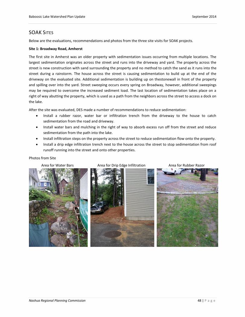
Baboosic Lake Watershed Plan Update September 2014
Nashua Regional Planning Commission 48 | P a g e
SOAK SITES
Below are the evaluations, recommendations and photos from the three site visits for SOAK projects.
Site 1: Broadway Road, Amherst
The first site in Amherst was an older property with sedimentation issues occurring from multiple locations. The
largest sedimentation originates across the street and runs into the driveway and yard. The property across the
street is new construction with sand surrounding the property and no method to catch the sand as it runs into the
street during a rainstorm. The house across the street is causing sedimentation to build up at the end of the
driveway on the evaluated site. Additional sedimentation is building up on thestonewall in front of the property
and spilling over into the yard. Street sweeping occurs every spring on Broadway, however, additional sweepings
may be required to overcome the increased sediment load. The last location of sedimentation takes place on a
right of way abutting the property, which is used as a path from the neighbors across the street to access a dock on
the lake.
After the site was evaluated, DES made a number of recommendations to reduce sedimentation:
Install a rubber razor, water bar or infiltration trench from the driveway to the house to catch
sedimentation from the road and driveway.
Install water bars and mulching in the right of way to absorb excess run off from the street and reduce
sedimentation from the path into the lake.
Install infiltration steps on the property across the street to reduce sedimentation flow onto the property.
Install a drip edge infiltration trench next to the house across the street to stop sedimentation from roof
runoff running into the street and onto other properties.
Photos from Site
Area for Water Bars Area for Drip Edge Infiltration Area for Rubber Razor

Baboosic Lake Watershed Plan Update September 2014
Nashua Regional Planning Commission 49 | P a g e
Area for Infiltration Steps
Site 2: Jebb Road, Merrimack
The second site was a property in Merrimack with far less sedimentation issues than the Broadway Road site. The
property consisted of two houses: the main house and a smaller house. The main house contained one small bare
spot on the access point to the dock and a bare spot from the downspout of the gutter. The adjoining property has
been affected by a swale and hidden culvert from a buried stream that the owner indicated the DES Subsurface
staff recommended more than ten years ago. The second house contains a surface bare spot from the culvert that
empties into the yard just before the lake. The area routinely backs up with water and soaks the lawn.
After the site was evaluated, DES made two recommendations to address the soaked area and slight erosion issue:
Provide the property owner with plantings for the wet area to reduce seepage from the culvert.
Occasionally move the down spout drain and redirect into a natural garden area.
Photos from Site
Area to be Planted Path to Deck Roof Drain under Deck

Baboosic Lake Watershed Plan Update September 2014
Nashua Regional Planning Commission 50 | P a g e
Roof drain under deck
Site 3: Scenic Vista Way, Merrimack
The last site visited was in Merrimack which was also affected by runoff from other properties. The largest issue on
the site is runoff from an upland stream, which collects sedimentation from a dirt “camp road” with earthen berms
created to divert runoff. There was an additional sloped dirt driveway with less sedimentation issues. The camp
road converges with a downslope paved road that increases the velocity of the stormwater causing more erosion
and increasing the contaminant load from surrounding properties such as fuel, fertilizers and salts. The paved road
ends at the site but continues into a brick driveway and down to the lake. The majority of the water is channeled
untreated into a storm drain emptying into the lake next to the site. The garage next to the drain routinely floods.
A plume of sedimentation was observed in the Lake on the day of evaluation. The plume creates a soft beach for
the property due to the current flow, which minimizes the need for beach nourishment.
The recommendations from NH DES to reduce the plume and sedimentation require collaboration with the
adjoining land owner who owns the forested property that surrounds Scenic Vista Way.
Replace earthen berms constructed by homeowners (which are unintentionally directing sediment off
unpaved road into stream) with rubber razors directed to well establish vegetated areas.
Install rubber razors to prevent sediments from compacted roadway onto property
Address storm drain and plume with NH DES, town and property owners in the future.

Baboosic Lake Watershed Plan Update September 2014
Nashua Regional Planning Commission 51 | P a g e
Photos from Site
Sedimentation from Dirt Road Plume in Lake from Runoff
Sediment in Stream

Baboosic Lake Watershed Plan Update September 2014
Nashua Regional Planning Commission 52 | P a g e
SOAK UP THE RAIN PROPERTY ASSESSMENT FIELD SHEET
Date Project Manager/ Crew Leader ________________ Landowner Name ___ Address ___ Watershed / Nearest Receiving Water ____________________________ Impairment(s): ______________________
PART A: PROPERTY OWNER INTEREST
If you answer “No” to any of these questions, it is recommended that you look for an alternative property.
1. Have you spoken with the homeowner? Yes / No 2. Is the homeowner interested in installing a stormwater
best management practice (BMP) on their property? Yes / No 3. Is the homeowner willing to take responsibility for BMP maintenance? Yes / No
PART B: INITIAL PROPERTY ASSESSMENT – IS THERE A STORMWATER ISSUE HERE?
STEP 1: Speak with the property owner and take a look around the property to determine 1) where the
stormwater is coming from, 2) where it travels, 3) where it ends up, and 4) any problems it may cause along the
way. It may help to draw a sketch. Answer the following questions to help complete the initial assessment.
1. For demonstration projects only is the potential BMP location highly visible in the community? Yes/No
2. Complete the following for each identified source of stormwater. See the following list for a description of
common stormwater problems.
Roof Has gutters? Y/N Has gutter downspout buried underground? Y/N Runoff Stays on the property Runs off of the property into (circle one) road / collection system Causes a problem. Description ____________________________________________________ ___________________________________________________________________________________________ Driveway Runoff Stays on the property Runs off of the property into (circle one) road / collection system Causes a problem. Description ____________________________________________________ ___________________________________________________________________________________________ Walkway/Paths Runoff Stays on the property Runs off of the property into (circle one) road / collection system Causes a problem. Description ____________________________________________________ ___________________________________________________________________________________________ Yard/Lawn Runoff Stays on the property Runs off of the property into (circle one) road / collection system Causes a problem. Description ____________________________________________________ ___________________________________________________________________________________________ Other Areas Other Source: ________________________________________________________________________________

Baboosic Lake Watershed Plan Update September 2014
Nashua Regional Planning Commission 53 | P a g e
Runoff Stays on the property Runs off of the property into (circle one) road / collection system Causes a problem. Description ____________________________________________________ ___________________________________________________________________________________________
STEP 2: Consider your answers to the questions above. More than one stormwater BMP may be needed to address
the stormwater concerns you have identified. Once you have decided which concern(s) to address, it’s time to look
at the types of practices that could help. Fortunately, you have multiple options for finding a solution! Part C of this
worksheet, the attached flow charts, and the Do-It-Yourself Fact Sheets in the Homeowner’s Guide are all great
next steps for choosing an appropriate BMP to meet the needs of the property and address concerns.
- - - - - - - - - - - - - - - - - - - - -- - - - - - - - - - - - - - - - - - - - - - - - - - - - - - - - - - - - - - - - - - - - - - - - - - - - - -
PART C: BMP LOCATION AND TYPE SELECTION
STEP 1: Answer the following questions to help consider limitations of the property and BMP location.
A. Are any of the following constraints present or suspected in the area where BMP installation is being
considered? To what degree?
B. Does the BMP location meet the following criteria? You should be able to say “yes” to all. If not, look for a new
location.
The proposed location is in the path of the stormwater flow.
For infiltration BMPs, the proposed location is at least 10’ away from building to prevent seepage into
basement.
Underground utilities/structures (Call Dig Safe) Unknown Low Moderate High
Shallow Bedrock (e.g., rocky outcroppings present) Unknown Low Moderate High
High Water Table (e.g., areas of standing water/ponding/persistent wet areas)
Unknown Low Moderate High
Large Rocks/Boulders Unknown Low Moderate High
Hard and/or Compacted Soil Unknown Low Moderate High
Common Stormwater Problems/Issues – Use this list to help fill in number 2 above
Flooding and/or persistent wet areas: standing water on or near property
Water in basement: water entering homeowner basement through foundation
Erosion: bare soil, exposed rocks, gully formation along path of stormwater flow
Pollutant runoff potential: known or suspected pollutants from property
Fertilizer or lawn chemicals are applied to the property
Pets reside at the property.
If this is your first assessment, please complete PARTS A and B. DES will assist with remainder of form.

Baboosic Lake Watershed Plan Update September 2014
Nashua Regional Planning Commission 54 | P a g e
The proposed location is away from drinking water wells and tree roots, and at least 15 feet away from a
septic tank or leach field.
The proposed location meets any other required local setbacks.
The proposed location is accessible for construction and maintenance activities.
For infiltration BMPs, a simple perc test drains completely within 24 hours.
STEP 2. The primary goal of Soak up the Rain is to infiltrate stormwater. If features of your property make
infiltration difficult or impossible, the goal is instead to safely move stormwater to an area where it can infiltrate or
to an area where it can be stored, treated, and slowly released to reduce impacts to nearby stream, lake or pond.
Review the following recommendations and considerations in order to select the most appropriate BMP for your
property. Refer to the Homeowner’s Guide for more detailed descriptions of each BMP.
A. If the BMP location allows for infiltration…
The following BMPs promote infiltration of stormwater into the ground. Recommendations for selection
based on the property and homeowner preferences are included in the table to the right.
Infiltration BMPs
Dripline infiltration trench
Driveway infiltration trench
Dry well
Infiltration steps
Rain garden
Pervious pavers
B. If the property is not suitable for infiltration… The following BMPs can be used to capture runoff, slow it down, and spread it out to reduce erosion and flooding problems.
Water Conservation BMPs
Rain barrel – A rain barrel can collect roof runoff from a gutter downspout or simply from a roof valley when appropriately placed to catch the concentrated flow.
Safe Conveyance BMPs
Vegetated swale Water bar
Congratulations! You have completed the property assessment. Use this information to
develop your property plan. Don’t be afraid to get creative with your design. For example,
From roof runoff
With gutters and downspout
Rain Garden
No gutters from roof edge Dripline infiltration trench
No gutters from roof valley Dry well
On steep slopes Infiltration steps
Low maintenance
Dry well, infiltration trench, or return maintained areas (such as lawn) to a natural, unmaintained condition.
Aesthetics Rain garden, pervious pavers, or infiltration steps
Before proceeding to Step Two, think about whether any items above would
eliminate the BMP location or the property altogether.
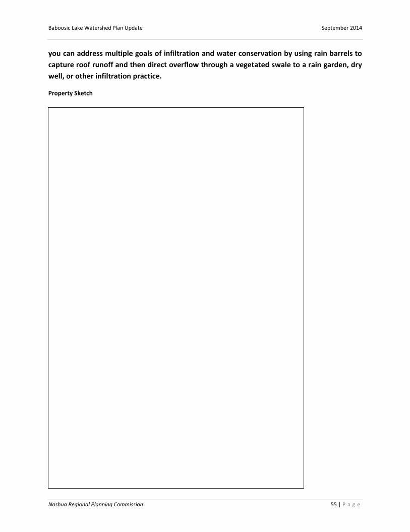
Baboosic Lake Watershed Plan Update September 2014
Nashua Regional Planning Commission 55 | P a g e
you can address multiple goals of infiltration and water conservation by using rain barrels to
capture roof runoff and then direct overflow through a vegetated swale to a rain garden, dry
well, or other infiltration practice.
Property Sketch