ASSESSMENT RPT PROSP SURV - Ontario · 2017-01-17 · Assessment Report fpecting ... A Magellan OPS...
16
-.\\\n Assessment Report fpecting Survey on the 10 Mile Creek Property, English Option Confederation Minerals Ltd. Located in the Gerry Lake Claim Sheet (G-1782) 2.19H 7 Red Lake Mining Division NTS 52 K/14 NW Ontario O M W K O M O Claims Prospected: KRL 1184500, 1184552, 1184555 Survey Date: September 26, 28, 30, 1998 G. J. Campbell, MSc October 21, 1998
-
Upload
hoangduong -
Category
Documents
-
view
216 -
download
0
Transcript of ASSESSMENT RPT PROSP SURV - Ontario · 2017-01-17 · Assessment Report fpecting ... A Magellan OPS...
-.\\\n
Assessment Report
fpecting Survey on the 10 Mile Creek Property, English Option
Confederation Minerals Ltd.
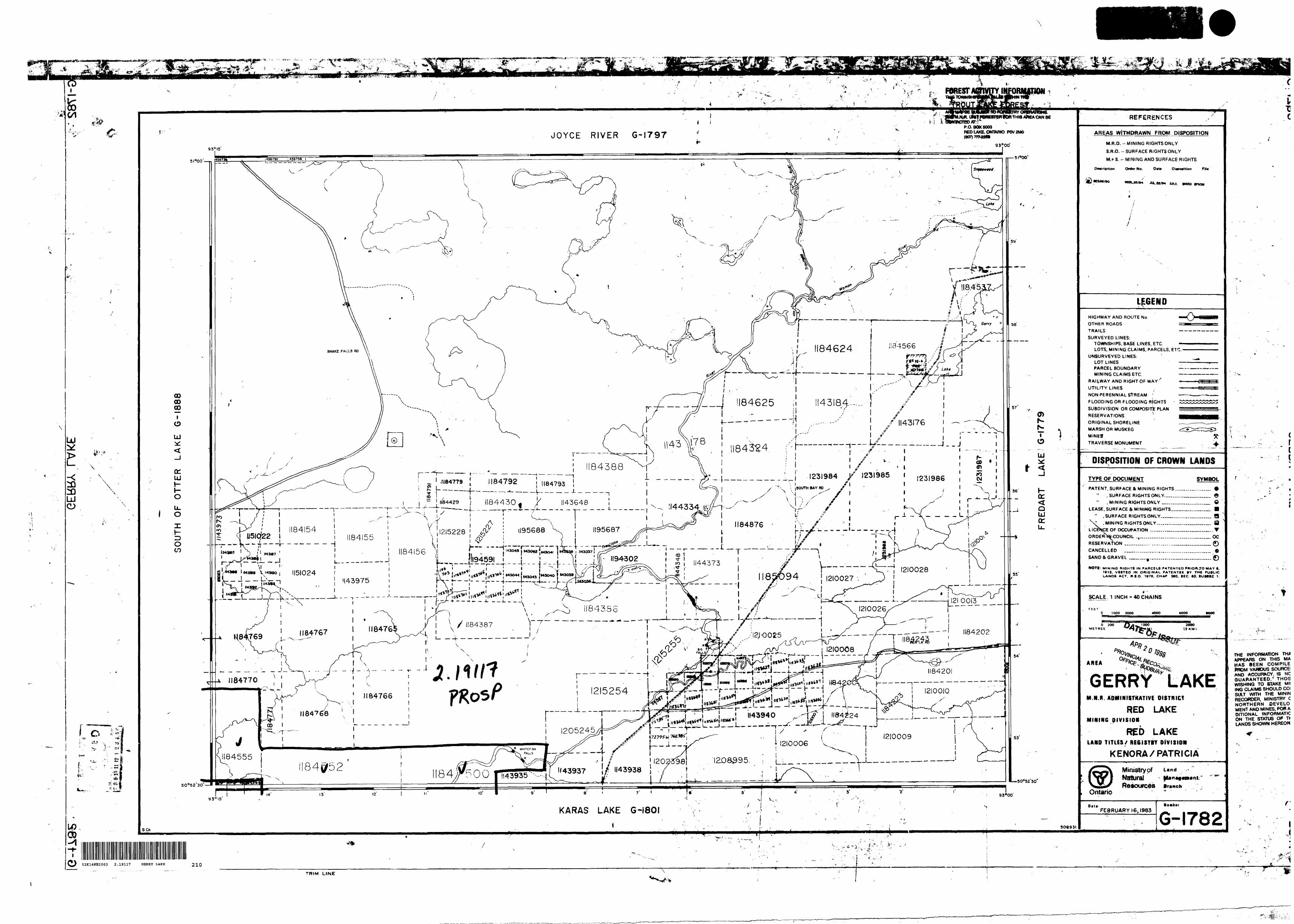
Located in the Gerry Lake Claim Sheet (G-1782)
2.19H 7
Red Lake Mining Division
NTS 52 K/14
NW Ontario
O M
W K
O M O
Claims Prospected: KRL 1184500, 1184552, 1184555 Survey Date: September 26, 28, 30, 1998
G. J. Campbell, MSc October 21, 1998
2
Table of Contents
52K14NE2003 2.19117 GERRY LAKE 010C 0326
I.0 Summary..................................................................^
2.0 Introduction............................................................................................................................3
3.0 Location and Access ...............................................................................................................3
4.0 Property .................................................................................................................................3
5.0 Work History.........................................................................................................................3
6.0 Regional Geology ...................................................................................................................6
7.0 Local Geology ........................................................................................................................6
8.0 Work Program........................................................................................................................?
9.0 Results...................................................................................................................................?
10.0 Recommendations ..................................................................................................................7
II.0 References ..............................................................................................................................7
List of Figures and Maps
Figure l Location and Access Map............................................................................................4
Figure 2 Land Position..............................................................................................................5
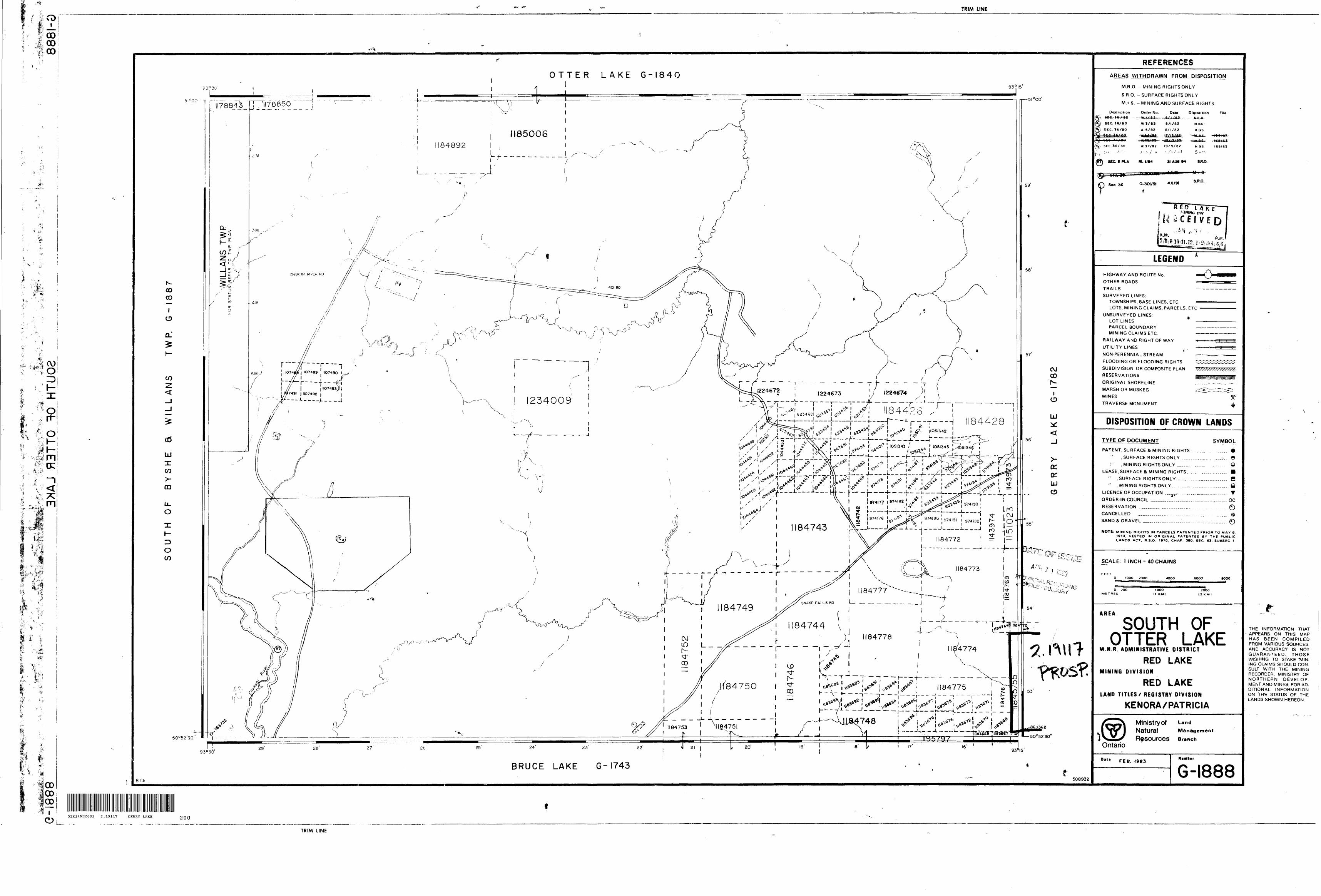
Map l Prospecting Survey, 10 Mile Creek Property..................................................in pocket

1.0 Summary
A prospecting survey was initiated on the 10 Mile Creek property which was optioned from Perry English of Red Lake by Confederation Minerals Ltd. The objective of the survey was to locate any mineralized outcrop on the property and find the claim boundary prior to line-cutting for a ground geophysical survey. An old hole drilled by Selco on the property could not be located. No outcrop has been discovered to date on the property.
2.0 Introduction
The 10 Mile Creek property was optioned as part of an ongoing exploration programme for volcanogenic massive sulfide (VMS) deposits in the Confederation Lake greenstone belt. This report details a prospecting survey initiated in order to locate outcrop and the claim boundaries prior to line cutting and a ground HLEM (horizontal-loop EM) survey.
3.0 Location and Access
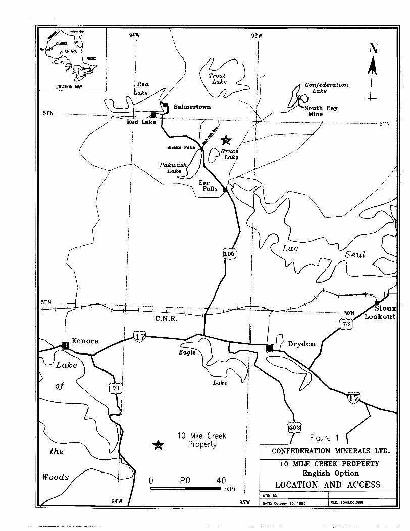
The 10 Mile Creek property is located in Northwestern Ontario in the Gerry Lake Claim Sheet (G-1782), approximately 40 km southeast of the town of Red Lake (Figure 1). Access is by the Snake Falls road which leads northeast from Hwy. 105 at the village of Snake Falls. A bush road goes southward to the property about 18 km along the Snake Falls road from Hwy. 105. Forest cutting operations and road construction is currently active in the immediate vicinity of the property.
4.0 Property
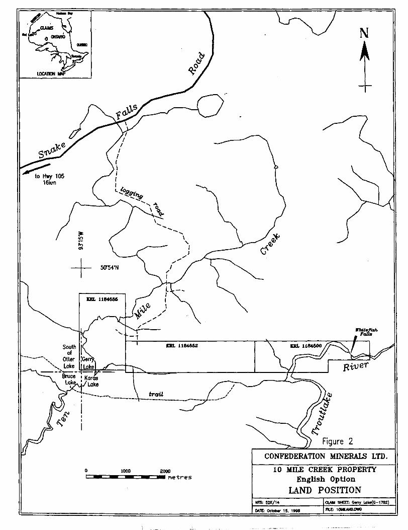
The property consists of three(3) mining claims containing of 47 units (Figure 2).
Claim Number Units Recording Date Expiry DateKRL1184500 16 units December 16, 1996 December 16, 1998KRL 1184552 16 units December 16, 1996 December 16, 1998KRL 1184555 15 units December 16, 1996 December 16, 1998
5.0 Work History:
1975:Selco Exploration flew a Mark VI Input AEM survey as part of their Dixie Extension program.
1976:Selco Exploration did ground magnetic and HLEM surveys with follow-up diamond drilling which resulted in the discovery of a the Dixie 3 deposit, located about 400m south of the claims. The deposit contains about 150,000 tons of 10 07o combined Cu and Zn. Following this discovery, the Dixie 3 North Extension grid was established over part of the present claims. Approximately 25 km of grid was cut and a magnetic and HLEM (horizontal loop EM) survey was completed. A Geonics EM-17 unit,
Confederation Lake
r\Bruce(/LO*
Eagle\ l *^x—
ioJbe ^
10 Mile Creek Property
CONFEDERATION MINERALS LTD10 MILE CREEK PROPERTY
English Option
LOCATION AND ACCESS
to Hwy 105 16km
Bruce ! Karas Lake
CONFEDERATION MINERALS LTD.10 MILE CREEK PROPERTY
English OptionLAND POSITION
CLAIM SHEET: C*rry Lok^C-1782)
employing only one (1) high frequency (1600 Hz) on a 400 foot coil separation was used to complete the survey. Two (2) short, weak conductors believed to be bedrock responses were outlined.
1977:One hole (D-29) was drill by Selco Exploration to test the northerly conductor which now occurs in the northern part of KRL 1144555 (Map 1). The drill hole intersected 0.06 "/o Cu, 1.4507o Zn, 0.002 oz/t Au and 0.01 oz/t Ag over 1.2 feet. The bedrock intersected consisted of porphyritic rhyolite and altered dacitic rocks which are intruded by numerous altered granodiorite and granite dykes. Overburden was 22m thick.
1983:Selco re-flew the area with a more sensitive version of the Mark VI INPUT system in the search for deeper, more subtle anomalies. No significant AEM anomalies were found on the property.
1991:The Ministry of Natural Resources, Mines and Minerals Division, released the results of an airborne electromagnetic-magnetic survey, flown over the Uchi- Confederation Lake area. Weak AEM anomalies found on the property were attributed to conductive clay overburden.
1996:The 10 Mile Creek property was staked by Perry English.
1998:Confederation Minerals optioned the 10 Mile Creek property. A review of the AEM records from the Government survey of 1991 indicates some of the AEM responses believed due to overburden may in fact be due to conductors in the bedrock (Limion, 1998).
6.0 Regional Geology
The area is underlain by Archean rocks of the Confederation Lake greenstone belt which occurs within the Uchi Subprovince. The greenstone belt in the area of the property consists of two, south-facing, east - west trending belts of metavolcanic and metasedimentary rocks, intruded by irregular dykes, sills and stocks of felsic and mafic plutonic rocks. Metamorphism in the area is amphibolite facies. The belts are separated by a granitic intrusion. The property is located in the northern edge of the southern belt and is believed to be to be part of the Confederation Lake assemblages. The Confederation Lake assemblage is 2730 Ma and is interpreted to have formed in an arc environment. This assemblage is composed of felsic flows, tuffs and local breccias and porphyry, gabbroic and dioritic sills and dykes. Approximately 400m to the south of the property, the Dixie 3 deposit is found. It contains approximately 150,0001 of 1007o combined Cu and Zn and is hosted by altered felsic metavolcanics which occur immediately above(?) a quartz porphyry sill.

7.0 Property Geology
The property geology is interpreted from EM and magnetic surveys and one borehole of uncertain location. The property is underlain by intermediate and felsic metavolcanic and metasedimentary units intruded by numerous dykes and sills of granodiorite and granite. The claims are located on the flanks of prominent magnetic highs, both to the north and south. Stratigraphic tops in the area have always been interpreted to be south however drilling in the area suggests property scale variations exist and units may be repeated due to folding.
Borehole DDH D-29 (Thorsen, 1977) intersected 1.4507o Zn over 1.2 feet explaining a weak HLEM anomaly in the northern part of KRL 1184555. The sulfide zone occurred in dacitic rocks cut by altered granodiorite. Overburden was 22m thick and composed of clay. Folding may repeat the Dixie 3 horizon indicating the property should be re-surveyed using a lower frequency HLEM in order to penetrate the thick clay overburden.
8.0 Work Program
Tony Maciejewski of Red Lake was contracted to locate outcrop and the claim posts on the property. This work was done on September 26, 28, and 30, 1998 (Figure 3). A Magellan OPS unit (Model Trail Blazer) was used to accurately pin-point claim posts and any outcrop that was found.
9.0 Resultsr"Up l
No outcrop was located on the claim lines where prospected (F4gttfe-3). Vegetation consists mainly of spruce, balsam and some tamarack with local concentrations of birch and poplar. Alders and labrador tea bush are found in low lying swampy areas. Soils are clay-rich with some sand. An old drill hole on the property could not be located.
UTM Co-ordinates of Posts from MAGELLAN GPS Unit
Post l-KRL 1184555 483600mE 5637850mNPost 4 - KRL 1184555 482360mE 5637870mNPost 4 - KRL 1184552 483580mE 5636670mNPost 3 - KRL 1184552 483570mE 5635750mNPost 2 - KRL 1184500 486750mE 5635700mNDDH 3-46 485540mE 5635250mN
10.0 Recommendations
It is unlikely that an undetected orebody lies within 150m of surface. However, a new survey may detect small zones of satellite base metal mineralization which would encourage the use of time-domain EM systems. A Max-Min II HLEM survey is recommended to cover as much of the property as possible. A low frequency such as 444 Hz must be used to provide better resolution of bedrock conductors since the overburden consists of thick conductive clay.
I) |Tf"3 riO Northern Development V./I ILCII l\J and Mines
Ministry d Declaration of Assessment WorkPerformed on Crown Lands
Mining Act, Subsection 66(2), R.S.0.1990
Transaction Number (office use)
Assessment FHes Research Imaging
section 66(2) of the Mining Act. Under section 8 of the Mining Act. this Information is id correspond with the mlnlr i land holder. Questions about this collection should belines, 3rd Floor, 933 Rams*
52K14NE2003 2.19117 GERRY LAKE 900
Instructions: - For work performed on mining lands, use form 0241. - Please type or print in ink
1. Recorded holder(s) (Attach a list if necessaryjfx
OFFICE -SUDBi.RECEi V!
^Ontario, P3E
DEC 1 1A.M.
3B5.
Name ^. p , i . Y ^.J- VJ- (-4fr\ V^e*Clf6. n "^ '** ' f\Cre\. 'f ^'W
Address / FifST G**-w3 ,J i ,**X r wet,, DoX 3 1? Stu-fe 7^C r ̂ 0 ^Vnc HT" tt7-
'J /J T^ftrwfT), O^IJ ^ 9X /^ 2
Name '
Address
Client Number
Telephone Number
Fax NumberV-97?T
Client Number
Telephone Number
Fax Number
2. Type of work performed. Only regional surveys and prospecting work are allowed on Crown Lands before recording.For work performed after recording a claim or on other mining lands, use form 0241.
Work Type o. f 1 -TiCS*ficTi*ic
Dales Work From ^^ ^T Performed Day | Month
Global Positioning System Data (if available)
j^ffgr TO 3o o? /9^^j Year Day | Month | Year
Township/Area s— i L-Oerry Uipo
M or G-Plan Number '
G17&Z-
Office Use
Commodity
Total S Value of Work Claimed \ 3i l O
NTS Reference
Mining Division
Resident Geologist District
Please remember to: - complete and attach a Statement of Costs, form 0212;- provide a map showing contiguous mining lands that are linked for assigning work;- include two copies of your technical report;- provide proper notice to surface rights holders before starting work.
3. Person or companies who prepared the technical report (Attach a list if necessary)Name - .
Address ^J 'i 1^-7 r^ lclc5 IU//OK/ Pr, QkL^L. OK) UK.1&1
Name f 7 'i'
Address
Name
Addiess
Telephone Number3-Z-37U
Fax Number
Telephone Number
Fax Number
Telephone Number
Fax Number
4. Certification by Recorded Holder or Agent
(Print, do hereby certify that l have personal knowledge of the facts set forth in
this Declaration of Assessment Work having caused the work to be performed or witnessed the same during or after its completion and, to the best of my knowledge, the annexed report is true.Skjnalure of Recorded Holder or ""K f/fCAgent's Address
llty Pf. ourTelephone Number Fax Number
0240 (03/97)
999
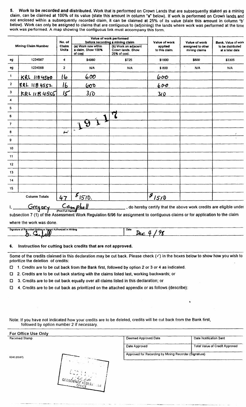
5. Work to be recorded and distributed. Work that is performed on Crown Lands that are subsequently staked as a mining claim, can be claimed at 1000Xo of its value (state this amount in column "a" below). If work is performed on Crown lands and not enclosed within a subsequently recorded claim, it can be claimed at 250Xo of its value (state this amount in column "b" below). Work can only be assigned to claims that are contiguous to (adjoining) the lands where work was performed at the time work was performed. A map showing the contiguous link must accompany this form.
Mining Claim Number
eg
eg
1
2
3
4
5
6
7
8
9
10
11
12
13
14
15
1234567
1234568
Kfti ne?tf5wW- 118^55*0-
KfcL M 8 4556"
Column Totals
No. of Claim Units
4
2
(k
It
If
^
47
Value of wor before recordin
(a) Work now within a claim. Show 100* of cost
54980
N/A
&00
koro
3 ID
\\*d i v "
*fS70.
k performed 3 a mining claim
(b) Work on adjacent Crown lands. Show 25* of cost.
5725
N/A
-0M
^
Value of work applied
to this claim
S 1600
S 800
kb®
hw3/0
*isn
Value of work assigned to other
mining claims
S800
N/A
Bank. Value of work to be distributed
at a later date
S3305
N/A
,,
_________ , do hereby certify that the above work credits are eligible under(Print Full Narnef
subsection 7 (1) of trie Assessment Work Regulation 6/96 for assignment to contiguous claims or for application to the claim
where the work was done.Signature of Recorded Authorized in Writing Date
6. Instruction for cutting back credits that are not approved.
Some of the credits claimed in this declaration may be cut back. Please check K) in the boxes below to show how you wish to prioritize the deletion of credits:
D 1. Credits are to be cut back from the Bank first, followed by option 2 or 3 or 4 as indicated.
D 2. Credits are to be cut back starting with the claims listed last, working backwards; or
D 3. Credits are to be cut back equally over all claims listed in this declaration; or
D 4. Credits are to be cut back as prioritized on the attached appendix or as follows (describe):
Note: If you have not indicated how your credits are to be deleted, credits will be cut back from the Bank first, followed by option number 2 if necessary.
For Office Use Only^^^^^^^^^^^^^^^^^^^Received Stamp
0240 (03/97)
Deemed Approved Date
Date Approved
Date Notification Sent
Total Value of Credit Approved
Approved for Recording by Mining Recorder (Signature)

Ontario Ministry of Statement of Costs for Assessment Credit
Transaction Number (office use)
Personal information collected on this form is obtained under the authority of subsection 6 (1) of the Assessment Work Regulation 6/96. Under section 8 of the Mining Act, this information is a public record. This information will be used to review the assessment work and correspond with the mining land holder. Questions about this collection should be directed to a Provincial Mining Recorder, Ministry of Northern Development and Mines, 3rd Floor, 933 Ramsey Lake Road, Sudbury, Ontario, P3E 6B5.
Work Type
PfO.Spe.clmr.
r li. 4- ^
Units of workDepending on the type of work, list the number of hours/days worked, metres of drilling, kilometres of grid line, number of samples, etc.
*- C*A.y5
i ' 5" -dloy f
9 1^^ * A Oil^11
Associated Costs (e.g. supplies, mobilization and demobilization).
fWpk^ai Pr,.JVi*c, 6^1t l-
^~(v^ ri of , roS~p
^'
Transportation Costs
iVv i locj?
Food and Lodging Costs
F
Ci.. C i i^GEoscierjcFAs;
Cost Per Unit of work
r-V
7
\ - - - -*"*^ i*x
i:: jESSMENT ~
Total Value of Assessment Work
Total Cost
(o if 2.1 OT)
(a^Ot
l Q-~2 1 bf)
2-Z. Li
SU'tt
15 'oq. 73
Calculations of Filing Discounts:
1. Work filed within two years of performance is claimed at 1000Xo of the above Total Value of Assessment Work.2. If work is filed after two years and up to five years after performance, it can only be claimed at 5007o of the Total
Value of Assessment Work. If this situation applies to your claims, use the calculation below:
TOTAL VALUE OF ASSESSMENT WORK x 0.50 = Total S value of worked claimed.
Note:- Work older than 5 years is not eligible for credit.- A recorded holder may be required to verify expenditures claimed in this statement of costs within 45 days of a
request for verification and/or correction/clarification. If verification and/or correction/clarification is not made, the Minister may reject all or part of the assessment work submitted.
Certification verifying costs:
e^se prir., do hereby certify, that the amounts shown are as accurate as may reasonably
(please print full name/
be determined and the costs were incurred while conducting assessment work on the lands indicated on the accompanying
Declaration of Work form as(recorded holder, agent, or slate company position with signing authority)
l am authorized to make this certification.
0212 (03/97)
PROVINCIAL RECORDING OFFICE -S'JDDUR'
R EC E I v -' '-: D
DEC 1 ' 1893
Signature Date

OntarioMinistry of Ministers duNorthern Development DeVeloppement du Nordand Mines et des Mines ^^^
Geoscience Assessment Office 933 Ramsey Lake Road
February 25, 1999 6th FloorSudbury, Ontario
CONFEDERATION MINERALS LTD. P3E 6B5 SUITE 745, P.O. BOX 369100 KING STREET WEST Telephone: (888) 415-9846 TORONTO, ONTARIO Fax: (877)670-1555 M5X-1E2
Visit our website at: www.gov.on.ca/MNDM/MINES/LANDS/mlsmnpge.htm
Dear Sir or Madam: Submission Number: 2.19117
Status Subject: Transaction Number(s): W9820.00109 Deemed Approval
We have reviewed your Assessment Work submission with the above noted Transaction Number(s). The attached summary page(s) indicate the results of the review. WE RECOMMEND YOU READ THIS SUMMARY FOR THE DETAILS PERTAINING TO YOUR ASSESSMENT WORK.
If the status for a transaction is a 45 Day Notice, the summary will outline the reasons for the notice, and any steps you can take to remedy deficiencies. The 90-day deemed approval provision, subsection 6(7) of the Assessment Work Regulation, will no longer be in effect for assessment work which has received a 45 Day Notice. Allowable changes to your credit distribution can be made by contacting the Geoscience Assessment Office within this 45 Day period, otherwise assessment credit will be cut back and distributed as outlined in Section #6 of the Declaration of Assessment work form.
Please note any revisions must be submitted in DUPLICATE to the Geoscience Assessment Office, by the response date on the summary.
If you have any questions regarding this correspondence, please contact Steve Beneteau by e-mail at [email protected] or by telephone at (705) 670-5855.
Yours sincerely,
ORIGINAL SIGNED BYBlair KiteSupervisor, Geoscience Assessment OfficeMining Lands Section
Correspondence ID: 13417
Copy for: Assessment Library

Work Report Assessment Results
Submission Number: 2.19117
Date Correspondence Sent: February 25, 1999 Assessor: Steve Beneteau
Transaction First Claim Number Number
W9820.00109 1184500
Section:9 Prospecting PROSP
Township(s) l Area(s)
GERRY LAKE
Status
Deemed Approval
Approval Date
February 22, 1999
Correspondence to:
Resident Geologist Red Lake, ON
Assessment Files Library Sudbury, ON
Recorded Holder(s) and/or Agent(s):
Gregory Campbell OSHAWA, ONTARIO
CONFEDERATION MINERALS LTD. TORONTO, ONTARIO
PERRY VERN ENGLISH RED LAKE, Ontario
Page: 1
Correspondence ID: 13417
f y.•t i. i 1 ' OTRIM LINE
eooo
V -
.V --,r-
* y -
j*1 *y
*- f - i
O
mi
l
f. , V..
"i,.
1-ii
000000
S lo
OTTER LAKE G-1840
5( 0 00'
N-coCO
l o
UJx
m
LLox
oC/)
50052'30"—'
• 78850^ j
kkXi tf i\i-----^:--u:...--^^^^.i---..,^K l -;t^l^]ff jf i. f :1^ ; ^:w^^I^j^X 1 ^**^" ^ ~3? ! ?"' IL^ 1 "" t*0* ' -\* ^ ^ ' j(* i~ i^'."""iTr'Z^i^ro 1 X i ' S'o*1 'o"*1 'o*^ i.^ l-o*1" ' ^ ^ ^ l/? \3? ^^t*** l S
i^ -^ i so x Vv i. .. —.1,- -a3 ' -tv5 1 ^^r i !^^^^ 974190 l , , , ^~ l tVJH y, ' ' 374J 91 c*~7AL^? r-— * f—\G l l 3f-*l-J,i| l CJ
~ - -j — — — - — — — —— —J p^ H LO1 ^ l —
'^MX'WL.l---Jj.— ^J — __ J.
16 l930 I5'
BRUCE LAKE G-1743t
B-Ch 508.932
REFERENCES
ARE AS WITHDR AWN DI SPOSI TION
M.R.O. MINING RIGHTSONLY
S.R.O. - SURFACE RIGHTS ONLY
M.+ S. -MINING AND SURFACE RIGHTS
Description Order No. Data Ditpoiition File
SEC. J*/*O
SEC.36/80
w. i/ea e/t/aa w. 5/a? 8/i/aJ
Mas. Mas
SEC 36/80 W.3T/8Z I9/5/8Z
-4**4*4
MSS 165163
SEC. e PLA m. I/M H AIM M
•MMM""-
S*c. 0-3CH/9I
f
4/1/91 S.R.O.
LAKEDfV
S C E l V E
LEGEND
HIGHWAY AND ROUTE No.
OTHER ROADS
TRAILS
SURVEYED LINES:TOWNSHIPS. BASE LINES. ETCLOTS, MINING CLAIMS, PARCELS. ETC
UNSURVEYED LINES;LOT LINESPARCEL BOUNDARYMINING CLAIMS ETC
RAILWAY AND RIGHT OF WAY H
UTILITY LINES
NON-PERENNIAL STREAM
FLOODING OR FLOODING RIGHTS
SUBDIVISION OR COMPOSITE PLAN
RESERVATIONS
ORIGINAL SHORELINE
MARSH OR MUSKEG
MINES
TRAVERSE MONUMENT
DISPOSITION OF CROWN LANDS
TYPE OF DOCUMENT SYMBOL
PATENT. SURFACE 8c MINING RIGHTS ....... ^ 0
.SURFACE RIGHTS ONLY.... ^...,, . ....,. ©
,'" , MINING RIGHTSONLY _... ,. ....... Q
LEASE, SURFACE ft MINING RIGHTS. ,, ............... B
" .SURFACE RIGHTSONLY.-—...................... H
" , MINING RIGHTS ONLY......... ....... . , U
LICENCE OF OCCUPATION .... y,..^..................... T
ORDER-IN COUNCIL ..........!......... . . . ^, OC
RESERVATION ___..... ......,......................... ©
CANCELLED ___.......___ —,... . ,. ®
SAND fit GRAVEL ._.............J........... (J)
NOTE: MINING RIGHTS IN PARCELS PATENTED PRIOR TO MAY 6. 1913. VESTED IN ORIGINAL PATENTEE 8V THE PUBLIC LANDS ACT, R S.O 19?0. CHAP 380, SEC 63, SUBSEC 1
SCALE ; 1 INCH * 40 CHAINS
FEET
O 1000 2OOO 4OOO eooo 8000
O 2OOMETRES
10OOl 1 KM]
200O(2 KM l
AREA
SOUTH OF OTTER LAKE
M.MR ADMINISTRATIVE DISTRICT
RED LAKEMINING DIVISION
RED LAKELAND TITLES/ REGISTRY DIVISION
KENORA/PATRICIA
MinistryofNatural
Ontario
LandManagement
Branch
FEB.
G-1888
52K14NE2Q03 2.19117 GERRY LAKE 200
THE INFORMATION THAT APPEARS ON THIS MAP HAS BEEN COMPILED FROM VARIOUS SOURCES, AND ACCURACY IS NOT GUARANTEED. THOSE WISHING TO STAKE "MIN ING CLAIMS SHOULD CON SULT WITH THE MINING RECORDER. MINISTRY OF NORTHERN DEVELOP MENT AND MINHS, FOR AD DITIONAL INFORMATION ON THE STATUS OF THE LANDS SHOWN HEREON
TRIM LINE
\
REFERENCESP.O.BQK 6003RED LAKE, ONTARIO POV2MO AREAS WtTHDRAWN FROM DISPOSITIONJOYCE RIVER G-I797
M.R.O. - MINING RIGHTS ONLY
S.R.O. - SURFACE RIGHTS ONLY
M.+ S. - MINING AND SURFACE RIGHTS
Dateription Qrtttr No. Dat* Di^xMHion File
LEGEND
HIGHWAY AND ROUTE No.
OTHER ROADS
TRAILS
SURVEYED LINES:TOWNSHIPS, BASE LINES, ETC.
1184624 LOTS, MINING CLAIMS, PARCELS, ETC.
UNSURVEYED LINES:LOT LINESPARCEL BOUNDARYMINING CLAIMS ETC.
R Al LWAY AND R IGHT OF WAY -f
UTILITY LINES
NON-PERENNIAL STREAM '
FLOODING OR FLOODING RIGHTS1184625 1143184---, \SUBDIVISION OR COMPOSITE PLAN
RESERVATIONS
ORIGINAL SHORELINE
MARSH OR MUSKEG
MINE?
TRAVERSE MONUMENT1143 W l j 7*———^———..—— —-11843^4DISPOSITION OF CROWN LANDS
1184388TYPE OF DOCUMENT
en .5 r——t———-—2 ! , \
PATENT. SURFACE A MINING RIGHTS
" .SURFACE RtGHTS ONLY
.MINING RIGHTS ONLY
LEASE, SURFACE St MINING RIGHTS
" .SURFACE RIGHTS ONLY
\* .MINING RIGHTS ONLY
LICENCE OF OCCUPATION
ORDERS-COUNCIL . 1..... __ ....................... _ . OC
RESERVATION ............^........,.................... (J)
CANCELLED __ ............,......................... C
SAND 4 GRAVEL __ ....,. _ ............. __ ..........lg)
-—-J-----1184430
1194302NOTf: MINING RIGHTS IN PARCELS PATENTED
1913, VESTED IN ORIGINAL PATENTEE tv THE *U*UC LANDS ACT, K.f.O. 1*70, CHAP MO. fEC. S3. *U**EC 1.II85O94
^, j ^ _ p a _ ̂ , i
1 INCH - 40 CHAINS
II843S6l T -*- -
II84767
THE INFORMATION THAT APPEARS ON THIS MAP HAS BEEN COMPILED PROM VARIOUS SOURCES, *ND *eCUR*CY. IS NOT GUARANTEED/ THOSE WISHING TO STAKE MIN ING CLAIMS SHOULD CON- SUIT WITH THE MINING RECORDER, MINISTRY OF NORTHERN DEVELOP MENT AND MINES. FOR AD DITIONAL INFORMATION ON THE STATUS OF THE LANDS SHOWN HEREON.
. M//T GERRII84770
M.N.R. ADMINISTHATIVE DISTRICT
RED LAKEMINING QIVISIOM
RED LAKELAND TITLES/ REGISTRY DIVISIOM
KENORA X PATRICIA
~
^—J—- — — J.——-^ —lI205245
120 8395. i— —— — — — ——— .— —. —. -——— — —184^52 Ministry Of Land
NaturalBranch
1143937
, Ontario
KARAS LAKE G-1801 i
FEBRUARYI6.1983 G-I782
52K14NE2003 2.19117
TRIM UNI
G-1782
74430^174400*1i **V1 i^30 ^
A* 1V*l j—J__-.-- ——-l 1202399
-—-
-,-- 1202400
1(84263
-;fe"^.
-if-
f
REFERENCES l
AREAS WITHDRAWN FROM DISPOSITION
M.R.O. - MINING RIGHTS ONLY
l.R.0. - SURFACE RIGHTS ONLY
M.-f l, - MfWflB AND SURFACE RIGHTS
On** No. DM DhpMMon FB.
{jj -13-S3
LEGENDHIGHWAY AND ROUTE No. OTHER ROADS TRAILS
SURVEYED LINES:TOWNSHIPS, BASE LINES, ETC.LOTS. MINING CLAIMS, PARCELS, ETC
UNSURVEYED LINES:LOT LINESPARCEL BOUNDARYWIN ING CLAIMS ETC."
RAILWAY AND RIGHT OF WAY H UTILITY LINES
, S
FLOODING OR FLOODING RIGHTSSUBDIVISION OR COMPOSITE PLANRESERVATIONSORIGINAL SHORELINEMARSH OR MUSKEGMINESTRAVERSE MONUMENT
x
DISPOSITION OF CROWN LANDS
TYPE OF DOCUMENT- . SYMBOL
PATENT, SURFACE A MINING RIGHTS.——-.,......,. 4ft" . SURFACfifllGHTS ONLY-.........^.....^... e" , MINING RIGHTS ONLY ___ . ,....^....... Q
L EASE, SURFACE,* MINING RIGHTS . ...... .. B
" *, SURFACE l* JGHtS ONLY............... __ .... B" .MINING RIGHTS ONLY....... ..........,..... __ H
UCENCE OF OCCUPATION .. .... .............,.__ TORDER-IN-COUNCIL .............................m.... OC
RESf RV4JION JL.^.,...,............-...........___
CANCELLED^ ......^......................M.-....- 9SAND ft GRAVEL ..m......_.........,........m......
NOTI; MINING MIQMT* IN PARCf L* PATINTtO PMIOM TO MAV f, 1tl3, VimO IN ONIQTNAL PATINTtt |Y TMf fUHLltUANOS ACT. n.*.o. IBTO, CHAP. 3M. *tc. *3, tuMlc i.
SCALE: 1 INCH-40 CHAINS.
O 1000 /2000 aooo
2000 [2 KM)
APK 2 J ?899'
LAKE
*. *\
C
\ i
\
/'-..y
s
DISTRICT r
RED LAKE
KENORA/PATRICIA
THE INFORMATION THAT. APPGARS ON THIS MMF\ HAS BEEN CQMPILgO FROM VARIOUS 3OUKCO,
I AND ACCURACY IS NOT GUArtANTEfib. THOSE \MSHWG TO SBlKE MW- (NO O4iM6 SHOULD CON
/feutr VWTH WHC MINING/REC*RO6R, MINISTRY OF
NORTHERN -DEVELOP MENTT AMD MINE&FOA AD- DlTlOWAl, INFORMATION ON THE STATUl OF THE LAHPS-'SHOWN HERtON.

Gerry LoSoun
Otter li~
Lake {KRL 1144555 (15 units)
Selco D-29 (approx19771.2 ft 1.457c Znob-22m LOCATION MAP
metre
KRL 1144552 (16 units) KRL 1144500 (16 units)
Bruc
150,000 tons
TiLJ lP Q P n rV-^ V-H v^ l l \^s
C a'm Post: ocated/nferred a m eel oundary o r o e
Pne rost Prospect'nq Traversei -—J
C a'm L'ne
wamp o
i * r~") is~^ /~~-*{ /'"N i IS~~\ ^~N __s ,^~N X—S s—NLoqqinq Koaa-—S -—^ -—S
Overburden r^\ i. c~^ -L o^ oo vurvey Dates: Sept. 26, zo, o
ril
NTS: 52K/M
DATE: October 8, 1998
CLAIM SHEET: Gerry Lake(G-1782)
E LE: 10MILE.DWGf\
52K14NE2003 2.19117 GERRY LAKE 230