
RPT ON PROSP GRAB SAMPLES & VLE-EM SURV … · CLAIM #1218739 PORCUPINE MINING ... has given the...
83
42A05NE2021 2.19548 TURNBULL 010 Report on: PROSPECTING GRAB SAMPLES AND VLF EM-16 FLAG SURVEY m TURNBULL TOWNSHIP CLAIM #1218739 PORCUPINE MINING DIVISION CLAIM MAP SHEET # G-3250 NTS SHEET 42 A/5 LONGITUTE: 81 DEGREES, 43 MINUTES WEST LATITUDE: 42 DEGREES, 29 MINUTES NORTH Submitted to: ONTARIO PROSECTOR'S ASSISTANCE PROGRAM 1998 in fulfillment of grant number OP 98-333 #.1954 8 Submitted by: PETER J.A. BILENKI Prospector's Licence K22227 Client number 108346
Transcript of RPT ON PROSP GRAB SAMPLES & VLE-EM SURV … · CLAIM #1218739 PORCUPINE MINING ... has given the...
42A05NE2021 2.19548 TURNBULL 010
Report on:
PROSPECTING GRAB SAMPLES AND VLF EM-16 FLAG SURVEY
m
TURNBULL TOWNSHIP
CLAIM #1218739
PORCUPINE MINING DIVISION CLAIM MAP SHEET # G-3250 NTS SHEET 42 A/5
LONGITUTE: 81 DEGREES, 43 MINUTES WEST LATITUDE: 42 DEGREES, 29 MINUTES NORTH
Submitted to:
ONTARIO PROSECTOR'S ASSISTANCE PROGRAM 1998
in fulfillment of grant number OP 98-333
#.1954 8
Submitted by:
PETER J.A. BILENKI Prospector's Licence K22227 Client number 108346

11:46 HM FORPRO RESOURCES LTD. 705 255 2213 P. ei
June 9, 1999
Please be advised that following claim holders) has given the listed parties authorization to act as an agent for the Cling of assessment work on any claims that he is the recorded holder of in Turnbull Twp.
This authorisation remains in effect until further notice is given.
Claim Holder Claim Holders Signatures
David V. Jones Box 1513South Porcupine, Ont. PON l HO
client #: 149868phone: (705)235-2474
fax: (705)235-2213
Authorized Agent for Filing Assessment Work
PeterBilenki Box 1043 Schumacher, Ont. PON 1GO
client #: 108346phone: (705)360-5177
fax: same
Table of Contents 42A05NE2021 2.19548 TURNBULL 010C
Statement of Geophysical Exploration and Prospecting ExperienceStatements of Ownership/ResponsibilitiesProject Site AccessArea and Property GeologyEconomic GeologySummary of Previous WorkSummay of OPAP 1998 Assessment WorkAnalysis of VLF-EM DataRecommendations Extracted from Analysis of VLF-EM Data
345678
101114
Figures
Figure 1: General Location MapFigure 2: Township Reference MapFigure 3: Claim Sketch of Rousseau-Larche Property (circa 1959)Figure 4: Claim Sketch of present claims 1218739 and 1218740Figure 5: ERLIS MDI Map of Turnbull TownshipFigure 6: Printout of ERLIS MDI page 1 of 2Figure 7: Printout of ERLIS MDI pqge 2 of 2Figure 8: Claim Sketch of Pyrotex Mmfrra and Exp. Co. Ltd. property (circa 1967).Eigurp-ftr Claim Map (Back Peekct)^,/^^-Figure 10: Prospecting and Topographic Notes Map (Back Pocket)Figure 11: VLF EM-16 Survey Map (Back Pocket)
Appendices
Appendix 1: Appendix 2: Appendix 3: Appendix 4: Appendix 5: Appendix 6: Appendix 7: Appendix 8:
Samples DescriptionsSamples LocationsAssay SheetsDaily Activities Log September 4 - November 13,1998Grid LogProspecting/sampling daily logVLF EM 16 Specifications and OperationVLF Log
OntarioGEOLOGY AND
PRINCIPAL MINERALSOF ONTARIO
Major Mineral Deposits Past and Present
Gold
Silver
Iron
Copper-Nickel
Zinc-Cop per
Platinum-Palladium
4- Uranium
Industrial Minerals
SUPERIOR AND SOUTHERN PROVINCES NEO-TO MESOPROTEROZOIC
Scale 1 B 000 000
O 50 100 150 ?00 Kilometres
150 Miles
LEGEND8PHANEROZOIC
MESOZOICCRETACEOUS
l l Sedimentary rocks
PALEOZOIC DEVONIAN
^^^B Sedimentary rocks
SILURIAN
Sedimentary rocks
ORDOVICIAN
^^^1 Sedimentary cocks
__ CAMBRIAN
i j Sedimentary rocks
PRECAMBRIANGRENVILLE PROVINCE
PROTEROZOICrjEO- TO MESOPROTEROZOIC
KfflBH Migmatitic rocks and gneisses
^^^H Mafic to ultramafic plutonic
^^^H Felsic plutonic rocks, derived ^^^B gneisses and rnigmatites
Metavolcanic androcks
Volcanic and sedimentary rocks
PALEOPROTEROZOIC
^^^H Mafic intrusive rocks
l Metasedimentary and metavolcanic
SUPERIOR PROVINCE ARCHEAN
NEP- TO MESOARCHEAN ^ 1 Massive to foliated granodiorite to H granite
l l Foliated lo gneissic tonalite to l____l granodiohle
Melasedimeitary rocks and derived gneisses
Metavolcanic and metasedimenlary rocks
MESOARCHEANMetavolcanic and rnelasedimeniary rocks
a Phanerozoic units are lilhoslratiqraphic. wnereas Precambrian units are lithologic.
1995 Queen's Pnoter tor Ontario
Printed in Ontario. Canada
GEOLOGIE ETMINERAUX PRINCIPAUX
DE L'ONTARIO
BAIE
D'HUDSON
Gisements Mineraux importants Epuisesel Acluels
OrArgent
A FerT Cuivre -Nickel H Zinc-Cuivre O Platine-Paliadmm 4- Uranium
Mm6raux Industriels
Echelte l 8000000
50 O SO 100 150 200 Kilomeir
LEG FM) K"PHANEROZOiQUE
MESOZOIQUECRETACE
PALEOZOIQUED^VONIEN
^H Roches s^dimentaires
PROVINCES DU SUPEHIEUH ET DU SUD NEO- A MESOPROTEROZOiQUE
Boches inirusives felsiquesS1LUR1EN
Roches sWimentaires Roches intrusives matiques
Roches volcaniques el sddimentaires
PALtOPROTEROZOiQUE
Roches intrusives matiquesCAMBRIEN
Roches sedimentaires Roches metasedi mentai res et meta volcaniques
PRECAMBRIENPROVINCE DE GRENVILLE
PROTEROZpfQUENEO- A MESOPROTEROZOi'OUE
Roches migmaliliques etgneissRoches plutomques maliquesa ultramafiquesRoches plutoniquesfelsiques, gneiss derives etmigmatite sRoches m^tavolcaniques etmetasedimentaires
PROVINCES DU SUPERIEUR ARCHEEN
NEP- A MESOARCHEEN ^^^H Granodiorite a granite massive a ^ H foliee
[ j Tonalite a granodiorite foliee a l____l gneissique
IHMH Roches metasedimentaires et
Roches metavolcariques et m6tasedimentaires
MESQAHCHEEN^ ^H Roches m eta volcaniques ^^^| etmelasedimentaires
a Les unites phanerozof'ques sonl lilhosiraligfaphiques, alorsque les unites precambnennes sont lilhologiques.
Imprlmeur de la Reine pour Ontario, 1995 Impnmto en Oraano. CanaOa

STATEMENT OF GEOPHYSICAL EXPLORATION AND PROSPECTING EXPERIENCE
From 1964 to the present, l have had twelve years of ground geophysical surveying and staking experience as a helper and as a crew chief of three to five person crews with vertical and horizontal loops, magnetometers, and IP equipment. The instruments l have read include in part: Canico's own VL, McPhar VL, EM 16, JEM, Omni-Pius, and tripod, fluxgate and proton procession magnetometers, l worked for Canico, Selco, Falconbridge, Mespi Mines, Shield Geophysics, Geoex and Exsics
With Canico, i used maps of airborne geophysical results to spot the locations of anomalies from helicopters' made an initial VL setup to find the first crossover on the conductor's strike line; moved the setup and verified the original crossover; then compassed, blazed, and flagged a baseline along the conductor's strike line and then ran at ieast seven two thousand foot traverse lines to define the conductor's location, l took the EM readings and prospecting notes and was responsible for the plotting of the EM and mag results.
During the last two years l have staked claims with Pye Explorations, Timmins, and Bay Lake Explorers, Latchford; worked as transmitter man on an Apex Max-Min II for Geoserve, South Porcupine; and continued to stake claims with ForPro Resources, Porcupine, until the present,
** The flagged VLF survey and prospecting l did on claims in Godfrey Twp., Timmins, during the fall, 1995. kept the claims in good standing and contributed to the optioning of them.
** The flagged VLF survey and prospecting i did with the assistance of the Ontario Prospector's Assistance Program on claims in Haultain Twp. 5 miles due north of Gowganda during the summer, 1997:
- verified the location of the two anomalies identified on the 1990Ontario Geological Survey's airborne electromagnetic and total intensity magnetic survey maps 81416 and 81415, Shining Tree Area;
- verified that the two conductors are zones of disseminated sulphides;- showed the location of several more anomalies and test pits within the
west end of the claim block;- produced assay results from samples that contained weak base metal
and precious metal values (- the best base metal sample of 4468 ppm copper was taken from an island in the Montreal River;} and
- contributed to keeping the claims in good standing.
With the help of the Ontario Prospector's Assistance Program grant for 1997, lgained a one-third interest in the Haultain claim block.
With the help of the Ontario Prospector's Assistance Program grant for 1998, i againearned a one-third interest in an OPAP project area that has yielded a best base metal assay of ^QOOO PPM CU ( 2.1 "/o) and a best gold result of 361 PPB Au30. It continues to seem likely that the 2.1 ^o copper will contribute to the optioning of the property.
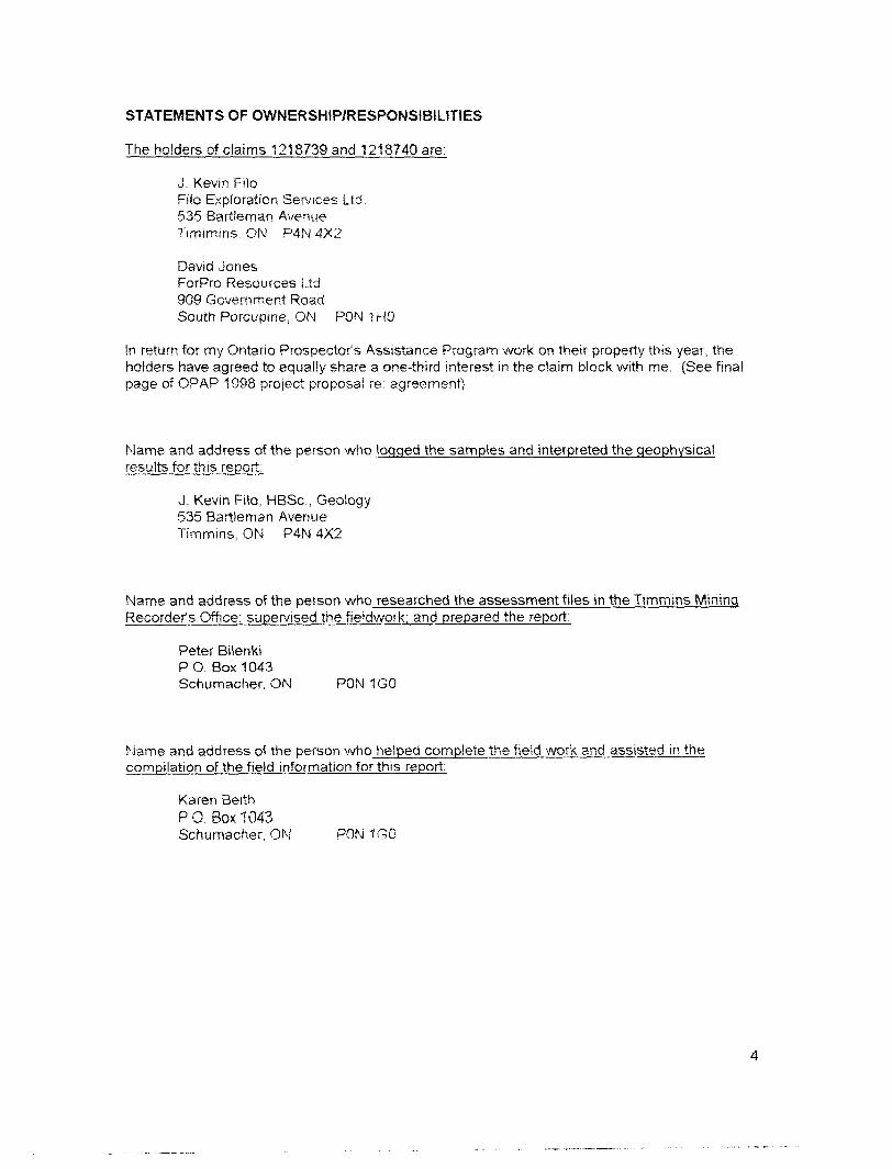
STATEMENTS OF OWNERSHIP/RESPONSIBILITIES
The holders of claims 1218739 and 1218740 are:
J- Kevin FiloFilo Exploration Services Ltd, 535 Bart'eman Avenue Timimins, ON P4N 4X2
David JonesForPro Resources Ltd909 Government RoadSouth Porcupine, ON RON 1 HO
In return for my Ontario Prospector's Assistance Program work on their property this year, the holders have agreed to equally share a one-third interest in the claim block with me. (See final page of OPAP 1998 project proposal re: agreement)
Name and address of the person who logged the samples and interpreted the .geophysicalresults for this report:
J. Kevin Filo, HBSc., Geology 535 Bartleman Avenue Timmins, ON P4N 4X2
Name and address of the person who researched the assessment files in the Timmins Mining Recorder's Office; supervised the fieldwork: and prepared the report:
Peter BilenkiP.O. Box 1043Schumacher, ON PON 1GO
Name and address of the person who helped complete the field work and assisted in the compilation of the field information for this report:
Karen BerthP.O. 80X1043Schumacher, ON PON 1GO

PROJECT SITE ACCESS
The proposed project site is 20 km (air) west of Timmins City Hall. Road access to it is had by driving west on highway 101 to a Mallette Lumber road and following it north off the highway at Mallette's yard and then west along the Turnbull/Carscallen and Godfrey/Bristol township line to the bridge over Godfrey Creek Godfrey Creek runs north through the eastern third of claim #1218739. Providing that the water level remains usable, it takes 45 to 60 minutes by canoe to reach the project area Air access can be had by helicopter to BLO/SOOmN on the bank of Godfrey Creek.
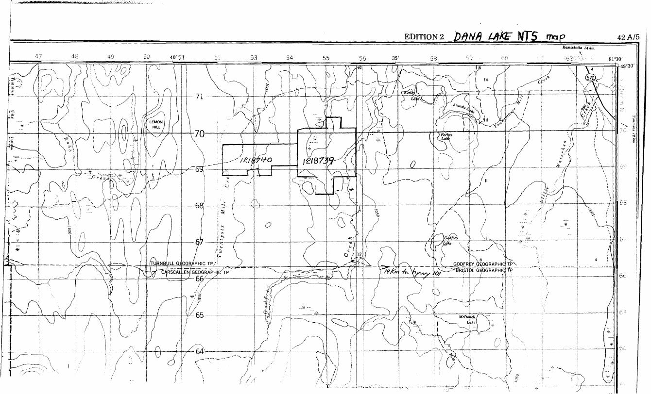
CARSCAL.EN GEOGRAPHIGT TP
AREA AND PROPERTY GEOLOGY
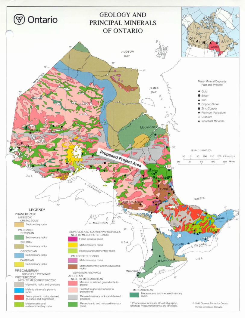
The regional geology map for this area (ODM Map 2205) shows that Turnbull Twp. is underlain by an intercalated suite of felsic and mafic volcanics that have been intruded by both felsic and mafic intrusives. The northern and extreme western portions of the township are covered by mafic intrusives. The volcanic package extends from the centra! portion of the proposed project's property to the eastern extremity of the township. The volcanic package is dominated by felsic volcanics. The felsic intrusives in Turnbull are principally in the central to eastern portion of the township as well, where they have intruded the volcanics. All of the aforementioned rocks have been intruded by a series of late northerly-trending diabase dykes.
The strike of the volcanics in Turnbull Twp is a west/northwest orientation. There are a number of large, northerly-trending faults in Turnbull Twp. and a single large easterly-tending fault in the east central portion of the township.
Regional maps suggest that the subject property is underlain by felsic volcanics that: have been intruded by porphyritic felsic intrusives. Assessment reports (i.e. T-384) have confirmed the presence of felsic volcanics on the property, and some shearing with associated mineralization and alteration. Both gold and base metal mineralization have been found within the felsic package.
Written by: J. Kevin Filo, HBSc., Geology.535 Bartleman St. Timmins, ON (705) 268-0371

ECONOMIC GEOLOGY
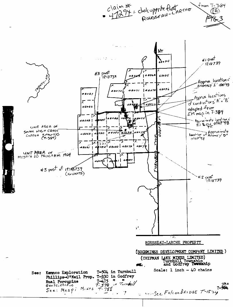
The property of claim #1218739 was originally staked prior to 1959 by John Larche and Alfred Rousseau following the discovery of a float with copper values of 5 to 100 o (fig 3).
In 1964, Mespi Mines drilled (fig. 3) into the area of the project's present claim #1218739 and produced copper values of 1,61 07o over 1.6 feet and 4 720Xo over 0.5 feet at 181 and 206 feet respectively with trace values of gold at the same depths.
An economic geology survey conducted Sept. 8-17, 1964 by Mespi Mines Limited within the area of present claim #1218739 was discussed by J. Duncan Crone in a letter dated June 4, 1965: "Sub-economic sulphide deposits and very low grade gold showings have been encountered." "Prospecting and sampling of numerous quartz veins has indicated the presence of small sub-economic quantities of gold." (T-788)
A multi-township map posted in the Timmins Mining Recorder's Office contains information compiled from the Erlis MDl data base. Of the 23 occurrences of metals noted in Turnbull Township; 4 are of gold occurence, 8 are of discretionary gold occurrence, (figs.5,6,7}
In a report prepared by Fonton Scott, P.Eng. in November, 1967 for John Canic, President of Pyrotex Mining and Exploration Company Limited, he describes the mineral deposits in the ten claims (fig 8) held by the company within what is now the sixteen units of claim #1218739:
"Two types of copper mineralization were observed on the property. To date, 19 separate occurrences have been discovered.
Within the rhyolites narrow, chalcopyrite veins or lenses generally trend in an east-west direction. Widths are generally less than a couple of inches, and chalcopyrite is usually the only sulphide observed. These veins are marked by a pronounced chloritization of their wall rocks, imparting a dark green colour to the normally light grey rhyolites.
The second type of copper mineralization consists of north-trending chalcopyrite - quartz veins up to two feet in width comformabiy cutting the north trending basic dyke. No megascopic wall rock alteration was observed.
The largest of these veins so far discovered has been traced for a minimum length of fifty feet, with an average width of six inches, and has been intersected by drilling at a vertical depth of 150 feet. Visual estimates and core assays suggest a grade of 4 - 5*^ copper. Random surface exposures suggest that this particular vein structure may have a length in excess of four hundred feet." {T-1417)
Most of the known conductors in the township have been classified as bearing sub economic values of metals. Many have surface showings of mineralization.
The "General Geology" section of Fonton Scott's November, 1967 report to Pyrotex reads as follows: "Ontario Department of Mines Map 2046 shows this section of Turnbull Township to be underlain by a complex of acid and basic extrusives extending west from the Mattagami River through Godfrey and Jamieson Townships. Within this complex, copper and zinc deposits have been developed at the Kamiscotia, Jameland, Canadian Jamieson, and United Obabki properties." (T-1417)
c\a\
D D PA-06
ROUSSEAU-LARCHE PROPERTY
tSOGEHINES DEVELOPMENT COMPANY LIMITED )
(CHIPMAN
See: Kermco Exploration T-504 in Turnbull Phillips-O'Neil Prop. T-330 in Godfrey Rual Porcupine
rurnbtiir~TownJ5hiD'. and Godfrey Twwttahip
Scale: l inch - 40 chains
ee:T-56%
/"s
187 59 W /**WO73?; aa** c/
ip
rkwor Sept 9, ,??f "
{ IIT039S !il703M S
I?05WIIT**4Ai|6UNrre .
lIHlfttf tlmK^ft
' 18 UNITS)"
UfiWfTO
; arscallen Tp.

98/0^/14-14:23-Ministry ofNorthern Development
and Mi nes
Sheet North 1 0 1 East 1 UTM zone l 7 VlAD 271000 2000 m
ERLIS DATABASES
Assessment Files Publications
Bedrock Geology
Energy
Geochemistry
li Geophysics
Minerol Deposits
Surficial Geolog
i l ii fffl i |i i! Miscel laneous
Mineral Deposits Drill Holes
Diamond Or 111 HoleDiscretionary Occurence
Occurence Wedged Dicrrond Drill H
Overburden Drill Hoi* (Auger, Wocker)
Developed Prospect Wi Ihout ReservesPost Producing Mine Without Reserves
Reverse Circulotion (Sonic)
D Developed Prospect With Reserves Underground Or i 1 1 Irtg
Past Producing Mine With Reserves
Rotation of S)nfcol Denotes Azirruth (e.g.
Lithogeochemistr
O Station Sarples - 1
A Station Sarples > 1
Topographic
Levee/Dyke
Inland Water
Rivers and Streuns
Major roads
Minor roads Ro i l L i ne
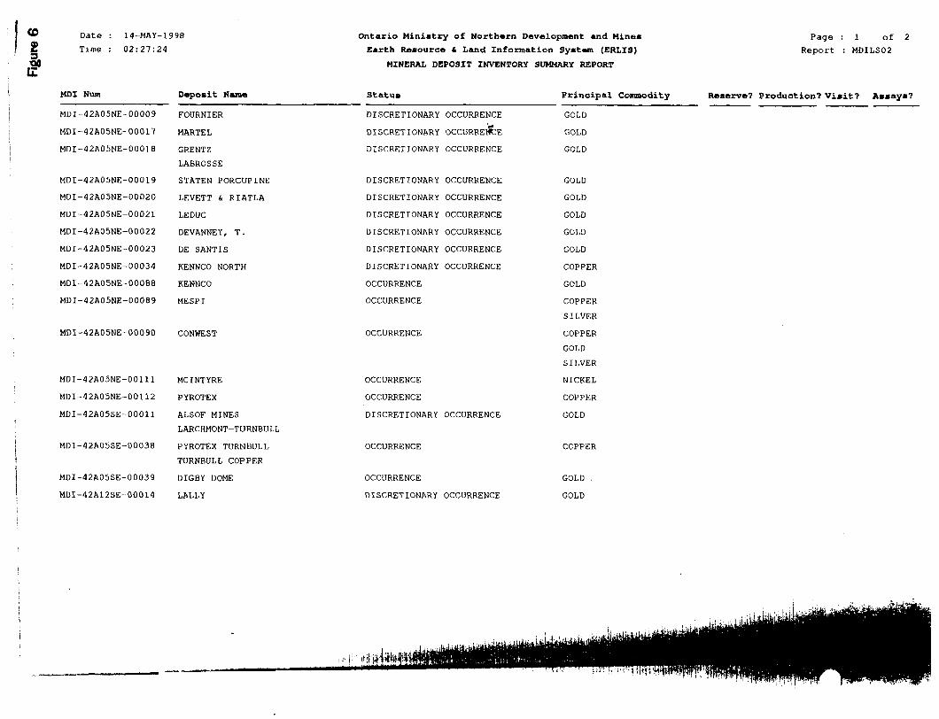
*" Date : 14-MAY-1998
2 Time : 02:27:24
1MDI Hum Deposit Name
MDI-42A05NE-00009
MDI-42A05NE-00017
MDI-42A05NE-OOOI8
MDI-42A05NE-00019
MDI-42A05NE-00020
MDI-42A05NE-00021
MDI-42A05NE-00022
MDI-42A05NE-00023
MDI-42A05NE-00034
MDI-42A05NE-00088
MDI-42A05NE-00089
MDI-42A05NE-00090
MDI-42A05NE-00111
MDI-42A05NE-00112
MDI-42A05SE-00011
FOURNIER
MARTEL
GRENTZ
LABROSSE
STATEN PORCUPINELEVETT l, RIATLA
LEDUC
DEVANNEY, T.
DE S ANT I S
KENNCO NORTH
KENNCO
MESPI
CONWEST
MCINTYRE
PYROTEX
ALSOF MINES
Ontario Ministry of Northern Development and Mines Page I of 2
Earth Resource fi Land Information System (ERLIS) Report : MDILS02
MINERAL DEPOSIT INVENTORY SUMMARY REPORT
Status Principal Commodity Reserve? Production? Visit? Assays?
DISCRETIONARY OCCURRENCE
DISCRETIONARY OCCURRENCE
DISCRETIONARY OCCURRENCE
DISCRETIONARY OCCURRENCE
DISCRETIONARY OCCURRENCE
DISCRETIONARY OCCURRENCE
DISCRETIONARY OCCURRENCE
DISCRETIONARY OCCURRENCE
DISCRETIONARY OCCURRENCE
OCCURRENCE
OCCURRENCE
OCCURRENCE
OCCURRENCE
OCCURRENCE
DISCRETIONARY OCCURRENCE
GOLD
GOLD
GOLD
GOLD
GOLD
GOLD
GOLD
GOLD
COPPER
GOLD
COPPER
SILVER
COPPER
GOLD
SILVER
NICKEL
COPPER
GOLD
MDI-42A05SE-00038
MDI-42A05SE-00039
MDI-42A12SE-00014
LARCHMONT-TURNBULL
PYROTEX TURNBULL
TURNBULL COPPER
DIGBY DOME
LALLY
OCCURRENCE
OCCURRENCE
DISCRETIONARY OCCURRENCE
COPPER
GOLD
GOLD

iDate : 14-MAY-1998
Time : 02:27:24Ontario Ministry of Northern Development and Mines
Earth Resource 6 Land Information System (ERLIS)
MINERAL DEPOSIT INVENTORY SUMMARY REPORT
Page : 2 of
Report : MDILS02
MDI Num Deposit Name
MDI-42A12SE-00058 TORCHIA
Status
OCCURRENCE
Principal Commodity
ZINC
Reserve? Production? Visit? Assays
Total Mineral Deposits: 19

ASSESSMENT WORK
T. H17
LOCATlOW MAP
PYROTEX MIKJIMG AMD
EXPLORATION COM PA M Y LTD
O ^ T A R i O
SCALE l" t f i A O
DltAVWM ftV . L"* '" C : . t~^.U (\.•^M.jj— . - ' - IH"! 'Jl'j- Jf^HI i1^. -:'! -',: !!l ; ii.1.!-(i:vjli|!{feHlii
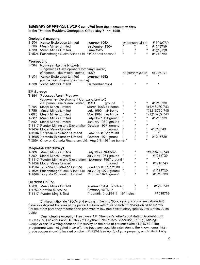
SUMMARY OF PREVIOUS WORK compiled from the assessment files in the Timmins Resident Geologist's Office May 7 -14, 1998.
Geological mappingT-504 Kenco Exploration Limited T-788 Mespi Mines Limited T-788 Mespi Mines Limited T-1524 Falconbridge Nickel Mines Ltd.
summer 1952 September 1964 June 1965 "1972 field season"
on present claim #1218739#1218739#1218739#1218739
ProspectingT-384 Rousseau-Larche Property
(Sogemines Development Company Limited) (Chipman Lake Mines Limited) 1959
T-504 Kenco Exploration Limited summer 1952 (no mention of results on this file)
T-788 Mespi Mines Limited September 1964
on present claim #1218739
EM SurveysT-384 Rousseau-Larch Property
(Sogemines Development Company Limited) (Chipman Lake Mines Limited) 1959 ground
T-788 Mespi Mines Limited March 1963 air-borne " T-788 Mespi Mines Limited July 1963 air-borne " T-882 Mespi Mines Limited May 1964 air-borne " T-882 Mespi Mines Limited July-Nov 1964 ground " T-882 Mespi Mines Limited January 1969 ground " T-1417 Pyrotex Mining and Exploitation October 1967 ground " T-1439 Mogar Mines Limited ground T-1504 Noranda Exploration Limited Jan-Feb 1972 ground " T-1668 Noranda Exploration Limited October 1974 ground T-2904 Chevron Canada Resources Ltd. Aug 2,3, 1984 air-borne
Magnetometer SurveysT-788 Mespi Mines LimitedT-882 Mespi Mines LimitedT-1417 Pyrotex Mining and ExplorationT-1439 Mogar Mines LimitedT-1504 Noranda Exploration LimitedT-1524 Falconbridge Nickel Mines Ltd.T-1668 Noranda Exploration Limited
Diamond DrillingT-788 Mespi Mines Limited T-1750 Northim Mines Inc. T-1417 Pyrotex Mng 4 Expl
July 1963 air-borne July-Nov 1964 ground " November 1967 ground "
groundJan-Feb 1972 ground " Juty-Aug 1972 ground " October 1974 ground
summer 1964 6 holes " February 1976 ?
15? holes
" #1218739 "#1218739-740 "#1218739-740 "#1218739-740 " #1218739
" #1218740
" #1218739
"#1218739-740" #1218739
11 #1218740
" #1218739 #1218739
#1218739
#1218739
Starting in the late 1950's and ending in the mid '80's, several companies (above list) have investigated the area of the present claims with their search emphasis on base metals. For the most part, they recorded the presence of low and discretionary goid values almost as an aside.
One noteable exception l read was J.P. Sheridan's letter/report dated December 6th 1960 to the President and Directors of Chipman Lake Mines. Sheridan, P.Eng., Mining Geophysicist, is writing about an EM survey on the area of present claim #1218739: "The programme was instigated in an effort to trace any possible extension to the known small high- grade copper showing located on claim P47294 (see fig. 3) of your property, and to detect any
8

similar larger zones which might occur in the vicinity" (T-384) It is worth noting that the EM survey he is interpreting was done before the Kidd Creek model was known.
In his interpretation of results on page 6 he writes:"Conductor A could possibly represent the extension of the zone containing the original
high grade copper showing. It, therefore, is considered a worthy target for further investigation.Conductor B is known to be associated with a sheared silicified rhyolite containing
minor sulphide mineralization. The extent of the sulphide mineralization and shear observed in the vicinity of Conductor B on line 14 West is not sufficient to have caused the anomaly representing conductor B. It may, therefore, be reasoned that more and perhaps better mineralization of a similar type will occur in the immediate area and therefore it is reasoned that Conductor B also represents a target worthy of further investigation." (T-384)
On the second page, he writes: "... a quartz vein was sampled on the south west portion of your property which assayed S6.00 in gold across 7 ft." (file T-384). He recommends: "intensive prospecting including geological reconnaissance, trenching and sampling with a packsack drill be carried out in the vicinity of the known conductors A and B with the area of the gold showing being the prime targets." (italics, author's) The accompanying EM map in T-384 shows conductors A and B, but not the location of the gold-bearing quartz, l have been unable to find any further mention, or a drawing other than the EM map's location of A and B, for the area of this gold sample's location in T-384 or any other file but, the block Sheridan is discussing, and the present claim #1218739 cover much common ground and share about 8007o of their boundaries, l think that the south-west portion of the block Sheridan mentions is the mid-north section of present claim # 1218739 (compare fig. 3 with fig. 4). The ERLIS MD! does not include this mention of gold (figs.5,6,7).
A geology map with a scale of 1" - 200' by Mespi Mines Limited to cover base metal sampling work completed between September 8 and October 10, 1964, provides a detailed description of sample locations and of actual and discerned rock types' locations thoughout all of claim #1218739 and throughout all but the two most western units of claim #1218740 (file T-788).
A geology map by Falconbridge Nickel Mines Limited also provides good outcrop detail of their search for base metals in the proposed project's area (T-1524).
In the literature, several professional recommendations for further work on the anomalies in the proposed project's area suggest IP surveys, l have not found a record of an IP survey in the files.
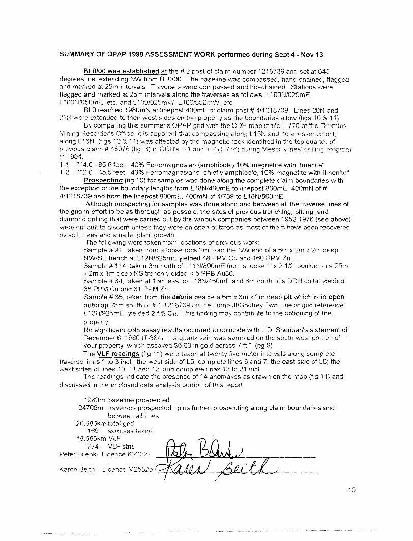
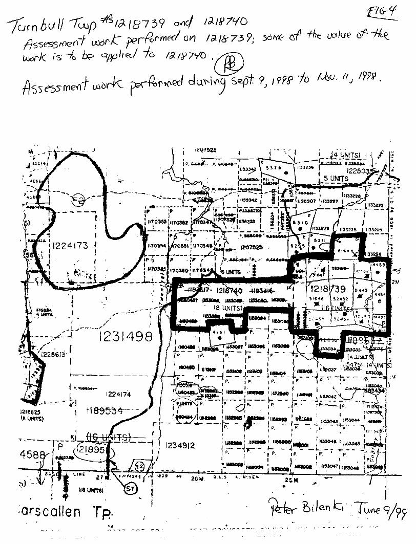
SUMMARY OF OPAP 1998 ASSESSMENT WORK performed during Sept 4 - Nov 13.
BLO/00 was established at the # 2 post of claim number 1218739 and set at 045 degrees; i.e. extending NW from BLO/00. The baseline was compassed, hand-chained, flagged and marked at 25m intervals. Traverses were compassed and hip-chained. Stations were flagged and marked at 25m intervals along the traverses as follows: L100N7025mE, LIOON/OSOmE, etc, and L100/025™ W, LIOO/OSQmW, etc.
BLO reached 1980mN at linepost 400mE of claim post # 4/1218739. Lines 20N and 21N were extended to their west sides on the property as the boundaries allow (figs.10 S 11).
By comparing this summer's OPAP grid with the DDH map in file T-778 at the Timmins Mining Recorder's Office, it is apparent that compassing along L15N and, to a lesser extent, along L16N, (figs. 10 S 11) was affected by the magnetic rock identified in the top quarter of previous claim # 48076 (fig. 3) in DDH's T-1 and T-2 (T-778) during Mespi Mines' drilling program in 1964.T-1 "140 - 85.6 feet - 409/0 Ferromagnesian (amphibole) 1007o magnetite with ilmenite" T-2 "12.0 - 45.5 feet - 4Q0Xo Ferromagnesians -chiefly amphibole, ID'% magnetite with ilmenite"
Prospecting (fig. 10) for samples was done along the complete claim boundaries with the exception of the boundary lengths from L18NM80mE to linepost 800mE, 40QmN of # 4/1218739 and from the linepost SOOmE, 400mN of 4/739 to LISN/SOOmE.
Although prospecting for samples was done along and between all the traverse lines of the grid in effort to be as thorough as possble, the sites of previous trenching, pitting; and diamond drilling that were carried out by the various companies between 1952-1976 (see above) were difficult to discern unless they were on open outcrop as most of them have been recovered by soil trees and smaller plant growth.
The following were taken from locations of previous work:Sample # 91, taken from a loose rock 2m from the NW end of a 6m x 2m x 2m deepNW/SE trench at L12W625mE yielded 48 PPM Cu and 160 PPM Zn.Sample #114, taken 3m north of LIIN/SOOmE from a loose 1' x 2 1/2' boulder in a 25mx 2m x 1 m deep NS trench yielded < 5 PPB Au30.Sample # 64, taken at 15m east of L16NM50mE and 6m north of a DDH collar yielded68 PPM Cu and 31 PPM Zn.Sample # 35, taken from the debris beside a 6m x 3m x 2m deep pit which is in openoutcrop 23m south of # 1 -1218739 on the Turnbull/Godfrey Twp. (me at grid referenceL10W925mE, yielded 2.1 "/o Cu. This finding may contribute to the optioning of theproperty.No significant gold assay results occurred to coincide with J.D. Sheridan's statement ofDecember 6, 1960 (T-384) "...a quartz vein was sampled on the south west portion ofyour property which assayed S6.00 in gold across 7 ft." (pg 9)The VLF readings (fig 11) were taken at twenty five meter intervals along complete
traverse lines 1 to 3 incl.; the west side of L5; complete lines 6 and 7; the east side of L8; the westsidesoflines10.il and 12; and complete lines 13 to 21 incl
The readings indicate the presence of 14 anomalies as drawn on the map (fig.11) and discussed in the enclosed data analysis portion of this report.
1980m baseline prospected 24706m traverses prospected plus further prospecting along claim boundaries and
between all lines 26.686km total grid
169 samples taken 18.660km VLF
774 VLF stns Peter Bilenki Licence K22227
Karen Beith Licence M25825 ' ^^ _ ^ y^-- -~- ^ - ^-~——————
10

Analysis of VLF-EM Data for Bilenki Turnbull 1998 OPAP Project
General Comments:
A number of VLF EM anomalies were detected during the course of the survey on this project. The data from this survey is very noisy suggesting there is some interference from conductive overburden. This author was not involved in the actual field work on this project, but the data presented in the accompanying map on which this interpretation is based in believed to be reliable and collected in a professional manner. The field technician faced in a northerly direction along the lines while taking each reading. The individual anomalies are discussed below:
Anomaly A:
This is a 200 m. long anomaly that trends in a NW direction from L2 N.- L4 N. The anomaly is strongest on line 3 N. The quadrature response tends for follow the in-phase suggesting a poor conductor and possibly some overburden response. The conductor weakens quite quickly to the east and west of line 3N. It would be prudent to verify this anomaly with I.P. to confirm it is indeed a bedrock conductor.
Anomaly B:
This anomaly is almost east west trending, and it is about 300 m. in length from line 3N to line 5N. There is a strong in phase response on all three lines. The quadrature is tending to follow the in phase to some extent suggest a weak to moderate conductor, possibly associated with some overburden. This anomaly is thought to be caused by a bedrock response. It would be prudent to carry out some horizontal loop EM or induced polarization surveys to reaffirm this anomaly is indeed a bedrock anomaly and also find out the dip of the anomaly prior to drill testing it.
Anomaly C:
This is a short anomaly extending from L6N-L7N. The in phase response on this anomaly is very strong on line 6N, and on both lines the quadrature response has a negative inflection suggesting that this anomaly is not associated with conductive overburden. This anomaly is thought to be caused by a bedrock source. Further, geophysics, such as horizontal loop EM or induced polarization should be done over this anomaly to confirm the dip and strike orientation of the anomaly prior to any drill testing.
Anomaly D:
This anomaly is a short anomaly proximal to the boundary of the property. The anomaly extends from line 7N-8N. There is a strong in phase response on L 7 and a weak response on L8. The out of phase response is flat and negative. This anomaly is typical of case studies shown by Geonics for a bedrock shear zone. Just north of this anomaly a strong in
11

phase response is building and another conductor will likely parallel this anomaly. Sulphide mineralization was noted roughly 25 m. across the boundary beyond the end of line 8, this shoulder building up is likely related to this mineralization, and may have effected the response on Anomaly D as well due the proximity of the two anomalies.
Anomaly E:
This is a single line anomaly on Line ION. It is not believed to be a bedrock response.
Anomaly F:
This is a short EM anomaly extending from L18N-L19N. This anomaly is thought to be a very weak bedrock source, possibly related to a structure. The response is similar to that found in case studies for a shear in the Geonic's case study references.
Anomaly G:
This anomaly strikes in a NW direction on L15N-16N. It has a very strong in phase response but a very poor crossover. It is possibly a weak conductor associated with conductive overburden, the conductive zone may be related to a structure as well.
Anomaly H:
This anomaly strikes in a E-W direction from L12N-14N. The type of response for this anomaly is similar to that of anomaly G just described previously, and the cause of this anomaly is suspected to be similar.
Anomaly I:
This anomaly is a strong anomaly with an E-W strike from L14N-16N. It has a strong in phase response on lines 14N and 15N. This anomaly is thought to be a definite weak to moderate bedrock anomaly. Further geophysics such as horizontal loop EM or induced polarization should be carried out over this anomaly to confirm its strike and dip orientation prior to drill testing.
Anomaly J:
This anomaly is proximal to a large creek and anomaly B and it strikes E-W on L4N- L5N. This anomaly is weak and the suspected cause of this anomaly is conductive overburden.
Anomaly K:
This is a single line anomaly on L6N. This anomaly is thought to be associated with conductive overburden.
12

Anomaly L:
This anomaly extends from Lil to LI5 N and it strikes is a N-S direction. The anomaly seems to have been the focus of some drilling by previous operators according to very rough location data from assessment files. Some narrow intersections of chalcopyrite were noted within felsic volcanics. No significant conductive horizons appears in the drill logs.(Pyrotex, Assessment File Report T1417)
Anomaly M:
This is also a N-S striking anomaly from L12N to L14N. This anomaly may have been evaluated according to rough location data from assessment files (Mespi Mines). Some narrow Cu intersections were found, however once again no distinct conductive horizon was noted.
Anomaly N:
This anomaly occurs precisely on a traverse line (16N7175mW) where, travelling westward, several hundred meters of swampland meet a one hundred or so meter expanse of bedrock that is covered with a foot or two of mossy overburden and contains approx fifty meters of outcrop within the hundred along the line before the line drops back into swampland (fig. 10 8.11). Therefore, it seems quite acceptable that "N" occurs due to the topographical contact.
13
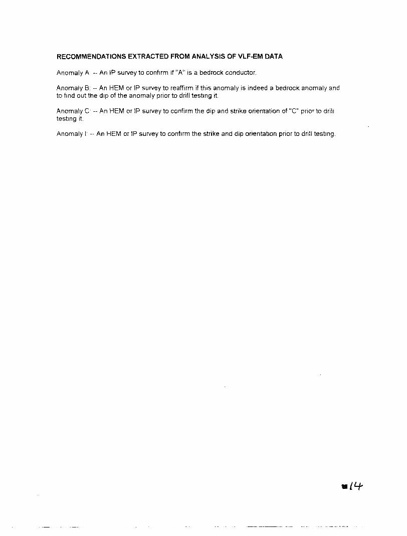
RECOMMENDATIONS EXTRACTED FROM ANALYSIS OF VLF-EM DATA
Anomaly A: - An IP survey to confirm if "A" is a bedrock conductor.
Anomaly B: - An HEM or IP survey to reaffirm if this anomaly is indeed a bedrock anomaly and to find out the dip of the anomaly prior to drill testing it.
Anomaly C: ~ An HEM or IP survey to confirm the dip and strike orientation of "C" prior to drill testing it
Anomaly l: - An HEM or IP survey to confirm the strike and dip orientation prior to drill testing.

APPENDIX 1SAMPLES DESCRIPTIONS
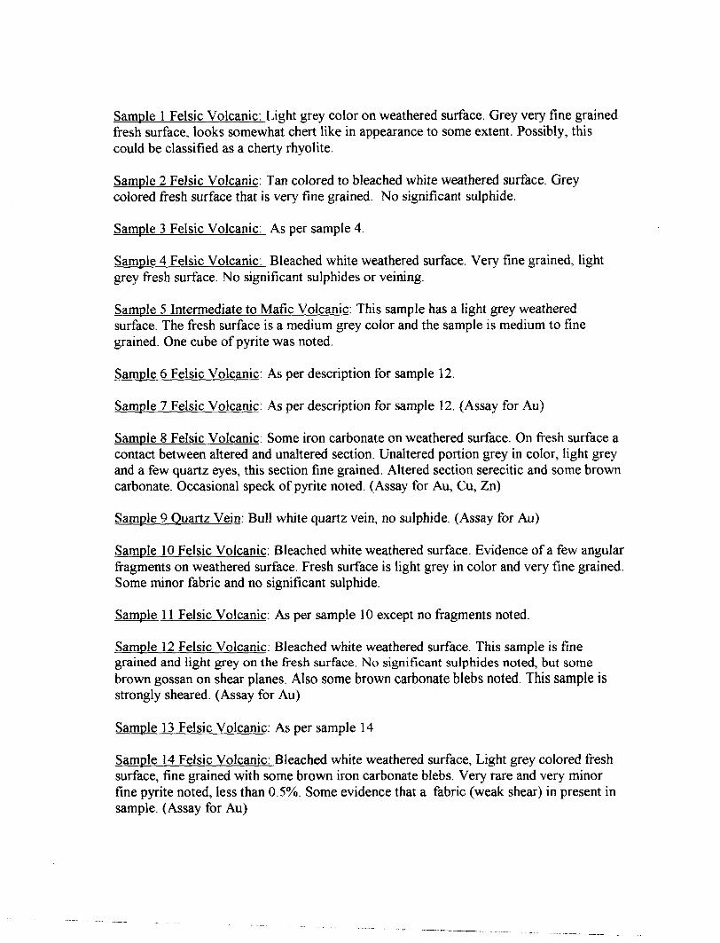
Sample l Felsic Volcanic: Light grey color on weathered surface. Grey very fine grained fresh surface, looks somewhat chert like in appearance to some extent. Possibly, this could be classified as a cherty rhyolite.
Sample 2 Felsic Volcanic: Tan colored to bleached white weathered surface. Grey colored fresh surface that is very fine grained. No significant sulphide.
Sample 3 Felsic Volcanic. As per sample 4.
Sample 4 Felsic Volcanic. Bleached white weathered surface. Very fine grained, light grey fresh surface. No significant sulphides or veining.
Sample 5 Intermediate to Mafic Volcanic. This sample has a light grey weathered surface. The fresh surface is a medium grey color and the sample is medium to fine grained. One cube of pyrite was noted.
Sample 6 Felsic Volcanic. As per description for sample 12.
Sample 7 Felsic Volcanic: As per description for sample 12. (Assay for Au)
Sample 8 Felsic Volcanic: Some iron carbonate on weathered surface. On fresh surface a contact between altered and unaltered section. Unaltered portion grey in color, light grey and a few quartz eyes, this section fine grained. Altered section serecitic and some brown carbonate. Occasional speck of pyrite noted. (Assay for Au, Cu, Zn)
Sample 9 Quartz Vein: Bull white quartz vein, no sulphide. (Assay for Au)
Sample 10 Felsic Volcanic. Bleached white weathered surface. Evidence of a few angular fragments on weathered surface. Fresh surface is light grey in color and very fine grained. Some minor fabric and no significant sulphide.
Sample 11 Felsic Volcanic: As per sample 10 except no fragments noted.
Sample 12 Felsic Volcanic: Bleached white weathered surface. This sample is fine grained and light grey on the fresh surface. No significant sulphides noted, but some brown gossan on shear planes. Also some brown carbonate blebs noted. This sample is strongly sheared. (Assay for Au)
Sample 13 Felsic Volcanic: As per sample 14
Sample 14 Felsic Volcanic: Bleached white weathered surface, Light grey colored fresh surface, fine grained with some brown iron carbonate blebs. Very rare and very minor fine pyrite noted, less than Q.5%. Some evidence that a fabric (weak shear) in present in sample. (Assay for Au)
Sample 15 Felsic Volcanic: Tan colored weathered surface. Some brown iron carbonate noted on weathered surface and fresh surface. Fresh surface is light grey in color and fine to medium grained. There is a distinct fabric present in this sample(weak shear) and some minor pyrite, less than Q.5% (Assay for Au, Cu, Zn)
Sample 16 Felsic Volcanic: Bleached white weathered surface with some brown iron carbonate. This sample is light grey and fine grained on fresh surface, the sample is from a shear zone and there is some alteration (sericite?) but weak. (Assay for Au)
Sample 17 Felsic Volcanic: Bleached white weathered surface. Light grey fine grained fresh surface. Substantial cubic pyrite noted in this sample \-207o of sample. Sample exhibits a weak fabric. There is also blebs of iron carbonate and some minor quartz stringers with iron carbonate as well. (Assay Au, Cu, Zn)
Sample 18 Mafic Volcanic: Green colored weathered surface. Black fine grained fresh surface. Some gossan along a fracture plane. No significant sulphide or veining. (Assay for Au)
Sample 19 Intermediate to Mafic Volcanic: Brown weathered surface with lots of iron carbonate. Light grey fine grained sheared sample with some minor finely disseminated sulphides, probably less than Q.5%. (Assay for Au)
Sample 20 Mafic Volcanic: This sample is appears to be a mafic volcanic as it has a grey black fresh surface that is fine to medium grained. It is unaltered an contains no significant pyrite or quartz. The surface weathering of this sample is somewhat unusual as it weathers similar to the felsic samples seen from this property.
Sample 21 Felsic Volcanic: Bleached white surface. Very fine grained light grey fresh surface, no significant alteration or mineralization. Some minor quartz stringers noted. (Assay for Au)
Sample 22 Diorite Intrusive: Medium to coarse grained intrusive with quartz feldspar and some ferro-magnesium minerals, brown weathered surface. (Assay for Au)
Sample 23 Quartz Vein: Mainly quartz vein with brown iron carbonate, some sheared mafic wall rock associated with veining, wall rock minor portion of sample. (Assay for Au)
Sample 24 Mafic Volcanic. Brown weathered surface. Grey black fine grained fresh surface, massive appearance, no significant sulphide or veining.
Sample 25 Mafic Volcanic: Brown weathered surface. Very fine grained black fresh surface, occasional rare speck of pyrite noted.
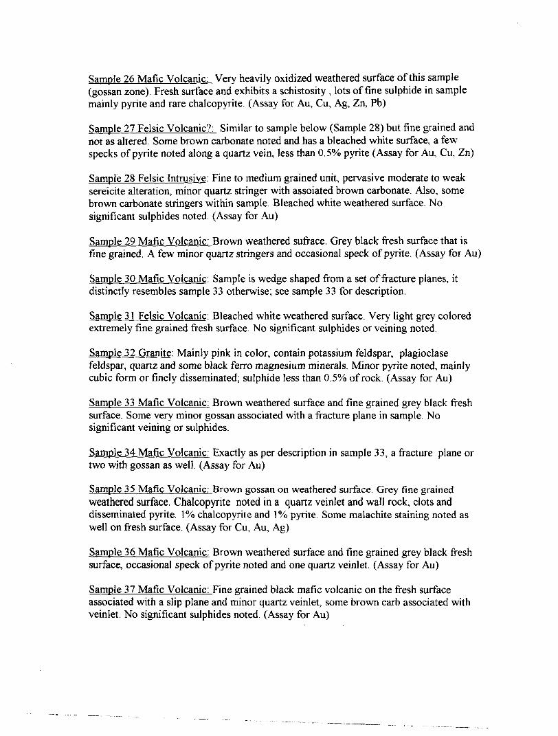
Sample 26 Mafic Volcanic. Very heavily oxidized weathered surface of this sample (gossan zone). Fresh surface and exhibits a schistosity , lots of fine sulphide in sample mainly pyrite and rare chalcopyrite. (Assay for Au, Cu, Ag, Zn, Pb)
Sample 27 Felsic Volcanic?: Similar to sample below (Sample 28) but fine grained and not as altered. Some brown carbonate noted and has a bleached white surface, a few- specks of pyrite noted along a quartz vein, less than G.5% pyrite (Assay for Au, Cu, Zn)
Sample 28 Felsic Intrusive: Fine to medium grained unit, pervasive moderate to weak sereicite alteration, minor quartz stringer with assoiated brown carbonate. Also, some brown carbonate stringers within sample. Bleached white weathered surface. No significant sulphides noted. (Assay for Au)
Sample 29 Mafic Volcanic: Brown weathered sufrace. Grey black fresh surface that is fine grained. A few minor quartz stringers and occasional speck of pyrite. (Assay for Au)
Sample 30 Mafic Volcanic. Sample is wedge shaped from a set of fracture planes, it distinctly resembles sample 33 otherwise; see sample 33 for description.
Sample 31 Felsic Volcanic: Bleached white weathered surface. Very light grey colored extremely fine grained fresh surface. No significant sulphides or veining noted.
Sample 32 Granite: Mainly pink in color, contain potassium feldspar, plagioclase feldspar, quartz and some black ferro magnesium minerals. Minor pyrite noted, mainly cubic form or finely disseminated; sulphide less than Q.5% of rock. (Assay for Au)
Sample 33 Mafic Volcanic: Brown weathered surface and fine grained grey black fresh surface. Some very minor gossan associated with a fracture plane in sample. No significant veining or sulphides.
Sample 34 Mafic Volcanic: Exactly as per description in sample 33, a fracture plane or two with gossan as well. (Assay for Au)
Sample 35 Mafic Volcanic: Brown gossan on weathered surface. Grey fine grained weathered surface. Chalcopyrite noted in a quartz veinlet and wall rock, clots and disseminated pyrite. V/* chalcopyrite and I 07o pyrite. Some malachite staining noted as well on fresh surface. (Assay for Cu, Au, Ag)
Sample 36 Mafic Volcanic: Brown weathered surface and fine grained grey black fresh surface, occasional speck of pyrite noted and one quartz veinlet. (Assay for Au)
Sample 37 Mafic Volcanic: Fine grained black mafic volcanic on the fresh surface associated with a slip plane and minor quartz veinlet, some brown carb associated with veinlet. No significant sulphides noted. (Assay for Au)

Sample 38 Mafic Volcanic: Very fine grained black fresh surface, appears silicified to some extent, no significant sulphides or veining noted. Brownish weathered surface. (Assay for Au)
Sample 39 Mafic Volcanic. As per sample description below for sample 44.
Sample 40 Mafic Volcanic: Brownish colored weathered surface, somewhat pseudo brecciated appearance with brown carbonate interstitial to fragments. Some slip planes noted in sample with quartz clots on the slip planes and minor choritic alteration. Fresh surface of sample is fine grained and grey black in color. No significant sulphide noted. (Assay for Au)
Sample 42 Mafic Volcanic: As per sample 44 below.
Sample 43 Mafic Volcanic: As per sample 44 below.
Sample 44 Mafic Volcanic: Brown weathered surface. Fine grained grey black on fresh surface. No signicifant veining or sulphide noted.
Sample 45 Felsic Volcanic: This sample is a piece of drill core (unsplit) from a pile of core on the subject property. The core is weathered on the surface from exposure to the elements. It has minor gossan on the weathered surface and is bleached white to some extent. The fresh surface is light grey in color and fine grained, somewhat silicious in appearance. This sample contains S-7% disseminated pyrite. (Assay for Au, Cu, Zn)
Sample 46 Mafic Intrusive. This sample is a piece of drill core (not split) found on the property. It is black and fine to medium grained. It is likely a gabbro. It contains stringers of pyrite and the sample is not magnetic. The sample also contains some disseminated pyrite. Total sulphide content estimated to me 407o. (Assay for Pd, Pt, Au, Cu, Ni)
Sample 47 Felsic Volcanic: This sample has a bleached white weathered surface and a fine to medium grained fresh surface that is light grey in color. The sample exhibits a fabric. No significant sulphide is present except for the occassional fleck of pyrite. (Assay for Au)
Sample 48 Mafic Volcanic: Brown weathered surface. Fine grained black fresh surface with no significant sulphide or veins.
Sample 49 Mafic to Intermediate Volcnic: As per description for sample 50.
Sample 50 Mafic to Itermediate Volcanic. Light brown weathered surface and a fine grained grey black fresh surface. A few minor specks of pyrite noted.
Sample 51 Mafic Volcanic: This sample is a fine grained grey black unit. No significant sulphides are noted but there is a large white quartz vein associated with this unit that is vuggy and white in color.
Sample 52: Mafic Volcanic: As per sample 53, no veining or sulphides.
Sample 53 Mafic Volcanic. This sample has a light brown weathered surface. It is a medium grey color on the fresh surface and fine grained. There are no significant sulphides present. The sample contains a small quartz veinlet.
Sample 54 Mafic Volcanic: As per sample 53.
Sample 55 Mafic Intrusive: Brown weathered surface and medium to fine grained, grey black fresh surface. Locally weakly magnetic. Possibly a diabase dyke.
Sample 56 Mafic Volcanic: Light brown weathered surface, medium to fine grained grey mafic volcanic. No significant sulphides or veining noted.
Sample 57 Mafic Volcanic: This sample is fine grained grey black on the fresh surface and has a brown weathered surface. No significant sulphides were noted. A small slip plane is present in the sample.
Sample 58 Mafic Volcanic: Brownish weathered surface, fine grained grey colored fresh surface. Some fine disseminated pyrite, approximately I 07o on the fresh surface. Also some brown carbonate noted on the weathered rind of sample. (Assay for Au)
Sample 59 Quartz Vein: Mainly quartz vein material with some minor chloritic mafic wall rock. (Assay for Au)
Sample 60 Mafic Volcanic: This sample is black in color on the fresh surface and weathered surface. This sample is part of a fault zone, it contains actual fault gouge on a fault plane with slickenslides. Fragments of intermediate to felsic rock are present within the sample. (Assay for Au)
Sample 61 Felsic Volcanic: Bleached white weathered surface. Sample is a very light grey color on fresh surface and fine grained; it exhibits some fabric. There are no significant sulphides present.
Sample 62 Chert: Sample is greyish on weathered surface. On fresh surface typical cherty appearace and a very light grey color. A number of fractures in sample with gossan. Also, sample has some fine pyrite in it outside of fractures. (Assay for Au, Cu, Zn)
Sample 63 Intermediate to Felsic Volcanic. This sample has a greyish weathered surface. It has fractures associated with it that are covered with a brown gossan. The fresh surface is light grey and fine grained. No real significat sulphides were noted.
Sample 64 Felsic Volcanic: This sample has a brown weathered gossanous surface. The sample has a very light grey fine grained fresh surface. There are a number of fracture

planes on the sample with gossan and fine pyrite. Fine pyrite is also found in the fresh wall rock adjacent the fractures. Estimated pyrite content 5Vo. (Assay for Au, Cu, Zn)
Sample 65 Felsic Volcanic: Weathered surface of sample brown to tan colored. This sample is a fine grained light grey on the fresh surface, a round circular clot of chlorite was noted in sample. A small quartz stringer was also noted in sample. No significant sulphides noted.
Sample 66 Felsic Intrusive?. This sample is a pinkish brown color on weathered surface and a pink/orange color on fresh surface. It is very fine grained, it is possibly the edge of a felsic intrusive. A small quartz veinlet was noted in the sample and no sulphides. (Assay for Au)
Sample 67 Chert: White slightly banded chert, very silicous. A number of fractures give the sample a blocky appearance, some gossan on the fracture plane. No sulphides noted. (Assay for Au)
Sample 68 Felsic Volcanic: Brown weathered surface. Very light grey fine grained fresh surface. Some fractures associated with sample that have a brown gossan on them. Also a minor quartz vein associated with sample, and no significant sulphide noted.
Sample 69 Quartz Vein. Sample is mainly quartz vein. The wall rock along quartz vein or vein salvage is thought to be a felsic, this felsic is a minor part of the sample but it contains a lot of iron carbonate and exhibits a fabric (shear). (Assay for Au)
Sample 70 Mafic Volcanic: Brown weathered surface. Grey black fine grained sample on fresh surface. No significant mineralization or veins.
Sample 71 Mafic Intrusive: This sample has a brown weathered surface. It is black and medium grained on the fresh surface. This sample is a diabase dyke.
Sample 72 Qurarzt Vein: Mainly white quartz with minor intermediate volcanic wall rock, no significant sulphide.
Sample 73 Mafic Volcanic: Brownish grey weathered surface. Fine grained grey fresh surface, no significant sulphide, some very minor quartz carbonate stringers.
Sample 74 Mafic Volcanic: This sample has a greenish colored weathered surface and there are a number small pits in the surface of sample from gas bubbles when this rock was cooling. The rock is very fine grained and grey black on the fresh surface. A fracture plane on the surface of this rock has some quartz on it and some minor sulphide.
Sample 75 Mafic Intrusive: As per description for sample 79.
Sample 76 Felsic Volcanic: Tan to bleached weathered surface. Very fine grained dark grey silicious looking fresh surface with phenocrysts of feldspar?. No significant sulphides noted. Gossan noted along fracture plane in sample. (Assay for Au, Cu, Zn)
Sample 77 Mafic Intrusive: Diabase dyke as per sample 89.
Sample 78 Felsic Volcanic: Tan bleached white weathered surface. Light grey color on fresh surface. Sample taken from the edge of a small fault plane. Slickenslides evident in sample. Minor quartz veinlet noted in sample. No significant sulphides. (Assay for Au)
Sample 79 Mafic Intrusive: Light brown to tan weathered surface. Black medium grained fresh surface. Sample is non magnetic and contains no significant sulphides. Compositionally this unit is likely a gabbro.
Sample 80 Mafic Volcanic: Brown weathered surface. Black fine grained fresh surface. Some quartz clots and rare sulphide. (Assay for Au)
Sample 81 Felsic Volcanic: Bleached white weathered surface. Fine grained light grey fresh surface. No significant sulphide noted.
Sample 82: Felsic Volcanic: As per sample 81.
Sample 83 Felsic Volcanic: As per sample 84 except no significant sulphide.
Sample 84 Felsic Volcanic: Bleached white weathered surface. Very fine grained, light grey almost chert like appearance in this sample. Some very minor fine grained disseminated pyrite note locally. (Assay for Au, Cu, Zn)
Sample 85 Felsic Volcanic. Bleached white weathered surface. Sample contains a fracture plane with some brown weathering. Fresh surface is very fine grained and very light grey in color, chert like appearance. No significant sulphide noted.
Sample 86 Felsic Volcanic. Bleached white weathered surface. Some quartz veining noted in sample (rare veinlet). Fresh surface is a very light grey color and sample is fine grained, almost a sugary texture. Occasional specks of pyrite noted. Pyrite less than Q.5%. (Assay for Au, Cu, Zn)
Sample 87 Felsic Volcanic: White weathered surface and light grey fine grained fresh surface, somewhat of a sugary texture. Very minor pyrite noted in sample. (Assay Au)
Sample 88 Felsic Volcanic: Gossan found on weathered surface. Sample contains some pyrrhotite blebs and some minor fine disseminated sulphide as well, I 07o sulphide in total. The sample is fine grained to very fine grained in color. Sections of the sample are cherty. This sample would likely be classified as a cherty rhyolite. (Assay Au,Cu,Zn)
Sample 88A Felsic Volcanic. As per sample 88 except no sulphide noted in this sample. This sample has some fabric within in it.
Sample 89 Mafic Intrusive: This is a medium grained mafic intrusive. It has a brown weathered surface and it is magnetic locally. This sample is thought to be part of a diabase dyke.
Sample 90 Mafic Volcanic: This sample has minor gossan on weathered surface and along a few fracture planes. The fresh surface is very fine grained and black in color. Some very minor pyrite is present. This sample would likely be classified as a basalt in the field. (Assay Au)
Sample 91 Mafic Volcanic: This sample is basically the same as sample 90, except it has a little bit more sulphide perhaps \ 0/*, roughly 50:50 pyrite and pyrrhotite. (Assay Au, Cu, Zn)
Sample 92 Felsic Volcanic: Brown weathered surface on this sample. Some brown carbonate present on both weathered and fresh surface. Very fine grained light greyish white chert like appearance on fresh surface. This sample might be considered to be a chert rhyolite. Rare speck of pyrite noted. (Assay for Au)
Sample 93 Felsic Volcanic: Weathered surface is tan in color. Fresh surface is a light grey color and fine grained. The sample might be considered a cherty rhyolite. Some minor quartz veinlets are noted. Also some very minor local sulphides (pyrite) is present along a fracture plane, less than Q.5% pyrite. (Assay Au, Cu, Zn)
Sample 94 Felsic Volcanic: This unit contains to fracture planes with gossan on them. The fresh surface of the sample is very fine grained and light grey in color There is some brown carbonate in the sample and a rare speck or two of pyrite. (Assay for Au)
Sample 95 Mafic Volcanic: This sample is a fine grained choritized mafic volcanic with quartz veinlets in it giving it "marble like appearance". Substantial brown carbonate is found on the weathered surface and the fresh surface. Quartz content in this sample is about 507o, and about Q.5% pyrite is present. (Assay for Au)
Sample 96 Mafic Volcanic: This sample is a black fine grained mafic volcanic. The weathered surface is brown. Some fine pyrite noted in the sample, approximately Wo disseminated sulphides. (Assay for Au)
Sample 97 Felsic Volcanic: White to light colored weathered surface. Very light grey very fine grained fresh surface. A small quartz vein cuts the sample and there is some brown iron carbonate associated with the vein. No signifiant sulphides noted. (Assay for Au)
Sample 98 Felsic Volcanic: White bleached weathered surface. Very light grey fine grained sample on the fresh surface with some cherty sections within the sample. Quartz eyes noted in sample. Some minor pyrite in sample. (Assay for Au)
Sample 99 Mafic Volcanic: Sheared mafic volcanic with brown weathered surface. Sample has substantial oxidation, where fresh surface is visible it is greyish in colored. There is about 1007o pyrite disseminated throughout the sample.(Assay for Au)
Sample 100 Felsic Volcanic. Bleached white weathered surface. Very light grey fine grained fresh surface, cherty appearance. Approximately 2-307o fine pyrite in sample, some fractures in sample are brown with gossan and locally contain slightly more pyrite, perhaps 4-507o. (Assay for Au)
Sample 101 Felsic Volcanic. As per sample 98 but no quartz eyes and no significant sulphide.
Sample 102 Intermediate Volcanic. Sample has a light green to light brown colored weathered surface. Numerous vesicles note and cubic pyrite noted in sample t-2%. Also lot s of small blebs of brown iron carbonate are present on fresh surface. The color of the fresh surface is dark grey to almost black and the unit is fine grained. (Assay Au)
Sample 103 Mafic Intrusive: Sample has a brown weathered surface. The fresh surface is medium grained and black in color. This sample contains no significant sulphide and is not magnetic.
Sample 104 Felsic Volcanic. Tan colored sample on weathered surface. Fine grained light tan color on fresh surface and a few minor pyrite cubes noted.
Sample 105 Felsic Volcanic. This sample has a bleached white weathered surface and the fresh surface appears very fine grained, it looks very similar to a black chert. No significant sulphides noted.
Sample 106 Felsic Volcanic. Bleached white weathered surface, and light grey fine grained fresh surface, some brown carbonate noted, no significant sulphides. Some fracture planes in sample with brown gossan.
Sample 107 Felsic Volcanic: Weathered surface is tan to bleached white. Fresh surface is dark grey and very fine grained. No significant sulphide or veining noted. Some gossan noted along a fracture plane in sample.
Sample 108 Felsic to Intermediate Volcanic. As per sample 109.
Sample 109 Felsic to Intermediate Volcanic. Grey weathered surface. Light grey to black fresh surface, some ferro-magnesium minerals note in darker portions of this fine grained unit. For the most part sample is light grey in color on fresh surface and has some brown

carbonate typical of other felsic samples from this property. A few specks of pyrite noted. (Assay for Au)
Sample 110 Mafic Volcanic: This sample has a brown weathered surface and a fresh fine grained black surface. It has substantial fine pyrite and subhedral pyrite crystals making up about 507o of the sample. (Assay for Au)
Sample 111 Felsic to Intermediate Volcanic: This sample is as per description for sample 109. (Assay for Au)
Sample 112 Felsic Volcanic: White weathered surface. Light grey fine grained fresh surface, some gossan on fracture planes, no significant sulphide noted.
Sample 113 Felsic Volcanic: This sample has a bleached tan colored weathered surface. The fresh surface is light grey colored and fine grained with a sugary texture and some blebs of brown carbonate. No significant quartz veining or sulphides. Sample contains what appears to be part of a fault plane.
Sample 114 Mafic Volcanic. Fine grained black mafic volcanic with quartz clots on fresh surface. Also, stingers and cubes of pyrite making up 4-5*M) of sample. Possibly some silicifiation noted on fresh surface of sample. Brown weathered surface.(Assay for Au)
Sample 115 Felsic Volcanic: Dirty white colored weathered surface. Very light grey fine grained fresh surface, occasional quartz eye noted in sample. Occasional speck of pyrite and very minor brown carbonate noted.
Sample 116 Felsic Volcanic: Bleached white weathered surface, cherty light grey fine grained fresh surface. No sulphide noted, rare minor quartz carbonate stringer noted occasionally.
Sample 117 Felsic Volcanic. This sample is thought to be a felsic volcanic, but it is heavily oxidized and mainly brown in color. (Assay for Au, Cu, Zn, Ag)
Sample 118 Mafic/Ultramafic? Volcanic: Brown weathered surface. Black fresh surface, gritty appearance, massive unit. Some very fine pyrite noted in sample, less than Q.5% in a disseminated form. (Assay for Au, Cu, Ni, Pt, Pd)
Sample 119 Felsic Volcanic. Light greyish weathered surface. Siliceous grey fine grained occasionally somewhat cherty fresh surface. Noted clot of sulphide with pyrite and minor chalcopyrite. (Assay for Au, Cu, Zn, Ag)
Sample 120 Quartz Vein: White quartz vein material with some felsic wall rock
Sample 121 Felsic Volcanic: Weathered surface a dirty white color. Fresh surface fine grained and very light grey color. Some minor pyrite and some small clots and veinlets of iron carbonate. (Assay for Au, Cu, Zn)
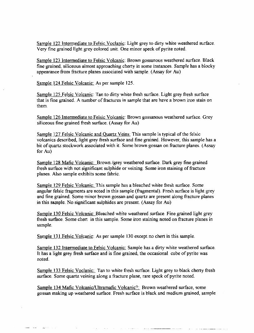
Sample 122 Intermediate to Felsic Voclanic: Light grey to dirty white weathered surface. Very fine grained light grey colored unit. One minor speck of pyrite noted.
Sample 123 Intermediate to Felsic Volcanic: Brown gossanous weathered surface. Black fine grained, siliceous almost approaching cherty in some instances. Sample has a blocky appearance from fracture planes associated with sample. (Assay for Au)
Sample 124 Felsic Volcanic: As per sample 125.
Sample 125 Felsic Volcanic: Tan to dirty white fresh surface. Light grey fresh surface that is fine grained. A number of fractures in sample that are have a brown iron stain on them.
Sample 126 Intermediate to Felsic Volcanic: Brown gossanous weathered surface. Grey siliceous fine grained fresh surface. (Assay for Au)
Sample 127 Felsic Volcanic and Quartz Veins: This sample is typical of the felsic volcanics described, light grey fresh surface and fine grained. However, this sample has a bit of quartz stockwork associated with it. Some brown gossan on fracture planes. (Assay for Au)
Sample 128 Mafic Volcanic: Brown /grey weathered surface. Dark grey fine grained fresh surface with not significant sulphide or veining. Some iron staining of fracture planes. Also sample exhibits some fabric.
Sample 129 Felsic Volcanic: This sample has a bleached white fresh surface. Some angular felsic fragments are noted in this sample (fragmental). Fresh surface is light grey and fine grained. Some minor brown gossan and quartz are present along fracture planes in this sample. No significant sulphides are present. (Assay for Au)
Sample 13d Felsic Volcanic. Bleached white weathered surface. Fine grained light grey fresh surface. Some chert in this sample. Some iron staining noted on fracture planes in sample.
Sample 131 Felsic Volcanic: As per sample 130 except no chert in this sample.
Sample 132 Intermediate to Felsic Volcanic: Sample has a dirty white weathered surface. It has a light grey fresh surface and is fine grained, the occasional cube of pyrite was noted.
Sample 133 Felsic Voclanic: Tan to white fresh surface. Light grey to black cherty fresh surface. Some quartz veining along a fracture plane, rare speck of pyrite noted.
Sample 134 Mafic Volcanic/Ultramafic Volcanic?: Brown weathered surface, some gossan making up weathered surface. Fresh surface is black and medium grained, sample

contains some pyrite clots and stringers and a few quartz stringers. (Assay for Au, Cu, Ni, Pt, Pd)
Sample 135 Mafic Volcanic/Ultramafic Volcanic?: As per sample 134 except little or nor mineralization and a small quartz vein along a fracture.
Sample 136 Intermediate to Mafic Volcaic: Light brown weathered surface. Dark greyish colored fresh surface that is fine grained and gritty in appearance. No significant sulphide and one minor quartz vein.
Sample 137 Quartz: Barren white quartz with minor volcanic wall rock. No sulphide noted.
Sample 138 Mafic Volcanic: Brown weathered surface. Grey black fine grained unit with some fine disseminated pyrite, approximately l "/o maximum. (Assay for Au)
Sample 139 Mafic Volcanic: Brown weathered surface. Fine grained grey black fresh surface, no significant sulphide or veining.
Sample 140 Intermediate to Felsic Volcanic: Light brown weathered surface. Fine grained light grey fresh surface, occasional quartz eye and rare minor pytite.(Assay for Au)
Sample 141 Mafic Volcanic: Brown weathered surface, and fine grained grey black fresh surface. No significant sulphide, some minor qurtz veining.
Sample 142 Granodiorite Intrusive: Sample contains quartz, K-feldspar, some plagioclase and ferro-magnesium minerals, no significant sulphides noted.
Sample 143 Intermediate Intrusive: Brown weathered surface, medium grained unit that is grey black in color and contains some quartz. No sulphide.
Sample 144 Mafic Volcanic: As per sample 148.
Sample 145 Mafic Volcanic: As per sample 148.
Sample 146 Mafic Volcanic: As per sample 148.
Sample 147 Mafic Volcanic: As per sample 148, except this sample may have up to l "/o pyrite disseminated within it. (Assay for Au)
Sample 148 Mafic Volcanic: Brown weathered surface. Grey black fine grained fresh surface, with some very minor pyrite.
Sample 149 Felsic Volcanic: Bleached white fresh surface. Light grey fine grained siliceous fresh surface, no sulphide, rare quartz veinlet.
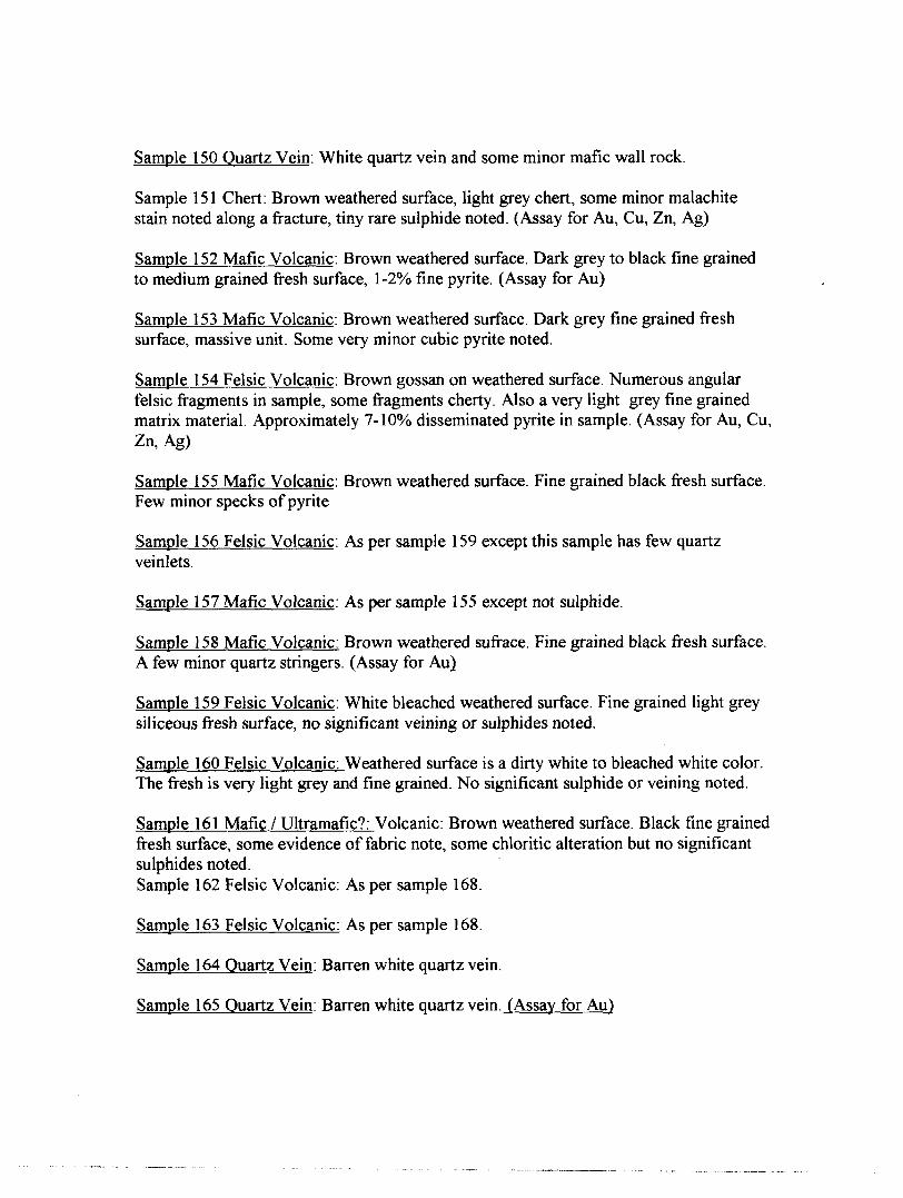
Sample 150 Quartz Vein: White quartz vein and some minor mafic wall rock.
Sample 151 Chert: Brown weathered surface, light grey chert, some minor malachite stain noted along a fracture, tiny rare sulphide noted. (Assay for Au, Cu, Zn, Ag)
Sample 152 Mafic Volcanic: Brown weathered surface. Dark grey to black fine grained to medium grained fresh surface, l -207o fine pyrite. (Assay for Au)
Sample 153 Mafic Volcanic: Brown weathered surface. Dark grey fine grained fresh surface, massive unit. Some very minor cubic pyrite noted.
Sample 154 Felsic Volcanic: Brown gossan on weathered surface. Numerous angular felsic fragments in sample, some fragments cherty. Also a very light grey fine grained matrix material. Approximately T-10% disseminated pyrite in sample. (Assay for Au, Cu, Zn, Ag)
Sample 155 Mafic Volcanic: Brown weathered surface. Fine grained black fresh surface. Few minor specks of pyrite
Sample 156 Felsic Volcanic: As per sample 159 except this sample has few quartz veinlets.
Sample 157 Mafic Volcanic: As per sample 155 except not sulphide.
Sample 158 Mafic Volcanic: Brown weathered sufrace. Fine grained black fresh surface. A few minor quartz stringers. (Assay for Au)
Sample 159 Felsic Volcanic: White bleached weathered surface. Fine grained light grey siliceous fresh surface, no significant veining or sulphides noted.
Sample 160 Felsic Volcanic: Weathered surface is a dirty white to bleached white color. The fresh is very light grey and fine grained. No significant sulphide or veining noted.
Sample 161 Mafic l Ultramafic?: Volcanic: Brown weathered surface. Black fine grained fresh surface, some evidence of fabric note, some chloritic alteration but no significant sulphides noted. Sample 162 Felsic Volcanic: As per sample 168.
Sample 163 Felsic Volcanic: As per sample 168.
Sample 164 Quartz Vein: Barren white quartz vein.
Sample 165 Quartz Vein: Barren white quartz vein. (Assay for Au)
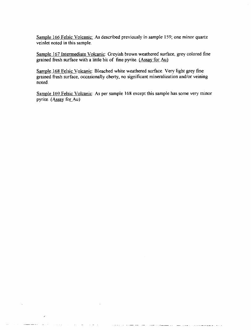
Sample 166 Felsic Volcanic: As described previously in sample 159; one minor quartz veinlet noted in this sample.
Sample 167 Intermediate Volcanic: Greyish brown weathered surface, grey colored fine grained fresh surface with a little bit of fine pyrite. (Assay for Au)
Sample 168 Felsic Volcanic: Bleached white weathered surface. Very light grey fine grained fresh surface, occasionally cherty, no significant mineralization and/or veining noted.
Sample 169 Felsic Volcanic: As per sample 168 except this sample has some very minor pyrite. (Assay for Au)

APPENDIX 2 SAMPLES LOCATIONS

Ontario Prospector's Assistance Program Samples' LocationsOPAP file number OP98-333Receipient Peter BilenkiHelper Karen Beith
NOTE: Ail sample locations have the sample number marked on flagging tied to adjacent trees or shrubbery and on flagging tied to a rock and placed onto the spot of origin.
SAMPLES # LOCATIONS
-i L5N;352mE oc
2 LSN/SOOmE oc on Twp line
3 9m northeast of L5N7388mE oc
4 1.5m south of BL/ 085N oc
5 5m south of L1N/115mE oc on Twp line
6 85m north of L2N7210mE oc on Twp line
7 53m north of L2M'210mE oc on Twp line
8 5m southeast of L2N/186I71E oc
9 13m @ 130 degrees from LSN/OSSmW oc
10 16m @ 318 degrees from L3N7285mE oc
11 5m north of # 10 oc
12 5m south of L3W258mE oc
13, 14, 15 L3N7229mE oc within a foot of each other
16 L4N;368mE oc
17 8m south of L4N/231 mE oc
18 L4N7350mW oc
19 on south boundary 32m west of linepost 400mW of #2/1218739 oc
20 L3N7275mW oc
21 LSN/OSSmW may or may not be oc
22 L6N7030mW oc
23 6m south of L6!W050mW oc
24 27 paces @ 017 degrees from L6N7254mW oc
25 L7NM54mW oc
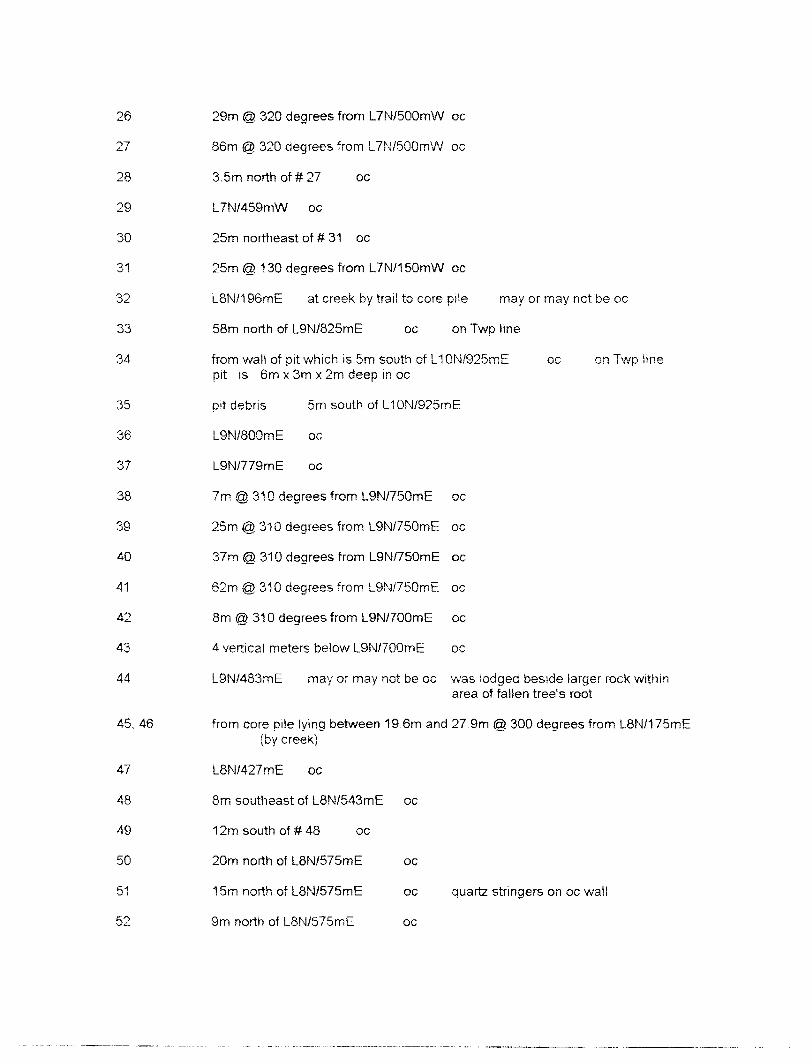
26 29m @ 320 degrees from LJN/SQOmW oc
27 86m @ 320 degrees from L7N7500mW oc
28 3.5m north of #27 oc
29 L7NA459mW oc
30 25m northeast of # 31 oc
31 25m @ 130 degrees from L7N7150mW oc
32 L8Nn96mE at creek by trail to core pile may or may not be oc
33 58m north of L9W825mE oc on Twp line
34 from wall of pit which is 5m south of L10N,'925mE oc on Twp line pit is 6m x 3m x 2m deep in oc
35 pit debris 5m south of L10W925mE
36 L9N;SOOmE oc
37 L9N;779mE oc
38 7m @ 310 degrees from L9N;750mE oc
39 25m @ 310 degrees from L9NA75QmE oc
40 37m @ 310 degrees from L9N;750mE oc
41 62m @ 310 degrees from L9NI750mE oc
42 8m @ 310 degrees from L9N7700mE oc
43 4 vertical meters below L9Nf7QQmE oc
44 L9NM83mE may or may not be oc was lodged beside larger rock withinarea of fallen tree's root
45, 46 from core pile lying between 19.6m and 27.9m @ 300 degrees from L8N7175mE (by creek)
47 L8NM27mE oc
48 8m southeast of L8N;543mE oc
49 12m south of # 48 oc
50 20m north of L8W575mE oc
51 15m north of L8Ny575mE oc quartz stringers on oc wall
52 9m north of L8N;575mE oc
53 5m south of 2 mile marker post on Godfrey/Turn bull Twp line approx 45m south of L8NA750mE oc
54 L6Nn99mE may or may not be oc
55 3m southeast of L6NM43mE may or may not be oc
56 70m @ 266 degrees from LSN/SOOmE oc
57 8m @ 140 degrees from L7W625m E oc
58 30m @ 160 degrees from L7W600mE below upturned tree trunk on open oc top
59 S 60 25m @ 160 degrees from LJN/eOOmE small cleft with EW quartz vein and quartz stringers oc
61 10m south of L11 Nj700mEfrom 20' x 20' x 8' high protrusion of rock may or may not be oc
62 L16N/411 mE from weathered off piece of the oc there
63 L16NM20mE from weathered off piece of the oc there
64 15m east of L16NM50mE ocDDH collar @ 6m south of #64 collar enters oc pointing within 10 degrees of True E
65 9m south of L16W710mE oc
66 25m to southeast of L16W800mE from a NS tending peaked ridge of moss-covered oc which is about 6' wide, 4' high and 20m to 25M long. A second smaller parallel ridge lies about 8m to the SE of the larger one
67 L17!\V67QmE taken from a 10' x 10' x 8' high protrusion which is heavily split by weather may or may not be bedrock
68 11m north of L17N,'7QOmE from a 1/4" to 1/2" film of white quartz which is about 1' to 2 1/2' wide by at least 10' to 12' NS The quartz may run across more of the moss-covered, low outcrop
69 10m north of #68 oc
70 10m north of LTN/SSOmE oc
71 10m northeast of L7W510mE oc
72 12m south, southeast of LJNMOOm E oc
73 50m southeast of LTN/SOOmE oc
74 25m south of L7IW15QmE small protrusion of several inches in moose path at east side edge of creek may or may not be oc
75 approx 13m north of LSN/STSmW oc
76 approx 20m north of L9N7575mW oc
77 5 paces north of # 76 oc
78 8 paces north of L9Ny575mW 1/4" to 4" veins/veinlets exposed in south edge of low oc which has an EW showing of 10' of quartz (Could have more work m this area?)
79 9m south of BLO/SSOmN oc
80 28m south of L11N/150mW oc
81 8m south of # 82
82 16m @ 130 deg rees from L11 NV250m W oc
83 6m west of # 84 oc
84 8m south of L10N;525mW oc
85 L10N/390E oc
86 3m northwest of L10W275mE oc
87 37m east of BL/110OmN oc
88 10m east of L11 Ny425mE from edge of T high, 12' x 8' boulder or oc ?
88 L11 NM40mE from large, loose boulder 4' x 4' x 3' high
NOTE: field notes - inadvertently noted two # 88's
89 L12W677mE from 5'x 5'patch of oc exposed by windfallen tree root
90 from SE end of SE-NW 6m x 2 wide x 2' deep trench @ L12N7625mE oc wall of trench
91 2m from NW end of above trench taken from a 1' x 2' loose rock that had 14" of top soil on it in the trench
92 9 paces northwest of L12N;566mE oc
93 21 m @ 304 degrees from L12N.'55QmE oc
94 10m south of L12N7325mE oc
95 10m southwest of # 94 oc
96 41 m @ 275 degrees from LISN/SOOmE from oc exposed by upturned tree root
97 70m @ 110 degrees from L11 NMOOmE from oc exposed by unturned tree root, on immediate N side of old walkable road that crosses L11N @ 425mE, old claim post at sample location

98 32m @ 130 degrees from L11 W450mE oc
99 5m northwest of L11NM75mE loose on surface beside oc no other similar rock in immediate area may or may not be oc
100 60m east of # 101 from a 10' x 8', split by weather, protrusion which may or may not be oc there are numerous moss-covered boulders in immediate area ranging in size from 1' x T to 3' x 4'
101 36m southeast of L12N,'430mE from 10' x 10' x 5' high protrusion which may or may not be oc
102 43m south of #101 from little boulder in upturned tree root may or may not be oc
103 1m west of #102 oc
104 8m west of #102 oc
105 9m northof L13N/125IT1E oc
106 13m @ 275 degrees from L1 SN/SOOmE oc
107 19m @ 275 degrees from L1 SN/SOOmE oc
108 52m @ 275 degrees from L1 SN/SOOmE oc
109 15m @ 023 degrees from marker flag oc marker flag is on open oc 76m @ 275 degrees from LI SN/SOOmE
110 about 18m @ 050 degrees from marker flag oc
111 2m south of marker flag from weathered-off slab of oc surface
112 30m northof L11N.'8QOmE oc
113 8m north of L11 N/SOOmE in 25m NS x 1'deep x 2'wide old trench oc
114 3m north of L11 N/SOOmE from loose 1' x 2 1 /2 1 boulder in old trench
115 14 paces @ 020 degrees from LISN/SSOmE from 4' x 5' protrusion exposed by overturned tree which may or may not be oc
116 10 paces north of L13N7200mE from 15' x 8' x 4 1/2' high protrusion which may or may not be oc
117 8m north of BL/L14N oc
118 5m east of L14Nn75mE oc
119 L14N/195IT1E oc
120 14m northof L15N7563mE oc
121 L17iW875mE oc
122 4m southeast of LISN/TSOmE oc
123 approx 190m north of post # 2/1218740 on claim line oc
124 from west edge of west patch of oc which is about 40m west of # 123
125 approx 11m west of claim line at the south end of the oc which is about 125m north of post #2/1218740
126 on claim line at south edge of oc which is about 125m north of post #2/740
127 6m southeast of # 123 on claim line on open oc (about 185m north of #2/740)
128 25m southeast of LISN/SSSmW 558W is on claim line oc
129 33m southeast of L18W558mWfrom weathered-off piece of oc surface
130 10m @ 288 degrees from L13W700mW oc
131 25m @ 288 degrees from L13N;700mW oc
132 10m north of #131 from a 2' x 2' boulder on top of the oc that looks like the oc, but may or may not be from the oc
133 12m north of #131 oc
134 50m @ 350 degrees from L13N7700mW oc from a T EW "vein" that is 2" to 3" wide
135 wall rock to #134 oc
136 9m south of #135 oc
137 5m north of L13N7675mW oc
138 2m north of L15Nf775mW from under 10" of soil from a loose rock (loosened by tree root?) may or may not be oc
139 5m south of # 138 oc
140 33m south of L15W775mW oc
141 36m south of L15N7775mW oc
142 about 12m @ 120 degrees from L15W775mW oc
143 about 12m @ 130 degrees from L15W750mW oc
144 38m southeast of # 141 oc
145 about 90m southeast of L15N7775mW (20 m NW of L14W775mW) oc
146 20m northwest of L16N;250mW oc

147 30m northwest of L16N;250mWoc
148 2m south of #147 oc
149 20m @ 332 degrees from L16N;250mW oc
150 12m west of L17N/1 QOmW oc
151 approx 25m northwest of LITN/IOOmW from weathered piece of loose on oc
152 25m @ 296 degrees from LI 5N/1 OOmW oc
153 approx 13m northwest of # 152 oc
154 L14N7125mW from weathered piece of loose on oc
155 10m @ 114 degrees from L14N/1 OOmW oc
156 approx 30m @ 338 degrees from L14N/1 OOmW oc
157 14 m @ 287 deg rees f rom # 156 oc
158 35m to 40m northwest of L15W250mW oc
159 18m east of L15N;225mW oc
160 20m @ 315 degrees from L14NA300mW oc
161 20m @ 199 degrees from L14NM25mW oc
162 16m @ 144 degrees from L14Ny325mW oc
163 20m to 25m @ 150 degrees from L14N;300mW oc
164 L14Ny300mW vein of quartz in a piece of loose on mossy oc surface
165 L13IW325mW oc
166 25m south of # 163 oc
167 25m @ 215 degrees from L13N/275 mW oc
168 25 southeast of L12Ny250mW oc
169 between 25m and 30m @ 305 degrees from L11N/125mW oc

APPENDIX 3 ASSAY SHEETS
12/14 98 LIN 16:5:: FAX 1S198250256 ITS CIHMITEC BONDARCLEGG 1TSTIMMINS 21002
ITS Intertek Testing ServicesBondar CleggChirnitec
CLIENT: PETER 9EIIKKI
REPORT: T98-57M5.0 ( CQNPU: TE
Certificat D'Analyse Assay Lab Report
DATE RECEIVED: Ot-KOV-98
PROJECT; OPAP 98
QKif PRINTED: 14-DEt;-9S PACE 1 Dfi 1
NUMBEfc
12 H
1617
184759
6076
788084Si S7
es90919293
9495969798
99100102
109110
111114
Au30 F-PS
CuPPH
Zn f-PH
AS
<5 <5IS
<5
<5
<S •;5<5
<S <5 <S
14 ^ <5 <5 <5
9
38
152
54
28
48
8
239
156
160
17
ITS - Chimitix 1322-B rue Harricana, Vt! d'Or, Qufbe;, J9P 3X6

12/14/98 LUN 16:53 FAX 18198250256 ITS CHIMITEC BONDARCLEGG -*-*-* ITSTIMMINS ©003
ITS Intertek Testing ServicesChimitec Bondar Clegg
Certificat D'Analyse Assay Lab Report
CLIENT: PETER BELINKI
REPORT: T98-57666.0 ( COMPLETE ) DATE RECEIVED: 06-NOV-98PROJECT: OPAP 98 DATE PRINTED: K-DEC-98 PAGE 1 DE 1
SAMPLE
NUMBER
ELEMENT Au30 Au Pt Pd Cu Zn Ni
UNITS PPB PPB PPB PPB PPM PPM PPM
4546 <1
24713
23428
ITS - Chimitec - Bondar ClegglTT)-tl r,,, H.r-r-ir.ns V.l rt'Or Cnif^rf IQP Vft
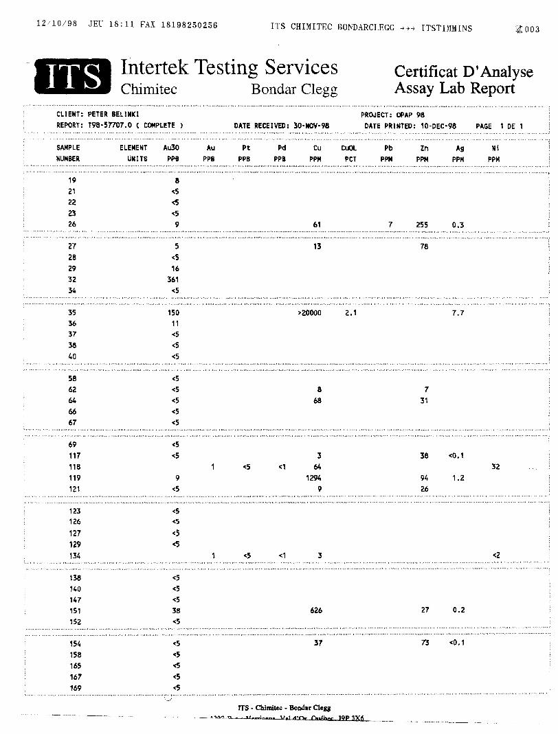
12/10/98 JEU 18:11 FAX 18198250256 ITS CHIMITEC BONDARCLEGG ITSTIMMINS i]003
ITS Intertek Testing ServicesChimitec Bondar Clegg
Certificat D'Analyse Assay Lab Report
i CLIENT:: REPORT:
i SAMPLENUMBER
1921222326
2728293234
3536373840
5862
; 646667
i 69117118119121
i 123i 126l 127i 129: 134
138i 140: 147
151152
; 154] 158i 165: 167
': 169
PETER BELIMKI PROJECT: OPAP 98T98-57707.0 ( COMPLETE ) DATE RECEIVED: 30-MOV-98 DATE PRINTED: 10-DEC-98 PAGE 1 DE 1
ELEMENT Au30 Au Pt Pd Cu CuOL Pb Zn Ag NiUNITS PPB PPB PPB PPB PPM PCT PPM PPM PPM PPM
8^ *5
*59 61 7 255 0.3
5 13 78*516
361"5
150 ^0000 2.1 7.711*5<5<5
*5<5 87^ 68 31K5
<5
<5^ 3 38 0.1
1 *5 *1 64 329 1294 94 1.2<5 9 26
,c5<5
<5<5
1 *5 ^ 3 <2
*5K5
<538 626 27 0.2
^ 37 73 O.1 55
<5<5<5
ITS - Chimitec - Bondar Clegg

APPENDIX 4DAILY ACTIVITIES LOGSEPTEMBER 4 - NOVEMBER 13,1998
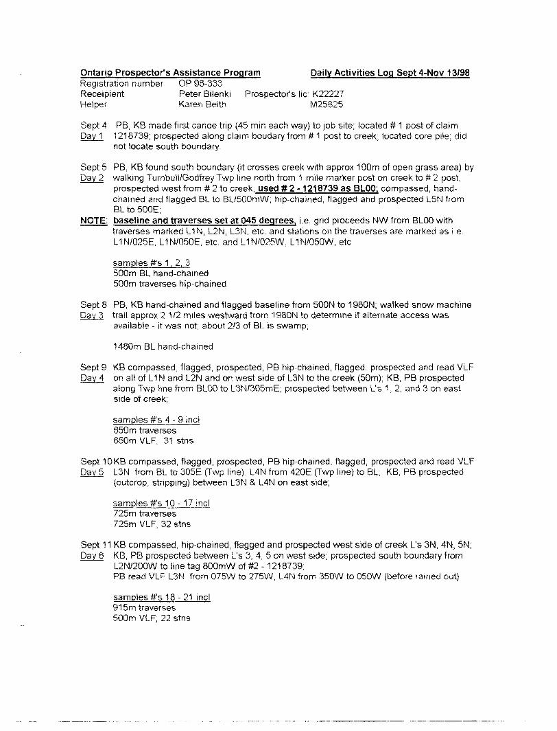
Ontario Prospector's Assistance Program Daily Activities Log Sept4-Nov 13/98Registration number OP 98-333Receipient Peter Bilenki Prospector's lie: K22227Helper Karen Berth M25825
Sept 4 PB, KB made first canoe trip (45 min each way) to job site; located # 1 post of claim Day 1 1218739; prospected along claim boudaryfrom # 1 post to creek; located core pile; did
not locate south boundary.
Sept 5 PB, KB found south boundary (it crosses creek with approx 100m of open grass area) by Day 2 walking Turn bull/Godfrey Twp line north from 1 mile marker post on creek to # 2 post;
prospected west from # 2 to creek; used #2 -1218739 as BLOO; compassed, hand- chained and flagged BL to BL/SOOmW; htp-chained, flagged and prospected L5N from BL to 500E;
NOTE: baseline and traverses set at 045 degrees, i.e. grid proceeds NW from BLOO withtraverses marked L1N, L2N, L3N, etc. and stations on the traverses are marked as i.e. L1N/025E, L1N/050E, etc. and L1N/025W, L1N/050W, etc.
samples #'s 1,2,3 500m BL hand-chained 500m traverses hip-chained
Sept 8 PB, KB hand-chained and flagged baseline from SOON to 1980N; walked snow machine Day 3 trail approx 21/2 miles westward from 1980N to determine if alternate access was
available - it was not; about 2/3 of BL is swamp;
1480m BL hand-chained
Sept 9 KB compassed, flagged, prospected, PB hip-chained, flagged, prospected and read VLF Day 4 on all of L1N and L2N and on west side of L3N to the creek (50m); KB, PB prospected
along Twp line from BLOO to L3N7305mE; prospected between Us 1, 2, and 3 on eastside of creek;
samples #'s 4 - 9 incl 650m traverses 650m VLF, 31 stns
Sept 10KB compassed, flagged, prospected, PB hip-chained, flagged, prospected and read VLF payS L3N from BL to 305E (Twp line), L4N from 420E (Twp line) to BL; KB, PB prospected
(outcrop, stripping) between L3N S L4N on east side;
samples #'s 10 -17 incl 725m traverses 725m VLF, 32 stns
Sept 11 KB compassed, hip-chained, flagged and prospected west side of creek L's 3N, 4N, 5N;Day 6 KB, PB prospected between L's 3, 4, 5 on west side; prospected south boundary from
L2N/200W to line tag SOOmW of #2 -1218739; PB read VLF L3N from 075W to 275W, L4N from 350W to 050W (before rained out)
samples #'s 18-21 incl 915m traverses 500m VLF; 22 stns
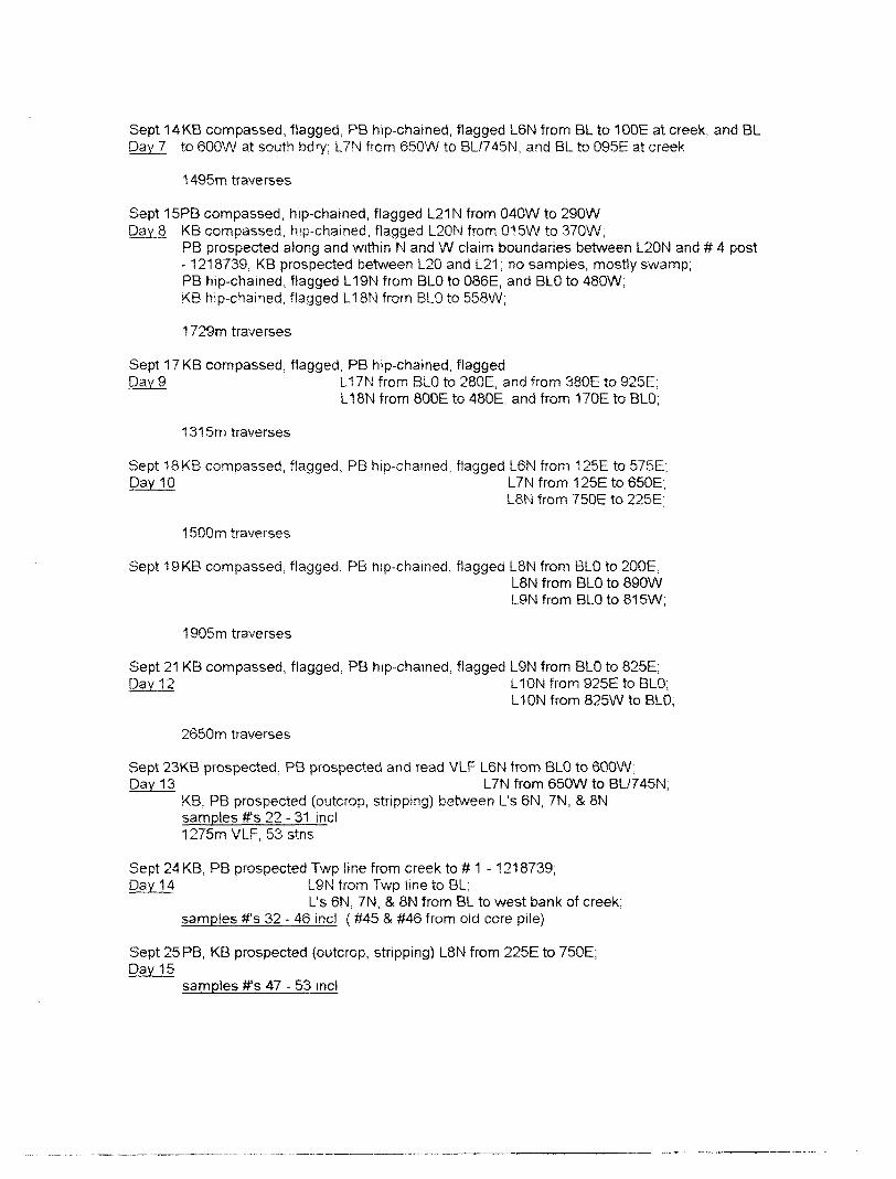
Sept 14KB compassed, flagged, PB hip-chained, flagged L6N from BL to 100E at creek, and BL Day 7 to 600W at south bdry; L7N from 650W to BL/745N, and BL to 095E at creek
1495m traverses
Sept 15PB compassed, hip-chained, flagged L21N from 040W to 290W Day 8 KB compassed, hip-chained, flagged L20N from 015W to 370W;
PB prospected along and within N and W claim boundaries between L20N and # 4 post-1218739, KB prospected between L20 and L21; no samples, mostly swamp;PB hip-chained, flagged L19N from BLO to 086E, and BLO to 480W;KB hip-chained, flagged L18N from BLO to 558W;
1729m traverses
Sept 17KB compassed, flagged, PB hip-chained, flagged Day 9 L17N from BLO to 280E, and from 380E to 925E;
L18N from 800E to 480E, and from 170E to BLO;
1315m traverses
Sept 18KB compassed, flagged, PB hip-chained, flagged L6N from 125E to 575E; Day 10 L7N from 125E to 650E;
L8N from 750E to 225E;
1500m traverses
Sept 19KB compassed, flagged, PB hip-chained, flagged L8N from BLO to 200E.L8N from BLO to 890W L9NfromBLOto815W;
1905m traverses
Sept 21 KB compassed, flagged, PB hip-chained, flagged L9N from BLO to 825E; Day 12 L1 ON from 925E to BLO;
L10Nfrom825WtoBLO;
2650m traverses
Sept 23KB prospected, PB prospected and read VLF L6N from BLO to 600W; Day 13 L7N from 650W to BL/745N;
KB, PB prospected (outcrop, stripping) between L's 6N, 7N, 8t 8Nsamples #s 22 - 31 incl1275m VLF, 53 stns
Sept 24KB, PB prospected Twp line from creek to # 1 -1218739; Day 14 L9N from Twp line to BL;
L's 6N, 7N, 8, 8N from BL to west bank of creek; samples #'s 32 - 46 incl (#45 S #46 from old core pile)
Sept 25 PB, KB prospected (outcrop, stripping) L8N from 225E to 750E; Day15
samples ffs 47 - 53 incl

Sept 27 PB, KB prospected (outcrop, stripping) along and between L6N from 125E to 575E; Day16 L7N from 125E to 650E;
L7Nfrom650Eto125E;L8N from 750E to 225E;
samples #'s 54 - 60 incl. #'s 70 - 74 inci (NOTE: Inadvertently omitted numbers 61 - 69 incl - didn't realize omisson until #114 was bagged; then used 61 to 69 between 114 and 115 See day 29.)
Sept 28KB compassed, flagged, PB hip-chained, flagged L11N from BL to 925W;Day 17 L12N from 1050W to 050W/BL;
1925m traverses
Sept 30KB compassed, flagged, PB hip-chained, flagged L11N from BL to 900E; Day 18 L12N from BL to 800E;
1700m traverses
Oct 3 KB, PB prospected (outcrop, stripping) L8N from BL to 890W; Day 19 L9N from 815W to BL;
samples #'s 75-79 incl
Oct 4 KB prospected, PB prospected,read VLF L11N from BL to 925W; Day 20 L1 ON from 825W to BL;
samples #'s 80 - 84 incl 1775m VLF, 73 stns
Oct 5 KB compassd, flagged, PB hip-chained, flagged L13N from BL to 1025W; Day21 L14N from 950W to BL;
2025m traverses
Oct 6 KB compassed, flagged, PB hip-chained, flagged L16N from BL to 775W Day 22 L15N from 850W to BL;
L17NfromBLto660W;
2285m traverses
Oct 9 PB compassed, hip-chained, flagged L16N from BL to 900E; Day 23 KB compassed, flagged L15N from BL to 700E (PB chained back);
1625m traverses
Oct 10 KB compassed, flagged, PB hip-chained, flagged L14N from BL to 625E; Day 24 L13N from BL to 685E;
1310m traverses
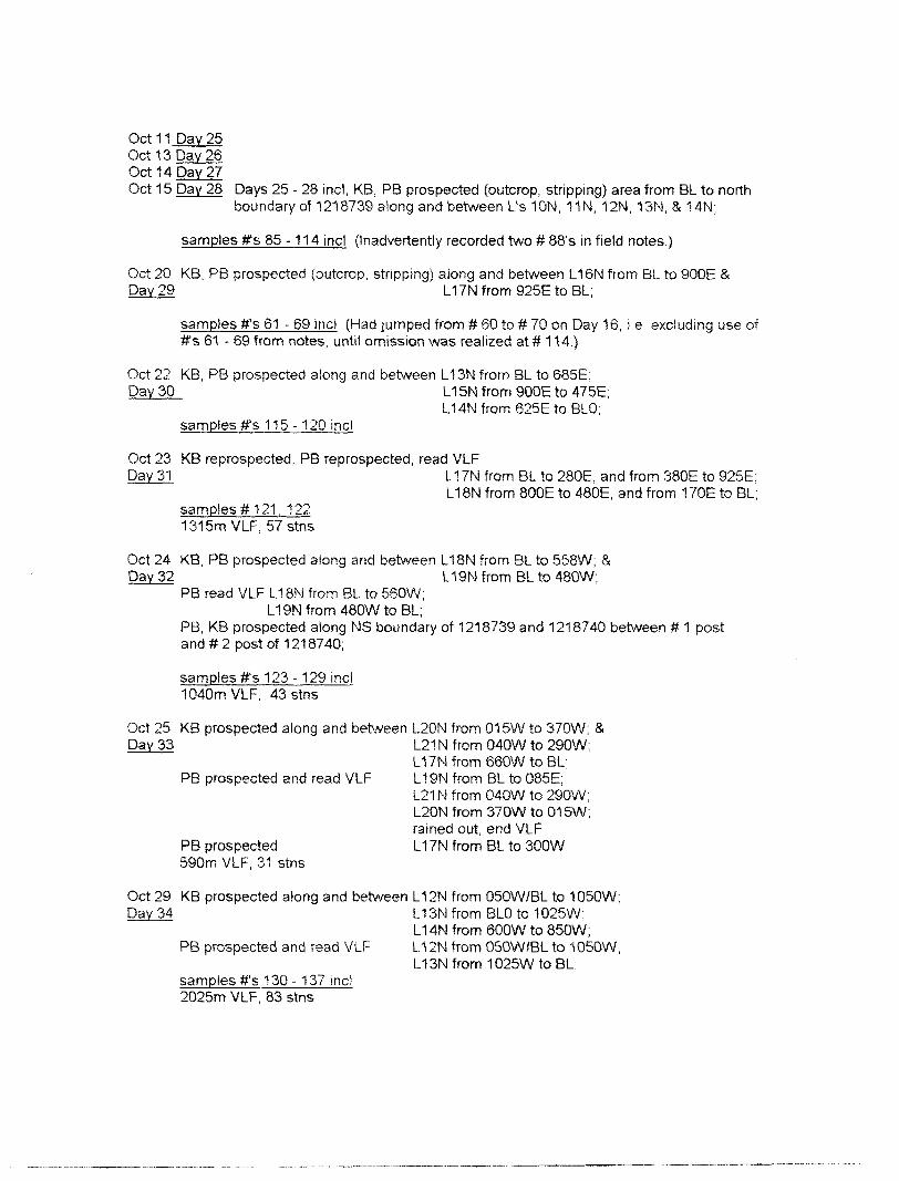
Od 11 Day 25 Oct13Dav26 Oct14Dav27Oct 15 Day 28 Days 25 - 28 incl, KB, PB prospected (outcrop, stripping) area from BL to north
boundary of 1218739 along and between L'slON, 11N, 12N, 13N, S 14N;
samples #*s 85 -114 incl (Inadvertently recorded two # 88's in field notes.)
Oct 20 KB, PB prospected (outcrop, stripping) along and between L16N from BL to 900E S Day 29 L17N from 925E to BL;
samples #'s 61 - 69 incl (Had jumped from # 60 to # 70 on Day 16, i.e. excluding use of #'s 61 - 69 from notes, until omission was realized at #114.)
Oct 22 KB, PB prospected along and between L13N from BL to 685E; Day 30 L15N from 900E to 475E;
L14Nfrom625EtoBLO; samples #'s 115 -120 incl
Oct 23 KB reprospected, PB reprospected, read VLFDay 31 L17N from BL to 280E, and from 380E to 925E;
L18N from 800E to 480E, and from 170E to BL;samples #121, 1221315m VLF, 57 stns
Oct 24 KB, PB prospected along and between L18N from BL to 558W; S Day 32 L19N from BL to 480W;
PB read VLF L18N from BL to 560W; L19Nfrom480WtoBL;
PB, KB prospected along NS boundary of 1218739 and 1218740 between # 1 postand #2 post of 1218740;
samples #'s 123 -129 incl 1040m VLF, 43 stns
Oct 25 KB prospected along and between L20N from 015W to 370W; 8, Day 33 L21N from 040W to 290W;
L17Nfrom66GWtoBL; PB prospected and read VLF L19N from BL to 085E;
L21N from 040W to 290W; L20N from 370W to 015W; rained out, end VLF
PB prospected L17N from BL to 300W 590m VLF, 31 stns
Oct 29 KB prospected along and between L12N from 050W/BL to 1050W; Day 34 L13N from BLO to 1025W;
L14N from 600W to 850W; PB prospected and read VLF L.12N from 050W/BL to 1050W;
L13Nfrom1025WtoBL; samples #'s 130-137 incl 2025m VLF, 83 stns
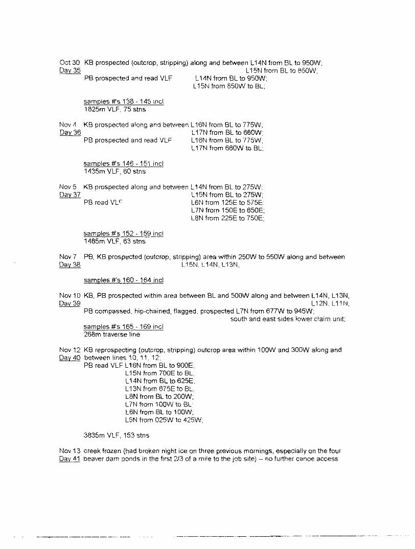
Oct 30 KB prospected (outcrop, stripping) along and between L14N from BL to 950W; Day 35 L15N from BL to 850W;
PB prospected and read VLF LI 4N from BL to 950W;L15Nfrom850WtoBL;
samples #'s 13.8- 145.incl 1825m VLF, 75 stns
Nov 4 KB prospected along and between L16N from BL to 775W;Day 36 L17N from BL to 660W;
PB prospected and read VLF L16N from BL to 775W;L17Nfrom660WtoBL;
samples #'s 146 -151 incl 1435m VLF, 60 stns
Nov 5 KB prospected along and between L14N from BL to 275W;Day 37 L15N from BL to 275W;
PB read VLF L6N from 125E to 575E;L7Nfrom150Eto650E;L8N from 225E to 750E;
samples tfs 152 -159 inci 1485m VLF, 63 stns
Nov 7 PB, KB prospected (outcrop, stripping) area within 250W to 550W along and between Day 38 L15N, L14N,L13N;
samples #'s 160-164 incl
Nov 10 KB, PB prospected within area between BL and 500W along and between L14N, L13N, Day 39 L12N, L11N;
PB compassed, hip-chained, flagged, prospected L7N from 677W to 945W;south and east sides lower claim unit;
samples#'s 16.5-169 incl268m traverse line
Nov 12 KB reprospecting (outcrop, stripping) outcrop area within 100W and 300W along and Day 40 between lines 10, 11, 12;
PB read VLF L16N from BL to 900E;L15Nfrom700EtoBL;L14NfromBLto625E;L13Nfrom675EtoBL;L8N from BL to 200W;L7Nfrom100WtoBL;L6NfromBLto100W;L5N from 025W to 425W;
3835m VLF, 153 stns
Nov 13 creek frozen (had broken night ice on three previous mornings, especially on the fourDay 41 beaver dam ponds in the first 2/3 of a mile to the job site) ~ no further canoe access

APPENDIX 5 GRID LOG
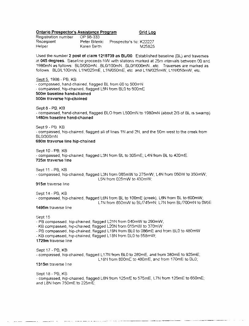
Ontario Prospector's Assistance Program Grid LogRegistration number OP 98-333Receipient Peter Bilenki Prospector's lie: K22227Helper Karen Beith M25825
Used the number 2 post of claim 1218739 as BL/00. Established baseline (BL) and traverses at 045 degrees. Baseline proceeds NW with stations marked at 25m intervals between 00 and 1980mN as follows: BLOy050mN...BL07100mN...BL071000mN...etc. Traverses are marked as follows: BLO/UOOmN, L1N7025mE, UN/OSOmE, etc. and L1N7025mW, L1 N/OSOmW, etc.
SeptS. 1998-PB, KB- compassed, hand-chained, flagged BL from 00 to SOOmN- compassed, hip-chained, flagged L5N from BLO to SOOmE 500m baseline hand-chained 500m traverse hip-chained
Sept 8 - PB, KB- compassed, hand-chained, flagged BLO from LSOOrnN to 1980mN (about 2/3 of BL is swamp) 1480m baseline hand-chained
Sept 9 - PB, KB- compassed, hip-chained, flagged all of lines 1N and 2N, and the 50m west to the creek fromBLO/SOOmN690m traverse line hip-chained
Sept 10-PB, KB- compassed, hip-chained, flagged L3N from BL to 305mE; L4N from BL to 420mE. 725m traverse line
Sept 11 - PB, KB- compassed, hip-chained, flagged L3N from 065mW to 275mW; L4N from 050W to 350mW;
L.5N from 025mW to 430mW; 915m traverse line
Sept 14-PB, KB- compassed, hip-chained, flagged L6N from BL to 100mE (creek); L6N from BL to 600mW;
L7N from 650mW to BL;745mN; L7N from BL;700mN to 095E 1495m traverse line
Sept 15- PB compassed, hip-chained, flagged L21N from 040mW to 290mW;- KB compassed, hip-chained, flagged L20N from 015mW to 370mW;- PB compassed, hip-chained, flagged L19N from BLO to 086mE and from BLO to 480mW- KB compassed, hip-chained, flagged L18N from BLO to 558mW; 1729m traverse line
Sept 17-PB, KB- compassed, hip-chained, flagged L17N from BLO to 280mE, and from 380mE to 925mE;
L18N from SOOmE to 480mE, and from 170mE to BLO; 1315m traverse line
Sept 18-PB, KB- compassed, hip-chained, flagged L6N from 125mE to 575mE; L7N from 125mE to 650mE; and L8N from 750mE to 225mE;
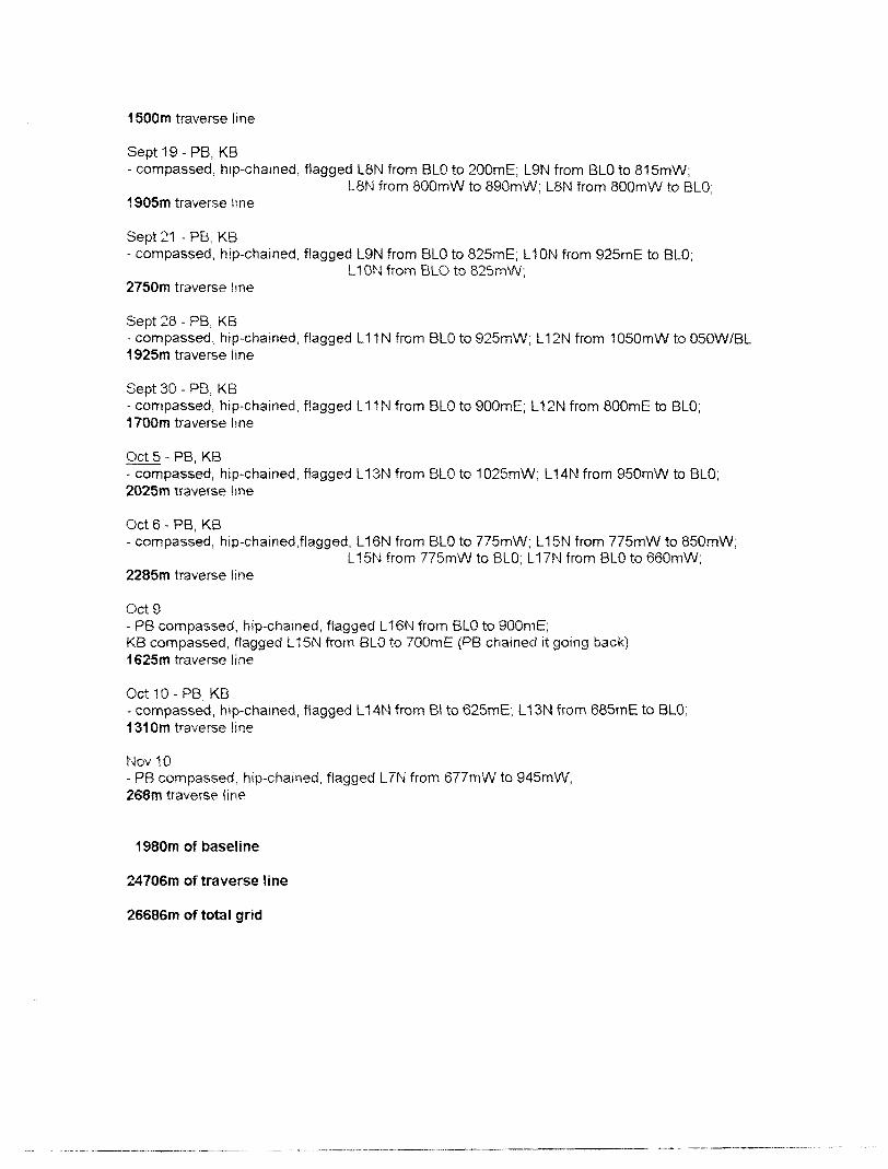
1500m traverse line
Sept 19-PB, KB- compassed, hip-chained, flagged L8N from BLO to 200mE; L9N from BLO to 815mW;
L8N from SOOmW to 890mW; L8N from SOOmW to BLO; 1905m traverse line
Sept 21 - PB, KB- compassed, hip-chained, flagged L9N from BLO to 825mE; L10N from 925mE to BLO;
L10N from BLO to 825mW; 2750m traverse line
Sept 28 - PB, KB-compassed, hip-chained, flagged LUNfrom BLOto925mW; L12Nfrom 10SOmW to 050W/BL 1925m traverse line
Sept 30 - PB, KB- compassed, hip-chained, flagged L1 IN from BLO to 900mE; L12N from 800mE to BLO; 1700m traverse line
Oct 5 - PB, KB- compassed, hip-chained, flagged L13N from BLO to 1025mW; L14N from 950mW to BLO; 2025m traverse line
Oct 6 - PB, KB- compassed, hip-chained,flagged, L16N from BLO to 775mW; L15IM from 775mW to 850mW;
L15N from 775mW to BLO; L17N from BLO to 660mW; 2285m traverse line
Oct 9- PB compassed, hip-chained, flagged L16N from BLO to 900mE;KB compassed, flagged L15N from BLO to 700mE (PB chained it going back)1625m traverse line
Oct10-PB, KB- compassed, hip-chained, flagged L14N from Bl to 625mE; L13N from 685mE to BLO; 1310m traverse line
IMovlO- PB compassed, hip-chained, flagged L7N from 677mW to 945mW; 268m traverse line
1980m of baseline
24706m of traverse line
26686m of total grid

APPENDIX 6 PROSPECTING/SAMPLING DAILY LOG
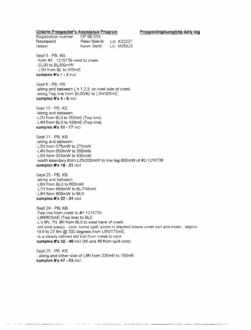
Ontario Prospector's Assistance Program Prospecting/sampling daily logRegistration number OP 98-333Receipient Peter Bilenki Lie: K22227Helper Karen Berth Lie: M25825
Sept 5 - PB, KB- from #2-1218739 west to creek- BLOO to BLSQOmW- L5N from BL to 500m E samples tfs 1 - 3 me!
Sept 9 - PB, KB-along and between L's 1,2,3, on east side of creek-along Twp line from BLOO/&2 to LSN/SOSmE samples #s 4 -9 incl
Sept 10-PB, KB-along and between-L3N from BLO to 305mE (Twp line)-L4N from BLO to 420mE (Twp line) samples if s 10-17 incl
Sept 11 - PB, KB-along and between-L3N from 075mW to 275mW-L4N from 050mW to 350mW-L5N from 025mW to 430mW-south boundary from L2N7200mW to line tag SOOmW of #2-1218739 samples tt s 18 - 21 incl
Sept 23 - PB, KB-along and between-L6N from BLO to 600mW-L7N from 650mW to BL7745mN-L8N from SOOmW to BLO samples ffs 22 - 31 incl
Sept 24 - PB, KB-Twp line from creek to #1 -1218739-L9W825mE (Twp line) to BLO-L's 6N, 7N, 8N from BLO to west bank of creek-old core pile(s) - core, some spilt, some in stacked boxes under soil and moss - approx 19.6 to 27.9m @ 300 degrees from L8Nyi75mE;-is a clearly defined old trail from creek to core samples #s 32 - 46 inc! (45 and 46 from spilt core)
Sept 25 - PB, KB- along and either side of L8N from 225mE to 750mE samples #s 47 - 53 incl
Sept 27 - PB, KB-along and between-L6N from 125mE to 575mE-L7N from 125mE to 650mE-L8N from 750mE to 225mEsamples tf s 54 - 60 incl; samples ffs 70 - 74 incl;(Inadvertently omitted #'s 61-69. Didn't realize it until #114 was bagged, then used 61-69between 114 S 115.)(see Oct 20 below)
Oct 3 - PB, KB-along and between-L8N from BL to SQOmW-L9Nfrom815mWtoBLO samples #"s 75 - 79 inc!
Oct 4 - PB, KB-along and between-L11N from BLO to 925mW-L10N from 825mW to BLO samples #s 80 - 84 incl
Oct 11, 13, 14, 15 incl-PB, KB-area from BLO to north boundary of claim 1218739 along and between L'slON, 11N, 12N, 13N, 14N
samples #s 85-114 incl
Oct 20 - PB, KB-along and between-L16N from BLO to 900mE-L17Nfrom925mEtoBLOsamples #s 61 - 69 incl (see Sept 27}
Oct 23 - PB, KB-redo along and between-L17N from BLO to 280mE, and from 380mE to 925mE-L18N from SOOmE to 480mE, and from 170mE to BLO samples #s 121,122
Oct 24 - PB, KB-aiong and between-L18NfromBLOto558mW-L19N from BLO to 480mW-along NS boundary of 1218739 8, 1218740 between #1 and #2 posts of 1218740 samples ffs 123-129 incl

Oct 29 - PB, KB-KB along and between L12N from QSOmW to 1050mW; L13N from BLO to 1025mW; L14N from 600mW to 850mW
-PB along and between L12N from 050mW to 105QmW; L13Nfrom 1025mW to BLO samples #"s 130 -137 me!
Oct 30 - PB, KB- along and between-L14N from BLO to 950mW-L15N from BLO to 850mW samples #"s 138 -145 incf
Nov 4 - PB, KB-along and between-L16N from BLO to 775mW-L17N from BLO to 660mW samples ffs 146 -151 inc!
Nov 5KB - along and between L14N from BLO to 275mW; L15N from BLO to 275mWsamples #*s 152 - 159 incl
Nov 7 - PB, KB-area within 250mW to 550mW along and between L's 15N, 14N, 13N samples #160-164 me!
Nov10-PB, KB- area within BLO and 500mW along and between L's 14N, 13N, 12N, 11N samples #s 165 - 169 incl
Nov 12KB - redo area within 100mW and 300mW along and between L's 10, 11, 12
Total of 169 samples taken from project site

APPENDIX 7VLF EM-16 SPECIFICATIONS AND OPERATION
QUADRATURE. CONTROLINCLINOMETER
FIG. l EM IQEARPHONE, JACK
CASE
STATION SELECTOR
VOLUME CONTROL
Page l
EM16 SPECIFICATIONS
MEASURED QUANTITY
SENSITIVITY
RESOLUTION
OUTPUT
OPERATING FREQUENCY
OPERATOR CONTROLS
POWER SUPPLY
DIMENSIONS
WEIGHT
Inphase and quad-phase components of vertical magnetic field as a percentage of horizontal primary field. (i.e. tangent of the tilt angle and ellipticity}.
Inphase: 1501 Quad-phase: 40*
1*
Nulling by audio tone. Inphase in dication from mechanical inclinometer and quadphase from a graduated dial.
15-25 kHz (15-30 kHz optional) VLFRadio Band. Station selection done bymeans of plug-in units.
ON/OFF switch, battery test push button, station selector switch, audio volume control, quadrature dial, inclinometer.
6 disposable 'AA 1 cells.
53 x 21.5 x 28 cm
Instrument: 1.8 kg
Shipping: 8.35 kg
CAUTION:
EMlb inclinometer may be damaged by exposure to temperatures below -30 0 c. Warranty does not cover inclinometers damaged by such exposure.

Page 20

Page 19
FIELD PROCEDURE
Orientation s, Taking a Reading
The direction of the survey lines should be selected approxi mately along the lines of the,primary magnetic field, at right angles to the direction tp the station being used. Before starting the survey, the instrument can be used to orient one self in that respect. By turning the instrument sideways, the signal is minimum when the instrument is pointing towards the station, thus indicating that the magnetic field is at right angles to the receiving coil inside the handle.(Fig.11).
To take a reading, first orient the reference coil (in the lower end of the handle) along the magnetic lines.(Fig.12) Swing the instrument back and forth for minimum sound intensity in the speaker. Use the volume control to set the sound level for comfortable listening. Then use your left hand to adjust the quadrature component dial on the front left corner of the instrument to further minimize the sound. After finding the minimum signal strength on both adjustments, read the inclino meter by looking into the small lens. Also, mark down the quadrature reading.
While travelling to the next location you can, if you wish, keep the instrument in operating position. If fast changes in the readings occur, you might take extra stations to pinpoint accurately the details of anomaly.
The dials inside the inclinometer are calibrated in positive and negative percentages. If the instrument is facing 180O from the original direction of travel, the polarities of the readings will be reversed. Therefore, in the same area take the readings always facing in the same direction even when travelling in opposite way along the lines.
The lower end of the handle, will as a rule, point towards the conductor. (Figs.13 i 14) The instrument is so calibrated that when approaching the conductor, the angles are positive in the in-phase component. Turn always in the same direction for readings and mark all this on your notes, maps, etc.
THE INCLINOMETER DIALS
The right-hand scale is the in-phase percentage(ie. Hs/Hp as a percentage) . This percentage is in fact the tangent of the dip angle. To compute the dip angle simply take the arc tangent of the percentage reading divided by 100. See the conversion graph on the following page.
The left-hand scale is the secant of the slope of the ground surface. You can use it to "calculate" your distance *o the next station along the slope of the terrain.
Page 21
(1) Open both eyes.
(2) Aim the hairline along the slope to the next station to about your eye level height above ground.
(3) Read on the left scale directly the distance necessary to measure along the slope to advance 100 (ft) horizon tally.
He feel that this will make your reconnaissance work easier. The outside scale on the inclinometer is calibrated in degrees just in case you have use for it.
PLOTTING THE RESULTS
For easy interpretation of the results, it is good practice to plot the actual curves directly on the survey line map using suitable scales for the percentage readings. (Fig.15) The horizontal scale should be the same as your other maps on the area for convenience.
A more convenient form of this data is easily achieved by transforming the zero-crossings into peaks by means of a simple numerical filtering technique. This technique is described by D.C. Fraser in his paper "Contouring of VLF-EM Data", Geophysics, Vol. 34, No. 6. (December 1969)pp958-967. A reprint of this paper is included in this manual for the convenience of the user.
This simple data manipulation procedure which can be imple mented in the field produces VLF-EM data which can be contoured and as such provides a significant advantage in the evaluation of this data.

APPENDIX 8 VLFLOG
Ontario Prospector's Assistance Program VLF LogRegistration number OP 98-333Receipient Peter Bilenki Prospector's lie: K22227Helper Karen Beith M25825
EM-16 operator-PB
Sept 9 - L1N from BLO to 115mE, from BLO to 115mW, L2N from BLO to 210mE, from BLO to 160mW; L3N from BLO to 050mW,
650m VLF
Sept 10 - L3N from BLO to 305mE; L4N from 420mE to BLO;
725m VLF
Sept 11 - L3N from 075mW to 275mW; L4N from 350mW to 054mW;
500m VLF
Sept 23 - L6N from BLO to 600mW;L7N from 650mW to BLOy745mN;
1275m VLF
Oct 4 - L11N from BLO to 925mW; L10N from 825mW to BLO;
1775m VLF
Oct 23 - L17N from BLO to 280mE and from 380mE 925mE; L18N from SOOmE t 480mE and from 170mE to BLO;
1315m VLF
Oct 24 - L18N from BLO to 560mW; L19N from 480mW to BLO;
1050m VLF
Oct 25 - L19N from BLO to 085mE;L21N from 040mW to 290mW; L20N from 370mW to 015mW;
690m VLF
Oct 29 - L12N from OSOmW/BLO to 1050mW; L13N from 1035mW to BLO;
2025m VLF
Oct 30 - L14N from BLO to 950mW; L15N from 850mW to BLO;
1825m VLF
Nov 4 - L16N from BLO to 775mW; L17Nfrom660mWtoBLO;
1435m VLF
Nov 5 - L6N from 125mE to 575mE; L7N from 150mE to 650mE; L8N from 225mE to 750mE;
1500m VLF
Nov 12 - L16N from BLO to 900mE; L15Nfrom700mEtoBLO; L14N from BLO to 625mE; L13Nfrom675mEtoBLO; L8^4 from 025mE to 200mE: L7Nfrom100mEtoBLO; L6N from 025rnE to 100mE; L5N from 025mW to 425mW;
3725m VLF
TotaM8660m VLF
Total 774 stns
Ontario Declaration of Assessment Work Performed on Mining LandMinina Act. Subnotion 66(2) and 66(3), R.S.O.1990
Transaction Number (office use)
Assessment Files Research Imaging
actions 65(2) and 66(3) of the Mining Act. Under section 8 of the Mining Act, this t work and correspond with the mining land holder. Questions about this collection it and Mines, 3rd Floor, 933 Ramsey Lake Road, Sudbury, Ontario, P3E 6B5.
42A05KE2021 2.19548 TURNBULL 900
Instructions: - For work performed on Crown Lands before recording a claim, use form 0240. - Please type or print in ink.
1. Recorded holder(s) (Attach a list if necessary)T"-
-"i" /O ^v/o &TUCCSClient Number
Address5*3.5
Telephone Number- 03x7
Fax Number
(J, Client Number
Address Telephone Number
Fax Number
2. Type of work performed: Check (*Q and report on only ONE of the following groups for this declaration.
r Geotechnical: prospecting, surveys, n Physical: drilling stripping, n Rehabilitation assays and work under section 18 (regs) ^
Physical: drilling stripping, trenching and associated assays D
Office UseCommodityTotal S Value Work Claimed
i# /f ^ ST 1(0. 6O&
DalasWorkPerformed
To NTS ReferenceDay l Month | Year Day | Month | Year
Global Positioning System Data (if available) Mining DivisionM or G-Plan Number Resident Geolog
District
Please remember to: - obtain a work permit from the Ministry of Natural Resources as required;- provide proper notice to surface rights holders before starting work;- complete and attach a Statement of Costs, form 0212;- provide a map showing contiguous mining lands that are linked for assigning work;- include two copies of your technical report.
3. Person or companies who prepared the technical report (Attach a list if necessary)Telephone Number
- 566 -Address
^ G*fT SFax Number
Telephone Number ^1 77
Fax Number
Name Telephone Number
Address Fax Number
ertification by Recorded Holder or Agent4. x Certification by Reei. Kefer PH l en/Ci , do hereby certify that l have personal knowledge of the facts set forth in
(Print Name)this Declaration of Assessment Work having caused the work to be performed or witnessed the same during or after its completion and, to the best of my knowledge, the annexed report is true.Signature of Recorded Holder or Agent
Telephone Number71^5-360-5/7-7 ~
Fax Number
2.195 4 S
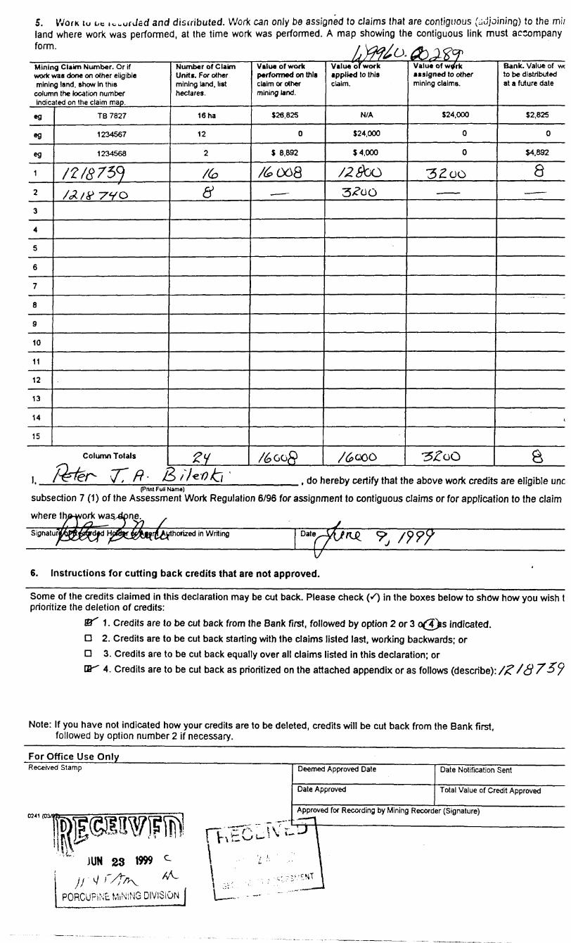
5. Worn tu bc .^urJed and distributed. Work can only be assigned to claims that are contiguous (adjoining) to the minir land where work was performed, at the time work was performed. A map showing the contiguous link must accompany th form. t Vx-ixi/,. JH ^ ^-}—
tin /f^ y*j^Lib7Mining Claim Number. Or if work was done on other eligible mining land, show In this
column the location number indicated on the claim map.
eg
eg
eg
1
2
3
4
5
6
7
8
g
10
11
12
13
14
15
TB 7827
1234567
1234568
/f #739
Column Totals ^-\
Number of Claim Units. For other mining land, list hectares.
16 ha
12
2
/(o
8
2i
Value of work performed on this claim or other mining land.
526,825
0
5 8,892
/&068— -
/6GG(9
Value ofwork applied to this claim.
N/A
524,000
5 4,000
/2&OO3*?o G
/^GOO
Value of w^rk assigned to othermining claims.
524,000
0
0
3200
- ———
•2^00
Bank. Value of work to be distributed at a future date
52,825
0
54,892
8—
'
81. v , /r - O x Ae # O
subsection
where th^-v/ork wa
_____, do hereby certify that the above work credits are eligible undt(Print Full Name)
7 (1) of the Assessment Work Regulation 6/96 for assignment to contiguous claims or for application to the claim
as^done..fhofized in Writing j my
6. Instructions for cutting back credits that are not approved.
Some of the credits claimed in this declaration may be cut back. Please check (S) in the boxes below to show how you wish tr prioritize the deletion of credits:
IS'" 1. Credits are to be cut back from the Bank first, followed by option 2 or 3 o(Tfcs indicated.D 2. Credits are to be cut back starting with the claims listed last, working backwards; orD 3. Credits are to be cut back equally over all claims listed in this declaration; orIB"" 4. Credits are to be cut back as prioritized on the attached appendix or as follows (describe): /Z /S 7^J
Note: If you have not indicated how your credits are to be deleted, credits will be cut back from the Bank first, followed by option number 2 if necessary.
For Office Use Only———————.——————————Received Stamp
02X1 (CO/
JUN 23 1999
PORCUPINE: MiNiNG DIVISION
Deemed Approved Date
Date Approved
Date Notification Sent
Total Value of Credit Approved
Approved for Recording by Mining Recorder (Signature)
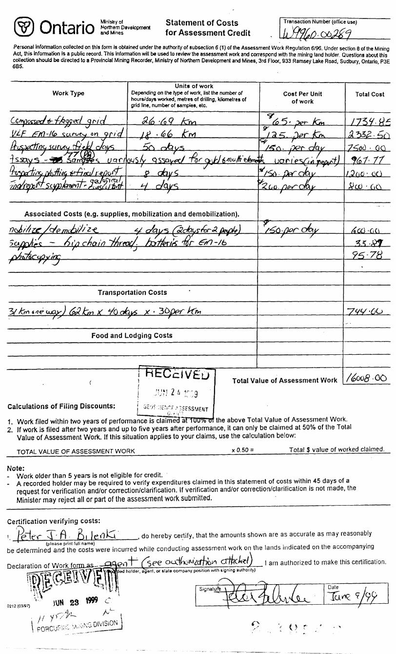
Ontario Ministry olNorthern Developmentand Mines
Statement of Costs for Assessment Credit
Transaction Number (office use)
Personal information collected on this form Is obtained under the authority of subsection 6 (1) of the Assessment Work Regulation 6/96. Under section 8 of the Mining Act. this Information Is a public record. This Information will bc used lo review the assessment work and correspond with the mining land holder. Questions about this collection should be directed to a Provincial Mining Recorder, Ministry of Northern Development and Mines, 3rd Floor, 933 Ramsey Lake Road Sudbury Ontario P3E 6B5.
Work Type
Cc^ofSFC/^- r/vQoec/ Q r/ or
t/t-F t^/fl-Ko scirKy on jrtcf
^3^^'^la^^ 'fjpr/fayJri'stojfirfiK is^'naJ Kputf'
^f^rscvp^lt- ffiffi/Sh
Units of workDepending on the type of work, list the number of hours/days worked, metres of drilling, kilometres of grid line, number of samples, etc.
Q S / n L- cXfo YO y (ATrv)
/^ ^6 /bv?
±)(^J OMUS
6VSV QS^Qy^c/ iQf Q.lfJ d/fiu/h zfemt,f y
..g.. Q3y*i. ., . . .V Q/Q/^
Associated Costs (e.g. supplies, mobilization and demobilization).
flQo/f/ZZr s^/P/nuD/// "C 'j/ c/cii/'z (o2.c*QiySrorol p&ptf]
^oyo^vYf'C ~ *)f/) chain (nrtof/- /XyfferifG 'for dvK7-X6
/V7Ck7Sc~cX3 v /rJT' ' ^X
Transportation Costs
^/fcrt^ecuoyJ^/fcnX' yOo6^ X-36^pr/^/"
Food and Lodging Costs
c
Calculations of Filing Discounts:
1 . Work filed within two years of perfor
s Total Va
j -JU?i 2 i ng '| G 2'^'-!P'irF,^SESSMENT
rnance is claimecf aT 1T3D^Tor the above TuU
Cost Per Unit of work
6* *5 ' per- kjv\y f
/3 . r&r fCr\*"*jr t
/^o- p?r oW
''/'Sb.perchy. f f
'Ztjti./iP^al&f1 r
^O'/fcpro^7 r
lue of Assessment Work
al Value of Assessment Wort
Total Cost
/73y.^KA 55^ - Zr\/sd() ' GO%-r- r r
#0) - C&
6cti -no
^/5'78-
•7 W -60
/^ootf.OC
c. iiil* W Y Wl f\ l II w W VTIklllll MT w J W Vi l ** W i ^*wi*^*ititv""iw** m-** -wr* —. .. . . — -— —. . — — -- — — --
2. If work is filed after two years and up to five years after performance, it can only be claimed at 50 0Xo of the Tolal Value of Assessment Work. If this situation applies lo your claims, use the calculation below:
TOTAL VALUE OF ASSESSMENT WORK x 0.50 = Total S value of worked claimed.
Note:- Work older than 5 years is not eligible for credit.- A recorded holder may be required to verify expenditures claimed in this statement of costs within 45 days of a
request for verification and/or correction/clarification. If verification and/or correction/clarification is not made, the Minister may reject all or part of the assessment work submitted.
Certification verifying costs:
___t do hereby certify, that the amounts shown are as accurate as may reasonably(please print full namo) , ,
be determined and the costs were incurred while conducting assessment work on the lands indicated on the accompanying
Declaration of WorkJoriiLasled holder, agent, of state company position with signing authority)
l | am authorized to make this certification.
0212 (OS'S 7)23 W9 c.
, in , ;v Mil.'iKG OlV.SlONj
Signalute
V O r .'

" ^JCTo7ttiT|928b94"' T * ~!228ft3o' *" T*""
— .f"**"** . i "3"36 [^ 12280
i lyiii3
" 4iC UfHTS)
——, L^ ~ . _ ~^~ ; IIBWX
i" ""l ~ ^ ~ —-l— -
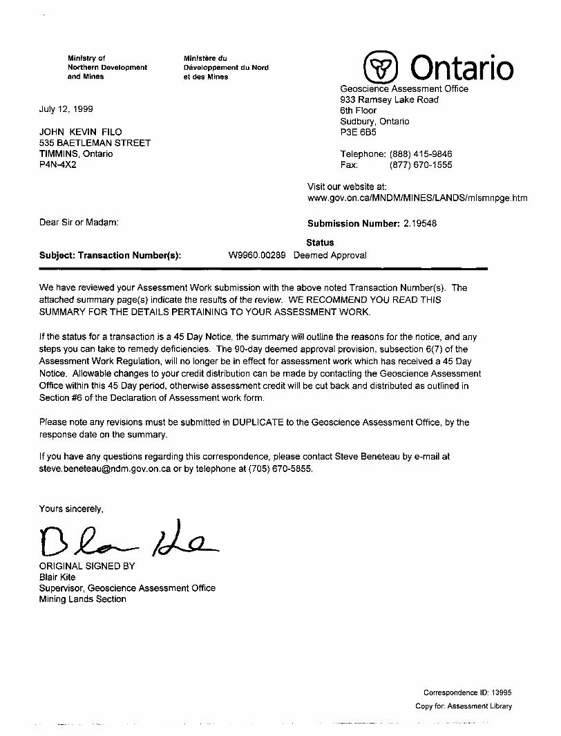
OntarioMinistry of Ministere duNorthern Development Developpement du Nordand Mines et des Mines
Geoscience Assessment Office 933 Ramsey Lake Road
July 12, 1999 6th FloorSudbury, Ontario
JOHN KEVIN FILO P3E 6B5535 BAETLEMAN STREETTIMMINS, Ontario Telephone: (888) 415-9846P4N-4X2 Fax: (877)670-1555
Visit our website at: www.gov.on.ca/MNDM/MINES/LANDS/mlsmnpge.htm
Dear Sir or Madam: Submission Number: 2.19548
Status Subject: Transaction Number(s): W9960.00289 Deemed Approval
We have reviewed your Assessment Work submission with the above noted Transaction Number(s). The attached summary page(s) indicate the results of the review. WE RECOMMEND YOU READ THIS SUMMARY FOR THE DETAILS PERTAINING TO YOUR ASSESSMENT WORK.
If the status for a transaction is a 45 Day Notice, the summary will outline the reasons for the notice, and any steps you can take to remedy deficiencies. The 90-day deemed approval provision, subsection 6(7) of the Assessment Work Regulation, will no longer be in effect for assessment work which has received a 45 Day Notice. Allowable changes to your credit distribution can be made by contacting the Geoscience Assessment Office within this 45 Day period, otherwise assessment credit will be cut back and distributed as outlined in Section #6 of the Declaration of Assessment work form.
Please note any revisions must be submitted in DUPLICATE to the Geoscience Assessment Office, by the response date on the summary.
If you have any questions regarding this correspondence, please contact Steve Beneteau by e-mail at [email protected] or by telephone at (705) 670-5855.
Yours sincerely,
ORIGINAL SIGNED BYBlair KiteSupervisor, Geoscience Assessment OfficeMining Lands Section
Correspondence ID: 13995
Copy for: Assessment Library
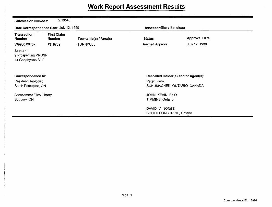
Work Report Assessment Results
Submission Number: 2.19548
Date Correspondence Sent: July 12, 1999 Assessor: Steve Beneteau
Transaction First Claim Number NumberW9960.00289 1218739
Section:9 Prospecting PROSP 14 Geophysical VLF
Township(s) l Area(s)TURNBULL
StatusDeemed Approval
Approval Date
July 12, 1999
Correspondence to:Resident Geologist South Porcupine, ON
Assessment Files Library Sudbury, ON
Recorded Holder(s) and/or Agent(s):Peter BilenkiSCHUMACHER, ONTARIO, CANADA
JOHN KEVIN FILO TIMMINS, Ontario
DAVID V. JONESSOUTH PORCUPINE, Ontario
Page: 1Correspondence ID: 13995
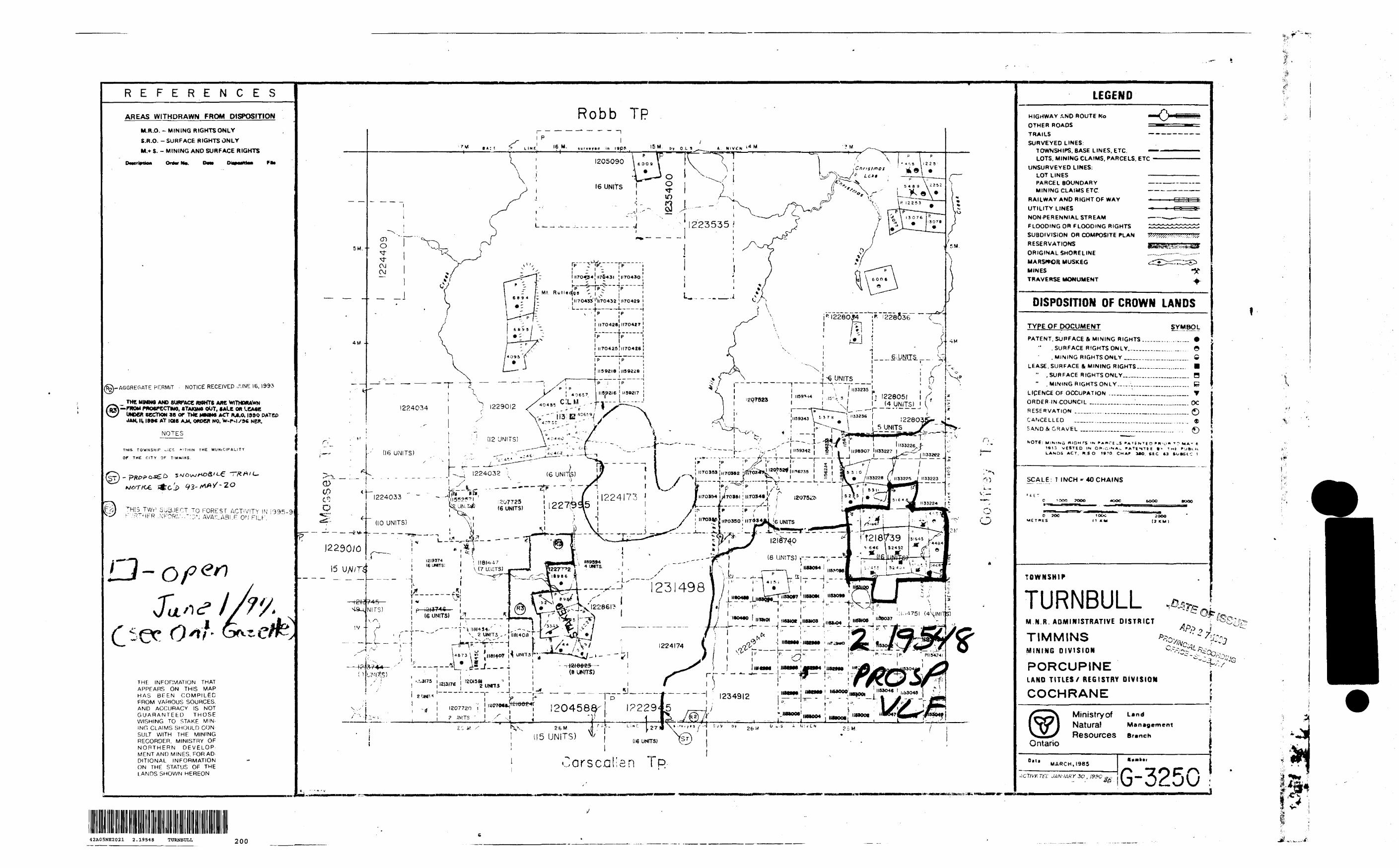
REFERENCES
AREAS WITHDRAWN FROM DISPOSITION
M.R.O. - MINING RIGHTS ONLY
S.R.O. - SURFACE RIGHTS ONLY
M.+ S. - MINING AND SURFACE RIGHTS
Ontar Ms. DMt Dl^aattlMi f tt
\-AGGREGATE PERMIT - NOTICE RECEIVED JUNE 16, 1993S
^ THE MIMNO AND 8UWAC6 RWHT8 ARC WITHDRAWN j—PROM PR06PCCTIMO, STAKM*! OUT, CALK OR LCA8B
UNDCR SECTION 36 OT THE MWtfM ACT R*.0.1980 PATCO JAN, II, I9*C AT lOie AM. ORDER NO. W^r-l/96 NCR.
NOTES
THIS TOWNSHIP t-iEC * L TH!N THE MUNICIPALITY
OF THE CITY OF TIMMINS.
strcj)
'"HiS TWr1 SUBJECT TO FOREST ACTIVITY IN i995-9 .i\'FOR,V,,'::;'i AVAILABI F QN1 FILF
\
THE INFORMATION THAT APPEARS ON THIS MAP HAS BEEN COMPILED FROM VARIOUS SOURCES. AND ACCURACY IS NOT GUARANTEED THOSE WISHING TO STAKE MIN ING CLAIMS SHOULD CON SULT WITH THE MINING RECORDER, MINISTRY OF NORTHERN DEVELOP MENT AND MINES. FOR AD DITIONAL INFORMATION ON THE STATUS OF THE LANDS SHOWN HEREON
Robb TP
223535 \
1/5431 j II7043Q
- Mt. Rutledjg* C
r- ' /' f Jf*™
' L ^ -^K- \ 1224032 ;
II3SZ28 ( M33225I133223
—— —— - —— TR.—— -,---, ' C)
' -I' L-'J-,^-NL-.__J,
(8 UNITS)'- -----
231498
^ft^l ™-^-iw* ItOWWE j HDMVO
i,--O-'\ 2 UNITS ,-p.- -- -
t c""" ITT" -,
-r 12(0925— (8 UNfTi)
20458^271 v • ry ''' :l y'
5 UNITS)
• arscjdllen TP
i •i ^
LEGENDHIGHWAY A.ND ROUTE Ko OTHER ROADS TRAILS SURVEYED LINES:
TOWNSHIPS, BASE LINES. ETC.LOTS, MINING CLAIMS, PARCELS. ETC
UNSURVEYED LINES:LOT LINESPARCEL BOUNDARYMINING CLAIMS ETC
RAILWAY AND RIGHT OF WAY UTILITY LINES NON-PERENNIAL STREAM FLOODING OR FLOODING RIGHTS : SUBDIVISION OR COMPOSITE PLAN 7 RESERVATIONS ORIGINAL SHORELINE MARSWO8 MUSKEG MINES TRAVERSE MONUMENT
l i-
DISPOSITION OF CROWN LANDS
TYPE OF DOCUMENT
PATENT. SUPFACE tt MINING RIGHTS " . SURFACE RIGHTS ONLY......
.MINING RIGHTS ONLY m... LEASE. SURFACE S, MINING RIGHTS..
" .SURFACE RIGHTS ONLY.___." .MINING RIGHTS ONLY...,.;...
LICENCE OF OCCUPATION ........l,,.ORDER -IN COUNCIL ......,......,,.^...
RESERVATION ___.......___.......
CANCELLED ___...,_____.......,?.AND St GRAVEL ..
SYMBOL
C5(ST
OC
NOTE: MiMUSu RIGHTS in ""APCE^S F* T t- N T t o 'H 10
1S13 VJSTED IN Od.G'NAi- PATENTEE t" Tu LANOS ACT, (U.S O 1970 CMAf MO. St C 43
T* MA" *
SCALE: 1 INCH'40 CHAINS
O 1000 MOO 4000 6000 •OOO
o looMETRES
IOOO MUM
i OOO[9 KM)
TOWNSHIP
TURNBULLMN.R. ADMINISTRATIVE DISTRICT
TIMMINSMINING DIVISION
PORCUPINELAND TITLES/ REGISTRY DIVISION
COCHRANEMinistryof L*ndNatural Management
Resources BranchOntario
Oil*MARCH, 1985
JANtlAKY 3O ,
• ••hti
G-3250
\
42A05NE2021 2.19548 TURNBULL 200
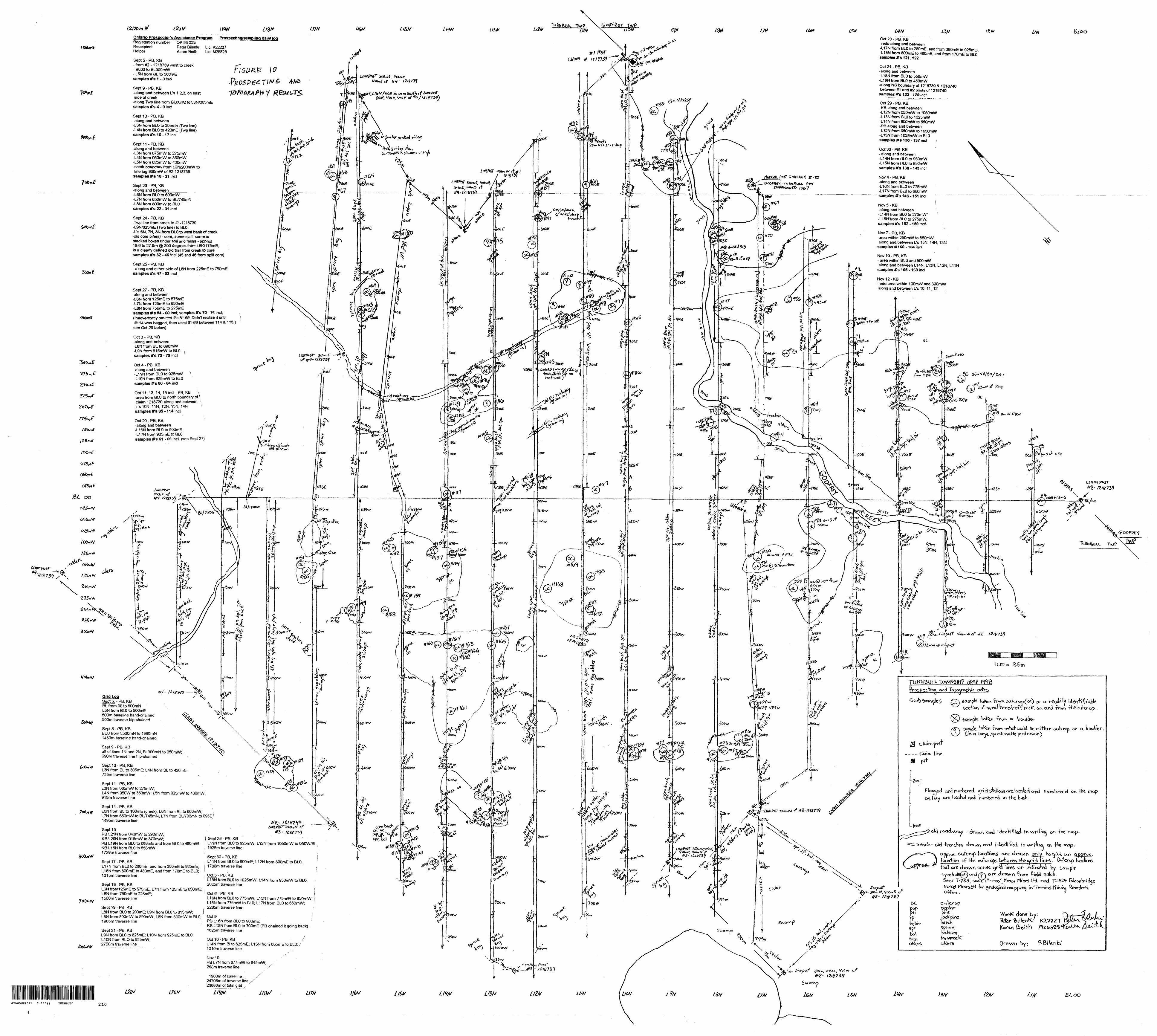
Ontario Prospector's Assistance ProgramRegistration number OP 98-333 Receiptent Peter Bilenki Helper Karen Berth
HW
Prospecting/sampling daily logL&V
Lie: K22227 Lie: M25825
700*
Sept 5 - PB, KB- from #2 - 1 21 8739 west to creek- BLOO to BLSOOmW- L5N from BL to SOOmE samples 4Ts 1 - 3 incl
Sept 9 - PB, KB-along and between L's 1 .2,3, on east side of creek-along Twp line from BLOOrt*2 to LSN/SOSmE samples #s 4 - B incl
Sept 10 -PB, KB-along and between-L3N from BLO to 305mE (Twp line)-L4N from BLO to 420mE (Twp line) samples #s 10 -17 incl
Sept 11 -PB, KB-along and between-L3N from 075mW to 275mW-L4N from OSOmW to 350mW-L5N from 025mW to 430mW-south boundary from L2M20QmW to line tag 800mW of #2-1 21 8739 samples #s 1 8 - 21 incl
Sept 23 - PB, KB-along and between
4*01*?
275*, f
^^—-L6N from BLO to 600mW-L7N from 650mW to BL7745mN-L8N from 800mW to BLO samples JTs 22 - 3t mcl
Sept 24 - PB, KB-Twp line from creek to #1-1218739-L9N7825mE (Twp line) to BLO-Us 6N, 7N, 8N from BLO to west bank of creek-old core pife(s) - core, some spslt, some in stacked boxes under soil and moss - appro* 1 9.6 to 27.9m @ 300 degrees from L8K/1 75mE; is a clearly defined old trail from creek to core samples *Fs 32 - 46 incl (45 and 46 from spilt core)
Sept 25 - PB, KB- along and either side of L8N from 225mE to 750m E samples #s 47 - S3 incl
Sept 27 -PB, KB-along and between-L6N from 125mE to 575mE-L7N from 1 25mE to 650mE-L8N from 750mE to 225mEsamples ffs 54 - 60 incl; samples *s 70 - 74 incl;(Inadvertently omitted ffs 61-69. Didn't realize tt until-1 14 was bagged, then used 61-69 between 114 4 115.) see Oct 20 below)
Oct 3 -PB, KB-along and between-L8N from BL to 890mW-L9Nfrom815mWtoBLO samples *f s 75 - 79 incl
Oct 4 - PB, KB-along and between-L1 1 M from BLO to 925mW-L1 ON from 825mW to BLO samples *Ts 80 - 84 incl
UtN
Oct23-PB. KB-redo along and between-L17N from BLO to 280mE, and from 380mE to 925mb,-L18N from 800m6 to 480mE, and from 170mE to BLO samples JTs 121,122
Oct 24 - PB, KB-along and between-L18N from BLO to 558mW-L19N from BLO to 480mvV-along NS boundary of 1218739 4 1218740 between #1 and #2 posts of 1218740
samples jtrs 123 -129 incl
Oct 29 - PB. KB-KB along and between-L12N from OSOmW to 1050mW-L13N from BLO to 1025mW-L14N from eoOmW to 850mW-PB along and between-L12N from OSOmW to 1050mW-L13N from 1025mW to BLO samples 7s 130 - 137 incl f
Oct30-PB KB- along and between-L14N from ilLO to 950mW-L15N from R.O to 850mW samples JFs 138 -145 incl
Nov 4 - PB. KB-along and between-LI 6N from BLO to 775mW-L17N from BLO to 660mWsamples *Ts 146-151 incl -
Nov 5 - KB '-along and between-L14N from BLO to 275mW*-L15N from BLO to 275mW samples tfs 152 - 159 incl
Nov 7 - PB, KB-area within 250mW to 550mW along and between L's 15N, 14N, 13N
samples ffi 160 -164 incl v
Nov 10-P9, KB- area within BLO and 500mW along and between L14N, L13N, L12N, L11N
samples *T s 165 -169 incl
Nov12-K8-redo area wrthin 100mW and 300mW along and between L's 10,11, 12
LtH 3/00
42A05NE2021 2.19548
Oct 11 .13, 14, 15inc!-PB, KB \ -area from BLO to north boundary of \ claim 121 8739 along and between i Us10N,11N, 12N, 13N, 14N samples # s 85 - 1 14 incl
Oct 20 - PB, KB-along and between-L16N from BLO to 900mE-L17N from 925mE to BLOsamples Hf s 61 - 69 incl. (see Sept 27)
Ci A'M
- /e/tf 73?
7 /3-"ffi);36* JJ
TotVNSH\P QfiftP
Grid LogSept 5. - PB, KB BLfromOOto500mN L5N from BLO to SOOmE 500m baseline hand-chained 500m traverse hip-chained
ctxift or a Douce"".wnaVcca\d he
r-^aa^/cxy -^ V W
noi on *e mop
only h*cu\*. idi JintS. CX
Outcrop ocQ-otvS c*rc Of "tttf (iotcr-ops betweenr **
SV. . -^ t/hdt are dvawn *x,ro6s grii \itrs or jrvdlx
rOi*neS^--Atr
Drown by;
Sept 8 - PB, KBBLO from LSOOmN to 1980mN1480m baseline hand-chained
Sept 9 - PB, KBall of lines 1N and 2N, BLSOOmN to OSOmW;690m traverse line hip-chained
Sept 10 -PB, KBL3N from BL to 305mE; L4N from BL to 420mE,725m traverse line
Sept 11-PB, KBL3N from 065mW to 275mW;L4N from 050W to 350mW; L5N from 025mW to 430mW;915m traverse line
Sept 14-PB, KBL6N from BL to 100mE (creek); L6N from BL to 600mW;L7N from GSOmWto BU745mN; L7N from BU700mN to 095E *1495m traverse line
Sept 15PB L21N from 040mW to 290mW;KB L20N from 015mW to 370mW;PB L19N from BLO to 086mE and from BLO to 480mWKB L18N from BLO to 558mW;1729m traverse {(ne
Sept 17 - PB, KBL17N from BLO to 280mE. and from 380mE to 925mE; L18N from SOOmE to 480mE. and from 170mE to BLO; 1315m traverse line
Sept 18-PB, KBL6N from12SmE to 575mE; L7N from 125mE to 650mE;L8N from 750mE to 225mE;1500m traverse line
Sept 19-PB. KBL8N from BLO to 200mE; L9N from BLO to 81 SmW; L8N from SOOmW to 890mW; L8N from SOOmW to BLO; 1905m traverse line
Sept 21 - PB, KBL9N from BLO to 825mE; L10N from 925mE to BLO;L1 ON from BLO to 825mW;2750m traverse line
j Sept 28 - PB, KB "f L11N from BLO to 925mW; L12N from 10SOmW to 050W/BL,, 1925m traverse line
Sept 30 - PB, KBL11N from BLO to 900mE; L12N from 800mE to BLO;1700m traverse line
Oct5-PB. KBL13N from BLO to 1025mW; L14N from 950mW to BLO;2025m traverse line
Oct 6 - PB, KBL16N from BLO to 775mW; L15N from 775mW to 850mW; L15N from 775mW to BLO; L17N from BLO to 660mW; 2285m traverse line
Oct 9PB L16N from BLO to 900mE;KB L15N from BLO to 700mE (PB chained it going back)1625m traverse line
Oct 10-PB. KB 7 L14N from Bl to 625mE; L13N from 685mE to BLO; /' 1310m traverse line
Nov 10PS L7N from 677mW to 945mW; , '268m traverse line X
1980m of baseline . 24706m of traverse line 266JJ6mjtf total grid x
TURNBULL 210

i./7/V
760 if
175 E
700 jf
100V/
/ft 873?
\\
225 w
7OOW
8oow
42A05NE2021 2.19548 TURNBULL
L7N LIN
VLF LogOntario Prospector's Assistance ProgramRegistration number OP 98-333Receipient Peter Bilenki Prospector's lie: K22227Helper Karen Beith M25825
EM-16 operator- PB
Sept 9 - L1N from BLO to 115mE, from BLO to 115mW; L2N from BLO to 210mE, from BLO to 160mW; L3N from BLO to OSOmW;
650m VLF
Sept 10 - L3N from BLO to 305mE; L4N from 420mE to BLO;
725m VLF
Sept 11 - L3N from 075mW to 275mW;L4N from 350mW to 054mW;
500m VLF
Sept 23 - L6N from BLO to 600mW,L7N from 650mW to BLOy745mN;
1275m VLF
Oct 4 - L11N from BLO to 925mW; L10N from 825mW to BLO;
1775m VLF
Oct 23 - L17N from BLO to 280mE and from 380mE 925mE; L18N from SOOmE t 480mE and from 170mE to BLO;
1315m VLF
Oct 24 - L18N from BLO to 560mW; L19N from 480mW to BLO;
1050m VLF
Oct 25 - L19N from BLO to 085mE;L21N from 040mW to 290mW; L20N from 370mW to 015mW;
690m VLF
Oct 29 - L12N f rom 050m W/BLO to 10SOmW; L13N f rom 1035m W to BLO;
2025m VLF
Oct 30 - L14N from BLO to 950mW; L15N from 850mW to BLO;
1825m VLF
Nov 4 - L16N from BLO to 775mW; L17N from 660mW to BLO;
1435m VLF
Nov 5 - L6N from 125mE to 575mE; L7N from 150mE to^650mE;L8N from 225mE to~750mE;
1500m VLF
Nov 12 - L16N from BLO to 900mE; L15N from 700mE to BLO;
. L14NfromBLOto625mE; L13N from 675mE to BLO; L8N from 025mE to 200mE; L7N from 100mE to BLO; L6N from 025mE to 100mE; L5N from 025mW to 425mW;
3725m VLF
Total 18660m VLF
Total 774 stns
H
EM -
-25m
l-lil 9737
220
n 7*2-^:
N/
7 ei:.4*W
TOWNSHIPVLP EM-lfo
l \ /i l B- . f ^ A
i 7 \
AM re^*dlttv*s were "takenNofiTH at atatVons on
t. *V*V\, ' *V 1
' D v
"' i
-j-j
jo :
O
f
xo;x o
X 0;x o\t** t.Itv
Z U
'0 XO^&iV*, y \ .,1
t
t ** A * ';73X-IOOW,\•7 ^
Vc o
\x^\\7,- x-2oowS
'r'-Vl 1
1rfci' -/o1
^ ^ ^o&vvr i' -5
-Y
V. lS'On,^
Voow
\i ~ — ~ — *"~B
f " \
\ \\-l.1 ,:-5 i, ,
t~1 H .
1
-ii, T\:
-l x•^ i-z;
-w :'.'•l-V*
x N*
-z :j
; f-5.xx-f-t
/ix - -fe
V's*.-5 ;^5•-5f
f
:*i'-4l
x'
i .5
O-t-fS*
-lv -OZ5,
-\z
-9
-7 -/(W W
-7
-7
-2
s /-Too*
-Z
-3
\/
HI -Jfa*J*/
-6
-Jo
J —
+J
——
Vx -VOOW G^V^
\.
/8
/?
21Y.SC~ift/
V
^"*
K
1it
\x
LtfN &QQ


