Archaeological, Historical, and Architectural Survey of ... 33.pdf · archaeological, historical,...
101
ARCHAEOLOGICAL, HISTORICAL, AND ARCHITECTURAL SURVEY Of THE GIBSON PLANTATION TRACT, fLORENCE COUNTY, SOUTH CAROLINA :.' , ' ... • \11 CHICORA FOUNDATiON RESEARCH SERIES 33
Transcript of Archaeological, Historical, and Architectural Survey of ... 33.pdf · archaeological, historical,...

ARCHAEOLOGICAL, HISTORICAL, AND ARCHITECTURAL SURVEY Of THE GIBSON PLANTATION TRACT, fLORENCE COUNTY, SOUTH CAROLINA
:.' , .~" '
... •
\11 W~3i~1iS
CHICORA FOUNDATiON RESEARCH SERIES 33

ARCHAEOLOGICAL, HISTORICAL, AND ARCHITECTURAL SURVEY OF THE GIBSON PLANTATION TRACT, FLORENCE COUNTY, SOUTH CAROLINA
RESEARCH SERIES 33
Michael Trinkley Natalie Adams
Chicora Foundation, Inc. PO Box 8664 • 861 Arbutus Drive Columbia, South Carolina 29202
803/787-6910
Prepared For: The Pee Dee Council of Governments
Florence, South Carolina
July 1992
ISSN 0882-2041

Library of Congress Cataloging-in-Publication Data
Trinkley, Michael. Archaeological, historical, and architectural survey of the Gibso~
plantation tract, Florence County, South Carolina / Michael Trinkley, Natalie Adams.
p. cm. -- (Research series, ISSN 0882-2041 ; 33) "Prepared for the Pee Dee Council of Governments." Includes bibliographical references. $20.00 1. Gibson Plantation Tract Site (S.C.) 2. Florence County (S.C.)
-Antiquities. 3. Excavations (Archaeology)--South Carolina--Florence County. I. Adams, Natalie, 1963- II. Pee Dee Council of Governments. III. Title. IV. Series: Research series (Chicora Foundation) ; 33. F279.G53T75 1992 975.7' 84--dc20 92-28488
The paper used in this publication meets the minimum requirements of American National Standard for Information Sciences - Permanence of Paper for Printed Library Materials, ANSI Z39.48-1984. ~
i
CIP

The art of our necessities is strange, That can make vile things precious.
-- Shakespeare, King Lear
ii

ABSTRACT
This study represents a preliminary historical and intensive archaeological survey of the 1400 acre Hoffmann-La Roche facility site on the Pee Dee River in central Florence County. The primary purpose of this investigation is to identify and assess the archaeological remains present in the proposed development tract, although secondary goals are to examine the relationship between prehistoric and historic settlement patterns and water sources, and to explore the cultural heritage interpretative potential of the proposed tract.
As a result of this work 42 archaeological sites were identified, primarily through the use of systematic shovel testing in wooded tracts and pedestrian surveys in agricultural fields. In addition, the historical research provides additional information on both the study tract and the architectural assessment has identified eight standing structures, dating from the early twentieth century, on the tract. These structures have been inventoried and photographed as part of the documentation process.
Of ,the identified archaeological sites, eight contained prehistoric components and 38 contained historic components. Five sites (38FL232, 38FL237, 38FL240, 38FL245, 38FL249) are recommended as eligible for inclusion in the National Register of Historic Places. Two of these sites (38FL237 and 38FL245) are standing structures. The remaining standing structures, while representative of a significant period of South Carolina's rural, agricultural history, are not recommended as eligible for inclusion on the National Register. The information they can contribution toward the documentation of South Carolina's vernacular architecture has been adequately recorded in this study. Two sites (38FL235 and 38FL269) are recommended as potentially elibigible for inclusion in 'the National Register of Historic Places. These two sites, both believed to related, to tenant occupations, are representative examples of a relatively large quantity of tenant sites on the Gibson tract. While all of the posited tenant occupations have been disturbed by plowing, 3BFL235 and 3BFL269 represent the best preserved tenant sites on the tract based primarily on artifact density.
iii

TABLE OF CONTENTS
List of Tables •
List of Figures.
Acknowledgements
Introduction . . Background Goals Cur at ion
• v
.vi
vii
. 1
Natural Setting. • . • • • • • • • • • • • • • • • . • • • • • • • • • • • 5 Physiography Geology and Soils Climate Floristics
Research Strategy and Methods. • • • • . • . • • • • • • • • • • • • • • • 8 Introduction Archival Research Field Survey Excavations Laboratory Methods and Analysis
Prehistoric and Historic Overview. Previous Research Prehistoric Archaeology Protohistoric Period Historic Synopsis Implications
Identified Archaeological Sites.
Identified Standing Structures
Conclusions. .
Sources Cited.
• • • • • • • • • • • . • • • • • • 15
.41
.73
.78
.85
iv

Table 1-2. 3. 4. 5. 6. 7. 8. 9. 10. 11. 12. 13. 14. 15. 16. 17. 18. 19. 20. 21-22. 23. 24. 25. 26.
LIST OF TABLES
1856 Inventory and Appraisement of James S. Gibson. Sites identified on the Gibson tract. Artifacts recovered at 38FL235. Artifact pattern at 38FL235 • Artifact pattern at 38FL240 • • Mean ceramic date for 38FL240 • Artifacts recovered at 38FL240. Artifacts recovered at 38FL241. Artifact pattern at 38FL241 • • Historic artifacts from Locus 2, 38FL249. Mean ceramic date for Locus 2, 38FL249 .• Distribution of prehistoric pottery at 38FL249. Distribution of lithics at 38FL249. Hafted bifaces from 38FL249 . • Artifacts recovered at 38FL256. Artifacts recovered at 38FL257. Artifacts recovered at 38FL260. Mean ceramic date for 38FL260 • Mean ceramic date for 38FL268 • Artifacts recovered at 38FL269. Artifact pattern at 38FL269 • Mean ceramic date at 38FL269. Artifacts from 38FL270 •••. Published artifact Patterns • Artifact patterns from Gibson Plantation tenant sites Artifact patterns from tenant/yeoman sites in the Carolinas
v
.27
.42
.43
.43
.47
.47
.48
.51
.52
.57
.57
.58
.59 .62 .64 .65 .65 .66 .68 .69 .70 .70 .71 .80 .81 .81

LIST OF FIGURES
Figure 1. 1986 Pee Dee Quadrangle topographic map showing project
2. 3. 4.
5. 6. 7. 8. 9.
area and site locations ................ . Clearing transect lines ................ . Map shoving shovel test transects and pedestrian survey areas. Chronology of the Woodland and Proto historic Periods in the Carol inas. . . . . . . . . . . . . . . . . . . . Vicinity of the Queensborough township • • . • • • • • • • • A portion of Marion district from Mills Atlas of 1825 •••• A portion of Marion County from the 1873 Joseph Sampson map. A protion of the 1913 Adams and Erwin Map of Florence County The vicinity of the project area shown on the 1914 Soil Survey of Florence County • • • • • • • • • • • • . • • . • • •
10. Plat of the Gibson lands in 1930-31. • • • • • • • ••• 11. Plat showing George Hyman and N.S. Gibson estate lands in 1933
and 1934 • • • . • • • • • • • • • • • . • • . 12. A portion of the 1945 edition of Florence East topographic map 13. Plat of the George Hyman lands in 1976 • 14. Shovel tests at 38FL235 ••••••• 15. Location of test unit, shovel tests, and cultural features at
16. 17. 18.
19. 20. 21-22. 23. 24.
38FL240. • • • • • • . • • • • • • • • • North view of TU1 base of zone 1 at 38FL240. • • • • • • • Historic artifacts recovered from the survey area. . . . . Location of tests units, Shovel tests, and cultural features at 38FL249. • • • • • • • • • •• •••••. North view of TU5 base of zone 3 at 38FL249. Prehistoric artifacts ... Shovel tests at 38FL269 •••• Mary Hyman house, 38FL237 ••• Location of standing structures on the Gibson tract. Winona General Store . . . . . . .
vi
.2 10 11
18 22 26 31 33
33 35
36 37 38 44
45 46 50
55 56 61 68 73 74 76
ACKNOWLEDGEMENTS
This work was funded jointly by Florence County, the City of Florence, the Economic Development Administration, and a Community Development Block Grant, with the project being administered by the Pee Dee Regional Council of Governments. While the work was conducted in compliance with various national historic preservation requirements, we wish to thank all of those involved for their constant and unwavering support. In particular, at the Pee Dee Regional Council of Governments, Mr. Phil Goff and Ms. Sheri Musick oversaw the work and assisted us on numerous occasions. We appreciate the work of Ms. Carla Shrader and Ms. Mary Jo Thomas in the Governor's Office. Mr. Barry L. Elliott, Florence County Administrator, consistently supported the work and ensured every cooperation from the County. Mr. Philip Britton assisted our survey and provided additional oral history regarding the tract.
The representatives of Hoffmann-La Roche, one of the giants of the pharmaceutical industry, were. constantly interested in the work and showed particular appreciation for the history and heritage of Florence County.
A variety of others also assisted in our work, including the staffs of the Thomas Cooper Map Repository, the South Carolina Department of Archives and History Search Room, the South Caroliniana Library, the Florence County Clerk of Court, the Marion County Clerk of Court, the Marion County Probate Court, the Darlington County Probate Court, and the Darlington County Historical Society. Ms. Libby Cooper, Vice President of Development at Francis Marion College, also graciously assisted in our historical research.
Ms. Suzanne Linder is completing her Ph.D. dissertation on the Pee Dee region and was very gracious in offering access to her research . .Mr. Keith Derting and Ms. Sharon Pekrul of the South Carolina Institute of Archaeology and Anthropology assisted in the recordation of identified sites and the cur at ion of the collections from the survey. At the South Carolina State Historic Preservation Office, we want to especially thank Mr. Charlie Hall for his assistance in the project, including his review of our draft manuscript and very useful comments and suggestions.
Finally, we want to thank those who conducted the field investigations with us, Ms. Mona Grunden and Ms. Liz Pinckney. As always, a great deal of the success of this project is due to their diligence and professionalism.
vii

INTRODUCTION
Background
This investigation of the proposed 1412 acre Britton tract was conducted by Dr. Michael Trinkley and Ms. Natalie Adams of Chicora Foundation, Inc. for Florence County. The tract is bordered-to the north and east by the swamps of the Pee Dee River, and to the south by the Seaboard Coast Line Railroad. The western boundary is irregular, conforming to several roads and a Carolina Power and Light easement (Figure 1). The survey tract actually consists of five parcels, previously owned by Philip Britton, Michael W. Britton, Michael W. and Ginger Rae Britton, and a local grain company.
Within this tract are a number of large agricultural fields, plowed earlier this season, and wooded areas, primarily along the edge of the Pee Dee swamp to the north and east. A series of dirt roads cover the property, allowing access to the various agricultural fields. A small, intermittent creek runs through the western edge of the property. OVerall, the property is level and well drained, with steep slopes found only into the Pee Dee swamps.
Hoffmann-La Roche, Inc. is proposing to construct a major pharmaceutical research and manufacturing facility on approximately 200 acres of the property, with the remainder as a buffer offering future expansion capability. Consequently, plans call for water and sewer lines, additional power company transmission lines, widening of currently existing public roadways, and construction of the industrial site (with associated buildings, parking, roads, and landscaping). Related to this will be a variety of ground disturbing activities, including clearing, grubbing, filling, and grading, as well as excavation for underground utilities.
The proposed project was reviewed by the South Carolina state Historic Preservation Office (SHPO) and an intensive archaeological survey was recommended. Chicora Foundation was requested to submit a proposal for the survey on April 3, 1992. Such a proposal was submitted on April 13, 1992 and a verbal notice to proceed was received on May 11, 1992.
These investigations incorporated a review of the site files at the South Carolina Institute of Archaeology and Anthropology. No previously recorded archaeological sites were within the survey boundaries. In addition, the South Carolina Department of Archives and History was contacted, requesting information on the identification of any National Register buildings, districts, structures, sites, or objects, or the presence of any structure surveys, in the vicinity of the 1400 acre survey tract. According to the files of the South Carolina Department of Archives and History the nearest National Register eligible property is Oaklyn Plantation in Darlington County, just north of I-95 and southeast of Howard's Crossroads (letter from Ms. Nancy Brock, S.C. Department of Archives and History to Dr. Michael Trinkley, dated May 19,1992).
Archival and historical research was conducted at the Thomas Cooper Library, the South Carolina Department of Archives and History, the South Caroliniana Library, the Florence County Clerk of Clerk and Probate Court, and the Darlington Historical Society. The published indices for the South Carolina Historical Society and the Southern History Collection were also examined for references pertinent to the study area. Throughout this historical research an emphasis was placed on the primary, rather than secondary, sources.
1

'"
\ \ , , "
" " " " II !
L, ~ ,.()
"- REAT _~~~ DEE IVER SWAMP ~ , " '- - ", -~ '~"'''h--- _.
• -:. If :',_ ·-'-'4&, 11=-
=OP
' .. o
g=
____ 38FL241ti v
Power-line
---------~ 38FL2a6 \' ,
'\ 0 vJe r \ 1/ ~" 005
1/ \0 II 1/ ". II
~=----,I- 1tf38FL283 /' '~~' ,I{ /'----.. I{
, q
I{ If
273~} /f
/f I{
~"" " ',,~, " " - ~">\," ,'" ./.L, ' ",' ~=~'" /0 L .; i , 0);1~~, ", ", ~ ~'" *' '/ '" 't • ., •• " \\\, '-," ",,,0/ ~h'FL'50 ~"FL2.2 X i\'I\' '''', ., 0 .24>2 ' =:)/ I ,I ~O~3~=", / )'" ~- 'V / 'I} ,II /11 _, ~~ f
-II ----- 11 ( , ~( ///L.-
'dI ••
FL24
• II , ' -<b .. ~~~~ ,::/' ' II '_ ........ .: ........ , II ,iii 38FL251\ -=0_
1/ 1\ -~io"~~""~"'-""'~F-~--II 1/ ~= ~ "
- / \\ '\~-= ,v if-________ / =--; I ~ / 11' 'I
--II ,/ , II"" "~I I{ '~ ~'!I'8FL"O ,I, /' ==-- " ':I I = 1111
\\:!t8FL261
0,3 PROPERTY :rade X~9
:.....- ~"'~.
BOUNDARY o
• ,p.">
'"
n , I
\\ :,':';J II :'1 L\ x :
'-===~38FL25~ I
38FL255i\' .!j ~ '.~'~254 :.-;,; '-.........--:-.....
o 5000
FEET
Figure 1. Pee Dee Quadrangle showing project area and site locations.
" ,II
n il
." J
,y ,y
~II
=

The primary goals of this study were, first, to identify the archaeological resources of the Gibson Plantation tract, and, second, to assess the ability of these sites to contribute significant archaeological, historical, or anthropological data. The second aspect essentially involves the site's eligibility for inclusion in the National Register of Historic Places, although Chicora Foundation only provides an opinion of National Register eligibility and the final determination is made by the lead compliance agency in consultation with the State Historic Preservation Officer at the South Carolina Department of Archives and History. The secondary goals were, first, to examine the relationship between site location, soil type, and topography, expanding the previous of Taylor (1984) for the Pee Dee region;and second, to explore historic settlement pattern change through time. These secondary goals are of considerable importance since little work has been done on both prehistoric and historic sites in the Upper Coastal Plain of South Carolina.
To identify sites within the deve'lopment tract, a strategy of intensive shovel testing of wooded areas was coupled with pedestrian survey of plowed fields4 Most of this wooded area occurred along the b,luff edge near the Pee Dee River swamp. It was here that previous findings by Taylor (1984) would be tested for prehistoric site location. At the Pee Dee Electrical Generating Station tract, pr~historic sites along the bluff edge were no less than 400 feet across. combined with the field survey was a preliminary examination of archival and secondary records pertaining to the tract4 This archival study revealed several early twentieth century maps which were used to assist in locating most of the tenant sites.
Once identified, sites were evaluated for their potential eligibility for inclusion on the National Register of Historic Places. It is generally accepted that "the significance of an archaeological site is based on the potential of the site to contribute to the scientific or humanistic understanding of the past" (Bense et al. 1986:60). Bulter suggests that the the only valid measurement of significance must be based on what he calls the "theoretical and substantive knowledge of the discipline" at any particular moment in time (Butler 1987:821). While the use of this approach over that developed by Glassow (1977) has been suggested, Butler himself acknowledges, "we cannot for see future research questions, and we may not possess the theory to interpret and understand all that is present" (Butler 1987:822). At this point in time it seems essential to recognize the importance of asking the right questions at the right sites, not limiting the number of sites at which questions are asked, or what questions are posed. Clearly, asking "right questions" at the "right sites" can be difficult and requires an understanding of the "theoretical and substantive knowledge of the discipline" (for a more detailed discussion of these questions, particularly relating to Woodland Period sites, see Trinkley 1990:30-31).
Glassow's (1977) approach to evaluating site eligibility is through the use of five properties: site integrity, site clarity, artifactual variety, artifactual quantity, and site environmental context 4 These qualities stress properties of the archaeological record, rather than a site's ability or potential to assist in providing data to limited, and possibly transient, research design4
Very few archaeological investigations have been conducted in the Inner Coastal Plain and only one investigation (Taylor 1984) is directly comparable. Results of the Gibson Plantation tract investigation can be used to refine ideas obtained from the Pee Dee Electrical Generating Station survey (Taylor 1984) about site location and settlement pattern change in the Pee Dee River basin.
Cur at ion
Archaeological site forms have been filed with the South Carolina Institute
3
of Archaeology and Anthropology. The field notes, photographic materials, and artifacts resulting from these investigations have been curated at the South Carolina Institute of Archaeology and Anthropology using their proveniencing system which consists of the site number-site provenience number-artifact type number. All original records and duplicate copies were provided to the Institute in archival condition and will be maintained by that institution in perpetuity.
4

NATURAL SETTING
Physiography
Florence County is situated in the Inner Coastal Plain of South Carolina and is bounded to the north by Marlboro and Dillon Counties, to the west by Darlington, Lee, Sumter Counties and Lynches River, to the south by Clarendon and Williamsburg County and to the east by the Pee Dee River, which separates it from Marion County. The land primarily consists of gently rolling hills with elevations ranging from about 20 feet above mean sea level in parts of the river floodplains to a high of about 150 feet above sea level in the FlorenceTimmonsville area. Most of the county has an elevation between 70 and 150 feet above sea level (Pitts 1974:109).
The county is drained by the Pee Dee river system which flows in a southeasterly direction and forms somewhat of a dendritic drainage pattern. It includes Lynches River, which merges with the Pee Dee in the southeastern corner of the county, as well as smaller streams such as Claussen Creek, Jeffries Creek, and Muddy Creek. In the project area, Buckley Creek is found on the western edge of the Pee Dee River Swamp and off of the eastern edge of the survey tract. A small intermittent stream is located in the south western corner of the tract.
The Gibson Plantation tract is situated in the northeastern portion of Florence County. It is bordered to the north and east by the swamps of the Pee Dee River, and to the south by the Seaboard Coast Line Railroad. The western boundary is irregular, conforming to several roads and a Carolina Power and Light easement. The topography tends to be flat with a range of elevation between 80 and 110 feet above sea level. The lower areas of the tract are located south of S.C. 24 and in the southern portion of the tract north of S.C. 24. This area is relatively level. The property rises gently in the northern area. The highest elevations are found along the northern boundary of the property, where narrow ridges run parallel to the swamp. These ridges are periodically cut by perpendicularly running drainages.
Geology and Soils
The geology is characteristic of the Coastal Plain. The parent materials of the soils are marine or fluvial deposits which consist of varying amounts of sands, silts, and clays. There are four geologic formations deposited at different periods during alternating transgression and recession of the ocean: the Duplin Marl Formation underlies parts of the southern and western portions of the county; the Black Creek Formation is found in the northern portion of the county; the Pee Dee Formation which is found across the southern area of the county; and seven Pleistocene formations in thin deposits allover Florence County. These include the Brandywine terrace (215 to 270 feet MSL) , the Coharie terrace (170 to 215 feet MSL), the Sunderland terrace (100 to 170 feet MSL) , the Penholoway terrace (42 to 70 feet MSL) , the Talbot terrace (25 to 42 feet MSL) , and the Pamlico terrace (less than 25 feet MSL) (Pitts 1974:109-110).
The project area contains 13 soil series including Coxville, Duplin, Exum, Goldsboro, Lakeland, Lucy, Lynchburg, Norfolk, Orangeburg, Pantego, Sunsweet, Varina, and Wagram soils. Of these, Pantego is classified as very poorly drained, Coxville is poorly drained, Lynchburg is somewhat poorly drained, Duplin, Exum, and Goldsboro soils are moderately well drained, Lucy, Norfolk, Orangeburg, Sunsweet, Varina, and Wagram soils are well drained, and Lakeland soils are excessively drained. Of these soils 17.9% are classified as poorly drained while 81.2% are well drained.
5

Mills comments that the swampland soils are composed of the "richest soil". He notes that" [wjhile the swamp lands reclaimed and secured from freshets, will bring 50 dollars an acre; and the oak and hickory lands 15 dollars an acre; the pine lands will scarely sell for 1 dollar per acre" (Mills 1972:623). He also observed that "[ojff the water courses the situations are healthy", but "[ajs the swamps are the principal sources of disease in this country, it is much to be regretted that measures are not taken to drain, or reclaim them, which would not only secure the blessing of health to the people, but afford an immense quantity of rich soil for cultivation to the district" (Mills 1826:625). The products cultivated during that time were "cotton, corn, wheat, pease, and potatoes,i (Mills 1826:623).
Climate
The general climate of the Florence county area is characterized by mild humid conditions. This climate is influenced by the warm Gulf Stream, as well as by the Appalachian mountains which block the coldest air masses. other factors include latitude, elevation, distance from the ocean, and location with respect to the average tracts of migratory cyclones. Day to day weather is controlled primarily by the movement of pressure systems across the nation. However, during the summer months there are fe~ complete exchanges of air masses because tropical maritime air persists for extended periods (Pitts 1974:108).
The average annual precipitation in the Florence area is 44.5 inches and is unevenly distributed throughout the year, with 28.9 inches occurring from April through October which is the primary growing season (Pitts 1974:108).
The climate, according to Mills (1972:625), "taking the whole year round, is pleasant". The annual average temperature in Florence is 63.2°F, and the average monthly temperature ranges from 44.8°F in January to 80.3°F in July. Frozen precipitation occurs only one to three times a year during the winter season. The abundant supply of warm, moist and relatively unstable air produces frequent scattered showers and thunderstorms in the summer. Sever.e weather usually means violent thunderstorms, tornadoes, and hurricanes. The tropical storm season is in late sununer and early fall, although storms may occur as early as Mayor as late as October (NOAA, 1977). Heavy rains and high winds occur with tropical storms about once every six years. Storms of hurricane intensity are much more infrequent. Droughts have occurred twice in modern times; in 1925 and 1954. Less severe dry periods have occurred more often, normally in late spring or in autumn (Pitts 1974:109).
Floristics
There are two major categories of plant communities exist in the Coastal Plain area where there is nearly level topography. The first category consists of upland vegetation. Supported here are a mixture of coniferous and deciduous forests dominated by pines and broadleaf taxa such as upland oaks, sweetgum, hickories, and various understory species.
Lowland forests are located on the floodplain of the Pee Dee River. This floodplain is 30 to 40 feet lower in elevation and is clearly defined by a scarp, such as found on the north and east boundary of the survey tract. These floodplain soils are forested with bald cypress, gum, sycamore, water hickory, lowland oaks, soft maples, willows, and other herbaceous species.
In the early nineteenth century Mills observed that:
the long leafed pine is most abundant of the forest trees; next the cypress, various kinds pf oak, the hickory, tupilo &c. Of fruit trees the peach, apple, pear, plu,. &c. are common (Mills 1972:624).
Mills also observed that the major use of these forest resources was
6

construction, also noting that "good clay is found in various places, suitable to make brick" (Mills 1972:625). Only lime, largely made of burnt shells, needed to be imported into the area (primarily from neighboring Georgetown). Mills encouraged the residents to make better use of their local "shell limestone" for lime, a suggestion which appears to have made little impact in the local economy (Mills 1972:628).
Today, about a third of the Florence's uplands have been cleared for cultivation. On the survey tract, approximately 70 percent of the land was in fallow fields or active cultivation. The remainder of the area consisted primarily of coniferous and deciduous trees including pines, oaks, sweetgums, and hickories. In addition, the wooded area consisted of a very thick understory of plants including blackberry (particularly along field edges), muscadine, wild and domesticated flowers, and various shrubs, vines, and herbaceous species.
7

RESEARCH STRATEGY AND METHODS
Introduction
As previously indicated, the primary goals of this survey are to identify, record, and assess the significance of archaeological sites within the approximately 1400 acre tract. Secondary goals of the survey include an examination of the soils, drainage, and topographic setting as they affect the location of prehistoric sites, and to examine and refine the historic settlement systems as previously observed in the survey of the santee Cooper facility adjacent to the Pee Dee River (see Taylor 1984). No major analytical hypotheses were created prior to the field work and data analysis, although certain expectations regarding the secondary goals will be outlined in these discussions. The research design proposed for this study is, as discussed by Goodyear et al. (1979:2), fundamentally explorative and explicative.
Archival Research
Th~se investigations incorporated a review of the site files at the South Carolina Institute of Archaeology and Anthropology. No previously recorded archaeological sites were within the survey boundaries. In addition, the South Carolina Department of Archives and History was contacted, requesting information on the identification of any National Register buildings, districts, structures, sites, or objects, or the presence of any structure surveys, in the vicinity of the 1400 acre survey tract. According. to the files of the South Carolina Department of Archives and History the nearest National Register eligible property is Oaklyn Plantation in Darlington County, just north of I-95 and southeast of Howard's Crossroads (letter from Ms. Nancy Brock, s.C. Department of Archives and History to Dr. Michael Trinkley, dated May 19, 1992),
The 1972 Historic Preservation Survey and Plan for the Pee Dee region (Pee Dee ·Regional Planning and Development Council 1972) identifies five historic sites in the vicinity of this project:
The Harwell House - located off SR-24, one mile northwest of u.S. 301,
Liberty Chapel - an Antebellum Methodist Episcopal church, at Highways 13 and 724,
stockade and u.S. Military Cemetery - the site of the Florence Prisoner of War Camp active from September 1864 through February 1865, located one block east of Church Street in Florence,
Fort Finger - Confederate earthworks located on the Pee Dee and intended to protect the Pee Dee Naval Yard,
Slave Houses - ca. 1840 slave houses from the Eli Gregg plantation, on the Francis Marion campus.
Archival and historical research was conducted at the Thomas Cooper Library, the South Carolina Department of Archives and History, the South Caroliniana Library, the Florence County Clerk of Clerk and Probate Court, the Darlington County Clerk of Court, the Marion County Clerk of Court and Probate Court, and the Darlington Historical Society. The published indices for the South Carolina Historical Society and the Southern History Collection were also examined for references pertinent to the study area. Throughout this historical research an emphasis was placed on the primary, rather than secondary, sources as the appropriate level of initial study. While the historical research is not
8

exhaustive, it does provide a clear background and is a sufficient base for future work in the project area.
Field Survey
The typical methodology for a compliance survey of a tract such as the 1400 acre Gibson Plantation is to establish a systematic intensive survey methodology which examines the entire acreage for archaeological and historical resources. Such an approach, however, does not necessarily require that all areas be examined with equal intensity.
Chicora Foundation proposed to meet the previously outlined goals in a cost and time-effective manner by using a stratified survey approach. This approach uses criteria for site location developed by Chicora Foundation as a result of 20 years of research (including the results of the Santee Cooper Pee Dee survey discussed in greater detail below and in the section detailing "Previous Research") and divides the survey tract into different "strata" or areas based on the criteria.
The intensity of the survey effort is then determined by the likelihood of identifying archaeological sites within a particular strata or area. The areas most likely to reveal archaeological sites are those most intensively examined. Those with the least potential for prehistoric or historic occupation are the least intensively examined.
Previous archaeological research has documented (either at an intuitive or empirical level) that:
• historic sites, especially from the eighteenth century, tend to be situated on high ground adjacent to the Pee Dee (i.e., on the bluff edge), while nineteenth century historic sites tend to be situated .within 300 feet of old roads (South and Hartley 1980; Taylor 1984:196),
• prehistoriC archaeological sites tend to be located adjacent to swamp edges, with relatively few sites located on interior soils (Taylor 1984:195; Ward 1978) ,
late nineteenth century associated with road networks, 1984:196) ,
and early twentieth century sites tend to be many of which are still in place (Taylor
• archaeological sites tend to located on high, well drained soils in proximity to water sources (Brooks and Scurry 1978),
• archaeological sites may be located adjacent to remnant creeks, now represented only as linear expanses of poorly drained soils (Brooks and Scurry 1978; Trinkley 1976),
archaeological sites are not often found on low, poorly drained soils, and
• prehistoriC archaeological sites are not often found on high, well drained soils when they are an excessive distance (ca. 300+ feet) from a water source (Taylor 1984).
In addition, the historical research would be used to illustrate areas of posited occupation.
Chicora Foundation therefore defined essentially two strata with two different levels of archaeological survey:
1. Areas of high archaeological probability are those which incorporated
9

high! well drained soils adjacent to the Pee Dee River swamp edge or te,rrace~ Also included as a high probability area are the well drained soils adjacent to smaller drainages, such as the one found in the southwest quadrant of the survey tract~ Along the terrace -there is a high potential of identifying either prehistoric or early historic resources, while there is a potential of also finding prehistoric sites along the smaller tributaries (Figure 2).
In these areas Chicora proposed to conduct an archaeological survey using shovel tests at 200 foot intervals on transects spaced at 200 feet from the swamp edge inland at leas·t 1000 feet G A series of 60 transects a't 200 foot intervals were established and 437 shovel tests were excavated during the course of the project ~ This count does not include close interval shovel testing at individual sites. ~l.'hese shovel tests are discussed in the site descriptions.
Typically, shovel tests are conducted at 100 foot intervals. However, the average site size identified by the Santee Cooper Pee Dee survey was 500 feet ~ In fact, no sites covering less than 400 feet in length were found along the bluff eQge. Consequently, these sites can be easily located with transects spaced at 200 feet~ When sites are identified the interval will be decreased to 50 feet and testing will continue to establish site boundaries. As a check on this approach, Chicora Foundation sampled approximately 5% of the terrace edge using a 100 foot transect interval. This provided. an independent check on the ;:nethociology ~ Since goal of this check was to determine whether sites could be missed with 200 foot transects( the most likely areas for occupation
E'igure 2 ~ Clea.ring transeot lines in wooded areae

I-' I-'
II
" \I
,--"i ~ 1/", "
:--!:'-.:{.~ -'" ~L-""f::f~ ",-"
/t' -'~-" '--...
- -'---'\ -....... ",----- l PEE D ~___::::::::- '--_ _- EE btv ~ ...... ~ . ___._-- ___ I"l
SWAMP
.-"- ' II,' ,'1Y7""e'" , 'J---/I"i" ~ __ =!=I=!=frl!'Y (I f I "F ;i,1
- , •• J J / . ," - / / " , " - _ _ I I if) I ~I { I I { f 1,\ {
PROPERTY laOUNDARV II
':1
__ " ,1/\\ 11/111,!1 -- --'~ I- ---/ 1''' i I / I [d - - -" -- - )1 I I /1 I -, 1 - -,/' :/:// - ~ ~ = I lorLJ=f / I I I I
{/III .• I. /II/il I
I'
\I \I
10010
P,~E!I'
2000 -
11// /1 \ I I
SHOVEL TEST TRANSECTS
PEDESRIAN TRANSECTS ~-
Figure 3. Map of the 1400 acre survey tract, showing shovel test transects, and pedestrian survey areas.

were chosen for investigation. These areas included ridges and large broad, flat areas adjacent to the swamp or drainages.
There were approximately 300 acres which fell into this category.
2. Areas of moderate to low archaeological probability are those found elsewhere on the tract, specifically as interior or upland parcels. Prehistoric sites were expected to be uncommon and the location of historic sites (largely tenant farms) was projected using historic research and maps.
These areas are almost entirely cultivated. Consequently, the survey consisted largely of a pedestrian survey, with occasional shovel tests to verify or explore geomorphic conditions such as erosion or deposition.
All shovel tests were approximately one-foot square and were excavated to sterile subsoil, usually about 1.0 to 1.5 foot below the existing grade. All soils were screened through ~-inch mesh and soil profiles were recorded as appropriate, using Munsell soil colors. All shovel tests were backfilled at the completion of the work.
Many of the areas to be surveyed were heavily overgrown (essentially impenetrable) and, in order to establish shovel test transects, it was necessary to first clear the survey lines (Figure 2). This situation occurred on about half of the 60 transects. While this was very labor intensive, it was an essential aspect of the work.
When evidence of archaeological sites was found during the shovel testing, the interval of the tests was decreased, usually to 50 or occasionally to 25 foot intervals, to determine more accurate boundaries. Boundaries were also determined through locating the extent of surface scatters as well as topographic features. For instance, when areas near the bluff obtained a large amount of slope, it was believed that the edge of the site had been reached. This was verified through negative shqvel tests and/or a lack of surface material. These boundaries were flagged (where possible) so the precise locations of sites can be added to the development maps by surveyors. The survey team, however, located sites on both development and USGS 7.5' topographic maps during the fieldwork.
Archaeological sites in this survey were defined as consisting of both isolated finds as well as multiple artifact occurences.
Figure 3 shows the various transect lines used in this study, as well as the areas subjected to pedestrian survey. During the course of the study the bulk of the agricultural fields were freshly plowed and toward the end of the project sufficient rainfall had fallen to make the surface survey very reliable. Shovel tests, however, continued to be excavated at irregular intervals and all sites identified in the agricultural fields were shovel tested and surface collected to establish boundaries, determine the existence of buried remains, and better assess site eligibility.
Information required by the completed.
was collected from each site identified to allow site forms South Carolina State Historic Preservation Office to be
In addition, all standing structures -over approximately 40 years were identified by the survey and recorded using the South Carolina State Historic Preservation Office Statewide Survey Site Forms. Shovel testing was conducted around these structures to examine for archaeological remains present in conjunction with the architectural site.
All archaeological sites were evaluated for their potential significance and eligibility for inclusion on the National Register of Historic Places using
12

criteria such as site integrity and clarity, as well as ability to answer broad questions of importance to the discipline (see Butler 1987 and Glassow 1977). Although subjective, the most commonly accepted criteria for assessing architectural significance are associated with the National Register. However, vernacular and twentieth century structures are under-represented on the National Register for Historic Places in South Carolina. Further, the absence of a detailed regional historic inventory to serve as a data base makes it difficult to assess the structures present on the survey tract. Consequently, the assessment of the standing structures is more subjective than perhaps are the assessments of the archaeological sites.
Excavations
At several sites it was determined that larger, formal excavation units would be appropriate to examine soil profiles and obtain a larger sample of diagnostic artifacts. These larger tests would also provide a better opportunity to discover features. Consequently, at 38FL240, 38FL249, and 38FL269 5-foot units were excavated during the last week of the survey.
The placement of excavation units at each site was guided by previously excavated close interval shovel tests. No permanent datums were established for either vertical or horizonal -control. Instead, units were located relative to natural features, such as buildings, trees, or similar objects. Vertical control was maintained by reference to the existing grade.
Stratigraphy at the bulk of the sites examined consisted of a gray-brown (10YR5j2) sandy loam p1owzone or A horizon overlying a pale brown (10YR6j3) sand subsoil. The upper soil was typically designated Zone 1 and was found to be 0.5 to 1.0 foot in depth. Typically cultural material terminated at the base of Zone 1, although at one site, 38FL249, aboriginal material extended to a depth of two feet. These remains were excavated from Zone 2 in a series of three arbitrary levels. All soils were dry screened through 1j4-inch mesh using hand roller screens. Soil samples were routinely collected from each zone. Units were troweled at the top of the subsoil, photographed in black and white and color, and plotted.
Laboratory and Analysis Methods
The cleaning of artifacts and cataloging of the specimens was conducted at the Chicora laboratories in Columbia during late June 1992. All artifacts except brass and lead specimens were wet cleaned. Brass and lead items were dry brushed and evaluated for further conservation needs. All artifacts were found to be in stable condition and no further treatment was needed.
As previously discussed, the materials have been accepted for curation by the South Carolina Institute of Archaeology and Anthropology and have been cataloged using that institution's accessioning practices. Specimens were packed in plastic bags and boxed. Field notes were prepared on pH neutral, alkaline buffered paper and photographic material were processed to archival standards. All original field notes, with archival copies, are also curated with this facility. All materials have been delivered to the curatorial facility.
Analysis of the collections followed professionally accepted standards with a level of intensity suitable to the quantity and quality of the remains. Prehistoric pottery was classified using common coastal Georgia and South Carolina typologies (DePratter 1979; Trinkley 1983) as well as Carolina Piedmont typologies (Coe 1964; South 1959) for pottery and lithics. The temporal, cultural, and typological classifications of the historic remains follow Noel Hume (1970), Bartovics (1981), Miller (1980, 1991), Price (1970), and South (1977) .
The analysis information was organized in a table format giving provenience
13

information when sites yielded 40 or more artifacts. Tables for mean ceramic dates were provided for sites with 20 or more datable ceramics. Otherwise, the artifacts and mean ceramic dates were simply given in text format. Pattern analysis tables were provided only for eligible historic sites.
14

PREHISTORIC AND HISTORIC OVERVIEW
Previous Research
Although considerable research has been conducted in the lower coastal plain of South Carolina, little scholarly research has focused on the region inland to the fall line. Prior to the mid-1970s, fewer than 20 sites were recorded in the county, and most of these represented small Native American sites along inland swamp edges. One exception was the remnants of the Confederate prisoner of war camp (38FL2) just outside the City of Florence.
Nineteen of the 28 archaeological studies (68%) conducted in Florence County have involved highway construction and have examined only very small, isolated areas of the County. The only major investigation was the 1984 survey of the 2700 acre Santee Cooper Pee Dee Electrical Generating Station, which is situated considerably south of the proposed project, but in a similar environmental context (Taylor 1984). The Santee Cooper study identified 103 cultural resources, including- 38 prehistoric sites, 33 historic sites, and 32 standing structures. The most intensively used environmental zones were the bluff edge and along minor tributaries. Upland areas were only lightly used, primarily by Woodland Period groups.
For historic settlement, the study found that eighteenth century sites were found either on the bluff edge, or along major roads. In the nineteenth century the bluff edge was abandoned and settlements were almost exclusively "road-oriented," although they might be set back from the road as much as 300 feet. By the early twentieth century the settlement pattern is less well defined, with tenant sites occurring in a variety of locations (Taylor 1984).
The Pee Dee Electrical Generating Station study by Taylor "(1984) is important because it was used as the underpinning for current work. The quantity, location, and nature of the sites identified there guided our research design. The results of the current work would test ideas about prehistoric and historic settlement patterns put forth by Taylor's work.
The Pee Dee Electrical Generating Station survey identified a total of 103 cultural resources within the 2409 acre tract. These included 38 prehistoric sites, 33 historic sites, nine homesites, 16 tobacco barns, and seven packhouses (Taylor 1984:1). The principle field method used to locate sites was systematic pedestrian survey, augmented by shovel testing in vegetated areas. Tests were placed at "regular intervals (20 to 50 meters) or in favorable locations in irregular topography" (Taylor 1984:54). The bluff edge along the Pee Dee River was partially wooded and the river itself was located within an average of 1000 feet of the bluff. Within 1000 feet of the bluff edge, 11 sites were identified all measuring no less than 400 feet across.
The results of Taylor's work indicated that prehistoric sites were found to occur in four principal settings: bluff edges, minor tributaries, upland areas, and Little Swamp Creek tributary settings. At historic sites, eighteenth century sites were found on the river bluff adjacent to Old River Road. In the nineteenth century, the bluff edge was abandoned as a farmstead, although there was minor use by tenant farmers. Nineteenth century sites were not immediately adjacent to the road, but were set back as much as 100 meters (Taylor 1984:195-196) .
Although there are few detailed studies of Florence County, the archaeological resources appears somewhat sparse (for example, one site per 26 acres in the Santee Cooper study), especially in the "inland areas". This may be
15

the result of relatively poorly drained soils, an absence of ecological diversity, or other factors. Regardless, archaeological sites seem to be found in rather narrowly defined areas.
Similar prehistoric results. were found in a survey of the White Creek drainage in Marlboro county (Ward 1978). There a large number of Archaic and Middle Woodland sites were found on the edges of terraces, overlooking the creek swamp. Ward noted that the survey area, while poor for horticulture, represents a "rich and varied selection of wild plant and animal resources (resulting from its location] in an ecotonal zone" (Ward 1978:57). Wards' work represented the first clearly defined Middle Woodland Yadkin occupation sites in he upper coastal plain of South Carolina.
More recent research at 38SU83 in Sumter County yielded additional information concerning on the Yadkin phase in the upper coastal plain (Blanton et al. 1986). A short term, domestic settlement, 38SU83 documents Yadkin phase ceramic and lithic technology, while offering some very tentative suggestions of a seasonal round and possible caching behavior. This work remains one of the few published reports on the excavation of a Yadkin phase site.
Prehistoric Archaeology
The Paleo-Indian period, lasting from 12,000 to 8,000 B.C., is evidenced by basally thinned, side-notched projectile points; fluted, lanceo1ate projectile points, side scrapers, end scrapers; and drills (Coe 1964; Michie 1977; Williams 1968). The Paleo-Indian occupation, while widespread, does not appear to have been intensive. Artifacts are most frequently found along major river drainages, which Michie interprets to support the concept of an economy "oriented towards the explOitation of now extinct mega-fauna" (Michie 1977:124).
Unfortunately, little is known about Paleo-Indian subsistence strategies, settlement systems, or social organization. Generally, archaeologists agree that the Paleo-Indian groups were at a band level of society (see Service 1966), were nomadic, and were both hunters and foragers. While population density, based on the isolated finds, is thought to have been low, Walthall suggests that toward the end of the period, "there was an increase in population density and in territoriality and that a number of new resource areas were beginning to be exploited" (Walthall 1980:30).
The Archaic period, which dates from 8000 to 2000 B.C., does not form a sharp break with the Paleo-Indian period, but is a slow transition characterized by a modern climate and an increase in the diversity of material culture. Associated with this is a reliance on a broad spectrum of small marrunals, although the white tailed deer was likely the most commonly exploited marrunal. The chronology established by Coe (1964) for the North Carolina Piedmont may be applied with little modification to the South Carolina coastal plain and piedmont. Archaic period assemblages, exemplified by corner-notched and broad-stern projectile points, are fairly common, perhaps because the swamps and drainages offered especially attractive ecotones.
In the Coastal Plain of the South Carolina there is an increase in the quantity of Early Archaic remains, probably associated with an increase in population and associated increase in the intenSity of occupation. While Hardaway and Dalton points are typically found as isolated specimens along riverine environments, remains from the following Palmer phase are not only more common, but are also found in both riverine and interriverine settings. Kirks are likewise common in the coastal plain (Goodyear et al. 1979).
The two primary Middle Archaic phases found in the coastal plain are the Morrow Mountain and Guilford (the Stanly and Halifax complexes identified by Coe are rarely encountered). Our best information on the Middle Woodland comes from sites investigated west of the Appalachian Mountains, such as the work in the
16

Little Tennessee River Valley. The work at Middle Archaic river valley sites, with their evidence of a diverse floral and faunal subsistence base, seems to stand in stark contrast to Caldwell's Middle Archaic "Old Quartz Industry" of Georgia and South Carolina, where axes, choppers, and ground and polished stone tools are very rarea
The Late Archaic is characterized by the appearance of large, square stemmed Savannah River projectile points (Coe 1964). These people continued the intensive exploitation of the uplands much like earlier Archaic groups. The bulk of our data for this period, however, comes from work in the Uwharrie region of North Carolina.
The Woodland period begins by definition with the introduction of fired clay pottery about 2000 B.C. along the South Carolina coast (the introduction of pottery, and hence the beginning of the woodland period, occurs much later in the Piedmont of South Carolina). It should be noted that many researchers call the period from about 2500 to 1000 B.C. the Late Archaic because of a perceived continuation of the Archaic lifestyle in spite of the manufacture of pottery. Regardless of terminology, the period from 2500 to 1000 B.C. is well documented on the South Carolina coast and is characterized by Stallings (fiber-tempered) pottery (see Figure 4 for a synopsis of Woodland phases and pottery designations). The subsistence economy during this early period was based primarily on deer hunting and fishing, with supplemental inclusions of small mammals, birds, reptiles, and shellfish.
Like the Stallings settlement pattern, Thorn's Creek sites are found in a variety of environmental zones and take on several formsa Thom's Creek sites are found throughout the South Carolina Coastal Zone, Coastal Plain, and up to the Fall Line. The sites are found into the North Carolina Coastal Plain, but do not appear to extend southward into Georgia.
In the coastal Plain drainage of the Savannah River there is a change of settlement, and probably subsistence, away from the riverine focus found in the Stallings Phase (Hanson 1982:13; Stoltman 1974:235-236). Thorn's Creek sites are more commonly found in the upland areas and lack evidence of intensive shellfish collection. In the Coastal Zone large, irregular shell middens, small, sparse shell middens; and large "shell rings" are found in the Thom's Creek settlement system.
The Deptford phase, which dates from 1100 B.C. to A.D. 600, is best characterized by fine to coarse sandy paste pottery with a check stamped surface treatment. The Deptford settlement pattern involves both coastal and inland sites.
Inland, sites such as 38AK228-W, 38LX5, 38RD60, and 38BM40 indicate the presence of an extensive Deptford occupation on the Fall Line and the Coastal Plain, although sandy, acidic soils preclude statements on the subsistence base (Anderson 1979; Ryan 1972; Trinkley 1978, 1980c). These interior or upland Deptford sites, however, are strongly associated with the swamp terrace edge, and this environment is productive not only in nut masts, but also in large mammals such as deer. Perhaps the best data concerning Deptford "base camps" comes from the Lewis-West site (38AK228-W), where evidence of abundant food remains, storage pit features, elaborate material culture, mortuary behavior, and craft specialization has been reported (Sassaman et al. 1989:96-98).
Throughout much of the Coastal Zone and Coastal Plain north of Charleston, a somewhat different cultural manifestation is observed, related to the "Northern Tradition" (e.g., Caldwell 1958). This recently identified assemblage has been termed Deep Creek and was first identified from northern North Carolina sites (Phelps 1983). The Deep Creek assemblage is characterized by pottery with medium to coarse sand inclusions and surface treatments of cord marking, fabric impressing, simple stamping, and net impressing. Much of this material has been
17

I-' (Xl
U H
'" 0 E-< V> H
'" A.D. 1650
@ j " 0
!i '" j
A.D. 1000
~ j § 0
'" '" .., '" " H
'" 300 B.C.
~ .. .., " 0 0
'" ,.. o:l i:i
South S.C. Coastal
Altamaha
Irene
<)avannah
St. Catherines
Central S.C. North S.C. Coastal Coastal
Kimbel
Wachesaw
Pee Dee
Jeremy
McClellanville
Mount Pleasant
South N.C. Coastal
T
Oak Island
Onslow
Adams Creek
North N.C. Coastal
&
Colling ton
Cashie
Mount Pleasant
Hanover Wilmington/Hanover
Deptford Deptford/Deep Creek
Refuge
Thorn' 5 Creek
Stallings
Deep Creek
(Thorn's Creek)
(Stallings)
South Central N.C. Piedmont
Caraway
Hillsboro
Dan River
Pee Dee
Uwharrie
Yadkin
Badin
Figure 4. Chronology of the Woodland and Protohistoric periods in South Carolina.
Northeast N.C. Piedmont
1-----Gas"ton
Clements
Vincent

previously designated as the Middle Woodland "Cape Fear" pottery originally typed by South (1960). The Deep Creek wares date from about 1000 B.C. to A.D. 1 in North Carolina, but may date later in South Carolina. The Deep Creek settlement and subsistence systems are poorly known, but appear to be very similar to those identified with the Deptford phase.
The Deep Creek assemblage strongly resembles Deptford both typologically and temporally. It appears this northern tradition of cord and fabric impressions was introduced and gradually accepted by indigenous South Carolina populations. During this time some groups continued making only the older carved paddle-stamped pottery, while others mixed the two styles, and still others (and later all) made exclusively cord and fabric stamped wares.
The Middle Woodland in South Carolina is characterized by a pattern of settlement mObil.ity and short-term occupation. On the southern coast it is associated with the Wilmington phase, while on the northern coast it is recognized by the presence of Hanover, McClellanville or Santee, and Mount Pleasant assemblages. The best data concerning Middle Woodland Coastal Zone assemblages comes from Phelps' (1983:32-33) work in North Carolina. Associated items include a small variety of the Roanoke Large Triangular points (Coe 1964:110-111), sandstone abraders, shell pendants, polished stone gorgets, celts, and woven marsh mats. Significantly, both primary inhumations and cremations are found.
On the Coastal Plain of South Carolina, researchers are finding evidence of a Middle Woodland Yadkin assemblage, best known from Coe' s work at the Doerschuk site in North Carolina (Coe 1964:25-26). Yadkin pottery is characterized by a crushed quartz temper and cord marked, fabric impressed, and linear check stamped surface treatments. The Yadkin ceramics are associated with medium-sized triangular points, although Oliver (1981) suggests that a continuation of the Piedmont Stemmed Tradition to at least A.D. 300 coexisted with this Triangular Tradition. The Yadkin series in South Carolina was first observed by Ward (1978, 1983) from the White's Creek drainage in Marlboro County, South Carolina. Since then, a large Yadkin village has been identified by DePratter at the Dunlap site (38DA66) in Darlington County, South Carolina (Chester DePratter, personal communication 1985) and Blanton et a1. (1986) have excavated a small Yadkin site (38SU83) in Sumter County, South Carolina. Anderson et al. (1982:299-302) offer additional typological assessments of the Yadkin wares in South Carolina.
These Middle Woodland Coastal Plain and Coastal Zone phases continue the Early Woodland Deptford pattern of mobility. While sites are found all along the coast and inland to the Fall Line, shell midden sites evidence sparse shell and artifacts. Gone are the abundant shell tools, worked bone items, and clay balls. Recent investigations at Coastal Zone sites such as 38BU747 and 38BU1214, however, have provided some evidence of worked bone and shell items at Deptford phase middens (see Trinkley 1990).
In many respects the South Carolina Late Woodland may be characterized as a continuation of previous Middle Woodland cultural assemblages. While outside the Carolinas there were major cultural changes, such as the continued development and elaboration of agriculture, the Carolina groups settled into a lifeway not appreciably different from that observed for the previous 500 to 700 years (cf. Sassaman et al. 1989:14-15). This situation would remain unchanged until the development of the South Appalachian Mississippian complex (see Ferguson 1971).
The South Appalachian Mississippian Period (ca. A.D. 1100 to 1640) is the most elaborate level of culture attained by the native inhabitants and is followed by cultural disintegration brought about largely by European disease. The period is characterized by complicated stamped pottery, complex social organization, agriculture, and the construction of temple mounds and ceremonial
19

centers. 1550) .
The earliest phases include the Savannah and Pee Dee (A.D. 1200 to
Protohistoric Period
The principal secondary sources for the Native Americans of South Carolina are Mooney (1894), Hodge (1910), and Swanton (1952). Despite considerable investigation of the recognized primary sources, little can be added to these earlier, rather sketchy, accounts of the Pedee.
The first Native American groups to make contact with the English settlers and explorers were the "feeble and unwarlike coast tribes" (Gregorie 1926:8), such as the Cussoes, Wandos, Wineaus, Etiwans, and Sewees. The Pedee are first mentioned in 1711 when they formed a small part of Colonel John Barnwell's force against the Tuscarora in North Carolina (Milling 1969:118). Mooney (1894:76-77) notes that their village, in 1715, was situated on the east bank of the Pee Dee, probably in the vicinity of Marion County. A military map dating from 1715 shows the Pedees to be about 38 miles down river from the "Saraus" (Saras) and about 80 miles up river from the Atlantic Ocean. This would place the Pedee very close to their location shown by DeBrahm on his 1757 map.
By 1716 the Pedees were~ in a region called Saukey (thought by Swanton to be what is today Socatee) which was mentioned as a possible trading post or "factory" site (McDowell 1955: 80). Several months later, however, the Indian Trade Commissioners abandoned Suakey in favor of Uauenee (or Great Bluff, today known as Yauhannah). It was observed that:
1st, its Vicinity to our English Plantations, will afford us News from thence, at all Times, by Land, within three or four Days, at most; whereas Saukey (the appointed Place) is much more remote; 2ndly, that Saukey being only covered by the Pedea's, is exposed to the Insults of the Charraws; 3rdly, that (besides the Interest it will be to us, in obliging the Wackamaws, a People of greater Consequence then the Pedeas, by such a Settlement), Uauenee being contiguous to the Wackamaws, the most populous of those two Nations; so on the other Hand, 'tis the best seated for a general Consourse and frequent (McDowell 1944:111).
This passage, while ambigious, suggests that Saukey was situated further north, perhaps along the Pee Dee River. But it is unlikely that it was at Socatee as suggested by Swanton.
During the early eighteenth century there was constant warfare between the southern and northern Indian groups, with a tremendous loss of life. An account in the British Public Records Office states:
Before the end of the said year [1716] we recovered the Charokees and Northward Indians after several Slaughters and Blood Sheddings, which has lessened their numbers and utterly Extirpating some little tribes as the Congarees, Santees, Seawees, Pedees, Waxhaws and some Corsaboys, so that by Warr, Pestilence and Civill Warr amongst themselves, the Charokess may be computed reduced to about 10,000 souls & the Northern Indians to about 2500 souls (quoted in Mills 1972: 223-224) •
While it is possible that the Pedee suffered a severe reduction in population, it is clear from the historic accounts that some of their number survived. In February 1717 a Pedee, Tom West, came to Charleston to arrange a peace between the English and the Charraw (McDowell 1955:160, 176). Apparently the peace was not formed, or at least was short lived (McDowell 1955:209). Late in 1717 the Pedee appealed to the English not to move the trading post from Uauenee to the Black River (McDowell 1955:208).
20

At least as early as the 1740s some of the Pedee had joined with the Catawba in an uneasy confederation (Mooney 1894:77), while the remaining Pedee were classified as "Settlement Indians," living among the English (McDowell 1958:85, 166). Mooney reports that the Settlement Pedee joined in a variety of Anglo activities, even keeping black slaves (Mooney 1894:77). In 1752 the Catawba wrote Governor James Glen:
There are a great many Pedee Indians living in the Settlements that we want to come and settle amongst us. We desire you to send for them and advise them to this, and give them this String of Wampum in Token that we want them to settle here, and will always live like Brothers with them. The Northern Indians want them all to settle with us, for as they are now at Peace they may be hunting in the Woods or stragling about killed by some of them except they join us and make but one Nation, which will be a great Addition of Strength to us (McDowell 1958:362).
While many of the remaining Pedee apparently joined the Catawba, it did not provide total protection. As late as 1753 the Northern Indians took at least one Pedee Indian slave during a "visit" to the Catawba area (McDowell 1958:388). In 1755 a Settlement Pedee was killed by the Notchee and Cherokee (Mooney 1894:77, 84) •
De Brahm's "Map of South Carolina and a Part of Georgia," dated 1757 shows the "Peadea Indian Old Town" situated almost inunediately east of the survey tract. By the time of Mouzon's "An Accurate Map of North and South Carolina" in 1775 no further evidence of the Pedee was shown.
The last mention of the Pedee comes from Ramsay's History of South Carolina:
Persons now living remember that there were about thirty Indians, a remnant of the Pedee and Cape Fear tribes that lived in the Pari~hes of st. Stephens and St. Johns. King John was their chief. There was another man among the same tribe who was called Prince. Governor Lyttelton give him a Commission of Captain General and Commander-in-Chief of the two tribes, which superseded Johnny. The latter took umbrage at the promotion of the former and attempted to kill him. There were some shots exchanged, but no mischief was done. All this remnant of these ancient tribes are now extinct except for one woman of a half-breed (Ramsay 1808:Appendix II).
Swanton was able to determine little more than this about the Pedee, observing that no words survived. In spite of this, he attributed the Pedee to the Siouan linguistic stock, probably on the basis of their frequent identification with other, supposedly Siouan, groups.
No archaeological sites attributable to the Pedee have been identified and Swanton observed, "no village names are known apart from the tribal name, which was sometimes applied to specific settlements" (Swanton 1952:97). The presumed protohistoric remains in this region are essentially identical (at least in a gross sense) to those found elsewhere. They include small, triangular projectile points, often crudely made; complicated stamped pottery with motifs ranging from finely applied to crudely stamped; and diminutive ground stone celts. Protohistoric to historic Pedee villages, when found, are likely to be evidenced by a significant quantity of trade goods, including glass beads, copper bangles, guns or gun parts, tobacco pipes, iron hatchets and knives, and similar items.
The presence, and particularly the association, of these trade items may be of considerable importance. Work in North Carolina by Wilson (1984) has revealed that at Siouan sites the trade goods assemblage changes dramatically from the terminal seventeenth century through the early eighteenth century, with
21

an increase in kitchen, arms, and tobacco artifacts and the replacement of beaded clothing by European fashions with buttons.
At the present, however, there is virtually nothing known of the Pedee Indians and their villages remain losta The Pedee settlement which should be most easily identified based on period maps has received no professional attention, although there is some evidence that it has been looted by relic hunters.
Historic Synopsis
The area today known as Florence County received little attention until the Yemasee War of 1715 forced many of the Native Americans from the region, allowing a more aggressive settlement policy in the region below the fall line, termed the "lower middle country" (Brown 1963:2; see also Wallace 1951). From about 1715 to 1727 there was a period of tremendous lust for land, with the accompanying fraud so cornmon to period politics. In 1730 Governor Robert Johnson began a policy of frontier settlement, hinged on the creation of 11 townships and intended to increase the number of small, white farmers a This increased settlement would provide protection from South Carolina's enemies from within (as the African American slaves were viewed) and from without (including both the Spanish and the Native Americans) a
With the creation of Georgia, only nine of the proposed 11 townships were actually established. One of these was Queensboro, 20,000 acres situated on the east and west sides of the Pee Dee River (Figure 5). Although well south of survey tract, the Queensboro boundaries have frequently been extended to include a large portion of southern Florence County, up to the Mars Bluff region (see King 1981:5). While not strictly a township, the Welch Tract was another center of frontier settlement. Joining Queensboro on the northwest, the Welch Tract originated in 1736 and was settled by a colony of Welsh Baptists from Newcastle County, Pennsylvania (Wallace 1951:155).
------+ I
.-t .,. k~
,----" ,
, ... ,~
Figure 5. Vicinity of the Queensborough Township.
22

Settlement in Queensboro was sporadic and limited, at least partially because the topography and soils were better suited to large plantations than to small farms. The rather limited high ground area was quickly obtained by a limited number of settlers (Merriwether 1940:89-90). One early settler in the Queensboro Township was Jacob Buckholt, a native of Prussia, who obtained two tracts in 1735 (Suzanne Linder, personal communication 1992). Burkholt apparently obtained several additional parcels on the Pee Dee in 1738 (S.C. Department of Archives and History, Mortage Book B, p. 330, 410).
By the mid-eighteenth century Gideon Gibson was beginning to obtain small tracts of land on both sides of the Pee Dee River. A tract of 200 acres on the southwest side of the Pee Dee was laid out in October 1755 (S.C. Department of Archives and History, Colonial Plats, volume 6, p. 45; see also Cook 1926). Another 200 acre tract in the same vicinity was laid out in 1764 (S.C. Department of Archives and History, Colonial Plats, volume 8, p. 453). A Memorial for 462 acres was issued in 1767 for a tract "near the Pee Dee" (S.C. Department of Archives and History, Memorial Book 9, p. 270). In 1773 Gibson obtained two additional tracts, totalling 1800 acres, both on the west side of the Pee Dee (S.C. Department of Archives and History Memorial Book 12, p. 150).
During this period the economy of the Pee Dee was oriented toward both mixed agricultural production, supplying the needs of the Georgetown rice plantations (see Rogers 1970:27) and also to the cash crop of indigo (Rogers 1970:52-53; Suzanne Linder, personal communication 1992). King (1981:11) found that a resident of the Mars Bluff area, Malachi Murphy, offered 1800 acres, ideal for the planting of indigo, for sale in 1745.
Only certain areas of the low country could produce rice profitably. This limiting factor, coupled with the dramatic decline in rice prices in the 1720s (see Coclanis 1989:106), provided the incentives necessary for serious consideration of indigo by planters. The economic motive for indigo was clear. Carman noted:
Mr. Glen's account is that one acre of good land will produce 80 lb. and one slave may manage two acres and upwards, and raise provisions besides, and have all the winter months to saw lumber and be otherwise employed: 80 lb. at 3s., the present price, is 12£ per acre; and 2~ acres at that rate amount to 30£ per slave, besides lumber, which is very considerable: but I should observe, that there is much indigo being brought now from Carolina which sells in London for from 5". to 8s. a pound, some even higher, though the chief part of the crop may not yield more than 3s. or 4s.; this will alter the average price (Carman 1939:281-290).
Copenhaver (1930) suggests that a yield of 80 pounds per acre was high and a better average was 30 to 40 pounds per acre. Eight slaves could cultivate, harvest, and prepare the dye from a 40 acre plot -- with returns from 30¢ to $2.25 per pound.
The industry also flourished because of its unusual advantages -- an indirect bounty, a protective tariff, and a monopoly on the British market during the various wars which cut off access to the better Spanish and French indigo supplies (Sharrer 1971). Winberry also suggests that South Carolina's love affair with indigo ran hot and cold, unlike its committment to rice. At the end of King George's War in 1748, many Carolina planters returned to rice. Indigo cultivation continued, but it was always of poor quality, typically the cheapest "copper indigo" quality. Carolina planters failed to pay close attention to the ext acting requirements of processing, and the result was disastrous. According to Winberry, "importers also noticed that in many of the casks there was nothing but a black spongy substance producing a muddy effect, as if the indigo were mixed with soil" (Winberry 1979:248).
23

If processing was difficult, cultivation was fairly simple. The crop was planted from seed in middle April, with a preference for dry, loose soil typical of "hickory lands and pine barrens." The plant was harvested in late June or early July, immediately after it blossomed, by cutting it off at ground level. This allowed the roots to produce a second, and sometimes a third, crop before it was filled by frost.
The plants were hauled to the indigo vats and placed in a steeper made from pine or cypress planks measuring 16 feet square and 3~ to 5 feet deep. The plants were weighted down, covered with water, and allowed to ferment for 10 to 14 hours to remove the dye. The "liquor" was drained off to the wooden beating vats, which were typically 15 feet long, 8 feet wide, and 5 feet deep. There the solution was oxidized by beating. After visible precipitation began, limewater was added from the adjacent lime vat to aid coagulation of the dye. Agitation was continued for about an hour. Afterwards the liquid was drained from the vat and strained through woolen cloth to catch the dye. As Carman notes, "indigo has a very disagreeable smell, while making and curing; and the foeces, when taken out of the steeper, if not immediately buried in the ground (for which it is excellent manure) breeds incredible swarms of flies" (Carman 1939:288).
The wet dye was carried to the curing shed where it was pressed to remove as much water as possible and cut into cubes about 2 inches square. It was dried on trays in the shade, then placed in barrels with damp moss, where it was allowed to mold for several days. Afterwards it was brushed off and graded into four categories -- fine blue, ordinary blue, fine purple, and ordinary copper, the least desirable (Copenhaver 1930:895).
Although relatively little is known about the economic activities of Gideon Gibson, his political sentiments are at least superficially understood (see King 1981:6,9,24). While geographically part of the "low country," the Florence and Pee Dee region was too remote and isolated from the seat of government in Charleston to feel the "taming influences of church and state" (King 1981:7). More to the point, however, there were a variety of serious complaints the Pee Dee region (as well as the rest of the "lower middle country") had with Charleston. In 1767 citizens of the region petitioned Charleston, noting:
Married Women have been ravished - virgins deflowered, and other unheard of cruelties committed by these barbarous Ruffians - who, by being let loose among us (and connived at) by the Acting Magistrates, have thereby reduced numbers of Individuals to Poverty (quoted in King 1981:7).
The region's repeated requests for assistance to stem the tide of lawlessness were rejected, creating a division between the wealthy planter elite of Charleston and the small farmers of the interior. In the wake of the broken trust the Regulator Movement was formed, the most significant vigilante movement in the pre-Revolutionary back country (see Brown 1963 for additional details). By the summer of 1768 the Regulators, to many, had become the criminals. A skirmish of shorts was fought in July 1768 between a group of Regulators, led by Gideon Gibson, and a band of constables intent upon restoring order. One of the constables was killed and several Regulators were wounded, with the battle a victory for the Regulators (Wallace 1951:226). Shortly afterward a second effort by Provost Marshall Roger Pinckney met similar, if not so severe, failure when the region's militia refused to take action (King 1981:9; Wallace 1951:226-227).
The establishment of judicial districts for the South Carolina back country in April 1768 offered some political stability for the region. What is today northern Florence County was placed in the Cheraws District (st. David's Parish), with court located at Long Bluff on the Pee Dee, near Society Hill. The southern part of Florence County, including the survey tract, remained in the Georgetown Judicial District of Prince Frederick Parish (Wallace 1951:166). Typical of the region's distrust of authority, Long Bluff quickly became known as a "resort of
24

judges and lawyers" and in spite of this improvement in the political system, the residents still lacked free schools, adequate bridges and roads, and ordinances to provide for the safe navigation of the Pee Dee River.
In 1757 the white population of the region later to become Florence county was approximately 4300, while there were only about 500 black slaves. This predominance of white farmers was typical of the entire back country and, to some degree, exacerbated the differences between the low country and the back country. Certainly the back country was little concerned with world affairs during the last half of the eighteenth century. Instead, the region continued to turn inward, working to improve both land and river navigation. The first road in the region was the Cheraw-Georgetown stagecoach road, established in 1747, but it wasn't until 1768 that a public ferry aCross the Pee Dee was established on James James Welch Tract property (King 1981:18).
In fact, the South Carolina Provincial Congress sent William H. Drayton into the region in 1774 to explain to the rural population how badly they were being treated by England and engender support for the growing revolutionary movement (King 1981:19). From the beginning of the war until about 1780 the American Revolution in the Pee Dee region was little more than a civil war, with occasional desultory raids by Whig and Tory factions. In 1780 this changed, as the British sought to "Americanize" the war, bringing it to the South and encouraging "local participation" using large numbers of Tories. At first the strategy was very successful, with Charleston falling in mid-1780 and Camden falling later that same year.
In an effort to consolidate their hold on South Carolina, the British, under Major General James Wemyss, took up a savage war in the South Carolina back country. Ostensively to destroy local resistance, and particularly to isolate and neutralize General Francis Marion, Wemyss marched through the back country, leaving a trail of destruction 15 miles wide and 70 miles long. Many of the plantations shown on the 1775 Mouzon map were likely destroyed by Wemyss (King 1981:23; Rankin 1973:79). This proved to be a mistake, as it encouraged. even more aggressive resistance to British military rule. Marion relentlessly attacked British lines of communication, camping at Snow Island (at the confluence of Lynches and Pee Dee rivers).
While the Revolutionary history of the Florence area is complex, it is well documented by King (1981) and Rankin (1973). Only four notable engagements were fought in the region (although most of the action consisted of maneuvers and partisan activities). These include the capture of Snow Island by British troops in March of 1781, the engagement at Witherspoon's Ferry that same month, a skirmish at Black Creek, and the Lynches Creek Massacre (Lipscomb 1991). None of these, however, are in the immediate survey area.
By September 1781 the British abandoned the back country, fleeing to Charleston and fighting in the Pee Dee region ended with the June 1782 surrender of Tory forces. On December 14, 1782 the British evacuated Charleston, ending the southern campaign of the American Revolution.
The transition from war to peace appears to have come rapidly to the Pee Dee region. Prince Frederick Parish, the political subdivision of Georgetown District which then encompassed the study area, sustained the majority of war activity. Yet by 1790 the Parish contained 3500 whites and 4500 slaves, figures which Rogers (1970:158-169) interprets to show that social and economic recovery after the Revolution was reasonably rapid. The only evidence that the war affected the survey tract comes from Gideon Gibson's claim for 49 hogs delivered to the Revolutionary army (South Carolina Department of Archives and History, Claims Growing out of the American Revolution, File 2786).
Shortly after the Revolution efforts were again made to make the political divisions of the region more responsive. In 1785 the new districts of Marlboro,
25

Chesterfield, Darlington, and Marion were created, with Marion called Liberty Precinct until 1795. Modern Florence County was contained within Marion, Darlington, and Marlboro districts, with the survey vicinity part of Marion.
The period from about 1784 until 1860 is characterized a maturing of the economic and, especially, agricultural potential of the region. By 1820 the Pee Dee had been made navigable up to Cheraw and it was noted that:
cotton has been carried from Chatham [Cheraw Hill] and Society Hill to Georgetown fort seventy-five cents the bale; whereas it could not be carried the same distance by land for less than two dollars, or by water by the former navigation for less than one dollar and twenty-five cents (Kohn 1938:85).
The Pee Dee continued to be the major transportation route until the arrival of the railroads in the late 1840s and early 1850s. Land transport continued to be unreliable at best and life threatening at worst.
The map of Marion District prepared for Mills' Atlas of 1825 shows the Old River Road running west of the Pee Dee River from Dubose's (formerly Witherspoon's) Ferry over the Lynches River northward to Jefferies Creek and from there to the Darlington District line. This is the same road shown on the 1773 "Map of the Province of South Carolina" and Mouzon's 1775 "An Accurate Map of North and South Carolina." By 1825, however, there are additional roads shown, including one which runs west from the Darlington line, crossing the Pee Dee at Mars Bluff and continuing to the Marion-Marlboro road (Figure 6). Two structures are shown on this road in the project vicinity -- "Gibson's" and further south, a store.
L_"--" '&odb"lds /
1 .,ufl/r(;r<gg/_
Figure 6. A portion of Marion District from Mills' Atlas of 1825.
26
The Gibson shown on this map is Captain John Gibson, who owned at least two tracts encompassing over 3991 acres, including the Mars Bluff ferry (Marion county Clerk of Court, Plat Book B, p. 216; Marion County Plat Book B, n.p., dated June 22, 1828). The plat showing Gibson's residence (described as "Capt. Gibson's Mansion House") provides a detailed drawing the structure. It was a two story, frame structure with end chimneys and a hipped roof. It had a full facade porch on at least three elevations. The symmetry and scale of the structure suggests a recently built Georgian house. A "Ferry House" is shown at the ferry.
Captain John Gibson acquired additional lands to the north of Mars Bluff, including a 827 acre tract, a 900 acre tract, and at least one other for which no survey had been found (Marion County Clerk of Court, Plat Book B, p. 36, 37). In spite of the existence of these plats, no deeds for John Gibson could be located. No wills could be identified to suggest that the property had passed from Gideon Gibson to John Gibson. And while one plat suggests that at least some of the property had been previously granted to others and Gibson was consolidating his claims, no documentation of this could be found in the Combined Alphabetic Index at the South Carolina Department of Archives and History.
By 1820 Marion District had a population of 10,201, of which over a third, or 3463, were African American slaves. Compared to the 1800 census, there was a slow increase in the proportion of black slaves in the district, largely the result of an increasing emphasis on cotton (Mills 1972:623). Mills notes that the swamps, if properly drained, yield the most valuable lands, bringing upwards
Table 1. 1856 Inventory and Appraisement of James S. Gibson
horses and mules sheep oxen cattle fat hogs stock hogs
wagons and harnesses ox carts horse carts log carriage
weeding hoes grubbing hoes socket spades long handled shovels bull tong shovels plow gear club axes plows and stocks, complete plow hoes single and double truss blacksmith tools
peas, bushels corn, bushels fodder, stacks cotton seed, bushels oats, bushels slips, bushels
corn sheller
27
Lower Plantation
24
28 80
3 1 1 1
34 6
9
20 10
100 20 40
1 set
200 6000
70 4500
80
1
Upper Plantation
28 59
3 yoke 40 36
100
1 4
42 12
8 10 15 23
120
50
150 1200
70 5000
70
1

of $50 an acre (still far below the $100 an acre demanded for prime Georgetown rice lands). Vast amounts of the Marion swamps, however t were classed as waste lands since no efforts had been made to either drain and reclaim them. These tracts were most often used as cattle ranges, continuing a practice that was common in the low country during the early eighteenth century, but abandoned as the region began to emphasize cash crops (Mills 1972:628).
The preliminary research indicates that the vast Gibson holdings in the survey area passed from John Gibson to his son, James S. Gibson sometime between 1830 and 1840 (James S. Gibson is first listed in the 1840 census for Darlington District, with only John Gibson listed in the 1830 census).
In 1850 the Agricultural Census for Marion County reveals that James S. Gibson owned 10,000 acres, 2,000 acres of which were improved. This holding was valued at $90,000, while the plantation contained $900 worth of implements and equipment, and slaughtered $1130 worth of animals the previous year. The plantation contained 15 horses, 3 asses or mules, 30 milk cows, 19 oxen, 100 other cattle, 93 sheep, and 300 swine, accounting for $6543 in livestock. Gibson's plantation produced 30 bushels of wheat, 150 bushels of rye, 7500 bushels of corn, 1500 bushels of oats, 1000 pounds of rice, 200 pounds of wool, 1000 pounds of peas and beans, 10 bushels of Irish potatoes, 300 bushels of sweet potatoes, and 200 pounds of butter.
While this indicates a diversified plantation, max~m~z~ng its potential (such as using waste lands for cattle and growing rice in the Pee Dee swamp), the most impressive accomplishment is the cultivation of 206 bales of cotton. In fact, only one other planter, James' brother, Samuel, reported more cotton and the district wide average was slightly more than 5.6 bales per farmer. Gibson's plantation represents one of the largest, most significant holdings in the region and it appears, based on this evidence alone, that James S. Gibson was wealthy far in excess of the smaller planters and farmers surrounding him.
On August 23, 1854 Gibson died and his estate was thrown intoca lengthy battle for partition, not settled until after the Civil War. The var~ous appraisements, inventories, and court papers, however, clearly reveal the wealth and prosperity of this unusual Pee Dee planter. Gibson's estate consisted of a house and lot in Darlington (his principle residence at which he also ran a store), 1161 acres in Darlington, and 10,000 acres in Marion. The court action to partition the estate reveal that at least the Marion plantation was obtained by Gibson "as heir of his father, John Gibson," from his mother, Martha Gibson, and from his brother, S.F. Gibson (Darlington County Court of Equity, Roll 397). A large number of slaves, plantation utensils, and $85,000 in cash, bonds, stocks, and notes also were part of the estate. Gibson left complex directions for the division of his estate, which at least partially resulted in it eventually taking the 1857 court case to decipher all of the requirements (Darlington County Wills, Case A, Apartment 16, package 46, stamped 830; see also Marion County Probate Court, Roll 1037).
The inventory found a total of 231 slaves, valued at $119,325, on the Marion plantation. The seven slaves, valued at $3900, tallied for Darlington District represented house servants and consisted almost entirely of women and young children. The plantation furniture, with such items as pine side board, pine tables, sitting chairs, and irons, linen sheets and pillow cases, a tine foot tub, one silver tea spoon, one lot of crockery, and a tin watering pot, suggests a rather spartan atmosphere, in spite of Gibson's wealth and prosperity. The appraisement of his Darlington residence reveals that the bulk of his furnishings were found there, suggesting that he spent little time on his Pee Dee plantation.
The inventory also divides the Marion property between a "Lower Plantation" and an "Upper Plantation." The items at each are shown in Table 1. The total value of Gibson's estate was nearly a quarter of a million dollars prior to the
28

Civil War. The documents also reveal that Gibson's plantation was operated by a Mr. OWens, listed as the overseer.
Apparently the plantation continued to be farmed while attempts were made to settle the estate. At the same time the estate apparently advanced funds to Gibson's primary heirs, including his wife, Amarantha D. Gibson, and his two sons, J. Knight Gibson and Nathan S. Gibson. Not surprisingly, by the time the Court eventually partitions the estate in 1866 its value had declined considerably from the the 1856 appraisal, with 25 shares of Confederate securities listed as having "doubtful" returns. The life estate eventually established for Gibson's wife was slightly over $16,000, while the children, exclusive of lands, received no more than about $1300 each (Darlington County Court of Equity, Roll 397). Although no plat showing the partition has been found, the 10,000 acre Marion county plantation was divided between Gibson's two sons, with Nathan S. Gibson receiving what appears to be the "Upper Plantation," composing the study tract, while his, brother J. Knight Gibson, received the "Lower Plantation" (see Marion County Court of Common Pleas, Case 195). Curiously, no property belonging to Gibson is listed in the 1860 agricultural census, perhaps suggesting that the tract was being operated by a slave driver at the time of the census.
Florence in some ways was better treated by the Civil War than it had been by the Revolution. The Pee Dee Rifles were created in July 1861 and joined as Company D of the First South Carolina Regiment, as well as the Pee Dee Light Artillery (King 1981:46). In November 1862 a site just above the Wilmington and Manchester Railroad was selected by the Confederate Navy for the Pee Dee Navy Yard. One of the three completed vessles of this yard was the CSS Pee Dee, which was scuttled March 1865. King reports that the propellers of the gunboat were "salvaged" in 1926 while the hull was removed from the Pee Dee River in the 1950s. When it failed as a tourist attraction in the Florence area it was moved to the South of the Border Complex near Dillon (King 1982:55-56). Still unsuccessful as a tourist attraction, these remains were apparently destroyed during the construction of 1-95 (Hartley n.d.).
The closest the war ever got to Florence was the creation of a Confederate prison in September 1864. Widely recognized, both then and now, as comparable to Andersonville in brutality and cruelty, the camp functioned for only five months before the advancing Union army necessitated its abandonment. At least 2800 Union soldiers, or about 560 a month, died at the 24 acre camp (King 1974).
Sherman's troops passed to the northwest of Florence, leaving the town and the Pee Dee region little worse for the experience. Eventually, the 167th New York Infantry occupied Florence, ensuring at least in the short term its reconstruction (King 1982:60). The only account dealing with the Gibson plantation is the May 8, 1865 murder of Gibson's overseer, Darius Gandy. A black man, Jeff Gee, was arrested and quickly sentenced to be hung. King notes that through the intervention of Frances E.W. Harper, Gee was eventually pardoned by the military authorities (King 1981: 59). This was certainly not an isolated event; violence was typical during the reconstruction period and Florence saw considerable Klan activity into the early twentieth century.
There is, however, some evidence that both Nathan S. and J. Knight Gibson were not totally intolerant of their new black neighbors. It was during the early days after the Civil War that the kin-based community of Jamestown was formed by Freedmen immediately west of Nathan Gibson's holdings. Similar communities are common in South Carolina and represent efforts by the Freedmen to establish themselves as small farmers, while ensuring the support of family and friends. These communities represent a unique response to the increasing discrimination and threat of violence typical of South Carolina during the late nineteenth century.
It is uncertain whether the land was deeded, or was simply occupied by the
29

Freedmen, but today the property is largely listed as "heirs property," with names such as Jim James, Sidney James, Eli James, Mitchel James, Robert James, and Ervin James (Florence county Tax Assessor, Tax Map 305). At least one deed from the early twentieth century demonstrates that occasionally the absence of clear ownership caused court actions (Florence County Deed Book 32, p. 37).
In 1875 Nathan S. Gibson and J. Knight Gibson deeded a four acre tract of land for the Liberty Chapel Church parsonage (Marion County Deed Book GG, p. 229). Liberty Chapel, in the vicinity of Secondary Roads S-24 and S-33. was built about 1855 as a Methodist Episcopal church (Florence Chamber of Commerce n.d.).
It was also during this time that the railroads began to recover from the Civil War (King 1981:71). In 1877 the Wilmington, Columbia and Augusta Railroad wanted to change the location of their track through Nathan s. Gibson's plantation and he sold them a tract of land "for the purpose of improving the alignment of said RR and getting earth to fill trestles in the Pee Dee Swamp" (Marion County Clerk of Court, DB HH, p. 127). The plat accompanied the deed indicates that this transaction moved the railroad to the location presently used by the CSX Railroad. The plat also shows that the railroad was between the plantations of Nathan and his brother, Knight. A few days later, J. Knight Gibson deeded "all the land owned by me the said John Knight Gibson on the North side of the said RR" to his brother, Nathan S. Gibson (Marion County Clerk of Court, DB LL, p. 4).
The immediate post-Civil War economy was unstable at best,. yet it appears that the Gibson's managed to maintain their tracts relatively intact. The only major sale of Gibson land was to dispose of the 4,482 acres of Pee Dee swamp land east and north of their highland tracts a This property, which the deed indicates was first obtained by John Gibson on October 1, 1839, was sold to Benjamin F. Newcomer of Baltimore, Maryland. Nathan and J. Knight Gibson, however, retained the Mars Bluff Ferry and ferry landing, as well as the right "to get and use firewood on said lands herein granted for our plantation use, and also the oak and other timber necessary for use for plantation purposes for ploughs, waggons &c, and the right to rake surface from the same" (Marion County Clerk of Court, DB HH, p. 31). This swamp land is the same 5601 acre tract that eventually came to be owned by the Atlantic Coast Lumber Company in the early twentieth century (South Caroliniana Library, Atlantic Coast Lumber Company Property Map, 1925) and is today owned by Georgia Pacific Corporation.
The 1870 agricultural census fails to list the Upper Plantation owned by Nathan S. Gibson, but does enumerate the holdings of J. Knight Gibson of Jeffries Township. At that time the Lower Plantation consisted of 500 acres of improved land, 300 acres of woodland, and 1400 acres of other unimproved land, with a total value of $8573. The farm implements were valued at only $150. Livestock included two horses, four mules or asses, and two oxen, valued at $900. Gibson produced 250 bushels of corn, 25 bushels of peas and beans, and 25 bushels of sweet potatoes. Only 26 bales of cotton were produced by Gibson, although $1200 in wages were paid.
This suggests that farmers in Marion, like elsewhere in South Carolina, experimented with wage labor immediately after the Civil War. Faced with uncertainty, but the need to begin planting immediately, many accepted the wage labor solution begun by the Union Army and latter espoused by the Freedman's Bureau. To support the wage system no less than seven major types of contracts were used by Southern planters (see Sholmowitz 1979). This system, however, was doomed to failure, being disliked by both the Freedmen, who found it too reminiscent of slavery, and the plantation owners, who found that it gave the Freedmen too much liberty. In response to both the Freedman's Bureau and the growing freedom the blacks, the South Carolina legislature passed the Black Codes in September 1865. These extended the restrictions placed on blacks and, in Charles Orser's words, "the Black Code had established what whites wanted for blacks: a nominal freedom that would lead them to a new kind of slavery" (Orser
30

1988:50).
In 1886 J. Knight Gibson died, throwing his estate into nearly as much turmoil as that of his father, over 30 years earlier. Nathan S. Gibson, as executor, eventually brought the case to court in order to force a partition of the estate and to obtain payment for debts against the estate. Nathan took over the operation of the Lower Plantation, as well as his brother's store, J.K. Gibson and Company. According to one witness:
J.K. Gibson was very much involved and my opinion was confirmed when I looked over his books. I regarded him utterly insolvent from the examination of his books and from my knowledge of his affairs being intimately associated with him. From my knowledge of his affairs he lived above his income. . At the time of the death of J .K. Gibson the farm was very much out of repairs (Marion County Court of Common Pleas, Case 195).
Nathan S. Gibson testified that he, "had a large number of stumps taken up; ditches cleaned out and new ones cut; had a new set of stables built in the place of stables burnt; had fine tenement hous~s built" on his brother's property, which he managed without paym~nt. In addition, Nathan S. Gibson and his mother, Amarintha D. Gibson, took in Knight's children, raising and educating them, again without cost to the estate.
The Court eventually decided that Knight's plantation should be sold to settle the debts of the estate, after a "Homestead" tract of 273 acres was struck off for his children. That "Homestead" included Knight's residence, which was at the same location as Capt. John Gibson's early nineteenth century house. The remainder of the plantation was purchased by his brother, Nathan S. Gibson (Marion County Court of Common Pleas, Case 195). This consolidated the bulk of the Gibson holdings initially split as a result of James S. Gibson's death before the Civil War.
Examination of Joseph Sampson's 1873 map of Marion County reveals that little had changed since Mills' Atlas was published nearly 50 years earlier and it seems likely that Sampson took little care to update his map (Figure 7).
1Jl Y t.,'" Ja
'z,E rOVt/11
J.a~.W . --Figure 7. A portion of Marion County from the 1873 Joseph sampson map.
31

Unfortunately, no other map or plat showing the Gibson holdings for this time period has been identified.
Beginning in 1887 there was a growing sentiment for the creation of a new county. A pamphlet arguing the cause explained:
The foremost and most powerful reason is, that Marion - a county possessing the area of Rhode Island, and three-fifths that of Delaware - is divided in two by the Great Pee Dee River. The court house is in the eastern portion, the people in the western portion are thus not only remote from the county seat, even if access were easy, but access is attained only by penetrating the dense river swamp by perilous and roundabout roads, so called, and crossing the stream by ferries, there being no bridges, public or private . . . . To go from west Marion to the court house, involves two days in traveling, besides spending the night at a Marion hotel (Evans 1888:1).
It further explained that as trade from western Marion County began to desert Marion, it turned to the City of Florence:
••• a town which has spring up where 30 years ago there was seen an unbroken forest. The junction there of three important (and completed) railroads first give it an impetus (Evans 1888:2).
Florence was created as a county that same year 1888 -- carved out of neighboring Marion, Darlington, and Marlboro counties.
The creation of the new county 'began what King (1981) calls an era of "boasterism," loudly proclaiming the benefits of Florence. One example is the advertisement of Florence County at the 1895 Atlanta Cotton Exposition:
... situated as she is, the great railroad center of eastern South Carolina, surrounded by lands which produce corn, wheat, rye, oats, tobacco, rice, sugarcane, cotton, potatoes, onion, and vegetables of all kinds, apples, pears, peaches, plums, grapes, berries, melons in profusion, whose forests contain most of the woods of commerce, with water power and easy access to fuel for manufacturing, Florence County presents an inviting field for investment and immigration (quoted in King 1981:168).
This advertisement is interesting since it begins the promotion of tobacco in Florence County, as well as encourages immigration.
Tobacco was a growing concern during this period, with the first tobacco growers association formed in 1895. Tobacco was referred to "Our Nicotiana Tobacum - Pearl of the Pee Dee." That same year there were 139 tobacco growers, with most planing around 5 acres and the largest planting only 40 acres (King 1981:170). By the mid-1890s the average profit on an acre of tobacco was $150 to $200 an acre, well over the $10 an acre provided by cotton.
This last decade of the nineteenth century marked the culmination of 30 years of effort to remove blacks for the political process and to re-assert white supremacy. The 1895 South Carolina Constitutional Convention almost totally disenfranchised blacks and the Federal government's retreat from its duty to protect the freedom of black citizens was symbolized by the 1896 Supreme Court decision of Plessy v. Ferguson which established the doctrine of "separate but equal." The Ku Klux Klan remained active in Florence County well into the 1920s, with the 1923 Confederate Veteran's Reunion in 1923 marking the climax of their activity (King 1981:331).
Being unable to vote in elections, an increasing number of Florence County
32

/ /
/ hJllc
/ /
/
llT."I'.C.JQbnlofl.
•• 1"1 .1\&,u1n
K .1.Co1"nl
F
Figure 8. A portion of the 1913 Adams and Ervin "Map of Florence County, S.C."
Figure 9. The vicinity of the Gibson Plantation, shown on the 1914 "Soil Survey of Florence County, South Carolina."
33

blacks "voted with their feet," leaving Florence and South Carolina for the north. This exodus spurred many to encourage immigration into the region, in order to replenish the work force. In spite of this, by 1923 upwards of 100 blacks a month were leaving Florence.
In 1909 Nathan S. Gibson died, leaving his estate to his wife, Rebecca Gibson, in trust for his daughter, Mary Savage Gibson, and his wife's children from a previous marriage, George Hyman, Mary A. Hyman, and McCall Hyman (Florence County Probate Court, Case 551). His plantation was described as a "large fifteen horse farm stocked with mules, wagons, plows and all of the various paraphernalia generally used in the conduct of a farm of equal size." Also included in his estate was his general store at Winona. Inventoried were 304 bales of cotton packed and ready to be shipped out of Winona, over 73 tons of cotton seed meal at the Darlington Oil Mill, and a car load of cotton seed on a siding at Winona.
The first activity by the executors was an effort in January 1909 to rent the farm, .. together with the mules, farming implements, dwelling houses, grist mill, gin, and store' which are situated on and go with said land." By the end of February the f arm was rented to H. S. Rose and the executors requested the Court's permission to sell Rose the store stock for 65% of its invoiced cost, noting that the "stock of merchandise at Winona [is] old and of not much value, and is only of special value to the party running the farm" (Marion County Probate Court, Case 551). This suggests that the primary function of the store, like many others, was to supply Gibson's tenants.
OVer the next several years the estate continued to sell off items, including livestock, hay, display cases from the store, and excess farm equipment. The executors also attempted to clear up the notes and accounts due to Gibson, often accepting far less than the face value realizing that many of those involved were unlikely to pay more. The estate papers also reveal that Gibson had been paying Talbert Bailey for working in the store and C.S. Bailey as an overseer of the plantation. Others paid were Pink Hinds for her work at the house, and Ezra Bailey for work on the farm. Accounts were created for what may have been Gibson's old tenants, including Nap Scipio, G. Avant, Herbert James, Tom Ford, and Mose Carter.
Regrettably little is known about the operation of the plantation during this time, although the Adams and Ervin 1913 "Map of Florence County, South Carolina" shows the Gibson estate north of the railroad (Figure 8). J.S. Gibson to the south is the son of J. Knight Gibson who was operating the Homestead. No reference has been found to the H. Hubbard who is shown on the map in the vicinity of Gibson's plantation. The 1914 Florence County Soil Survey map (Figure 9) provides the best plan of the plantation found. Twelve structures are found scattered across the property, with an additional 15 structures forming a double row at the north edge of the plantation, adjacent to the Pee Dee swamp. This row strongly resembles a nineteenth century slave settlement that continued to be used by freedmen into the twentieth century. The scattered houses represent both laborers' housing and also the dwelling of Nathan S. Gibson. The Jamestown settlement is also shown on the map as a loosely nucleated settlement at the edge of the Pee Dee swamp.
In the most simple of terms, two types of tenancy existed in the South -sharecropping and renting. Sharecropping required the tenant to pay the landlord part of the crop produced, while renting required the tenant to pay a fix rent in either crops or money. While similar, there were basic differences, perhaps the most significant of which was that the sharecropper was simply a wage laborer who received his portion of the crop from the plantation owner, while the renter paid his rent to the landlord.
Further distinctions can be made between sharecropping, share-renting, and cash-renting. With sharecropping the tenant supplied the labor and one-half of the necessary fertilizer, while the landlord supplied everything else, including
34

, V
• !
,,-.... ,I ;!,.j'
.. ~' M4;,,:,1' _"I' \ -'.' . 'I,
Figure 10. Plat of the Gibson lands in 1930-1931 (Marion County Clerk of Court, Plat Book C-2, page 329).
35
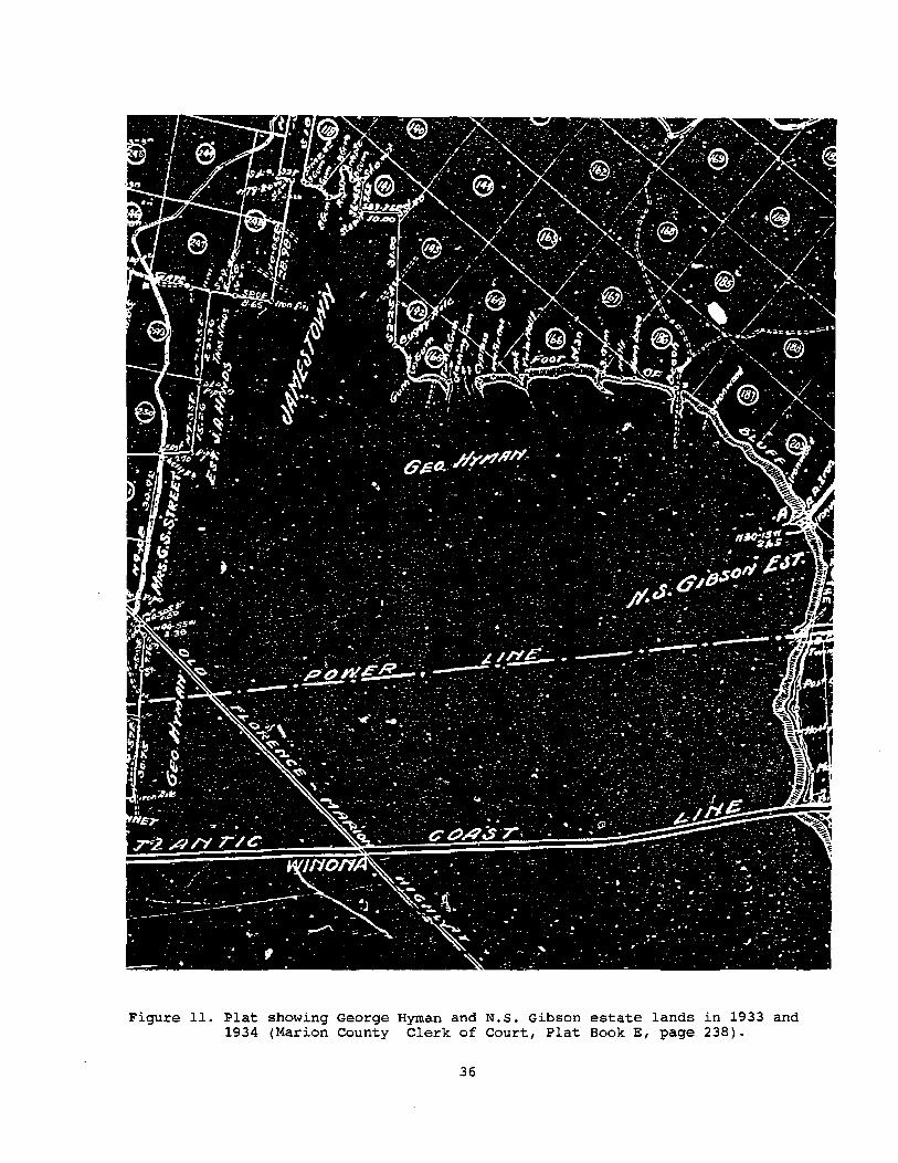
Figure 11. Plat showing George Hyman and N.S. Gibson estate lands in 1933 and 1934 (Marion County Clerk of Court, Plat Book E, page 238).
36

the land, housing, tools, work animals, feed, and seed. At harvest the crop would be divided, usually equally. In share-renting the landlord supplied the land, housing, and either one-quarter or one-third of the fertilizer, while the tenant supplied everything else necessary, including the animals, feed, seed, and tools. At harvest the crop was divided equal to the portion of fertilizer each party provided. Finally, with cash-renting the landlord supplied the land and the housing, while the tenant supplied everything else. The owner received a fixed rent per acre in cash.
Agee et al. provide some general information on agricultural activities during the early twentieth century, observing that:
Farms operated by tenants are usually devoted mainly to the production of cotton, corn, and tobacco. The ordinary yield of cotton on such farms is a little over one-half bale per acre, while that of corn is about 16 bushels. These yields could easily be increased, as is demonstrated by the better farmers, who obtain 1 bale to 2 bales of cotton and 40 to 60 bushels of corn per acre. .
About 65 per cent of the farms are operated by tenants. • • • The ordinary yield of tobacco in the county is somewhat over 800 pounds per acre. The price has averaged about 14 cents per pound (Agee et al. 1916:9).
By the late 1920s the boll weevil was reaching Florence County and one newspaper editorial reported that the weevil had "put a stop to the lazy man's crop,11 and that now planting took "brains, money, hard work, and poison to raise cotton hereabouts these days" (quoted in King 1981:338).
At Nathan Gibson's death in 1909, the property apparently consisted of 2575.7 acres shown on a 1930-1931 plat made to assist in the partition of the
t:~ ~~~-... -..,
- :. ~"= -- -" -~
- *--
Figure 12. A portion of the 1945 edition of Florence East topographic map (reproduced scale is 1:46875).
37

w en
,i " 'I ',I
'r~r.:',i"".,,~Mle;':';;· ". :;.~. ;";"~;,." '. ' , , 0:::<."", ' , ~ ',,,,, \ " ' ":\',\ '·If,,,,,·l,, _ "'_ 'I ::. -=\
'i', , ' ! " i, .. ~ i,.;,"
, jl " ~/ Y;':"l' ' , '.~t' .... ", -' . , .. , ' i,. d>~-,,)_, ,_: ' "" l •• · '"". " '1,,' if I' ", ",'.. 'I , , ,
:t·'1 ":ti ~i:!
. ·jl;;;"::.".:, ... ,,:ft~~::~:,c~:::'.~:"::J'; "'i;
estate (Marion County Clerk of Court, PB C-2, p. 329; Figure 10). Tracts 1, 2, 3, 4, 5, 6, and 7, totalling 1473.5 acres account for the study area. In 1931 George H. Hyman, McCall Hyman, and Mary A. Hyman conveyed tracts 4 and 11 (with 1005 acres) to their mother, Rebecca A. Gibson "to effect a portion of the estate of N.S. Gibson, deceased" (Florence County Clerk of Court, DB 13, p. 203). At Rebecca Gibson's death in 1938 she devised her 1/3 interest in the property she obtained from her daughter, Martha Gibson, to her children, Italine Hyman Finklea, George H. Hyman, Mary A. Hyman, and McCall Hyman (Florence County Probate Court, Box 3543). The general area of the Gibson lands is also shown on the Atlantic Coast Lumber Corporation and united Timber Corporation map of the Duckponds made in 1933 and 1934 (Marion County Clerk of Court, PB E, p. 238; Figure 11).
The estate was finally settled in 1940 with the partition of the estate, which gave the bulk of the plantation to George Hyman. Mary Hyman was provided with the homestead built about 1909 by Rebecca Gibson after her husband's death. (Florence County Probate Court, Box 3543). A 1941 aerial photograph maintained by the Soil Conservation Service in Florence County shows the operations of both George Hyman and Mary Hyman (Florence County 1941 Photo PC 6B 12, Thomas Cooper Map Repository, University of South Carolina). At that time six structures are shown on the survey tract, including Mary Hyman's homestead, the probable homestead of George Hyman, ana a series of tenant houses. The slave settlement first identified on the 1914 soil survey is shown as just within the woods, although the road bisecting the settlement is clearly shown. This suggests that this row, or replacement structures, were present. The aerial photograph also reveals that something approaching 85% of the plantation was under cultivation.
Slightly more detail is provided by the 1945 edition of the Florence East topographic map (Figure 12; this map is not appreciably different from the 1940 edition of the Florence topographic map available at the Thomas Cooper Map Repository). The neighboring black community is named Jamestown for the first time on a published map. A series of six structures in the slave settlement are shown as still standing. In addition, 14 structures are shown scattere~ over the property.
Examination of the aerial photographs at the Thomas Cooper Map Repository indicates that between 1949 and 1969 the cultivated acreage in the survey area was reduced by approximately 25%. This is much greater than the county average of nearly a 6% reduction of cropland between 1958 and 1975. It seems likely that after 100+ years of cultivation some of the Gibson lands were nearly exhausted and no longer profitable for cultivation.
At his death in 1969 George Hyman passed his farm of 1691 acres on to his wife, Florence F. Hyman (Florence County Probate Court, Roll 10333). At the death of Mary A. Hyman her homestead tract of 21 acres and 85 acres of woodland were devised to the Francis Marion College Foundation (Florence County Probate Court, Roll 16733). In addition, she bequeathed to the Foundation:
all furnishings presently located in my sitting room, hall and dinning room. These items consist mainly of antiques that I and my family have owned for many years and it is my request that they be used in my home as nearly as possible as they are being utilized at the present time (Florence County Probate Court, Roll 16733).
Although the Mary Hyman property was sold by the Foundation in 1985 to Philip Britton (Florence County Clerk of Court, DB A-227, p. 152), the bulk of the antiques were transferred to the President's home, the restored Wallace House, where they are still being used (Mrs. Libby Cooper, Vice President for Development, Francis Marion College, personal communication 1992).
Florence Hyman devised the bulk of the property inherited from her husband to her children. One tract of 14.92 acres was bequeathed to her sister, Margaret
39

F. Johnson, while another tract of 2.92 acres was given as a life estate to McKinley Jesse, then to pass to Frank M. Davis, III (Florence County Probate Court, Case 13354; see also Florence County Clerk of Court, PB 15, p. 795).
The executors of Florence Hyman's estate sold the property in 1977 to Philip Britton (Florence County Clerk of Court, DB A-153, p. 533). Britton also acquired the two out parcels, one from Margaret F. Johnson (Florence County Clerk of Court, DB A-153, p. 532) and the other from Frank M. Davis, III .(Florence County Clerk of Court, DB A-346, p. 1424). Michael Wayne Britton, Philip Britton's son, also acquired two out parcels of the Mary Hyman estate (Florence County Clerk of Court, DB A-237, p. 1879 and DB A-258, p. 515).
A plat made in 1976 shows the estate of George Hyman (and Florence Hyman), as well as its boundary with the estate of Mary A. Hyman (Figure 13). A single tenant house is shown on the southwest edge of the tract and the major complex belonging to George Hyman, and built about 1940, is shown at the north edge of the property. This plat also identifies, for the first time, a small black cemetery between the Hyman tract and Jamestown.
The purchase of the property by Philip Britton represented the end of nearly 150 years of ownership. by the Gibson family. Britton held the tract from 1977 until its sale to LaRoche Carolina in November 1991.
Implications
This historical research reveals that the Hoffmann-La Roche survey tract was first occupied probably by the early nineteenth century. No clear evidence was encountered for any occupation or plantation development in the eighteenth century. However, by the earlyantebellum the Gibson plantation was established and operating using slave labor. There remains some doubt as to the actual location of the Gibson settlement from this early period and it is possible that the plantation operations were directed by an overseer or even a slave driver. Regardless, it is likely that a slave settlement was established during this period.
The economic upheaval of the postbellum certainly impacted the operation of the Gibson tract. The use of wage and/or tenant labor is evidenced by both the historic documents and various maps. While early the settlement previously used by the slaves continued to be occupied by the African American laborers in the postbellum, the earlier nucleated settlement gradually dissolved and a more diffuse settlement pattern began developing. Agricultural pursuits gradually shifted from a sole reliance on cotton to somewhat more diversified production of cotton, subsistence crops, and tobacco.
The Gibson plantation seems typical of many other moderately large tracts in the Pee Dee region, although there are few historical or archaeological investigations suitable for comparative purposes. The historical research, however, is useful in verifying the suitability of the field methodology outlined for the survey. Further, the background research also reveals opportunities to contribute toward a better understanding of Pee Dee history and culture.
40

IDENTIFIED ARCHAEOLOGICAL SITES
As a result of the archaeological survey, 42 sites were identified. These include eight sites with prehistoric components and 38 sites with historic components. Of these 42 sites, seven are considered eligible for the National Register. These sites include 38FL232 (Jamestown Cemetery), 38FL235, 38FL237 (Mary Hyman House), 38FL240, 38FL245 (Winona General Store), 38FL249, and 38FL269. Two of these sites 38FL232 (Jamestown Cemetery) and 38FL245 (Winona General store) are not located on the survey tract and, therefore, are not currently not within the primary impact zone.
Eight sites consist of standing (or partially standing) structures which were recorded using the South Carolina Statewide Survey Site Forms. These include a Victorian era structure (38FL237, the Mary Hyman House), two tobacco barns (38FL238 and 38FL259), two dismantled owners' houses (38FL239, the Michael Britton House and 38FL242), two tenant houses (38FL244 and 38FL258), and one store (38FL245, the Winona General Store). These will be discussed in the following section. -
Site 38FL232, Jamestown Cemetery, represents a postbellum (and possibly antebellum) period African-American cemetery situated on a ridge and ridge slope adjacent to the Pee Dee River swamp, just west of the survey tract. It contains a large number of graves including about 20 marked with headstones, about 30 marked with metal tags, and a large number evidenced by grave goods or depressions. The earliest marked grave is 1913, but most date to the 1920s. The latest burial dates to the 1970s. The central UTM coordinates are E628520 N3787680 and the site is on Cahaba loamy fine sand at an elevation of 104 feet above sea level. The site measures about 400 feet north/south by 300 feet east/west. Survey at the site consisted only of visual inspection; no. artifacts were gathered.
38FL232 can contribute significant demographic and biocultural data on an Inner Coastal Plain African-American population. The study of grave items and coffin hardware can contribute social/cultural information and can refine temporal dating of the cemetery. This site is recommended as eligible for inclusion in the National Register. The only known threat to the cemetery is the potential for encroachment because of its imprecise boundaries.
Site 38FL233 represents a late nineteenth/early twentieth century tenant site situated along an east/west running road. It consists of a thin veneer of historic remains which have been largely disturbed by an existing borrow pit. Three shovel tests failed to reveal any in situ remains. Since the surrounding area consisted of plowed field, disturbed borrow pit area, or dirt road, visibility was good and a surface collection was made. The artifacts consist of seven whitewares, one blue edged whiteware, two brown alkaline glazed stonewares, one piece of sheet copper, one piece of fossilized wood, one non-cortical porphyritic rhyolite flake, one non-cortical flow-banded rhyolite flake, one noncortical quartz flake, and two small unidentifiable prehistoric sherds. The site yielded a mean historic ceramic date of 1889.75. In addition, the presence of prehistoric pottery suggest that the prehistoric remains indicate post 500 BC occupation.
The central UTM coordinates are E628720 N3787260 and the site is on Lakeland sand at an elevation of 110 feet above MSL. Soil profiles revealed 0.8 foot of dark gray brown soil (10YR3/2) overlying yellowish brown soil (10YR5/4). The site measures about 600 feet east/west and 300 feet north/south.
38FL233 has been badly disturbed by a dirt road and,a borrow pit. This site
41

Table 2. Sites identified on the Gibson Plantation tract.
Site No. Site Tlee SoiL T~ and Drainage Elevation (ft. ) Size (ft.) Eligibilit~ 38FL232 cemetery Cahaba, well 104 400 x 300 E 38FL233 tenant Lakeland, excessively well 110 600 x 300 NE 38FL234 tenant Lakeland, excessively well 110 50 x 25 NE 38FL235 tenant Exum, moderately well 101 200 x 125 PE 38FL236 tenant Exum, moderately weLL 101 200 x 150 NE 38FL237 owner Coxville, poorly 101 400 x 400 E 38FL238 tobacco barn DupLin/Exum, moderately well 85 30 x 30 NE 38FL239 owner Coxville, poorly 101 200 x 200 NE 38FL240 slave/tenant Lakeland, excessively well 110 1000 x 300 E 38FL241 tenant Goldsboro, moderately well 104 200 x 200 NE 38FL242 owner Orangeburg, well 107 200 x 200 NE 38FL243 historic scatter Orangeburg, well 110 100 x 150 NE 38FL244 tenant Coxville, poorly 98 50 x 25 NE 38FL245 store Exum, moderately well 98 150 x 50 E 38FL246 lithic scatter Varina, welL 98 isolated NE 38FL247 historic/lithic scatter Goldsboro, moderately well 98 100 x 50 NE 38FL248 tobacco barns Sunsweet, well 88 250 x 50 NE 38FL249 tenant/prehistoric Sunsweet/Lucy, well 104 1000 x 600 E 38FL250 lithic scatter Orangeburg, well 110 isolated NE 38FL251 tenant Lynchburg, somewhat poorly 104 25 x 25 NE 38FL252 historic scatter Orangeburg, well 101 isolated NE 38FL253 lithic scatter Orangeburg, well 101 50 x 50 NE 38FL254 lithic scatter Varina, well 85 200 x 200 NE 38FL255 lithic scatter Varina, well 88 50 x 50 NE 38FL256 tenant Varina, well 91 300 x 200 NE 38FL257 tenant Exum, moderately well 91 200 x 200 NE 38FL258 late 20th century Duplin/Exum, moderately well 88 50 x 50 NE 38FL259 tobacco barn Duplin, moderately well 85 50 x 50 NE 38FL260 tenant Goldsboro, moderately well 91 300 x 200 NE 38FL261 tenant Coxville, poorly 98 50 x 50 NE 38FL262 tenant Coxville, poorly 98 50 x 50 NE 38FL263 tenant Coxville, poorly 98 200 x 100 NE 38FL264 tenant Coxville, poorly 94 200 x 100 NE 38FL265 tenant Coxville, poorly 98 50 x 50 NE 38FL266 tobacco barn? Norfolk, well 98 50 x 50 NE 38FL267 tenant Duplin, moderately weLL 98 50 x 50 NE 38FL268 tenant Duplin, moderateLy weLL 98 50 x 50 NE 38FL269 tenant Duplin, moderateLy weLL 98 250 x 150 PE 38FL270 tenant Coxville, poorly 98 250 x 200 NE 38FL271 historic/lithic scatter Exum, moderately welL 91 200 x 100 NE 38FL272 trash dump Duplin, moderately weLL 88 25 x 25 NE 38FL273 tenant Duplin, moderately well 101 50 x 50 NE
Eligibility - E=Eligible, PE=Potentially Eligible, NE=Not Eligible
is recommended as not eligible for inclusion in the National Register.
Site 38FL234 represents a late nineteenth/early twentieth century tenant site situated adjacent to an east/west road and to a north/south road which leads to the Jamestown cemetery. It consists of a small, sparse scatter of historic artifacts adjacent to the roads and in disturbed areas. Three shovel tests failed to yield any artifacts. Surface collected from the site were one vitreous porcelain ceramic (MCD=1883), 12 sherds of solarized glass (including one sherd with a por~ion of a S.c. Dispensary motif), and eight sherds of aqua glass. Soil profiles revealed about 0.7 foot of dark gray brown soil (10YR3/2) overlying yellowish brown soil (10YR5/4). The central UTM coordinates are E628540 N3787200 and the site is located on Lakeland sand at 110 feet above MSL. It is 50 feet north/south by 25 feet east/west in size.
38FL234 yielded no subsurface remains and is badly disturbed by road construction. This site is recommended as not eligible for inclusion in the
42

National Register.
Site 38FL235 is a late nineteenth/early twentieth century tenant site located approximately 200 feet north of SC Hwy 24 and 200 feet east of a dirt road (Jamestown Road) which services several residential lots~ The site consists of a scatter of artifacts in a plowed field. Of 15 shovel tests, 11 evidenced subsurface remains of artifacts and/or brick rubble. The site had been freshly plowed allowing surface collection. Forty-eight artifacts were recovered (Table 3) which provided an adequate sample to perform an artifact pattern analysis (Table 4).
Artifact Surface Whiteware, undec. 2
handpainted Porcelain, white
green overglz. 1 Redware, lead glazed 2 Stoneware, bristol slip 1 Glass, clear 4
soLarized 1 aqua dk. olive green
TumbLer fragments Window glass 1 UID nail fragments Brass Clothing rivet 1 Total 13
Table 3. Artifacts recovered at 38FL235
ST1 ST2 ST4 ST5 ST6 ST7 1 2
1 3 _ 2 3 1 3 1
2
7 3 3 4 4 2
Table 4. Artifact Pattern at 38FL235
Group # Kitchen 39 Architecture 8 Furniture a Arms 0 Clothing 1 Tobacco 0 Activities 0
48
% 81.2 16.7 o o 2.1 o o
ST9 ST10 ST11 ST13 1
1
2
1
1 1
3 4 3 2
Ceramics suggest a late nineteenth/early twentieth century occupation. Undecorated whitewares (N=6) date from 1820 to 1970, handpainted whitewares (N=l) date from 1826 to 1870, and late porcelains (N=2) date from 1851 to 1915 (Bartovics 1981). These yield a mean ceramic date (MCD) of 1887.1.
Soil profiles revealed about 1.0 foot of gray brown plowzone (10YR5/2) overlying yellow brown subsoil (10YR5/6). The central UTM coordinates are E627890 N3786560 and the site is located on Exum sandy loam at an elevation of 101 feet above MSL. It measures 125 feet east/west by 200 feet north/south.
Although heavily plowed this site is an early representative of the ubiquitous tenant occupation of the tract. Investigation of intact later tenant sites on the tract (38FL240 and 38FL249) indicate relatively insubstantial architecture with footings and chimney supports being seated no lower than three courses (about 0.7 ft.) below ground surface. In fact, it is clear than tenant sites in plowed areas will most likely not reveal any intact subsurface architectural remain. Artifacts suggest a late nineteenth century occupation and historic maps indicate that the site was active in 1914, but had been abandoned
43

by 1945. Site 38FL235 is recommended as potentially eligible for inclusion in the National Register. This site has the potential to reveal similarities or differences between dispersed tenant settlement as opposed to clustered settlement such as found at 38FL240. The fact that tenant sites are so common in this area magnifies the importance of investigating what is clearly an important part of Florence County's agricultural and social history.
Site 38FL236 represents a house which was demolished circa 1983 (Phillip Britton, personal communication 1992). Furniture and clothing are still present at the site. Historic maps indicate that the structure existed in 1945, but does not appear on the 1914 map. The site is located approximated 800 feet from SC Hwy. 24 at the end of a dirt road. Nine shovel tests were excavated with six yielding subsurface remains. Artifacts include six undecorated whitewares (MCD=189s), 13 sherds of clear glass, two sherds of solarized glass, one sherd of amber glass, one sherd of milk glass, one sherd of amber reflector glass, one 12d wire nail, one wire nail fragment, one UIO nail fragment, four tin can fragments, one piece of flat tin, one piece of animal bone, and one non-cortical quartz flake. No surface collection was made.
The central UTM coordinates are E628120 N3786720 and the soils are Exum sandy loam at an elevation of 101 feet above MSL. Soil profiles indicate that the Ap horizon consists of gray brown soil (10YRs/2) overlying yellow brown subsoil (10YRs/6) .• The site is 150 feet north/south by 200 feet in size.
Based on the late date of occupancy and the sparsity of archaeological remains, site 38FL236 is recommended as not eligible for inclusion in the National Register.
Site 38FL240 consists of the remains of a slave/tenant row. This site is located in and to the north of an east/west dirt field road which runs through
a o
o
• POSITIVE
o NEGATIVE
PLOWED FIELD
TRANSMISSION LINE
100 200
~!;~ FEET !;
Figure 14. Shovel tests at 38FL23s.
44

o
>-w z ,.
w i ... " ~
o
" ~ ...
w w z => Z > ~ > ., 0 => ., ~ ... .. z " ;;; " .. ;: ~ 0 w ... w .. Z ~ ~ ... • 0 • ,? •
)1
ii
t(. ~\ \.
\
\\. \. \ \ \ .. \ b \ ~ \~
'" \'" i .. .a: \~ \ .. '0
\ '" \ g i '" .\
\ \ \
o o .. o o ~
o
o w
== o .... Q.
\
o
o
45
o \ ~ ~
\ ~ \ 0
\ f \
\ \ \ \ \ i \ !
)
... w w ..
OJ OJ
" ~
-:;: OJ
<i-I
OJ .... OJ OJ ....
.-<
~ o .<: OJ
<i-I o OJ c o . ... -:;: o o ..:I
"' .... OJ
" g, .... r..

the northern half of the property. The bulk of the site is found on a narrow east/west ridge just north of the dirt road~ Also found during survey was the remnant of a parallel road located approximately 200 feet north of the field road. The majority of the site is wooded with a ve.ry thick understory of vegetationo Eighteen transects at either 25 or 50 foot intervals were placed across the site with shovel tests at either 25 or 50 foot intervals. A total of 142 shovel tests were excavated with 99 (or 69.8%) yielding artifacts or brick and mortar rubble. Two standing chimneys (one double and one single) were located and four areas of dense brick concentrations were located {Figure 15) ~ Artifacts were also collected in areas of good surface visibility such as the dirt road and fallow field. As a result of the investigations at the site, 522 historic artifacts were recovered. They are summarized in Table 7 ~ In addition, five prehistoric artifacts were recovered. They include one non-cortical vitric tuff flake, two non-cortical orthoquartzite flakes, and two non-cortical flakes of an unknown material~
Four sizes of brick were noted during these investigation9~ The first was small (7 3/4 inches x 3 1/2 inches x 2 1/4 inches), compact, containing textured sides for mortaring, and weak red (10R4j4) in color. The second tcype was larger (1 inches x 3 3/4 inches x 3 inches), soft, and pink (5YR7/4). The third type measured 8 1/2 inches x 3 3/4 inches x 2 1/4 inches, was relatively hard, and pink (5YR7/4). The fourth brick (8 inches x 3 3/4 inches x 2 1/4) was hard and weak red in color (lOR4/3). Munsell colors were obtained from freshly abraded surfaces. The larger I pink bricks appear older, while the smaller 1 red bricks are found on many of the standing structures throughout the survey area. The two standing chimneys were constructed of the smaller r red bricks~
One of the brick concentrations, located on transect 12 shovel test 3, was the focus of further testing primarily because the majority of surface brick consisted of the larger, older brick. Here, a 5 by 10 foot unit was opened
Figure 16~ 38FL240 base of zone 1 showing remains of a brick firebox~
46

oriented with magnetic north revealing a poorly constructed brick firebox with its base set just below subsoil, three courses below ground level (Figure 16). The unit was excavated in one zone to a depth of 1.0 feet below ground surface. The long axis of the firebox was oriented N5°W (as were the standing chimneys), opening to the east. The back was three courses wide and the arms were two courses wide. Although it was not confirmed that the firebox consisted of only three sides, surface brick and topography suggested that a fourth side did not exist or had been almost entirely destroyed.
A sufficient quantity of artifacts were recovered to calculate an artifact pattern for the site. Since surface collections and subsurface testing can yield very different patterns, they have been separated in Table 5.
Group Kitchen Architecture Furniture Arms Clothing Personal Tobacco Activities Total
Table 5. Artifact Patterns from 38FL240
Surface # %
203 97.6 o 0 o 0 o 0 1 0.5 o 0 1 0.5 4 1.9
208
Subsurface # %
202 80.5 40 15.9 o 0 1 0.4 1 0.4 o 0 1 0.4 6 2.4
251
Total # %
405 40 o 1 2 o 2
10 459
86.3 11.4 o 0.2 0.4 o 0.4 1.5
Ceramics from the site indicate a relatively long period of occupation, probably dating from the early half of the nineteenth century up through the mid twentieth century. Of the 148 earthenwares collected 0.7% are creamwares, 6.8% are pearlwares, and 92.5% are whitewares. Datable ceramics from the site yielded a mean ceramic date (MCD) of 1882.6 (Table 6).
Table 6. Mean Ceramic Date for 38FL240
Ceramic White porcelain, undecorated
NA salt glazed stoneware Brown stoneware bottles
Creamware, annular Pearlware, blue transfer print
edged annular undecorated
Whiteware, edged blue transfer print non-blue transfer print decal annular polychrome hand painted undecorated
Yellow ware, banded Total
(xi) 1883
1866 1860
1798 1818 1805 1805 1805 1853 1848 1848 1926-1866 1848 1895
1890
299200 ~ 159 = 1881.8
47
( fi) fi x xi 9 16947
3 5598 2 3720
1 1798 1 1818 3 5415 2 3610 5 9025 7 12971 4 7392 2 3696 1 1926 6 11196 1 1848
112 212240
2 3780 159 299200

~ g
~
-, • ; -• " • ~ • ~ ~ ,
" , • <
0
'" " '" ,
..:l § ...
CD
'" ..., S <11
~ . '" t- O>
0> ... § 0> .-< > .Q 0 § <11 E-< 0
0> p:; §
"' ;; ..., , 0 <11
" .... ; .~ ..., ;; ... ; ..;
§
; ;
~ ;
§
" ;
E
• - ; , i . N • .. '" ... ... ,., '" " N " i ~ I I j
! • i i j
~ ! 1 i ~
~ I ! i - ~ ,
• •
1 , j j i ~
, ~ ! i ! j ! i !
i ! i i i ~ i ~ ! i ~ i i ! ! } I i } i .. i I j J
! ~ i l I j • , !
I 1 ~ .. ~ ; 5
, 1
! [ ~
l 1 ]
[ ~ ~ , , i
., ., , ~ • ~ , ,
; ,
48

o ... N
~ (Xl
'" ..... "ll'" 0'0 " Ol ,,",
r-~ Ol 0 .... " .aOl ",<>: 8.,
.... " '" "" .... .... ~ ~ ~~++++4444~~~~~++++++~~~~~~
~~~++++4444~~~~~++++++~~~~~~ §~~~++~~~~~~~~++++~~~~~~ ~~4-~-r+-~4-~-r~~4-~4-~-r~~4-~-r~~4-~-r~
, i 1 I ! j , ! I i i , 1 ,
! , , i i i j ~ ;
! j ~ i i j 1 i ! ! 1 1 ~
~ • , , ~ ~ ! ~ .! ~ ~ t . i l ~ , ,
~ ~ ;, ~ , ~ l i
< ! i ! • • l < , , ! i ;
l ~ ~ } ~ i I 1 , I i ~ ! ~ i I g i • ~ ~ , ! i j ;
• • , • • . 3 ; ,
49

B c D
G H E F
J
K l I
M N o
Figure 17", Historic artifacts recovered from the survey area. At Annular Crea.ruware; B f Blue Edged Pearlware; C, Blue Edged Whiteware; Dr Annular Whiteware; E, Polychrome Handpaini.:ed Whit.eware; F', SluG 'I'ransfer Print:ed Whi.teware; G, Decalcomania; H, Vitreous Porcelain, Willow Pattex.'n; I,. pharmaceutical bottle; J f glazed pipestem; Kp stub-·stemmed kaolin pipe; L, padlock; M, black fa.ceted glass button; N, swirled glass marble; 0; "Size VITIlt doll part~
50

This site is shown on a 1914 soil survey map as a double row of 15 structures (eight to the north and seven to the south) although by 1945 only six of these structure are shown on the Florence East topographic map. The fact that the settlement is laid out in double rows strongly suggests that it was originally built as a slave settlement, but continued to be occupied into the postbel1um. This is supported by the presence of the two brick types and early artifacts.
The central UTM coordinates are E629060 N3787340 and the soils are Lakeland sands at an elevation of 110 feet above MSL. Soil profiles taken from the excavation unit indicate that the Ap horizon consists of 1.0 foot of dark brown soil (7.5YR4/2) overlying yellow subsoil (10YR7/6). The site measures 1000 feet east/west and 300 feet north/south.
38FL240 is recommended as eligible for inclusion in the National Register. Most of the site evidences little disturbance and contains information that can answer important questions about lifestyles similarities and changes of AfricanAmericans before and after emancipation. In addition, the tenant period component of the site can yield information about clustered African-American settlement which can then be compared to dispersed tenant settlements such as found at 38FL235 and 38FL269. It is likely that this change in settlement corresponds to changes in labor organization, with associated differences in material culture (see Orser 1988). Very little is known about slave and tenant life in the Inner Coastal Plain, so investigations at this site can begin to shed light on how life here was similar or different than life at coastal plantations.
Site 38FL241 consists of a late 19th/early 20th century scatter in the middle of a plowed field approximately 400 feet north of the northern-most transmission line. The field was freshly plowed making surface visibility excellent. The site was collected and a series of 16 shovel tests were excavated, with 12 containing artifacts or brick. Forty-four artifacts were collected from the site and are summarized in Table 8. A sufficient quantity of artifacts were collected to perform an artifact pattern analysis (Table 9).
Twelve datable ceramics were recovered during testing. These include nine undecorated whitewares (MCD~1895), one transfer-printed whiteware (MCD~1848), and two white porcelains (MCD~1883). These yield a mean ceramic date of 1889.1.
The central UTM coordinates are E628620 N3786960 and the soils are Goldsboro loamy sand at an elevation of 104 feet above MSL. Soil profiles indicate an Ap horizon of dark brown soil (10YR4/1) overlying pale brown soil (10YR6/3). The site measures 200 by 200 feet.
Table 8. Artifacts recovered from 38FL241
Artifact Surface ST1 STZ ST3 STS ST6 ST7 ST9 ST10 ST12 ST13 ST14 Whiteware, undec. 4 1 1 2 1
red trans. print PorceLain, vitreous 1 1 GLass, cLear 5 3 2 2 1
soLarized 2 Lt. bLue 3 milk 1
Canning lid fragment 1 Kettle fragment 1 Window glass 1 UnidentifiabLe nail fragments 1 2 1 5/64" brown glazed l?:iQestem 1
16 5 1 2 1 5 2 5 2 2
51

Table 9. Artifact Pattern for 38FL241
Group Kitchen Architecture Furniture Clothing Personal Tobacco Activities
# 36
7 o o o 1 o
44
% 81.8 15.9 o o o 2.3 o
38FL241 is recommended as not eligible for inclusion in the National Register. Although artifact count is only slightly lower than the count at 38FL235 (N=49), the artifacts are also more dispersed. No in situ remains were indicated and the site is heavily plowed.
Site 38FL243 consists of a scatter of historic artifacts in the northern portion of the main dirt road leading into the survey property. Eight shovel tests were excavated adjacent to the road which yielded no artifacts. The only remains recovered were surface collected from the road. These remains include three undecorated whitewares and one blue transfer printed whiteware. Although surface visibility adjacent to the road was good, no artifacts were noted on the surface. The site yielded a mean ceramic date of 1883.25.
The central UTM coordinates are E629260 N3787260 and the soils are Orangeburg loamy sand at an elevation of 110 feet above MSL. The Ap horizon consists of 0.6 foot of gray brown soil (10YR5/2) overlying pale brown soil (10YR6/3). The site is 50 feet east/west and 100 feet north/south.
38FL243 is recommended as not eligible for inclusion in the National Register. No subsurface artifacts were recovered and the site may actually represent road fill rather than primary domestic refuse.
Site 38FL246 consists of one isolated artifact. This artifact is a quartz biface fragment found on the surface of a plowed field. It is not located near any of the prehistoric sites on the tract and a series of four shovel tests did not located any subsurface remains. The central UTM coordinates are E628620 N3785840 and the soils are Varina loamy fine sands at an elevation of 98 feet above MSL. The Ap horizon consists of 0.7 feet of dark brown soil (10YR5/2) overlying pale brown soil (10YR7/3).
38FL246 is recommended as not eligible for inclusion in the National Register. Only one artifact was located in a heavily plowed field.
Site 38FL247 consists of a scatter of historic and prehistoric artifacts located in the southern portion of the main dirt road leading into the tract. A series of six shovel tests were excavated adjacent to the road, only two of which recovered artifacts. A surface collection was made in the dirt road. Although surface visibility was good adjacent to the road, no artifacts were noted. Remains include 11 undecorated whitewares, one blue handpainted whiteware, one white vitreous porcelain, two brown glass, two aqua glass, seven clear glass, two solarized glass, and one felsic tuff biface. The site yielded a mean ceramic date of 1890.5.
The central UTM coordinates are E628700 N3785960 and the soils are Goldsboro loamy sand at an elevation of 98 feet above MSL. The Ap horizon consists of dark gray brown soil (10YR4/1) overlying pale brown soil 10YR6/3. The site is 50 feet east/west by 100 feet north/south.
38FL247 is recommended as not eligible for inclusion in the National
52

Register. The site appears to represent road fill rather than primary domestic refuse.
Site 38FL248 consists of two demolished tobacco barns located north of a field road and south of a drainage on the eastern edge of the property. The two barns are approximately 180 feet apart and are both 20 by 20 feet in size. One foundation is constructed of concrete blocks while the other is constructed of brick. Inscribed in the mortar footing of the eastern barn (concrete) is "R.C. HINSON FEB 5 1952". A series of seven shovel tests yielded no subsurface remains. The central UTM coordinates are E630440 N3787060 and the soils are Sunsweet loamy fine sand at an elevation of 88 feet above MSL. The Ap horizon consists of 0.9 foot of dark grayish brown soil (10YR4/2) overlying pale brown soil (10YR6/3). The site is 250 feet east/west by 50 feet north/south in size.
38FL248 is recommended as not eligible for inclusion in the National Register. The barns have been demolished and the sites have been adequately studied through recordation.
Site 38FL249 is a large stratified Early Archaic through Late Woodland prehistoric site with two historic components including one mid to late 19th century artifact scatter and.one tenant period chimney footing. This site is located in the north central portion of the tract approximately 1000 feet from the Pee Dee River Swamp. The central UTM coordinates are E629800 N3787840 and the soils are Sunsweet and Lucy loamy fine sands and sand at an elevation of 104 meters. The site measures approximately 1000 feet east/west by 600 feet north/south.
The majority of the site (locus 1) was located during shovel testing of the wooded area. This portion of the site appears to be in excellent condition although a small portion of the site has been disturbed by the tenant component. The remainder of the site was located independently of the shovel testing through pedestrian survey. This portion has been disturbed through plowing, however 50% of the shovel tests in the eastern portion of the locus 2 area were. positive. Four lithic scatters in plowed fields were initially defined as individual sites since they were clearly on small ridges separated by lower area. In addition, shovel testing between them revealed that they were all approximately 200 feet apart. All four of these scatters yielded lithics. The western-most scatter yielded pearlwares and whitewares, and the scatter just east of it yielded whitewares and clear bottle glass. After several heavy rains, these four scatters were again collected and it was found that two of the scatters contained a significant number of prehistoric pottery sherds. Further shovel testing revealed that the two eastern-most scatters appeared to be connected to the wooded area of the site (locus 1), while the western-most scatters (locus 2) were small knolls separated from the remainder of the site by low areas. A total of 55 shovel tests were excavated (Figure 18).
The eastern lobe of locus 2 yielded the largest amount of surface collected artifacts and since 50% of the shovel tests were positive it was decided that several 5 by 5 feet units would be opened here. Also, since the wooded portion of locus 1 seemed to be intact, other units would be placed there.
At locus 2, two 5 foot units were excavated, each on high areas of the site. Test unit 1 was located approximately 50 feet south of a dirt farm road and was oriented with magnetic north. It was in this area that most of the prehistoric pottery was surface collected~ The unit was excavated to a depth of 0.7 feet. To this depth the soil was yellowish brown (10YR5/4) and at the base of the unit the soil was brownish yellow (10YR6/6). No features other than plowscars were located in this unit and artifacts consisted of a sparse amount of lithics. Although the surface remains were not dense, it was believed that there would be more subsurface remains. As a result we excavated a small test hole in the southwestern corner of the unit to see if artifacts were being plowed out of the soils at the base of the unit. No artifacts were recovered. Test Unit
53

2 was located on a high area further south of the road, just before the area drops and becomes relatively flat for a large expanse of the field. It was also oriented with magnetic north. This unit was excavated to a depth of 0.4 foot below grade. Soils here were the same color as in Test Unit 1 and, again, the only features were plowscars.
A third unit was located between Test Units 1 and 2 in a lower area of the site. This unit was placed here to check site erosion and to excavate further into the lighter color soils to see if higher portions of the site had been truncated by plowing. This unit was excavated in two zones. Zone 1 consisted of yellowish brown soil (10YR5/4) to a depth of 1.2 feet. Zone 2 consisted of brownish yellow soil (10YR6/6) to a depth of 1.5 feet. Very few artifacts were recovered in zone 1 and no artifacts were recovered in zone 2. The only features encountered were plowscars.
Based on these three test units, locus 2 of site 38FL249 appears to have been entirely plowed out. In addition, locus 2 has been visited by a number of local artifact collectors (Phillip Britton, personal communication 1992). While there still may be remnants of subsurface prehistoric features, they are probably truncated.
At locus 1, Test Unit 4 was placed in an old north/south running road bed approximately 200 feet north of where it intersects a field road. The unit was oriented N300W. Zone 1 consisted of dark soils including brown soil (10YR5/3) to a depth of 0.2 foot and very dark grayish brown soils (10YR3/2) to a depth of 0.5 foot. The darker band of soil is believed to represent old road bed. This zone contained historic artifacts related to a nearby tenant house, lithic debitage, and prehistoric ceramics (primarily cordmarked and fabric impressed). Zone 2 consisted of lighter soils including yellowish brown soil (10YR5/6) to a depth of 0.8 foot and brownish yellow (10YR6/6) to a depth of 1.1 feet. This layer contained mostly lithics with a relatively large amount of ceramics, most of which appear to be Badin and Yadkin. Zone 3 was a continuation of the brownish yellow soils to a depth of 1.8 feet. This level contained a large,amount of lithics, but few ceramics. Zone 4 consisted of mottled brownish yellow soils along with very pale brown soils (10YR7/3) and contained only a few artifacts. This zone was excavated to a depth of 2.0 feet when the soils were primarily very pale brown in color. Two tree root stains were plotted at the base of both Zone 2 and 4.
Test Unit 5 was located approximately 150 feet north of Test Unit 4, also in the old road bed. The unit was oriented N400E. This unit was excavated in three zones. Zone 1 consisted of very dark gray soil (10YR3/1) which probably represent old road bed and dark brown soil (10YR3/3). This zone was excavated to a depth of 0.3 foot below surface. Artifacts consisted of historic artifacts, prehistoric ceramics and lithics. Zone 2 consisted of yellowish brown soil (10YR5/6) and was excavated to a depth of 0.8 foot below surface. Artifacts consisted primarily of lithics with a few ceramics. Zone 3 consisted of yellowish brown soils mottled with light yellowish brown soil (lOYR6/4) and was excavated to a depth of 1.3 feet. Artifacts consisted of lithics with one Stallings Plain sherd. At the base of the unit, the light yellowish brown soils predominated the mottling and no artifacts were found at the base of the unit. No cultural features were encountered, except for the road bed in Zone 1. Both Test Units 4 and 5 contained burned animal bone.
38FL249 yielded 1475 artifacts. The prehistoric artifacts are summarized in Tables 12 and 13. Historic artifacts were relatively few at locus 1. Locus 1 contained 16 clear glass, two aqua glass, nine flat glass, 11 wire nails, and one wire screening fragment. All of these are most likely related to the tenant occupation. Locus 2 historic artifacts are summarized in Table 10 and a mean ceramic date (MCD) is given in Table 11. These were all surface collected. Subsurface testing did not yield any historic period artifacts.
54

U1 U1
I
SURFACE SCATTER
• POSITIVE
o NEGATIVE
• TEST UNIT
.. CHIMNEY _._ SITE BOUNDARY
,!
if; } Ii o J
,~~~ ~ II
!
\ ./1 J~"h , /{(' )
/1; /,'
/ \
/
Figure 18. Site 38FL249.
"U . , \
"\
o
o
( .....
o '
I /
• , 0
,-- 0
0 0
\ '----'
~ 38FL249
I. LOCUS 2
o 100
, •• 0 \
.~
CD ;)
I I
/ I
200
FEET
o
'''-.J\''''''-'\~ _ 0
-==:::.. _ ............... -A....-...... ~ ......... -- --
--~-~
400

Figure 19. Test Unit 5, base of zone 3.
As a result of survey and testing the orehistoric component, 178 prehistoriC ceramics! 1203 lithicB, 3 small pieces of daub! and approximately 3 ounces of animal bone ~Y€:re collectedo Lithies and ceramics are summarized in Tables 12 and 130 The d.aub was recovered from TU4, zone 3. Animal bone was found in TU4, zones 2, 3 , and 4, and TU5, zones 2 and 3. A.ll the bone .is small and calcined, exhibiting evidence af having been bur:r;,ed while still wet.
Fifty-two (29%) of the 178 sherds were large enough for further analysis. Stallings, Thoms Creek, Badin, Yadkin, and Hanoyer phases are represented in the pottery collection.
The stallings se:r:'i.es is recognized by the occurrence of fiber t.t."acks, the result of plant material wh.i.ch oxidized during the firing 'proces£I« Recent work by Simpkins and Allard (1986) indicates that the bulk of this plant material \>lae Spanish mess l intentionally added t.o the clay Ft70bably as a binder~ The pott.ery was decorated. ~4ith punctatio!1s {u.sing periwinkle sheJ.ls r reeds" and sticks} f
finger pinching f and incisi.ng. All Stallings pott.ery at. 3BFL249 was undecorated (N~6 or 11. 5%) •
The Thom~s Creek series con!21ist.s of sandy paste pott,r-try deco:::ated with designs COffiInOn to the stallings Beries~ Only one shard {1 .. 9%} of' Thom~8 Creek pottery "\faa recovered at 38FL249 ~ This example was decorated with reed PU:'H::tate&.
Badin and. Yadkin pot,teries were sometimes difficult t,e:; differentiat.e during analysis. This may not be surprising Yadkin since is believed t.o be a continuation of the Badin tradition (Coe 1964:30). Badi.n is described by Cae (1964:28) as containing a very fine san.d paste with occasional pebbles. The ext:erior surface ·treat.ment consists p:t~iroaJ:ily of cordmark.ing and fabric imp:reeaions~ The interio.c surfaces are carefully smoothed. \'lith evidence of the use of a scraping tool to dress the surface before hand finishing it~ fI'he
56

Table 10. Summary of historic artifacts collected at locus 2, 38FL249
Group Kitchen
Pearlware, undecorated edged trans. printed
Whiteware, undecorated handpainted transfer printed
Burned earthenware, edged NA salt glazed stoneware Alkaline glazed stoneware White porcelain, overglz. Bottle glass, milk
Stove part Architecture
Window glass Cut nail
Tobacco Pipe bowl
solarized clear aqua dk. olive
Table 11-
# 52
5 1 2
17 2 3 1 2 1 1 1 1
11 2 1 1 4 3 1 1
_1_ 57
Mean Ceramic Date for locus 2, 38FL249
Ceramic (xi) ( ti) NA salt glazed stoneware 1866 2
Pearlware, blue trans print 1818 2 edged 1805 .1 undecorated 1805 5
Whiteware, non-blue trans print 1848 2 handpainted 1848 2 undecorated 1895 17
Total 31
57805 + 31 = 1864.6
% 91.2
7.0
1.8
fi x xi 3732
3636 1805 9025 3696 3696
32215 57805
interior often has a smooth clayey feel. In contrast, Yadkin (Coe 1964:30-31) pottery is tempered with large angular fragments of quartz. It is also primarily cordmarked and fabric impressed. The interior was carefully smoothed. First the interior was scraped and tooled, then hand smoothed. The interior surface can be quite irregular. Some of the sherds seemed to have attributes of both types. For example, some sherds did not have large angular quartz tempering typical of Yadkin, but were irregular on the interior, like Yadkin, although some were smoother than others. In these instances, the better smoothed sherds were typically called Badin while the sherds that were more irregular were typed Yadkin, even if there were no large angular quartz inclusions.
Badin series pottery consists of six examples (11.5%) including two Plain (33.3% of Badin), one Cordmarked (16.7% of Badin), two Fabric Impressed (33.3% of Badin), and one Check Stamped (16.7% of Badin).
Twenty-nine (55.8%) sherds were typed Yadkin including nine Plain (31.1% of Yadkin), 15 cordmarked (51. 7% of Yadkin), three Fabric Impressed (10.3% of
57

U1 0>
Artifacts
Stall ings, Plain
Thoms Creek, Reed Punet
Bad;n Plain
Badin Fab. Impressed
Badin Cordmarked
Badin Check Stamped
Yadkin Plain
Yadkin Fab. Impressed
Yadkin Cordmarked
Yadkin Check Stamped
Hanover Plain
Hanover Fab. Impressed
Hanover Cordmarked
Unidentified
smal t
Total ----_._---- --
Surface Locus 1
1
2
3
Table 12. Distribution of prehistoric pottery at 38FL249.
Surface TU1 Locus 2 21
4
2
1
2
1
1
6
17 0
lU2 TU3 TU3 ru4 TU4 TU4 TU4 TUS TU5 TUS T20 T20 21 Z1 22 21 Z2 Z3 24 21 22 23 ST2 ST3
1 1
1
1 1
1
1
1 1 1 1 1
1 1
1 1 1 1 1
1
1
1 1
1 1
16 49 17 9 1 2
0 0 0 18 54 1 1 26 14 1 2 2 - ,-L __ , -
r20 T20 513 s13
1 2
1
1
2
3 1 ..
T20 s13 T22 21A 21A 21A 21A
3 ST1 ST1 513 ST5 ST8
1 6 1
5
1 10 3 8
1 1 16 52 4 8
TOTAL
6
1
2
2
1
1
9
3
15
2
1
2
7
2
124
178
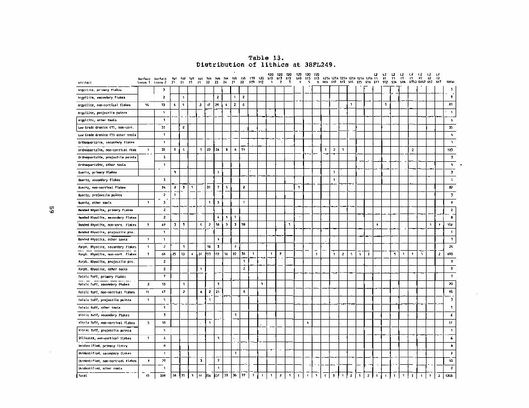
'" '"
Artifact
Acgyllite, pr'"",'y lI .. kes
Argyll;te, secondary flakes
Argyllite, non-cortical fh~es
Mgylta". projectile points
"tgyLllle, other tools
LOll Grade Granite (1), non-tort.
~ Grade Granite (?) other !<XIl.
orthocrJartzite, secondary fl"kes
orthoquartzite, non-cortle"l flak
orthoquartzite, p .... jectile points
Ort~rUlle, oIlier tools
OJartz, priMrr flake.
ouartz, secondary flakes
Quartz, non-oortie .. l flakes
OJ.ru, projectile points
C),Ja.U, other tools
&r<led Rhyolite, prlllllry Hakes
Banded Rhyot he, secondary flahs
BlInded Rllyolite, non-cort. flaku
6i!r<led Rhyolite, p'oJe~tHe ph.
sanded Rhyolite, other too's
Po'ph. Rhyolite, secondary Hakes
Po'ph. Rhyo\he, non_cort. flakes
Porph. Rhyolite, proJe~tHe pts.
Porph. Myo! he, other tools
felsic TLlff, priMry flakes
felsic TLlff, secondary flakes
felsic TLlff, non-cortlCIII flakes
felsic TLlff, projectile poil\u
felsic TLlff, other tools
Viltic TLlff, seCOfidary fla~es
Vltrlo TLlff, lIOn-cortical flakes
Vittic Tuff, projectHe poillts
Silicates, lIOn-corticsl 1lskes
Uoidentified, prill/lry Hakes
lInidentified, .e~ry flakes
Uoident.fled, oon-cortical fla\"s
I,h'>identified, other tools
Total
Sudaoe lOtuS'
"
I
I
,
I
I
I
, \I
I
,
I
I
"
Surh~e WI '"' Locus 2: " " , , I
" I I
I
I
" ,
I
I
" , ,
1
I
I
1
" , ,
, I
, , ,
19 , , I
I
, I
" " " 2
2
, " I
" ,
I
I , \0
I
, , I
" I
,eo " 11
Distribution
IIJ! ru4 1114 TU4 T~ JUS "" " " " " " n " , I ,
, ., " , , 6
I " " , ,
"
I
I " , I ,
I , I
, I I
, , \6 1 1 \0
I
\6 , I
, " " " \6 " "
I
I ,
, 6 , 21 6
I
I
I
I
I
1 , I
, " " " n " "
Table 13. of lithics at 3BFL249.
120 120 120 T20 120 120 " 119 {20 S12 m m so Sf) so TZU TZU 121~ TZU IlIA IlIA T1
'" '" I , , , , 6 511 S1i! 513 S14 SiS 516 511
I
I , I
I
I
I
I I
I I , I I 2 I I ,
I
,
I I I , I I I I I , , , I , I
" " " n n n STi! Sf4 $T6
I
I I
I I I
lZ lZ l2 12 T1 11 12 12 ST10 5112 512 ST7 TOTAL
, , "
I
I
" I
I
, III , I , , " , 9 , ,
I I "" I
, "
I I , 190
, , ,
20
" , I
, I.'
I
6 , , '" ,
, I I 1 120'

Yadkin), and two Check Stamped (6.9% of Yadkin).
Hanover series is characterized by sherd tempering which may make up to 30 or 40% of the paste. Types include cordmarked, fabric impressed, net impressed, and plain, although stamped and brushed pottery are occasionally found (Trinkley 1983:46) .
Hanover pottery consists of ten examples (19.2%). These include one Plain (10% of Hanover), seven Cordmarked (70% of Hanover), and two Fabric Impressed (20%) •
Lithics were the most numerous artifact type (N=1203) recovered at 38FL249. These are summarized in Table 13. Examination of the artifacts indicate that most of the materials are metavolcanics, with some quartz, orthoquartzite, and silicates. Lithic raw materials include argyllite (N=94 or 7.8%), orthoquartzite (N=128 or 10.6%), quartz (N=lOl or 8.4%), flow-banded rhyolite (N=116 or 9.6%), porphyritic rhyolite (N=5l9 or 43.1%), felsic tuff (N=13l or 10.9%), vitric tuff (N=22 or 1.8%), silicates (N=6 or 0.5%), and an unidentified material similar to a low grade granite (N=36 or 3.0%). This material was speckled gray and white with a very poor knapping quality. Most of this material appeared as chunks, although a few were clearly worked. One example (Figure 20) is an abandoned stemmed projectile point. several other artifacts consist of unidentified materials (N=52 or 4.3%). Taylor (1984:74-76) found very similar proportions of
. these lithic raw materials during the Pee Dee Electrical Generating Station survey.
Primary flakes, or flakes with the outer surface completely covered with cortex, were represented by 23 examples (1.9%). Secondary flakes, or flakes that are only partially covered with cortex, were represented by 71 examples (5.9%). Non-cortical flakes, exhibiting no cortex, were represented by 1071 examples (89.0%). Included in the non-cortical flake category are bifacial thinning flakes, pressure flakes, notch flakes, and miscellaneous flakes. Other artifacts include five cores, five bifaces or biface fragments, three uniface~/utilized flakes, three hammerstones, and 14 hafted bifaces or hafted biface fragments.
Examples of Palmer (Coe 1964), Taylor Side Notched, Kirk Corner Notched (Coe 1964), St. Albans (Chapman 1975), Morrow Mountain, Eared Yadkin (Coe 1964), Large Triangular, and Caraway/Roanoke (South 1959) were recovered (Table 14). The most common projectile point type recovered was Morrow Mountain which dates to about 4500 B.C •• One example of st. Albans was found which is a point type common to the Tennessee area (6770 B.C. ± 250), but not to South Carolina (see Chapman 1975).
Site 38FL249 is recommended as eligible for inclusion in the National Register, based on the significance of the prehistoric component. The majority of the site is intact and the site has the potential to answer questions about prehistoric diet and intra-site spatial patterning. In addition, this site can be compared to similar sites located during the survey of the proposed Pee Dee Electric Generating Facility (Taylor 1984). This site can begin to answer questions about the little known Yadkin phase in South Carolina. The historic components at 38FL249 are a non contributing resource of the site since the mid nineteenth century locus contains only a sparse amount of artifacts and no artifacts or intact features were encounter in the shovel tests. The tenant period site does not appear on the 1914 soil survey map or the 1945 topographic map. It probably dates to the last half of the twentieth century.
While an archaeological site is either eligible or not eligible as a whole for inclusion on the National Register of Historic Places (U.S. Department of Interior 1990:5,23), it is clear that Locus 1 of site 38FL249 is the most intact portion of the site. It is this area that should receive the bulk of attention in regard to data recovery or green spacing. And while Locus 2 has been plowed out, this area also deserves further attention. The artifact assemblage there may
60

A B
G
H
K L
R 5
w v
0
N
M
T
x
J
Q
u
y
L..J em
E
Figure 20. Prehistoric artifacts. A, Palmer CSPPi S, base of a Taylor CSPP; C, Kirk CSPP; D, St. Albans CSPP; E - H, Morrow Mountain CSPP; I, Eared Yadkin CSPP; J, Roanoke CSPP; K - L, obverse and reverse of triangular CSPP; M, Thelma CSPPi N, attempted CSPPi 0, used flake; P - Q, bifacesi R, Stallings Plain; S, Thorn's Creek Reed Punctate; T, Badin Check Stamped; V, Badin Fabric Impressed; V, Yadkin Check Stamped; W, Yadkin Cord Marked; X, Hanover Cord Marked; Y, Hanover Fabric Impressed.
61

Table 14. Projectile Points from 38FL249 and 250
(measurements in millimeters)
T:tee Location Material Total Height Blade Height Blade Width Haft Width Thi ckness Palmer surface, locus 2 Quartz 22 15 17 13 5 Taylor surface, locus 2 Orthoquartzite ? ? ? 18 ? Kirk surface, Locus 2 Banded Rhyolite 42 34 28 17 7 St. ALbans surface, Locus 2 Porph. Rhyolite 33 26 19 14 ' 5 Morrow Mt. surface, locus 2 Felsic Tuff ? ? 25 6 Morrow Mt. surface ... locus 2 Vitric Tuff ? ? 28 6 Morrow Mt. surface, locus 2 Quartz ? ? 26 11 Morrow Mt. surface, locus 2 Orthoquartzi te 31 23 25 6 Morrow Mt. surface, locus 2 Orthoquartzi te ? ? 23 7 Morrow Mt. TU2, zone 1 Quartz 29 22 ? 7 Morrow Mt. TU4, zone 2 Felsic Tuff 30 23 22 5 Eared Yadkin surface, locus 2 Argyll ite 41 35 22 19 11 Lg. Triangle rus, zone 2 Porph. Rhyolite ? ? 25 6 Caraway! Roanoke surface, locus 1 FeLsic Tuff ? ? 20 5
reveal that different activities were taking place in this area of the site or that this area was used during the early half of the site occupation; but later abandoned. In other words, it may add information about site function and intrasite spatial patterning change not contributed by examination of Locus 1 alone.
Site 38FL250 consists of an isolated Thelma point made of felsic tuff surface collected from a fallow field approximately 500 feet south of 28FL249. It measures 33 mms in height, the blade height is 27 mms, the blade width is 16 mms, the haft width is 8 mms, and it is 8 mrns thick. In spite of an extensive search for other surface remains and a series of four shovel tests, no other remains were found. This point may be related to the occupation at 38FL249. The central UTM coordinates are E629660 N3787380 and the soils are Orangeburg loamy sand at an elevation of 34 meters above MSL. Soil profiles indicate that the Ap horizon consists of 0.8 foot of grayish brown soil (10YR5/2) overlying pale brown soil (10YR6/3).
38FL250 is recommended as not eligible for inclusion in the National Register. Only one artifact was located and the site has been extensively plowed.
Site 38FL251 consists of a small historic scatter in a fallow field approximately 200 feet north of a transmission line. Two whiteware sherds (MCD=1895) were surface collected in an area of good surface visibility. Four shovel tests failed to yield any artifacts. The central UTM coordinates are E629630 N3787100 and the soils are Lynchburg sandy loam at an elevation of 104 feet above MSL. Shovel tests revealed that the Ap horizon consists of 0.7 foot of dark gray soils (10YR3/1) overlying lighter gray soils (10YR4/2). The site measures 25 by 25 feet.
38FL251 is recommended as not eligible for inclusion in the National Register. The artifacts were sparse and the site has been heavily plowed.
Site 38FL252 consists of an isolated blue edged whiteware sherd (MCD=1853) surface collected from a field road, just south of a small drainage. Four shovel tests revealed no other artifacts. The central UTM coordinates are E630460 E3787380 and the soils are Orangeburg loamy sands at an elevation of 100 feet above MSL. The Ap horizon consists of 0.7 foot of grayish brown soil (10YR5/2) overlying pale brown soil (10YR6/3).
38FL252 is recommended as not eligible for inclusion in the National Register. The site consists of a single sherd in a field road.
Site 38FL253 is a sparse lithic scatter in a fallow field located on the
62

eastern edge of the tract bounded by small drainages to the north and south, and the Pee Dee River swamp to the east. Surface visibility was good and a collection was made. Three shovel tests yielded no further artifacts. Artifacts collected consist of one non-cortical felsic tuff flake, one non-cortical banded rhyolite flake, and one secondary porphyritic rhyolite flake. The central UTM coordinates are E630630 N3787360 and the soils are Orangeburg loamy sand at an elevation of 100 feet above MSL. The Ap horizon consists of 0.7 foot of grayish brown soil (10YR5/2) overlying pale brown soil (10YR6/3). The site is 50 by 50 feet in size.
38FL253 is recommended as not eligible for inclusion in the National Register. The remains are sparse and the site has been heavily plowed.
Site 38FL254 consists of a lithic scatter in a fallow field located in the southeastern corner of the property, just north of the CSX railroad and under a north/south running transmission line. Surface visibility was relatively good and a collection was made. A series of four shovel tests were excavated which yielded no subsurface remains. Artifacts collected consist of one non-cortical argyllite flake, one pr~ary quartz flake, one secondary quartz flake, one non-cortical quartz flake, one non-cortical felsic tuff flake, one non-cortical banded rhyolite flake, five non-cortical porphyritic rhyolite flakes, and one bifacially worked orthoquartzite flake. The central UTM coordinates are E630640 N3786240 and the soils are Varina loamy fine sand at an elevation of 85 feet above MSL. The Ap horizon consists of 0.6 foot of dark gray brown soil (10YR6/2) overlying pale brown soil (10YR7/3). The scatter is approximately 200 by 200 feet in size.
38FL254 is recommended as not eligible for inclusion in the National Register. It has been heavily plowed and there is no evidence of any subsurface artifactual remains.
Site 38FL255 consists of three lithics surface collected from a fallow field. Despite good surface visibility no other artifacts were located. Three shovel tests were excavated yielding no subsurface remains. Artifacts consist of one non-cortical porphyritic rhyolite flake, one secondary porphyritic rhyolite flake, and one piece of fired clay. The central UTM coordinates are E630R450 N3786250 and the soils are Varina loamy fine sand at an elevation of 88 feet above MSL. The Ap horizon consists of 0.7 foot of dark gray brown soil (10YR6/2) overlying pale brown soil (10YR7/3). The scatter measures about 50 by 50 feet in size.
38FL255 is recommended as not eligible for inclusion in the National Register. The remains are very sparse and the site has been heavily plowed.
Site 38FL256 is the remains of an early twentieth century tenant house, which appears on the 1914 soil survey map and the 1945 topographic map. The site is located approximately 400 feet from a north/south running dirt farm road in a fallow field in the southeastern portion of the study area. Artifacts and brick were found scattered over a 200 foot east/west by 300 foot north/south area. Surface visibility was excellent, allowing a sizeable collection to be made. Eighteen shovel tests were excavated with 13 yielding artifacts or brick. Some evidence of burning was noted. A total of 55 artifacts were collected. These artifacts are summarized in Table 15. Ten datable ceramics were recovered including eight undecorated whitewares (MCD=1895), one transfer printed whiteware (MCD=1848), and one decalcomania (MCD=1926). These yielded a mean ceramic date of 1893.4. A sufficient amount of artifacts were collected to perform a pattern analysis. The only three groups represented were Kitchen (N=37 or 67.2%), Architecture (N=14 or 25.5%), and Activities (N=4 or 7.3%). The central UTM coordinates are E629980 N3786400 and the soils are Varina loamy fine sand at an elevation of 92 feet above MSL. The Ap horizon consists of 0.9 foot of dark gray brown soil (10YR6/2) overlying pale brown soil (10YR7/3).
38FL256 is recommended as not eligible for inclusion in the National Register. Although the remains were relatively dense, the site has been badly
63

disturbed by plowing, and appears to have been dispersed by that plowing.
Site 38FL257 is very similar to 38FL256. The artifact assemblage (ie. whiteware and decalcomania) suggests that it is the remains of an early twentieth century tenant house. Again, this structure appears on both the 1914 and 1945 maps. This site is located approximately 500 feet east of 38FL256 and consists of a scatter of artifacts and brick in a 200 by 200 foot area. A surface collection was made and 11 shovel tests were excavated with eight yielding artifacts or brick. Some evidence of burning was noted. A total of 80 artifacts
Table 15. Historic artifacts from 38FL256
T1 T1 T1 T1 T1 T1 T1 T1 T1 T1 T2 T2 Artifact Surface ST2 ST4 STS ST6 ST7 ST8 ST9 ST10 ST11 ST13 ST1 ST3 Whiteware, undecorated 7 1
blue trans. print 1 decaL. 1
Glass, clear 1 5 4 2 solarized 2 aqua 1 cobalt blue 2 brown 1 2
Porcelain ja.l" seal 1 Window glass 3 Wire nails and nail frags. 1 1 3 Pad lock,. modern 1 Copper wi re 1 Blacl< rubber 1 UIO iron 1
21 2 6 6 4 5 1 2 3 2
were collected. They are summarized in Table 16. Fourteen datable ceramics were collected including 13 whitewares (MCD=1895), and one decalcomania (MCD=1926). These yielded a mean ceramic date of 1897.2. Artifacts include kitchen related items (N=68 or 85.0%), architectural items (N=10 or 12.5%), arms group (N=l or 1.25%) and activities group (N=l or 1.25%). The central UTM coordinates are E630400 N3786400 and the soils are Exum sandy loam at an elevation of 88 feet above MSL. The Ap horizon consists of 0.8 foot of gray brown soil (10YR5/2) overlying yellow brown soil (10YR5/6).
38FL257 is recommended as not eligible for inclusion in the National Register. The site has been thoroughly plowed with no evidence for subsurface features or architectural remains. While this site and several other identified tenant sites on the tract are quite similar to 38FL235 and 38FL269 (which have been recommended as potentially eligible), we feel that it is redundant to perform further work on more of these sites. We believe that excavation or greenspacing of 38FL235 and 38FL269 will provide an adequate sample of this site type on the study tract.
Site 38FL260 consists of the remains of a tenant house, similar to 38FL256 and 38FL257, and appears on both the 1914 and 1945 maps. This site is located approximately 200 feet south of the southern-most transmission line which crosses the tract. It is approximately 1200 feet north of 38FL257 and is located in a slight depression surrounded on all sides by small rises. Surface visibility was good and a collection was made. In addition, 13 shovel tests were excavated with nine yielding artifacts or brick. Artifacts are summarized in Table 17. They include kitchen related artifacts (N=51 or 72.9%), architectural remains (N=16 or 22.9%), clothing items (N=l or 1.4%), and activities items (N=2 or 2.8%). Ceramics include primarily whitewares. One piece of vitreous porcelain displayed a maker's mark "EDWIN M. KNOWLES/CHINA COMPANY". This type of porcelain was produced from 1900 to 1948 (Kovels 1986:28). The site yielded a mean ceramic date of 1885 (Table 18). No features were encountered. The central UTM coordinates
64

Table 16. Historic Artifacts from 38FL257
Artifacts Surface STI ST2 ST3 ST5 ST7 ST8 ST9 STI0 Whiteware, undecorated 11 1 1
decal. 1 Glass, clear 8 5 1 7 7 10 8 1
solarized 1 aqua 2 brown 2 2
Wire nails and nail frags. 4 4 1 1 .22 calibre shell 1 UID metal 1
22 3 5 2 8 13 16 9 2
are E630200 N3786800 and the soils are Goldsboro loamy sand at an elevation of 91 feet above MSL. The Ap horizon consists of 0.9 foot of dark gray soil (10YR4/l) overlying pale brown soil (10YR6/3). The site is approximately 300 feet north/south by 200 feet east/west in size.
38FL260 is recommended as not eligible for inclusion in the National Register. The site has been badly disturbed by plowing. While it is similar to other tenant sites recommended as potentially eligible, the excavation or green spacing of those sites is believed to provide an adequate sample of the site type.
Site 38FL261 is a small scatter of historic artifacts located in an old logging road in the south central portion of the tract. It is approximately 1500 north of the CSX railroad and 1000 feet east of the main dirt road leading through the property. Artifacts were surface collected from the road and five shovel tests were excavated in areas adjacent to the road. No artifacts were recovered from these shovel tests. Surface artifacts consist of tWQ vitreous white porcelain, seven undecorated whitewares, and one sherd of clear glass. The site yielded a mean ceramic date of 1892.3.
Table 17. Historic artifacts from 38FL260
Artifacts Surface STI ST3 ST4 ST5 ST7 ST9 STIO ST11 ST12 Whiteware, undecorated 8 1
annular 2 hand painted 2
Porcelain, white vitreous 1 1 NA salt glazed stoneware 1 Glass, clear 7 2 1 2 2 2 1 1
solarized 1 aqua 4 2 It. blue 1 cobalt blue 2 brown 1 1 1 milk 2
Canning lid fragments 1 Tin can fragments 1 Window glass 2 1 1 Wire nails and nail frags 1 1 1 6 2 Structural tile 1 Rubber shoe sole frag. 1 Plastic material 1 UID iron 1
36 1 3 2 4 12 3 1 6 2
65

Table 18. Mean ceramic date for 38FL260
Ceramics Porcelain, white Porcelain, makers mark NA salt glazed stoneware Whiteware, annular
TOTAL
handpainted undecorated
(xi) 1883 1924 1866 1866 1848 1895
(fi) 1 1 1 2 2 9
16
30156 + 16 = 1884.75
xi x fi 1883 1924 1866 3732 3696
17055 30156
central UTM coordinates are E629360 N3786280 and the soils are coxville fine sandy loam at an elevation of 98 feet above MSL. Shovel tests revealed an Ap horizon of 0.6 foot of very dark gray soil (10YR3/l) overlying gray soil (10YR5/1). The site is approximately 50 by 50 feet in size.
38FL261 is recommended as not eligible for inclusion in the National Register. Only 10 historic artifacts were surface collected and no other remains were found.
Site 38FL262 consists of pushed structural debris and a few historic artifacts. The site is located off of an old logging road in an area of the property where there are many push piles of hurricane debris. It is located approximately 500 feet north of the Mary Hyman house (38FL237). A small amount of artifacts were surface collected from the road area and adjacent to the road. Four shovel tests were excavated near the debris and no artifacts were recovered. Artifacts consist of one metal juice jar lid, one undecorated whiteware, and two willow pattern vitreous porcelains. The site yielded a mean ceramic date of 1887. The central UTM coordinates are E629960 N3786l40 and the soils are Coxville fine sandy loam at an elevation of 98 feet above MSL. The Ap horizon consists of 0.7 foot of very dark gray soil (10YR3/1) overlying gray soil (10YR5/1). The site is approximately 50 by 50 feet in size.
38FL262 is recommended as not eligible for inclusion in the National Register. The site appears to be a structure pushed from elsewhere.
Site 38FL263 is a small scatter of twentieth century historic artifacts and brick. The site is located in a freshly plowed field and is approximately 1000 feet north of SC Hwy 24 and 400 feet east of a dirt road which leads to site 38FL236. The site was surface collected and nine shovel tests were excavated with five yielding artifacts and/or brick. Recovered artifacts consist of one coarse unglazed redware, four undecorated whitewares, one vitreous porcelain, one tin can fragment, 14 clear glass, two aqua glass, two brown glass, and one milk glass. The site yielded a mean ceramic date of 1892.6. The central UTM coordinates are E628180 N3786500 and the soils are Coxville fine sandy loam at an elevation of 98 feet above MSL. The Ap horizon consists of 0.9 foot of very dark gray soil (10YR3/1) overlying gray soil (10YR5/l). The site is approximately 100 feet east/west by 200 feet north/south in size.
38FL263 is recormnended as not eligible for inclusion in the National Register. Artifacts were relatively sparse and the site has been thoroughly plowed.
Site 38FL264 is the remains of a twentieth century tenant house. The site is located in the southwestern portion of the property approximately 800 feet north of the CSX railroad and approximately 1200 feet from the western boundary of the tract. Just to the west of the site is a large agricultural ditch. The area had been recently plowed allowing excellent surface visibility and the site was collected. In addition, nine shovel tests were excavated with five yielding
66

artifacts or brick. Artifacts consist of 12 undecorated whitewares (MCD=1895), two clear glass, two solarized glass, four aqua glass, two brown glass, three milk glass, three window glass, and three wire nail fragments. The central UTM coordinates are E627740 N3786020 and the soils are Coxville fine sandy loam at an elevation of 94 feet above MSL. The Ap horizon consists of 0.8 foot of very dark gray soil (10YR3/l) overlying gray soil (10YR5/1). The site is approximately 200 feet east/west by 100 feet north/south.
38FL264 is recommended as not eligible for inclusion in the National Register. The site has been heavily plowed and there is no evidence for subsurface features.
Site 38FL265 is a twentieth century artifact scatter located 200 feet north of 38FL264. Seven shovel tests were excavated with three yielding artifacts. Artifacts include five undecorated whitewares, one stoneware bottle fragment, one burned stoneware sherd, three aqua glass, and two amethyst glass. The site yielded a mean ceramic date of 1889.2. The central UTM coordinates are E627850 N3786l00 and the soils are Coxville fine sandy loam at an elevation of 98 feet above MSL. The Ap horizon consists of 0.8 foot of very dark gray soil (10YR3/1) overlying gray soil (10YR5jl). The site is 50 by 50 feet in size.
38FL265 is recormnended as not eligible for inclusion in the National Register. The site has been plowed and there is no evidence for subsurface features.
Site 38FL266 consists of a scatter of brick approximately 800 feet north of 38FL265. Although surface visibility was excellent, no artifacts were noted with the brick. Five shovel tests yield no artifacts or brick. It is believed that this may be the foundation remains of a tobacco barn. The central UTM coordinates are E627860 N3786300 and the soils are Norfolk loamy sand at an elevation of 98 feet above MSL. The Ap horizon consists of 0.8 foot of gray brown soil (10YR5j2) overlying pale brown soil (10YR6/2). The site is 50 by 50 feet in size.
38FL266 is recommended as not eligible for inclusion in the National Register. The site consists only of brick scatter with no associated artifacts and has been badly disturbed by plowing.
Site 38FL267 is a twentieth century historic scatter located approximately 300 feet north of 38FL266, 200 feet south of SC Hwy 24, and 300 feet east of a large agricultural ditch. Surface visibility was excellent and the site was collected. In addition, five shovel tests were excavated yielding no subsurface remains. Collected artifacts consist of four undecorated whitewares, one stoneware "Ginger Beer" bottle fragment, one light olive bottle glass, and one milk glass. The site yielded a mean ceramic date of 1888. The central UTM coordinates are E627860 N3786420 and the soils are Duplin fine sandy loam at an elevation of 98 feet above MSL. The Ap horizon consists of 0.7 foot of dark gray soil (10YR4/l) overlying pale brown soil (10YR6/3). The site is 50 by 50 feet in size.
38FL267 is recommended as not eligible for inclusion in the National Register. The site is a small, sparse historic scatter containing no subsurface remains.
Site 38FL268 is a twentieth century historic scatter located approximately 800 feet south east of 38FL267 and 200 feet south of SC Hwy 24. Surface visibility was excellent and a collection was made. In addition, five shovel tests were excavated with none yielding artifacts. Collected artifacts consist of 16 undecorated whitewares, three vitreous porcelains, four solarized glass, one light blue glass, and three aqua glass. The site yielded a mean ceramic date of 1893.1. The central UTM coordinates are E628040 N3786280 and the soils are Duplin fine sandy loam at an elevation of 98 feet above MSL. The Ap horizon
67

Ceramic White porcelain Whiteware, undecorated
Table 19. Mean Ceramic Date for 38FL268
(xi) 1883 1895
35969 ~ 19 1893.1
(fi) 3
16 19
f1 x xi 5649
30320 35969
consists of 0.7 foot of dark gray soil (10YR4/1) overlying pale brown soil (10YR6/3). The site is 50 by 50 feet in size.
38FL268 is very similar to 38FL267 containing only a small, sparse scatter of artifacts with no remains recovered below surface. This site is recommended as not eligible for inclusion in the National Register.
Site 38FL269 is a twentieth century historic scatter located approximately 400 feet southeast of 38FL268 and 200 feet south of SC Hwy 24. A structure appears in this vicinity in Qoth the 1914 and 1945 maps. The site exhibited a large amount of artifacts on the surface and a relatively large collection was made. Twelve shovel tests were excavated with eight yielding subsurface remains. This site appeared to be one of the densest tenant sites encountered and it was decided that further testing was warranted.
• POSITIVE
o NEGATIVE
, 38FL269
PLOWED
P~N ~
o 100 200
FEET
Figure 21. Location of shovel tests at 38FL269.
68

One 5 foot unit was placed in the posited center of the site, oriented with magnetic north. Heavy rain had fallen the night before which required that the soil either be pushed through the screen or artifacts had to be sorted out of the soil by hand. The unit was excavated in one zone to a depth of 0.7 foot below ground surface. Soil in zone 1 was blackish in color (10YR2.5/1) and the subsoil was a yellowish brown (10YR5/4). The only features encountered were plowscars. The artifacts were relatively dense. They are summarized in Table 20. Artifact patterns were calculated for surface and subsurface remains separately. The kitchen group is quite high in both instances and is very similar to patterns at tenant sites previously discussed in this section. The mean ceramic date is calculated in Table 22.
other artifacts are also temporally sensitive including twentieth century soda bottles. At 38FL269 one clear textured weave design Orange Crush bottle fragment was recovered. Early Orange Crush bottles are clear and date to about 1920 to 1940 (Jeter 1987:60). In the 1940s they were amber in color and silk screened. A portion of an early aqua straight sided Coca-Cola bottle was also found. These date primarily from 1902 to 1920 (Jeter 1987:42). Another temporally diagnostic artifact was also recovered. This was a white lead glazed tile with (PA)TENTED JUNE 20, 189_ stamped on the unglazed side.
The central UTM coordinates are E628140 N3786180 and the soils are Duplin fine sandy loam at an elevation of 98 feet above MSL. The site is approximately 250 feet east/west by 150 feet north/south.
Table 20. Historic artifacts from 38FL269
Artifacts Whiteware, undecorated
transfer print decalcomania
Yellow ware Porcelain, vitreous white
willow pattern glazed bisque
Stoneware, alkaline glz. Glass, clear
solarized aqua aqua green (Coke) cobalt blue brown bright green dk. olive milk
Tumbler frags, clear solarized
Porcelain jar sealer frags Canning jar lid frags stove parts Window glass Wire nails and nail frags Cut nails and nail frags Tile White plastic 4-hole button Doll parts Bolt TOTAL
Surface 51
1 2 2 9
1 7
20 6
17 2 4 1
5
2 1
2 1
1 1 1
138
TUI 22
1
93 4
24 2 3 3 2 1
1 3 2 2 7
18 1
1 190
69
ST1
1
1
ST2 ST3 1
3
1 1
1
6 1
ST4 ST5 1
2
1
3 1
ST8
1
1
ST10 1
2 1
2
6

38FL269 is recommended as potentially eligible for inclusion in the National Register. Although the site is damaged by plowing, artifacts are dense and it is believed that the site,was occupied from the late nineteenth century through the early half of the twentieth century. It's significance lies in the fact that these tenant sites are very common, and therefore an important part of Florence County history. This site along with 38FL235 are examples of dispersed tenant settlement pattern. The primary difference between these two sites is that 38FL269 was occupied for a longer period of time and may display changes or continuities in dispersed settlement lifestyle. This site can contribute to understanding how life at these dispersed settlements differed from life at clustered settlements such as found at 38FL240.
Site 38FL270 is a twentieth century historic scatter located approximately 300 feet southeast of 38FL269, 200 feet from SC Hwy 24, and 200 feet west of a large agricultural ditch. Surface visibility was excellent and a collection was made. In addition, 11 shovel tests were excavated with seven yielding artifacts. They include kitchen related artifacts (N=33 or 82.5%), architectural items (N=4 or 10%), and activities related items (N=3 or 7.5%). They are summarized in Table 22. Datable ceramics consist of 10 examples. They include seven undecorated whitewares (MCD=1895) , one annular whiteware (MCD=1866), one decalcomania (MCD=1926), and one NA salt glazed stoneware (MCD=1866). These yield a mean ceramic date of 1892.3. ~
Table 21. Artifact Patterns at 38FL269
Surface Grou12 # % Kitchen 131 94.9 Architecture 4 2.9 Furniture 0 0.0 Arms 0 0.0 Clothing 1 0.7 Personal 0 0.0 Tobacco 0 0.0 Activities 2 1.5
138
Table 22. Mean Ceramic Date at 38FL269
Ceramic (xi) (ti) Porcelain, white 1883 9 Whiteware, blue trans print 1848 1
decal 1926 3 undecorated 1895 76
Yellow ware 1890 2 TOTAL 91
172373 ~ 91 = 1894.2
TU1 #
180 29
0 0 0 0 0 0
209
and STs %
86.1 13.9 0.0 0.0 0.0 0.0 0.0 0.0
xi x fi 16947
1848 5778
144020 3780
172373
The central UTM coordinates are E628240 N3786080 and the soils are coxville fine sandy loam at an elevation of 98 feet above MSL. The Ap horizon consisted of 0.8 foot of dark gray soil (10YR3/1) overlying gray soil (10YR5/1). The site is approximately 250 feet north/south by 200 feet east/west in size.
38FL270 is recommended as not eligible for inclusion in the National
70

Register. The site has been heavily plowed and exhibits no subsurface features. While it is similar to other tenant sites which were recommended as potentially eligible, it is believed that excavations here would be redundant. We believe sites 3SFL235 and 3SFL269 will provide an adequate sample of tenant sites for the study tract.
Site 38FL271 is a sparse scatter of lithics and historic artifacts located in the southeastern portion of the tract in tlle eastern half of a fal,low field, just west of a pond. A series of 15 shovel tests yielded no subsurface remains. Collected artifacts include one undecorated whiteware, one handpainted pearlware, one wire nail, one kaolin pipe bowl fragment, one secondary quartz flake, three non-cortical quartz flakes, one secondary felsic tuff flake, one non-cortical banded rhyolite flake, and one non-cortical argyl lite flake. The site yielded a mean ceramic date of 1S50. The central UTM cOordinates are E630040 N37S6060 and the soils are Exum sandy loam at an elevation of 91 feet above MSL. The Ap horizon consists of 0.6 foot of gray brown soil (10YR5/2) overlying yellow brown
Table 23. Historic Artifacts from 3SFL270
Artifacts Whiteware, undecorated
annular decal.
NA Salt Glazed Stoneware Glass, clear
aqua peach blue cobalt blue brown milk
Window Glass Wire nails and nail frags Glass marbles Transformer insulator
Surface STI ST3 ST4 ST6 5 1 1 1 242
1
2
2
2 1
1
1
1 1
IS 6 1 1 2
ST7 1
2
3
STS
1
1
1 1
4
ST9 I
2
1
1
5
soil (10YR5/6). The site is approximately 100 feet east/west by 200 feet north/south in size.
3SFL271 is recommended as not eligible for inclusion in the National Register. No subsurface artifacts were located despite intensive shovel testing.
Site 38FL272 is a mid to late twentieth century trash dump located approximately 200 feet south of the log tobacco barn (3SFL259) at the edge of a drainage. The dump consists of soda bottles, cleaning fluid bottles, brake fluid containers, condiment bottles, liquor bottles, glass jugs, and tinned enamel vessels. A representative sample was collected. The sample includes one blue enameled tin bucket, one white enameled tin coffee pot, one brake fluid(?) can, one clear gallon jug, two sauce bottles, one green crown cap bottle, one brown crown cap bottle, one clear Moore's Beverage crown cap bottle, one clear crown cap bottle with FLORENCE, S.C. embossed on the base, and one brown screw top bottle with SAV-A-DAY embossed on the shoulder. This may some type of household cleaner. The Moore's Beverage bottle is blue and white silk screened. It is labeled "Moore's/Drink/Moore's Better Beverages//Moore's/Drink/Moore's/Beverages/ Made from the finest/Ingredients/Invigorating and Healthful/Minimum Contents 7 FLU. ozs/o/POP-KOLA BOTTLING CO INC/FLORENCE, S.C.". Jeter (19S7:64) states that the Pop-Kola Bottling Company of Florence, S.C. produced this bottle between 1947 and 1949. This dump is possibly associated with sites 3SFL256, 3SFL257, and/or 3SFL260 which are tenant sites located on the opposite side of the drainage. Four
71

shovel tests were excavated yielding no subsurface remains. The central UTM coordinates are E630080 N3786l20 and the soils are Duplin fine sandy loam at an elevation of 88 feet above MSL. The Ap horizon consists of 0.8 foot of dark gray soil (10YR4jl) overlying pale brown soil (10YR6j3). The site is approximately 25 by 25 feet in size.
38FL272 is recommended as not eligible for inclusion in the National Register. It is a late period bottle dump which has been mitigated by the collection of a representative sample of vessels.
Site 38FL273 is a small, sparse historic scatter located approximately 1200 feet from where SC Hwy 24 and the main dirt road intersect, approximately 100 feet west of the dirt road. A small amount of artifacts were collected despite the excellent surface visibility. Shovel testing in that area yielded no subsurface remains. Collected artifacts consist of one clear silk screened bottle fragment, one cobalt blue glass, and one milk glass. The UTM coordinates are E628780 N3786280 and the soils are Duplin fine sandy loam at an elevation of 101 feet above MSL. The Ap horizon consists of 0.6 foot of dark gray soil (10YR4jl) overlying pale brown soil (10YR6j3). The site is approximately 50 by 50 feet in size.
38FL273 is recommended~ as not eligible for inclusion in the National Register .. The site is small, sparse and contained no subsurface remains.
72

IDENTIFIED STANDING STRUCTURES
Site 3SFL237 I the Mary Hyman House, is a large Victorian-style house located just north of the CSX railroad approximately 800 feet from S.C. 24. other features include a shed/garage, a windmill, remnants of a garden as well as lawn area4 The house was provided in the 1940s for Mary Hyman by Rebecca Gibson! who built it around 1909 after her husband ~ s death. The structure was architecturally documented with the South Carolina Statewide Survey Site Form (Control Number R/41/0000/3921.00). Twelve shovel tests were excavated to locate any archaeological remains associated with the house~ Only three were positive. Artifacts consist of one piece of wire, one wire nail, one cut nail fragment, and one sherd of milk glaasa Surface visibility was relatively poor and no surface collection was made~
The central UTM coordinates are E628900 N3786040 and the soils are coxville fine sandy loam at an elevation of 101 feet above MSL. Soil profiles indicate an Ap horizon of 0.7 foot of dark brown soil (10YR3/1) with soils becoming lighter below (lOYR5/1). The whole Hyman house complex measures approximately 400 feet by 400 feet.
The structure has been altered only on the second floor where it was crudely partitioned into apartments~ 38FL237 is recommended as eligible for inclusion in the National Register~ It is representative of vernacular housing during the era of consolidation of a rural agricultural society with industrialization. While the area was becoming more industrialized, it still remained primarily agricultural. Since the mono-crop of cotton prices were
Figure 22. The Mary Hyman houae. 3SFL237.
73

" ...
r-~ !o /-...... .',
-;;;[ .. ~ ~\-:: --,-., --.. _' ".
/I
I I I I
PROPERTY BOUNDARY
", --........
o
RUINS
1\ 1\ 1\ ===::::-:9
38FL259 L ~ 38FL238 BARN
HOUSE
II, . ~_-._ fSJ' ~lIF 2;S9 ~-
. USE :, 0 1'000 2000
d" I 0,-;-'1' [
0" ~ FE~T' G~EIiIAL STORE
Figure 23. Location of standing structures on the Gibson Plantation tract.
.-I I I I I I I I ! \

depressed, an increasing number of farmers had become tenants or were becoming involved in the textile industry. In a rural setting, the Hyman house site is representative of what was becoming more uncommon in the area; a large landowner's residence.
Site 38FL238 is a standing wood framed tobacco barn located on the east bank of a drainage approximately 700 feet north of the CSX railroad. The barn was probably constructed sometime in the last half of the twentieth century since it does not appear on the 1945 Florence East topographic map. The structure was architecturally documented with the South Carolina Statewide Survey Site Form (Control Number R/4l/0000/3922.00). The central UTM coordinates are E630060 N3786200 and the soils are Duplin and Exum sandy loam at an elevation of 84 feet meters above MSL. Eight shovel tests were excavated around the barn, yielding no archaeological remains. No surface collection was made. Soil profiles indicate that the Ap horizon consists of 0.6 foot of gray brown soil (10YR5/2) overlying yellow brown soil (10YR5/6). The site measures 30 feet east/west by 20 feet north/south.
38FL238 is recommended as not eligible for inclusion in the National Register based on its recent age and since the architectural documentation can be considered adequate mitigation for its loss.
Site 38FL239, the Michael Britton house, is the remains of a partially disassembled structure. The only other building found in association was a privy, located approximately 75 feet east of the house. This site is located approximately 200 feet north of the CSX railroad and 100 feet east of the main dirt road that runs roughly north through the tract. The structure was architecturally documented with the South Carolina Statewide Survey Site Form (Control Number R/4l/0000/3923.00). This house was built in 1945 by Ramous Godley, which is inscribed in the eastern-most chimney. The central UTM coordinates are E628730 N3785400 and the soils are-Coxville fine sandy loam at an elevation of 101 feet above MSL.
Eight shovel tests were excavated, with five yielding artifacts. These artifacts include one gild edged porcelain, two clear bottle glass, one solarized glass, six window glass, one wire nail fragment, one 9d wire nail, and one bolt. No surface collection was made. The soil profile indicates that the Ap horizon consists of 0.7 foot of dark brown soil (10YR3/l) overlying lighter soil (10YR5/l). The site measures 200 by 200 feet.
38FL23"9 is recommended as not eligible for inclusion in the National Register. The majority of the house has been dismantled, it is relatively recent, and there is no evidence of associated trash dumps or other features.
Site 38FL242 is the disassembled remains of a mid to late twentieth century house with an associated privy. The architectural remains have been documented using the South Carolina Statewide Survey Site Form (Control Number R/41/0000/3924.00). The site is located on a ridge at the end of the main dirt road leading through the survey tract. Surface visibility was relatively poor except in the area of the dirt road leading to the house. No surface collection was made. Sixteen shovel tests were excavated with eight yielding artifacts. A total of 29 artifacts were collected which include one undecorated whiteware, two olive green glass, five clear glass, one amber glass, one cobalt blue glass, three milk glass, two flat glass, seven wire nails and wire nail fragments, five unidentifiable nail fragments, one unidentified metal object, and one piece of flat metal.
The central UTM coordinates are E629320 N3787380 and the soils are Orangeburg loamy sand at an elevation of 107 feet above MSL. Soil profiles indicate an Ap horizon consisting of 0.8 foot of gray brown soil (10YR5/2) overlying pale brown soil (10YR6/3). The site is 200 by 200 feet in size.
75

38FL242 is recommended as not eligible for inclusion in the National Register~ The ::;:Ftructure is probably not more than 45 years old and has been disassembled~ The archaeological remains are r~latively sparse.
Site 38FL244 is a double pen structure \ .... hich stands immediately behind Mr. Phillip Britton's house, located approximately 500 feet north of S.C. 24. This structure was documented using the South Carolina Statewide Survey Site Form (Control Number Rj41jOOOO/3925.00). A series of four shovel tests revealed no subsurface artifacts and no artifacts were noted on the ground surface although visibility was moderately good. The central UTM coordinates are E62B460 N3786100 and the soils are coxville fine sandy loam at an elevation of 98 feet above MSL. The Ap horizon consists of dark gray soil (lOYR3!1) overlying gray soil (10YR5jl). The structure is 16.2 by 43.3 feet in size.
38FL244 is recommended as not eligible for inclusion in the National Register. According to Mr ~ Phillip Britton, the structure was moved by the previous property owner from the opposite side of S.C. 24 (Phillip Britton, personal communication 1992)~ In addition, the interior has been significantly altered.
Site 3SFL245 is comnl0nly known as the Winona General store. The building is located off the the survey tract, just south of S.C. 24 and "the csx railroad. It has been documented using the South Carolina state~ .... ide Survey Site Form (Control Number R/1l1/0000j3926.00). The central UTM coordinates are E628640 N3785750 and the soils are Exum sandy loam at an elevation of 98 feet above MSL. The structure is 105 by 26~3 feet in size.
38FL245 is recommended as eligible for inclusion in the National Register~ The store, built by the Gibsons sometime before 1909 ( serviced the tenant farmers working on Gibson' is property and probably had a "captive" clientele since it was conveniently located. These stores were an important part of rural life throughout the South.
Figure 25 ~ Winona General Store, 38F'L245 ~
76

site 38FL258 is a standing late twentieth century house. The structure was documented using the South Carolina Statewide Survey Site Form (Control Number R/41/0000/3928.00). It is located just north of the csx railroad and just west of a small pond. The building contains a concrete floor and is sided with asbestos shingles. Presently, it appears to be occasionally used by local hunters. Four shovel tests were used to verify the date of the site. One shovel test recovered modern materials. No surface collection was made at the site. Artifacts include one wire nail fragment, two green glass, and five clear glass. The central UTM coordinates are E630100 N3786010 and the soils are Dup1in/Exum sandy loam at an elevation of 84 feet above MSL. The Ap horizon consists of 0.7 foot of gray brown soil (10YR5/2) overlying yellow brown soil (10YR5/6). The site is approximately 50 by 50 feet in size.
38FL258 is recommended as not eligible for inclusion in the National Register. The structure appears to date to the late twentieth century.
Site 38FL259 is a standing log tobacco barn located approximately 1000 feet north of 38FL258, along the same drainage that expands into a pond further south. The structure was documented using the South Carolina Statewide Survey Form (Control Number R/41/0000/3927.00). It is round-notched (Wigginton 1972:75) chinked with clay and covered over with asphalt roll siding. The structure measures 18.8 by 17 feet in size, excluding external overhangs. The barn appears to be one of the structures represented on the 1945 Florence East topographic map. Only one of four shovel tests yielded artifacts. No surface collection was made. Artifacts include one piece of barbed wire, one wire nail fragment, one clear glass, and 10 pieces of window glass. The central UTM coordinates are E630040 N3786200 and the soils are Dup1in/Exum sandy loam at an elevation of 84 feet above MSL. The Ap horizon consists of 0.6 foot of gray brown soil (10YR5/2) overlying yellow brown soil (10YR5/6). The site is approximately 50 by 50 feet in size. .
38FL259 is recommended as not eligible for inclusion in the National Register, because the structure has been mitigated through documentation.
77

CONCLUSIONS
The primary goals of this study were, first, to identify the archaeological resources of the Gibson Plantation tract and, second, to asses the ability of these sites to contribute significant archaeological, historical, or anthropological data. The second aspect essentially involves the site's eligibility for inclusion in the National Register of Historic Places, although Chicora Foundation only provides an opinion of National Register eligibility. These goals were achieved with 42 sites being identified and seven being recommended as eligible or potentially eligible for inclusion in the National Register of Historic Places.
Secondary goals were, first, to examine the relationship between site location, soil type, and topography. Previous work (Taylor 1984) indicates that prehistoric sites in the Pee Dee River area are located within 1000 feet from the swamp edge and are at least 400 feet across. In general, however, prehistoric sites are located on well drained soils close to a water source. Another secondary goal was to observe changes in historic settlement pattern. South and Hartley (1980) have noted that eighteenth century settlements are located on high ground adjacent to deep water access. While there is a bluff in the northern portion of the tract there is no deep water access. Taylor (1984:196) found that in the nineteenth century the river bluff was abandoned as farmstead, but there was minor occupation by tenant farmers. The settlement pattern became more road oriented, being located next to primary or secondary roads.
Prehistoric Sites
Of the 42 sites identified eight contained prehistoric components (see Table 2). Of those eight sites, one (38FL249) is recommended as eligible for inclusion in the National Register. Three sites are isolated finds and will not be discussed further. Four of the remaining five sites are located no further than 2,000 feet from the Pee Dee Swamp along the bluff edge and are located on well drained soils. The remaining site is located approximately 200 feet from a tributary feeding into Buckley Creek and is moderately well drained. Taylor (1984:195) found at the Pee Dee Electrical Generating Facility that, although prehistoric sites were found in four different settings, the most intensively used areas were the bluff edges and minor tributaries. Sites located at Gibson Plantation correspond to their findings.
Based on findings of the survey at the Pee Dee Electrical Generating Facility (Taylor 1984) it was hypothesized that no sites less than 400 feet across would be found within 1000 feet of the Pee Dee Swamp. While essentially this proved to be true, two lithic scatters (38FL253 and 38FL254) which measured 50 by 50 feet and 200 by 200 feet respectively, were located approximately 1100 feet from the swamp.
There were several ridges adjacent to the swamp that we believed would have been desirable for prehistoric groups on which no sites were found, even when the shovel testing interval was decreased. These areas probably contained no sites because there was no ready access to water. Although the swamp is adjacent to these areas, the Pee Dee River is approximately two miles away and other creeks are over a mile away. Site 38FL249, the only prehistoric site within 1000 feet of the swamp, is flanked by two drainages which may have contained springs where water could have been locally obtained. At the Pee Dee Electrical Generating Facility the river or creeks were located within 500 feet of the sites.
78

Historic Sites
Of the 42 sites identified at Gibson Plantation 38 contained historic components. Of these 38 components six were recommended as eligible or potentially eligible for inclusion in the National Register. Only one site (38FL252) represented an isolated find and will not be further discussed.
No historic sites were located which appear to date to the eighteenth century. This was not surprising since these sites are generally on high ground located next to deep water (South and Hartley 1980) and there is no deep water access to the property.
Site 38FL249, locus 2 contained pearlware, suggesting that it dates to the early 19th century. This site is located on a ridge approximately 2200 feet from the Pee swamp on well drained soil. While no subscribers to Mills Atlas are found on the 1825 map at this location, this may be the residence of an overseer for Gibson's property there.
38FL240 is the only other site which appears to have been occupied in the early to mid-nineteenth century. This site is a double row of structures located on a narrow ridge of well drained soil. The configuration of the settlement, as well as the presence of pearlware and one creamware sherd, indicates that it originated during the slavery period. While the settlement dwindled over time, it was still being occupied in the mid-20th century since portions of it appear on the 1945 Florence East map.
Twenty five sites appear to be postbellum tenant occupations dating into the mid-20th century. Two of these (38FL235 and 38FL269) were recommended as eligible for inclusion in the National Register. Of these 25 sites, two sites are located on excessively drained soil, four are located on well drained soils, 11 are located on moderately well drained soil, one is located on somewhat poorly drained soil, and seven are located on poorly drained soil. All of these sites are adjacent to roads, either present now on the tract or on earlier ~aps. Many of these sites and individual structure are located along S.c. 24 or the northern-most east/west dirt road, however fields were probably convenient to all tenant settlements.
Three owners sites were identified (38FL237, 38FL239, and 38FL242). Two are located on poorly drained soils while the other was located on well drained soils. Apparently, drainage was not as important as accessibility of Hwy 24. The well drained site is located at the northern end of the main dirt road adjacent to the 38FL240, the slave/tenant row and may have functioned as the home of a farm manager rather than a land owner.
Four sites contained a total of five tobacco barns. Four of the barns are located at the edges of fields, next to drainages. One site 38FL266 is located adjacent to tenant houses in the middle of what is now plowed field. This site is only posited to be a tobacco barn based on the absence of domestic artifacts. It may have had another function. All of these barns are located on well drained or moderately well drained soils.
Sites 38FL236 and 38FL258 are clearly late twentieth century structures, although 38FL236 was occupied in 1945. Both are located on moderately well drained soil. 38FL236 contains an access to S. c. 24, however 38FL258 has no ready access to S.c. 24, only to field roads and is adjacent to the CSX railroad.
One site (38FL232) is a twentieth century African-American cemetery. It is located off of the tract on a knoll of well drained soil near the Jamestown community.
The Winona General Store (38FL245) is located off of the tract on moderately well drained soil next to S.c. 24 and the CSX railroad. From that
79

position is was readily available to people passing through as well as the local residents. Additionally, the railroad access allowed the transport of crops to the market.
Although there were no plats located for the eighteenth and nineteenth centuries, this survey has been able to detect settlement pattern change at the Gibson tract. No sites were found for the eighteenth century which corresponds with other studies that eighteenth century sites will generally be found on high land with deep water access. There is no deep water access on this tract. During the early to mid-nineteenth century sites are located on ridges in the northern section of the property which were probably convenient to agricultural fields. After emancipation, settlement becomes more dispersed. While some of these sites were close to main roads, others were set far away from main roads. The former slave settlement remained to be occupied, although the settlement dwindled by the mid-twentieth century. A similar pattern was encountered during the Pee Dee Electrical Generating Station survey (Taylor 1984).
It was noticed while performing pattern analysis on the tenant sites that the artifact patterns, particularly for the Kitchen and Architecture groups, were markedly similar (Table 25).
Since surface collection tends to increase the Kitchen group category, based on calculations at 38FL240 (see Table 25), it may be that almost all of these sites have kitchen group percentages which are inflated slightly, particularly since the majority of artifacts were surface collected. Nonetheless, the results are significantly higher than the Piedmont Tenant/Yeoman Artifact Pattern found by Drucker et al. (1984:5-47), but very similar to the tenant artifact patterns published by Trinkley and Caballero (1983a, 1983b, 1983c) and Trink1ey et al. (1985) (Table 24). The variation between the two published patterns may be due to individual wealth or poverty. In any case, the patterns found at the Gibson Plantation closely correspond with the Tenant Pattern published by Trinkley and Caballero (1983b). The higher percentages of architectural items illustrated by Drucker et al. ' s (1984) Piedmont Ten;mt/Yeoman Pattern and sites such as Finch and Webb Farms (Joseph et al. 1991) indicate that the people probably had a higher standard of living and can be classified as small land owners rather than tenants.
Pattern Kitchen Revised carolina~ 51.8-65.0 Revised Frontier 35.5-43.8 Carol ina Slav~t 70.9-84.2 Georgia Slave 20.0-25.8 Piedmont Tenant! 45.6
Tenantf Yeomane 40.0-61.2
(mean) 72.3
Sources: ~ Garrow 1982b
Garrow 1982b
Table 24. Published artifact patterns.
Architecture Furniture Arms Clothing Personal 25.2-31.4 0.2-0.6 0.1-0.3 0.6-5.4 0.2-0.5 41.6-43.0 0.1-0.3 1.4-8.9 0.3-1.6 0.1 11.8-24.8 0.1 0.1-0.3 0.3-0.8 0.1 67.9-73.2 0.0-0.1 0.0-0.2 0.3-1.7 0.1-0.2
50.0 0.4 1.8 0.4 35.8-56.3
22.1 0.0 0.0 1.5 0.3
~ Wheaton et a l. 1983 SingLeton 1980
e Drucker et aL. 1984:5-47 (no range provided, but has been partiaLly f reconstructed for Kitchen and Architecture Groups)
TrinkLey and CabaLLero 1983b
80
Tobacco Activities 1.9-13.9 0.91.7 1.3-14.0 0.5-5.4 2.4-5.4 0.2-0.9 0.3-9.7 0.2-0.4
1.8
0.0 3.8

Table 25. Kitchen and Architecture Group Percentages for Tenant Sites
on the Gibson Plantation Tract.
# Site No. MCD Artifacts Kitchen % Architecture % Obtained From 38FL235 1887 48 81.2 16.7 S & STs 38FL240 1883 465 88.4 8.6 S, TU & STs
214 97.6 0.0 S 251 80.5 15.9 TU & STs
38FL241 1889 44 81.8 15.9 S & STs 38FL256 1893 55 67.2 25.5 S & STs 38FL257 1897 80 85.5 12.5 S & STs 38FL260 1885 70 72.9 22.9 S & STs 38FL269 1894 209 86.1 13.9 TU & STs 38FL270 1892 40 82.5 10.0 S & STs --------5 = surface, STs shovel tests, TU = test units
Table 26. Kitchen and Architecture Group Percentages for Tenant/Yeoman Sites
in other areas of the Carolinas
# Site No. MCD Artifacts Kitchen % Architecture % Obtained From Source 38HR127 1866 403 78.7 18.1 S & TUs Trinkley and Caballero 1983a 38HR131 1898 169 79.9 3.6 S Trinkley and CabaLlero 1983a 38SU81 1910 349 77.4 10.6 S & TUs TrinkLey et al. 1985 38SP101D nle nle 72.3 22.1 S & TUs Trinkley and cabaLlero 1983b 38SU74 1904 1272 77.7 19.3 S & TUs Trinkley et al. 1985 Nichols unk. unk. 78.14 14.38 unk. Stine 1990 Stine unk. unk. 80.16 12.30 unk. Stine 1990 Finch unk. unk. 58.81 33.09 TUs Joseph et a l. 1991 Webb unk. unk. 57.04 85.83 TUs Joseph et a l. 1991 Lynch unk. unk. 80.60 11.30 TUs Joseph et a l. 1991 ---------n/e = not calculated, unk. = unknown, S = surface, STs = shovel tests, TUs = test units
The fact that most tenant sites fall entirely within the Carolina Slave Pattern (Wheaton et al. 1983) suggests that these tenant farmers, most likely black, were impoverished. Base on the low quantity of architectural remains, their housing was probably insubstantial. With exception of Orser et al. (1987), little extensive archaeological work has been performed at tenant sites, so little is known about the material lifestyle that produced such a pattern. The only extant structure probably related to the early twentieth century tenant occupation at the Gibson Plantation tract is the double penned structure (38FL244) that had been moved to its present spot from the south side of S.c. 24. It is unknown if this type of housing was common for the postbellum period in Florence County.
Recommendations
Eligible Archaeological Sites
The archaeological sites recommended in this study as eligible for inclusion on the National Register of Historical Places may be either green spaced or subjected to data recovery. Green spacing is recognized as an appropriate, and often cost-effective, mitigation measure for archaeological sites conservation. This procedure involves placing the site aside and protecting
81

it from all future ground disturbing activities in perpetuity. This is usually accomplished by placing a protective covenant on the property or by establishing preservation easements, held by some other organization. Nine recommendations are offered (subject to the review and approval of the state Historic Preservation Office) if green spacing is to be considered:
1. The site is to be physically blocked out in the field with a buffer sufficient 0 ensure the protection of the archaeologj"cal remains;
2. The site should be cleared, by hand, of understory vegetation. No heavy equipment should be used and all cut vegetation should be removed from the site area;
3. Any above ground remains should be cleared of vegetation by hand, taking all measures necessary to ensure that the features are not damaged;
4. The area should continue to be clearly defined during all phases of construction. No equipment should be allowed in the site area, or be allowed to the area as a turn-around. The area should not be used to stockpile supplies, or be otherwise disturbed. All personnel, including contractor's and various subcontractor's personnel, should be strictly prohibited from entering the area. This is particularly important to prevent looting of the site;
5. Any landscaping in the site area should be conducted by hand and ground disturbance should be limited to the upper 0.2 foot of soil. No utilities, including sprinkler lines, should be placed through the site;
6. If more intensive landscaping is desired, the site should be protected by placing an isolating layer of clean builder's sand Qver the area. This layer should be at least 0.5 foot thick and it may be appropriate to also use filter cloth between the site and the sand zone. Additional topsoil may then be placed on the sand fill. Landscaping or sprinkler lines should not exceed the depth of the isolating level of top soil and sand;
7. The property owner should develop a protective easement or covenant assuring the protection of the site area set aside in green spacing and this protection should be in perpetuity; ,
8. Appropriate security should be provided to ensure that the site is not vandalized, looted, or otherwise damaged;
9. All above ground remains which contribute to the significance of the site should receive immediate intervention to prevent their continued deterioration. This work should be performed by individuals with experience in this field, using appropriate, nonintrusive and reversible methods.
Alternatively, any of the sites recommended as eligible for inclusion on the National Register of Historic Places can be mitigated through data recovery, or the excavation, analysiS, proper curation of recovered remains, and publication of findings. The level of data recovery can vary from relatively modest excavations and surface collections at sites such as 38FL235 and 38FL269 to fairly intensive and extensive excavations at sites such as 38FL240 and 38FL249. The level of effort at each site would be sufficient to address the research questions previously raised.
One of the archaeological sites identified in this investigation is the
82

Jamestown Cemetery (38FL232). This site is situated immediately adjacent to, but just outside the current tract boundaries a Since it is not within the survey tract, the property owner is not responsible for any additional investigations. The site has been discussed in this study only because of its proximity to the survey tract and its sensitivity. It should be entered into the planning process to ensure that it is not encroached on in the future.
Standing Architectural Sites
There are only two standing architectural sites that are recommended for inclusion on the National Register - the Mary Hyman House (38FL237) and the Winona General Store (38FL245). The Winona General Store, however, is not situated within the survey tract and is included in these discussions only because of its proximity to the proposed project. Like the Jamestown Cemetery, the Winona General Store should be included in the planing process, but is not directly the responsibility of the property owners.
The Mary Hyman House is within the survey tract and is considered a significant vernacular structure, representative of an important period of South Carolina history. Like a below ground archaeological site, this standing structure may either be "green spaced" or subjected to "data recovery."
In this case, "green spacing, tI includes more than not demolishing the structure. Leaving it alone, but failing to intercede in its preservation is the equivalent to "demolition through neglect." Absent intervention, the structure will continue to slid into disrepair and will eventually go into failure. Consequently, "green spacing" a standing structure involves some degree of preservation. Minimally the structure must be made secure and weatherproof. It must receive minimal, but on-going, maintenance. More appropriately, the structure can be adapted to some new function, rehabilitated, and again made functional.
The alternative, or "data recovery," involves a very careful anc;i thorough architectural recordation of the structure, using both drawings and photographs. This process, conducted to the standards of the Historic lImerican Building Survey, result in sufficient documentation to allow the structure to be demolished after the study is completed. The resulting documentation, like an archaeological study, is placed on file and is made available to future researchers, architects, and the general public.
Heritage Interpretation
The archaeological survey of the Gibson Plantation tract has provided a basic planning document for the cultural resources of the property. As such it is suitable for compliance with various state and federal environmental and historic preservation regulations.
Beyond this rather limited function, the Gibson Plantation survey provides a foundation for the development of a conceptual interpretative program. Aimed at explaining the major themes of Florence County and the Pee Dee region, it provides Hoffmann-La Roche with an opportunity to not only educate staff and employees, but also reach out to the community and provide an interpretative experience to school groups. Even at a relatively passive level the Gibson Plantation tract has the potential to excite the public about the history and heritage of the Pee Dee region.
As a company with an exceptional record of community involvement, HoffmannLa Roche will certainly be opening the new plant to school science groups for tours and will be developing materials regarding the importance of the pharmaceutical industry. It is very easy to integrate into this science program curriculum units on the regional and site-specific history. Hoffmann-La Roche could also establish several exhibits or displays that local school groups could
83

visit on the property. Reaching out to the school children of the region would be an excellent opportunity to not only help kids understand the importance of science and history, but to demonstrate the commitment and dedication of Hoffmann-La Roche to the future of country - its children.
The standing Mary Hyman House could be converted into an interpretative center, exploring the contributions that the pharmaceutical industry has made, as well as the history of the Florence area. Alternatively, the structure could be rehabilitated for use as executive housing, still incorporating modest displays, tracing the history of the region and the site.
This offers only a brief view of how the Gibson Plantation can become more than just another industrial development. It can meet all of the planned development goals of Hoffmann-La Roche and still incorporate cultural heritage issues. By embracing this approach, Hoffmann-La Roche, Inc. can maximize its investment in the tract and can maximize ~he facility's return to the citizens of the Pee Dee region.
84

SOURCES CITED
Adams, Natalie 1992
and Michael Trinkley Management Summary of Archaeological Survey at the Gibson Plantation Tract, Florence County I Sout.h Carolina. Chicora Research Contribution 84. Chicora Foundation, Inc. Columbia, S.C.
Agee, J.B., J.A. Kerr, and W.E. McLendon 1916 Soil Survey of Florence County, South Carolina. U.S.D.A.,
Bureau of Soils, Washington, D.C.
Anderson, David G. 1979 Excavations at Four Fall Line Sites: The Southeastern Beltway
Project. Commonwealth Associates, Inc., Jacksonville, Michigan.Submitted to the South Carolina Department of Highways and Public Transportation, Columbia.
Anderson, David G., Charles E. Cantley, and A. Lee Novick 1982 The Matassee Lake Sites: Archaeological Investigations Along
the Lower Santee River in the Coastal Plain of South carolina. Commonwealth Associates, Inc., Jackson, Michigan. Submitted to National Park Service, Archaeological Services Branch, Atlanta.
Bartovics, Albert 1981
Bense, Judith A. , 1986
The Archaeology of Daniels Village: An Settlement Archaeology. PhD. dissertation, Anthropology, Brown University.
Experiment Department
in of
Hester A. Davis, Lorraine Heartfield, and Kathleen Deagan Standards and Guidelines for Quality Control in Archaeological Resource Management in the Southeastern United States. Southeastern Archaeology 5:52-62.
Blanton, Dennis 1983
B., Christopher T. Espenshade, and Paul E. Brockington, Jr. An Archaeological Study of 38SU83: A Yadkin Phase Site in the Upper Coastal Plain of South Carolina. Garrow and Associates, Atlanta.
Brooks, Mark J. and James D. Scurry
1978
Brown, Richard M. 1963
Butler, William B.
An Intensive Archaeological Survey of Amoco Realty Property in Berkeley County, South Carolina with a Test of Two Subsistence-Settlement Hypotheses for the Prehistoric Period. Research Manuscript Series 147. S.C. Institute of Archaeology and Anthropology, University of South Carolina, Columbia.
The South Cambridge.
Carolina Regula'tors. Harvard University Press,
1987 Significance and other Frustrations American Antiquity 52:820-829.
in the CRM Process.
Caldwell, Joseph R. 1958 Trend and Tradi'tion in 'the Prehis'tory of 'the Eas'tern UnLted
85

States. Memoirs of the American Anthropological Association 88.
Carman, Harry J., editor 1939 American Husbandry. Reprinted. Columbia University Press, New
York. Originally published 1775, London.
Chapman, Jefferson 1985 The Rose Island Site and the Bifurcate Point Tradition. Report
of Investigations 14. Department of Anthropology, University of Tennessee, Knoxville.
Coclanis, Peter 1989
Coe, Joffre L. 1964
A. The Shadow of a Dream: Economic Life and Death in the South Carolina Low Country 1670-1920. Oxford University Press, New York.
The Formative Cultures of the carolina Piedmont. Transactions of the American Philosophical Society 54(5).
Cook, Harvey 1926
Toliver
Copenhaver, J.E.
Rambles in the Fee Dee Basin, South Carolina, Company, Columbia, South Carolina.
vol. 1. The State
1930 Culture of Indigo in the Provinces of South carolina and Georgia. Industrial and Engineering Chemistry 22:894-896.
DePratter, Chester 1979 Ceramics. In The Anthropology of St. Catherines Island 2. The
Refuge-Deptford Mortuary Complex, edited by David Hurst Thomas and Clark Spencer Larsen, pp. 109-132. Anthropologi~al Papers of the American Museum of Natural History 56(1).
Drucker, Lesley, 1984
Evans, James 1888
Ferguson, Leland 1971
Florence Chamber n.d.
Ronald Anthony, Susan Jackson, Susan Krantz, and Carl Steen An Archaeological Study of the Little River-Buffalo Creek Special Land Disposal Tract. Carolina Archaeological Services, Ccilumbia, South Carolina. Submitted to U.S. Army Corps of Engineers, Savannah District, Savannah, Georgia.
Why the Proposed New County of Florence Should Be Established. C.H. Prince's, Florence, South Carolina.
South Appalachian Mississippian. Ph.D. dissertation, University of North Carolina, Chapel Hill. University Microfilms, Ann Arbor.
of Commerce Florence, South Carolina. Florence City-County Commission, Florence, South Carolina.
Historical
Garrow, Patrick H. 1982a Archaeological Investigations on the Washington, D.C. Civic
Center Site. Soil Systems, Inc., n.p. Submitted to Historic Preservation Office, Department of Housing and Community Development, Government of the District of Columbia.
1982b Artifact Analysis. Archaeological Investigations on the Washington, D.C. Civic Center Site. Soil Systems, Inc., n.p.
86

Submitted to Historic Preservation Office, Department of Housing and Community Development, Government of the District of columbia.
Glassow, Michael A. 1977 Issues in Evaluating the Significance of Archaeological
Resources. American Antiquity 42:413-420.
Goodyear, Albert 1979
Hanson, Glen T., 1982
Hartley, Michael n.d.
Jeter, Paul 1987
c., John H. House, and Neal W. Ackerly LaurenS-Anderson: An Archaeological Study of the Inter-Riverine Piedmont. Anthropological Studies 4. South Carolina Institute of Archaeology and Anthropology, University of South Carolina, Columbia.
Jr. The Analysis of Late Archaic-Early Woodland Adaptive Change Along the Middle savannah River: A Proposed Study. South Carolina Institute of Archaeology and Anthropology Notebook 14:1-38.
o. The Mars Bluff Navy Yard: An Archaeological Evaluation. Ms. on file, South Carolina Institute of Archaeology and Anthropology, 38FL91 site file.
South Carolina Beverage Bottles, 1880-1980. Published by the author.
Joseph, J.W., Mary Beth Reed, and Charles Cantley 1991 Agrarian Life, Romantic Death: Archaeological and Historical
Testing and Data Recovery for the I-85 Northern Alternative, Spartanburg, South Carolina. New South Associates~Technical Report 39. New South Associates, Stone Mountain, Georgia.
King, G. Wayne 1974
1981
Death Camp at Florence. Civil War Times Illustrated 12(9):35-42.
Rise Up So Early: A History of Florence County, South Carolina. The Reprint Press, Spartanburg, South Carolina.
Kohn, David, editor 1938 Internal Improvement in South Carolina 1817-1828. n.p.,
Washington, D.C.
Kovel, Ralph and 1986
Lipscomb, Terry 1991
Terry Kovel Kovels' New Dictionary of Marks. Crown Publishers, Inc., New York.
Battles, Skirmishes, and Actions of the American Revolution in South Carolina. S. C. Department of Archives and History, columbia.
McDowell, W.L., editor 1955 Journals of the Commissioners of the Indian Trade, September
20, 1710 - August 29,1718. South Carolina Archives Department, Columbia.
1958 Documents Relating to Indian Affairs, May 21, 1750 - August 7, 1754. South Carolina Archives Department, Columbia.
87

Merriwether, Robert L. 1940 The Expansion of South Carolina. Southern Publishers,
Kingsport, Tennessee.
Michie, James 1977
Miller, George L. 1980
1991
The Late Pleistocene Human Occupation of South Carolina. Unpublished Honor's Thesis, Department of Anthropology, University of South Carolina, Columbia.
Classification and Economic Scaling of 19th Century Ceramics. Historical Archaeology 14:1-40.
A Revised Set of CC Values for Classification and Economic Scaling of English Ceramics from 1787 to 1880. Historical Archaeology 25:1-25.
Milling, Chapman J. 1962 Red Carolinians. University of South Carolina Press, Columbia.
Mills, Robert 1972
Mooney, James 1894
NOAA 1977
Noel Hume, Ivor 1970
Oliver, Billy L. 1981
Orser, Charles 1988
Pee Dee Regional 1972
Phelps, David S. 1983
Pitts, J.J. 1974
Statistics of South Carolina. Reprinted. The Reprint Press, Spartanburg, South Carolina. Originally published 1826, Hurlbut and Lloyd, Charleston.
The Siouan Tribes of the East. Bulletin 22. Smithsonian Institution Bureau of American Ethnology. Washington, D.C.
National Oceanic and Atmospheric Administration (NOAA) Environmental Data Service, 1977.
A Guide to Artifacts of Colonial America. Alfred A. Knopf, New York.
The Piedmont Tradition: Refinement of the Savannah River Stemmed Point Type. Unpublished Master's thesis, Department of Anthropology, University of North Carolina, Chapel Hill.
The Material Basis of the Historical Archaeology in University of Georgia Press,
Postbellum the South Athens.
Planning and Development Council
Tenant Plantation: Carolina Piedmont.
Historic Preservation Survey and Plan. Pee Dee Planning and Development Council, Florence.
Regional
Archaeology of the North Carolina Coast and Coastal Plain: Problems and Hypotheses. In The Prehistory of North Carolina: An Archaeological Symposium, edited by Mark A. Mathis and Jeffrey J. Crow, pp. 1-51. North Carolina Division of Archives and History, Raleigh.
Soil Survey of Florence and Sumter Counties, South Carolina. United States Department of Agriculture, Washington, D.C.
88

Price, Cynthia R. 1979
Ramsay, David 1809
Rankin, Hugh F. 1973
19th Century Ceramics in t.he East.ern Ozark Boarder Region. Monograph Series 1. Center for Archaeological Research, Southwest Missouri University, Springfield.
The History of South Carolina. 2 vo1s. Charleston.
Francis Marion: The Swamp Fox. Thomas Y. Crowell, New York.
Rogers, George e., Jr. 1970 The History of Georgetown County, South Carolina. University
of South Carolina Press, Columbia.
Ryan, Thomas M. 1972
Sassaman, Kenneth 1989
Service, E.M. 1966
Sh1omowitz, Ralph 1979
Archaeological Survey of the Columbia Zoological Park, Richland and Lexington Counties, South carolina. Research Manuscript Series 37. South Carolina Institute of Archaeology and Anthropology, University of South Carolina, Columbia.
E., Mark J. Brooks, Glen T. Hanson, and David G. Anderson Technical Synthesis of Prehistoric Archaeological Investigations on t.he Savannah River Site, Aiken and Barnwell Counties, South Carolina. Draft ms. on file, Savannah River Archaeological Research Program, South Carolina Institute of Archaeology and Anthropology, University of South Carolina, Columbia.
The Hunters. Prentice-Hall, Englewood Cliffs.
The Origins of Southern Sharecropping. Agricultural History 53:557-575.
Simpkins, Daniel 1986
L. and Dorothy J. Allard Isolation and Identification of Spanish Moss Fiber from a Sample of stallings and Series Ceramics. American Antiquitey 51:102-117.
Singleton, 1980
Theresa
South, Stanley 1959
1960
1977
South, Stanley 1980
The Archaeology of Afro-American Slavery in Coastal Georgia: A Regional Perception of Slave Household and Community Patterns. Ph.D. dissertation, University of Florida, Gainesville. University Microfilms, Ann Arbor.
A Study of the Prehistory of the Roanoke Rapids Basin. Unpublished Masters Thesis. Department of Sociology and Anthropology, University of North Carolina, Chapel Hill.
An Archaeological Survey of Southeastern North Carolina. Ms.on file, Research Laboratories of Anthropology, University of North Carolina, Chapel Hill.
Method and Theory in Historical ArchaeoLogy. Academic Press, New York.
and Michael Hartley Deep Water and High Ground: Seventeenth Century Low Country Set.t.lement. Research Manuscript Series 166. South Carolina
89

Stine, Linda F. 1990
Stoltman, James B.
Institute of Archaeology and Anthropology, University of South Carolina.
Social Inequality and Turn-of-the-Century Farmsteads: Issues of Class, Stat'l:1s, Ethnicity, and Race. Historical ArchaeoLogy 24(4): 37-49.
1974 Groton Plantation: An Archaeological Study of a South Locality. Monographs of the Peabody Museum 1, University, Cambridge.
Carolina Harvard
Swanton, John R. 1952
Taylor, Richard L.
The Indian Tribes of North America. Bulletin 145. Smithsonian Institution Bureau of American Ethnology. Washington, D.C.
1984 Cultural Resources Survey of the Proposed Pee Dee Electric Generating Facility, Florence County, South Carolina. Commonwealth Associates, Inc., Jackson, Michigan.
Trinkley, Michael 1976
1978
1980
1983
1990
Trinkley, Michael 1983a
1983b
1983c
Evidence of a Water Source for Marett Mound (38CH110), Edisto Island, South Carolina. South Carolina Antiquities 8 (2) : 15-18.
Archaeological Investigations in the Vicinity of the S-84 Bridge Replacement, Bamburg County, South Carolina. South Carolina Department of Highways and Public Transportation, Columbia.
Additional Investigations at Site 38LX5. South Carolina Department of Highways and Public Transportation, Columbia.
Ceramics of the Central South Carolina Coast. South Carolina Antiquities 15:43-54.
An Archaeological Period. Research columbia.
Context for the South Carolina Woodland Series 22. Chicora Foundation, Inc.,
and Olga Caballero Additional Archaeological, Historical, and Evaluation of 38HR127 and 38HR131: Examples of Twentieth Century Subsistence Farming. S.C. Highways and Public Transportation, Columbia,
Architectural Nineteenth and Department of S.C.
An Archaeological and Historical Evaluation of the I-85 Northern Alternative, Spartanburg County, South Carolina~ S.c. Department of Highways and Public Transportation, Columbia, S.C.
u.S. 521 Relocation, Sumter County, South Carolina: An Archaeological Survey of an Inter-Riverine Upper Coastal Plain Locality. S.C. Department of Highways and Public Transportation.
Trinkley, Michael, Jeanne Calhoun, Debi Hacker-Norton 1985 Archaeological and Historical Investigations at 38SU81 ,
38SU82 , 38SU83 , and 38SU862. S.C. Department of Highways and Public Transportation.
90

u.s. Department 1990
of the Interior
Wallace, David D. 1951
Walthall, John A. 1980
Ward, Trawick 1978
1983
Wells, B.W. 1928
How to Apply the National Register Criteria for Evaluation. National Register Bulletin, 15. u.s. Department of the Interior.
South Carolina: A Short History, 1520 - 1948. University of South Carolina Press, columbia.
Prehistoric Indians of the Southeast: Archaeology of Alabama. University of Alabama Press, University.
The Archaeology of Whites Creek, Marlboro County, S.c. Research Laboratories of Anthropology, University of North Carolina, Chapel Hill.
Whites Creek: The Second Time Around. South Carolina Antiquities 15:63-66.
Plant Communities of the Coastal Plain of North Carolina and Their Successional Relations. Ecology 9:230-242.
Wigginton, Eliot (editor) 1968 The Foxfire Book. Anchor Books, Garden City, New York.
Williams, Stephen 1968
B. (editor) The Waring Papers: The Collected Works of Antonio J. Waring, Jr. Papers of the Peabody Museum of Archaeology and Ethnology 58.
Wilson, Homes Hogue 1984 European Trade Goods from the Fredericks Site (310R231). Ms.
on file, Chicora Foundation, Inc., Columbia.
Winberry, John G. 1979 Reputation of Carolina
Magazine 80:242-250.
91
Indigo. South Carolina Historical

Archaeological Investigations
Historical Research
Preservation
Education
Interpretation
Heritage Marketing
Museum Support
Programs
Chicora Foundation, Inc. PO Box 8664 ▪ 861 Arbutus Drive Columbia, SC 29202-8664 Tel: 803-787-6910 Fax: 803-787-6910 www.chicora.org