APPENDIX F POPULATION-BASED PARKS AND OPEN SPACE Population-Based … · Population-Based Park...
26
- 152 - APPENDIX F POPULATION-BASED PARKS AND OPEN SPACE Population-Based Park Inventory The City's General Plan addresses population-based parks, which include community, neighborhood, resource-based and other (such as mini or pocket) parks. These parks and open space are administered and maintained by the Park and Recreation Department unless otherwise noted. The following facilities comprise the City's inventory of these population-based parks: Population-Based Parks/Joint Use Leases Total Acres Useable Acres Bird Rock Elementary (Joint-Use) 1.50 1.50 *Bird Rock Park 0.95 0.76 School Adj.Credit 5.00 5.00 *Cliffridge Park 10.90 10.07 School Adj.Credit 5.00 5.00 Decatur Elementary (Joint-Use) 1.12 1.12 Serves as Neighborhood Park *Ellen Browning Scripps Park 5.60 3.80 Serves as Neighborhood Park *Kellogg Park 9.12 9.12 *La Jolla Athletic Area (Allen Field) 6.41 5.75 *La Jolla Community Park 3.83 3.43 School Adj.Credit 7.00 7.00 La Jolla Elementary (Joint-Use) 2.31 2.31 Serves as Neighborhood Park La Jolla High School (Joint-Use) 0.90 0.50 *Laureate (Mata) Mini-Park 0.81 0.81 *Starkey Mini-Park 1.31 1.00 Torrey Pines Elementary (Joint-Use) 2.50 2.50 Union Place Circle 0.10 0.10 *Via del Norte Mini-Park 0.39 0.25 64.75 60.02 Resource-Based Parks (R) and Public Open Space (O/S) Total Acres *Calumet Park (R) 0.70 Charlotte Park (R) 0.15 Coast Boulevard Park (R) 4.55 *Ellen Browning Scripps (R) 1.80 *Hermosa Terrace Park (R) 0.92 *La Jolla Heights Natural Park (O/S) 42.64 *La Jolla Hermosa Park (R) 0.32 *La Jolla Shores Beach (R) 6.30 *La Jolla Strand Park (R) 0.90 Ludington Heights Park # 1 (O/S) 0.04 Ludington Heights Park # 2 (O/S) 0.05 Marine Street Beach (Jones Beach & Whispering Sands Beach) 1.04 *Mount Soledad Natural Park (O/S) 277.10 *Nicholson’s Point Park (R) 1.04 *Pottery Canyon Park (O/S) 18.28 *San Diego-La Jolla Underwater Park (R) 5,977.00 *Soledad Open Space Park (O/S) 10.05 *Torrey Pines City Park (R) 12.39 *Tourmaline Surfing Park (R) (La Jolla share) 4.41 *Windansea Park (R) 2.93 6,362.61 Not included in the inventory above Administered and maintained by the Transportation Department: Fay Avenue Right-of-way. * - Dedicated by Charter Section 55
Transcript of APPENDIX F POPULATION-BASED PARKS AND OPEN SPACE Population-Based … · Population-Based Park...

- 152 -
APPENDIX F POPULATION-BASED PARKS AND OPEN SPACE
Population-Based Park Inventory The City's General Plan addresses population-based parks, which include community, neighborhood, resource-based and other (such as mini or pocket) parks. These parks and open space are administered and maintained by the Park and Recreation Department unless otherwise noted. The following facilities comprise the City's inventory of these population-based parks: Population-Based Parks/Joint Use Leases Total Acres Useable Acres Bird Rock Elementary (Joint-Use) 1.50 1.50 *Bird Rock Park 0.95 0.76
School Adj.Credit 5.00 5.00 *Cliffridge Park 10.90 10.07
School Adj.Credit 5.00 5.00 Decatur Elementary (Joint-Use) 1.12 1.12
Serves as Neighborhood Park *Ellen Browning Scripps Park 5.60 3.80
Serves as Neighborhood Park *Kellogg Park 9.12 9.12 *La Jolla Athletic Area (Allen Field) 6.41 5.75 *La Jolla Community Park 3.83 3.43
School Adj.Credit 7.00 7.00 La Jolla Elementary (Joint-Use) 2.31 2.31
Serves as Neighborhood Park La Jolla High School (Joint-Use) 0.90 0.50 *Laureate (Mata) Mini-Park 0.81 0.81 *Starkey Mini-Park 1.31 1.00 Torrey Pines Elementary (Joint-Use) 2.50 2.50 Union Place Circle 0.10 0.10 *Via del Norte Mini-Park 0.39 0.25 64.75 60.02 Resource-Based Parks (R) and Public Open Space (O/S) Total Acres *Calumet Park (R) 0.70 Charlotte Park (R) 0.15 Coast Boulevard Park (R) 4.55 *Ellen Browning Scripps (R) 1.80 *Hermosa Terrace Park (R) 0.92 *La Jolla Heights Natural Park (O/S) 42.64 *La Jolla Hermosa Park (R) 0.32 *La Jolla Shores Beach (R) 6.30 *La Jolla Strand Park (R) 0.90 Ludington Heights Park # 1 (O/S) 0.04 Ludington Heights Park # 2 (O/S) 0.05 Marine Street Beach (Jones Beach & Whispering Sands Beach) 1.04 *Mount Soledad Natural Park (O/S) 277.10 *Nicholson’s Point Park (R) 1.04 *Pottery Canyon Park (O/S) 18.28 *San Diego-La Jolla Underwater Park (R) 5,977.00 *Soledad Open Space Park (O/S) 10.05 *Torrey Pines City Park (R) 12.39 *Tourmaline Surfing Park (R) (La Jolla share) 4.41 *Windansea Park (R) 2.93 6,362.61 Not included in the inventory above Administered and maintained by the Transportation Department: Fay Avenue Right-of-way. * - Dedicated by Charter Section 55

- 153 -
APPENDIX G
COASTAL ACCESS SUBAREA MAPS The following section includes a detailed description for each existing or potential shoreline access site within La Jolla (including La Jolla Shores).

- 154 -
SUBAREA A: LA JOLLA FARMS Shoreline Access: a. Torrey Pines City Park. A 12.39 acre portion of the park within the La Jolla Farms area contains
the mouth of Box Canyon. Several trails feed into Box Canyon, a unique, remote beach area, from public and private parcels on La Jolla Farms Road.
b. The northwestern-most lot of the La Jolla Farms subdivision provides the entrance of a beach
access trail which winds through Box Canyon to the only portion of Torrey Pines Beach still within City ownership. The lot has been developed and some on street parking is available.
c. A dedicated vertical easement between Torrey Pines Road and La Jolla Farms Road, which was
required by the Coastal Commission, has been assumed by UCSD due to student traffic issues. The descriptions which follow (sites d through f) pertain to property owned in whole or in part by the University of California. d. Sumner (Black's) Canyon Road. Controlled access road owned and maintained by the University
of California. The road provides the only access to Torrey Pines City Beach for lifeguards and beach maintenance crews. The entryway is located near the intersection of La Jolla Farms Road and Black Gold Road. A small parking lot is located at the shoreline terminus, however, the road and parking lot is not adequate for general public use. Vehicular access is presently restricted. The road, however, is utilized by the public for pedestrian access. This site represents the most heavily used beach accessway in the La Jolla Farms area.
e. Vista point with splinter trail between Black’s Canyon Road (above) and La Jolla Farms Road.
Restore the previously-existing trail that traversed two private parcels along the west side of la Jolla Farms Road, and that provided a shortcut to Black’s Canyon Road.
f. Scripps "La Jolla Farms" Knoll. The "Knoll" is an approximately 15-acre bluff top area
topographically defined by steep canyons to the north and south. The site is part of a larger 25.5-acre parcel owned by the University of California. The entire parcel, which includes the associated northerly canyon, is part of the University's Natural Land and Water Reserve System, and has been designated as a natural Reserve. Archaeological resources are also present on the parcel. An unimproved loop trail along the perimeter of the bluffs is accessible to pedestrians via a street reservation off of La Jolla Farms Road. The trail has been used by the public to enjoy the scenic ocean vistas and pristine nature of the bluff and canyons.
g. Sumner Canyon. Sumner Canyon is an environmentally sensitive habitat area. In recognition of
the area's unique assemblage of coastal plants, the University of California has placed its portion of the canyon in the University Natural Land and Water Reserves System. Private owners of the remainder of the canyon have placed their portion under similar protection.

- 155 -

- 157 -

- 158 -
SUBAREA B: SCRIPPS Shoreline Access: a. Bluff top easement at the end of La Jolla Shores Lane. Required by Coastal Commission as a
condition of development. An offer of dedication has been accepted by The City of San Diego. Provides scenic vista of ocean and shoreline, but not physical access. No off-street parking is available.
The descriptions which follow (sites b through g) pertain to property owned in whole or in part by the University of California. b. Scripps Institution of Oceanography (University of California). The Scripps campus and
research center occupies the entire area between La Jolla Shores Drive and the seaward bluffs. Approximately 2,000 linear feet of beach below the bluffs are owned by the University of California.
c. Concrete ramp just north of Scripps Pier. Provides beach access at the end of Discovery Way. A
scenic bluff top viewing area required by the Coastal Commission is located north of the pier in front of the biology building. The pier is not open to the public.
d. Bluff top area and walkway between pier and Scripps Building. Provides scenic ocean vistas. e. Wood and concrete stairway just north of Scripps Building. Provides pedestrian access down
bluff to sand beach below. f. Concrete stairway to beach just south of Administration Building. g. Bluff top area and pathway south of Administration Building. Provides access to stairway (f)
from Discovery Way. h. El Paseo Grande. A paved walk extends from the bend of El Paseo Grande to the bluff edge. A
concrete stairway provides pedestrian access to the sandy beach below. Off-street parking is available to nearby Scripps.

- 159 -
- 161 -

- 162 -
SUBAREA C: LA JOLLA SHORES Shoreline Access: a. La Jolla Shores Beach and Kellogg Park. The beach and adjacent park comprise 15.42 acres of
land between Calle Opima and Vallecitos Avenue. The area is a major recreational resource and is utilized intensively by visitors throughout the region. The existing parking lot, containing 365 spaces is the largest shoreline parking lot in La Jolla, but is presently inadequate. Local residents are concerned that beach usage has reached a saturation point and that additional support facilities would only worsen the situation. Beach traffic is a major contributor toward congestion in the La Jolla Shores community. A concrete walkway and seawall separates the beach from Kellogg Park. Vertical and lateral accesses are generally unrestricted.
b. Boat Launching Area. A section of La Jolla Shores Beach at the end of Avenida de la Playa is
designated by ordinance as a boat launching area. No other areas in La Jolla have level ocean access. Very limited trailer storage capacity is available. The end of the dedicated street also provides vertical access for beach users.
c. La Jolla Beach and Tennis Club. The Beach and Tennis Club occupies approximately 1,000 feet
of beach front shoreline south of Avenida de la Playa. Continuous lateral access is available on beach areas below the mean high tide line. The beach area above the mean high tide line is under private ownership. Modes-scaled signs to deter trespassing on private property may be posted by the La Jolla Beach and Tennis Club and, if posted, should include information identifying the rights and limitations of public access.
d. Marine Room Walkway. A narrow concrete walkway along the south side of the Marine Room
Restaurant provides vertical access between Spindrift Drive and the beach. The easement has been dedicated.

- 163 -

- 165 -

- 166 -
SUBAREA D: COAST WALK Shoreline Access: a. Princess Street. As a condition of a permit to build a single-family house, the State Coastal
Commission required the owner of the bluff top lot to dedicate a five foot-wide vertical easement along one side of the property from the Princess Street cul-de-sac to the shoreline. This easement has access only for emergency lifeguard rescue.
b. Charlotte Park. Dedicated unimproved vista point. Neither Charlotte Park nor Charlotte Street
are accessible at the present time. Opportunities to link Charlotte Street with Coast Walk have been lost due to bluff erosion. Charlotte Street is a 50-foot-wide dedicated "paper street" running vertically from Torrey Pines Road to the bluff edge. The street has never been improved and is presently fenced and overgrown with vegetation. An old cottage built in the 1920s encroaches several feet into the west side of the street easement and will apparently remain for some time. Retain as open space.
c. Coast Walk. Dedicated and historically-designated right-of-way off Torrey Pines Road. Within
the right-of-way is a continuous bluff top trail and scenic overlook with public parking. Points of access to the trail include Coast Walk Boulevard, Park Row (street end), and Cave Street (near Goldfish Point). Bluffs adjacent to the walk are extremely steep and fragile. No vertical access to the shoreline exists along the trail except at the Goldfish point terminus.
d. Devils Slide. Devils Slide is a steep bluff section along Coastal Walk below the foot of Park
Row. Access has historically been provided to this point utilizing a stairway down the bluff face. The last stairway was burned out in the early 1960s and has never been replaced. High maintenance costs and the need to limit access to the ecological reserve have been cited as reasons not to rebuild the access. The unimproved site is still used by some individuals to climb down the bluff, although it is very hazardous.
e. Goldfish Point. Rocky headland area within the Coast Walk right-of-way. A natural pedestrian
trail provides vertical access to the tip of the point. A nearby historic structure, the Cave Store (on Cave Street) contains the entrance to a tunnel which leads to a sea cave below the bluffs. A fee is charged for the use of the tunnel.

- 167 -

- 169 -

- 170 -
SUBAREA E: COAST BOULEVARD
Shoreline Access: a. La Jolla Cove. Small (.4-acre) pocket beach at the north end of Ellen B. Scripps Park. Concrete
stairways provide access down bluff. Heavily used. The Cove and adjacent bluffs are an important visual and historical resource. Site of the La Jolla Roughwater Swim.
b. Ellen Scripps Park. Dedicated 5.6-acre bluff top park. The park is a major recreational focal
point for visitors to La Jolla. A scenic walkway along the bluff edge provides outstanding coastal views. A ramp down the bluff provides access to Boomer Beach. Heavily utilized. No off-street parking.
c. Shell Beach. Small pocket beach south of Ellen B. Scripps Park. Stairway has been damaged. d. Children's Pool. Small (.7-acre) artificial pocket beach held in place by seawall. Lifeguard facilities. Stairway access down bluff. Heavily utilized. e. South Casa Beach. Small pocket beach accessible by concrete stairway. Part of Coastal
Boulevard Park. f. Coast Boulevard Park. Dedicated 4.55-acre Shoreline Park between the stairway at Ocean Street
and the stairway south of La Jolla Boulevard. Several unimproved trails provide access down gentle bluffs and vegetation dunes. Moderate-to-heavy use. No off-street parking.
g. Vehicular access. Graded area near intersection of South Coast Boulevard and Coast Boulevard
provide beach access for emergency vehicles. h. Concrete stairway next to pump station. Provides pedestrian access to adjacent pocket beach and
north end of Nicholson's Point Park.

- 171 -

- 173 -

- 174 -
SUBAREA F: WINDANSEA Shoreline Access: a. Nicholson Point Park (a.k.a. Whale View Point). 1.04-acre shoreline park, south of Coast Boulevard
and Ravina Street. Natural rock formations and pocket beaches afford recreational use during low tides. Important as lateral accessway between Coast Boulevard Park and Marine Street Beach. Establishes limit to seaward encroachment from adjacent residential development.
b. 100 South Coast Boulevard. A paved dedicated walkway along the north side of the 100 South Coast
condominium development provides access from South Coast Boulevard to Nicholson's Point Park. Required by Coastal Commission. A wood and concrete stairway at the end of the walkway facilitates access down the bluff to the rock area below.
c. Whispering Sands (Jones Beach). Public and private beach (above the mean high tide line) seaward
of the White Sands development. Provides lateral access between Nicholson's Point Park and Marine Street Beach.
d. Vista Del Mar. Dedicated street end. Paved walk on north side of street leads to sandy beach area
(Marine Street Beach). e. Marine Street. Dedicated street end. Concrete stairway at end of street leads to Marine Street Beach.
Heavily used. Good access from La Jolla Boulevard. f. Sea Lane. Dedicated street end. Provides emergency and maintenance access for vehicles. Steps at
end of sidewalk provide pedestrian access to Marine Street Beach. g. Vista de la Playa. Dedicated concrete walk at end of cul-de-sac provides access to beach. Primarily
neighborhood use. The access is presently obscured by a large hedge. h. Fern Glen and Neptune Place. Dedicated easement provides maintenance road and pedestrian access
to beach. The easement entrance forms part of the driveway to the adjacent residence. Gate across easement discourages pedestrian use.
i. Windansea Park. Designated, 2.94-acre shoreline park between Westbourne Street and Bonair Street.
The park includes the historically-designated “Surf Shack” and is known for surfboard riding. The park's unique pattern of rock formations and pocket beaches attracts visitors from throughout the region. An unimproved bluff top trail provides scenic vistas and additional lateral access. A small parking lot, accessible from Neptune Place, is located between Nautilus Street and Bonair Street. Individual vertical accessways are described below.
j. Stairway at foot of Westbourne Street. k. Wooden stairway at the foot of Nautilus Street. Provides access from parking lot to beach. l. Wooden stairway between Playa del Norte and Playa del Sur. Provides access down bluff to City-
owned beach. m. Concrete stairway at foot of Gravilla Street. Provides access down bluff to La Jolla Strand Park. n. La Jolla Strand Park. Dedicated .90-acre shoreline park between Playa del Sur and Palomar Street.
Continuous with Windansea Beach. Provides high-quality beach areas and scenic bluff top walkway. Serves regional recreation needs. No off-street parking.
o. Pathway between Kolmar Street and Rosemont Street provides access down bluff to La Jolla Strand
Park p. Palomar Street and Neptune Place. Path and wooden stairway provide vertical access to shoreline
below.

- 175 -

- 177 -

- 178 -
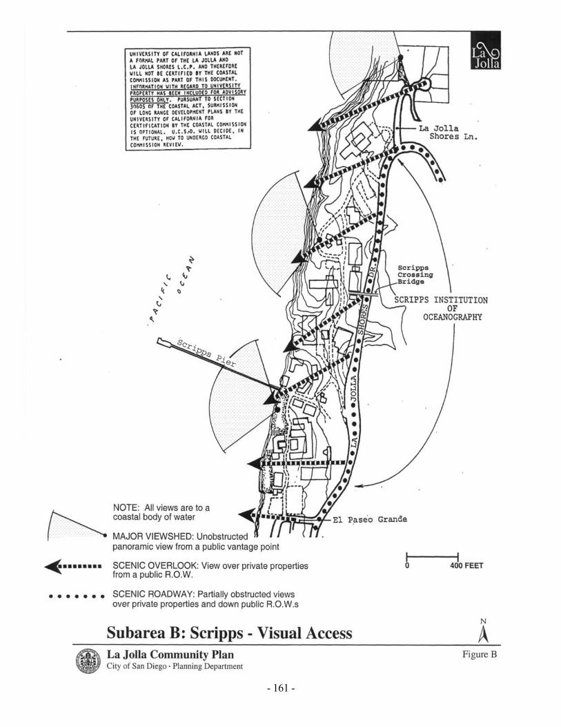
SUBAREA G: LA JOLLA HERMOSA Shoreline Access: a. Hermosa Terrace Park. Designated .92-acre shoreline park (owned in fee) at base of bluffs, south
of Palomar Avenue. Sandy beach. b. Paved dedicated easement off of Camino del la Costa just north of Winamar Avenue. Easement
is between residences. Provides pedestrian access to beach. c. Cortez Place. Unimproved dedicated street off of Camino de la Costa. Provides bluff top
viewing area and neighborhood access to shoreline. Lateral bluff trail below residences to north facilitates access to rock headland.
d. Mira Monte Place. Unimproved dedicated street off of Camino de la Costa. Dirt path provides
neighborhood access to small cove. Pathway extends from La Jolla Boulevard to the ocean. The previously-existing footpath access to the shoreline should be restored.
e. Camino de la Costa. Dedicated street end. Easiest natural access to shoreline in the area. Scenic
vista point. Good access to La Jolla Boulevard. f. Costa Place. Unimproved dedicated street off of Camino de la Costa. The easement contains a
steeply sloping gully which is overgrown with dense vegetation. No access is possible at the present time and the easement has been fenced. The Coastal Commission required dedication of an additional vertical easement on the adjacent parcel to the north, noting past use of portions of that parcel to gain access down the bluff. In the opinion of the City, however, physical access would be hazardous at this location. Retain as open space.
g. La Jolla Hermosa Park. Dedicated .30-acre, unimproved bluff top park at Camino de la Costa
and Chelsea Avenue. Access to cobble beach below is very hazardous due to dense vegetation and steep slopes. No off-street parking, although site has good access to La Jolla Boulevard.
- 179 -

- 181 -

- 182 -
SUBAREA H: BIRD ROCK Shoreline Access: a. Moss Lane. Improved dedicated street off of Dolphin Place. Provides bluff top viewing. Steps
are located in gunnited bluff edge, but access to the beach is not recommended. Well defined bluff trail leads to rock point to the south.
b. Birdrock Avenue. Dedicated street end. Concrete stairway leads down bluff to riprap shoreline.
Excellent tide pools, (used for study by school classes). Additional on-street parking at street end. Good access to La Jolla Boulevard. A safe alternative path through the riprap should be created.
c. Coral Lane. Vista Point. Unimproved dedicated street off of Dolphin Place. Easement is fenced
and blocked by development. Steep cliff at end of easement. d. Chelsea Place. Improved street off of Chelsea Avenue terminates at bluff edge. Concrete
drainage swale at end of street provides steep descent from bluff edge to rocky beach. Mostly neighborhood use. No parking.
e. Forward Street. Dedicated. Bluff top Vista Point at end of street provides visual access. Access
down bluff is steep and hazardous. Coastal Commission required bluff top easement in front of residence to north. Erosion is a problem. Additional on-street parking at street end. Good access to La Jolla Boulevard.
f. Midway Street. Dedicated Bluff top Vista Point at end of street provides visual access. Access
down bluff is steep and hazardous. Erosion is a problem. Additional on-street parking at street end. Good access to La Jolla Boulevard.
g. Calumet Park Dedicated Vista Point .7-acre bluff top park between Midway Avenue and Colima
Court. Required by Coastal Commission as condition of adjacent subdivision. Provides visual access and public walkway along bluff top. No access to shoreline except for hazardous trail at the north end of the park. All parking is on-street.
h. Bandera Street. Unimproved portion of dedicated street off of Calumet Avenue. Fence at
entrance and at bluff edge. Steep cliff at end of easement. No access to beach. i. Linda Way. Dedicated street off of Sea Ridge Drive, that provides bluff top viewing and access
to shoreline. Very popular with surfers. Concrete stairway leads down moderately steep bluff to shoreline. Excellent tide pool areas. Good access to La Jolla Boulevard but no additional parking.
j. Tourmaline Surfing Park. Dedicated 8.82-acre shoreline park below bluffs between San Colla
Street and Tourmaline Street. A parking lot for 103 cars is located at the end of Tourmaline Street, the boundary between La Jolla and Pacific Beach.

- 183 -

- 185 -