Appendix E - Real Estate
23
APPENDIX E REAL ESTATE
Transcript of Appendix E - Real Estate

APPENDIX E
REAL ESTATE

•
•
PURPOSE
APPENDIX E
REAL ESTATE PLAN
This Real Estate Plan (REP) desctibes the necessary acquisition of lands, easements and rights of way (LER) for the Recommended Plan, as presented in this General Reevaluation Report. The term "project lands· or "LER•, when used in this plan, refers to all lands needed for construction, operation and maintenance of the flood damage reduction features, disposal of excess excavated material, access, recreation and mitigation of losses in terrestrial wildlife habitat for the various plans.
OTHER PLANS
As briefed elsewhere in this report, the authorized plan for the Dallas Floodway Extension involves a 22 mile levee and floodway system and 9.1 miles of channel improvements along the Trinity River, 4.1 miles of channel improvements along White Rock Creek, and 5.4 miles of channel improvements to divert Five Mile Creek. This plan was authorized in 1965 as part of the basin-wide plan of improvements for the Trinity River and Tributaries, Texas. During the current plan formulation process the National Economic Development plan (NED plan) has been determined to be a large flood relief swale. The 1,200-foot wide NED swale would be in two segments, divided generally by the IH-45 bridge. The upstream part would be on the west bank,;while the downstream segment would be a clearing on the east side of the river through park lands owned by the City of Dallas. Real Estate costs for the NED plan are estimated at approximately $15.2 million at April 1998 price levels. of which $1 O. 7 are attributed to mitigation.
LANDS, EASEMENTS ANO RIGHTS OF WAY FOR THE RECOMMENDED PLAN
Neighborhood Analysis
The project area is located entirely in the City of Dallas, south of the central business district. Zoning and development in the immediate neighborhood is mixed, consisting of single-family detached dwellings, single-family attached dwellings, medium density multi-family dwellings, office, retail, service retail, commercial, industrial, and flood plain. The residential development consists primarily of new to 40-year old single-family detached dwellings located throughout the general neighborhood. Typically, multi-family dwellings can be found interspersed throughout the neighborhood, primarily along connector streets. Commercial, service retail, and industrial uses are located at major intersections and arterial roadways. All public utilities, City services and emergency medical services are readily available.
Project Lands
The flood control features of the plan consist of two levees and a chain of wetlands, located along the Trinity River, downstream of the existing Dallas Floodway. One levee will be constructe.d on the east bank, generally parallel to Lamar Street. This feature, referred to as the Lamar Street Levee, will conned to the existing Floodway levee on the upstream end and the existing Rochester Park levee at the downstream end. The other levee, known as the Cadillac Heights Levee, will be located on the west bank of the Trinity. It will tie-into high ground just downstream of th~ existing Floodway, parallel the river to a point of intersection with the levee around the City's Central Waste Water Treatment Plant (CWWTP), utilize and raise of portion of the CWWTP Levee near the entrance, then extend to the west of the CWWTP, terminating at a point near Kiest Boulevard. These levees will provide protection against the standard project flood (SPF). The chain of wetlands is in two segments, both located on the west bank. The_ upstream segment is between the two new
Dallas F/oodway Extension General Reevaluation Report - Page E-1
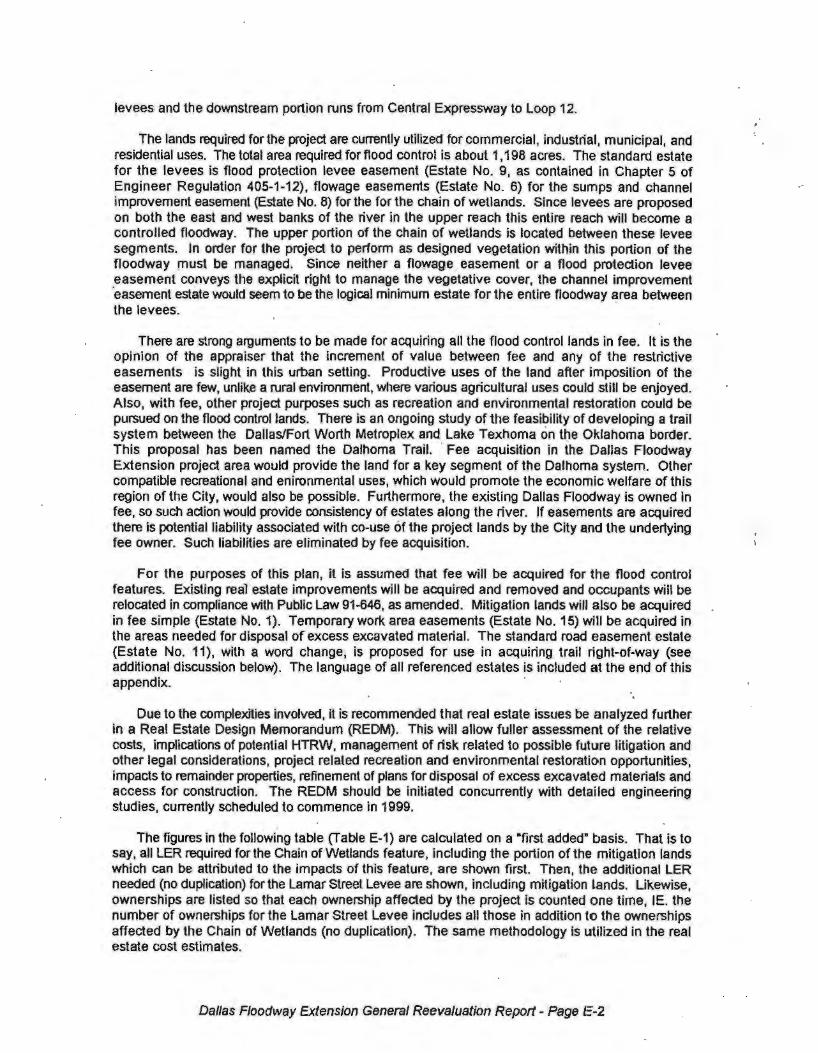
levees and the downstream portion runs from Central Expressway to Loop 12.
The lands required for the project are currently utilized for commercial, industrial, municipal, and residential uses. The total area required for flood control is about 1, 198 acres. The standard estate for the levees is flood protection levee easement (Estate No. 9, as contained in Chapter 5 of Engineer Regulation 405-1-12), flowage easements (Estate No. 6) for the sumps and channel improvement easement (Estate No. 8) for the for the chain of wetlands. Since levees are proposed on both the east and west banks of the river In the upper reach this entire reach will become a controlled floodway. The upper portion of the chain of wetlands is located between these levee segments. In order for the project to perform as designed vegetation within this portion of the floodway must be managed. Since neither a flowage _ easement or a flood protection levee easement conveys the explicit right to manage the vegetative cover, the channel improvement ·easement estate would seem to be the logical minimum estate for the entire floodway area between the levees.
There are strong arguments to be made for acquiring all the flood control lands in fee. It is the opinion of the appraiser that the increment of value between fee and any of the restrictive easements is slight in this urban setting. Productive uses of the land after imposition of the easement are few, unlike a rural environment, where various agricultural uses could still be enjoyed. Also, with fee, other project purposes such as recreation and environmental restoration could be pursued on the flood control lands. There is an ongoing study of the feasibility of developing a trail system between the Dallas/Fort Worth Metroplex and Lake Texhoma on t~e Oklahoma border. This proposal has been named the Dalhoma Trail. · Fee acquisition in the Dallas Floodway Extension project area would provide the land for a key segment of the Dalhoma system. Other compatible recreational and enironmental uses, which would promote the economic welfare of this region of the City, would also be possible. Furthermore, the existing Dallas Floodway ls owned in fee, so such action would provide consistency of estates along the river. If easements are acquired there is potential liability associated with co-use of the project lands by the City and the under1ying fee owner. Such liabilities are eliminated by fee acquisition.
For the purposes of this plan, it is assumed that fee will be acquired for the flood control features. Existing real estate improvements will be acquired and removed and occupants will be relocated in compliance with Public Law 91-646, as amended. Mitigation lands will also be acquired in fee simple (Estate No. 1). Temporary work area easements (Estate No. 15) will be acquired in the areas needed for disposal of excess excavated material. The standard road easement estate (Estate No. 11), with a word change, is proposed for use in acquiring trail right-of-way (see additional discussion below). The language of all referenced estates is included at the end of this appendix. ·
Due to the complexities involved, it is recommended that real estate issues be analyzed further in a Real Estate Design Memorandum (REDM). This will allow fuller assessment of the relative costs, implications of potential HTRW, management of risk related to possible future litigation and other legal considerations, project related recreation and environmental restoration opportunities, impacts to remainder properties, refinement of plans for disposal of excess excavated materials and access for construction. The REDM should be Initiated concurrently with detailed engineering studies, currently scheduled to commence in 1999.
The figures in the following table (Table E-1) are calculated on a •first added• basis. That is to say, all LER required for the Chain of Wetlands feature, including the portion of the mitigation lands which can be attributed to the impacts of this feature, are shown first. Then, the additional LER needed (no duplication) for the Lamar Street Levee are shown, including mitigation lands. Likewise, ownerships are listed so that each ownership affected by the project is counted one time, IE. the number of ownerships for the Lamar Street Levee includes all those in addition to the ownerships affected by the Chain of Wetlands (no duplication). The same methodology is utilized in the real estate cost estimates.
Dallas Floodway Extension General Reevaluation Report - Page E-2

TABLE E-1 LANDS, EASEMENTS AND RIGHTS OF WAY
DALLAS FLOODWAY EXTENSION PROJECT n .11.1 1 11.c TFX6.~
PURPOSE: FLOOD CONTROL
FEATURE: Chain of Wetlands
Estate Acreage Ownerships
Fee 736 10
Temporary Easement (disposal) 435 1
FEATURE: Lamar Street Levee
Estate
Fee 333 20
Flowage Easement (sumps) 33 *
FEATURE: Cadillac Heights Levee
Estate
· Fee 96 9
PURPOSE: WILDLIFE HABITAT MITIGATION
FEATURE: Chain of Wetlands
Estate Acreaae Ownershios
Fee 720 2
FEATURE: Lamar Street Levee
Estate Acreaoe Ownershios
Fee 400 1
FEATURE: Cadillac Heights Levee
Estate Acreaae Ownershios
Fee 59 1
PURPOSE: ACCESS / RECREATION
Estate
Fee 1 .. Trail Easement 11 ..
* Ownerships afrected by fee acquisition include all properties needed for sumps (no additional ownerships are affected by sumps) ·
The majority of the project LER is in private ownership. Approximately 20% is Sponsor-owned. Minor areas, associated with highways, are owned by the State of Texas.
Excavating the chain of wetlands feature will generate a large amount of spoil, even after utilization in the levees. Excess excavated material is proposed to be hauled to a disposal site located south of the project area. This site was identified by the City of Dallas as a disposal area for dredged material from White Rock Lake and there is believed to be sufficient capacity to accommodate both projects. The property is located south of Interstate Highway 20, east of
Dallas F/oodway Extension General Reevaluation Report - Page E-3

Interstate Highway 45 and west of the Trinity River. Total area in. the site is 1,013 acres. Approximately 435 acres of the site would be utilized for this project. A temporary work area easement over this land will be required. Mitigation of losses to wildlife habitat will require the acquisition of approximately 1,179 acres in fee, of which 71 acres is mitigation of the Interstate · Highway 45 river realignment plan. Location of the proposed mitigation lands are _shown in Appendix F. · · ·
Some minor real estate acquisitions will be necessary to provide adequate access to project lands. This will consist of smail (15-20 car capacity) parking areas and trail rights-of-way. Most of the proposed recreation trail system will be located on lands needed for flood control or mitigation. Five of the seven proposed acce.ss areas fall outside of this area; however, these amount to a total of only one acre of additional land. About eleven acres of trail easement, outside of the other project lands, will be needed to provide adequate access. Standard Estate No. 11 (Road Easement) is proposed for use in acquiring trail right-of-way. A word change in the estate will be made by replacing the word •road" with the word "trail". This estate is included at the end of this appendix.
Sponsor-Owned LER
The City of Dallas ~rrently owns interests in approximately 20 percent of the project LER. The upper chain of wetlands will partially be located on Central Waste Water Treatment Plant (CWWf P) property and a portion of the Lamar Street Levee and floodway will be on City park lands. In addition, the west end of the Cadillac Heights SPF levee will terminate on a City-owned lot adjacent to Kiest Boulevard. All these lands are owned by the sponsor in fee. Therefore, the estate is sufficient and the lands are considered to be available for project purposes.' We will also be connecting the Cadillac Heights Levee to the existing levee around the cwwrP and the Lamar Street Levee to the existing Rochester Park Levee. These existing levees, constructed by the City of Dallas, are creditable toward this project as provided in Section 351 of the Water Resources Development Act of 1996. The right of way associated with these existing features is excluded from discussion under this real estate plan.
Other Federal Projects
As the name implies, the Dallas Floodway Extension, will add onto an existing floodway, the Dallas Flooqway, which is a Federally cost-shared project. The City of Dallas is the local sponsor. Construction was completed in 1960. The extension project is located immediately downstream of the existing floodway. Project lands do not overlap. ·
There are no significant Federal land holdings within the project LER. The only known interest of the United States is an easement for a multi-purpose channel within u,,e right of way of 1-45 on the west side of the Trinity River. This easement covers 4.64 acres and was granted by the State of Texas on August 14, 1973, as part of Contract No. DACW63-70-C-O020 for the Trinity River Project. The Trinity River Project was an authorized Federal navigation project at the time that the 1-45 bridge was constructed. Therefore, the referenced contract was Hntered into to pay· for the increment of cost necessary to build the bridge to accommodate orperation of the navigation channel. The easement partially overfaps the LER for the upper segmenlt of the Chain of Wetlands. The estate appears to be sufficient for project purposes, as it grants th•e following rights:
a perpetual and assignable (assignable only to another or other Government agency or agencies) right and easement in, on, over, and across the land hereinafter described to const.ruct, operate, repair, maintain, patrol and replace a drainage ditch, floodway, multiple purpose channel, ch,9nnel improvement works and waterway for commercial navigation, as authorized by the Act of Congress: approved October 27, 1965, Public Law 89-298, 89th Congress, 1st Session, and to excavate, dredge, cut away and remove any or all of said land, to place levees thereon, and to deposit dredge or spoil' material and for such other purposes as may be required in connection with suet) ditch, channel, channel improvement works, multiple purpose·floodway and waterway, including the right to clear, cut, fell, removo and dispose of any and all timber, trees, underbrush, buildings, improvements, or other obstructions from .said right-of-way, reserving,
Dallas Floodway Extension General Reeva/ua(ion Report - t°age E-4

• however, to the State of Texas and ns assigns, the right, power, end privilege of constructing, operating, maintaining and replacing a highway bridge, or other structures and appurtenances related to highway use. and further reserving ell other rights and privileges as may be used or exercised without interfering with or abridging the rights and easements hereby granted
The channel for the Trinity Project was never constructed, however the easement appears·to still be in force and under the jurisdiction of the Department of the Army. The easement could be assigned to the City of Dallas for the purposes of this project.
Navigation Servitude
The Trinity River is a navigable water and some of the land within the floodway, between the two levee segments, is probably within the navigation servitude. We estimate this to be less than ten percent of the approximately 297 acres of floodway. No interest in real estate will have to be acquired over these areas, likewise, no value has been attributed to these lands in the appraisal process. At this point it does not appear that there will be removals of utilities or facilities within the navigation servitude, but any that might arise can be accomplished at no cost to the Government through exercise of the servitude. This issue will be carefully considered in the final Attorney's Opinion of Compensability. ·
Downstream Impacts
There are no LER requirements downstream of the primary project features. The downstream impacts on water surface elevations are insignificant qn this major river system. The with-project 100-year water surface will rise approximately 0.2 feet, immediately downstream of Loop 12 and the SPF will increase approximately 0.3 feet.
BASELINE COST ESTIMATE FOR REAL ESTATE
Property values included in the cost estimate are based on a Gross Appraisal dated April 14, 1997, prepared by a Fort Worth District Staff Appraiser. The appraisal was reviewed and approved by a Reviewing Appraiser in Corps of Engineers Headquarters, Washington, DC on May 30, 1997. The appraisal was supplemented to provide a value estimate for mitigation lands and the supplement was approved after a verbal delegation of authority from HOUSACE. Data from this supplement has been included in the following cost estimates. All land values were predicated on the assumption that the lands are free of hazardous, toxic or radiological wastes, in accordance with Real Estate Policy Guidance Letter No. 1 - Appraisal of Lands Containing Hazardous and Toxic Wastes. Contingencies have been added to the cost estimate as follows:
01.23.03.01 . Real Estate Planning Documents, 20% based on extent and complexity of relocation assistance planning
01.23.03.02. Real Estate Acquisition Documents, 20% based on potential for additional ownerships
01.23.03.03. Real Estate Condemnation Documents, 25% based on the variability of labor and administrative requirements for condemnations and unknown number of cases
01.23.03.05. R~al Estate Appraisal Documents, 10% based on reasonable certainty of contract costs
01.23.03.06. Real Estate PL 91-646 Asst. Documents, 25% based on general variability of relocation assistance cases ~nd possibility of increased number of cases
01.23.03.15. Real Estate Payment Documents, 25% based on contingency assigned by the Appraiser in the Gross Appraisal and the know variation in business relocation assistance benefits
Dallas Floodway Extension General Reevaluation Report - Page E-5

01.23.03.17. Real Estate LERRD Crediting Documents, 10% based on reasonable certainty regarding crediting requirements
Costs are presented in the following four tables: E-2, Chain of Wetlands; E-3, Lamar Street Levee; E-4, Cadillac Heights Levee; and E-5, Total Project. All estimates include costs for lands for wildlife habitat mitigation, and were estimated at April 1998 price levels. The amounts attributed to mitigation are shown separately in parenthesis. Estimates are presented in the standard Code of Accounts f~om the MCACES Models Database, October 1994.
Dallas Floodway Extension General Reevaluation Report - Page, E-6
: • . .
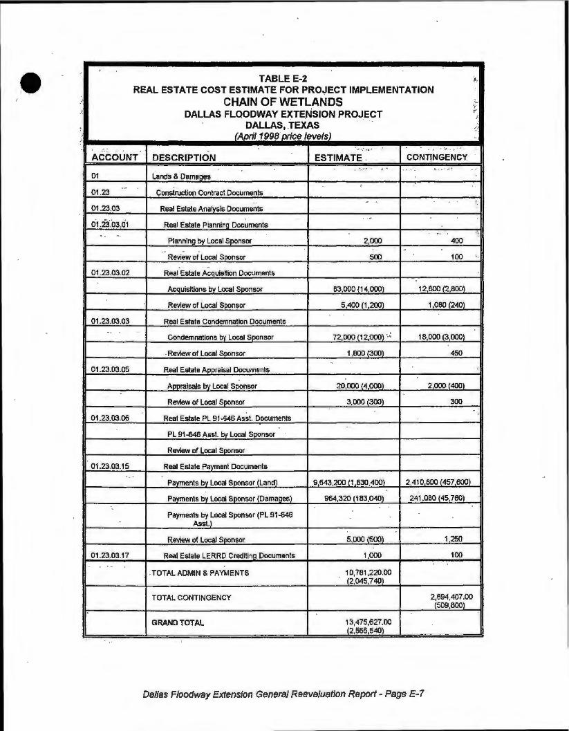
·• TABLE E-2 ~, REAL ESTATE COST ESTIMATE FOR PRO~ECT IMPLEMENTATION
,· CHAIN OF WETLANDS ~~-
DALL.AS FLOODWAY EXTE_NSION PROJECT ..
DALLAS, .TEXAS ..
.. , .. ,' (April 1998 price levels)
~.~:, •·• I • . ' ,_
.- , , - .
ACCOUNT DESCRIPTION ESTIMATE . . - CONJ1NGENCY ... ;. ,·:" ' ' .l , , - .. .. _ ..
01 Land!.! a Diamaaes .. ' , -·
01.23 Construction Contract Documents .. - .
" 01 .23.03 Real Estate Analysis Documents ..
' . 0·1.23.'03.01 .Real Estate Planning Documents ... ; ~ . . " ·
Plannlng by Local SPonsor 2,000 400 .. ...
Review of Local Spensor 500 100 ·-. "
01.23.03.02 Real Estate Acquisition Documents
Acquisitions bv Local Sponsor 63 000 {14 000) 12 600 (2 800)
Review of Local Sponsor 5,400 .(1,200) 1,080 (240)
01.23.03.03 Real Estate Condemnation Documents ..
72,000 (12,000) ,_: 18,000 (3,000) Condemnations b\' Local Sponsor
. Review of Local Soonsor 1 800 (300) 450
01 .23.03.05 Real Estate Appraisal Documents ' Aooraisals bv Local Sponsor 20,000 (4 000) 2,000 (400)
Review of Local Spensor 3,000 (300) 300 -
01.23.03.06 Real Estate PL 91-646 Asst. Documents :
PL 91-646 Asst. by Local Sponsor
Review of Local Sponsor
01.23.03.15 Real Estate Pavment Documents • . .
Payments by Local Soonsor (Land) 9 643 200 (1 830 400) 2,410 800 (457 600)
Payments by Local Sponsor IDamaaesl 964 320 0 83,040) 241 080 (45,760)
Payments by Local Sponsor (PL 91-646 Asst.)
Review of Local Soonsor 5,000(500} 1 250
01.23.03.17 Rea! Estate LERRD Creditin!l Documents 1,000 100 , _
. TOTAL ADMIN & PAYMENTS 10,781,220.00 (2,045,740}
·-TOTAL CONTINGENCY 2,694,407.00
(509,800)
GRAND TOTAL 13,475,627.00 (2,555 540)
Dallas Floodway Extension General Reevaluation Report - Page E-7

•'
TABLE E-3 '.~ REAL ESTATE COST ESTIMATE FOR PROJECT IMPLEMENTATION '
LAMAR STREET LEVEE ~ ·,!
DALLAS FLOODWAY EXTENSION PROJECT f
DALLAStTEXAS 1
' . , . (Aoril 1998 oricesJ . .. "· •" .. .-
:,·: .... 17 :-:
. CONTINGENCY .ACCOUNT DESCRIPTION ESTIMATE; .. . ,,
"' ·:"°1 • ' 01 lands & Damages ~ - . - . .
••,-
01-.23 Construction Contract Documents -· - .. ..
,, 01 .23.03 .. Real Estate Analysis Documents .- ~. , ..... .. ..~ . ·--: , • ; · • I
01 .23.03.01 Real Estate Planning Documents , .. .,.. ' . ~
; .. Planning by l<>eal Sponsor 2,000 .. ' ' . ' 400 .• ,· - . · .. - .
Review of local Soonsor -soo 100 ~ ~ -
01.23.03.02 Real Estate Acquisition Documents "
AcQuislllons by local Sponsor 147 000 (7 000} 29 400 (1 400) .
" Review of Local Soonsor 12,600 (600) 2,520
01.23.03.03 Real Estate Condemnation Documents
Condemnations by Local Sponsor 108,000 27,000
Review of Local Sponsor 2600 650
01 .23.03.05 Real Estate Appraisal Documents
Appraisals by Local Sponsor 46 000 {2 000) 4 600(200)
'. ~view of local Soonsor 6,800 (300) '680 . .
-01 .23,03.05 Real Estate PL 91-646 Asst. Documents
PL 91-646 Asst. by Local Sponsor 5,000 , . 1,250
Review of Local Sponsor 500 125 .. . . . ,!
01.23.03.15 Real Estate Payment Documents
Pavments bv Local Soonsor (Land) 3 165,230 (1 019 200) 791 307 (254 800)
Payments by Local Sponsor (Damaaesl 316,523 (101,920) 79,130 (25 480)
Payments by Local Sponsor (PL 91-646 800,000 200,000 Asst.)
Review of Local Soonsor '4:ooo (200) 1,000
. 01.23.03.17 Real Estate LERRD Crediting Documents ' - 2,000 200 .•
.. TOTAL ADMIN & PAYMENTS 4,618,753.00
(-1 ,131,220)
TOTAL CONTINGENCY 1,138,362.00 (281,880)
GRAND TOTAL 5,757,115.00 (1 ,413,100)
Dallas F/oodway Extension General Reevaluation Report - Page -E-8

• . TABLE E--4
REAL ESTATE COST ESTIMATE FOR PROJECT IMPLEMENTATION CADILLAC HEIGHTS LEVEE
DALLAS FLOODWAY EXTENSION PROJECT DALLAS,TEXAS (Aoril 1998 oricesJ
ACCOUNT DESCRIPTION ESTIMATE CONTINGENCY
01 Lands & Dam8Qes
01 .23 Constru.clion Contract Documents
01 .23.03 Real Estate Analysis Documents
01.23.03.01 Real Estate Planning Documents
Planning by Local Sponsor . 4,000 BOO
Review or Local Sponsor 1,000 200
01 .23.03.02 Real Estate ACQuisition Documents
ACQUisltlons by Local Sponsor 70,000 (I 000) 14 000 (1,400)
Review of Local Sponsor 6,000 (600) 1,200
01 .23.03.03 Rea! Estate Condemnation Documents :
Condemnations by Local Soonsor 24000 6,000
• Review of Local Sponsor 600 150
01 .23.03.05 Real Estate Appraisal Documents
Aom11lsals bv Local SPOnSOf 22 000 (2 000) 2200(200}
Review or Local Sponsor 3,200 (300) 320
01 .23.03.06 Real Estate PL 91-646 Asst. Documents
PL 91-646 Asst. by Local Sponsor 10,000 2,500
Review or Local Sponsor 1 000 250
01.23.03.15 Real Estate Payment Documents
Payments by Local Sponsor (Land} 2,059,870 (150 800) 514 968 (37 700)
Pavments by Local Sponsor (Damages) 205,987 (15,080) 51,497 (3,nO)
Payments by Local Sponsor (PL 91-646 2,415,830 603,957 Asst.)
Review of Local Sponsor 3 000 (300) 750
01.23.03.17 Real Estate LERRD Crediting Documents 1,000 100
TOTALADMIN & PAYMENTS 4,827,487.00 {176,080)
TOTAL CONTINGENCY 1 , 198,892.00 (43,070)
GRAND TOTAL 6,026,379.00 (219,150)
Dallas Floodway Extension General Reevaluation Report - Page E-9

TABLE E-5 REAL ESTATE COST ESTIMATE FOR PROJECT IMPLEMENTATION
TOTAL PROJECT DALLAS FLOODWAY EXTENSION PROJECT
DALLAS,TEXAS (April 1998 oricesJ
ACCOUNT DESCRIPTION ESTIMATE CONTINGENCY
01 Lands & Damages
01.23 Construction Contract Documents
01.23.03 Real Estate Analvsis Documents
01 .23.03.01 Real Estate Planning Documents
Planning by Local Sponsor 8000 1,600
Review of Local Sponsor 2000 400
01 .23.03.02 Real Estate AcQuisilion Documents
Acaulsllions bv Local Soonsor 280 000 (28 000) 56 000 (5 600)
Review of Local Sponsor 24 000 (2 400) 4,800 (480)
01.23.03.03 Real Estate Condemnation Documents
Condemnations by Local Sponsor 204 000 (12 000) 51,000 (3,000)
Review of Loca.1 Sponsor 5 0001300) 1 250
01 .23.03.05 Real Estate Appraisal Documents
Aooralsals by Local Sponsor 88 000 (8 000) 8 800 (800)
ReView of Local Sponsor 13,000 (900) 1,300
01.23.03.06 Real Estate PL 91-646 Asst. Documents
PL 91-646 Asst. by Local Sponsor 15,000 3,750
Review of Local Sponsor 1 500 375
01 .23.03.15 Real Estate Payment Documents
Pavments by Local Sponsor (Land} 14 866 300 (3 000 400) 3 717 075 {750 100)
Pavments bv Local Sponsor (Damages) 1 486,830 (300 040) 371 707 (75010)
Payments by Local Sponsor (Pl 91-646 3,215,830 803,957 Asst}
Review of Local Soonsor 12. 000 ( 1 000) 3000
01.23.03.17 Real Estate LERRD Crediting Documents 4,000 400
TOTAL ADMIN & PAYMENTS 20,227,460.00 (3,353,040)
TOTAL CONTINGENCY 5,025,414.00 (834,990)
GRAND TOTAL 25,252,874.00 (4,188,030)
Dallas Floodway Extension General Reevaluation Report - Page E-1 O

·•
•
RELOCATIONS OF PERSONS AND BUSINESSES
The Recommended Plan will displace sever~I commercial establishments, and one residence. The occupants of the residence can be relocated within the immediate vicinity as the supply -0f comparable replacement housing is adequate. The business relocations are more _complex and specialized. Additional analysis in the Real Estate Design Memorandum is needed to accurately develop relocation plans and costs. This plan would impact four commercial buildings used for service/industrial purposes, two large warehouses, and an active meat packing plant. A vacant building (formerty used for meat packing) which is within the LER, has recently been approved for use as a waste-products transfer station. Finally, the entire Sleepy Hollow Golf Course will be displaced. Based on the information available, we estimate relocation payments at well over $3 million. More study is needed to increase the level of confidence in this estimate.
MINERALS AND TIMBER
There is no significant mineral exploration or production activity in the project area and none is anticipated. City ordinances preclude such development. Sand and gravel is present in the area and is commonly extracted by open pit mining for construction uses. Again, current City ordinances and permitting in concert with the restrictive language of the standard easement estates should protect the interests of the Government and the Sponsor. Although the Trinity floodplain is heavily wooded, there is no economically merchantable timber .
. SPONSOR'S CAPABILITY TO ACQUIRE LER
The City of Dallas has extensive experience and full legal and professional capability to acquire the necessary LER in compliance wilh the standard Project Cooperation Agreement. -A
· checklist has been prepared in accordance with Corps of Engineers Real Estate Policy Letter No . 12 and is included at the end of this real estate plan. The City has been advised of the requirements of Public Law 91-646, as amended, and the requirements for documenting expenses for credit pufl)Oses: We do not anticipate that the Sponsor will request the Government's assistance to acquire LER.
ZONING
There are no special zoning ordinances proposed to be enacted in connection with this project.
MILESTONES FOR REAL ESTATE ACQUISITION.
It is estimated that this acquisition will require approximately 23 months to complete. The project schedule includes this time frame. The following are the major milestones in the acquisition process:
Dallas Floodway Extension General Reevaluation Report- Page E-11

TABLE E-6 REAL ESTATE MILESTONE Sq-tEDULE
DALLAS FLOODWAY EXTENSION PROJECT 0ALLAS,TEXAS
ACTIVITY COE COE LS LS INITIATE COMPLETE INITIATE COMPLETE
Final ROW drawings 15May2000 - -Execution of PCA - 1 J_un 2000 - 1 Jun 2000
"Transmittal of ROW drawings to LS with instruction to acquire LERRD -- 1 Jun 2000 - -Conduct landowner meeting - - - 6Jul 2000
Prepare mapping and legal descriptions - - 13Jun·2000 7 Sep2000
Review mapping and legal descriptions 10Aug 2000 2Oct 2000 - -Obtain title evidence - - 24Aug2000 28 Nov2000
Review title evidence 3 Oct 2000 18 Dec 2000 - -
Obtain tract appraisals - - 16 Oct 2000 22f"eb2001
Review tract appraisals 4Dec2000 15 Mar 2001 - -
Conduct negotiations - - 8 Jan 2001 8 Jun 2001
Perform closings - - 20 Mar 2001
Prepare condemnations - - 20 Mar 2001 29 Jun 2001
Review condemnations - - 18 Apr 2001 13 Jul 2001
Perform condemnations - - 1 May2001 1 May2002
Obtain possession - - 10 Oct 2001 1 May2002
Complete PL 91-646 benent assistance - - 1 Apr 2001 1 May2002
Review PL 91-646 payments 22 Apr2001 24 May2002
Certify avallabllity of LERRD 6May2002 7 May2002 1 May2002 2May2002
Prepare and submit credit requests - - 2May2002 16 May 2002
Review credit requests 17May2002 7 Jun2002 - -Approve or deny credit requests 7 Jun2002 7 Jun 2002 - -Establish value of LERRD credit in 10 Jun 2002 11 Jun 2002 - -accounting records
UTILITY AND FACILITY RELOCATIONS
· A number of utilities and facilities including roads, railroads, sanitary sewers, storm sewers, water lines, fiber optic cables and an electric transmission tower will be affected by the project. These are listed, by owner, in Table E-7 below. A detailed description of each can be found in Appendix C - Civil/Structural Design and Relocations.
Dallas Floodway Extension General Reevaluation Report - Page E-12 ·
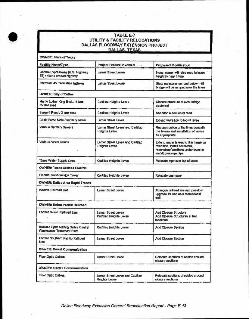
TABLE E~7 UTILITY & FACILITY RELOCATIONS
DALLAS FLOODWAY EXTENSION PROJECT nA11A~ TFXA~
OWNER: State of Texas
Facility Name!Type .Project Feature Involved Proposed Modification
Central Expressway (U.S. Highway Lamar Street Levee None, owner will raise road to levee 75) / 4 lane divided highway height in near future
Interstate 45 / interstate highway Lamar Street Levee State maintenance road below 1-45 bridge will be ramped over the levee
OWNER: City of Dallas
Martin Luther King Blvd. / 4 lane Cadillac Heights Levee Closure structure al west bridge divided road abutment
Sargent Road/ 2 lane road Cadillac Heights Levee Abandon a section or road
Cadiz Force Main / sanitary sewer Lamar Street Levee Extend valve box to top or levee '
Vario\.1$ Sanitary Sewers Lamar Street Levee and Cadillac Reconstruction of the llnes beneath Heights Levee the levees and Installation of valves
as appropriate
Various Storm Drains Lamar Street Levee and Cadillac Extend under levees to discharge on Heights Levee river side, _install collectors,
reconstrucf sections under levee or install pressure pipe
Three Waler Supply lines Cadillac Heights levee Relocate pipe rYVer top of levee
OWNER: Texas Utilities Electric
Electric Transmission Tower Cadillac Heights Levee Relocate one tower
OWNER: Dallas Area Rapid Transit
Inactive Railroad Line Lamar Street Levee Abandon railroad line and possibly ~pgrade for use as a recreational trail
OWNER: Union Pacific Railroad
Former M-K-T Railroad line Lamar Street Levee Add Closure Structure Cadillac Heights Levee Add Closure Structures at two
locations
Railroad Spur serving Dallas Central Cadillac Heights Levee Add Closure Section Wastewater Treatment Plant
Former Southern Pacific Railroad Lamar Street Levee Add Closure Section Line
OWNER: Qwest Communication
Fiber Optic Cables Lamar Street Levee Relocate sections of cables around closure sections
OWNER: Electra Communication
Fiber Optic Cables Lamar Street Levee and Cadfllac Relocate sections of cables around Heights Levee closure sections
Dallas Floodway Extension General Reevaluation Report- Page E-13

A Fort Worth District Real Estate Attorney has prepared a Preliminary Investigation of Utility and Transportation Infrastructure, dated July 23, 1997. The findings are that all the proposed
· relocations are considered "publicw and that there is a need for continued service. The proposed relocation actions are therefore necessary to elil')1inate permanent interruption of service. Provision of a functionally equivalent facility is believed to constitute just compensation to the owners. All owners are thought to hold a compensable interest in the right of way involved, however formal title evidence and a full Attorney's Opinion of Compensability will be required prior to contractual commitments being made by the Sponsor or the Government. The final Attorney's Opinion of Compensability will be completed along with the Real Estate Design .Memorandum.
A relocation agreement is proposed between railroads and the Government, as ·discussed in the Civil Engineering appendix., to acquire the rights necessary to accommodate the project. This agreement would include the right to periodi~ally close the floodgates. Project impact to railroad · operations should be no more restrictive than the design flood would be under existing conditions. No additional cost would be anticipated for this agreement beyond the firs~ cost of construction. ·
The total cost of relocations is detailed in Appendix K, Cost Estimates, under the 02 Account. None of these costs, or the costs in the 01 Account, are associated with right of way acquisition for relocations. At this stage of project development it appears that relocations can be accomplished within the owners existing right of way or that lands otherwise required for flood control will accommodate the work. In the latter case, standard easement estates may have to be combined to create a dual purpose estate, eg. a flood control levee and utility easement.
HAZARDOUS, TOXIC AND RADIOLOGICAL WASTE
The project area has a history of commercial and industrial uses and includes significant amounts of landfill. There are documented actions and investigations which indicate the presence of buried HTRW. Appendix J details the results of the current investigations; b~sed on the access that was possible and other data which was available (During this study the District was unable to obtain rights of entry from a number of private property owners, for the p1urposes of conducting HTRW investigations).'· Appendix J also contains maps showing the lands where there is some known or suspected contamination.
This type of problem is often faced in older urban areas becau,se of past practices for handling industrial and municipal wastes. Therefore, in order to implernent a necessary public project, a risk-based assessment must be performed and risks must be minimized to the greatest . extent possible when developing project alternatives. The plans have been formulated to avoid sites under active CERCLA or RCRA enforcement actions and other situs which represent a high risk, with the exception of the Linfield Landfill.
The Linfield Landfill was closed in 1979. It has been taken off of CERCLA regulatory status by the EPA and given a ·no further action~ listing. The lower segment oft he Chain of Wetlands will require excavation through a portion of the landfill. The alignment has beem chosen to pass through the western portion which is believed to be the least hazardous.
. . ER 1165-2-132 states that the, local sponsor shall be respom:ible for ensuring that the
development and execution of Federal, State and locally required HTf'?W response actions are accomplished at 100 percent non-project cost. The Model Project Cooperation Agreement For Structural Flood Control Projects sets out the guidelines for handling HTRW issues after PCA execution. Article XVlll.b. stipulates that the Government and the Local\ Sponsor must mutually agree for the Sponsor to acquire or provide any project LER that is found to contain any hazardous substance regulated under CERCLA. Article XVII I.e. provides, that an appropriate response to the contamination must be detennined, considering any liability that may arise under CERCLA and that the Local Sponsor shall be responsible, as between the Government and the Local Sponsor, for any and all necessary clean up costs, to include costs of any studies and invest.'igations.
Dallas F/'oodway Extension General Reevaluation Report- Page• E-14

••
•
Assuming that n.o project LER is under an active CERCLA or RCRA enforcement action by either the EPA or the Texas Natural Resource Conservation Commission (TNRCC), a risk-based assessment can be used to detennine appropriate action. In the floodway between the levees there will be a large amount of project LER which will not be affected by construction activities. Even though some of these lands may contain CERCLA regulated wastes, the appropriate response may be to leave the material in place, because risks are very low. Under the terms of the PCA, it will be a Sponsor cost (non-project cost) to make this assessment and determination, once the PCA is signed. Where construction activities will disturb CERCLA or active RCRA regulated HTRW resulting in identification of any hazardous substance regulated under CERCLA or any other material which may necessitate a required HTRW response action which increases construction costs (including disposal costs), this increment of increase will have to be borne entirely by t_he Sponsor and will be a non-project cost. Any land necessary for remediation or disposal of CERCLA regulated wastes will not be considered as project LER and will not be credited . . lf..non-CERCLA regulated waste are present and clean up is required, these costs (including LER) will become project costs and cost-shared or credited accordingly.
These assumptions have implications on the value of U:R both for acquisition and crediting purposes. For the planning purposes of this report, no special allowance has been made for the possible effect of HTRW on LER value. This ls valid since the overall policy of the Corps is to require the Sponsor to provide LER in a · clean· condition, thus the LER credit would be the value of the land as if "clean·. If it is determined to be appropriate for the Sponsor to ac.quire land containing HTRW, the affect on market value and the estimated remediation costs must be evaluated by the appraiser. Credit for LER might be affected if non-CERCLA waste is found and the Sponsor incurs significant LER cost in providing a suitable disposal area. We do not anticipate this scenario, based on available information.
· .. This issue is both controversial and complicated. The public heath and safety concerns,
magnitude of potential costs, cost-sharing implications, legal liabilities, time required to resolve issues and the complexity of statutes and regulations make these matters worthy of further detailed study. We propose to address the real estate requirements associated with HTRW more fully in a Real Estate Design Memorandum.
A TTITUOE OF PROPERTY OWNERS
This project has been the subject of a great deal of public involvement. Most property owners in the project area have expressed a desire for flood proteqtion and opposition from the group of affected owners is not anticipated. Apprehension is more descriptive of the general attitude among occupants of the neighborhood. This in typical at this stage, since a detailed picture of the configuration of real estate takings has not been produced. Controversy has centered around environmental matters, particularly preservation of bottom land hardwood habitat anq the level of flood protection that will be afforded to the neighborhood. With the exception of HTRW concerns, there are no known issues are expected to greatly protract the ac.quisition process.
The City of Dallas has a high degree of expertise in real estate acquisition and is proactive in making acquisitions when the time is right. The City has been advised in writing of the risks associated with acquiring LERRD before execution of the PCA. We will work with the sponsor throughout the project, to the extent appropriate and allowable, to assure that there is understanding of the Federal real estate principles. Action will also be taken to address policy issues along the way which could significantly affect the project.
Dallas Floodway Extension General Reevaluation Report - Page E-15

ESTATES TO BE EMPLOYED FOR THE PROJECT
. The following estates are' proposed for use on this project. They are numbered as they appear in Chapter 5 of Engineer Regulation 405-1-12.
1. Fee
The fee simple title to (the land described in Schedule A) (Tracts Nos.____:_, __ , and __J, subject, however, to existing easements for public roads and highways, public utilities, railroads and pipelines.
6. Flow~ge Easement (Occasional Flooding)
The perpetual right, power, privilege and easement occasionally to overflow, flood and submerge (the land described in Schedule A) (Tracts Nos. __ , __ , and __) (and to maintain · mosquito control) in connection with the operation and maintenance of the ___ _,project as authorized by the Act of Congress approved · · together with all right, title and interest in and to the structures and improvements now situate on the land, except fencing (and also excepting _______________ (here identify those structures not designed for human habitation which the District Engin·eer determines may remain on the land); provided th~t no structures for human habitation shall be constructed or maintained on the land, that no other structures shall be constructed or maintained on the land except as may be approved in writing by the representative of the United States in charge of the project, and that no excavation shall be conducted and no landfill placed on the land without such approval as to the location and method, of excavation and/or placement of landfill; the above estate is taken subject to existing easements for public roads and highways, public utilities, railroads and pipelines; reserving, however, to the landowners, their heirs and assigns, all such rights and privileges as may be used and enjoyed without interfering with the use of the project r or the purposes authorized by Congress or abridging the rights and easement hereby acquired; provided further that any use of the land shall be subject. to Federal and State l~~s with respect to pollution.
8. Channel Improvement Easement
A perpetual and assignable tight and easement to construct, operate, and maintain channel improvement works on, over and across (the land described !n Schedul'e A) (Tracts Nos. __ , _ ·_ and__} for the purpose as authorized by the Act of Congress approve•d ______ , including the right to clear, cut, fell, remove and dispose of any and all timber, trees, underbrush, buildings, improvements and/or other obstructions therefrom; to excavate, dredge, cut away, and remove any · or all of said land and to place thereon dredge or spoil material; and for such other purpose as may be required in connection with said work of improvement; reserving, however, to the owners, their heirs and assigns, all such rights and privileges as may be used without int,erfering with or abridging the rights and easement hereby acquired; subject, however, to existir,,g easements fQr public utilities, railroads and pipelines. · · · ·
9; Flood Protection Levee Easement
A perpetual and assignable right and easement in (the land deiscribed in Schedule A) (Tracts Nos. __ , __ and_) to construct, maintain, repair, operate, putrol and replace a flood protection levee, including all appurtenances thereto; reserving, however, t.o the owners, their heirs and assigns, all such rights and privileges in the land as may be used v-.,ithout interfering with or abridging the rights and easement hereby acquired; subject, howevm. 'Lo existing easements for public roads and highways, public utilities, railroads and pipelines.
Dallas F/oodway Extension General Reevaluation Rep,01rt - Page E-16
•

-• 11. (modified) Trail Easement
A perpetual and assignable easement and right-of-way in, on, over and across (the land described in Schedule A) (Tracts No. __ , __ and___) for the location, construction, operation, maintenance, alteration and replacement of (a) trail(s) and appurtenances thereto; together with the right to trim, cut, fell and remove therefrom all trees, underbrush, obstruction and other vegetation, structures, or obstacles within the limits of the right-of-way; {reserving, however, to the owners, their heirs and assigns, the right to cross over or under the right-of-way as access to their adjoining land at the locations indicated in Schedule B); subject, however, to existing easement~ for -p,ublic-roads and highways, public utilities, railroads and pipelines.
15. Temporary Work Area Easement
A temporary easement and right-of-way in, on, over and across (the land described in Schedule A) (Tracts Nos. __ , __ and ___), for a period not to exceed __________ , beginning with date possession of the land is granted to the United States, for use by the United States, its representatives, agents, and contractors as a (borrow area) ·(work area), including the right to (borrow and/or deposit fill, spoil and waste material thereon) (move, store and remove equipment and supplies) and erect and remove temporary structures on the land and to perform any other work necessary and incident to the construction of the -----------,..--- Project, together with the right to trim, cut, fell and remove .therefrom all trees, underbrush, obstructions, and any other vegetation, structures, or obstacles within the limits of the right-of-way; reserving, however, to the landowners, their heirs and assigns, all such rights and privileges as may be used without interfering with or abridging the rights and easement hereby acquired; subject, however, to existing easements _for pu~~!c road~_ an~ highways, public utilities, railroads and pipelines. -
Dallas Floodway Extension General Reevaluation Report- Page E-17

ASSESSMENT OF NON-FEDERAL SPONSOR'S REAL ESTATE ACQUISITION CAPABILITY
DALLAS FLOODWAY EXTENSION PROJECT DALLAS,TEXAS
NON-FEDERAL SPONSOR: City of Dallas, Texas
I. Legal Authority:
a. Does the sponsor have iegal authority to acquire and hold title to real. property for project purposes? · YES
b. Does !he sponsor have the po~er of eminent dom~in for this project? YES
c. Does the sponsor have •quick-take" authority for this project? NO
d. Are any of the lands/ interests in· land required for the project located outside of the sponsor's political boundary? NO · · ·
e. ' · .. Are ·any of the lands/ interests in land required for the project. owned by an entity wh·ose·ptoperty the sponsor cannot condemn? YES. THE CITY MAY 'NOT HA\(E . POWERS OF EMINENT DOMAIN OVER RAILROAD PROP:ERTIES. .
11. Human Resource Requirements:
a. Will the sponsor's in-house staff require training to become: familiar with the real estate requirements o~federal projects including P.L. 91-646, as amendedJ? NO
b. If the answer to II.a. is ayes", has a reasonable plan been 1jeveloped to provide such training? N/A
c. Does the sponsor's in-house staff have sufficient real estate acquisition experience to meet its responsibilities for the project? YES
d. Is the sponsor's projected in-house staffing .level sufficien t considering its other work load, if any, and the project schedule? YES
e. Can the sponsor obtain contractor support, if required, in ,a timely fashion? YES
f. Will the sponsor likely request USACE assistance in acqu1iring real estate? NO
111. Other Proiect Variables:
site?
IV.
a. Will the sponsor's staff be located within reasonable proxirnity to the project YES
b. Has the sponsor approved the project / real e:3tate schedule .I milestones? YES
Overall Assessment:
a. Has the sponsor performed satisfactorily on other USAGE pro:jects? YES
Dallas F/oodway Extension General Reevalua1'ion Report - Page E-18
•
b. With regard to this project, the sponsor is anticipated to be: FULLY CAPABLE
V. Coordination:
a. Has this assessment been coordinated with the sponsor? YES
b. Does the sponsor concur with this assessment? YES
Prepared by:
K ~"" L 7=2..:, lo 0"--
Rand~ Realty Specialist, CESWF-RE-P
Reviewed and approved by:
¥1:?Jdf . Chief, Real Estate Division, CESWF-RE
•
Dallas Floodway Extension General Reevaluation Report• Page E-19
•
•
•
LEGENO
SPCINSOII OWIC L.#G
~ FLOOO OOflTIIOl Llvt:E EASE.ll(NT
- FLOWM:t £"51:l«HT
il9JJ OWi a, W[fLNC)t
-••- PltOPERTr LK
-••- ,U: FOil .. l1GATI0N
,. • TIU&. 11.0,W.
c::J ACctSS Plt»IT
DALLAS FLOODWAY EXTENSION REAL ESTATE PROPERTY BOUNDARY
N
\\ . .
SH££T 1 OF 3

--
•
N
~ 0WML U'IIO\IIWNT t.t.SEl«lfT
SPOH50II 0WICD ;L#ID
~ Fl.000 COCTltOL Ltvt£ EAS'.IOT
FLOWAGE EA5tllENT
'1J2B OWi OI WEn-,s
- • • - Plt(Jl!ERTY LM
-••- FU FOR YTIQATION
• • • TRM, ltO,W,
DALLAS FLOODWAY EXTENSION REAL ESTATE PROPERTY BOUNDARY
SHEET 2 OF 3
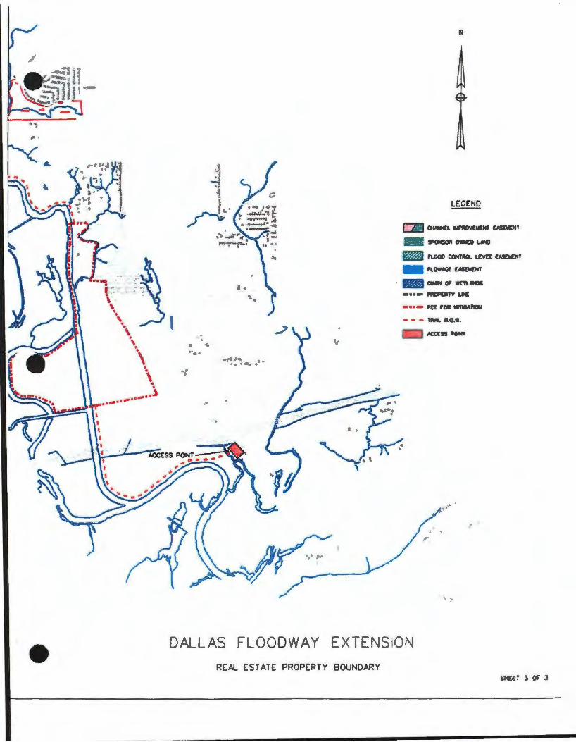
•
\
....... -··
\ • • \ •
_ ... i
t
..
.. ,. .· ' .
.
Ye ... ·'*':J _, .. :--,,:
,<I
.. .
'a• J.f
,.,,
N
LEGEND
!P0NSOII OWNED LNCI
- FLDDD C04TIIOL I.EVE[ tASOil[HT
- Fl.OWMit: EASE.OT
· l'I/IJ Ol»I Qt Vil:TlNCIS
-••- IIRQIPERTY I.IC
•••- ,a FDR WflGAl"ICIN
• • • 'llUiL lt.D.W.
\ •"
' .
, :,
DALLAS FLOODWAY EXTENSION
REAL ESTATE PROPERTY BOUNDARY SHEET J or .S