APPENDIX A Species List Requests - BPA.gov bridge site at Marks Ranch Imnaha Satellite Facility...
80
NEOH BA final 05.24.04.doc A-1 APPENDIX A Species List Requests
Transcript of APPENDIX A Species List Requests - BPA.gov bridge site at Marks Ranch Imnaha Satellite Facility...

NEOH BA final 05.24.04.doc A-1
APPENDIX A Species List Requests

NEOH BA final 05.24.04.doc A-2

NE
OH
BA
final 05.24.04.doc A
-3

NE
OH
BA
final 05.24.04.doc A
-4

NEOH BA final 05.24.04.doc A-5

NEOH BA final 05.24.04.doc A-6
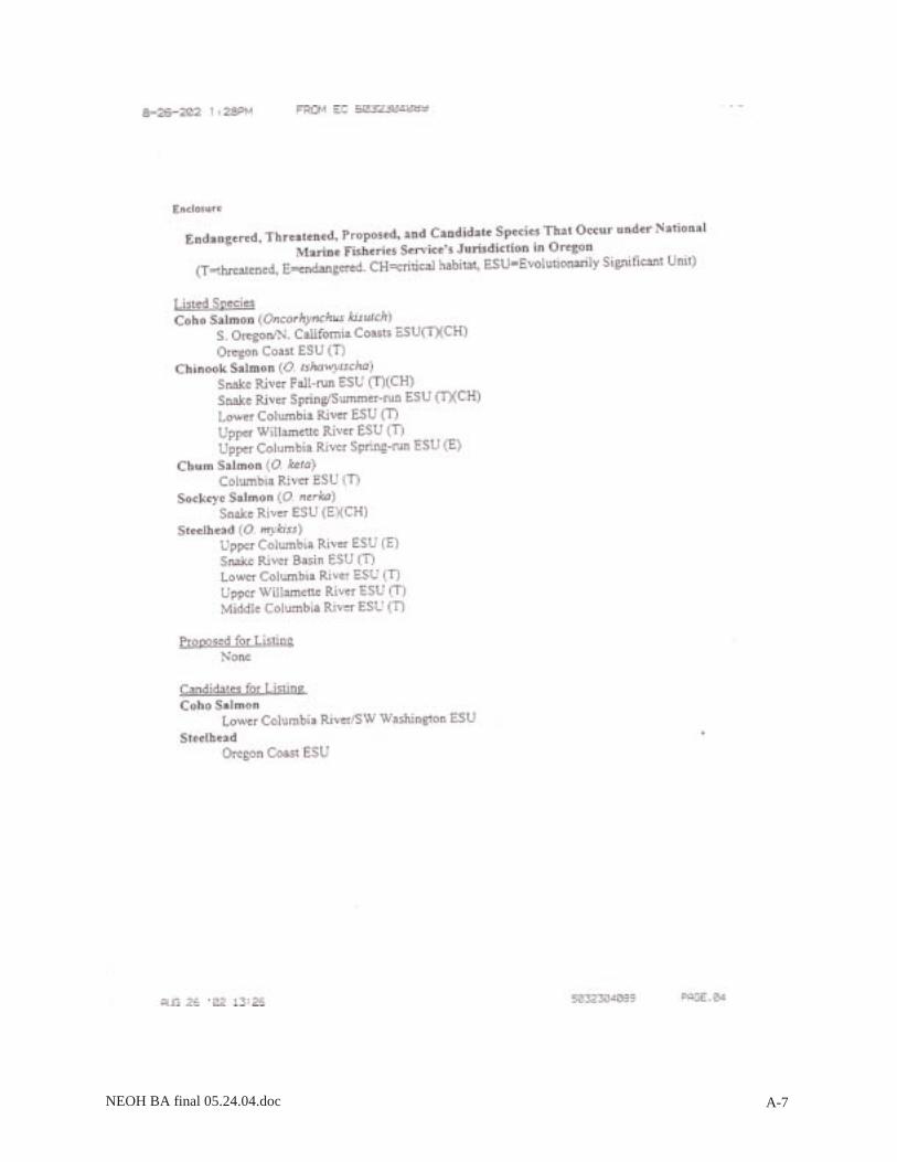
NEOH BA final 05.24.04.doc A-7

NEOH BA final 05.24.04.doc A-8
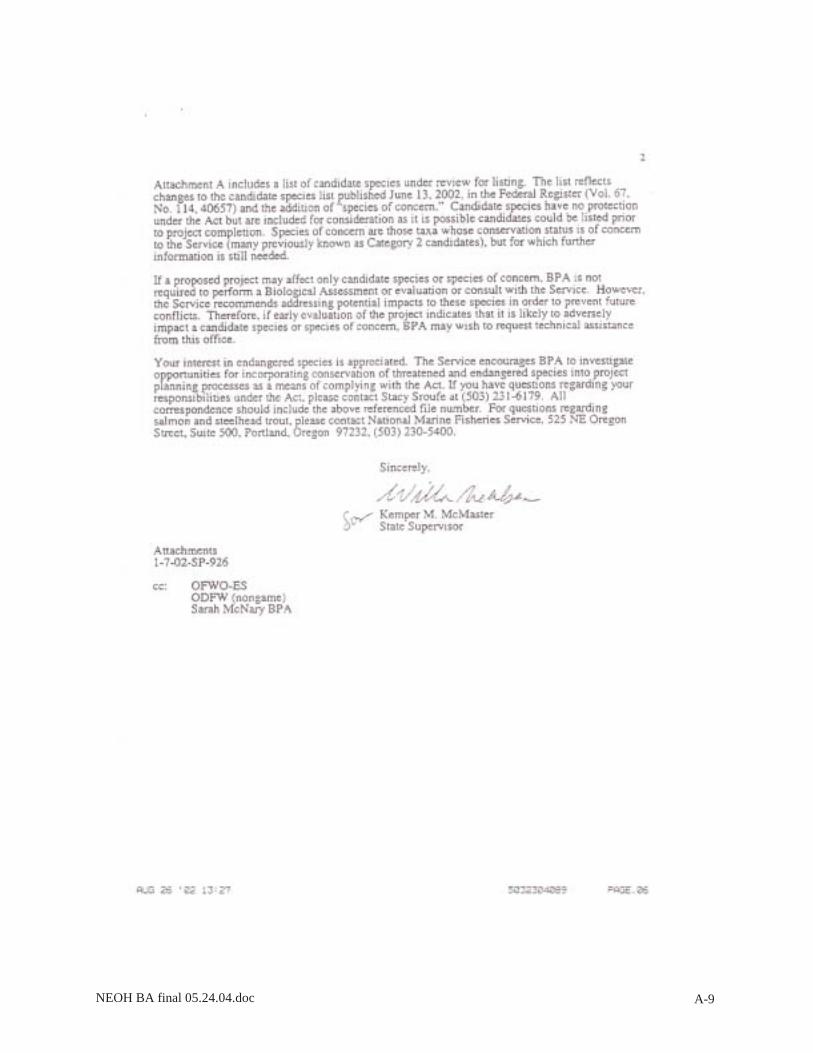
NEOH BA final 05.24.04.doc A-9

NEOH BA final 05.24.04.doc A-10
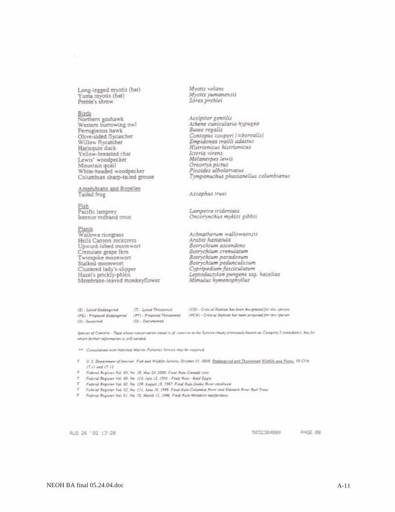
NEOH BA final 05.24.04.doc A-11

NEOH BA final 05.24.04.doc A-12

NEOH BA final 05.24.04.doc A-13

NEOH BA final 05.24.04.doc A-14

NEOH BA final 05.24.04.doc A-15
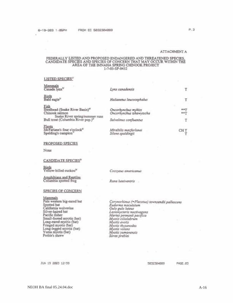
NEOH BA final 05.24.04.doc A-16
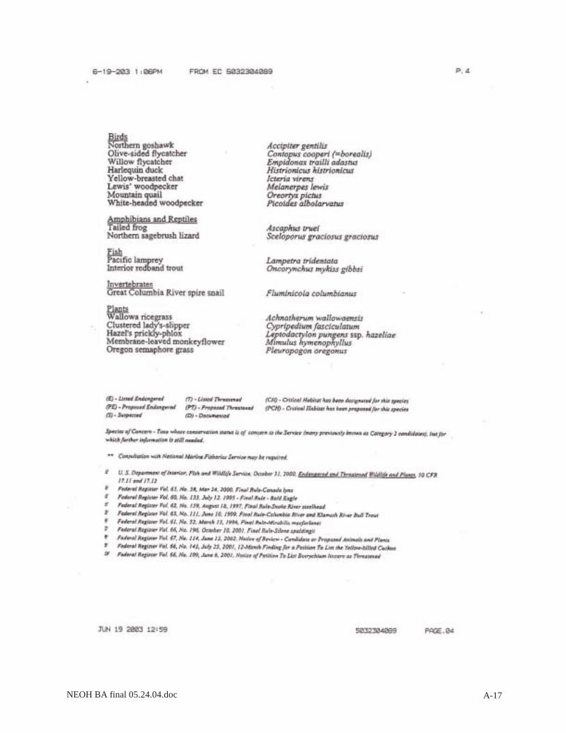
NEOH BA final 05.24.04.doc A-17

NEOH BA final 05.24.04.doc A-18

NEOH BA final 05.24.04.doc B-1
APPENDIX B
Photographs of NEOH Project Sites

NEOH BA final 05.24.04.doc B-2
Photo 1. Existing fish ladder at proposed Lostine Adult Collection Facility
Photo 2. Existing conditions on west bank of proposed Lostine Adult Collection Facility
site.

NEOH BA final 05.24.04.doc B-3
Photo 3. Existing conditions at the proposed Lostine River Hatchery site.
Photo 4. Proposed outfall location at Lostine River Hatchery.

NEOH BA final 05.24.04.doc B-4
Photo 5. Proposed intake location at Lostine River Hatchery.
Photo 6. Existing Acrow Panel Bridge at Marks Ranch site.

NEOH BA final 05.24.04.doc B-5
Photo 7. Existing intake location and proposed additional intake location (looking
upstream) at the Imnaha Satellite Facility.
Photo 8. Existing picket weir and adjacent upland habitat at the Imnaha Satellite Facility.

NEOH BA final 05.24.04.doc C-1
APPENDIX C
List of Plant Species Observed at NEOH Project Sites

NEOH BA final 05.24.04.doc C-2
Lookingglass
Hatchery Lostine R.
Adult Collection
Lostine R. Hatchery
Acrow bridge site at Marks
Ranch
Imnaha Satellite Facility
Elevation (ft) 2,565 3,470 3,700 1,995 3,760
Trees Abies grandis Betula occidentalis Larix occidentalis Picea engelmannii Pinus ponderosa Populus balsamifera Populus tremuloides Pseudotsuga menziesii
X
X
X X
X
X
X X X
X X
X X X X X
X
X X
X
X
X
Shrubs Acer glabrum Alnus incana Amelanchier alnifolia Apocynum androsaemifolium Arctostaphylos uva-ursi Ceanothus sanguineus Clematis ligusticifolia Cornus sericea Crataegus douglasii Holodiscus discolor Juniperus occidentalis Mahonia repens Pachistima myrsinites Philadelphus lewisii Physocarpus malvaceus Prunus sp. Prunus viginiana Rhamnus purshiana Rhus radicans Ribes sp. Ribes lacustre Rosa sp. Rubus leucodermis Rubus parviflorus Salix spp. Sambucus cerulea Shepherdia canadensis Spiraea betulifolia Symphoricarpos albus Vaccinium sp.
X X X X
X X X
X X
X X
X
X X X
X X
X
X
X X
X
X
X X
X X
X
X X X
X
X X X X X
X
X
X X
X X X
X X
X X
X X X
X
X X X X X X X
X X
X X
X
X X
X
X X
X
X
X X X
X
Forbs Achillea millefolium Actea rubra Agastache utricifolia Allium cernuum Anchusa officinalis Arctium minus Arnica cordifolia
X
X X X
X
X
X X
X
X
X
X
X
X

NEOH BA final 05.24.04.doc C-3
Lookingglass Hatchery
Lostine R. Adult
Collection
Lostine R. Hatchery
Acrow bridge site at Marks
Ranch
Imnaha Satellite Facility
Aster sp. Athyrium filix-femina Balsamorhiza sagittata Capsella bursa-pastoris Centaurea diffusa Chenopodium album Cirsium arvense Cirsium vulgare Clintonia uniflora Collomia linearis Collomia grandis Conium maculatum Cynoglossum officinale Dipsacus sylvestris Equisetum spp. Eriogonum sp. Erodium cicutarium Fragaria vesca Fragaria virginiana Galium sp. Geranium viscosissimum Geum macrophyllum Habenaria dilitata Hackelia floribunda Heracleum lanatum Hieracium sp. Hypericum perforatum Lactuca serriola Leucanthemum vulgare Lomatium sp. Lupinus sp. Maianthemum stellatum Marrubium vulgare Medicago lupulina Medicago sativa Melilotus alba Melilotus officinalis Mentha arvensis Mimulus guttatus Myosotis sp. Osmorhiza berteroi Paeonia brownii Penstemon sp. Phacelia hastata Plantago lanceolata Plantago major Polemonium occidentalis Potentilla glandulosa Potentilla gracilis Prunella vulgaris Pteridium aquilinum Pterospora andromedea Ranunculus sp.
X X X
X
X X X
X X
X X
X
X X
X
X
X X
X
X
X
X
X
X
X
X X
X X X X
X
X X
X X X
X
X X
X
X X X
X
X
X X X X X
X X
X
X X
X
X
X
X
X X
X X
X X
X X
X
X
X X
X X
X
X
X
X
X
X
X
X
X
X
X
X
X
X
X
X
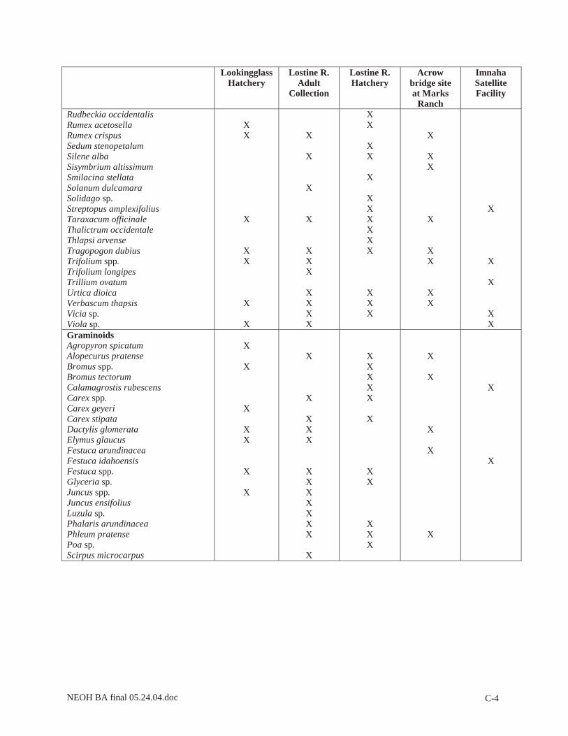
NEOH BA final 05.24.04.doc C-4
Lookingglass Hatchery
Lostine R. Adult
Collection
Lostine R. Hatchery
Acrow bridge site at Marks
Ranch
Imnaha Satellite Facility
Rudbeckia occidentalis Rumex acetosella Rumex crispus Sedum stenopetalum Silene alba Sisymbrium altissimum Smilacina stellata Solanum dulcamara Solidago sp. Streptopus amplexifolius Taraxacum officinale Thalictrum occidentale Thlapsi arvense Tragopogon dubius Trifolium spp. Trifolium longipes Trillium ovatum Urtica dioica Verbascum thapsis Vicia sp. Viola sp.
X X
X
X X
X
X
X
X
X
X
X X X
X X X X
X X
X X
X
X X X X X X
X X X
X
X X
X
X X
X X
X
X
X
X X
Graminoids Agropyron spicatum Alopecurus pratense Bromus spp. Bromus tectorum Calamagrostis rubescens Carex spp. Carex geyeri Carex stipata Dactylis glomerata Elymus glaucus Festuca arundinacea Festuca idahoensis Festuca spp. Glyceria sp. Juncus spp. Juncus ensifolius Luzula sp. Phalaris arundinacea Phleum pratense Poa sp. Scirpus microcarpus
X
X
X
X X
X
X
X
X
X X X
X X X X X X X
X
X X X X X
X
X X
X X X
X
X
X
X
X
X
X

NEOH BA final 05.24.04.doc D-1
APPENDIX D
Design Drawings and Details

NEOH BA final 05.24.04.doc D-2
D-1. Lookingglass Hatchery Existing and Proposed Site Plan

NEOH BA final 05.24.04.doc D-3
D-2. Lostine Adult Collection Facility Proposed Site Plan

NEOH BA final 05.24.04.doc D-4
D-3. Lostine River Hatchery Proposed Site Plan
NEOH BA final 05.24.04.doc D-5
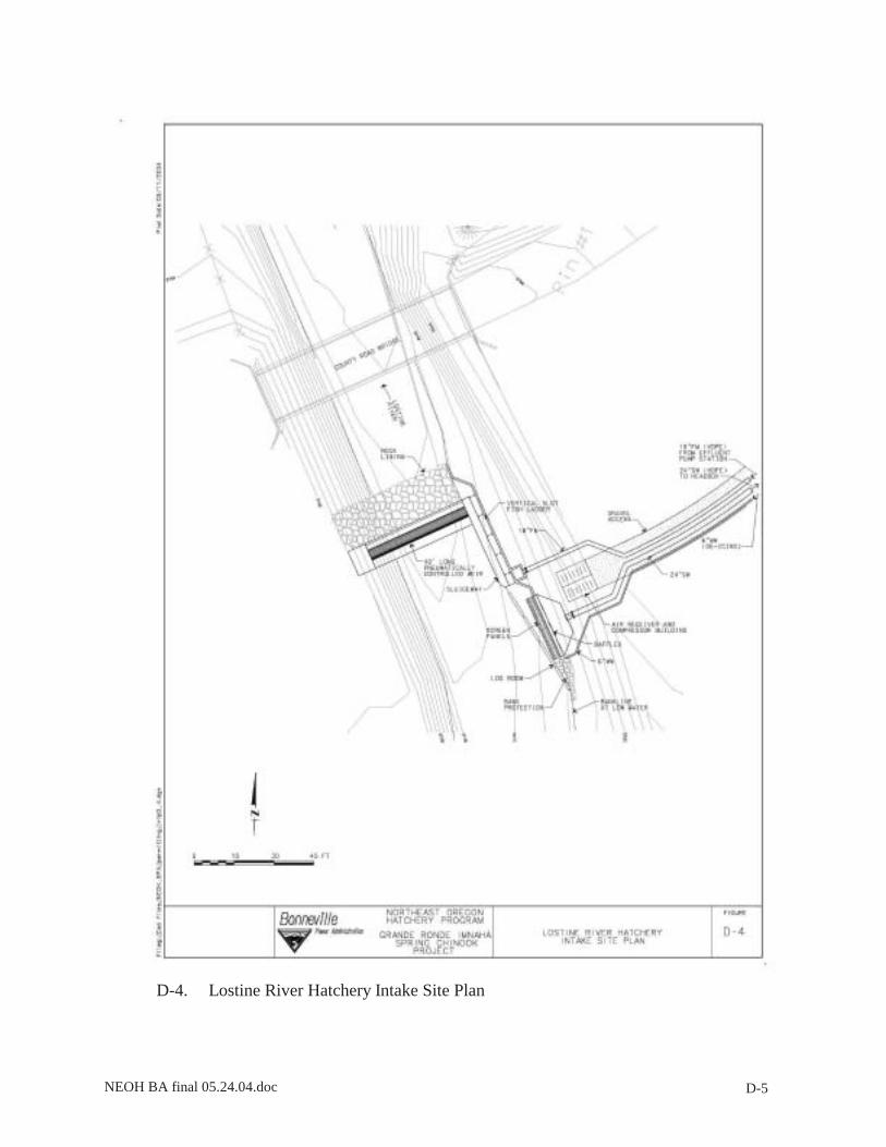
D-4. Lostine River Hatchery Intake Site Plan

NEOH BA final 05.24.04.doc D-6
D-5. Acrow Panel Bridge Location at Marks Ranch
NEOH BA final 05.24.04.doc D-7
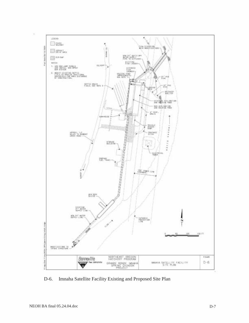
D-6. Imnaha Satellite Facility Existing and Proposed Site Plan

NEOH BA final 05.24.04.doc D-8

NEOH BA final 05.24.04.doc E-1
APPENDIX E
Bull Trout Matrix of Pathways and Indicators

NEOH BA final 05.24.04.doc E-2
Table E-1. Matrix of Diagnostics/Pathways and Indicators for Bull Trout (NMFS 1996; USFWS 1998; USFS 1998) at Lookingglass Creek.
POPULATION AND ENVIRONMENTAL BASELINE EFFECTS OF THE ACTION DIAGNOSTICS/ PATHWAYS
INDICATORS
Criteria
Present condition Functionality (F/FR/FU)*
Restore
Maintain
Degrade
Subpop. Characteristics: Subpopulation Size
Total Juv, 5000-2000 & Adults >500 - <200
Low FR X
Water Quality: Temperature (7 day average)
• Incubation 36-41 °F1
• Rearing 39-54°F • Spawning 39-48°F • Migration not to exceed
59° F • Oregon criteria = 50°F
>70°F during July/August6, 7; on 303d list for exceeding bull trout temperature limit (50°F)2
FU4 X
Sediment <12% fines in gravel1 On 303d list for sediment2, 3, 4
FR X
Chemical Contamination/Nutrients
Low levels of chemicals; no CWA 303d reaches
Excess Nutrient Loading3, 6
FR X
Habitat Access: Physical Barriers
Human made barriers do not restrict passage
Fish ladders and intakes restrict passage at hatchery; on 303d list for habitat modifications2
FR4 X
Habitat Elements: Substrate Embeddedness
Embeddedness <20%; mostly gravel and cobble
Excess fine sediment6
FR3 X
Large Woody Debris >20 pieces/mi >35ft long >12” diameter
Lack of LWD and riparian veg6
FR3 X
Pool Frequency Wetted width pools/mi 0-5’ 39 5-10’ 60 10-15’ 48 15-20’ 39 20-30’ 23 30-35’ 18 35-40’ 10 40-65’ 9 65-100’ 4
FR3 X
Pool Quality >1m deep with good cover Pools lacking6 FU3 X Large Pools Each reach has many large
pools (>1m deep) X
Off-channel Habitat Numerous ponds and backwaters with cover
Moderate amount of covered ponds
FR4 X
Refugia Sufficient in size and number to maintain pop.
Moderate amount of refugia
FR4 X
Channel Conditions and Dynamics: Avg. Wetted Width/Max. Depth Ratio
Natural = 10 <10 FR3 X
Streambank Condition >90% stable or >80% of reach has = 90%
Erosive banks FR3 X
Floodplain Connectivity Frequent with overbank Moderate FR4 X Flow/Hydrology: Change in Peak/Base Flows
Peak flow, base flow and timing similar to other watersheds
FR3 X
Increase in Drainage Network
Zero or minimum increase in drainage network
FR4 X
Watershed Conditions: Road Density & Location
<2mi/mi2; no valley bottom roads
Valley bottom roads occur
FR3 X X
Disturbance History <15% with no unstable areas FU4 X Riparian Reserve Riparian corridor at least
80%intact; composed of 50% endemics
Invasive plants common
FR3 X
Recruitment, Population Structure and Heterogeneity
Healthy subpopulation of bull trout (several thousand individuals) or directly linked to one. All life history modes are possible
Abundance of bull trout is low in Lookingglass Creek5
FR5 X
* F = Functioning appropriately, FR = Functioning at risk, FU = Functioning at unacceptable risk 1 USFWS 1998

NEOH BA final 05.24.04.doc E-3
2 Nowak and Eddy 2001 3 Upper Grande Ronde BA (USFS 1994a) 4 BPA 1998 5 B. Smith, ODFW, pers comm., October 17, 2002 6 Wallowa County – NPT 1993, Revised 1999 7 B. Lund, Lookingglass Hatchery Manager, pers comm., October 2, 2002

NEOH BA final 05.24.04.doc E-4
Table E-2. Matrix of Diagnostics/Pathways and Indicators for Bull Trout for the Lostine River (NMFS 1996a; USFWS 1998; USFS 1998b).
POPULATION AND ENVIRONMENTAL BASELINE EFFECTS OF THE ACTION DIAGNOSTICS/ PATHWAYS
INDICATORS Criteria Present condition Functionality
(F/FR/FU)*
Restore
Maintain
Degrade Subpop. Characteristics: Subpopulation Size
Total Juv, 5000-2000 & Adults >500 - <200
USFWS surveys (1999- 2003) indicate low utilization in lower Lostine9
F X
Water Quality: Temperature1 (7 day average)
• Incubation 36-41 °F1
• Rearing 39-54°F • Spawning 39-48°F • Migration not to
exceed 59° F • Oregon criteria =
50°F
55.1°F during August7; migratory temps ok; spawning occurs upstream; low winter temps; Meets DEQ criteria for Alkalinity, Ammonia, BOD, Nitrogen, Oxygen, pH, Phosphates, Solids, Temp, and Turbidity
F4 X
Sediment <12% fines in gravel1 On 303d list for sediment2
F2 X
Chemical Contamination/Nutrients
Low levels of chemicals; no CWA 303d reaches
Low levels of contamination
F X X
Habitat Access: Physical Barriers
Human made barriers do not restrict passage
On 303d list for habitat modifications2
FR4 X8
X8
X8
Habitat Elements: Substrate Embeddedness
Embeddedness <20%; mostly gravel and cobble
F3 X
Large Woody Debris >20 pieces/mi >35ft long >12” diameter
F3 X
Pool Frequency Wetted width pools/mi 0-5’ 39 5-10’ 60 10-15’ 48 15-20’ 39 20-30’ 23 30-35’ 18 35-40’ 10 40-65’ 9 65-100’ 4
F3 X
Pool Quality >1m deep with good cover F4 X Large Pools Each reach has many large
pools (>1m deep) F4 X
Off-channel Habitat Numerous ponds and backwaters with cover
FR4 X
Refugia Sufficient in size and number to maintain pop.
FR4 X
Channel Conditions and Dynamics: Avg. Wetted Width/Max. Depth Ratio
Natural = 10 F3 X
Streambank Condition >90% stable or >80% of reach has = 90%
F3 X
Floodplain Connectivity Frequent with overbank FR4 X Flow/Hydrology: Change in Peak/Base Flows
Peak flow, base flow and timing similar to other watersheds
On 303d list for flow modification2
FU3 X
Increase in Drainage Network
Zero or minimum increase in drainage network
FR4 X
Watershed Conditions: Road Density & Location
<2mi/mi2; no valley bottom roads
<2mi/mi2 F3 X
Disturbance History <15% with no unstable areas
FR3 X
Riparian Reserve Riparian corridor at least 80%intact; composed of 50% endemics
F3 X
Recruitment, Population Structure and Heterogeneity
Healthy subpopulation of bull trout (several thousand individuals) or directly linked to one. All life history modes are possible
Population is healthy; abundance good
F5 X
* F = Functioning appropriately, FR = Functioning at risk, FU = Functioning at unacceptable risk 1 USFWS 1998

NEOH BA final 05.24.04.doc E-5
2 Nowak and Eddy 2001 3 Upper Grande Ronde BA (USFS 1994a); Lostine River Watershed BA (USFS 1994b) 4 BPA 1998 5 P. Sankovich, ODFW, pers comm., October 1, 2002; G. Sausen, USFS, pers comm., October 16, 2002 6 Wallowa County – NPT 1993, Revised 1999 7 MWH 2001 8 Passage may be degraded due to installation of a new weir at the Lostine River Hatchery; however, improvements to passage at the Lostine Adult Collection Facility are likely 9 G. Sausen, USFWS, pers comm., 3/23/04; P. Sankovich, USFWS, pers comm., 4/13/04
Effects on Bull Trout Population and Habitat Indicators Lostine River Facilities and Lookingglass Hatchery The effects analysis for the proposed Lostine Adult Collection Facility, the proposed Lostine River Hatchery and Lookingglass Hatchery is presented cumulatively based on similar impacts and identical in-stream work windows (July 15 – August 15) within the Lostine River. There will be no instream work at Lookingglass Hatchery. Subpopulation Characteristics: Matrix subpopulation information for the Lostine River and Lookingglass Creek systems was not available, but trends are discussed below.
Subpopulation Size – A seasonal reduction of habitat would occur from the water diver-sions but not to an extent that would affect the subpopulation throughout the watershed.
Growth and Survival – No lethal take of bull trout is anticipated through project activities. Instream work and operation of ladders and weirs would be conducted during juvenile emigration and adult migration. Juvenile migration is not anticipated to be disrupted. Adult migration may be temporarily delayed during the instream construction window, but the impact would be short term. Stream surveys conducted in 1992 indicated a low abundance of adult bull trout in the Lostine (ODFW 1995; Bellerud et al. 1997). As stated in the main document, Lostine River bull trout spawning surveys have been conducted by the USFWS from 1999 to 2003 (G. Sausen, USFWS, personal communication, March 23, 2004). Established spawning areas have been observed through these surveys, one of which is the Lundquist Bridge to OC Ranch section of the river. The proposed Lostine River Hatchery is wholly located within the Lundquist Bridge to OC spawning area and the bridge is located approximately 600 feet downstream of the proposed intake location. In 2003, the USFWS observed three bull trout redds in the Lundquist to OC survey area (2.8 mi section) for an average of 1.1 redds per mi. In addition, 20 large fluvial bull trout were observed during 2003 surveys of the section. Further downstream, at the junction of the forked split in the Lostine adjacent to the existing acclimation raceways, one bull trout redd was observed (G. Sausen, USFWS, pers comm., March 23, 2004). Bull trout do not spawn in the immediate vicinity of the Lostine Adult Collection Facility (P. Sankovich, USFWS, pers comm., 4/13/04). The 2003 survey data for the Lostine was the highest total for five consecutive survey years, although more spawning data (10-15 consecutive years of data) is needed to establish population trends and to determine if bull trout populations are healthy in the Lostine. Because bull trout spawning occurs in September and October, with subsequent egg incubation into winter, the proposed instream work window would avoid impact to spawners and incubating eggs. Adult migrants and subadults could be in the vicinity, although high temperatures may cause them to move upstream into headwaters to seek

NEOH BA final 05.24.04.doc E-6
cooler temperatures. Due to the low occurrence of bull trout in the immediate vicinity of the proposed Lostine facilities, the subpopulation would likely be resilient to short-term impacts that may occur.
Life History Diversity/Isolation – The migratory connection would not be disrupted by this project.
Persistence and Genetic Integrity Subpopulation – The project would not impact the existence of the Lostine River or Lookingglass Creek local populations. Project activities would not affect this indicator.
Water Quality:
Temperature 7-day avg (summer) – As shown in Table E-2, existing values for several parameters including alkalinity, ammonia, BOD, nitrogen, oxygen, pH, phosphates, solids, temperature, and turbidity are rated as “A” under the ODEQ rating system in the Lostine River (ODEQ 1991). An “A” rating indicates that sampled parameter measurements are within the standards of ODEQ criteria. Estimated hatchery effluent at the Lostine River Hatchery, shown in Table 4.2-20, would not adversely impact these parameters. Ambient water temperature within the Lostine River and Lookingglass Creek would not be altered by this project. Reduced Lostine River flow within the diversion reach at the Lostine River Hatchery is not expected to increase temperatures. However, any potential instream temperature increases may be reduced by implementing low flow strategies (ie: higher densities and less volume of rearing water) for facility requirements. At the proposed Lostine River Hatchery, temperature issues could be further minimized by supplementation of instream flow through the pumping of effluent water to the base of the fish ladder. The use of chillers and well-water at the Lostine River Hatchery could potentially decrease temperatures in the immediate vicinity of the discharge; however, the water would rapidly mix with river water and the impact would be negligible.
Sediment – Disturbed stream banks would be armored with riprap or cobbles and revegetated with willow fascines to minimize erosion potential and protect structures. With the exception of cobble placement downstream of the weir, all work within the stream channel would be conducted behind cofferdams to minimize sediment introduction into the Lostine River and any construction impacts would be short-term. According to Waters (1995), most construction projects done essentially at a point on a stream, such as these projects, would have temporary effects. Subsequent flows within these river systems are high enough to scour away light deposits and fish would generally repopulate quickly (Waters 1995). Roads would be constructed in a manner to minimize sediment delivery to the Lostine River. Excess materials would be placed in an upland location where they would not be able to enter the Lostine River or Lookingglass Creek. All disturbed soils would be revegetated.
Chemical Contamination /Nutrients – No change in chemical discharge to Lookingglass Creek would occur as a result of activities. Two chemicals, formalin and erythromycin, would be introduced into the Lostine River through this project. Both chemicals would be applied according to labeling requirements (see Water Quality section in main document). Although indicated on the matrix table that degradation is possible from these introductions, introductions would be diluted in compliance with regulatory standards and the effect negligible. Equipment operation instream or adjacent to the river would use synthetic hydraulic oil as recommended by NOAA Fisheries. All equipment would be
NEOH BA final 05.24.04.doc E-7
free of petroleum or hydraulic fluid leaks and would be serviced outside the riparian zone. Nutrients would be introduced into the Lostine River through the return of spawned salmon carcasses. This action is considered a benefit to increase the level of marine derived micro-nutrients essential to a healthy ecosystem (Cederholm et al. 2000).
Additionally, the use of feed and subsequent effluent would introduce soluble nutrients to the Lostine River systems. The impacts caused by this action are not likely to adversely affect water quality and impacts could be further minimized by the use of low phosphorus feed. As discussed in the main text, hatchery effluent may alter a variety of parameters within the receiving water’s mixing zone. However, according to NMFS (1999), this impact is expected to be very small and is likely localized at outfall areas as effluent is rapidly diluted in the receiving streams and rivers.
Habitat Access:
Physical Barriers – No stream crossings or culverts would be constructed. However, passage may be delayed due to the development of a new instream weir at the Lostine River Hatchery. Additionally, the Lostine Adult Collection Facility’s flow velocity barrier may delay migration, but operational criteria developed by USFWS/NOAA Fisheries would be implemented to reduce and minimize effects. Bull trout passage would likely be improved at the Lostine Adult Collection Facility as compared to existing passage through outdated ladders and weir structures.
Habitat Elements: Substrate Embeddedness – See sediment.
Large Woody Debris – LWD recruitment at a local level in the Lostine River would be impacted through the limited streamside tree removal at both Lostine facilities. Removed trees can be left on site for LWD recruitment if requested by NOAA Fisheries or USFWS. No existing LWD would be removed from the Lostine River. Project activities would not affect this indicator on a watershed scale.
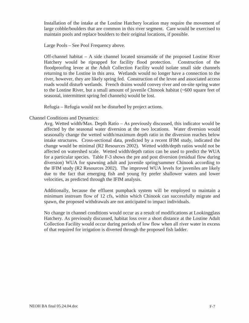
Pool Frequency and Quality – The Lostine River intake structure would be placed into the toe of the stream bank and designed to operate in three ft depth of water. Installation of the intake at the Lostine Hatchery location may require the movement of large cobble/boulders that are common in this river segment. Care would be exercised to maintain pools and replace boulders to their original location, if possible.
Large Pools – See Pool Frequency above.
Off-channel habitat – A side channel located streamside of the proposed Lostine River Hatchery would be partially riprapped for facility flood protection. This meander channel is not likely used for spawning habitat as it is dry in the summer and substrate is not suitable for spawning (R. Zollman, NPT, pers comm., 1/2/03). Construction of the floodproofing levee at the Adult Collection Facility would isolate small side channels returning to the Lostine in this area. French drains would convey river and on-site spring water to the Lostine River, but approximately 600 square ft of seasonally wet, spring-fed intermittent channels that may serve as seasonal rearing habitat juvenile bull trout would be cut off from the mainstem due to construction of the proposed levee.
Refugia – Refugia would not be disturbed by project actions.

NEOH BA final 05.24.04.doc E-8
Channel Conditions and Dynamics:
Avg. Wetted width/Max. Depth Ratio – This indicator would be affected by the seasonal water diversion at both Lostine site locations. Water diversion would seasonally change the wetted width/maximum depth ratio in the diversion reaches below intake structures. Cross-sectional data, predicted by a recent IFIM study (R2 Resources 2002), indicated the change would be minimal. Wetted width/depth ratios would not be affected on watershed scale. Using these data, the WUA, defined as the surface area of a stream weighted by its suitability to an aquatic organism, can be predicted for different life stages of bull trout. Table E-3 shows the pre and post (during) diversion WUA for adult and juvenile bull trout according to the IFIM study. As shown in the table, an increase in the WUA for juveniles is predicted following diversions. The maximum WUA for juveniles occurs at 50 cfs. When water levels exceed this flow, juveniles require more energy to maintain their position in the water column. Therefore, the residual flow during diversion is more suitable to juveniles as they prefer lower velocities and less depth (R2 Resources 2002). Older juveniles may prefer higher velocities and greater depths. As stated in the main text, bull trout can successfully migrate through waters with maintained depths of 0.6 feet. Chinook require a depth of 0.8 feet, which can be maintained by 10 cfs of flow. As a buffer, managers will maintain a minimum of 12 cfs during low flows by returning hatchery effluent to the point of diversion. Therefore, adult bull trout migrants should not be delayed in the diversion reach. No change in channel conditions would occur as a result of upland modifications at Lookingglass Hatchery. Although no withdrawals would occur at the Lostine Adult Collection Facility site, during periods of low flow, all river water in excess of that required for irrigation diversion would be directed through the fish ladder. This would eliminate instream “habitat” (currently consists of concrete sills of existing fish ladder) during periods of low flow for a linear distance of approximately 150 ft. However, during these periods, the ladder would be monitored daily at a minimum to ensure safe passage of migrants, both upstream and downstream through the ladder. Monitoring activities may result in the need to allow a sufficient amount of water through the stream to allow for downstream passage of juveniles, but it is anticipated that, if present, they would use the ladder and follow river flow downstream. During low flow summer periods, high river temperatures would cause most juveniles to hold upstream in headwaters where water is a more suitable temperature.

NEOH BA final 05.24.04.doc E-9
Table E-3. Change in Weighted Usable Area – Lostine River Hatchery for adult and juvenile bull trout.
Pre-diversion mean monthly flow (cfs)
Approximate WUA Pre-diversion (%)
Predicted diversion (cfs) using normal flow strategy
Post-diversion flow (cfs) (residual flow during diversion)
Approximate WUA Post-diversion (%)
Adult June 787.8 NA1 2.8 785.0 NA1 July 383.3 50 17.8 365.5 54 August 86.2 98 17.8 68.4 97 September 50.2 84 17.8 32.4 63 Juveniles June 787.8 NA1 2.8 785.0 NA1 July 383.3 48 17.8 365.5 50 August 86.2 90 17.8 68.4 95 September 50.2 100 17.8 32.4 90
1IFIM (R2 Resource Consultants, Inc. 2002) study predicted WUA only from 5 cfs to 400 cfs
Streambank condition – Streambank conditions would change at the following locations at the Lostine Adult Collection Facility: new fish ladder location, improved bridge abutment locations, and the floodproofing levee location. At the proposed Lostine River Hatchery, streambank conditions would be altered at the intake and outfall locations, and at the fish ladder location due to placement of riprap or cobbles. Although bank stabilization at the north well location is being completed under a separate project, on-going maintenance of this area may be necessary. Banks would be stabilized to prevent erosion and sedimentation into the Lostine River and to protect structures. Streambank change is not expected to be extensive enough to affect this indicator on a watershed basis. No streambank alterations would occur at the Lookingglass Hatchery.
Floodplain connectivity – No culverts, fords or stream crossings would be constructed. The Acrow panel bridge that currently spans the Imnaha will replace the existing bridge at the Lostine Adult Collection Facility. New bridge abutments would be re-located out of the floodway, above the OHWM. Although the proposed levee at the Lostine Adult Collection Facility would prevent flooding, there would be a loss of connection with wetlands and approximately 600 square ft of rearing habitat within seasonal, intermittent side channels. These losses are not expected to impact bull trout habitat on a watershed scale. The side channel that is proposed to be riprapped at the Lostine River Hatchery is not likely to impact wetland or riparian linkages as the area adjacent to the side channel contains upland vegetation.
Flow/Hydrology:
Change in Peak/Base Flows – No effect would occur due to the minimal change in forest disturbance and road density.
Increase in Drainage Network – No effect would occur due to the limited road constructed for the project. The addition of impervious surfaces is not anticipated to affect this parameter on a watershed scale.

NEOH BA final 05.24.04.doc E-10
Watershed Conditions: Road Density and Location – Access road construction would not affect the road density criteria and watershed conditions would be maintained. The temporary access road on the west side of the river at the Lostine Adult Collection Facility would be constructed within 150-ft of the river. In accordance with the NMFS (2002) SLOPES Biological Opinion, soil disturbance would be minimized by clearing vegetation to ground level and placing clean gravel over geotextile fabric. The temporary access road would be obliterated, the soil stabilized and the area revegetated.
Disturbance History – Timber removal that could affect the Equivalent Clearcut Area would not occur.
Riparian Resource Areas – Project actions are expected to have minimal impact on large woody debris recruitment and shade and are therefore expected to have little effect on riparian corridors. As discussed previously, trees removed on site could be left for LWD recruitment if so stipulated.
Disturbance Regime – Project actions are not expected to increase the potential for landslides, scour or flooding.
Integration of Species and Habitat Conditions – Actions do not occur at a scale across the watershed (or subwatershed) that would affect the bull trout continued existence and connectivity to Columbia River DPS populations.

NEOH BA final 05.24.04.doc E-11
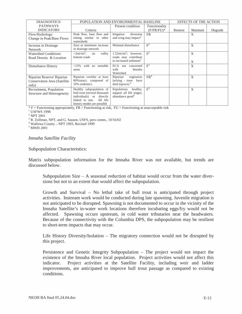
Table E-4. Matrix of Diagnostics/Pathways and Indicators for Bull Trout for the Imnaha River (NMFS 1996; USFWS 1998)
POPULATION AND ENVIRONMENTAL BASELINE EFFECTS OF THE ACTION DIAGNOSTICS/ PATHWAYS
INDICATORS Criteria Present condition Functionality
(F/FR/FU)*
Restore
Maintain
Degrade Subpop. Characteristics: Subpopulation Size
Total Juv, 5000-2000 & Adults >500 - <200
“low risk” of extinction
F X
Water Quality: Temperature (7 day average)
• Incubation 36-41 °F1
• Rearing 39-54°F • Spawning 39-48°F • Migration not to
exceed 59° F • Oregon criteria = 50°F
>63°F during July and August5; on 303d list for exceeding bull trout temperature limit (50°F) upstream of Summit Creek (~RM 45)
FU2 X
Sediment <12% fines in gravel1 Excess erosion and fine sediments may be a problem, but properly functioning.4
F2 X
Chemical Contamination/Nutrients
Low levels of chemicals; no CWA 303d reaches
Potential herbicide and pesticide input, but properly functioning4
F2 X X
Habitat Access: Physical Barriers
Human made barriers do not restrict passage
Fish ladders and intakes restrict passage at site; but no known manmade barriers on USFS land2
F2 X
Habitat Elements: Substrate Embeddedness
Embeddedness <20%; mostly gravel and cobble
Gravels and cobbles stable2
FR2 X
Large Woody Debris >20 pieces/mi >35ft long >12” diameter
At natural potential even though does not have >20 pieces/mi
F2 X
Pool Frequency Wetted width pools/mi 0-5’ 39 5-10’ 60 10-15’ 48 15-20’ 39 20-30’ 23 30-35’ 18 35-40’ 10 40-65’ 9 65-100’ 4
Survey methodology not consistent with PACFISH/INFISH and NOAA Fisheries matrix -does not measure pools less than full width in size
FU2 X
Pool Quality >1m deep with good cover Pools are Rosgen B and C channel types – plunge and step pools
F2
Large Pools Each reach has many large pools (>1m deep)
Deep plunge pools common
F2 X
Off-channel Habitat Numerous ponds and backwaters with cover
Properly functioning throughout except where channel modified
F2
Refugia Sufficient in size and number to maintain pop.
Properly functioning throughout except where channel modified
F2
Channel Conditions and Dynamics: Avg. Wetted Width/Max. Depth Ratio
Natural = 10 Properly functioning throughout except where channel modified
F2 X
Streambank Condition >90% stable or >80% of reach has = 90%
Bank form has deteriorated in some areas4
F2 & FR4 X
Floodplain Connectivity Frequent with overbank Properly functioning except where scoured during 1997 flood
F2 X
NEOH BA final 05.24.04.doc E-12
POPULATION AND ENVIRONMENTAL BASELINE EFFECTS OF THE ACTION DIAGNOSTICS/ PATHWAYS
INDICATORS
Criteria Present condition Functionality
(F/FR/FU)*
Restore
Maintain
Degrade Flow/Hydrology: Change in Peak/Base Flows
Peak flow, base flow and timing similar to other watersheds
Irrigation diversion and icing may impact2
FR X
Increase in Drainage Network
Zero or minimum increase in drainage network
Minimal disturbance F2 X
Watershed Conditions: Road Density & Location
<2mi/mi2; no valley bottom roads
1.52mi/mi2; however, roads may contribute to increased sediment2
F2 X X
Disturbance History <15% with no unstable areas
ECA not concerned with Imnaha Watershed
F2 X
Riparian Reserve/ Riparian Conservation Area (Satellite only)
Riparian corridor at least 80%intact; composed of 50% endemics
Riparian vegetation lacking - trees have died (spruce) 4
FR4 X
Recruitment, Population Structure and Heterogeneity
Healthy subpopulation of bull trout (several thousand individuals) or directly linked to one. All life history modes are possible
Populations healthy; support all life stages; abundance good3
F3 X
* F = Functioning appropriately, FR = Functioning at risk, FU = Functioning at unacceptable risk 1 USFWS 1998 2 NPT 2001 3 R. Zollman, NPT, and G. Sausen, USFS, pers comm., 10/16/02 4 Wallowa County – NPT 1993, Revised 1999 5 MWH 2001
Imnaha Satellite Facility Subpopulation Characteristics: Matrix subpopulation information for the Imnaha River was not available, but trends are discussed below.
Subpopulation Size – A seasonal reduction of habitat would occur from the water diver-sions but not to an extent that would affect the subpopulation. Growth and Survival – No lethal take of bull trout is anticipated through project activities. Instream work would be conducted during late spawning. Juvenile migration is not anticipated to be disrupted. Spawning is not documented to occur in the vicinity of the Imnaha Satellite’s in-water work locations therefore incubating eggs/fry would not be affected. Spawning occurs upstream, in cold water tributaries near the headwaters. Because of the connectivity with the Columbia DPS, the subpopulation may be resilient to short-term impacts that may occur. Life History Diversity/Isolation – The migratory connection would not be disrupted by this project. Persistence and Genetic Integrity Subpopulation – The project would not impact the existence of the Imnaha River local population. Project activities would not affect this indicator. Project activities at the Satellite Facility, including weir and ladder improvements, are anticipated to improve bull trout passage as compared to existing conditions.

NEOH BA final 05.24.04.doc E-13
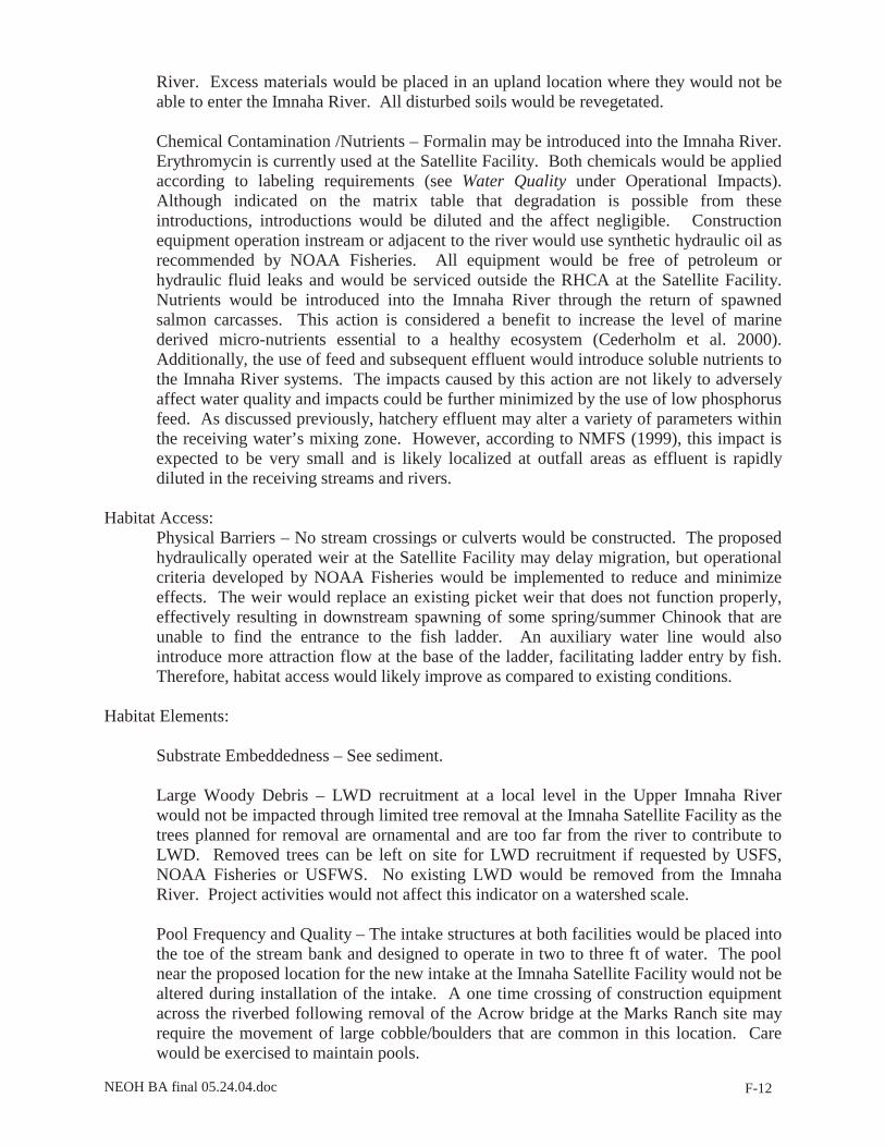
Water Quality: Temperature Avg max summer – The mainstem Imnaha River, from Summit Creek to the North/South Fork confluence, violates Oregon state temperature standards for bull trout and is on the Oregon Department of Environmental Quality’s 303d list (Bryson et al. 2001). Ambient water temperature within the Imnaha River would not be altered by this project. Reduced Imnaha River flow within the diversion reach at the Satellite Facility is not expected to increase temperatures due to relatively short diversion distance and the good vegetative canopy within the diversion reach where the summer diversion would occur. No streamside tree removal at the Satellite Facility would occur within RHCA. Disturbed soils would be revegetated with native species. Sediment – Disturbed stream banks would be armored with riprap or cobbles and revegetated with willow fascines to minimize erosion potential and protect structures. All work within the stream channel would be conducted behind cofferdams to minimize sediment introduction into the Imnaha River and any construction impacts would be short-term, requiring one instream work window. Access roads would be constructed to minimize sediment delivery to the river. Excess materials would be placed in an upland location where they would not be able to enter the Imnaha River. All disturbed soils would be revegetated. Chemical Contamination /Nutrients – Formalin may be introduced into the Imnaha River. Erythromycin is currently used to inoculate both fish released above the Satellite weir and those taken for broodstock. Both chemicals would be applied according to regulatory requirements (see Water Quality). Although indicated on the matrix table that degradation is possible from these introductions, discharged chemicals would be diluted in compliance with regulatory standards and the effect negligible. Equipment operation instream or adjacent to the river would use synthetic hydraulic oil as recommended by NOAA Fisheries. All equipment would be free of petroleum or hydraulic fluid leaks and would be serviced outside the riparian zone and the RHCA at the Satellite Facility. Nutrients would be introduced into the Imnaha River through the return of spawned salmon carcasses. This action is considered a benefit to increase the level of marine derived micro-nutrients essential to a healthy ecosystem (Cederholm et al. 2000). The use of feed and subsequent effluent would introduce soluble nutrients into the Imnaha River at the Satellite Facility. The impacts caused by this action are not likely to adversely affect water quality, and impacts could be further minimized by the use of low phosphorus feed. As discussed in the main text (Table 4.2-23), hatchery effluent may alter a variety of parameters within the receiving water’s mixing zone. According to NMFS (1999), the impact that effluent has on receiving waters is expected to be very small and is likely localized at outfall areas as effluent is rapidly diluted in the receiving streams and rivers.
Habitat Access:
Physical Barriers – No stream crossings or culverts would be constructed. The proposed weir at the Satellite Facility may delay migration, but operational criteria developed by NOAA Fisheries would be implemented to reduce and minimize effects. The weir and new ladder would replace an existing picket weir and ladder that do not function effectively and therefore habitat access and passage would likely improve.

NEOH BA final 05.24.04.doc E-14
Habitat Elements: Substrate Embeddedness – See sediment.
Large Woody Debris – LWD recruitment at a local level in the Upper Imnaha River would not be impacted through the limited tree removal at the Imnaha Satellite Facility, as trees planned for removal are be too far from the river to contribute to LWD. Removed trees can be left on site for LWD recruitment if requested by USFS, NOAA Fisheries or USFWS. No existing LWD would be removed from the Imnaha River. Project activities would not affect this indicator on a watershed scale.
Pool Frequency and Quality – The intake structure would be placed into the toe of the stream bank and designed to operate in two to three ft depth of water. The existing pool near the new intake would not be altered during installation. However, the intake would then be located in this pool habitat, which may impact usage of the pool.
Large Pools – See Pool Frequency above. Off-channel habitat – Disturbance of off-channel habitat would not occur. Refugia – Refugia would not be disturbed by project actions. Channel Conditions and Dynamics:
Avg. Wetted width/Max. Depth Ratio – Water diversion would seasonally change the wetted width/maximum depth ratio in the diversion reaches below intake structures. Cross-sectional data was not available for the existing Imnaha Satellite Facility. However, channel characteristics, including gradients, substrate and widths are similar to cross sectional data available at the Marks Ranch site, downstream from the Satellite Facility. Based on these characteristics and similar mean monthly flows, it is anticipated that the additional 11.3 cfs withdrawal (total of 20.3 cfs withdrawal, plus 6 cfs for return pipe usage) would not affect seasonal bull trout habitat. Average monthly streamflows (Table 3.2-2) are high enough that withdrawals in the 1,000 ft diversion reach would not substantially alter WUA for bull trout.
Streambank condition – Streambank conditions would change at the following locations: new intake, abutments for the weir, and auxiliary water supply line. Banks would be stabilized via riprap to prevent erosion and sedimentation to the Imnaha River. Streambank change is not expected to be extensive enough to affect this indicator on a watershed basis.
Floodplain connectivity – No change in connectivity would occur from project actions. No culverts, fords or stream crossings would be constructed. Linkages between wetlands, riparian areas and the Imnaha River would be maintained.
Flow/Hydrology:
Change in Peak/Base Flows – No effect would occur due to the minimal change in forest disturbance and road density.
Increase in Drainage Network –No new road construction would occur at the Imnaha Satellite Facility. No effect on the in-drainage network is expected to occur. The minor

NEOH BA final 05.24.04.doc E-15
addition of impervious surfaces is not anticipated to affect this parameter on a watershed scale.
Watershed Conditions: Road Density and Location - Within the RHCA at the Satellite Facility, existing gravel access roads would be used for construction. Road density would remain under the criteria of 2mi/mi2 thereby maintaining watershed conditions.
Disturbance History – Timber removal that could affect the Equivalent Clearcut Area would not occur.
Riparian Conservation Areas – Project actions are expected to have minimal impact on LWD recruitment and shade and are therefore expected to have little effect on riparian conservation areas at the Imnaha Satellite. As discussed previously, trees removed on site could be left for LWD recruitment if so stipulated.
Disturbance Regime – Project actions are not expected to increase the potential for landslides, scour or flooding.
Integration of Species and Habitat Conditions – Actions do not occur at a scale across the watershed (or subwatershed) that would affect the bull trout continued existence and connectivity to the Columbia River DPS populations.

NEOH BA final 05.24.04.doc F-1
APPENDIX F
Chinook NOAA Fisheries Matrix of Pathways

NEOH BA final 05.24.04.doc F-2
Table F-1. Matrix of diagnostics/pathways and indicators for spring/summer Chinook at Lookingglass Creek (NMFS 1996a; USFWS 1998; Wallowa County and NPT 1993; Bjornn and Reiser 1991; BLM 1993)
POPULATION AND ENVIRONMENTAL BASELINE
EFFECTS OF THE ACTION
DIAGNOSTICS/ PATHWAYS
INDICATORS
Properly Functioning
Criteria
Present condition Functionality (F/FR/FU)*
Restore
Maintain
Degrade
Water Quality: Temperature Avg Max Summer
40 - 57°F for spawning and incubation1
>70°F during July/August6, 7; on 303d list for temperature2
FU4 X
Sediment <12% fines On 303d list for sediment2, 3, 4
FR X
Chemical Contamination/Nutrients
Low Excess Nutrient Loading3, 6
FR X
Habitat Access: Physical Barriers
<1 barrier Fish ladders and intakes restrict passage at hatchery; on 303d list for habitat modifications2
FR4 X
Habitat Elements: Substrate Embeddedness % clean substrate
<20%1, 2
Excess fine sediment6 FR3 X
Large Woody Debris 10-20 pieces/100 linear ft1
Lack of LWD and riparian veg6
FR3 X
Pool Frequency Channel width #pools/mi 5 ft = 184 10’ = 96 15’ = 70 20’ = 56 25’ = 47 50’ = 26 75’ = 23
FR3 X
Pool Quality >1m deep with good cover
Pools lacking6 FU3 X
Large Pools Each reach has many large pools (>1m deep)
X
Off-channel Habitat Many backwaters with cover
FR4 X
Refugia Sufficient FR4 X Channel Conditions and Dynamics: Avg. Wetted Width/Max. Depth Ratio
<10 FR3 X
Streambank Condition >90% stable FR3 X Floodplain Connectivity Frequent FR4 X Flow/Hydrology: Disturbance History/ Change in Peak/Base Flows
<15% ECA FR3 X
Increase in Drainage Network
Zero or minimum increase in drainage network
FR4 X
Watershed Conditions: Road Density & Location
<2mi/mi2; no valley bottom roads
FR3 X X
Riparian Reserves Riparian corridor at least 80%intact; composed of 50% endemics
FR3 X
Integration of Species and Habitat Conditions
X

NEOH BA final 05.24.04.doc F-3
* F = Functioning appropriately, FR = Functioning at risk, FU = Functioning at unacceptable risk 1 USFWS 1998 2 Nowak and Eddy 2001 3 Upper Grande Ronde BA (USFS 1994) 4 BPA 1998 5 R. Zollman, NPT, pers comm., October 16, 2002 6 Wallowa County – NPT 1993, Revised 1999 7 B. Lund, Lookingglass Hatchery Manager, pers comm., October 2, 2002

NEOH BA final 05.24.04.doc F-4
Table F-2. Matrix of diagnostics/pathways and indicators for spring/summer Chinook at the Lostine River (NMFS 1996; USFWS 1998; Wallowa County and NPT 1993; Bjornn and Reiser 1991; BLM 1993)
POPULATION AND ENVIRONMENTAL BASELINE EFFECTS OF THE ACTION
DIAGNOSTICS/ PATHWAYS
INDICATORS
Properly Functioning
Criteria
Present condition
Functionality (F/FR/FU)*
Restore
Maintain
Degrade
Water Quality: Temperature Avg Max Summer
40-57°F for spawning and incubation1
55.1°F during August7; migratory temps ok; spawning occurs upstream; low winter temps
F4 X
Sediment <12% fines On 303d list for sediment2
F2 X
Chemical Contamination/Nutrients
Low Low levels of contamination
F X X
Habitat Access: Physical Barriers
Human made barriers do not restrict passage
On 303d list for habitat modifications2
FR4 X8
X8
Habitat Elements: Substrate Embeddedness % clean substrate
Embeddedness <20%; mostly gravel and cobble
F3 X
Large Woody Debris >20 pieces/mi >35ft long >12” diameter
F3 X
Pool Frequency Channel width #pools/mi 5 ft = 184 10’ = 96 15’ = 70 20’ = 56 25’ = 47 50’ = 26 75’ = 23
F3 X
Pool Quality >1m deep with good cover
F4 X
Large Pools Each reach has many large pools (>1m deep)
F4 X
Off-channel Habitat Numerous ponds and backwaters with cover
FR4 X
Refugia Sufficient in size and number to maintain pop.
FR4 X
Channel Conditions and Dynamics: Avg. Wetted Width/Max. Depth Ratio
<10 F3 X
Streambank Condition >90% stable or >80% of reach has = 90%
F3 X
Floodplain Connectivity Frequent with overbank
FR4 X
Flow/Hydrology: Disturbance History/ Change in Peak/Base Flows
<15% ECA On 303d list for flow modification2
FU3 X
Increase in Drainage Network
Zero or minimum increase in drainage network
FR4 X
Watershed Conditions: Road Density & Location
<2mi/mi2; no valley bottom roads
F3 X
Riparian Reserves Riparian corridor at least 80%intact; composed of 50% endemics
F3 X
Integration of Species and Habitat Conditions
X
* F = Functioning appropriately, FR = Functioning at risk, FU = Functioning at unacceptable risk 1 USFWS 1998 2 Nowak and Eddy 2001

NEOH BA final 05.24.04.doc F-5
3 Upper Grande Ronde BA (USFS 1994); Lostine River Watershed BA (USFS 1994b) 4 BPA 1998 5 P. Sankovich, ODFW, pers comm., 10/1/02 6 Wallowa County – NPT 1993, Revised 1999 7 MWH 2001 8Passage at the Lostine Adult Collection Facility location will likely improve; however, an additional instream structure may degrade this factor at the Lostine River Hatchery fish ladder location
Effects on Spring/Summer Chinook Population and Habitat Indicators Lostine River Facilities and Lookingglass Hatchery Subpopulation Characteristics:
Subpopulation Size – Project actions are intended to prevent further population decline of Lookingglass Creek and Lostine River spring/summer Chinook, and to eventually recover the natural population. The goal of this project is to achieve a self-sustaining population that would meet or exceed NOAA Fisheries delisting criteria while maintaining the genetic characteristics of the population. Growth and Survival – Project actions are intended to increase survival in the egg to smolt life stage through artificial propagation. Habitat effects from project actions are not expected to be detrimental to natural production of spring/summer Chinook. Life History Diversity/Isolation – Population characteristics would be maintained through application of conditions of the Grande Ronde spring Chinook HGMP (Nowak and Eddy 2001) and implementation of the Monitoring and Evaluation Plan (Appendix D of Ashe et al. 2000; Hesse and Harbeck 2004). Persistence and Genetic Integrity Subpopulation – The project would monitor actions to ensure that the population persists. Broodstock collection and spawning protocols have been developed to maintain the genetic integrity of Grande Ronde subbasin spring/summer Chinook (Ashe et al. 2000; Nowak and Eddy 2001). As a population, spring/summer-run Chinook of the Snake River generally exhibit low levels of genetic variation (Winans 1989).
Water Quality:
Temperature avg max summer – Ambient water temperature within the Lostine River and Lookingglass Creek would not be altered by this project. Diverted water from the streams may be exposed to solar thermal gain through storage in the raceways, but would pass through the facility under constant flow. Reduced Lostine River flow within the diversion reach at the Lostine River Hatchery is not expected to increase temperatures. Potential temperature increases may be reduced by implementing minimum flow strategies for hatchery requirements. The use of chillers and well-water at the Lostine River Hatchery could potentially decrease temperatures in the immediate vicinity of the discharge, however, the water would rapidly mix with river water and the impact would be negligible.
Sediment – Disturbed stream banks would be armored with riprap or cobbles and revegetated with willow fascines to minimize erosion potential and protect structures. With the exception of cobble placement downstream of the weir, all work within the stream channel would be conducted behind cofferdams to minimize sediment introduction into the Lostine River and any construction impacts would be short-term.

NEOH BA final 05.24.04.doc F-6
Roads would be constructed to minimize sediment delivery to the Lostine River. Excess materials would be placed in an upland location where they would not be able to enter the Lostine River or Lookingglass Creek. All disturbed soils would be revegetated. Chemical Contamination /Nutrients – No change in chemical discharge to Lookingglass Creek would occur as a result of activities. Two chemicals, formalin and erythromycin, would be introduced into the Lostine River through this project. Both chemicals would be applied according to labeling requirements (see Water Quality). Although indicated on the matrix table that degradation is possible from these introductions, introductions would be diluted according to regulatory standards and the effect negligible. Equipment operation instream or adjacent to the river would use synthetic hydraulic oil as recommended by NOAA Fisheries. All equipment would be free of petroleum or hydraulic fluid leaks and would be serviced outside the riparian zone. Nutrients would be introduced into the Lostine River through the return of spawned salmon carcasses. This action is considered a benefit to increase the level of marine derived micro-nutrients essential to a healthy ecosystem (Cederholm et al. 2000). Additionally, the use of feed and subsequent effluent would introduce soluble nutrients to the Lostine River systems. The impacts caused by this action are not likely to adversely affect water quality and impacts could be further minimized by the use of low phosphorus feed. As shown in Table E-2, measured values for several parameters in the Lostine River, including alkalinity, ammonia, BOD, nitrogen, oxygen, pH, phosphates, solids, temperature, and turbidity are rated as “A” under the ODEQ rating system (ODEQ 1991). An “A’ rating indicates that sampled parameter measurements are within the standards of ODEQ criteria. Estimated hatchery effluent at the Lostine River Hatchery, shown in Table 4.2-20, would not adversely impact these parameters. Additionally, according to NMFS (1999), any impact is expected to be very small and is likely localized at outfall areas as effluent is rapidly diluted in the receiving streams and rivers.
Habitat Access:
Physical Barriers – No stream crossings or culverts would be constructed. However, passage may be delayed due to the development of a new instream weir at the Lostine River Hatchery. Additionally, the Lostine Adult Collection Facility’s flow velocity barrier may delay migration, but operational criteria developed by NOAA Fisheries would be implemented to reduce and minimize effects. Chinook passage would likely be improved at the Lostine Adult Collection Facility as compared to existing passage through outdated ladders and weir structures. No additional instream structures would be installed at the Lookingglass Hatchery location.
Habitat Elements: Substrate Embeddedness – See sediment.
Large Woody Debris – LWD recruitment at a local level in the Lostine River would be impacted through the limited streamside tree removal at both Lostine facilities. Removed trees can be left on site for LWD recruitment if requested by USFS, NOAA Fisheries or USFWS. No existing LWD would be removed from the Lostine River. Project activities would not affect this indicator on a watershed scale.
Pool Frequency and Quality – The Lostine River Hatchery intake structure would be placed into the toe of the stream bank and designed to operate in one ft depth of water.
NEOH BA final 05.24.04.doc F-7
Installation of the intake at the Lostine Hatchery location may require the movement of large cobble/boulders that are common in this river segment. Care would be exercised to maintain pools and replace boulders to their original locations, if possible.
Large Pools – See Pool Frequency above.
Off-channel habitat – A side channel located streamside of the proposed Lostine River Hatchery would be riprapped for facility flood protection. Construction of the floodproofing levee at the Adult Collection Facility would isolate small side channels returning to the Lostine in this area. Wetlands would no longer have a connection to the river, however, they are likely spring fed. Construction of the levee and associated access roads would disturb wetlands. French drains would convey river and on-site spring water to the Lostine River, but a small amount of juvenile Chinook habitat (~600 square feet of seasonal, intermittent spring fed channels) would be lost.
Refugia – Refugia would not be disturbed by project actions. Channel Conditions and Dynamics:
Avg. Wetted width/Max. Depth Ratio – As previously discussed, this indicator would be affected by the seasonal water diversion at the two locations. Water diversion would seasonally change the wetted width/maximum depth ratio in the diversion reaches below intake structures. Cross-sectional data, predicted by a recent IFIM study, indicated the change would be minimal (R2 Resources 2002). Wetted width/depth ratios would not be affected on watershed scale. Wetted width/depth ratios can be used to predict the WUA for a particular species. Table F-3 shows the pre and post diversion (residual flow during diversion) WUA for spawning adult and juvenile spring/summer Chinook according to the IFIM study (R2 Resources 2002). The improved WUA levels for juveniles are likely due to the fact that emerging fish and young fry prefer shallower waters and lower velocities, as predicted through the IFIM analysis. Additionally, because the effluent pumpback system will be employed to maintain a minimum instream flow of 12 cfs, within which Chinook can successfully migrate and spawn, the proposed withdrawals are not anticipated to impact individuals. No change in channel conditions would occur as a result of modifications at Lookingglass Hatchery. As previously discussed, habitat loss over a short distance at the Lostine Adult Collection Facility would occur during periods of low flow when all river water in excess of that required for irrigation is diverted through the proposed fish ladder.

NEOH BA final 05.24.04.doc F-8
Table F-3. Change in Weighted Usable Area – Lostine River Hatchery for spawning adult and juvenile spring/summer Chinook.
Pre-diversion
mean monthly
flow (cfs)
Approximate WUA
Pre-diversion (%)
Predicted diversion
(cfs) using normal
flow index
Post-diversion flow (cfs) (residual
flow during diversion)
Approximate WUA Post-
diversion (%)
Adult June 787.8 NA1 2.8 785.0 NA1 July 383.3 50 17.8 365.5 80 August 86.2 98 17.8 68.4 60 September 50.2 84 17.8 32.4 28 Juveniles June 787.8 NA1 2.8 785.0 NA1 July 383.3 48 17.8 365.5 27 August 86.2 90 17.8 68.4 81 September 50.2 100 17.8 32.4 97
1IFIM study predicted WUA only from 5 cfs to 400 cfs Streambank condition – At the proposed Lostine Adult Collection Facility, streambank conditions would change due to the following components: new fish ladder, improved bridge and abutments, and the floodproofing levee. At the proposed Lostine River Hatchery, streambank conditions would be altered at the intake and outfall locations, and the fish ladder location due to placement of riprap or cobbles. Although bank stabilization at the north well location is being completed under a separate project, on-going maintenance of this area may be necessary. Banks would be stabilized to prevent erosion and sedimentation into the Lostine River and to protect structures. Streambank change is not expected to be extensive enough to affect this indicator on a watershed basis. No streambank alterations would occur at the Lookingglass Hatchery.
Floodplain connectivity – No culverts, fords or stream crossings would be constructed. The new bridge at the Lostine Adult Collection Facility would replace an existing bridge. New bridge abutments would be re-located out of the floodway, above the OHWM. Although the proposed levee would prevent flooding, there would be a loss of connection with wetlands and side channels. These losses are not expected to impact Chinook habitat on a watershed scale. The side channel that is proposed to be riprapped at the Lostine River Hatchery is not likely to impact wetland or riparian linkages as the area adjacent to the side channel contains upland vegetation.
Flow/Hydrology:
Change in Peak/Base Flows – No effect would occur due to the minimal change in forest disturbance and road density.
Increase in Drainage Network – No effect would occur due to the limited amount of roads constructed for the project. The addition of impervious surfaces is not anticipated to affect this parameter on a watershed scale.

NEOH BA final 05.24.04.doc F-9
Watershed Conditions: Road Density and Location – Although the Lostine facilities and Lookingglass Hatchery are not located on USFS land, proposed access roads would not result in road densities that exceed the criteria of 2 mi of roads per square mi of land.
Disturbance History – Timber removal that could affect the Equivalent Clearcut Area (ECA) would not occur.
Riparian Resource Areas – Project actions are expected to have minimal impact on large wooded debris recruitment and shade and are therefore expected to have little effect on riparian corridors.
Disturbance Regime – Project actions are not expected to increase the potential for landslides, scour or flooding.
Integration of Species and Habitat Conditions – The intent of project actions is to recover the Lostine River spring/summer Chinook population through supplementation/recovery activities. Project actions are not expected to affect habitat conditions within the watershed (or subwatershed) to an extent that would affect the continued existence of the Lostine River spring/summer Chinook population. Monitoring and evaluation is proposed (Hesse and Harbeck 2004) to determine the effectiveness of the project, and detect any negative effects that may occur and modify project action to minimize or eliminate those effects.

NEOH BA final 05.24.04.doc F-10
Table F-4. Matrix of diagnostics/pathways and indicators for spring/summer Chinook for the Upper Imnaha River - Section 7 Watershed (USFWS 1998; NMFS 1996a; Imnaha Subbasin Summary, reproduced from the USDA Forest Service 1998a)**
POPULATION AND ENVIRONMENTAL BASELINE EFFECTS OF THE ACTION DIAGNOSTICS/ PATHWAYS
INDICATORS
Properly Functioning
Criteria
Present condition Functionality (F/FR/FU)*
Restore
Maintain
Degrade
Water Quality: Temperature Avg Max Summer
< 50-57 deg F. >63°F during July/August5
(Ashe et al. 2000 = 71.8°F)
FU2 X
Sediment <20% Excess erosion and fine sediments may be a problem, but properly func.4
F2 X
Chemical Contamination/Nutrients
Low Potential herbicide and pesticide input, but properly functioning4
F2 X X
Habitat Access: Physical Barriers
<1 barrier Fish ladders and intakes restrict passage at site; but no known manmade barriers on USFS land2
F2 X6
Habitat Elements: Substrate Embeddedness % clean substrate
Embeddedness <20%; mostly gravel and cobble
Gravels and cobbles stable2
FR2 X
Large Woody Debris >20 pieces/mi >35ft long >12” diameter
At natural potential even though does not have >20 pieces/mi
F2 X
Pool Frequency Depends on width; 26-184 pools per mi
Does not meet PACFISH and NMFS matrix due to stream survey methodology – does not measure pools less than full width in size
FU2 X
Pool Quality >1m deep with good cover
Pools are Rosgen B and C channel types – plunge and step pools
F2 X
Large Pools > 3m deep2 F2 X Off-channel Habitat Backwaters
Many - few Properly functioning throughout except where channel modified
F2 X
Refugia Sufficient in size and number to maintain pop.
Properly functioning throughout except where channel modified
F2 X
Channel Conditions and Dynamics: Avg. Wetted Width/Max. Depth Ratio
>10 Properly functioning throughout except where channel modified
F2 X
Streambank Condition >90% stable or >80% of reach has = 90%
Bank form has deteriorated in some areas4
F2 & FR4 X
Floodplain Connectivity Frequent with overbank to maintain wetlands
Properly functioning except where scoured during 1997 flood
F2 X
Flow/Hydrology: Disturbance History/ Change in Peak/Base Flows
Hydrographs comparable to undisturbed watershed
Irrigation diversion and icing may impact2
FR X
Increase in Drainage Network
Zero or minimum increase in drainage network
F2 X
Watershed Conditions: Road Density & Location
<2mi/mi2; no valley bottom roads
1.52mi/mi2; however, roads may contribute to increased sediment2
F2 X
Riparian Reserves/ Riparian Conservation Areas (Satellite only)
Riparian corridor at least 80%intact; composed of 50% endemics
Riparian vegetation lacking - trees have died (spruce) 4
FR4 X
Disturbance Regime (haz/risk rating)
<15% ECA with no disturbance
F X
Integration of Species and Habitat Conditions
X

NEOH BA final 05.24.04.doc F-11
* F = Functioning appropriately, FR = Functioning at risk, FU = Functioning at unacceptable risk ** Overall, the upper Imnaha River is properly functioning, however, segments within private lands are at risk (NPT 2001). 1 USFWS 1998 2 Imnaha Subbasin Summary 3 R. Zollman, NPT, and G. Sausen, USFS, pers comms., 10/16/02 4 Wallowa County – NPT 1993, Revised 1999 5 MWH 2001 6 Improvements at the Satellite weir would likely improve passage
Imnaha River Facilities Subpopulation Characteristics:
Subpopulation Size – Project actions are intended to prevent further population decline of Imnaha River spring/summer Chinook, and to eventually recover the natural population. The goal of the NEOH project is to achieve a self-sustaining population that would meet, or exceed, NOAA Fisheries delisting criteria while maintaining the genetic characteristics of the population. Growth and Survival – Project actions are intended to increase survival in the egg to smolt life stage through artificial propagation. Habitat effects from project actions are not expected to be detrimental to natural production of spring/summer Chinook. Life History Diversity/Isolation – Population characteristics would be maintained through application of conditions of the Imnaha Subbasin HGMP (NPT 2001) and implementation of the Monitoring and Evaluation Plan (Appendix D of Ashe et al. 2000; Hesse and Harbeck 2004). Persistence and Genetic Integrity Subpopulation – The project would monitor actions to ensure that the population persists. Broodstock collection and spawning protocols have been developed to maintain the genetic integrity of Imnaha River spring/summer Chinook (Ashe et al. 2000; NPT 2001).
Water Quality:
Temperature Avg max summer – Ambient water temperature within the Imnaha River would not be altered by this project. Diverted water from the Imnaha River may be exposed to solar thermal gain through storage, but would pass through the facility under constant flow. Reduced flow within the diversion reach at the Imnaha Satellite Facility is not expected to increase temperatures due to ample surface water flows and good shading vegetation within the diversion reach where the summer diversion would occur. Potential temperature increases may be reduced by implementing minimum flow strategies for facility requirements. The use of well-water at the Imnaha Satellite Facility could potentially alter temperatures in the immediate vicinity of the discharge, however, the proposed 100 gpm of use is negligible and the discharge would rapidly mix with river water. The Imnaha Satellite Facility is within the boundaries of the WWNF. Limited tree removal would occur within the RHCA. Disturbed soils would be revegetated with native species. Sediment – Disturbed stream banks would be armored with riprap or cobbles and revegetated with willow fascines to minimize erosions potential and protect structures. All work within the stream channel would be conducted behind cofferdams to minimize sediment introduction into the Imnaha River and any construction impacts would be short-term. Roads would be constructed to minimize sediment delivery to the Imnaha
NEOH BA final 05.24.04.doc F-12
River. Excess materials would be placed in an upland location where they would not be able to enter the Imnaha River. All disturbed soils would be revegetated. Chemical Contamination /Nutrients – Formalin may be introduced into the Imnaha River. Erythromycin is currently used at the Satellite Facility. Both chemicals would be applied according to labeling requirements (see Water Quality under Operational Impacts). Although indicated on the matrix table that degradation is possible from these introductions, introductions would be diluted and the affect negligible. Construction equipment operation instream or adjacent to the river would use synthetic hydraulic oil as recommended by NOAA Fisheries. All equipment would be free of petroleum or hydraulic fluid leaks and would be serviced outside the RHCA at the Satellite Facility. Nutrients would be introduced into the Imnaha River through the return of spawned salmon carcasses. This action is considered a benefit to increase the level of marine derived micro-nutrients essential to a healthy ecosystem (Cederholm et al. 2000). Additionally, the use of feed and subsequent effluent would introduce soluble nutrients to the Imnaha River systems. The impacts caused by this action are not likely to adversely affect water quality and impacts could be further minimized by the use of low phosphorus feed. As discussed previously, hatchery effluent may alter a variety of parameters within the receiving water’s mixing zone. However, according to NMFS (1999), this impact is expected to be very small and is likely localized at outfall areas as effluent is rapidly diluted in the receiving streams and rivers.
Habitat Access:
Physical Barriers – No stream crossings or culverts would be constructed. The proposed hydraulically operated weir at the Satellite Facility may delay migration, but operational criteria developed by NOAA Fisheries would be implemented to reduce and minimize effects. The weir would replace an existing picket weir that does not function properly, effectively resulting in downstream spawning of some spring/summer Chinook that are unable to find the entrance to the fish ladder. An auxiliary water line would also introduce more attraction flow at the base of the ladder, facilitating ladder entry by fish. Therefore, habitat access would likely improve as compared to existing conditions.
Habitat Elements:
Substrate Embeddedness – See sediment.
Large Woody Debris – LWD recruitment at a local level in the Upper Imnaha River would not be impacted through limited tree removal at the Imnaha Satellite Facility as the trees planned for removal are ornamental and are too far from the river to contribute to LWD. Removed trees can be left on site for LWD recruitment if requested by USFS, NOAA Fisheries or USFWS. No existing LWD would be removed from the Imnaha River. Project activities would not affect this indicator on a watershed scale. Pool Frequency and Quality – The intake structures at both facilities would be placed into the toe of the stream bank and designed to operate in two to three ft of water. The pool near the proposed location for the new intake at the Imnaha Satellite Facility would not be altered during installation of the intake. A one time crossing of construction equipment across the riverbed following removal of the Acrow bridge at the Marks Ranch site may require the movement of large cobble/boulders that are common in this location. Care would be exercised to maintain pools.

NEOH BA final 05.24.04.doc F-13
Large Pools – See Pool Frequency above. Off-channel habitat – Disturbance to off-channel habitat would not occur. Refugia – Refugia would not be disturbed by project actions. Channel Conditions and Dynamics:
Avg. Wetted width/Max. Depth Ratio - Although there is no cross-sectional data for the Imnaha Satellite facility, water diversions are not anticipated to reduce the instream flow to less than 67 cfs, based on historic mean monthly flow data. Rick Zollman (NPT, pers comm., 1/2/03) has observed successful spring/summer Chinook spawning at 30 cfs within the Imnaha and therefore, it is anticipated that diversions would not impact spring/summer Chinook spawning or migration during the average flow year. Streambank condition – At the Satellite Facility, streambank conditions would change due to the following components: new intake structure, abutments for the weir, and the addition of the auxiliary water line and associated diffuser. Banks would be stabilized to prevent erosion and sedimentation to the Imnaha River. Streambank change is not expected to be extensive enough to affect this indicator on a watershed basis.
Floodplain connectivity – No change in connectivity would occur from project actions. No culverts, fords or stream crossings would be constructed. Linkages between wetlands, riparian areas and the Imnaha River would be maintained.
Flow/Hydrology:
Change in Peak/Base Flows – No effect would occur due to the minimal change in forest disturbance and road density.
Increase in Drainage Network – No new roads would be required at the Imnaha Satellite Facility. Therefore, no effect on the in-drainage network is anticipated. The addition of impervious surfaces is not anticipated to affect this parameter on a watershed scale.
Watershed Conditions: Road Density and Location - Within the RHCA at the Satellite Facility no new access roads would be constructed. Road density would remain under the criteria of 2mi/mi2 thereby maintaining watershed conditions.
Disturbance History – Timber removal that could affect the Equivalent Clearcut Area would not occur.
Riparian Conservation Areas – Project actions are expected to have minimal impact on LWD recruitment and shade and are therefore expected to have little effect on riparian conservation areas at the Imnaha Satellite Facility. As discussed previously, trees removed on site could be left for LWD recruitment if so stipulated.
Disturbance Regime – Project actions are not expected to increase the potential for landslides, scour or flooding.
Integration of Species and Habitat Conditions – The intent of project actions is to recover the Imnaha River spring/summer Chinook population through supplementation/recovery

NEOH BA final 05.24.04.doc F-14
activities. Project actions are not expected to affect habitat conditions within the watershed (or subwatershed) that would affect the continued existence of the Imnaha River spring/summer Chinook population. Monitoring and evaluation would be conducted to determine the effectiveness of the project (Hesse and Harbeck 2004), and detect any negative effects that may occur and modify project action to minimize or eliminate those effects. One potential negative impact of hatchery releases on natural populations is the addition of high percentages of jacks to the river system. Hatcheries have been shown to produce 20% more jacks than occur naturally in the Imnaha River populations (Hoffnagle et al. 2002). Methods to reduce the number of jacks produced at hatcheries include limiting fast growth, which has been shown to increase jack production (Hoffnagle et al. 2002).
NEOH BA final 05.24.04.doc G-1
Appendix G
Steelhead NOAA Fisheries Matrix of Pathways

NEOH BA final 05.24.04.doc G-2
Table G-1. Matrix of diagnostics/pathways and indicators for steelhead at Lookingglass Creek (NMFS 1996; USFWS 1998; Wallowa County and NPT 1993; Bjornn and Reiser 1991; BLM 1993)
POPULATION AND ENVIRONMENTAL BASELINE EFFECTS OF THE ACTION DIAGNOSTICS/ PATHWAYS
INDICATORS
Properly Functioning
Criteria
Present condition Functionality (F/FR/FU)*
Restore
Maintain
Degrade
Water Quality: Temperature Avg Max Summer
40 - 57°F for spawning and incubation1
>70°F during July/August6, 7; on 303d list for temperature2
FU4 X
Sediment <12% fines On 303d list for sediment2, 3, 4
FR X
Chemical Contamination/Nutrients
Low Excess Nutrient Loading3, 6
FR X
Habitat Access: Physical Barriers
<1 barrier Fish ladders and intakes restrict passage at hatchery; on 303d list for habitat modifications2
FR4 X
Habitat Elements: Substrate Embeddedness % clean substrate
<20%1, 2
Excess fine sediment6 FR3 X
Large Woody Debris 10-20 pieces/100 lin ft1
Lack of LWD and riparian veg6
FR3 X
Pool Frequency Channel width #pools/mi 5 ft = 184 10’ = 96 15’ = 70 20’ = 56 25’ = 47 50’ = 26 75’ = 23
FR3 X
Pool Quality >1m deep with good cover
Pools lacking6 FU3 X
Large Pools Each reach has many large pools (>1m deep)
X
Off-channel Habitat Many backwaters with cover
FR4 X
Refugia Sufficient FR4 X Channel Conditions and Dynamics: Avg. Wetted Width/Max. Depth Ratio
<10 FR3 X
Streambank Condition >90% stable FR3 X Floodplain Connectivity Frequent FR4 X Flow/Hydrology: Disturbance History/ Change in Peak/Base Flows
<15% ECA FR3 X
Increase in Drainage Network
Zero or minimum increase in drainage network
FR4 X
Watershed Conditions: Road Density & Location
<2mi/mi2; no valley bottom roads
FR3 X
Riparian Reserves Riparian corridor at least 80%intact; composed of 50% endemics
FR3 X
Integration of Species and Habitat Conditions
X
* F = Functioning appropriately, FR = Functioning at risk, FU = Functioning at unacceptable risk 1 USFWS 1998 2 Grande Ronde Subbasin Summary

NEOH BA final 05.24.04.doc G-3
3 Upper Grande Ronde BA (USFS 1994) 4 BPA 1998 5 R. Zollman, NPT, pers comm., 10/16/02 6 Wallowa County – NPT 1993, Revised 1999 7 B. Lund, Lookingglass Hatchery Manager, pers comm., 10/2/02

NEOH BA final 05.24.04.doc G-4
Table G-2. Matrix of diagnostics/pathways and indicators for steelhead at the Lostine River (NMFS 1996; USFWS 1998; Wallowa County and NPT 1993; Bjornn and Reiser 1991; BLM 1993)
POPULATION AND ENVIRONMENTAL BASELINE EFFECTS OF THE ACTION DIAGNOSTICS/ PATHWAYS
INDICATORS
Properly Functioning
Criteria
Present condition Functionality (F/FR/FU)*
Restore
Maintain
Degrade
Water Quality: Temperature Avg Max Summer
40-57°F for spawning and incubation1
55.1°F during August7; migratory temps ok; spawning occurs upstream; low winter temps
F4 X
Sediment <12% fines On 303d list for sediment2
F2 X
Chemical Contamination/Nutrients
Low Low levels of contamination
F X X
Habitat Access: Physical Barriers
Human made barriers do not restrict passage
On 303d list for habitat modifications2
FR4 X8
X
X8
Habitat Elements: Substrate Embeddedness % clean substrate
Embeddedness <20%; mostly gravel and cobble
F3 X
Large Woody Debris >20 pieces/mi >35ft long >12” diameter
F3 X
Pool Frequency Channel width #pools/mi 5 ft = 184 10’ = 96 15’ = 70 20’ = 56 25’ = 47 50’ = 26 75’ = 23
F3 X
Pool Quality >1m deep with good cover
F4 X
Large Pools Each reach has many large pools (>1m deep)
F4 X
Off-channel Habitat Numerous ponds and backwaters with cover
FR4 X
Refugia Sufficient in size and number to maintain pop.
FR4 X
Channel Conditions and Dynamics: Avg. Wetted Width/Max. Depth Ratio
<10 F3 X
Streambank Condition >90% stable or >80% of reach has = 90%
F3 X
Floodplain Connectivity Frequent with overbank
FR4 X
Flow/Hydrology: Disturbance History/ Change in Peak/Base Flows
<15% ECA On 303d list for flow modification2
FU3 X
Increase in Drainage Network
Zero or minimum increase in drainage network
FR4 X
Watershed Conditions: Road Density & Location
<2mi/mi2; no valley bottom roads
F3 X
Riparian Reserves Riparian corridor at least 80%intact; composed of 50% endemics
F3 X
Integration of Species and Habitat Conditions
X
* F = Functioning appropriately, FR = Functioning at risk, FU = Functioning at unacceptable risk

NEOH BA final 05.24.04.doc G-5
1 USFWS 1998 2 Grande Ronde Subbasin Summary 3 Upper Grande Ronde BA (USFS 1994); Lostine River Watershed BA (USFS 1994b) 4 BPA 1998 5 P. Sankovich, ODFW, pers comm., 10/1/02 6 Wallowa County – NPT 1993, Revised 1999 7 MWH 2001 8Passage at the Lostine Adult Collection Facility location will likely improve; however, an additional instream structure may degrade this factor at the Lostine River Hatchery fish ladder location Effects on Steelhead Population and Habitat Indicators Lostine River Facilities and Lookingglass Hatchery Subpopulation Characteristics:
Subpopulation Size - A seasonal reduction of habitat would occur from the water diversions but not to an extent that would affect the subpopulation. Growth and Survival – No lethal take of steelhead is anticipated through project activities. Instream work would be conducted post spawning. Implementation of sediment control measures would protect eggs and fry downstream of the project sites. Operation of the Lostine River Hatchery fish ladder and the pneumatically-controlled weir would be conducted year-round. The operation of this facility could impact adult migration as well as juvenile and kelt emigration due to low flows. If migration is delayed, the low flow strategy and effluent pumpback would be implemented. Life History Diversity/Isolation – The permanent migratory connection would not be disrupted by this project. Persistence and Genetic Integrity Subpopulation – The project would not impact the existence of the Lostine River or Lookingglass Creek local populations. Project activities would not affect this indicator.
Water Quality: Temperature avg max summer – Ambient water temperature within the Lostine River would not be altered by this project. No new water diversions are proposed at the Lookingglass Hatchery under the proposed action. Diverted water from the streams may be exposed to solar thermal gain through storage, but would pass through the facility under constant flow. Reduced Lostine River flow within the diversion reach at the Lostine River Hatchery is not expected to increase temperatures. In the unlikely event that instream temperatures do increase, the low flow strategy could be used. The use of chillers and well-water at the Lostine River Hatchery could potentially decrease temperatures in the immediate vicinity of the discharge; however, the water would rapidly mix with river water and the impact would be negligible. Sediment – Disturbed stream banks would be armored with riprap or cobbles and revegetated with willow fascines to minimize erosion potential and protect structures. With the exception of the cobbles placed downstream of the weir, all work within the stream channel would be conducted behind cofferdams to minimize sediment

NEOH BA final 05.24.04.doc G-6
introduction into the Lostine River and any construction impacts would be short-term. Roads would be constructed to minimize sediment delivery to the Lostine River. Excess materials would be placed in an upland location where they would not be able to enter the Lostine River or Lookingglass Creek. All disturbed soils would be revegetated. Chemical Contamination /Nutrients – No change in chemical discharge would occur to Lookingglass Creek as a result of activities. Two chemicals, formalin and erythromycin, would be introduced into the Lostine River through this project. Both chemicals would be applied according to labeling requirements (see Water Quality under Operational Impacts section). Although indicated on the matrix table that degradation is possible from these introductions, chemicals would be diluted and the effect negligible in the immediate vicinity of the discharge. Equipment operation instream or adjacent to the river would use synthetic hydraulic oil as recommended by NOAA Fisheries. All equipment would be free of petroleum or hydraulic fluid leaks and would be serviced outside the riparian zone. Nutrients would be introduced into the Lostine River through the return of spawned salmon carcasses. This action is considered a benefit to increase the level of marine derived micro-nutrients essential to a healthy ecosystem (Cederholm et al. 2000). Additionally, the use of feed and subsequent effluent would introduce soluble nutrients to the Lostine River systems. The impacts caused by this action are not likely to adversely affect water quality and impacts could be further minimized by the use of low phosphorus feed. As discussed previously, hatchery effluent may alter a variety of parameters within the receiving water’s mixing zone. However, preliminary analysis (Table 4.2-20) indicates that all discharges will be well-below threshold limits. Additionally, according to NMFS (1999) the impact of effluent is expected to be very small and is likely localized at outfall areas since effluent is rapidly diluted in the receiving streams and rivers.
Habitat Access:
Physical Barriers – No stream crossings or culverts would be constructed. However, passage may be delayed due to the development of a new instream weir at the Lostine River Hatchery. Additionally, the Lostine Adult Collection Facility’s flow velocity barrier may delay migration, but operational criteria developed by NOAA Fisheries would be implemented to reduce and minimize effects. Steelhead passage would likely be improved at the Lostine Adult Collection Facility as compared to existing passage through outdated ladders and weir structures.
Habitat Elements: Substrate Embeddedness – See sediment.
Large Woody Debris – LWD recruitment at a local level in the Lostine River would be impacted through the limited streamside tree removal at both Lostine facilities. Removed trees can be left on site for LWD recruitment if requested by USFS, NMFS or USFWS. No existing LWD would be removed from the Lostine River. Project activities would not affect this indicator on a watershed scale.
Pool Frequency and Quality – The Lostine River intake structure would be placed into the toe of the stream bank and designed to operate in one ft depth of water. Installation of the

NEOH BA final 05.24.04.doc G-7
intake at the Lostine Hatchery location may require the movement of large cobble/boulders that are common in this river segment. Care would be exercised to maintain pools and replace boulders to their original location.
Large Pools – See Pool Frequency above.
Off-channel habitat – A side channel located streamside of the proposed Lostine River Hatchery would be riprapped for facility flood protection. Construction of the floodproofing levee at the Adult Collection Facility would isolate small side channels returning to the Lostine in this area. French drains would convey river and on-site spring water to the Lostine River, but approximately 600 square ft of seasonal, intermittent habitat for juvenile salmonids would be lost.
Refugia – Refugia would not be disturbed by project actions. Channel Conditions and Dynamics:
Avg. Wetted width/Max. Depth Ratio – As previously discussed, this indicator would be affected by the seasonal water diversion at the Lostine locations. Water diversion would seasonally change the wetted width/maximum depth ratio in the diversion reaches below intake structures. Cross-sectional data for the Lostine River Hatchery, predicted by a recent IFIM study indicated the change would be minimal (R2 Resources 2002). Wetted width/depth ratios would not be affected on watershed scale. Wetted width/depth ratios can be used to predict the WUA for a particular species. Table G-3 shows the pre and post diversion (residual flow during diversion) WUA for spawning adult steelhead according to the IFIM study (R2 Resources 2002). The IFIM did not predict WUA for steelhead juveniles or non-spawning adults. No change in channel conditions would occur as a result of upland modifications at Lookingglass Hatchery. As previously discussed, habitat loss over a short distance at the Lostine Adult Collection Facility would occur during periods of low flow when all river water is diverted through the proposed fish ladder. Steelhead can successfully migrate through maintained depths of 0.6 feet. Chinook require 0.8 feet, which can be supplied by 10 cfs of flow. Managers of the Lostine Hatchery would employ the effluent pumpback system to maintain 12 cfs of instream flow, at a minimum. Therefore, steelhead passage is not likely to be impacted by diversions.

NEOH BA final 05.24.04.doc G-8
Table G-3. Change in Weighted Usable Area – Lostine River Hatchery for spawning adult steelhead
Pre-diversion
mean monthly
flow (cfs)
Approximate WUA
Pre-diversion (%)
Predicted diversion
(cfs) using normal flow
strategy
Post-diversion flow (cfs) (residual
flow during diversion)
Approximate WUA Post-
diversion (%)
Month March 55.3 40 15.0 40.3 38 April 161.9 95 7.5 154.4 93 May 512.6 NA1 2.8 509.8 NA1
1IFIM study predicted WUA only from 5 cfs to 400 cfs Streambank condition – At the Lostine Adult Collection Facility, streambank conditions would change due to the following components: new fish ladder, new bridge abutments, and the floodproofing levee. At the proposed Lostine River Hatchery, streambank conditions would be altered at the intake and outfall locations, and the fish ladder location due to placement of riprap or cobbles. Although bank stabilization at the north well location is being completed under a separate project, on-going maintenance of this area may be necessary. Banks would be stabilized to prevent erosion and sedimentation into the Lostine River and to protect structures. Streambank change is not expected to be extensive enough to affect this indicator on a watershed basis. No streambank alterations would occur at the Lookingglass Hatchery.
Floodplain connectivity – No culverts, fords or stream crossings would be constructed. The new bridge at the Lostine Adult Collection Facility would replace an existing bridge. New bridge abutments would be re-located out of the floodway, above the OHWM. Although the proposed levee at the Lostine Adult Collection Facility would prevent flooding, there would be a loss of connection with wetlands and side channels. Side channels are not likely used by steelhead for rearing, so there should be no loss of habitat due to the loss of connection to the river. The side channel that is proposed to be riprapped at the Lostine River Hatchery is not likely to impact wetland or riparian linkages as the area adjacent to the side channel contains upland vegetation.
Flow/Hydrology: Change in Peak/Base Flows – No effect would occur due to the minimal change in forest disturbance and road density.
Increase in Drainage Network – No effect would occur due to the limited amount of roads constructed for the project. The addition of impervious surfaces is not anticipated to affect this parameter on a watershed scale.
Watershed Conditions: Road Density and Location – Access road construction would not affect the road density criteria and watershed conditions would be maintained. The temporary access road at the Lostine Adult Collection Facility would be constructed within 150 ft of the river.

NEOH BA final 05.24.04.doc G-9
According to the NMFS SLOPES Biological Opinion (2002), soil disturbance would be minimized by clearing vegetation to ground level and placing clean gravel over geotextile fabric. The temporary access road would be obliterated, the soil stabilized and the area revegetated.
Disturbance History – Timber removal that could affect the Equivalent Clearcut Area would not occur. Riparian Resource Areas – Project actions are expected to have minimal impact on large wooded debris recruitment and shade and are therefore expected to have little effect on riparian corridors. As discussed previously, trees removed on site could be left for LWD recruitment if so stipulated.
Disturbance Regime – Project actions are not expected to increase the potential for landslides, scour or flooding.
Integration of Species and Habitat Conditions - Project actions are not expected to affect habitat conditions within the watershed (or subwatershed) that would affect the continued existence of the steelhead population. Monitoring and evaluation would be conducted to determine the effectiveness of the project, detect any negative effects that may occur, and modify project actions to minimize or eliminate those effects.

NEOH BA final 05.24.04.doc G-10
Table G-4. Matrix of diagnostics/pathways and indicators for steelhead for the Upper Imnaha River - Section 7 Watershed (USFWS 1998; NMFS 1996; Imnaha Subbasin Summary, reproduced from the USDA Forest Service 1998a)
POPULATION AND ENVIRONMENTAL BASELINE EFFECTS OF THE ACTION DIAGNOSTICS/ PATHWAYS
INDICATORS
Properly Functioning
Criteria
Present condition Functionality (F/FR/FU)*
Restore
Maintain
Degrade
Water Quality: Temperature Avg Max Summer
< 50-57°F. >63°F during July/August5
(Ashe et al. 2000 = 71.8°F)
FU2 X
Sediment <20% Excess erosion and fine sediments may be a problem, but properly func.4
F2 X
Chemical Contamination/Nutrients
Low Potential herbicide and pesticide input, but properly functioning4
F2 X X
Habitat Access: Physical Barriers
<1 barrier Fish ladders and intakes restrict passage at site; but no known manmade barriers on USFS land2
F2 X
Habitat Elements: Substrate Embeddedness % clean substrate
Embeddedness <20%; mostly gravel and cobble
Gravels and cobbles stable2
FR2 X
Large Woody Debris >20 pieces/mi >35ft long >12” diameter
At natural potential even though does not have >20 pieces/mi
F2 X
Pool Frequency Channel width #pools/mi 5 ft = 184 10’ = 96 15’ = 70 20’ = 56 25’ = 47 50’ = 26 75’ = 23
Does not meet PACFISH and NMFS matrix due to stream survey methodology – does not measure pools less than full width in size
FU2 X
Pool Quality >1m deep with good cover
Pools are Rosgen B and C channel types – plunge and step pools
F2 X
Large Pools > 3m deep2 F2 X Off-channel Habitat Backwaters
Many - few Properly functioning throughout except where channel modified
F2 X
Refugia Sufficient in size and number to maintain pop.
Properly functioning throughout except where channel modified
F2 X
Channel Conditions and Dynamics: Avg. Wetted Width/Max. Depth Ratio
>10 Properly functioning throughout except where channel modified
F2 X
Streambank Condition >90% stable or >80% of reach has = 90%
Bank form has deteriorated in some areas4
F2 & FR4 X
Floodplain Connectivity Frequent with overbank to maintain wetlands
Properly functioning except where scoured during 1997 flood
F2 X

NEOH BA final 05.24.04.doc G-11
POPULATION AND ENVIRONMENTAL BASELINE EFFECTS OF THE ACTION DIAGNOSTICS/ PATHWAYS
INDICATORS
Properly Functioning
Criteria
Present condition Functionality (F/FR/FU)*
Restore
Maintain
Degrade
Flow/Hydrology: Disturbance History/ Change in Peak/Base Flows
Hydrographs comparable to undisturbed watershed
Irrigation diversion and icing may impact2
FR2 X
Increase in Drainage Network
Zero or minimum increase in drainage network
F2 X
Watershed Conditions: Road Density & Location
<2mi/mi2; no valley bottom roads
1.52mi/mi2; however, roads may contribute to increased sediment2
F2 X
Riparian Reserves/ Riparian Conservation Areas (Satellite only)
Riparian corridor at least 80%intact; composed of 50% endemics
Riparian vegetation lacking - trees have died (spruce) 4
FR4 X
Disturbance Regime (haz/risk rating)
<15% ECA with no disturbance
F2 X
Integration of Species and Habitat Conditions
X
* F = Functioning appropriately, FR = Functioning at risk, FU = Functioning at unacceptable risk 1 USFWS 1998 2 Bryson et al. 2001 3 R. Zollman, NPT, and G. Sausen, USFS, pers comms., 10/16/02 4 Wallowa County – NPT 1993, Revised 1999 5 MWH 2001 Effects on Population and Habitat Indicators Imnaha River Facilities Subpopulation Characteristics:
Subpopulation Size - A seasonal reduction of habitat would occur from the water diversions but not to an extent that would affect the subpopulation. Growth and Survival – No lethal take of steelhead is anticipated through project activities. Instream work would be conducted post spawning. Implementation of sediment control measures would protect potential eggs and fry downstream of the project site. Operation of the Imnaha Satellite Facility’s fish ladder and weir would not take place during adult migration or during peak juvenile emigration. However, juveniles likely move up and down portions of the Imnaha at all times of the year and may be affected during drought years in combination with water diversions. Life History Diversity/Isolation – The migratory connection would not be disrupted by this project. Persistence and Genetic Integrity Subpopulation – The project would not impact the existence of the Imnaha River local population. Project activities would not affect this indicator. Project activities at the Satellite Facility, including weir improvements and the addition of a significant amount of attraction flow, are anticipated to improve steelhead passage as compared to existing conditions.

NEOH BA final 05.24.04.doc G-12
Water Quality: Temperature Avg max summer – Ambient water temperature within the Imnaha River would not be altered by this project. Diverted water from the river may be exposed to solar thermal gain through storage in the raceways, but would pass through the facility under constant flow. Reduced Imnaha River flow within the diversion reach at the Satellite Facility is not expected to increase temperatures due to relatively short diversion distance and the good vegetative canopy within the diversion reach where the summer diversion would occur. The use of well-water at the Satellite could potentially alter temperatures in the immediate vicinity of the discharge; however, only 100 gpm would be discharged and would rapidly mix with river water. Only limited tree removal at the Satellite Facility would occur within RHCA. Disturbed soils would revegetated with native species.
Sediment – Disturbed stream banks would be armored with riprap and revegetated with willow fascines to minimize erosion potential and protect structures. All work within the stream channel would be conducted behind cofferdams to minimize sediment introduction into the Imnaha River and any construction impacts would be short-term, requiring one instream work window. Excess materials would be placed in an upland location where they would not be able to enter the Imnaha River. All disturbed soils would be revegetated. Chemical Contamination /Nutrients – Formalin may be introduced into the Imnaha River from the Satellite Facility (erythromycin is currently used). Both chemicals would be applied according to labeling requirements (see Water Quality in Section 4.2.2). Although indicated on the matrix table that degradation is possible from these introductions, chemicals would be diluted and the affect negligible in the immediate vicinity of the discharge. Construction equipment operation instream or adjacent to the river would use synthetic hydraulic oil as recommended by NOAA Fisheries. All equipment would be free of petroleum or hydraulic fluid leaks and would be serviced outside the RHCA at the Satellite Facility. Nutrients would be introduced into the Imnaha River through the return of spawned salmon carcasses. This action is considered a benefit to increase the level of marine derived micro-nutrients essential to a healthy ecosystem (Cederholm et al. 2000). Additionally, the use of feed and subsequent effluent would introduce soluble nutrients to the Imnaha River. The impacts caused by this action are not likely to adversely affect water quality and potential impacts could be further minimized by the use of low phosphorus feed. As discussed previously, hatchery effluent may alter a variety of parameters within the receiving water’s mixing zone. However, according to NMFS (1999), this impact is expected to be very small and is likely localized at outfall areas as effluent is rapidly diluted in the receiving streams and rivers.
Habitat Access:
Physical Barriers – No stream crossings or culverts would be constructed. The proposed weir at the Satellite Facility may delay migration, but operational criteria developed by NOAA Fisheries would be implemented to reduce and minimize effects. The weir would replace an existing picket weir that does not function effectively and therefore habitat access would likely improve.
NEOH BA final 05.24.04.doc G-13
Habitat Elements: Substrate Embeddedness – See sediment.
Large Woody Debris – LWD recruitment at a local level in the Upper Imnaha River would not be impacted through limited tree removal at the Imnaha Satellite Facility, as the trees planned for removal are too far from the river to contribute to LWD. Removed trees can be left on site for LWD recruitment if requested by USFS, NOAA Fisheries or USFWS. No existing LWD would be removed from the Imnaha River. Project activities would not affect this indicator on a watershed scale. Existing LWD conditions within the Imnaha are considered “not properly functioning.”
Pool Frequency and Quality – The upgraded intake structure at the Imnaha Satellite Facility would be placed into the toe of the stream bank and designed to operate in two to three ft of water. The pool near the proposed location for the new intake would not be altered during installation of the intake.
Large Pools – See Pool Frequency above. Off-channel habitat – Disturbance of off-channel habitat would not occur. Refugia – Refugia would not be disturbed by project actions. Channel Conditions and Dynamics:
Avg. Wetted width/Max. Depth Ratio - As previously discussed, cross-sectional data indicated the change in this parameter would be minimal (Table E-5). Wetted width/depth ratios would not be affected on watershed scale. These data assume that 100% of the area within each diversion reach is suitable habitat for steelhead (which is likely an overestimate). The minimum depth for steelhead migration is 0.6 feet (P. Sankovich, USFWS, pers comm., 4/13/04; Thompson 1972 in Pauley et al. 1986) and proposed diversions would not dewater the channel below that depth. During historic low flow events, the change in wetted width/depth would likely adversely impact the passage of steelhead. However, historic low flows would naturally impact the species throughout the watershed during these periods.
Streambank condition – At the Satellite Facility, streambank conditions would be altered by the placement of the following components: the new intake structure, abutments for the hydraulically operated weir, and the auxiliary water line/diffuser. Banks would be stabilized to prevent erosion and sedimentation to the Imnaha River. Streambank change is not expected to be extensive enough to affect this indicator on a watershed basis.
Floodplain connectivity – No change in connectivity would occur from project actions. No culverts, fords or stream crossings would be constructed. Linkages between wetlands, riparian areas and the Imnaha River would be maintained.

NEOH BA final 05.24.04.doc G-14
Flow/Hydrology: Change in Peak/Base Flows – No effect would occur due to the minimal change in forest disturbance and road density.
Increase in Drainage Network – No new access roads would be required at the Imnaha Satellite Facility. Therefore, no effects on the in-drainage network are anticipated. The addition of impervious surfaces is not anticipated to affect this parameter on a watershed scale.
Watershed Conditions:
Road Density and Location - Within the RHCA at the Satellite Facility, existing access roads would be used for construction. Road density would remain under the criteria of 2mi/mi2 thereby maintaining watershed conditions.
Disturbance History – Timber removal that could affect the Equivalent Clearcut Area would not occur.
Riparian Conservation Areas – Project actions are expected to have minimal impact on LWD recruitment and shade and are therefore expected to have little effect on riparian conservation areas at the Imnaha Satellite Facility. As discussed previously, trees removed on site could be left for LWD recruitment if so stipulated.
Disturbance Regime – Project actions are not expected to increase the potential for landslides, scour or flooding.
Integration of Species and Habitat Conditions - Project actions are not expected to affect habitat conditions within the watershed (or subwatershed) that would affect the continued existence of the steelhead population. Monitoring and evaluation would be conducted to determine the effectiveness of the project, and detect any negative effects that may occur and modify project action to minimize or eliminate those effects.

NEOH BA final 05.24.04.doc H-1
Appendix H
Consistency with Forest Plan Standards – PACFISH/INFISH
NEOH BA final 05.24.04.doc H-2
The only NEOH facility that is located within USFS-managed property (WWNF) is the Imnaha Satellite Facility. Both the Imnaha Satellite Facility and the existing Acrow bridge location at Marks Ranch are within the Hells Canyon Recreational Area. All construction activities at the Imnaha Satellite Facility would occur within the RHCA, defined as 300 ft from the edge of the active stream channel of the Class 1 streams (the Imnaha River). The entire facility is within 300 ft of the Imnaha River and therefore is entirely within the RHCA. Riparian Management Objectives (RMOs)
1) Pool Frequency – Pool frequency is expected to be maintained. Change in wetted depth due to water diversion is minimal and no pools would be filled or modified.
2) Water Temperature – Water quality within the Imnaha River would be maintained. The RMO of no measurable increase in maximum water temperature would be met as water diverted from rivers would flow through the facility and would not be impounded which could result in thermal gain.
3) Large Woody Debris – Limited tree removal (<10 trees) at the site would not reduce the potential LWD recruitment at this site, as the trees are not adjacent to the river corridor. Removed trees can be left on site for recruitment. The scale of the tree removal would not be detrimental to the LWD recruitment of the watershed. No existing LWD would be removed from the Imnaha River.
4) Bank Stability = 80% stable. All stream bank areas disturbed during construction would be stabilized with riprap (or cobbles) around large structures and/or revegetated with appropriate native vegetation. Limited areas of stream bank would be disturbed by this project.
5) Lower Bank Angle = 75% of banks with <90o angle (undercut). Bank angle within the project location does not meet this criteria. Bank angle post construction would match the existing contour. This indicator would not be changed by the Proposed Action.
6) Width/Depth Ratio = <10. Existing width and depth ratios at the project locations exceed the RMO and are not anticipated to be greatly affected by the project. Sedimentation would be managed during construction and operation of the facility and would not result in a source of sediment introduction to the Imnaha River. Water withdrawal is anticipated to maintain or only slightly change the pre-diversion ratio within the diversion reach.