Analysis of Regional Fundamental Datasets Questionnaire · Analysis of Regional Fundamental...
34
Analysis of Regional Fundamental Technical Questionnaire - 1 - Report on Analysis of Regional Fundamental Datasets Questionnaire March 2000 ABBAS RAJABIFARD and IAN P. WILLIAMSON Department of Geomatics, University of Melbourne AUSTRALIA Prepared for PCGIAP-Working Group 2 Regional Fundamental Data
Transcript of Analysis of Regional Fundamental Datasets Questionnaire · Analysis of Regional Fundamental...
Analysis of Regional Fundamental Technical Questionnaire
- 1 -
Report on
Analysis of Regional Fundamental DatasetsQuestionnaire
March 2000
ABBAS RAJABIFARD and IAN P. WILLIAMSON
Department of Geomatics, University of MelbourneAUSTRALIA
Prepared forPCGIAP-Working Group 2
Regional Fundamental Data
Analysis of Regional Fundamental Technical Questionnaire
- 2 -
Content
Foreword 1Executive Summary 4Introduction 6Section A 6
Existing National Datasets 8Method of Updating 11Quality Control and Quality assurance 13Metadata 14End products from National Datasets 16Existing Hardware & Software 17National Data Program/Project 19Data Exchange 20Problems/Difficulties in Exchanging Data 22Joint Project along the Borders 23
Section B 24National Datasets and ISO/TC211 24Data Exchange Standards 25
Section C 26Restriction to National Datasets 26Data Charge Policy and Intellectual Properties 27
Section D 28Expected Users/Users Expectation 28
General 30Barriers 30Other Comments 32
Analysis of Regional Fundamental Technical Questionnaire
- 3 -
Foreword
The Permanent Committee on GIS Infrastructure for Asia and the Pacific (PCGIAP) hasa vision for an Asia-Pacific Spatial Data Infrastructure (APSDI) that is a network ofdatabases, located throughout the region. Together, they provide the fundamental dataneeded by the region in achieving the PCGIAP objectives. These include economic,social, human resource development, environmental management, research, GIS analysisand planning objectives.
Recognising that the fundamental dataset is the most important component of SDIs, and:
1. Considering Resolution 1 of the 14th United Nations Regional CartographicConference (UNRCC-AP) which recognised;
..the fundamental role played by the spatial data infrastructure in ensuring thesuccessful implementation of the initiatives of Agenda 21 and in facilitatingsustainable development..
2. Item C of Recommendation 3, of Resolution 12 of the conference that recommendsPCGIAP;
..provide a generic template with which nations can report the status of surveying,mapping, and GIS activities, including relevant national issues actions taken andassociated rationales for those actions.
3. Noting Recommendations 2 and 3 of Resolution 14 of the conference that;
..The United Nations urge all Governments in Asia-Pacific to consider participatingin the work of the Permanent Committee in establishing the APSDI; and
..The United Nations urge the PCGIAP to endeavor to link the APSDI into the GlobalSpatial Data Infrastructure.
4. And that these recommendations were endorsed and supported by the PCGIAP.
The Permanent Committee, through its Working Group 2 (WG2), believes that theavailability of fundamental data from member countries is essential to the:
- development of the Asia-Pacific Spatial Data Infrastructure;- development of regional knowledge infrastructure;- realisation of economic, social and environmental benefits for the region;
and- the implementation of the United Nations Conference on Environment and
Development (UNCED) Agenda 21;
and that:

Analysis of Regional Fundamental Technical Questionnaire
- 4 -
- data sharing avoids wasteful duplication of resources and facilitates dataintegration; and
- provides better data for decision making and thus expands market potential.
There is currently a general lack of transparency in the Asia-Pacific region as to what(mainly national) data exists regarding the commercial conditions of their usage and theirscope and quality. In order to ensure access to data, directories are required to enable thelocation of existing information and its sharing for different purposes. Potential users ofgeographic information need to know what data exists, where it is located, who owns it,and how it can be accessed and purchased.
This is the background providing the justification for development of an Asia-PacificRegional directory. However, there is a need to document the existing availability ofnational datasets in a standardised way to enable its collation. In order to overcome thissituation, WG2 defined a project to assist its effort to fulfil its tasks regardingdevelopment of Regional Fundamental Datasets and to create a Metadata system forthem. The overall objective is that member nations are aware of the existence of regionaldata, can make informed decisions based on the data’s fitness for a given use, and canassess the suitability of data for their regional applications.
The Department of Geomatics, University of Melbourne, which currently has an activeresearch group working in the field of SDI undertook the project for WG2. TheDepartment was asked to design and analyse the results of an technical questionnaire todetermine what data exists, where it is, its availability, and its quality.
In pursuing these objectives, and receiving support from the 5th meeting of PCGIAP inBeijing, April 1999, the questionnaire was distributed to all 55 countries in the regionregarding national fundamental datasets, GIS facilities, and standardisation initiatives ineach member countries. This questionnaire was developed to provide WG2 with a betterappreciation of the situation existing in the countries of the region with respect tofundamental datasets, and the sharing and exchange of geo-referenced data at the nationallevel. This information will help WG2 to better focus and manage the steps required fordeveloping regional fundamental datasets and accurately identifying the proper coverage,scale(s), format, and the other important aspect of the Asia-Pacific regional fundamentaldatasets.
The questionnaire contains five sections. Section A includes information about theexisting national datasets including national base map series, hardware and software andinstitutional arrangements for using and sharing Geographic Information in membernations. Section B provides information about the current use and knowledge aboutspatial data and data exchange standards in member nations. Section C providesinformation about the data policy, pricing and copyrighting issues involve with theirnational datasets. Section D provides information about the potential users of, andexpected coverage of spatial data in the Asia-Pacific regional fundamental dataset, andnumber of personnel active in the field of national datasets. The last section (General),

Analysis of Regional Fundamental Technical Questionnaire
includes information about anticipated technical and political barriers expected whendeveloping regional fundamental datasets.
This Report summarises the key findings from that survey on Regional Fundamentaldatasets.
Abbas RajabifardPhD CandidateDepartment of GeomaticsEmail: [email protected]
- 5 -
Ian P. WilliamsonProfessor of Surveying and Land InformationDepartment of GeomaticsEmail: [email protected]
Analysis of Regional Fundamental Technical Questionnaire
- 6 -
Executive Summary
This questionnaire was developed to provide WG2 with a better appreciation of thesituation existing in the member nations of the region with respect to fundamentaldatasets, and the sharing and exchange of geo-referenced data at the national level.Responses were returned by 17 organisations from 17 countries out of 55 countries fromthe Asia-Pacific region. All of the organisations who returned the questionnaire wereengaged in surveying and mapping.
There is more than one organisation in half of countries which produce/provide nationaldatasets. The number of organisations responsible for producing or providing nationaldataset ranges from 2 to 7 in these counties with all being Governmental Departments.
There are large amounts of digital data available at different scales in the region thatcould be useful for the creation of a regional Fundamental dataset. Four countries havedata only in a paper format. The availability of national datasets ranges from small tolarge scale depending on the size of the counties. The range in scale is from smaller than1:5,000,000 to larger than 1:2,500. There are also many common layers in differentdatasets that could be used for a possible regional fundamental dataset.
Almost all the countries have adopted national standards for the preparation of theirdatasets. Very few countries have commenced converting their datasets into theISO/TC211 standards. However most countries have indicated that they plan to adopt theISO/TC211 standards in the near future.
In the existing datasets of most countries, the main items of available Metadata arecomparable. This similarity should facilitate the development of a common Metadatasystem for the region. It would be useful to prepare a regional directory concerned withthe availability of national datasets using a common metadata system for the region.
Regarding organisational infrastructure based on availability of the hardware systems, thedominant hardware used are Personal Computers (88 percent of countries). More thantwo-thirds use Workstations, and a minority use Mainframes. Large format plotters anddigitisers are installed at over 85 percent of countries, two-thirds of countries have largeformat scanners and a few countries have Film writers.
ARC/INFO and ArcView are the most widely used software and are installed in 65percent of countries. Other GIS and graphical software include MapInfo, Microstationand MGE (Intergraph).
Almost all countries indicated that they are planning to undertake some form of nationalmapping project within the next five years. The scales of these projects are mostly1:250,000, 1:100,000 and 1:50,000. The main sources of data collection are aerial photosand satellite imagery.

Analysis of Regional Fundamental Technical Questionnaire
- 7 -
The main problems and issues experienced during data exchange between organisationswithin different countries includes security, cost recovery, copyright, non-standard dataformats, metadata and the quality of datasets.
Only seven countries indicated that they have joint projects along their national borderswith other countries. The total number of countries from the Asia-Pacific region that areinvolved in such joint projects is 17.
Almost all countries have their own cost recovery or charging policies for digital datawhich includes useful suggestions which may be used in the preparation of a regionaldata exchange policy.
Over 82 percent of countries are exchanging data within their countries. Theirorganisations typically exchange large volumes (range from >100 MB to 150 GB) of datainfrequently, from twice-monthly to once a year. Only three countries indicated that theydo not exchange data between organisations.
Storage media (disks, CDs, …) are used most commonly for both types of data exchangebetween and within organisations. The second commonly used method is Local AreaNetworks (LAN). Very little use is made of World Wide Web (WWW) and Wide AreaNetworks (WAN), a reflection of the fact that very few organisations are interconnected.
DXF and ASCII files are the most common formats used for the exchange of data. Themost important datasets which are desired by different users (over 70 percent) to be in aregional fundamental dataset include Geodetic, Topography, Hydrologic and Costlines,Transportation, Environmental data, Place names, Statistics data, and Landuse andForestry data.
The most anticipated political barriers regarding the establishment of a regionalfundamental dataset includes access to datasets for security reasons, lack of resources,national administrative boundaries as a data layer, and copyright issues. Regardingtechnical barriers, the important issues are using different standards, lack of technicalexpertise, lack of valid information, lack of uniformity in dataset specifications, anddifferences in geodetic reference frameworks and lack of basic infrastructure in the areaof GIS.

Analysis of Regional Fundamental Technical Questionnaire
- 8 -
IntroductionThe regional fundamental technical questionnaire was sent to all 55 countries in the Asia-Pacificregion through Working Group 2 (WG2). There were only 17 countries that responded. A list ofthe countries and organisations providing information is given in Table 1. All respondingorganisations are national representatives in the PCGIAP.
Table 1: List of Countries RespondedCountry Name of Organisation Responded Type
Australia Australian Surveying & Land Information Group (AUSLIG) GovernmentChina, People R. of State Bureau of Surveying and Mapping (SBMS) //Hong Kong, China Survey and Mapping Office, Land Department (SMO) //Iran, I.R. of National Cartographic Center (NCC) //Japan Geographic Survey Institute (GSI) //Kiribati Land Management Division //Laos National Geographic Department //Macau DIRECCAO DOS SERVICOS DA CARTOGRAFIA E CADASTR (D.S.C.C.) //Malaysia Department of Survey and Mapping Malaysia //Maldives Ministry of Construction and Public Works //Mongolia State Administration of Geodesy & Cartography //Nepal Survey Department //New Zealand Land Information New Zealand (LINZ) //Palau, R. of Bureau of Lands and Surveys //Singapore Survey Department //Soloman Islands Survey & Mapping //Tuvalu Lands and Survey Department //
SECTION A
This section provides information about the infrastructure and institutional arrangementin different countries for creation and use of spatial data.
A list of key responsibilities and names of organisations which are the main producers and/orproviders of National Datasets (including National base maps seris/Topographic maps and anyother types of Spatial datasets such as: Thematic, Cadastral, Administrative boundaries, GeodeticControl points, and state or provincial datasets which are aggregated to a national level) isprovided in Table 2. According to this table, almost all-44 organisations involved in providingand/or producing national datasets are government organisations. Based on the nature of majoractivity and key responsibilities of producer/provider of national datasets, organisations areclassified in Figure 1.
3
8
7
3
3
20
0 5 10 15 20 25
Statestic-Census
Geology
Planning-Land Admin
Environment
Forestry-Agriculture
Mapping-Surveying
Series1
No. of Organisations
Figure 1: Type of Organisation/Agency

Analysis of Regional Fundamental Technical Questionnaire
- 9 -
Table 2: List of Producer/Provider of National DatasetsCountry Organisation/Agency Key Responsibilities Government
Department/MinistryAUSLIG Topographic Mapping, Geodetic
Info., Maritime BoundariesIndustry, Science & Resources
AGSO Geological Information //ERIN Environmental Information Environmental AustraliaPSMA Statistical/Census Information Each State/TerritoryABS Statistical Information Treasury
Australia
NLWRA National Resources Audit Environmental Australia &AFFA
China, People R. of National Geomatics Centerof China (NGCC)
Managing, Producing and ProvidingNational Datasets
State Bureau of Surveying andMapping (SBMS)
Hong Kong, China Survey and Mapping Office,Land Department (SMO)
Geodetic, Standard, Maps, Plans forall Land development, Landtransactions and administrationpurposes
Hong Kong Government ofSpecial Administrative Region
NCC Base Mapping, NTDB, GeodeticInfo., National Atlas, MaritimeBoundaries
Plan & Budget Organisation
Geology Survey Geological Mapping Ministry of Mines and IndustryAgriculture Statistics &Information Dept.
Agricultural Map and Statistics Ministry of Agriculture
Soil & Water Resource Orga. Soil & Land Capability Mapping //National Iranian Oil Com. Topographic Mapping Ministry of OilWatershed ManagementDept.
Soil and Water Conservation Mapping Ministry of Jihad
Iran, I.R. of
Forest & Rangland Dept. Forest and Rangeland Mapping Ministry of JihadGSI Topographic Mapping, Thematic
maps, Administrative Boundaries,Geodetic Info.
Ministry of Constraction
Hydrographic Department National Charts, Aeronautical Charts Maritime Safety Agency,Ministry of Transport
Japan
National Land Agency Cadastral Maps ?Kiribati Land Management Dept. Survey and Mapping Home AffairesLaos National Geographic Dept. Base Map & other Topo maps,
(producer and provider)Prime Minister Office
Macau D.S.C.C. Base map, Topo maps, Cadastralmaps, Thematic maps, Geodeticcontrol points
Government Department
Dept. of Survey and Mapping Land Survey and Mapping,Geographic Info. Dissemination
Government Depatment
Public Works Dept. Infrastructure & facilitiesDevelopment & Management
//
Geological Survey Geological Surveys, Maps & Info //Agricultural Dept. Regulating Agricultural Land use //
Malaysia
Drainage Land IrrigationDept.
Water Resource Management //
Ministry of Construction andPublic Works
National Mapping MCPW
Ministry of AtollsAdministration
Mapping for Urban Planning MAA
Male Municipality Cadastral Maps of Male municipalarea
MW
Environment Section Regulating Environmental Issues Ministry of Home Affairs
Maldives
Projects Section National Planning Ministry of PlanningMongolia State Administrative of
Geodesy & CartographyTopo maps, Geodetic Control Points,Cadaster maps
Government Department
Topographical SurveyBranch
Base Maps, Thematic andAdministrative Maps
Survey Department, Ministryof Land Reform andManagement
Geodetic Survey Branch Geodetic Control Points //
Nepal
Cadastra Survey Branch Cadastral Maps //
Continue…..

Analysis of Regional Fundamental Technical Questionnaire
Country Organisation/Agency Key Responsibilities GovernmentDepartment/Ministry
Land Information NewZealand (LINZ)
Geodetic Systems, Cadaster Surveyand Mapping, Geographic Names,Administrative Boundaries, Topodatabase, Hydrographic &Bathymetric Database
Government Department
Land Care Ltd. Soils, Land Use Capability Crown Resource Institute (CRI)Institute of Geological andNuclear Sciences (IGNS)
Geology CRI
New Zealand
Statistics New Zealand Statistical Info., EnvironmentalRelated Databases
Government Department
Palau, R. of Bureau of Lands and Surveys GIS //Survey Dept. Cadastral Mapping Ministry of LowSingaporeMapping Unit Topo Mapping Ministry of Defense
Soloman Islands Survey & Mapping Division National Mapping, Land Registration Ministry of Lands & HousingTuvalu Lands & Survey Dept. Topo Maps, Cadastral Maps,
Bathymetric MapsMinistry of Natural Resources
Existing National Datasets
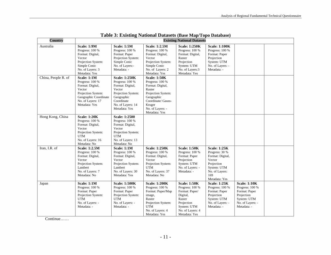
- 10 -
There are many national datasets in the region. The specification and characteristic ofthese datasets are varied from country to country in terms of scale, type(Topographic/thematic data), available format, validity, quality, etc. The informationprovided on these datasets can collectively form input for the metadata directory systemof the region. Based on the information provided by different countries, only 4 countriesdo not have any national datasets in the digital format.
The amount of digital datasets in the region can facilitate WG2 fast-tracking differentactions on the preparation of the Asia-Pacific regional fundamental dataset. However,due to the different characteristics of the available national datasets, there are difficultiesinvolved with datasets that might cause delay on the progress of WG2 or increase thenumber of steps required for creation of the regional fundamental dataset. Thesedifficulties include lack of a common dataset scale in digital format, as well as in paperformat; availability of datasets in different projection systems; and different standardsand specifications used for collection of these datasets. To address these difficulties,WG2 would be required to undertake additional actions that may need extra budgetting.Information about the existence of national datasets within different countries is providedin Table 3.
According to this table, the availability of national datasets in a digital form ranges fromsmall scale (1:9,000,000) to large scale (larger than 1:2,500) depending on the size of thecountries. There are also many common layers in different datasets that could formdifferent layers of the regional fundamental dataset.
Analysis of Regional Fundamental Technical Questionnaire
- 11 -
Table 3: Existing National Datasets (Base Map/Topo Database)Country Existing National Datasets
Australia Scale: 1:9MProgress: 100 %Format: Digital,VectorProjection System:Simple ConicNo. of Layers: 3Metadata: Yes
Scale: 1:5MProgress: 100 %Format: PaperProjection System:Simple ConicNo. of Layers:-Metadata: -
Scale: 1:2.5MProgress: 100 %Format: Digital,VectorProjection System:Simple ConicNo. of Layers: 2Metadata: Yes
Scale: 1:250KProgress: 100 %Format: Digital,RasterProjectionSystem: UTMNo. of Layers:3Metadata: Yes
Scale: 1:100KProgress: 100 %Format: PaperProjectionSystem: UTMNo. of Layers: -Metadata: -
China, People R. of Scale: 1:1MProgress: 100 %Format: Digital,VectorProjection System:Geographic CoordinateNo. of Layers: 17Metadata: Yes
Scale: 1:250KProgress: 100 %Format: Digital,VectorProjection System:GeographicCoordinateNo. of Layers: 14Metadata: Yes
Scale: 1:50KProgress: 100 %Format: Digital,RasterProjection System:GeographicCoordinate/ Gauss-KrugerNo. of Layers: -Metadata: Yes
Hong Kong, China Scale: 1:20KProgress: 100 %Format: Digital,VectorProjection System:UTMNo. of Layers: 16Metadata: No
Scale: 1:2500Progress: 100 %Format: Digital,VectorProjection System:UTMNo. of Layers: 13Metadata: No
Iran, I.R. of Scale: 1:2.5MProgress: 100 %Format: Digital,VectorProjection System:LambertNo. of Layers: 7Metadata: No
Scale: 1:1MProgress: 100 %Format: Digital,VectorProjection System:LambertNo. of Layers: 30Metadata: Yes
Scale: 1:250KProgress: 100 %Format: Digital,VectorProjection System:UTMNo. of Layers: 37Metadata: No
Scale: 1:50KProgress: 100 %Format: PaperProjectionSystem: UTMNo. of Layers: -Metadata: -
Scale: 1:25KProgress: 30 %Format: Digital,VectorProjectionSystem: UTMNo. of Layers:169Metadata: Yes
Japan Scale: 1:1MProgress: 100 %Format: PaperProjection System:UTMNo. of Layers: -Metadata: -
Scale: 1:500KProgress: 100 %Format: PaperProjection System:UTMNo. of Layers: -Metadata: -
Scale: 1:200KProgress: 100 %Format: Paper/Mapimage,RasterProjection System:UTMNo. of Layers: 4Metadata: Yes
Scale: 1:50KProgress: 100 %Format: Paper/Digital,RasterProjectionSystem: UTMNo. of Layers: 4Metadata: Yes
Scale: 1:25KProgress: 100 %Format: PaperProjectionSystem: UTMNo. of Layers: -Metadata: -
Scale: 1:10KProgress: 100 %Format: PaperProjectionSystem: UTMNo. of Layers: -Metadata: -
Continue……

Analysis of Regional Fundamental Technical Questionnaire
- 12 -
Country Existing National DatasetsKiribati Scale: 1:25K
Progress: 100 %Format: PaperProjection System:Local TMNo. of Layers: -Metadata: -
Scale: 1:2500Progress: 100 %Format: Digital,VectorProjection System:UTMNo. of Layers: 6Metadata: No
Laos Scale: 1:100KProgress: 100 %Format: PaperProjection System:Gauss-KrugerNo. of Layers: -Metadata: -
Scale: 1:25KProgress: 100 %Format: DigitalProjection System:UTMNo. of Layers: ?Metadata: ?
Macau Scale: 1:20KProgress: 100 %Format: Digital/PaperProjection System:HayfordNo. of Layers: -Metadata: -
Scale: 1:10KProgress: 100 %Format:Digital/PaperProjection System:HayfordNo. of Layers: -Metadata: -
Scale: 1:5KProgress: 100 %Format:Digital/PaperProjection System:HayfordNo. of Layers: -Metadata: -
Malaysia Scale: 1:50KProgress: 100 %Format: Paper/Digital,VectorProjection System:RSONo. of Layers: 8Metadata: No
Maldives Scale: 1:300KProgress: 100 %Format: Paper/Digital,VectorProjection System:UTMNo. of Layers: ?Metadata: No
Mongolia Scale: 1:1MProgress: 100 %Format: PaperProjection System:Gauss-Krueger’sNo. of Layers: -Metadata: -
Scale: 1:500KProgress: 100 %Format: PaperProjection System:Gauss-Krueger’sNo. of Layers: -Metadata: -
Scale: 1:300KProgress: 100 %Format: PaperProjection System:Gauss-Krueger’sNo. of Layers: -Metadata: -
Scale: 1:100KProgress: 100 %Format: PaperProjectionSystem: Gauss-Krueger’sNo. of Layers: -Metadata: -
Scale: 1:50KProgress: 48.6 %Format: PaperProjectionSystem: Gauss-Krueger’sNo. of Layers: -Metadata: -
Scale: 1:25KProgress: 28.3 %Format: PaperProjectionSystem: Gauss-Krueger’sNo. of Layers: -Metadata: -
Scale: 1:5KProgress: 100 %Format:Paper/Digital, VectorProjection System:Gauss-Krueger’sNo. of Layers:?Metadata: Yes

Analysis of Regional Fundamental Technical Questionnaire
- 13 -
Country Existing National DatasetsNepal Inaccurate InformationNew Zealand Scale: 1:4M
Progress: 100 %Format: PaperProjection System:PaperNo. of Layers: -Metadata: -
Scale: 1:3MProgress: 100 %Format: PaperProjection System:Lambert, ConicNo. of Layers: -Metadata: -
Scale: 2MProgress: 100 %Format: Paper,Projection System:NZMGNo. of Layers: - Metadata: -
Scale: 1:1MProgress: 100 %Format: PaperProjectionSystem: Lambert,ConicNo. of Layers: -Metadata: -
Scale: 500KProgress: 100 %Format: Paper,ProjectionSystem: NZMGNo. of Layers: - Metadata: -
Scale: 50KProgress: 100 %Format:Paper/Digital,VectoreProjectionSystem: NZMGNo. of Layers: - Metadata: Yes
Scale: 25KProgress: 100 %Format: Digital,VectorProjectionSystem: UTMNo. of Layers: - Metadata: No
Palau, R. of Scale: 25KProgress: 100 %Format: Paper,Projection System: ?No. of Layers: - Metadata: -
Singapore Scale: 5KProgress: 100 %Format: Digital, VectorProjection System:CassiniNo. of Layers: < 68 Metadata: ?
Soloman Islands Scale: 3MProgress: 100 %Format: Paper,Projection System:UTMNo. of Layers: - Metadata: -
Scale: 1:1MProgress: 100 %Format: Paper,Projection System:UTMNo. of Layers: - Metadata: -
Scale: 1:250KProgress: 0.02 %Format: DigitalProjection System: ?No. of Layers: - Metadata: -
Scale: 1:150KProgress: 98 %Format: Paper,ProjectionSystem: UTMNo. of Layers: - Metadata: -
Scale: 1:50KProgress: 100 %Format: Paper,ProjectionSystem: UTMNo. of Layers: - Metadata: -
Tuvalu Scale: 10KProgress: 100 %Format: Digital/PaperProjection System:UTMNo. of Layers: - Metadata: -
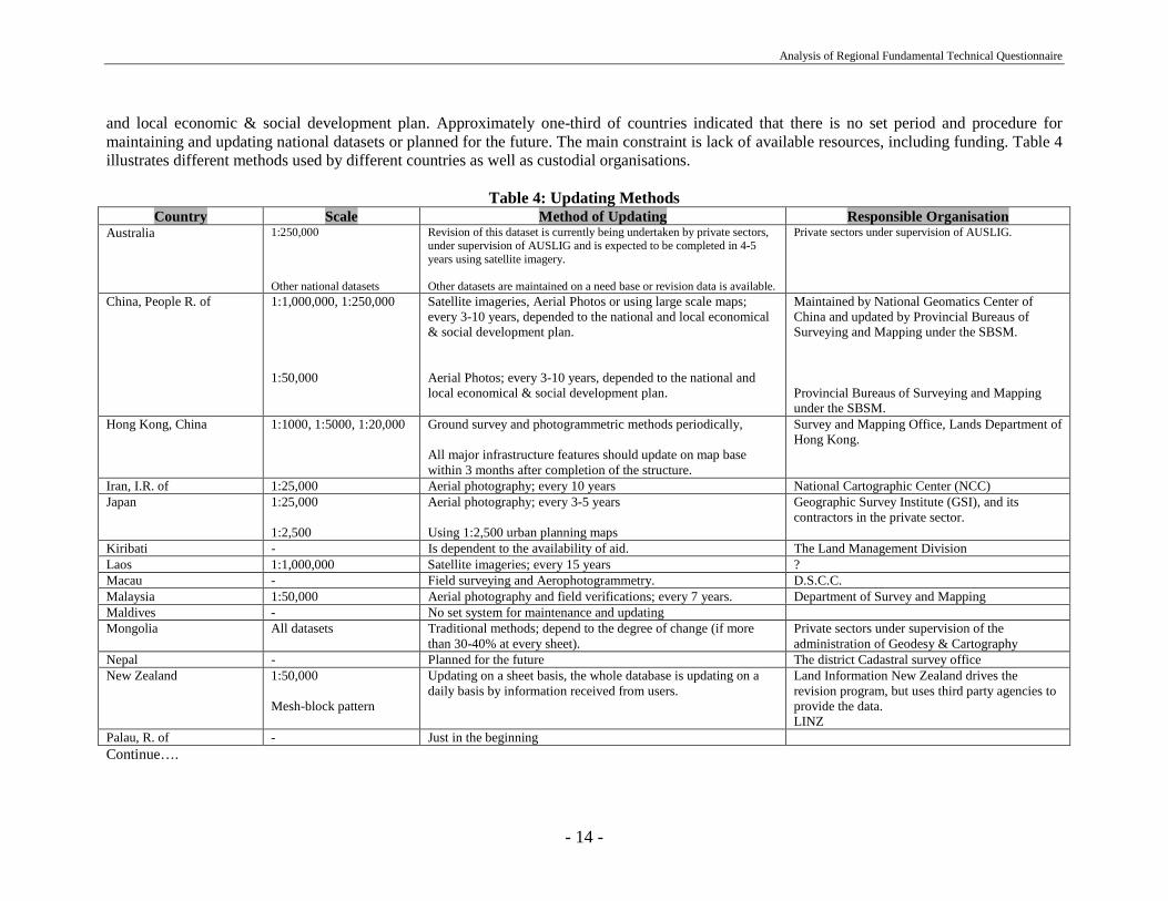
Method of UpdatingWith regard to the procedure for maintaining and updating national datasets in the region, different methods are utilised. Most of the countries areusing Aerial photos, Field surveying, and Satellite imagery with figures of 41.50, 23.55 and 11.80 percent respectively for maintaining andupdating of their national datasets. The period for updating is varied from 3-15 years in different countries and it depends usually on the national
Analysis of Regional Fundamental Technical Questionnaire
- 14 -
and local economic & social development plan. Approximately one-third of countries indicated that there is no set period and procedure formaintaining and updating national datasets or planned for the future. The main constraint is lack of available resources, including funding. Table 4illustrates different methods used by different countries as well as custodial organisations.
Table 4: Updating MethodsCountry Scale Method of Updating Responsible Organisation
Australia 1:250,000
Other national datasets
Revision of this dataset is currently being undertaken by private sectors,under supervision of AUSLIG and is expected to be completed in 4-5years using satellite imagery.
Other datasets are maintained on a need base or revision data is available.
Private sectors under supervision of AUSLIG.
China, People R. of 1:1,000,000, 1:250,000
1:50,000
Satellite imageries, Aerial Photos or using large scale maps;every 3-10 years, depended to the national and local economical& social development plan.
Aerial Photos; every 3-10 years, depended to the national andlocal economical & social development plan.
Maintained by National Geomatics Center ofChina and updated by Provincial Bureaus ofSurveying and Mapping under the SBSM.
Provincial Bureaus of Surveying and Mappingunder the SBSM.
Hong Kong, China 1:1000, 1:5000, 1:20,000 Ground survey and photogrammetric methods periodically,
All major infrastructure features should update on map basewithin 3 months after completion of the structure.
Survey and Mapping Office, Lands Department ofHong Kong.
Iran, I.R. of 1:25,000 Aerial photography; every 10 years National Cartographic Center (NCC)Japan 1:25,000
1:2,500
Aerial photography; every 3-5 years
Using 1:2,500 urban planning maps
Geographic Survey Institute (GSI), and itscontractors in the private sector.
Kiribati - Is dependent to the availability of aid. The Land Management DivisionLaos 1:1,000,000 Satellite imageries; every 15 years ?Macau - Field surveying and Aerophotogrammetry. D.S.C.C.Malaysia 1:50,000 Aerial photography and field verifications; every 7 years. Department of Survey and MappingMaldives - No set system for maintenance and updatingMongolia All datasets Traditional methods; depend to the degree of change (if more
than 30-40% at every sheet).Private sectors under supervision of theadministration of Geodesy & Cartography
Nepal - Planned for the future The district Cadastral survey officeNew Zealand 1:50,000
Mesh-block pattern
Updating on a sheet basis, the whole database is updating on adaily basis by information received from users.
Land Information New Zealand drives therevision program, but uses third party agencies toprovide the data.LINZ
Palau, R. of - Just in the beginningContinue….

Analysis of Regional Fundamental Technical Questionnaire
- 15 -
Country Scale Method of Updating Responsible OrganisationSingapore 1:5000
1:1000(cadasteral dataset)Aerial photography; annually,Ground surveying
Mapping Unit
Soloman Islands - There is not a set periods ?Tuvalu - Strategy is still under development -
Quality Control and Quality assuranceThe validation and quality control of national datasets are mostly (88.2 percent) assessed by governmental departments using their own standardsand regulations. In some cases this assessment employs a statistical methodology. The individual procedures of these activities in differentcountries are presented in Table 5.
Table 5: Quality Control and AssuranceCountry Method of Quality Assurance of National DataSets
Australia Statistically acceptable sampling techniques based on the Australian Standard AS1199-1988.China, People R. of National Standards and Specifications of surveying and mapping for different scales are responsible for quality assurance.Hong Kong, China Survey and Mapping Office is responsible for quality assurance and validation of map dataset of various scales.
In addition, the Hong Kong Institute of Surveyors (HKIS) is a professional body recognised to monitor the quality and professional ethics of landsurveyors in map making and related survey and mapping activities.
Iran, I.R. of Department of Quality Control and Supervision (QCS) of NCC is responsible of quality assurance and validity of the national dataset produced bydifferent sectors. QCS is doing test on both geometry and attributes of features with specific instructions and national standards.
Japan The quality of the national dataset is controlled by GSI’s operational specifications for each product.
The survey act requires involvement of surveyors and assistant surveyors to fundamental surveys in which national datasset is produced.Kiribati Datasets are subject to standard procedures and accuracy set in Divisions’ Survey Directions.Laos Regulations responsible for quality assurance.Macau D.S.C.C. is responsible to assure the accuracy of the national dataset.Malaysia The topographic and cadastral datasets are governed by departmental procedures and guidelines.
Apart from that, surveyors in the private sector will have to be licensed and there is strict over them to ensure quality of work.Maldives -Mongolia State administration of Geodesy and Cartography has issued the standard for accuracy of surveying and mapping. Inspectors of Geodesy and
Cartography supervise all mapping activities under mentioned standard.Nepal There is no quality assurance procedure developed except that the map before publishing will have to pass through a national committee called
mapping committee.New Zealand Data suppliers must be accredited by LINZ. LINZ has validating and testing procedures that all data must pass before it can be accepted into the
master dataset.Palau, R. of Not started yet.Continue….
Analysis of Regional Fundamental Technical Questionnaire
- 16 -
Country Method of Quality Assurance of National DataSetsSingapore Topographic data go through internal checks by Mapping Unit. Cadastral data are supplied by registered surveyors in accordance with Land
Surveyors Rules and examined by the Survey Department.Soloman Islands There are some specific regulations for mapping activities. The Survey Act specifies only Registered/Commissioned Surveyors need to carry out
legal Surveys.Tuvalu Quality assurance and validation of national datasets are accessed by state of the Lands and Survey Department under the authority of the Chief
Lands Office.
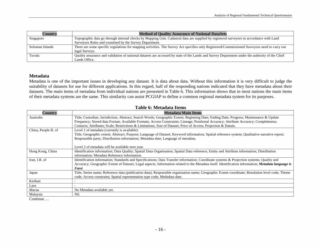
MetadataMetadata is one of the important issues in developing any dataset. It is data about data. Without this information it is very difficult to judge thesuitability of datasets for use for different applications. In this regard, half of the responding nations indicated that they have metadata about theirdatasets. The main items of metadata from individual nations are presented in Table 6. This information shows that in most nations the main itemsof their metadata systems are the same. This similarity can assist PCGIAP to define a common regional metadata system for its purposes.
Table 6: Metadata ItemsCountry Metadata Main Items
Australia Title; Custodian; Jurisdiction; Abstract; Search Words; Geographic Extent; Beginning Date; Ending Date; Progress; Maintenance & UpdateFrequency; Stored data Format; Available Formats; Access Constraints; Lineage; Positional Accuracy; Attribute Accuracy; Completeness;Contacts; Attributes; Scale; Restrictions & Limitations; Size of Dataset; Price of Access; Projection & Datum.
China, People R. of Level 1 of metadata (currently is available):Title; Geographic extent; Abstract; Purpose; Language of Dataset; Keyword information; Spatial reference system; Qualitative narrative report;Responsible party; Distribution information; Metadata date; Language of metadata.
Level 2 of metadata will be available next year.Hong Kong, China Identification information; Data Quality; Spatial Data Organisation; Spatial Data reference; Entity and Attribute information; Distribution
information; Metadata Reference information.Iran, I.R. of Identification information; Standards and Specifications; Data Transfer information; Coordinate systems & Projection systems; Quality and
Accuracy; Geographic Extent of Dataset; Legal aspects; Information related to the Metadata itself. Identification information; Metadata language isFarsi
Japan Title; Series name; Reference data (publication data); Responsible organisation name; Geographic Extent coordinate; Resolution level code; Themecode; Access constrains; Spatial representation type code; Medadata date.
Kiribati -Laos -Macau No Metadata available yet.Malaysia Nil.Continue….

Analysis of Regional Fundamental Technical Questionnaire
- 17 -
Country Metadata Main ItemsMaldives -Mongolia Content; Scale; Producer; Accuracy; Access & Availability; Date produced; Index map; Datum; Cost; Interval of Contour line.Nepal Not started yet.New Zealand A data Dictionary that describes Object classes, allowable attributes etc. A data documentation guide that set requirements for data, accuracy etc.Palau, R. of Not available yet.Singapore Title; Custodian; Jurisdiction; Abstract; Search Words; Geographic Extent; Beginning Date; Ending Date; Progress; Maintenance & Update
Frequency; Stored data Format; Available Formats; Access Constraints; Lineage; Positional Accuracy; Attribute Accuracy; Completeness;Correctness; Contact Organisation; Metadata Date; Additional Metadata.
Soloman Islands -Tuvalu -
Table 7 provides information about the type of Metadata systems of individual nations complying with national or international standards. Overhalf of the countries (53 percent) indicated that they don't have any Metadata systems available. In those countries that do have Metadata systemsthese are generally part of individual national standards.
Table 7: Type of MetadataCountry Type of Metadata comply with Standard
Australia ANZLIC Metadata Guidelines (http://www.anzlic.org.au/metaelem.htm).China, People R. of Its content is very similar with the Committee Draft (CD) of the international standard “Geographic Information-Metadata” (ISO15046-15) created
by the ISO/TC211.Hong Kong, China This Metadata has been designed to comply with the specification of FGDC of USA.Iran, I.R. of The Metadata is part of the Iranian Standard being used for the NTDB (standard for Digital Data Topographic Data at 1:25K scale- Version 2.3),
and does not comply with any international standard.Japan Yes. The Metadata follows the standard which was the output from the collaborated research between GSI and 53 private companies in Japan based
on ISO/TC211/WG3 15046-15 Metadata standard draft.Kiribati -Laos -Macau Not Metadata available yet.Malaysia Nil.Maldives -Mongolia The Metadata comply with Russian national standard.Nepal Not available yet.New Zealand No.Palau, R. of -Singapore We adopt open GIS consortium standards.Soloman Islands -Tuvalu Not applicable.

Analysis of Regional Fundamental Technical Questionnaire
- 18 -
End products from National DataSetsInformation about end products and value-added services from National datasets of individual countries is provided in Table 8. This table, togetherwith table 23, can help to identify potential users and their expected areas of application for regional level, based on the relation between nationaland regional datasets with regards to their scales, currency, content and etc.
Table 8: End Product & Value-added Services from National DataSetsCountry Products Producer User
Australia Variable Public & Private Sectors Mapping, Environment, Telecommunication, Defense, Emergency, Geoscience,Transportation, Agriculture, Marine, Tourists, Software development, Publicationsections.
China, People R. of 1:4 M-scale Database
1:1 M-scale Digital map of China,1:50k Topographic DRG
NGCC
SBSMGovernment agencies, educational & academic institutions, companies.
Hong Kong, China Computerised Mapping Inquirysystem for Tourists
Survey & Mapping office andHong Kong Tourist Association
General public of Hong Kong and tourist from worldwide.
Iran, I.R. of 1:1 M-scale Digital map & inquirysystem
National Atlas
Road Maps
Physical plan study systemMany others
NCC
//
Ministry of Roads andTransportationMinistry of Housing and Urbanplanning
Government agencies, educational & academic institutions, and the other Public andPrivate sectors,
Different sectors
Urban planning consultants companies
Japan City, Road, Travelling Maps
Educational Atlas
Digital road maps
Private sector
//
public service corporation,Private sector
General Public
Educational sector
Car navigation users
Kiribati Different Topo and Cadastral maps Public sector Ministries, Educational & research departments and individualsLaos Base map NGD Ministries, industry, etc.Macau Emergency Services
Macau City GuideStatistical informationUrban Planning
Security ForcesMunicipal CouncilStatistic DepartmentPublic Works Dept.
Security Forces (Police Department)General PublicGeneral PublicConstructors
Malaysia Digital Terrain Models
Tourist MapsRoad Maps
Dept. of Survey & MappingPublic & Private sectors//
Military and government departments
Public, tourists etc.Ministries, public, tourists, etc.
Maldives Tourist mapsNavigation charts
Public sector//
TouristsInter Island vessels
Continue….

Analysis of Regional Fundamental Technical Questionnaire
- 19 -
Country Products Producer UserMongolia All scales topographic maps
Thematic maps & national Atlas
Aerial surveying & mappingenterpriseCartographic enterprise
Ministries and the other Public & private sectors
Educational & research departments, mineral exploration firms and environmentalresearchers and administrations.
Nepal - Not available yet (national datasetis under construction)
New Zealand DTM’sPublished mappingGIS
DCDB
ASP
Public & Private sectors////
public sector
//
Telecommunications companies, Science agencies and others.Emergency services, other public & private groups.Emergency services, Local Authorities, other Public and Private agencies.Local government, utilities, real state sectors, government agencies, forestry and farming.New Zealand electoral agencies.
Palau, R. of NilSingapore CD Rom of street Directory Private sector The publicSoloman Islands Topographic maps
Topo Cadastral
Survey & Mapping Division// //
Census Office, Police, Sports Committee’s etc.
Mining, Energy, ForestryTuvalu -
Existing Hardware & SoftwareThe organisational infrastructure, based on availability of hardware systems, is illustrated in Table 9. This shows that almost all organisations usedPCs (88.2 percent), two thirds had Workstations, and only 3 countries (17.6 percent) used Mainframe computers. Local Area Networks (LAN) arethe most commonly used form of communication: 14 (82.3 percent) out of all responding countries access a LAN. But only one third of countriesare using Wide Area Networks (WAN) and the same proportion had the capability to use and access the World Wide Web. Regarding peripherals,large format plotters and digitisers are widely installed (88.2 percent). Relatively few countries had file writers but about two thirds had largeformat scanners.
Table 9: Hardware AvailabilityComputers Mainframe Workstations Personal Computers (PCs)
No%
317.6
1376.5
1588.2
Networks LAN WAN WWWNo%
1482.3
635.3
635.3
Peripherals Scanner (LF) Film writer Plotter (LF) Digitizer (LF)No%
1164.7
529.4
1588.2
1588.2
Analysis of Regional Fundamental Technical Questionnaire
- 20 -
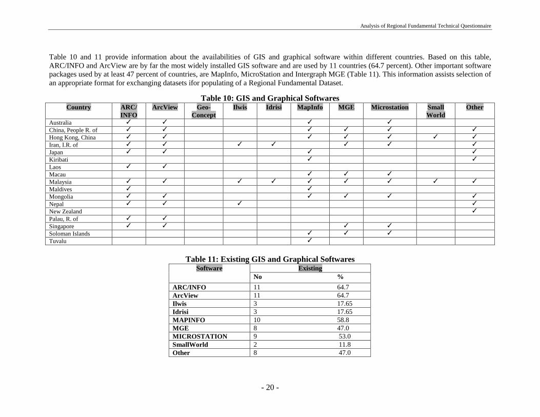
Table 10 and 11 provide information about the availabilities of GIS and graphical software within different countries. Based on this table,ARC/INFO and ArcView are by far the most widely installed GIS software and are used by 11 countries (64.7 percent). Other important softwarepackages used by at least 47 percent of countries, are MapInfo, MicroStation and Intergraph MGE (Table 11). This information assists selection ofan appropriate format for exchanging datasets ifor populating of a Regional Fundamental Dataset.
Table 10: GIS and Graphical SoftwaresCountry ARC/
INFOArcView Geo-
ConceptIlwis Idrisi MapInfo MGE Microstation Small
WorldOther
Australia ✓ ✓ ✓ ✓
China, People R. of ✓ ✓ ✓ ✓ ✓ ✓
Hong Kong, China ✓ ✓ ✓ ✓ ✓ ✓ ✓
Iran, I.R. of ✓ ✓ ✓ ✓ ✓ ✓ ✓
Japan ✓ ✓ ✓ ✓
Kiribati ✓ ✓
Laos ✓ ✓
Macau ✓ ✓ ✓
Malaysia ✓ ✓ ✓ ✓ ✓ ✓ ✓ ✓ ✓
Maldives ✓ ✓
Mongolia ✓ ✓ ✓ ✓ ✓ ✓
Nepal ✓ ✓ ✓ ✓
New Zealand ✓
Palau, R. of ✓ ✓
Singapore ✓ ✓ ✓ ✓
Soloman Islands ✓ ✓ ✓
Tuvalu ✓
Table 11: Existing GIS and Graphical SoftwaresExistingSoftware
No %ARC/INFO 11 64.7ArcView 11 64.7Ilwis 3 17.65Idrisi 3 17.65MAPINFO 10 58.8MGE 8 47.0MICROSTATION 9 53.0SmallWorld 2 11.8Other 8 47.0

Analysis of Regional Fundamental Technical Questionnaire
- 21 -
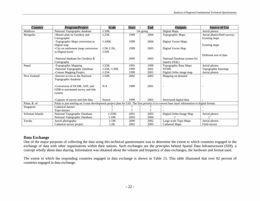
National Data Program/ProjectOne of the important factors needed for any strategic plan for future Regional Spatial Data Infrastructure, is awareness of current and future plansof any nationals data program and project by individual member nations of the relevant region. Table 12 illustrates information about current andplanned national data programs or projects within each country. This information can form a basis for the development of a knowledge-basedinfrastructure as a powerful tool for the strategic plan of the Asia-Pacific SDI (APSDI) initiative. Based on this information, all countries have atleast one up to a maximum of five programs/projects on their respective national datasets. The scales of these projects are mostly 1:250K; 1:100K;and 1:50K. The outputs of all these programs/projects are in a digital format and are mostly planned to made available in the form of a GIS readyformat. Access to this information may better enable individual countries to pursue their National SDI initiatives whilst facilitating bettercontribution to the development of the APSDI by using and sharing national digital datasets.
Table 12: Current and Planned National Data Program/ProjectsCountry Program/Project Scale Start End Outputs Source of Use
Australia GEODATA TOPO 250K Series 2+Map Revision
1:250 K 1998 0ngoing GIS ready data hard copymap
Satellite Imagery
China, People R. of 1:50K scale DEM of the NFGIS1:50K scale DOM of the NFGIS1:10K scale DEM of the NFGIS
1:1M and 1:250K Topographicdatabases updating
1:50K1:50K1:10K
1:1M, 1:250K
199819991998
1999
20012002
depended onrequirement
ongoing
Grid dataDigital Ortho-imageGrid data
Vector data
Map/aerial photoMap/aerial photos/SatelliteimageryAerial photosDigital map/Satelliteimagery
Hong Kong, China Topographic Map 1:10K 1998 1999 Paper map/Digital data 1:10K, 1:5K Topo mapsIran, I.R. of Topographic Map
Topographic Map
National Landuse AdjustmentProvincial Landuse Map
1:25K
1:50K
1:250K1:100K
1998
2001
2002
20012005
Digital database/map
Digital Map
Digital MapDigital Map
Aerial photos/SatelliteimageryDigital maps
Satellite imagerySatellite imagery
Japan GSI will continue periodical revision of current national datasetKiribati Map of Kiritimati Island 1:2500 2001 2002 Digital Ortho-image map Aerial photosLaos Updating National Base map 1:100K 1999 2002 Digital map Satellite imageryMacau 3D Base Map
Environmental MapLanduse MapAM/FM UtilitiesPopulation Maps
1:5K1:5K1:5K1:10K1:5K
20002001200020022000
20012002200020032000
Digital/paper Maps // // // //
-----
Malaysia Conversion of Topographic paperMaps into Digital formContracting out Populating ofDigital Cadastral Database
1:50K
-
1997
1999
2000
2000
Digital Topographic Map
Digital Cadastral Map
Aerial photos
Old plans & field surveys
Continue….
Analysis of Regional Fundamental Technical Questionnaire
- 22 -
Country Program/Project Scale Start End Outputs Source of UseMaldives National Topographic database 1:10K On going Digital Maps Aerial photosMongolia -Master plan on Geodesy and
Cartographic-Topographic Maps conversion toDigital map-City on settlement (map conversionto Digital form)
-National database for Geodesy &Cartography
1:25K
1:100K
1:5K,1:2K,1:500
-
1999
1999
1999
2000
2004
2004
2005
2005
Topographic Maps
Digital Vector Maps
Digital Vector Map
National Database system forinquiry (SQL)
Aerial photos/field surveysExisting maps
Existing maps
Different sort of data
Nepal -Topographic Mapping-National Topographic Database-Census Mapping Project
1:25K1:25K, 1:50K1:25K
199219991999
199920012001
Topographic Base MapsNTDBDigital Ortho image map
Aerial photosTopographic basemapAerial photos
New Zealand -Internet access to the NationalTopographic database
-Conversion of DCDB, ASP, andGDB to automated survey and titlesystem.
-Capture of survey and title data
1:50K
N/A
Source
2002
1998
1999
2003
2001
2001
Mapping on demand
-
Structured digital data
-
-
-Palau, R. of Palau is just starting on 3-year development project plan for GIS. The first priority is to convert base layer information to digital format.Singapore Cadastral dataset
Topo dataset??
??
??
--
--
Soloman Islands National Topographic DatabaseNational Topographic Database
1:25001:10K
20012003
20032004
Digital Ortho-Image Map //
Aerial photos //
Tuvalu Aerial photogrphyCadastral survey project
1:1M1:2K
20002002
20022005
Large scale Topo MapsCadastral Maps
Aerial photosField survey
Data ExchangeOne of the major purposes of collecting the data using this technical questionnaire was to determine the extent to which countries engaged in theexchange of data with other organisations within their nations. Such exchanges are the principles behind Spatial Data Infrastructures (SDI), aconcept wholly about data sharing. Information was obtained about the volume and frequency of data exchanges, the hardware and format used.
The extent to which the responding countries engaged in data exchange is shown in Table 13. This table illustrated that over 82 percent ofcountries engaged in data exchange.
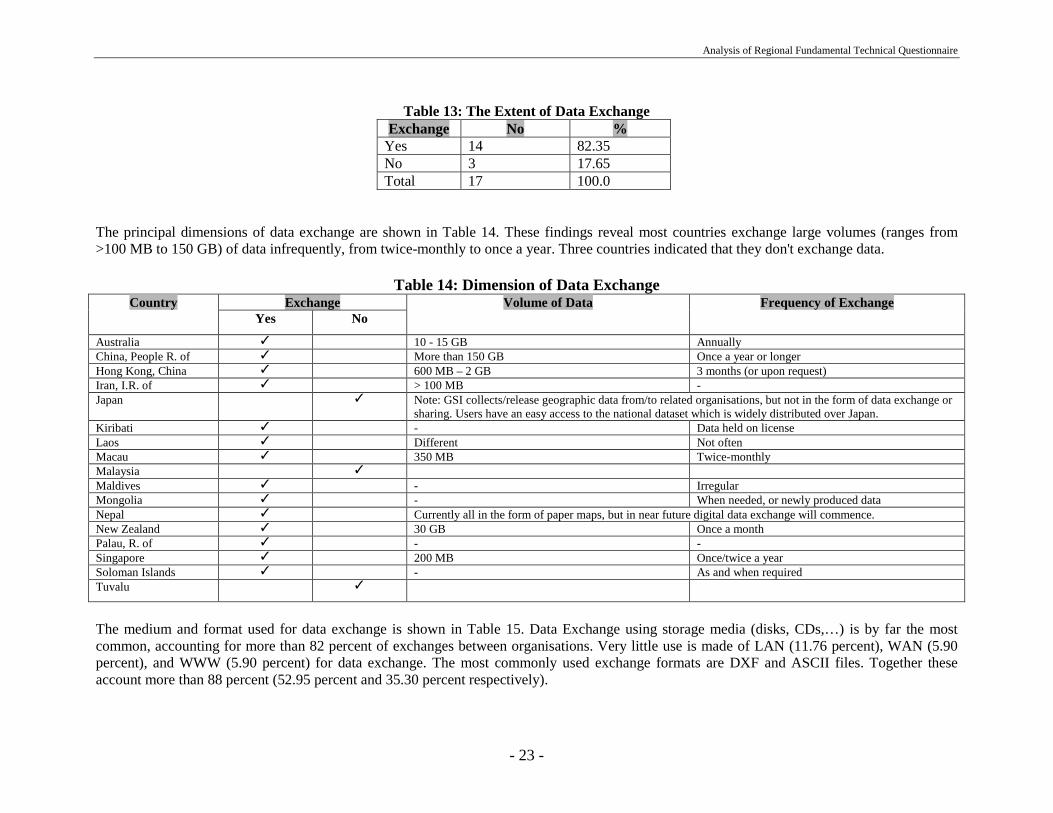
Analysis of Regional Fundamental Technical Questionnaire
- 23 -
Table 13: The Extent of Data ExchangeExchange No %
Yes 14 82.35No 3 17.65Total 17 100.0
The principal dimensions of data exchange are shown in Table 14. These findings reveal most countries exchange large volumes (ranges from>100 MB to 150 GB) of data infrequently, from twice-monthly to once a year. Three countries indicated that they don't exchange data.
Table 14: Dimension of Data ExchangeExchangeCountry
Yes NoVolume of Data Frequency of Exchange
Australia ✓ 10 - 15 GB AnnuallyChina, People R. of ✓ More than 150 GB Once a year or longerHong Kong, China ✓ 600 MB – 2 GB 3 months (or upon request)Iran, I.R. of ✓ > 100 MB -Japan ✓ Note: GSI collects/release geographic data from/to related organisations, but not in the form of data exchange or
sharing. Users have an easy access to the national dataset which is widely distributed over Japan.Kiribati ✓ - Data held on licenseLaos ✓ Different Not oftenMacau ✓ 350 MB Twice-monthlyMalaysia ✓
Maldives ✓ - IrregularMongolia ✓ - When needed, or newly produced dataNepal ✓ Currently all in the form of paper maps, but in near future digital data exchange will commence.New Zealand ✓ 30 GB Once a monthPalau, R. of ✓ - -Singapore ✓ 200 MB Once/twice a yearSoloman Islands ✓ - As and when requiredTuvalu ✓
The medium and format used for data exchange is shown in Table 15. Data Exchange using storage media (disks, CDs,…) is by far the mostcommon, accounting for more than 82 percent of exchanges between organisations. Very little use is made of LAN (11.76 percent), WAN (5.90percent), and WWW (5.90 percent) for data exchange. The most commonly used exchange formats are DXF and ASCII files. Together theseaccount more than 88 percent (52.95 percent and 35.30 percent respectively).
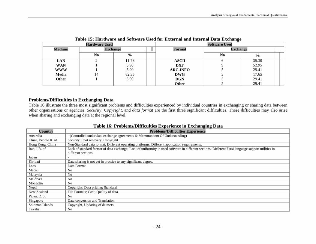
Analysis of Regional Fundamental Technical Questionnaire
- 24 -
Table 15: Hardware and Software Used for External and Internal Data ExchangeHardware Used Software Used
Exchange ExchangeMediumNo %
FormatNo %
LANWAN
WWWMediaOther
211
141
11.765.905.90
82.355.90
ASCIIDXF
ARC-INFODWGDGNOther
695355
35.3052.9529.4117.6529.4129.41
Problems/Difficulties in Exchanging DataTable 16 illustrate the three most significant problems and difficulties experienced by individual countries in exchanging or sharing data betweenother organisations or agencies. Security, Copyright, and data format are the first three significant difficulties. These difficulties may also arisewhen sharing and exchanging data at the regional level.
Table 16: Problems/Difficulties Experience in Exchanging DataCountry Problems/Difficulties Experience
Australia - (Controlled under data exchange agreements & Memorandom Of Understanding)China, People R. of Security; Cost recovery; Copyright.Hong Kong, China Non-Standard data format; Different operating platforms; Different application requirements.Iran, I.R. of Lack of standard format of data exchange; Lack of uniformity in used software in different sections; Different Farsi language support utilities in
different sections.Japan -Kiribati Data sharing is not yet in practice to any significant degree.Laos Data FormatMacau NoMalaysia NoMaldives NoMongolia NoNepal Copyright; Data pricing; Standard.New Zealand File Formats; Cost; Quality of data.Palau, R. of NoSingapore Data conversion and Translation.Soloman Islands Copyright, Updating of datasets.Tuvalu No

Analysis of Regional Fundamental Technical Questionnaire
- 25 -
Joint Project along the BordersOne of the potential sources for populating regional dataset is using existing data from joint projects along the borders between different countriesin the region. To achieve this, there is need of awareness of existing projects of this nature. Table 17 provides information about existing jointprojects along the boarders between responding countries in the region. Based on the information provided in this table, 7 countries had such jointprojects. The total number of countries from the Asia-Pacific region that are involved in these projects is 17. The spatial data used in these projectsmight be useful for the purpose of WG2 of PCGIAP. But there is still need to find out more about these datasets.
Table 17: Joint Project along the BordersCountry Joint Project Name of Project Involve Countries Status
Australia Yes Timore Sea Gap Project Australia, Indonesia CompletedChina, People R. of -Hong Kong, China NoIran, I.R. of Yes Caspian Geo-Dynamic Iran, Russia, Azerbayjan,
Turkamanestan, Ghergizestan,Ozbakestan
Ongoing
Japan NoKiribati NoLaos Yes Lao-Vietnam Border Project Laos, Vietnam ?Macau NoMalaysia Yes International Boundary Demarcation and Survey
//Malaysia, ThailandMalaysia, Indonesia
Completed. Now maintenanceTargeted to be completed by year
2000Maldives NoMongolia Yes Mapping on the bordering part with Russia
Mapping on the bordering part with ChinaMongolia, RussiaMongolia, China
?
?Nepal NoNew Zealand Yes UNCLOS New Zealand, Australia OngoingPalau, R. of Yes GPS data observation
GPS projectPalau, JapanPalau, USA
FinishedFinished
Singapore NoSoloman Islands NoTuvalu No

Analysis of Regional Fundamental Technical Questionnaire
- 26 -
SECTION B
This section provides information about the knowledge of spatial data standards and data exchange standards within differentindividual countries.
National Datasets and ISO/TC211Table 18 provids information about standards used by the individual National datasets and how they comply with any standards published byISO/TC211. Most national datasets (71.50 percent) are developed using existing national standards. However, nearly half of the countries statedthat they planned to eventually meet ISO/TC 211 standards, and the balance is moving in this direction.
Table 18DataSets Meet ISO/TC211
Country Yes No
Australia GeoDATA TOPO-250K (national dataset) was designed before TC211began publishing. It is built around STDS. We believed that, as such, it isbroadlly compliant with the concepts of TC211. Conversion of theterminology, etc to 15046 compliance has not commenced.
China, People R. of National dataset meets some Committee Drafts (CDs) created by ISO/TC211.
National dataset meets some national standards:- Classify and codes for the national land information- Codes for the administrative divisions; naming; etc.- Specification for data quality control and Metadata.
Hong Kong, China De facto standards to comply with frequently used software:e.g. Arc/Info; DGN; DXF; ASCII
Iran, I.R. of Iran is P-member of TC211 and we planning to implement the standardin the future.
At the time of developing the national dataset ISO/TC211 standards werenot available. National dataset meet the Iranian national standards.
Japan When ISO/TC211 standards are established, GSI will reflect them intoGSI’s standards, which act as de facto standards of Japan.
At the time of generation of national dataset, neither ISO/TC211 standardsnor their draft version were available. Therefore technical standardsdescribed in GSI’s specifications are used for their production.
Kiribati National Survey standards are prescribed.Laos National standards are used.Macau NoMalaysia Malaysia MS 1074. However, currently developing a national standard
which is targeted to eventually meet ISO/TC211 standards.Maldives No standards used.Mongolia National standards were used. International standards will be used in the
future.Nepal National standards were used. These standards will be modified in line
with ISOTC/211 in future.Continue….
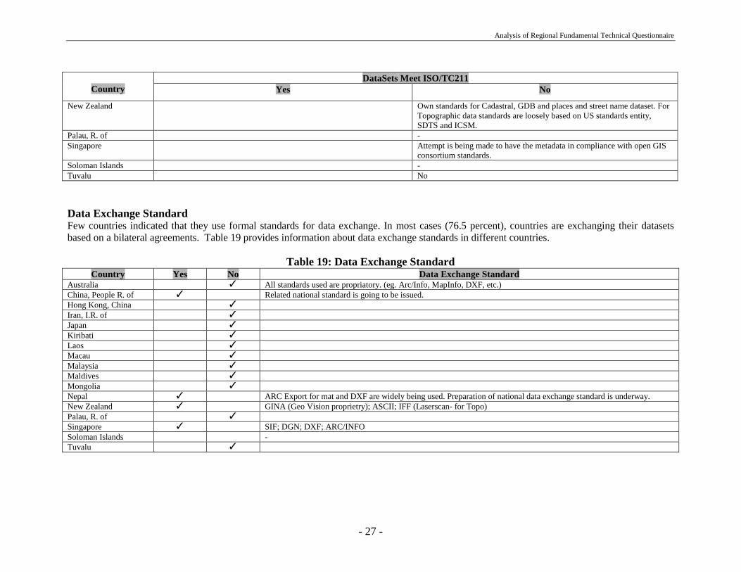
Analysis of Regional Fundamental Technical Questionnaire
- 27 -
DataSets Meet ISO/TC211Country Yes No
New Zealand Own standards for Cadastral, GDB and places and street name dataset. ForTopographic data standards are loosely based on US standards entity,SDTS and ICSM.
Palau, R. of -Singapore Attempt is being made to have the metadata in compliance with open GIS
consortium standards.Soloman Islands -Tuvalu No
Data Exchange StandardFew countries indicated that they use formal standards for data exchange. In most cases (76.5 percent), countries are exchanging their datasetsbased on a bilateral agreements. Table 19 provides information about data exchange standards in different countries.
Table 19: Data Exchange StandardCountry Yes No Data Exchange Standard
Australia ✓ All standards used are propriatory. (eg. Arc/Info, MapInfo, DXF, etc.)China, People R. of ✓ Related national standard is going to be issued.Hong Kong, China ✓
Iran, I.R. of ✓
Japan ✓
Kiribati ✓
Laos ✓
Macau ✓
Malaysia ✓
Maldives ✓
Mongolia ✓
Nepal ✓ ARC Export for mat and DXF are widely being used. Preparation of national data exchange standard is underway.New Zealand ✓ GINA (Geo Vision proprietry); ASCII; IFF (Laserscan- for Topo)Palau, R. of ✓
Singapore ✓ SIF; DGN; DXF; ARC/INFOSoloman Islands -Tuvalu ✓
Analysis of Regional Fundamental Technical Questionnaire
- 28 -
SECTION C
This section provides information about the data policy, pricing and copyrighting issues involved with different national datasets andend products of individual countries.
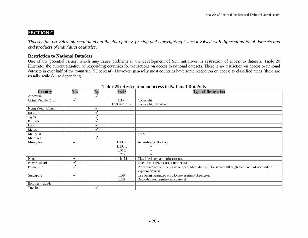
Restriction to National DataSetsOne of the potential issues, which may cause problems in the development of SDI initiatives, is restriction of access to datasets. Table 20illustrates the current situation of responding countries for restrictions on access to national datasets. There is no restriction on access to nationaldatasets in over half of the countries (53 percent). However, generally most countries have some restriction on access to classified areas (these areusually scale & use dependant).
Table 20: Restriction on access to National DataSetsCountry Yes No Scale Type of Restriction
Australia ✓
China, People R. of ✓ 1:1M1:500K-1:10K
CopyrightCopyright, Classified
Hong Kong, China ✓
Iran, I.R. of ✓
Japan ✓
Kiribati ✓
Laos ✓
Macau ✓
Malaysia ?????Maldives ✓
Mongolia ✓ 1:200K1:100K1:50K1:25K
According to the Law // // //
Nepal ✓ > 1:1M Classified area and information.New Zealand ✓ - License to LINZ; Cost; Internet usePalau, R. of ✓ Procedures are still being developed. Most data will be shared although some will of necessity be
kept confidential.Singapore ✓ 1:5K
1:1KUse being permitted only to Government Agencies.Reproduction requires an approval.
Soloman Islands -Tuvalu ✓
Analysis of Regional Fundamental Technical Questionnaire
- 29 -
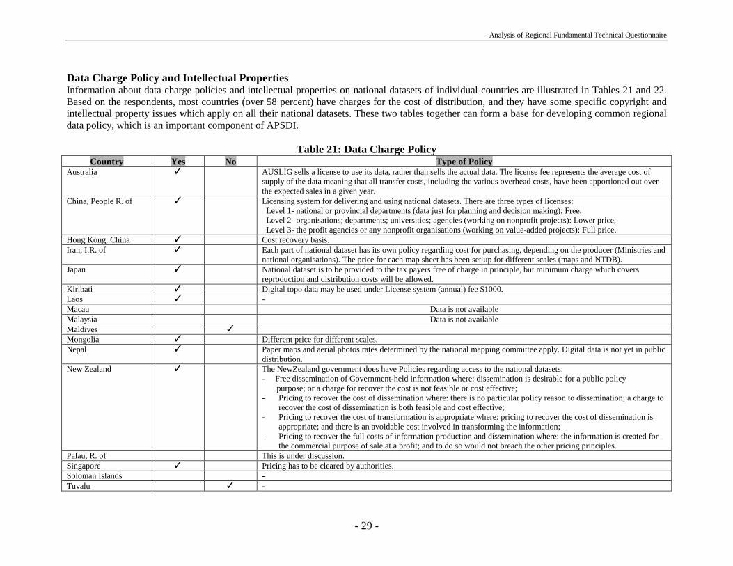
Data Charge Policy and Intellectual PropertiesInformation about data charge policies and intellectual properties on national datasets of individual countries are illustrated in Tables 21 and 22.Based on the respondents, most countries (over 58 percent) have charges for the cost of distribution, and they have some specific copyright andintellectual property issues which apply on all their national datasets. These two tables together can form a base for developing common regionaldata policy, which is an important component of APSDI.
Table 21: Data Charge PolicyCountry Yes No Type of Policy
Australia ✓ AUSLIG sells a license to use its data, rather than sells the actual data. The license fee represents the average cost ofsupply of the data meaning that all transfer costs, including the various overhead costs, have been apportioned out overthe expected sales in a given year.
China, People R. of ✓ Licensing system for delivering and using national datasets. There are three types of licenses: Level 1- national or provincial departments (data just for planning and decision making): Free, Level 2- organisations; departments; universities; agencies (working on nonprofit projects): Lower price, Level 3- the profit agencies or any nonprofit organisations (working on value-added projects): Full price.
Hong Kong, China ✓ Cost recovery basis.Iran, I.R. of ✓ Each part of national dataset has its own policy regarding cost for purchasing, depending on the producer (Ministries and
national organisations). The price for each map sheet has been set up for different scales (maps and NTDB).Japan ✓ National dataset is to be provided to the tax payers free of charge in principle, but minimum charge which covers
reproduction and distribution costs will be allowed.Kiribati ✓ Digital topo data may be used under License system (annual) fee $1000.Laos ✓ -Macau Data is not availableMalaysia Data is not availableMaldives ✓
Mongolia ✓ Different price for different scales.Nepal ✓ Paper maps and aerial photos rates determined by the national mapping committee apply. Digital data is not yet in public
distribution.New Zealand ✓ The NewZealand government does have Policies regarding access to the national datasets:
- Free dissemination of Government-held information where: dissemination is desirable for a public policy purpose; or a charge for recover the cost is not feasible or cost effective;- Pricing to recover the cost of dissemination where: there is no particular policy reason to dissemination; a charge to
recover the cost of dissemination is both feasible and cost effective;- Pricing to recover the cost of transformation is appropriate where: pricing to recover the cost of dissemination is
appropriate; and there is an avoidable cost involved in transforming the information;- Pricing to recover the full costs of information production and dissemination where: the information is created for
the commercial purpose of sale at a profit; and to do so would not breach the other pricing principles.Palau, R. of This is under discussion.Singapore ✓ Pricing has to be cleared by authorities.Soloman Islands -Tuvalu ✓ -

Analysis of Regional Fundamental Technical Questionnaire
- 30 -
Table 22: Intellectual PropertiesCountry Type of Intellectual property
Australia Copyright applies to Auslig’s paper map and digital data products. The Commonwealth of Australia is the owner of the data, their respectivedocumentation and copyright.
China, People R. of There is copyright and intellectual property issues for the national datasets. Users of national datasets have to apply a license and sign an agreement forcopyright and intellectual property protection.
Hong Kong, China All maps and digital data are protected under the Intellectual Property Laws of Hong Kong.Iran, I.R. of The copyright is supported by Plan and Budget Organisation under the Specific rules.Japan Not in particular.Kiribati NoneLaos Yes there is intellectual propertiy.Macau Decree-Law No. 113/96M dated 20th May 1996.Malaysia ????Maldives -Mongolia All thing are regulated according to the Law on know how or other related Laws of Malaysia.Nepal National topographic dataset is basically belongs to Survey Department. Users cannot reproduced the same data, but they could publish the information
after incorporating their field of interest, and they have to specify the data source.New Zealand The New Zealand Government retains copyright over its datasets and has a licensing/copyright fee system in place.Palau, R. of NoneSingapore Topographic dataset- copyright by Mindef.; Cadastral dataset-copyright by Chief Surveyor.Soloman Islands -Tuvalu None
SECTION D
This section provides information about the potential users and expected spatial coverage of a regional fundamental dataset for theAsia and the Pacific.
Expected Users/Users ExpectationThe potential users from different countries and their expectations of a regional fundamental dataset are illustrated in Table 23. The expectedcoverage for Asia and the Pacific regional fundamental dataset is: Geodetic; Topographic; Hydrologic and Costlines; Transportation;Environmental data; Place names; Statistics data; and Land use and Forestry data. Some countries also suggested including cultural features andother thematic layers. Regarding potential users based on the provided information, users are from all levels of government agencies; industriesand academic areas. This table together with table 8 can form a base from which to identify potential users and their expected coverage andapplication areas at the regional level.

Analysis of Regional Fundamental Technical Questionnaire
- 31 -
Table 23: Expected Users/Users ExpectationCountry User Interest Applications Expected Datasets
Australia - State Mapping agencies- Commonwealth agencies
- Surveying/Cadastral/Land titles- Aid, Social, Environmental
- Geodetic; Cadastral; Topography- Topography; Statistics; Environment
China, People R. of Government agencies, educational & academicinstitutions, companies, etc.
Global environmental changing, Regionalsustainable development, Reducing risks fromnatural disasters, etc.
All kinds of datasets including vector,raster and image covered the region.
Hong Kong, China Survey and Mapping Office, Lands Department,Hong Kong Government of SAR
Various GIS applications on land use,environmental analysis and geographicalanalysis.
Any spatial data that comply with theSurvey and Mapping Officespecifications.
Iran, I.R. of All Ministries, organisations and private sectors relatedto spatial information
Transportation, Landuse/landcover,Environmental study, Hazard management,Natural resource management, etc.
All type of Topographic data; Thematiclayers.
Japan - Educational sector- Researchers- International Steering Committee of Global
Mapping
- Teaching materials- Regional study- Establishment of Global Map
- General- General- 1:1M level digital data for elevation,
vegetation, land use, river, coastallines, traffic network, administrativeboundaries.
Kiribati Government Departments - Costlines; Geodetic control; TopographicLaos Ministries - -Macau - - -Malaysia - Dept. of Environment/Ministry of Science and
Technology- Public Works Dept./Ministry of Works- Ministry of Defense- Higher learning institutions
- Environmental Management- Planning transport infrastructure networks- Defense- Broad ranged research work
Land use; Forestry; Orthoimagery;Hydrology; Building;; Transportation;Elevation.
Maldives - Transportation companies,- Communication companies and authorities,- Researchers and students
- Transportation planning, regulating, etc.- Communication planning, regulating,- Research and studies
- Transportation routs and networks,- Cultural features,- All
Mongolia - Ministry & agencies of nature and environment,- Urban planning department,- Agency of Road & Bridge (transportation),- Local & Mining agencies; telecommunication
agencies.
- Environmental management,- City planning,- Planning and mineral exploration firms,- Design & mineral exploration firms
Digital Data
Nepal ICIMOD; Universities; Forestry agencies Environmental Management, Education, Topographic Data Base; Remote SensingData
New Zealand It is felt that the directory should primarily be a point of reference to the authoritative source of the information/fundamental datasets.Palau, R. of Fisheries agency, transportation agency, environmental
agency,Fisheries programs, environmental issues,transportation projects
-
Continue….
Analysis of Regional Fundamental Technical Questionnaire
- 32 -
Country User Interest Applications Expected DatasetsSingapore - - -Soloman Islands - Forestry & Environment
- City Council- Local Authorities- Police
- Prevention of environment degradation- Land Rating & Taxation- Services- Security
- Forest cover and protected areas,- Land Valuation,- Roads and Services routes,- Topographic & Place Names
Tuvalu Government - Geographic & Environmental data
GENERAL
This section provides information about the political and technical barriers expected to appear when cooperation is entered intobetween different countries in the region, as well as general comments from individual countries.
BarriersTable 24 illustrated the political and technical barriers that were anticipated when different countries are cooperating with each other. Theimportant political barriers expected are access to datasets for security reasons; lack of resources; national administrative boundaries as a layer;copyright issue; setting priorities for data collection. For the technical barriers, the important issues are using different standards; lack of technicalexpertise; lack of valid information; lack of uniformity in dataset specifications; differences in geodetic reference frameworks; lack of basicinfrastructure in the area of GIS.
Table 24: BarriersCountry Political Technical
Australia - Access to datasets for Security reasons.- Resources committed to creation & maintenance of fundamental
datasets.
- Fundamental datasets collected & created to differentstandards.
- Lack of technical expertise & hardware (including access tothe internet).
China, People R. of - National boundaries, geographic names, security, copyright andintellectual property protection, etc.
- Software, technical standards, speed of network, etc.
Hong Kong, China - -Iran, I.R. of - Limitation on data exchange in regional level, due to security
regulations in some scales.- Limitation on fiscal resources.
- Lack of valid information.- Lack of updated information.- Lack of uniformity in dataset specifications.- Lack of expertise.
Continue….

Analysis of Regional Fundamental Technical Questionnaire
- 33 -
Country Political TechnicalJapan - Copyright issue of the fundamental data released through APSDI.
- Liability issue of the fundamental data released through APSDI.- Method of charging to the fundamental data released through
APSDI.
-
Kiribati - - Relatively low level of Technical expertise in Kiribati may bea barrier.
Laos - -Macau - -Malaysia - Release of certain data by some governments which may be linked
to national security and related considerations.- Resources to maintain quality and currency of data.- Setting priorities for data collection (types).
- Differences in geodetic reference frames and standards.- Ensuring datasets collected to consistent quality and standards.
Maldives - - Lack of basic infrastructure in the area of GIS.
Mongolia - - We are needed to modernise hardware & software, standardsof national datasets in the near future. But these are dependingon financial difficulties.
Nepal - - It is very much difficult to follow the latest technologicaldevelopment due to financial and proper human resourcesconstraints.
New Zealand - Privacy Laws and resulting Confidentiality issues andrequirements.
- Competition for limited resources and funding for such initiatives.
- Access issues, not all Datasets may be in suitable format to beshared to have access to them allowed.
- Possible incompatibility of file formats etc.- Maintenance costs.- Cost of conversion of datasets from non-digital to digital to
enable ease of access.- Compilation of adequate standardised metadata.
Palau, R. of - Money to participate will be the key element. -
Singapore - -Soloman Islands - Support may not be high as compared with other flashy economic
generated functions of the government.- Lack of qualified/expert staff with modern equipment know-
how to fully utilise the system and to maintain it.
Tuvalu - -

Analysis of Regional Fundamental Technical Questionnaire
- 34 -
Other CommentsThe last table of this analysis is Table 25, which provides some comments suggested by some responding countries. These comments are veryuseful for future strategic decisions by PCGIAP.
Table 25Country Comments
Australia -China, People R. of The questionnaire is rather complicated, but it is useful for developing an APSDI. We are also interested in the answers from other countries.Hong Kong, China -Iran, I.R. of -Japan A pilot service which limits participating countries or information provided might help to test the concept of APSDI. During the pilot phase, as
many as success stories with APSDI should be searched and advertised through brochures.Kiribati -Laos -Macau -Malaysia - Have more frequent working group consultations and meetings.
- Instill higher commitments and sense of urgency from member nations.Maldives - We need more professionals in this field to set up a system from the very beginning.
- We also need technical assistance in the form of experts to advise and guide us.Mongolia -Nepal Due to financial constraints, it is difficult to participate each or most of the meetings/seminar/workshop. So, if possible, a special funds should
be created to support to make regular participation in the committee’s activities for the developing country like Nepal.New Zealand -Palau, R. of -Singapore -Soloman Islands Unable to provide answers to some questions as we are yet to see a fully integrated system established as a National Network. We have some
stand alone systems which cater for specific functions but have not been well maintained.Tuvalu Tuvalu is far behind in most of the questions asked in the questionnaire which I hope you understand why most questions does not have a
proper feedback.