An Efficient System for Vehicle Tracking in Multi …cs.uky.edu/~jacobs/papers/dixon09multi.pdf ·...
8
An Efficient System for Vehicle Tracking in Multi-Camera Networks Michael Dixon, Nathan Jacobs, Robert Pless Washington University St. Louis, MO, USA (msd2|jacobsn|pless)@cse.wustl.edu Abstract—The recent deployment of very large-scale camera networks has led to a unique version of the tracking problem whose goal is to detect and track every vehicle within a large urban area. To address this problem we exploit constraints inherent in urban environments (i.e. while there are often many vehicles, they follow relatively consistent paths) to create novel visual processing tools that are highly efficient in detecting cars in a fixed scene and at connecting these detections into partial tracks. We derive extensions to a network flow based probabilistic data association model to connect these tracks between cameras. Our real time system is evaluated on a large set of ground-truthed traffic videos collected by a network of seven cameras in a dense urban scene. I. I NTRODUCTION Tracking vehicles as they pass through a city is a classic surveillance problem. An extreme version of this problem is to track every vehicle in an urban area. Urban areas are inter- esting problem domains; they are complex because they often have high vehicle density and frequent occlusion, but also simple because vehicles follow very predictable paths. In this paper we develop a probabilistic tracking system that exploits this predictability to perform real time multi-camera, multi- vehicle tracking. In particular, we focus on the development of image processing tools that are fast enough to support real time tracking within each camera, and a probabilistic model that supports combining partial tracks within and between cameras. This work is inspired by recent work [6] that exploits the urban environment to track within a camera very efficiently. Their insight is that since cars usually travel within a lane, it is possible to decompose the 2D tracking problem to a set of 1D tracking problems; creating tracklets that capture vehicle mo- tion within one lane, and creating complete tracks (including, for example lane changes) by connecting appropriate tracklets. However, the previous work uses an ad hoc scoring mechanism for connecting tracklets and is limited to single camera. The current work offers three major contributions. First, we cast the lane-based tracking framework within a strict probabilistic framework, mapping image coordinates to geo- referenced coordinates so that we can express priors in glob- ally consistent units, rather than ad hoc units of pixels per frame. Second, we offer a novel measure for the likelihood that two tracklets come from the same vehicle. Finally, we offer quantitative results on a publicly available dataset of hundreds of hand-tracked cars traveling through a series of (slightly overlapping) camera views. Figure 1 highlights one of the Fig. 1. Our tracking framework creates short high-confidence tracklets of cars while they remain in one lane and links them with an efficient MAP optimization using min-cost network flow. The top shows the tracklets for one vehicle in two of the cameras; the bottom shows the tracklets from all seven cameras that were associated with that vehicle. 622 objects tracked by our multi-camera tracking algorithm, showing the individual tracklets linked together to make a complete track. These results highlight the benefits of tracking within a collaborative camera network — errors in each camera are fewer within the system than they are using the same algorithm within each camera. We believe this framework offers a scalable approach to city-scale, real time tracking of vehicles within a city. This type of tracking could support optimization of traffic light patterns, grounds models of typical traffic behavior that is useful for civic planning, and supports data mining approaches for unusual behavior detection. A. Related Work Using Space-Time Sheets: Reasoning about full spatio- temporal volumes has become extremely popular with the increasing memory capacity and speed of computers. Explicit reasoning about spatio-temporal slices has received only lim- ited attention. Spatio-temporal slices were first used in the context of regularizing structure from motion when the camera motion stays constant [3], and more recently to reason about specular reflections [4]. Within the context of human activity recognition, spatio-temporal slices have been shown to be an
Transcript of An Efficient System for Vehicle Tracking in Multi …cs.uky.edu/~jacobs/papers/dixon09multi.pdf ·...

An Efficient System for Vehicle Tracking inMulti-Camera Networks
Michael Dixon, Nathan Jacobs, Robert PlessWashington UniversitySt. Louis, MO, USA
(msd2|jacobsn|pless)@cse.wustl.edu
Abstract—The recent deployment of very large-scale cameranetworks has led to a unique version of the tracking problemwhose goal is to detect and track every vehicle within a largeurban area. To address this problem we exploit constraintsinherent in urban environments (i.e. while there are often manyvehicles, they follow relatively consistent paths) to create novelvisual processing tools that are highly efficient in detecting carsin a fixed scene and at connecting these detections into partialtracks. We derive extensions to a network flow based probabilisticdata association model to connect these tracks between cameras.Our real time system is evaluated on a large set of ground-truthedtraffic videos collected by a network of seven cameras in a denseurban scene.
I. INTRODUCTION
Tracking vehicles as they pass through a city is a classicsurveillance problem. An extreme version of this problem isto track every vehicle in an urban area. Urban areas are inter-esting problem domains; they are complex because they oftenhave high vehicle density and frequent occlusion, but alsosimple because vehicles follow very predictable paths. In thispaper we develop a probabilistic tracking system that exploitsthis predictability to perform real time multi-camera, multi-vehicle tracking. In particular, we focus on the development ofimage processing tools that are fast enough to support real timetracking within each camera, and a probabilistic model thatsupports combining partial tracks within and between cameras.
This work is inspired by recent work [6] that exploits theurban environment to track within a camera very efficiently.Their insight is that since cars usually travel within a lane, it ispossible to decompose the 2D tracking problem to a set of 1Dtracking problems; creating tracklets that capture vehicle mo-tion within one lane, and creating complete tracks (including,for example lane changes) by connecting appropriate tracklets.However, the previous work uses an ad hoc scoring mechanismfor connecting tracklets and is limited to single camera.
The current work offers three major contributions. First,we cast the lane-based tracking framework within a strictprobabilistic framework, mapping image coordinates to geo-referenced coordinates so that we can express priors in glob-ally consistent units, rather than ad hoc units of pixels perframe. Second, we offer a novel measure for the likelihood thattwo tracklets come from the same vehicle. Finally, we offerquantitative results on a publicly available dataset of hundredsof hand-tracked cars traveling through a series of (slightlyoverlapping) camera views. Figure 1 highlights one of the
Fig. 1. Our tracking framework creates short high-confidence tracklets ofcars while they remain in one lane and links them with an efficient MAPoptimization using min-cost network flow. The top shows the tracklets forone vehicle in two of the cameras; the bottom shows the tracklets from allseven cameras that were associated with that vehicle.
622 objects tracked by our multi-camera tracking algorithm,showing the individual tracklets linked together to make acomplete track.
These results highlight the benefits of tracking within acollaborative camera network — errors in each camera arefewer within the system than they are using the same algorithmwithin each camera. We believe this framework offers ascalable approach to city-scale, real time tracking of vehicleswithin a city. This type of tracking could support optimizationof traffic light patterns, grounds models of typical trafficbehavior that is useful for civic planning, and supports datamining approaches for unusual behavior detection.
A. Related Work
Using Space-Time Sheets: Reasoning about full spatio-temporal volumes has become extremely popular with theincreasing memory capacity and speed of computers. Explicitreasoning about spatio-temporal slices has received only lim-ited attention. Spatio-temporal slices were first used in thecontext of regularizing structure from motion when the cameramotion stays constant [3], and more recently to reason aboutspecular reflections [4]. Within the context of human activityrecognition, spatio-temporal slices have been shown to be an

Global data association
Tracking results
Extract sheet image data
Object detection and local tracklet
generation
Map to world coordinates
for each sheet
Camera 1 Video
Extract sheet image data
Object detection and local tracklet
generation
Map to world coordinates
for each sheet
Camera N Video
Compute affinities
Fig. 2. A block diagram of the data flow within our tracking system. Our system extracts a set of space-time sheets from each video (separately) by samplingthe image data along each lane, processes the sheets to generate a set of partial object tracks in world coordinates, then solves a global MAP data associationproblem to create complete object tracks.
effective and compact representation for applications such asperson detection and people counting [17], tracking [14], [18],and behavior recognition [10]. Spatio-temporal slices have alsobeen used in traffic flow measurement sensors to measurevehicle velocity [?].
Multi-Object Tracking: There is a large body of workon visual object tracking; see the article by Yilmaz [20] foran overview. Most recent work on multi-object tracking usesdata-association based methods [21], [15], [2], [8], [11]. Thesemethods use a wide variety of optimization techniques to buildobject tracks from lower-level primitives. A common elementof all these approaches is the use of a pair-wise score functionto help determine which primitives to associate. These scoresare typically based on a combination of kinematic, appearance,and other, often ad hoc, terms. In this work we describe anassociation score that is suitable for linking overlapping andnon-overlapping tracklets.
Tracking with Multiple Cameras: Using multiple-cameraviews for object tracking can significantly reduce ambiguitiespresent in the single-view case. A broad range of cameradeployment scenarios including overlapping [5], partially over-lapping [9], and non-overlapping [7] fields of view have beenconsidered. Our system uses a standard approach of mappingobjects to the ground plane and performing data associationin world coordinates.
B. System Overview
Our proposed system (shown in Fig. 2) for tracking multipleobjects in multiple camera views works in three stages. First,given the location of roads in each camera view, we extracta set of space-time sheets from each video by sampling theimage data along these curves (see Section II). Next, weprocess the sheets to generate a set of partial object tracks, ortracklets (see Section III). Finally, we perform data association,in world coordinates, to combine tracklets from all sheets intocomplete object tracks (see Section IV).
II. SPACE-TIME SHEETS
A space-time sheet, or simply a sheet, is an image con-structed from video data extracted along a single curve inimage space over time. In this work, the curve, which wecall a sheet curve, c, is typically drawn along a lane of traffic.Pixels in a sheet are parametrized by a temporal coordinate tand a spatial coordinate p, where c(p) is a position along thesheet curve in image space. To construct a space-time sheetfor a sheet curve c and a video I , we extract the colors ofpixels under the curve, sampling every one pixel width, foreach frame t of the video such that sheet(p, t) = I(c(p), t).Fig. 3 shows example sheets extracted from video of a trafficscene highlighting that relevant video data for tracking overhundreds of frames can be summarized within a single image.Thus tracking a car while it travels within a lane reduces to asimpler 1D tracking problem.
In a single camera view there may be one or many space-time sheets of interest depending on the number of lanes inview. In this work, we manually specify the location of sheetcurves in image space. While it is possible to automaticallyfind sheets [12], [19], [6] we believe that the work of findingsheets is largely orthogonal to the work of understandingand using the sheets. Additionally, we assume that we havea mapping of point locations c(p) along each sheet into aworld coordinate system, consistent across all cameras. In ourcase this mapping is computed by estimating a homographybetween each camera and an aerial site image using manu-ally clicked corresponding points. We acknowledge that thisregistration problem is challenging but also consider it to beorthogonal work in the remainder of this paper.
A. Benefits of the Sheet Representation
The choice of image measurement schemes has typicallybeen constrained by the full-frame world view. In this predomi-nant view, an entire frame of video is captured by an imagingsensor and transported to a processor system. Advances insensor design and the pressing need for low-power distributedsystems necessitates exploring alternatives.

Fig. 3. The image on the left shows three example frames from a video of a traffic scene. Three sheet curves are highlighted in red, green and blue,respectively. The image on the right shows an example of sheets extracted from the three marked lanes for 450 frames of video. The curved streaks visiblein the sheets show the cars’ progress moving from right to left in the image, and coming to a stop for a light (just outside the field of view). The sheet onthe left corresponds to the top lane; occlusions in that lane are visible as dominant vertical streaks. A lane change is also visible in this figure: a blue carenters the scene in lane two, its blue streak disappears as it changes lanes at about frame 225, and it then appears in the sheet for lane three. This is visiblein the original video frame on the left at time t2, where the blue car can be seen between the red and green lanes.
A significant benefit of working with the sparse sheetrepresentation is the greatly reduced bandwidth requirements.For example, a 640× 480 video with five lanes of traffic canbe reduced to approximately 1% of the original data. It isconceivable that this data reduction could be integrated deeperinto the imaging system to reduce the image data bandwidthdirectly in the imaging sensor. This has the potential to greatlyreduce the power requirements for visual tracking applications.
The ability to inspect a long temporal window can alsosignificantly increase the accuracy of vision algorithms. In thefull-frame world view, memory constraints significantly limitthe possible duration of the temporal window. In our system,using the sheet representation allows temporal windows thatare approximately 100 times longer than traditional models.
Thus these sheets offer a novel representation, allowing longtemporal windows with low memory requirements and newapproaches for a number of distributed camera applications,including object counting, scene activity analysis, and anomalydetection. In the remainder of this work we focus on thechallenging problem of multiple object tracking. We describe asystem capable of fast and accurate tracking of a large numberof objects in a challenging urban environment. We begin witha description of our method for extracting object trackletsdirectly from sheets.
III. LOCAL TRACKING WITHIN SPACE-TIME SHEETS
The second stage of our tracking system (see Fig. 2 for apictorial overview) extracts a set of tracklets, separately, fromeach space-time sheet. The tracklets from all sheets are usedas input to the global data association algorithm describedin Section IV. We follow the approach of [6], which wesummarize in this section.
The tracklet generation process consists of two main steps:generating candidate moving object detections and temporallyextending candidate locations. The first stage generates aset of 1D moving object detections. Each detection marksthe possible location and scale of a moving object. Thefeatures used for detection are based on a color backgroundmodel and local-motion consistency [16]. The second stagefilters out false-positive detections and temporally extendsdetections. The temporal extension process uses a template-based appearance model coupled with an acceleration penaltyto track forward and backward in time from the detections.This enables tracklets to be generated in regions in which fewdetections were found.
The output of the tracklet generation stage is the set oftracklets for each sheet, mapped onto world coordinates.
IV. DATA ASSOCIATION BETWEEN SHEETS AND CAMERAS
The final stage of our system combines tracklets detectedfrom different sheets throughout the camera network into aset of complete object tracks. The input is a set of tracklets,which we denote as S = {Sj}, where each tracklet, Sj ,contains a sequence of world-space position observationsYj = {y1
j ,y2j , ...,y
ljj }, an appearance descriptor, ai, and its
start and end frames, tsj and tej . Our desired output is a set oftracks T = {Tk}, where each track is a sequence of tracklets,Tk = {Sk1 , Sk2 , ..., Sk|Tk|}.
We follow the formulation presented by Zhang et al. [21],but extend it from single-frame detections to tracklets. Thedata association problem is expressed as a MAP estimation
over the posterior probability of T given the tracklets S:
T ∗ =argmaxT
P (T |S)
Assuming the likelihood probabilities are conditionally in-dependent given T and that objects move independently ofone another, this can be simplified to
T ∗ =argmaxT
P (S|T )P (T )
= argmaxT
∏Si∈S
P (Si|T )∏Tk∈T
P (Tk)
s.t. Tk ∩ Tl = ∅,∀k 6= l
The first term is defined as follows
P (Sj |T ) =
{1− βi, if ∃Tk ∈ T , Sj ∈ Tkβi otherwise.
where βi is the probability that Si is a false positive. Thesecond term is the probability of track Tk, which can bemodeled as a Markov chain
P (Tk) =P ({Sk1 , Sk2 , ..., Skn})=P (I(k1))P (L(k1, k2))...P (L(kn−1, kn))P (T (kn))
with indicator functions
I(i) ≡ ∃Tk ∈ T , Si is the first tracklet in TkT (i) ≡ ∃Tk ∈ T , Si is the last tracklet in Tk
L(i, j) ≡ ∃Tk ∈ T , Sj immediately follows Si in Tk
representing the initialization, termination, and ordering oftracks.
Given estimates of βi, P (I(i)), and P (T (i)) for eachtracklet Si and P (L(i, j)) for each pair of tracklets Si andSj , this formulation of the data association problem can becast as a minimum-cost flow problem and solved optimallyand efficiently.
A. Data association model
We now describe our model of the four probability termsdescribed above.
False positives: The generation of tracklets can be modeledas a random process, where the tracklet generation stage initi-ates a false tracklet with some probability and then iterativelytracks forward and backward from this false initialization untila termination condition is reached. Under this model, theprobability that a tracklet Si of length li is a false positiveis
βi = B0eλB ·li
where B0 is the probability of initiating a false tracklet and λBis the log probability of continuing to extend a false trackletfor another frame.
Track initialization/termination: Assuming a track canenter or exit the scene at any point, then the initialization andtermination probabilities of each tracklet are defined as
P (I(i)) = P (T (i)) =E(|T ∗|)|S|
where E(|T ∗|) is the expected number of objects in the sceneand |S| is the number of tracklets. As mentioned in [21],when a suitable estimate of |T ∗| is not available, an EMapproach can be used to estimate P (I(i)) and P (T (i)) duringthe optimization.
Tracklet linking: To derive our link scores, we start byassuming P (L(i, j)) depends only on Si and Sj , and applyBayes’ rule to get
P (L(i, j)|Si, Sj) =P (Si, Sj |L(i, j))P (L(i, j))
P (Si, Sj)
=
(1 + b · P (Si, Sj |¬L(i, j))
P (Si, Sj |L(i, j))
)−1
whereb =
P (¬L(i, j))P (L(i, j))
=1− P (L(i, j))P (L(i, j))
is the prior odds against any two tracks being linked.Assuming that Si and Sj are independent when L(i, j)
is false, and assuming that the tracklet motion, appearance,and start/end frames are independent of each other, we candecompose this term further:
P (L(i, j)|Si, Sj) =(1 + b · P (Si)P (Sj)
P (Si)P (Sj |Si)
)−1=
(1 + b · P (Sj)
P (Sj |Si)
)−1=
(1 + b · P (Yj)
P (Yj |Yi)P (aj)
P (aj |ai)P (tsj)
P (tsj |tsi , tei )
)−1
reducing it to its kinematic, appearance, and temporal terms.Kinematic model: To compute the kinematic terms, we
model each object’s motion as a linear dynamic system,where the object’s state at each frame is represented as a 4-dimensional vector comprised of its 2-D position and velocityin world space, and the state is updated according to theprocess matrix
F =
1 0 1 00 1 0 10 0 1 00 0 0 1
and with Gaussian process noise
Q = σ2a ·
14 0 1
2 00 1
4 0 12
12 0 1 00 1
2 0 1
.

Each tracklet’s trajectory through world-space, Yi, can beexpressed as a sequence of observations drawn from this modelaccording to the measurement matrix
H =
[1 0 0 00 1 0 0
]and with Gaussian measurement noise
R = σ2m ·[
1 00 1
]Under a linear dynamic model, the probability of observing
a given sequence of measurements, P (Yj), can be computedusing a Kalman filter. To compute P (Yj |Yi) under our model,we first use Yi to estimate the state of the model at the start ofSj , xtsj
, after which a Kalman filter can be used to computethe probability of observing Yj using the new estimate ofthe initial state. When tsj is after tei , an optimal estimate ofxtsj
from Yi can be computed using a Kalman filter; however,when tsj is before tei (i.e. when two tracklets overlap in time),the Kalman filter’s estimate of xtsj
does not take into accountmeasurements after tsj . In this case, the optimal state estimatecan be computed using a Kalman smoother.
Because P (L(i, j)) must be computed for all pairs of i andj, it is important that this probability can be computed quickly.While P (Yj) can be precomputed for all Sj , P (Yj |Yi) must becomputed for each pair, and for long tracklets, where the set ofmeasurements Yj is large, this can be expensive to compute.We note that
P ({y1j , ...,y
Nj })
P ({y1j , ...,y
Nj }|Yi)
≈ P (Yj)
P (Yj |Yi)
as N approaches |Yj |. Thus, in practice, a close approximationcan be obtained without filtering over the entire tracklets. Inour experiments, we terminate after 30 frames.
Appearance model: We represent the appearance of eachtracklet, Si, with a vector, ai, denoting the mean color ofall pixels covered by the tracklet. Letting N(x;µ,Σ) denotea Gaussian distribution with mean µ and covariance Σ, wedefine our appearance terms as follows:
P (aj) = N(aj ;µa,Σa)
where µa and Σa describe the distribution of appearancevectors over all tracklets, and
P (aj |ai)
{N(aj ;ai,Σs) ci = cj
N(aj ;ai,Σd) ci 6= cj
with Σs and Σd representing how consistent a single object’scolor is between two tracklets. Because color cues are typicallymuch less reliable between cameras than they are within asingle camera, the distribution of aj given ai is conditionedon whether or not the two tracklets were observed by the samecamera.
Temporal model: We represent the temporal extent of eachtracklet with its start and end frames, tsi and tei . The firsttemporal term P (tsj) expresses the prior probability that atracklet will begin at a particular frame. Assuming tracklets
are uniformly distributed throughout video sequence of lengthT , this is simply
P (tsj) =1
T.
The second term describes the temporal relationship be-tween subsequent tracklets. We model this relationship withthree cases.
P (tsj |tsi , tei ) =
0 tsj < tsi1Zt
tsi ≤ tsj < tei1Zteλr·(tsj−t
ei ) tsj ≥ tei
The first case enforces the ordering of tracklets, expressingthat the second tracklet in a sequence will never begin beforethe first. In the second case, the two tracklets are in the properorder but overlap in time; this is common in networks withoverlapping camera views, where the same object may bedetected in two different views at the same time. The finalcase models the distribution of frame-gap tsj − tei betweentwo tracklets of the same object, which we represent as anexponential fall-off, where λr is the miss rate of the trackletdetector and Zt is a normalizing constant.
Despite our extensions to make this MAP data associationapply to tracklets, it remains in the same format as thatof [21], and therefore is solvable by an efficient network flowalgorithm.
V. EXPERIMENTS
We validated our approach on the NGSIM Peachtree dataset [13]. This data set was captured through a collaborationof researchers interested in modeling vehicle behavior [1]. Aseries of cameras were set up viewing consecutive parts ofPeachtree Street in Atlanta, Georgia, and 15 minutes of datawere simultaneously recorded in each. Figure 4 shows a viewfrom each camera and its associated field of view on an aerialphotograph.
Extensive ground truth is freely available within the dataset, including geo-referenced lane centerlines, intersection lo-cations and traffic light cycles. Trajectories of many hundredsof vehicles were tracked through the scene using a semi-automated tracking system with extensive hand corrections.
A. Tracking Metrics
To provide a quantitative evaluation of our system, wemeasure the track completeness factor and track fragmentationas defined by Perera et al. [15]. We compute these metrics asfollows:
Given a set of estimated tracks, T , and ground truth tracks,G, we find an optimal-cost association, A∗, from each track inT to a corresponding track in G. The cost of an association isdefined as the sum of distances between the estimated tracksand their associated ground truth tracks, where the distancebetween two tracks is defined as the average Euclidean dis-tance between the estimated object position and ground truthobject position over all frames. The optimal association, A∗,is the association that minimizes this cost. From the optimalassociation, we compute two performance metrics. The first

Fig. 4. The top row shows a view from seven cameras in the NGSIM Peachtree camera network. Cameras simultaneously captured 15 minutes of data alongconsecutive parts of Peachtree Street in Atlanta, Georgia. The bottom row shows each camera’s field of view plotted on an aerial photograph of the area.
is the track completeness factor (TCF), which provides ameasure of how well each object is detected. The second is thetrack fragmentation (TF), which provides a measure of howwell the identity of a track is maintained. These are definedas follows:
TCF =
∑i
∑Tj∈A(Gi)
|O(Tj , Gi)|∑i |Gi|
TF =
∑i |A(Gi)|
|{Gi|A(Gi) 6= φ}|,
where A(Gi) is the set of estimated tracks associated withtrack Gi in the optimal association, A∗; O(Tj , Gi) denotesthe frames where Tj and Gi overlap; and | · | denotes thecardinality operator.
B. Tracking Results
We evaluated our system on seven videos from the NGSIMPeachtree data set. Ground truth vehicle positions are providedin world-space coordinates for the first 10,000 frames of thedata set. However, any vehicles present in the scene at frame 1were not included in the ground truth set. Because of this, wediscard the first 2,000 frames of video, ensuring that all unla-beled vehicles have left the scene. We also note that groundtruth positions and identities were only provided for vehiclestraveling on or through Peachtree Street. Thus, while vehicleson cross streets are tracked by our system, these tracks do notappear in the ground truth and cannot be empirically validated.This may artificially increase the track fragmentation score attimes, as vehicles without a corresponding ground truth trackmay be erroneously associated with another ground truth trackduring evaluation, even when the estimated vehicle is trackedaccurately.
For our experiments, we divided the sequence into four2,000-frame subsequences and performed tracking on eachindependently. We then compared our estimated tracks to theground truth tracks and computed the TCF and TF scores. Wereport the mean and standard deviation over the four trials in
Single-camera Multi-cameraCamera TCF TF TCF TF
1 0.36 ± 0.17 1.36 ± 0.32 0.60 ± 0.04 1.28 ± 0.282 0.61 ± 0.05 1.25 ± 0.37 0.80 ± 0.03 1.25 ± 0.223 0.71 ± 0.12 1.38 ± 0.31 0.91 ± 0.05 1.31 ± 0.354 0.77 ± 0.07 1.14 ± 0.15 0.92 ± 0.02 1.23 ± 0.235 0.62 ± 0.07 1.35 ± 0.22 0.70 ± 0.03 1.16 ± 0.176 0.63 ± 0.04 1.29 ± 0.18 0.57 ± 0.09 1.14 ± 0.177 0.46 ± 0.07 1.40 ± 0.10 0.42 ± 0.11 1.13 ± 0.20
All N/A N/A 0.67 ± 0.04 1.39 ± 0.32
TABLE ITHE TRACK COMPLETION FACTOR (TCF) AND TRACK FRAGMENTATION
(TF) FOR THE NGSIM PEACHTREE DATA SET.
Table I. The bottom shows the overall performance in trackingcars throughout the entire network. In addition, we also reportthe TCF and TF scores for each camera. To compute this, wecompare our estimated tracks to the ground truth tracks overonly the portions of the tracks that fall within a particularcamera’s field of view. We emphasize that the tracking resultswere obtained by performing global data association overthe entire camera network; the scores reported by individualcamera simply reflect how well the global tracking algorithmperformed at different parts of the network. Breaking downthe performance metrics by camera also enables us to makea direct comparison to previously reported results [6] for thesingle camera case.
Our system processed each video at approximately 20-30FPS running in Matlab 2007b on a desktop workstation with a2.66 GHz Intel Xeon processor. Figure 5 shows three examplecomplete trajectories through the camera network.
VI. DISCUSSION
The NGSIM dataset, a publicly available data set with hand-coded ground truth, provides the best data set we know ofto quantitatively evaluate multi-camera, multi-vehicle trackingalgorithms on real data. This data set includes multiple viewsof a dense traffic scene with stop-and-go driving patterns,numerous partial and complete occlusions, and several inter-
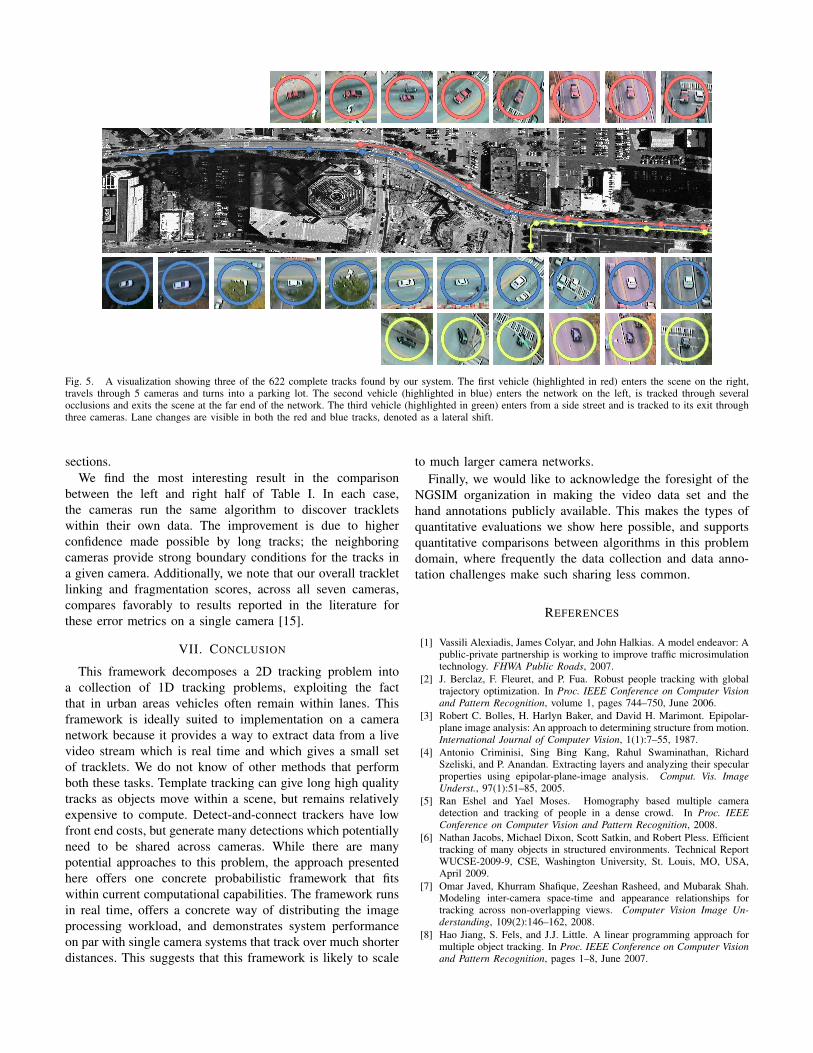
Fig. 5. A visualization showing three of the 622 complete tracks found by our system. The first vehicle (highlighted in red) enters the scene on the right,travels through 5 cameras and turns into a parking lot. The second vehicle (highlighted in blue) enters the network on the left, is tracked through severalocclusions and exits the scene at the far end of the network. The third vehicle (highlighted in green) enters from a side street and is tracked to its exit throughthree cameras. Lane changes are visible in both the red and blue tracks, denoted as a lateral shift.
sections.We find the most interesting result in the comparison
between the left and right half of Table I. In each case,the cameras run the same algorithm to discover trackletswithin their own data. The improvement is due to higherconfidence made possible by long tracks; the neighboringcameras provide strong boundary conditions for the tracks ina given camera. Additionally, we note that our overall trackletlinking and fragmentation scores, across all seven cameras,compares favorably to results reported in the literature forthese error metrics on a single camera [15].
VII. CONCLUSION
This framework decomposes a 2D tracking problem intoa collection of 1D tracking problems, exploiting the factthat in urban areas vehicles often remain within lanes. Thisframework is ideally suited to implementation on a cameranetwork because it provides a way to extract data from a livevideo stream which is real time and which gives a small setof tracklets. We do not know of other methods that performboth these tasks. Template tracking can give long high qualitytracks as objects move within a scene, but remains relativelyexpensive to compute. Detect-and-connect trackers have lowfront end costs, but generate many detections which potentiallyneed to be shared across cameras. While there are manypotential approaches to this problem, the approach presentedhere offers one concrete probabilistic framework that fitswithin current computational capabilities. The framework runsin real time, offers a concrete way of distributing the imageprocessing workload, and demonstrates system performanceon par with single camera systems that track over much shorterdistances. This suggests that this framework is likely to scale
to much larger camera networks.Finally, we would like to acknowledge the foresight of the
NGSIM organization in making the video data set and thehand annotations publicly available. This makes the types ofquantitative evaluations we show here possible, and supportsquantitative comparisons between algorithms in this problemdomain, where frequently the data collection and data anno-tation challenges make such sharing less common.
REFERENCES
[1] Vassili Alexiadis, James Colyar, and John Halkias. A model endeavor: Apublic-private partnership is working to improve traffic microsimulationtechnology. FHWA Public Roads, 2007.
[2] J. Berclaz, F. Fleuret, and P. Fua. Robust people tracking with globaltrajectory optimization. In Proc. IEEE Conference on Computer Visionand Pattern Recognition, volume 1, pages 744–750, June 2006.
[3] Robert C. Bolles, H. Harlyn Baker, and David H. Marimont. Epipolar-plane image analysis: An approach to determining structure from motion.International Journal of Computer Vision, 1(1):7–55, 1987.
[4] Antonio Criminisi, Sing Bing Kang, Rahul Swaminathan, RichardSzeliski, and P. Anandan. Extracting layers and analyzing their specularproperties using epipolar-plane-image analysis. Comput. Vis. ImageUnderst., 97(1):51–85, 2005.
[5] Ran Eshel and Yael Moses. Homography based multiple cameradetection and tracking of people in a dense crowd. In Proc. IEEEConference on Computer Vision and Pattern Recognition, 2008.
[6] Nathan Jacobs, Michael Dixon, Scott Satkin, and Robert Pless. Efficienttracking of many objects in structured environments. Technical ReportWUCSE-2009-9, CSE, Washington University, St. Louis, MO, USA,April 2009.
[7] Omar Javed, Khurram Shafique, Zeeshan Rasheed, and Mubarak Shah.Modeling inter-camera space-time and appearance relationships fortracking across non-overlapping views. Computer Vision Image Un-derstanding, 109(2):146–162, 2008.
[8] Hao Jiang, S. Fels, and J.J. Little. A linear programming approach formultiple object tracking. In Proc. IEEE Conference on Computer Visionand Pattern Recognition, pages 1–8, June 2007.

[9] Gabin Kayumbi, Pier Luigi Mazzeo, Paolo Spagnolo, Murtaza Taj,and Andrea Cavallaro. Distributed visual sensing for virtual top-view trajectory generation in football videos. In Proceedings of theInternational conference on Content-based image and video retrieval,pages 535–542, 2008.
[10] V. Kellokumpu, G. Zhao, and M. Pietikainen. Human activity recog-nition using a dynamic texture based method. In Proc. of The BritishMachine Vision Conference (BMVC 2008), 2008.
[11] B. Leibe, K. Schindler, and L. Van Gool. Coupled detection and trajec-tory estimation for multi-object tracking. In Proc. IEEE InternationalConference on Computer Vision, pages 1–8, Oct. 2007.
[12] J. Melo, A. Naftel, A. Bernardino, and J. Santos-Victor. Detectionand classification of highway lanes using vehicle motion trajectories.Intelligent Transportation Systems, IEEE Transactions on, 7(2):188–200,June 2006.
[13] Summary report, ngsim peachtree street (atlanta) data analysis.http://www.ngsim.fhwa.dot.gov/, June 2007.
[14] S.A. Niyogi and E.H. Adelson. Analyzing and recognizing walkingfigures in xyt. In Proc. IEEE Conference on Computer Vision andPattern Recognition, pages 469–474, 1994.
[15] A. G. Amitha Perera, Chukka Srinivas, Anthony Hoogs, Glen Brooksby,and Wensheng Hu. Multi-object tracking through simultaneous longocclusions and split-merge conditions. In Proc. IEEE Conference onComputer Vision and Pattern Recognition, pages 666–673, Washington,DC, USA, 2006. IEEE Computer Society.
[16] Robert Pless. Detecting roads in stabilized video with the spatio-temporal structure tensor. Geoinformatica, 10(1):37–53, 2006.
[17] Yang Ran, Rama Chellappa, and Qinfen Zheng. Finding gait in spaceand time. Proc. International Conference on Pattern Recognition, 4:586–589, 2006.
[18] Yann Ricquebourg and Patrick Bouthemy. Real-time tracking of movingpersons by exploiting spatio-temporal image slices. IEEE Transactionson Pattern Analysis and Machine Intelligence, 22(8):797–808, 2000.
[19] T.N. Schoepflin and D.J. Dailey. Dynamic camera calibration of roadsidetraffic management cameras for vehicle speed estimation. IntelligentTransportation Systems, IEEE Transactions on, 4(2):90–98, June 2003.
[20] Alper Yilmaz, Omar Javed, and Mubarak Shah. Object tracking: Asurvey. ACM Comput. Surv., 38(4):13, 2006.
[21] Li Zhang, Yuan Li, and R. Nevatia. Global data association for multi-object tracking using network flows. In Proc. IEEE Conference onComputer Vision and Pattern Recognition, pages 1–8, June 2008.