An Account and Survey of Great Oone's Hole, Cheddar Gorge, … · 2015. 4. 22. · Figure 1. Fake...
14
AN ACCOUNT AND SURVEY OF GREAT OONE’S HOLE, CHEDDAR GORGE, SOMERSET by G.J. MULLAN and A.A.D. MOODY ABSTRACT The history and archaeology of Great Oone’s Hole, in Cheddar Gorge are described, and a new survey is presented. The results of a previously unpublished investigation carried out in 1976-7 are discussed. It is concluded that the deposits have been too badly disturbed previously to merit further investigation. INTRODUCTION Great Oone’s Hole is situated high on the southern side of Cheddar Gorge, between Gough’s Cave and Cooper’s Hole. It is one of the few Mendip caves that can be described as having been ‘always open’ but despite that it seems to have a relatively obscure history and to be rather less well known than some of its neighbours. This account was inspired by two things; the re-survey of the cave as part of the project being carried out to build a comprehensive 3D model of all the caves in the Cheddar catchment and the discovery in the Society’s Library of a log book detailing a trial excavation in the entrance area of the cave carried out in 1976-7 but never published. OONES, GREAT AND OTHERWISE The origin of the cave’s name is not known for certain. Various writers have linked it to the Anglo-Saxon name for the Great Horned Owl (Barrington and Stanton, 1977) or the Anglo-Saxon for ‘one’ (Balch, 1935) The former seems unlikely, as the Old English (Anglo- Saxon) word for owl is either úle or úf (see http://bosworth.ff.cuni.cz/) and there seems to be nothing to link the site with owls; Barn Owls will nest on rock ledges and in caves, but there seems to be no direct evidence of this having happened at this site. The latter interpretation is more plausible as ‘one’ is oon in Middle English, the Old English being ãn, meaning ‘one’ ‘sole’ or ‘alone’ and would give something like the Great One’s Cave. There is, however, no conclusive evidence to justify a Middle English or Old English origin for the name of the cave. Jim Hanwell, who was brought up in Draycott, near Cheddar, recalls oone being used for ‘owl’ by his grandfather, Reginald Davis who worked in the quarries at Cheddar and by other locals, including Roland Pavey, Victor Painter (see below) and Painter’s son, Colin; the word being pronounced as if mimicking their hoots phonetically. (J.D. Hanwell, pers. comm.). If this is so, then this dialect usage seems to have been very localised as it does not seem to be recorded in standard works on Somerset speech. Elworthy (1886) gives oon the meaning of ‘one’ in 19th century dialect. He notes that it is “most usual in Dorset and E. Somerset, but also heard commonly in the vale of West Som. about Bishop's Lydeard.” Jennings (1825) makes no mention of the word, at all. Proc. Univ. Bristol Spelaeol. Soc., 2014, 26 (2), 117-130
Transcript of An Account and Survey of Great Oone's Hole, Cheddar Gorge, … · 2015. 4. 22. · Figure 1. Fake...

AN ACCOUNT AND SURVEY OF GREAT OONE’S HOLE,CHEDDAR GORGE, SOMERSET
by
G.J. MULLAN and A.A.D. MOODY
ABSTRACT
The history and archaeology of Great Oone’s Hole, in Cheddar Gorge are described, and a new survey ispresented. The results of a previously unpublished investigation carried out in 1976-7 are discussed. It is concluded thatthe deposits have been too badly disturbed previously to merit further investigation.
INTRODUCTION
Great Oone’s Hole is situated high on the southern side of Cheddar Gorge, betweenGough’s Cave and Cooper’s Hole. It is one of the few Mendip caves that can be described ashaving been ‘always open’ but despite that it seems to have a relatively obscure history and tobe rather less well known than some of its neighbours.
This account was inspired by two things; the re-survey of the cave as part of theproject being carried out to build a comprehensive 3D model of all the caves in the Cheddarcatchment and the discovery in the Society’s Library of a log book detailing a trial excavationin the entrance area of the cave carried out in 1976-7 but never published.
OONES, GREAT AND OTHERWISE
The origin of the cave’s name is not known for certain. Various writers have linked itto the Anglo-Saxon name for the Great Horned Owl (Barrington and Stanton, 1977) or theAnglo-Saxon for ‘one’ (Balch, 1935) The former seems unlikely, as the Old English (Anglo-Saxon) word for owl is either úle or úf (see http://bosworth.ff.cuni.cz/) and there seems to benothing to link the site with owls; Barn Owls will nest on rock ledges and in caves, but thereseems to be no direct evidence of this having happened at this site. The latter interpretation ismore plausible as ‘one’ is oon in Middle English, the Old English being ãn, meaning ‘one’‘sole’ or ‘alone’ and would give something like the Great One’s Cave. There is, however, noconclusive evidence to justify a Middle English or Old English origin for the name of the cave.
Jim Hanwell, who was brought up in Draycott, near Cheddar, recalls oone being usedfor ‘owl’ by his grandfather, Reginald Davis who worked in the quarries at Cheddar and byother locals, including Roland Pavey, Victor Painter (see below) and Painter’s son, Colin; theword being pronounced as if mimicking their hoots phonetically. (J.D. Hanwell, pers. comm.).If this is so, then this dialect usage seems to have been very localised as it does not seem to berecorded in standard works on Somerset speech. Elworthy (1886) gives oon the meaning of‘one’ in 19th century dialect. He notes that it is “most usual in Dorset and E. Somerset, but alsoheard commonly in the vale of West Som. about Bishop's Lydeard.” Jennings (1825) makes nomention of the word, at all.
Proc. Univ. Bristol Spelaeol. Soc., 2014, 26 (2), 117-130
A further unlikely possibility is given by Witcombe (2008) who postulated that thename may be a corruption of Great Wounte’s Hole where wounte is an archaic dialect term for‘mole’. This is partially corroborated by Jennings (op. cit.) who gives the spelling as wont butthere seems to be no direct justification for this reading in this case.
HISTORY
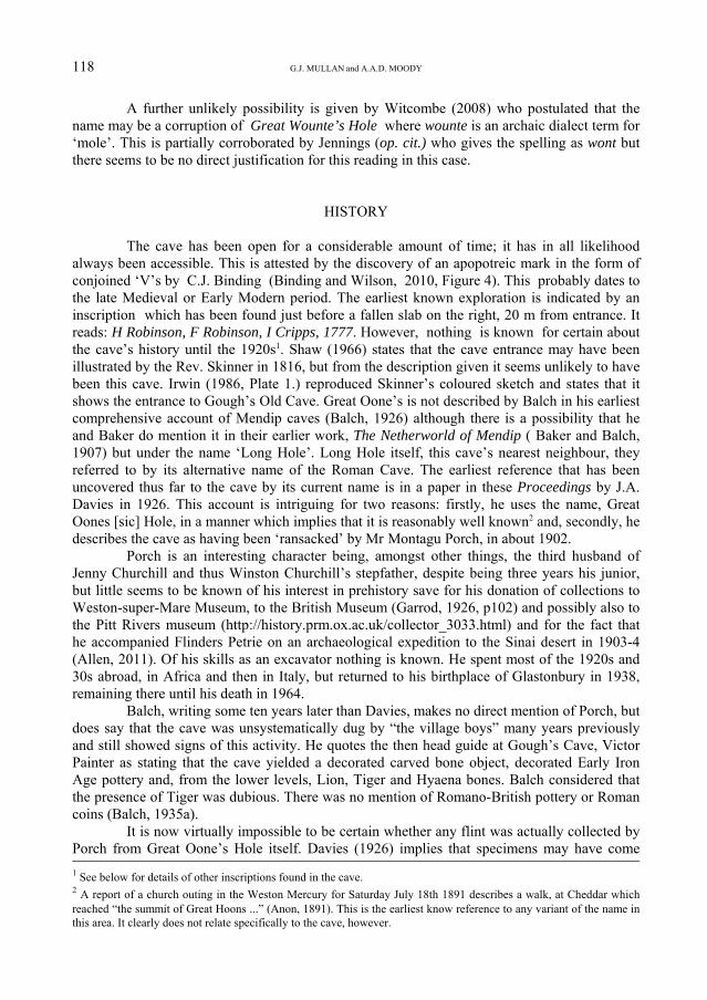
The cave has been open for a considerable amount of time; it has in all likelihoodalways been accessible. This is attested by the discovery of an apopotreic mark in the form ofconjoined ‘V’s by C.J. Binding (Binding and Wilson, 2010, Figure 4). This probably dates tothe late Medieval or Early Modern period. The earliest known exploration is indicated by aninscription which has been found just before a fallen slab on the right, 20 m from entrance. Itreads: H Robinson, F Robinson, I Cripps, 1777. However, nothing is known for certain aboutthe cave’s history until the 1920s1. Shaw (1966) states that the cave entrance may have beenillustrated by the Rev. Skinner in 1816, but from the description given it seems unlikely to havebeen this cave. Irwin (1986, Plate 1.) reproduced Skinner’s coloured sketch and states that itshows the entrance to Gough’s Old Cave. Great Oone’s is not described by Balch in his earliestcomprehensive account of Mendip caves (Balch, 1926) although there is a possibility that heand Baker do mention it in their earlier work, The Netherworld of Mendip ( Baker and Balch,1907) but under the name ‘Long Hole’. Long Hole itself, this cave’s nearest neighbour, theyreferred to by its alternative name of the Roman Cave. The earliest reference that has beenuncovered thus far to the cave by its current name is in a paper in these Proceedings by J.A.Davies in 1926. This account is intriguing for two reasons: firstly, he uses the name, GreatOones [sic] Hole, in a manner which implies that it is reasonably well known2 and, secondly, hedescribes the cave as having been ‘ransacked’ by Mr Montagu Porch, in about 1902.
Porch is an interesting character being, amongst other things, the third husband ofJenny Churchill and thus Winston Churchill’s stepfather, despite being three years his junior,but little seems to be known of his interest in prehistory save for his donation of collections toWeston-super-Mare Museum, to the British Museum (Garrod, 1926, p102) and possibly also tothe Pitt Rivers museum (http://history.prm.ox.ac.uk/collector_3033.html) and for the fact thathe accompanied Flinders Petrie on an archaeological expedition to the Sinai desert in 1903-4(Allen, 2011). Of his skills as an excavator nothing is known. He spent most of the 1920s and30s abroad, in Africa and then in Italy, but returned to his birthplace of Glastonbury in 1938,remaining there until his death in 1964.
Balch, writing some ten years later than Davies, makes no direct mention of Porch, butdoes say that the cave was unsystematically dug by “the village boys” many years previouslyand still showed signs of this activity. He quotes the then head guide at Gough’s Cave, VictorPainter as stating that the cave yielded a decorated carved bone object, decorated Early IronAge pottery and, from the lower levels, Lion, Tiger and Hyaena bones. Balch considered thatthe presence of Tiger was dubious. There was no mention of Romano-British pottery or Romancoins (Balch, 1935a).
It is now virtually impossible to be certain whether any flint was actually collected byPorch from Great Oone’s Hole itself. Davies (1926) implies that specimens may have come
118 G.J. MULLAN and A.A.D. MOODY
2 A report of a church outing in the Weston Mercury for Saturday July 18th 1891 describes a walk, at Cheddar whichreached “the summit of Great Hoons ...” (Anon, 1891). This is the earliest know reference to any variant of the name inthis area. It clearly does not relate specifically to the cave, however.
1 See below for details of other inscriptions found in the cave.

from Flint Jack’s Cave, but in contradiction, Oakley (1958) quotes part of a letter, dated 28thNovember 1950, from Balch to F.S. Wallis, then Director of the City Museum, Bristol whichrecords Victor Painter as stating that 50 years before, flint artefacts from Great Oone’s Holewere passed off as being from Flint Jack’s Cave.
A further, and rather peculiar, piece of archaeology was described by Balch a fewyears later, when he described the discovery of fake Palaeolithic rock art in this cave. He notesthat they “photographed and destroyed them, knowing them to be false” (Balch, 1941, p 50) butthe work was still visible enough to be photographed in 2003 (Figure 1). According to VictorPainter, they were probably made between 1925 and 1935 (Tratman, 1946).
Whatever the effect that “the village boys” and Mr Porch may have had on the archae-ology of the cave, it also seems to have been the case that it was stripped of a great many calciteformations, probably in the 19th century.
Figure 1. Fake Palaeolithic cave paintings, reputedly destroyed in 1935, pictured in 2003.Photo: G. Mullan.
In 1940, The cave was taken over by the armed forces, who equipped it as secrethideout for a Home Guard auxiliary unit, intended to be a sabotage team in the event of aGerman invasion. This work included the building of a wall across the entrance and the instal-lation of a gate. Inside the cave they installed bunks and a water collection tank (Brown, 1999).Stanton (1944) describes it being fitted out “as an air raid shelter” in June 1944, but notes thatby 1948, the fittings had been removed (Stanton, 1948). The remains of the entrance wall are
GREAT OONE’S HOLE, CHEDDAR GORGE 119

120 G.J. MULLAN and A.A.D. MOODY
Figu
re 2. 1935 surve y of Great O
one’sH
ole, by J.W. D
uck.

still there today. In 1956, the cave was again gated and locked by the landowners, the LongleatEstate, but this lock was reportedly soon removed (Frost, 1957) and the gate was completelyremoved at a later date.
In the early 1980s stalagmite samples were taken for purposes of radiometric dating.This material was reanalysed using modern methods in 2013 (see below).
THE 1976-7 EXCAVATIONS
According to the log books preserved in the Society’s Library, which seem to be theonly extant record of this work, the object of the dig was “to ascertain if the ‘plunderers’ whoare reported to have dug here at the end of the 19th century did, in fact, destroy the site fromthe archaeological point of view, or if there is still a stratified sequence left and to recover anyinformation which may still be found.”
Work began with the production of a BCRA Grade 6c survey of the first 15 m of thecave by E.K. Tratman, Juliet Rogers, D.J. Irwin. R. Harrison and C.J. Hawkes in January 1976.However, excavation did not commence until June 12th that year. Work took place over fiveweekends during 1976 and 1977, with the final working visit being on the 3rd July 1977. Thecore team comprised Tratman, Mrs Rogers, Harrison, and Hawkes, supplemented at times byMrs Elizabeth Hawkes, their two sons, Jeremy and Nick, and D. Wassell.
As no drawings of the excavations seem to have survived, it is difficult to easilyanalyse the results as recorded in the log. However, they do seem to have recorded a roughstratigraphy, though it seemed to intersect disturbed areas interpreted as being caused in part bythe footings for the wall across the cave mouth and in part by a trench dug possibly by MrPorch.
The stratigraphy can be partially reconstructed. The top layer was described in the logbook thus: “Red limestone breakdown earth with many angular stones up to 150 mm square.Into the top of the layer a lot of glass, remains from recent fires, sheep bones, iron nails, bolts,clay pipe stems and pieces of 18/19th C. internally green glazed ware had been trodden in. Thisgradually died out and before the bottom of this layer (at 370 approx) the root system of thepresent plant cover had died out. Apart from the modern remains and the sheep bones no othermaterial was found and there was no sign of disturbance except in the SE corner grading deeperthan 200. In the SE corner however where the present surface dips down toward the caveentrance gate there was a little more disturbance and perhaps there had been a trench dug intothe cave.” [Depths refer to an arbitrary zero datum point established close by.]
The second layer was also described in some detail: “Yellow silty layer with manyangular stones (reminiscent of the Pleistocene layers in other Mendip caves- EKT). No artefactsor skeletal material found. The layer went down gradually and erratically into a layer of whitetufaceious material between the stones. The change was over several centimetres and associatedwith a more open texture in the deposit as there was no salt between the stones but just a whitepatchy coating on the stones. The layer dips down into the cave – south. Middle to south thelayer was looser and more open as if there had been a ground slip ? Down to the gorge at sometime in the distant past. To the north end the layer was solider and a little damper – not sosheltered going down to a clay-marl layer over a large rock.”
The third layer was described in less detail but appears to have been an archaeologi-cally sterile marl.
The majority of the finds appear to have come from the second layer. The log listsskeletal remains “some of which appeared modern and others rather older” of sheep/goat,
GREAT OONE’S HOLE, CHEDDAR GORGE 121

rabbit, deer, horse, various birds, various rodents, insectivores, and possibly amphibians. Atleast one fragment of a flint blade, a piece of glass, some caches of nuts of different vintagesand charcoal apparently from at least one hearth are also mentioned.
Thus although it does seem that there may have been some Pleistocene fauna present,confirmed by a personal communication from Hawkes to Roger Jacobi (Jacobi, 2004) it alsoseems that the deposit has, indeed, been seriously disturbed and does not therefore justify anyfurther excavation. It is not known where the finds now are. Despite the site being given aUBSS catalogue number (M44) the material is not in the Society’s museum and no cataloguewas written. Neither is it listed in the Gough’s Cave Museum catalogue, which lists but twoitems from this site, a crudely made pottery lamp and a sherd from a decorated pot.
It seems clear that work ceased owing to the seriously disturbed nature of the deposit.The final visit, on 24th July 1977, by Tratman, Irwin and Hawkes was spent cleaning a better
way into the main cave to “allow easier access to the cave for dumping inside - if a suitable sitecan be found. That no final report was produced, even a brief one, can probably be attributed to
Figure 3. Great Oone’s main passage.Photo: A.P. Glanvill.
Tratman’s subsequent illness and his death in August 1978. A final visit was made on the 17thJune 1979 by a team including Hawkes and Harrison who cleared out the accumulated debris ofthe previous two years and started to cut down through what appeared to be lenses of ‘tip soil’.This work recovered two coins thought to be of Roman date. Sketches of these can be found on
122 G.J. MULLAN and A.A.D. MOODY

a sheet of paper inside one of the log books, but the current whereabouts of the specimensthemselves is unknown.
DESCRIPTION OF THE CAVE
The entrance to the cave is a 5 m wide arch, located high up the left-hand bank ofCheddar Gorge. In the past, a wall was constructed across the back of the arch allowing thecave to be locked. The cavecontains numerous inscrip-tions throughout its lengthand in this description, thenumbers in square bracketsrefer to entries in the detailedlist of inscriptions givenbelow. After passing theremnants of the old gate,access is gained to a wideroomy passage with arubbish-strewn floor [1].About 7 m from the gatethere is a line of three largeboulders [2]. Immediatelybeyond the third one, fakePalaeolithic cave paintingscan be found on the sloping,now yellow algae covered,right-hand wall. (Figure 1).
Ahead, the passagenarrows slightly [3, 4] and thepassage beyond [5] slopesgently uphill to a six-wayjunction, approximately 50 mfrom the entrance. Thepassage widens at this pointand the two ways on aheadunite after a few metres toform the route further into thecave. Two passages lead offto the right; the first is aloose bouldery crawl thatdescends steeply to a chokeafter 7 m, and the other passage is a narrow blind rift [6]. The final option at the six-wayjunction slopes up left to a level platform [7]. Four passages lead off from this point, and of thetwo routes to the right, the lower one has a tight connection to the higher continuation of themain route, while the other provides the return for a short round trip. This can be achieved byascending either of the two parallel passages that rise steeply above the platform. These twoclimbs unite in a horizontal passage that immediately divides. The left-hand branch slopes up to
GREAT OONE’S HOLE, CHEDDAR GORGE 123
Figure 4. The Slip, with steps cut in the calcite bank.Photo: A.P. Glanvill.

a small damaged grotto [8]. Here, evidence of chisel marks can be found and at some stage anattempt seems to have been made to erase some inscriptions and to remove the calcite blockinto which they were carved. In the grotto, a small blind annex can be entered by squeezing upthe back wall and a hole over to the right in the floor provides a tight connection with the otherbranch at the last junction. This option starts horizontally, but after a couple of metres the floordrops out as the passage changes to a 4 m deep rift. A direct descent can be made or, by travers-ing along the rift, it is possible to step down to a bouldery floor. At this point a scallopedmud-choked tube leads off to the left and in the opposite wall a small descending passagechokes after 4 m.
The main route doubles back along the base of the rift and after a few metres a choiceof either a lower or upper option both provide a link to the platform area mentioned earlier. Oneenters at floor level and the other comes in halfway up the right-hand climb.
Continuing down cave from the six-way junction, the easiest route is the lowerpassage. The higher option [9] drops into the lower route via a slippery calcite slope. Scratchedand pencil inscriptions can be found in the scalloped ceiling just beyond where the twopassages unite. Ahead the passage widens at an area of breakdown, notable for the boulderscovered in a vivid red ochre based mud and for a fine boulder arch. The safest option is to passthrough the right-hand side of the arch and beyond the breakdown the passage bends right anddescends steeply at a feature known as The Slip.
The Slip begins at an impressive flowstone bank, 10 m high and up to 6 m wide. Inplaces shallow steps have been cut into the calcite. On the descent, two blind steeply ascendingtubes can be entered by moving across to the left. A parallel option on the right-hand side of thestalagmite bank provides an alternative bouldery route back to the breakdown area, enteringnear the boulder arch.
At the base of the bank there are several features of interest. A 5 m high double avenrises above the right-hand side of the stalagmite bank, one option is blind and the other closesup at the top in a too-tight passage. In the roof ahead is the remnant of a large vandalised geodewhere, unfortunately, only a few dog-tooth crystals remain [10]. Below the stalagmite bank TheSlip continues descending steeply but the passage narrows, to 2 m wide, and the roof lowersforcing a crawl. After a few metres the passage widens in a breakdown area, with boulder slabs,before breaking out into a sizeable bedding chamber 12 m long and up to 8 m wide [11, 12].The laminated flowstone from where the U/Th dated stalagmite sample (see below) was takenis located in the top right-hand corner of the chamber. A nearby ledge, easily identifiable by theblack smoke mark on the wall has been used to form a candle niche. [13] Formations in thechamber include a flowstone bank on the right and at the lowest point dried up pools containsome superb calcite snowflake type rafts. A hole down to the left of the pools [14] gives accessto a descending chamber with a calcite flow along the floor. The chamber narrows to a constric-tion and beyond this a short crawl leads to a junction. The sizeable branch to the left closesdown after 7 m. The right branch, a phreatic passage, ends in a stalagmite choked grotto and adig below a false floor.
LIST OF RECORDED INSCRIPTIONS
1. The first inscriptions, which include H Cooper, F Trevana, F (or E) Harris, Cheddarare scratched on the sloping right-hand roof where the passage becomes standing height, about7 m from the gate and just before the first of the line of three large boulders.
124 G.J. MULLAN and A.A.D. MOODY

2. Just beyond these, inscriptions have been written, in what appears to be red wax onthe ceiling above the first boulder with the names H Robinson, F Robinson, I Cripps 1777, seeabove, and on the opposite wall: Luke D…. 177?. On this wall there is also an inscription inpencil: J Hill… 1902.
3. After 6 m there is an illegible inscription scratched on the right wall, directly oppositea section of damaged flowstone at head height.
4. Other inscriptions are found in a blind chimney Mu…. Scarborough York scratched ona wall.
5. In the passage beyondthe narrow point are inscriptionsincluding G Horn 1931 written inpencil.
6. The blind narrow rifthas some fine inscriptionsscratched on the left wall near theend, 1.5 m above the boulderfloor: 1912 H Pavey, JamesThomas and also the adjacentinitials JS CG RS KG HG 1937.
7. At the level platformseveral indecipherable inscrip-tions have been scratched on thewalls and roof.
8. In the small damagedgrotto there are many inscriptionsincluding a set that have beenchiselled on the back flowstonewall: 13/8 1902 E Wayland, FCooper.
9. The higher route hasseveral, possibly chalk, inscrip-tions including a W described asbeing in a very old style. Asnoted above, about ten years ago,a conjoined ‘V’ a type of sign used as a ritual protective mark was also described, but has notbeen located since. This was described as being close to the entrance and was drawn in “whatappeared to be charcoal on soft moonmilk covering the rock (Binding and Wilson, op. cit.).
10. To the left of the geode, a 4m high roof pocket has a pencil inscription on one wall: J.Mathison 5. Aug 1930.
GREAT OONE’S HOLE, CHEDDAR GORGE 125
Figure 5. Pencilled inscription (see item 13).Photo: A.A.D. Moody.

11. On entering the chamber, there is flowstone covered with pencil inscriptions on theoverhanging roof: R A Coop written three times – two of which are coated in calcite.
12. From point [11] by moving across to the right, looking down the chamber, anotherinscription can be seen which has been scratched in the overhanging roof: A Pavey 1900.
13. Continuing down the chamber and about 5 m from the entry point three calcite coatedpencil inscriptions are found high on the right-hand wall: R A Coop 1899, H Rogers twice1919. A nearby set of inscriptions bend around a corner to follow the line of the wall: N.Morton L Burnell …… Aug 10th 1906 (Figure 5).
Figure 6. Scratched inscription (see item 6).Photo: A.A.D. Moody
14. Above the hole down, further inscriptions have been engraved including in a box:1932 AH RS.
15. The phreatic passage has numerous inscriptions dating as far back as the 1930s.
RADIOMETRIC DATING
The sample of calcite collected in the 1980s has been reanalysed, as noted above, by ateam led by Don McFarlane and Joyce Lundberg. Dr Lundberg writes: “Great Oone’s Hole is apalaeo-resurgence cave for Cheddar River that is currently accessible from Gough’s Cave. Assuch, ages on Great Oone’s flowstones potentially provide minimum ages for stream
126 G.J. MULLAN and A.A.D. MOODY

Figure 7. Plan and projected elevation survey of Great Oone’s Hole.
GREAT OONE’S HOLE, CHEDDAR GORGE 127

abandonment and can be used to refine estimates of Gorge downcutting rate, work pioneered byAndy Farrant. A re-examination of a flowstone fragment from the lower part of Great Oone’shole, using TIMS U-Th dating, has yielded a marine isotope stage 9 age (~280,000 - 330,000years). In conjunction with better elevation data provided by the UBSS re-survey of GreatOone’s, we are now developing a more formal project to re-date critical deposits in the Gorge.The original analysis of this material was inconclusive and was thus never published.”
NOTES ON THE SURVEY
Great Oones Hole has been mapped in entirety twice before. The first survey wascarried out by J.W. Duck and published in 1935 (Balch, 1935b). It is reproduced here as Figure2. The second drawing was made by W.I. Stanton and published by him both as part of hisGough’s Cave drawing (Stanton, 1952) and later as part of his more comprehensive survey ofall the then known caves of Cheddar Gorge (Stanton, 1965). The data for the BCRA Grade 6csurvey of the first 15 m of the cave mentioned above is still extant in the Society’s Library, inone of the log books, but this never appears to have been drawn up.
The present survey (Figure 7) was carried out on the 31st May 2013, by AndrewAtkinson, Alison Moody and Tony Boycott using a Distox and PDA combination (Mullan andAtkinson, 2013). Total length is 257.03 m and vertical range 37.25 m. There are four closedloops, with relative errors of 0.61%, 0.52%, 0.40% and 0.28%. The survey is considered to beto grade UISv1 6-4-BCEF. (See http://www.uisic.uis-speleo.org/UISmappingGrades.pdf.) Theentrance location was checked using a hand-held Garmin Oregon 450 GPS with EGNOSenabled. The altitude comes from levelling carried out by W.I Stanton.
ACKNOWLEDGEMENTS
The authors wish to thank the management of Cheddar Gorge and Caves, especiallyHugh Cornwell, for allowing us unrestricted access to the cave. We are grateful to Dr JoyceLundberg for her comments on the radiometric dating and Andrew Atkinson for the drawing ofthe survey. Nicole Guenther Discenza, Associate Professor of English at the University ofSouth Florida, gave us invaluable advice on Old and Middle English. J.W. Duck’s survey ofthe cave is reproduced by kind permission of the Mendip Nature Research Committee. Somedetails of the inscriptions in the cave and the references to Shaw and Irwin were kindlysupplied by Tony Boycott. Richard Rossington found the reference to Porch having donated tothe Pitt Rivers Museum and Chris Richards the 1891 reference in the Weston Mercury.
REFERENCES
ALLEN, A.R. 2011. Last Act: Montagu Porch.http://www.winstonchurchill.org/learn/biography/genealogy/other-relations/931-last-act-montagu-porch. Accessed June 2013.
ANON, 1891. District News: St Werburgh’s Church Bible Class’s excursion to Cheddar. WestonMercury for Saturday July 18th. Page 8. Column 5.
128 G.J. MULLAN and A.A.D. MOODY

BAKER, E.A. and BALCH, H.E. 1907. The Netherworld of Mendip. London Simpkin, Marshall, Hamil-ton, Kent & Co.
BALCH, H.E. 1926. The Caves of Mendip. London. Folk Press Ltd.
BALCH, H.E. 1935a. Mendip - Cheddar, its Gorge and Caves. Wells. Clare, Son & Co. Ltd. (1st edition).
BALCH, H.E. 1935b. Annual Report of the Mendip Nature Research Committee. 28. 40-43.
BALCH, H.E. 1941. Mendip - Cheddar, its Gorge and Caves. Bristol John Wright & Sons Ltd. (2ndedition).
BARRINGTON, N. and STANTON, W.I. 1977. Mendip: The Complete Caves and a view of the hills.Cheddar. Barton Productions.
BINDING, C.J. and Wilson, L.J. 2010. Ritual protection marks in Wookey Hole and caves in the CheddarGorge, Somerset. Proceedings of the University of Bristol Spelaeological Society. 25. 1. 47-73.
BROWN, D. 1999. Somerset v Hitler: Secret Operations in the Mendips 1939-45. Newbury. CountrysideBooks.
DAVIES, J.A. 1926. Notes on Upper Palaeolithic implements from some Mendip Caves. Proceedings ofthe University of Bristol Spelaeological Society. 2. 3. 264.
ELWORTHY, F.T. 1886. The West Country Work Book. London. The English Dialect Society.
FROST, F.W. 1957. Vandalism in Cheddar Gorge. Journal of the Wessex Cave Club. 4. 64. 251.
GARROD, D.A.E. 1926. The Upper Palaeolithic Age in Britain. Oxford. Clarendon Press.
IRWIN, D.J. 1986. Gough’s Old Cave - Its History. Proceedings of the University of Bristol Spelaeologi-cal Society. 17. 3. 250-266.
JACOBI, R. 2004. The Late Upper Palaeolithic Collection from Gough’s Cave, Cheddar, Somerset andHuman Use of the cave. Proceedings of the Prehistoric Society. 70. 1-92.
JENNINGS, J. 1825. The Dialect of the West of England Particularly Somersetshire, with a glossary ofwords now in use there; also with poems and other pieces exemplifying the dialect. BaldwinCraddock and Joy. London.
MULLAN, G.J. And ATKINSON, A. 2013. A new survey of Gough’s Cave, Cheddar Gorge, Somerset.Proceedings of the University of Bristol Spelaeological Society. 26. 1. 27-36.
OAKLEY, K.P. 1958. The antiquity of the skulls reputed to be from Flint Jack’s Cave, Cheddar,Somerset. Proceedings of the University of Bristol Spelaeological Society. 8. 2. 77-82.
SHAW, T.R. 1966. Cave Illustrations Before 1900: a catalogue of non-photographic illustrations ofcaves. British Speleological Association Monograph.
STANTON, W.I. 1944. Caving Diary Volume 2, 1944-1945.http://www.mcra.org.uk/logbooks/index.php?dir=Willie%20Stanton%2F Accessed June 2013.
GREAT OONE’S HOLE, CHEDDAR GORGE 129

STANTON, W.I. 1948. Caving Diary Volume 4, 1947-1949.http://www.mcra.org.uk/logbooks/index.php?dir=Willie%20Stanton%2F Accessed June 2013.
STANTON, W.I. 1952. The survey of Cheddar Caves. Annual Report of the Mendip Nature ResearchCommittee. 44/45. 16-23.
STANTON, W.I. 1965. Notes on the survey : The caves of Cheddar and neighbourhood. Journal of theWessex Cave Club. 8. 103. 324-329.
TRATMAN, E.K. 1946 Entry for 9th January 1946 in UBSS Logbook. 1. 90-91.http://www.ubss.org.uk/resources/logs/1943-1946_UBSS_Camp_Log.pdf Accessed July 2013.
WITCOMBE, R. 2008. Who was Aveline anyway? Priddy. Wessex Cave Club. 2nd edition.
G.J. Mullan38, Delvin Road
Westbury on TrymBristol BS10 5EJ
A.A.D. MoodyFountain Cottage
Priddy GreenSomerset BA5 3BE
130 G.J. MULLAN and A.A.D. MOODY