AMC Strategic Infrastructure & Land Use Plan...2020/06/18 · Client approval Approval date D...
115
AMC Strategic Infrastructure & Land Use Plan DRAFT Strategic Infrastructure & Land Use Plan Department of Jobs, Tourism, Science and Innovation 18 June 2020 301012-02724
Transcript of AMC Strategic Infrastructure & Land Use Plan...2020/06/18 · Client approval Approval date D...

AMC Strategic Infrastructure & Land Use
Plan
DRAFT Strategic Infrastructure & Land Use Plan
Department of Jobs, Tourism, Science and Innovation
18 June 2020
301012-02724

AMC Strategic Infrastructure & Land Use Plan Advisian 2
D: 301012-02724-MP-REP-0003
Disclaimer
This report has been prepared on behalf of and for the exclusive use of Department of Jobs, Tourism,
Science and Innovation, and is subject to and issued in accordance with the agreement between
Department of Jobs, Tourism, Science and Innovation and Advisian Pty Ltd. Advisian Pty Ltd accepts no
liability or responsibility whatsoever for it in respect of any use of or reliance upon this report by any
third party. Copying this report without the permission of Department of Jobs, Tourism, Science and
Innovation and Advisian Pty Ltd is not permitted.
Company details
Advisian Pty Ltd
ABN 50 098 008 818
Level 14, 240 St Georges Terrace
Perth WA 6000
Australia
T: +61 8 9485 3811
F: +61 8 9278 8110
PROJECT 301012-02724 - 301012-02724-MP-REP-0003: AMC Strategic Infrastructure & Land
Use Plan - DRAFT Strategic Infrastructure & Land Use Plan
Rev Description Author Review Advisian
approval
Revision
date
Client
approval
Approval
date
D
Issued for Stakeholder
Consultation DF/AB PM AB
18.06.20 Approval
date
DF / AB PM AB
AMC Strategic Infrastructure & Land Use Plan Advisian 3
D: 301012-02724-MP-REP-0003
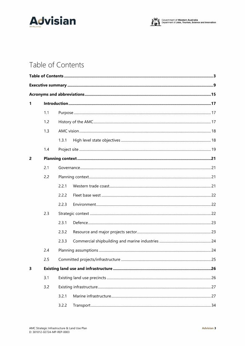
Table of Contents
Table of Contents ......................................................................................................................................... 3
Executive summary ...................................................................................................................................... 9
Acronyms and abbreviations .................................................................................................................... 15
1 Introduction ................................................................................................................................... 17
Purpose .......................................................................................................................................................... 17
History of the AMC .................................................................................................................................... 17
AMC vision .................................................................................................................................................... 18
1.3.1 High level state objectives ..................................................................................................... 18
Project site .................................................................................................................................................... 19
2 Planning context ........................................................................................................................... 21
Governance ................................................................................................................................................... 21
Planning context ......................................................................................................................................... 21
2.2.1 Western trade coast .................................................................................................................. 21
2.2.2 Fleet base west ........................................................................................................................... 22
2.2.3 Environment ................................................................................................................................. 22
Strategic context ........................................................................................................................................ 22
2.3.1 Defence .......................................................................................................................................... 23
2.3.2 Resource and major projects sector ................................................................................... 23
2.3.3 Commercial shipbuilding and marine industries .......................................................... 24
Planning assumptions .............................................................................................................................. 24
Committed projects/infrastructure ..................................................................................................... 25
3 Existing land use and infrastructure .......................................................................................... 26
Existing land use precincts ..................................................................................................................... 26
Existing infrastructure ............................................................................................................................... 27
3.2.1 Marine infrastructure ................................................................................................................ 27
3.2.2 Transport ....................................................................................................................................... 34

AMC Strategic Infrastructure & Land Use Plan Advisian 4
D: 301012-02724-MP-REP-0003
3.2.3 Utilities ........................................................................................................................................... 42
Latitude 32 Industrial Area – DA6A ..................................................................................................... 45
4 Demand drivers ............................................................................................................................. 47
Defence activities ....................................................................................................................................... 47
4.1.1 Vessel characteristics ................................................................................................................ 48
4.1.2 New vessel builds ...................................................................................................................... 49
4.1.3 Vessel maintenance requirements ...................................................................................... 50
Resources and major project activities .............................................................................................. 52
Commercial shipbuilding and maintenance activities ................................................................. 54
Planning and design principles for AMC waterfront .................................................................... 55
4.4.1 Berth characteristics and planning assumptions ........................................................... 55
4.4.2 Future demand for berth facilities ...................................................................................... 56
4.4.3 Vessel lift and transfer characteristics and planning assumptions ........................ 57
4.4.4 Future demand for lift and transfer facilities .................................................................. 59
4.4.5 Vessel hardstand characteristics and planning assumptions ................................... 61
4.4.6 Future demand for vessel hardstand ................................................................................. 61
5 Opportunities and constraints .................................................................................................... 63
Defence .......................................................................................................................................................... 63
Commercial shipbuilding ........................................................................................................................ 64
Resource sector and major projects ................................................................................................... 64
Support industry/activities ..................................................................................................................... 65
Common User Facility .............................................................................................................................. 65
Transportation ............................................................................................................................................. 66
Utilities ............................................................................................................................................................ 66
Governance ................................................................................................................................................... 67
Environment ................................................................................................................................................. 67
Amenity .......................................................................................................................................................... 67
6 Infrastructure and land use solutions ........................................................................................ 68
Waterfront land uses ................................................................................................................................ 68
AMC Strategic Infrastructure & Land Use Plan Advisian 5
D: 301012-02724-MP-REP-0003
Northern Harbour – concept ................................................................................................................. 69
6.2.1 CUF North ..................................................................................................................................... 69
6.2.2 Initial development ................................................................................................................... 72
6.2.3 Waterfront land use priority zones ..................................................................................... 72
Southern Harbour – concept 1 ............................................................................................................. 74
6.3.1 Stage 1: 0 to 5 years ................................................................................................................. 74
6.3.2 Stage 2: 5 to 10 years ............................................................................................................... 77
6.3.3 Stage 3: 10+ years ..................................................................................................................... 79
6.3.4 Waterfront land use priority zones ..................................................................................... 81
Southern Harbour – concept 2 ............................................................................................................. 82
6.4.1 Stage 1: 0 to 5 years ................................................................................................................. 82
6.4.2 Stage 2: 5 to 10 years ............................................................................................................... 84
6.4.3 Stage 3: 10+ years ..................................................................................................................... 86
6.4.4 Waterfront land use priority zones ..................................................................................... 88
AMC land use precincts ........................................................................................................................... 90
Available development sites .................................................................................................................. 90
6.6.1 Lots 15, 16 and 17 Clarence Beach Road ......................................................................... 92
6.6.2 Lot 307 and part Lot 804 ........................................................................................................ 92
6.6.3 Sump ‘D’ ........................................................................................................................................ 92
6.6.4 Lot 101 Stuart Drive .................................................................................................................. 93
6.6.5 Technology precinct ................................................................................................................. 93
Transport infrastructure ........................................................................................................................... 93
6.7.1 Car parking ................................................................................................................................... 94
6.7.2 Proposed public car parks ...................................................................................................... 94
6.7.3 Public transport .......................................................................................................................... 97
Roads .............................................................................................................................................................. 99
6.8.1 Intersections................................................................................................................................. 99
6.8.2 Restricted access vehicles and high wide loads .......................................................... 101
6.8.3 Pedestrians ................................................................................................................................. 104
AMC Strategic Infrastructure & Land Use Plan Advisian 6
D: 301012-02724-MP-REP-0003
6.8.4 Cycling .......................................................................................................................................... 104
6.8.5 Integrated Transport Plan .................................................................................................... 104
Utilities .......................................................................................................................................................... 105
6.9.1 Power ............................................................................................................................................ 105
6.9.2 Water ............................................................................................................................................ 105
6.9.3 Telecommunications .............................................................................................................. 106
Amenities ..................................................................................................................................................... 106
Governance ................................................................................................................................................. 106
7 Next steps ................................................................................................................................... 107
8 Future studies ............................................................................................................................. 108
9 References ................................................................................................................................... 110
Appendix A Stakeholder Consultation ............................................................................................ 112
A.1 Stakeholder consultation methodology ......................................................................................... 113
A.2 Phase 1 ......................................................................................................................................................... 114
A.3 Phase 2 ......................................................................................................................................................... 114
A.4 Outcomes phase 1 consultation ........................................................................................................ 115

AMC Strategic Infrastructure & Land Use Plan Advisian 7
D: 301012-02724-MP-REP-0003
Table list
Table 2-1 Existing governance structure ........................................................................................................................... 21
Table 3-1 AMC CUF berths...................................................................................................................................................... 30
Table 4-1 Vessel key characteristics .................................................................................................................................... 48
Table 4-2 Resource project opportunities ........................................................................................................................ 53
Table 4-3 Typical vessel sizes ................................................................................................................................................. 55
Table 4-4 Lift and transfer options ...................................................................................................................................... 58
Table 6-1 Waterfront activity zones .................................................................................................................................... 69
Table 6-2 Lot sizes ...................................................................................................................................................................... 92
Table 8-1 Summary of future study requirements ...................................................................................................... 108
Table 9-1 Stakeholder consultation categories ............................................................................................................ 113
Table 9-2 Phase 1 questionnaire response rate ........................................................................................................... 115
Figure list
Figure 0-1 AMC context ........................................................................................................................................................... 10
Figure 0-2 AMC Strategic Infrastructure and Land Use Plan Option 1 ................................................................. 13
Figure 0-3 AMC Strategic Infrastructure and Land Use Plan Option 2 ................................................................. 14
Figure 1-1 AMC context ........................................................................................................................................................... 20
Figure 3-1 Approach shipping channels to AMC ........................................................................................................... 28
Figure 3-2 AMC harbour dredge depths ........................................................................................................................... 29
Figure 3-3 Existing berth locations at the CUF................................................................................................................ 30
Figure 3-4 AMC lift and transfer capabilities ................................................................................................................... 31
Figure 3-5 Naval Waters at AMC (Commonwealth of Australia, 2019) ................................................................. 33
Figure 3-6 AMC road network ............................................................................................................................................... 35
Figure 3-7 Existing RAV and High Wide Load networks ............................................................................................. 37
Figure 3-8 Existing on street car parking (source: (City of Cockburn, 2016)) ..................................................... 38
Figure 3-9 Existing public transport services ................................................................................................................... 39
Figure 3-10 Existing cycling infrastructure........................................................................................................................ 41
Figure 3-11 Existing power and domestic gas distribution networks .................................................................... 43
Figure 3-12 Existing potable water and sewer networks ............................................................................................ 44

AMC Strategic Infrastructure & Land Use Plan Advisian 8
D: 301012-02724-MP-REP-0003
Figure 4-1 AMC 4, 5 and 6 wharf utilisation .................................................................................................................... 54
Figure 4-2 Defence berth demand over time .................................................................................................................. 57
Figure 4-3 Defence lift and transfer demand over time .............................................................................................. 60
Figure 4-4 Hardstand demand over time .......................................................................................................................... 62
Figure 6-1 Northern Harbour concept ............................................................................................................................... 71
Figure 6-2 Waterfront land use priority zones ................................................................................................................ 73
Figure 6-3 Southern Harbour concept 1 - stage 1, 0 to 5 years .............................................................................. 76
Figure 6-4 Southern Harbour concept 1 - stage 2, 5 to 10 years ............................................................................ 78
Figure 6-5 Southern Harbour concept 1 - stage 3, 10+ years .................................................................................. 80
Figure 6-6 Southern Harbour concept 1 – land use priority zones ........................................................................ 81
Figure 6-7 Southern Harbour concept 2 - stage 1, 0 to 5 years .............................................................................. 83
Figure 6-8 Southern Harbour concept 2 - stage 2, 5 to 10 years ............................................................................ 85
Figure 6-9 Southern Harbour concept 2 – stage 3, 10+ years ................................................................................. 87
Figure 6-10 Southern Harbour concept 2 land use priority zones ......................................................................... 89
Figure 6-11 Available development sites .......................................................................................................................... 91
Figure 6-12 Proposed multi-user car park locations .................................................................................................... 96
Figure 6-13 Proposed modification to bus service 522 ............................................................................................... 98
Figure 6-14 AMC critical intersections ............................................................................................................................. 100
Figure 6-15 Proposed HWL corridor to the Latitude 32 Industrial Area ............................................................. 103
Figure 7-1 Next steps .............................................................................................................................................................. 107

AMC Strategic Infrastructure & Land Use Plan Advisian 9
D: 301012-02724-MP-REP-0003
Executive summary
The Australian Marine Complex (AMC) is located in Henderson, approximately 23km south of the Perth
city centre. It is a world-class centre of excellence for manufacturing, fabrication, assembly, technology,
repair and maintenance activities of the marine, defence and resource industries.
At the heart of the complex is the Western Australian Government owned Common User Facility (CUF),
which commenced operations in 2003. Its business model is the provision of facilities for multiple
users, including laydown areas, a fabrication hall, workshops, offices, off-load and load-out wharves
and vessel berths.
Vessel construction and maintenance has always played a key role in the AMC. However, for the past
15 years supporting large scale resource projects (oil and gas as well as mining) has been a key focus.
Looking to the future, shipbuilding and sustainment (in particular driven by the Defence sector) is seen
as a key to the AMC’s continuing growth.
As one of just two locations identified for naval shipbuilding in Australia, the AMC is of strategic
national importance. The AMC will support the continuous build of minor naval vessels and future
maintenance and sustainment of submarines, and surface vessels. The AMC will also be critical to
attracting suitable export opportunities and international sustainment work.
To ensure Western Australia is ready to support this future naval work and provide ongoing support
for resource and other major projects, it is critical that infrastructure in the AMC is matched to the
current and emerging requirements of these sectors. It is also critical for the surrounding areas, both
land and waterways, to be equipped with the necessary infrastructure, services and utilities to support
this effort.
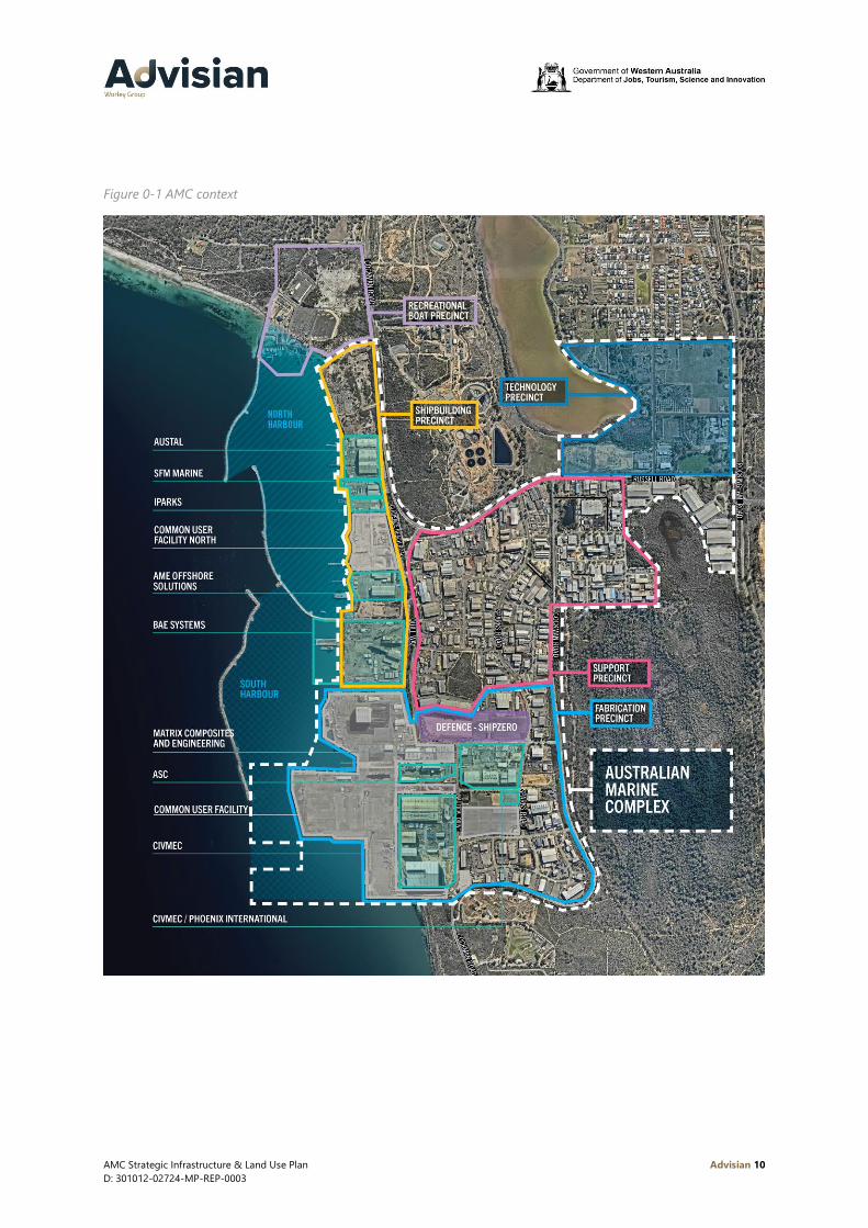
The AMC consists of the following key precincts shown in Figure 0-1:
• Shipbuilding Precinct
• Technology Precinct
• Support Industry Precinct
• Fabrication Precinct (including the CUF)
• Recreational Boat Precinct.
Purpose
The purpose of the Strategic Infrastructure and Land Use Plan (SILUP) is to provide a comprehensive
land and infrastructure response to both the current and future requirements of the defence, resources
and marine industries at the AMC including their associated manufacturing, fabrication and assembly
needs.
AMC Strategic Infrastructure & Land Use Plan Advisian 10
D: 301012-02724-MP-REP-0003
Figure 0-1 AMC context

AMC Strategic Infrastructure & Land Use Plan Advisian 11
D: 301012-02724-MP-REP-0003
High Level State Objectives
• Establish the AMC as the principal location for all maintenance, upgrades and sustainment of
Australia’s submarines and frigates1
• Enable the national and international expansion of Western Australia’s defence, marine and
resource industry capabilities
• Facilitate and enhance economic development and diversification opportunities created by the
clustering of defence, marine, and resources industries
• Provide common user infrastructure and land to meet the needs of defence, marine, and resource
industries
• Enable the co-location of businesses across the marine, defence and resource industries supply
chains
• Enable research and development activities that promote cross sector collaboration and
innovation.
Land Use
Currently land within the AMC is structured around five precincts, each with a focus on different
activities. This precinct structure has informed the AMC’s development to date and major changes to
this approach is not proposed. It is critical that the unique nature of the AMC is preserved in the future,
and that land use provides for a range of industrial activities associated with the defence, resource and
marine industries. With the development of the Latitude 32 Industrial Area adjacent to the AMC there
is the potential for new support businesses to be located here.
AMC Waterfront
The AMC waterfront is focused on two sheltered harbours. The SILUP has considered the roles and
functions of each harbour in alignment with the State’s objectives for the future of the AMC.
AMC Northern Harbour
The primary focus of the Northern Harbour will be to continue to support build of minor naval vessels,
commercial shipbuilding and maintenance activities. Key elements proposed for the Northern Harbour
include:
• Extension of Clarence Beach Road and utilities north to support development of Lots 15, 16 and 17
• A land backed wharf and potential new ship transfer system within the existing CUF North
• New fabrication buildings within CUF North
• Extension of the vessel transfer path from the Southern Harbour to Austal and including CUF
North, providing access to the BAE and CUF ship lift facilities.
AMC Southern Harbour
The primary focus of the Southern Harbour will be to support the construction and sustainment of
Defence vessels and the ongoing support of resource sector and major projects. Two concept options
have been developed for the future development of land and infrastructure within the Southern
1 As and when required by Defence and the Commonwealth Government.
AMC Strategic Infrastructure & Land Use Plan Advisian 12
D: 301012-02724-MP-REP-0003
Harbour. Both options provide the same capacity with regard to berth numbers, vessel lift and transfer,
vessel transfer paths, hardstand positions and breakwaters.
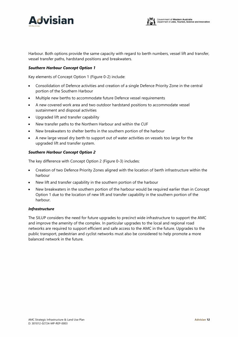
Southern Harbour Concept Option 1
Key elements of Concept Option 1 (Figure 0-2) include:
• Consolidation of Defence activities and creation of a single Defence Priority Zone in the central
portion of the Southern Harbour
• Multiple new berths to accommodate future Defence vessel requirements
• A new covered work area and two outdoor hardstand positions to accommodate vessel
sustainment and disposal activities
• Upgraded lift and transfer capability
• New transfer paths to the Northern Harbour and within the CUF
• New breakwaters to shelter berths in the southern portion of the harbour
• A new large vessel dry berth to support out of water activities on vessels too large for the
upgraded lift and transfer system.
Southern Harbour Concept Option 2
The key difference with Concept Option 2 (Figure 0-3) includes:
• Creation of two Defence Priority Zones aligned with the location of berth infrastructure within the
harbour
• New lift and transfer capability in the southern portion of the harbour
• New breakwaters in the southern portion of the harbour would be required earlier than in Concept
Option 1 due to the location of new lift and transfer capability in the southern portion of the
harbour.
Infrastructure
The SILUP considers the need for future upgrades to precinct wide infrastructure to support the AMC
and improve the amenity of the complex. In particular upgrades to the local and regional road
networks are required to support efficient and safe access to the AMC in the future. Upgrades to the
public transport, pedestrian and cyclist networks must also be considered to help promote a more
balanced network in the future.

AMC Strategic Infrastructure & Land Use Plan Advisian 13
D: 301012-02724-MP-REP-0003
Figure 0-2 AMC Strategic Infrastructure and Land Use Plan Option 1

AMC Strategic Infrastructure & Land Use Plan Advisian 14
D: 301012-02724-MP-REP-0003
Figure 0-3 AMC Strategic Infrastructure and Land Use Plan Option 2

AMC Strategic Infrastructure & Land Use Plan Advisian 15
D: 301012-02724-MP-REP-0003
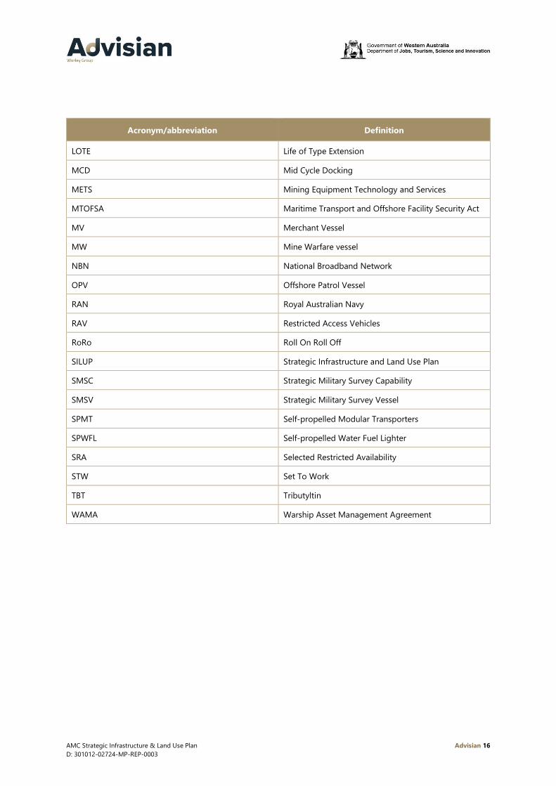
Acronyms and abbreviations
Acronym/abbreviation Definition
ACSM Attack Class Submarine
ADV Australian Defence Vessel
AMC Australian Marine Complex
AMCM AMC Management Pty Ltd
AMCAP Anzac Midlife Capability Assurance Program
AOR Auxiliary Oiler Replenishment
ASC Australian Submarine Corporation
CASG Capability Acquisition and Sustainment Group
CD Chart Datum
CUF Common User Facility
CCSM Collins Class Submarine
Defence Department of Defence
DMSS Defence Maintenance Support Systems
DoT Department of Transport
DSRA Selected Restricted Availability with Docking
EMP Extended Maintenance Period
EPA Environmental Protection Authority
FBE Fleet Base East
FBW Fleet Base West
FCD Full Cycle Docking
FFG Frigate (Hunter Class)
FFH Frigate (Anzac Class)
FTTN Fibre To The Node
GSP Gross State Product
HMAS Her Majesty’s Australian Ship
HWL High Wide Loads
IMAV Intermediate Maintenance Availability Period
JTSI Department of Jobs, Tourism, Science and Innovation
AMC Strategic Infrastructure & Land Use Plan Advisian 16
D: 301012-02724-MP-REP-0003
Acronym/abbreviation Definition
LOTE Life of Type Extension
MCD Mid Cycle Docking
METS Mining Equipment Technology and Services
MTOFSA Maritime Transport and Offshore Facility Security Act
MV Merchant Vessel
MW Mine Warfare vessel
NBN National Broadband Network
OPV Offshore Patrol Vessel
RAN Royal Australian Navy
RAV Restricted Access Vehicles
RoRo Roll On Roll Off
SILUP Strategic Infrastructure and Land Use Plan
SMSC Strategic Military Survey Capability
SMSV Strategic Military Survey Vessel
SPMT Self-propelled Modular Transporters
SPWFL Self-propelled Water Fuel Lighter
SRA Selected Restricted Availability
STW Set To Work
TBT Tributyltin
WAMA Warship Asset Management Agreement

AMC Strategic Infrastructure & Land Use Plan Advisian 17
D: 301012-02724-MP-REP-0003
1 Introduction
On 30 October 2018, the Premier launched the Western Australian Defence and Defence Industries
Strategic Plan (Government of Western Australia, 2018) to ensure Western Australia can fully
contribute to the national and international defence industry. The Strategic Plan’s vision is for the
defence sector to continue to grow and become a key pillar of the Western Australian economy, with
the annual Gross State Product (GSP) contribution to double by 2030 to $6 billion.
The Strategic Plan outlines six key strategies to achieve this vision, one of which is ‘developing
strategic infrastructure’. This involves strategic planning for, and management of the Henderson
Precinct and the Australian Marine Complex (AMC) to ensure they meet current and future Defence
requirements, and to optimise and coordinate infrastructure to continue to meet the needs of
resources and other industry sectors. The Henderson Precinct is the terminology used by Defence
when referring to the Australian Marine Complex.
As one of just two locations identified by the Commonwealth Government for naval shipbuilding in
Australia, the AMC is of strategic national importance. The AMC will support the continuous build of
minor vessels and future maintenance and sustainment of the Royal Australian Navy fleet including
submarines, patrol boats and frigates. The AMC will also be critical to attracting suitable export
opportunities and international sustainment work. Additionally, the AMC has played (and will continue
to) a pivotal role in the development of resource sector and major projects throughout Western
Australia as a base for manufacturing and fabrication prior to deployment on site.
To ensure Western Australia is ready to support future Defence and major projects, it is critical that
infrastructure in the AMC is matched to the current and future requirements of these sectors. It is also
critical for the surrounding areas, both land and waterways, to be equipped with the necessary
infrastructure, services and utilities to support this effort.
Purpose
The purpose of the Strategic Infrastructure and Land Use Plan (SILUP) is to provide a comprehensive
land and infrastructure response to both the current and future requirements of the defence, resources
and marine industries at the AMC including their associated manufacturing, fabrication and assembly
needs.
This is a high level plan only and there will be the need to complete further, more detailed studies on a
number of the recommendations prior to their implementation.
History of the AMC
The AMC was established in 2003 following development of the Common User Facility. Since its
establishment, the AMC has become home to hundreds of businesses focussed on the complex key
areas of manufacturing, fabrication, assembly, technology, repair and maintenance for the marine,
defence and resource sectors.
The AMC has played a key role in the construction of many resources projects in the mining, oil and
gas sectors over the past two decades.

AMC Strategic Infrastructure & Land Use Plan Advisian 18
D: 301012-02724-MP-REP-0003
Between 2002 and 2005, investment from both Commonwealth and State Governments of $200
million assisted in developing strategic infrastructure to capitalise on the growing potential in marine,
defence, mining, oil and gas industries by enabling the delivery of major engineering projects within
the State.
The State Government further invested $170 million between 2006 and 2008, to further enhance
capability including the floating dock, self-propelled modular transporters and extensions to wharves.
During 2009 to 2010 a partnership with Chevron saw the development of their quarantine base and a
$35 million service and supply base. The floating dock was commissioned with enhanced lifting
capability for the defence and marine industries.
Growth continued from 2011 to 2013 with the establishment of businesses in the Support Precinct,
with benefits arising from the strategic location to facilitate commercial success. Since 2014 the overall
markets slowed in both the mining, and oil and gas sectors however the AMC has retained a key role
in the support of this sector.
AMC vision
At the heart of AMC’s success is a clearly articulated vision:
‘A world class centre of excellence for manufacturing, fabrication, assembly, technology, repair and
maintenance servicing activities in the marine, defence and resources industries. Which also incorporates
a state of the art recreational boating launching, storage and servicing facilities for the WA community.’
(AMC Land Use and Infrastructure Plan, 2008)
1.3.1 High level state objectives
During the process of this study high level objectives have been developed, as follows:
• Establish the AMC as the principal location for all maintenance, upgrades and sustainment of
Australia’s submarines and frigates2
• Enable the national and international expansion of Western Australia’s defence, marine and
resource industry capabilities
• Facilitate and enhance economic development and diversification opportunities created by the
clustering of defence, marine, and resources industries
• Provide common user infrastructure and land to meet the needs of defence, marine, and resource
industries
• Enable the co-location of businesses across the marine, defence and resource industries supply
chains
• Enable research and development activities that promote cross sector collaboration and
innovation.
2 As and when required by Defence and the Commonwealth Government.

AMC Strategic Infrastructure & Land Use Plan Advisian 19
D: 301012-02724-MP-REP-0003
A number of sector specific objectives have also been developed:
Defence
• Ensure the AMC can support sustainment and maintenance activities of all Royal Australian Navy
(RAN) vessels stationed at Fleet Base West (FBW), as well as a number of vessels based at Fleet
Base East (FBE)
• Position the AMC to support sustainment activities of Allies and Regional Partners subject to
harbour and infrastructure capabilities/availabilities
• Provide a competitive environment for defence sustainment work through the availability of
common user infrastructure
• Establish the AMC as a secure and resilient support location for Defence
• Develop the AMC as a location that attracts and sustains a distinguished Defence and defence
industries workforce.
Resource Sector and Major Projects
• Ensure that sufficient land and suitable infrastructure is available to support the resource sector on
a project basis
• Provide a competitive environment for resource sector project work through the availability of
common user infrastructure
• Develop the AMC as a flexible environment with opportunity for expanded laydown areas that are
appropriately connected to the Common User Facility.
Commercial Shipbuilding and Maintenance
• Ensure the AMC has capacity to support commercial shipbuilding and maintenance activities
• Provide a competitive environment for project work through the availability of common user
infrastructure
• Develop the Common User Facility in the Northern Harbour as a hub for commercial shipbuilding
and maintenance activities, and support of smaller Defence vessels.
Project site
The AMC, located approximately 23km south of Perth in the suburb of Henderson, consists of the
following key precincts and shown in Figure 1-1:
• Shipbuilding Precinct
• Technology Precinct
• Support Industry Precinct
• Fabrication Precinct (including the CUF)
• Recreational Boat Precinct.
Section 3.1 provides an overview of the purpose and core functions of each precinct.

AMC Strategic Infrastructure & Land Use Plan Advisian 20
D: 301012-02724-MP-REP-0003
Figure 1-1 AMC context

AMC Strategic Infrastructure & Land Use Plan Advisian 21
D: 301012-02724-MP-REP-0003
2 Planning context
The following section provides an overview of agencies currently responsible for the planning and
operation of the AMC and current policy/strategy positions that will drive the future development of
the AMC.
Governance
Governance within the AMC involves several agencies/authorities for various elements of the AMC.
Table 2-1 identifies existing agencies and their role within the AMC at present.
Table 2-1 Existing governance structure
Agency Responsibilities
Department of Jobs,
Tourism, Science and
Innovation
WA Government department responsible for strategic planning
within the AMC
DevelopmentWA WA Government agency responsible for the management of
strategic government land holdings within the AMC and
infrastructure within the CUF
City of Cockburn WA Local Government responsible for the administration of local
planning regulations and requirements within the AMC and
infrastructure including roads, drainage, footpaths etc
AMC Management (AMCM) Contracted facility manager and responsible for the day to day
operations of the CUF
Department of Transport
(DoT)
WA Government department responsible for operation of the
Northern Harbour, including seabed leases and the Woodman
Point Recreational Boating Facility
Fremantle Ports Authority WA Government agency responsible for operation of the Southern
Harbour including seabed leases
Department of Defence Commonwealth Government department responsible for control
of Naval Waters
Planning context
2.2.1 Western trade coast
The AMC is one of four industrial areas that makes up an area known as the Western Trade Coast. The
other industrial areas being the Kwinana Industrial Area, Rockingham Industry Zone and Latitude 32.

AMC Strategic Infrastructure & Land Use Plan Advisian 22
D: 301012-02724-MP-REP-0003
The four industrial areas are home to State and nationally significant industrial operations and their
associated supply chains. These operations include heavy engineering, fuel refining, mineral
processing, chemical manufacturing, energy generation and others. The synergies offered by these
existing operations together with established industrial land, waterways, infrastructure and services,
can continue to support the Defence, resources and marine industries in the AMC and vice-versa.
2.2.2 Fleet base west
The RAN has a permanent presence on Garden Island, in the form of HMAS Stirling. This is the
location of FBW, the home port to the RAN’s West Coast Fleet, including ships, submarines, support
vessels, support staff, logistics and repair facilities and Australian Clearance Diving Team Four. HMAS
Stirling continues to provide a base for the RAN in its response to regional security in the Indian
Ocean.
The AMC provides a critical sustainment hub supporting all FBW vessels and the greater Australian
naval fleet. At present in water sustainment activities are undertaken at both FBW and the AMC whilst
out of water activities are undertaken solely at the AMC. Development of the Ship Zero facility in the
AMC is a significant investment by Defence and signals the importance of the AMC in the long term as
a sustainment hub.
2.2.3 Environment
The AMC waterways are in the Moderate Protection Area of the Cockburn Sound. The AMC as a
history of environmental approvals through the Environmental Protection Authority (EPA) which have
supported the staged development of marine infrastructure in the Northern and Southern Harbours by
the State. These include:
• Ministerial Statement 443, Breakwater Extension, Northern Harbour Precinct, Jervoise Bay (1997)
• Ministerial Statement 490, Industrial Infrastructure and Harbour Development, Jervoise Bay (1998).
Future development of infrastructure will require up to date consideration of the environment to
support requests to the EPA for variations to these existing ministerial statements. This will likely
include an updated baseline for the current state of key environmental factors such as water
circulation, quality and sediments.
Strategic context
Western Australia’s economic diversification framework, Diversify WA, has a vision for a strong and
diversified economy to create jobs and increase investment across a broad range of industries.
Continued investment in infrastructure at the AMC will play a critical role in delivering this vision.
The AMC can support the delivery of a range of initiatives across several priority sectors in addition to
Defence, including energy, resources and METS, and technology and advanced manufacturing. A
multi-sector and common-user approach to the AMC will ensure this strategic asset is able to sustain a
high level of industry-relevant capability without over-reliance on any one sector.

AMC Strategic Infrastructure & Land Use Plan Advisian 23
D: 301012-02724-MP-REP-0003
2.3.1 Defence
There are a number of existing and background strategy and policy documents that have direct
relevance to planning for the AMC. The following Commonwealth and State strategies outline the
significant role AMC will play in the future:
• Maritime Sustainment 2025 - Plan Galileo (Department of Defence, 2020)
• Defence Industry Capability Plan (Department of Defence , 2018)
• Western Australian Defence and Defence Industries Strategic Plan (Government of Western
Australia, 2018)
• Naval Shipbuilding Plan (Department of Defence, 2017)
• Defence White Paper (Department of Defence, 2016)
• Defence Integrated Investment Program (Department of Defence, 2016)
• The Defence of Australia (Defence White Paper) (Department of Defence, 1987)
The Defence White Paper (2016) is the key driver of the actions RAN is undertaking to have a more
capable and reliable fleet at the disposal of the Commonwealth. In relation to shipbuilding, the AMC
will be the minor naval vessel hub, for vessels up to 100m, with the larger major naval vessels and
submarines being built in South Australia.
The Western Australian Defence and Defence Industries Plan and Plan Galileo by Defence provide a
strong framework for the Future Maritime Sustainment Model and give direction on the future
requirements of Defence that must be accommodated through the AMC. This includes the importance
and long term commitment to the AMC as the Regional Maintenance Centre West for naval vessel
sustainment and as a Naval Shipbuilding Hub, which requires greater capability and flexibility to
service a larger range of vessels.
Plan Galileo describes the intention of the future sustainment model to provide “Platform Agnostic”
capability permitting Defence to achieve a nationally consistent approach to sustainment with the
ability to undertake repairs to ships through the application of uniform process around the country.
These plans provide certainty that shipbuilding and maintenance will be ongoing activities within the
AMC into the future. This will require the AMC to move to a “program” approach to its engagement
with Defence, and provides a strong platform for future public and private sector investment in
infrastructure that can be leveraged across industries.
2.3.2 Resource and major projects sector
Western Australia’s resources sector has long been of strategic and economic importance and a
comparative advantage to the State and Australia. The AMC has been instrumental to the
manufacturing, fabrication and assembly needs of some of Western Australia’s and Australia’s largest
mining, oil and gas projects. This includes:
• The assembly and load out location for 13 prefabricated, customised control rooms and
substations by Schneider Electric for $30 billion Wheatstone Project. This required 40,000sqm of
laydown over a 24 months period, and use of the SPMT’s to transport the buildings which were in
excess of 70m long, 28m wide and 590 tonnes.

AMC Strategic Infrastructure & Land Use Plan Advisian 24
D: 301012-02724-MP-REP-0003
• The pre-dressing and pre-assembly works by CB&I Kentz Joint Venture for the Chevron operated
$60 billion Gorgon Project. This required up to 14 hectares of laydown, use of the SPMT’s and load
out wharves from October 2011 to November 2015.
• The fit out and load out by Thyssenkrupp of stackers and reclaimers for the $3.6 billion BHP South
Flank Project. These machines each have a capacity of 20,000t/h making them the largest rail
mounted stackers and reclaimer in the world.
The AMC will continue to play a key role in supporting resources and major projects in the future with
an increased emphasis on project sustainment and support in addition to construction support. To
achieve this a range of infrastructure will continue to be required (laydowns, fabrication buildings and
berths) in addition to supporting infrastructure extending into the greater metropolitan region and
beyond (High Wide Load (HWL) and Restricted Access Vehicles (RAV) networks).
2.3.3 Commercial shipbuilding and marine industries
The AMC has long supported the docking and berthing of a range of commercial vessels, along with
the build and maintenance of superyachts, ferries, tugs, rescue, patrol and offshore supply vessels.
The largest superyacht ‘White Rabbit’ to be built in Australia was completed by Echo Yachts in the
AMC and launched in September 2018. The 3,000 tonne, 84m long vessel is the largest aluminium tri
hulled superyacht in the world.
There is significant opportunity for the AMC to continue to support the growth of the shipbuilding and
marine industry, through the availability of infrastructure including fit for purpose lift and transfer
systems, fabrication and maintenance halls and transfer paths connecting existing and future
waterfront operations in the Northern Harbour with the Southern Harbour.
Planning assumptions
As part of the planning process a number of assumptions were made where information or firm
commitments were not available to support development of the SILUP. These include:
• AMC will continue to be Western Australia’s sole shipbuilding and maintenance precinct
• Full Cycle Docking (FCD) for Collins Class Submarines (CCSM) will be transitioned to AMC in the
future with the first of these activities scheduled to commence in 2024/2026. Flexibility in the
timing of this transition is possible. 3 For the purposes of developing the SILUP it is assumed to
take place at an expanded ASC facility. Mid Cycle Docking (MCD) activities will continue at ASC’s
present facilities
• AMC should, as far as practical, be able to accommodate the sustainment activities of all Royal
Australian Navy (RAN) vessels stationed at FBW, and the major upgrades of all RAN vessels
wherever they are stationed
• The AMC must remain capable of supporting the current and emerging needs of the major
projects and resources sectors
3 At present no commitment to this transition has been made by Defence or the Commonwealth Government.

AMC Strategic Infrastructure & Land Use Plan Advisian 25
D: 301012-02724-MP-REP-0003
• Commercial shipbuilding will continue to be an important activity within the AMC. The AMC
should have common user infrastructure (shiplift and transfer, vessel hardstand) available to
support the commercial shipbuilding activity
• A number of specific assumptions have been made regarding future Defence requirements within
the AMC. These are addressed later in Section 4.1
• Emerging technology trends such as the digital shipyard concept, additive manufacturing,
augmented reality and increased use of autonomous systems for maintenance, fabrication,
assembly and construction must be considered in future planning for the AMC.
Committed projects/infrastructure
The following are currently committed projects in terms of vessel build and sustainment, facility and
infrastructure development within the AMC:
• Civmec undercover modularisation and maintenance facility
• ‘Ship Zero’ to be established by Defence at Lot 103 Quill Way in the near future. The facility will
form a Navy capability centre in Western Australia, consolidating system program offices for naval
vessel construction, sustainment and support programs. Ship Zero will also provide a base for
Navy personnel while vessels are undergoing maintenance in the AMC
• Build of ten new Offshore Patrol Vessels (OPV) at the Civmec maintenance facility, with final fit-out,
testing, in-water harbour and sea trials at the CUF
• Anzac frigate sustainment and upgrades under the Warship Asset Management Agreement
(WAMA). These works are being completed at BAE and AMC CUF
• Collins Class Submarine sustainment and upgrades at the ASC facility
• Build of six Cape Class Patrol Boats by Austal
• Build of remaining Guardian Class Patrol Boats by Austal
• Development of the submarine escape and rescue facility on Stuart Drive by Civmec and Phoenix
International.

AMC Strategic Infrastructure & Land Use Plan Advisian 26
D: 301012-02724-MP-REP-0003
3 Existing land use and infrastructure
Existing land use precincts
The AMC is divided into five precincts (refer to Figure 1-1) each with a defined purpose/objective:
Fabrication Precinct
The Fabrication Precinct is intended to provide land for industry directly associated with marine and
resources projects in close proximity to the waterfront. This precinct has a total area of 38ha and is
currently occupied by over 150 businesses. There is limited vacant land available within this precinct at
present.
The CUF is located within the Fabrication Precinct and provides a range of multi-user infrastructure to
support shipbuilding, maintenance and large scale resource projects. This includes approximately 40
hectares of laydown area, assembly and fabrication halls (including cranage) and six wharves including
a heavy load out facility. Additionally, the CUF also includes a floating dock facility capable of lifting
vessels up to 12,000 tonnes and supported by on shore transfer infrastructure (Self Propelled
Motorised Transporters - SPMT) for transfer of vessels up to 4,500 tonnes.
The CUF offers infrastructure and services on a project by project basis, for a range of different
industry users. It has an open access policy and can cater for a number of projects at any one time.
The CUF has a Section 15 Customs gazettal which allows customs clearance at the facility and operates
under a CUF Port Security Plan in compliance with the MTOFSA.
Shipbuilding Precinct
The focus of this precinct is the construction and maintenance of commercial vessels and associated
manufacturing, engineering, repair and refurbishment activities. This precinct also provides support
services to resource industries. It enables a waterfront location for individual operators to establish
their own marine infrastructure, along with the development opportunity of CUF North addressing the
needs of commercial shipbuilding industry.
There are currently several vacant sites available for future development on a leasehold basis within
this precinct.
Technology Precinct
This precinct is allocated to support innovation and entrepreneurship within the marine, defence, oil
and gas, and resources sectors. This precinct includes offices, conference and training facilities to
support businesses within the AMC.
There are significant future development opportunities within this precinct.
Support Industry Precinct
This precinct occupies a total area of approximately 11.3ha providing land for specialist businesses
delivering goods and services to the AMC and beyond. There is limited vacant land available within
this precinct at present, though there are several sites on the market that could be redeveloped.

AMC Strategic Infrastructure & Land Use Plan Advisian 27
D: 301012-02724-MP-REP-0003
Recreational Boat Precinct
The Recreational Boat Precinct (Woodman Point Recreational Boating Facility) is located at the
northern end of the AMC. The DoT manages the facility (in addition to the Northern Harbour). Public
facilities currently include eight boat ramps with finger jetties, a floating universal access pontoon,
parking facilities for 400 car/boat trailer bays and two leasehold sites occupied by Cockburn Power
Boat Club and Cockburn Pleasure Boat Storage operations, both of which sell fuel and a limited range
of convenience goods. A small breakwater currently shelters the precinct, opening into the Northern
Harbour with vessels sharing the same entrance to Cockburn Sound.
As the vested authority of the facility and 29ha of vacant land behind it, DoT’s vision is to cater for
expansion of leasehold development within a Maritime Business Park, attracting businesses in service
to the recreational boating community. Typical uses would include boat building, repairs and
maintenance, maritime retailing and chandlery, boat showrooms, and boat storage sites.
Data collected by the DoT between October 2010 and December 2016 indicated an annual average of
44,000 movements to/from the site, or 845 weekly movements. Activities are typically concentrated
over weekends and Monday’s/Friday’s between December and March.
Based on predicted increases in recreational boat registrations, a further 8 ramp lanes (plus associated
car and trailer parking) and 350 moorings will be required by 2036 to meet future demand.
Existing infrastructure
3.2.1 Marine infrastructure
The AMC is located in Jervoise Bay. It is within the declared Port waters of the Outer Harbour of the
Fremantle Port. There are two defined harbours; Northern and Southern. The seabed in the Northern
Harbour is the responsibility of the Department of Transport. The seabed in the Southern Harbour is
the responsibility of Fremantle Ports.
Vessel approach channels and harbour depths
The AMC is accessible from sea via Gage Roads, and the Success and Parmelia Channels (Figure 3-1).
Both these channels are in line with each other, and have a width of 154m and a design dredged depth
of -14.7mCD. This is the only vessel access and it is recognized there is a risk should the channels get
blocked by other port users. This risk could be reduced by the establishment of a second channel.
Woodman and Jervoise channels provide access to the AMC with a minimum seabed depth of
approximately 10m. These two channels are not dredged.
The Southern Harbour is accessible via the Stirling, Calista and Medina channels with maintained
dredge depths of -11.6mCD, -11.5mCD and -9.9mCD respectively.

AMC Strategic Infrastructure & Land Use Plan Advisian 28
D: 301012-02724-MP-REP-0003
Figure 3-1 Approach shipping channels to AMC
All shipping is managed by Fremantle Ports and vessels of length greater than 35m require a pilot to
be on board for all movements within the Outer Harbour area.
The seabed depths within the Northern and Southern Harbours are shown in Figure 3-2. The central
CUF harbour is currently dredged to a minimum of -10mCD, the deep sink pocket for the floating dock
to -18mCD, and the southern CUF portion to -8mCD.

AMC Strategic Infrastructure & Land Use Plan Advisian 29
D: 301012-02724-MP-REP-0003
Figure 3-2 AMC harbour dredge depths
Berths
Northern Harbour
There are a number of privately owned berths in the Northern Harbour. These are small jetty
structures perpendicular to the land. There is one finger jetty in the AMC CUF North site. This has a
berth face of 88m, and fendering on both sides. The jetty can accommodate vessels of around 1300t,
and lengths in the order of 70m.

AMC Strategic Infrastructure & Land Use Plan Advisian 30
D: 301012-02724-MP-REP-0003
Southern Harbour
The existing berths at the CUF are listed in Table 3-1 and shown in Figure 3-3.
Table 3-1 AMC CUF berths
Berth No Designated Use Depth (m) Length (m)
AMC 1 RAN Maintenance / Load out 10m 115m
AMC 2 RAN Maintenance 10m 69m
AMC 3 RAN Maintenance 9.3m 132m
AMC 4 Maintenance / Heavy lift /
Construction Support / Supply Vessel
and Major Logistics Staging
12.7m 254m
AMC 5 Heavy lift / RoRo 8m 177m
AMC 6 RoRo 8m 75m
Figure 3-3 Existing berth locations at the CUF
AMC Strategic Infrastructure & Land Use Plan Advisian 31
D: 301012-02724-MP-REP-0003
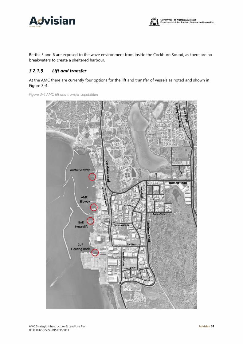
Berths 5 and 6 are exposed to the wave environment from inside the Cockburn Sound, as there are no
breakwaters to create a sheltered harbour.
Lift and transfer
At the AMC there are currently four options for the lift and transfer of vessels as noted and shown in
Figure 3-4.
Figure 3-4 AMC lift and transfer capabilities
AMC Strategic Infrastructure & Land Use Plan Advisian 32
D: 301012-02724-MP-REP-0003
Northern Harbour
Within the AMC Northern Harbour there are two existing privately owned facilities to enable vessel
launching and retrieval:
• 2,000t slipway at the Austal facility
• 2,000t slipway at the AME facility
They both use rail transfer to move vessels around on land and into and out of sheds.
Southern Harbour
Within the AMC Southern Harbour there are two existing facilities to enable vessel launching and
retrieval:
• 8,000t syncrolift at the BAE facility
• 12,000t lift capacity floating dock with 4,500t transfer capacity at the CUF
The BAE syncrolift is privately owned, and the turntable and rail system enables moving of vessels on
the land. The syncrolift is capable of lifting up to the weight of an in service Hobart Class Air Warfare
Destroyer, but the vessel is too long to traverse the turntable. The BAE syncrolift has been used by
other AMC tenants previously including ASC, Austal and Echo Yachts.
At the CUF, the floating dock is common use infrastructure operated by AMCM and once vessels are
lifted, they can be transported on dedicated transfer paths using SPMTs. There is one dedicated
transfer path from the floating dock to the ASC facility.
The current floating dock has a transfer capacity with a maximum pay load of 4,500t including the
SPMTs. The system can currently transfer the Collins Class submarines and Anzac frigates. It can lift
vessels up to 12,000t but was not designed to act as a maintenance floating dock, as there are
requirements to ensure its availability for submarine transfer on limited notice. The floating dock has
been in operation since 2009 and has a design life of 25 years.
It is noted that there is the potential to upgrade all of these facilities in the future to accommodate
larger vessel types.
Naval Waters
In February 2019, Naval Waters were declared over the Southern Harbour of the AMC. The term ‘Naval
Waters’ means those waters declared by Proclamation, pursuant to Section 3B of the Control of Naval
Waters Act 1918 (Cth) (Commonwealth of Australia, 2016) (‘Act’), in respect of the Henderson AMC.
The limits of Naval Waters at the Henderson AMC are shown in Figure 3-5. The Act, in conjunction with
the Control of Naval Waters Regulation 2015 (Cth) (Commonwealth of Australia, 2015) (‘Regulation’),
provides the legal framework to regulate non-Defence presence and activity in the prescribed Naval
Waters around facilities owned or used by Defence.

AMC Strategic Infrastructure & Land Use Plan Advisian 33
D: 301012-02724-MP-REP-0003
Figure 3-5 Naval Waters at AMC (Commonwealth of Australia, 2019)
The operation of Naval Waters will be overseen by the Superintendent of Naval Waters Perth (the
Chief Commanding Officer of HMAS Stirling). A guidance note (Royal Australian Navy, 2019) has been
prepared by the Superintendent outlining the operation of Naval Waters and the roles and
responsibilities of the RAN and other parties in their implementation and ongoing operations.
The establishment of Naval Waters at the AMC does not replace or remove the roles and
responsibilities required under the Maritime Transport and Offshore Facility Security Act (MTOFSA).
The intent is that they will augment the security arrangements of Defence facilities and assets co-
located at the AMC, thereby providing users with more flexibility on responding to various matters or
threats within Naval Waters which are specific to Defence in a timely and effective manner.
With regard to security the guidance note includes the following:
“Security considerations (such as heightened threat levels or force protection) and/or public safety
considerations (such as naval activities involving ship handling and manoeuvring) may necessitate
restrictions on access to Naval Waters, as well as the exercise of other powers under the Act and the
Regulation. Defence’s intention is to use the powers conferred under the Naval Waters legislation only to
the extent necessary and appropriate to ensure security and public safety. Noting the commercial nature
of the Henderson AMC, these powers are not intended to, and will not be used to, unnecessarily deter or

AMC Strategic Infrastructure & Land Use Plan Advisian 34
D: 301012-02724-MP-REP-0003
impede the passage of commercial shipping, disrupt non-Defence activities, or interfere with the
functions and responsibilities of ports and industry. The Conditions do not supplant the security
arrangements of the Henderson AMC based entities or the respective security plans associated with the
MTOFSA”.
Ongoing close engagement will be required between the State, AMCM, Superintendent of Naval
Waters (Commanding Officer HMAS Stirling) and Henderson Security and Facilities Manager of
Capability Acquisition and Sustainment Group (CASG) to ensure the practical implementation does not
impact commercial operations at the AMC. The Henderson Precinct Security working group provides
an ongoing forum for this to occur.
3.2.2 Transport
A high-level review of existing transport infrastructure has been undertaken as part of this study by
Flyt; AMC Transport and Traffic Report (Flyt, 2019). This section provides a high level overview of the
current transport network supporting the AMC.
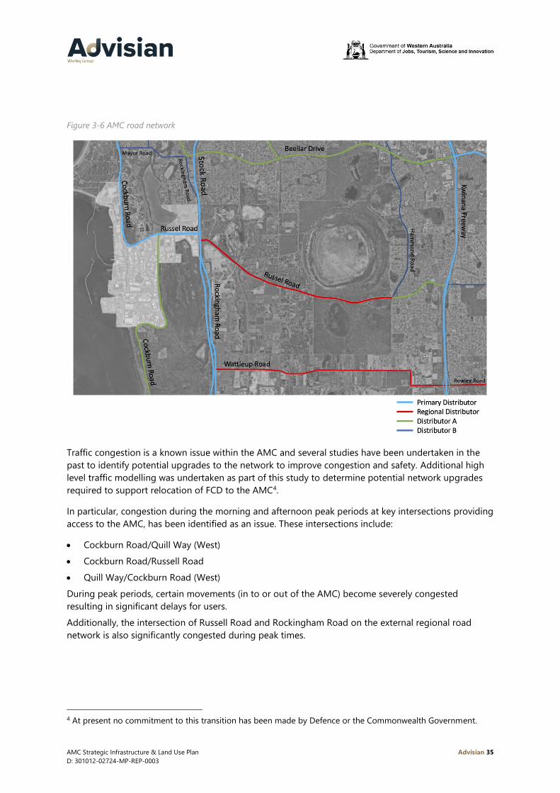
Road network
The AMC precinct is well connected to the wider regional road network and the greater metropolitan
region. Cockburn Road provides a north-south spine through the AMC. To the east Rockingham Road
provides further north-south access with Russell Road providing access eastward towards the Kwinana
Freeway. Figure 3-6 illustrates the surrounding regional road network.
AMC Strategic Infrastructure & Land Use Plan Advisian 35
D: 301012-02724-MP-REP-0003
Figure 3-6 AMC road network
Traffic congestion is a known issue within the AMC and several studies have been undertaken in the
past to identify potential upgrades to the network to improve congestion and safety. Additional high
level traffic modelling was undertaken as part of this study to determine potential network upgrades
required to support relocation of FCD to the AMC4.
In particular, congestion during the morning and afternoon peak periods at key intersections providing
access to the AMC, has been identified as an issue. These intersections include:
• Cockburn Road/Quill Way (West)
• Cockburn Road/Russell Road
• Quill Way/Cockburn Road (West)
During peak periods, certain movements (in to or out of the AMC) become severely congested
resulting in significant delays for users.
Additionally, the intersection of Russell Road and Rockingham Road on the external regional road
network is also significantly congested during peak times.
4 At present no commitment to this transition has been made by Defence or the Commonwealth Government.

AMC Strategic Infrastructure & Land Use Plan Advisian 36
D: 301012-02724-MP-REP-0003
High Wide Loads network
High Wide Loads are over-dimensional loads up to 8m high, 8m wide and 24m long with a maximum
of 270t net mass. HWL corridors are built to standards which accommodate large indivisible loads
linking key heavy fabrication centres and the AMC in the Perth metropolitan area with mine sites,
refineries and other industrial factories that require large machinery and plant.
Access by RAV’s and HWL’s is critical for many of the businesses operating within the AMC. These
networks provide access to the AMC for materials, components and vessels that have been
constructed elsewhere within the region.
The majority of roads within the AMC are part of the Perth RAV network. The existing RAV network in
the vicinity of the AMC permits RAV categories 2-4 (pocket road train, B-Double, and other vehicles
with a maximum length of either 25.0m or 27.5m) to use these routes. The RAV network is set out in
Figure 3-7.

AMC Strategic Infrastructure & Land Use Plan Advisian 37
D: 301012-02724-MP-REP-0003
Figure 3-7 Existing RAV and High Wide Load networks
All other roads within the study area not identified on the RAV network are constructed to an industrial
standard to accommodate “as of right” vehicles. Specific turn areas, such as the large turning area at
the top of Egmont Road, have been constructed to facilitate truck movements.

AMC Strategic Infrastructure & Land Use Plan Advisian 38
D: 301012-02724-MP-REP-0003
Car parking
An extremely limited volume of public car parking is provided within the AMC. Each business is
responsible for managing its own car parking on site. Over time however, the public road network (on
street and within the road reserve) has been utilised for car parking which has the potential to
adversely impact on road safety and the ability of the road network to cater for RAV. Figure 3-8
illustrates the location of existing formal and informal on street parking within the AMC.
Figure 3-8 Existing on street car parking (source: (City of Cockburn, 2016))
Public transport
Public transport services within the AMC are limited at present. Industrial areas are typically difficult to
serve effectively with public transport due to their low density nature and operating hours. At present
only two bus services provide direct access to the AMC as shown in Figure 3-9.
Route 548 currently services the AMC traveling between Rockingham Station (~25mins) and Fremantle
Station (~25mins) and operates throughout the day. Route 522 provides access to Spearwood and
Cockburn Central Station (~20 mins travel time), however only three services per day operate on this
route. Additionally, the 549 (also travelling between Rockingham Station and Fremantle Stations)
passes the precinct on Rockingham Road.

AMC Strategic Infrastructure & Land Use Plan Advisian 39
D: 301012-02724-MP-REP-0003
Figure 3-9 Existing public transport services

AMC Strategic Infrastructure & Land Use Plan Advisian 40
D: 301012-02724-MP-REP-0003
The limited frequency and number of routes serving the AMC limits the ability of people working
within AMC to use public transport as a viable mode of transport. Limited frequencies impact the
ability of people to time their travel to coincide with their start and finish times. It also impacts on their
flexibility to travel when required.
Current services also provide a limited catchment for public transport users. The Rockingham to
Fremantle corridor is relatively well serviced, however access to the wider metropolitan region is
difficult. The 522 service provides a connection to Cockburn Central Station providing the opportunity
to use a connecting train service or park ride at Cockburn Central. The extremely limited frequency of
this service impacts on its ability to be used by the AMC workforce however.
The majority of the AMC’s workforce therefore travel each day by car as it is more convenient and
efficient. The impacts of this include:
• Congestion on roads providing access to AMC
• Difficulty for apprentices, or those who cannot drive, accessing the AMC
• Limited demand for public transport, which in turn results in reduced provision.
Pedestrians and cyclists
Pedestrian infrastructure is extremely limited within the AMC, only the east-west extension of Quill
Way, Redemptora Road and one section of Sparks Road provide footpaths. Quill Way is the only road
to have footpaths on both sides. The paths are narrow and adjacent to the road carriageway with no
buffer from vehicles. The footpath is regularly broken for crossovers, stops abruptly or is not provided
in key locations (such as connecting to existing bus stops).
There is no shade or limited protection from weather and there are currently very few destinations
within the overall area that would generate pedestrian trips in their own right (i.e. cafes, lunch bars or
other businesses that people may access on foot from their work site).
Cycling infrastructure is also available within the precinct however it is limited in nature and the
volume, speed and composition of traffic is not conducive to a friendly cycling environment. The AMC
is currently served by a regional network of on and off road cycling infrastructure as noted in Figure
3-10. Regional connections are provided by on road lanes, whilst a limited network of off road paths
also exists in the surrounding area.

AMC Strategic Infrastructure & Land Use Plan Advisian 41
D: 301012-02724-MP-REP-0003
Figure 3-10 Existing cycling infrastructure

AMC Strategic Infrastructure & Land Use Plan Advisian 42
D: 301012-02724-MP-REP-0003
3.2.3 Utilities
The AMC is served by a range of utilities including:
• Power
• Gas
• Water (Potable/Sewer)
• Telecommunications
• Stormwater Drainage.
Power
Electrical power is currently supplied to the AMC from the Cockburn Cement substation located on
Russell Road. The AMC is serviced by three 22kV feeders from this substation. Within the AMC, power
is delivered to premises via an underground network.
Western Power currently own land on Amur Close within the AMC. This land was acquired in the past
as a potential site for an additional substation to support the AMC. Sufficient demand to warrant
development of a new substation has not developed. Access to this site with 132kV feeders from the
existing Cockburn Cement substation would be required in the future.
Figure 3-11 illustrates the location of the existing electrical power distribution network within the AMC
and Western Power’s potential future substation site on Amur Close.
Natural gas
Natural gas is available in some locations within the AMC as illustrated in Figure 3-11. The existing
network extends along Russell Road and Clarence Beach Road within the industrial portion of the site.
It also extends through the Technology Precinct along McGrath Road.

AMC Strategic Infrastructure & Land Use Plan Advisian 43
D: 301012-02724-MP-REP-0003
Figure 3-11 Existing power and domestic gas distribution networks
Water
All existing premises within the AMC have access to potable water and sewer networks. Water
Corporation operate a waste water treatment plant to the north east of the AMC on Cockburn Road.

AMC Strategic Infrastructure & Land Use Plan Advisian 44
D: 301012-02724-MP-REP-0003
An outfall from this plant passes through Lot 15 on Clarence Beach Road before discharging into the
Northern Harbour.
Future development of land and infrastructure in the vicinity of the outfall will need to consider its
easement and impacts on marine infrastructure. Figure 3-12 illustrates the location of the existing
potable water and sewer networks.
Figure 3-12 Existing potable water and sewer networks

AMC Strategic Infrastructure & Land Use Plan Advisian 45
D: 301012-02724-MP-REP-0003
Telecommunications
Access to telecommunications infrastructure within the AMC is provided via retail providers. The
National Broadband Network (NBN) has been implemented within the AMC and predominantly uses
‘Fibre to the Node’ (FTTN) technology to connect to premises. A FTTN connection is where existing
copper phone and internet network are utilized from a nearby fibre node (street cabinet) into the
individual property, as the final connection to the NBN access network. Nodes are then connected to a
local exchange (located on the corner of Quill Way and Nautical Drive) by optic fibre.
The FTTN network will support asymmetrical consumer broadband up to 100/40Mbps and symmetrical
service up to 10/10Mbps or possibly 20/20Mbps at some premises. The NBN can also provide data
and communications services tailored to the specific requirements of business where their standard
offering is insufficient.
The AMC is currently covered by Telstra’s existing 4G and 5G networks. A small portion of Zedora Turn
is currently not serviced by the 5G network.
Stormwater drainage
Stormwater drainage is provided throughout the AMC via a piped system feeding into a number of
sumps for collection and natural infiltration. When flows exceed a certain volume there is a series of
overflow paths, into larger sumps. Stormwater is discharged into Cockburn Sound through gross
pollutant traps.
The City of Cockburn is responsible for the stormwater drainage network within the AMC. Within the
CUF the AMCM is responsible for stormwater drainage.
CUF utilities
Utilities are supplied to the CUF by external providers, however distribution within the CUF is the
responsibility of AMCM.
For current vessel sustainment activities at the CUF, RAN follows a series of procedures for use of
equipment. The CUF shore power cannot support this process and portable power in the form of
generators is used as backup. There is a need to upgrade the power supply system to the wharves, to
support RAN set processes and procedures (Oropesa Port Management Pty Ltd, 2018).
Other utilities include telecommunications (both public and Defence restricted networks), potable
water, firewater and sewer and these are also provided at the berths within the CUF.
Latitude 32 Industrial Area – DA6A
The development area 6A within the Latitude 32 Industrial Area is about to be developed as a new
industrial estate by DevelopmentWA. The development area will encompass 100 hectares of land, and
is located immediately east of Stock Road/Rockingham Road adjacent to the AMC. Development area
6A will provide the opportunity to meet any demand for additional transport, storage and laydown
areas outside of the AMC, and provide industrial lots for businesses seeking to improve supply chain
efficiencies by locating in close proximity to the infrastructure in the AMC.

AMC Strategic Infrastructure & Land Use Plan Advisian 46
D: 301012-02724-MP-REP-0003
Efficient access to this precinct in the future will be critical. The ability to move large modules and
equipment between the AMC CUF and Latitude 32 will help reinforce the relationship between these
two precincts and create further opportunities in the future.

AMC Strategic Infrastructure & Land Use Plan Advisian 47
D: 301012-02724-MP-REP-0003
4 Demand drivers
The following section outlines key demand drivers for the AMC in the future. These drivers are
focussed on projects/activities that are of sufficient size/volume they will have a significant influence
on the AMC as a whole. Typically, these projects/activities are focussed on the waterfront and/or the
CUF, however their influence will extend throughout the AMC and beyond.
Defence activities
To support future planning for infrastructure within the AMC, in particular within the waterfront
precinct, it is necessary to understand planned shipbuilding, sustainment and vessel disposal activities.
A high-level sustainment schedule for all existing and future RAN vessels stationed at FBW was
developed. A schedule for planned future shipbuilding activities was also identified. Together these
schedules were then used to identify demand for AMC infrastructure in the future. The schedule was
developed on a per quarter basis from 2020 to end 2035, and subsequently extended to examine
additional demand up to 2044.
Key steps in the sustainment schedule’s development included identification of:
• All vessels (existing and potential future) stationed at FBW including the following information:
− Defence maintenance schedule for ANZAC class vessels through to 2029 (received 22 May
2020)5
− SEA1180 OPV launch schedule (dated 20 February 2020)
• Maintenance upgrades of the Fleet Base East (FBE) frigate vessels
• Commissioning dates for new vessels
• Likely sustainment activities for future vessels
• Key characteristics of each vessel type to be accommodated in AMC (draft, beam, length,
displacement)
• Identification in-water and out of water activity requirements.
A number of key assumptions support the development of the sustainment schedule as follows:
• In conjunction with infrastructure at FBW, AMC should be able to support all FBW vessel
sustainment requirements
• AMC should be able to support the sustainment activities of some FBE vessels including Hobart
Class Destroyers
• A dedicated precinct for Defence activities within AMC would be preferable
• Ideally AMC should include facilities to enable maintenance activities (including paint removal and
application) for RAN vessels in all weather conditions
• Common user infrastructure within the AMC should create a competitive environment for future
sustainment activities
5 Confidential information supplied by the Department of Defence
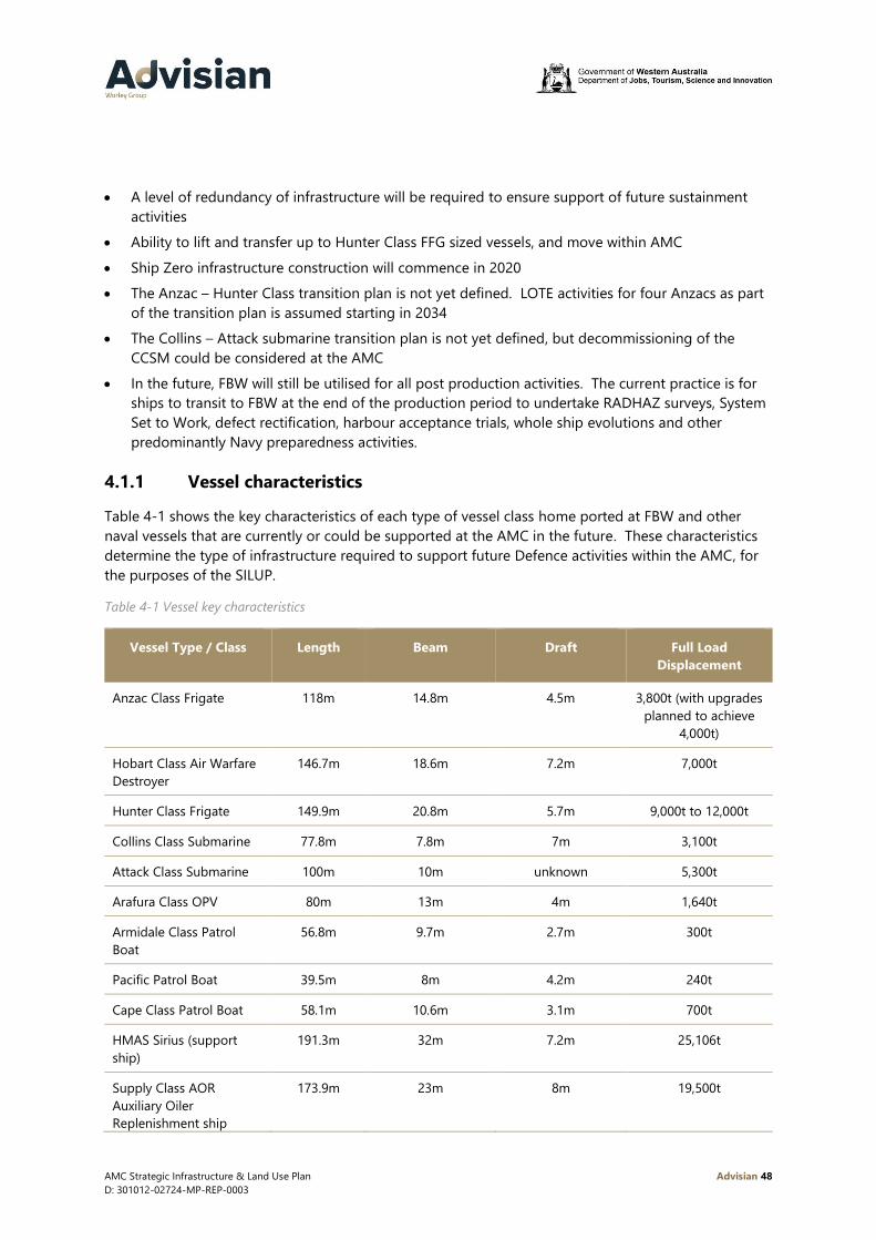
AMC Strategic Infrastructure & Land Use Plan Advisian 48
D: 301012-02724-MP-REP-0003
• A level of redundancy of infrastructure will be required to ensure support of future sustainment
activities
• Ability to lift and transfer up to Hunter Class FFG sized vessels, and move within AMC
• Ship Zero infrastructure construction will commence in 2020
• The Anzac – Hunter Class transition plan is not yet defined. LOTE activities for four Anzacs as part
of the transition plan is assumed starting in 2034
• The Collins – Attack submarine transition plan is not yet defined, but decommissioning of the
CCSM could be considered at the AMC
• In the future, FBW will still be utilised for all post production activities. The current practice is for
ships to transit to FBW at the end of the production period to undertake RADHAZ surveys, System
Set to Work, defect rectification, harbour acceptance trials, whole ship evolutions and other
predominantly Navy preparedness activities.
4.1.1 Vessel characteristics
Table 4-1 shows the key characteristics of each type of vessel class home ported at FBW and other
naval vessels that are currently or could be supported at the AMC in the future. These characteristics
determine the type of infrastructure required to support future Defence activities within the AMC, for
the purposes of the SILUP.
Table 4-1 Vessel key characteristics
Vessel Type / Class Length Beam Draft Full Load
Displacement
Anzac Class Frigate 118m 14.8m 4.5m 3,800t (with upgrades
planned to achieve
4,000t)
Hobart Class Air Warfare
Destroyer
146.7m 18.6m 7.2m 7,000t
Hunter Class Frigate 149.9m 20.8m 5.7m 9,000t to 12,000t
Collins Class Submarine 77.8m 7.8m 7m 3,100t
Attack Class Submarine 100m 10m unknown 5,300t
Arafura Class OPV 80m 13m 4m 1,640t
Armidale Class Patrol
Boat
56.8m 9.7m 2.7m 300t
Pacific Patrol Boat 39.5m 8m 4.2m 240t
Cape Class Patrol Boat 58.1m 10.6m 3.1m 700t
HMAS Sirius (support
ship)
191.3m 32m 7.2m 25,106t
Supply Class AOR
Auxiliary Oiler
Replenishment ship
173.9m 23m 8m 19,500t
AMC Strategic Infrastructure & Land Use Plan Advisian 49
D: 301012-02724-MP-REP-0003
Vessel Type / Class Length Beam Draft Full Load
Displacement
(HMAS Stalwart and
HMAS Supply II)
ADV Ocean Protector 105.9m 21m 6.6m 8,500t
MV Stoker (rescue gear
ship)
93.2m 16m 4.1m 3,690t
MV Besant (submarine
intervention gear ship)
83m 16m 4.3m 3,231t
4.1.2 New vessel builds
Defence is currently embarking on a program of continuous shipbuilding. Vessels committed for
construction at the AMC include:
Offshore Patrol Vessels
Ten of the new future Offshore Patrol Vessels will be constructed at the Civmec facility in the AMC.
The schedule allows for a vessel build of 27 months in total. This timeframe is broken down to being
21 months within the Civmec facility, one transfer and lift, and 6 months in the water alongside a berth.
Pacific Patrol Vessels
The Pacific Patrol Vessels are currently being constructed by Austal at their facility in Naval Base. They
are transported via the HWL road network, launched via the floating dock and the set to work activities
are completed alongside the berth at the Austal facility in the Northern Harbour.
Cape Class Patrol Vessels
Austal have been awarded a contract to build six evolved Cape Class Patrol Boats for the RAN to
replace the existing Armidale class, ensuring there is no capacity gap before the introduction of the
OPVs. Construction will commence at Austal’s Northern Harbour by mid-2020 with the first vessel to
be delivered in late 2021 and the sixth to be delivered in mid-2023.
SEA 1905 and SEA 2400
SEA 1905 is the Maritime Mine Countermeasures Program which includes Mine Warfare (MW) vessels.
Program SEA 2400 is the Hydrographic Data Collection Capability Program which includes introduction
of a Strategic Military Survey Capability (SMSC) to replace Navy’s two Hydrographic Survey Ships
(HMAS Melville and HMAS Leeuwin).
The Government has announced their intent to build at least three vessels at the AMC in the mid-
2020s. i.e. two MW support vessels based on the OPV platform and a Strategic Military Survey Vessel
(SMSV). The capability solution for the SMSV is still under development, and Government will consider
SEA1905/SEA2400 program options later this year.

AMC Strategic Infrastructure & Land Use Plan Advisian 50
D: 301012-02724-MP-REP-0003
Border Force Vessels
The Naval Shipbuilding Plan (Department of Defence, 2017) identifies a need for up to sixteen Border
Force vessels to be replaced in the future. Whilst the construction of these vessels has not yet been
committed, there is a significant opportunity for the replacement vessels to be constructed in the
AMC.
Land Combat and Amphibious Warfare Vessels
The AMC also has the potential to support construction of new Riverine Patrol Craft, Landing Craft,
Light Watercraft, Special Operations Enhancements and Australian Defence Force Search and Rescue
vessels. Whilst these vessel build programs are not yet committed, the AMC can be positioned to
support these programs in the future.
4.1.3 Vessel maintenance requirements
For each type of vessel further assumptions are noted in the sections below.
Anzac Class Frigates
In the future the following maintenance activities are assumed to be undertaken at the AMC:
• IMAV (Intermediate Maintenance Availability period) with a duration of 9 weeks. This is
represented by a 3-month duration in the sustainment schedule. This activity is undertaken in the
water alongside a berth
• SRA (Selected Restricted Availability period) with a duration of 14 weeks. This is represented by a
3-month duration in the sustainment schedule, with the works being completed in water alongside
a berth
• DSRA (selected restricted availability period with a docking) with a duration of 14 weeks. 3 months
is considered in the sustainment schedule. This activity includes a lift and transfer, with the vessel
located on a vessel hardstand position, and a second transfer and lift to return the vessel to the
water. An additional 3 months is allowed in a DSRA for extended post-production activities such
as Fleet Technical Assessment, trials, defect rectification and Unit Readiness Assessment. It is
assumed these activities will be undertaken with the ship based at FBW, not AMC
• AMCAP (Anzac Midlife Capacity Assurance Program) with a duration of 24 months overall. 18
months allows for a lift and transfer, with the vessel located on a vessel hardstand position, and a
second transfer and lift to return the vessel to the water, and onto a berth. There is a further 6
months of in water maintenance, with this activity being completed at FBW
• LOTE (life of type extension) with a duration of up to 24 months and the same breakdown as
AMCAP.
Hobart Class Destroyers
A major upgrade of the three Hobart Class Air Warfare Destroyers, focussed on their Combat
Management Systems, will be conducted in the mid-late 2020s under Project SEA 4000 Phase 6.
Although Defence has yet to confirm the location and duration of this upgrade, this activity may be
conducted at the AMC.
AMC Strategic Infrastructure & Land Use Plan Advisian 51
D: 301012-02724-MP-REP-0003
Future Hunter Class Frigates
It is assumed the first Hunter Class Frigate will be undergoing trials and testing from 2027 and
commence operations in 2030. There is no available information on the sustainment of the future
Hunter Class frigates. For the purposes of the schedule the following maintenance activities are
assumed:
• In water maintenance undertaken annually, with a duration of 3 months
• Out of water maintenance undertaken every 5 years, with a duration of 9 months. This activity
allows for a lift and transfer of the vessel to the hardstand location, and a transfer and lift to return
the vessel back into the water.
Collins Class Submarines
The current sustainment activities for the Collins Class Submarines are split between Osborne in South
Australia and at the AMC. It is assumed that FCD will be completed at the AMC in 2024/2026.
Flexibility in the timing of this transition is possible6. The following maintenance activities are assumed
to be completed at the ASC facility in AMC:
• MCD (mid cycle docking) for an overall duration of 12 months. This comprises a lift and transfer
and around 9 months on the hardstand within the ASC Facility. The submarine is then transferred
back into the water for a 3-month set to work (STW) period in water
• FCD (full cycle docking) for an overall duration of 24 months. This comprises a lift and transfer and
around 21 months on the hardstand within the ASC Facility. The submarine is then transferred
back into the water for a 3-month STW period in water. It is assumed LOTE activities require the
same timeframe and replace FCD when required
• The Collins – Attack submarine transition plan is not yet defined, however decommissioning of the
CCSM could be considered at the AMC.
It is acknowledged that the location of FCD if transitioned to AMC is yet to be determined. For the
purpose of developing the SILUP it is assumed to take place at an expanded ASC facility6.
Future Attack Class Submarines
The first Attack Class submarine (ACSM) is scheduled for completion in 2032. The sustainment
activities for the ACSM will be able to be undertaken at the AMC. It is assumed a similar schedule and
activities/durations to the current Collins Class will be undertaken at the AMC.
Provision to accommodate unscheduled dockings will be required at AMC from 2032 onwards.
Offshore Patrol Vessels
Two of the OPVs will be stationed at FBW. For the purposes of the schedule the following
maintenance activities are assumed for these two vessels:
• In water maintenance undertake annually, with a duration of 3 months
6 At present no commitment to this transition has been made by Defence or the Commonwealth Government.

AMC Strategic Infrastructure & Land Use Plan Advisian 52
D: 301012-02724-MP-REP-0003
• Out of water maintenance undertaken every 5 years, with a duration of 6 months. This activity
allows for a lift and transfer of the vessel to the hardstand location, and a transfer and lift to return
the vessel back into the water.
Support vessels
HMAS Sirius will be decommissioned at the end of 2021 and will be replaced by the Auxiliary Oiler
Replenishment (AOR) HMAS Stalwart. Both these vessels are too large to dock using the current
facilities at the AMC and any major maintenance is required to be conducted in the Captain Cook
Graving Dock (a large vessel dry berth) in Sydney. The schedule identifies an in water extended
maintenance period (EMP) once a year for 3 months alongside a berth and it is assumed this will be
undertaken at the AMC in the future. For major maintenance a large vessel dry berth would be
required.
The ADV Ocean Protector vessel can be lifted by the existing floating dock at AMC, but not transferred.
It has a five year docking cycle, hence it could be maintained on the floating dock. This would prevent
any other lift and transfer activities during this maintenance period. Alternatively, the Graving Dock in
Sydney can be used for this activity.
For MV Stoker and MV Besant regular in water maintenance is currently completed at FBW. This
arrangement will continue in the future, hence our schedule does not allow for this to occur within the
AMC. Out of water maintenance is undertaken every 5 years, with a duration of 3 months and is
assumed to be at the AMC. This activity allows for a lift and transfer of the vessel to a hardstand
location and a transfer and lift to return the vessel back into the water.
The Defence Marine Support Systems (DMSS) water craft including tugs and Self-Propelled Water Fuel
Lighter (SPWFL) undertake regular maintenance at FBW. Dockings are normally completed every three
to four years. These vessels are not included in this schedule as given their size there are opportunities
for maintenance in the Northern Harbour.
Resources and major project activities
The future activities of the resources sector (oil and gas, and mining) are not as well defined as for
Defence. Workload for the resource sector is on a project by project basis and preparing a similar
schedule to identify demand is not possible.
The unprecedented growth of the resources sector from around 2008 to 2016 enabled expansion of
the AMC to its existing state. Whilst it is unlikely there will be the same level of growth in the future
there are major projects in the pipeline over the next five years, with the AMC positioned to provide
support. This includes key projects as listed in Table 4-2. Specific to this sector the future planning of
the AMC needs to ensure:
• Adequate laydown area
• Covered workspace for fabrication
• Availability of wharf space.

AMC Strategic Infrastructure & Land Use Plan Advisian 53
D: 301012-02724-MP-REP-0003
Table 4-2 Resource project opportunities
Sector Company Project
Mining Resources BHP South Flank
Mining Resources FMG Iron Bridge
Oil & Gas Woodside Scarborough
Oil & Gas Woodside Pluto Train 2
Oil & Gas Woodside Browse
Oil & Gas ConocoPhillips Barossa
Oil & Gas SANTOS Dorado
Oil & Gas Chevron Gorgon Stage 2
Oil & Gas Carnarvon Petroleum Buffalo
Oil & Gas Chevron Janz Io
Oil & Gas INPEX Ichthys Phase 2a
Oil & Gas Neptune Energies Petrel/Tern/Frigate
Oil & Gas SANTOS Spartan subsea tieback
Oil & Gas SANTOS Van Gogh infill Phase 2
Oil & Gas BHP Pyrenees Infill Phase 4
Oil & Gas Western Gas Equus
Oil & Gas Woodside Julimar Phase II
Oil & Gas Woodside NWS brownfield tiebacks - Pyxis
Oil & Gas Woodside Pluto expansion onshore (source gas Scarborough)
Oil & Gas Woodside NWS brownfield tiebacks - Lambert Deep / GWF3
Oil & Gas Decommissioning Woodside, Chevron, Vermillion, SANTOS
Utilisation of local facilities for fabrication is likely to be the main drawcard in the use of the AMC. This
includes piles, jackets and topsides, shiploaders, reclaimers and conveyors. A near future example of
the oil and gas sector’s use of the AMC is an upcoming Pipe Spool project. This will utilise 80,000m2 of
laydown area from October 2020 to October 2021 and load out over AMC 4 wharf. Pipe spool
fabrication is a niche market in the AMC, given close proximity of the fabrication location to the
offshore fields in the State’s north west.
It is not possible to directly relate these projects with anticipated usage of businesses in the AMC,
however the need to cater for the future is essential. Ensuring adequate laydown area and covered
work space for fabrication and availability of wharf space at the CUF are essential.

AMC Strategic Infrastructure & Land Use Plan Advisian 54
D: 301012-02724-MP-REP-0003
Figure 4-1 notes the utilization of AMC 4, 5 and 6 wharves since the opening of the CUF. These three
wharves can accommodate at least up to 900 days per year of usage. In a downturn of the market,
(2016-2019) berth usage was around 200 wharf day per year for all three berths.
Figure 4-1 AMC 4, 5 and 6 wharf utilisation
Commercial shipbuilding and maintenance activities
There are around 2,500 commercial vessels registered in WA. These include fishing boats, charter
boats, supply vessels, ferries, shipping and port related service vessels.
Taylored Consulting completed a market outlook for the AMC over the next 10 years (Taylored
Consulting, 2019). In relation to shipbuilding it recognised opportunities in the commercial and small
vessel sectors exist. This includes the Defence sector but also high end superyachts, ferries and vessels
for small-scale tourism activities.
Large cruise operators are likely to schedule maintenance in countries such as Singapore, Malaysia,
Vietnam and China. The ability of local AMC businesses to compete in the global shipbuilding
industry, is based on their capability to deliver technology and innovative bespoke requirements, as
opposed to low cost labour resources. Infrastructure such as a large vessel dry berth can also play a
significant role in attracting maintenance of large cruise operators.
Similar to the resources sector, future activities for commercial shipbuilding and maintenance are not
clearly defined but there is demand. It is recognized that the Northern Harbour area is an ideal
location to further concentrate this sector’s activities. Specific to this sector the future planning of the
Northern Harbour needs to ensure:
• Availability of common user infrastructure in the form of a lift and transfer system, and transfer
paths
• Sheds and buildings for shipbuilding and maintenance activities
0
200
400
600
800
1000
1200
Wh
arf
Days
per
Year
AMC 4 - 5 -6 WHARF UTILISATION
AMC 4 AMC 5 AMC 6

AMC Strategic Infrastructure & Land Use Plan Advisian 55
D: 301012-02724-MP-REP-0003
• A transfer path linking the Northern Harbour with the Southern Harbour.
Planning and design principles for AMC waterfront
The output from the sustainment schedule for Defence activities is a series of graphs showing demand
over a 24 year timeframe for the following:
• In water activities (berths)
• Vessel lift and transfer
• Vessel hardstands.
These demand over time graphs have enabled the ability to map out the future infrastructure
requirements and explore the possible configurations.
4.4.1 Berth characteristics and planning assumptions
Northern Harbour
There are a number of privately owned berths in the Northern Harbour, and one located at CUF North.
Any new berths would need to be designed to cater for a range of steel and aluminum hulled vessels
with typical sizes noted in Table 4-3.
Table 4-3 Typical vessel sizes
Type Length
(m)
Beam (m) Draft (m) Displacement Tonnage (t)
Cape class
patrol boat
58 10.6 3.1 300
Pacific patrol
boat
39.5 8 2.5 240
Superyachts –
monohull
75 10 4.5 600
Superyachts –
trimaran
84 20 4.2 2940 (Gross tonnage)
Vehicle &
Passenger
Ferries
118 29 4.2
Passenger
Ferries
56 14 1.8
Southern Harbour
All new berths in the Southern Harbour would be designed to cater for RAN vessels. New berths can
either be orientated along the edge of existing land or as a finger jetties, extending into the harbour
basin. If there is sufficient space, finger jetties enable creation of berths on both sides of the jetty and
a greater opportunity to cater for potential demand. Their design should ensure that there is sufficient

AMC Strategic Infrastructure & Land Use Plan Advisian 56
D: 301012-02724-MP-REP-0003
space available for the multiple contractors to work independently on both sides of the jetty
simultaneously.
The location of new berths needs to consider:
• Protection from wind and waves
• Vessel turning circles
• Impacts on existing berths, operations and services
• Access to support land uses
• Ability to cater for different vessel types
• Defence priority zone and security implications.
The design of all future Defence berths require the following:
• Shore power at the front and rear for each ship – 1600 Amp, 450V, 60 Hz and 50 Hz
• Water, both for potable and fire fighting
• Sewage, either reticulated pipeline or vacuum tanker service
• Telephone, information and communication services (including access to Defence Restricted
Networks)
• Pneumatic yokohama fendered berths
• Refrigerated storage for ship cold food supplies
• Hazchem/dangerous goods store
• Quarantine waste facilities
• Gangway supply (to alleviate the need to truck them to/from FBW)
• Cranage and wharf load capacity
• Wharf side showers and toilets for use by ship staff and industry
• Galley crew break rooms, if existing CUF building 2 lease is discontinued
• A range of different contractor shore power connection points
• Cathodic protection earth bonding on wharf for ship cathodic protection systems
• Shore side laundry facility for ship and possibly industry use if required.
4.4.2 Future demand for berth facilities
Figure 4-2 shows the demand over time graph for Defence berth usage. There will be demand for
resource projects to access berths over time, but the timing and extent of these activities is not clear.
There will be demand for resource projects to access berths over time. Although the timing and extent
of these activities is not clear, the planning for berths has considered continued access for this sector.

AMC Strategic Infrastructure & Land Use Plan Advisian 57
D: 301012-02724-MP-REP-0003
Figure 4-2 Defence berth demand over time7
There is a need to increase the number of berths to cater for four vessels from 2023 onwards,
expanding in the early 2030’s to five vessels, followed by a consistent demand for six vessels by the
mid-2030’s. All new berths will need to be designed to cater for RAN vessels with the services and
requirements as noted in Section 4.4.1. To cater for the submarines, a dedicated berth with panelling
to support the hydropneumatic fenders will be required.
To ensure maximum flexibility, each new berth will be 200m in length to cater for the future Hunter
Class vessels. It is recognized that the support vessels require longer berths and hence the berths
should be positioned to accommodate this in at least one location in the AMC.
4.4.3 Vessel lift and transfer characteristics and planning assumptions
Infrastructure to support lift and transfer of vessels is key to the development of both the Northern
and Southern Harbours. In the Northern Harbour it is recognised there is a need for a lift capability up
to 1,250t / 1,500t. In the Southern Harbour there is a need for capability to lift and transfer up to the
proposed Hunter Class vessels, in the order of 9,000t to 12,000t. The options for lift and transfer,
including the role of existing infrastructure, must be considered holistically for both Harbours to
determine the best solution for all AMC users. Critical in these considerations is access to this
infrastructure by all those seeking to lift and transfer vessels within the AMC.
There are a number of options for the lift and transfer of vessels as described in Table 4-4.
7 This graph assumes transition of FCD to the AMC. At present no commitment to this transition has been made
by Defence or the Commonwealth Government.

AMC Strategic Infrastructure & Land Use Plan Advisian 58
D: 301012-02724-MP-REP-0003
Table 4-4 Lift and transfer options
Option Description Benefits
Slipway • Twin rails and cradle
system for vessel launch
and retrieval
• Move vessel onshore
using rail system
• Limited benefits –
considered as an ‘old
fashioned’ transfer
method
Shiplift /
syncrolift
• Structural platform lifted
and lowered vertically for
vessel launch or retrieval
• Can connect to rails and
trailers on land or utilize
SPMTs
• Common technology to
cater for a range of
vessels
• Longevity
Floating
dock
• System includes a floating
dock, a deep sink dredged
pocket, a wharf to berth
against for vessel transfer
• Ability to move the vessel
using SPMTs when on
land
• Could have cranes built
onto the sides for lifting
capability and use as a
maintenance dock
• Increased flexibility in
relation to transporting
on SPMTs
• Can operate as a dry dock
with access for cranes and
other vehicles
Marine
travel lift
• Travel crane for lifting and
moving vessels
• Requires two finger jetties
to support travel lift
• Limited to lifting vessels
up to 1500 tonnes
• Flexible means of lifting
vessels and transport to
hardstand or shed
• Could be an option in the
Northern Harbour due to
smaller anticipated vessel
sizes
Pallet
barge
• Flat top barge designed
to cater for a defined
tonnage
• Requires a wharf with
suitable mooring
arrangement to berth
• Cheaper option for vessel
transfer that could be
adopted in Northern
Harbour
• Significant risks as
involves ‘double handing’
of a vessel
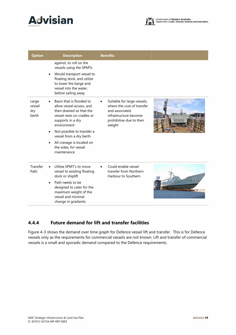
AMC Strategic Infrastructure & Land Use Plan Advisian 59
D: 301012-02724-MP-REP-0003
Option Description Benefits
against, to roll on the
vessels using the SPMTs
• Would transport vessel to
floating dock, and utilize
to lower the barge and
vessel into the water,
before sailing away
Large
vessel
dry
berth
• Basin that is flooded to
allow vessel access, and
then drained so that the
vessel rests on cradles or
supports in a dry
environment
• Not possible to transfer a
vessel from a dry berth
• All cranage is located on
the sides, for vessel
maintenance
• Suitable for large vessels,
where the cost of transfer
and associated
infrastructure become
prohibitive due to their
weight
Transfer
Path
• Utilise SPMT’s to move
vessel to existing floating
dock or shiplift
• Path needs to be
designed to cater for the
maximum weight of the
vessel and minimal
change in gradients
• Could enable vessel
transfer from Northern
Harbour to Southern
4.4.4 Future demand for lift and transfer facilities
Figure 4-3 shows the demand over time graph for Defence vessel lift and transfer. This is for Defence
vessels only as the requirements for commercial vessels are not known. Lift and transfer of commercial
vessels is a small and sporadic demand compared to the Defence requirements.

AMC Strategic Infrastructure & Land Use Plan Advisian 60
D: 301012-02724-MP-REP-0003
Figure 4-3 Defence lift and transfer demand over time8
The maximum number of lift and transfers over a three month period is five. Typically, a lift and
transfer utilising the existing AMC floating dock, takes around three days to prepare for and complete
the manoeuvre. Based on this duration there is adequate capacity to cater for the projected number
of lift and transfer movements predicted in the future. Additionally, it is assumed that privately owned
lift and transfer facilities (Austal, AME and BAE) will continue to be available in the future, thus ensuring
that sufficient lift and transfer capacity is available.
Although the floating dock can lift vessels up to 12,000 tonnes, the transfer of vessels from the floating
dock to the CUF is restricted to 4,500 tonnes. It is not possible to transfer the existing Hobart Class
Destroyers, or future Hunter Class Frigates and Attack Class Submarines.
To transfer these vessels an upgraded or new vessel lift and transfer facility will be required. Any new
facility would need to enable operation independent of tidal state and in all weather conditions. The
pros and cons of the various options will need to be considered in a separate Vessel Lift and Transfer
Technology Study as they are complex and must be considered in the context of other infrastructure
investments in the AMC.
Option1 upgrade existing floating dock
To accommodate larger vessels in the future, upgrades to the existing floating dock could include:
• Replacement with a larger floating dock, to cater for vessels up to 150m in length and full load
displacement weights of between 9,000t to 12,000t to accommodate future growth of the Hunter
Class fleet
• Extension of the existing floating dock by 50m and an increase in lifting capacity to 9,000t, (or
even 12,000t if feasible)
• Acquisition of additional SPMTs.
8 This graph assumes transition of FCD to the AMC. At present no commitment to this transition has been made
by Defence or the Commonwealth Government

AMC Strategic Infrastructure & Land Use Plan Advisian 61
D: 301012-02724-MP-REP-0003
Option 2 alternative lift and transfer options
• A shiplift could be purposely designed to cater for a future Hunter Class vessel, with SPMTs used
to transport vessels on land
• A large vessel dry berth could provide an alternative means for vessel maintenance that does not
need transfer onto land
• Provision of a transfer path to the BAE syncrolift on the assumption that this facility is upgraded to
cater for the future vessels.
For the Northern Harbour, given smaller vessels the following lift and transfer facilities could be
considered:
• Marine travel lift for vessels up to 1,250 /1,500 tonnes
• Shiplift / new floating dock for vessels greater than 1,500 tonnes, such as OPVs
• Relocate the existing floating dock, if an alternative solution is considered for the Southern
Harbour
• Pallet barge system.
Options for the Northern Harbour and their pros and cons should be considered in conjunction with
those in the Southern Harbour, in a separate Vessel Lift and Transfer Technology Study.
4.4.5 Vessel hardstand characteristics and planning assumptions
Northern Harbour
There are no defined outdoor hardstand positions in the Northern Harbour area, but there are a
number of sheds where vessels can be constructed, sustained and upgraded.
Southern Harbour
Within the Southern Harbour there are the following hardstand positions:
• BAE facility - three outdoor locations
• CUF – one outdoor location for Anzac frigates
• ASC – one outdoor and one indoor position for submarines
• Civmec – a vessel maintenance facility is currently being constructed. This can cater for two frigate
vessels (up to future Hunter class size) and eight OPVs indoors.
4.4.6 Future demand for vessel hardstand
Figure 4-4 shows the demand over time graph for Defence hardstand requirements. Although the
demand for hardstand from other users is unclear, this has been considered to ensure these activities
can have new or continued access.

AMC Strategic Infrastructure & Land Use Plan Advisian 62
D: 301012-02724-MP-REP-0003
Figure 4-4 Hardstand demand over time9
In the future up to six hardstand positions will be required. These could be catered for with existing
facilities within the AMC (CUF and others).
A key requirement of Defence is the provision of facilities to enable maintenance activities (including
paint removal and application) for future RAN vessels in all weather conditions. Currently the only
location in the Southern Harbour where this is feasible is the Civmec maintenance facility. Provision
for additional covered facilities in the CUF to meet this key requirement will be considered.
The above demand over time graph does not account for disposal of the RAN vessels. To account for
this, additional hardstand positions with utilities and suitable bunding will be accommodated in the
CUF.
The OPV construction is driving demand in the early part of the schedule. Demand will also eventuate
from the SEA1905 and SEA2400 programs which is currently understood to be three vessels from mid-
2020’s. Future vessel construction beyond the 15 year horizon is unknown, and other demand may
eventuate in the future. The hardstand area could also be utilised by resource / major projects if not
required for vessels.
9 This graph assumes transition of FCD to the AMC. At present no commitment to this transition has been made
by Defence or the Commonwealth Government

AMC Strategic Infrastructure & Land Use Plan Advisian 63
D: 301012-02724-MP-REP-0003
5 Opportunities and constraints
The following section provides a summary of the opportunities and constraints identified through the
stakeholder consultation and gap analysis process. For further information on the stakeholder
consultation see Appendix A. The opportunities and constraints have been grouped according to
project types or infrastructure types within the AMC to help guide subsequent planning for
infrastructure and land uses within the AMC.
Defence
ID Opportunities / Constraints
D1 ASC currently undertakes in water activities at FBW rather than within the AMC as they believe
the infrastructure currently available in AMC does not meet their requirements.
D2
Suitable utilities (power, water, telecommunications) with sufficient working space is required at
each berth to support Defence activities (existing and new vessels). Offices and support
buildings are also required within close proximity to the wharves to support in water
maintenance activities. (Oropesa Port Management Pty Ltd, 2018)
D3 There are currently no amenities within AMC for Navy personnel while vessels are being
maintained. Personnel therefore move between FBW and the AMC as required.
D4
There is no dedicated location/infrastructure for vessel disposal within the AMC at present.
Additional hardstand positions will be required in the future to accommodate sustainment and
disposal activities. The location of transfer paths to the south and north of the floating dock will
impact on the potential to provide hardstand positions.
D5
Current common user vessel lifting capacity will not support future known Defence vessel types
(Future Hunter Class Frigate to be design vessel). Limitation on the existing capacity to lift
(maximum lift = 12,000 tonnes) and transfer vessels (maximum transfer = 4,500 tonnes).
D6
There is currently no infrastructure to cater for larger vessels than those currently based at FBW
within AMC and therefore no redundancy of infrastructure within Australia. This is only
available through the Captain Cook graving dock in Sydney.
D7 Connectivity with the Ship Zero site is required from the CUF.
D8 Non-Defence activities are located and operate in close proximity to current Defence activities.
D9 There is a need for warehousing to support Defence sustainment activities to be located inside
or in close proximity to the AMC.
AMC Strategic Infrastructure & Land Use Plan Advisian 64
D: 301012-02724-MP-REP-0003
Commercial shipbuilding
ID Opportunities / Constraints
C1
There is no common user ship lift and transfer capability within the Northern Harbour at
present, however, access to privately owned infrastructure occurs to support commercial
shipbuilding and maintenance activities.
C2
There is no defined transfer path for vessels between the Northern Harbour and Southern
Harbour to provide access to shiplift and transfer capabilities at both BAE and the floating
dock.
C3 Activities undertaken outdoors in some locations, within and adjacent to, may impact other
users within the AMC (outdoor sandblasting/painting).
C4 Condition of the breakwater in the Northern Harbour is poor in places and will require
significant maintenance in the future.
C5 Varying dredge depths in the Northern Harbour restrict vessel access/movement.
C6 Common user infrastructure including fabrication sheds and hardstand needs to be available to
provide flexibility for project based commercial shipbuilding.
C7
The Recreation Boating Precinct brings the public into the Northern Harbour and close
proximity to existing private landholdings. There is the potential for conflict for vessel
movement and public accessing private jetties and groynes.
Resource sector and major projects
ID Opportunities / Constraints
RP1
Access to the CUF for HWL from the surrounding road network is constrained in some areas,
which makes the transport of HWL from some locations expensive due to permitting/removal
of street furniture/raising of powerlines.
RP2 Additional buildings to provide covered work space inside the CUF to support fabrication.
RP3 Maintain availability of appropriately sized laydown areas for future resource projects, and
access to heavy load out wharves (such as AMC 4 and 5) at the CUF.
RP4
A flexible approach is required for co-habitation of oil and gas, resources and Defence related
activities within the CUF, ensuring availability of common use infrastructure. This includes
access to the AMC 1 wharf for load-out of large modules from the fabrication hall.
RP5 Ability for laydown area overflow into other waterfront lots or adjacent ones directly behind.

AMC Strategic Infrastructure & Land Use Plan Advisian 65
D: 301012-02724-MP-REP-0003
Support industry/activities
ID Opportunities / Constraints
SIP1 There is limited vacant land available for future development within the support/fabrication
precincts at present.
SIP2 Within the Shipbuilding Precinct there are three vacant lots (15,16 and 17) to the north of
Austal which are not accessible by road at present and therefore cannot easily be developed.
SIP3 The Technology Precinct is currently under utilised.
SPI4
The City of Cockburn is progressing an amendment to its local planning scheme (Scheme
Amendment No.144) to relax zoning requirements for land within the AMC through the
inclusion of additional (non core) uses. Limited land is available within AMC for future
development. Relaxation of permitted land uses would potentially result in less land available
for target uses in the future.
SIP5
The Latitude 32 Industrial Area is located immediately to the east of AMC and has the potential
to accommodate related land uses and activities in the future. There is no direct transfer path
to transport large modules between the Latitude 32 Industrial Area and the AMC at present.
Common User Facility
ID Opportunities / Constraints
CUF1 There is limited working area behind AMC 1/AMC 2 and AMC 3 berths due to their current
design.
CUF2 Berths AMC 5 and AMC 6 are exposed to open water which reduces their operability.
CUF3 Vessel size limited by berth lengths/dredged depth (refer Figure 3-2, Figure 3-3)
CUF4
New transfer paths will be required to establish redundancy in lift and transfer capability and
connect with locations for vessel construction, maintenance, sustainment and decommissioning
activities.
CUF5 Future use and development of the southern portion of the CUF will need to ensure a
competitive environment for all users
CUF6 The design life of floating dock is 25 years with a recertification at that stage for an additional
25 years. This is due in 2034.

AMC Strategic Infrastructure & Land Use Plan Advisian 66
D: 301012-02724-MP-REP-0003
Transportation
ID Opportunities / Constraints
T1
Traffic congestion at key intersections along Cockburn Road, Russell Road and Rockingham
Road makes access to AMC difficult. Congestion and existing road safety issues will continue to
worsen in the future due to increased development in the AMC and surrounding areas.
T2
Some businesses have converted their on site car parking to other uses forcing staff to park off
site. On street car parking has the potential to impact on the movement of RAV’s within the
AMC. Car parking is not the ‘highest and best use’ of land within the CUF or other areas within
AMC. Demand for car parking will likely increase in the future.
T3
There is limited public transport infrastructure and services within AMC making it difficult to
access AMC by transport modes other than car. Existing services will require upgrade in the
future to provide greater travel options for the AMC workforce.
T4 There is limited pedestrian infrastructure within the AMC which makes moving around on foot
very difficult. There are limited footpaths and no marked pedestrian crossings within the AMC.
T5
There is limited infrastructure for cyclists. Traffic volumes and composition contribute to a
hostile road environment for cyclists. It is also likely that there are limited end of trip facilities
available for cyclists.
Utilities
ID Opportunities / Constraints
U1
Sump D is located on the western side of Nautical Drive on valuable waterfront land, between
ASC and Civmec. Sump D forms part of the overall AMC stormwater drainage network. This
land could potentially be used for other purposes if not required for drainage
U2 Upgrade to the power supply and distribution network within the CUF may be required to
support new fabrication facilities and the potential large vessel dry berth
U3 Utility services will require extension to Lots 15,16 and 17 Clarence Beach Road to support
development of these sites in the future

AMC Strategic Infrastructure & Land Use Plan Advisian 67
D: 301012-02724-MP-REP-0003
Governance
ID Opportunities / Constraints
G1 Declaration of Naval Waters over the Southern Harbour will require close engagement with
Superintendent of Navel Waters (Commanding Officer HMAS Stirling) and Henderson Security
and Facilities Manager (CASG) to ensure the practical implementation does not impact
commercial operations.
G2 Several Government agencies have roles and responsibilities in the AMC that may be difficult
for owners / businesses to understand and navigate if not coordinated.
G3 There is currently some inconsistency between government charges (seabed leases). The
Northern Harbour is administered by the Department of Transport and the Southern Harbour is
administered by Fremantle Port.
G4 Compliance with the existing planning scheme requirements (car parking and permitted uses)
has been an issue within the AMC in the past. The City of Cockburn has progressed Scheme
Amendment No.144 to address zoning and land use permissibility within the AMC.
Environment
ID Opportunities / Constraints
E1 Circulation of water within the Northern Harbour.
E2 Existing constraints within the AMC including, contaminated sites, ship wrecks and WaterCorp
outfalls.
E3 Existing constraints outside the AMC including seagrass and Henderson Cliffs.
Amenity
ID Opportunities / Constraints
A1
Amenity should be significantly improved in the future to help businesses compete for the best
workforce and to support increased numbers of Navy personnel stationed in the AMC during
training and sustainment activities.

AMC Strategic Infrastructure & Land Use Plan Advisian 68
D: 301012-02724-MP-REP-0003
6 Infrastructure and land use solutions
The following section outlines a range of infrastructure and land use proposals intended to address the
opportunities and constraints identified earlier in Section 5. It should be noted that these are high level
concepts only and will require further study in the future to determine the final engineering solutions.
It is recognised there is a difference in nature and activities in the Northern and Southern Harbours at
the AMC. The Southern Harbour is dominated with the CUF and RAN vessel sustainment, whereas the
Northern Harbour, with the exception of Austal, focuses on commercial vessel build and sustainment.
Future planning is focused on reinforcing the strengths of each location and ensuring that activities in
each are supported by appropriate land use planning and infrastructure in the future.
Two concept options have been developed for the Southern Harbour and one for the North, each with
accompanying zoning plans. It should be noted the zones identified in these plans are strategic and
not statutory zones. In developing options, it is important to ensure that existing operations at the CUF
and those of other waterfront operators are not impacted.
Land uses and infrastructure have also been considered throughout the broader AMC and a number of
proposals developed support future growth.
Waterfront land uses
To help ensure that sufficient land and infrastructure is available for all AMC users a number of Priority
Zones are proposed within the current waterfront precinct (including the CUF). The intention of each
zone is outlined in Table 6-1. These zones have no statutory powers and are intended as a guide for
future development only.
It is acknowledged that the CUF Defence Priority Zone will require further specialised planning in
collaboration with Defence to ensure the zone meets the security and access requirements of Defence
from both a personnel and facility perspective. Sections 6.3.4 and 6.4.4 detail the initial concept layout
options for establishing a Defence Priority Zone within the CUF. This zone will require specialised
physical systems to meet the needs of Defence. This should be planned to complement the
sustainment activities undertaken within Defence Contractor sites across varying Navy platforms. The
formulation of separate zones at the AMC and the physical systems required on their boundaries will
be determined as part of a ‘whole of complex’ comprehensive security strategy.

AMC Strategic Infrastructure & Land Use Plan Advisian 69
D: 301012-02724-MP-REP-0003
Table 6-1 Waterfront activity zones
Zone Function
Defence Contractors These sites are identified as existing and future Defence Contractors who
require direct access to the CUF or their own waterfront infrastructure,
for shipbuilding or sustainment activities.
CUF Defence Priority
Zone
Within this zone Defence activities are prioritised. Infrastructure will be
designed primarily to suit Defence requirements and access for Defence
activities will be prioritised over other uses.
Non-Defence activities can be undertaken in this zone if
land/infrastructure is not required for Defence purposes.
CUF Common Use
Zone
This zone is prioritised for use by major/resources projects. Infrastructure
and land within this zone is designed to accommodate these uses. This
zone can be used for other purposes provided that it is not required for
projects.
Commercial Vessels
Zone
The intention of this zone is to ensure that commercial shipbuilding and
maintenance activities have a prioritised precinct. Smaller Defence
vessels could also be constructed and maintained within this zone.
Depending on use, physical and operational restrictions would be applied within these zones, given
the CUF is a working port facility (under MTOSFA) and there are designated custom controlled areas.
Northern Harbour – concept
The focus for the Northern Harbour is to support commercial vessel build and maintenance. This
concept does not have a staged approach as per the Southern Harbour as development is project
driven. Demand for infrastructure and land within this precinct will therefore need to be monitored
closely to ensure that infrastructure is provided in a timely manner.
This concept considers the following infrastructure development in three distinct areas, as shown in
Figure 6-1.
6.2.1 CUF North
The Northern Harbour includes approximately 7.5ha of land allocated to the CUF. Infrastructure
focused on the future development of this land includes:
• Dredging, reclamation and the construction of a land backed wharf. Dredge depth to be
determined depending on the vessel requirements, possibly in the order of -6mCD to -8mCD
• Development of a vessel transfer facility. This could range from a large marine travel lift (capable
of lifting between 1,250t and 1,500t displacement), to using the existing floating dock or some
form of pallet barge
• Construction of hardstand and laydown for vessel movement
• Sheds and offices for vessel build and maintenance

AMC Strategic Infrastructure & Land Use Plan Advisian 70
D: 301012-02724-MP-REP-0003
• Utilising the existing jetty as a facility for the Fremantle Ports Kwinana tugs
• Development of a transfer path from the Southern Harbour to Austal and including CUF North to
BAE/CUF, for any vessels larger than the vessel transfer system can cater for. It is noted that the
proposed alignment of the transfer path within the Northern Harbour traverses privately held land
and would require negotiation with existing land owners to achieve access.

AMC Strategic Infrastructure & Land Use Plan Advisian 71
D: 301012-02724-MP-REP-0003
Figure 6-1 Northern Harbour concept

AMC Strategic Infrastructure & Land Use Plan Advisian 72
D: 301012-02724-MP-REP-0003
6.2.2 Initial development
The key known infrastructure development in 0 to 5 years are:
• Extension of Clarence Beach Road through Lots 15, 16 and 17
• Major maintenance of the Southern Jervoise Bay breakwater, to ensure the harbour is protected
for years to come
• Construction of a new vessel fabrication shed to initiate the development of CUF North. This would
require either the vessel transfer path to be in place from the CUF or an initial vessel transfer
facility in CUF North as identified in Section 6.2.1.
6.2.3 Waterfront land use priority zones
Figure 6-2 illustrates the proposed structure of land use priority zones within the Northern Harbour.
These zones have been structured to promote this area’s focus on commercial shipbuilding and
maintenance, whilst providing a significant area for the CUF.
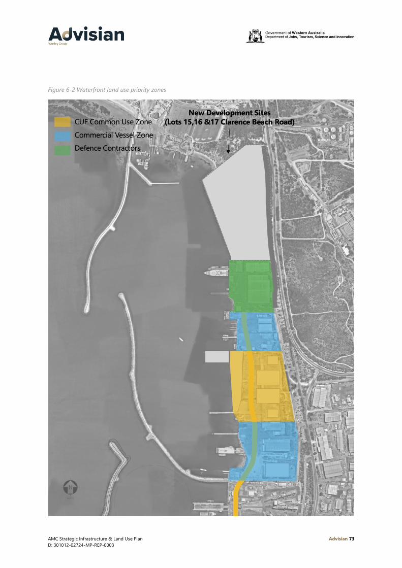
AMC Strategic Infrastructure & Land Use Plan Advisian 73
D: 301012-02724-MP-REP-0003
Figure 6-2 Waterfront land use priority zones

AMC Strategic Infrastructure & Land Use Plan Advisian 74
D: 301012-02724-MP-REP-0003
Southern Harbour – concept 1
This concept focuses Defence activity within the central area of the Southern Harbour. It provides for
staged expansion of the berths to cater for demand, without impacting on existing CUF operations and
creates the opportunity for a consolidated Defence precinct.
The staging of berth construction will need to be coordinated with Defence, given other wharf
upgrades and works at both FBW and FBE.
Figure 6-3 to Figure 6-5 show the proposed stage development for this concept.
6.3.1 Stage 1: 0 to 5 years
The following infrastructure is included in Stage 1:
• Three new build priority berths for Defence. This will be an extension of the existing AMC 1 wharf,
in a northerly direction to provide for a berth (AMC 1 and 2) length around 280m. A finger jetty
running perpendicular to the extended AMC 1 berth, providing a further two new berths, of 200m
in length. One of these berths could be a dedicated submarine berth. The width of the finger jetty
would need to be able to cater for the possibility of two different contractors undertaking
sustainment activities. To cater for a berth depth of -10mCD, localised dredging adjacent to the
existing land will be required
• A reclamation behind the two new berths provides land to develop secure offices for Defence and
Defence contractors. These offices would also have secure IT and cater for all of Defence’s
requirements
• Upgrades to the existing services (power, water, secure communications) that currently feed to
AMC 2 and 3 wharves. Extensions of the services to feed to the new berths with a staged design
approach to cater for the future expansion
• A defined transfer path from the Civmec facility to floating dock to cater for the movement of the
OPVs and Anzac frigates
• Expansion of the ASC facility to the north and construction of a new shed and facilities to cater for
FCD maintenance activities10
• An additional set of cradles to support the submarine whilst in the shed
• A dedicated transfer path from new ASC FCD maintenance shed to the floating dock10
• Possible relocation of Building 9 to another location in the CUF to provide covered work space
areas. The location would depend on its usage, and whether vessels are to be transferred into the
building or more for use as a covered fabrication hall
• Once the transfer path is constructed to ASC, the existing vessel hardstand position at the CUF will
need to be relocated. This new vessel hardstand will be designed with suitable bunding to cater for
refurbishment and also disposal
• It is essential to ensure there are berths available for common use, with AMC berths 4, 5 and 6,
able to support resource based activities
• Upgrades to the Facility Management offices, to provide for additional office space, café, gym and
other facilities for all workers and Defence personnel based in the area. The specific amenity
10 At present no commitment to this transition has been made by Defence or the Commonwealth Government.
AMC Strategic Infrastructure & Land Use Plan Advisian 75
D: 301012-02724-MP-REP-0003
improvements made to the CUF facility management offices will be considered in conjunction with
the provision of services at the Ship Zero site for Defence personnel.
It is acknowledged that the location and timing of FCD if transitioned to AMC is yet to be determined.
For the purpose of developing the SILUP it is assumed to take place at an expanded ASC facility11.
11 At present no commitment to this transition has been made by Defence or the Commonwealth Government.

AMC Strategic Infrastructure & Land Use Plan Advisian 76
D: 301012-02724-MP-REP-0003
Figure 6-3 Southern Harbour concept 1 - stage 1, 0 to 5 years
AMC Strategic Infrastructure & Land Use Plan Advisian 77
D: 301012-02724-MP-REP-0003
6.3.2 Stage 2: 5 to 10 years
The following infrastructure is included in Stage 2:
• Upgrade to the existing floating dock, by either adding on an additional section or building a new
one, to enable the lift and transfer of the Hunter Class frigate vessels
• To cater for the expanded floating dock the easternmost dolphin on the AMC 4 berth would need
to be demolished, hence reducing the overall length of this berth to 200m
• Purchase of additional SPMTs for Hunter Class vessel transfer
• Construction of new garage facilities for the SPMT units
• Upgrades to the transfer path from Civmec to cater for loads up to and including Hunter Class
frigate vessels
• Development of a transfer path from BAE to the CUF floating dock on the assumption that BAE
upgrade their shiplift to cater for the future Hunter Class frigate vessels
• Expansion of the vessel hardstand to cater for a second vessel, and an additional set of vessel
cradles
• Construction of a covered work area within the CUF to cater for vessels up to the Hunter Class
frigate size
• Three existing berths remain available for common use, AMC berths 4, 5 and 6.

AMC Strategic Infrastructure & Land Use Plan Advisian 78
D: 301012-02724-MP-REP-0003
Figure 6-4 Southern Harbour concept 1 - stage 2, 5 to 10 years
AMC Strategic Infrastructure & Land Use Plan Advisian 79
D: 301012-02724-MP-REP-0003
6.3.3 Stage 3: 10+ years
The following infrastructure is proposed in stage 3:
• Two additional priority berths for Defence providing an overall total of seven berths. It is intended
to extend the finger jetty by an additional 200m. This wharf structure effectively separates the
existing harbour in two parts. To the north there is an allowance for a vessel turning circle of
360m, and to the south 420m. This larger turning circle can cater for vessels of lengths up to
230m
• Construction of additional breakwaters to create a southern sheltered harbour. The position of
these is dependent on further studies to understand the wave environment and also vessel
simulation study. There is an allowance for a 420m turning circle, catering for a vessel of maximum
length 230m
• Localised dredging to create a channel to a new large vessel dry berth
• Development of a large vessel dry berth, with supporting facilities, and cranage.
• Two existing berths remain available for common use, AMC berths 4 and 5. The operability of
AMC 5 would be improved with the construction of breakwaters.

AMC Strategic Infrastructure & Land Use Plan Advisian 80
D: 301012-02724-MP-REP-0003
Figure 6-5 Southern Harbour concept 1 - stage 3, 10+ years

AMC Strategic Infrastructure & Land Use Plan Advisian 81
D: 301012-02724-MP-REP-0003
6.3.4 Waterfront land use priority zones
This option creates a consolidated Defence Priority zone in the centre of the Southern Harbour as
shown in Figure 6-6. The majority of land and infrastructure in the Southern Harbour remains common
user preserving the ability to support resource and major projects in the future.
Figure 6-6 Southern Harbour concept 1 – land use priority zones

AMC Strategic Infrastructure & Land Use Plan Advisian 82
D: 301012-02724-MP-REP-0003
Southern Harbour – concept 2
This concept concentrates development in the southern portion of the Southern Harbour creating the
opportunity for new shiplift infrastructure. This option adopts the same proposed infrastructure
developments as concept 1 for the first five years. Figure 6-7 to Figure 6-9 shows the proposed stage
development for this concept.
6.4.1 Stage 1: 0 to 5 years
The following infrastructure is proposed in Stage 1:
• Three new build priority berths for Defence. This will be an extension of the existing AMC 1 wharf,
in a northerly direction to provide for a total berth length of approximately 280m (AMC 1 and 2).
A finger jetty running perpendicular to the extended AMC 1 berth, providing a further two new
berths, each of 200m in length. One of these berths could be a dedicated submarine berth. The
width of the finger jetty would need to be able to cater for the possibility of two different
contractors undertaking sustainment activities. To cater for a berth depth of -10mCD, localised
dredging adjacent to the existing land will be required
• A reclamation behind the two new berths provides land to develop secure offices for Defence and
Defence contractors. These offices would also have secure IT and cater for all Defence’s
requirements
• Upgrades to the existing services (power, water, secure communications) that currently feed to
AMC 2 and 3 wharves. Extensions of the services to feed to the new berths with a staged design
approach to cater for the future expansion
• A defined transfer path from the Civmec facility to floating dock to cater for the movement of the
OPVs and Anzac frigates
• Expansion of the ASC facility to the north and construction of a new shed and facilities to cater for
FCD maintenance activities12
• An additional set of cradles to support the submarine whilst in the shed
• A dedicated transfer path from new ASC FCD maintenance shed to the floating dock12
• Possible relocation of Building 9 to another location in the CUF to provide covered work space
areas. The location would depend on its usage, and whether vessels are to be transferred into the
building or more for use a covered fabrication hall
• Once the transfer path is constructed to ASC, the existing vessel hardstand position at the CUF will
need to be relocated. This new vessel hardstand will be designed with suitable bunding to cater for
refurbishment and also disposal
• AMC berths 4, 5 and 6 will remain available to support resource sector/major project activities
• Upgrades to the Facility Management offices, to provide for additional office space, café, gym and
other facilities for all workers and Defence personnel based in the area.
It is acknowledged that the location of FCD if transitioned to AMC is yet to be determined. For the
purpose of developing the SILUP it is assumed to take place at an expanded ASC facility.
12 At present no commitment to this transition has been made by Defence or the Commonwealth Government

AMC Strategic Infrastructure & Land Use Plan Advisian 83
D: 301012-02724-MP-REP-0003
Figure 6-7 Southern Harbour concept 2 - stage 1, 0 to 5 years

AMC Strategic Infrastructure & Land Use Plan Advisian 84
D: 301012-02724-MP-REP-0003
6.4.2 Stage 2: 5 to 10 years
The following infrastructure is proposed in Stage 2:
• Construction of additional breakwaters to create a southern sheltered harbour
• Dredging of the southern harbour area to achieve a minimum depth of -10 mCD
• Expansion of the vessel hardstand to cater for a second vessel
• Construction of a covered work area within the CUF to cater for vessels up to the Hunter Class
frigate size
• Additional offices for Defence and Defence Contractors, so they are close to the priority berths.
There are two options to consider for lift and transfer of the Hunter Class vessels during this time
frame:
• Option 1 - Upgrade to the existing floating dock, by either adding on an additional section or
building a new one, to enable the lift and transfer of the Hunter Class vessels, along with
modifications to AMC 4, additional SPMT’s and garage storage as per concept 1 above. The
transfer path to Civmec would need to be upgraded to cater for loads up to and including Hunter
Class vessels. Other transfer paths within the CUF would also need to be upgraded to cater for
loads up to and including the Hunter Class vessels
• Option 2 -The alternate to upgrading the floating dock is the construction of a new shiplift facility
in a southern sheltered harbour. This would be designed to lift the Hunter Class vessels, and
SPMTs used to transport the vessel on defined paths to the hardstand location. This could
minimise the distance to move vessels on land and assist in reducing associated risks.
Development of a further transfer path from BAE could provide another lift option on the assumption
that BAE upgrade their shiplift to cater for the future Hunter Class vessels.

AMC Strategic Infrastructure & Land Use Plan Advisian 85
D: 301012-02724-MP-REP-0003
Figure 6-8 Southern Harbour concept 2 - stage 2, 5 to 10 years
AMC Strategic Infrastructure & Land Use Plan Advisian 86
D: 301012-02724-MP-REP-0003
6.4.3 Stage 3: 10+ years
The following infrastructure is proposed in Stage 3:
• Two additional priority berths for Defence. The present AMC 5 can be converted with upgrades to
the fendering system and new services. The two westernmost dolphins would be decommissioned
and new mooring facilities incorporated into a new berth with the berthing line remaining
consistent with the AMC 5 wharf
• One additional berth for common use, given conversion of AMC 5
• Localised dredging to create a channel to a new large vessel dry berth
• Development of a large vessel dry berth, with supporting facilities and cranage.

AMC Strategic Infrastructure & Land Use Plan Advisian 87
D: 301012-02724-MP-REP-0003
Figure 6-9 Southern Harbour concept 2 – stage 3, 10+ years

AMC Strategic Infrastructure & Land Use Plan Advisian 88
D: 301012-02724-MP-REP-0003
6.4.4 Waterfront land use priority zones
In this concept CUF Common Use Zone is largely the same as concept 1. The Defence Priority Zone
however is now spread across two locations due to the positioning of new berths further south within
the harbour, as shown in Figure 6-10.
Given the staging of this option, there may be a time frame when only one berth (AMC 4) is available
for common use. Usage of at least one of the defence priority berths would need to be managed to
ensure ongoing availability to the resource and major projects sector, unless Berth 11 is constructed in
advance of Berths 9 and 10.

AMC Strategic Infrastructure & Land Use Plan Advisian 89
D: 301012-02724-MP-REP-0003
Figure 6-10 Southern Harbour concept 2 land use priority zones
AMC Strategic Infrastructure & Land Use Plan Advisian 90
D: 301012-02724-MP-REP-0003
AMC land use precincts
The structure of the AMC land use precincts has proven to be robust over time. By limiting the types of
industry that can develop within the AMC, the precincts have ensured that the original intent and
purpose of the complex as a whole has remained consistent over time and focussed on target
industry/activities.
In the future it will be critical to maintain this precinct structure and ensure that activities within the
AMC remain focussed on the core objectives of the complex. Without this continued focus, it is
possible that other uses will seek to locate within the AMC, diluting the core activities and occupying
land that may one day be required for core industry.
Development of the Latitude 32 Industrial Area immediately to the east of the AMC should be viewed
as an opportunity to develop complementary and general industry. This negates the need to relax
existing zoning restrictions to allow the development of general industry within the AMC and will allow
it to remain focussed on its current target industry.
The ongoing administration of the AMC could however be simplified through the creation of a
Strategic Industry zone of the entirety of the AMC in recognition of its State and National significance
as one of only two shipbuilding hubs in Australia. Land use permissibility should be consistent with the
zone’s objectives.
The existing precinct definitions are generally considered suitable for the future, however the following
update to the fabrication precinct is considered necessary given the proposed change in nature of
activities:
Fabrication Precinct
The Fabrication Precinct incorporates the CUF and is intended to provide land for industry directly
associated with Defence, marine, oil and gas and major projects in close proximity to the waterfront.
Available development sites
Although there is limited land available at present within the AMC, several large parcels of land still
exist for future development. Figure 6-11 illustrates the location of potential future development sites
within the AMC.

AMC Strategic Infrastructure & Land Use Plan Advisian 91
D: 301012-02724-MP-REP-0003
Figure 6-11 Available development sites

AMC Strategic Infrastructure & Land Use Plan Advisian 92
D: 301012-02724-MP-REP-0003
6.6.1 Lots 15, 16 and 17 Clarence Beach Road
These three lots at the northern end of the harbour, adjacent to Austal and the recreational boating
facility, are currently vacant. The lots have a combined size of approximately 14 hectares and are sized
as noted in Table 6-2.
Table 6-2 Lot sizes
Lot No Area (Hectares)
15 6.80
16 3.53
17 3.64
Total Area 13.97
This land should be prioritised for the development of strategic projects, including activities related to commercial shipbuilding and maintenance or major projects that require direct access to the waterfront for development of marine/berth infrastructure.
To realise the development potential of this land it will be necessary to extend Clarence Beach Road
from its current end point at Austal north into Lots 15, 16 and 17. Utilities will also need to be
extended to these sites.
Development of infrastructure along the waterfront could be achieved through public investment
based on the anticipated future requirements of businesses. This infrastructure could then be retained
as part of a new Common User Facility in the Northern Harbour. Alternatively, the private sector could
be relied upon to develop any required infrastructure along the waterfront. Third party access could
potentially be achieved through lease agreements with new businesses.
6.6.2 Lot 307 and part Lot 804
This is small block of land could accommodate a fabrication shed and offices for vessel build and
maintenance or future multi-user car parking.
The combination of all of Lot 307 Clarence Beach Rd and a smaller area of Lot 804 Quill Way creates
this 3.3ha development site. Approximately half this area could accommodate built form such as
fabrication sheds, enclosed painting work areas and offices. This site has direct access to the BAE
syncrolift and has accommodated land transfer of vessels to this launch facility in the past. For this
reason, the western portion of the site should remain undeveloped (except for laydown and temporary
storage) to enable continued land-based transfer of vessels to the BAE syncrolift and the CUF’s
Floating Dock.
6.6.3 Sump ‘D’
The ‘Sump D’ site, located between ASC and Civmec has been used for a variety of purposes over time.
Originally designed as part of the stormwater drainage network, over time the area allocated for the
sump has been reduced with the western portion of the site filled in and now used for laydown
purposes.
AMC Strategic Infrastructure & Land Use Plan Advisian 93
D: 301012-02724-MP-REP-0003
Potential uses of the site are dependent on its future role as part of the stormwater network. To this
end, further studies are required to determine if the area of sump can be further reduced, replaced
with tanks or gross pollutant traps creating a large area of land for development.
Due the strategic location of the site, potential future activities may include:
• Vessel disposal (requires the implementation of bunding and site specific drainage)
• General outdoor laydown
• Fabrication building.
6.6.4 Lot 101 Stuart Drive
This site is currently held by DevelopmentWA and has been used for a variety of purposes in the past.
Part of the Lot is allocated as a temporary car park for ASC for the next few years. In the future this site
could potentially be utilized as an extension of the CUF for laydown and fabrication activities.
The retention of this site as a flexible location for short term projects/overflow from the CUF would
ensure ongoing flexibility within the AMC to accommodate fluctuations in demand. The potential to
connect this site directly to the CUF using stormwater drainage Sump ‘D’ on Quill Road should be
explored in the future to increase the potential to use this site as an overflow for the CUF. This would
potentially allow the fabrication of large modules or other components within Lot 101 prior to direct
transport into the CUF. The potential to use the existing road network for the transport of these
modules should also be considered.
6.6.5 Technology precinct
The Technology Precinct currently has a large area of land available for development in the future. The
precinct definition currently in place for the Technology Precinct is still considered relevant.
Reallocation of this land for industrial purposes (like those found throughout the AMC) is not
considered viable due to its proximity to existing residential uses to the north.
In the future this precinct should continue to be developed with offices, training, research and
development facilities to support the core activities of the AMC. Light industrial activities associated
with research and development, training or other low impact activities could potentially be considered
for this precinct, however, activities would need to be considered on a case by case basis with regard
to their suitability.
Businesses looking for a location within the AMC could be encouraged to locate some components of
their operations (engineering/administration offices) within this precinct rather than occupying more
valuable land within the core precincts.
Additional amenities could also be permitted to locate here including gymnasiums, childcare facilities
or other services that might support and increase the amenity of the AMC for its workforce.
Transport infrastructure
The AMC precinct is well connected to the wider regional road network and the greater metropolitan
region. Cockburn Road provides a north-south spine through the site dividing the technology precinct
and dissecting the support industry precinct. To the east Rockingham Road provides further north-
south access with Russell Road providing access eastward towards the Kwinana Freeway.

AMC Strategic Infrastructure & Land Use Plan Advisian 94
D: 301012-02724-MP-REP-0003
The designated high wide loads network provides direct access to the southern end of the CUF whilst
Cockburn Road, Russell Road and many of the AMC’s internal roads form part of the RAV Network.
Proposed infrastructure and service upgrades within this section should be considered as part of a
package of measures that should be implemented together in order to achieve their full benefits.
6.7.1 Car parking
Car parking is an important issue within the AMC. Minimum requirements for on site car parking
provision are dictated by the City of Cockburn through their Town Planning Scheme. Some businesses
have reduced on site car parking numbers and reallocated this space to their core activities. This has
resulted in a large number of vehicles being parked on streets and verges within the AMC.
On street parking within the AMC has a number of adverse impacts including:
• Road safety - increased potential conflicts between informally parked vehicles and moving traffic
• Pedestrian safety - as pedestrians need to travel between parked vehicles and businesses with
limited footpath infrastructure
• RAV network function – on street parking may impede the movement of RAV’s within the AMC.
In the waterfront precincts car parking occupies land that could be used for more productive purposes
related to AMC’s core activities.
6.7.2 Proposed public car parks
A potential solution to the issue of car parking within the AMC would be the implementation of multi-
user car parks in key locations. This approach would include the development of multi-story car parks
positioned within the AMC to serve multiple businesses.
The size, capacity and exact location of each car park requires further analysis based on demand within
each car park catchment. Proposed car park capacities shown here are broad estimates only. Detailed
parking surveys and business cases will be required to support each car park. Figure 6-12 illustrates the
potential location of public car parks within the AMC. In each case, it is intended that car park users
would be able to walk to/from their workplace with no need for an internal shuttle bus service.
Upgrades to pedestrian infrastructure, including footpaths and safe road crossings will also be
required.
Proposed locations and functions include:
Site 1 - Serves Austal and new development sites to the north (Lots 15, 16 and 17 – where the car park
would be located) and existing sites to the south of Austal. A car park accommodating 1,000-2,000
vehicles in this location would allow current parking on Clarence Beach Road to be removed whilst
minimising the requirement to provide car parking within the Austal and northern development sites
(a more efficient use of valuable waterfront land).
Site 2 - Serves BAE and existing commercial operations at the southern end of the Northern Harbour,
located on Lot 307 and part Lot 804 which are currently vacant. In locating a car park on this site, it is
acknowledged that a potential waterfront development site is being allocated to car parking as
opposed to the commercial shipbuilding industry. The intention of this car park would be to
consolidate the parking of several businesses in this precinct making more land available for

AMC Strategic Infrastructure & Land Use Plan Advisian 95
D: 301012-02724-MP-REP-0003
productive uses along the waterfront. The size of this car park requires further study and consultation
with potential users but could be in the vicinity of 1,000-1,500 bays.
Site 3 - Serves ASC, Ship Zero, CUF. This site is currently owned by Defence and will require further
engagement with them to explore the potential for a multi-user car park. In addition to car parking
required for the Ship Zero (550 bays), an additional 780 bays would be required to support ASC (as
part of their expansion to accommodate FCD13) and a further 1000 bays to accommodate potential
CUF users (resources and major projects) for a total of 2330 bays.
Site 4 - Serves the southern AMC fabrication precinct and potentially ASC using Lot 101 Stuart Drive,
currently held by DevelopmentWA. This car park will accommodate overflow parking from businesses
within the fabrication precinct and could also accommodate ASC parking if this cannot be located
within Site 3. It is not possible to determine the number of parking bays required in this location as a
detailed survey of existing on street parking would be required.
Site 5 - Serves Austal and CUF North utilising road reserve at the intersection of Quill Way and
Cockburn Road. This car park will need to be sized based on potential demand generated by CUF
North users. The potential to implement a car park here will also be impacted by the final design of
Clarence Beach Road.
13 At present no commitment to this transition has been made by Defence or the Commonwealth Government.

AMC Strategic Infrastructure & Land Use Plan Advisian 96
D: 301012-02724-MP-REP-0003
Figure 6-12 Proposed multi-user car park locations
There are several options available to support the implementation of multi-user car parks within the
AMC. The mechanism for their construction and operation will depend on their intended use and the
need to recover capital/operational costs. These can be broadly defined as follows:

AMC Strategic Infrastructure & Land Use Plan Advisian 97
D: 301012-02724-MP-REP-0003
Government – Either State or Local Government could construct and operate the car parks. Car
park users could either be charged directly (as they use the facility) or businesses charged based
on the number of their staff using the facility.
Private Sector – Land could be allocated for development of the car parks and leased to the private
sector who would then operate the car park and charge users of the facility.
In both scenarios, on site parking requirements for businesses within an agreed distance of the car
parks could be reduced making additional land available for development. The preferred
implementation mechanism will need to consider tax implications on existing businesses and the
equitable location of proposed car parks within the AMC.
6.7.3 Public transport
To help increase the use of public transport to/from AMC it is proposed to upgrade selected current
bus services and related infrastructure within the AMC. It is proposed to increase the frequency of the
522 service in the morning and afternoon peak periods (aligned with AMC shift start/finish times) and
modify this route to provide a direct service between the AMC and Cockburn Central Station. The new
service would travel directly between Cockburn Central and the AMC utilising Rockingham Road and
Beeliar Drive. This will improve the AMC’s connection to Cockburn Central Station and access to the
broader metropolitan rail network. Timing for the implementation of this service will be determined
based on development of the AMC and increases to workforce over time.

AMC Strategic Infrastructure & Land Use Plan Advisian 98
D: 301012-02724-MP-REP-0003
Figure 6-13 Proposed modification to bus service 522
Within the AMC the route will be modified to utilise Sparks Road and Quill Way providing additional
stops and increasing the number of businesses with access to the service as illustrated in Figure 6-13.
AMC Strategic Infrastructure & Land Use Plan Advisian 99
D: 301012-02724-MP-REP-0003
To realise the full benefits of proposed upgrades to the frequency and routing of existing bus services
within the AMC it will be necessary to upgrade supporting infrastructure as well. This should include:
• Upgrades to existing stop infrastructure to provide shelters
• New stop infrastructure along Sparks Road and Quill Way
• Footpaths to provide safe pedestrian access to the stops (refer to Section 6.8.3).
Roads
Aside from the maritime based operations, the site is reliant on road access – for workforce access and
operational purposes. The requirements of each of these groups are substantially different, with
employment generated trips reliant on overall road network capacity whilst operational trips are more
dependent on specific design elements such as lane widths, turning pockets and priority movements
with adequate sight lines and braking distances at intersections.
During peak times congestion has become a significant issue on the external road network and at key
intersections providing access to the AMC.
The following sections discuss key issues relating to the transport network and options for improving
safety and efficiency in the future.
6.8.1 Intersections
Increased development within the AMC and across the broader region will increase demand on both
regional road network and the road network within the AMC. The biggest driver of demand on the
road network is the movement of personnel to and from the site each day.
Based on high level traffic modelling, potential improvements to the traffic network were identified to
help improve traffic congestion and road safety. Investigations focussed on potential improvements at
five critical intersections (Figure 6-14) within the AMC.
A detailed traffic study will be required in the future to investigate localised impacts of increased traffic
movements on the local road network within the AMC.
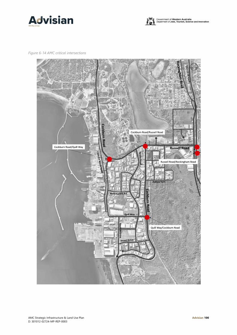
AMC Strategic Infrastructure & Land Use Plan Advisian 100
D: 301012-02724-MP-REP-0003
Figure 6-14 AMC critical intersections

AMC Strategic Infrastructure & Land Use Plan Advisian 101
D: 301012-02724-MP-REP-0003
Investigations undertaken as part of this study were high level only, based on 24 hour turn counts and
outputs from Main Roads WA 2025 traffic model for the region. The intention of these investigations
was to identify what improvements could be implemented to minimise adverse impacts on the traffic
network.
It is recommended that the following intersections (refer to Figure 6-14) are upgraded to signalised
intersections with increased lane capacities:
• Cockburn Road/Quill Way (North)
• Cockburn Road/Russell Road
• Cockburn Road/Quill Way (South).
These upgrades will increase the capacity of these intersections, whilst improving access to the AMC in
general and improving safety for all road users.
It should be noted that there is reserve in place for the realignment of Cockburn Road north of its
current intersection with Russell Road. The future upgrade of this intersection should include provision
for this future realignment.
The Rockingham Road/Russell Road intersections were also reviewed as part of this study. Main Roads
WA has developed several concepts for the future upgrade of this intersection. Our analysis showed
that upgrading these intersections, either through increased lanes/channelization or creation of a four
way at grade intersection, would result in improved performance in the future. However, the decision
to upgrade these intersections must be considered in the broader context of the regional road
network as a whole and likely changes to land uses in the region. Main Roads WA does have plans to
upgrade this intersection to a grade separated interchange in the future, however this project is not
currently included in forward capital works estimates.
The entry to the CUF should be investigated in the future taking into consideration potential increases
in traffic volumes. Reconfiguration of this intersection should be considered to improve safety and
efficiency of operation.
6.8.2 Restricted access vehicles and high wide loads
The HWL network currently provides access to the southernmost end of the CUF. There are several
known constraints on the existing external HWL network that should be removed in the future to
enable movement of these loads to and from the AMC. In particular there are known locations with
insufficient clearance to powerlines. These powerlines need to be lifted to facilitate access to the AMC,
adding expense to transport of loads and restricting the development of supporting land uses in areas
outside the AMC. There is an opportunity to bury these powerlines to provide a long term solution to
this issue.
With development of the Latitude 32 Industrial Area to the east of the AMC, the opportunity exists to
accommodate additional AMC related activities/industry in close proximity. It is proposed to extend
the existing HWL network to permit the efficient movement between the Latitude 32 Industrial Area
and the AMC. This would allow the transportation of large loads between Latitude 32 and the AMC
and create additional opportunities for industry.
Figure 6-15 outlines two proposed alignments for a new RAV corridor between the Latitude 32
Industrial Area and the AMC. The northernmost option utilising Russell Road is significantly shorter,
AMC Strategic Infrastructure & Land Use Plan Advisian 102
D: 301012-02724-MP-REP-0003
however it would require the future grade separated interchange of Russell Road and Rockingham
Road to be designed to accommodate these HWL movements. The southern alignment utilises the
existing HWL corridor along Cockburn Road before turning north and utilising Rockingham Road.
Alignment of the corridor within Latitude 32 should be considered further during the development of
detailed planning for the precinct.
In both cases the design of existing roads and proposed future upgrades to intersections will need to
consider the design requirements of HWL.

AMC Strategic Infrastructure & Land Use Plan Advisian 103
D: 301012-02724-MP-REP-0003
Figure 6-15 Proposed HWL corridor to the Latitude 32 Industrial Area

AMC Strategic Infrastructure & Land Use Plan Advisian 104
D: 301012-02724-MP-REP-0003
6.8.3 Pedestrians
An improved network of pedestrian paths will be required within the AMC in the future to support a
more balanced transport solution. In particular footpaths are required to support improved public
transport services, connecting bus stops and future multi-user car parks to businesses within the AMC.
Upgrades to the existing network should include consideration of future public/shared car parks,
existing and proposed bus stop locations. The aim is to create a comprehensive network that provides
safe access for pedestrians between businesses and car parks/bus stops. As a minimum, footpaths
should be provided on at least one side of all roads within the AMC to ensure safe and efficient
pedestrian movements in the future.
6.8.4 Cycling
Within the AMC there is currently no cycling infrastructure provided. It is unlikely that cycling will
become a significant mode of transport for people working within the AMC in the future. The industrial
nature of activities within the AMC, the presence of large heavy goods vehicles and the relative
isolation of the AMC from residential areas are all key factors in this outcome.
Provision for cyclists should still be considered in the future however. As part of a future detailed
integrated transport study, the potential to provide cycling infrastructure within the AMC should be
explored. This should consider the potential to implement shared paths on key roads within the AMC
connected to the external network to promote cycling.
6.8.5 Integrated Transport Plan
Transport plays a central role in the efficient operation of the AMC. As such preparation of an
Integrated Transport Plan (ITP) for AMC is recommended in the future to further explore and develop
the recommended actions in this plan.
This study would progress the work undertaken as part of the SILUP and identify a staged, costed plan
for implementing improvements to the transport network. Critically, preparation of an Integrated
Transport Plan should involve all key stakeholders and the final plan should include an agreed list of
recommendations including responsibilities for implementation.
The scope of this study should include:
• Car parking – A detailed parking study of private and public car parking throughout the AMC
should be undertaken. It should consider the optimal balance between public and private parking
within AMC considering planned land uses/values. The study would explore the proposed public
car park locations identified in the SILUP determining required capacities, designs and costs. The
study should also address funding mechanisms and operating/management options making firm
recommendations for the future development of public car parking within the AMC
• Traffic modelling (regional and local) – Regional traffic modelling should be undertaken taking into
consideration future changes to the regional road network and land uses. Local traffic modelling
should also be undertaken to identify future network performance and potential upgrades to local
intersections to improve performance and safety. This modelling should consider the location of
future public car parks and build out of vacant land within the AMC
AMC Strategic Infrastructure & Land Use Plan Advisian 105
D: 301012-02724-MP-REP-0003
• Local and regional road network upgrades – The ITP should identify practical upgrades to the local
and surrounding regional road networks required to support the future development of the AMC
including existing RAV and HWL networks. This should include consideration of the impacts of
adjacent land uses on the network and the potential to manage access points to the network more
efficiently
• Public transport – Options to improve public transport use should be further explored by the
study. This would include developing a detailed plan for proposed service upgrades (including
costings) and identifying an appropriate implementation mechanism. The study should also
consider upgrades to stop and pedestrian infrastructure to support public transport upgrades
• Pedestrian network review – This task should be undertaken in conjunction with investigations into
car parking and public transport. High volume pedestrian routes within the AMC should also be
identified. Proposed upgrades to the existing network should be clearly identified to support bus
stop and car park locations. Proposed improvements should be costed and included in the ITP’s
recommendations
• Cycling network review (including end of trip facilities) – A detailed review of existing cycling
infrastructure within/serving the AMC. This might also include an audit of existing end of trip
facilities within the AMC and exploration of the potential to provide multi-user/public end of trip
facilities if it is felt that these would benefit the AMC.
Utilities
Key utility providers have been consulted as part of this study. Feedback from these providers indicate
that the AMC is well placed for the future.
The provision of specific utilities relating to berth side activities within the CUF is addressed in Section
4.4.1 of this report.
6.9.1 Power
Western Power has confirmed that the existing substation near Cockburn Cement on Russell Road
currently has some spare capacity that could accommodate growth in demand from the AMC in the
future. Western Power also have a site on Amur Close that could be developed for a substation if
required in the future.
There is strong potential for the deployment of renewable energy systems within the AMC. This could
include the installation of solar panels on the roofs of buildings. If sufficient power could be generated
within the precinct the potential for a microgrid could be explored.
This concept would also require the coordination of land owners willing to invest in the technology
and infrastructure required.
6.9.2 Water
There are no known deficiencies in the potable water network at present and no upgrades are planned
as part of this plan.
Stormwater drainage is managed through a complex system of piped networks, drainage sumps and
overland flows. The system was designed to cater for the AMC at build out and anecdotal evidence
suggests that the system has sufficient capacity at present. The localised stormwater drainage network

AMC Strategic Infrastructure & Land Use Plan Advisian 106
D: 301012-02724-MP-REP-0003
may require review and modification in the future if Sump D is intended to be resumed completely for
development purposes.
6.9.3 Telecommunications
The NBN is currently available to businesses within the AMC and will be upgraded in the future as
demand requires. The NBN has been delivered using multiple technologies, however within the AMC
optic fiber to the premises is available to all existing businesses via third party retailers.
In the future it will be necessary to continue to update and upgrade telecommunications within the
AMC and ensure that businesses have secure and efficient access. With the evolution of the digital
shipyard, the provision of fast high speed internet, ease of connectivity to secure wifi networks, and
efficient access to electronic data is key.
Amenities
With an increased volume of activities occurring within the AMC there will also be an increased
workforce. It is important to ensure that sufficient amenities are available to support the workforce
within the AMC. This includes ensuring that there are options to buy lunch or coffee within the AMC
through to providing recreation facilities that could be used after hours.
Within the Technology Precinct there are still a number of sites available that could be developed to
support activities throughout the AMC. This may include amenities such as gymnasiums facilities to
support the existing playing fields. Any upgrade or development of new amenities within the AMC
should consider existing facilities located in the surrounding area such as the Coogee Surf Club and
opportunities to promote their utilisation.
Within the CUF it is proposed to upgrade the existing AMC Management offices to include supporting
amenities such as a gym and café for personnel working within the CUF.
Governance
As noted in Table 2-1 there are currently six agencies actively involved in the ongoing
governance/planning of the AMC.
There is an opportunity to explore improved governance within AMC. JTSI is undertaking a review of
governance separate to this SILUP.

AMC Strategic Infrastructure & Land Use Plan Advisian 107
D: 301012-02724-MP-REP-0003
7 Next steps
Finalisation of the AMC Strategic Infrastructure and Land Use Plan is a two part process. As illustrated
in Figure 7-1 the information presented in this plan is preliminary only and will be subject to further
refinement based on the outcomes of stakeholder consultation.
The AMC SILUP will be finalised through the Strategic Infrastructure Taskforce, as a deliverable of the
WA Defence and Defence Industries Strategic Plan. The Taskforce includes senior representatives from
the departments of Jobs, Tourism, Science and Innovation; Planning, Lands and Heritage; Transport
and Premier and Cabinet and DevelopmentWA. It is anticipated that the final SILUP will be published
by August 2020.
Figure 7-1 Next steps

AMC Strategic Infrastructure & Land Use Plan Advisian 108
D: 301012-02724-MP-REP-0003
8 Future studies
It is recommended that the following studies be progressed to address a number of areas that require
further detailed investigations. The outcome of these investigations will assist in refining the
infrastructure concept developed in the SILUP. These studies are outlined in Table 8-1.
Table 8-1 Summary of future study requirements
Study Title Justification
Integrated Transport Plan Required to confirm future local intersection upgrades, pedestrian
and cycle network upgrades and regional network upgrades to
support efficient transport to/within the AMC in the future.
Vessel Lift and Transfer
Technology Study
To determine the most appropriate technology solution/s for vessel
lift and transfer within the Northern and Southern Harbours,
including addressing efficiency and cost of transfer
Water Quality Study To determine any required changes to existing breakwaters in the
Northern Harbour to improve water quality.
Northern Breakwater
Condition Survey
Identification of any required maintenance/improvements to the
existing Northern Harbour breakwaters.
Northern Harbour Vessel
Demand and Harbour
Entrance Study
To determine the vessel demand in the Northern Harbour and
suitably of the entrance for both commercial and recreational vessels
Sump D Utilisation Study Review of Sump D within the overall stormwater drainage network of
the AMC to determine if this site could be utilised for other purposes
i.e. vessel disposal.
CUF Wharves Power
Supply
Undertake a study to determine options for power supply upgrades
to existing CUF wharves utilised by Defence and provision for future
development.
Microgrid Business Case Preparation of a microgrid business case to explore the potential to
implement this concept within AMC.
Large Vessel Dry Berth
Feasibility Study
Preparation of technical feasibility and business case to determine the
potential to implement a dry berth within the AMC Southern
Harbour.
Southern Harbour
Breakwater Extension and
New Berths
Technical study to determine the design and cost of implementing
breakwaters and develop concepts for proposed new berths in the
Southern Harbour. This study would include wave climate modelling,
ship handling simulations and concept design of breakwater options.
Clarence Beach Road
Extension Study
Preparation of a concept study to determine the preferred alignment
of the Clarence Beach Road between its intersection with Quill Way
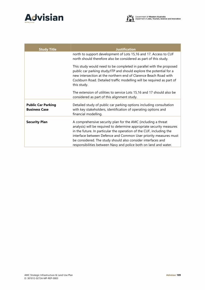
AMC Strategic Infrastructure & Land Use Plan Advisian 109
D: 301012-02724-MP-REP-0003
Study Title Justification
north to support development of Lots 15,16 and 17. Access to CUF
north should therefore also be considered as part of this study.
This study would need to be completed in parallel with the proposed
public car parking study/ITP and should explore the potential for a
new intersection at the northern end of Clarence Beach Road with
Cockburn Road. Detailed traffic modelling will be required as part of
this study.
The extension of utilities to service Lots 15,16 and 17 should also be
considered as part of this alignment study.
Public Car Parking
Business Case
Detailed study of public car parking options including consultation
with key stakeholders, identification of operating options and
financial modelling.
Security Plan A comprehensive security plan for the AMC (including a threat
analysis) will be required to determine appropriate security measures
in the future. In particular the operation of the CUF, including the
interface between Defence and Common User priority measures must
be considered. The study should also consider interfaces and
responsibilities between Navy and police both on land and water.

AMC Strategic Infrastructure & Land Use Plan Advisian 110
D: 301012-02724-MP-REP-0003
9 References
AMC Land Use and Infrastructure Plan. (2008).
Australian Marine Complex Overarching Committee. (2008). AMC Land Use and Infrastructure Master
Plan Assessment.
City of Cockburn. (2016). AMC Parking Study.
Commonwealth of Australia. (2015). Control of Naval Waters Regulation 2015.
Commonwealth of Australia. (2016). Control of Naval Waters Act 1918.
Commonwealth of Australia. (2019). Control of Naval Waters (Henderson and Osborne) Proclamation
2019.
Department of Defence . (2018). Defence Industrial Capability Plan.
Department of Defence. (1987). The Defence of Australia (Defence White Paper).
Department of Defence. (2016). Defence White Paper.
Department of Defence. (2016). Integrated Investment Program.
Department of Defence. (2017). Naval Shipbuilding Plan.
Department of Defence. (2020). Maritime Sustainment : 2025 Plan Galileo.
Flyt. (2019). AMC Transport and Traffic Report.
Government of Western Australia. (2018). WA Defence and Defence Industries Strategic Plan.
Government of Western Australia. (2019). Western Australia Investment and Trade Plan 2019-20.
Oropesa Port Management Pty Ltd. (2018). AMC CUF Infrastructure and Facilities Study.
Royal Australian Navy. (2019). Operation of Vessels within Naval Waters - Henderson Austrailan Marine
Complex.
Taylored Consulting. (2019). Australian Marine Complex Market Outlook.

AMC Strategic Infrastructure & Land Use Plan Advisian 111
D: 301012-02724-MP-REP-0003

AMC Strategic Infrastructure & Land Use PlanAMC Strategic Infrastructure & Land Use Plan Advisian Digital
D: 301012-02724-MP-REP-0003

AMC Strategic Infrastructure & Land Use Plan Advisian
D: 301012-02724-MP-REP-0003
A.1 Stakeholder consultation methodology
The overall objectives of the stakeholder engagement process for the AMC SILUP are to:
inform: to provide stakeholders with balanced and objective information to assist them in
understanding the problems, alternatives, opportunities and/or solutions
consult: to obtain feedback on analysis of alternatives and/or decisions
involve: to work directly with stakeholders throughout the process to ensure concerns and aspirations
are consistently understood and considered.
To inform the development of the AMC SILUP, engagement with stakeholders aims to understand:
• Existing operators in the AMC and their current and planned activities
• Current and future requirements for services through AMC to support industry and Defence
• Constraints and opportunities in relation to current operations and further development of the
AMC
• Major issues to be addressed through planning to facilitate meeting the future requirements.
To support the consultation process, stakeholders have been grouped based on their role/activities
within AMC as noted in Table 9-1.
Table 9-1 Stakeholder consultation categories
Stakeholder category Description
A Waterfront facilities operator Operators of facilities within AMC that are located
on the AMC waterfront. Operators may be
engaged in Defence and non-Defence related
activities.
B AMC facilities user – Defence Defence organisations (Navy, CASG, E&IG) that
obtain Defence related services through AMC
C AMC facilities user – other Commercial and industrial organisations that
obtain services through AMC
D Government body Commonwealth, Western Australian, and local
government agencies and committees with an
interest in AMC
E Government interest group Existing groups formed of government agencies
representing regional or other interests
F Industry representative body Organisations representing groups of businesses
with involvement in AMC as operators or users
G Support industry operator Businesses within and outside AMC that provide
goods or services to waterfront facilities operators
or other stakeholders of the AMC

AMC Strategic Infrastructure & Land Use Plan Advisian
D: 301012-02724-MP-REP-0003
Stakeholder category Description
H Utility or service provider Providers of electricity, water, sewerage,
telecommunications, transport infrastructure
The stakeholder engagement program comprises two phases:
A.2 Phase 1
Initial consultation with stakeholders to gather base information and identify existing
issues/opportunities and future requirements.
During this phase the study team completed the following activities:
• 10 face to face meetings with key stakeholders in groups A, B, C, D and E
• Issued electronic surveys to all stakeholder groups (25 returned surveys)
• Advertised through the City of Cockburn newsletter
• Requested data/information from stakeholder group H.
A.3 Phase 2
Phase 2 consultation has not yet been completed. This phase will be focused on closing the ‘feedback
loop’ and ensuring the recommendations in the SILUP reflect the needs of all stakeholders.
The Phase 2 stakeholder consultation will comprise of two parts.
• Part 1 – Pre-public consultation
Targeted consultation with the waterfront businesses, LNG Taskforce members, Defence and City
of Cockburn. This consultation will be on a one-by-one basis via video conferencing, given current
COVID-19 restrictions.
• Part 2 – Public consultation
This will be open to all stakeholders to provide comment through a series of online forums, and
one-by-one meetings where applicable.

AMC Strategic Infrastructure & Land Use Plan Advisian
D: 301012-02724-MP-REP-0003
A.4 Outcomes phase 1 consultation
The response rate to the survey questionnaire issued is summarized in Table 9-2.
Table 9-2 Phase 1 questionnaire response rate
Stakeholder Category No. of issued
questionnaires
No. of returns Response rate
Support Industry Operator 122 7 6%
Waterfront Operator 14 7 50%
Government interest group, industry
representative bodies, Government
Departments
6 5 83%
AMC Facility Users – LNG Taskforce 6 3 50%
Utility of Service Provider 4 3 75%
Total 152 25
The key themes from the consultation are:
• General support for the AMC Concept
− A strategic industrial area with a focus on marine, fabrication and resource sector support
− Some owners would like to see zoning restrictions relaxed
• Transportation
− Road congestion and road safety during peak periods
− Car parking within the AMC
• CUF
− Generally meets the requirements of users
− On berth infrastructure could be improved (utilities, offices etc)
− Access to multi-user facilities not available from all parts of the Waterfront (i.e. CUF North and
lots further north)
• Governance
− Multiple government agencies/departments involved in managing the AMC
− Lack of enforcement of existing planning requirements
− Need for a renewed vision/plan for the AMC’s future