Alteration and mineralization of the Copper Cliff prospect ...
71
University of Montana University of Montana ScholarWorks at University of Montana ScholarWorks at University of Montana Graduate Student Theses, Dissertations, & Professional Papers Graduate School 1993 Alteration and mineralization of the Copper Cliff prospect Garnet Alteration and mineralization of the Copper Cliff prospect Garnet Range Montana Range Montana Peter C. Ellsworth The University of Montana Follow this and additional works at: https://scholarworks.umt.edu/etd Let us know how access to this document benefits you. Recommended Citation Recommended Citation Ellsworth, Peter C., "Alteration and mineralization of the Copper Cliff prospect Garnet Range Montana" (1993). Graduate Student Theses, Dissertations, & Professional Papers. 7576. https://scholarworks.umt.edu/etd/7576 This Thesis is brought to you for free and open access by the Graduate School at ScholarWorks at University of Montana. It has been accepted for inclusion in Graduate Student Theses, Dissertations, & Professional Papers by an authorized administrator of ScholarWorks at University of Montana. For more information, please contact [email protected].
Transcript of Alteration and mineralization of the Copper Cliff prospect ...

University of Montana University of Montana
ScholarWorks at University of Montana ScholarWorks at University of Montana
Graduate Student Theses, Dissertations, & Professional Papers Graduate School
1993
Alteration and mineralization of the Copper Cliff prospect Garnet Alteration and mineralization of the Copper Cliff prospect Garnet
Range Montana Range Montana
Peter C. Ellsworth The University of Montana
Follow this and additional works at: https://scholarworks.umt.edu/etd
Let us know how access to this document benefits you.
Recommended Citation Recommended Citation Ellsworth, Peter C., "Alteration and mineralization of the Copper Cliff prospect Garnet Range Montana" (1993). Graduate Student Theses, Dissertations, & Professional Papers. 7576. https://scholarworks.umt.edu/etd/7576
This Thesis is brought to you for free and open access by the Graduate School at ScholarWorks at University of Montana. It has been accepted for inclusion in Graduate Student Theses, Dissertations, & Professional Papers by an authorized administrator of ScholarWorks at University of Montana. For more information, please contact [email protected].

pereR c euswoRTvt
Maureen and Mike MANSFIELD LIBRARY
The University ofMontanaPermission is granted by the author to reproduce this material in its entirety, provided that this material is used for scholarly purposes and is properly cited in published works and reports.
** Please check “Yes ” or “No ” and provide signature**
Yes, I grant permission _1_No, I do not grant permission —
Author’s Signature
Date: 11 j 0-^ ^ ^ 3 ________
Any copying for commercial purposes or financial gain may be undertaken only with the author’s explicit consent.
M ALICOPY PM4


ALTERATION AND MINERALIZATION of the
COPPER CLIFF PROSPECT GARNET RANGE, MONTANA
byPeter C . Ellsworth
B.S., Montana State University, 1985
Presented in partial fulfillment of the requirementsfor the degree of Master of Science
University of Montana 1993
Approve^ by
Chairman, Board of Examiners
Dean, Graduate School
Date

UMI Number: EP38377
All rights reserved
INFORMATION TO ALL USERS The quality of this reproduction is dependent upon the quality of the copy submitted.
In the unlikely event that the author did not send a complete manuscript and there are missing pages, these will be noted. Also, if material had to be removed,
a note will indicate the deletion.
UMTDtssertartion Publishing
UMI EP38377Published by ProQuest LLC (2013). Copyright in the Dissertation held by the Author.
Microform Edition © ProQuest LLC.All rights reserved. This work is protected against
unauthorized copying under Title 17, United States Code
uesfProQuest LLC.
789 East Eisenhower Parkway P.O. Box 1346
Ann Arbor, Ml 48106 - 1346

ABSTRACTEllsworth, Peter C., M.S., November 1993 GeologyAlteration and Mineralization of the Copper Cliff Prospect, Garnet Range, Montana (62 p )Director: Ian M. Lange
The Copper Cliff prospect in western Montana hosts gold- copper deposits in an altered porphyry stock, hydrothermal breccia pipes and carbonate replacement deposits. The recent recognition of quartz-alunite alteration sparked a renewed interest among explorationists.
Extensive faulting formed by thrusting of the Sapphire allochthon and movement along the Lewis and Clark line prepared structural conduits for acid sulfate-rich fluid migration during emplacement of Eocene quartz latite plutons and dikes. Post-mineral movement along the faults have offset altered and mineralized zones.
The Copper Cliff district has undergone multiple mineralizing events manifested by advanced argillic, phyllitic and propylitic alteration zones within Tertiary quartz latite plutons that intrude Late Proterozoic metasedimentary and Cambrian carbonate rocks. Anomalous gold concentrations occur within the phyllitic altered core zone, while higher gold and copper values occur within peripheral breccia pipes and carbonate replacement bodies•
Zonation of alteration minerals, the presence of enargite and hypogene alunite, and the style of mineralization suggest that the prospect is of the enargite-bearing quartz alunite gold-copper deposit type. The model was developed by geological, geochemical and mineral patterns observed at Goldfield, NV, Summitville, CO, El Indio, Chile, Pueblo Viejo, Dominican Republic and others. Several of these quartz-alunite gold deposits are underlain by gold-rich porphyry copper deposits. Patterns at the Copper Cliff district resemble both the quartz-alunite and porphyry copper deposit models. Late gold mineralization corresponds with sericite alteration zones. Observation of sericite overprinting alunite suggest that gold was mineralized from alkaline epithermal fluids.
11

ACKNOWLEDGEMENTSThe author acknowledges Newmont Exploration Ltd.'s
financial support for this study, particularly Rich Harris who initiated the assistance and provided valuable data. Randy Vance of Newmont, Ian Lange and Don Winston, University of Montana provided integral editorial and technical assistance. Geologic maps prepared by Mike Thomas and Pavel Reichl of Newmont were the primary source for district geologic interpretations. Aaron and Tom Charlton, of Trans-Global Resources, N.L., owners of Copper Cliff, granted access to the property and data provided use of their office. Finally, Sid Williams' pétrographie data and H. Roy Krouse's isotope analysis were integrated into this report.
Xll

TABLE OF CONTENTSABSTRACT ................................................ üACKNOWLEDGEMENTS....................................... ...TABLE OF CONTENTS....................................... ivLIST OF F IGURES......................................... vLIST OF T A B L E S ......................................... vI. INTRODUCTION ....................................... 1
Procedure ......................................... 2Study O b j e c t i v e ................................... 2Location ........................................... 3History and Previous Investigations ............. 4Methods of Study ................................... 7
II. G E O L O G Y .............................................. 9Lewis and Clark L i n e .............................. 9Sapphire Allochthon .............................. 11District Geology ................................... 12Union Hill S t o c k ................................... 15V o l c a n i s m ......................................... 16Structural Geology ................................. 16Copper Cliff Breccia .............................. 18Whole Rock Geochemistry.......................... 20
III. ALTERAT I ON & MINERALIZATION........................ 23Zonation of Hydrothermal Alteration ............. 23Alteration of the Union Hill S t o c k ............... 24Mineralization of the Union Hill S t o c k ........... 26Copper Cliff Breccia .............................. 28Leonard and Klenzie Mines ........................ 30Trace Element Geochemistry ........................ 31Sulfur Isotope Geochemistry ...................... 32
IV. GEOCHRONOLOGY....................................... 34Copper Cliff Age Dates ............................ 34Western Garnet Range Age Dates . . . . 34Interpretation ..................................... 35Geologic History ................................... 36
V. DISCUSSION AND CONCLUSIONS ........................ 3 8Quartz-Alunite Deposit Model ...................... 39Porphyry copper-gold Systems ...................... 44Copper Cliff District Model ...................... 45Conclusions and Summary .......................... 49
R E F E R E N C E S .............................................. 5 3
IV

APPENDIX A APPENDIX B
Figure 1. Figure 2. Figure 3. Figure 4. Figure 5. Figure 6. Figure 7. Figure 8. Figure 9• Figure 10 Figure 11 Figure 12 Plate I.
LIST OF FIGURESLocation map..............................Regional geologic map...................District geologic map ....................Geologic map of the Copper Cliff breccia.Stereonet plot............................Alkaline-silica diagram ...............Le Maitre diagram ........................Photomicrographs ........................Backscatter electron image .............Scatter diagrams ........................Age dates .................................Quartz-alunite deposit model
5861
310131920 21 21 25 27 33 36 41
Geologic map of the Copper Cliff prospect .pocketLIST OF TABLES
Table 1 Table 2 Table 3 Table 4 Table 5
531354647

CHAPTER I INTRODUCTION
The historic Copper Cliff mining district has been prospected for over 100 years, however Pederson's (1988) recognition of extensive quartz-alunite alteration sparked renewed interest among large-scale mining companies. Sillitoe's (1988) observation that porphyry copper deposits underlie quartz-alunite alteration, further enhances the district's potential to host world class gold-copper deposits. The district hosts gold-copper occurrences within an altered quartz latite porphyry stock, carbonate replacement bodies and hydrothermal breccia pipes, however large deposits remain undiscovered.
Eocene quartz latite volcanic plutons and dikes intrude Belt metasedimentary rocks and Cambrian carbonate rocks in the Copper Cliff district. Extensive faulting provided pathways for hydrothermal fluids which formed breccia pipes scattered throughout the district. The largest pipe, the Copper Cliff, earned its name from secondary copper minerals that decorate the cliff face with bright blue and green streaks. Chalcedonic quartz, alunite, clays and sulfides together with gold and copper were deposited within breccia pipes, a porphyritic stock and carbonate rocks.
This study analyzes the complex geology and geochemistry to determine the type of deposit present and the origin and timing of hydrothermal fluids responsible for the widespread

2alteration and unique mineralization of the mining district. The information generated by the study is used to test the hypothesis that the district hosts an epithermal quartz— alunite hydrothermal system.
ProcedureThe study was launched by assembling and analyzing a data
package from Newmont Exploration Limited. The data consists of geologic maps and cross-sections prepared by Pavel Reichl and Mike Thomas, soil geochemical maps, geophysical maps, rock sample geochemistry, drill hole assays, drill logs and drill samples. Pertinent data were selected for the study, and integrated with previous literature, whole rock geochemistry, absolute age dates, microprobe data, sulfur isotope analysis, x-ray mineralogy, drill sample logs and pétrographie data generated by myself.
Study ObjectiveThe primary goal is to categorize the Copper Cliff
district into the proper hydrothermal precious metal model. To do this, the enormous database must be streamlined into a succinct summary in order to compare characteristics of the Copper Cliff district with the conceptual quartz-alunite gold deposit model presented by Ashley (1982), Bonham and Giles (1983), Bonham (1984, 1988), Walthier (1985) and Berger(1986). The model is based on world-class epithermal gold- copper deposits hosted in acid-sulfate altered volcanic rocks.
The research consolidates information generated over the

into a succinct summary, and integrates these findings with field and laboratory data. The results of the research clarifies the timing, chemistry, paragenesis and depth of gold and copper mineralizing events. These conclusions lead to additional exploration targets in the district, and will be useful for future exploration strategies in the northern Rockies.
L o c a t i o n
The Copper Cliff prospect is located 29 miles (47 km) east of Missoula in the western portion of the Garnet Range, Sec. 10-15, T 12 N, R 15 W, Missoula and Granite Counties,
MONTANA
MISSOUl^#
Ro u nd u pB a r — L incoln ^
GARNET RANGEColoma
X GarnetPoto
Btockfoot T avern - X Top O* Deep
C O PPE R CLIFF. Cfinton
Rock Cre ak Lodge Drum m ond
figure i. j-»ocatjLon map surrounding mining districts

4Montana (Fig, 1), The property is accessed via Interstate 90 at the Beavertail exit, 25 miles (40 km) east of Missoula, and northeast up the Cramer Creek Road approximately 15 miles (24 km). Research is concentrated in Sec, 11, which encompasses the Copper Cliff breccia pipe, the intensely altered Union Hill stock and the Klenzie and Leonard mines.
History and Previous InvestigationsGold in the western Garnet Range was first discovered
within placer deposits along Bear and Elk Creeks in 1865 (Irving, 1963), Lode gold in the Garnet, Coloma and Top 'O Deep districts was discovered shortly thereafter. These mining districts, shown in figure 1, surround the Copper Cliff district, which was discovered in 1891 by W,P. Shipler (Irving, 1963), The Clinton mining district to the west was not discovered until 1899. Intermittent mining, development and exploration throughout the Garnet Range continued since that time, and exploration is presently active in the Garnet and Copper Cliff districts. Metallic lode production for the western Garnet Range through 1960 is summarized in Table 1.
Acquisition of the Copper Cliff property in 1900 by an English syndicate resulted in substantial development in the search for high grade ore. After mining several hundred tons of copper ore, the property was passed on to Bielenberg and Higgins in 1916, who shipped about 150 tons of 9% copper ore. The Potomac Copper Company was formed in 1918 to explore and develop low grade, large tonnage ore at depth within the

Table 1. Metal lode production through 1960 in the western Garnet Range.
District Au (Oz.) Ag (Oz.) Cu (Lbs) Pb (Lbs) Zn(Lbs)
Clinton 212 31,774 226,545 36,642 3,200Coloma 17,456 21,950 13,503 18,856 800Copper Cliff 259 567 110,898Garnet 113,139 101,962 166,699 7,442 1,744Blacktail 6,487 1,300 1,336,170 26,700Top '0 Deep 2,575 N/A N/ATotal 133,641 162,740 518,945 1,399,110 32,444
Copper Cliff breccia pipe. Exploration was terminated after discovering that the pipe is truncated at shallow depth by a low angle fault.
The Bielenberg family maintained ownership until 1958 during which time, only minor, sporadic mining took place on the Copper Cliff face. Mr. James Charlton purchased the property and founded the American Mining Company in 1958. AMC explored the property through 1978 by compiling literature, mapping, surface sampling, geophysical surveying and drilling. The Charlton family still controls the Copper Cliff property, and numerous major exploration and mining companies examined the property since the mid 1970s.
Cities Service Mining Company leased Copper Cliff in 1977, however a decline in copper prices forced termination of the project in 1978 despite their 317 million ton potential ore estimate (Pederson, 1988). Anaconda Minerals Company initiated exploration at Copper Cliff in 1980 in conjunction

6with its Forest Products program in the western Garnet Range. Brannon et al. (1980) delineated three distinct targets along with resource potentials: 1) porphyry copper gold system with340+ million tons of 0.01 oz/st gold and 1% copper; 2) mineralized breccia pipes with 2.5 million tons of 0.1 oz/st gold y 1.0 oz/st silver and 3% copper; 3) carbonate replacements with 20 million tons of 0.1 oz/st gold, 1.0 oz/st silver and 2% copper. Anaconda was unable to reach a lease agreement, and terminated exploration. Western Energy Company's purchase of Anaconda's Forest Product mineral holdings in 1985 prompted reconnaissance of the Copper Cliff district and subsequent recognition by Pederson (1988) of the quartz-alunite type system.
Newmont Exploration Limited reached an exploration agreement with Trans Global Resources N.L., controlled by the Charlton family, for the Copper Cliff district in 1991. The program entailed geologic mapping, geophysical surveying, geochemical sampling and drilling 17 holes. Newmontterminated the project in 1992, and contributed data and funding for this study- The property is presently under the control of Trans-Global Resources.
Information on Copper Cliff mineralization was first published by Pardee (1917) just after the peak mining activity in the Garnet Range. Sahinen (1957) summarized the geology, mineralization and production for the western Garnet Range mining districts. A condensed summary of this thesis was

7published by Ellsworth (1993). Additional publications are available for the western Garnet Range. Numerous private company reports were made available for this study, which include reports by Billingsley (1916), Rozenkranz (1919), Weed and Gow (1919), Higgens (1919), Irving (1963, 1969), Johnson (1972), Hawe (1974), Michel (1976), Shell (1977), Sherry (1983), Brannon and Korzendorfer (1982), Brannon et al. (1982), Pederson (1988), Childs and Mulholland (1988) and Vance (1988). Geologic maps, geochemical data, geophysical data and historical information of the Copper Cliff district are presented in these reports.
Methods of Study This study integrates data generated by myself with
information provided by previous workers in order to develop a coherent deposit model. K-Ar age determinations from biotite in unaltered quartz latite intrusive rock, and from alunite obtained from core recovered in the altered Union Hill stock establish their timing* Magma-chem whole rockgeochemical analyses of samples collected from unaltered quartz latite stocks and dikes, as well as volcanic flows on Union Peak and Tenmile Creek east of the district indicate their compositional relationship. More than 35 thin and polished sections of igneous phases, alteration and mineralization were examined. Three samples from drill core in the Union Creek stock were prepared for fluid inclusions analysis, however none were found. Information obtained from

8previous studies of the regional and local geology, and the quartz-alunite deposit model is condensed into this report*

CHAPTER II GEOLOGY
The Copper Cliff mining district is located on the southwest limb of a broad southeast-plunging anticline shown in figure 2. Late Proterozoic Belt Supergroup quartzite and argillite, Cambrian carbonates and shale, and Eocene hypabyssal quartz latite plutons and dikes crop out in the area surrounding mineralization. Tectonic effects along the Lewis and Clark line (tectonic zone) and thrusting of the Sapphire allochthon are expressed as a complex fault pattern that may be responsible for igneous activity, hydrothermal fluid migration, emplacement of hydrothermal breccia pipes and displacement of mineralized zones within the district. The complicated fault patterns and poor outcrop exposure obscures clear interpretations of structures and the geologic history of the area.
Lewis and Clark LineThe Lewis and Clark line is a broad structural zone that
extends from Couer d'Alene, Idaho, southeast to the Helena area, and possibly as far east as the Lake Basin fault zone north of Billings, Montana (Harrison et al., 1974). It is represented by a series of steep faults that exhibit strike- slip, dip-slip and oblique-slip motion (Vice, 1989; Wallace et al., 1990). Reynolds (1979) suggested that movement recurred along the line since Proterozoic time. Harrison et al. (1974) observed that the line truncates the Libby trough and the

1)4 WSWAN
VAUEYÛVMISSION VAUEY
TQuTQu
rcfrc*rca ra
ECw
u HNEVADA VAUEY
P C n
PCSTQuMISS'
TQu
AVONVAUEY
DEUMMONO+ + I; #-.+ + +t.v'- TQu
TQu TQu
IM W
TQu U ndiffurenliolad Q uotarnery and T artiary
^ Eocena Volcanics
J T artiary & C ratocaous Intrusive Igneous Rocks+ + ±_t
K Jurassic C ratocaous Sadim antory Rocks
D Davonian Sadim antory Rocks
C Cambrian Sedim entary Rocks
PCb U ndiffarantiotad Belt Supergroup
PCmu Upper M issoula Group
PCml Lower Missoula Group
PCm U ndiffaranliated M issoula G roup
PCw W allace & Helena Form ations
PCr Ravalli Group
P^P Prichard Formation
Thrust Fault
Normal Fault
lithologie Contact
Figure 2. Regional geologic map of the G arnet Range and surrounding oreos. Modified a fte r Sears at al. (1989] and Vice (1989),

11Rocky Mountain trench to the north. These observations, along with aeromagnetic and gravity data suggest that the line forms a deep crustal feature that influenced Mesozoic and Cenozoic igneous activity. The recurrent activity along the line may also be responsible for channeling hydrothermal fluids and subsequent mineral deposition in the western Garnet Range.
Sapphire Allochthon The Sapphire allochthon in western Montana constitutes
the western segment of two principal thrust plates within the Cordilleran overthrust belt (Reynolds, 1991). Late Cretaceous eastward thrusting of the Sapphire allochthon accompanied emplacement of numerous plutons such as the Garnet stock, the Boulder, Philipsburg and Pioneer batholiths. These large sill-like bodies were emplaced along active thrust faults to form an arcuate pattern that extends from Paradise to Drummond, and south to Bannock (Sears, 1988; Hyndman et al., 1988; Winston, 19 86). Hyndman (1980) proposed that the Sapphire allochthon represents a regional gravity slide tectonic block that detached from the Idaho batholith along the Bitteroot mylonite zone. Sears (1988) suggested that the Sapphire plate was then carried piggy-back eastward by the eastern slab over the southern portion of the Montana Disturbed Belt during Paleocene time.
The northern edge of the Sapphire allochthon is expressed as the Blackfoot and Bearmouth thrust faults in the western Garnet Range (Sears et al. , 1989) as shown on figure 2. These

12faults are exposed along Cramer Creek within 8 miles (13 km) south of the Copper Cliff property. Here, the Bearmouth thrust places Proterozoic upper Missoula Group of the Belt Supergroup over the Cambrian Hasmark Dolomite. Further north near the Linton (Blacktail) mine^ the Blackfoot thrust places Proterozoic McNamara Formation over a series of horses composed of the Pilcher Quartzite, Garnet Range Formation, the Hasmark Dolomite and the Devonian Jefferson Dolomite (Sears et al., 1989).
District GeologyThe Copper Cliff district is hosted by the Late
Proterozoic Belt Supergroup unconformably overlain by the Middle Cambrian Silver Hill and Hasmark formations. Early Eocene quartz latite porphyry plutons and dikes intrude the sedimentary rocks within the central mining district, and middle Eocene quartz latite volcanic flows cap Union Peak two miles (3 km) east (Fig. 2). All rock types in the central district have undergone propylitic, silicic or advanced argillic alteration.
Sedimentary rocks consist of the McNamara Formation in the northern areas, ascending south stratigraphically to the Garnet Range Formation, the Silver Hill Formation, the Hasmark Dolomite and the Red Lion Formation. Bedding planes dip 10® to 40® to the south (Fig. 3). The Flathead Quartzite, which typically underlies the Silver Hill Formation, is absent in this area. Evidently, the Copper Cliff district was located

approx im atea x tsn te x te n t of propylitic a lte ra tio n / ,zone / >
Copper
Stock
C opperPlutons
Klenzie
Modified from Newmont Exploration Ltd. (1991)
Phyllitic a lte red Porphyry
A dvanced Argillic a lte red Porphyry
^ M ineralized H ydrotherm al B reccia Pipe
U naltered to Propylitic Q uartz L atite Porphyry
H asm ark Dolomite
J s ilv e r him Form ation
G arnet R ange Pm.
Normal Fault
T hrust Fault
S trike & Dip of Bedding
3 Mine S haft
J Adit
"0 Existing Drillhole
m eters100 200
1000
300
K-Ar AGE DATES:
^ Alunite: 4S.4 M.Y.
I Blotlte: 56.4 M.Y.
5 0 0 0 ' -
4 5 0 0 ’ -
4 0 0 0 ’
3 5 0 0 ’ -
3 0 0 0 ’ -
C opper Cliff
mm
Porphyry Cu
Figure 3. Geologic map (3a) and conceptual of the Copper Cliff mining district. cross-section (3b)

14on a topographic high during the Middle Cambrian marine transgression and the near shore sand of the Flathead did not bury it* The mine area and primary alteration areconcentrated just north of the Garnet Range/Silver Hill unconformity, which is exposed at the Klenzie mine portal (Fig. 3).
The McNamara Formation consists of maroon and light green argillite interbedded with cross-bedded quartzite. It grades up into Garnet Range Formation (within Missoula Group), which is composed of green to pink hummocky, cross-stratified quartzite with fewer argillite interbeds. Detrital muscovite is aligned along bedding planes, and up to 10% microcline and interstitial chlorite is common (Brannon et al., 1982). Ripple marks, mud cracks and shaly partings characterize the upper 50 feet (15 m) of the unit. Apparent thickness is about 3000 feet (915 m) in the district (Brannon et al. , 1982),however Reynolds (1991) reports a 2500 foot (760 m) section in Cramer Creek to the south. North of the Copper Cliff breccia the Garnet Range Formation may be thickened by concealed bedding-plane thrust faults.
The Silver Hill Formation is divided into two units onplate I. The lower unit includes 50 feet (15 m) of olivegreen fissile shale; the upper portion contains 100 feet (30m) of dark grey mottled limestone and minor shale that forms prominent outcrops just south of the mineralized area. The Hasmark Dolomite is a massive, micritic, dark gray, ridge

15forming unit. The Red Lion Formation, exposed south of the study area, encompasses 500 feet (150 m) of gray, nodular micritic limestone and red-brown siltstone and shale.
Early Eocene quartz latite and quartz trachyte porphyritic plutons and dikes intrude Belt and Cambrian strata throughout the Copper Cliff district. Plagioclase and sanidine phenocrysts are within a matrix of biotite, hornblende and quartz in unaltered plutons that crop out several hundred feet east of the Copper Cliff breccia pipe. These plutons are cylindrical in shape, measuring 300 to 400 feet (90 to 120 m) in diameter. Biotite from the largest unaltered pluton yields a K-Ar age of 56.4 +/- 1.5 ma (Fig. 3). The intensely altered Union Hill stock, located northeast of the Union Creek fault (Fig. 3), is texturally similar to these porphyritic plutons.
Union Hill StockThe Union Hill stock measures 1500 feet (457 m) by 900
feet (274 m) and is truncated by the Union Creek fault on its southwest margin (Fig 3a) . It appears that the Union Hill stock was uplifted relative to the Copper Cliff plutons after its alteration and mineralization (Fig. 3b). Relictporphyritic textures are preserved within quartz—alunite and quartz-sericite replacements in the stock. Alterationpatterns described in Chapter III suggest that this stock is central to the mineralizing source.

16Volcanism
Latite porphyry volcanic flows that cap Union Peak two miles (3 km) east of the Copper Cliff district are described in detail by Carter (1982). Age dates indicate that regional volcanism was active from 47*7 to 4 3.7 ma. Carter (1982) reports that the oldest flows from Union Peak yield 47.4 ma. The Copper Cliff plutons were emplaced 8 million years before the volcanic flows, and therefore cannot be their feeders. This volcanic event however, was the source for mineralization and alteration at Copper Cliff, dated at 4 8.4 ma. Paragenesis of volcanism and alteration is discussed in detail in the Geochronology section of this report.
Structural GeologyThe Copper Cliff district is located about 5 miles (8 km)
north of the Clark Fork/Nine Mile fault zone (Fig. 2), a major component of the Lewis and Clark line that experienced Tertiary right-lateral strike-slip motion (Sears, 1988). This fault however, has a normal component along Cramer Creek several miles south of the deposit, which places the Copper Cliff district on the upthrown footwall (Sears et al., 1989) . The St. Mary's fault, 15 miles (24 km) north of the Copper Cliff district, forms the northeast margin of the Lewis and Clark line. This fault experienced both normal and right- lateral strike-slip motion.
The Union Creek fault is the only northwest-trending fault that parallels the Lewis and Clark line in the Copper

17Cliff district (Fig. 3 and plate I). At least 1500 feet (460 m) of normal offset along this fault caused the emplacement of a deep level hydrothermal alteration zone to the northeast in contact with upper level shallow alteration on the southwest. In addition, numerous northeasterly-striking faults dominate the structural fabric in the Copper Cliff district (Fig. 3). This fault pattern is probably related to the Lewis and Clark line as large-scale dilational fault jogs that are commonly sandwiched between two strike-slip faults (Sibson, 1986). This style of extensional faulting can create implosion breccias, which induce boiling of hydrothermal fluids originating from igneous magmas at depth (Sibson, 1986). Boiling is induced by a sudden loss of lithostatic pressure, which subsequently precipitates hydrothermal minerals within breccia pipes (Sibson, 1986). This process may have formedthe Copper Cliff breccia pipe, and its mineralization. Extension in the western Garnet Range correlates regionally with a mid-Eocene métallogénie epoch that ranges from the Toroda and Republic grabens in north-central Washington to the Custer and Panther grabens in south-central Idaho and into western Montana.
The Copper Cliff district is north of the Blackfootfault, the major north-bounding fault of the Sapphireallochthon (Reynolds, 1991), but effects of the Sapphiredetachment are not prominent in the Copper Cliff district. Evidence of only one thrust fault is mappable, located about

18600 feet (183 m) south of the Copper Cliff breccia^ which brought the Garnet Range Formation on the south over the Hasmark Dolomite (Fig. 3a) during Late Cretaceous time. Additional thrust faults may be present in the district, but poor outcrop and lithologie uniformity of the Garnet Range Formation obscure their traces. Altered and mineralized zones are likely offset by low angle or bedding plane faults formed by Tertiary extensional detachments.
Copper Cliff BrecciaThe Copper Cliff breccia pipe forms a prominent cliff in
the center of the district. It measures 330 feet (100 m) by 75 feet (23 m) in plan and 100 feet (30 m) in height (Figs. 3 & 4). Brecciated clasts of quartzite, argillite, limestone and quartz latite are suspended within a chalcedonic quartz matrix. All the clasts are intensely silicifled, and contain alunite, rutile, pyrite and chenevixite (Williams, 1988). Typically, pyrite, famatinite and enargite are disseminated within the matrix. The breccia pipe is bounded by a graben fault (Fig. 4), which was probably responsible for channelling the pressurized fluids that brecciated the underlying rocks.
Post-mineral faults, not exposed at the surface but mapped in early underground workings, overprint the breccias and were reactivated along syn-mineral/breccia structures. Joint mapping along the face of the Copper Cliff breccia pipe did not indicate a strong preferred structural orientation, shown by the large scatter of poles to joints in figure 5.

19
Ygr
- ORE BIN /
DUMP
Csh/ O R E ^ STOCKPILE
CshCshYgr
25 50ChS c a l e ( f e e t )
Ch H A SM A R K DOLO MI TE
C s h SILVER HILL F O R M A T I O N
Y g r G A R N E T RA N G E F O R M A TI O N
ROAD
COLLAPSED ADIT
NORMAL FAULT
Figure 4. Detailed geologic map of the Copper Cliff breccia. Joints and slickenside measured along the southeast face are shown in Figure 5.

20A l o w - a n g l e p o s t m i n e r a l i z a t i o n fault underlying the breccia pipe at 30 feet (10 m) depth was discovered during early underground development, and truncates the roots of the pipe (Pardee, 1917 and Irving, 1963). Thisnortheast-striking fault dips Figure 5. Stereonet plot of
poles to joints and 45® to 50® to the southeast, slickenside mapped on
southeast face of Copper and is not exposed at the Cliff.surface (Irving, 1963). Theextension of the Copper Cliff breccia pipe at depth remains undiscovered. Underground mapping and Newmont drilling indicate that the breccia pipe roots are offset to the southeast, as speculated in cross-section (Fig. 3b).
Whole Rock Geochemistry Whole rock geochemistry of 12 igneous and volcanic rock
samples were used to characterize the composition of the volcanic activity that dominated the area during Eocene time. Unaltered Copper Cliff plutons and Union Peak volcanic flows were sampled for the study. The raw whole rock geochemical data are presented in Appendix A, and sample locations are shown on Plate I. The purpose for obtaining the whole rock geochemical data was to compare compositions of the Copper

21
15 I Agpanic f Syenite^H S to c k s and D ikes
^ Volcanic Flovys
' M iaskitic S y e n ite
F a m ily
A verage C om position
Alkali Basalt Family
Currie (1 9 7 6 )
5
Subalkallne Rocks
030 35 5040 45 55 60 65
Cliff plutons with the Union Peak flows, two miles east. The oxide chemicals, excluding LOI were normalized to 100%, and CIPW norms were calculated using GPPcomputer software. % SiO ?_ _ Figure 6. Alkaline-silica diagramThese results are also ^ith Copper Cliff data plotted.
. Squares show plutonic samples, andtabulated in Appendix triangles volcanic flows from UnionPeak.A.
The whole rock samples are chemically similar, and exhibit an alkaline affinity. The compositions lie mostly in the alkali basalt family of the Currie alkali-silica diagram (Fig. 6) . The data were also plotted on an lUGSclassification chart using the Le Maitre method of calculating alkali feldspar andp l a g i o c l a s e f r o m Quartz
normative minerals (Fig.7 ) . The results showthat the plutons liewithin the quartz trachyte and quartz latite fields, while the more siliceous flows lie within the
S t o c k s a n d D ik es
V o lca n ic F lo w s
LG M aître Ciassificaiion
b a s e d o n W h o le Rock A n a ly s is
A kall f e ls p a r = O r(O r * AD * A n y ro r * A n]
P lag ioclase = A n(O r*A b*A nV (O r.A n)
Alkal
DaciteRhyolite ▲
Quartz
Trachyte
TrachyteAndes l ie \ x
Feldspar P lagioclasc
Figure 7. Le Maitre classification rhyolite based on whole rock geochemical
analyses of unaltered samples.

22field* Slight secondary silicification was noted in a few of the pluton samples (shown as square symbols), so their original composition could have been latite and trachyte. Although whole rock composition between the Copper Cliff plutons and the Union Peak volcanic flows is similar, their 8 million year difference in age precludes the possibility that the Copper Cliff plutons fed the flows, but suggest a common magma source.

CHAPTER III ALTERATION & MINERALIZATION
The Copper Cliff mining district exhibits silicic, advanced argillic, phyllitic and propylitic alteration types, and hosts enargite, chalcopyrite and pyrite along with tetrahedrite and other precious metal minerals. Three primary altered and mineralized occurrences within the mining district are discussed in this chapter. The most widespread, intensely altered and mineralized occurrence is within the Union Hill stock (Fig. 3). It is dominated by an advanced argillic alteration assemblage of quartz-alunite (+/- kaolinite- diaspore), and contains anomalously high levels of disseminated gold and copper. The second occurrence is the Copper Cliff breccia, which is a faulted fragment of a silicified pipe that hosts ore-grade gold and copper, and was the principal focus for historic mining and development in the district (Fig. 4). The third mineralized area, comprising the Leonard and Klenzie mines (Fig. 3), contain sub-ore grade gold and copper within silicified carbonates and breccias of the Silver Hill Formation.
Zonation of Hydrothermal Alteration Alteration zones form a crude, district-wide bullseye
pattern centered on the Union Hill stock (Fig. 3a) . A peripheral propylitic zone is developed within the Copper Cliff plutons. The lack of chemical reactivity of the Garnet Range Formation precluded the development of propylitic
23

24alteration minerals. The Union Hill stock contains an advanced argillic shell at shallow depths, and a phyllitic core at deeper levels, based on drill hole data and conceptualized in cross—section (Fig. 3b). This pattern suggests that the hydrothermal fluid source was centered beneath the Union Hill stock.
The propylitic mineral assemblage consists of quartz, chlorite, epidote, kaolinite, magnetite, pyrite and sulfosait minerals. The advanced argillic alteration zone in the Union Hill stock is an acid-sulfate assemblage that contains quartz, alunite, kaolinite, diaspore, hematite, sulfosalts and native sulfur. The central phyllitic zone within the stock contains quartz, sericite, kaolinite, chlorite, phlogopite, anhydrite, magnetite, pyrite and chalcopyrite along with elevated gold and copper values.
Alteration of the Union Hill Stock The Union Hill stock, located in the northeast portion of
the district, exhibits the most intense and extensive alteration in the district, as well as the highest gold intercepts encountered during Newmont's 1991 drill program. The original, unaltered stock was a chilled porphyry consisting of plagioclase, biotite and hornblende within an aphanitic quartz and plagioclase matrix (Williams, 1988).
Strong hydrothermal alteration subsequently destroyed most of the primary minerals but not the primary texture. A cid-sulfate alteration dominates shallow levels of the stock.
258a
8b
mmi
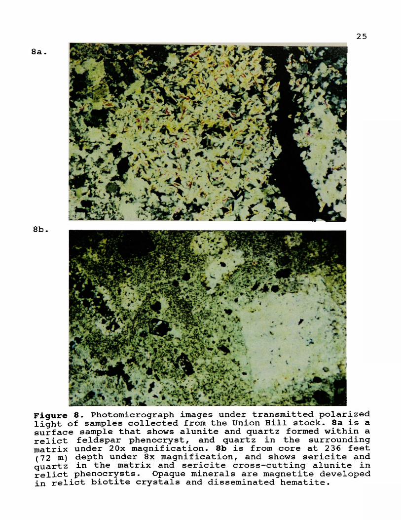
Figure 8. Photomicrograph images under transmitted polarized light of samples collected from the Union Hill stock. 8a is a surface sample that shows alunite and quartz formed within a relict feldspar phenocryst, and quartz in the surrounding matrix under 2Ox magnification. 8b is from core at 236 feet (72 m) depth under 8x magnification, and shows sericite and quartz in the matrix and sericite cross-cutting alunite in relict phenocrysts. Opaque minerals are magnetite developed in relict biotite crystals and disseminated hematite.

26but grades into quartz-sericite with depth (Ellsworth, 1993) .
Alunite and clay minerals replaced feldspar phenocrysts, and quartz replaced the groundmass of the original porphyry in the shallow advanced argillic zone. Thin section petrography indicates that quartz-sericite type alteration (phyllitic) dominates at deeper levels. Figures 8a and 8b are photomicrographs of alunite from the surface, and sericite from core that replaced feldspar phenocrysts, respectively. Pétrographie work by Matter (1993) on deep sericite-altered drill samples shows progressive alteration of hornblende to biotite, chlorite, and finally sericite. These samples contain high levels of gold and copper, and their paragenetic frameworks are typical of porphyry copper systems (Beane, 1993).
Mineralization of the Union Hill StockAnomalously high gold and copper values occur throughout
the Union Hill stock. Drill hole assays typically range from 50 to 200 ppb gold and 100 to 1000 ppm copper across 100's of feet, and yield isolated ore-grade intercepts. Minéralogie studies of ore-grade drill samples from the Union Hill stock characterize gold distribution, and the alteration minerals that accompanied its mineralization.
Whole rock X-ray diffraction analyses of ore-grade intercept drill samples, located 700 feet (213 m) beneath the surface near the northeast margin of the Union Hill stock, yielded the following mineral assemblage:

27quartzchlorite-smectitealbitepyritetetrahedrite
kaolinitephlogopitebiotitehematitetennantite
sericiteanhydritemagnetitechalcopyriteAu-telluride?
A panned concentrate sample of the same drill sample was analyzed by automated microprobe scanning, and revealed the following mineral assemblage (Brosnahan, 1993):
quartzchloritewoodhouseitepyritegalenagold
baritephlogopiteanhydritechalcopyritebornitekrennerite
sericiteapatiteTiOjsphaleritechalcociteelectrum
r \
Figure 9. backscatter electron image of pyrite (py) particle with chalcopyrite (cp) and quartz (qz). Arrows show gold grains (Au) encapsulated in pyrite. Quartz and sericite (ser) occur in mounting medium. Scale Bar = 100 microns.

28Most of the gold detected by the microprobe scan is
encapsulated in pyrite crystals, as shown in the backscatter electron image in figure 9. Gold occurs as end-member native gold, with minor silver substitution, and ranges between 1.3 to 5.0 microns in diameter, averaging 2.1 microns. Brosnahan (1993) also reported that gold occurs as a gold-silver telluride (krennerite), is attached to pyrite and occurs as free gold with chlorite and quartz.
Copper Cliff Breccia Pipe Historic production, development and exploration of the
district concentrated on the Copper Cliff breccia pipe. Early shipping records report copper grades as high as 12% (Irving, 1963), and gold grades over 0.1 oz/st (Gow and Weed, 1919). Ore shipments to the Anaconda smelter between 1917 and 1944 from the Copper Cliff mine totalled 146 tons with the following average grades: 9.8% Cu, 2.18 oz/st Ag, 0.11 oz/st Au (Childs and Mulholland, 1988). Johnson (1972) collected 14 channel samples around the perimeter of the Copper Cliff breccia pipe, and obtained a weighted average of 0.061 oz/st gold, 0.20 oz/st silver and 0.17% copper.
Higher grade zones are reported from underground workings beneath the Copper Cliff breccia pipe, which are developed within unconsolidated fault breccias. These zones are referred to as either "black ore" or "red ore". The "black ore" contains pyrite, enargite, chalcocite and covellite. The "red ore" contains malachite, azurite, chrysocolla and native

29copper, and is probably oxidized "black ore".
Irving (1963) reported that enargite, famatinite, covellite and auriferous pyrite are microscopically disseminated within the silica matrix. In addition,pétrographie work by Williams (1988) indicated trace amounts of alunite, rutile, pyrite and chenevixite disseminated in the matrix. Deep red hematite staining of the matrix is due to leaching of microscopic pyrite cubes on matrix grain boundaries. Secondary copper minerals stain the cliff face in the form of copper phosphate (Pardee, 1917), probably the turquoise variety.
The Copper Cliff breccia was probably formed by highly pressurized magmatic ( + /- meteoric? ) fluids that fractured the country rock, mobilized the fragments and deposited quartz, gold and copper. The matrix-supported breccia clasts vary in lithology and texture. Their rounded to angular shape, coupled with the variety of fragment rock types, suggests the clasts were transported vertically and experienced milling. In addition, older breccia clasts are encased within younger breccia clasts. Such characteristics demonstrate that the Copper Cliff breccia originated from repeated explosions and introduction of hydrothermal fluids. Micrographie textures indicate that at least two brecciation and mineralization events occurred (Williams, 1988). The fluids intensely silicified all the clasts, and deposited chalcedony in the matrix. Chemical analyses of the Copper Cliff breccia average

3080% average SiO^.
Numerous other small breccia bodies scattered throughout the district contain comparable grades and minerals (Plate I) . These satellite breccias were likely formed temporally with the Copper Cliff breccia.
Leonard and Klenzie MinesThe Leonard and Klenzie mines are aligned along a
northeast-trending fault within the Silver Hill Formation. They contain sub-ore grade gold and copper within silicified carbonates and breccias of the Silver Hill Formation (Fig. 3). The known replacement bodies are not extensive, and appear to be controlled by a northeasterly fault that channelled hydrothermal fluids. A jasperoid breccia, measuring 100 feet by 30 feet (30 x 10 m) is exposed by the Klenzie mine workings. It cuts the Garnet Range/Silver Hill formation unconformity.
The Klenzie breccia is similar to the Copper Cliff breccia, however clasts are predominately silicified limestone. Pardee (1917) reported enargite, famatinite and pyrite are finely disseminated within the matrix; malachite and azurite form coatings and veinlets. Silicified carbonate lenses extend 5 to 10 feet (1.5 to 3 m) laterally beyond the breccia, and contain low-grade gold and copper. Three channel samples yield 0.011 oz/st gold across 14 feet (4.3 m) of jasperoid along the Klenzie adit (Childs and Mulholland, 1988). The limited size and grade of the Leonard and Klenzie

31mines precluded extensive development of these deposits.
Trace Element GeochemistryA total of 442 surface rock samples collected from the
Copper Cliff prospect were analyzed for various traceelements y and compiled Into a single database (Table 2).Table 2. Basic statistics for surface rock sample geochemical data. Gold Is listed In units of ppb, and all other elements In ppm. Values half the detection limit were assigned to undetected results.
Element mean # maximumAu 198 442 6900Ag 1 442 >50Cu 1072 442 >20000Pb 96 442 1A66Zn 3Ô 442 645Mo 5 420 109Hi 7 442 157As 447 442 >10000Sb 41 442 2120Hg 1 25Ô 47W 3 ^73 15
Te 5 423 >100T1 2 169 20Ba 83Ï 239 390ÔSe 2 147 15
Scatter diagrams of gold versus selected elements are plotted on log-log scales to evaluate correlations (Fig. 10). The plots show that gold correlates well with copper, arsenic, antimony and tellurium; silver and mercury show a weak correlation with gold. These relationships probably reflect a spatial and temporal relationship of gold with enargite (copper arsenic sulfosait), tetrahedrite (copper antimony sulfosait), chalcopyrite and telluride minerals. The weak gold-silver correlation may be the result of supergene surface

32leaching of silver. Silver to gold ratios average 2:1 in these rock samples. Mercury shows very high levels (1 ppm average) in the district, but correlates weakly with gold.
Sulfur Isotope Geochemistry A single sulfur-isotope analysis of alunite from core at
660 feet depth within the Union Hill stock yields of 21.4+ /- 0.2 %». While only one analysis of anything should be treated with extreme caution, the result is compatible with disproportionation of magmatic SO; into H^S and SO '. This results in the formation of isotopically heavy alunite and isotopically light pyrite. This datum suggests a magmatic source for at least the sulfur, and rules out a supergene origin of the alunite.
Alunite, a potassium-aluminum-sulfate-hydroxide mineral is formed by acid meteoric water and acid hydrothermal fluids that react with primary potassium-bearing minerals. Hypogene alunite typically occupies advanced argillic alteration assemblages associated with epithermal precious metal deposits, or high-level porphyry copper deposits.

33
1 0 0 0 0 Au v s Cu
nCLdOtO
1000 3
100
I 10 100 1000 10000 100000Copper ppm
10000Au v s As
nClCl
OtD
1000
100
10 100 1000 10000
A r s e n ic ppm
100 0 0Au v s Sb
ûCLCL
OO
1 0 0 0 :
1 0 0 :
1 0 :
0.1 1 10 too 1000 10000Am imony ppm
10000Au v s Te
naCL
100
Te 11urium ppm
Au v s Aq10000
1000naCL
100■D0O
0.1 1000.01
S i l v e r ppm
10000
1000rtaCL
0.1 IM e r c u r y ppm
1000.001 0.01
Figure 10. Rock sample geochemistry of district-wide database, presented as scatter diagrams of gold against various trace elements. Note gold is plotted in units of parts per billion, while trace elements in units of parts per million on logarithmic scales. Effects of upper and lower detection limits from various analytical methods and labs align data points. Data outside detection limits were disregarded for r calculation (r=correlation coefficient).

CHAPTER IV GEOCHRONOLOGY
Age dates were obtained from rock samples at the Copper Cliff district in order to constrain interpretations of geochronologic events that led to the alteration and mineralization patterns within the district* Copper Cliff district age dates are compared with earlier obtained dates from the western Garnet Range (Table 3).
Copper Cliff Age Dates A potassium-argon determination on biotite from the
easternmost unaltered Copper Cliff pluton yields an age of56.4 +/- 1.5 Ma (Fig. 3a). This age does not correlate with other igneous dates obtained in the western Garnet Range (Fig. 11), but correlates regionally with igneous activity in the central Montana alkalic belt, the Idaho batholith and various isolated volcanic eruptions in western Montana. Alunite from core recovered at 660 feet (201 m) down the hole (467 feet beneath surface) in the Union Hill stock yields a K-Ar date of48.4 +/- 1.3 Ma. These age dates indicate that alunite formed eight million years after emplacement of the Copper Cliff pluton. Age date sample locations are shown in figure 3a.
Western Garnet Range Age Dates The alunite age from the Union Hill stock correlates
temporally with latite volcanic flows located 2 miles (3 km) east on Union Peak, and the Clinton stock 5 miles (8 km) west. The age also correlates with the Challis and Lowland Creek
34

35volcanic rock ages. Carter (1982) reported that the composition of volcanic flows in the Union Peak and Bearmouth ^]^Ga progressively change with age. Forty-seven Ma flows are hornblende-biotite andésite, whereas 44 Ma flows shift to biotite-pyroxene andésite.
Location & Rock Type Age Method ReferenceBearmouth: rhyolite porphyry flow
44.5+/- 2.0 Ma
K-Arsanidine
Carter(1982)
Bearmouth: olivine basalt flow
44.9+/- 2.0 Ma
K-Ar whole rock
Carter(1982)
Union Peak: Latite porphyry flows
47.4+/- 1.6 Ma
K-Arbiotite
Carter (1982)
Clinton stock: granite 48.0+/— 2.0 Ma
Pb-isotope Reynolds(1991)
Union Hill stock: altered porphyry
48.4+/- 1.3 Ma
K-Aralunite
Geochron Lab (1993)
Copper Cliff pluton: quartz latite porphyry
56.4+/- 1.5 Ma
K-Arbiotite
Geochron Lab (1993)
Garnet stock: granodiorite
78.7+/- 3.9 Ma
K-Arbiotite
Carter (1982)
Garnet stock: granodiorite
82 Ma K-Arhornblende
Sears et al. (1989)
These age dates suggest that the Union Hill stock was altered 8 million years following its emplacement. Theacidic fluid source was apparently a pluton at depth which may have vented the Union Peak volcanic flows 2 miles (3 km) east.
InterpretationAlunite-forming fluids were derived from a hypothetical
gold-rich porphyry copper system which typically underlie quartz-alunite type epithermal gold deposits (Ashley, 1982;

36
EO 52 4956
Sillitoe, 1988; Walthier et al., 1985; Sillitoe, 1990).The quartz-alunite alteration was either overprinted by late sericite from a separate m a g m a t i c event that
MILLIONS Of TEARS
introduced gold and copper, H . Age dates from theor was immediately followed ^Istlrn^GarL^Rlngl^ by the sericite alteration.A sericite date would clarify their chronologic relationship.
Géologie History A summary of the geologic history of events that led to
mineralization in the district begins with Late Cretaceous thrusting of the Sapphire allochthon and emplacement of the Garnet stock (Fig. 2). The western Garnet Range then experienced Early Eocene east-west extension due to right- lateral pull-apart motion from the St. Mary's and Clark Fork/Nine Mile faults of the Lewis and Clark line. The extension formed graben faults and induced emplacement of the Copper Cliff plutons and the Union Hill stock at 56.4 Ma (Fig. 11). Middle Eocene time marked the intrusion of an inferred buried porphyry copper stock, the likely source of acid fluids that formed alunite in the Union Hill stock at 48.4 Ma. This intrusion is apparently related to the Copper Cliff breccias and the Union Peak volcanic flows. A third magmatic event (porphyry Cu-Au?) introduced alkaline fluids and gold into the

37Union Hill stock that formed the gold-bearing sericite zone (Fig. 3) , and continued development of the breccias. This mineralizing epoch accompanied eruption of the Bearmouth volcanic flows 8 miles (13 km) to the southeast. This event deposited gold in the Union Hill stock, which correlates with sericite and not alunite. Continued Tertiary displacement along the Lewis and Clark line subsequently offset mineralized and altered zones and formed the complex fault structures at the Copper Cliff district.

CHAPTER V DISCUSSION AND CONCLUSIONS
In order to understand the genesis and structure of hydrothermal ore deposits In complex districts, such as Copper Cliff, deposit models are developed for exploration and development of ore deposits. Models are formulated from well known and understood deposits. Six possible scenarios can explain the co-exlstence of alunite and sericite alteration In the Union Hill stock. They Include:
1) Fluids lie along acid/alkaline Eh-pH phase boundary.2) Late sill or dike Introduced sericite without gold.3) Porphyry copper system with acid meteoric water
mixing.4 ) Metal-bearing solutions evolved from an alkaline to an
acid system.5) Porphyry copper with alunite cap (e.g. Red Mountain)6) Acld-sulfate alunite assemblage overprinted by
sericite (e.g. El Indio)
Scenarios 1) and 2) are discounted since they cannotaccount for the zonation of shallow alunite and deep sericite, or the spatial association of gold within the sericite zone. Scenario 3) can explain the zonation but the sulfur Isotope value Indicates a magmatic rather than supergene origin of the sulfur. In scenario 4) the magmatic fluids would Initially be acid, however wall rock buffering raises the solution pH at depth forming alunite, and sericite forms late as the wall rocks lose their buffering capacity. This mechanism would result with a sericite zone overlying an alunite zone. This scenario cannot explain the gold-copper affinity to thesericite alteration zone, or the dominance of alunite In the
38

39upper levels of the Union Hill stock. Scenarios 5) and 6 ) best explain the alteration and mineralization within the Union Hill stock.
The Copper Cliff district resembles Berger's (1986) spithermal quartz—alunite Au descriptive model in which the deposit forms near the surface and is associated with deep gold-rich porphyry copper systems. However, drilling revealed similarities of Copper Cliff mineralization to the acid- sulfate capped gold-rich porphyry copper type deposit which form at greater depths (Beane, 1993). Both models are described and discussed in relation to the Copper Cliff district in this chapter.
Quartz-Alunite Deposit ModelEnargite-bearing quartz-alunite epithermal systems host
large gold deposits within intermediate-composition intrusive complexes in a variety of geologic settings throughout the world. They commonly are associated with porphyry copper systems, and are characterized by the presence of advanced argillic alteration and enargite group minerals. Most of these deposits lie along the Pacific rim, including the majority of world class gold deposits of the central Chilean Andes.
The epithermal ore deposit type known as enargite-bearing quartz-alunite gold systems were classified in recent years by Ashley (1982), Bonham and Giles (1983), Heald et al. (1987), Bonham (1984, 1988) and Walthier (1985). The term is

40synonymous with acid-sulfate, high—sulfur, high-sulfidation and enargite-gold. Berger (1986) lists deposit sizes ranging from 0.24 million to 12 million short tons with grades ranging from 0.11 to 0.53 oz/st gold. Many of the deposits contain one to 5 million ounces of gold, and may host 300,000 to one million tons of copper. Sillitoe (1991) describes the majority of precious metal districts in the Andean Cordillera of Chile as the world's premier high-sulfidation epithermal province.
Bonham (1988) proposed the "general occurrence quartz- alunite model", which is volcanic hosted, sulfur-rich and shows no evidence of venting. Examples include El Indio, Chile; Lepanto, Philippines; Coldfield, Nevada; Summitville, Colorado; Chinkuashih, Taiwan; Pueblo Viejo, Dominican Republic; Cerro de Pasco, Cuahuarso and Julcani, Peru. An idealized cross-section of the general occurrence quartz- alunite model is illustrated in figure 1 2 .
Most of these deposit types located along the Pacific rim are of Tertiary age. However several deposits lie inboard of plate margins. All the deposits require significantstructural preparation to provide plumbing for ascending hydrothermal fluids and mineral deposition. Berger (1986) emphasized that through-going fracture systems are critical, including keystone graben structures, ring fracture zones, normal faults, dome-related fractures and joints. Heald et al. (1987) noted that nine of 16 deposits studied are

41
hydrothermal exp los ion brecc ia
OO
rATunite. S — Hg —Si —Kao
LSi cap
Scale
100 m
Au—Ag
Qtz—alunite l egd e or pipe, multiple hydrothermal events
Kaol, K —m ica
Kaol —mont
prop
^ r o p h y l l i t e , seric ite d ia s p o r e
2 —3 km depth porphyry Cu
Figure 12• Schematic cross-section of an epithermal enargite-precious metal deposit associated with granodiorite-dacite magmatism (Bonham, 1988). Refer to Appendix B for abbreviations•
spatially related to calderas, making this geologic settingmost common. The deposit morphology varies depending onstructures and host rock. Deposits range from complex veinsystems (e.g. El Indio) to irregular pod or pipe-like bodiesassociated with silicified hydrothermal breccias (Sillitoe,1988). Most deposits have pyrite-enargite and associatedsulfides as massive or semi-massive replacements withinadvanced argillic alteration zones, composed of vuggychalcedonic silica, alunite and clays.
The origin of contemporaneous alunite-bearing acid-

42sulfate alteration is due to disproportionation of magmatic SOj to HjS and in magmatic water or mixed magmatic-meteoric water systems at less than 400®C (Rye et al., 1989). Bonham (1988) suggests that the acid sulfate chloride solutions are derived from depth and deposit gold during boiling. Alteration is dominated by intermediate argillic assemblages such as quartz-kaolinite-Kmica, quartz-illite- montmorilUnite and quartz-kaolinite that surround the advanced argillic zone. The advanced argillic zone of minerals, which form under very acid-oxidizing conditions, envelops the main hydrothermal feeders, and forms alteration mineral assemblages such as: quartz-alunite-kaolinite, quartz- alunite-native sulfur, quartz-diaspore, quartz-pyrophyllite- diaspore, quartz-alunite-pyrophyHite-diaspore, quartz- alunite-sericite (Ashley, 1982).
Several districts are vertically zoned; intermediate argillic zones grade into a phyllic assemblage with depth (Fig. 10) . Gold mineralization is primarily restricted to the advanced argillic zone along with vuggy chalcedonic silica. Large volumes of pyrite-bearing propylitized zones commonly surround the advanced argillic zones.
Quartz-alunite gold ore is dominated by sulfosait minerals, specifically the enargite-luzonite and tetrahedrite- tennantite series. Silver sulfosait minerals, bismuthinite and gold-silver tellurides occur in some deposits; pyrite is ubiquitous (Ashley, 1982). Base-metal sulfides occur around

43and beneath gold mineralization. Berger (1986) indicated that some deposits may contain a hypogene oxidation phase with chalcocite, covellite, luzonite and late stage native sulfur. The ore assemblage displays vertical zonation as shown in figure 12. The central enargite-luzonite zone tends to grade both vertically downward and laterally outward into tetrahedrite-tennantite, chalcopyrite and bismuthinite, and finally into base-metal sulfides where gold values decrease. Gold is primarily hosted in the enargite zone, while the highest silver values occur in the tetrahedrite zone (Bonham, 1988).
Sillitoe (1988) suggested that gold deposition post-dates enargite mineralization. He proposed that gold, re—mobilized from early gold-rich porphyry copper at depth, was transported upward into the epithermal system during late-stage alteration (e.g. El Indio, Jannas and Araneda, 1985).
Quartz, the most abundant gangue mineral in the ore zone, forms matrix comb structures. Barite, alunite and kaolinite occur as breccia fillings and barite is widespread in all deposits.
Recent discoveries at El Indio, Chile, and Goldfield, Nevada, disclose that enargite, chalcopyrite and alunite were introduced early. They were overprinted by late-stage gold- bearing sericite mineralization. The pre-existing alunite causes gold to precipitate from late-stage alkaline fluids by dropping the pH and oxidizing the fluids as they encounter the
44acidic-sulfate assemblage (Richard Beane, pers. comm., 1993).
Porphyry copper-Qold SystemsMost quartz-alunite gold deposits are spatially
associated with gold-rich porphyry copper deposits, strongly suggesting a genetic association exists. Some quartz-alunite deposits appear to represent the epithermal upper expression of deeper mesothermal porphyry copper systems (Fig. 12). In other systems barren quartz-alunite alteration zones are known to cap porphyry copper deposits (e.g. Red Mountain, Arizona, Bodnar and Beane, 1980). At Red Mountain propylitic alteration forms an outer zone to alunite, which gives way to sericite at a shallow depth.
Gold-rich porphyry copper systems are centered on high- level stocks with pervasive alteration and mineralization. Retrograde boiling mineralizes potassic, propylitic, argillic and sericitic zones, forming spatial and timing patterns (Sillitoe, 1990). Extensive intermediate argillic alteration often overprints potassic alteration, and predominates in the upper levels of the system. Quartz-sericite-pyrite alteration masks primary rock textures, and may form around potassic cores. Gold porphyries commonly are capped by advanced argillic zones which post-date other alteration, and are formed during degeneration of the porphyry system (Sillitoe,
1990) .According to Sillitoe's (1990) model, gold is found in
quartz veinlet stockwork within the potassic alteration zone.
45This zone typically contains phlogopite, K-feldspar or amphibole. Intermediate argillic alteration zones are also known to host gold ore where they overprint pre-existing gold- bearing potassic zones. Porphyry gold occurs as electrum, mainly in association with chalcopyrite, pyrite and bornite ( Sillitoe, 1988). Some porphyry gold occurs in the highfineness native state and is fine-grained (< 60 microns).
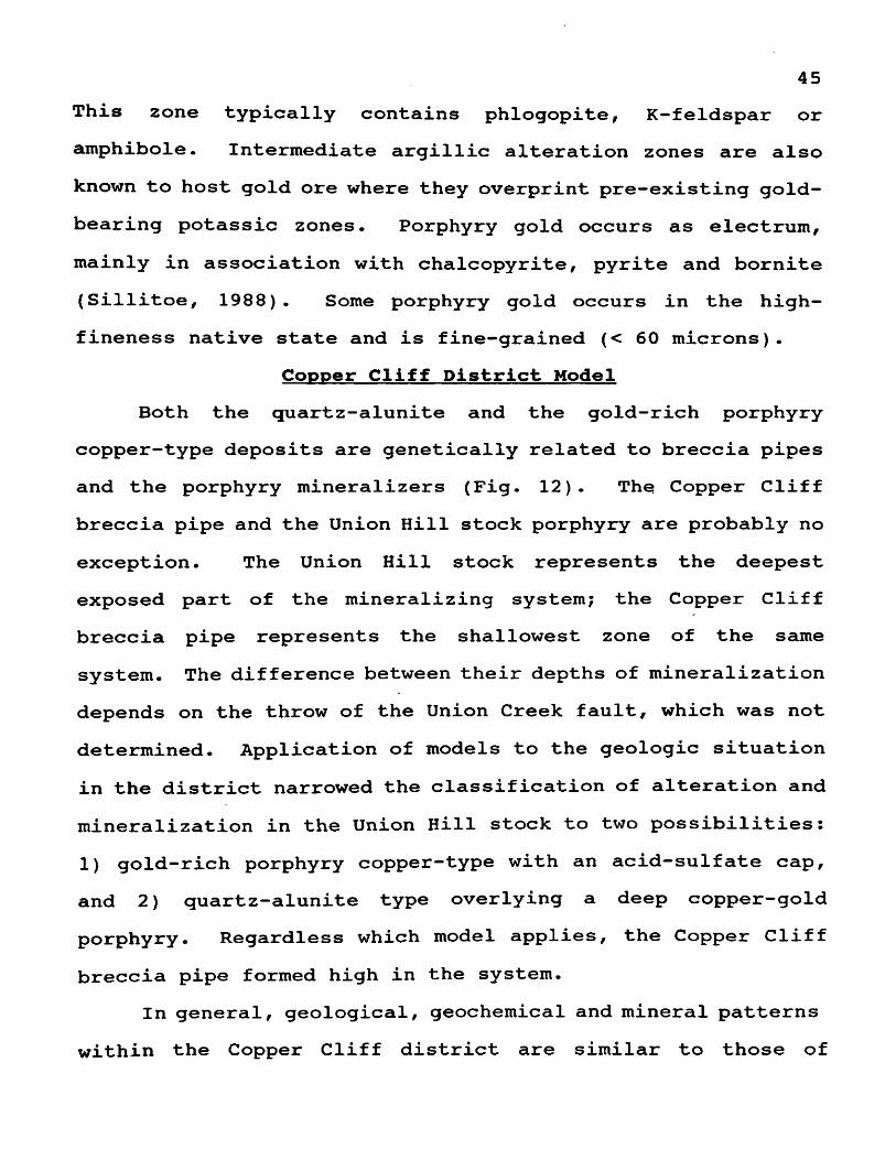
Copper Cliff District Model Both the quartz-alunite and the gold-rich porphyry
copper-type deposits are genetically related to breccia pipes and the porphyry mineralizers (Fig. 12). The Copper Cliff breccia pipe and the Union Hill stock porphyry are probably no exception. The Union Hill stock represents the deepest exposed part of the mineralizing system; the Copper Cliff breccia pipe represents the shallowest zone of the same system. The difference between their depths of mineralization depends on the throw of the Union Creek faulty which was not determined. Application of models to the geologic situation in the district narrowed the classification of alteration and mineralization in the Union Hill stock to two possibilities: 1 ) gold-rich porphyry copper-type with an acid-sulfate cap, and 2 ) quartz-alunite type overlying a deep copper-gold porphyry. Regardless which model applies, the Copper Cliff breccia pipe formed high in the system.
In general, geological, geochemical and mineral patterns within the Copper Cliff district are similar to those of

46alunite deposit systems which overlie porphyry systems
at depth. Both the Copper Cliff district and the model contain quartz alunite, sericite, enargite, tetrahedrite, clays and additional accessory minerals, and are hosted in intermediate composition, hypabyssal plutonic rocks and hydrothermal breccias, as shown in Table 4.Table 4. Comparison of selected quartz-alunite gold deposits. See Appendix B for abbreviations.Deposit Oz Au Host Rock Ore Mineral AlterationEl Indio Chile
7 M Dacite-Rhyolite
tn-py-en-tl al-kaol-ser-pyr-qtz-chl
Pueblo Viejo Dom. Rep.
21 M Spillite py-sp-en-tn-tt
pyr-al-qtz-clay
SummitvilleColorado
N/A Qtz Latite cv—Iz—cp— tn-en
qtz-al-kaol
CopperCliffMontana
? Qtz Latite py-cpy-tl-en-cc-sp-gl
al-kaol-ser-qtz-chl
Table 5 compares characteristics of the Copper Cliff district with the quartz-alunite deposit model. The Copper Cliff district differs from the quartz-alunite deposit model by lacking near-surface high sulfide mineral-rich zones and metallized quartz veins and near-surface, large gold deposits. Gold at Copper Cliff either was not abundant in hydrothermal fluids, or erosion has not cut down to the mineralized horizon, typically corresponding with boiling levels (Richard Beane, pers. comm., 1993). Absence of placer gold depositsdownstream in Union Creek suggest there was no gold horizon

47above the present erosional level.Table 5. Copper Cliff district characteristics compared to the quartz-alunite deposit model. Refer to Appendix B for abbreviations. Model characteristics from Ashley (1982) and Berger (1986).Observation Copper Cliff Modelhost rock qtz-latite,
trachytetrachyandesite, qtz latite, rhyodacite
age Eocene (Cenozoic) Cenozoictiming: volcanism w/alteration
close (?) ; alunite w/Union Pk. flows
close association
alteration qtz-al, ser-chl- phl-anh, kaol; advanced argillic
qtz-al, qtz-kaol, pyr-ser; advanced argillic
alterationtexture
replacement (relict phenocrysts)
replacement
gangue minerals qtz-al-clays-ba-ap-hm
qtz-al-ba-kaol
sulfides en-tt-py-cp-sp-gl-bn-cc
en-luz-tt-tn-py-cp
structures grabens,hydrothermalbreccias
grabens, breccia pipes
sulfur isotopes = 21.4 magmatic?-enriched
Alternatively, the pétrographie and microprobe' mineralogical information, generated from the Union Hill stock drill samples, are compatible with an acid-sulfate capped gold-rich porphyry copper deposit that formed at much greater depths than the epithermal quartz-alunite type. Beane (1993) concluded that the alteration sequence ( hornblende->biotite-> chlorite^sericite), and the fine-grained nature of the pyrite-

48encapsulated gold are more typical of ore zones in high-level porphyry copper deposits of southwestern North America. Beane (1993) suggested progressively increasing acid fluids formed early sericite followed by alunitization and finally silicification. Red Mountain, Arizona, described by Bodnar and Beane (1980), was classified as a high-level gold-rich porphyry copper deposit that shows similar zonation patterns to the Copper Cliff district. Beane (1993) concluded that alunite formed immediately above the porphyry copper zone in the Union Hill stock.
If the Union Hill stock is, indeed a porphyry copper deposit with a quartz-alunite cap, displacement along the Union Creek fault is great. This is due to the fact that the near surface-forming Copper Cliff breccia pipe, containing sulfosait minerals and alunite, is exposed on the other side of the fault.
The textural observations of the Copper Cliff breccia pipe (see Chapter III), and the presence of relatively shallow alunite and deep sericite in the Union Hill stock support either several hydrothermal pulses, or a single, long-lived evolving hydrothermal system. Unaltered, post—mineralization dikes in core from the Union Hill stock indicate a possible second or third magmatic event (depending on the above scenarios), a potential source for late-stage sericite-forming fluids. Furthermore, the x-ray, microprobe and pétrographie data (Chapter III) indicate that gold in the Union Hill stock

49precipitated from alkaline fluids associated with late sericite and pyrite formation, and not from earlier acid fluids that deposited alunite and enargite group minerals.
Alteration in the Union Hill stock could have formed under deep mesothermal or shallow epithermal conditions. Occurrences southwest of the Union Creek fault, however are undoubtedly epithermal, and likely formed under acid-oxidizing conditions, as evidenced by sulfosait minerals and alunite. Gold within breccia pipes and with enargite-group minerals are more typical of quartz-alunite epithermal deposits (Fig. 12). The Union Creek fault, could therefore represent a major normal fault that raised the deep alteration zone of the Union Hill stock to the same level as the shallow epithermal zone of the Copper Cliff breccia pipe, or more likely the system is a quartz-alunite type located over deep gold-rich porphyry copper system. At any rate, the Copper Cliff breccia pipe formed at a high level, and is genetically linked to deeper porphyry copper activity within or beneath the Union Hill stock.
Conclusions and SummaryIn summary, at least two scenarios can explain the
mineralization and alteration patterns seen in the Union Hill stock: 1 ) gold-rich porphyry style mineralization with achronologic progression of alkaline to acid conditions, and 2 ) epithermal quartz-alunite acid-oxidizing alteration overprinted by late sericite-type alkaline gold mineralizing

50fluids. Fluid inclusion studies might resolve fluid temperatures, however no useable inclusions were found.
Scenario 1) is possible only if the assumption is made that the Union Hill stock was positioned well below the Copper Cliff breccia pipe during the mineralizing events. Later offset along the Union Creek fault placed the two zones at the same erosional level. Such major offset should be reflected in great stratigraphie offset across the Union Creek fault. Although difficult to document, the strata does not appear to be largely offset by the Union Creek fault. It therefore seems more logical that the offset along the Union Creek fault was not large enough to juxtapose a deep seated mesothermal system (Union Hill stock) against a shallow epithermal system (Copper Cliff breccia).
According to the quartz-alunite model (Scenario 2), Copper Cliff mineralizing fluids were likely similar to those that formed deposits at El Indio and Goldfield. Early acid fluids were followed by alkaline fluids in an evolving system or in two distinct hydrothermal events, forming the alunite and sericite alteration pattern conceptualized in cross- section (Fig. 3b) . The late alkaline fluids did not reach the present erosional level, leaving alunite near the surface, and sericite at depth.
Compared with El Indio however. Copper Cliff fluids apparently lacked sufficient quantities of sulfur to form comparable quantities of alunite and sulfide minerals. Also,

51the areal extent of the alunite zone throughout the region is very limited. Sulfur-rich fluids enhance the gold transport capacity, and a high water/rock ratio along with host rock permeability are required to form large gold deposits.
Regardless of whether fluid conditions became more acidic or alkaline with time in the Copper Cliff district, the system was undoubtedly driven by a gold-rich porphyry copper magma at some depth. This proposal is supported by the Butte-type suite of copper minerals present in the district (e.g. enargite-group, bornite, chalcopyrite and chalcocite)• Additionally, the mineral zonation pattern strongly resembles patterns at the Red Mountain porphyry copper, Arizona (Bodnar and Beane, 1980).
In summary, I believe the available evidence best supports early alunite formation, together with enargite, tetrahedrite and tennantite. Sericite formed later,accompanied by gold and some pyrite. Some copper formed chalcopyrite. The system was driven by a gold-rich porphyry copper pluton located about 1500 feet (460 m) beneath the present surface. This interpretation was first proposed by Anaconda geophysicists. The prospect shows similarities to El Indio, a world class gold deposit that hosts over 7 million ounces of gold within high grade bonanza quartz veins and gold tellurides. The Copper Cliff district lacks high sulfide zones, mineral rich zones and bonanza quartz veins within the reaches of present exploration. Therefore, large quantities

52of gold were either not abundant in the hydrothermal fluids, or were deposited at deeper levels. Accordingly, the primary exploration targets are structurally controlled, discrete veins beneath the Copper Cliff breccia pipe, porphyry copper targets northeast of the Union Creek fault and carbonate replacements or skarns associated with the porphyry copper deposit.
Ongoing gold and copper exploration of the Copper Cliff prospect will add to our understanding of the hydrothermal system that produced this intriguing mining district. Deposit modelling is an essential exploration tool in this district, and hopefully will lead to discovery of a world class gold- copper deposit. The model developed by this study may also prove useful for exploration of acid-sulfate and gold-rich porphyry systems in the northwest U.S.

REFERENCESAshley, R.P., 1982, Occurrence model for enargite-gold
deposits. In Erickson, R.L., ed. , Characteristics of mineral deposit occurrences: U.S. Geological SurveyOpen-File Report 82-795, p. 126-129.
Beane, R.E. and Titley, S.R., 1981, Porphyry copper deposits: Part II. Hydrothermal alteration: Econ. Geol., 75thAnniv. vol., p 235-269.
Beane, R.E., 1993, Analysis of alteration and its relation to gold. Copper Cliff district, Montana: In-house Consultant Report to Trans-Global Resources N.L., 16 p.
Berger, B.R., 1986, Descriptive model of epithermal quartz-alunite Au in Mineral deposit models: U.S. Geol. SurveyBull. 1693, p.158-161.
Billingsley, P., 1916, Report on the Copper Cliff district,Missoula County, Montana: Unpublished Report, 10 p.
Bodnar, R.J. and Beane, R.E., 1980, Temporal and spatialvariations in hydrothermal fluid characteristics during vein-filling in preore cover overlying deeply buried porphyry copper mineralization at Red Mountain, Arizona; Econ. Geol., vol. 75, p 876-893.
Bonham, H.F.,Jr., 1984, Three major types of epithermalprecious-metal deposits: Abstracts with Programs. The Geological Society of America , Annual Meeting, v. 16, no.6 , p.449.
Bonham, H.F.,Jr., and Giles, D.L., 1983, Epithermal deposits: the geothermal connection: Geothermal Resources CouncilSpecial Report no. 13, p.257-262.
Bonham, H.F.,Ur., 1988, Models for volcanic-hosted epithermal precious metal deposits in Bulk minable precious metal deposits of the western United States, Symposium Proceedings: Geologic Society of Nevada, 755 p.
Brannon, C.A., Crebs, T.J., Klem, R. and Riese, W.C., 1982,Copper Cliff annual report : Unpublished Report, 21 p.
Brannon, C.A. and Korzendorfer, D. , 1982, 1980 districtevaluations Forest Products Program, Garnet Range, Missoula and Granite counties, Montana: UnpublishedReport, 50 p.
53

54D.R, , 1993, Written results of microprobe
examination of gold-bearing sample from Copper Cliff, Montana: Prepared for P. Ellsworth, Trans-GlobalResources, 4 p.
Carter, B .A., 1982, Geology of the Eocene volcanic sequence, Mt, Baldy-Union Peak area, central Garnet Range, Montana [M.S. Thesis]: Missoula, University of Montana 55 p.
Childs, J.F., and Mulholland, P.S., 1988, Summary report onthe Copper Cliff copper/gold submittal: Pegasus Corp. In House Report, 19 p.
Ellsworth, P.C., 1993, Alteration and mineralization of theCopper Cliff prospect. Garnet Range, Montana: Northwest Geology v.22, p.43-48.
Harrison, J.E., Griggs, A.B. and Wells, J.D., 1974, Tectonic features of the Precambrian Belt basin and their influence on post-Belt structures: U.S. Geol. SurveyProf. Paper 8 6 6 .
Hawe, R.G., 1974, A combined magnetic resistivity andgeochemist exploration study of the Copper Cliff mining district: Unpublished Report, 13 p.
Heald, P., Foley, N.K., and Hayba, D.O., 1987, Comparativeanatomy of volcanic-hosted epithermal deposits : Acid-sulf ate and adularia-sericite types : Econ. Geology,V . 82 , p.1-26.
Higgens, W.I., 1919, Superintendent's report for year 1919,Potomac Copper Company: Unpublished Report, 5 p.
Hyndman, D.W., Alt, D., and Sears, J.W., 1988, Post-Archeanmetamorphic and tectonic evolution of western Montana and northern Idaho, in Ernst, W.G., ed.. Metamorphism and crustal evolution of the western United States : RubeyVolume VII, New Jersey, Prentice Hall, p. 332-361.
Hyndman, D.W., 1980, Bitterroot dome-Sapphire tectonic block, an example of a plutonic-core gneiss-dome complex with its detached suprastructure, in M.D. Crittenden, P.J. Coney, and G.H. Davis, eds., Cordilleran Metamorphic Core Complexes, Geol. Soc. of America Mem. 153.
Irving, J.G., 1969, Geologic report on corporate miningproperties at Garnet, First Chance and Copper Cliff mining districts: Unpublished Report, 7 p.

55Irvingy J.G.^ 1963, Report on the Copper Cliff mining
district, Missoula and Granite Counties, Montana; In- house Consultant Report to the American Mining Company, 54 p.
Jannas, R.R. and Araneda, G.R., 1985, Geologia de la vetaIndio Sur 3500; una estructura tipo bonanza del yacimiento El Indio, Chile: Cong. Geol. Chileno, 4th,Antofagasta, Actas, p. 3.873-3.893.
Johnson, J.J., 1972, Report on sampling and analysis of theCopper Cliff outcrop. Copper Cliff district, Missoula County, Montana: Unpublished Report, 8 p.
Matter, P.M., 1993, Pétrographie descriptions of two thinsections from Copper Cliff, Montana: Prepared for P.Ellsworth, Trans-Global Resources, 4 p.
Michel, R.J., 1979, An introduction to the Copper Cliffproperty: In-house report to the Continental MineralsCorporation, 14 p.
Pardee, J.T.,1917, Ore deposits of the northwestern part of the Garnet Range, Montana: U.S. Geological Survey Bull.660, 2 1 p.
Pederson, R.J., 1988, Preliminary evaluation report on the Copper Cliff and Garnet prospects, Missoula and Granite Counties, Montana: Western Energy Company unpublished in- house report, 29 p.
Reynolds, M. W., 1979, Character and extent of basin-rangefaulting, western Montana and east-central Idaho, in, Newman, G.W., and Goode, H.D., (Eds.), Basin and RangeSymposium: Rocky Mountain Association of Geologists and Utah Geological Association, p. 185-193.
Reynolds, P.H., 1991, Structural geology of the Blackfoot thrust system in the Cramer Creek area, Missoula County, Montana [M.S. thesis]: Missoula, University of Montana, 70 p.
Rozenkranz, T.H., 1919, Report on the Copper Cliff miningdistrict, Missoula County, Montana: Unpublished Report, 13 p.
Rye, R.O., Bethke, P.M., and Wasserman, M.D., 1989, Diverseorigins of alunite and acid-sulfate alteration: Stableisotope systematics: U.S. Geol. Survey Open File Report89-5.

56Sahinen, U*M*, 1957, Mines and mineral deposits, Missoula and
Ravalli counties, Montana: Montana Bureau of Mines and Geology Bull. 8 , p. 28-31.
Sears, J.W., 1988, Changes in Late Cretaceous structuralstyles between Nine Mile and Drummond, Montana In Weidman, R.M. and Van der Poel, C.A., eds.. Tobacco Root Geological Society 13th Annual Field Conference Guidebook, p.42-54.
Sears, J.W., Weiss, C.P., Reynolds, P.H., and Griffin, J.H., 1989, A structural section through a 25 km thick thrust plate in west-central Montana: a field trip from Paradise to Garrison, in Chamberlain, V.E., Breckenridge, R.M., and Bonnichsen, B., eds.. Guidebook to the geology of northern and western Idaho and surrounding area: IdahoGeological Survey Bulletin 28, p. 87-102.
Shell, G. , 1977, The Copper Cliff property, Missoula County, Montana: Unpublished Report: 9 p.
Sherry, R.A., 1983, Union Peak Copper Silver Claims:Unpublished Report, 2 p.
Sibson, R.H., 1986, Brecciation processes in fault zones:inferences from earthquake rupturing: Pageoph, Vol. 124, Nos 1-2, p. 159-175.
Sillitoe, R.H., 1991, Gold metallogeny of Chile-anintroduction: Econ. Geology, v. 8 6 , p.1187-1205.
Sillitoe, R.H., 1990, Gold-rich porphyry copper deposits ofthe circum-Pacific region-An updated overview: Proceedings from the Pacific-Rim '90 Congress.
Sillitoe, R.H., 1988, Gold and silver deposits in porphyrysystems, in Shafer, R..W., Cooper, J.J., and Vikre, P.G., eds.. Bulk minable precious metal deposits of the western United States, Symposium Proceedings: Reno, GeologicSociety of Nevada, p.. 233-257.
Vance, R.B., 1988, Property acquisition recommendation for the Copper Cliff property, Missoula and Granite Counties, Montana: Newmont Exploration Limited In House Report, 13P-

57Vice, D.H., 1989, The mineral resource potential of the Garnet
Range, west—central Montana In French, D.E. and Grabb, R.E., eds., Montana Geologic Society 1989 field conference guidebook; Montana centennial edition; Geologic resource. Volume I. Field-Conference-Montana- Geologic-Society, p.411-414.
Wallace, C.A., Lidke, D.J., and Schmidt, R.G., 1990, Faults of the central part of the Lewis and Clark Line and fragmentation of the Late Cretaceous foreland Basin in west-central Montana; Geol. Soc. of Am. Bull., v. 102 No. 8 , p. 1021-1037.
Walthier, T.N., Sirvas, E . , and Araneda, R. , 1985, The ElIndio gold, silver, copper deposit: Engineering & MiningJournal v.l 8 6 , no.10, p.38-42.
Weed, W.H. and Gow, P.A., 1919, Geologic report on property of Potomac Copper Company: Unpublished Report, 16 p.
Williams, S.A., 1988, Pétrographie descriptions of 19 thinsections from Copper Cliff, Montana: prepared for R.Vance, Newmont Exploration Ltd., 9 p.
Winston, D.W., 1986, Tectonics and sedimentation of the Middle Proterozoic Belt basin, and their influence on Phanerozoic compression and extension in western Montana and northern Idaho, In Peterson, J.A., ed., Paleotectonics and sedimentation in the Rocky Mountain region. United States: American Association of Petroleum Geologists Memoir 41, p.87-118.

APPENDIX A
Raw Whole Rock Geochemical Data and corresponding
Normalized Whole Rock Geochemical Data with CIPW Normative Minerals
58
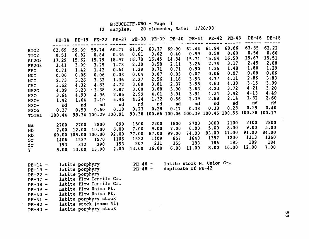
BtCUCLIFF.WRO - Page 1 12 samples, 20 elements, Date: 1/20/93
PE-14 PE-19 PE-22 PE-37 PE-38 PE-39 PE-40 PE-41 PE-42 PE-43 PE-46 PE-48PE-14 PE-19 PE-22 PE-3'
SI02 62.69 59.39 59.74 60.77TI02 0.51 0.82 0.84 0.36AL203 17.29 15.62 15.79 18.97FE203 3.41 3.09 3.25 1.78FEO 0.71 1.42 1.42 0.64MNO 0.06 0.06 0.06 0.03MGO 2.73 3.26 3.32 1.36CAO 3.62 4.32 4.83 4.72NA20 4.09 3.23 3.38 3.87K20 3.64 4.90 4.96 2.85H20+ 1.42 1.64 2.10 5.46H20- nd nd nd ndP205 0.27 0.59 0.60 0.10TOTAL 100.44 98.34 100.29 100.91
Ba 2700 2700 2800 890Nb 7.00 12.00 10.00 6.00Rb 60.00 105.00 100.00 92.00Sr 1406 1537 1570 1106Zr 193 312 290 153Y 5.00 13.00 13.00 2.00
PE-14 latite porphyryPE-19 - latite porphyryPE-22 - latite porphyryPE-37 — latite flow Tenmile Cr.PE-38 - latite flow Tenmile Cr.PE-39 — Latite flow Union Pk.PE-40 — latite flow Union Pk.PE-41 - latite porphyry stockPE-42 — latite stock (same 41)PE-43 - latite porphyry stock
61.910.61
16.702.301.290.042.273.803,002.994.24
nd0.23
99.38
63.370.62
16.453.580.710.072.563.813.884.011.32
nd0.28
100.66
1500 22007.00 9.00
77.00 87.001522 1409207 231
13.00 16.00
69.900.4014.842,110.710.031.162.373.903.91 0.56
nd0.17
100.0618007.00
99.00857155
6 . 0 0
62.440.59
15,713.260.900.073.533.583.633.912.39
nd0.38
100.3927006.00
74.00 1648183
11 . 00
61.940.59
15.542.741.350.063.773.633.234.342.88
nd0.38
100.4530005.00
83.001357186
8.00
60.660.60
16.503.171.480.074.114,383.723.422.14
nd0.28
100.5321008.00
47.00 1200185
10 . 00
PE-46PE-48
latite stock N. Union Cr. duplicate of PE-42
63.850.56
15.672.451.800.082 . 8 63.164.214.131.32
nd0.29
100.38
62.220.60
15.512.881.290.063.833.093.204.492.60
nd0.40
100.172100 2800 9.00 5.00
91.00 84.001313 1360189 184
12.00 7.00
cnVO

B;CUCLFNRM.NRM - Page 1 13 samples, 32 elements, Date: 1/20/93
PE-14 PE-19 PE-22 PE-37 PE-38 PE-39 PE-40 PE-41 PE-42 PE-43 PE-46 PE-48 MEAN
SI02TI02AL203FE203FEOMNOMGOCAONA20K20H20+H20-P205TOTAL
ApIIMtOrAbAnDiHyCQHmTotalAMFA FSPARPLAGNA+K2
58.36 0.36
18.972.390.550.053.793.617.384.32
ndnd
0.21100.00
.63578
.980591.02
21.71 34.9516.36
nd6.85
.6939814.062.75
100.0051.6718.2530.0841.6531.3711.71
56.840.59
17.622.231.140.054.654.435.995.98
ndnd
0.48100.00
1.421.612.48
29.93 28.26 14.113.176.91
nd10.611.49
100.0050.0520.0729.8849.1323.1711.98
56.260.59
17.532.301.120.054.66 4.87 6.17 5.96
ndnd
0.48100.00
1.421.632.39
29.8329.12 13.515.39 5.91
nd9.131.67
100.0049.9619.8930.1549.8822.5812.13
58.650.26
21.581.290.520 . 0 21.964.887.243.51
ndnd
0.08100.00
.24426
.718021.17
17.6434.3023.85
nd3.541.23
16.251.06
1 0 0 . 0 062.8112.7124.4732.2243.5710.75
60.590.4519.261.69 1.06 0.03 3.31 3.985.69 3.73
ndnd
0.191 00 .0 0
.563601.222.65
18.5626.6818.23
nd5.922.28
23.29.59211100.0049.4818.7531.7732.0231.459.43
59.03 0.43
18.062.510.550.063.563.807.014.77
ndnd
0.22100.00
.657161.19
.7262923.8433.04 15.731.145.87
nd14.693.11
100.0052.1216.9130.9743.7528.8611,77
65.410.28
16.371.490.560 . 0 21.622.387.084.67
ndnd
0.13100.00.39830.76525
1.2423.2133.16 10.70
nd2.89
.2916526.081.27
100 . 0064.959.65
25.4045.9121.16 11.74
58.840.42
17.452.310.710.064.963.616.634.70
ndnd
0.30100.00
.904151.151.45
23.5731.3415.33 .20207
8.85nd
14.872.33
100. 0048.3622.6429.0142.5627.6811.33
58.67 0.42
17.351.951.070.055.323.685.935.24
ndnd
0.30100.00.90816
1.152.91
26.2828.0115.46
.352119.43
nd14.68 .80529 100.0048.1123.9627.9343.9125.8411.18
56.760.42
18.202.231.160.065.734.396.75 4.08
ndnd
0.22100.00
.663591.163.32
20.53 31.99 18.521.339.76
nd11.78 .93976 100.0043.9325.2930.78 37.35 33.69 10.83
59.410.39
17.18 1.72 1.40 0.06 3.97 3.157.594.90
nd nd
0.23100.00.68257
1.083.59
24.6335.9611.77 1.686.90
nd13.71
nd100.0053.0418.1928.7748.96 23.40 12.50
58.950.43
17.322.051. 020.055.413.145.885.43
ndnd
0.32100.00
.955961.172.69
27.1927.7513.03
nd9.75
.7443815.62
1. 11100.0048.03 23.92 28.05 45.9422.03 11.31
58.980.4218.072.010.900.054.083.836.614.77
ndnd
0.26100.00
.788381.152.14
23.9131.2115.551.896 . 8 81.05
15.401.56
100 . 0051.8819.1928.9442.7727.9011.39
o

APPENDIX B
Mineral Abbreviations and their
Chemical Formulas
61

62
Abbreviation Mineral Name Chemical Formulaal alunite KAl 3 (SOj 2 (OH),anh anhydrite CaS0 4
ap apatite Ca5(P04)3(F,PH,Cl)3ba barite BaSO^bn bornite Cu^FeS^cc chalcocite CUjScp chalcopyrite CuFeSj
chenevixite CUgFez ( ASO 4 ) 2 ( OH ) 4 *H2 Ûchi chlorite (Mg,Fe)5Al 2 Si 3 0 3 o(OH) 8
cv covellite CuSen enargite CU 3ASS 4
famatinite Cu 3 SbS4
gi galena PbShm hematite FejOakaol kaolinite Al 3 Si 2 0 5 (0 H ) 4
krennerite (Au,Ag)Te2
Iz, luz luzonite CU 3 ( As g4 f Sb 3 g ) S 4
mont montmorillinite5 native sulfur Sphi phlogopite K(Mg,Fe)2(AlSi3)Oio(F,OH)3p y pyrite FeSgpyr pyrophyllite Al2Si40io(OH)2qtz quartz SiOzser sericitesp sphalerite ZnStl telluridestn tennantite C U 1 2 A S 4 S 1 3
tt y tetr tetrahedrite C U i 2S b 4S i 3
woodhouseite CaAl 3 (S0 4 ) (PO4 ) (OH)g