Albemarle County RoadsALBEMARLE COUNTY ROADS 1725-1816 By Nathaniel Mason Pawlett Faculty Research...
100
ALBEMARLE COUNTY ROADS 1725-1816 By Nathaniel Mason Pawlett Faculty Research Historian Virginia Highway & Transportation Research Council (A Cooperative Organization Sponsored Jointly by the Virginia Department of Highways & Transportation and the University of Virginia) Charlottesville, Virginia January 1981 Revised September 2003 VHTRC 81-R36
Transcript of Albemarle County RoadsALBEMARLE COUNTY ROADS 1725-1816 By Nathaniel Mason Pawlett Faculty Research...

ALBEMARLE COUNTY ROADS 1725-1816
By
Nathaniel Mason Pawlett Faculty Research Historian
Virginia Highway & Transportation Research Council (A Cooperative Organization Sponsored Jointly by the Virginia
Department of Highways & Transportation and the University of Virginia)
Charlottesville, Virginia
January 1981
Revised September 2003 VHTRC 81-R36

ii
ABSTRACT
This publication is the result of an effort to write a history of the early road system of Albemarle County which could be used as a prototype for similar histories of other areas. This has involved research in such primary sources as court records, deeds, and plats and, in the secondary, printed materials on the county and state, as well as on-site surveys of road traces and historic sites and their associated architecture.
Albemarle County, formed in 1744 from Goochland, had its basic road network laid
down between 1725 and 1750. With subsequent additions and improvements, the principal part of this network remains in service today and still constitutes most of the important roads of the county. Along it has flowed the economic, social, and political life of the community each day for the last 250 years. It is the skeleton along which are arranged most of the plantations, mills, battlefields and archaeological sites ranging from Monticello to the Indians� soapstone quarries near Alberene.
Designed to serve as an example for local historians executing similar works for other counties, this publication serves to underscore the importance of the preparation of a detailed history of the early roads of each of Virginia�s counties.

iii
� . . . because there is no living soul who knows the complete truth; here, may be one who knows a section; and there, one who knows another section: but to the whole picture not one is initiated.�
Vita Sackville-West, in Portrait of a Marriage
Copyright © 1973 by Nigel Nicholson All Rights Reserved
From the book Portrait of a Marriage Reprinted with permission of Atheneum Publishers

ALBEMARLE COUNTY ROADS 1725-1816
By
Nathaniel Mason Pawlett
Faculty Research Historian
INTRODUCTION
In a county wherein has dwelt a major university for a century and a half, one would expect to find every facet of that county�s history long since thoroughly researched, explained and documented, with little left to be discovered about its people, its plantations and its roads. Particularly would this seem to be the case during its Bicentennial, for the history of the colonial period. Nevertheless the colonial history of Albemarle County remains largely unwritten, possibly because no individual possessing the requisite knowledge of the early settlers� genealogy, origins and family connections, their land patents, the counties from which Albemarle was formed, the early road connections and trade patterns and the ability to integrate these has approached this task. The present writer does not expect to remedy all these deficiencies, nor does he even hope to provide the definitive work on Albemarle County�s roads. Indeed, he has learned from sad experience that the courses of old roads are sometimes quite elusive things, and that often what it is said, �everyone knows� is what in reality no one knows. In addition, large gaps in the available records make it difficult to speak of certain periods with any degree of authority. Nevertheless, he hopes that he will be able to set out in rather broad strokes the story of the development of Albemarle�s roads from the time the first road began to creep into the area in 1731 up to the formation of the Board of Public Works in 1816 and the ensuing �turnpike era.� In preparing this document the surviving records of the counties from which Albemarle was formed have been consulted and relevant portions extracted, indexed and published in order to facilitate this work, as well as to make them available to other interested individuals and groups throughout the state and nation. These archival publications, together with a few brief histories of roads and turnpikes, as well as this report, go to make up the corpus of the series Historic Roads of Virginia. Besides these publications, which will be cited when used, the usual volumes familiar to all students of Virginia history have been consulted and, except in unusual cases, will not be cited herein.
Albemarle County is located in the foothills of the Blue Ridge Mountains and probably has more geographic resemblance to Nelson and Amherst Counties than to the counties located north of it along the Blue Ridge and those to the east. With Amherst and Nelson it shares a number of mountains east of and roughly paralleling the Blue Ridge, as well as a number located at odd angles to the main ridges. All of these, main ridges and foothills alike, provide some obstacles to the location and construction of roads and highways. Particularly is this so as one moves toward Nelson County, once characterized as �the place where the Lord dumped all his odds and ends, his nub-ends of mountains after he finished creating the Blue Ridge and the Alleghenies.�

2
Besides the Blue Ridge, to the west, Albemarle possesses, nearly on its eastern border, another mountain range which runs intermittently from northern Virginia to North Carolina under various names. In Albemarle, north of the Rivanna River it is called the Southwest Mountain, from the Rivanna to the Hardware River at Carter�s Bridge it is called Carter�s Mountain, and from there to the Rockfish River it is known as the Green Mountain. While there exist a few gaps north of the Rivanna, it possesses only one between the Rivanna and the Hardware River. This is located where Route 53 crosses at Monticello and is called the Thoroughfare, the early name for a gap or pass. From the Hardware River south the ridge, here called Green Mountain, has many passes and poses no serious obstacle to travel.
Near the border with Greene County another series of mountains, extending south for five or six miles from the Blue Ridge, form Brown�s Cove, while Buck�s Elbow Mountain extends east from the Blue Ridge near Crozet to form another obstacle to road building. In the southern part of the country between Carter�s Mountain - Green Mountain and the Blue Ridge lie two more mountain systems which contain between them U.S. Route 29. Besides these principal systems, there are several monadnocks such as Buck Mountain and Piney Mountain scattered about, but these do not form significant obstacles to road building.
The rivers, outside of the James, capable of providing obstacles to the early traveller were the Rivanna and its tributaries, Moorman�s and Mechum�s River, the Rockfish River and, to a lesser degree, the Hardware River up to its fork at Carter�s Bridge. Even these are fordable at numerous places when not in flood, and most other streams could be crossed almost at will at normal flow.
Indeed, to a great degree geography was to determine the shape of Albemarle�s early road system, and that road system, in turn, determined very much, if not all, of the present road system. Though often appearing illogical-to the modern observer, the early road system was severely logical if viewed in light of Albemarle�s overall geography, the topography of the immediate area of the road, and the means available to the eighteenth century road builder to effect his purposes. Not to be forgotten, of course, is the still unchallenged supremacy of the horse and the ox during this time. All these things must be borne in mind when one attempts to view an eighteenth century road system from today�s perspective.
Containing within its present bounds parts of two of the original eight shires, Albemarle unites the tier of James River counties with the tier of York River counties. Prior to 1777 when Albemarle achieved its present form, its land area had fallen under the jurisdiction of a number of different county governments over the years.
Henrico was one of the earliest eight shires formed in 1634. From it, in 1728, the original frontier Goochland County containing all or part of eleven present counties was formed (see page 5). In 1744 Goochland itself was divided to yield Albemarle, which then contained about two-thirds of the present county plus the vast area now in Amherst, Nelson, Buckingham and

3
Fluvanna as well as parts of Appomattox, Campbell and Bedford counties. As settlement continued apace in Southside Virginia and with the James River creating a considerable obstacle to those attempting to reach the (then) courthouse near present Scottsville, the county was again divided in 1761. This time, Buckingham County was formed from the area south of the James River and Amherst County from the area northwest of the river. That area now in Bedford and Campbell Counties had already become part of Bedford with its formation in 1754, and Nelson County remained part of Amherst until 1807. The area now within Fluvanna County remained part of Albemarle until 1777.
After this 1761 carving up of the original Albemarle of 1744 about two-thirds of the present Albemarle remained, along with the area now in Fluvanna. To compensate Albemarle for her losses the western portion of Louisa County, which then ran to the Blue Ridge, was annexed to her.
Louisa was an outgrowth of the original Charles River shire that later became York
County. From York in 1654 was formed New Kent County, a rather large subdivision containing a number of future counties, among them King and Queen and King William. King and Queen was detached in 1691, and King William split from it a decade later. The upper end of New Kent had to wait almost thirty years until it became Hanover County in 1720. In turn the upper end of Hanover, then stretching all the way to the Blue Ridge, became Louisa County in 1742. Until 1761 the lower line of Louisa extended westward, probably crossing the mouth of Ivy Creek (as in the 1757 survey) and striking the Blue Ridge a little above the confluence of Doyle�s and Moorman�s Rivers north of White Hall. Now, all this area became Albemarle County, even though its roots were in the Louisa-Hanover stream of migration from the York River area.
Thus constituted, Albemarle had attained almost its present shape, which would be finally
achieved with the creation of Fluvanna from its eastern portion in 1777. The alteration in shape of 1761 was also to leave the courthouse in a strange location on the southern periphery of a county now warped to the north by the addition of the portion taken from Louisa. This would lead to the creation of Charlottesville at a more central location on the main east-west route from the Valley to Richmond, the Three Notch�d Road. The story of the development of Albemarle�s roads, due to the dual origin of the county and its settlement by the group from the York River counties and the one from the James River counties is best approached as two separate, but interrelated, accounts during the period to 1761 when Albemarle County began to assume its present configuration. The fact that the records for the counties along the James River though not complete are still more nearly so than those for the counties along the York River demands that the narrative initially be concerned with developments along that line. This study can be brought to about 1750 with the surviving road orders of Goochland and Albemarle Counties, at which point attention will be directed to Hanover and Louisa where the principal documentary evidence remaining seems to be that of the road orders contained in the first order book of Louisa County Court, which covers the years 1742 to 1748, which will also serve to bring the

4
development of roads in the northern part of present Albemarle County to about 1750. For both sections of the present county the road orders cease in 1748. Albemarle County Order Books are missing for the years from 1748 to 1783, while Louisa�s from 1748 to 1766 are lost. After 1761, of course, the western portion of Louisa was incorporated within Albemarle, and the applicable road orders would have been in the lost books there. Besides the aforementioned road orders, the Albemarle County Surveyors Books 1744-1853 provide some important corroborative evidence for this period and help to ameliorate the lack of road orders for the years 1748-83.
Deeds were not consulted although it was originally supposed that they would prove very helpful for the early period in the form of an easily-read, indexed typescript. Recent publication by Rosalie Edith Davis of Louisa County Deed Books A and B 1742-1759 seems to refute this idea, however, for the early period. When placed beside a computer printout of all the place names in Louisa County deeds 1765-1815, prepared by Ransome True, nearly complete coverage is available for the first seventy-five years of Louisa deeds and the fallacy inherent in this line of thought is laid bare, at least as far as roads in the first twenty or thirty years after the initial settlement are concerned. Only nine roads are specifically named by Davis in her index, with the rather unspecific �Main Road� leading in number of citations. Three Notch�d Road, the southern border of the county, is mentioned by name only once. It would appear that the Hanover deeds would be little more productive for this period, were they not lost. True�s list, while containing more roads, is for a period beginning some forty or forty-five years after Louisa began to be settled, and thirty years after that part of Louisa later to be incorporated into Albemarle began to be settled. No doubt the problem arises from attempting to read the twentieth century practice of using roads for property lines back into an eighteenth century Virginia where the original land patents were laid out with regard to the topography and the quality of the land (as well as other property owners� lines) rather than to road locations. In the beginning, of course, there were no roads to speak of, and those which did exist doubtless moved at the will of the users. It would therefore have been foolhardy to rest property ownership on the locations of such nebulous and transitory things as roads. Later, as the gentlemen justices of the county court made their power felt through their appointed surveyors of roads, locations became more nearly fixed, and as time and death took their toll and tracts changed hands and were broken up, roads became more important as boundary lines.

5
THE DEVELOPMENT OF ALBEMARLE COUNTY Note: As originally published in paper format, this volume included maps showing the evolution of the county. These maps, which constituted Figures 1 and 2 in the original volume, are not included in the electronic version due to legibility and file size considerations. Instead, a verbal description is provided.
By the 1720s, the area that is now Albemarle County was part of the western reaches of Goochland County (created in 1728 from Henrico County) and Hanover County (created in 1721 from New Kent County). In 1742, the western section of Hanover was cut off as Louisa County (then including the northern third of modern-day Albemarle County).
Albemarle County was created in 1744 from Goochland County. In its original form,
Albemarle contained the southern two-thirds of modern Albemarle County, the entirely of the modern counties of Amherst, Buckingham, Nelson, and Fluvanna, and parts of Appomattox, Campbell, and Bedford counties. Albemarle�s boundaries were considerably reduced with the creation of Buckingham County (then also containing part of modern Appomattox County) and Amherst County (then also containing present-day Nelson County) in 1761. The year 1762 brought a slight northward expansion of the county boundaries, with the addition to Albemarle of the western portion of Louisa County. This brought Albemarle�s western, southern, and northern boundaries to their current locations. With the last reduction in its territory, the creation of Fluvanna County in 1777, Albemarle reached its present size.

6
7
THE GOOCHLAND YEARS 1731 � 1744
In the beginning, geography predetermined the design of much of Albemarle�s road
system. Given the topographical features, it was foreordained that the first roads would have to follow certain paths. They could hardly have done otherwise. (Figures 1& 2 along with those maps contained in the map pocket at the back of this publication, will assist the reader in understanding the following narrative).
While credit is often given to the Indians for many of the paths which developed into our road systems, it is unlikely that the savage deserves much more of this credit than does the white man. Indeed, the Indian, like his successor the Englishman, was probably only following in the footsteps of his predecessors, �nature�s engineers,� along well-trodden paths already used for thousands of years by the beasts of the animal kingdom in their peregrinations in search of food. Indian paths themselves retain a quasi-legendary status due to the lack of available documentation. One of the best-documented, the so-called �Indian Road� through the Valley of Virginia, now more or less Route 11 or Interstate 81, turns out upon examination to be really the result of a road laid out by Colonel James Patton in 1745 for the use of the Indians travelling through the Valley, in order that they might avoid future clashes with the whites. Nearer home, the so-called Seminole Trail (Route 29) now appears to be the result of the nationwide automobile touring enthusiasm of the 1920�s and an attendant legislative enactment of 1928. Further scrutiny reveals that the Indians had already agreed by the 1722 Treaty of Albany to confine their travels to the Valley, and that the Seminoles, who seemed not to travel this way, were a tribe which developed from renegades, fugitive slaves and outcast Indians in the period after settlement by the English. The name Seminole means only refugee. True, there had been a Shenandoah Hunting Path, later called the Carolina Road, which entered Virginia near the mouth of the Monocacy River in the Potomac and ran east of the Blue Ridge down to the island of Occaneechi at the junction of the Dan and Staunton Rivers in present Mecklenburg County, but this was prior to 1722.
All of which should not be construed as an attempt to deny the existence of Indian paths. No doubt many a path or road attributed to the early planters, and for which we could show an order issuing from the courts of Goochland, Albemarle or Louisa, was really only an improvement of an Indian path. After all this is said, the fact remains that by the time the settlement of this area began about 1730 the Indians had been gone for a considerable period of time. That this is so is evidenced by the names of the rivers and streams, practically none of which bear Indian names. Had there been Indians present at least some of the streams� Indian names would have survived. Mechunk Creek is the only one which comes readily to mind.
Given this absence of the savage, whatever Indian paths had existed must have fallen back greatly, to the level of mere game paths or worse) in the years after his departure.
8
Anyone who has ever hunted knows what twenty or thirty years of disuse will do to a narrow forest road. Departure of the Indians, and subsequent disuse, must have had a similar effect on the paths in this area.
By the year 1725 English settlement was approaching this area, both along the James River and along the line of the York, the Pamunkey and its tributary, the South Anna River, which heads against the Southwest Mountain. Patents were being issued in the area of present Louisa and Fluvanna Counties, with the pace being set by gentlemen from the tidewater counties who characteristically took up large tracts. Richard Cocke patented Bremo in 1725. Shortly, Nicholas Meriwether would be surveying the area of his immense patent along the Southwest Mountain, and John Carter of Shirley, secretary of state for the ancient dominion of Virginia, his tract of 9,350 acres, which came to be called the Secretary�s Quarter, along Carter�s Mountain south of the Rivanna River. Following these and the surveys of other members of the tidewater gentry in the area, there came a host of smaller patentees over the next several decades. Naturally, the best lands were taken up first, with some of the land, considered worthless, not being patented until much later, in the 1780�s and 1790�s.
With the patenting of these large tracts came the necessity for roads since these areas had to be supplied with slaves, food and tools in order that land might be cleared, quarters and a mill built, subsistence crops raised and, as soon as possible, tobacco produced. Shortly, a steady stream of hogsheads of tobacco would emerge, bound for Richmond on the James, Fredericksburg on the Rappahannock, or else Hanovertown (not Hanover Court House) or New Castle, the Meriwether�s town, on the Pamunkey River. At all of these points ships from London, Bristol, Liverpool and other English ports were riding at anchor waiting to receive into their holds the round containers of tobacco, meanwhile disgorging cargoes of English manufactured goods, furniture, cloth, Madeira, port and sherry for the upcountry planters.
Goochland County Order Books are complete to 1744, when Albemarle was formed, and in their road orders can be traced the progress of roads into the lower part of present Albemarle County, as well as the roads of Goochland, Powhatan, Cumberland, Buckingham Appomattox (part), Campbell (part), Bedford (part), Nelson, Fluvanna and Amherst Counties. All of these orders (as with those from Louisa) are dated by the old system in effect until 1752, whereby the year began March 25 rather than January 1, making what is currently the first quarter of the year the last. This is indicated in the citations by the use of O.S. after the date to denote Old Style.
The first order with which we are concerned occurs on 17 March 1729 O.S. and calls for a road up across the branches of Bird (Byrd) Creek to Martin King�s near Troy in present Fluvanna County. The next order to occur concerning this area, 21 December 1731 O.S. extends what is known as the River Road from �Bird Creek� on the James River across the �North branch of James River� (the Rivanna) at �Mount Misery fford� and to Rockfish River �the best way the grounds will permit,� thus exhibiting the fact that no road worthy of the name previously existed along that route. �Allen Howard, Gent.,� whose name survives in Howardsville, made the

9
motion for this order before the Goochland County Court. The road was to have its length divided into three segments with a road surveyor for each segment. Patrick Mullin was to be surveyor as far as �opposite to Mr. Richard Cocke�s Plantation where John Ripley is Overseer� (Bremo); Ripley was to be overseer or surveyor from there to �opposite Mr. Edward Scott�s Plantation where John Tuly is Overseer� (near present Scottsville) and Tuly was to be surveyor there to �Rock Fish River.�
The Rivanna River was then often referred to as the north branch of the James River, or sometimes simply James River, while the James above Point of Fork usually went by the name of Fluvanna. �Mount Misery fford� was located approximately where present Route 6 crosses the Rivanna, and the stream which flows down alongside Route 6 on the west side of the river still bears the name Mount Misery branch. From its name, River Road, one might expect this road to literally skirt the river. In fact, it did no such thing, but usually stayed well back from the river on top of the bluffs in its path �up the country� as its course upriver was then called. Following generally the path of the present Route 6, which is the modern rationalised version of it, across Fluvanna County its course can be traced along the modern highway into Albemarle near present Scottsville. By staying well away from the James River it was possible to head the smaller streams while avoiding the drainage problems attendant upon running a road through lowgrounds.
Approaching the present site of Scottsville it is likely that the road diverged from the
present Route 6 to avoid descending to the James River and followed Route 773 ► Route 795 ► Route 726 along the bluff to the west of the present town, joining 627 for a short distance to 626 and continuing thence to cross the Rockfish River where Howardsville is now located. The reason for Allen Howard�s interest in this road seems self-evident; Edward Scott�s name is well known to students of Albemarle history, and John Tuly�s name survives on some of the older maps where Totier Creek is shown as Tooley�s Creek. A Tooley�s Hill is also mentioned in this area in the road orders of the 1790�s. The River Road has the distinction of being the first road we can document which penetrated the area now within modern Albemarle County.
The next order for a road near this area (Goochland, 19 September 1732 O.S.) called for a road from �about two miles above the mouth of the Bird Creek up the County as far as Buck Island�.� While the earlier road terminating at Martin King�s in present Fluvanna County came up the east side of Byrd Creek, crossing its branches, this new road began on the western side and, utilising the watershed, apparently came along Routes 659 ► 608 ► small abandoned portion ► 616 to the vicinity of the later Boyd�s Tavern opposite to Buck Island Creek in Albemarle County avoiding, with the exception of Mechunk Creek and its attendant declivity, most of the water courses and severe grades along the way. This was a very good route; so good in fact that it would be chosen in the nineteenth century for the stage route from Richmond to Charlottesville, thereby gaining for itself the name Stage Road.
Where Joseph Barringer had been appointed surveyor of this entire road in the fall of 1732, his task was halved in 1733 when the road was divided and Samuel Burk appointed surveyor of that portion from Barringer�s up to Buck Island. This was a procedure often followed

10
as settlement continued in the area and the number of �labouring male titheables� available to the individual overseer of roads increased. It also served to greatly lessen the burden placed upon each overseer and his gang. While beneficial in the early stages of settlement of an area, when one man and his gang might be responsible for opening and maintaining fifteen or twenty miles of road, like any virtue carried too far, it became a vice. By the 1790�s continuing division of roads in this manner would produce an excessive number of surveyors on individual roads, with concomitant problems of supervision.
The road along the James River had been followed by a road up the north side of the Rivanna. Next, a road was to be constructed along the northern border of Goochland County. On 19 June 1733 O.S. there issued an order for a road to be cleared from �the Mountains down the ridge between the North River [Rivanna] & Pamunkey River [the South Anna is the southern fork of the Pamunkey] the most convenient way�.� The �Mountains� referred to were the Southwest Mountain, Little Mountain or Chestnut Mountain as it was sometimes called. In the fall, on November 20, Henry Runnals replaced the original surveyor Robert Adams, though the road is misdescribed as �the Road from the Mountains down the Country on the North side of the Northanna to meet Saunder�s Road.� No doubt this was a slip on the part of the clerk recording the order at Goochland Court House. The next spring, after a Grand Jury Presentment in November against Runnals for not keeping the road in repair, Peter Jefferson became surveyor of this road, this time described as �the Road from the Mountains to Licking hole Creek.� Jefferson�s tenure was to prove highly beneficial to this road, for during it numbered markers were erected along the route, with zero located between present Charlottesville and Ivy, the �twelve mile tree� near Shadwell, and other numbers reaching at least as high as 40 along the ridge to the lower end of Goochland County. Most of these markers were probably incised on trees and perhaps also painted. Though only the �twelve mile tree� is specifically mentioned in road orders, it is unlikely that with the superfluity of trees time would then have been taken to erect any other kind of marker.
From its route and destination this road, by 1736, became known as the Mountain or Mountain Ridge Road, a name which still continued in occasional use many years after it became known as the Three Notch�d Road about 1742. We shall return to this road and a more complete description of it later.
Thus by early 1734 three roads penetrated present Albemarle County. Along the bluffs above the James River ran the River Road as far as the Rockfish River, while along the ridge generally dividing the watershed of the Rivanna from that of the South Anna ran the Mountain Road, presumably as far as the Rivanna water gap in the Southwest Mountain. Leaving the River Road near the mouth of Byrd Creek the road later to be called the Stage Road, staying on the high ground to the north of the Rivanna River, traversed the present area of Fluvanna County and joined the Mountain Road on the ridge to the east of Limestone Creek, at the later site of Boyd�s Tavern.
In July of 1734, the Goochland County Court issued an order for what has survived to this day as the Secretary�s Road or the Secretary�s Rolling Road, and which ran from Bremo along the ridge between the Hardware and Rivanna Rivers to Secretary John Carter�s Quarter near the present

11
Overton, east of Carter�s Mountain. Leaving Bremo, this road followed what is today a forest road to Route 650 above Little Bremo or Cocke�s Creek, thence to the present New Fork Church. The portion from there across to Route 671, near Central Plains, is now abandoned, but the rest of the distance to Albemarle County remains in service (Route 671 ► 640 ► Central Plains ► 697 ► 6 ► 620 ► Woodbridge ► 620 ► Overton). From Overton this road probably continued along Route 795 through Morven on an abandoned portion into 734 and back into 795 into 53 at Simeon. From there it must have followed 53 through the Thoroughfare between Monticello and Carter�s Mountain, leaving 53 to go down to Moore�s Creek and the Secretary�s Ford. Charles Lynch was the first surveyor of this road.
Presumably, Carter�s 1730 patent was nearly operational by 1734 as a working tobacco plantation requiring access to market for its principal product. A nearer connection with the James River might have been achieved by crossing the Hardware River above its fork and following ridges to the vicinity of present Scottsville. That this was not done, and that the connection with the James occurred only at somewhat distant Bremo, indicates that there existed a blockage, or blockages, in the river. Seven Islands, with its rocks, shoals and piles of brush and uprooted trees dumped by the river was probably the principal impediment to navigation above Bremo. The river, in fact, seems not to have been cleared above this point until well into the 1740s. Additionally, Cocke�s quarter at Bremo, a 1725 patent, must have been operational by 1734 and already engaged in the transportation of tobacco down the James to Richmond, a considerable convenience to the Secretary�s operations in the area to the west. The Reverend Robert Rose, in his diary, mentions a period of seven years which it took to get his plantations on the Tye River into production. Whether this was a good average or not, Cocke�s should certainly have been producing by 1734 and the Secretary�s Quarter, patented in 1730, must also have been well along toward production by this time.
Another interesting aspect of this construction sheds some light on the station occupied by John Carter as Secretary of State. The original order for the road, 16 July 1734 O.S. called for the opening of a road �from the Round pond Road to Collo. John Carter�s Plantation�.� The next order, issued some six months later on 21 January 1734 O.S. was cryptic in its prohibition: �Ordered that the Road from the round pond to the Secretary�s Quarter be esteemed no Publick Road�.� So a road constructed at public expense was to be given over wholly to private usage! Indeed an interesting commentary on the eighteenth century view of conflict of interest.
The Secretary�s Road (see Figure 3) was ultimately opened to public use, and was later extended from his mill near Carter�s Bridge down the Green Mountain, across the Rockfish River, south through the gap near the present Variety Mills, to the Tye River, where the Secretary acquired another large tract called the Secretary�s Tye River Quarter. Unfortunately, his name has not survived on this part of the road as it has on that from Bremo to Carter�s Mountain were it not for the surviving road order, some plats and the diary of the Reverend Robert Rose, whose plantation was adjacent to the Secretary�s Quarter on the Tye River, we might not know that this road had ever had a name.

12
Figure 3. The Secretary�s Road (left) leading from the 2nd roundabout at Monticello down to the Secretary�s Ford on the Rivanna River (Lay).
At the same meeting of the Goochland County Court that ordered the Secretary�s Road to �be esteemed no Public Road,� an order issued for the �titheables appointed by the Vestry [St. James�s] and the titheables on the South Side of the North [Rivanna] River above Barringer�s� to work on the Mountain Road. Although the vestry book does not survive, this illustrates the vestry�s continued involvement in the road building process, whether similar to that of St. Paul�s in Hanover or not. These titheables on the south side of the Rivanna had to be added to Peter Jefferson�s gang to work on the Mountain Road because the territory north of the road was in Hanover County (Louisa after 1742), and therefore provided no people to maintain Goochland County roads. This order was probably issued at the behest of Jefferson, who had by this time been in charge of the Mountain Road for eight months and probably had many improvements projected along this route, among them the trees marked with numbers denoting mileage.
Besides this order strengthening Jefferson�s gang on the Mountain Road, one other order concerned with roads in this area issued at this session of court. This was for �Charles Hudson & others� to clear a road from their �Plantations in the ffork� (the area between the James and Rivanna Rivers was so called) to �the North River� (Rivanna). Hudson�s plantation was located below Carter�s Bridge on the Hardware River near where the present Route 795 crosses it. It does not appear that this road was completed to the satisfaction of the court for what is probably the same order is repeated several years later (21 June 1737 O.S.), this time calling for a road

13
from �the falls of Hardwar to the north river� by �the most Convenient way that can be, with the titheables living on the branches of Hardwar [the river forks just above Carter�s Bridge] to do the work.�
Both of the aforementioned orders would appear to refer to the road that later came to be called Martin King�s Road, from its destination one supposes. This road ran from the vicinity of the present Carter�s Bridge, by Woodbridge to cross the Rivanna near Union Mills (Route 708 ► 618 ► 53 ► 618 ► portion through ford to Union Mills abandoned). Today the crossing occurs a bit lower down, at Crofton. Following Charles Hudson, John White was the surveyor on this road, and probably was followed by two of the Anthonys and then Martin King himself.
Mention might also be made here of the fact that the original name of the Hardware River seems to have been Hardwar or Hardwarr, judging from the early land patents and road orders. In the minutes of the Council at Williamsburg it appears several times as Hardway or Hardaway River. There were, of course, families named Hardaway and Harwar in Virginia and it is possible that they may have been in this area in some capacity. A better source for the name was suggested by a recent perusal of the Shell Guide to England, which revealed a place called Hardraw Scaur in the West Riding of Yorkshire. This name, easily transposed to HardWarr, was applied to a large waterfall over an exposed view of rocks. Slate deposits were also stated to exist nearby. Given this description one immediately thinks of the slate found along Hardware River, and of the way the falls at Jefferson�s Mill, at Eolus Mill and those near Garland�s Store might have appeared to any early explorer who had heard of, or who was actually familiar with, Hardraw Scaur. Unfortunately, this possibility will probably have to remain purely conjectural. Certainly by the time of the Fry-Jefferson Map of l751 the name seems to have generally been accepted as Hardware.
From 21 January 1734 O.S. until 17 June 1736 O.S. there occurs a very strange lull in road building activities in this area, although roads continued to be laid out and improved and bridges built elsewhere in Goochland County. For a year and a half no road orders dealt with the present area of Albemarle. Had most of the rich land east of the Southwest Mountain been engrossed by the tidewater magnates? Had roads already been opened along the likeliest routes east of the mountain? Was the pause occasioned by a lag on the part of smaller patentees in moving into this area? Possibly the number of available titheables in the area restricted road building activity to the roads for which orders had already been issued. It is well known that the first �opening� or �clearing� of a road might be a very rough, hit-or-miss operation, requiring much further work. Particularly was this so in the case of a road opened for many miles at a time as some of these early roads into this area were. Quite often an order would be repeated several times before the desired road was completed, leaving one to wonder about the laggardliness of road surveyors and their titheables, and whether the project might not have been overly ambitious in the first place. Whatever the reason the eighteen-month gap remains, with the next succeeding order serving to emphasise the remarks on performance by surveyors and their gangs.
The next order which does appear concerning this area (17 June 1736 O.S.) appoints Edward Scott to clear a new road �from the North River [north fork of the James, Rivanna]

14
up the ffork and Across Hardwarr River.� Roads fitting this general description are hard to come by, particularly if they must be �new� roads. The River Road would fit this description and possibly the road from present Palmyra to Carter�s Bridge, if it were not the road laid out by Charles Hudson (Route 53 ► 619 ► 708). It seems more likely that this order, though calling for a new road, only indicates a reworking or improvement of the original route of the River Road of 1731. After five years use whatever deficiencies existed would have been revealed. This, plus the growing availability of manpower in the area may have indicated improvement at this time.
On 21 September 1736 O.S. Charles Lynch supplanted Peter Jefferson as surveyor of the Mountain Road, which was shortly to begin to be divided into segments under individual surveyors. In fact, the next order dealing with this area (17 May 1737 O.S.) named Benjamin Wheeler �surveyor of part of the Mountain Road on the North side of James River beginning at Number Twelve and ending at Number Thirty.� This was the first mention of the mileage markings along this road, and it denoted an eighteen-mile segment beginning about the present community of Shadwell and running well into what is now Fluvanna County. From this time, divisions of the Mountain Road would proliferate until individual surveyors had segments of only six miles each.
Strangely enough, the same day that the order for subdivision of the Mountain Road was issued, an order for what would ultimately become the other end of the Three Notch�d Road was also issued. This gave Michael Wood permission to clear a road from the �Blew Ledge� or Blue Ridge, sometimes merely �the Ledge� or �Great Mountains,� down to Ivy Creek. This road ran from Wood�s Gap (now Jarman�s) down along the ridge where Crozet now stands, crossing Mechums River near the depot of that name, thence to what must have been the end of the Mountain Road at the place later called D.S. An unusual circumstance surrounding this part of what was to be the later Three Notch�d Road was that it exactly reversed the usual order of settlement and road building in this area, for Michael Wood had come south through the Valley into Virginia from Pennsylvania, moving eastward through the mountains to settle below Wood�s Gap on the eastern side. Thus the road came to be built from west to east rather than the more usual east to west direction. (Route 611 ► 691 ► 240 ► 802 ► 680 ► 250 and north of it on parallel farm road ► 250 ► 738 to Ivy ► 250 to D.S.)
A month after John White was appointed to open the road from the �falls of Hardwar to the north river,� the Mountain road was again subdivided, with William Harris getting the portion from �Number forty to forty-six on its lower end (19 July 1737 O.S.). The progress of civilisation �up the country� was further indicated by orders that same day relating to a bridge to be built over �the Bird Creek� at a place where �it is Sixty footwide,� and another for the viewing of a bridge site on Willis�s Creek (River) in present Cumberland County.
On 16 May 1738 O.S. the Mountain Road was again divided, with John Wright being appointed surveyor from �a little below Number thirty six to his house,� Andrew Moreman replacing Charles Lynch over his portion, Benjamin Wheeler from �Number twelve to Number twenty-two� and John Woody from �Number twenty two to Number thirty.� Thus the task of

15
each individual surveyor decreased as the use of the road increased. �Number twelve� would have referred to the twelve-mile tree near the present Shadwell, with this portion probably terminating near Zion Cross Roads.
With the exception of the alterations in surveyors on the Mountain Road there seems to have been another lull in activity from June 1737 O.S. to September 1738 O.S., a period of about fourteen months. However on 19 September 1738 O.S. activity resumed with an order for a major road. This was the Secretary�s Road which ran from his land near Carter�s Bridge to �his new Settlement on Tye River.� and should not be confused with the other road of similar name. From the later repetitions of the order for this road it is uncertain just when the road was finally opened. The more difficult terrain which had to be traversed may account for this delay. It appears that this section of the Secretary�s Road began near the site of his mill above the intersection of Routes 20 and 708 on the north fork of the Hardware River. From there it followed Route 717 southwest toward Route 6, probably cutting the angle between Routes 717 and 6 to catch 722 down the top of Green Mountain to Joplin�s Ford on the Rockfish River. A short distance upriver on Route 602, Route 722 resumes, crossing the Rockfish River now at Joplin�s Ford Bridge. The Secretary�s Road to his Tye River Quarter probably followed 722 down across Route 56 along Findlay�s Mountain to the gap where Rucker�s Run passes through the mountain. Here it passed through the mountain along the line of present Route 655 to the vicinity of Arrington. There in order to keep to the high ground, it took Route 662 and then, cutting the angle, picked up 663 into Arrington. Leaving Arrington it would seem to have followed roughly present 665 to Route 29, thence down 29 to 757, along which it descended to cross the Tye River above its fork with the Piney near the Reverend Robert Rose�s plantation, and passed on toward the Secretary�s Quarter, which was adjacent to the Rose property.
This road, although not yet precisely located by historians along much of its route, is given all this attention because it was undoubtedly one of the earliest main roads into what would become Amherst County in 1761. It is too often forgotten that until 1761, that is, for the entire early period of Albemarle�s history, the real center of the county, Albemarle Court House, was located just to the west of present Scottsville. Indeed, Charlottesville had hardly been thought of, and it was to this first courthouse that such luminaries as Peter Jefferson, Charles Lynch, Joshua Fry and Robert Rose resorted for the conduct of business, public and private, in those early days when Albemarle was a still giant county. By the time the county had been divided and court moved to the nearly nonexistent town of Charlottesville all of these people were long in their graves.
The Secretary�s Road was probably the second or third road from the east into the
Amherst area, the first being the River Road. Rose travelled along it quite often in the late 1740�s, and mentions stopping overnight at Joplin�s and at Fry�s at Viewmont. In at least one instance he appears to have followed the eastern Secretary�s Road from Fry�s on down to Bremo.
The Mountain Road came in for further attention toward the end of the year, on 20 February 1738 O.S. The road through �Thomas Smith�s Plantation at the Mountains� (near Pantops) was ordered to be opened by the surveyor, who had apparently been laggardly in the

16
performance of his duty. Evidently the winter had produced a considerable quantity of fallen timber on this particular road, for orders were issued for gangs to clear between �Number twenty two� and �twenty six,� �twenty six� and �thirty,� and �twelve� and �twenty two.� Thomas Anburey, in his later writings, mentions the continual danger of derelict pine trees falling on travellers along Virginian roads in wintertime. No doubt this resulted in much extra work for surveyors and their titheables each winter and spring.
At the last meeting of the Goochland Court for the year 1738 (20 March 1738 O.S.) the recently passed act of the Assembly which called for surveyors to erect direction signs on their roads was read into the record as an order from the gentlemen justices:
Pursuant to an Act of Assembly of this Colony it is Ordered that the Surveyors of the Severall Roads within this County where two or more Crossroads on highways meet do forth-with cause to be Erected in the most Convenient place where such ways joyn, A Stone or Post with Inscriptions thereon in large Letters directing to the most noted place to which each of the said Joyning roads leads
As is evident from an examination of the County Levy on 17 December 1739 O.S., a
general erection of signboards and posts was then carried out by the individual surveyors in the lower part of Goochland, with one surveyor making claim for the erection of five posts with ten boards along his road. After Albemarle was formed in 1744 this same order was repeated by the new court with the further proviso that the posts be 10 feet tall, which is puzzling until one recalls that this would be about eye level for a man on horseback.
The first bridge in the local area which appears in the records was over Mechunk Creek and was either on the Mountain Road (soon to be Three Notch�d Road) or else the road skirting the Rivanna �up the country� (Route 616), later called the Stage Road. The Goochland Court on 15 May 1739 O.S. appointed Henry Wood, Peter Jefferson and Charles Lynch to view a place for a bridge over �My Chunk.� It was over a year later, on 17 June 1740 O.S. that the court called for �Workmen� to �undertake� the bridge, and a month more before �ffrans James� agreed to build the bridge for £20 without accepting any responsibility for keeping it in repair. Often it was the custom for the �undertaker� to agree to also maintain the bridge for some fixed term, say seven years, in addition to constructing it, as James had done for the earlier Jones Creek Bridge. Francis James, the double small �f� representing a contemporary substitute for the capital letter, was responsible for the construction of several bridges in Goochland before 1744, the Jones Creek Bridge before that over Mechunk, to be followed by one over Deep Creek. All of which did not make a professional bridge contractor of him, since many other planters are known to have occasionally built bridges for the county in Virginia.
To one viewing today the site where the Mountain Road (later Three Notch�d) crosses Mechunk Creek at Allegre�s Tavern the whole idea of a bridge over such a stream appears ridiculous, and the site near Route 616 seems a much better choice. Still, from the amount of attention being bestowed upon it about this time one must think that the Mountain Road received the bridge. Certainly it would have been the better, drier, more level route �down the country,�

17
Mechunk Creek being the only sizeable watercourse between the Rivanna River and Lickinghole Creek near Goochland Court House. In addition, the numbered markers along this road make it seem that it was selected for improvement as a major road at an early date, possibly by Peter Jefferson the site of whose Shadwell plantation it already passed when still a mere Indian path.
At this same session (15 July 1740 O.S.), another order issued which ultimately produced a road tributary to the Mountain Road. This order called for a �Road from the Thorrowfare [an old English name for a pass or gap] a little above Morrisons to the Secretarys fford.� Whether anything was done on this road is not clear. A little more than a year later (15 September 1741 O.S.) the same group, considerably enlarged, appears with another petition evidently relating to the same road. This time leave is given them to clear a road from �Thomas Morrisons to the D. S. Tree in Michael Woods road.� From this it would appear that Michael Wood�s Road (later to be included in Three Notch�d) was open from the Blue Ridge to Secretary�s Ford and that the petitioners needed only to connect with it. The D.S. Tree was located at the intersection of Routes 677 and 250 between Ivy and Charlottesville, and this is the first mention of it in the road orders although it may have been there as the zero marker when the numbers were placed from this point along the Mountain Road. Legend has it that Michael Wood and Davis Stockdon, after a trip to Williamsburg to patent their lands, separated at this point on their way home and Stockdon carved his initials �D.S.� on a large tree. Whatever its origin this noted landmark was to figure prominently in road orders well into the nineteenth century.
The rest of this road from �The Thorrowfare a little above Morrisons to the Secretarys fford� must have been the road which leads from D.S. along the west side of the Ragged Mountains through Batesville into Nelson County (D.S. ► Route 677 ► 637 ► 689 ► 635 ► Batesville ► 635 ► Nelson County). Later, in the 1790�s, the part of this road from D.S. to near Batesville would come to be called the Dick Wood�s Road, after its surveyor. At this early stage of road development it would have provided access to the Mountain Road, with its superior route east, for the people between the Ragged Mountains and the Blue Ridge as far as the Rockfish Valley. The �Thorrowfare a little above Morrisons� may have been Brent�s Gap, earlier perhaps Verdeman�s Thoroughfare, but pronounced Vardaman�s.
As a part of this same long road order another group was directed to clear a road from the Secretarys fford to the D.S. Tree. Still another group, liberally sprinkled with Woods and their connections, was to clear a road from the D.S. Tree to Michael Wood�s. This must have been at most a reworking of the road previously opened by the Woods from Wood�s Gap to Ivy Creek, and gives rise to the notion that the portion from the D.S. Tree down to Secretary�s Ford was also being improved rather than �cleared� for the first time.
A similar case presents itself in another road order of the same date, this one giving �leave,� or permission, to the �Honble John Carter Esqr. to Clear a road from his Tye River Quarters to his Clear mount Quarters,� the same road previously ordered to be opened by Robert Davis, Carter�s overseer, in 1738. Overseers were supposed to be appointed annually and,

18
although this was not always done, it was perhaps necessary to issue a new order each time to reinforce the authority of the overseer of roads to dragoon people into working on the roads as well as to prod him into the performance of his duty. Six months before (17 March 1740 O.S.), the other Secretary�s Road described as the road �from the Secretarys mill to the Lower main road to the Manacan Town ffery,� had received some attention with the appointment of a new surveyor and the direction of another�s gang to assist in the clearing of it. Now, with the repetition of the order for the new Secretary�s Road to Tye River, it seems to have been completed to acceptable standards, for a year later (21 September 1742 O.S.) it received the customary division into sections, with Howard Cash surveyor from Buffalo Quarter to the Tye River, Thomas Jones from the Tye River to the Rockfish, and John Jones from the Rockfish River to the Hardwar. �Peter Jefferson and Charles Lynch, Gent.� were instructed to make the assignments of titheables to the gangs, or crews, of these newly appointed surveyors.
By 21 July 1742 O.S. the road from D.S. down the western side of the Ragged Mountains (later in part Dick Wood�s Road) was also in good enough order for it to be divided into two sections under individual surveyors. James Martin was given the section from Morrison�s to Davis Stockdon�s and Samuel Arnold from there to the D.S. Tree on the Michael Wood�s or Mountain Road (later Three Notch�d).
At the September court (21 September 1742 O.S.) the Mountain Road again received attention, this time along its upper end, with Peter Jefferson again becoming surveyor this time from number 12 to number 18, and Charles Lynch evidently taking over the portion from the Secretary�s Ford to the Twelve Mile Tree near present Shadwell. In the same series of orders the road from Martin King�s into the �Mountain ridge road,� another name for the Mountain Road, was also mentioned and a surveyor appointed for it.
In addition there was by this time another name coming into use for this road. This was the name Three Notch�d Road which, strangely enough, seems to first occur not in Goochland County, which contained the road (see Figure 4), but rather in Louisa County, which was formed in 1742 and of which the road seems to have been the lower boundary. The circumstances of its occurrence was the issuance of an ordinary license by the Louisa County Court to one Charles Allen. Later, in 1744, Allen was to be presented by a Goochland Grand Jury for failing to clear �the three notch�d road from No. 40 to 46. Since this ordinary license contains the first use of the name yet discovered it is reproduced here:
14 Feb. 1742 O.S. Louisa County Order Book 1742-1748, page 11. On the petition of Charles Allen License is granted him to keep an Ordinary on the Three-notched Road in this County he with Thomas Paulett his security having first entered into Bond therefore and acknowledged the same.
The next occurrence of the name is a year later on 12 March 1743 O.S., when the license
is renewed with the style now being �Three notch road.� Eleven days later, on 23 March 1743 O.S., the name first appears in the Goochland County records in a road order as �the three notchd road.� On 15 May 1744 O.S., two months later, the road pops up again as �three notch�d road�

19
in the aforesaid presentment against Charles Allen for failing to clear it. On 19 June 1744 O.S. it appears as �three Chopt road,� and then, as Albemarle County is formed, it reappears in the records there as the Three Notch�d Road, though the old name, Mountain Road, is occasionally used. Indeed, as late as 1755 in an advertisement in the Virginia Gazette it is referred to as the �Three notched mountain road.�
Once the name Three Notch�d, or Three Notched, Road appeared it swept the field. Of the first 12 occurrences of the names Three Notch�d and three chopt, 10 are for the Three Notch�d or Three Notched form, while only 2 use the name three chopt or a variant. It would seem, therefore, that Three Notch�d Road expresses the original name and its proper pronunciation best. Advertisements in the Virginia Gazette through 1778 indicate this preferred original form continued dominant at least through the Revolution. Many of the road orders do not, of course, refer to the road by name, but it is obvious from the landmarks mentioned that they concern this particular road. One on 20 September 1743 O.S. appointed David Lewis surveyor of the road �from the D. S. Tree down to Moors Creek and into the Secretarys Road.� Moore�s Creek flows into the Rivanna River near the Secretary�s Ford on the Three Notch�d Road, while the Secretary�s Road has its western terminus at the Secretary�s Ford on the Rivanna River. Another order (16 May 1744 O. S.) appoints Edwin Hickman to the road from �My Chunk Creek to the Secretary�s Ford.� Most of the Three Notch�d Road between Richmond and Charlottesville remains in service today as secondary road and can be driven in an afternoon by the tourist or amateur road historian with the aid of a previous publication of this series, The Route of the Three Notch�d Road.
Figure 4. The Three Notch�d Road ascending the Blue Ridge.

20
The last orders in the Goochland Order Books dealing with the present area of Albemarle
concern the road from the D.S. Tree down the west side of the Ragged Mountains. On 21 July 1742 O.S., apparently laid off and cleared, this road had been divided between two surveyors, James Martin and Samuel Arnold. Now (20 November 1744 O.S.) this road was divided into four precincts, beginning somewhere about the present Greenfield in the Rockfish Valley in Nelson County. Here Charles Lynch had a tract of land and his name survives today on Lynch�s Creek, which flows into the Rockfish River. The first surveyor, Thomas Morrison, received that part from �the halfway run (unidentified) to Capt. Charles Lynch�s Bridge,� while the second, James Martin, took the portion from there to Whitesides Creek (now Batesville). The portion from there to the D.S. Tree was split at �Woods�s ffield,� probably about the present intersection of Routes 637 and 708, with John Dobbins taking the lower portion and John McCord taking the remainder to the D.S.Tree.
The bridge mentioned here tends to pique one�s curiosity. It may have been a large structure crossing the Rockfish River or it may have been only a small one over Lynch�s Creek or some other small stream, but we cannot know which. Neither can we say whether it was located within the present confines of Albemarle County since it never reappears in the surviving Albemarle road orders up to 1748. Whatever its fate, it, along with the bridge over �My Chunk,� shares the distinction of almost having been the first bridge located within the present limits of Albemarle County. Certainly these two appear to be the earliest bridges in the up-country area of Goochland County and no bridges at all are mentioned in the surviving first order book of Albemarle County 1744-48.
When records coverage resumes in 1783 an order immediately appears for payment for a bridge built over the Hardware River the previous year (1782). Although many bridge orders are listed from this time onward it hardly seems likely that this was the first bridge in the Carter�s Bridge area or elsewhere in the county. With the division of greater Albemarle and the accompanying removal of the courthouse to Charlottesville in 1762, a bridge at this point on the most direct route to the courthouse must have become a necessity for those from the riverine section of the county having legal business to transact. Therefore it seems safe to suggest the presence of a bridge here by, say, 1765 at the latest, a bridge which probably had to be replaced at least once before 1782 if later experiences with the rampaging little Hardware River are any indication.
With the order for the division of the road from the Rockfish Valley along the western
side of the Ragged Mountains to the D.S. Tree, the curtain falls on the period when the lower two-thirds of present Albemarle lay within the gigantic Goochland County of 1728. By 1744 many, if not most, of the principal roads had been built along the routes which they still occupy today. The River Road provided a southern route along the James River into the area of later Amherst County, while the Three Notch�d Road (earlier the Mountain Road) traversed the northern boundary, crossing the Blue Ridge at Wood�s Gap to connect with Beverley�s Mill Place, shortly to become the county seat of Augusta County and be renamed Staunton. This road would become a main east-west route and one of Virginia�s most famous colonial roads. Diverging from the River Road near Bremo, the Secretary�s Road looped along the ridge to the

21
Secretary�s Quarter and across Carter�s Mountain to Secretary�s Ford, with a newer road of the same name going from the Secretary�s Mill down Green Mountain, crossing Rockfish into the Tye River area. Between these several major roads there was a growing network of feeders and crossroads such as the ones today called Martin King�s Road and Dick Wood�s Road.

22

23
THE FIRST ALBEMARLE 1744-1761
Under the able administration of the new Albemarle County government this skeletal
network of roads would be fleshed out considerably. Unfortunately, only the period 1744-1748 can be spoken for with any degree of authority due to the loss of all the order books to 1783, with the exception of the first one. Although a good number of land plats in the surveyor�s book do show roads during this period (1748-1783) they are no substitute for the missing order books.
The area covered by these orders and plats (and the previous Goochland Orders) encompasses approximately the southern two-thirds of the present Albemarle County and, as will be seen presently, the experience of the records of the remaining third derived in 1761 from Louisa, earlier Hanover, is, if anything, much worse than that of the Goochland-Albemarle portion. These difficulties, notwithstanding, the author still believes that an adequate reproduction of the roads in both of these portions to about 1750 can be achieved by the use of these existing sources. Since the evidence in both cases disappears in the Cimmerian mists about 1748, and since that portion of Louisa was not incorporated into Albemarle until 1761, the Goochland-Albemarle portion will be completed to about 1750 before the Louisa portion is dealt with.
The first road order of the new county of Albemarle was issued a few days after the new year began, on 28 March 1745 O.S. Actually the order partook more of the character of a presentment than a road order, for it called John Henderson to show cause why a road had not been cleared �From the Three Notch�d Road and so to Hardway River: through Henderson�s land near the present Milton.� This road must have been very nearly along the course of the present road from Shadwell, by Milton, Simeon and Ash Lawn, down the east side of Carter�s Mountain to Carter�s Bridge (Route 729 ► 732 ► 53 ► 795 ► 627). When built, it probably utilised portions of already existing roads between the Rivanna and the Hardware for it traversed the lands of Peter Jefferson as well as those of the late Secretary. Robert Rose, in his diary, refers to a part of this road as �the Secretary�s Road� a few years later. No doubt Peter Jefferson rolled his tobacco hogsheads along this part of the Secretary�s Road, thence eastward to Bremo, as did many another early planter of the area.
Several other road orders were issued at this same March term of the court, most of them dealing with the Three Notch�d Road. James Defoe was appointed surveyor from Number 12 to Number 18, and John Woody from Number 18 to the County Line. Charles Lynch became surveyor from �the late Secretary�s Foard� to Number 12 and of the road to Lynch�s Ferry. Presumably this last would have referred to a road up the east side of the Rivanna to a place opposite Pen Park, Lynch�s plantation, where he had established a ferry. The County Line referred to in the road order would not have been the present eastern boundary because Fluvanna remained in Albemarle until 1777. In fact, it is even doubtful whether all of Defoe�s precinct from Number 12 to Number 18 would have fallen within the present county of Albemarle.

24
The road along the west side of the Ragged Mountains (later partially Dick Wood�s Road) was now put under two surveyors by the Albemarle County Court. John McCord took that portion from �D. S. to W .M,� William Morrison evidently taking the portion from �W.M,� his place, no doubt, to Thomas Morrisons.
When the April court met (25 April1745 O.S.) it was petitioned by Benjamin Wheeler �and others� for a road from �Wheeler�s in to the Four Chopt Road; to Wood�s Gap� and leave was granted them to clear the road. Presumably �four Chopt� represents a clerical rendering of three chopt or, more properly, Three Notch�d Road, going to Wood�s Gap in the Blue Ridge, though the name Three Notch�d seems to have been confined to the area east of the Rivanna River at first. Whatever the circumstances concerning the name, there seems little doubt that the road referred to here left the present area of the University following roughly the direction of Route 29 South to end near the head of the valley where Gleco Mills now stands beside the modern highway (Probably Stadium Road ► 782 ► abandoned [Route 29] ► 745 on east side of Route 29). By the time records resume in the 1780�s this road is regularly referred to as Wheeler�s Road although it is not so cited in the surviving early records. Unfortunately, much of this road has been obliterated by the building of Interstate 64 and subsequent improvement to Route 29.
At this same term of court David Lewis secured permission to clear a road �over Capt. Charles Lynches foard� on the Rivanna River at the present Pen Park. This road might have departed the Three Notch�d Road in the vicinity of present downtown Charlottesville following roughly the line of Park Street and Rio Road to Pen Park, or, since David Lewis lived to the west of the University area, it might have left Three Notch�d at Lewis Mountain on the ridge on which the University is now located and followed the line of Rugby Road, Grove Road, Melbourne Road to intersect Rio Road at Meadow Creek, thence to Pen Park. This question is unlikely ever to be resolved, of course, since both routes now lie within heavily developed areas.
At the June term of court (27 June 1745 O.S.) an order was issued continuing the surveyors of roads previously appointed by Goochland Court in their posts until they should be superseded by the appointees of the court of the new county, and the process of breaking down the heavily travelled Three Notch�d Road or �great Road� into smaller segments continued, with Andrew Wallace being appointed surveyor from �D.S. to Mitchams [Mechum�s] River,� a distance of only five miles. Improvements were also ordered for the River Road, under William Cabell, from �the ffoard of Tye River [present Nelson County] to the Court House,� which had by this time been located just to the west of present Scottsville, a site it would occupy until after the division of the county in 1761.
With the courthouse established, the need for a road connecting with the seat of the adjacent county of Louisa became apparent to the gentlemen justices and, no doubt, the lawyers practising at both courts. Thus Charles Lynch was directed to layoff a road, of which John Anthony would be surveyor, from the courthouse to Martin King�s Road, and another road was directed to be cleared from the �place Martin Kings Road came into the Three Notched Road by Ellis Hues�/to the County Line towards Louisa Court House.�
The portion from the courthouse to Martin King�s Road probably followed Route 726 ► 795 ► 618, crossing the Hardware River at Jefferson�s Mill to join Martin King�s Road at the

25
present Woodridge. From there it would have followed Martin King�s Road along 618 to the Rivanna River, crossing by a now-abandoned ford near Union Mills, to Route 616 ► 600 ► 633 to join the Three Notch�d Road, now Route 615, just west of Zion Crossroads.
Road orders were numerous indeed at this session of court (27 June 1745 O.S.). Thomas Joplin was appointed surveyor �from Rockfish to Hardwar,� presumably along the lower Secretary�s Road going to the late Secretary�s Quarter on Tye River. Joplin lived near the present Joplin�s Ford Bridge and is mentioned often as providing lodging for the Reverend Mr. Rose in his travels along this road. Provision was also made for maintenance of the lower portion of this road at this session.
On the east side of the Rivanna River a road was ordered opened �from the End of a Road which is Cleared, to John Keys Mill, the nearest and best way to the Late Secretarys ffoard.� The road cleared to John Key�s Mill (the present Red Bird Branch was formerly called Key�s Mill Swamp) was evidently a Louisa County road, precursor to present Route 20, along the western side of the Southwest Mountain, while the terminus at the Secretary�s Ford indicated a connection with the Three Notch�d Road. Not surprisingly, John Key was to .be surveyor of this road, which probably followed the line of present Route 20 to the George Rogers Clark birthplace, thence either along Route 1421 past the Free Bridge down the river to Secretary�s Ford, or else, taking a higher elevation and more direct route, from that point down the ridge to Three Notch�d Road. In either case, development will now have obliterated evidence of it.
Terminating the flurry of road orders on 27 June 1745 O.S. was one which repeated the
Assembly�s 1738 command that direction posts and signs be set up at intersections of roads, with now an additional proviso that �the said Directions be set up at Least ten feet from the Ground,� a height conveniently read by a man on horseback.
Location of the first courthouse near Scottsville necessitated the establishment of a ferry nearby to enable the people of that part of the (then) county lying below the James River to attend court and transact legal business. This was accomplished on 25 July 1745 O.S. when Daniel Scott was given the right to establish and keep such a ferry from �the Court House Landing to the Opposite side.�
The plat pictured in Figure 5 shows the approach to this ferry from the south side of the river. Part of this approach road survives in service today as Route 747 in Buckingham County.
Besides the ferry, Scott was also licensed at this term of court to operate an ordinary at
the same place on the condition that the said Daniel Scott shall Constantly provide in his said Ordinary good wholesome and cleanly Lodging and Diet for Travellers, and Stablage &c. for Horses. During the Tearm of One Year & c.� By this time, no doubt, the county seat was beginning to resemble the standard Virginian configuration of courthouse, clerk�s office, tavern, store, and perhaps a house or two for good measure.

26
Figure 5. The horseshoe bend on James River at Scottsville showing the Ferry Road leading toward the crossing to Albemarle�s first courthouse.

27
Once these details necessary to the operation of the county seat had been taken care of, the justices turned their attention to the outlying parts of the county, granting the inhabitants on the upper part of Mechum�s River permission to clear a road from the Rockfish Gap to the D.S. Road. Although �D. S. Road� could be either the road later called Dick Wood�s or the Three Notch�d Road, it would appear to be the latter since the term �D.S. Road� seems to indicate this when next used on 20 Sept. 1745 O.S.
Up to this time Rockfish Gap seems to have not been much used, the main or �great� road, Three Notch�d, going instead through Wood�s Gap to the Valley. Why this was so is somewhat puzzling considering the evident superiority of Rockfish, but as late as 1748 Wood�s, not Rockfish, was one of three gaps chosen by the colonial government to have money spent on their improvement. In 1751 Robert Rose crossed the Blue Ridge at Rockfish and noted in his diary: �This is a pass might easily be fitted for Carriages of any kind.� Thus it would appear that the pass was then still not suitable for wheeled vehicles. A possible explanation may lie in the old Indian paths and the subsequent routing of the road to Beverley�s Mill Place, now Staunton. Still, the question remains only partly answered.
Presumably the first road from Rockfish Gap to D.S. Road descended through Afton to Route 750 ► 250 ► 796 ► 250 ► Yancey�s Mill on 797 ► 250 ► 751 ► 250 ► 752 ► Mechum�s River. This would seem obviously the best route, but tracing is complicated by its having been later raised to the status of a turnpike in the nineteenth century.
Alternatively, if one assumed �D.S. Road� to have here referred to the road later called Dick Wood�s then this road might have been Route 692, which runs from Route 250 at the foot of the Blue Ridge to Route 637, the Dick Wood�s Road.
Besides the opening of a road from Mechum�s River to Rockfish Gap, a clearance of the road from�the ffoard on the Mitcham�s River to Michael Woods Gapp on the Blue Mountains� was ordered. Since this, the Three Notch�d Road, from Mechum�s River to the Blue Ridge, was already open (and had been for several years), this order must have indicated only maintenance of a routine sort. The Secretary�s Road also received routine clearing at this same time.
The next month (22 August 1745 O.S.), possibly with an eye toward the coming winter, the court authorised Charles Lynch to keep a ferry across the North (Rivanna) River at Pen Park. This was evidently a sometime thing principally used during periods of high water, since earlier road orders mention a ford at the same place.
A road was also on the petition of Joseph Kinkead and Andrew Wood, from Kinkead�s house to Davis Stockton�s Mill near Batesville. Wood lived near the present Greenwood Depot and Kinkead near the later Immanuel Church so that one is tempted to place this road along Route 692 to Batesville, or else Route 691 to Stockton�s Mill Creek. A more precise determination might be provided if the exact location of Stockton�s Mill were known.
The Three Notch�d Road also received some attention at this court, with William Woods being appointed surveyor from �the Foard on Mitcham�s River to Michael Wood�s Gapp on

28
the Blue Mountains� and Matthew Graves replacing Charles Lynch from �the Secretary�s Foard to twelve Mile tree� near present Shadwell.
During this whole period work also continued on roads throughout the greater Albemarle County, though these are not within the purview of this study.
At the September court the order for John Key to continue his road from Key�s Mill to
the Secretary�s ffoard was repeated, doubtless because the task had not yet been completed. A road was also ordered from William Harris�s Plantation on Green Creek to the South (James) River at the lower side of Barrengers Creek. Apparently designed to connect with the River Road, this road probably followed Route 6 from the valley of Green Creek across Green Mountain, leaving it at Porter along Route 627 to join the River Road for a way and then descend to Warren. This assumes �the lower side of Barrengers Creek� to refer to the down-river side of Ballinger�s (so called today) Creek. Interpreting the description geographically one might choose Route 723 through the Green Mountain from Green Creek, but the first solution seems the correct one.
The next day, 29 November 1745 D.S., the court ordered that the road from �D.S. Road to Capt. Charles Lynch�s ferry be a Publick Road.� As previously mentioned this road had been opened by David Lewis and probably followed along the ridge on which Park Street now runs, thence along Rio Road (Route 631) and down to Pen Park and Lynch�s Ferry. Routine maintenance was also ordered this day along the River Road �from the Court House to Shepards foard on Hardwar River./.�
When road activity resumed after Christmas (23 January 1745 D.S.) the first order issued was on behalf of Thomas Walker of Castle Hill, who petitioned for a road �from the north Garden through Ivey Creek Pass to Rock fish Road.� This road is a good example of the slowness with which these orders were often executed by the surveyors and their labouring male titheables. The initial order, petitioned for by Thomas Walker who owned land in the area, was for a view of the route, with a subsequent report to be made to the court by the viewers. Although ordered on 23 January 1745 O.S. to return their report to the next court, the viewers did not actually make a report until a year later, on 12 February 1746 O.S., at which time the road was actually ordered opened and a surveyor was appointed. Why the report should have taken so long is unclear, since the road in its routing should have presented no great problems of engineering. Although the reference here to �Rock fish Road� may have referred to a connection with the road to Rockfish Gap at Mechum�s River, with which the road certainly does connect today, it is more likely that this name was given to the road running from D.S. to the Rockfish River (Route 677 ► 637 ► 635), or that running from D.S. to Rockfish Gap and later called the Dick Wood�s Road. The connection from North Garden must have taken Route 710 and 708 through Taylor�s Gap to Route 637, the later Dick Wood�s Road, here perhaps termed �Rockfish Road.� The original name of Taylor�s Gap, Ivy Creek Pass, no doubt derived from the fact that Ivy Creek has its headsprings in this valley below the pass. Prior to this time no roads seem to have existed connecting North Garden with the west side of the Ragged Mountains.

29
Whatever the circumstances concerning the laggardliness of the viewers in the previous case, another petition of the same date, this time with Thomas Walker and Thomas Bibb as petitioners, was handled within two months. As a result on 27 March 1746 O.S. a road was ordered from �the 3 notch�d road to Rooks�s Foard, from thence the best way a Cross Buck Island Creek to Martin King�s and John Anthony�s Roads.� Rook�s Ford, the name of which may have derived from its proximity to a roosting place for rooks or crows, was apparently located near the later site of Milton since it is mentioned in Jefferson�s 1765 scheme to improve the Rivanna River from Rook�s ford to its mouth. From the Three Notch�d Road near present Shadwell this road probably followed Route 729 through the ford thence, still on Route 729, down across Buck Island Creek to Martin King�s Road (Route 618). One might be inclined to accept present Route 53 across Buck Island Creek as this road except for the knowledge that it is a product of the 1790�s. Route 729 also has more the look of the directness in the line it takes to accomplish its purpose.
Successive halving of overseers� assignments continued at this term of court, with Capt. James Martin being appointed overseer of �One half of the Road William Morrison was formerly Overseer of� with �one Half of the Hands living on the said Road� to assist him. It was also ordered that the road from �the Court House to Shepards foard be Carried round the Ridge.� This evidently referred to the River Road, which may have then descended the bluff crossing the present site of Scottsville to climb the bluff again to the east. Now this road was to be routed �round the Ridge,� or bluff, to avoid whatever difficulties lay along the river.
At the June term of court (12 June 1746 O.S.) an order was issued stating that the
�Surveyors of the Several High ways within this County be Continued According to their former Orders./.� This was done to ensure that each road would continue to have a surveyor until new appointments were made since, by law, surveyors had to be appointed by the court yearly between April and August.
During the summer of 1746 several road orders were issued for roads on the extremity of the giant county Albemarle then was. Although not within the compass of this study they are mentioned here to show the sometimes unlikely places in which information on a given area may lie. One of these was for a road from Beard�s Road �on the Ridge between Appomattox and Willis�s� to Albemarle Court House. Beard�s Road refers to the present Route 636, which runs across the southern part of present Buckingham County on the ridge above the Appomattox River. The next order called for a road from Nicholas Davis�s Plantation at the Blue Ridge Falls to be brought to the Slate River Mountains. Davis was located near Eagle Eyrie in present Bedford County, and this road ran from there across Campbell County, skirting the later site of Lynchburg, to connect with existing roads near the Slate River in present Buckingham County. Although this area was only within Albemarle a few years, that lying in Buckingham from 1744 to 1761, and that in Bedford and Campbell 1744-1754, it is obvious that anyone writing on the early development of these counties, their roads and institutions would have to give close attention to surviving Albemarle records.
With the August court (16 August 1746 O.S.) there occurred a flurry of activity along the western side of Carter�s Mountain around the late Secretary�s Foard, Secretary�s Mill and

30
Secretary�s Mill Quarter near the later site of Carter�s Bridge. The first road order that day called only for an alteration by Charles Lynch and Edwin Hickman �Gentn.� of the road to the �Secretarys foard on North River� and probably referred to a rerouting of the road from Key�s Mill down the east side of the Rivanna River to the Secretary�s Ford. The next local order was for maintenance of the �Road from David Lewis Road to the late Secretary�s Mill� and referred to the road leaving the Three Notch�d Road and following roughly the line of Avon Street ► Route 742 ► Route 20 or else Route 20 from Moore�s Creek to the Mill just above the present Carter�s Bridge. Thomas Sowell was appointed overseer with his hands �the Inhabitants on Biskett Run� and �the Secretarys hands that live above the Mountain� (those at the Mill Quarter) to help him keep the road in order.
Beyond this it was now ordered that a road be cleared from �the late Secretarys Mill to the Court House.� Although this road may have continued down the Hardware River to cross at the ford near the later plantation Belle Aire, it is more likely that it followed the more direct line along the present Route 20 south to intersect the River Road near the Court House. The Secretary�s Road to his Tye River Quarter left the Mill also but, unfortunately for those going to court, it tended in a more southwesterly direction, diverging from the most direct line to Albemarle Court House.
Besides the work on this predecessor of Route 20 from Charlottesville to Scottsville, work continued on roads which joined it, leading east and west. David Lewis was now ordered to maintain Three Notch�d Road to the Secretary�s Ford. Martin King�s Road, running eastward from the Secretary�s Mill to cross the Rivanna River (Route 708 east from Carter�s Bridge) received a new feeder opened by James Taylor. This may have been along Route 795 from the Hardware River (James Taylor�s Ford) or may have been the road through the Mount Pleasant plantation to join 708 to the east of the present state road.
In October (10 October 1746 O.S.) the ferry at Albemarle Court House was relocated slightly to run from the land of William Battersby across the James River to the mouth of Totier Creek, and this necessitated the removal of the road on the south side of the river to a new route running through Battersby�s land. This would appear to be the same location it occupied in 1754 when a plat of the horseshoe bend in the James River shows a road descending to it. That this new ferry site also required some work on the north side of the river is evident from an order the next spring (13 March 1746 O.S.) for a road from the mouth of Totier up to the Court House.
During the winter road orders continued to be issued for work in the outlying portions of
greater Albemarle, but little was being done within the present confines of the county. With the coming of spring, activity resumed with the appointment (12 March 1746 O.S.) of a surveyor for a portion of the Three Notch�d Road from �Number Twelve to the County Line.� Here, interestingly enough, the road is called �the Mount Road� for its old name, Mountain Road, which seems to have generally passed out of use in the road orders after about 1743. Although orders were issued in April for the maintenance of the River Road and the road from the Court House to Martin King�s Road, actual road building during the summer occurred only in those areas later to be within Amherst, Nelson and Buckingham Counties.

31
In November (12 November 1747 O.S.) there were more routine replacements of road surveyors, with the portion of Three Notch�d Road from No. 12 to the county line reverting to its usual name in one of the assignments.
The next month (10 December 1747 O.S.) an order issued for a road �from Stephen Heards to the late Secretary�s Road near John Burns Plantation.� A John Heard appears in the names of the petitioners for the road along the western side of the Ragged Mountains (Dick Wood�s Road) and it would appear that this family was located on the lower end of this road in the Rockfish Valley or near the present village of Heards. As has been previously noted, the road up the western side of the Ragged Mountain to D. S. seems to have been the principal outlet to the east for people of this area, with no passage existing through the mountains prior to the establishment of the road through Ivy Creek Pass (later Taylor�s Gap). Now, with this new road from Heard�s to the Secretary�s Road a more direct route east through the mountains to the county seat and the River Road would be made available.
The Secretary�s Road here referred to would have been the lower one from the Mill to his Tye River Quarter. John Burn�s Plantation was located between the present Powell�s Store, or Alberene and Schuyler, where the lower Secretary�s Road (Route 717) runs along the ridge toward the Rockfish River. From this, and considering the possible routes through these mountains, it would appear that this road followed Route 712 up the Hardware River to Route 633, thence along this to present Covesville, continuing to the village of Heards and, via Route 634 into the Rockfish Valley.
Several months later, on 10 March 1747 O.S., a road was ordered to be constructed �from the Green Mountain Road near the head of Hogg Creek into the Court House Road (River Road) below Mr. Stith�s Quarter.� The Green Mountain Road, so named because it ran along the top of Green Mountain, was probably a part of the road to the Secretary�s property on the Tye River. The new road from it �near the head of Hogg Creek� was probably the present Route 723, which leaves it at a low spot or gap and runs to the River Road (Route 626), heading Hog Creek in the process. Apparently no connection then existed from Ballinger�s Creek to the Rockfish River between the Secretary�s Road and the River Road or Court House Road.
At this same session one of those orders occurred which provide another reminder of the extent of the great Albemarle County of 1744. This was for a road from �Holladay River to meet Otter River,� probably the predecessor of Route 24 from Holiday Lake in Appomattox County to somewhere beyond Rustburg in Campbell County, then the furthest extent of the 1744 boundary of Albemarle.
New surveyors were also assigned at this court for the road �from the late Secretary�s Mill to the Court House� and for the River Road from the Court House to Ballinger�s Creek, and the arrangement for a road from Albemarle Court House to Louisa Court House via Martin King�s Road and Foard were emphasised with the repetition of the order for it on 12 March 1747 O.S. Evidently the justices of Louisa County were something less than enthusiastic about this

32
scheme for on 13 May 1748 O.S. they ordered that �Joshua Fry & Charles Lynch Gent. do Apply to Louisa Court that the Road from King�s foard on the Rivanna may be continued from the County Line to Louisa Court House.�
On 12 May 1748 O.S. there issued an order for a road �the way from the great Mountains
to Morrison�s Road,� and later (9 June 1748 O.S.) referred to as �a Road from Rock Fish Gap to Morrison�s Road.� This would appear to be the road along the line of Routes 250, 692, 637 and 635 into the road from D.S. to Morrisons near Batesville, although since �the Inhabitants of Rock Fish� are mentioned in this second order it might have been along Routes 151 and 6 down Rockfish Valley. Since the first order book of Albemarle terminates in the autumn of 1748 it is difficult to say for certain when this road was constructed, but at least one other account mentions a road south from Rockfish Gap to cross the James River east of the present site of Lynchburg being opened about 1748. Indeed, it is probable that confirmation of this will ultimately be found in the road orders of either Lunenburg or Bedford County.
By 11 August 1748 O.S, after a little more than three years� operation, the Albemarle County Court found it necessary to rationalise the operation of its road maintenance system and called for the sheriff to notify all the surveyors of highways to appear at the September court, and for the clerk to meanwhile prepare lists of all �the Several Surveyors with in this County.� Unfortunately, this list, which would probably have provided much valuable information on the roads of greater Albemarle County, was recorded in the next order book, the one which fell victim to the destruction wrought by Colonel Tarleton on his visit to Charlottesville in 1781.
Figure 6. Another early plat, showing the intersection of the Secretary�s Road, Martin King�s Road, and others at Woodridge.

33
THE LOUISA YEARS 1742 � 1761
As previously noted, the upper one-third of the present Albemarle County evolved
through the New Kent � Hanover � Louisa County development along the York � Pamunkey �Anna River axis. With the record coverage being discontinuous for this series of counties, the roads in this area were kept until last in the treatment of the development of Albemarle roads during the period 1725-1750.
It would appear that no road orders survive for this area when it was still Hanover County
(pre-1742) and the surviving vestry book (St. Paul�s) is for the lower parish of that county rather than St. Martin�s, the upper parish, which would have encompassed this area. Therefore, we are forced to rely on those road orders found in the surviving first order book of Louisa County 1742-1748 and the Fredericksville Parish Vestry Book 1742-1787 as well as such later maps as those done by the Confederate Engineers. Additionally orders issued during the 1783-1816 period, after the area�s incorporation into Albemarle, are of some help in spite of the length of the intervening period.
Louisa County, as originally constituted in 1742, when it was created from the western portion of Hanover County, extended all the way to the crest of the Blue Ridge Mountains. What is now the boundary between Louisa and Fluvanna then extended westward, crossing the point where Ivy Creek joins the Rivanna River and passing north of Moorman�s River to the mountains behind the Mount Fair plantation in Brown�s Cove. Although this portion was incorporated with the remnants of greater Albemarle in the reorganisation of 1761, it was administered by Hanover until 1742, and then by Louisa to 1761. Thus all the early roads were built under directives by these courts and it is in the surviving Louisa orders and deeds that the information will be found.
Although the Hanover records are gone it is obvious from the early Louisa road orders
that some roads existed in this area of present Albemarle before the formation of Louisa County in 1742. Indeed, it would be strange were this not the case, for the Meriwether patent along the Southwest Mountain represents one of the earliest settlements. Certainly by 1733 at the latest Meriwether had development of this tract well under way and access to it might have been gained in several ways. The Old Mountain Road up the lower side of the South Anna River (not to be confused with Goochland�s Mountain Road, later Three Notch�d) connected at its lower end rather neatly, by means of the Ash Cake Road, with Hanovertown and the Meriwether�s own port town, New Castle, on the Pamunkey River. No doubt English ships there received many a hogshead of tobacco from upper Louisa County, the area along the Southwest Mountain and the Green Springs. Certain it is, that thirty years later Meriwether�s descendants were still engaged in the tobacco business at New Castle. Surviving documents show that his grandson, Colonel Richard Johnson (III); and Colonel John Boswell, who married Johnson�s sister, were engaged in this trade as late as 1769 or 1770. Johnson died in 1771 and Boswell later returned to Louisa County, where he operated the ordinary which gave its name to the village of Boswell�s Tavern. Some similar family arrangement for handling tobacco probably existed at New Castle from at least the 1730s, when the town was founded, if not earlier.

34
Besides the Old Mountain Road (Route 640 from the Green Springs down the South Anna Riyer) the so-called Main Louisa Road (now Route 33) would have been available, along with the road to the falls of the Rappahannock (Route 231 ► 15 ► 20 ► 3) at Fredericksburg and, along the lower line of Louisa, the road later called Three Notch�d.
Beyond the Southwest Mountain a road apparently also existed along the line of current Route 20. This road, which later came to be called the Orange Court House Road, seems to have at first been called Coursey�s Road from its overseer William Coursey, while that to the east of the mountains was usually described as the Fredericksburg Road. The Fredericksburg Road met the Three Notch�d Road just beyond the (then) Louisa line near the present Shadwell. (Intersection of Routes 730 and 731 at the place now called La Fourche). This point was of considerable significance to those Virginians located beyond the mountains in Augusta County and travelling eastward. Here the road forked, with one fork leading to Fredericksburg on the Rappahannock and the other to Richmond on the James. An order of 19 March 1746 O.S. (Augusta County Minute Books 1745-1749) for a road to the top of the Blue Ridge in the Rockfish Gap emphasised this when it directed the viewers to view �the most Convenient Way from thence to the Road that Leads to the Falls of James River & Fredericksburg� [Three Notch�d Road at Mechum�s River] and to report their findings to the Augusta County Court, which actually possessed no authority east of the Blue Ridge in Albemarle County.
This Fredericksburg Road along the Southwest Mountain also had connections with the Old Mountain Road near the present village of Cismont and another by means of Clark�s Tract (probably over a plantation road to Route 648 at Route 22 ► 648 ► abandoned portion ► 686 ► Thelma ► 640 ► Old Mountain Road). �Tract� was a term then also used to denote a road or pathway of a sort. The Old Mountain Road apparently followed Route 640 to Thelma, thence 615 ► 616 ► 22 ► Cobham ► 22 ► Cismont. All of the village names mentioned here are, of course, of much later derivation and are mentioned only as points of reference for the reader.
Having outlined those roads whose existence can be deduced from surviving later road orders, deeds, wills, etc. we now return to the chronological development of the roads in that western portion of Louisa which became part of Albemarle in 1761. Early orders by the Louisa court (13 December 1742 O.S.) were confined to the usual blanket continuance of surveyors appointed by the Hanover County Court as well as a few new appointments. One order on 10 January 1742 O.S. dealt with the �Road from the Mountains to Hudson�s bridge� and �the Road from Hudson�s bridge to Camp-creek Bridge.� Camp Creek and Hudson�s Creek are streams in the Green Springs area. Although it is not clear whether Hudson�s Bridge spans Hudson�s Creek, it would appear that this order mentioning the road �from the Mountains� refers to the Mountain Road running via the present Thelma to the Green Springs.
With the meaning of the next road order bearing on Albemarle, however, there can be little doubt or questioning. On 14 March 1742 O.S. the court ordered that a �Road be laid off and Cleared from Coursey�s Road up to Rocky Creek and Henry Bunch is appointed Overseer of that part above Buck-mountain Creek and John Snow of that part below the same�.� From

35
another order of the same date dividing �William Coursey�s Company� of titheables it can be seen that Coursey�s Road was the predecessor of Route 20. �Coursey�s Company� was by this second order divided, with one-half ordered to maintain that portion from Turkey Run (just above the present Stony Point) to the Orange County line and the other half to maintain that part south to the Albemarle County line, which then cut the road near Redbud Branch or Key�s Mill Swamp, near the place now called Eastham.
This new road to be constructed from Coursey�s Road up to Rocky Creek would within five years come to be called the Buck Mountain Road, a name it bears to this day. Whether it actually takes its name from Buck Mountain, which, though in sight, it never reaches, or Buck Mountain Creek, which it does cross, is uncertain. This road left Stony Point on Route 600, thence to Route 784 to the end, crossing the Rivanna at the place now called Burnt Mills and, over a now abandoned portion, entering Route 649, continuing across the present Route 29 to the airport. Crossing this, it pursued Route 743 to Earlysville, where it became 663, thence to 664 and 665 to cross Buck Mountain Creek and enter Free Union. Beyond the present Free Union, it extended to Rocky Creek, and probably on across Moorman�s River since the name survives today attached to 665, 671 and 614 to White Hall, and 810 and 789 into Crozet, although this usage may be much later. Unfortunately, Rocky Creek appears to have been about where the Louisa line crossed the road, and, therefore, where the Louisa portion of road ended, as per the road order. The surviving first order book of Albemarle quite naturally makes no mention of Buck Mountain Creek or Road and we are left to conjecture some extension of the name to the rest of the road during the years 1748-1783, for, when record coverage resumes in 1783, the road of this name seems to have taken the form it has today.
Figure 7. Buck Mountain Road descending to the ford at Burnt Mills on the north fork of the Rivanna River (Lay).

36
Although from this time orders proliferated for roads within present Louisa County, the
next order falling within our area of interest occurs in the fall on 10 October 1743 O.S. This order called for a road �from the road in Orange that extends to the dividing line between this County and Orange on Linches river to the upper north fork of Buck Mountain creek along the track that leads to Robert Thomson.� Greene County was separated in 1838 from Orange County, created in 1734, so that the area in question lies on Lynch�s River along that boundary. Although it is not known where Robert Thomson lived, the �upper north fork of Buck mountain creek� would appear to be those branches of the stream in the Boonesville area, and the road Route 810 from the hollow north of Brown�s Cove down through the present Boonesville and Nortonsville to Lynch�s River and �the road in Orange County that extends to the dividing line.� Whether this road was the present Route 810 from Stanardsville is questionable, since it appears that a better route eastward might be had by continuing from Nortonsville on Route 663, thence to 603 across the line into Greene County proceeding by Celt and Amicus to Route 633 and on to Quinque, where Route 33�s predecessor no doubt already existed in 1743. Either 810 or 603 would of course qualify as the connecting road since they are both �on Linches River� and at the line between the counties.
What is most interesting about this road is that it is oriented toward Orange County and its better and closer connection with the head of navigation at Fredericksburg on the Rappahannock River rather than with the York � Pamunkey ports of New Castle and Hanovertown or Richmond on the James. Some of this may have been due to the fact that this area lay within the forks of the Rivanna and the easiest (and driest) land route ran by way of Orange along the ridge (present Routes 20 and 3) between the Rappahannock and North Anna Rivers to Fredericksburg. Besides it being considerably closer, by following this route residents of western Louisa could avoid the crossing of the north fork of the Rivanna on the Buck Mountain Road near present Stony Point, as well as the crossing of the Southwest Mountain at the Turkey Sag. Actually, it would appear from the surviving records that no road, as such, was yet in existence through the Turkey Sag, though no doubt a bridle path of some sort must have been there by this time. Therefore a wagon following the Buck Mountain Road, having made the river crossing near Stony Point, could only as yet have turned north or south on Coursey�s Road (Route 20). Shortly this would be remedied, however.
The first surviving order mentioning the road through the Turkey Sag is dated 19 December 1743 O.S. and calls for Benjamin Hensley, Joseph Martin and John Dickerson to view a road through �Turkey Runn Saggs and into the road the West side the mountains� upon the petition of John Carr. Cited in the order as �John Carr Gent.� this was apparently John Carr of Bear Castle, Louisa County, a large landholder along the north fork of the Rivanna River and obviously very interested in this road which would provide access to his lands.
What resulted from this order does not appear from the records, although something may have been accomplished on the eastern side of the Southwest Mountain for the next order relative to this road refers to it as �a road to begin at the Chestnut Ridge� (another name for the mountain). Whatever the case, the next order occurs in the spring, on 12 March 1743 O.S., and this time �John Meriwether & Doctr,� Walker� (of Castle Hill) are directed to meet and layoff the route for the road. A continuance listed in June (11 June 1744 O.S.) indicates the work had
37
not yet been accomplished. Not until the next February (26 February 1744 O.S.) did Meriwether and Walker report that they had �viewed & laid off the road,� and the court then ordered the road cleared. On the eastern side of the mountain the hands of �Madame Meriwether, Nicholas Meriwether, Thomas Walker, John Meriwether, Robert Lewis, Thomas Meriwether & Christopher Clark Gent:� were to accomplish the work under Andrew Tate as overseer, while on the western side Richard Davis, as overseer, was to have �the hands that William Coursey is Overseer of [,] Richard Durrett & John Mccollay to clear from his road; to meet the other gang on the Top of the mountains��.
From the subsequent orders it would appear that the work was accomplished at this time and a passable road was thereafter available through the mountain. Since no mention of a road through any other pass prior to this exists, we must assume this was the first road across the mountain in Louisa (now Albemarle) County. No mention is made of the road through Stony Point Pass, which must therefore have been built after 1748 but probably before 1761, after which, with the incorporation of the area into Albemarle, there would probably have been less demand for it. A road is mentioned through a Todd�s Pass, still unidentified, and this will be later touched on briefly.
Returning to the matter of the road through the Turkey Sag, there seems little doubt that this is the present Route 640 from Cash Corner on Route 231 up Turkey Sag Creek through the Turkey Sag in the Southwest Mountain, down Turkey Run on the other side, to intersect with Route 20 above Stony Point. It is also quite possible that Route 640 between Cobham and Cash Corner is a part of this road, either preexisting or built as a result of that first order of 19 December 1743 O.S.
An order of 12 November 1744 O.S. seems to indicate that the Old Mountain Road followed the present Route 22 to the foot of the Southwest Mountain near Cismont, probably coming along the ridge from the Green Springs to Thelma on Route 640, and thence into 22 above Thelma. This order calls for a road from �the old Mountain road near the old chaple into Capt. Clark�s road; thence up to Capt. Thomas Meriwether�s Smiths� Shop; thence along the same to Goochland County line,� which should be the present Route 600 from Cismont through Campbell to join Clark�s Tract, or Road, Route 686, on top of the hill above Mechunk Creek. Although the location of Thomas Meriwether�s Smith�s Shop has not been established, the general location of the Goochland line then being along the present location of the Louisa-Fluvanna line makes it seem that this road may have continued along Route 600 and into 799 to the area where Louisa, Fluvanna and Albemarle presently come together near Mechunk Creek.
Whatever the case with regard to the road in question, this order would seem to positively locate the Old Mountain Road on Route 22 through Cobham to Cismont by its mention of the �old chapel,� which stood about where the present Grace Church stands. Even a casual drive by way of Cismont, Cobham and Thelma to the Green Springs will indicate that this is a better, more logical route than that by way of Boswell�s Tavern.
At this same term of court (12 November 1744 O.S.) a summons issued for John Snow to answer a grand jury presentment against him for �not keeping his road in good repair according

38
to Law.� Snow appeared in court on 22 January 1744 O.S., and was, upon his own motion, discharged �from being any Longer Surveyor of the highways from Henry Bunches road at Buck Mountain Creek in this County to Courseys Road.� This was the Buck Mountain Road down to the present Stony Point and Route 20, and Andrew Rae, or Rea, was appointed in Snow�s place. Following this, Snow answered the presentment of the grand jury to the satisfaction of the justices for it was dismissed. This was the usual ending to most presentments against surveyors although occasionally fines were levied. No doubt Snow had good and plausible reasons for his failure to perform.
On 23 April1745 O.S., on the petition of Richard Hammack, the court ordered a bridge constructed �over Pritty�s Creek below Ambrose Joshua Smith�s Mill.� This order was repeated over a year later, on 22 July 1746 O.S., which indicated the bridge had either not been erected or else had been washed away. Whether Smith�s Mill was actually on the present Priddy�s Creek is uncertain since Turkey Run, its first fork, also went by this name in this early period. Thus the bridge might have been on Coursey�s Road (Route 20) at Turkey Run or on Route 600 or 640, both of which cross Priddy�s Creek. Richard Hammack also requested at this term of court that a road be opened from his plantation to Smith�s, probably the present Route 612 leading off Route 20 toward Hammock�s Gap in the Southwest Mountain. With the later opening of the Rivanna River to navigation about 1765 and the subsequent development of the town of Milton at the head of navigation in the 1790�s, this road would take on a new importance. As the Hammock�s Gap Road it would provide access to Milton for trade from the Valley, as well as that area served by the Buck Mountain Road, and would see a steady stream of wagons, drovers and travellers winding through it into the Three Notch�d Road at Edgehill and then across the Rivanna to Milton.
Events in the Valley were not without their effect at this period however. Although the giant Augusta County had been created from Orange in 1738, no government had been established there until 1745. During the interim the area continued to be governed by the Orange County Court to the east of the Blue Ridge. Now in the summer of 1745 (27 August 1745 O.S.), came William Waller Gent. on behalf of the Court of Orange to have a road cleared from the old Line of Orange County; at the end of a new road on the Top of the Ridge of the Great Mountains through this County to the road near Martin Hackets leading to the falls of the Rappahannock,� and Robert Thomson, Martin Hackett and John Keaton were accordingly appointed to view the way across the corner of Louisa County involved. That nothing much was done as a result of this order is evident from its repetition on 27 May 1746 O.S., with the only change in its wording being the substitution of �Augusta County Line� for �old Line of Orange� in the first order. Exactly what came of this order is not clear from the record; although no order for the construction of the road was found, a later order indicates that one had been issued and the road constructed for on 28 April 1747 O.S. the court ordered �that John Thomson be added; to the order for clearing a road from the Augusta County Line.� There being no other mention of the Augusta County line in the surviving road orders, and Robert Thomson having already named as one of the viewers besides being known to live in this part of the county, it would seem proven that the road was built. What is unclear is just where this road crossed the Blue Ridge in (then)
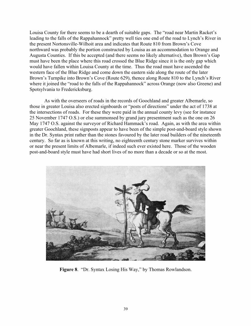
39
Louisa County for there seems to be a dearth of suitable gaps. The �road near Martin Racket�s leading to the falls of the Rappahannock� pretty well ties one end of the road to Lynch�s River in the present Nortonsville-Wilhoit area and indicates that Route 810 from Brown�s Cove northward was probably the portion constructed by Louisa as an accommodation to Orange and Augusta Counties. If this be accepted (and there seems no likely alternative), then Brown�s Gap must have been the place where this road crossed the Blue Ridge since it is the only gap which would have fallen within Louisa County at the time. Thus the road must have ascended the western face of the Blue Ridge and come down the eastern side along the route of the later Brown�s Turnpike into Brown�s Cove (Route 629), thence along Route 810 to the Lynch�s River where it joined the �road to the falls of the Rappahannock� across Orange (now also Greene) and Spotsylvania to Fredericksburg.
As with the overseers of roads in the records of Goochland and greater Albemarle, so those in greater Louisa also erected signboards or �posts of directions� under the act of 1738 at the intersections of roads. For these they were paid in the annual county levy (see for instance 25 November 1747 O.S.) or else summonsed by grand jury presentment such as the one on 26 May 1747 O.S. against the surveyor of Richard Hammack�s road. Again, as with the area within greater Goochland, these signposts appear to have been of the simple post-and-board style shown in the Dr. Syntax print rather than the stones favoured by the later road builders of the nineteenth century. So far as is known at this writing, no eighteenth century stone marker survives within or near the present limits of Albemarle, if indeed such ever existed here. Those of the wooden post-and-board style must have had short lives of no more than a decade or so at the most.
Figure 8. �Dr. Syntax Losing His Way,� by Thomas Rowlandson.

40
The impediment to travel which the Southwest Mountain presented to the citizens of western Louisa County was emphasised by an order on 22 April 1746 O.S. From the extant evidence it would appear that up to this time the road through the Turkey Sag was the only road passage of the mountain within Louisa County. To the south, in newly-created greater Albemarle, the Three Notch�d Road passed the mountain through the Rivanna water gap, and to the north in Orange County, the road to the falls of the Rappahannock� at Fredericksburg passed the mountain along the path of the present Route 20 near Orange Court House, but no other pass seems to have yet been opened within Louisa.
Now, with this order (22 April 1746 O.S.), the court was apparently attempting to remedy this lack or, at the least, to make available an alternative to the Turkey Sag road. The court now called for �a road to be cleared on the ridge between the south & North Rivers to Todd�s pass� and ordered several road surveyors and their gangs to layoff and clear the road. Presumably the �south & North Rivers� here referred to are the North and South Anna Rivers and the �Todd�s pass� an unidentified gap in the Southwest Mountain somewhere near the present boundary of Albemarle, Orange and Louisa. Since it is known that a man named Todd owned considerable land between Gordonsville and Orange Court House along the Southwest Mountain, this seems the likely location. Besides this, the names �Couhar� and �Land� (Cowherd and Lam), cited in the road order, still exist in this area.
Based on these assumptions, there then seem to exist two good possibilities for this road. The first and easiest is to simply take this road to be the present Route 33 extending up through Gordonsville and over the Southwest Mountain, thence into the up-country portion of what was then western Louisa County. Unfortunately Gordonsville, the pass and the road lie in (and then lay in) Orange County a good part of the way. It is extremely unlikely that the Louisa authorities would have attempted to build such a road, unless what they intended was to be only a road to connect with an already existing road through Todd�s pass. In that case, Route 33 from Trevillian�s Station to Gordonsville might have been the piece of road in question. When one examines the names of titheables appointed to clear the road, however, the selection seems rather heavily weighted in favour of people living considerably west of the Southwest Mountain. From this fact one is inclined to look for a route that would have fallen completely within Louisa at the time, and to look for a continuous road stretching to the westward.
The head stream of the North Anna River lies in Orange County between Gordonsville and Orange Court House and that of the South Anna River also runs south of Gordonsville after it issues from the Southwest Mountain west of the town. Therefore any road lying between this head stream and the county line would qualify as having been �on the ridge between the south & North Rivers� and within greater Louisa County in 1746, the time of this road order. One such road exists. From Route 231 this road runs along the line of Routes 646 ► 608 ► 645 to the end of state maintenance, thence along an old roadbed across the Southwest Mountain to where Route 641 begins on the western side of the ridge. From this point 641 provides a good route west by Burnley and Advance Mills to the area serviced by the Buck Mountain Road as well as that area along the northern side of the North Fork of the Rivanna River, here much more easily forded than it is lower down.

41
Besides this road paralleling the Buck Mountain Road westward, settlement in the Brown�s Cove area near the Blue Ridge brought forth a petition (on 22 April 1746 O.S.) from Benjamin Brown �for a bridle way to be cleared from Doyles River down into Ennis�s road�.� From deeds in Louisa County it appears that the Ennis Family owned land on the waters of Rocky Creek east of Fox Mountain at least by the 1750�s, and were probably there earlier, so that the road here petitioned for was probably either along the line of Route 668 (presently called the Fox Mountain Road) or Routes 672 and 821, both leading from Doyle�s River in Brown�s Cove into the Rocky Creek watershed and providing a connection with the main county road (Buck Mountain Road) leading east to Louisa Court House and the river ports. Although viewers were appointed, nothing seems to have been done. A year later, on 23 June 1747 O.S., Brown�s petition was again mentioned as being �Continued till the next Court�.� Although road orders after 1748 are lost it seems likely that this bridle path was opened shortly in view of Brown�s establishment of his seat in the cove which still bears his name.
Another petitioner for a bridle way or path, John Bryson, or Brison, seems to have
achieved success earlier. Petitioning on 26 August 1746 O.S. for one to be opened from �the County Line to Martin Hackets� near the present Nortonsville, Bryson succeeded in having viewers appointed. Petitioning again in the September and January courts, he finally received permission for the bridle path at the February meeting of the Louisa County Court (24 February 1746 O.S.).
On 25 August 1747 O.S. viewers were appointed for �the way; where Mr. Martin�s roling
path comes into the road over the north river; below Wm. Carrs quarter into Buck mountain road�,� and on 24 November 1747 O.S. the court issued orders for �Thomas Henry�s Gang, Jno. Mccollys, Richd. Hammack & William Coursey�s� to �meet & open the same� with David Watts as overseer.
From the wording and location this could be merely an improvement to the existing
crossing of the river and attendant grades on the Buck Mountain Road, the logical consequence of several years� use of the road as initially constructed. Or, alternatively, this might have been the road which once connected Route 649 (Buck Mtn.Rd.) and Route 600 above the present Stony Point. A stub portion of this road survives in service as Route 785, running from the Buck Mountain Road (Route 649) north toward the Rivanna River.
The remaining citations in these Louisa County orders serve to emphasise some of the
points made earlier concerning roads in general in the eighteenth century Virginia counties. A good instance of the division of roads into shortened segments under separate surveyors occurred on 24 February 1746 O.S. when the Fredericksburg Road, essentially the present Route 231 from near Keswick to the Orange County line, was divided into three portions. Running through an area in which there had been settlement for almost fifteen years and serving as a main road to Fredericksburg for those living in the then giant Albemarle County, as well as those beyond the Blue Ridge in Augusta County, the road must have been much in need of maintenance as a result of constant and heavy use. Remember, Fredericksburg was somewhat closer than Richmond to many of these people; besides, this road presented a more gentle series of grades than did the Three Notch�d Road to Richmond.

42
The three segments into which the Fredericksburg Road was divided on 24 February 1746 O.S. were not quite equal. There were about ten miles of the road in Louisa County, from the Albemarle County line (then near the present Keswick) to the Orange County line. The first of these orders directed that �Majr: Meriwether, Micajah Clark, Bolen Clark & William Harris; and the Labouring male Tithables belonging to each of them do clear the road from Albemarle line to Colo: Lewis�s mill��and appointed Micajah Clark overseer. The Colonel Lewis here referred to was, of course, Robert Lewis of Belvoir, the son-in-law of Nicholas Meriwether II.
The next portion of the road was referred to in the order as �the Road from Colo: Lewis�s
mill to the new road� and must have been that portion of the Fredericksburg Road from Belvoir to the point where the new road through the Turkey Sag (Route 640) intersected it. This was to have �Robert Lewis Gentleman� as overseer and was to be cleared by �Colo: Lewis�s people & Anthony Pate�s,� that is, the slaves of Lewis and Pate.
The final section of the road was that from the �new road� (Turkey Sag Road) to the Orange County line and was the longest of the three sections. Whether this was because of its ease of maintenance or the size of the labor force actually available to do the work is difficult to say. John Meriwether was to be overseer with the hands of James Meriwether, Colonel Lewis�s Quarter (presumably a separate slave corps to the previously mentioned �Colo: Lewis�s people�), John Moore, George Eastham and five of Samuel Dalton�s to do the actual work. Although it is very difficult to estimate the number of slaves represented by these rather cryptic notations, they would appear to represent about as many as those assigned to the first segment, and to the second, if Colonel Lewis be assumed a large slaveholder. Therefore, the terrain traversed by the road in this area may have made it so much easier to maintain that a larger distance could be covered by approximately the same number of hands.
That signposts were erected in this area, as well as elsewhere in Louisa County, is also evident from the orders in the surviving first book. On 11 June 1744 O.S. the order book repeats in almost verbatim form the 1738 Act of the Assembly calling for the erection of signposts. By this time the Louisa County government had been operating for about eighteen months and, whether through an oversight on the part of the justices, or because there had been a sufficiency of posts erected under the overseers appointed by Hanover County, no provision had yet been made for signposts.
Following the entry of this order, a number were erected in this western part of Louisa as
well as elsewhere throughout the county, not without some prodding of the overseers by the justices in order to get compliance with the act. The first posts to be erected in this western area were by one John McCauley (here spelled Mccolly) for which he was paid 80 pounds of tobacco on 26 November 1745 O.S. Payments made to others a couple of years later indicate that the going rate was 20 pounds per signpost, so that McCauley apparently erected four posts. If not, then he may have erected a large post with a number of boards on it at some main intersection. Unfortunately, the existing records leave unclear on which road these signs were erected.
The next notation in this area concerns �the Surveyor of Richard Hammacks road,�
summoned on 26 May 1747 O.S. to appear before the grand jury for �not Setting up a Post of

43
directions according to Law.� Apparently he too made his peace with the justices since there is no record of his being fined, and on 25 March 1747 O.S. he was paid 40 pounds of tobacco for setting up �two posts of directions.� Besides Richard Hammack, Thomas Henry was also paid at this time for the erection of a signpost in this area.
Although, as previously stated, it would be difficult to pinpoint the actual location of these signposts and the others which must have been shortly erected, some conjecture here is not amiss, given our knowledge of what were the main roads and the most likely routes of travel in the area. Looking first to the Fredericksburg Road on the eastern side of the Southwest Mountain, signposts must have been erected at the intersection of the Mountain Road with it near the present Cismont (intersection Routes 22 and 231 there) and at the Turkey Sag Road (Route 640) to the west. No doubt one also existed just over in Albemarle at its intersection with the Three Notch�d Road. At this important point travellers from the Valley had a choice of roads, one going to Fredericksburg and the other to Richmond.
Beyond the Southwest Mountain lay the road along the line of Route 20, called at first Coursey�s Road and much later the Orange Court House Road, which, although the terrain was more hilly, also led ultimately to Fredericksburg Just above Stony Point the road through the Turkey Sag entered this road, providing access to Louisa Court House and the Hanover County ports of New Castle and Hanover Town, as well as Richmond. As it was the principal county road leading east, a sign must have been erected here. At the present village of Stony Point the Buck Mountain Road diverged to cross the Rivanna River and head west, serving as the main road for all that western part of Louisa to the Blue Ridge. Here, also, signs would have been necessary to direct travellers properly. Indeed, of the few signs mentioned in the surviving records, all are associated with the names of overseers of roads living near the Southwest Mountain. Shortly, the road intersections now known as Earlysville, Ehart and Free Union must have also demanded signboards although we have no early records of them.
Just what each of these boards said to the traveller must have depended to some extent upon the mind of the individual surveyor of roads in these early days before the establishment of villages in this area. How he construed the words �the most noted Place, to which each of the Said joining roads leads� determined the lettering upon the board. Signs oriented �down the country� toward the ports could bear the names of Louisa Court House, Orange Court House, Hanover Court House, Richmond and Fredericksburg, but the overseer must have often found himself in a quandry attempting to divine what was �the most noted Place� in a part of the country as yet possessed of nothing but a few outlying plantations.
By 1748 most of that road network which we see today when we look at the map of Albemarle County was in place. Indeed, could a knowledgeable twentieth century resident of the county be transported back through time to 1748, he would, almost instantly recognising where he was, have little difficulty finding his way about the countryside. True, nothing worthy of the name town could he find, no Charlottesville, no Scottsville, no Crozet, nor any of the small villages such as Free Union, Earlysville and Alberene, but the roads themselves would be in most cases very nearly on their present locations.

44
Along the north side of James River he would find the River Road, running from Richmond �up the country� by the first Albemarle Court House and into the Tye River area. Bisecting the fork between the Rivanna and James River he would find the Secretary�s Road running from near Bremo, crossing the River Road, to pass along the ridge between the two rivers, passing through the Secretary�s Quarter east of Carter�s Mountain and across that mountain at the Thoroughfare, where in twenty years Thomas Jefferson would begin to raise Monticello, to end at the Secretary�s Ford on the Three Notch�d Road.
This last road, sometimes still called the Mountain Road, Mountain Ridge Road or Three Notch d Mountain Road, by those who used it, also ran �up the country,� from the fledgling town of Richmond at the falls of the James, to cross the Rivanna River at the Secretary�s Ford, thence up the hill past the future site of Charlottesville and westward over hill and dale to pass through the Blue Ridge at Wood�s Gap.
From Secretary�s Ford northward along the westward side of the Southwest Mountain ran a road to Orange Court House, while a few miles to the eastward along Three Notch�d Road the Fredericksburg Road diverged, and following along the eastern face of the mountain through the Meriwether patent, led to Fredericksburg.
A few miles up this road our traveller through time would find it intersected by the Old Mountain Road, which ran �down the country� to the ports of New Castle, Hanovertown and Richmond. From this point a fairly easy passage of the Southwest Mountain was available along the road through the Turkey Sag and into the road to Orange Court House on the western side.
Continuing onward, our man on horseback might set his face to the west and, continuing �up the country,� follow the Buck Mountain Road down across the Rivanna River and up along the ridges past the recently erected Buck Mountain Church and John Henry�s Quarter, where Michie Tavern would begin to rise before many years had passed, along Ennis�s Road over into Brown�s Cove, the most western part of Louisa. Or he might cross Moorman�s River, continuing back into the Three Notch�d Road near what would a century later become the site of Crozet.
Proceeding back to the east along the Three Notch�d Road our peripatetic friend would have several opportunities to turn toward Rockfish Gap and the Rockfish Valley, among them the road leaving his path at the crossing of Mechum�s River and that at the D.S. Tree. If temptation could be resisted long enough for him to reach the area near the Secretary�s Ford, where the Secretary�s Road connected with the Three Notch�d Road, a turn to the south along the road on the west side of Carter�s Mountain leading to the Secretary�s Mill on the Hardware River would take him over another familiar road.
Once at the Secretary�s Mill on the Hardware River, our traveller might choose to continue on toward the county seat, on the James River for a few years yet, or taking the

45
other Secretary�s Road to the Tye River, proceed toward Joplin�s Ford on the Rockfish River. Whatever the area chosen for his further peregrinations, he would already have been struck by the overwhelming coincidence of the eighteenth century road system with that of his own time, marvelling at the skill with which these visionary engineers of the early period were, with none of the benefits of modern technology, able to thread their way over, through and around the plethora of obstacles which nature had placed in their way, building roads which have survived the succeeding centuries of use as little changed as they have.
Figure 9. Buck Mountain Church, circa 1747. The last surviving one of the three original churches of Fredericksville Parish (Lay).

46

47
THE RECORDLESS YEARS 1748-1783
Styling this section thus is perhaps not entirely justified since some records actually do
exist for this period. Nevertheless the prime source would have been the road orders in the missing Albemarle County Order Books 1748-1783, and, to a somewhat lesser extent, those in the Louisa County Order Books 1748-1761, also, coincidentally, lost. It is then in the sense of these prime sources being no longer available to us that we call this period �the recordless years.�
While it is true that a considerable body of material has survived in the form of deeds and
plats, these serve better as corroborative material than as anything else, because they seldom provide the answers to such questions as why a road was built, or when and by whom. To answer these questions the road orders themselves are almost essential.
Besides the historical limitations inherent in the use of the deeds and plats, there is also
the problem of information retrieval unless deed abstracts are available. While early plats can be readily examined, to extract from the early deeds of a county all the bits of information relevant to road development would be a very time-consuming procedure and still might ultimately prove of little benefit to the researcher into road history. Where deed abstracts are available, as in the case of Louisa County 1742-1774, they can be resorted to with some benefit by the researcher, bearing in mind, of course, the rather limited use of roads as property boundaries in the early period.
Probably the most advantageous and effective use of deed information can be made by the spot search technique, which is essentially corroborative in nature. Here the area to be examined has usually been narrowed to several pieces of property adjacent to each other thought to be the approximate location of an early road whose location (and name) may have been changed over a long period of time. Even then the title search and plat examination will often produce conflicting data and pose questions which simply cannot be resolved with the existing information.
A word might be inserted here concerning the dating of evidence as it relates to the initial opening of a road. With no good early maps existing for most countries, contemporary road orders are usually the best source, when they are obtainable, with plats, maps, deeds and whatever else is available serving to confirm the road orders. The nearer the date of any of these latter to the date of the initial series of order concerning the road, the better they should be considered as evidence in a particular case. Now, as it often transpires that this other evidence may be separated from the orders by a considerable period of time, and that this evidence may either conflict with the earlier evidence or even with all of the other later supporting evidence, it seems that some exclusionary rule should be formulated for such cases.
With this need in view, and taking into consideration the experience of all those associated with this project in attempting to research the eighteenth century roads of

48
Albemarle, it would seem that the greatest weight should be given to that evidence falling within a 25 to 30-year period following the initial orders concerning the road, and somewhat less to that falling within a 30 to 60-year period after the initial orders.
That evidence dating as much as, or more than, 50 or 60 years after a road was initially opened should probably be viewed very critically. There are a number of reasons for this. First, in the eighteenth century a period of this length would probably have exceeded the lifespan of most men, and therefore of living memory, and would have become dependent to a greater extent upon traditional knowledge, that handed down from father to son. Thus, errors might have crept in during the second generation. Second, roads constructed about the threshold of settlement and during the succeeding two decades or so were probably more likely to be moved slightly during this time as whatever deficiencies existed in the original route came to be corrected. Then, as population increased and new counties were created, county seats moved and boundaries rearranged, routes of travel were often altered and what had been an important road turned into little more than a disused path.
Fortunately, the basic road network of the area now within Albemarle County seems to have been pretty well laid by 1748 so that the difficulties occasioned by the record loss in both Albemarle and Louisa Counties are not nearly so severe as they would have been had the first order book of Albemarle (1744-1748), the first order book of Louisa (1742-1748) or some portion of the Goochland order books during the 1730�s been lost. Continuous coverage is available for the period 1748-1783 in the plats in the Surveyor�s Books and these offer a number of clues to road development during this period. In addition to those certainties which these plats provide, various probabilities exist as a result of the division of the county in 1761 and the subsequent removal of the courthouse from near Scottsville to Charlottesville the next year. Some of these have already been touched on rather briefly in the remarks on the early bridges within and near the county.
Beyond this, the historical forces external to the county but acting upon it have to be
taken into account as the tide of settlement rolled westward across and through the Valley and into the present states of West Virginia and Kentucky, although settlement probably begins to make itself felt more in the years following the Revolution, for which road orders do still exist. With the foregoing in mind, this period may then be dealt with in something less than the extended, rigourous manner of the better documented formative period of the early years.
With a good proportion of the road network laid down by 1748 and the 1761 division of
greater Albemarle a considerable distance in the future, a brief summation of river transportation in the area, insofar as it can be known, is now in order. River transportation has already been mentioned rather briefly in this narrative as it may have related to the development of the Secretary�s Road from the vicinity of Bremo to near Carter�s Bridge. However, this was at the

49
very earliest period and something more can be learned from Hening�s Statutes and the recently published Diary of Robert Rose, edited by the Reverend Ralph E. Fall of Port Royal, Virginia. Besides providing a great deal of detailed information not readily available elsewhere on early travels and road building in the area by one of Albemarle�s �first gentlemen,� the Reverend Robert Rose, this diary provides a much-needed inside view of the internal workings of an up-country tobacco plantation and how its product was transported via the Tye and James Rivers on the double-dugout canoe invented by the Reverend Mr. Rose.
In the section dealing with the 1734 Secretary�s Rolling Road from Bremo to the vicinity of Carter�s Bridge it was stated that a blockage or blockages of the James River somewhere above Bremo seemed possible. At best, the river was unimproved as yet. It was further stated that the nearest and most likely place above Bremo for this blockage would seem to have been at Seven Islands, although others may have existed. These blockages, whether rocks, shoals or islands, in many places no doubt also contained piles of brush and uprooted trees, making navigation extremely uncertain.
Just what the condition of the river above Bremo was at the time of the formation of Albemarle County in 1744 seems thus far unclear, but that difficulties existed in the 1730�s and well into the 1740�s is manifest from legislation enacted in February 1745 (Hening V, 375, 377, et seq.) by the General Assembly. This legislation, nearly contemporaneous with the formation of Albemarle County, consisted of two acts. The first of them (Hening V, 375) was a general act empowering county courts to open rivers for navigation, while the second (Hening, V, 377) much more specific, directed its efforts toward the clearing of the Fluvanna River, the name then current for the James River above Point of Fork, and appropriated £100 to be placed in the hands of Trustees for the clearing of the �Rocky places� in the river. Rather significantly, three of the trustees named, Joshua Fry, Peter Jefferson and Charles Lynch, were prime movers in the development of early Albemarle, and, one also suspects, were probably the authors of this particular bill. The remaining two, Benjamin Cocke and William Randolph, were from the area along the lower part of the James River nearer to Richmond.
Whatever was accomplished as a result of this legislation, much room for improvement still existed when Robert Rose began sending his tobacco canoes downward from the Tye River area a few years later. Just when he did is somewhat unclear, the generally accepted date being 1748, when on March 14 he noted in his diary that �Richard Ripley and My people were making a Canoe, being the 3d for carrying Down Tobo�.�. Although subsequent notations appear to indicate a growing interest in and use of the canoes by Rose in his various enterprises, it probably could be argued that the first use of the canoes occurred the previous year. Then, on 10 September 1747 O.S. Rose noted in his diary: ��received an Acct from Mr. Thos. Atcheson that eleven hhds of my Tye River tobo was got down & Inspected: the first Fruits of seven years� Labour, having first seated these plantations by John Ray in Febry 1739/40�.� From this it is evident that Rose had already moved some tobacco from the Tye River to Richmond, where Atcheson was a tobacco inspector, but whether by rolling, by waggon or by water is uncertain.

50
While it seems that Rose ought to have mentioned it had the canoes been involved, his notations are often incomplete in this regard. That the notation of 14 March, 1748 O.S., the first to specifically mention canoes, refers to the one then under construction as the third one adds to the confusion. One is left to speculate as to just when the other two were constructed. Whether they were as yet being lashed together in pairs as operational units, an innovation attributed to Rose, is also unclear. There is also no mention of any prior reconnaissance by water of the Tye River, which seems to indicate the possibility of a trip the previous year. Indeed, it would appear that Rose entered the tobacco transportation business with his canoes� first trip down the river.
Whatever the case, on 16 March 1748 O.S. Rose�s tobacco canoes did leave his plantation at the intersection of the Tye and Piney Rivers, proceeding down the Tye River to the James where they took on board �some Tobo of Mr. Harvie�s� and proceeded on down the James River toward Richmond. The Reverend Mr. Rose�s brother, Alexander, his overseer and the joiner, Richard Ripley, who had constructed some or all of the canoes, went down on the canoes �some Miles to see the Nature of the Navigation,� returning on foot. Thus, proof that the James River was navigable to a greater or lesser degree, by at least 1747 or 1748, and was being navigated along the present southern border of Albemarle County.
From this time until the Diary ends in 1751, there are a number of notations concerning the canoes and river navigation. A few months later (5 May 1749 O.S.) �my man Titus came home having run away from the canoes,� notes Rose, an apparent reference to one of the slaves manning the canoes. A remark on the nineteenth of the same month casts some doubt on the efficacy of whatever arrangements had been made by the trustees appointed by the Act of 1745 to be responsible for clearing the James River. �Viewed the Seven Islands & think it a place safely to be made navigable,� says Rose of a horseback visit to the place. Not all his activities on behalf of river navigation ended happily, as on the twenty-fifth he noted: �tumbled out of Canoe into the River.� The next March (1749 O.S.) he stated that his people were busy making canoes and on the twenty-ninth he noted the departure of four canoes manned by five people. Again Rose, his brother, and this time his son, rode down some way with them and walked back. Presumably this was to aid in the passage of the more difficult Tye River, their presence probably becoming unnecessary once the James River was reached. Although stated as �4 canoes� these were probably by this time lashed together in pairs with two people riding each pair. Each pair could have carried nine or ten hogsheads of tobacco weighing a total of five or six thousand pounds down to the warehouses at Richmond.
It is evident from the next citation concerning the canoe that Rose was far from complete in his entries on this subject. Without previous mention of their departure downriver, on 27 June 1750 O.S., he wrote: ��this Evening my Watermen got home having safely carried down fifty & two hhds of Tobo 29 of which are mine, two Mr. Benger�s, 6 R. Powel�s, 9 Edwd Spencer�s, 3 �Timo o�Brian�s, one Thomas Jone�s, one Mr. Goodwin�s, one Wm. Ogilsby�s.� By this time he

51
was acting as a wholesale transporter of tobacco for the adjoining planters besides the many other activities he engaged in. Unfortunately we do not know how many of the double canoes were used to transport these 52 hogsheads of tobacco, although it seems a minimum of six would have been required, if not more.
Were similar early documentary evidence available for other large up-country planters it is likely that a number of them would exhibit this same preoccupation with transportation, both land and water. Indeed, the records of John Smith, a planter of the 1750s on the Staunton River in the neighbourhood of the present town of Altavista, reveal that much of his tobacco travelled overland to the James River near the later site of Lynchburg and thence by water down the James River by the same route as Rose�s to Richmond.
In July 1750 O.S. Rose travelled by canoe from Seven Islands down the river to
Tuckahoe, where he visited with Colonel Peter Jefferson and then rode into Richmond. Rose says that the �Journey by Water was to view the River which may be made a very safe conveyance, considering that I was able to steer thro all the Falls without any difficulty.� In a few short years, of course, many other Virginia gentlemen would be thinking in terms of river navigations and, a bit later, canals, and the James River would become the focus of Virginia�s great effort in internal improvements under the Board of Public Works during the first half of the nineteenth century. Always with an eye to advantages in water transportation, Rose while travelling beyond the Blue Ridge at John Salling�s house near the site of present Glasgow, just above Balcony Falls on the James River, in one of the last entries in his Diary noted that Salling had �every advantage except the conveniency of water Carriage�.�
That Rose�s example may have proven worthy of emulation some twenty years later in
the improvements to navigation of the Rivanna River is not unlikely. Where Peter Jefferson, the father, had been involved in the improvement to the James River, Thomas Jefferson was the driving force behind a 1765 scheme embodied in an Act of the Assembly to make the Rivanna navigable from about the site of the later town of Milton down to its mouth. If the formation of Albemarle County was what gave impetus to the James River improvements, then the 1761 division of the county and the subsequent relocation of the county seat onto the Three Notch�d Road at what came to be called Charlottesville must be considered the cause of the Rivanna improvements. As in the case of the James River, the Rivanna River would also in the nineteenth century grow into a better articulated system incorporating locks and canals, although it would always remain a somewhat local enterprise. We shall return to this subject at a later time as it relates to the development of the town of Milton.
In addition to his interest in water transportation, the best and most practical method for the conveyance of tobacco when available, Rose also occasionally turned his attention to the matter of roads and road building, thus providing some first-hand evidence concerning a subject about which little was usually written by those regularly involved in it. In this context Rose has been mentioned several times before, with particular emphasis on his travels along the

52
Secretary�s Road between the Tye River and Carter�s Mill near Carter�s Bridge, and also his remarks on making the Rockfish Gap passable by carriages.
Rose was also involved in the construction of several roads and bridges, a not unusual employment for a planter, as has previously been pointed out in the section on bridges. Besides the entries dealing with his travels and road construction, some touch upon larger subjects, such as the one on 13 October 1748 O.S. which mentions his conversing with a group �travelling from Chenandoa to the Atkin River in Carolina� (Shenandoah to the Yadkin River in western North Carolina), probably indicating that it was already possible for a wagon to cross the Rockfish Gap and proceed down the Rockfish Valley, thence to the Tye River area and across the James River and into Carolina.
In another entry (27 January 1748 O.S.) he mentions passing along �a Ridge marked for a Road.� Later the same month, and continuing into February, he was himself engaged in road building and bridge building operations:
January 30 Cloudy, went with Mr. Harvie and my people on the Buffalow Road, moved a heap of stones�
January 31 Returned to ye Road, laid a bridge over Naked Creek and part of another over a fine Spring Branch, returned in the Night �
February 1 Finished the Bridge over the Spring Branch, cut down the Bank at Buffalow, levelled part of ye Hill by Naked Creek & got Home at Night, these 3 days has cost Me 36 Men�s labour, to do my Neighbours a pleasure before I have got Necessarys for myself �
� 2 Went with John Blyre, and cleared a Road thro Capt. Wilcox�s land towads the Mill, very Cold, returned Home to Dinner-
� 3 Went & finished the above road being two Miles from one Rolling Road to the other, very Cold, got home about 3 pm -
The foregoing will enable the reader to gain some idea of what road building operations
were like in the greater Albemarle and its environs in the mid-eighteenth century. Of particular interest is the scale of the operations here cited. Rose mentions using 36 men, apparently most of the slave force at his home plantation, which numbered 39 at his death in 1751. Although this is a sizeable number of men to be employed on a project of this sort, he could have added about 20 more to this total had he also employed those slaves of his on adjacent plantations, without taking into account whatever white indentured servants he may have possessed. Besides these, he still had a number of slaves located on his plantations in Essex and Orange Counties. Too often, a casual reading of a road order reveals only the names of several planters and, while cognizant of the engineering and managerial skills of these men, one often fails to take into

53
account the potential labour force made available for road work when two or three planters of the stature of Rose were assigned a road to clear or open. From the number of slaves known to be in the possession of many of these men at death it would appear that the employment of 100 or more men at one time in constructing or opening a road would not have been a difficult or unusual thing.
Besides the magnitude of the labour force employed by Rose, the amount of grading or levelling of hills is somewhat surprising in light of the prevalent notion that such activities were extremely minimal in most of the early road building due to the lack of any sort of equipment beyond the pick and shovel of the individual labourer. What is perhaps forgotten here is that a paucity of equipment can often be overcome or ameliorated by a sufficiency of manpower, properly applied. The bridges Rose mentions were probably of the smaller variety erected by surveyors of roads as a routine part of their function rather than the larger type which usually required a separate agreement by the undertaker with the gentlemen justices of the county court.
While we should be thankful for this insight provided by Rose�s Diary, it is unfortunate that none of the other entries deal with roads in such detail, although he does mention �reconnoitring� a road (6 June and 27 September 1750 O.S.), that he �obtain�d leave to open a Road to Rockfish� (14 August 1750 O.S.) and on 9 February 1758 O.S. he mentions again that he �went and worked with ye people on ye Road all day,� indicating as usual his close supervision of, and participation in, that road building activity with which he was connected. While we might wish for more, road building is one of those activities which, like tobacco planting, seems to have been considered so humdrum and commonplace as to be beneath being written about.
Turning next to those roads which are shown on plats in the surviving three Surveyors Books 1744-1853, we shall consider several of those which first appear during these �recordless years,� either not previously appearing in the surviving road orders or else not being known by their various names during that period. References to plats will be in that form used and described in the author�s An Index to Roads in the Albemarle County Surveyors Books 1744-1853 (Virginia Highway & Transportation Research Council, 1976), where cited.
One of the first plats of interest refers to a road west of Carter�s Mountain on the land of one Daniel Jones on Sowell�s Spring Creek near present Carter�s Bridge as Martin King�s Road. (I 162). Sowell�s Spring Creek would appear to have been the present Sowell�s Branch, which flows into the Hardware River above the intersection of Routes 708 and 20. If so, then this plat raises some interesting questions concerning the configuration of the original roads at this point, the approximate location of the Secretary�s Mill of the early 1730�s. Although both the Peyton Map of 1875 and the Massie Map of 1906 show Martin King�s Road stopping at the intersection at Woodridge with that portion from there to Carter�s Bridge mislabelled Secretary�s Road, recent research indicates it continued on towards Carter�s Bridge, going at least as far as the site
54
of the Forge Church on Route 708 a mile below Carter�s Bridge. A plat showing the road west of Carter�s Mountain is also reported to exist.
Heretofore, it was assumed that its terminus was probably the Secretary�s Mill or, roughly, Little Carter�s Bridge, so called, just above the junction of the north and south forks of the Hardware River, and that the early arrangement of roads there probably did not differ materially from that existing up until the replacement, in the last twenty years, of the metal truss bridge by the concrete span.
The existence of this plat, dated 17 March 1747 O.S., now clearly calls much of this into question. Because of its early date, within twenty years of the date of the Secretary�s patenting of the area in 1730, it seems unlikely that this plat is the result of an error on the part of the surveyor or is based on hearsay or legendary lore. With Sowell�s Branch flowing into the Hardware River from the north side, the plat showing Martin King�s Road in this area would seem to indicate that the original road junction may have existed a considerable ways above the present one at Little Carter�s Bridge, may have even been above the Secretary�s Mill rather than below it, as has been previously thought. When the architectural survey along Martin King�s Road and/or the Secretary�s Road is ultimately completed, and if the original location of the Secretary�s Mill can be found, it is possible these questions may be resolved. Perhaps the configuration of the present road developed after the time when the mill ceased to be the focal point of the community, whether through disuse or destruction. The answer may lie in researching the deeds in the area.
Probably the next significant citation (1I-120) is to Stockton�s Thoroughfare, although no road is actually indicated on the plat. Indeed, this is the most significant thing about it, the fact that there is no road shown at this date, 7 November 749 O.S. Stockton�s Thoroughfare (or pass) is now known as Israel�s Gap, where the road from Batesville, originally Israel�s Store, (Route 692) passes through the Ragged Mountains to Route 29 at the Crossroads. Not only is no road shown in the 1749 plat, but it is unlikely that there was anything worthy of the name road here before the 1780s, when road order coverage resumes. About 1790 a road was opened through this gap as part of a scheme to connect the Valley with the river port of Warren, then being promoted by Wilson Cary Nicholas as a rival for Scottsville. Later, this road would become a part of the Staunton and James River Turnpike, sometimes referred to locally as the Plank Road.
Another plat of 1749 (1I 120) illustrates the continuance in occasional use of the name
Mountain Road for the Three Notch�d Road. Called more often the Three Notch�d Road in the years following 1742, this was the preferred form in most of the fifteen or so times the road appears in the Surveyors Books between 1744 and 1853. Interspersed with the hereinbefore mentioned plats are many others which serve to further corroborate the information provided by the earlier road orders as well as the nineteenth century maps of the area. Since they present no

55
essentially new information, most of these will be passed over with little mention here unless they serve to illustrate some process such as the evolution of the same Three Notch�d Road.
A pair of 1754 plats (1I 260) illustrate another problem often encountered in road
research. Both of these show a road labelled Rockfish Road and would appear to be located in the area along Route 6 near Schuyler in the southern part of present Albemarle. On one, branches of Ivy Creek are shown; on the other, branches of Kirby�s Creek. Unfortunately, there are two streams named Ivy Creek now within Albemarle County. (There were then three or more). That in the northern part of the county also has a road traversing its head branches which may have been called Rockfish Road at this early period, before it came to be called Dick Wood�s Road, since branches of it led both to the upper valley of the Rockfish River and to Rockfish Gap. In the southern part of the county the road along the line of present Route 6 through Butler�s Gap also led into the Rockfish Valley and could, with equal accuracy, also have been (and was) called Rockfish Road. The deciding factor in determining the southern location of this particular plat was the ownership of the lands in question by John Burns, a known resident of this area, and, presumably, his brother George, owner of the land shown on the plat.
All of which leads us into the next plat of more than passing interest while serving to illustrate another of the general principles involved in research into road history. This plat (1I 309) of a survey completed in 1755 deals with another portion of the road which ran generally along the line of present Route 6. This portion was, however, somewhat to the east of the previous one, crossing Green Creek, and presents what would appear to be another name for this same road, the Irish Road. This plat is for a 1,388 acre plantation or quarter of Colonel Richard Randolph�s and shows the Irish Road crossing (apparently) the upper part of Green Creek, approximately as shown on later maps of the area. Although it may be used in some earlier deeds in the area, this is the earliest use of the name �Irish Road� found by the author and raises a number of rather interesting questions.
Wood�s History (p.68) notwithstanding, there seems to be no trace of the James Ireland to whom he ties the name Irish Road. There was a James Freeland, whose name, in the script of the time utilising the double small �f� in place of the capital, does appear to be Ireland. There may be at least two other possible explanations for the use of this name for this road.
Four plats, including the aforementioned Randolph plat, show this road, and all of these date between 1755 and 1775 and show the road on the branches of Green and Totier Creeks along the line of the present Route 6 and its antecedents, indicating that the name applied from about the vicinity of Scottsville to as far as Schuyler and perhaps farther. The last of these plats, dated 1775, calls the road the Irish Old Road, a name which could indicate disuse or that it was a portion superseded by a newer, straightened version of the road. Now, as has been previously stated, the name Irish Road not occurring in any of the road orders prior to 1748 would appear

56
to indicate its coming into use between that time and 1755, when it first appears on a plat. Later research in deeds along the line of the road may allow even more precise dating of the name.
With all this in mind one finds particularly interesting the fact that at approximately the same time, that is about l750, there occurred just a few miles to the west, beyond the Blue Ridge, the settlement of the lands of James Patton in the area which came to be called �the Irish Track,� or Irish Tract, the first form being the one shown on the later editions of the Fry-Jefferson Map of 1751. A considerable distance south of this Irish Tract, there also flows out of the Blue Ridge to the west a stream called Irish Creek, which heads near Irish Gap.
While Irish Creek and Irish Gap seem a bit far removed to be easily related to the Irish Road here in Albemarle, such is not the case with the Irish Tract. Any traveller crossing the Blue Ridge into the Rockfish Valley, and continuing down the Rockfish River toward the James, would find this the logical way to avoid the tortuous, narrow valley or gorge through which the lower part of the Rockfish River winds its way. Considering recent experience with floods along this route it was probably no easier to build and maintain a road along this line in the eighteenth century than it is today. Besides the matter of topography, this would also have been a considerably shorter route for a traveller bound for Richmond than would have the route following generally the line of the Rockfish River. Again, as investigation of the settlement of the Valley continues, confirmation of this explanation may be discovered in road orders in one of the Valley counties or in deeds in the area to the west of that part of the road which the plats clearly establish as having had the name Irish Road.
Turning from a macro-historical analysis to a micro-historical one, and taking only the known extent of the Irish Road, it is possible that the road actually has no long-range historical connection with the Irish Tract in the Valley at all, or with Irish Creek or Irish Gap, but instead owes its name to a derogatory reference to the poor quality of this particular stretch of road. While the Oxford English Dictionary lists nothing under �Irish road,� it does have a listing for �Irish Bridge,� which was nothing more than a stone-lined ditch across a public road. Neither Bennett Wood Green�s Word Book of Virginia Folk Speech nor the Oxford Book of English Proverbs provides any help, so that one is forced either to leave the question open or else to conclude that the allusion is possibly a locally developed one which did not gain any general currency elsewhere.
Little doubt exists concerning the naming of the Green Mountain Road (1I 314) shown on a plat on the branches of Eppes and Totier Creeks drawn for John Coles in 1755. The road ran on Green Mountain from near Carter�s Bridge to the vicinity of Esmont or Porter (Route 627). It is possible that Route 722 from Route 6 southwest to the Rockfish River may also have borne this name at times, whether it was originally a part of the Secretary�s Road of 1742 or not.

57
A plat of 1771 (2 I 88) may indicate the growing preference, by this time, of travellers for the better route through Rockfish Gap into the Valley over the one through Wood�s Gap along the Three Notch�d Road which is here called �Wood�s old Road� as it runs along Lickinghole Run, presumably the Lickinghole Creek of today. From the proximity of the road to the stream the location would appear to be in the valley leading up to Wood�s (now Jarman�s) Gap on either Route 691 or 611, although a short stretch of Route 680 at Mechum�s River might be equally close to this stream. By this time (1771) the road through Rockfish Gap would have been in service to a greater or lesser degree for about 25 years. In spite of this, the much worse Wood�s Gap passage of the mountain seems to have still remained in use, and even to have been preferred by some. As late as 1779 the Hessian prisoners were moved by this road to their place of detainment at the Barracks near Charlottesville.
Many notations on these plats remain cryptic in spite of efforts to decipher them because of the lack of road orders for the period. In some cases the road is unnamed or else is one which seems not to have survived in use and appears nowhere else. By this time, in the l770s, the use of the word �old� also raises the spectre of even those roads whose names have survived down to the present having had several courses during their early years. Are these the abandoned portions? Or does the word merely refer to their declining popularity? How can we be certain? The term �new road� oft-times proves equally worrisome. As in most road-related research, one lives with the expectation that parts of one�s findings will be either upset shortly or, at the least, modified considerably.
On the other hand, there are some plats which are absolutely positive in their location and naming of roads. Two 1777 plats are definitely of this type (2I 125 and 2I 126). The first of these shows the intersection near the present Boyd�s Tavern of the Three Notch�d Road (here Routes 759 ► 616 ► 794), Adam�s Road, later the Stage Road (Route 616), and Valentine Wood�s Rolling Road (Route 623). At the time of the plat Valentine Wood�s Rolling Road crossed Adam�s Road to join the Three Notch�d Road a bit east of its intersection with Adam�s Road.
Although this last mentioned portion has been abandoned the identification is no less positive, for the next plat is that for the line run to separate the newly created Fluvanna County from Albemarle in 1777 and both Adam�s Road and Three Notch�d Road are clearly shown near the northern end of the boundary line. It would be hard to wish for more positive proof of the names of these roads than that supplied by these plats.
This same 1777 plat dates �The new road that crosses Buck island creek at Colo. Wood�s quarter� (Route 53). Apparently traffic down the lower side of the Rivanna River had previously used a portion of the road running from the vicinity of McGhee�s Ford, later Milton (Route 729), to cross Buck Island Creek higher up, entering and/or crossing Martin King�s Road (Route 618) and continuing down the river. On another plat, this Route 729 appears to be labelled �Old Court House Road,� an excessively popular name found applied to many different roads on plats.

58
Figure 10. Plat showing the road configuration near Boyd�s Tavern. Compare this with the modern map reproduced in Figure 14.

59
Besides the aforementioned roads on the 1777 plat of the new Fluvanna line, there are shown Martin King�s Road, Bremo Road (another name for the Secretary�s Road), Roundabout Road (Route 773), Coles� Road (Route 637), and, again, Old Court House Road, the name this time being applied to the River Road (Route 6) just east of the site of Scottsville. Of these, several being important early roads have already had their origins described in detail in the previous section. The others, along with many other roads first mentioned on these plats, will be covered in some detail in the post-1783 section. However, before proceeding to that time when adequate records coverage resumes some consideration should be given to the political changes which occurred in 1761 and which had a direct bearing on the development of the Albemarle County road system.
From the formation of the county in 1744 until its division in 1761 and, indeed, until the removal of the county seat to Charlottesville, the principal axis of the county remained generally along the line of the James River, the water transportation link, and the road which ran along its northern bank by the courthouse, located slightly to the west of the present town of Scottsville, penetrating the mountain fastness of what we know today as the counties of Appomattox, Bedford, Campbell, Amherst and Nelson, but which were then within Albemarle, either wholly or in part.
During these years, the early or formative period of Albemarle�s history, this was the actual centerline of the county. Charlottesville did not yet exist and the courthouse was the place to which the people of the giant county of Albemarle came to conduct their business, both public and private, during these years. Those from the south side of James River crossed by the ferry, also located here.
Public business could be transacted at the courthouse and at the clerk�s office, while private business arrangements could be made with the members of the gentry and the yeomanry thronging the green on court days and refreshing themselves in the ordinary. At the ordinary they met their compatriots and conversed over a social glass, read the sometimes little more than a month old newspapers (or had them read to them) from London and Glasgow, amused themselves with games of one sort or another, and, often, also conducted their business affairs. The genial tavern keeper stood always ready with a bowl of punch, a toddy or a julep, a copy of the Virginia Gazette, and a hilarious anecdote or two.
In l761 came the division of the county and the creation of Buckingham, including then a part of the present Appomattox County, and the creation of Amherst, which then also included Nelson. With these changes the giant Albemarle County of 1744 was greatly reduced in size and drastically altered in its configuration. In 1754 that westerly portion lying to the south of the James River had been lost to Bedford County, which was formed that year, so that with the 1761 division a rather strange elongated shape would have been produced had not the western portion of Louisa County been ceded to Albemarle. The end result of all these changes was an Albemarle County consisting of what are today� s Albemarle and Fluvanna Counties. In 1777 Fluvanna would become a separate county itself, but this gets ahead of our narrative.

60
This new shape left the old county seat on the James River on the periphery of the new, post-1761 county, making it inconvenient for many of the people who now found themselves within Albemarle County. In short, the legal facilities of the county were no longer anywhere near being centrally located, always a prime consideration in the location of a county seat. Without going into all the known details of the matter, the result of this was the movement of the seat of government to a site near the point where the Three Notch�d Road, a major east-west artery, crossed the Rivanna River at Secretary�s Ford in the water gap in the Southwest Mountain, at the place which we know today as Charlottesville.
Perceptive readers will no doubt already have noted the confluence of many important
roads at or near this point, making it in many respects a somewhat ideal location for a town site as well as a county seat. From the direction of �the Fork� between the Rivanna and James Rivers, which would in 1777 become Fluvanna County, came the Secretary�s Road terminating at the Secretary�s Ford where Three Notch�d Road, on its way from Richmond to the Valley, crossed the Rivanna River. Just across the river the road from Orange Court House and Fredericksburg which followed the western side of the Southwest Mountain joined Three Notch�d Road, while several miles farther eastward, beyond the Southwest Mountain, the Fredericksburg Road left the Three Notch�d Road somewhere near the Twelve Mile Tree, followed up the eastern side of the mountain and thence along the watershed between the Rappahannock and the North Anna and the various branches of the Mattaponi made its way to the port of Fredericksburg.
To the north of the site of Charlottesville a road ran in from the ferry at Pen Park, which
allowed travellers on the Orange Court House Road access in times of high water. A few miles to the west, at the D.S. Tree on the Three Notch�d Road, a road skirting the western side of the Ragged Mountains entered from the Rockfish Valley. By this road and others to the west of it, passage could be had through Rockfish Gap from the Valley. Entering the Three Notch�d Road from the south, within sight of Charlottesville, were the road from the Secretary�s Mill and the area of the old court house on the James River.
While citizens living in that area formerly within Louisa County and north of and in the forks of the Rivanna River and along the Buck Mountain Road might experience some difficulty in times of high water, a host of fords were available for crossing the river in times of normal flow, and feeder roads connecting the site of Charlottesville with the Buck Mountain Road either already existed or else might readily be opened.
Although the James River connection was lost with the move to the new site, it seemed that this might be re-established by improvements to the Rivanna River to make it navigable nearly as high as the new town site. Through the efforts of Thomas Jefferson and others a bill was gotten through the General Assembly in 1765 providing for the clearing of the river to a point just east of the Southwest Mountain. Over the next half century improvements would continue, with locks and canals being built, until a well articulated system existed along the Rivanna River.

61
Figure 11. The Michie Tavern, a perhaps 1765 structure, originally stood on the Buck Mountain Road (Lay).
Figure 12. Burnley�s Tavern was originally located at the intersection of the Buck Mountain Road and Coursey�s Road or the Orange Courthouse Road (now Route 20 at Stony Point) (Lay).

62
Charlottesville�s good fortune would in many respects continue through the nineteenth century and into the twentieth. Its choice as the site of the University of Virginia probably contributed to the selection of this route for the continuation of the Virginia Central Railroad in the 1840�s and its later extension across the Blue Ridge via a tunnel at Rockfish Gap, the best crossing of the mountain for many miles. Although the advent of the steam railroad drastically reduced Charlottesville�s importance vis-a-vis roads by the middle of the nineteenth century, the popularity of the motor car in the early years of the next produced a resurgence of interest in roads. The Three Notch�d Road was at first superseded by the route through Louisa Court House to Richmond, but in the 1930�s it began to be straightened and improved, emerging as Route 250 over much of its course. In the 1960�s Route 250 was in turn succeeded by Interstate 64 along the same route. With Route 29, a creature of the 1930�s road building period, crossing Interstate 64 at Charlottesville, the town once again found itself an important road junction.
It is extremely unfortunate that the loss of records prevents us from answering some of the questions about the developments and changes in the road system resulting from the establishment of the new county seat at Charlottesville in the years from 1761 up to the coming of the Revolutionary War in 1775. Just what changes occurred, and when? Were they the immediate results of the relocation of the courthouse itself, and did they serve to further its accessibility? Or were they really more closely related to the commercial interests developing in the new town and to the links developing between it and Richmond? How did the proposed Rivanna improvements relate to the road building activities of the time, and what was the attitude of the gentlemen justices of the Albemarle Court toward the scheme?
Emphasising the importance of these questions is the fact that in the years between 1761 and 1777 what is now Fluvanna County was still within Albemarle; therefore, the whole Rivanna improvement scheme would have then lain within the county. The greater extent of the county during these years would also have provided the court a much greater influence on such an east-west thoroughfare as the Three Notch�d Road, roughly half of which remained within Albemarle County itself up to 1777. Likewise the Secretary�s Road from Charlottesville to Bremo would have been wholly within the county, and also the Buck Mountain Road which had heretofore linked that area with Louisa and Hanover Counties, but which now must somehow be tied to Albemarle County and Charlottesville.
While most of the probabilities deriving from the alteration of the county and removal of its seat to Charlottesville can be pointed out, to go much beyond the realm of conjecture seems unlikely at present. Upon resumption of record coverage in 1783 certain roads are clearly in existence, and seem to have been for some time, but just when they were built is far from clear. The conventional wisdom would indicate that these were roads built ante-1775, before the disruptions of the Revolution, and that roads received little attention in the years between 1775

63
and 1781, interest in them returning only with peace and the interest in settling the western part of Virginia.
Viewed at the state level, this interpretation would appear to have considerable validity for such concerns were shoved aside while the more important questions of independence and fighting a war were being dealt with. In the 1780s with peace achieved this whole question was reopened, argued at the state level and over a 30-year period a coherent state transportation policy gradually evolved which, after 1816, was administered by the newly formed Board of Public Works. From this, it does not follow, however, that the same sequence of events occurred at the local or county level in road administration and development. This may or may not be the case, and a definitive answer will have to await studies of those several counties still retaining adequate record coverage for the period of the Revolution. These studies may in fact show a similar neglect of the matter of roads at the local level, but this would seem unlikely in a body like the county courts which of necessity had to deal with roads on a day-to-day basis through their duly-appointed overseers of roads and their labouring male titheables. On the other hand, it is quite possible that the records may show a continuing interest in and solicitude for roads on the part of the gentlemen justices, the gentry and the yeomanry of Virginia�s counties during the greater part of the war years. True, commerce was disrupted by the war, but the normal, everyday business of living continued. People still had to go to court, to church, to the seat of government at Williamsburg (after 1780, to Richmond), and to the various other towns, villages and plantations throughout the Commonwealth itself, as well as northward and southward to the theatres of war. Since the war did not actually come to Virginia until late in the year 1780, it seems likely that for much of this period road development in the settled counties continued at its normal pace, very little hindered, if at all, perhaps sometimes even accelerated, by the war going on in the states to the north and those to the south. Those frontier counties subject to Indian raids no doubt did suffer either some diminution or cessation of activity, but they were a very distinct minority by this time.
Whatever the case with regard to the development and maintenance of Virginia roads during the Revolution, it can be established that the roads of Albemarle, and what had recently been Albemarle but was, after 1777, Fluvanna, did play a role of some little note in the later years of the conflict. Not surprisingly, considering its role as a main east-west road prior to the advent of the steam railroad, most of these events seemed to center on the Three Notch�d Road. Besides being Albemarle�s link via Richmond with the capitol at Williamsburg (later Richmond) this road figured in at least three events of note.
The first of these was the movement into the county in January 1779 of those British prisoners captured at Saratoga in 1777. Initially quartered in New England, by a decision of the Continental Congress in October 1778 they were removed to Virginia. Thus, early in January 1779, these troops moved into the Valley, through Wood�s Gap along the Three Notch�d Road, to take up residence on the property of Colonel John Harvie on Ivy Creek at a place which would

64
Figure 13. The two versions of Monticello. The upper picture represents something closely akin to what Captain Jack Jouett saw (Lay).

65
Figure 14. Lafayette�s position of 13 June 1781 was located at the point where the Three Notch�d Road crossed Mechunk Creek.

66
come to be called �the Barracks� and also give its name to the road running thence from Charlottesville. Although it probably originally bore another name, a portion of this road still survives in use today under the name Barracks Road, bearing mute testimony to this brief episode in Albemarle�s history, for the prisoners were removed at the end of the next year as the war moved into Virginia itself.
The Three Notch�d Road was involved in two other military actions in 1781 during the
events leading up to Yorktown. The first of these was Jack Jouett�s ride on the night of 3 June 1781. Jouett�s exact route from Cuckoo Tavern in Louisa to Charlottesville remains unclear, but he must have used this road for at least the last portion of his journey to warn Jefferson and the Virginia legislature of the approach of Colonel Banastre Tarleton and his dragoons. Similarly, in the hours after his arrival the western portion of this road carried the members of the �flying legislature� bound for the security of Staunton and the Valley.
A few days later on 13 June 1781, at Allegre�s Tavern, where the Three Notch�d Road crosses Mechunk Creek just inside Fluvanna County, this road again figured briefly in the Revolutionary annals when, during the feint and parry warfare then being carried on by the Marquis de Lafayette and Earl Cornwallis, Colonel Tarleton attempted a move up it toward Charlottesville only to find Lafayette on the heights to the north of the road in a strong position overlooking and commanding the passage of the road. Instead of trying to force the position, Tarleton elected to return to Cornwallis, then encamped near Elk Hill in Goochland County. Shortly began the retrograde movement which would end at Yorktown with the surrender in October.
These documentable incidents had no effect on the Three Notch�d Road itself; its importance had by this time long been established. They do serve, however, to again emphasize its importance during this period and that from the Revolution up to 1816, an importance further attested to by the large number of surviving taverns of circa 1800 vintage on it. Indeed, the index of Albemarle County Road Orders 1783-1816 (Virginia Highway and Transportation Research Council, 1975) has indexed nearly four pages of citations relating to this road and its feeders.

67
THE REVOLUTION TO THE TURNPIKE ERA 1783 � 1816
The previous section bore the title �The Recordless Years,� reflecting the destruction of
most of the Albemarle records dealing with roads between the years 1748 and 1783. Although record coverage is not quite continuous from 1783 to 1816, this section might appropriately be called the �Excessively Recorded Years� in light of the large number of surviving road orders. Indeed, one of the inherent problems in dealing with any county�s roads in the years after its maturity is that the overall picture tends to become clouded by the much larger number of orders issued from the county court as time passed, orders dealing both with those minor roads, usually of something less than overpowering public interest, and with the subdivision of existing roads into more and smaller segments under increasing numbers of surveyors throughout the county.
In the Albemarle County records at least, these years seem to underscore the growing
unwieldiness of the old county road system, and its inability to cope with the changing transportation needs of Virginia�s economy in the years following the Revolution as settlement pushed westward, international (and national) economic relationships altered, and the new national government was being set up. Where twenty-five years before the Revolution it had seldom been necessary to cross more than one or two counties in transporting goods to the heads of navigation on the rivers or bays of Virginia, the push of settlement westward, the subdivision of old counties, and the creation of new ones might now subject a tobacco roller, a merchant or a traveller covering this same distance to the roads of five or six counties, not to mention the whims of innumerable overseers of roads and their sometimes not-too-labouring male titheables, as he fought his way �down the country� to, say, Richmond, Petersburg or Fredericksburg. A previous publication (A Brief History of the Roads of Virginia 1607-1840, Virginia Highway & Transportation Research Council, 1977) cited the Three Notch�d Road from Richmond to Staunton as a hypothetical example of the almost impossible problems of supervision which the county road system presented to the maintenance of long distance main or through roads. The author then stated that by 1785
the counties of Henrico, Goochland, Fluvanna, Louisa, Albemarle, and Augusta would have been involved in any effort to bring this road up to the level of a turnpike or all-weather waggon road. Six county courts (with possibly as many as 20 justices each) and probably 35 or 40 road surveyors and their titheables, as well as a plethora of special bridge commissioners, commissioners for inter-county cooperation, etc., would have been involved for a total of 150-200 people having to do with supervisory or management functions and many, many more actually involved in executing the work. In point of fact, as time went on more road surveyors tended to be appointed with smaller segments of road to maintain so that in the older, eastern counties the number of people involved would have been still greater.

68
It is in the context of these problems and their attempted solutions that the years from the Revolution to the formation of the Board of Public Works in 1816 (see again the previously cited Brief History of the Roads of Virginia 1607-1840 for this story) must be viewed. Neither should it be forgotten that always, up until the coming of the railroad, the preferred mode of transportation was via water, its cost being somewhat between one-sixth and one-tenth that of land transportation. Although the railroad would in the 1840�s have roads and turnpikes built to connect with it, in the period with which we are concerned in Albemarle County this effect was confined to the James River and to the then head of navigation on the Rivanna where the town of Milton came to be located.
As a microcosm of Virginia transportation history Albemarle County reflects many of the forces acting throughout the state during these years of experiment with state aid to roads, canals and navigation, with toll-roads and with privately owned turnpike companies, as the need for a coherent transportation policy at the state level slowly became evident to Virginians. As with other areas in the state, progress here would be slow but the basis for several roads that would later become major transportation links was laid during these years, although they would only reach maturity as turnpikes under the Board of Public Works.
Traditionally, the destruction of Albemarle�s order books has been attributed to Banastre Tarleton�s visit to Charlottesville in 1781 in search of Jefferson and the Virginia legislature. Since this occurred in June 1781 and record coverage does not resume until 13 February 1783, there is then some question as to what was going on during the intervening year and a half at the county level. While one might expect some period of demoralisation following this visit by the British marauders, this seems far too long a period for the recovery. Especially is this so when
Figure 15. The transportation of tobacco by the �rolling� of hogsheads continued into the twentieth century in Virginia.

69
one considers that the victory at Yorktown in October 1781 more or less ended the war. Certainly this was the case for the Virginians, and another year should not have elapsed before records began being kept systematically once again by the Gentlemen Justices and the Clerk of the Albemarle County Court.
Whatever the case, with the resumption of record coverage in early 1783 the rather largely conjectural method of analysis necessary for the post-1748 years can be discarded in favour of one more solidly based upon road orders and plats. In addition to the availability of these records, the increasing proximity to the various nineteenth-century maps is of great assistance in determining locations of the families and place names which usually serve to identify the roads of the period. Against this is set the difficulty of having to cope with the larger number of road orders, road segments, overseers of roads and the new place names which appear in the road orders.
The very first road order (13 February 1783 New Style), mentioning �the Way from Old Forge to Charlottesville,� establishes the existence of one segment of what is known today as the Old Lynchburg Road or Lynchburg Stage Road (from Charlottesville south on 780 and/or 631 ► 631 ► 712 ► 633 ► Covesville ► 632 et seq. via Lovingston and Amherst Court House towards Lynchburg), the latter presumably from its later service as a stage route. Although this order calling for a view of the best way for a road would seem to indicate that no road existed along this line, one would tend to think there might have been a road along this route fairly soon after Charlottesville became the seat of the county, say by about 1765. Nevertheless an order of 13 November 1783 N.S. establishing the road, along with orders of 11 March 1784 appointing an overseer, and of 15 October 1784 subdividing this same segment and appointing two overseers, would seem persuasive that it was indeed a new road.
This portion of the Old Lynchburg Road ran from Charlottesville to Old�s Forge, which was located on the north fork of the Hardware River near the intersection of Route 631 with 708. John Old, an emigrant from Lancaster County, Pennsylvania, came to Albemarle in 1769 and, in partnership with one John Wilkinson, soon built a forge and began to manufacture iron. This first forge is not the one mentioned in the road order, for it was located further south on the south fork of the Hardware River. In 1782 Old purchased a tract of land on the north fork and this was the one to which the road in question was built. From this forge southward already ran a road along the line of Route 631 (Old Lynchburg Road) to join Route 712 in the area called the South Garden. Another order, this time of 12 June 1783, makes clear that this road already existed, referring to Route 712 as �the garden Road.� Thus the Old Lynchburg Road as far as the South Garden, and probably as far as the present village of Covesville on the edge of Albemarle County, was in service but did not yet have its present name.
The genesis of the Barracks Road, another road which survives in part today under its own name, can also be seen in a series of road orders stretching from 11 April 1783 to

70
10 November 1785 (11 April, 14 August, 10 October 1783, and 11 August, 8 September, 10 November 1785). Much controversy seems to have surrounded this road, described in the initial order as �the way from Mansfields fence, by the grave yard to Colo Harries mill, and from thence the most direct and Convenient way to Charlottesville,� possibly because it was a peacetime conversion into a permanent road of what had been a wartime expedient. Wood describes this road, saying that it ran from �the west end of High Street, ran on the highland south of the ravine crossed by the present road near Kelly town�passed over Preston Heights not far from the mansions of Colonel Preston and General Rosser, forking on the summit with the road to Carr�s Ford, continued past Colonel Duke�s and the colored settlement of Georgetown to the ridge east of Ivy Creek, and descended to the ford of the creek past the old Ivy Creek Church.�
Although the Preston, Rosser and Duke houses are still readily identifiable, most of this area has been much disturbed by subsequent development. A comparison of Wood�s description with the Massie map of 1906 would indicate the road followed roughly the line of today�s Preston Avenue into Barracks Road or Route 654, thence right onto Route 656 (Georgetown Road) ► 743 ► 657 ► abandoned portion across Ivy Creek ► intersecting Routes 676 and 660, this last the Rea�s Ford Road). Almost all of this as far as the end of Route 657 beyond Albemarle High School presents a very disturbed context, with the best surviving portions now being located on private property.
Three Notch�d Road remained in service and, receiving regular attention from the county court through its appointed surveyors, was perhaps then just reaching its heyday as the principal east-west artery. Maintaining a usable road south past the old Secretary�s Mill toward Scottsville was still a problem for the gentlemen justices, as it would be for many years to come, and on 22 October 1783 they ordered �that John Prince be Allowed Twelve months Interest on the Money directed to be Levied for him Last year for Building a bridge Over Hardware�.� This 1781 or 1782 bridge at Carter�s Bridge was doubtless the second or third on the site, and many more would be built over the following years.
The lag in reimbursing Prince for this bridge was probably attributable to the dislocations occasioned by the war itself, by inflation, and by the difficulty in collecting taxes without actually levying on the property of individuals. Neither 1784 nor 1785 seems to have brought a return to normality as far as the roads of Albemarle County were concerned. Although it was legally the duty of the court to appoint new surveyors of roads each year, the justices still seemed to be dealing with this on a piecemeal catch-as-catch-can basis, for on 11 March 1784 they ordered that �all the present Overseers of Roads in this County be Continued One Year.� Again, on 9 September 1785, the same order issued forth extending the duty of many, if not most, of the surveyors for another year. Some overseers had been replaced during the year and some had their roads subdivided, others had been indicted by the grand jury for non-performance of their duties, but the magistrates were still far from being recovered from their confusion of the war years. Obvious confusion reigned well into the next decade, when it actually became necessary

71
to send out people to compile lists of overseers of roads in order to find out just who was in charge of each road. Much of the difficulty in these later years no doubt stemmed from the knowledge on the part of the people involved that the justices often lacked adequate records on the subject (order books 1785-1791 are also missing) and therefore would find it difficult to take action against both recalcitrant surveyors and titheables.
Further complicating matters was the continuing subdivision of the road segments assigned to each individual surveyor, apparently in a well-intentioned effort to lighten the burden of the office while simultaneously achieving improved maintenance of the roads. Unfortunately, this subdividing meant that two appointments would now have to be made each year where formerly one had sufficed. In addition, two grand jury indictments and two summonses were now necessary if the road were not sufficiently maintained, and two sets of excuses had to be heard and/or two fines levied, and, often, two more appointments made in order to get compliance. Thus the administrative problems multiplied, further reducing the ability of the justices to cope with the problems presented by the roads themselves.
While all this was occurring, new roads continued to be laid out, requiring still more supervision, more viewers, more appointments of surveyors annually, and more labouring male titheables to build and maintain them. On 10 July 1783 viewers were appointed for a road from the Buck Mountain Road (Route 649 just north of Proffit) across the south fork of the Rivanna River at the Broad Mossing Ford and into Charlottesville. (Route 649 ► 643 ► abandoned portion crossing river parallel to Southern Railroad ► 631, Rio Road ► Charlottesville). The month following (14 August 1783) the road was established on the report of the viewers, and on 9 October 1783 two overseers were appointed, along with titheables, the road being divided into two segments at the rivers. Presumably, access to Charlottesville from this area had formerly been via the ford higher up at the later site of Rio Mills.
West of the fork of the Rivanna, on the Buck Mountain Road, other roads were also being opened (13 February, 14 March, 10 May, 10 July 1783). Described as �the way from below McCauleys to Near the Widow Ferguson�s� and the road �from William Carr�s Ford to the Widow Ferguson�s,� these fed into Buck Mountain Road, the old �main county road� of this area when it had been the westernmost part of Louisa County. Although the road from McCauley�s remains unidentified, the other road is probably that later referred to as �the road from the fork in Buck Mountain Road below the creek to William Carr�s Ford,� either the present Route 743 to Advance Mills, or else Route 606 leading from the airport toward Piney Mountain.
South of the Rivanna near where the village of Milton would shortly appear there was occurring some alteration of the existing road network. This was the road called McGehee�s, or simply Gehe�s, probably the present Route 732 running from Simeon to Milton (then McGehee�s Ford) and by Route 729 to the Three Notch� d Road at Shadwell. Now (14 August and 13 November 1783) an order issued for a road from �Gehes Road, Near Colley by Colo

72
Henderson�s Mill to the Road Leading from Charlottesville to Fredericksburg.� While this may indicate only a straightening of McGehee�s Road, the wording would seem to imply more. Perhaps the stub Route 762 in that area is all that now remains of this effort since the later demise of Milton. Subsequent orders (12 August 1784 and 11 March 1785) indicate some controversy over these roads leading to Milton, probably a result of their heavy use by wagon traffic. Alteration was continually going on, and it is sometimes difficult to ascertain whether an order is actually for a new road or only for the modification of an old one. Sometimes it will be stated that the viewers are �to turn the present way,� indicating an alteration, but this is not always the case. In the case of most of these, it would be almost impossible to locate the variant routes at this late date.
The aforementioned road from Colle across the Rivanna River into the Three Notch�d Road was shortly to be lengthened to include the road from Colle to Moore�s Creek (along the line of Route 53 through the thoroughfare at Monticello and thence down to Moore�s Creek along the former Route 53 or else down the old Secretary�s Road along the edge of the Monticello property and into the Three Notch�d Road near the Secretary�s Ford).
From 10 November 1785 to 8 September 1791 occurs another gap in the Albemarle orders. What caused this loss and when it was sustained are both unclear, but a number of long listings of overseers and titheables by area (15 June 1792, 12 July 1792,11 October 1792 and 12 April 1793) would seem to indicate that the gap was due to a record loss which occurred in 1791. Besides facilitating the identification of certain landmarks along the principal roads, these lists of surveyors and titheables lend further emphasis to the statements previously made concerning the proliferation of road surveyors and the accompanying problems of supervision during this period.
Although many road orders are extremely difficult to decipher and to assign present roads
to, several of the orders issued subsequent to the resumption of coverage in September 1791 leave little room for confusion. Although not defined by any previous order, Rodes� Road (Route 601 ► 614 ► White Hall) is clearly already in existence on 9 September 1791 when surveyors are appointed for it from the neighbourhood of Ivy Creek to �McCullocks Mill� and �the Cove road� above the present village of White Hall.
Likewise an order the same day for a view of a way �from the East end of the main Street in Charlottesville to Moores Ford on the North River� through the lands of Nicholas Lewis and John Jouett could hardly refer to anything other than the predecessor of East High Street leading to Free Bridge, the earlier site of Moore�s Ford.
An order of 14 October 1791 emphasises the growing importance of Milton, the recently chartered town at the head of navigation on the Rivanna River east of Carter�s Mountain. This may also have been part of an attempt to divert the traffic from Buck Mountain Road, western Albemarle County and the Shenandoah Valley to Milton. This order called for a view of a

73
road from Hammock�s Gap to Milton. This was followed by more orders on 14 October 1791 and 9 and 10 February 1792 laying out a road from near John Key�s Mill Swamp, now called Redbud Branch, through Hammock�s Gap across the Three Notch�d Road to Milton. Probably utilising the present Route 649 to tap the Buck Mountain Road, this road left the Orange Court House Road (earlier Coursey�s Road, now Route 20) just north of Redbud Branch running along Route 612 to its end thence an abandoned portion through Hammock�s Gap and the present Edgehill Plantation ► emerging on Route 231 at about the farm entrance to Edgehill ► abandoned and disturbed portion to the old trace of the Three Notch�d Road at the intersection of Routes 250 and 729 ► Route 729 ► Old Route 729, now abandoned, across Rivanna and up to Milton.
With the exception of that portion about the village of Shadwell, this road is clearly discernible through the Southwest Mountain and Edgehill, with a good portion of the required 30 foot wide right-of-way bordered by well-preserved dry fieldstone walls and venerable trees and running in moderate to deep banks and over causeways, the road provides a very romantic setting for an afternoon�s walk, as was the case with the author and several associates about 1976. Divided into several segments, variously described, this road appeared regularly thereafter in road orders. It provided a shorter, more direct route over a good, if not better, grade to Milton, than was hitherto available for those from the northern part of the county.
Figure 16. The Hammock�s Gap Road across the Southwest Mountain, once a principal access road to Milton and the Rivanna River and, later, canal.

74
Another clearly identifiable road, also related to the river, and later canal, transportation makes its appearance on 14 October 1791, although one earlier order may possibly relate to it if the presence of Wilson Cary Nicholas�s name in the order is any indication. This road seems to have had its origin in the flour-milling activities of Nicholas. These, and perhaps the success of Milton (he was also involved in this; see Hening XIII, 87, 88, 588) shortly inspired him to promote the town of Warren, located on his land on the James River, as a commercial and transportation center to rival Scottsville, then Scott�s Ferry. Although Warren ultimately came to nought, the seeds of what would in the nineteenth century become the Staunton & James River Turnpike were sown. (See A Brief History of the Staunton & James River Turnpike, by Douglas Young, Virginia Highway & Transportation Research Council, 1975.)
Ultimately successful in his quest for incorporation in 1795, Nicholas fought a rather stiff battle with the Scott family, then pushing the General Assembly to incorporate their town downstream from Warren, below the mouth of Totier Creek, claiming that the river was not navigable above the mouth of Totier where there were rapids. Nicholas, of course, claimed that the river was navigable to the mouth of Ballenger�s Creek at Warren.
With his political connections, and using his influence with the General Assembly,
Nicholas succeeded in getting the town chartered in 1795 but it never became the hoped-for bonanza. A busy commercial center for the surrounding countryside, it somehow never really rivalled Milton and was to be superseded after 1818 by both Charlottesville and Scottsville, although as late as 1835 it could still claim 50 inhabitants. Finally, the turnpike through Rockfish Gap to the James River for which Nicholas laid the early foundation would take Scottsville for its eastern terminus.
While serving to place the road order of 14 October 1791 in proper context this gets
somewhat in advance of the narrative. A good road through Rockfish Gap, the best gap in the Blue Ridge for many miles in either direction, to connect with the James River at the highest and most convenient point had by this time been long contemplated. As early as 1764 (VIII Hening 16) the General Assembly had passed a bill authorizing Augusta County to collect up to£150 for the construction of a road over the Blue Ridge at Rockfish Gap. In 1772 (VIII Hening 548) and 1784 (XI Hening 429) further acts were passed for the maintenance of this road which apparently came to be operated as a toll road by Augusta County at some later date. That the idea for another road from this one to some point on the James River had motivated some of the citizens of Albemarle to action is shown by an act of 1790 (XIII Hening 175) permitting a lottery to raise £400 to cut a road from Rockfish Gap to Nicholas�s and Scott�s landing on the James River (still called Fluvanna in the act) in Albemarle County, and naming Francis Walker, William Clark, Nicholas Lewis, John Breckinridge, George Divers, William Douglas Meriwether, Charles Irving and Isaac Davis as trustees.
Whether anything was ever accomplished as a result of this act is unclear, but a series of
road orders, beginning on 14 October 1791, indicate the construction of the road on a piecemeal basis using mostly existing roads with a few new sections being cut to connect those. All of

75
these pieces, once strung together, and after further legislative action in 1811, would become in 1826 the Staunton & James River Turnpike running from Staunton to Waynesboro, over the Blue Ridge Mountains at Rockfish Gap, through the Ragged Mountains at Israel�s Gap, thence through the North and South Gardens to Scottsville.
Although difficult to interpret in terms of existing landmarks, the order of 14 October 1791 clearly relates to the road from the Valley, for the order states:
�That this way will be much nearer to Nicholas�s ware house than the
present Road and Convenient to a considerable part of the people of this County and also to a Considerable part of the inhabitants of Amherst and Augusta�. It would be excessively tedious to fully quote this order here or to attempt to interpret it
point by point. However, the road was ordered to be built using old and new sections, and from the few landmarks named and the owners of land cited the route can be estimated with what is probably a fair degree of accuracy. This road, stated to run from Milton�s Ford to Tuley�s Hill, appears to have run from the ford on the Hardware River north of present-day Alberene (bridge on Route 712) to the vicinity of Porter at the intersection of modern Routes 6 and 627. The road from there to Warren along present 627, here called Colonel Coles� Church Road, was probably already in existence as a part of the whole length of 627 which runs (and ran) through the Coles properties from near Carter�s Bridge. Presumably traffic from the Valley would depart Route 712 (later the route of the Staunton and James River Turnpike), near Alberene in favour of the town of Warren, travelling along Route 719 past Esmont House, crossing 715 and over an abandoned portion to make the junction with 627. The stub 757 off 627 may be the remainder of this. By 14 June 1792 this road was beginning to make itself felt as it is cited in an order for a view of a road from the Cove Creek area to run roughly along the line of Route 6 and the old Irish Road to this road at Tuley�s Hill, now Porter, and along a road (now abandoned) from there by the limestone spring and quarry to Glendower. Another order of 11 October of the same year calls for a view of a road from Dyer�s Store, near the present Keene, to �the Town of Warren,� further indicating the ripple effect of Nicholas� activities in the county.
From the county line near Rockfish Gap travellers from the transmontane area would have come along Route 750 from the village of Afton ► 250 ► 692 ► Batesville ► 692 ► Cross Roads ► 712 ► 719, where Nicholas�s road probably turned off. If continuing on toward Scott�s Ferry (Scottsville), they followed 712 and 20 on to that point.
That portion of Route 692 between modern Batesville and the intersection with 637 (Dick
Wood�s Road) was apparently one of the segments opened specially for Nicholas�s effort. It is first referred to as �the new cut Road to Warren� on 10 July 1794, indicating its recent construction. From the large number of citations of �Warren Road� following this and running

76
into 1812 it would appear that it was considered the final link completing this road from the Valley to Warren. Certainly the gentlemen of the Albemarle County Court considered it so when they issued road orders thereafter.
A footnote to all this occurs in a late order of 2 December 1811 relating to the appointment of commissioners by an Act of Assembly �to superintend the turnpike road Crossing at rock fish gap�� seeming to indicate that Albemarle County somehow had a share in this road across the Blue Ridge, which must then have been almost wholly within Nelson and Augusta Counties.
Rooted in the need of the Nicholas mill and distilling interests at Warren for wheat from the Valley, further related to his commercial ventures there and the promotion of the town, this road should have ensured the success of both Nicholas and Warren. Unfortunately it did not, for Wilson Cary Nicholas in a few years turned his eye to other ventures, both commercial and political, and, his supervision ceasing shortly, Warren began to decline. Without his influence to aid it, the commercial centre of gravity slowly shifted to Scott�s Ferry, later Scottsville, which finally became the eastern terminus of Nicholas�s road after its rebirth as the Staunton & James River Turnpike in the 1820�s.
A little noted, if not altogether unknown, change was now occurring to a portion of Albemarle�s most famous road about this time. The Three Notch�d Road, beginning on 14 June 1792 and running for several years, became the subject of a controversy over what appears to be the straightening of that portion from the hill called �the Stony Ridge,� on which the University of Virginia would later be built, to Jesse Lewis�s shop, which was probably located between the present University Heights and Ivy Gardens apartment complexes. A surviving stone building here is said to be Jesse Lewis�s Weaving House.
There seems little doubt that at this time the road was moved to the line of University Avenue, Route 250, Old Ivy Road from the University past the Old Ivy Inn. This road later became a turnpike of which the present Old Ivy Inn building was a tollhouse. What is very unclear is how the road ran over this distance before this modification took place. Here the context area is very disturbed due to subsequent development of the area, and what appears to be the surviving bits of evidence may actually be of a considerably later date than the 1790�s. If so, then these still fit rather nicely the author�s hypothetical route for the road over this distance.
This analysis is based on the author�s knowledge of the routes of early roads in Virginia, the tradition (accepted) that the Three Notch�d Road was originally an Indian and game path and the fact that the area from the present Memorial Gymnasium down across Lambeth Field then contained only the swampy headwaters of Meadow Creek, since placed underground over most of this route.
In the wilderness state a traveller would have attempted to stay on the high ground in order to skirt Meadow Creek entirely or else to head it as high up as possible where there would be no great problem in crossing even in the wettest weather. This would dictate a path from the

77
ridge on which the Rotunda stands, along the one on which McCormick Road runs, to skirt the foot of Lewis Mountain and cross Meadow Creek near its headsprings, staying on the highest ground possible. If this be accepted as the logical route for our traveller, whether Indian or early road builder, and the search for evidence is made along this line, a considerable amount can be discovered which will fit the requirements rather nicely.
Just where the original road departed the line of University Avenue - Main Street is uncertain due to the early development of this area in the 1820�s and subsequent rather intensive use. It may have turned out at Hospital Lane, or perhaps somewhere nearer the crest of the ridge in the area of the Rotunda and proceeded along the top of the ridge which now carries McCormick Road. Somewhere before the crossing with Alderman Road, the Three Notch�d Road descended from this ridge to cross Meadow Creek. Some trace of a road remains below the University Cemetery, or it may have crossed about where Alderman Road now crosses the creek, here only a small stream generated by the several springs above.
From this point there is a series of deep road traces which, connected together, point back to the Three Notch� d Road in the area where Jesse Lewis�s shop must have stood in the eighteenth century. Leaving the stream and ascending the hill between the house of Bernard Peyton Chamberlain, Esq. and the Church of St. Thomas is a well-defined trace several feet deep and now overgrown with vegetation. This continues up past the School of Continuing Education�s building as a clearly visible depression adjacent to its parking lot, and continues into the woods on the spur of Lewis Mountain. In the next area the University Heights development has obscured most traces with the exception of one remaining portion of what appears to be a raised fill in the yard of a house which adjoins the apartment complex. This seems the most likely route prior to the 1790�s alteration until some documentary evidence to the contrary is unearthed.
The first order (12 April 1793) calls for �a view of a way from Jesse Lewis Shop into the three choped road at the Stony Ridge� on the petition of James Monroe. These viewers reported on 13 June but for some reason their recommendation was overruled by the court, but this was rescinded the next day and the road ordered to be constructed.
Much road-building activity was also occurring in the White Hall - Buck�s Elbow -Crozet area in the domain of the Maupin family at this time. A comprehensive genealogy of the family would be a necessity if one were to be able to understand all the orders relating to the various members of this widespread family. The Buck�s Elbow mountain seems to have then had a road or roads across its top although these have not survived in service. The road which has survived and has enjoyed some measure of later fame as a part of the Brown�s Gap Turnpike over which Stonewall Jackson marched is Route 680 from near White Hall to the Mountain Plain Meeting House at Mechum�s River on the Three Notch�d Road. This road, first mentioned in an order of 11 October 1792, was established on 10 January 1793 and described as �the way leading

78
from Wm Maupin�s Senr. River Plantation to the Mountain plain Meetinghouse�.� After the coming of the railroad it would in the 1850s receive state aid, becoming a part of the extension of the Brown�s Gap Turnpike to connect with the Virginia Central Railroad at Mechum�s Depot.
On 10 January 1793 a bridge was proposed for the Three Notch�d Road at Mechum�s River, but upon receiving the report on 15 June of the same year the court seems to have decided against it. Prior to 1816 there is no further mention of a bridge at this site. Many others appear in the records during these years. With the exception of those across the Hardware at Carter�s Bridge, that over the Rivanna at Moore�s Ford (Free Bridge) and perhaps one, or at most two, others they were minor undertakings. Fords still remained very much the accepted method of crossing a creek or river throughout most of Albemarle County.
Many orders are devoted to the maintenance of the various sections of the road from
Rockfish Gap to the James River which Wilson Cary Nicholas had done so much to open so that the citizens of Augusta would have access to his town. Access for (and to) the citizens of Albemarle�s adjacent child Amherst (after 1807, Nelson) County was provided by a number of routes, some apparently new and some quite old. Probably the oldest was the River Road (Route 626) dating from about 1731 and running generally along the high ground above the James River. Until l76l, of course, this road led by the county seat of Albemarle, but after that Warren and Scott�s Ferry (Scottsville) were its principal destinations. Moving north, the next significant road would probably have been the old Secretary�s Road (to John Carter�s Tye River plantation), either Route 722 crossing the Rockfish River at Joplin�s Ford, or possibly Route 800 crossing at Schuyler. The road along the line of Route 6 through Butler�s Gap, variously called Rockfish Road, the Irish Road, and perhaps other names, also led into Amherst as well as Route 29�s predecessor along the line of Route 632 down Cove Creek. North of Covesville, another road was opened (Route 633) up through Austin�s Gap near the later village of Heards and into Amherst County (10 January and 13 June 1793). Beyond this range of mountains ran the old 1741 road (Route 635) which connected with the Dick Wood�s Road and Three Notch�d just west of Charlottesville at the D.S. This road tended to appear as �the road to Amherst Court House� in road orders, but not invariably. Farther west, along the foot of the Blue Ridge, another road ran down Rockfish Valley along the line of Routes 151 and 6. It would be difficult to assign any particular order of importance to these roads without a detailed analysis of Amherst County�s economic history, but the author feels that the most important may have been the River Road and the aforementioned �road to Amherst Court House.�
Of the increasing number of road orders issued during this period, more and more were being devoted to slight alterations of portions of existing roads. Tentative locations of these could probably be arrived at with sufficient research into deeds and wills, but it is extremely

79
doubtful whether there would be any remaining trace of segments of road which were abandoned nearly 200 years ago. Most of the other orders relate to simple changes of surveyors and assignments of labouring male titheables to work on particular roads. Not important of themselves, all of these orders can still be useful in providing locations of landmarks, place names and individual residences to the individual researchers as they attempt to treat the orders dealing with the opening of significant roads.
Most of the alterations petitioned for seem to have been of a rather minor character and covered only a short distance. Some, however, called for a rationalisation of an existing road or series of roads. Such was the case with the road from Rockfish Gap to Warren sponsored by Wilson Cary Nicholas. Connections between such places as Milton and Scott�s Ferry, Milton and Charlottesville and Michie Tavern (on the Buck Mountain Road then) and Milton were reviewed in the light of the newly developing commercial and transportation facilities within the county.
As early as 2 February 1795 the road connection between Milton and Scott�s Ferry came under scrutiny as the result of a petition by John Henderson, one of a family with strong commercial ties to Milton. The usual road connection would have been by way of McGhee�s Road (Route 732) ► Simeon ► Route 53 ► Secretary�s Road (roughly 795) ► Overton ► 627 ► Carter�s Bridge ► Route 20 ► Scott�s Ferry (Scottsville). This road describes a great arc in travelling from Milton to Scott�s Ferry, and was then possessed of two or three moderate grades near the crossing of the Hardware River at Carter�s Bridge. Whether because of these grades, the greater length of the old road, or because of other considerations, a new, more direct road was petitioned for by Henderson.
The viewers turned in their report on 3 June 1795, detailing Henderson�s route which had been laid out utilising mostly existing roads and a few �new-cut� segments. Not impressed, the viewers recommended strongly against this enterprise, saying:
We further report that sundry Individuals will be injured by said road if opened which will cost an immensity of Labour and when speaking of the advantages arising from the said road we are of opinion that the Publick cannot be benefited by it, the worshipfull Court will please to ask such questions as they think proper of us which may prove more Satisfactory than the above�
Just why the viewers were so vehemently opposed to this road is unknown. Perhaps it
was because they and their hands would have to be the ones to build it. From the description of the viewers it would seem that the road was designed to run in very nearly a straight line to Scott�s Ferry. Designed to run south from Milton to intersect the Brimmer (Bremo or Secretary�s) Road near the present Woodridge, thence along Moon�s Road to Scott�s Ferry, it

80
almost appears from the surviving roads that this one was built. A ride from Milton south along Route 729 ► 728 ► 620 ► (Secretary�s Road) ► Woodridge ► 618 (Moon�s Road) ► 795 ► Scottsville will closely approximate what was the route proposed for this road by John Henderson.
In spite of the interest in Milton and Warren visible in many quarters during these years, the county seat, Charlottesville, was still stretching forth the tentacles which were necessary to bind the rest of the county to it, both politically and commercially. A web of these roads existed, radiating like spokes from their hub at Charlottesville. The Three Notch�d Road ran east and west through the town, itself, tapping roads like Dick Wood�s, the Secretary�s and the Fredericksburg Road, while such other roads as the Orange Court House Road, the feeders from the Buck Mountain Road (crossing the Rivanna at Broad Mossing Ford, Rio and Rea�s Ford), Rodes�s Road, the Old Lynchburg Road and the road to Carter�s Mill ran more or less directly into the town. Whatever the condition of roads in the more outlying parts of the county, these received almost constant attention from the court. One road, located today within Charlottesville but then in the county, seems to have presented some problems. Over a period of years, beginning on 7 September 1795, the road towards Barracks Road, described as leading �from the end of the cross street in Charlottesville�by the Court house�to meadow creek on the Barrack Road,� was the subject of a number of orders. Probably occasioned by its route over several hills and streams, this road never seems to have been quite satisfactory to the people of the northwestern part of the county, to whom it provided access to the county seat.
Charlottesville and its competitor Milton were in ensuing years to have a direct road connection. That indefatigable petitioner for roads, John Henderson, was back at it, with a petition on 6 October 1795 for a view of a road �the nearest & best way Down the river� from Charlottesville to Milton. These viewers do not seem to have returned a report as ordered, but over the next decade there are a number of orders relating to the building of this road along the river by the northern end of Carter�s Mountain. A more direct route with probably a better grade than the old Secretary�s Road which ran through the thoroughfare at Monticello, evidences of this road can still be seen in winter. Now abandoned, as late as 1906 this road was still in service, although Milton had long since faded into obscurity.
Access to Milton from the Three Notch�d Road and that through Hammock�s Gap was in times of high water on the Rivanna now being provided by a ferry operated by Jacob Oglesby. Orders of 12 October and 7 December 1795 for a road to this ferry from the Three Notch�d Road would seem to indicate that it was located slightly below the town.
Perhaps because of flood, or possibly only the passage of time and normal deterioration, it was again necessary in the fall of 1795 to replace the bridge over the Hardware River at Carter�s Bridge. Although described in the initial order (5 October 1795) as on the road from

81
Charlottesville to Warren, subsequent references to �the new bridge� make clear its location. By 1 February 1796 the bridge was in place at a cost of $100 to the county. Only four years later (1 September and 6 October 1800) it would be again necessary to replace this bridge, and to repair the one just above it at Carter�s Mill. There seems little doubt this time that the cause was a flood.
New roads connecting Charlottesville with the Buck Mountain Road continued to be built. A petition of 7 September 1795 called for one from �Charlottesville to David Woods old place on the Buck Mountain road,� subsequent orders revealing its construction and division into two segments under separate surveyors of roads. Although not yet positively identified, this may be the same as the road later described as running from the Buck Mountain Road by the Red Hills and the Broad Mossing Ford to Charlottesville, which ran from the present Rio Road (Route 631) north, generally along the line of the later Southern Railroad crossing the south fork of the Rivanna River at Broad Mossing Ford ► 643 ► left a short distance on 741 ► 741 to end► abandoned portion of old road to Burnt Millon the old (now abandoned) Buck Mountain Road where it crossed the north fork of the Rivanna. The exact location of the line of this road is uncertain and it has recently figured in litigation regarding the location of the ford or fords on the south fork of the Rivanna.
The supreme rationality of the early roads has been continually emphasised and the proofs thereof so often demonstrated that there may now be some disbelief at the statement that one of today�s major roads owes its locations to a more or less chance occurrence nearly 200 years ago. Such is probably the case with a part of Route 29. The effects of the road building of Wilson Cary Nicholas were felt for many years after he had managed to assemble the bits and pieces of his direct route from the Valley to Warren on the James River as people along the route made or altered their plans accordingly. Some petitioned for roads to run directly to Warren while others asked for roads to connect with his at various points along its route. A petition of 5 April 1796 calling for a view of a road �leading from the upper end of Wheelers road into the road from the blew ridge to warren�at or near Harts store� was followed by a report on 6 September 1794 and another on 5 February 1798 which finally established the road. The phrase �upper end of Wheelers road� would make it seem that this road (roughly Stadium Road ► 29 South ► 745 to the head of the Valley of Moore�s Creek near Red Hill) was not then a through road into the North Garden.
The lure of the easy connection with water transportation at Warren via Nicholas�s road was now too strong to be resisted, although there were perhaps other factors involved here. There can be no doubt that the road of 1798 proceeded over the ridge between Gleco Mills and Arrowhead and down the valley along the route now occupied by Route 29. There is simply no other place for it until the intersection with Route 708 and the valley of the Hardware River are reached. From there this road may have crossed to intersect Route 712 by way of the present

82
stub Route 813 or 778, although neither of these will be very close to Hart�s Store. Again, perhaps this part of the order is taken in too narrow a sense and the road entered 712 (Nicholas�s road to Warren) by way of 760 and 801. Whatever the case, the line now occupied by Route 29 was opened. Later segments allowed a continuous road to be developed leading to Lynchburg, another of the towns beginning to develop along the James River at this time. Today a four-lane highway runs along Wheeler�s Road and down the valley into the North Garden, superseding the Old Lynchburg Road (Route 631 and 633), now only a rather insignificant and winding country road.
Periodically the gentlemen of the bench made an effort to tighten up their administration of the road system. A list of 23 presentments of surveyors or roads discontinued by orders of 1 August 1796 give evidence that this was a continuing effort which would always remain something less than successful due to the nature of the county road system. In addition to the time consumed by route administration of existing roads the time and litigation necessary to the opening of a new road was coming to be well-nigh prohibitive in many cases, as individuals through whose land it was proposed to route new roads or alterations of existing ones either resisted strenuously or else refused to allow the road to be built, sometimes also refusing to answer a summons from the court to �show cause why the road petitioned for �had not been built. (See, for instance, the innumerable orders in the case between Richard Bunch and Thomas Garth, beginning 8 December 1791.) Innumerable orders can be found relating to the opening of one short road or even a simple alteration of an existing one. Most of these seem rooted in the particularism of certain individuals toward their own property, but some may have come from a growing feeling that there were coming to be far too many roads to be maintained in each area with the available labour force and that some of these requests were frivolous. In effect, each new road ordered was an additional levy or tax upon the labour supply, then mostly slave property, of the adjacent landowners. Is there any wonder, then, that there may have been a growing resentment in certain quarters?
All of these orders could be dealt with at length, but to little purpose in a work intended to be this general. As more studies of individual roads, such as that on Three Notch�d, are completed, some of this material might be found interesting and worthy of inclusion. Even so, it is doubtful whether it will be very often possible to identify road alterations as slight as some of these after the passage of so much time, with ensuing alterations. An order of 2 December 1799 containing the report of the viewers of a road petitioned for by James Monroe is a good example of the type of problem faced by the road historian in cases of this type: �We think the new road the levelest, but they run near each other, over the same ridge, and Valleys that the difference is inconsiderable.�
Sometimes, adding to the confusion, several alternate routes also closely paralleled each other and remained continuously in service over a period of years. Where continuous

83
record coverage is available this problem is considerably reduced because the routes can be identified, one by one, as they are established. Sometimes, also, as in the case of the road from the Valley to Warren, the orders themselves will openly state, or at least hint at, the reasons for the building of the new road. When, however, as in the case of Albemarle 1748-1783, record coverage is discontinuous, all the alternate roads appearing simultaneously in use with the resumption of record coverage, the problem becomes well-nigh insoluble.
A good example of the sort of confusion which can occur is provided by the road(s) from Carter�s Bridge to the neighbourhood of Keene and Glendower, roughly along the line of modern Route 20. Road orders surviving from the period prior to 1748 indicate a road along this line, running from the Secretary�s Mill above Carter�s Bridge to the (then) courthouse near present Scottsville. This early road probably followed Route 20 to about Harris Creek, thence an abandoned portion to intersect 713 at Plain Dealing ► 712 ► 795 ► 726 ► Albemarle Old Court House west of the present Scottsville. As the land lies, this would probably have been the dryest route with the least grades.
By 1783, probably by about 1765, Carter�s Bridge over the Hardware River was in existence, though quite often replaced, and at least one other route was also available. Now, a traveller had the option of going east on Martin King�s Road (708) to turn south at Bellair Plantation, or perhaps earlier at the site of the Forge and the later Eolus Mill, crossing, the Hardware River at a ford, with the rather forbidding name of Hard Times, and coming into Route 713 at Plain Dealing. It would seem that most travellers should have preferred the easier all-weather crossing at Carter�s Bridge, but it is obvious that they did not. Perhaps the grade or the
Figure 17. The �big bridge over Hardware River� (Carter� s Bridge) was probably similar to the one depicted in this print of the Free Bridge over the Rivanna.
84
condition of the road crossing the spur of Green Mountain at Viewmont proved an insuperable obstacle for too many of them. Then also, Carter�s Bridge was often washed out. At any rate it is clear that the route via Hard Times was an alternate of coequal status during these years. Whether the road from Harris Creek to Keene along Route 20 then existed is uncertain. If it did, a second steep grade was presented to any loaded waggon bound for Scott�s Ferry.
Indeed, whether anything at all existed at Keene prior to the construction of the Staunton & James River Turnpike in the 1820�s is uncertain. It is very likely that our present conception of what existed there is even derived from developments of the later nineteenth century and the construction in the 1920�s of the modern concrete road (Route 20) from Barboursville to Scottsville. In terms of topography and history the strategic intersection at Plain Dealing, Samuel Dyer�s Store, (Routes 712 and 713) would then seem to have been the �central place� for this area at the beginning of the nineteenth century, along with Glendower and its tavern and mill a short distance down the road toward Scott�s Ferry (Scottsville).
The continuing popularity of the ford at Hard Times may be partially explained by examining a few years of the history of Carter�s Bridge. Although road orders themselves are usually so cryptic that no mention is made of the specific difficulty or of the weather which caused it, bridge orders can indicate the frequent occurrence of storms and floods with attendant damage to the structures. By extension, they can also provide some idea of the difficulties under which overseers of roads must have regularly laboured in the performance of their duties.
Bridges have previously been discussed. Only the larger bridges requiring construction by a special contractor are normally the subject of court orders, smaller structures usually being erected as a matter of course by the overseers and labouring male titheables. Whether very many of these small bridges were actually erected we have no way of knowing. Smaller streams could be forded even in times of flood and many of these retained their fords well into the 1930�s and 1940�s, long after the automobile had made bridges or culverts imperative. Among the bridges mentioned in orders between 1783 and 1916 are Christopher Hudson�s Bridge, Moore�s Creek Bridge, the Rivanna River Bridge (later to be called the Free Bridge), and Carter�s Bridge.
Christopher Hudson�s Bridge would seem to have stood on Route 795 at the crossing of the Hardware River and may have been erected by him while serving as overseer of roads or it may have taken its name from its location near Mount Air, his plantation. Alternatively, it may have been erected prior to 1783, since no order survives for its construction.
Moore�s Creek Bridge, located on the road to Scottsville (one was earlier erected in 1798 on the Old Lynchburg Road), was ordered constructed on 8 September 1801 and was in place by 7 December of the same year) when a payment of $125.50 was authorised for it. Strangely enough, an inspection to see whether it was well constructed did not occur until 7 February 1803,

85
Figure 18. A 1798 plat made from a division of the Carter estate shows the present road to Monticello (Route 53) and the road to Carter�s Bridge (Route 20), further demonstrating the great continuity of road locations.

86
long after payment had been made. On 9 March 1803 abutments were ordered to be constructed to it (a separate operation usually handled by the overseers and titheables of the road) and it was formally �received� by the county. By 2 April 1811 it would be in need of repair or replacement.
The Rivanna River Bridge (later Free Bridge) was designed to cross the Rivanna at a place where it was fairly narrow and would, therefore, be less expensive. A site near where Route 250 now crosses was selected in preference to one lower down at the Secretary�s Ford where the Three Notch�d Road crossed. This would be bridged in 1825 by William H. Meriwether�s toll bridge, giving use to the �free bridge� name for the upper one, which charged no tolls. The court ordered that a contract for this bridge be let on 5 October 1801. It would survive until 1843, when it was carried away in a flood, shortly to be rebuilt.
Carter�s Bridge, on the other hand, was in an almost continual state of repair or
rebuilding. Perhaps we should say Carter�s Bridges, for there were two. That on the road to Scottsville (Route 20) was usually referred to as �the big bridge over Hardware,� while the other was located slightly to the north at the Secretary�s Mill (intersection of Routes 20 and 708), or Carter�s Mill, as it was now called. The �big bridge� crossed the Hardware River while the other traversed only the north fork of the river. Both were timber-framed bridges but whether with stone abutments and causeways it is now impossible to say. Let us look at the history of these spans for the ten years from 1806 to 1816. Bear in mind that these bridges had already been replaced several times (at least) between about 1765 and 1806.
An order of 6 October 1806 called for repairs to be made to them, presumably as a result
of flood damage recently sustained. A year later the County Levy (6 October 1807) reveals a payment of $155.50 for building a bridge across the Hardware and for repairs to the new bridge across the same river. This work must represent a replacement of the smaller bridge and repairs to the larger if the size of the expenditure is compared to later ones. Three years were to elapse before the next mention of Carter�s Bridge, perhaps years of drought!
On 10 October 1810 viewers were appointed to examine �the big bridge on hardware
below Carter�s mill & report the situation thereof,� indicating that all was not well. All was definitely not well, for the sheriff was ordered on 7 January 1811 to summon all the gentlemen justices to the next meeting of the court to levy money to rebuild the �big bridge,� a call repeated the next month (4 February 1811) with the proviso that the purpose was �to deside (sic) on the propriety of rebilding (sic) Or repairing the big bridge�.� Apparently this was to be a large undertaking. Perhaps some of the justices were reluctant to endorse an undertaking which would shortly raise their tax rate.
Finally, on 4 March 1811, commissioners were appointed to let the repairs or rebuilding of the bridge. A year passed. More commissioners were added to those already appointed (2

87
March 1812), and a report in favour of rebuilding was finally handed in on 7 April 1812. Another summons now issued for all the gentlemen justices to appear at the next court to appropriate funds for this venture. The condition of the bridge while all this was going on nowhere appears. One is left to conjecture whether the bridge was still serviceable, collapsed, washed off its abutments by flood, or what. On 1 June 1812, the commissioners reported that they had let the contract, that the bridge was completed, that it was satisfactory, and that Rezin Porter was to be paid $725 for its construction.
A comparison with the expenditure of 6 October 1807 would indicate this was a major construction project. Then $155.50 bought one bridge across the Hardware and some repairs to another one, so that $725 must have purchased a considerable bridge for the people of Albemarle County. Unfortunately, the difficulties with this bridge would continue. Less than a year later, on 6 April 1813, viewers were again appointed to examine it, and on 2 August it was ordered that a contract be let for necessary repairs to �the big Bridge across Hardware.� Shortly (6 December 1813) the commissioners reported that a contract for repairs had been let at $154.
Events of the year 1814 seem to have rendered this order moot by washing away both it and the smaller bridge before the repairs could be completed. On 1 August 1814 an order issued to build two new bridges across the Hardware below Carter�s Mill. Evidently the little river had again done its work. By 1 May 1815 the bridges were once again in position over the Hardware River and the next month (6 June 1815) James Old received $140 for building one of them and John and William Dunkum $400 for the other. But even though the old bridge under repair had been swept away, the repairs, or some portion of them, remained to be paid for. Thus on 8 November 1815 the commissioners were ordered to report to the court �what was the deficiency in the repairs of the bridge across hardware at the time that it was carried away by the fresh and whether the said bridge if it had been Completed according to the Contract of James Porter would have sustained force of the said fresh and also to report what the deficiency of repairs was worth at the time it was taken away.� Finally, on 4 June 1816, Porter received $124, noted as �after deducting $30 per report of Commissioners� in the County Levy.
This story would be repeated throughout the nineteenth century as the little river went on its periodic rampages. One is tempted to question why an arrangement of bridge and abutments strong enough to withstand the floods was not eventually constructed by the county. Perhaps, the best answer to this is the recent experience with hurricanes and floods in Virginia with attendant loss of lives, houses, and bridges. Given the unleashing of sufficient natural forces even the twentieth century�s well-engineered bridges, abutments and roadways have fallen

88
before the flood waters. What must have then been the case in a time possessed of only limited engineering and technological capabilities? And if this was the effect upon a major bridge, what must it have been upon the many smaller bridges erected by individual overseers, the fords, drainage ditches and the miles of road surfaces themselves, things of which we have no such detailed records? Considering the number of storms each year in Albemarle County, it is a wonder that any coherent system of roads could be maintained at all.
While the day-to-day battle of road and bridge maintenance continued to be fought, the slow rationalisation and improvement of Albemarle�s road system continued in the years down to 1816, as is evidenced by the many orders for apparently slight modifications to existing roads. Roads feeding into and connecting the principal early roads of the 1740�s continued to be built too, but more and more effort seemed focused upon the development and improvement of commercially oriented roads. The predecessor of the Staunton & James River Turnpike has already been treated, as well as the important Hammock�s Gap Road directed towards Milton. The Brown�s Gap Turnpike, a privately constructed improvement through Brown�s Gap, gains brief mention in a road order of 6 January 1806 as �the new Turnpike,� when an improvement of the road north �leading immediately towards Fredericksburg� is called for (Route 810 north from Brown�s Cove). The Brown�s Gap Turnpike was constructed about 1805 by Brightberry Brown and William Jarman from the Shenandoah Valley through Brown�s Gap into Brown�s Cove (from the crest of the Blue Ridge via a forest road ► Route 629 ► 810 south). The improvement was many years later extended to join the Virginia Central Railroad at Mechum�s River Depot.
Figure 19. The D. S. Tree as recreated at its original location by the author in September 1979. No documentation exists, however, for the notches this far west in early times.
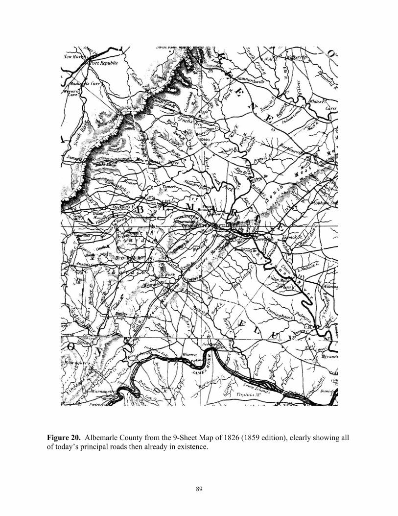
89
Figure 20. Albemarle County from the 9-Sheet Map of 1826 (1859 edition), clearly showing all of today�s principal roads then already in existence.

90
The road from Boyd�s Tavern eastward along the Rivanna River (Route 616) was also
beginning to be called �the stage road� (3 February 1806) from its function as the stage coach route into Charlottesville, and sporadic references to the Rivanna Company amongst the court orders (5 October 1812 and 4 November 1813) indicate the growing presence in Virginia of the forces that would soon create the James River & Kanawha Canal as well as the Rivanna Navigation and (later) Canal. Orders of 2 December 1811 and 3 March 1812 relating to the commissioner for �the turn pike road Crossing at rock fish gap� show the continuing importance of Wilson Cary Nicholas�s road, which would in a few years become the Staunton & James River Turnpike.
All of these orders, however, are perhaps better understood within the context of the creation of the Board of Public Works in 1816, state participation and planning, and the history of ensuing era of turnpikes, canals and that ultimately obsoletising innovation, the steam railroad. Moving rapidly towards the use of the developing technology of the nineteenth century to improve commercially-oriented transportation facilities, the road orders merely serve to further emphasise those routes recognized as important by Albemarle�s founders. And it is to this earlier road network that one must first turn in order to be able to understand later developments.
To really understand this early road network, one must be able to do more than simply read about it. An exercise of the imagination is demanded of the reader as he slowly and observantly drives over them. Come then, gentle reader, into a place and a time completely apart from our existence today. As you feel the road rise and fall underneath you across Albemarle�s verdant hills and valleys see if you can visualise its early life in sight and sound. Pull over to the side of the road at a convenient place from time to time and, using this publication and its map, refresh your memory. Indeed, take your time and get out and walk about a bit. Sense the topography and the challenge it must have presented to the eighteenth-century Virginian gentleman when he first came to these hills. He was a universal man; one who lived each day just as it came to him. In an age when mere survival often made self-sufficiency a necessity, he found it expedient to practice many different arts. Neither the master of his environment nor yet its slave, he had learned to live in harmony with it. This relationship is still visible in the road system which he laid out.

91
ACKNOWLEDGMENTS
Acknowledgment is hereby made for the use of the following photographs: Figures 7, 9, and 12 VIRGINIA ROAD TRACES
(Buck Mountain Road; Feldman Perdue and Mickler, 1977). Figure 11 VIRGINIA ROAD TRACES
(Buck Mountain Road; Macleod and Wenger, 1976) under the direction of K. Edward Lay, Assistant Dean of Architecture, University of Virginia (Unpublished Series, Fiske Kimball Fine Arts Library).

92

93
SELECTED BIBLIOGRAPHY I. Unpublished Dissertations and Theses.
Dabney, William Minor, �Jefferson�s Albemarle 1727-1810,� unpublished Ph.D.
dissertation, University of Virginia, 1951. Harrison, Joseph H., �The Internal Improvement Issue in the Politics of the Union, 1783-
1825,� unpublished Ph.D. dissertation, University of Virginia, 1954. Rice, Philip M., �Internal Improvements in Virginia, 1775-1860,� unpublished Ph.D.
dissertation, University of North Carolina, 1948. Roberts, Edward G., �The Roads of Virginia, 1607-1840,� unpublished Ph.D.
dissertation, University of Virginia, 1950. Sarles, Frank B., Jr., �Trade of the Valley of Virginia, 1789-1860,� unpublished M.A.
Thesis, University of Virginia, 1951. Watts, Charles Wilder, �Colonial Albemarle 1727-1775,� unpublished M.A. thesis,
University of Virginia, 1948. II. Printed Public Records
Hening, William Waller, The Statutes at Large. Being a Collection of All the Laws of Virginia 1619-1792, 13 vols. Richmond 1818-1825.
Shepherd, Samuel, The Statutes at Large of Virginia, from, October 1792 to December
Session 1806�Being a Continuation of Hening, 3 vols. Richmond: Samuel Shepherd, 1835-36.
Acts of the General Assembly of Virginia, Richmond: State Printer, 1807-1860. The Revised Code of the Laws of Virginia, 2 vols. Richmond: Thomas Ritchie, 1819.
III. Published Works
Mead, Edward C., Historic Homes of the South-West Mountains, Virginia, Philadelphia and London, 1899.
Moore, John Hammond, Albemarle: Jefferson�s County 1727-1976, Charlottesville,
1976. Pawlett, Nathaniel Mason, Albemarle County Road Orders l744-1748, Charlottesville,
1975.

94
________, Albemarle County Road Orders 1783-1816, Charlottesville, 1975. ________, A Guide to the Preparation of County Road Histories, Charlottesville, 1979. ________, An Index to Roads Shown in the Albemarle County Surveyor�s Books 1744-
1853. Charlottesville, 1976. ________, Goochland County Road Orders 1728-1744, Charlottesville, 1975. ________, Louisa County Road Orders 1742-1748, Charlottesville, 1975. ________, A Brief History of the Roads of Virginia 1607-1840, Charlottesville, 1977. Pawlett, Nathaniel Mason, and Howard Newlon, Jr., The Route of the Three Notch�d
Road, Charlottesville, 1976. Rawlings, Mary, The Albemarle of Other Days, Charlottesville, 1925. Rawlings, Mary, Ante-Bellum Albemarle, Charlottesville, 1935. Woods, Edgar, Albemarle County in Virginia, Charlottesville, 1901. Young, Douglas, A Brief History of the Staunton and James River Turnpike,
Charlottesville, 1976.

95
INDEX TO PRINCIPAL ROADS
Copious documentation of these is available in the indexed publications of road orders by the author cited in the bibliography. The modern county highway map with overlaid colonial roads found in the map pocket at the rear should also prove helpful to the reader. John Anthony�s Road, 29
Ash Cake Road, 33
Barracks Road, 66, 69, 80
Beard�s Road, 29
Bridges:
Carter�s, 70, 81, 83, 84, 86, 87
Free (Rivanna River), 25, 72, 84, 87
Christopher Hudson�s, 84
Charles Lynch�s, 20
Mechunk Creek, 16
Moore�s Creek, 84, 85
Pritty�s Creek, 38
Brown�s Gap Turnpike (earlier Cove Road), 38, 39, 72, 77, 78, 88
Buck Mountain Road, 34, 35, 36, 38, 41, 43, 60, 62, 71, 72, 79, 80, 81
Carolina Road, 7
Clark�s Tract, 34, 37
Coles�Road, 59
Colonel Coles Church Road, 75
Coursey�s Road (later Orange Court House Road) and extension in Albemarle County, 25, 28,
30, 34, 35, 36, 38, 43, 44, 60, 80
D.S. Road (probably Three Notch�d Road), 27, 28
D.S. Tree,. 17, 18,19, 20, 24, 28, 31, 44
Road to Fluvanna Court House, 57
Fox Mountain Road, 41
Fredericksburg Road, 34, 36, 41, 42, 44, 60, 72, 80
Green Mountain Road, 31,56
Hammock�s Gap Road, 38, 73, 80
Road from Holladay River to meet Otter River, 31

96
Indian paths, 7, 17, 27, 76
Indian Road, 7
Irish Road, 55, 56, 75, 78
Martin King�s Road, 12,13, 21, 24, 25, 29, 30, 31, 53, 54, 59, 83
Road to Louisa Court House (from old Albemarle Court House near Scottsville), 24, 31, 32
Main Louisa Road, 34
Road to Lynch�s Ferry (Ford), 23, 24, 28
Old Lynchburg Road (Lynchburg Stage Road), 67, 78, 80, 81, 82
New Lynchburg Road, 81
McGehee�s Road, 71, 72
Road from Milton to Charlottesville, 80
Road from Milton to Scott�s Ferry, 79
Moon�s Road, 79, 80
Mountain Road (after 1743 Three Notch�d), 10, 12, 14, 15, 16, 17, 18, 19, 20, 30, 33
Old Mountain Road (Hanover and Louisa Counties), 33, 34, 37, 43, 44
Rea�s Ford Road, 70
River Road, 8, 9, 14, 20, 24, 28, 29, 31, 44, 59, 78
Road from the Green Mountain Road near the head of Hogg Creek into the Court House Road (River Road) below Mr. Stith�s Quarter, 31
Road to the River Road from William Harris�s Plantation on Green Creek, 28
Rockfish Gap Road, 27, 28, 32, 44, 52, 53
Rockfish Road, 28, 44, 55, 78
Road from the North Garden through Ivy Creek Pass to Rockfish Road, 28, 29, 31
Rodes� Road, 72, 80
Roundabout Road, 59
Road to the Secretary�s Mill (from Charlottesville), 30, 44, 60, 70, 80
Road from the Secretary�s Mill to the Court House (Scottsville), 30, 31, 60, 70
Secretary�s Road, Secretary�s Old Rolling Road (later Bremo Road), 10, 11, 12, 18, 20, 21, 23, 44, 49, 52, 53, 54, 59, 60, 62, 72, 79, 80
Secretary�s Road to his Tye River Quarter, 11, 15, 17, 18, 21, 25, 30, 31, 45, 56, 78
Road from Stephen Heard�s to the late Secretary�s Road near John Burns Plantation, 31
Seminole Trail, 7
Shenandoah Hunting Path, 7

97
Signposts, 16, 25, 39, 42, 43
Stage Road (earlier Adams�s Road), 8, 9, 16, 57, 90
Staunton & James River Turnpike (see also Warren Road), 54, 74, 75, 76, 78, 84, 88
Road through Stony Point Pass, 37
Three Notch�d Road (prior to 1743 the Mountain Road), 18, 19, 20, 23, 24, 25, 27, 28, 29, 30, 31, 33, 34, 43, 44, 54, 55, 57, 60, 62, 63, 66, 69, 70, 71, 73, 76, 77, 78, 80, 82
Road from Three Notch�d Road to Hardware River (later Milton to Carter�s Bridge), 23
Road Through Todd�s Pass, 37, 40
Turkey Sag Road, 36, 37, 42, 43, 44
Dick Wood�s Road, 17, 18, 20, 21, 23, 24, 27, 28, 31, 55, 60, 75, 78, 80
Valentine Wood�s Rolling Road, 57
Warren Road, 75, 78, 79, 81, 82, 83
Wheeler�s Road, 81, 82


![החכמה שהאדם צריך לדעת אותה€¦ · Web viewMishpatim [Ordinances], 438-441 84. Being Rewarded with Sons 85. VaYeshev [And Jacob Dwelt], 188 85. Death Does](https://static.fdocuments.us/doc/165x107/5f54a6794e0ccd1d8358fe48/-oe-web-view-mishpatim-ordinances.jpg)