Agenda City of Winter Haven Planning Commission Meeting ...
39
Agenda City of Winter Haven Planning Commission Meeting January 5, 2021, 6:00 p.m. Nora Mayo Hall, 500 Third Street, NW, Winter Haven, Florida 1. Call to Order 2. Roll Call 3. Invocation and Pledge of Allegiance 4. Approval of December 1, 2020 Minutes 5. Explanation of Hearings by Chair 6. Hearings a. New Business i. Case Number P-21-03: Request by James F. Simpson and Yvonne M. Simpson to rezone a parcel from Highway Commercial (C-3) Zoning District to Single Family Residential- Small Lot (R-2) Zoning District. General Location: 2222 9 th Street, NW. The area covered by this request is 0.22± acres. ii. Case Number P-21-04: Administrative request to amend the Winter Haven Code of Ordinances, Chapter 21, Article II, Division 2, for the purpose of deleting Table 21-32(B), Table of Commercial, Industrial, and Institutional Development Standards and moving the requirements into the respective zoning districts contained in Chapter 21, Article II, Division 2. iii. Case Number P-21-05: Administrative request to amend the Winter Haven Code of Ordinances, Chapter 21, Article III, Division 6, Section 21-174, Dumpsters, for the purpose of addressing placement criteria, enclosure design standards, maintenance, and screening exemptions. iv. Case Number P-21-06: Administrative request to amend the Winter Haven Code of Ordinances, Chapter 21, Article II, Division 3, Section 21-69, Animal Limitations, for the purpose of addressing chickens. 7. Other Business a. Comments from Staff b. Comments from Planning Commissioners c. Comments from the Public 8. Adjournment All interested parties who decide to appeal any decision made by this Commission with respect to the matter considered at such meeting or hearing will need a record of the proceedings, and that, for such purpose, may need to ensure that a verbatim record of the proceedings is made, which record includes the testimony and evidence upon which the appeal is to be based (F.S. 286.0105). Please be advised that you must make your own arrangements to produce this record. If you need assistance with language, contact the Planning Division at least four (4) days prior to the meeting. The Planning Division may be reached at (863) 291-5600, at City Hall, 451 Third Street, NW, Winter Haven, Florida, 33881, or online at www.mywinterhaven.com/government/planning. In accordance with the Americans with Disabilities Act and Florida Statutes, Section 286.26, persons with disabilities needing special accommodations to participate in this proceeding, should contact the City Clerk’s Office, 451 Third Street, NW, Winter Haven Florida 33881, in writing, no later than 48 hours prior to the proceeding; if not in writing, then not later than four (4) days prior to the proceeding at (863) 291-5600. Vision or hearing impaired please call (800) 955-8771 for assistance.
Transcript of Agenda City of Winter Haven Planning Commission Meeting ...

Agenda City of Winter Haven Planning Commission Meeting
January 5, 2021, 6:00 p.m. Nora Mayo Hall, 500 Third Street, NW, Winter Haven, Florida
1. Call to Order
2. Roll Call
3. Invocation and Pledge of Allegiance
4. Approval of December 1, 2020 Minutes
5. Explanation of Hearings by Chair
6. Hearings
a. New Business i. Case Number P-21-03: Request by James F. Simpson and Yvonne M. Simpson to rezone
a parcel from Highway Commercial (C-3) Zoning District to Single Family Residential- Small Lot (R-2) Zoning District. General Location: 2222 9th Street, NW. The area covered by this request is 0.22± acres.
ii. Case Number P-21-04: Administrative request to amend the Winter Haven Code of Ordinances, Chapter 21, Article II, Division 2, for the purpose of deleting Table 21-32(B), Table of Commercial, Industrial, and Institutional Development Standards and moving the requirements into the respective zoning districts contained in Chapter 21, Article II, Division 2.
iii. Case Number P-21-05: Administrative request to amend the Winter Haven Code of Ordinances, Chapter 21, Article III, Division 6, Section 21-174, Dumpsters, for the purpose of addressing placement criteria, enclosure design standards, maintenance, and screening exemptions.
iv. Case Number P-21-06: Administrative request to amend the Winter Haven Code of Ordinances, Chapter 21, Article II, Division 3, Section 21-69, Animal Limitations, for the purpose of addressing chickens.
7. Other Business a. Comments from Staff b. Comments from Planning Commissioners c. Comments from the Public
8. Adjournment
All interested parties who decide to appeal any decision made by this Commission with respect to the matter considered at such meeting or hearing will need a record of the proceedings, and that, for such purpose, may need to ensure that a verbatim record of the proceedings is made, which record includes the testimony and evidence upon which the appeal is to be based (F.S. 286.0105). Please be advised that you must make your own arrangements to produce this record. If you need assistance with language, contact the Planning Division at least four (4) days prior to the meeting. The Planning Division may be reached at (863) 291-5600, at City Hall, 451 Third Street, NW, Winter Haven, Florida, 33881, or online at www.mywinterhaven.com/government/planning. In accordance with the Americans with Disabilities Act and Florida Statutes, Section 286.26, persons with disabilities needing special accommodations to participate in this proceeding, should contact the City Clerk’s Office, 451 Third Street, NW, Winter Haven Florida 33881, in writing, no later than 48 hours prior to the proceeding; if not in writing, then not later than four (4) days prior to the proceeding at (863) 291-5600. Vision or hearing impaired please call (800) 955-8771 for assistance.

CITY OF WINTER HAVEN PLANNING COMMISSION MEETING MINUTES December 1, 2020 1. CALL TO ORDER
Chair Fuller called the meeting to order at 6:00 p.m. 2. ROLL CALL
Commissioners Present: Chair Craig Fuller, Vice-Chair Tamara S akagawa, Jennifer Fasking, Steve Lockhart, Wendy Venters, David Lane Commissioners Absent: Rick Hemenway, Elizabeth Davis, Charles Smith, Toby Tiller (Ex-Officio) Heather Reuter confirmed a Quorum. Staff Present: Eric Labbe, Economic Opportunity & Community Investment Director; Sean Byers, Planning Manager; Heather Reuter, Planner II; Sean Martin, Planner II; Deena Ware, CRA and Neighborhood Programs Manager
3. INVOCATION AND PLEDGE OF ALLEGIANCE Invocation and Pledge of Allegiance led by Commissioner Lockhart. 4. APPROVAL OF MINUTES
Chair Fuller asked for a motion to approve the November 2, 2020 Planning Commission Meeting Minutes. Motion was made by Commissioner Fasking for approval of the November 2, 2020 Planning Commission Meeting Minutes; Commissioner Lockhart seconded the motion. Motion carried by a unanimous voice vote. (6:0)
5. EXPLANATION OF HEARINGS Chair Fuller provided the explanation of hearings. Heather Reuter swore in those wishing to speak for or against a case.
6. HEARINGS
a. New Business
i. Case Number P-20-10-S: Request by Six/Ten, LLC for Special Use Approval for small scale artisan production in the Downtown Commercial (C-1) zoning district. General Location: 140 Sixth Street, SW. The area covered by this request is 0.11± acres. Heather Reuter gave an overview of the request via a slideshow presentation. Chair Fuller asked the Commissioners i f there were any questions for staff. Commissioner Venters recused herself from this case due to a conflict of interest and submitted Form 8B (See “Exhibit ‘A’”). Chair Fuller asked if there were any other questions for staff. Hearing and seeing none, Chair Fuller closed the regular meeting and opened the public hearing, asking anyone wishing to speak for or against this request to come to the podium, and if they have not yet done so, state their name and address for the record. Mr. Labbe stated there were no Zoom platform participants with hands raised. Seeing and hearing none, Chair Fuller closed the public hearing, and reopened the regular meeting.
Heather Reuter gave an overview of the request via a slideshow presentation.
Chair Fuller asked the Commissioners if there were any questions for staff.
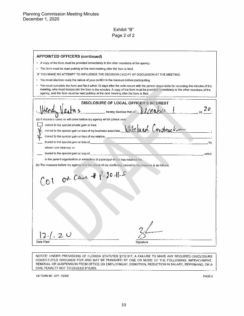
Commissioner Venters recused herself due to a conflict of interest and submitted Form 8B (See “Exhibit ‘B’”).
Vice-Chair Sakagawa inquired about the number of wholesale deliveries. Ms. Reuter deferred to the applicant.
Vice-Chair Sakagawa inquired what a café would entail. Ms. Reuter stated a café would meet the City’s definition of a restaurant, but all State licensing would need to be met for the services they provide.
Chair Fuller asked if there were any other questions for staff. Hearing and seeing none, Chair Fuller closed the regular meeting and opened the public hearing, asking anyone wishing to speak for or against this request to come to the podium, and if they have not yet done so, state their name and address for the record.
Jon Lane of 3954 Whistlewood Circle, Lakeland, FL and of Haven Coffee Roasters, and hereafter known as Agent Lane, and stated the following:
• Plan two deliveries a week for wholesale sales • Will be a café with full hot and cold beverage offerings
Commissioner Lane inquired about seating and parking. Discussion ensued.
Chair Fuller asked anyone else wishing to speak to please come forward. Mr. Labbe stated there were no Zoom platform participants with hands raised. Seeing and hearing none, Chair Fuller closed the public hearing, and reopened the regular meeting.
Planning Commission Meeting Minutes December 1, 2020
Chair Fuller asked if there were any other questions. Hearing and seeing none, Chair Fuller sought a motion for the case. Motion was made by Commissioner Lockhart to approve Case Number P-20-10-S in accordance with the fact sheet. Vice-Chair Sakagawa seconded the motion. Motion carried by a unanimous voice vote (5:0) with Commissioner Venters abstaining.
ii. Case Number P-20-11-S: Request by Haven Coffee Roasters, LLC, agent for Central South, LLC for Special Use Approval for small scale artisan production in the Downtown Commercial (C-1) zoning district. General Location: 140 Third Street, SW. The area covered by this request is 1.09± acres.
Chair Fuller asked if there were any other questions. Hearing and seeing none, Chair Fuller sought a motion for the case. Motion was made by Vice-Chair Sakagawa to approve Case Number P-20-11-S in accordance with the fact sheet. Commissioner Fasking seconded the motion. Motion carried by a unanimous voice vote (5:0) with Commissioner Venters abstaining.
iii. Case Number P-20-50: Administrative request to amend the Winter Haven Code of Ordinances, Chapter 21, Article III, Sections 21-151 and 21-192, for the purpose of deleting language relating to required connection to reclaimed/reuse water lines and installation of reclaimed/reuse water lines. Sean Byers gave an overview of the request via a slideshow presentation.
2

Planning Commission Meeting Minutes December 1, 2020
Chair Fuller asked the Commissioners if there were any questions for staff. Hearing and seeing none, Chair Fuller closed the regular meeting and opened the public hearing, asking anyone wishing to speak for or against this request to come to the podium, and if they have not yet done so, state their name and address for the record. Mr. Labbe stated there were no Zoom platform participants with hands raised. Seeing and hearing none, Chair Fuller closed the public hearing, and reopened the regular meeting.
Chair Fuller asked if there were any other questions. Hearing and seeing none, Chair Fuller sought a motion for the case. Motion was made by Commissioner Fasking to approve Case Number P-20-50 in accordance with the fact sheet. Vice-Chair Sakagawa seconded the motion. Motion carried by a unanimous voice vote. (6:0)
iv. Case Number P-21-01: Request by H.R. Baxter & Sons Enterprises, Inc. to rezone four parcels from Single Family Residential- Small Lot (R-2) and Conservation (CN) Zoning Districts to Planned Unit Development (PUD) Zoning District. General Location: Four vacant parcels generally located east of County Road 653, north of Old Bartow Lake Wales Road, and west of McClean Road. The area covered by this request is 190.87± acres.
Sean Martin gave an overview of the request via a slideshow presentation.
Chair Fuller asked the Commissioners if there were any questions for staff.
Vice-Chair Sakagawa asked if the proposed PUD is consistent with developments in the area. Discussion ensued.
Chair Fuller asked if there were any other questions for staff. Hearing and seeing none, Chair Fuller closed the regular meeting and opened the public hearing, asking anyone wishing to speak for or against this request to come to the podium, and if they have not yet done so, state their name and address for the record.
Dana Venrick, of 35 Spring Glen Drive, DeBary, FL and hereafter known as Citizen Dana, and stated the following:
• Family owns property in the area • Questions about the deeded right-of-way adjacent to the PUD • Questions about the types of residential allowed
Mr. Martin stated the PUD allows for single-family residential. Discussion ensued.
Chair Fuller asked anyone else wishing to speak to please come forward.
Brian Hunter, of Hunter Engineering, and hereafter known as Agent Hunter stated the following: • Has concerns with the 15-foot build-to requirement, as it will not work with the product
models • Request the front setback be changed to a minimum of 20 feet for the living area and 25
feet for the garage
Chair Fuller asked anyone else wishing to speak to please come forward.
Steve Burrell, 1226 Sawgrass Drive, Winter Haven, FL, and hereafter known as Citizen Burrell stated the following:
• Wants a more detailed final plan to be presented before any vote is taken • Concerned with the developer asking for changes at the podium
Chair Fuller asked anyone else wishing to speak to please come forward. 3

Planning Commission Meeting Minutes December 1, 2020
Inge Salyers, of 4850 State Road 60 in Lake Wales, FL, and hereafter known as Citizen Salyers stated the following:
• Drives this roadway every day • Trains backing up in the area cause traffic • Does not know how schools have capacity in the area
Mr. Byers stated Polk County Public Schools own land in the area for the development of a school as needed.
Chair Fuller asked anyone else wishing to speak to please come forward.
Reed Venrick, 5004 East Fowler Avenue, Tampa, FL, and hereafter known as Citizen Reed, and stated the following:
• Owns property in the area • Real problem on Old Bartow Road with traffic being backed up by trains
Mr. Byers stated there is sufficient roadway capacity for this development, though some physical improvements to the roadway may be required by Polk County. Discussion ensued.
Chair Fuller asked anyone else wishing to speak to please come forward.
Agent Hunter stated the following: • Will coordinate with Polk County for required improvements to the roadway to support
this development • Will have to complete a large scale traffic study • Will have to meet all public infrastructure concurrency for each phase prior to approval
Vice-Chair Sakagawa asked what the benefit is to rezone from R-2 to PUD for the developer. Agent Hunter stated setbacks, lot sizes, and other provisions of the PUD provide a benefit over R-2. Discussion ensued.
Vice-Chair Sakagawa asked about recreational amenities throughout the PUD. Discussion ensued.
Mr. Labbe provided a summary of differences between the current R-2 development standards and those of the proposed PUD. Discussion ensued.
Chair Fuller asked anyone else wishing to speak to please come forward.
Citizen Salyers asked who the builder will be for this project. Agent Hunter stated it has not been determined yet.
Chair Fuller asked anyone else wishing to speak to please come forward. Louella Venrick, of 1600 Granada Way, Winter Haven, FL, and hereafter known as Citizen Louella stated the following:
• Her family owns a lot of property in the area • Wants to know all the details of the plan to know how it will affect her interests • Concerned with impacts to the wetlands
Discussion ensued between Citizen Louella and Chair Fuller regarding wetlands and the Peace Creek Canal in the area.
4

Planning Commission Meeting Minutes December 1, 2020
Agent Hunter stated there will be stormwater management plan required for this site before development. Discussion ensued.
Chair Fuller asked anyone else wishing to speak to please come forward. Mr. Labbe stated there were no Zoom platform participants with hands raised. Seeing and hearing none, Chair Fuller closed the public hearing, and reopened the regular meeting.
Chair Fuller asked the Commissioners if there were any other questions.
Commissioner Lockhart if there are changes to the setbacks from what is in the fact sheet. Mr. Martin confirmed the presented conditions in the recommendation were changes from the fact sheet. Discussion ensued.
Agent Hunter stated he would prefer to return to the front and street-side setbacks in the fact sheet instead of those presented tonight and request the interior rear yard setback from 20 feet to 15 feet. Discussion ensued with Mr. Byers clarifying what the proposed building setbacks will be.
Commissioner Lane asked about the rear yard tree requirements. Discussion ensued.
Chair Fuller asked if there were any other questions. Hearing and seeing none, Chair Fuller sought a motion for the case. Motion was made by Commissioner Lockhart to approve Case Number P-21-01 in accordance with the fact sheet with the recommended amendments to conditions C, F, and H as presented by staff and the amendment to Condition B to make the interior rear yard setback 15 feet. Vice-Chair Sakagawa seconded the motion. Motion carried by a unanimous voice vote. (6:0)
v. Case Number P-21-02: Administrative request to rezone 32 parcels from Highway Commercial (C-3) Zoning District to Commercial- Downtown (C-1) Zoning District. General Location: The area subject to this request is generally south of the east/west alley lying between Avenue C, SW and Avenue D, SW; north of Avenue G, SW; west of Second Street, SW; and east of Fourth Street, SW. The area covered by this request is 18.3± acres.
Sean Byers gave an overview of the request via a slideshow presentation.
Chair Fuller asked the Commissioners if there were any questions for staff.
Commissioner Lane asked if staff has heard from the property owners subject to this request. Discussion ensued.
Vice-Chair Sakawaga asked about rezoning the parcels to the east to First Street, South excluded from this request. Discussion ensued.
Chair Fuller asked about the development standards for C-1 that are more favorable than C-3 for redevelopment of the area. Mr. Byers stated parking, setbacks, and landscape requirements are all reduced in C-1. Discussion ensued.
Chair Fuller asked about creation of non-conforming uses by this request. Discussion ensued.
Chair Fuller asked if there were any other questions for staff. Hearing and seeing none, Chair Fuller closed the regular meeting and opened the public hearing, asking anyone wishing to speak for or against this request to come to the podium, and if they have not yet done so, state their name and address for the record.
5

• One of the property owners in the area and she is in favor of this request
Chair Fuller asked anyone else wishing to speak to please come forward. Mr. Labbe stated there were no Zoom platform participants with hands raised. Seeing and hearing none, Chair Fuller closed the public hearing, and reopened the regular meeting.
Chair Fuller asked if there were any other questions. Hearing and seeing none, Chair Fuller sought a motion for the case. Motion was made by Vice-Chair Sakagawa to approve Case Number P-21-02 in accordance with the fact sheet. Commissioner Lockhart seconded the motion. Motion carried by a unanimous voice vote. (6:0)
Other Business
a. Comments from Staff • Next Meeting Tuesday, January 5, 2021 • Mr. Byers reviewed the 2021 meeting schedule. • Mr. Byers gave an update of past cases.
b. Comments from Planning Commissioners • Commissioner Fasking asked if any changes made after the agenda packet is sent
could be printed out for commissioners to review during the meeting. Discussion ensued.
• Commissioner Lane stated he had concerns with the acoustics in this meeting space. Discussion ensued.
• Commissioner Lane asked about an update on the Schulz property. Discussion ensued.
• Commissioner Lane asked about the zoning for the Winter Haven Regional Airport and future development. Discussion ensued.
c. Comments from the Public - NONE
Adjournment – 8:13 PM
_______________________________
________________________________________
Planning Commission Meeting Minutes December 1, 2020
Bill Vinson, of The Church of the Nazarene, and hereafter known as Citizen Vinson stated the following:
• The Church owns 8 acres within the subject area • Discussed the size of the sanctuary and parking requirements • Concerned with uses that will be developed near them due to this change
Mr. Byers provided a general comparison of allowed uses between C-3 and C-1. Discussion ensued.
Chair Fuller asked anyone else wishing to speak to please come forward.
Wanda Baez, 115 North Lake Florence Drive, Winter Haven, FL, and hereafter known as Citizen Baez stated the following via Zoom:
7.
8.
CITY OF WINTER HAVEN, FLORIDA PLANNING COMMISSION
Chair
ATTEST:
Planning Commission Clerk
6

FORM 88 MEMORANDUM OF VOTING CONFLICT FOR COUNTY, MUNICIPAL, AND OTHER LOCAL PUBLIC OFFICERS
COMMITTEE
THE BOARD, COUNCIL, MISSION, AUTHORITY DR COMMITTEE ON ICH I SERVE IS A UNIT OF:
OcouNTY OoTHERLOCALAGENCY
DATE ON WHICH VOTE OCCURRED 12 • ) • -:z,-0 MY POSITION IS: 0 ELECTIVE APPOINTIVE
WHO MUST FILE FORM 8B
This form is for use by any person serving at the county, city, or other local level of government on an appointed or elected board, council,
commission, authority, or committee. It applies equally to members of advisory and non-advisory bodies who are presented with a voting
conflict of interest under Section 112.3143, Florida Statutes.
Your responsibilities under the law when faced with voting on a measure in which you have a conflict of interest will vary greatly depending
on whether you hold an elective or appointive position. For this reason, please pay close attention to the instructions on this form before
completing the reverse side and filing the form.
INSTRUCTIONS FOR COMPLIANCE WITH SECTION 112.3143, FLORIDA STATUTES
A person holding elective or appointive county, municipal, or other local public. office MUST ABSTAIN from voting on a measure which
inures to his or her special private gain or loss. Each elected or appointed local officer also .is prohibited from knowingly voting on a mea
sure which inures to the special gain or loss of a principal (other than a government agency) by whom he or she is retained (including the
parent organization or subsidiary of a corporate principal by which he or she is retained); to the special private gain or loss of a relative; or
to the. special private gain or loss of a business associate. Commissioners of community redevelopment agencies under Sec. 163.356 or
163.357, F.S., and officers of independent special tax districts elected on a one-acre, one-vote basis are not prohibited from voting in that
capacity.
For purposes of this law, a "relative" includes only the officer's father, mother, son, daughter, husband, wife, brother, sister, father-in-law,
mother-in-law, son-in-law. and daughter-in-law. A "business associate" means any person or entity engaged in or carrying on a business
enterprise with the officer as a partner, joint venturer, coowner of property, or corporate shareholder (where the shares of the corporation
are not listed on any national or regional stock exchange).
ELECTED OFFICERS:
In addition to abstaining from voting in the situations described above, you must disclose the conflict:
PRIOR TO THE VOTE BEING TAKEN by publicly stating to the assembly the nature of your interest in the measure on which you
are abstaining from voting; and
WITHIN 15 DAYS AFTER THE VOTE OCCURS by completing and filing this form with the person responsible for recording the min
utes of the meeting, who should incorporate the form in the minutes.
APPOINTED OFFICERS:
Although you must abstain from voting in the situations described above, you otherwise may participate in these matters. However, you
must disclose the nature o the conflict before making any attempt to influence the decision, whether orally or in writing and whether made
by you or at your direction.
IF YOU INTEND TO MAKE.ANY ATTEMPT TO INFLUENCE THE DECISION PRIOR TO THE MEETING AT WHICH THE VOTE WILL BE
TAKEN:
• You must complete and file this form (before making any attempt to influence the decision) with the person responsible for recording the
minutes of the meeting, who will incorporate the form in the minutes. (Continued on other side)
Planning Commission Meeting Minutes December 1, 2020
Exhibit “A” Page 1 of 2
7

OFFICERS (continued)
A copy of the form must be provided immediately to the other members of the agency.
The form must be read publicly at the next meeting after the form is filed.
IF YOU MAKE NO ATTEMPT TO INFLUENCE THE DECISION EXCEPT BY DISCUSSION AT THE MEETING:
You must disclose orally the nature of your conflict in the measure before participating.
You must complete the form and file it within 15 days after the vote occurs with the person responsible for recording the minutes of the meeting, who must incorporate the form in the minutes. A copy of the form must be provided immediately to the other members of the agency, and the form must be read publicly at the next meeting after the form is filed.
' ( DISCLOSURE OF LOCAL OFFICER'S INTEREST
I, ~Uf\J\, ~ i , herebydisclosethaton 1), ce» ~ {J
. 20 Zo (a) A measure came or will come before my agency which (check one)
(E inured to my special private gain or loss; , f J{,_ inured to the special gain or loss of my business associate, kJ ~:kL,J Ccrc.olr ~ • .::,,,--.:1._ inured to the special gain or loss of my relative, --------------------------~
inured to the special gain or loss of ______________________________ ~ by
whom I am retained; or
inured to the special gain or loss of _____________________________ ~ which
is the parent organization or subsidiary of a principal which has retained me.
(b) The measure before my agency and the nature of my conflicting interest in the measure is as follows:
Date Filed
NOTICE: UNDER PROVISIONS OF FLORIDA STATUTES §112.317, A FAILURE TO MAKE ANY REQUIRED DISCLOSURE CONSTITUTES GROUNDS FOR AND MAY BE PUNISHED BY ONE OR MORE OF THE FOLLOWING: IMPEACHMENT, REMOVAL OR SUSPENSION FROM OFFICE OR EMPLOYMENT, DEMOTION, REDUCTION IN SALARY, REPRIMAND, OR A CIVIL PENAL TY NOT TO EXCEED $10,000.
CE FORM 8B - EFF. 1/2000 PAGE2
Planning Commission Meeting Minutes December 1, 2020
Exhibit “A” Page 2 of 2
8

8B MEMORANDUM OF VOTING CONFLICT FOR COUNTY, MUNICIPAL, AND OTHER LOCAL PUBLIC OFFICERS
LAST
MAIL RITY OR COMMITTEE ON
CITY D COUNTY OoTHER LOCAL AGENCY
DATE ON WHICH VOTE OCCURRED MY POSITION IS: 0 ELECTIVE APPOINTIVE
WHO MUST FILE FORM 88
This form is for use by any person serving at the county, city, or other local level of government on an appointed or elected board, council, commission, authority, or committee. It applies equally to members of advisory and non-advisory bodies who are presented with a voting conflict of interest under Section 112.3143, Florida Statutes.
Your responsibilities under the law when faced with voting on a measure in which you have a conflict of interest will vary greatly depending on whether you hold an elective or appointive position. For this reason, please pay close attention to the instructions on this form before completing the reverse side and filing the form.
INSTRUCTIONS FOR COMPLIANCE WITH SECTION 112.3143, FLORIDA STATUTES
A person holding elective or appointive county, municipal, or other local public office MUST ABSTAIN from voting on a measure which inures to his or her special private gain or loss. Each elected or appointed local officer also is prohibited from knowingly voting on a measure which inures to the special gain or loss of a principal ( other than a government agency) by whom he or she is retained (including the parent organization or subsidiary of a corporate principal by which he or she is retained); to the special private gain or loss of a relative; or to the. special private gain or loss of a business associate. Commissioners of community redevelopment agencies under Sec. 163.356 or 163.357, F.S., and officers of independent special tax districts elected on a one-acre, one-vote basis are not prohibited from voling in that capacity.
For purposes of this law, a "relative" includes only the officer's father, mother, son, daughter, husband, wife, brother, sister, father-in-law, mother-in-law, son-in-law, and daughter-in-law. A "business associate" means any person or entity engaged in or carrying on a business enterprise with the officer as a partner, joint venturer, coowner of property, or corporate shareholder (where the shares of the corporation are not listed on any national or regional stock exchange).
ELECTED OFFICERS:
In addition to abstaining from voting in the situations described above, you must disclose the conflict:
PRIOR TO THE VOTE BEING TAKEN by publicly stating to the assembly the nature of your interest in the measure on which you are abstaining from voting; and
WITHIN 15 DAYS AFTER THE VOTE OCCURS by completing and filing this form with the person responsible for recording the minutes of the meeting, who should incorporate the form in the minutes.
APPOINTED OFFICERS:
Although you must abstain from voting in the situations described above, you otherwise may participate in these matters. However, you must disclose the nature o the conflict before making any attempt to influence the decision, whether orally or in writing and whether made by you or at your direction.
IF YOU INTEND TO MAKE.ANY ATTEMPT TO INFLUENCE THE DECISION PRIOR TO THE MEETING AT WHICH THE VOTE WILL BE TAKEN:
• You must complete and file this form (before making any attempt to influence the decision) with the person responsible for recording the
minutes of the meeting, who will incorporate the form in the minutes. (Continued on other side)
Planning Commission Meeting Minutes December 1, 2020
Exhibit “B” Page 1 of 2
9
OFFICERS (continued)
A copy of the form must be provided immediately to the other members of the agency.
The form must be read publicly at the next meeting after the form is filed.
IF YOU MAKE NO ATTEMPT TO INFLUENCE THE DECISION EXCEPT BY DISCUSSION AT THE MEETING:
You must disclose orally the nature of your conflict in the measure before participating.
You must complete the form and file it within 15 days after the vote occurs with the person responsible for recording the minutes of the meeting, who must incorporate the form in the minutes. A copy of the form must be provided immediately to the other members of the agency, and the form must be read publicly at the next meeting after the form is filed.
DISCLOSURE OF LOCAL OFFICER'S INTEREST
'· \~ V 4h !> .herebydlsol~•~atoa )ul¾W I 20 ,20 __ .
(a) A measure came or will come before my agency which (check one)
inured to my special private gain or loss; \. ~ f I [ . f r inured to the special gain or loss of my business associate. _w~·~h-_'b~t=--M~~a.Pl-~·-~L--_""-~-ob:u.v~~-~-· ..,.,..._ ________ ~ inured to the special gain or loss of my relative. --------------------------~ inured to the special gain or loss of ___ ________ ___________________ ~ by
whom I am retained; or
inured to the special gain or loss of __ --'--------------------------~ which
is the parent organization or subsidiary of a principal which has retained me.
(b) The measure before my agency and the nature of my conflicting interest in the measure is as follows:
Co,
Date Filed Signature
NOTICE: UNDER PROVISIONS OF FLORIDA STATUTES §112.317. A FAILURE TO MAKE ANY REQUIRED DISCLOSURE CONSTITUTES GROUNDS FOR AND MAY BE PUNISHED BY ONE OR MORE OF THE FOLLOWING: IMPEACHMENT. REMOVAL OR SUSPENSION FROM OFFICE OR EMPLOYMENT, DEMOTION. REDUCTION IN SALARY, REPRIMAND, OR A CIVIL PENAL TY NOT TO EXCEED $10,000.
CE FORM 8B - EFF. 1/2000 PAGE2
Planning Commission Meeting Minutes December 1, 2020
Exhibit “B” Page 2 of 2
10

___________________________________________________________________________
CITY OF WINTER HAVEN FACT SHEET PLANNING COMMISSION MEETING
January 5, 2021
DATE: December 3, 2020
TO: Winter Haven Planning Commissioners
VIA: Eric Labbe, Economic Opportunity and Community Investment Director Sean Byers, Planning Manager
FROM: Sean Martin, Planner II
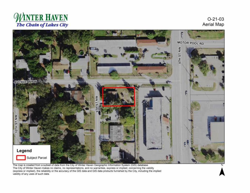
SUBJECT: Case Number P-21-03: Request by James F. Simpson and Yvonne M. Simpson to rezone a parcel from Highway Commercial (C-3) Zoning District to Single Family Residential- Small Lot (R-2) Zoning District. General Location: 2222 Ninth Street, NW. The area covered by this request is 0.22± acres.
BACKGROUND:
James F. Simpson and Yvonne M. Simpson, petitioners, request the City rezone a parcel from Highway Commercial (C-3) zoning district to Single Family Residential- Small Lot (R-2) zoning district. The parcel subject to this request is located at 2222 Ninth Street, NW and contains a 1,336-square foot single-family residence, constructed in 1954, on 0.22± acres.
The current use of a single family home on the subject parcel is legal non-conforming in the C-3 zoning district. As a non-conforming use, the single-family use cannot be expanded or re-established upon its use ceasing for a period greater than 180 days. The petitioners would like to build an addition for their growing family; therefore, rezoning to a residential district is necessary to bring the property into compliance. The subject parcel is similar in scale to properties zoned R-2 on the west side of Ninth Street, NW.
When assigned several years ago, the original intent of the C-3 zoning on the east side of Ninth Street, NW between Avenue W, NW and Avenue V, NW was to allow for larger redevelopment sites fronting US 17. Individually, the subject parcel is unlikely to be used for commercial purposes.
SURROUNDING USES:
Uses surrounding the subject parcel include single-family residential to the west across Ninth Street, NW and south, a hotel to the east, and a motel to the north across Avenue W, NW. Ninth Street, NW is primarily fronted by residential uses with some commercial access to the south near Havendale Boulevard.

COMPREHENSIVE PLAN:
The current Future Land Use is Primary Activity Center. The requested R-2 zoning district is not inconsistent with the Primary Activity Center Future Land Use.
NOTIFICATION:
All public notification requirements for this request were met.
CONCLUSION:
Upon review of this request, the following conclusions have been reached:
1. The existing land use of single-family residential is legal non-conforming, but is consistent with the immediate neighborhood located to the south and west.
2. The subject parcel is similar in size and scale to nearby parcels zoned R-2, including parcels on the west side of Ninth Street, NW.
3. Ninth Street, NW functions primarily as a residential street.
4. The property has been zoned C-3 for over 20 years with little or no interest shown in redeveloping the property with a commercial use.
RECOMMENDATION:
Staff recommends the Planning Commission approve this request and its forwarding to the City Commission for action.
ATTACHMENTS:
Future Land Use Map Zoning Map Aerial Map
ANTICIPATED CITY COMMISSION ACTION DATES:
February 8, 2021 (First Reading) February 22, 2020 (Second Reading, Public Hearing, and Final Adoption)

O)t1NTER HAVEN 0 -21 -03 The Chain ofLakes City Future Land Use Map
-~~~~~,~~~~. ~~~~-~ ~ -:-;-. ·---......_.. =~:~~~---~m-- =-~----z~~ ~.~.... . ~~~ '~-~ ~ :;:;.-..---~~ ~
,;·• . . ~~-,,$ .... ':-. ; ~--·-·' * -.- ~~~: ..:~~~ AVENUE WNW
~--1-~~ ~~ , Ii;
3:: z tii
'"'¾"-...~J . J:: .-~~~~~ ,...;.~~~ en
.... ··•:-:-"'•. ,._ J:::; ~
. ::~ ~'~"""'"-"'-~~~..,__,:i
Legend
D Subject Parcel
- Recreation/Open Space
~ Primary Activity Center
Traditional Neighborhood Area
:j
hi map rs created frotn a&Uti:set Of ciata trom 1M CilYOf w.,cer ~Geographle1ntormation sys,em (GISTcialabase. The City of \1Vint8f Havan makes no datms, no represenlabOnS, and no wamnbeS. exp<eu ot rnphed, C0il08(1.ic,g the vald,ty (expre..o, implied), the "'liabilrty 0< lhe accuracy cf lhe GIS dala and GIS data products 11.m,shed by the Oly, rouding the ,mp1;oo validl'fy of any uses of such data
MOTOR POOL RD
3:: z tii ~
A

HAVEN The Chain of Lakes City
AVENUE WNW
~ Iii :I:
~ -Legend ~ Subject Parcel
R:2
- Highway Commercial (C-3)
- Public Recreation (PR)
R-2
Single Family Residential- Small Lot (R-2)
~ z t; :I:
~
The map is creaied from • S<lbset of <fala lrom lhe Cily of V.Wer Haven~ lnlonnahOn Sys,em (GISJ darabase. The City of Winter Haven makes no dams, no representations, and no warran&JeS. express or fflpied. conoerni'lg the vafidity (express or implied). the relrabdrly or the accuracy of the GIS data and GIS data procb::ts furmshed by the c«v. n:::lud.ng the rmpCied validrty or any u:SeS of such data
MOTOR.
~ z Iii :I: Ii;
0 -21 -03 Zoning Map
A
HAVEN The Chain of Lakes City
IC
"' j i1
.... • I ., '
Legend
D Subject Parcel r-- .a · :wau .. hi map II crea~ from •
The Ccy of Wlnle, - makes no c:18,rns. no r-.,,8SMtaoons. and now.,,.., _ _ 8><press o, omplll<l. concem,ng the valtd,ty (eXl)fUI o, mpliod~ lhe ~ o, lhe accuracy cl 1he GIS data and GIS data products lumoshed by lhe Cfty. onclud,ng lhe impllad valodcy of any UHS cl such Clala
' I
'
\
F..
0-21-03 Aerial Map
A

___________________________________________________________________________
CITY OF WINTER HAVEN FACT SHEET PLANNING COMMISSION MEETING
January 5, 2021
DATE: December 11, 2020
TO: Winter Haven Planning Commissioners
VIA: Eric Labbe, Economic Opportunity and Community Investment Director
FROM: Sean Byers, Planning Manager
SUBJECT: Case Number P-21-04: Administrative request to amend the Winter Haven Code of Ordinances, Chapter 21, Article II, Division 2, for the purpose of deleting Table 21-32(B), Table of Commercial, Industrial, and Institutional Development Standards and moving the requirements into the respective zoning districts contained in Chapter 21, Article II, Division 2.
BACKGROUND:
Prior to the last major update to the City’s Land Development Code in 2000, development standards for each zoning district were called out within the code section for a particular zoning district. With the update in 2000, all lot and building requirements for the City’s zoning districts were placed into one of two tables. Table 21-32B was created for the residential zoning districts while Table 21-32C was for commercial, industrial, and institutional districts. In October 2017, former Table 21-32B, containing lot and setback requirements for the City’s residential setbacks, was deleted and the requirements moved back into the individual zoning district.
Staff is now requesting to delete current Table 21-32B, Table of Commercial, Industrial, and Institutional Development Standards, and move the requirements back into the individual code sections for the City’s commercial, industrial, institutional, recreation, and conservation zoning districts. As part of this request, with the exception of the Public Recreation (PR) zoning district, no lot requirements or building setbacks were revised, nor were any permitted, special, or conditional uses revised. For the PR, zoning district, minimum lot size and building setback requirements were added as current Table 21-32B does not provide these requirements. The proposed lot and building requirements follow the current requirements for the Public Institutional (PI) zoning district. As staff time permits, a more detailed review of these zoning districts will occur in the future.
The additional benefit of making these changes is an improved user experience, particularly when viewed online. An individual will now be able to go to a specific zoning district and easily view the required information.

COMPREHENSIVE PLAN:
As part of the proposed changes, the permissible Future Land Use designations for the C-2, C-3, C-4, I-1, I-2, PI, PR, and CN zoning districts were updated to reflect the 2025 Comprehensive Plan.
NOTIFICATION:
All public notification requirements for this request were met.
RECOMMENDATION:
Staff recommends the Planning Commission recommend approval of this request, and its forwarding to the City Commission for final action.
ATTACHMENTS:
Deleted Table 21-32(B), Table of Commercial, Industrial, and Institutional Development Standards Revised Section 21-44, C-2 Neighborhood Commercial Revised Section 21-45, C-3 Highway Commercial Revised Section 21-46, C-4 General (Heavy) Commercial Revised Section 21-47, I-1 Light Industrial Revised Section 21-48, I-2 Heavy Industrial Revised Section 21-49, PI Public Institutional Revised Section 21-50, PR Public Recreation Revised Section 21-51, CN Conservation
ANTICIPATED CITY COMMISSION ACTION DATES:
February 8, 2021 (First Reading) February 22, 2021 (Second Reading, Public Hearing, and Final Adoption)
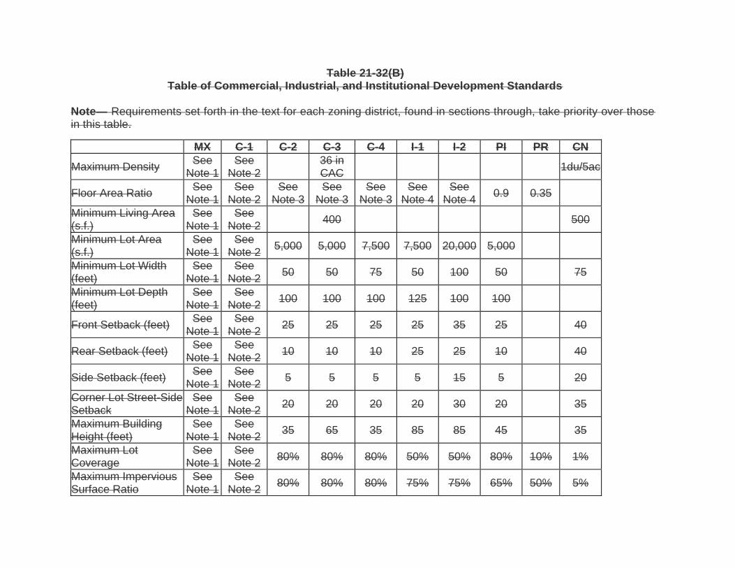
Table 21-32(B) Table of Commercial, Industrial, and Institutional Development Standards
Note— Requirements set forth in the text for each zoning district, found in sections through, take priority over those in this table.
MX C-1 C-2 C-3 C-4 I-1 I-2 PI PR CN
Maximum Density See
Note 1 See
Note 2 36 in CAC
1du/5ac
Floor Area Ratio See
Note 1 See
Note 2 See
Note 3 See
Note 3 See
Note 3 See
Note 4 See
Note 4 0.9 0.35
Minimum Living Area (s.f.)
See Note 1
See Note 2
400 500
Minimum Lot Area (s.f.)
See Note 1
See Note 2
5,000 5,000 7,500 7,500 20,000 5,000
Minimum Lot Width (feet)
See Note 1
See Note 2
50 50 75 50 100 50 75
Minimum Lot Depth (feet)
See Note 1
See Note 2
100 100 100 125 100 100
Front Setback (feet) See
Note 1 See
Note 2 25 25 25 25 35 25 40
Rear Setback (feet) See
Note 1 See
Note 2 10 10 10 25 25 10 40
Side Setback (feet) See
Note 1 See
Note 2 5 5 5 5 15 5 20
Corner Lot Street-Side See Note 1
See Note 2
20 20 20 20 30 20 35 Setback
Maximum Building Height (feet)
See Note 1
See Note 2
35 65 35 85 85 45 35
Maximum Lot Coverage
See Note 1
See Note 2
80% 80% 80% 50% 50% 80% 10% 1%
Maximum Impervious Surface Ratio
See Note 1
See Note 2
80% 80% 80% 75% 75% 65% 50% 5%
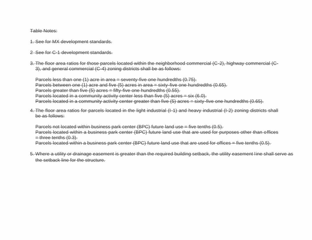
Table Notes:
1. See for MX development standards.
2 See for C-1 development standards.
3. The floor area ratios for those parcels located within the neighborhood commercial (C-2), highway commercial (C-3), and general commercial (C-4) zoning districts shall be as follows:
Parcels less than one (1) acre in area = seventy-five one hundredths (0.75). Parcels between one (1) acre and five (5) acres in area = sixty-five one hundredths (0.65). Parcels greater than five (5) acres = fifty-five one hundredths (0.55). Parcels located in a community activity center less than five (5) acres = six (6.0). Parcels located in a community activity center greater than five (5) acres = sixty-five one hundredths (0.65).
4. The floor area ratios for parcels located in the light industrial (I-1) and heavy industrial (I-2) zoning districts shall be as follows:
Parcels not located within business park center (BPC) future land use = five tenths (0.5). Parcels located within a business park center (BPC) future land use that are used for purposes other than offices = three tenths (0.3). Parcels located within a business park center (BPC) future land use that are used for offices = five tenths (0.5).
5. Where a utility or drainage easement is greater than the required building setback, the utility easement l ine shall serve as
the setback line for the structure.

Sec. 21-44. C-2 Commercial- Neighborhood commercial.
(a) Future land use classification: Commercial—Retail. Permissible Future Land Use
classifications. The C-2 zoning district may be assigned to properties designated as Primary Activity Center, Regional Activity Center, Neighborhood Activity Center, or Commercial on the City’s Future Land Use Map.
(b) The purpose of the C-2, Commercial- nNeighborhood commercial zoning district is intended primarily to meet the limited shopping and service needs of surrounding neighborhoods generally located within two (2) miles. Retail stores are intended to include convenience, fashion and durable goods.
(c) Other requirements:
(1) Bed and breakfast: Property shall front on a collector or arterial roadway. Primary points of ingress-egress shall connect to such roadway. Signs shall be in accordance with regulations in Article IV. Parking requirements are one (1) space per room/unit available for rent.
Permitted Development Intensity
1. The maximum Floor Area Ratio (FAR) for commercial uses located in the C-2 zoning district shall be as set forth in Table 21-44A.
Table 21-44A, Maximum Commercial Floor Area Ratio
Adopted Future Land Use Designation Maximum Permitted
FAR
Primary Activity Center
Parcels 0.5 acres or less 6.0
Parcels more than 0.5 acres 3.0
Regional Activity Center
Parcels less than 1.0 acre 2.0
Parcels 1.01 acres up to 5.0 acres 1.0
Parcels more than 5.0 acres 0.50
Parcels adjacent to or within 1,320 feet of an existing or proposed transit route
2.0
Neighborhood Activity Center
Parcels less than 1.0 acre 1.0
Parcels 1.01 acres up to 3.0 acres 0.75
Parcels more than 3.0 acres 0.50
Parcels adjacent to or within 1,320 feet of an existing or proposed transit route
1.0
Commercial
Parcels less than 1.0 acre 0.40
Parcels 1.01 acres up to 3.0 acres 0.30
Parcels more than 3.0 acres 0.25
Parcels adjacent to or within 1,320 feet of an existing or proposed transit route
0.40

(d) Building form standards. All development within the C-2 zoning district shall follow the building form standards as set forth below in Table 21-44B.
Table 21-44B, C-2 Zoning District Development Standards
Lot and Building Standard Requirement
Lot Area Minimum 5,000 square feet
Lot Width Minimum 50 feet
Lot Depth Minimum 100 feet
Building Setbacks
Front Minimum 25 feet
Side Minimum 5 feet
Street Side Minimum 20 feet
Rear Minimum 10 feet
Building Height Maximum 35 feet
Lot Coverage Maximum 80 percent
Impervious Surface Ratio Maximum 80 percent
(e) Additional development requirements:
1. See Article III of this Code for landscaping, parking, site access, stormwater, and utility connection requirements.
2. Bed and breakfast: Property shall front on a collector or arterial roadway. Primary points of ingress-egress shall connect to such roadway. Signs shall be in accordance with regulations in Article IV. Parking requirements are one (1) space per room/unit available for rent.

Sec. 21-45. C-3 Commercial- Highway commercial.
(a) Future land use classification: Commercial—Retail. Permissible Future Land Use
classifications. The C-3 zoning district may be assigned to properties designated as Primary Activity Center, Regional Activity Center, Neighborhood Activity Center, or Commercial on the City’s Future Land Use Map.
(b) The purpose of the C-3, highway business Commercial- Highway zoning district is intended to apply to provide areas along arterial streets and collector trafficwaysstreets where business establishments primarily not of a neighborhood or community service type may properly be located to serve large sections of the City. Such businesses generally require considerable ground area, do not cater directly to pedestrians and need and a conspicuous and accessible location convenient for motorists.
(c) Additional development standards:
(1) Development site shall be large enough to accommodate all required parking, stormwater management and other standards and facilities.
Permitted Development Intensity
1. Permitted development densities for residential uses shall be as set forth in Table 21-45A.
Table 21-45A, Permitted Residential Densities
Adopted Future Land Use Designation Permitted Densities
(Units per gross acre)
Primary Activity Center
Parcels up to 0.35 acres Maximum 200
Parcels between 0.36 acres and 0.50 acres Maximum 150
Parcels between 0.51 acres and 0.75 acres Maximum 100
Parcels between 0.76 acres and 1.00 acre Maximum 50
Parcels greater than 1.00 acre Maximum 40
Regional Activity Center Minimum 7;
Maximum 28
Neighborhood Activity Center
Minimum 5; Maximum 15;
Maximum 17 if within 1,320 feet of a transit
route
Commercial Maximum 7 as
Accessory Use Only
2. The maximum Floor Area Ratio (FAR) for commercial uses located in the C-3 zoning district shall be as set forth in Table 21-45B.
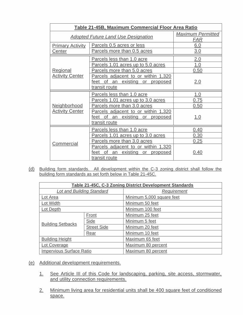
Table 21-45B, Maximum Commercial Floor Area Ratio
Adopted Future Land Use Designation Maximum Permitted
FAR
Primary Activity Center
Parcels 0.5 acres or less 6.0
Parcels more than 0.5 acres 3.0
Regional Activity Center
Parcels less than 1.0 acre 2.0
Parcels 1.01 acres up to 5.0 acres 1.0
Parcels more than 5.0 acres 0.50
Parcels adjacent to or within 1,320 feet of an existing or proposed transit route
2.0
Neighborhood Activity Center
Parcels less than 1.0 acre 1.0
Parcels 1.01 acres up to 3.0 acres 0.75
Parcels more than 3.0 acres 0.50
Parcels adjacent to or within 1,320 feet of an existing or proposed transit route
1.0
Commercial
Parcels less than 1.0 acre 0.40
Parcels 1.01 acres up to 3.0 acres 0.30
Parcels more than 3.0 acres 0.25
Parcels adjacent to or within 1,320 feet of an existing or proposed transit route
0.40
(d) Building form standards. All development within the C-3 zoning district shall follow the
building form standards as set forth below in Table 21-45C.
Table 21-45C, C-3 Zoning District Development Standards
Lot and Building Standard Requirement
Lot Area Minimum 5,000 square feet
Lot Width Minimum 50 feet
Lot Depth Minimum 100 feet
Building Setbacks
Front Minimum 25 feet
Side Minimum 5 feet
Street Side Minimum 20 feet
Rear Minimum 10 feet
Building Height Maximum 65 feet
Lot Coverage Maximum 80 percent
Impervious Surface Ratio Maximum 80 percent
(e) Additional development requirements.
1. See Article III of this Code for landscaping, parking, site access, stormwater, and utility connection requirements.
2. Minimum living area for residential units shall be 400 square feet of conditioned space.

Sec. 21-46. C-4 General (heavy) cCommercial- Heavy.
(a) Future land use classification: Commercial—Retail. Permissible Future Land Use
classifications. The C-4 zoning district may be assigned to properties designated as Primary Activity Center, Regional Activity Center, Neighborhood Activity Center, or Commercial on the City’s Future Land Use Map.
(b) The purpose of the C-4 general business district Commercial- Heavy zoning district is intended to provide locations for a combination of retail, wholesale, distribution and light manufacturing businesses that serve the entire City and markets beyond the City limits. In addition to large retail and service activities with outdoor storage, the district permits the manufacture of small articles and nonobjectionable products and limited production and processing operations. Generally, such districts are served by arterial and major collector streets.
(c) Permitted Development Intensity
1. The maximum Floor Area Ratio (FAR) for commercial uses located in the C-4 zoning district shall be as set forth in Table 21-46A.
Table 21-46A, Maximum Commercial Floor Area Ratio
Adopted Future Land Use Designation Maximum Permitted
FAR
Primary Activity Center
Parcels 0.5 acres or less 6.0
Parcels more than 0.5 acres 3.0
Regional Activity Center
Parcels less than 1.0 acre 2.0
Parcels 1.01 acres up to 5.0 acres 1.0
Parcels more than 5.0 acres 0.50
Parcels adjacent to or within 1,320 feet of an existing or proposed transit route
2.0
Neighborhood Activity Center
Parcels less than 1.0 acre 1.0
Parcels 1.01 acres up to 3.0 acres 0.75
Parcels more than 3.0 acres 0.50
Parcels adjacent to or within 1,320 feet of an existing or proposed transit route
1.0
Commercial
Parcels less than 1.0 acre 0.40
Parcels 1.01 acres up to 3.0 acres 0.30
Parcels more than 3.0 acres 0.25
Parcels adjacent to or within 1,320 feet of an existing or proposed transit route
0.40
(d) Building form standards. All development within the C-4 zoning district shall follow the
building form standards as set forth below in Table 21-46B.
Table 21-46B, C-4 Zoning District Development Standards
Lot and Building Standard Requirement
Lot Area Minimum 7,500 square feet
Lot Width Minimum 75 feet
Lot Depth Minimum 100 feet
Building Setbacks
Front Minimum 25 feet
Side Minimum 5 feet
Street Side Minimum 20 feet
Rear Minimum 10 feet
Building Height Maximum 35 feet
Lot Coverage Maximum 80 percent
Impervious Surface Ratio Maximum 80 percent
(e) Additional development requirements.
1. See Article III of this Code for landscaping, parking, site access, stormwater, and utility connection requirements.

Sec. 21-47. I-1 Light iIndustrial- Light.
(a) Future land use classification: Industrial. Permissible Future Land Use classification. The
I-1 zoning district may be assigned to properties designated as Industrial on the City’s Future Land Use Map.
(b) The purpose of the I-1 light iIndustrial- Light zoning district is intended primarily to provide areas for the manufacture of small articles and nonobjectionable products not involving the use of any materials, processes or machinery likely to cause undesirable effects upon nearby or adjacent business and residential property.
(c) Additional development standards:
(1) Development site shall be large enough to accommodate all required parking, stormwater management and other standards and facilities.
Permitted Development Intensity
1. The maximum Floor Area Ratio (FAR) for industrial uses located in the I-1 zoning district shall be as set forth in Table 21-47A.
Table 21-47A, Maximum Industrial Floor Area Ratio
Adopted Future Land Use Designation Maximum Permitted FAR
Primary Activity Center Maximum 0.25
Industrial
Parcels less than 5.0 acres Maximum 0.50
More than 5.0 acres Maximum 0.30
Convenience retail and services, daycare, and restaurant uses
Maximum 0.01
(d) Building form standards. All development within the I-1 zoning district shall follow the
building form standards as set forth below in Table 21-47B.
Table 21-47B, I-1 Zoning District Development Standards
Lot and Building Standard Requirement
Lot Area Minimum 7,500 square feet
Lot Width Minimum 50 feet
Lot Depth Minimum 125 feet
Building Setbacks
Front Minimum 25 feet
Side Minimum 5 feet
Street Side Minimum 20 feet
Rear Minimum 25 feet
Building Height Maximum 85 feet
Lot Coverage Maximum 50 percent
Impervious Surface Ratio Maximum 75 percent
(e) Additional development requirements.
1. See Article III of this Code for landscaping, parking, site access, stormwater, and utility connection requirements.

Sec. 21-48. I-2 Heavy iIndustrial- Heavy.
(a) Future land use classification: Industrial. Permissible Future Land Use classification. The
I-2 zoning district may be assigned to properties designated as Industrial on the City’s Future Land Use Map.
(b) The purpose of the I-2, heavy iIndustrial- Heavy zoning district is intended primarily to provide areas for manufacturing, or the use of processes or machinery having the potential to cause undesirable effects upon nearby residential or business propertyies.
(c) Additional development standards:
(1) Development site shall be large enough to accommodate all required parking, stormwater management and other standards and facilities.
Permitted Development Intensity
1. The maximum Floor Area Ratio (FAR) for industrial uses located in the I-2 zoning district shall be as set forth in Table 21-48A.
Table 21-48A, Maximum Industrial Floor Area Ratio
Adopted Future Land Use Designation Maximum Permitted FAR
Primary Activity Center Maximum 0.25
Industrial
Parcels less than 5.0 acres Maximum 0.50
More than 5.0 acres Maximum 0.30
Convenience retail and services, daycare, and restaurant uses
Maximum 0.01
(d) Building form standards. All development within the I-2 zoning district shall follow the
building form standards as set forth below in Table 21-48B.
Table 21-48B, I-2 Zoning District Development Standards
Lot and Building Standard Requirement
Lot Area Minimum 20,000 square feet
Lot Width Minimum 100 feet
Lot Depth Minimum 100 feet
Building Setbacks
Front Minimum 35 feet
Side Minimum 15 feet
Street Side Minimum 30 feet
Rear Minimum 25 feet
Building Height Maximum 85 feet
Lot Coverage Maximum 50 percent
Impervious Surface Ratio Maximum 75 percent
(e) Additional development requirements.
1. See Article III of this Code for landscaping, parking, site access, stormwater, and utility connection requirements.

Sec. 21-49. PI Public iInstitutional.
(a) Future land use classification: Institutional. Permissible Future Land Use classifications. The PI zoning district may be assigned to properties designated as Primary Activity Center, Regional Activity Center, Neighborhood Activity Center, Industrial, and Institutional on the City’s Future Land Use Map.
(b) The purpose of this the PI, Public Institutional zoning district is to establish locations for existing or future public and private institutional uses, such as local, State and Federal government buildings and facilities; schools, hospitals, major medical clinics, hospices, nursing homes, adult and child care facilities, churches, colleges and universities.
(c) Additional development requirements:
(1) Elevated water tanks shall be exempt from meeting the maximum building height requirements.
Permitted Development Intensity
The maximum Floor Area Ratio (FAR) for uses located in the PI zoning district shall be 0.90.
(d) Building form standards. All development within the PI zoning district shall follow the
building form standards as set forth below in Table 21-49A.
Table 21-49A, PI Zoning District Development Standards
Lot and Building Standard Requirement
Lot Area Minimum 5,000 square feet
Lot Width Minimum 50 feet
Lot Depth Minimum 100 feet
Building Setbacks
Front Minimum 25 feet
Side Minimum 5 feet
Street Side Minimum 20 feet
Rear Minimum 10 feet
Building Height Maximum 45 feet
Lot Coverage Maximum 65 percent
Impervious Surface Ratio Maximum 65 percent
(e) Additional development requirements.
1. See Article III of this Code for landscaping, parking, site access, stormwater, and utility connection requirements.
2. Elevated water tanks shall be exempt from meeting the maximum building height requirements.
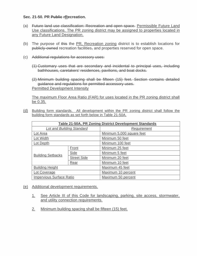
Sec. 21-50. PR Public rRecreation.
(a) Future land use classification: Recreation and open space. Permissible Future Land Use classifications. The PR zoning district may be assigned to properties located in any Future Land Designation.
(b) The purpose of this the PR, Recreation zoning district is to establish locations for publicly-owned recreation facilities, and properties reserved for open space.
(c) Additional regulations for accessory uses:
(1) Customary uses that are secondary and incidental to principal uses, including bathhouses, caretakers' residences, pavilions, and boat docks.
(2) Minimum building spacing shall be fifteen (15) feet. Section contains detailed guidance and regulations for permitted accessory uses.
Permitted Development Intensity
The maximum Floor Area Ratio (FAR) for uses located in the PR zoning district shall be 0.35.
(d) Building form standards. All development within the PR zoning district shall follow the
building form standards as set forth below in Table 21-50A.
Table 21-50A, PR Zoning District Development Standards
Lot and Building Standard Requirement
Lot Area Minimum 5,000 square feet
Lot Width Minimum 50 feet
Lot Depth Minimum 100 feet
Building Setbacks
Front Minimum 25 feet
Side Minimum 5 feet
Street Side Minimum 20 feet
Rear Minimum 10 feet
Building Height Maximum 45 feet
Lot Coverage Maximum 10 percent
Impervious Surface Ratio Maximum 50 percent
(e) Additional development requirements.
1. See Article III of this Code for landscaping, parking, site access, stormwater, and utility connection requirements.
2. Minimum building spacing shall be fifteen (15) feet.
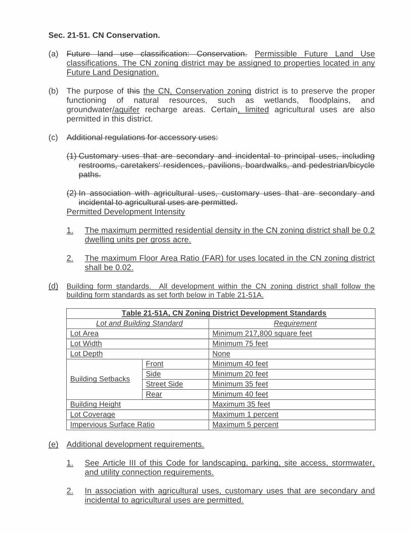
Sec. 21-51. CN Conservation.
(a) Future land use classification: Conservation. Permissible Future Land Use classifications. The CN zoning district may be assigned to properties located in any Future Land Designation.
(b) The purpose of this the CN, Conservation zoning district is to preserve the proper functioning of natural resources, such as wetlands, floodplains, and groundwater/aquifer recharge areas. Certain, limited agricultural uses are also permitted in this district.
(c) Additional regulations for accessory uses:
(1) Customary uses that are secondary and incidental to principal uses, including restrooms, caretakers' residences, pavilions, boardwalks, and pedestrian/bicycle paths.
(2) In association with agricultural uses, customary uses that are secondary and incidental to agricultural uses are permitted.
Permitted Development Intensity
1. The maximum permitted residential density in the CN zoning district shall be 0.2 dwelling units per gross acre.
2. The maximum Floor Area Ratio (FAR) for uses located in the CN zoning district shall be 0.02.
(d) Building form standards. All development within the CN zoning district shall follow the
building form standards as set forth below in Table 21-51A.
Table 21-51A, CN Zoning District Development Standards
Lot and Building Standard Requirement
Lot Area Minimum 217,800 square feet
Lot Width Minimum 75 feet
Lot Depth None
Building Setbacks
Front Minimum 40 feet
Side Minimum 20 feet
Street Side Minimum 35 feet
Rear Minimum 40 feet
Building Height Maximum 35 feet
Lot Coverage Maximum 1 percent
Impervious Surface Ratio Maximum 5 percent
(e) Additional development requirements.
1. See Article III of this Code for landscaping, parking, site access, stormwater, and utility connection requirements.
2. In association with agricultural uses, customary uses that are secondary and incidental to agricultural uses are permitted.

3. Minimum living area for residential units shall be 500 square feet of conditioned
space.

___________________________________________________________________________
___________________________________________________________________________
CITY OF WINTER HAVEN FACT SHEET PLANNING COMMISSION MEETING
January 5, 2021
DATE: December 9, 2020
TO: Winter Haven Planning Commissioners
VIA: Eric Labbe, Economic Opportunity and Community Investment Director
FROM: Sean Byers, Planning Manager
SUBJECT: Case Number P-21-05: Administrative request to amend the Winter Haven Code of Ordinances, Chapter 21, Article III, Division 6, Section 21-174, Dumpsters, for the purpose addressing placement criteria, enclosure design standards, maintenance, and screening exemptions.
BACKGROUND:
In February 2005, the City Commission adopted Ordinance O-05-06 creating Section 21-174 of the Code Ordinances addressing dumpsters. Section 21-174 provides requirements for the placement and screening of dumpsters on commercial and multi-family residential properties as well as a provision which required all existing dumpsters to be in compliance with the new standards by January 1, 2010. In February 2010, Section 21-174 was further revised to extend the time to bring existing dumpsters into compliance to July 1, 2013.
Following the July 1, 2013 expiration date, the City’s Code Compliance Division, began enforcement proceedings on property owners failing to comply with the screening requirements. As these cases moved forward to the Code Enforcement Special Magistrate, it became clear many properties in the City had physical difficulties becoming compliant with this section of Code. As a result, Code Compliance limited their enforcement of this section until such time the Code is readdressed.
Planning staff, in coordination with staff from Solid Waste and Code Compliance, reviewed ongoing concerns with this section and developed changes to improve both the fairness and enforceability of this Section. Changes include:
• Elimination of requirements to bring dumpsters presently in place up to code (Note: All new dumpsters installed since 2005, meet screening requirements);
• Any new installment, change in use, change in business, or replacement of a dumpster will require compliance with screening requirements;
• Now exempts dumpsters located behind the principal structure or more than 100 feet from the roadway from screening, provided a minimum 6-foot opaque fence or wall lies between the dumpster and any residentially or recreationally zoned property; and

• Specifically states dumpster enclosures are not accessory structures, and therefore not subject to setback requirements (This is needed as accessibility by collection vehicles often dictates placement locations on a site).
The proposed changes keep in place current requirements for 100 percent opaque screening of new dumpsters, a maximum 50 percent opaque screening for enclosure gates, maintenance of the enclosure, dumpster lid closure, and a waiver process.
NOTIFICATION:
All public notification requirements for this request were met.
RECOMMENDATION:
Staff recommends the Planning Commission recommend approval of this request, and its forwarding to the City Commission for final action.
ATTACHMENT:
Revised Section 21-174
ANTICIPATED CITY COMMISSION ACTION DATES:
February 8, 2021 (First Reading) February 22, 2021 (Second Reading, Public Hearing, and Final Adoption)

Revised Section 21-174
New language is underlined and deleted language is stricken through.
Sec. 21-174. Dumpsters.
All commercial and multi-family residential developments shall have adequate solid waste collection areas with adequate access and egress, independent of parking and loading facilities. Where dumpsters are to be used, Ddumpster pads and access drives shall meet the requirements currently issued by the City’s Community Services Public Works Department. Any new installment, change in use, change in business, or replacement of a dumpster will require compliance with this code and must be inspected and approved by the Solid Waste Division.
(a) Screening. Dumpsters areas shall be screened to completely shield dumpsters from view of from public roads, public rights-of-way, and residential areas permitted by zoning. The screening material shall be one hundred (100) percent opaque and shall be of similar material or color as the principal structure. The entry doors to the dumpster area must be no more than fifty (50) percent opaque. Screening shall include fencing, retaining walls, plant material, or a combination thereof. Vegetative planting shall provide a living visual screen of adequate height (no less than five (5) feet at planting) and density to accomplish effective screening. This section of the code will be phased in over an eight-year period, with all dumpsters in compliance by July 1, 2013. The Community Development Director, or her/his designee, may grant a waiver from this section, if a majority of the Development Review Committee (DRC) determines the screening is physically infeasible. Additionally, any change in use, change in business, or replacement of a dumpster will require compliance with the Code. Screening shall meet the following requirements:
(1) The screening material shall be one hundred (100) percent opaque and shall
be of similar material or color as the principal structure. Screening materials
may include fencing, retaining walls, plant material, or a combination thereof.
If vegetative plantings are used for screening, the plantings shall provide a
living visual screen of adequate height (no less than five (5) feet at planting)
and density to accomplish effective screening within 24 months.
(2) The entry doors and gates to the dumpster area must be no more than fifty
(50) percent opaque and shall be kept closed and secured.
(3) Screening materials shall be installed in a workmanlike manner and installed
in accordance with the manufacturer’s installation instructions.
(4) Dumpster enclosures, screening materials, gates, and all portions thereof
shall be maintained and kept in good repair and free from defects.
(5) Dumpster lids must be kept closed and secured.

(6) Areas located inside and surrounding the dumpster enclosure shall be kept
free of loose or bagged garbage or other solid waste debris.
(b) Exemptions.
1. Dumpsters located behind the principle structure or one-hundred (100) or
more feet from the roadway shall be exempt from the screening requirement,
provided a minimum 6-foot wall or opaque fence exists between the dumpster
and any residentially or recreationally zoned property.
2. Temporary construction dumpsters shall be exempt from the requirements of
this section provided an active permit is in effect for the property on which the
construction dumpster is located.
(c) Waivers. The Economic Opportunity and Community Investment Director, or
his/her designee, may grant a waiver from this section if the Development Review
Committee (DRC) determines the screening is physically infeasible.
(d) For the purposes of this Code, dumpsters and required dumpster enclosures, are
not considered accessory structures for setback purposes.

___________________________________________________________________________
CITY OF WINTER HAVEN FACT SHEET PLANNING COMMISSION MEETING
January 5, 2021
DATE: December 2, 2020
TO: Winter Haven Planning Commissioners
VIA: Eric Labbe, Economic Opportunity and Community Investment Director Sean Byers, Planning Manager
FROM: Heather Reuter, Planner II
SUBJECT: Case Number P-21-06: Administrative request to amend the Winter Haven Code of Ordinances, Chapter 21, Article II, Division 3, Section 21-69, Animal Limitations for the purpose of addressing chickens.
BACKGROUND:
In response to concerns with respect to the City’s agricultural regulations, specifically the inability to allow chickens within any zoning district, staff has developed regulations to address these concerns. The intent of this amendment is to allow chickens as an accessory use in all non-agricultural zoning districts and provide specific standards related to chicken quantities, permitted locations on the property, and coops. The Agriculture (AG) zoning district which permits broader agricultural uses will not be affected by this request.
NOTIFICATION:
All public notification requirements for this request were met.
CONCLUSION:
The proposed amendments to Section 21-69 will accomplish the following:
Allow chickens as an accessory use in all zoning districts, except Agricultural (AG) zoning district
Provide the following standards for accessory chickens:
o Hens only (no roosters allowed);
o 1 chicken/500 square feet of parcel/lot area, excluding any principal or accessory structures with a maximum of 15 permitted;
o A coop must be present on the property;

o Coops shall adhere to accessory structure setbacks for the zoning district; and
o Coops shall be a maximum of 125 square feet and maximum of 6 feet in height.
RECOMMENDATION:
Staff recommends the Planning Commission recommend approval of the text amendments to the ULDC and their forwarding to the City Commission for final action.
ATTACHMENT:
Proposed amendments to Section 21-69
ANTICIPATED CITY COMMISSION ACTION:
February 8, 2021 (First Reading) February 22, 2021 (Second Reading, Public Hearing, and Final Adoption)
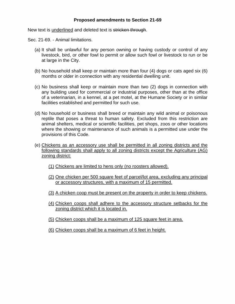
Proposed amendments to Section 21-69
New text is underlined and deleted text is stricken through.
Sec. 21-69. - Animal limitations.
(a) It shall be unlawful for any person owning or having custody or control of any livestock, bird, or other fowl to permit or allow such fowl or livestock to run or be at large in the City.
(b) No household shall keep or maintain more than four (4) dogs or cats aged six (6) months or older in connection with any residential dwelling unit.
(c) No business shall keep or maintain more than two (2) dogs in connection with any building used for commercial or industrial purposes, other than at the office of a veterinarian, in a kennel, at a pet motel, at the Humane Society or in similar facilities established and permitted for such use.
(d) No household or business shall breed or maintain any wild animal or poisonous reptile that poses a threat to human safety. Excluded from this restriction are animal shelters, medical or scientific facilities, pet shops, zoos or other locations where the showing or maintenance of such animals is a permitted use under the provisions of this Code.
(e) Chickens as an accessory use shall be permitted in all zoning districts and the following standards shall apply to all zoning districts except the Agriculture (AG) zoning district:
(1) Chickens are limited to hens only (no roosters allowed).
(2) One chicken per 500 square feet of parcel/lot area, excluding any principal or accessory structures, with a maximum of 15 permitted.
(3) A chicken coop must be present on the property in order to keep chickens.
(4) Chicken coops shall adhere to the accessory structure setbacks for the zoning district which it is located in.
(5) Chicken coops shall be a maximum of 125 square feet in area.
(6) Chicken coops shall be a maximum of 6 feet in height.