ADVANCING A PROSPECTIVE PORTFOLIO TO DISCOVERY … · 2019-07-29 · Domeyko Cordillera –3 of...
84
www.reveloresources.com ADVANCING A PROSPECTIVE PORTFOLIO TO DISCOVERY SUCCESS Copper - Gold - Silver MONTEZUMA COPPER-GOLD-MOLY Northern Chile LOI with BMR Group PLC Project Technical Summary July 2019
Transcript of ADVANCING A PROSPECTIVE PORTFOLIO TO DISCOVERY … · 2019-07-29 · Domeyko Cordillera –3 of...

www.reveloresources.com
ADVANCING A PROSPECTIVE PORTFOLIOTO DISCOVERY SUCCESS
Copper - Gold - Silver
MONTEZUMA
COPPER-GOLD-MOLYNorthern Chile
LOI withBMR Group PLC
Project Technical Summary
July 2019

www.reveloresources.com
Cautionary Statement
2
Certain statements contained in the following presentation constituteforward-looking statements. Such forward looking statements involvea number of known and unknown risks, uncertainties and otherfactors which may cause the actual results, performance orachievements of the Company to be materially different from anyfuture results, performance or achievements expressed or implied bysuch forward-looking statements. Readers are cautioned not to placeundue reliance on these forward-looking statements.
Dr. Demetrius Pohl, PhD., Certified Professional Geoscientist (CPG), anindependent consultant, is the Company’s Qualified Person for thepurposes of National Instrument 43-101 Standards of Disclosures forMineral Projects of the Canadian Securities Administrators, and isresponsible for the accuracy of, and has verified, the technicalinformation in this presentation and has approved its writtendisclosure.
www.reveloresources.com www.reveloresources.com
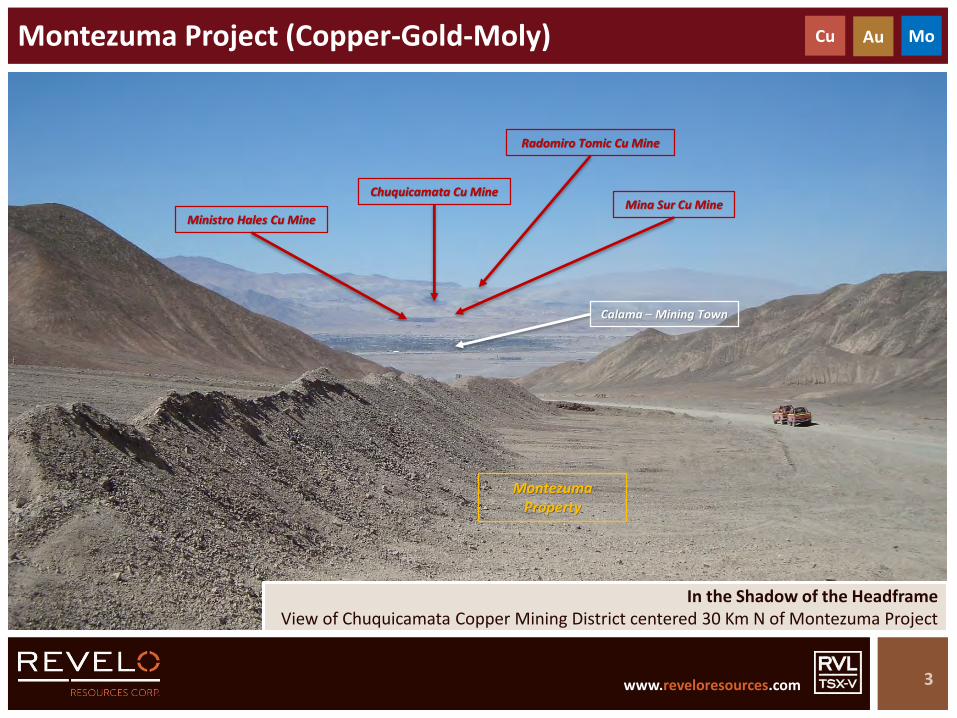
Montezuma Project (Copper-Gold-Moly)
3
In the Shadow of the HeadframeView of Chuquicamata Copper Mining District centered 30 Km N of Montezuma Project
Cu Au Mo
Ministro Hales Cu Mine
Calama – Mining Town
Chuquicamata Cu MineMina Sur Cu Mine
Radomiro Tomic Cu Mine
Montezuma Property
www.reveloresources.com www.reveloresources.com
Montezuma Project (Copper-Gold-Moly)
4
Cu Au Mo
Copper-Gold-Moly exploration project – Northern Chile
Major district-scale exploration play – ~ 16,300 Hectares
Project subject to LOI with BMR Group PLC (Option Agreement and shares in BMR)
Centred in the heart of one of the world’s largest copper mining districts
Midway between the Chuquicamata District and the Centinela District
Porphyry copper-gold-moly exploration targets
Major hydrothermal alteration systems with porphyry copper-gold characteristics
Significant historic drill intercepts indicating presence of mineralised systems
E.g. 44m @ 0.55% Cu + 0.17g/t Au + 3.4g/t Ag
Multiple targets – some drill ready
Northern Chile
Desert terrane, excellent infrastructure, easy access
www.reveloresources.com www.reveloresources.com
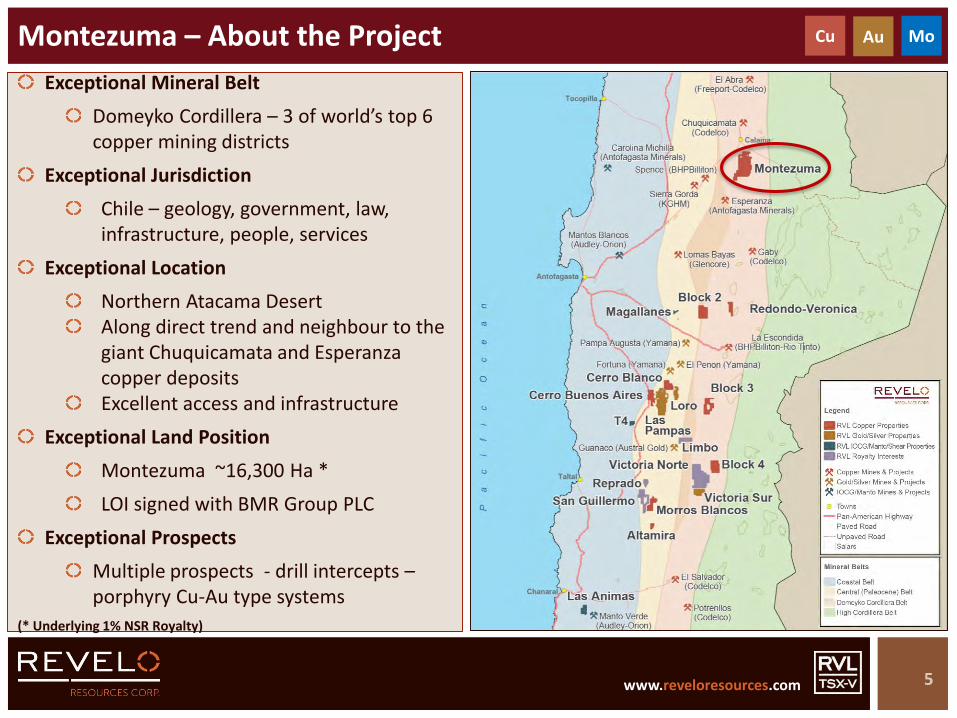
Exceptional Mineral Belt
Domeyko Cordillera – 3 of world’s top 6 copper mining districts
Exceptional Jurisdiction
Chile – geology, government, law, infrastructure, people, services
Exceptional Location
Northern Atacama DesertAlong direct trend and neighbour to the giant Chuquicamata and Esperanza copper depositsExcellent access and infrastructure
Exceptional Land Position
Montezuma ~16,300 Ha *
LOI signed with BMR Group PLC
Exceptional Prospects
Multiple prospects - drill intercepts –porphyry Cu-Au type systems
(* Underlying 1% NSR Royalty)
Montezuma – About the Project
5
Cu Au Mo
www.reveloresources.com www.reveloresources.com
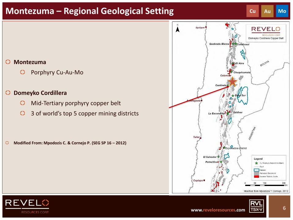
Montezuma
Porphyry Cu-Au-Mo
Domeyko Cordillera
Mid-Tertiary porphyry copper belt
3 of world’s top 5 copper mining districts
Modified From: Mpodozis C. & Cornejo P. (SEG SP 16 – 2012)
Montezuma – Regional Geological Setting
6
Cu Au Mo

www.reveloresources.com www.reveloresources.com
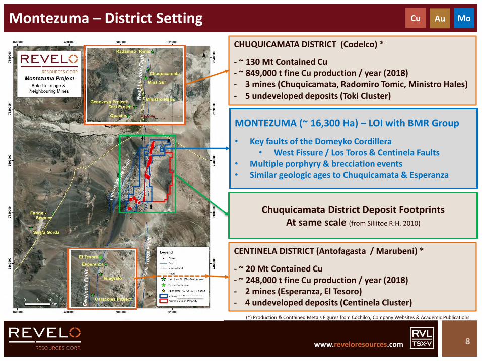
Montezuma – District Setting
7
10 Km
CHUQUICAMATA DISTRICT (Codelco) *
- ~ 130 Mt Contained Cu- ~ 849,000 t fine Cu production / year (2018)- 3 mines (Chuquicamata, Radomiro Tomic, Ministro Hales)- 5 undeveloped deposits (Toki Cluster)
CENTINELA DISTRICT (Antofagasta / Marubeni) *
- ~ 20 Mt Contained Cu- ~ 248,000 t fine Cu production / year (2018)- 2 mines (Esperanza, El Tesoro)- 4 undeveloped deposits (Centinela Cluster)
Cu Au Mo
MONTEZUMA (~ 16,300 Ha) – LOI with BMR Group
• Key faults of the Domeyko Cordillera• West Fissure / Los Toros & Centinela Faults
• Multiple porphyry & brecciation events• Similar geologic ages to Chuquicamata & Esperanza
ARRIEROS PROJECT (~ 14,000 Ha) – Revelo
• Key post-mineral covered area with geophysical anomalies
(*) Production & Contained Metals Figures from Cochilco, Company Websites & Academic Publications
www.reveloresources.com www.reveloresources.com
Montezuma – District Setting
8
10 Km
CHUQUICAMATA DISTRICT (Codelco) *
- ~ 130 Mt Contained Cu- ~ 849,000 t fine Cu production / year (2018)- 3 mines (Chuquicamata, Radomiro Tomic, Ministro Hales)- 5 undeveloped deposits (Toki Cluster)
CENTINELA DISTRICT (Antofagasta / Marubeni) *
- ~ 20 Mt Contained Cu- ~ 248,000 t fine Cu production / year (2018)- 2 mines (Esperanza, El Tesoro)- 4 undeveloped deposits (Centinela Cluster)
Cu Au Mo
MONTEZUMA (~ 16,300 Ha) – LOI with BMR Group
• Key faults of the Domeyko Cordillera• West Fissure / Los Toros & Centinela Faults
• Multiple porphyry & brecciation events• Similar geologic ages to Chuquicamata & Esperanza
(*) Production & Contained Metals Figures from Cochilco, Company Websites & Academic Publications
Chuquicamata District Deposit FootprintsAt same scale (from Sillitoe R.H. 2010)

www.reveloresources.com www.reveloresources.com
Montezuma – Scale Comparison with Chuquicamata District
9
10 Km 10 Km
Chuquicamata District Deposit Footprints
At same scale(modified from Sillitoe R.H. 2010)
Chuquicamata District Montezuma Project
Calama Town
Calama TownRadamiro Tomic
Chuquicamata
Mina Sur
Ministro Hales
Toki Cluster
Melissa
Target L
Target F
Target C
Target A
Target B
Arrieros Project
www.reveloresources.com www.reveloresources.com
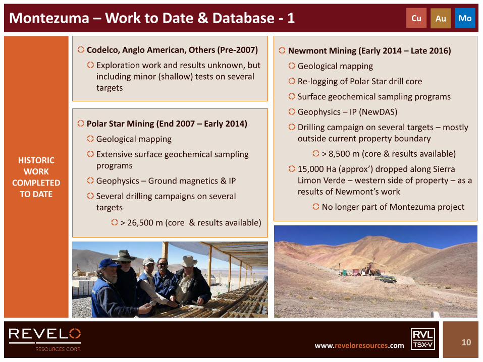
Codelco, Anglo American, Others (Pre-2007)
Exploration work and results unknown, but including minor (shallow) tests on several targets
Montezuma – Work to Date & Database - 1
10
HISTORIC WORK
COMPLETED TO DATE
Polar Star Mining (End 2007 – Early 2014)
Geological mapping
Extensive surface geochemical sampling programs
Geophysics – Ground magnetics & IP
Several drilling campaigns on several targets
> 26,500 m (core & results available)
Newmont Mining (Early 2014 – Late 2016)
Geological mapping
Re-logging of Polar Star drill core
Surface geochemical sampling programs
Geophysics – IP (NewDAS)
Drilling campaign on several targets – mostly outside current property boundary
> 8,500 m (core & results available)
15,000 Ha (approx’) dropped along Sierra Limon Verde – western side of property – as a results of Newmont’s work
No longer part of Montezuma project
Cu Au Mo
www.reveloresources.com www.reveloresources.com
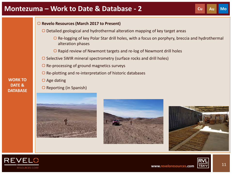
Revelo Resources (March 2017 to Present)
Detailed geological and hydrothermal alteration mapping of key target areas
Re-logging of key Polar Star drill holes, with a focus on porphyry, breccia and hydrothermal alteration phases
Rapid review of Newmont targets and re-log of Newmont drill holes
Selective SWIR mineral spectrometry (surface rocks and drill holes)
Re-processing of ground magnetics surveys
Re-plotting and re-interpretation of historic databases
Age dating
Reporting (in Spanish)
Montezuma – Work to Date & Database - 2
11
WORK TO DATE &
DATABASE
Cu Au Mo

www.reveloresources.com www.reveloresources.com
Montezuma – Satellite Image & Principal Targets
12
Paleozoic basement with numerous small workings for Cu, with lesser Au
Extensive intermediate argillic alteration in transition to phyllic (sericitic) alteration
New, undrilled target defined by Revelo, associated with phyllic alteration and chalcocite-rich structures
Area to N of principal target – post-mineral cover
Phyllic & potassic alteration at surface and drill holes with morphology of Ministro Hales deposit/mine
Geophysical anomalies
Limited drilling – fault controlled targets
Mid-Tertiary age dating from drill hole
+10 km of discontinuous outcrops of Mid-Tertiary aged porphyry intrusions and breccias
Intense hydrothermal alteration from potassic to phyllic to intermediate argillic to advanced argillic
Multiple porphyry and breccia types (including phreatomagmatic breccias)
Extensive drilling with mineralised intercepts – but open potential defined by Revelo
Mid-Tertiary ages from drill hole & surface outcrops
Arrieros Property – Separate Project
MELISSA
ANOMALYL & F
ANOMALYC-A-B
ARRIEROS(COVERED)

www.reveloresources.com www.reveloresources.com
Montezuma – Schematic Geology & Principal Targets
13
Paleozoic basement with numerous small workings for Cu, with lesser Au
Extensive intermediate argillic alteration in transition to phyllic (sericitic) alteration
New, undrilled target defined by Revelo, associated with phyllic alteration and chalcocite-rich structures
Area to N of principal target – post-mineral cover
Phyllic & potassic alteration at surface and drill holes with morphology of Ministro Hales deposit/mine
Geophysical anomalies
Limited drilling – fault controlled targets
Mid-Tertiary age dating from drill hole
+10 km of discontinuous outcrops of Mid-Tertiary aged porphyry intrusions and breccias
Intense hydrothermal alteration from potassic to phyllic to intermediate argillic to advanced argillic
Multiple porphyry and breccia types (including phreatomagmatic breccias)
Extensive drilling with mineralised intercepts – but open potential defined by Revelo
Mid-Tertiary ages from drill hole & surface outcrops
Arrieros Property – Separate Project
MELISSA
ANOMALYL & F
ANOMALYC-A-B
ARRIEROS(COVERED)

www.reveloresources.com www.reveloresources.com
Montezuma – Radiometric Age Dating
14
Surface sample – U-Pb age date on zircon from sericite-altered granitoid – 281 +/- 8.5 Ma
Possible inherited age date from Paleozoic host
Equivocal result
2 samples – Target L
MODD-34-10 @ 63.4m – K-Ar date from sericite-altered dacite porphyry – 45.4 +/- 1.2 Ma
MODD-34-10 @ 233.5m – K-Ar date from sericite-altered feldspar porphyry – 39.1 +/- 1.3 Ma
Mid-Tertiary ages confirmed
4 samples – Target B
MODD-38-10 @ 870m – U-Pb age date on biotite from dacite porphyry – 43.9 +/- 0.2 Ma
Surface sample – K-Ar age date on alunite from altered basement granite – 29.0 +/- 6.8 Ma (supergene?)
Surface sample – U-Pb age date on biotite from quartz monzodiorite porphyry – 43.7 +/- 0.4 Ma
Surface sample – K-Ar age date on feldspar from feldspar porphyry – 45.4 +/- 1.2 Ma (JOGMEC)
Mid-Tertiary ages confirmed
MELISSA
TARGETL & F
TARGETC-A-B
45.4 ± 1.2K-Ar
39.1 ± 1.3K-Ar
29.0 ± 6.8K-Ar
43.9 ± 0.2U-Pb
45.4 ± 1.2K-Ar
43.7 ± 0.4U-Pb
281 ± 8.5U-Pb
268.8 ± 8.0K-Ar

www.reveloresources.com www.reveloresources.com
Database: RAB/TOB Surface Rock – Sample Locations
15
Montezuma
Polar Star RAB/TOB rock samples – taken along IP lines
Shallow holes up to 1.2m deep
Red dots show samples that reached TOB (Top of Bedrock)
Black dots show samples that sampled caliche or alluvium / colluvium
2,965 samples in total collected for Montezuma
Of which 1,666 reached TOB (results used by Revelo)
Effectively weathered rock-chip samples
Analysed by ALS labs – ICP ME-MS61 (4-acid)
Not all samples analysed for Au or Hg
5 Km

www.reveloresources.com www.reveloresources.com
Database: IP Chargeability
16
IP Chargeability @ 250m (Polar Star) NewDas Chargeability @ 300m (Newmont)
5 Km 5 Km

www.reveloresources.com www.reveloresources.com
Database: IP Resistivity
17
IP Resistivity @ 250m (Polar Star) NewDas Resistivity @ 300m (Newmont)
Inverted colour code
5 Km 5 Km

www.reveloresources.com www.reveloresources.com
Database: IP Chargeability & Principal Targets
18
IP Chargeability @ 250m (Polar Star)
5 Km
Paleozoic basement with numerous small workings for Cu, with lesser Au
Extensive intermediate argillic alteration in transition to phyllic (sericitic) alteration
New, undrilled target defined by Revelo, associated with phyllic alteration and chalcocite-rich structures
Area to N of principal target – post-mineral cover
Phyllic & potassic alteration at surface and drill holes with morphology of Ministro Hales deposit/mine
Geophysical anomalies
Limited drilling – fault controlled targets
Mid-Tertiary age dating from drill hole
+10 km of discontinuous outcrops of Mid-Tertiary aged porphyry intrusions and breccias
Intense hydrothermal alteration from potassic to phyllic to intermediate argillic to advanced argillic
Multiple porphyry and breccia types (including phreatomagmatic breccias)
Extensive drilling with mineralised intercepts – but open potential defined by Revelo
Mid-Tertiary ages from drill hole & surface outcrops
Arrieros Property – Separate Project
MELISSA
ANOMALYL & F
ANOMALYC-A-B
ARRIEROS(COVERED)
www.reveloresources.com www.reveloresources.com
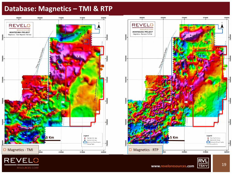
Database: Magnetics – TMI & RTP
19
Magnetics - TMI Magnetics - RTP
5 Km 5 Km
www.reveloresources.com www.reveloresources.com
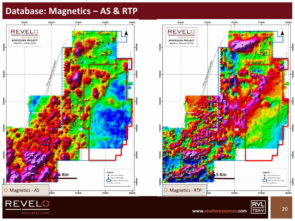
Database: Magnetics – AS & RTP
20
Magnetics - AS Magnetics - RTP
5 Km 5 Km

www.reveloresources.com www.reveloresources.com
Database: Magnetics – AS & Principal Targets
21
Magnetics - AS
5 Km
Paleozoic basement with numerous small workings for Cu, with lesser Au
Extensive intermediate argillic alteration in transition to phyllic (sericitic) alteration
New, undrilled target defined by Revelo, associated with phyllic alteration and chalcocite-rich structures
Area to N of principal target – post-mineral cover
Phyllic & potassic alteration at surface and drill holes with morphology of Ministro Hales deposit/mine
Geophysical anomalies
Limited drilling – fault controlled targets
Mid-Tertiary age dating from drill hole
+10 km of discontinuous outcrops of Mid-Tertiary aged porphyry intrusions and breccias
Intense hydrothermal alteration from potassic to phyllic to intermediate argillic to advanced argillic
Multiple porphyry and breccia types (including phreatomagmatic breccias)
Extensive drilling with mineralised intercepts – but open potential defined by Revelo
Mid-Tertiary ages from drill hole & surface outcrops
Arrieros Property – Separate Project
MELISSA
ANOMALYL & F
ANOMALYC-A-B
ARRIEROS(COVERED)
www.reveloresources.com www.reveloresources.com
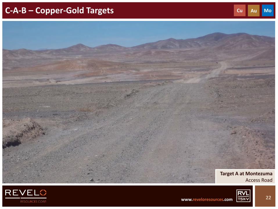
C-A-B – Copper-Gold Targets
22
Cu Au Mo
Target A at MontezumaAccess Road

www.reveloresources.com www.reveloresources.com
2 Km2 Km
A
B
C-A-B – Satellite Image
23
C

www.reveloresources.com www.reveloresources.com
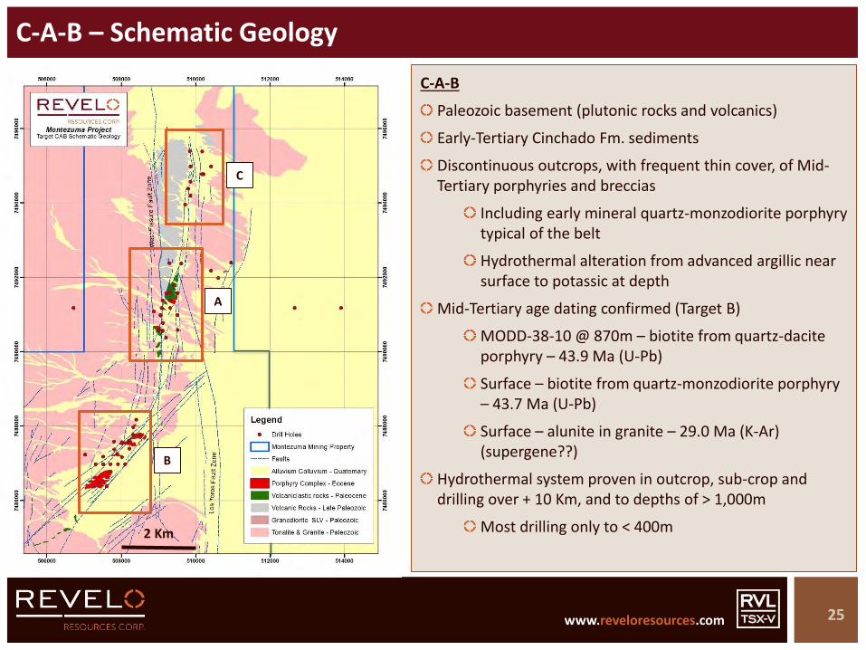
C-A-B – Schematic Geology
24
2 Km 2 Km
C-A-B
Key structural controls of multiple porphyry and breccia events
West Fissure / Los Toros Fault Zone (N-S)
Centinela Fault Zone (NE-SW)
+ 10 Km of hydrothermal alteration – Mid-Tertiary (dated)
A
B
C
www.reveloresources.com www.reveloresources.com
C-A-B – Schematic Geology
25
2 Km 2 Km
C-A-B
Paleozoic basement (plutonic rocks and volcanics)
Early-Tertiary Cinchado Fm. sediments
Discontinuous outcrops, with frequent thin cover, of Mid-Tertiary porphyries and breccias
Including early mineral quartz-monzodiorite porphyry typical of the belt
Hydrothermal alteration from advanced argillic near surface to potassic at depth
Mid-Tertiary age dating confirmed (Target B)
MODD-38-10 @ 870m – biotite from quartz-dacite porphyry – 43.9 Ma (U-Pb)
Surface – biotite from quartz-monzodiorite porphyry – 43.7 Ma (U-Pb)
Surface – alunite in granite – 29.0 Ma (K-Ar) (supergene??)
Hydrothermal system proven in outcrop, sub-crop and drilling over + 10 Km, and to depths of > 1,000m
Most drilling only to < 400m
A
B
C

www.reveloresources.com www.reveloresources.com
C-A-B – RAB/TOB Surface Rock Geochemistry - Cu
26
2 Km 2 Km
C-A-B
Polar Star RAB/TOB rock samples - CuA
B
C
www.reveloresources.com www.reveloresources.com
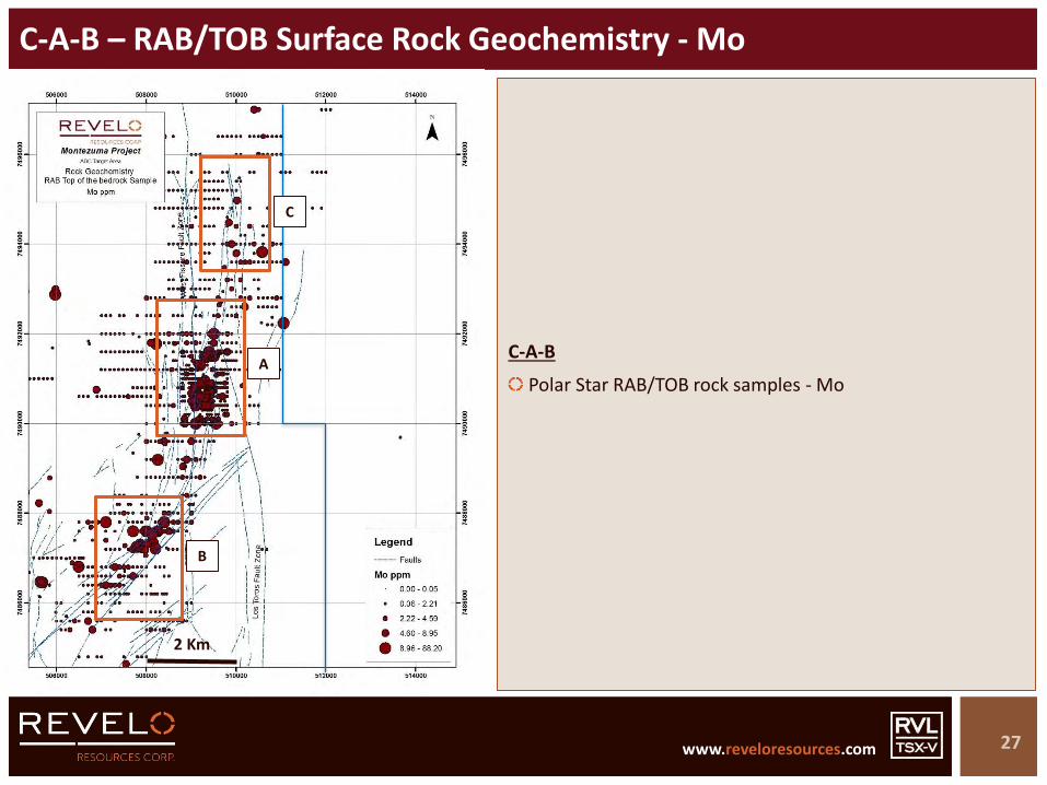
C-A-B – RAB/TOB Surface Rock Geochemistry - Mo
27
2 Km 2 Km
C-A-B
Polar Star RAB/TOB rock samples - MoA
B
C

www.reveloresources.com www.reveloresources.com
C-A-B – RAB/TOB Surface Rock Geochemistry – Summary (1 of 2)
28
2 Km 2 Km
C-A-B
Multi-element geochemical anomalies from Polar Star RAB/TOB surface rock samples
Note (restricted) sample distribution in geochemical maps
Only those RAB samples that reached TOB are plotted (others sampled post-mineral materials)
3 principal zones drill tested by Polar Star clearly anomalous in surface geochemistry – multi-element
Coincident with IP chargeability anomalies (shallow penetrating – see below))
Cu-Mo-Au-Ag focussed at A and B
Clear porphyry geochemical signature
Mostly high-level epithermal signature at C
May represent lesser erosion than A and B
Possibly telescoped systems at A and B – epithermal and porphyry signatures
Corresponds with known geology – AA alteration at surface – into sericite alteration in drill holes
Strongest As at A
A
B
C

www.reveloresources.com www.reveloresources.com
C-A-B – RAB/TOB Surface Rock Geochemistry – Summary (2 of 2)
29
2 Km 2 Km
C-A-B
Sb-Bi-Li signature along western branch of West Fissure Fault to west of C (possible epithermal signature to be investigated)
Epithermal / high level
Post-mineral covered areas not tested by surface geochemistry methodology
Extensive colluvial cover in areas of immediate interest
Deeper, gravel filled, fault-bounded basins (“pampas”) – particularly to E, SE, S, and SW of B, and N of C
Arrieros pampa to east
Surface oxidation and leaching will affect some geochemical distribution patterns
A
B
C
www.reveloresources.com www.reveloresources.com
C-A-B – IP Chargeability
30
2 Km
C-A-B
IP Chargeability @ 250m shown
Three principal Target areas (C-A-B) indicated by IP chargeability response
Chargeability map reflects strong structural controls along West Fissure / Los Torros and Centinela Fault Zones
IP appears to have shallow penetration
Intense caliche & high contact impedance
Likely only top of sulphide system is detected beneath a leached capping
Effectiveness of IP in covered areas - variable
Historic drilling focused on IP chargeability anomalies
Covered areas – particularly to SW, S, SE and E of Target B –not tested by drilling
2 Km
A
B
C

www.reveloresources.com www.reveloresources.com
C-A-B – IP Resistivity
31
2 Km
C-A-B
IP Resistivity @ 250m shown
Three principal Target areas (C-A-B) indicated by IP resistivity response
Resistivity map reflects strong structural controls along West Fissure / Los Torros and Centinela Fault Zones
IP appears to have shallow penetration
Intense caliche & high contact impedance
Effectiveness of IP in covered areas - variable
Margin of Miocene gravel-filled Arrieros Basin to east is clearly depicted by resistivity to east of Targets C-A-B
Broad, flat resistivity response
2 Km
A
B
C
www.reveloresources.com www.reveloresources.com
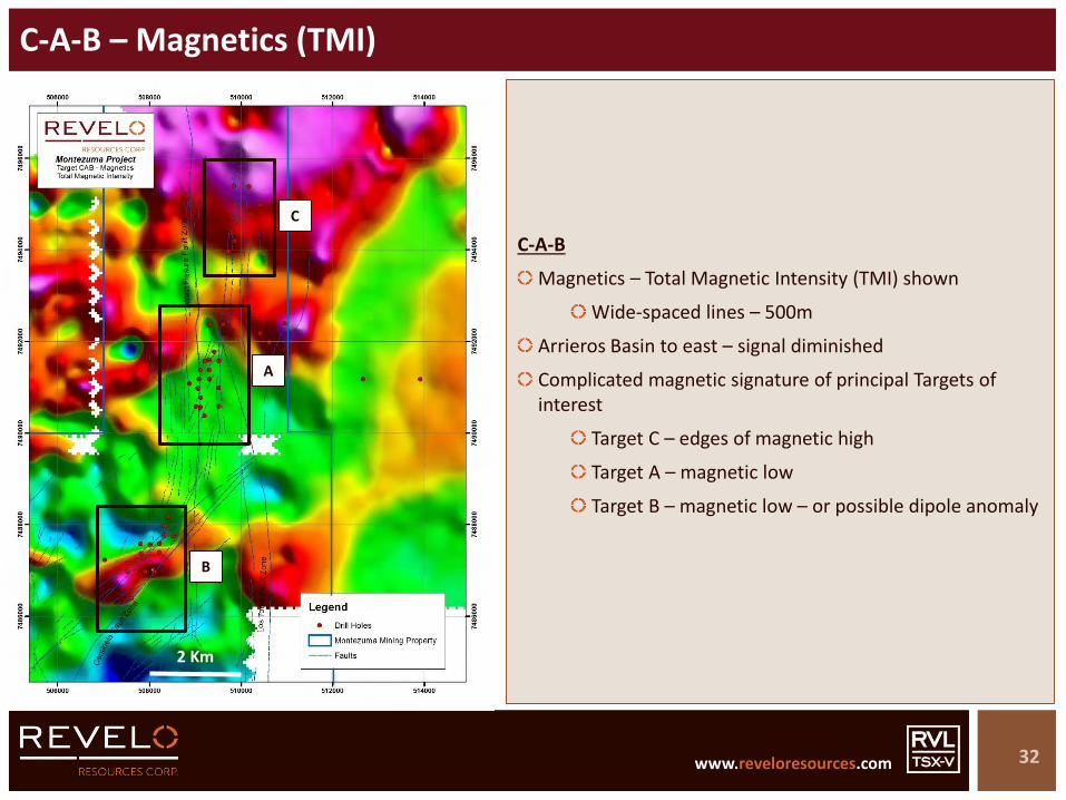
C-A-B – Magnetics (TMI)
32
2 Km
C-A-B
Magnetics – Total Magnetic Intensity (TMI) shown
Wide-spaced lines – 500m
Arrieros Basin to east – signal diminished
Complicated magnetic signature of principal Targets of interest
Target C – edges of magnetic high
Target A – magnetic low
Target B – magnetic low – or possible dipole anomaly
2 Km
A
B
C

www.reveloresources.com www.reveloresources.com
C-A-B – Magnetics (RTP)
33
2 Km
C-A-B
Magnetics – Reduction To Pole (RTP) shown
Wide-spaced lines – 500m
Arrieros Basin to east – signal diminished
Complicated magnetic signature of principal Targets of interest
Target C – magnetic high
Target A – relative magnetic low
Target B – magnetic low – or possible dipole anomaly
2 Km
A
B
C
www.reveloresources.com www.reveloresources.com
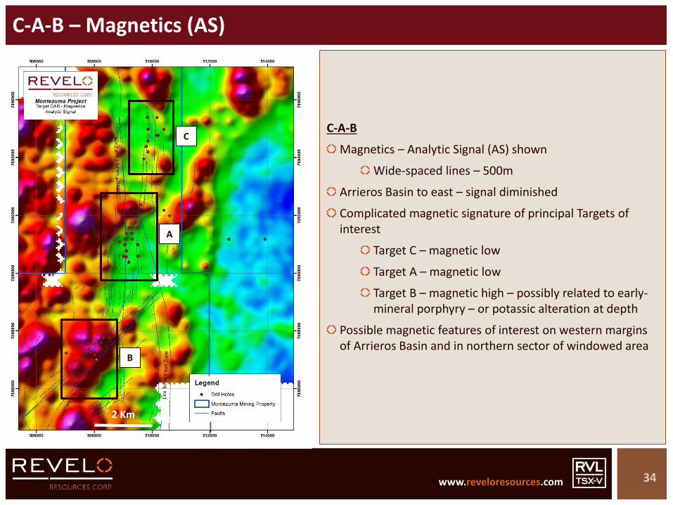
C-A-B – Magnetics (AS)
34
2 Km
C-A-B
Magnetics – Analytic Signal (AS) shown
Wide-spaced lines – 500m
Arrieros Basin to east – signal diminished
Complicated magnetic signature of principal Targets of interest
Target C – magnetic low
Target A – magnetic low
Target B – magnetic high – possibly related to early-mineral porphyry – or potassic alteration at depth
Possible magnetic features of interest on western margins of Arrieros Basin and in northern sector of windowed area
2 Km
A
B
C
www.reveloresources.com www.reveloresources.com
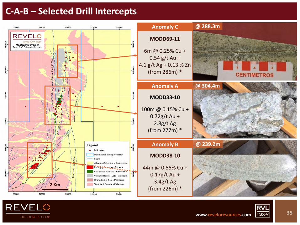
C-A-B – Selected Drill Intercepts
35
2 Km2 Km
Anomaly A
Anomaly B
MODD33-10
100m @ 0.15% Cu + 0.72g/t Au +
2.8g/t Ag(from 277m) *
MODD38-10
44m @ 0.55% Cu + 0.17g/t Au +
3.4g/t Ag(from 226m) *
@ 304.4m
@ 239.2m
Anomaly C
MODD69-11
6m @ 0.25% Cu +0.54 g/t Au +
4.1 g/t Ag + 0.13 % Zn(from 286m) *
@ 288.3m

www.reveloresources.com www.reveloresources.com
Target B – Schematic Section
36
B
Section 7487000N
Paleozoic basement host rocks – granitoids
Major multiple porphyry and breccia events
Confined between strands of Centinela Fault Zone
Mid-Tertiary age dates confirmed
B – Target
Prograde potassic-altered Cu-Au core associated with inter-mineral porphyry phase
Possible extensions under faulted Miocene cover to SW, S, SE and E

www.reveloresources.com www.reveloresources.com
C-A-B – Geology & Drilling Summary – 1 of 2
2 Km
C-A-B
Paleozoic granitoid basement of Sierra Limon Verde Intrusive Complex, with fine rhyolitic and dacitic porphyry dacites of the Agua Dulce Formation
Green colored epiclastic rocks in faulted contact with granites - base of the Cinchado Formation (Lower Paleocene-Eocene)
Intruded by variable porphyries and breccias associated with hydrothermal alteration and breccias
HS epithermal, through IS epithermal to porphyry Cu-Au-Mo signatures
Mid-Tertiary (Domeyko) age dates at B
+ 10 km hydrothermal system overall C-A-B
Scale factor important to consider – size of target sought compared to drill hole spacing, drill hole depth, and undrilled areas – plenty of space left
C
Least eroded portion of system – epithermal signatures
Weakest Cu-Mo-Au-Ag surface geochemistry
Strong Sb-Bi-Te geochemistry

www.reveloresources.com www.reveloresources.com
C-A-B – Geology & Drilling Summary – 2 of 2
2 Km
A
AA alteration with K-alunite and muscovite, defines hydrothermal center at the epithermal-porphyry transition
2.5 km long and 100-250 m wide
Confined to intersection between NE faults of Centinela system to the SW, and N-S faults of West Fissure system to the N
Peripheral intermediate argillic alteration in granites, with sub-epithermal structures with Au-Zn values
Likely related to porphyry system at depth – but needs confirming with further drilling – exploration potential
B
Clear Cu-Au-(Mo) porphyry-type hydrothermal alteration zone along the Centinela fault zone
Base of lithocap exposure level
Several superficial and deep Cu-Au mineral intersections similar to Esperanza located 30 km SE
Associated with porphyry-style alteration and veinlets
Upside potential along strike, in neighbouring covered areas, and at depth

www.reveloresources.com www.reveloresources.com
Target C-A-B – Summary
39
MODD38-10 @ 898 m
Quartz-monzonite porphyry with biotite alteration
“A” veinlets with chalcopyrite
Cut by late “D” veinlets with pyrite
ANOMALY B
MODD45-10 @ 1124 m
Quartz-monzodioritic porphyry with phyllicalteration
“B” veinlets with molybdenite
Cut by late “D” veinlets with pyrite
Cu Au Mo
Porphyry Cu-Au system
Model type: - Esperanza (35Km SSW)
Focus on Anomaly B, with Anomaly A as secondary target (more space restrictions)
Focus on potassic alteration beneath current levels of drilling (+ 400m)
Untested areas under post-mineral cover to immediate east, southeast and southwest
TARGET

www.reveloresources.com www.reveloresources.com
L-F – Copper-Gold-Moly Target
40
Cu Au Mo
Target L at MontezumaWest Fissure Fault Zone
www.reveloresources.com www.reveloresources.com
2 Km
L
F
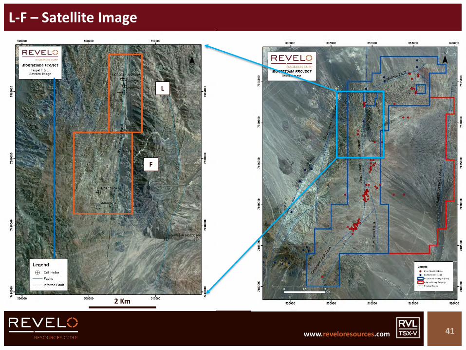
L-F – Satellite Image
41
www.reveloresources.com www.reveloresources.com
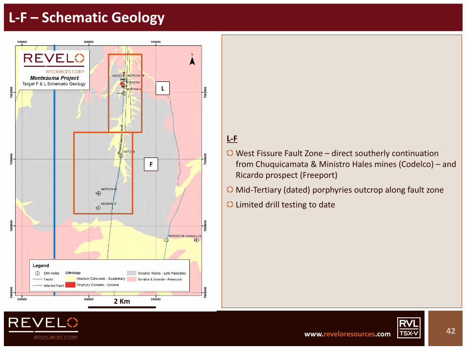
L-F – Schematic Geology
42
2 Km
2 Km
L-F
West Fissure Fault Zone – direct southerly continuation from Chuquicamata & Ministro Hales mines (Codelco) – and Ricardo prospect (Freeport)
Mid-Tertiary (dated) porphyries outcrop along fault zone
Limited drill testing to date
L
F
www.reveloresources.com www.reveloresources.com
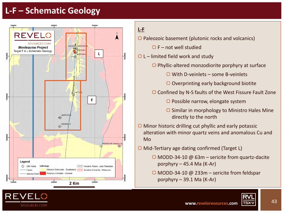
L-F – Schematic Geology
43
2 Km
2 Km
L-F
Paleozoic basement (plutonic rocks and volcanics)
F – not well studied
L – limited field work and study
Phyllic-altered monzodiorite porphyry at surface
With D-veinlets – some B-veinlets
Overprinting early background biotite
Confined by N-S faults of the West Fissure Fault Zone
Possible narrow, elongate system
Similar in morphology to Ministro Hales Mine directly to the north
Minor historic drilling cut phyllic and early potassic alteration with minor quartz veins and anomalous Cu and Mo
Mid-Tertiary age dating confirmed (Target L)
MODD-34-10 @ 63m – sericite from quartz-dacite porphyry – 45.4 Ma (K-Ar)
MODD-34-10 @ 233m – sericite from feldspar porphyry – 39.1 Ma (K-Ar)
L
F

www.reveloresources.com www.reveloresources.com
L-F – RAB/TOB Surface Rock Geochemistry - Au
44
2 Km
2 Km
L-F
Polar Star RAB/TOB rock samples - Au
L
F

www.reveloresources.com www.reveloresources.com
L-F – RAB/TOB Surface Rock Geochemistry - Pb
45
2 Km
2 Km
L-F
Polar Star RAB/TOB rock samples - Pb
L
F
www.reveloresources.com www.reveloresources.com
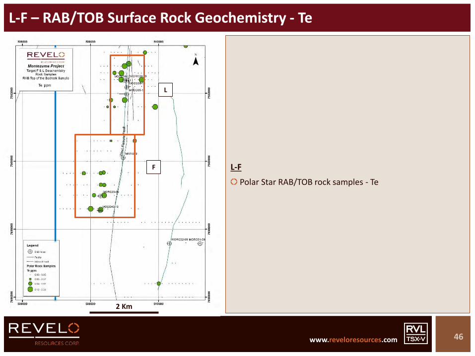
L-F – RAB/TOB Surface Rock Geochemistry - Te
46
2 Km
2 Km
L-F
Polar Star RAB/TOB rock samples - Te
L
F

www.reveloresources.com www.reveloresources.com
L-F – RAB/TOB Surface Rock Geochemistry – Summary
47
2 Km
2 Km
L-F
Multi-element geochemical anomalies from Polar Star RAB/TOB surface rock samples
Note (restricted) sample distribution in geochemical maps
Only those RAB samples that reached TOB are plotted (others sampled post-mineral materials)
Focused Te and Sb anomalies at F suggest poorly eroded system
Au and Ag at F may be epithermal
Focused Bi, Te +/- Se anomalies at L suggest slightly deeper erosional levels
+/- Cu, Mo, Au, Pb (top of porphyry?)
Surface oxidation and leaching will affect some geochemical distribution patterns
L
F

www.reveloresources.com www.reveloresources.com
L-F – IP Chargeability
48
2 Km
L
F
L-F
IP Chargeability @ 250m shown
Two principal Target areas (L-F) indicated by IP chargeability response
Chargeability map reflects strong structural controls along West Fissure Fault Zone
IP appears to have shallow penetration
Intense caliche & high contact impedance
Likely only top of sulphide system is detected beneath a leached capping
Historic drilling focused on IP chargeability anomalies
Drilling at F is on the S margins of, or beyond the S margins of, the IP chargeability anomaly – not well tested
2 Km

www.reveloresources.com www.reveloresources.com
L-F – IP Resistivity
49
2 Km
L
F
L-F
IP Resistivity @ 250m shown
Resistivity map reflects strong structural controls along West Fissure Fault Zone
IP appears to have shallow penetration
Intense caliche & high contact impedance
2 Km

www.reveloresources.com www.reveloresources.com
L-F – Magnetics (RTP)
50
2 Km
L
F
L-F
Magnetics – Reduction to Pole (RTP) shown
Magnetics survey reveals a series of magnetic features of potential interest
Several apparent dipole anomalies (remnant magnetism)
Drilling at L on magnetic low (RTP)
Key magnetic anomaly undrilled between L and F
Magnetic feature at F may represent potassic altered porphyry target
Other magnetic features to south and east of F may be of interest – apparent dipole anomalies
2 Km
www.reveloresources.com www.reveloresources.com
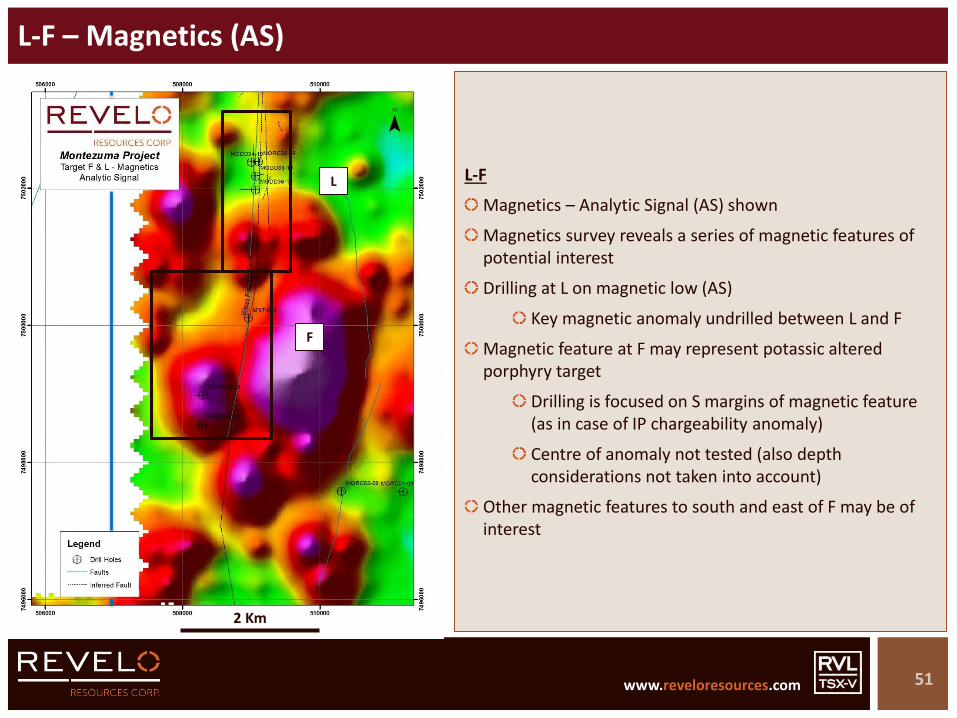
L-F – Magnetics (AS)
51
2 Km
L
F
L-F
Magnetics – Analytic Signal (AS) shown
Magnetics survey reveals a series of magnetic features of potential interest
Drilling at L on magnetic low (AS)
Key magnetic anomaly undrilled between L and F
Magnetic feature at F may represent potassic altered porphyry target
Drilling is focused on S margins of magnetic feature (as in case of IP chargeability anomaly)
Centre of anomaly not tested (also depth considerations not taken into account)
Other magnetic features to south and east of F may be of interest
2 Km
www.reveloresources.com www.reveloresources.com
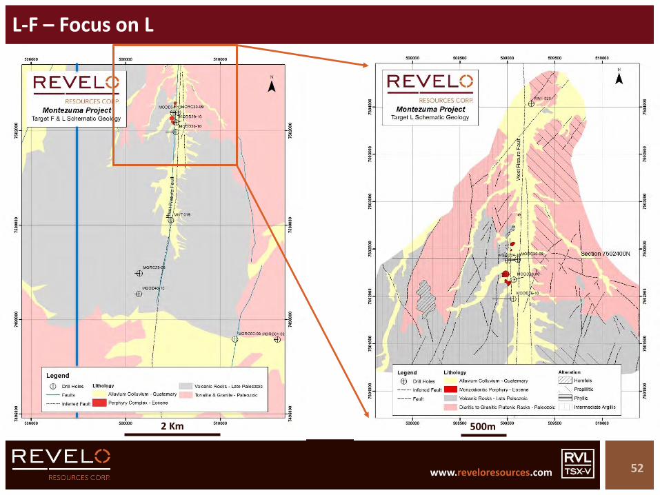
L-F – Focus on L
52
2 Km
2 Km
500m

www.reveloresources.com www.reveloresources.com
Target L – Schematic Geology & Satellite Image
53
2 Km
500m
West Fissure Fault Zone controlled valley
N-S
Up to 500m wide

www.reveloresources.com www.reveloresources.com
Target L – Schematic Geology & Alteration
54
2 Km
500m
L
Paleozoic granitoids and volcanics crop out in area
Small outcrops of monzo-dioritic porphyry outcrop along fault-controlled valley floor
Intense phyllic alteration associated with porphyries
Leached at surface
Mid-Tertiary porphyries (dated)
Zoned propyrlitic and intermediate argillic alteration
www.reveloresources.com www.reveloresources.com
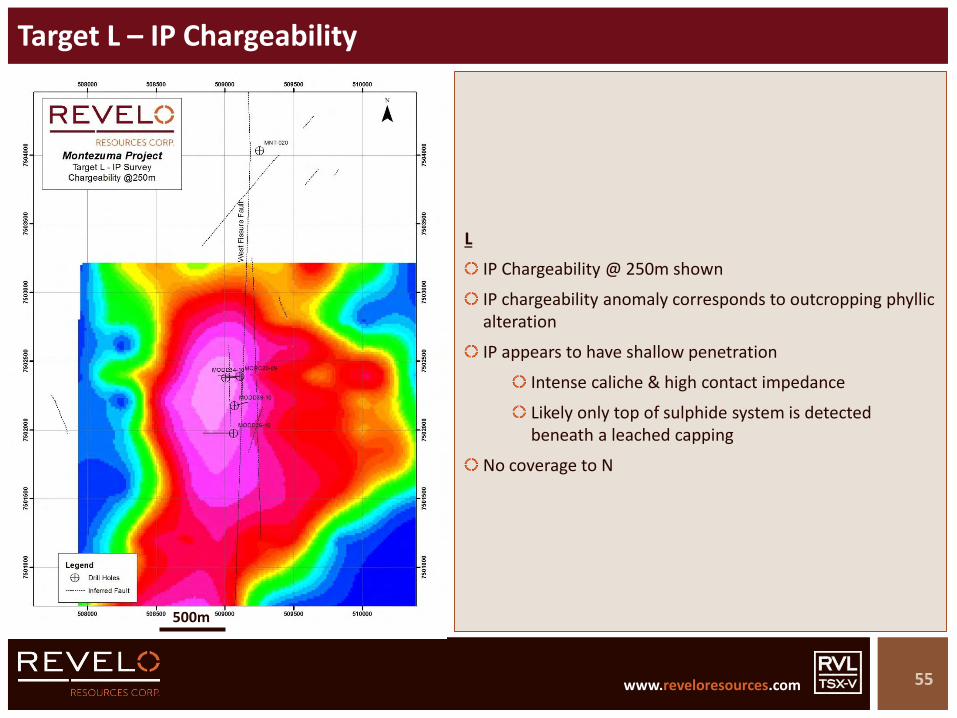
Target L – IP Chargeability
55
2 Km
500m
L
IP Chargeability @ 250m shown
IP chargeability anomaly corresponds to outcropping phyllicalteration
IP appears to have shallow penetration
Intense caliche & high contact impedance
Likely only top of sulphide system is detected beneath a leached capping
No coverage to N
www.reveloresources.com www.reveloresources.com
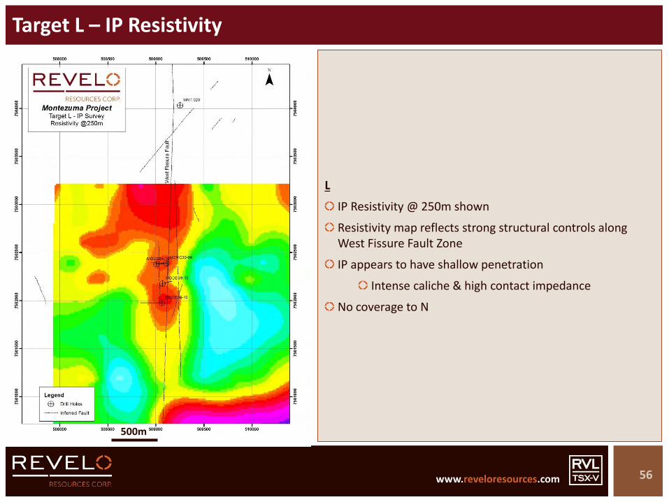
Target L – IP Resistivity
56
2 Km
500m
L
IP Resistivity @ 250m shown
Resistivity map reflects strong structural controls along West Fissure Fault Zone
IP appears to have shallow penetration
Intense caliche & high contact impedance
No coverage to N

www.reveloresources.com www.reveloresources.com
Target L – Magnetics (AS)
57
2 Km
500m
L
Magnetics – Analytic Signal (AS) shown
Magnetics survey reveals a series of magnetic features of potential interest
Drilling at L on magnetic low (AS)
Corresponds to outcropping phyllic alteration
Key magnetic anomaly undrilled to south
Other magnetic features to N

www.reveloresources.com www.reveloresources.com
Target L – Schematic Section
58
L
Section 7502400N
Paleozoic basement host rocks – granitoids and volcanics
Small outcrops of altered porphyry intrusions
Confined between strands of West Fissure Fault Zone
Mid-Tertiary age dates confirmed
L – Target
Prograde potassic-altered Cu-Mo-Au core associated with inter-mineral porphyry phase
Possible extensions along fault zone to N & S – including Target F

www.reveloresources.com www.reveloresources.com
Target L – Size Comparison with Ministro Hales Mine
59
Target L & Ministro Hales
Section through Codelco’s Ministro Hales mine at same scale as Target L
Ministro Hales located 23 Km N of Target L along same West Fissure Fault
Ministro Hales resource ~ 1.1Bt @ 1% Cu
Target L
Ministro Hales
Target L & Ministro Hales
Sections at same scale 500m
500m
500m
Modified from Rivera et al 2012 & Pinget 2016
www.reveloresources.com www.reveloresources.com
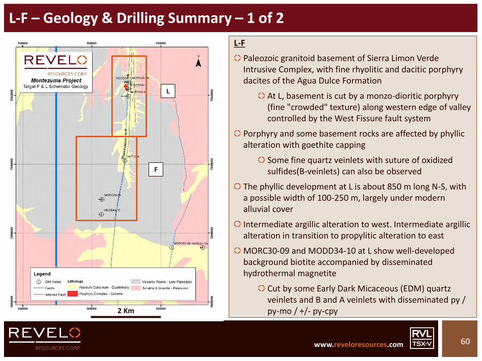
L-F – Geology & Drilling Summary – 1 of 2
60
2 Km
2 Km
L-F
Paleozoic granitoid basement of Sierra Limon Verde Intrusive Complex, with fine rhyolitic and dacitic porphyry dacites of the Agua Dulce Formation
At L, basement is cut by a monzo-dioritic porphyry (fine "crowded" texture) along western edge of valley controlled by the West Fissure fault system
Porphyry and some basement rocks are affected by phyllicalteration with goethite capping
Some fine quartz veinlets with suture of oxidized sulfides(B-veinlets) can also be observed
The phyllic development at L is about 850 m long N-S, with a possible width of 100-250 m, largely under modern alluvial cover
Intermediate argillic alteration to west. Intermediate argillic alteration in transition to propylitic alteration to east
MORC30-09 and MODD34-10 at L show well-developed background biotite accompanied by disseminated hydrothermal magnetite
Cut by some Early Dark Micaceous (EDM) quartz veinlets and B and A veinlets with disseminated py / py-mo / +/- py-cpy
L
F

www.reveloresources.com www.reveloresources.com
L-F – Geology & Drilling Summary – 2 of 2
61
2 Km
2 Km
L-F
Prograde alteration in MORC30-09 and MODD34-10 is superimposed by phyllic and intermediate argillic alteration with weak-moderate disseminated pyrite
Two other drill holes to the south cut Paleozoic rocks with Intermediate argillic alteration
Age dates in drill holes confirm mid-Tertiary porphyry system (45.4Ma to 39.1Ma)
System at L open to N – at least 500m – and possibly at depth
System at F poorly explored
Compelling coincident magnetic high with IP chargeability
MORC29-09 and MODD40-10 at F have strong quartz-sericite alteration for the first 100m from surface, followed by chlorite & epidote assemblages for about 150m, which increases to strong chlorite towards the bottom of the holes
Possibly peripheral (laterally and/or vertically) to hypogene target indicated by magnetics and IP
Deeper drilling required – somewhat N of existing holes
L
F
www.reveloresources.com www.reveloresources.com
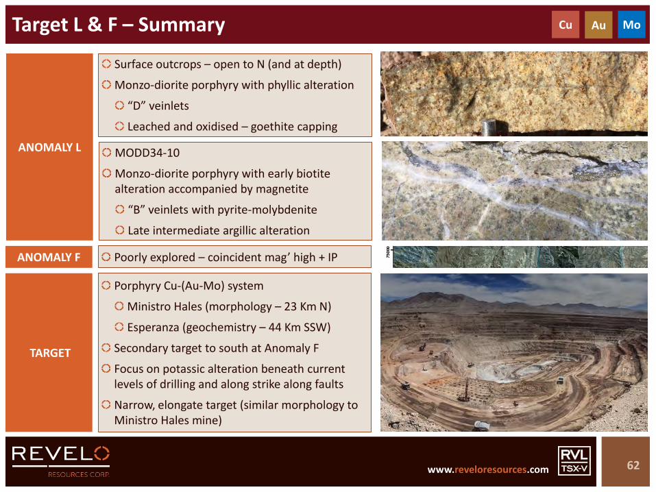
Target L & F – Summary
62
MODD34-10
Monzo-diorite porphyry with early biotite alteration accompanied by magnetite
“B” veinlets with pyrite-molybdenite
Late intermediate argillic alteration
ANOMALY L
Surface outcrops – open to N (and at depth)
Monzo-diorite porphyry with phyllic alteration
“D” veinlets
Leached and oxidised – goethite capping
Cu Au Mo
Porphyry Cu-(Au-Mo) system
Ministro Hales (morphology – 23 Km N)
Esperanza (geochemistry – 44 Km SSW)
Secondary target to south at Anomaly F
Focus on potassic alteration beneath current levels of drilling and along strike along faults
Narrow, elongate target (similar morphology to Ministro Hales mine)
TARGET
Poorly explored – coincident mag’ high + IPANOMALY F
www.reveloresources.com www.reveloresources.com
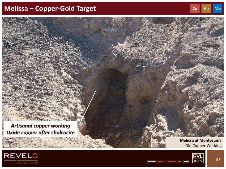
Melissa – Copper-Gold Target
63
Cu Au Mo
Melissa at MontezumaOld Copper Working
Artisanal copper working Oxide copper after chalcocite

www.reveloresources.com www.reveloresources.com
Melissa – Satellite Image
64
5 Km2 Km

www.reveloresources.com www.reveloresources.com
Melissa – Schematic Geology & Alteration
65
5 Km
Melissa
Basement dominated by Paleozoic plutonic rocks
Widespread intermediate argillic alteration transitioning to phyllic alteration
Numerous artisanal workings (Cu >> Au)
Area highly anomalous geochemically
Age dating equivocal (Melissa)
Surface sample – sericite altered granite
281 Ma (U-Pb) – from zircon
May be “inherited” age date from Paleozoic zircon
2 Km

www.reveloresources.com www.reveloresources.com
Melissa – RAB/TOB & Trench Surface Rock Geochemistry - Cu
66
Melissa
Polar Star RAB/TOB rock samples – Cu
Trench samples included
2 Km
Cu-Ag-Hg-Se surface geochemical anomaly
Principal target defined from surface geology
Multi-element geochemical anomaly
Requires better understanding in the field
“Epithermal” trend As-Sb-Hg-Bi +/- Others
www.reveloresources.com www.reveloresources.com
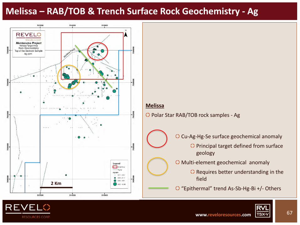
Melissa – RAB/TOB & Trench Surface Rock Geochemistry - Ag
67
Melissa
Polar Star RAB/TOB rock samples - Ag
2 Km
Cu-Ag-Hg-Se surface geochemical anomaly
Principal target defined from surface geology
Multi-element geochemical anomaly
Requires better understanding in the field
“Epithermal” trend As-Sb-Hg-Bi +/- Others

www.reveloresources.com www.reveloresources.com
Melissa – RAB/TOB & Trench Surface Rock Geochemistry - Hg
68
Melissa
Polar Star RAB/TOB rock samples – Hg
2 Km
Cu-Ag-Hg-Se surface geochemical anomaly
Principal target defined from surface geology
Multi-element geochemical anomaly
Requires better understanding in the field
“Epithermal” trend As-Sb-Hg-Bi +/- Others
www.reveloresources.com www.reveloresources.com
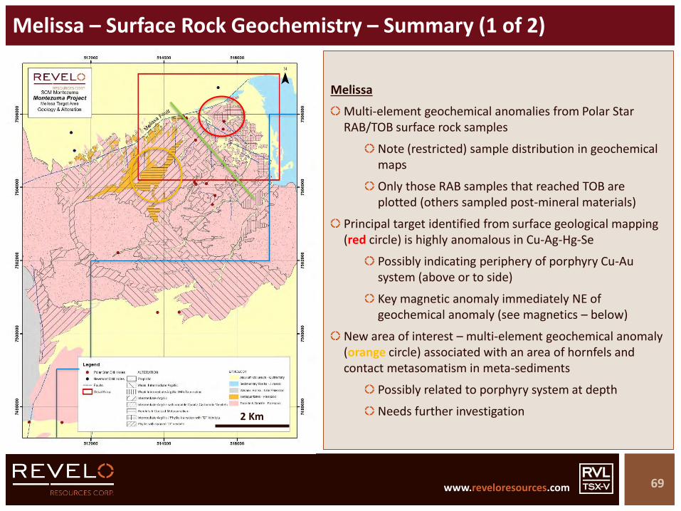
Melissa – Surface Rock Geochemistry – Summary (1 of 2)
69
5 Km
Melissa
Multi-element geochemical anomalies from Polar Star RAB/TOB surface rock samples
Note (restricted) sample distribution in geochemical maps
Only those RAB samples that reached TOB are plotted (others sampled post-mineral materials)
Principal target identified from surface geological mapping (red circle) is highly anomalous in Cu-Ag-Hg-Se
Possibly indicating periphery of porphyry Cu-Au system (above or to side)
Key magnetic anomaly immediately NE of geochemical anomaly (see magnetics – below)
New area of interest – multi-element geochemical anomaly (orange circle) associated with an area of hornfels and contact metasomatism in meta-sediments
Possibly related to porphyry system at depth
Needs further investigation2 Km

www.reveloresources.com www.reveloresources.com
Melissa – Surface Rock Geochemistry – Summary (2 of 2)
70
5 Km
Melissa
“Epithermal” trend (green line) – As-Sb-Hg-Bi anomalies, apparently aligned (+/- other elements)
Possible mineralised structural trend
Needs further investigation
Other anomalies in larger Melissa area
Need follow-up on ground to evaluate source
Surface oxidation and leaching will affect some geochemical distribution patterns
2 Km

www.reveloresources.com www.reveloresources.com
Melissa – IP Chargeability
71
Melissa
IP chargeability @ 250m shown
IP survey does not cover principal target area delineated to date in northeast corner of windowed area
IP Chargeability anomaly open towards target area
Significant IP chargeability anomaly on border of post-mineral covered area in centre of windowed area
2 Km
www.reveloresources.com www.reveloresources.com
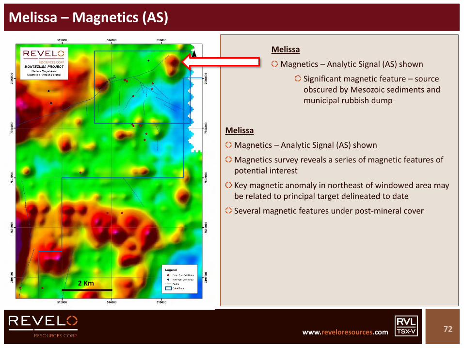
Melissa – Magnetics (AS)
72
Melissa
Magnetics – Analytic Signal (AS) shown
Magnetics survey reveals a series of magnetic features of potential interest
Key magnetic anomaly in northeast of windowed area may be related to principal target delineated to date
Several magnetic features under post-mineral cover
2 Km
Melissa
Magnetics – Analytic Signal (AS) shown
Significant magnetic feature – source obscured by Mesozoic sediments and municipal rubbish dump
www.reveloresources.com www.reveloresources.com
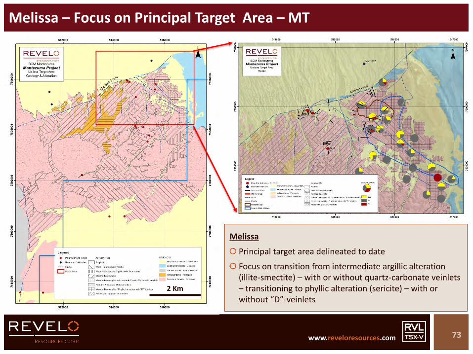
Melissa – Focus on Principal Target Area – MT
73
5 Km
Melissa
Principal target area delineated to date
Focus on transition from intermediate argillic alteration (illite-smectite) – with or without quartz-carbonate veinlets – transitioning to phyllic alteration (sericite) – with or without “D”-veinlets
2 Km

www.reveloresources.com www.reveloresources.com
Melissa – MT – Artisanal Copper Workings
74
Melissa
Multiple small mineral workings for copper coincident with red hematite cap
Copper as chalcocite (oxidising to brocantite)
Probably secondary cc after chalcopyrite
Copper focused on carbonate buffer related to intermediate argillic alteration on margins of phyllic alteration
1 Km
www.reveloresources.com www.reveloresources.com
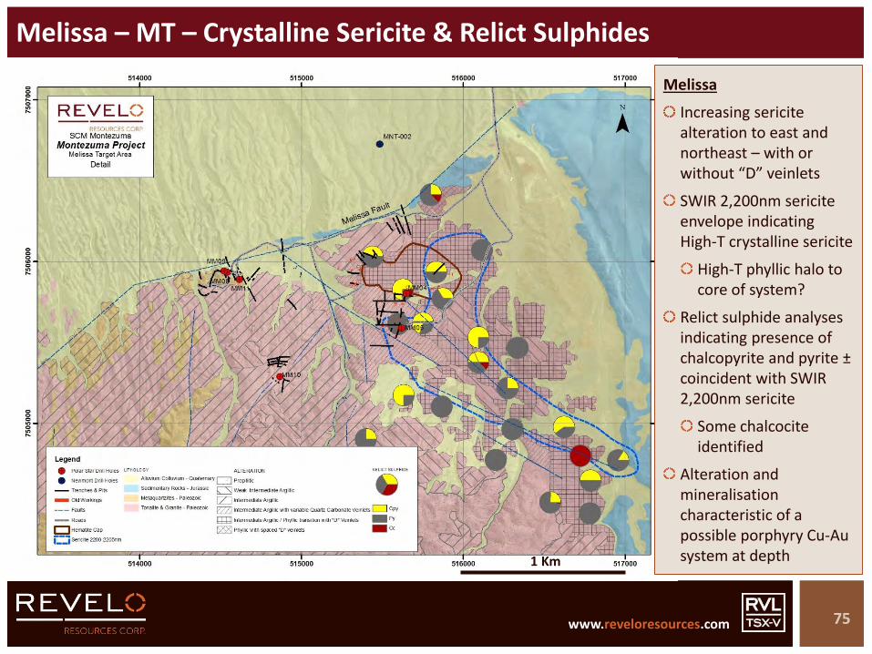
Melissa – MT – Crystalline Sericite & Relict Sulphides
75
Melissa
Increasing sericite alteration to east and northeast – with or without “D” veinlets
SWIR 2,200nm sericite envelope indicating High-T crystalline sericite
High-T phyllic halo to core of system?
Relict sulphide analyses indicating presence of chalcopyrite and pyrite ±coincident with SWIR 2,200nm sericite
Some chalcocite identified
Alteration and mineralisation characteristic of a possible porphyry Cu-Au system at depth1 Km
www.reveloresources.com www.reveloresources.com
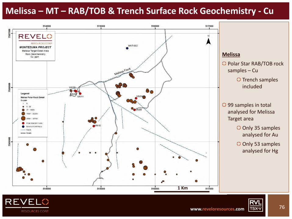
Melissa – MT – RAB/TOB & Trench Surface Rock Geochemistry - Cu
76
Melissa
Polar Star RAB/TOB rock samples – Cu
Trench samples included
99 samples in total analysed for Melissa Target area
Only 35 samples analysed for Au
Only 53 samples analysed for Hg
1 Km
www.reveloresources.com www.reveloresources.com
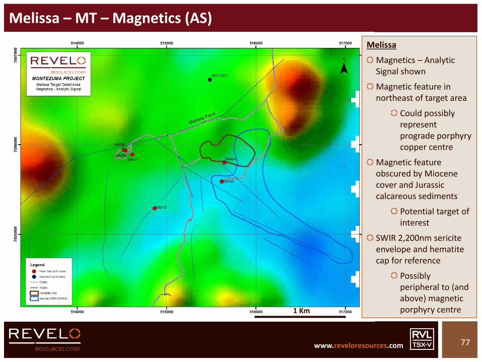
Melissa – MT – Magnetics (AS)
77
Melissa
Magnetics – Analytic Signal shown
Magnetic feature in northeast of target area
Could possibly represent prograde porphyry copper centre
Magnetic feature obscured by Miocene cover and Jurassic calcareous sediments
Potential target of interest
SWIR 2,200nm sericite envelope and hematite cap for reference
Possibly peripheral to (and above) magnetic porphyry centre1 Km
www.reveloresources.com www.reveloresources.com
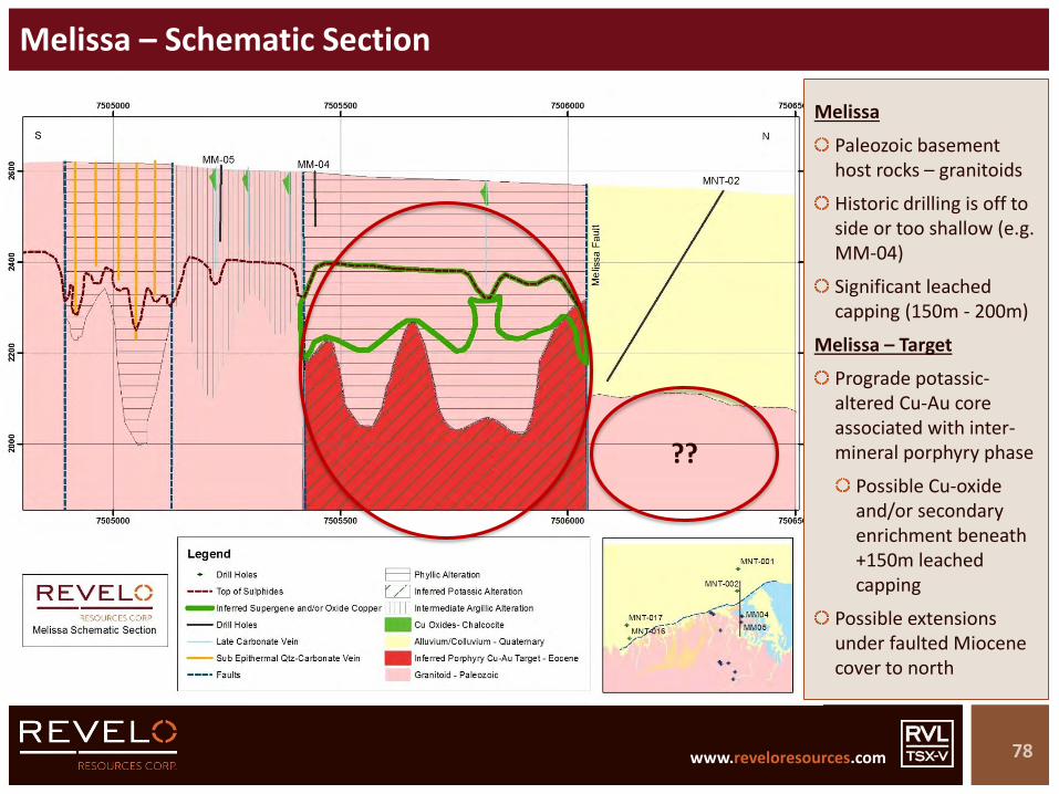
Melissa – Schematic Section
78
Melissa
Paleozoic basement host rocks – granitoids
Historic drilling is off to side or too shallow (e.g. MM-04)
Significant leached capping (150m - 200m)
Melissa – Target
Prograde potassic-altered Cu-Au core associated with inter-mineral porphyry phase
Possible Cu-oxide and/or secondary enrichment beneath +150m leached capping
Possible extensions under faulted Miocene cover to north
??

www.reveloresources.com www.reveloresources.com
Melissa – Summary
79
Host rock of Paleozoic granitoids with phyllicalteration
Veinlets and narrow veins of chalcocite (after chalcopyrite)
Oxidising to brochantite
MELISSAPaleozoic granitoid with background intermediate argillic alteration
Illite / smectite alteration & quartz-carbonate veinlets
Phyllic / sericitic alteration at top of sample
Vein of oxidising chalcocite
Cu Au Mo
Porphyry Cu-Au system
Model type: - Possible SW Pacific examples
Possible oxide-copper and/or secondary enrichment beneath +150m of leached capping
Peripheral sub-epithermal polymetallic veins with high-grade gold (up to 22g/t Au in MM11)
TARGET
www.reveloresources.com www.reveloresources.com
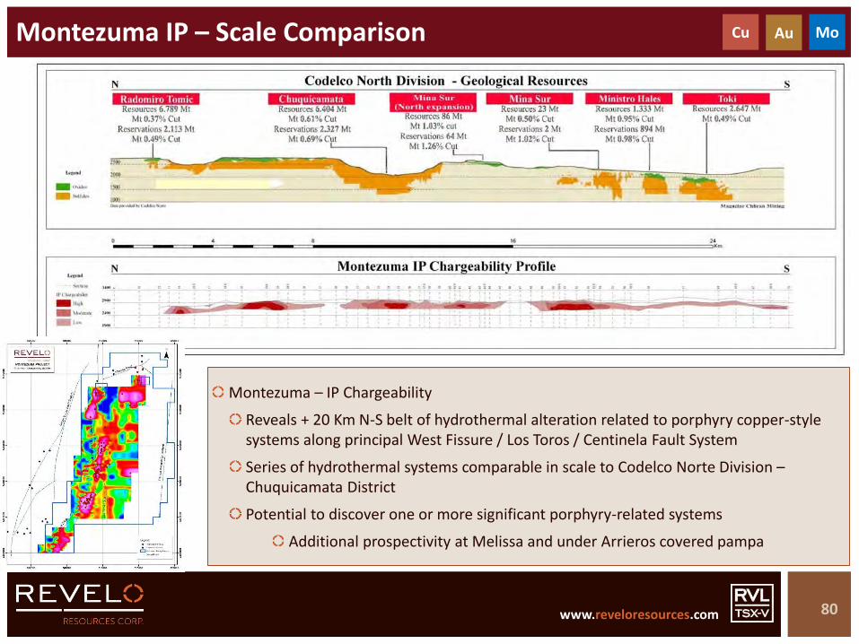
Montezuma IP – Scale Comparison
80
Cu Au Mo
Montezuma – IP Chargeability
Reveals + 20 Km N-S belt of hydrothermal alteration related to porphyry copper-style systems along principal West Fissure / Los Toros / Centinela Fault System
Series of hydrothermal systems comparable in scale to Codelco Norte Division –Chuquicamata District
Potential to discover one or more significant porphyry-related systems
Additional prospectivity at Melissa and under Arrieros covered pampa

www.reveloresources.com www.reveloresources.com
Montezuma – Target Summary
81
Cu Au Mo
Target Revelo Work Potential Follow-up
Melissa
• 42 Km2 geological mapping @ 1:10,000
• Re-logging of 6 out of 11 drill holes (1,898m)
• Mineral spectrometry• Relict sulphide analyses (~ 23
samples)• Review of surface
geochemistry• Review of magnetics data• Schematic geological section
• Porphyry Cu-Au – Post-Mesozoic age• Mineralised structure cuts Mesozoic sediments (i.e.
post-Mesozoic mineralisation)• Possible SW Pacific examples
• Zone of variable phyllic alteration oriented NW-SE, with abundant Cu-oxides at surface, associated with oxidising secondary chalcocite after chalcopyrite, in veins and structures
• 2 Km x 0.5 Km target area (plus covered extensions to N)
• Widespread intermediate argillic alteration – sub-epithermal levels exposed (including mineralised veins)
• Detailed magnetics acquisition (50m line spacing)
• 3-D modelling of magnetics data• Statistical processing of surface
and drill hole geochemical data• IP or resistivity sections (20 Km)• Drilling – RC – 3,000m (6 holes)
Anomaly B
• 25 Km2 geological mapping @ 1:10,000
• Re-logging of 21 out of 21 drill holes (11,686m)
• Mineral spectrometry• Review of surface
geochemistry• Review of magnetics data• 3 x geological sections
• Porphyry Cu-Au (-Mo) – Mid-Tertiary (U-Pb – 43.9 Ma)• Esperanza style (Centinela District)
• Intense and large hydrothermal system with multiple porphyries and breccias and vein types
• Key drill intercepts guide towards potassic core beneath current drilling
• 1.5 Km x 100-500m target area (plus covered extensions to immediate east, southeast and southwest)
• Detailed magnetics acquisition (50m line spacing)
• 3-D modelling of magnetics data• Statistical processing of surface
and drill hole geochemical data• Resistivity sections (20 Km)• Drilling – DD – 4,000m (5 holes)
Anomaly A
• 12 Km2 geological mapping @ 1:10,000
• Re-logging of 13 out of 20 drill holes (4,492m)
• Mineral spectrometry• Review of surface
geochemistry• Review of magnetics data
• Porphyry Cu-Au (-Mo) – Mid-Tertiary• Esperanza style (Centinela District)
• Beneath advanced argillic lithocap – target area confined between West Fissure Faults – oriented N-S
• 1.2 Km x 100-200m target area (plus covered extensions to immediate east, southeast and southwest
• Secondary zone along strike to north
• Detailed magnetics acquisition (50m line spacing)
• 3-D modelling of magnetics data• Statistical processing of surface
and drill hole geochemical data• Resistivity sections (10 Km)• Drilling – DD – 2,500m (3 holes)

www.reveloresources.com www.reveloresources.com
Montezuma – Target Summary
82
Cu Au Mo
Target Revelo Work Potential Follow-up
Anomaly C
• 12 Km2 geological mapping @ 1:10,000
• Re-logging of 6 out of 10 drill holes (1,756m)
• Mineral spectrometry• Review of surface
geochemistry• Review of magnetics data
• Sub-Epithermal system – Zn (-Au-Ag) – Mid-Tertiary• Covered area to north – untested potential
• Complete revision of drill holes• Construct cross sections• Detailed magnetics acquisition
(50m line spacing)• 3-D modelling of magnetics data• Evaluate drilling options
Anomaly L
• 2 Km2 geological mapping @ 1:10,000
• Re-logging of 4 out of 4 drill holes (1,424m)
• Porphyry Cu-Au (-Mo) – Mid-Tertiary (K-Ar – 39.1 Ma)• Esperanza style (Centinela District) – with
morphology of Ministro Hales• Potassic alteration in drill holes with phyllic alteration
at surface• 850m x 100-250m target area
• Increase area of geological mapping
• Construct cross sections• Detailed magnetics acquisition
(50m line spacing)• 3-D modelling of magnetics data• Negotiate 3rd party in-holding• Resistivity sections (10 Km)• Drilling – DD – 4,000m (5 holes)
Newmont Targets
• Antena• Eliana• Biri• Encontrado• Target Vi
• None – no potential – targets fall outside current Montezuma property boundary (ground dropped)
• Abandon• Property abandonment (~15,000
Ha) completed in Q1 2018 (reducing overall area from ~45,000 Ha to 30,000 Ha)

www.reveloresources.com www.reveloresources.com
Montezuma Project (Copper-Gold-Moly)
83
Cu Au Mo
Copper-Gold-Moly exploration project – Northern Chile
Major district-scale exploration play – ~ 16,300 Hectares
Project subject to LOI with BMR Group PLC (Option Agreement and shares in BMR)
Centred in the heart of one of the world’s largest copper mining districts
Midway between the Chuquicamata District and the Centinela District
Porphyry copper-gold-moly exploration targets
Major hydrothermal alteration systems with porphyry copper-gold characteristics
Significant historic drill intercepts indicating presence of mineralised systems
E.g. 44m @ 0.55% Cu + 0.17g/t Au + 3.4g/t Ag
Multiple targets – some drill ready
Northern Chile
Desert terrane, excellent infrastructure, easy access

www.reveloresources.com www.reveloresources.com
In the Shadow of the Headframe
84
METALS COPPER-GOLD-SILVER
STAGE EXPLORATION
LOCATION NORTHERN CHILE
TEAM HIGHLY EXPERIENCED
TENEMENTMAJOR LAND POSITION &
ROYALTY INTERESTS
PORTFOLIO MULTIPLE TARGETS