Advanced Metering Infrastructure (AMI) System - South ...
42
U.S. Department of the Interior Bureau of Reclamation March 2017 Environmental Assessment Advanced Metering Infrastructure (AMI) System – South Tahoe Public Utilities District 17-01-MP
Transcript of Advanced Metering Infrastructure (AMI) System - South ...

U.S. Department of the Interior
Bureau of Reclamation March 2017
Environmental Assessment
Advanced Metering Infrastructure (AMI) System – South Tahoe Public Utilities District 17-01-MP

U.S. Department of the Interior
Bureau of Reclamation March 2017
Mission Statements The Department of the Interior protects and manages the Nation's natural resources and cultural heritage; provides scientific and other information about those resources; and honors its trust responsibilities or special commitments to American Indians, Alaska Natives, and affiliated island communities. The mission of the Bureau of Reclamation is to manage, develop, and protect water and related resources in an environmentally and economically sound manner in the interest of the American public.

Advanced Metering Infrastructure (AMI) System 3 March 2017
List of Acronyms and Abbreviations AFY acre-feet per year AMI advanced metering infrastructure APE area of potential effects STPUD South Tahoe Public Utilities District Reclamation Bureau of Reclamation CALFED grant CALFED Water Use Efficiency Grant CEQ Council on Environmental Quality EA Environmental Assessment IS/MND Initial Study/Mitigated Negative Declaration NEPA National Environmental Protection Act NHPA National Historic Preservation Act SHPO State Historic Preservation Officer USEPA United States Environmental Protection Agency GHG Greenhouse Gas ROG Reactive Organic Gases CO Carbon Monoxide NO2 Nitrogen dioxide SO2 Sulphur dioxide NOx Oxides of nitrogen TRPA Tahoe Regional Planning Agency ARB Air Resources Control Board EDAQMD El Dorado Air Quality Management District LTAB Lake Tahoe Air Basin SAQMD Sacramento Air Quality Management District Tpy Tons per year

Advanced Metering Infrastructure (AMI) System 4 March 2017
Section 1 Introduction In conformance with the National Environmental Policy Act of 1969 (NEPA), Council on Environmental Quality (CEQ) regulations (40 CFR 1500-1508), and Department of Interior (DOI) regulations (43 CFR Part 46), the Bureau of Reclamation (Reclamation) prepared this Environmental Assessment (EA) to disclose potential environmental effects associated with granting a CALFED Water Use Efficiency Grant (CALFED grant) to the South Tahoe Public Utility District (STPUD) for its Advanced Metering Infrastructure (AMI) System (Proposed Action). The Proposed action would take place in the STPUD service area located in South Lake Tahoe (Figure 1 and Figure 2). The Proposed Action involves installation of AMI for Phase 3 and part of Phase 4 in the STPUD service area. Phase 3 (Figure 1) involves the installation of 1,432 water meters and Phase 4 (Figure 2) involves the installation of 1,327 water meters. Metering in the STPUD service area will allow STPUD to meter volumetric consumption, and better determine district water allocation. Figure 1: STPUD Phase 3 AMI Installation

Advanced Metering Infrastructure (AMI) System 5 March 2017
Figure 2: STPUD Phase 4 AMI Installation
1.1 Need for the Proposed Action California State Assembly Bill (AB) 2752, requires all urban water suppliers (serving 3,000 or more connections) to install water meters on all residential/commercial connections by the year 2025. As part of AB 2752, water suppliers will be required to engage in volumetric pricing for metered customers after January 1, 2011. The state is also requiring urban water purveyors to reduce water demand by a mandated 20% by the year 2020. STPUD provides drinking water to 14,000 connections and in order to comply with AB 2752 and reduce water demand by the year 2020, STPUD needs additional funding of $297,606 in grant funds to finish Phase 3 and part of Phase 4 of its AMI installation. By regulating future was supply in the STPUD service area, and promoting conservation, STPUD will be able to meet a 20% demand reduction by 2020.

Advanced Metering Infrastructure (AMI) System 6 March 2017
Section 2 Proposed Action and Alternatives 2.1 No Action Alternative Under the No Action Alternative, Reclamation would not award the STPUD with CALFED grant money equal to $297,606. Although it is possible the STPUD may find alternate sources of funding for the project, for the purposes of this EA, the consequences of Reclamation not providing funding for the Proposed Action would result in no construction of the project which may result in STPUD not being able to meet state mandated water reductions. 2.2 Proposed Action STPUD is a special district that supplies approximately 14,000 drinking water connections with fresh potable water and 17,000 sewer service connections to the City of South Lake Tahoe and portions of El Dorado County. All drinking water supply sources are from 12 wells and produce and average annual water supply of 9,528 acre-feet per year (AFY). STPUD operates within the delicate environment of Lake Tahoe and is subject a high level of regulations by multiple state and federal agencies, including the only bi-state regulatory agency, the Tahoe Regional Planning Agency (TRPA). However, the Proposed Action area or STPUD service area is located only in California and is subject to California State Drinking Water and Sewer Treatment requirements. The Proposed Action involves installation of AMI for Phase 3 and part of Phase 4 in the STPUD service area. Phase 3 (Figure 1) involves the installation of 1,432 water meters and Phase 4 (Figure 2) involves the installation of 1,327 water meters. Metering in the STPUD service area will allow STPUD to meter volumetric consumption, and better determine district water allocation.
Section 3 Affected Environment and Environmental Consequences Potential impacts to the following resources were considered and found to have no environmental consequences. Brief explanations are provided below: Indian Trust Assets (ITAs): are legal interests in property or rights held in
trust by the United States for Indian Tribes or individual Indians. Indian reservations, Rancherias, and Public Domain Allotments are common

Advanced Metering Infrastructure (AMI) System 7 March 2017
ITAs in California. The nearest ITA is Washoe Tribe of Nevada and California approximately 12.47 miles southeast of the Proposed Action. The proposed action does not have a potential to affect ITAs (see Appendix A for additional details and a map showing all other tribal locations).
Executive Order 13007 (May 24, 1996) requires that federal agencies
accommodate access to and ceremonial use of Indian sacred sites by Indian religious practitioners, and avoids adversely affecting the physical integrity of such sacred sites. The proposed action would not be located on Federal lands and therefore would not affect access to or use of Indian sacred sites.
Environmental Justice: Executive Order 12898 requires each Federal agency to identify and address disproportionately high and adverse human health or environmental effects, including social and economic effects of its program, policies, and activities on minority populations and low-income populations. Since there are no minority or low-income populations on or adjacent to the Proposed Action, there would be no disproportionate adverse human health or socio-economic and environmental effects.
3.1 No Action Alternative Under the No Action Alternative, Reclamation would not award the STPUD with CALFED grant money equal to $297,606. Although it is possible that the STPUD may find alternate sources of funding for the project, for the purposes of this EA, the consequences of Reclamation not providing funding for the Proposed Action would result in no construction which may result in STPUD not being able to meet state mandated water reductions. The No Action Alternative would have no effect on water resources, air quality, special status species, and cultural resources.

Advanced Metering Infrastructure (AMI) System 8 March 2017
3.2 Proposed Action 3.2.1 Water Resources The Proposed Action is located in the Upper Truckee River Watershed. The Upper Truckee River and the tributaries, which make up the Upper Truckee River Watershed comprise the largest contribution to the waters of Lake Tahoe. The Upper Truckee River Watershed is located in Alpine and El Dorado Counties. Tributaries include Angora, Echo, Grass Lake, and Big Meadow Creeks, and the Upper and Lower Echo, Round and Dardanelles Lakes. The headwaters are in Desolation Wilderness and in road-less areas managed for wilderness uses by the U.S. Forest Service. The State of California adopts water quality standards to protect beneficial uses of state waters as required by Section 303(d) of the CWA and the Porter-Cologne Water Quality Control Act of 1969 (PCWQCA). Section 303(d) of the Clean Water Act established the total maximum daily load (TMDL) process to guide the application of state water quality standards. In order to identify candidate water bodies for TMDL analysis, a list of water-quality limited streams was generated. These streams are impaired by the presence of pollutants such as sediment and are more sensitive to disturbance due to this impairment. The Upper Truckee River is 303(d) Listed as impaired for iron and phosphorus, both of which, could be transported to the Upper Truckee River via disturbance of soil (SWRCB, 2012).
Construction of the Proposed Action involves very minimal ground disturbance as the majority of construction will occur in STPUD right-of-way which already consists of impervious surface. If any excavation occurs from installation of meters, STPUD will use proper sedimentation control best management practices (BMPs) to ensure that no sediment or construction related pollutants will reach the Upper Truckee River.
3.2.2 Air Quality Air quality within the Lake Tahoe Basin is regulated by several agencies including the USEPA, the California Air Resources Board (ARB), the Tahoe Regional Planning Agency (TRPA) and the El Dorado Air Quality Management District (EDAQMD). The Proposed Action is located in the Lake Tahoe Air Basin (LTAB). The LTAB includes portions of El Dorado County and Placer County in California, and Washoe County, Douglas County, and Carson City Rural District in Nevada. The LTAB is downwind of larger urban areas such as San Francisco and Sacramento area. The LTAB must conform to thresholds set by rule 502, general conformity thresholds. As a result, the LTAB is listed as Unclassified on the following pollutants: ozone; carbon monoxide (CO); nitrogen dioxide (NO2); sulfur dioxide (SO2); fine particulate matter (PM 10 and PM2.5); and lead. These pollutants are commonly referred to as “criteria air pollutants.”

Advanced Metering Infrastructure (AMI) System 9 March 2017
The Proposed Action supports existing and proposed air quality and greenhouse gas (GHG) reductions efforts. Installation of smart water meters will not only provide for water conservation, but also result in a reduction in emissions over time as the STPUD will eliminate the need for route driven meter readings. Over the 20-year lifecycle of the construction phase (Proposed Action plus Phase 5), there would be a net reduction of GHG emissions of 2,324 metric tons of CO2. The EDAQMD has established quantitative operation emissions thresholds of 82 pounds per day for both Reactive Organic Gases (ROG) and Oxides of Nitrogen (NOx). Construction phase emissions for the Proposed Action were calculated using the Road Construction Emissions Model Version 8.10 (Model) released in June 2016 by the Sacramento Air Quality Management District (SAQMD). Due to the small size of the Proposed Action and specific equipment used, the Model was best suited for the Proposed Action instead of either CalEEMod or the Offroad Simulation Model. The Model uses Sacramento Valley Air Basin Fleet Average Emissions Factors, representative of the equipment used for the Proposed Action. The construction phase of the Proposed Action plus Phase 5 will result in daily ROG emissions of 0.80 pounds per day (0.15 tons per year (tpy)) and NOx emissions of 6.57 pounds per day (1.20 tpy), significantly under the EDAQMD CEQA significance threshold of 82 pounds per day for both respectively (Sierra Ecotone Solutions, 2016). De minimus levels of Sulphur Oxides (0.01 pounds per day or 0.01 tpy), inhalable particulates (PM10 – 2.2 pounds per day (0.40 tpy) in comparison to 122 tons per day produced throughout El Dorado County), and Carbon Monoxide (5.66 pounds per day (1.03 tpy) compared to 890 tons per day produced throughout Eldorado County) (Sierra Ecotone Solutions, 2016). In addition, because the analysis included Phase 5, the Proposed Action would result in even less ROG and NOx then the values presented above. Therefore, construction of the Proposed Action would have a negligible effect on air quality in the LTAB, and operation of the Proposed Action would be beneficial to air quality and GHG emissions in the LTAB. Emissions from the Proposed Actions are much lower than the general conformity de minimis thresholds (EDCAQMD, 1994). Therefore no general conformity analysis is required.
3.2.3 Special Status Biological Resources The Tahoe Basin provides habitat for over 250 species of resident and migratory vertebrate wildlife species. Each of these species of mammals (64), birds (168), and reptiles and amphibians (23) occurs in the region because a variety of habitats are available to meet their needs. The quality and size of these habitats generally determine the abundance of any one species or animal population. An Initial Study – Mitigated Negative Declaration (IS/MND) was prepared by Sierra Ecotone Solutions, LLC for the Proposed Action (Sierra Ecotone Solutions 2016). The Initial Study analyzed biological resources to determine if the Proposed Action would have any effect on wildlife in the action area. The Initial

Advanced Metering Infrastructure (AMI) System 10 March 2017
Study determined that there would be no effect on wildlife in the action area. Database searches included the California Natural Diversity Database (CNDDB) and the U.S. Fish and Wildlife Service (USFWS) database. In addition to the above searches, Reclamation validated the USFWS search on January 17, 2017. Sierra Nevada yellow-legged frog, Lahontan cutthroat trout, and North American wolverine (Table 1) are the three federally listed species with ranges in or near the action area. Table 1: Special Status Biological Resources
Scientific Name Common Name Federal Status
Effects Potential Habitat Utilized by species in Proposed Action
Area AMPHIBIANS
Rana sierra Sierra Nevada Yellow-legged Frog
E NE Absent. The Project occurs within the general range of this species. No suitable habitat in
the Proposed Action area. FISHES
Oncorhynchus clarkia henshawi
Lahontan cutthroat trout
E NE Absent. The Project occurs within the general range of this species. No suitable aquatic or riparian habitat in the Proposed Action area. No suitable habitat
would be disturbed. MAMMALS Gulo gulo luscus North American
wolverine E NE Absent. The Project occurs
within the general range of this species. No suitable habitat in
the Proposed Action area.
According to the CNDDB map included in the IS/MND, a total of 287 parcels as part of the Proposed Action are located near potential suitable habitat for Sierra Nevada yellow-legged frog. However, all meters are to be installed on existing water service lines to residential properties within a portion of maintained right-of-way and a small portion of private property. No impacts to stream banks, riparian vegetation or bodies of water will occur as a result of implementation of the Proposed Action. Access to meter locations will be via existing roads. No habitat for the Sierra Nevada Yellow-legged Frog and Lahontan cutthroat trout will be disturbed. The USFWS list also includes bird species that are protected under the Migratory Bird Treaty Act of 1918 and have potentially suitable habitat in the area surrounding the action area. The action will not result in the removal of any foraging or nesting habitat for any of the migratory bird species included in Appendix C, and would have no effect on migratory birds.
3.2.4 Cultural Resources Cultural resources is a broad term that includes prehistoric, historic, architectural, and traditional cultural properties. Title 54 U.S.C. 300101 et seq., formerly and commonly known as the National Historic Preservation Act (NHPA) is the
Advanced Metering Infrastructure (AMI) System 11 March 2017
primary legislation for Federal historic preservation. Section 106 of the NHPA (54 U.S.C. 306108) requires Federal agencies to take into consideration the effects of their undertakings on historic properties and to afford the Advisory Council on Historic Preservation an opportunity to comment. Historic properties are those cultural resources that are listed in or are eligible for inclusion in the National Register of Historic Places (National Register). The Section 106 regulations at 36 CFR 800 outline the process the Federal agency takes to identify historic properties within the area of potential effects (APE), and to assess the effects the proposed undertaking will have on those historic properties. The Section 106 process involves consultations with the State Historic Preservation Officer, Indian tribes, and other identified consulting and interested parties. The APE for the current undertaking consists of approximately 1,179 acres (Figure 1 and Figure 2) and includes the proposed AMI System installation locations and staging areas on surface streets and areas adjacent to the parcels that will be included in the Proposed Action. In an effort to identify historic properties in the APE, Dr. Susan Lindstrom (Lindstrom, 2016) conducted a records search of the California Historical Records System (CHRIS) and a pedestrian survey of the APE in June 2016. No historic properties were identified in the APE through these efforts. Reclamation sent a letter to the Washoe Tribe of Nevada and California on December 28, 2016, to invite their participation in the Section 106 process and request their assistance in the identification of sites of religious and cultural significance or historic properties that may be affected by the proposed undertaking, pursuant to 36 CFR § 800.4(a)(4). To date, Reclamation has not received a response from this tribe. Reclamation applied the criteria of adverse effect [36 CFR § 800.5(a)] for the Proposed Action and determined that it would result in no historic properties affected. Utilizing these identification efforts, Reclamation entered into consultation with the California State Historic Preservation Officer (SHPO) in January 2017, seeking their concurrence on a finding of “no historic properties affected pursuant to 36 CFR § 800.4(d)(1).” Reclamation received concurrence from SHPO on February 28, 2017 and the Section 106 process is complete. A copy of the response letter detailing SHPO’s findings is included in Appendix B. The Proposed Action has the potential to affect historic properties. However, a records search and cultural resources survey did not identify any historic properties within the APE. Reclamation determined that no historic properties would be affected pursuant to 36 CFR § 800.4(d)(1); therefore, there would be no impacts to cultural resources as a result of implementing the Proposed Action.
3.2.5 Cumulative effects According to CEQ regulations for implementing the procedural provisions of NEPA, a cumulative impact is defined as the impact on the environment which results from the incremental impact of the action when added to other past,

Advanced Metering Infrastructure (AMI) System 12 March 2017
present, and reasonably foreseeable future actions regardless of what agency (federal or non-federal) or person undertakes such other actions. Cumulative effects can result from individually minor but collectively significant actions taking place over a period of time.
1.1.1.1 Greenhouse Gas Emissions The Proposed Action (Phase 3 and 4) are independent from the completed Phase 1 and 2 in that the Proposed Action could have been completed during any construction phase along with Phase 5. The completed Phase 1 and 2 resulted in no adverse impacts to GHG emissions. Phase 5 is not part of the Proposed Action, but was analyzed as part of the IS/MND. Although the Proposed Action along with the reasonably foreseeable Phase 5 would result in a small construction related GHG emission, improved operations would offset Phase 5’s contribution to climate change. Over the 20 year multi-phased project lifecycle (Proposed Action plus Phase 5), a net reduction in GHG of 2,324 metric tons of CO2 will occur from both water conservation (reducing energy required for production), and from the reduction in emissions associated with drive-by meter reading routes (Sierra Ecotone Solutions. 2016). Therefore, there are no cumulative effects associated with GHG emissions.
Section 4 Consultation and Coordination 4.1 Agencies and Persons Consulted Reclamation consulted and coordinated with STPUD and used information included in the IS/MND. 4.2 Endangered Species Act (16 USC § 1531 et seq.) Section 7 of the Endangered Species Act requires Federal agencies, in consultation with the Secretary of the Interior, to ensure that their actions do not jeopardize the continued existence of endangered or threatened species, or result in the destruction or adverse modification of the critical habitat of these species. Reclamation determined that the project would have no effect on federally-listed as endangered or threatened species. Therefore, no consultation is needed.

Advanced Metering Infrastructure (AMI) System 13 March 2017
4.3 Title 54 U.S.C § 306108, Commonly Known as Section 106 of the National Historic Preservation Act Title 54 U.S.C. § 306108 (formerly 16 U.S.C. 470 et seq.) requires Federal agencies to consider the effects of their undertakings on historic properties, properties determined eligible for inclusion in the National Register, and to afford the Advisory Council on Historic Preservation an opportunity to comment. Compliance with Section 106 follows a series of steps, identified in its implementing regulations found at 36 CFR Part 800, that include identifying consulting and interested parties, identifying historic properties within the area of potential effect, and assessing effects on any identified historic properties, through consultations with the SHPO, Indian tribes and other consulting parties. Reclamation determined that this is the type of action that does not have the potential to cause effects on historic properties, should such properties be present, pursuant to 36 CFR § 800.3(a)(1). As such, Reclamation has no further obligations under Title 54 U.S.C. § 306108, commonly known as Section 106 of the National Historic Preservation Act.

Advanced Metering Infrastructure (AMI) System 14 March 2017
Section 5 References California Emissions Estimator Model (CalEEMOD). 2013. Windows Version
2013 2.1. October 28, 2013. El Dorado County Air Quality Management District (EDCAQMD). 1994. General Conformity Rule. Available: http://edcgov.us/Government/AirQualityManagement/Air_Quality_Plans.aspx. Accessed: 3/16/2017
Hanak, E. Lund, J. Dinar, A. Gray, B., Howitt, R., Mount, J. Moyle, P. Thompson, B. (2011) Managing California’s Water: From Conflict to Reconciliation. p. 258. Public Policy Institute of California. Retrieved July 18, 2016, from: http://www.ppic.org/main/publication.asp?i=944. United States Bureau of Reclamation (USBR). 2014. Environmental Assessment:
Madera Irrigation District Water Conservation, Telemetry Upgrade and Improvement Project. http://www.usbr.gov/mp/nepa/documentShow.cfm?Doc_ID=16881. Accessed: November 3, 2015.
LinstrÖm, Susan, Ph.D. 2016. South Tahoe Public Utilities District Water Meter
Installation Project, Cultural Resources Inventory. California Environmental Protection Agency. 2016. Air Resources Control Board. Assembly Bill 32 Overview. Available: https://www.arb.ca.gov/cc/ab32/ab32.htm. Accessed: 11/22/2016. State Water Resources Control Board (SWRCB). 2012. 2012 Integrated Report, CWA Section 303(d) List of Impaired Waters. Available: http://www.waterboards.ca.gov/water_issues/programs/tmdl/integrated2012.shtml. Accessed: 3/1/2017. Sierra Ecotone Solutions. 2016. South Tahoe Public Utility District Water Meter Installation Project. Initial Study/Mitigated Negative Declaration. Phases III through V. U.S. Environmental Protection Agency (EPA). 2014. Greenhouse Gas Reporting
Program. http://www.epa.gov/ghgreporting/.

Advanced Metering Infrastructure (AMI) System 15 March 2017
Appendix A: ITA Concurrence
Indian Trust Assets Request Form (MP Region) Submit your request to your office’s ITA designee or to MP-400, attention Kevin Clancy. Date: 12/21/2016
Requested by (office/program)
Nathaniel Martin
Fund 16XR0680A1
WBS RX33080001150210E
Fund Cost Center RR02015200
Region # (if other than MP)
Project Name Advanced Metering Infrastructure (AMI) System – South Tahoe Public Utilities District
CEC or EA Number NA
Project Description (attach additional sheets if needed and include photos if appropriate)
The South Tahoe Public Utilities District (STPUD) is a special district that supplies approximately 14,000 drinking water connections with fresh potable water and 17,000 sewer service connections to the City of South Lake Tahoe and portions of El Dorado County. All drinking water supply sources are from 12 wells and produce and average annual water supply of 9,528 acre-feet per year (AFY). In order to comply with AB 2752 and reduce water demand by the year 2020, STPUD needs additional funding of $297,606 in grant funds to finish Phase 3 and Phase 4 of its AMI installation. By regulating future was supply in the service area, and promoting conservation and meeting a 20% demand reduction, there will be water savings in the Truckee River downstream that will benefit tribes downstream near Pyramid Lake.

Advanced Metering Infrastructure (AMI) System 16 March 2017
*Project Location (Township, Range, Section, e.g., T12 R5E S10, or Lat/Long cords, DD-MM-SS or decimal degrees). Include map(s)
There would be approximately 7,000 coordinates for this water meter installation. So for the sake of saving time, see the two additional attachments.
Nathaniel Martin Nathaniel Martin 12/21/2016
Signature Printed name of preparer Date ITA Determination: The closest ITA to the proposed Advanced Metering Infrastructure (AMI) System – South Lake Tahoe Public Utilities District activity is the Washoe Tribe of Nevada & California about 12.47 miles to the southeast. (See attached image). Based on the nature of the planned work it does not appear to be in an area that will impact Indian hunting or fishing resources or water rights nor is the proposed activity on actual Indian lands. It is reasonable to assume that the proposed action will not have any impacts on ITAs. K.Clancy Kevin Clancy 12/22/2016
Signature Printed name of approver Date

Advanced Metering Infrastructure (AMI) System 17 March 2017

Advanced Metering Infrastructure (AMI) System 18 March 2017
Appendix B: NHPA, Section 106 Concurrence
STATE OF CALIFORNIA – THE NATURAL RESOURCES AGENCY EDMUND G. BROWN, JR., Governor
OFFICE OF HISTORIC PRESERVATION DEPARTMENT OF PARKS AND RECREATION 1725 23rd Street, Suite 100 SACRAMENTO, CA 95816-7100 (916) 445-7000 Fax: (916) 445-7053 [email protected] www.ohp.parks.ca.gov
February 27, 2017
In reply refer to: BUR_2017_0130_002
Ms. Anastasia T. Leigh, Regional Environmental Officer
U.S. Bureau of Reclamation, Mid-Pacific Regional Office 2800 Cottage Way, Sacramento, CA 95825-1898
Subject: Section 106 Consultation for the South Lake Tahoe Public Utility District (SLTPUD) Phases 3-5 Water Meter Installation Project, El Dorado County, California (Project 16-LBAO-168)
Dear Ms. Leigh:
The Office of Historic Preservation (OHP) received on January 30, 2017 your letter initiating consultation on the above referenced undertaking under Section 106 of the NHPA, and its implementing regulations found at 36 CFR Part 800. Reclamation is proposing to award Drought Resiliency Grant funds to the SLTPUD to assist with installation of 5,300 residential water meters on existing unmetered water service connections throughout the SLTPUD service area. Excavation for installation will occur at compacted road shoulders adjacent to each property where the water lines were originally installed for water service.
The State Water Resources Control Board (SWRCB) also is providing partial grant funding and previously consulted with the OHP with a finding of no historic properties affected and received concurrence (included OHP letter: EPA_2016_1003_001 dated October 27, 2016).
Reclamation is seeking comments on the adequacy of defining the Area of Potential Effects (APE), on its historic property identification efforts and on its finding of no historic properties affected. Documents included with the submittal are:

Advanced Metering Infrastructure (AMI) System 19 March 2017
• Figure 1: Project Vicinity Map; Figure 2: Project Phase 3 APE; Figure 3: Project Phase 4 APE
• South Tahoe Public Utility District Water Meter Installation Project Cultural Resource Inventory (By: S. Lindstrom 2016) [For: South Lake Tahoe Public Utilities District, South Lake Tahoe, CA]).
Installing each of the 5300 meters will require a 48-inch-deep excavated pit in the road shoulder at the right of way edge and, once installed, the meters will be flush with the ground. Reclamation determined that the area of potential effects (APE) is the same as that of the SWRCB which consists of about 1,179 acres and includes the proposed meter locations and staging areas on existing streets and next to the parcels being metered (Figures 2 & 3). As noted, the vertical APE is the 48-inch depth of each required meter pit.
Efforts to identify historic properties in the APE were conducted by Dr. Susan Lindstrom on behalf of SLTPUD; results are documented in the enclosed cultural resources inventory report (Lindstrom 2016). The efforts included background research; a records search at the North Central Information Center at California State University, Sacramento; Native American consultation; and a mixed reconnaissance field survey of the APE. A total of 96 parcels were determined to be near cultural resources and subsequent investigation confirmed that most of these cultural resources were not within the APE (Lindstrom 2016: pp. 14-19, Table 1, p. 23).
Fifty water meters are located at parcels within the boundary of the Tahoe Meadows National Register of Historic Places District (listed 1990, revised 2010). However, the District is eligible under Criterion C for the architectural values of its historic buildings and the meters will be at the road shoulders and flush when installed and therefore there will be no undue visual effects from their installation (Lindstrom 2016: pp. 14-19). No other historic properties were identified in the APE and there is minimal potential for effects to subsurface deposits at the proposed meter installation points due to extensive prior ground disturbance during initial waterline installation and housing development (Lindstrom 2016: pp. 4, 15).
Reclamation invited the Washoe Tribe of Nevada and California to consult and requested assistance in the identification of sites of religious and cultural significance or historic properties that may be affected, pursuant to 36 CFR 800.4(a)(4). To date, no response has been received. Should any Native American concerns be subsequently raised, Reclamation will work to address them and make notifications as required.
Based on the included information and the scope of the proposed project, Reclamation has reached a no historic properties affected finding and requests comments. After OHP staff review of the documentation, the following comments are offered:
• Pursuant to 36 CFR 800.4(a)(1), there are no objections to the APE as defined; • Pursuant to 36 CFR 800.4(b), Reclamation has documented a reasonable and good
faith effort to identify historic properties within the area of potential effects. • Reclamation has determined that the proposed undertaking will result in no
historic properties affected. Pursuant to 36 CFR 800.4(d)(1), I do not object.
Please be advised that under certain circumstances, such as unanticipated discovery or a change in project description, Reclamation may have additional future responsibilities for this

Advanced Metering Infrastructure (AMI) System 20 March 2017
undertaking under 36 CFR Part 800 (as amended). Should you require further information, please contact Jeanette Schulz at [email protected] or (916) 445-7031.
Sincerely,
Julianne Polanco
State Historic Preservation Officer

Advanced Metering Infrastructure (AMI) System 21 March 2017
Appendix C: USFWS IPac List United States Department of the Interior FISH AND WILDLIFE SERVICE Reno Fish and Wildlife Office 1340 FINANCIAL BOULEVARD, SUITE 234 RENO, NV 89502 PHONE: (775)861-6300 FAX: (775)861-6301 URL: www.fws.gov/nevada/ Consultation Code: 08ENVD00-2017-SLI-0148 January 17, 2017 Event Code: 08ENVD00-2017-E-00245 Project Name: Advanced Metering Infrastructure (AMI) System - South Tahoe Public Utilities District (STPUD) Subject: List of threatened and endangered species that may occur in your proposed project location, and/or may be affected by your proposed project To Whom It May Concern: The attached species list indicates threatened, endangered, proposed, and candidate species and designated or proposed critical habitat that may occur within the boundary of your proposed project and/or may be affected by your proposed project. The species list fulfills the requirements of the U.S. Fish and Wildlife Service (Service) under section 7(c) of the Endangered Species Act of 1973, as amended (ESA, 16 U.S.C. 1531 et seq.), for projects that are authorized, funded, or carried out by a Federal agency. Candidate species have no protection under the ESA but are included for consideration because they could be listed prior to the completion of your project. Consideration of these species during project planning may assist species conservation efforts and may prevent the need for future listing actions. For additional information regarding species that may be found in the proposed project area, visit http://www.fws.gov/nevada/es/ipac.html. The purpose of the ESA is to provide a means whereby threatened and endangered species and the ecosystems upon which they depend may be conserved. Under sections 7(a)(1) and 7(a)(2) of the ESA and its implementing regulations (50 CFR 402 et seq.), Federal agencies are required to utilize their authorities to carry out programs for the conservation of threatened and endangered species and to determine whether projects may affect threatened and endangered species and/or designated critical habitat. A Biological Assessment is required for construction projects that are major Federal actions significantly affecting the quality of the human environment as defined in the National Environmental Policy Act (42 U.S.C. 4332(2) (c)). For projects other than major construction activities, the Service suggests that a biological evaluation similar to a Biological Assessment be prepared to determine whether the project may affect listed or proposed species and/or

2
designated or proposed critical habitat. Guidelines for preparing a Biological Assessment can be found at: http://www.fws.gov/midwest/endangered/section7/ba_guide.html. If a Federal action agency determines, based on the Biological Assessment or biological evaluation, that listed species and/or designated critical habitat may be affected by the proposed project, the agency is required to consult with the Service pursuant to 50 CFR 402. In addition, the Service recommends that candidate species, proposed species, and proposed critical habitat be addressed within the consultation. More information on the regulations and procedures for section 7 consultation, including the role of permit or license applicants, can be found in the "Endangered Species Consultation Handbook" at: http://www.fws.gov/endangered/esa-library/pdf/TOC-GLOS.PDF. New information based on updated surveys, changes in the abundance and distribution of species, changed habitat conditions, or other factors could change this species list. Please feel free to contact us if you need more current information or assistance regarding the potential impacts to federally listed, proposed, and candidate species and federally designated and proposed critical habitat. Please note that under 50 CFR 402.12(e) of the regulations implementing section 7 of the ESA, the accuracy of this species list should be verified after 90 days. This verification can be completed formally or informally, as desired. The Service recommends that verification be completed by visiting the ECOS-IPaC website at regular intervals during project planning and implementation, for updates to species lists and information. An updated list may be requested through the ECOS-IPaC system by completing the same process used to receive the attached list. The Nevada Fish and Wildlife Office (NFWO) no longer provides species of concern lists. Most of these species for which we have concern are also on the Animal and Plant At-Risk Tracking List for Nevada (At-Risk list) maintained by the State of Nevada's Natural Heritage Program (Heritage). Instead of maintaining our own list, we adopted Heritage's At-Risk list and are partnering with them to provide distribution data and information on the conservation needs for at-risk species to agencies or project proponents. The mission of Heritage is to continually evaluate the conservation priorities of native plants, animals, and their habitats, particularly those most vulnerable to extinction or in serious decline. In addition, in order to avoid future conflicts, we ask that you consider these at-risk species early in your project planning and explore management alternatives that provide for their long-term conservation. For a list of at-risk species by county, visit Heritage's website (http://heritage.nv.gov). For a specific list of at-risk species that may occur in the project area, you can obtain a data request form from the website (http://heritage.nv.gov/get_data) or by contacting the Administrator of Heritage at 901 South Stewart Street, Suite 5002, Carson City, Nevada 89701-5245, (775) 684-2900. Please indicate on the form that your request is being obtained as part of your coordination with the Service under the ESA. During your project analysis, if you obtain new information or data for any Nevada sensitive species, we request that you provide the information to Heritage at the above address. Furthermore, certain species of fish and wildlife are classified as protected by the State of Nevada (http://www.leg.state.nv.us/NAC/NAC-503.html). You must first obtain the appropriate license, permit, or written authorization from the Nevada Department of Wildlife (NDOW) to take, or possess any parts of protected fish and wildlife species. Please visit

3
http://www.ndow.org or contact NDOW in northern Nevada (775) 688-1500, in southern Nevada (702) 486-5127, or in eastern Nevada (775) 777-2300. Please be aware that bald and golden eagles are protected under the Bald and Golden Eagle Protection Act (16 U.S.C. 668 et seq.), and projects affecting these species may require development of an eagle conservation plan ( http://www.fws.gov/windenergy/eagle_guidance.html). Additionally, wind energy projects should follow the Service's wind energy guidelines (http://www.fws.gov/windenergy/) for minimizing impacts to migratory birds and bats. The Service's Pacific Southwest Region developed the Interim Guidelines for the Development of a Project Specific Avian and Bat Protection Plan for Wind Energy Facilities (Interim Guidelines). This document provides energy facility developers with a tool for assessing the risk of potential impacts to wildlife resources and delineates how best to design and operate a bird- and bat-friendly wind facility. These Interim Guidelines are available upon request from the NFWO. The intent of a Bird and Bat Conservation Strategy is to conserve wildlife resources while supporting project developers through: (1) establishing project development in an adaptive management framework; (2) identifying proper siting and project design strategies; (3) designing and implementing pre-construction surveys; (4) implementing appropriate conservation measures for each development phase; (5) designing and implementing appropriate post-construction monitoring strategies; (6) using post-construction studies to better understand the dynamics of mortality reduction (e.g., changes in blade cut-in speed, assessments of blade “feathering” success, and studies on the effects of visual and acoustic deterrents) including efforts tied into Before-After/Control-Impact analysis; and (7) conducting a thorough risk assessment and validation leading to adjustments in management and mitigation actions. The template and recommendations set forth in the Interim Guidelines were based upon the Avian Powerline Interaction Committee's Avian Protection Plan template (http://www.aplic.org/ ) developed for electric utilities and modified accordingly to address the unique concerns of wind energy facilities. These recommendations are also consistent with the Service's wind energy guidelines. We recommend contacting us as early as possible in the planning process to discuss the need and process for developing a site-specific Bird and Bat Conservation Strategy. The Service has also developed guidance regarding wind power development in relation to prairie grouse leks (sage-grouse are included in this). This document can be found at: http://www.fws.gov/southwest/es/Oklahoma/documents/te_species/wind%20power/prairie%20gr . Migratory Birds are a Service Trust Resource. Based on the Service's conservation responsibilities and management authority for migratory birds under the Migratory Bird Treaty Act of 1918, as amended (MBTA; 16 U.S.C. 703 et seq.), we recommend that any land clearing or other surface disturbance associated with proposed actions within the project area be timed to avoid potential destruction of bird nests or young, or birds that breed in the area. Such destruction may be in violation of the MBTA. Under the MBTA, nests with eggs or young of migratory birds may not be harmed, nor may migratory birds be killed. Therefore, we recommend land clearing be conducted outside the avian breeding season. If this is not feasible, we recommend a qualified biologist survey the area prior to land clearing. If nests are located, or if other evidence of nesting (i.e., mated pairs, territorial defense, carrying nesting material,

4
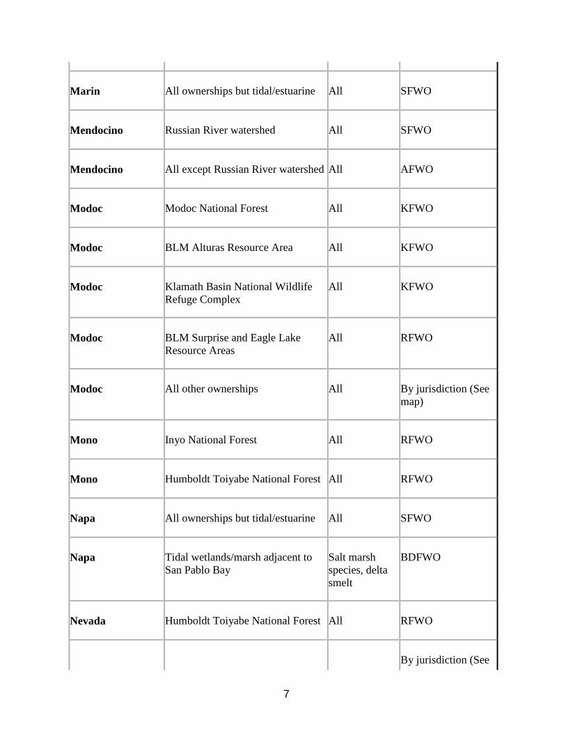
transporting food) is observed, a protective buffer (the size depending on the habitat requirements of the species) should be delineated and the entire area avoided to prevent destruction or disturbance to nests until they are no longer active. Guidance for minimizing impacts to migratory birds for projects involving communications towers (e.g., cellular, digital television, radio, and emergency broadcast) can be found at: http://www.fws.gov/migratorybirds/CurrentBirdIssues/Hazards/towers/towers.htm; http://www.towerkill.com; and http://www.fws.gov/migratorybirds/CurrentBirdIssues/Hazards/towers/comtow.html. If wetlands, springs, or streams are are known to occur in the project area or are present in the vicinity of the project area, we ask that you be aware of potential impacts project activities may have on these habitats. Discharge of fill material into wetlands or waters of the United States is regulated by the U.S. Army Corps of Engineers (ACOE) pursuant to section 404 of the Clean Water Act of 1972, as amended. We recommend you contact the ACOE's Regulatory Section regarding the possible need for a permit. For projects located in northern Nevada (Carson City, Churchill, Douglas, Elko, Esmeralda, Eureka, Humboldt, Lander, Lyon, Mineral, Pershing, Storey, and Washoe Counties) contact the Reno Regulatory Office at 300 Booth Street, Room 3060, Reno, Nevada 89509, (775) 784-5304; in southern Nevada (Clark, Lincoln, Nye, and White Pine Counties) contact the St. George Regulatory Office at 321 North Mall Drive, Suite L-101, St. George, Utah 84790-7314, (435) 986-3979; or in California along the eastern Sierra contact the Sacramento Regulatory Office at 650 Capitol Mall, Suite 5-200, Sacramento, California 95814, (916) 557-5250. We appreciate your concern for threatened and endangered species. Please include the Consultation Tracking Number in the header of this letter with any request for consultation or correspondence about your project that you submit to our office. The table below outlines lead FWS field offices by county and land ownership/project type. Please refer to this table when you are ready to coordinate (including requests for section 7 consultation) with the field office corresponding to your project, and send any documentation regarding your project to that corresponding office. Therefore, the lead FWS field office may not be the office listed above in the letterhead. Lead FWS offices by County and Ownership/Program
County
Ownership/Program
Species
Office Lead*
Alameda
Tidal wetlands/marsh adjacent to Bays
Salt marsh species, delta smelt
BDFWO
Alameda
All ownerships but tidal/estuarine
All
SFWO

5
Alpine Humboldt Toiyabe National Forest All RFWO
Alpine
Lake Tahoe Basin Management Unit
All
RFWO
Alpine
Stanislaus National Forest
All
SFWO
Alpine
El Dorado National Forest
All
SFWO
Colusa
Mendocino National Forest
All
AFWO
Colusa
Other
All
By jurisdiction (see map)
Contra Costa
Legal Delta (Excluding ECCHCP)
All
BDFWO
Contra Costa
Antioch Dunes NWR
All
BDFWO
Contra Costa
Tidal wetlands/marsh adjacent to Bays
Salt marsh species, delta smelt
BDFWO
Contra Costa
All ownerships but tidal/estuarine
All
SFWO
Del Norte
All
All
AFWO
El Dorado
El Dorado National Forest
All
SFWO
El Dorado
LakeTahoe Basin Management Unit
RFWO
Glenn
Mendocino National Forest
All
AFWO

6
Glenn Other All By jurisdiction (see map)
Humboldt
All except Shasta Trinity National Forest
All
AFWO
Humboldt
Shasta Trinity National Forest
All
YFWO
Lake
Mendocino National Forest
All
AFWO
Lake
Other
All
By jurisdiction (see map)
Lassen
Modoc National Forest
All
KFWO
Lassen
Lassen National Forest
All
SFWO
Lassen
Toiyabe National Forest
All
RFWO
Lassen
BLM Surprise and Eagle Lake Resource Areas
All
RFWO
Lassen
BLM Alturas Resource Area
All
KFWO
Lassen
Lassen Volcanic National Park
All (includes Eagle Lake trout on all ownerships)
SFWO
Lassen
All other ownerships
All
By jurisdiction (see map)
Marin
Tidal wetlands/marsh adjacent to Bays
Salt marsh species, delta smelt
BDFWO
7
Marin
All ownerships but tidal/estuarine
All
SFWO
Mendocino
Russian River watershed
All
SFWO
Mendocino
All except Russian River watershed
All
AFWO
Modoc
Modoc National Forest
All
KFWO
Modoc
BLM Alturas Resource Area
All
KFWO
Modoc
Klamath Basin National Wildlife Refuge Complex
All
KFWO
Modoc
BLM Surprise and Eagle Lake Resource Areas
All
RFWO
Modoc
All other ownerships
All
By jurisdiction (See map)
Mono
Inyo National Forest
All
RFWO
Mono
Humboldt Toiyabe National Forest
All
RFWO
Napa
All ownerships but tidal/estuarine
All
SFWO
Napa
Tidal wetlands/marsh adjacent to San Pablo Bay
Salt marsh species, delta smelt
BDFWO
Nevada
Humboldt Toiyabe National Forest
All
RFWO
By jurisdiction (See

8
Nevada All other ownerships All map)
Placer
Lake Tahoe Basin Management Unit
All
RFWO
Placer
All other ownerships
All
SFWO
Sacramento
Legal Delta
Delta Smelt
BDFWO
Sacramento
Other
All
By jurisdiction (see map)
San Francisco
Tidal wetlands/marsh adjacent to San Francisco Bay
Salt marsh species, delta smelt
BDFWO
San Francisco
All ownerships but tidal/estuarine
All
SFWO
San Mateo
Tidal wetlands/marsh adjacent to San Francisco Bay
Salt marsh species, delta smelt
BDFWO
San Mateo
All ownerships but tidal/estuarine
All
SFWO
San Joaquin
Legal Delta excluding San Joaquin HCP
All
BDFWO
San Joaquin
Other
All
SFWO
Santa Clara
Tidal wetlands/marsh adjacent to San Francisco Bay
Salt marsh species, delta smelt
BDFWO
Santa Clara
All ownerships but tidal/estuarine
All
SFWO

9
Shasta
Shasta Trinity National Forest except Hat Creek Ranger District (administered by Lassen National Forest)
All
YFWO
Shasta
Hat Creek Ranger District
All
SFWO
Shasta
Bureau of Reclamation (Central Valley Project)
All
BDFWO
Shasta
Whiskeytown National Recreation Area
All
YFWO
Shasta
BLM Alturas Resource Area
All
KFWO
Shasta
Caltrans
By jurisdiction
SFWO/AFWO
Shasta
Ahjumawi Lava Springs State Park
Shasta crayfish
SFWO
Shasta
All other ownerships
All
By jurisdiction (see map)
Shasta
Natural Resource Damage Assessment, all lands
All
SFWO/BDFWO
Sierra
Humboldt Toiyabe National Forest
All
RFWO
Sierra
All other ownerships
All
SFWO
Siskiyou
Klamath National Forest (except Ukonom District)
All
YFWO
Siskiyou
Six Rivers National Forest and Ukonom District
All
AFWO

10
Siskiyou
Shasta Trinity National Forest
All
YFWO
Siskiyou
Lassen National Forest
All
SFWO
Siskiyou
Modoc National Forest
All
KFWO
Siskiyou
Lava Beds National Volcanic Monument
All
KFWO
Siskiyou
BLM Alturas Resource Area
All
KFWO
Siskiyou
Klamath Basin National Wildlife Refuge Complex
All
KFWO
Siskiyou
All other ownerships
All
By jurisdiction (see map)
Solano
Suisun Marsh
All
BDFWO
Solano
Tidal wetlands/marsh adjacent to San Pablo Bay
Salt marsh species, delta smelt
BDFWO
Solano
All ownerships but tidal/estuarine
All
SFWO
Solano
Other
All
By jurisdiction (see map)
Sonoma
Tidal wetlands/marsh adjacent to San Pablo Bay
Salt marsh species, delta smelt
BDFWO
Sonoma
All ownerships but tidal/estuarine
All
SFWO

11
Tehama
Mendocino National Forest
All
AFWO
Tehama
Shasta Trinity National Forest except Hat Creek Ranger District (administered by Lassen National Forest)
All
YFWO
Tehama
All other ownerships
All
By jurisdiction (see map)
Trinity
BLM
All
AFWO
Trinity
Six Rivers National Forest
All
AFWO
Trinity
Shasta Trinity National Forest
All
YFWO
Trinity
Mendocino National Forest
All
AFWO
Trinity
BIA (Tribal Trust Lands)
All
AFWO
Trinity
County Government
All
AFWO
Trinity
All other ownerships
All
By jurisdiction (See map)
Yolo
Yolo Bypass
All
BDFWO
Yolo
Other
All
By jurisdiction (see map)
All
FERC-ESA
All
By jurisdiction (see map)

12
All FERC-ESA Shasta crayfish SFWO
All
FERC-Relicensing (non-ESA)
All
BDFWO
*Office Leads:
AFWO=Arcata Fish and Wildlife Office
BDFWO=Bay Delta Fish and Wildlife Office
KFWO=Klamath Falls Fish and Wildlife Office
RFWO=Reno Fish and Wildlife Office
YFWO=Yreka Fish and Wildlife Office
Attachment

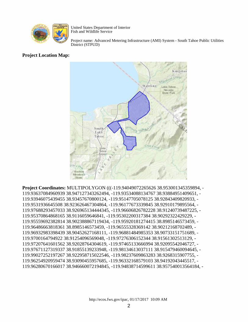
United States Department of Interior Fish and Wildlife Service
Project name: Advanced Metering Infrastructure (AMI) System - South Tahoe Public Utilities District (STPUD)
http://ecos.fws.gov/ipac, 01/17/2017 10:09 AM 1
Section 2 Official Species List Provided by: Reno Fish and Wildlife Office 1340 FINANCIAL BOULEVARD, SUITE 234 RENO, NV 89502 (775) 861-6300 http://www.fws.gov/nevada/
Consultation Code: 08ENVD00-2017-SLI-0148 Event Code: 08ENVD00-2017-E-00245 Project Type: WATER SUPPLY / DELIVERY Project Name: Advanced Metering Infrastructure (AMI) System - South Tahoe Public Utilities District (STPUD) Project Description: STPUD is a special district that supplies approximately 14,000 drinking water connections with fresh potable water and 17,000 sewer service connections to the City of South Lake Tahoe and portions of El Dorado County. All drinking water supply sources are from 12 wells and produce and average annual water supply of 9,528 acre-feet per year (AFY). STPUD operates within the delicate environmental of Lake Tahoe and is subject a high level of regulations by multiple state and federal agencies, including the only bi-state regulatory agency, the Tahoe Regional Planning Agency (TRPA). However, the Proposed Action area or STPUD service area is located only in California and is subject to California State Drinking Water and Sewer Treatment requirements. The Proposed Action involves installation of AMI for Phase 3 and part of Phase 4 in the STPUD service area. Phase 3 involves the installation of 1,432 water meters and Phase 4 involves the installation of 1,327 water meters. Metering in the STPUD service area will allow STPUD to meter volumetric consumption, and better determine district water allocation. Please Note: The FWS office may have modified the Project Name and/or Project Description, so it may be different from what was submitted in your previous request. If the Consultation Code matches, the FWS considers this to be the same project. Contact the office in the 'Provided by' section of your previous Official Species list if you have any questions or concerns.
United States Department of Interior Fish and Wildlife Service
Project name: Advanced Metering Infrastructure (AMI) System - South Tahoe Public Utilities District (STPUD)
http://ecos.fws.gov/ipac, 01/17/2017 10:09 AM 2
Project Location Map:
Project Coordinates: MULTIPOLYGON (((-119.94049072265626 38.953001345359894, - 119.93637084960939 38.947127343262494, -119.93534088134767 38.93884951409651, - 119.93946075439455 38.93457670800124, -119.95147705078125 38.92843409820933, - 119.9531936645508 38.923626467304864, -119.96177673339845 38.92910179895564, - 119.97688293457033 38.926965134444345, -119.96606826782228 38.91240739487225, - 119.95370864868165 38.9116059646841, -119.95302200317384 38.90292322429229, - 119.95559692382814 38.902388867119434, -119.95920181274415 38.8985146573459, - 119.96486663818361 38.8985146573459, -119.96555328369142 38.90212168702489, - 119.96932983398439 38.90452627168111, -119.96881484985353 38.90733151751689, - 119.9700164794922 38.91254096569048, -119.97276306152344 38.91561302513129, - 119.97207641601562 38.92028764304619, -119.97465133666994 38.92095542046727, - 119.97671127319337 38.91855139233948, -119.98134613037111 38.915479460094645, - 119.99027252197267 38.922958715022546, -119.98237609863283 38.9268315907755, - 119.96254920959474 38.93090455957685, -119.96332168579103 38.94192043445517, - 119.96280670166017 38.946660072194845, -119.94838714599611 38.957540013564184, -

United States Department of Interior Fish and Wildlife Service
Project name: Advanced Metering Infrastructure (AMI) System - South Tahoe Public Utilities District (STPUD)
http://ecos.fws.gov/ipac, 01/17/2017 10:09 AM 3
119.94049072265626 38.953001345359894))) Project Counties: El Dorado, CA

United States Department of Interior Fish and Wildlife Service
Project name: Advanced Metering Infrastructure (AMI) System - South Tahoe Public Utilities District (STPUD)
http://ecos.fws.gov/ipac, 01/17/2017 10:09 AM 4
Section 3 Endangered Species Act Species List There are a total of 3 threatened or endangered species on your species list. Species on this list should be considered in an effects analysis for your project and could include species that exist in another geographic area. For example, certain fish may appear on the species list because a project could affect downstream species. Critical habitats listed under the Has Critical Habitat column may or may not lie within your project area. See the Critical habitats within your project area section further below for critical habitat that lies within your project. Please contact the designated FWS office if you have questions.
Amphibians Status Has Critical Habitat
Condition(s)
Sierra Nevada Yellow-legged Frog (Rana sierrae) Population: Wherever found
Endangered Final designated
Fishes
Lahontan cutthroat trout (Oncorhynchus clarkii henshawi) Population: Wherever found
Threatened
Mammals
North American wolverine (Gulo gulo luscus) Population: Wherever found
Proposed Threatened

United States Department of Interior Fish and Wildlife Service
Project name: Advanced Metering Infrastructure (AMI) System - South Tahoe Public Utilities District (STPUD)
http://ecos.fws.gov/ipac, 01/17/2017 10:09 AM 5
Section 4 Critical habitats that lie within your project area There are no critical habitats within your project area.
United States Department of Interior Fish and Wildlife Service
Project name: Advanced Metering Infrastructure (AMI) System - South Tahoe Public Utilities District (STPUD)
http://ecos.fws.gov/ipac, 01/17/2017 10:09 AM - Appendix A 1
Section 5 Appendix A: FWS National Wildlife Refuges and Fish Hatcheries
There are no refuges or fish hatcheries within your project area.

United States Department of Interior Fish and Wildlife Service
Project name: Advanced Metering Infrastructure (AMI) System - South Tahoe Public Utilities District (STPUD)
http://ecos.fws.gov/ipac, 01/17/2017 10:09 AM - Appendix B 1
Section 6 Appendix B: FWS Migratory Birds The protection of birds is regulated by the Migratory Bird Treaty Act (MBTA) and the Bald and Golden Eagle Protection Act (BGEPA). Any activity, intentional or unintentional, resulting in take of migratory birds, including eagles, is prohibited unless otherwise permitted by the U.S. Fish and Wildlife Service (50 C.F.R. Sec. 10.12 and 16 U.S.C. Sec. 668(a)). The MBTA has no otherwise lawful activities. For more information regarding these Acts see: http://www.fws.gov/birds/policies-and-regulations/laws-legislations/migratory-bird-treaty-act.php http://www.fws.gov/birds/policies-and-regulations/laws-legislations/bald-and-golden-eagle-protection-act.php All project proponents are responsible for complying with the appropriate regulations protecting birds when planning and developing a project. To meet these conservation obligations, proponents should identify potential or existing project-related impacts to migratory birds and their habitat and develop and implement conservation measures that avoid, minimize, or compensate for these impacts. The Service's Birds of Conservation Concern (2008) report identifies species, subspecies, and populations of all migratory nongame birds that, without additional conservation actions, are likely to become listed under the Endangered Species Act as amended (16 U.S.C 1531 et seq.). For information about Birds of Conservation Concern, go to: http://www.fws.gov/birds/management/managed-species/birds-of-conservation-concern.php For information about conservation measures that help avoid or minimize impacts to birds, please visit: http://www.fws.gov/birds/management/project-assessment-tools-and-guidance/conservation-measures.php To search and view summaries of year-round bird occurrence data within your project area, go to the Avian Knowledge Network Histogram Tools at: http://www.fws.gov/birds/management/project-assessment-tools-and-guidance/akn-histogram-tools.php

United States Department of Interior Fish and Wildlife Service
Project name: Advanced Metering Infrastructure (AMI) System - South Tahoe Public Utilities District (STPUD)
http://ecos.fws.gov/ipac, 01/17/2017 10:09 AM - Appendix B 2
Migratory birds that may be affected by your project: There are 27 birds on your migratory bird list. The list may include birds occurring outside this FWS office jurisdiction.
Species Name Bird of Conservation Concern (BCC)
Seasonal Occurrence in Project Area
Bald eagle (Haliaeetus leucocephalus)
Yes Year-round
Black Rosy-Finch (Leucosticte atrata)
Yes Year-round
Black Swift (Cypseloides niger) Yes Breeding
Brewer's Sparrow (Spizella breweri)
Yes Breeding
California spotted Owl (Strix occidentalis occidentalis)
Yes Year-round
Calliope Hummingbird (Stellula calliope)
Yes Breeding
Flammulated owl (Otus flammeolus)
Yes Breeding
Fox Sparrow (Passerella liaca) Yes Year-round
Greater sage-grouse (Centrocercus urophasianus)
Yes Year-round
Green-tailed Towhee (Pipilo chlorurus)
Yes Breeding
Lewis's Woodpecker (Melanerpes lewis)
Yes Wintering
Loggerhead Shrike (Lanius ludovicianus)
Yes Year-round
Long-Billed curlew (Numenius americanus)
Yes Breeding
Olive-Sided flycatcher (Contopus cooperi)
Yes Breeding
Peregrine Falcon (Falco peregrinus)
Yes Year-round

United States Department of Interior Fish and Wildlife Service
Project name: Advanced Metering Infrastructure (AMI) System - South Tahoe Public Utilities District (STPUD)
http://ecos.fws.gov/ipac, 01/17/2017 10:09 AM - Appendix B 3
Pinyon Jay (Gymnorhinus cyanocephalus)
Yes Year-round
Rufous-crowned Sparrow (Aimophila ruficeps)
Yes Year-round
Sage Thrasher (Oreoscoptes montanus)
Yes Breeding
Short-eared Owl (Asio flammeus) Yes Year-round
Snowy Plover (Charadrius alexandrinus)
Yes Breeding
Swainson's hawk (Buteo swainsoni) Yes Breeding
tricolored blackbird (Agelaius tricolor)
Yes Breeding
Virginia's Warbler (Vermivora virginiae)
Yes Breeding
Western grebe (aechmophorus occidentalis)
Yes Year-round
White-headed Woodpecker (Picoides albolarvatus)
Yes Year-round
Williamson's Sapsucker (Sphyrapicus thyroideus)
Yes Year-round
Willow Flycatcher (Empidonax traillii)
Yes Breeding

United States Department of Interior Fish and Wildlife Service
Project name: Advanced Metering Infrastructure (AMI) System - South Tahoe Public Utilities District (STPUD)
http://ecos.fws.gov/ipac, 01/17/2017 10:09 AM - Appendix B 4
Section 7 Appendix C: NWI Wetlands Wetlands data for your project area was not available at the time of this species list request.