Accessible Mt. Baker Integrated Multimodal Plan Seattle Planning Commission Michael James, SDOT...
19
Accessible Mt. Baker Integrated Multimodal Plan Seattle Planning Commission Michael James, SDOT January 8, 2015
-
Upload
gavin-wood -
Category
Documents
-
view
221 -
download
3
Transcript of Accessible Mt. Baker Integrated Multimodal Plan Seattle Planning Commission Michael James, SDOT...

Accessible Mt. BakerIntegrated Multimodal Plan
Seattle Planning CommissionMichael James, SDOTJanuary 8, 2015

Background / Study Area
4
• North Rainier Neighborhood Plan• Southeast Transportation Study• McClellan Town Center Development
Strategy• North Rainier Action Plan• Seattle Station Area Transportation
Analysis• Mt. Baker Urban Design Framework• Seattle Mobility Plans• Community Voices
• North Rainier Neighborhood Plan
• SE Transportation Study
• McClellan Town Center Development Strategy
• North Rainier Action Plan
• Seattle Station Area Transportation Analysis
• Mt. Baker Urban Design Framework
• Seattle Mobility Plans• Community Voices

Teams
5
Interdepartmental City Team• Seattle Dept. of Transportation• Dept. of Planning and
Development• Office of Housing• Dept. of Neighborhoods/Public
Outreach and Engagement Liaisons • Somali, Spanish, Oromo,
Tigrinya and Amharic
Consultant Team• HDR (transportation)• Cascadia Consulting Group
(outreach)

Project outcomes
• Identify and develop conceptual designs for pedestrian and bicycle safety improvements
• Refine an integrated multimodal plan– Operational analysis for all modes– Reconsider the “Bowtie”– How are improvements prioritized and phased?– How can this strengthen community assets and
values?
6

Scope Overview
7
Results:Identify short-term solutions; establish med and long-term priorities
Results:Advance short-term projects and refine integrated multimodal plan
Results:Deliver an integrated implementation plan to move improvements forward
Public Event
#1 (March)
Early public engagement
Ongoing public engagement
Public Event
#2 (June)

The Charrette Week (Dec 15 – 19)
• Town Center vision offered themes• Stakeholder interviews informed ideas• Project goal defined direction• Guiding principles framed fundamentals• Evaluation criteria helped test
alternatives• Early concepts tested• New concepts prepared and evaluated• Long-term plan emerged• Near-term actions followed

Accessible Mt. Baker goal
The outcome is a place where jobs are retained and created. The multi-modal plan prioritizes
modes as: Pedestrian, Bicycle, Transit, Freight and Auto. Town Center Vision themes are
incorporated. In doing so, Mt Baker becomes a “To Place” rather than a “Through Place”, making
it a highly desirable destination.
Recognize Mt Baker is the gateway to southeast Seattle, with the intent of creating a place that honors the tradition of compact, walkable, and mixed use communities.

Guiding Principles• Integrate transport and land use • Create a network of streets, paths and open
space• Identify and respect known constraints • Make a legible and identifiable place• Establish the hierarchy of modes as:
– Ped/Bike: Safety and comfort – Transit: Reliable and frequent– Freight: Access and geometrics– Auto: Calm and equal throughput
• Optimize fire and emergency access• Apply universal design and promote equity

Long-term Concept
• Reflects the prioritized modal preferences
• Restores the traditional urban values
• Eliminates the confluence of streets• Supports redevelopment to the
north and conservation to the south• Allows the Olmsted Greenway
extension• Creates the desired destination
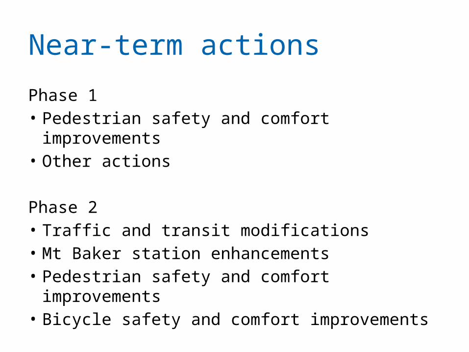
Near-term actions
Phase 1• Pedestrian safety and comfort improvements• Other actions
Phase 2• Traffic and transit modifications• Mt Baker station enhancements• Pedestrian safety and comfort improvements• Bicycle safety and comfort improvements

Schedule
13
• December 2014: launch study, Charrette #1
• January – March: early engagement• March: public event #1• April – July: ongoing public engagement• June: public event #2• Fall 2015: final report


Early concepts reviewed

Early concepts reviewed
17
Bowtie
Roundabout

Stakeholder Interview Summaries
• Pedestrians• Bikes• Transit – bus and
light rail• Freight• Repurposing
Rainier• Connectivity • Urban design/TOD
• Economic development/ opportunity sites
• Unintended consequences
• Concept feedback• Short-term ideas• Long-term ideas• Other issues

Evaluation Factors
In concert with the Guiding Principles, a set of Evaluation Factors was created to guide the overall multi-modal plan. These factors are for the prioritized modes as previously identified. • Pedestrian
– Crossing distance– Conflict points– Traffic signal cycle length and walk distances– Eliminate push button pedestrian signals– Visibility– Large refuge areas

Evaluation Factors
• Bicycle– Directness– Conflict minimization – Separation – Bike share – Parking
• Transit– Reliability - schedule and frequency– Proximity and convenience– Rapid Ride-like features and amenities– Ease of transfer• Local transfer (bus to rail)• Regional transfer (rail to bus to rail)
– On-street stops and layover

Evaluation Factors
• Freight– Reliable trips for deliveries– Access to properties– Geometrics
• Autos– Vehicles per lane– V/C ratio– % traffic diversion– Queue length– Travel times– Property and service access


![Monitoria multimodal cerebral multimodal monitoring[2]](https://static.fdocuments.us/doc/165x107/552957004a79599a158b46fd/monitoria-multimodal-cerebral-multimodal-monitoring2.jpg)

![CERAMICHE CAESAR YAM LTD CAESARSTONE SDOT- · Ceramiche Caesar SpA v Caesarstone Sdot-Yam Ltd [2017] SGCA 30 The Appellant’s CAESAR Mark was registered for goods in Class 19 as](https://static.fdocuments.us/doc/165x107/5e240939cdd8d53f750245d8/ceramiche-caesar-yam-ltd-caesarstone-sdot-ceramiche-caesar-spa-v-caesarstone-sdot-yam.jpg)