Access Docklands: A Strategy for the Docklands Transport ... · A StrAtEgy FOr tHE DOCKLANDS...
33
ACCESS DOCKLANDS A STRATEGY FOR THE DOCKLANDS TRANSPORT NETWORK IN COLLABORATION WITH
Transcript of Access Docklands: A Strategy for the Docklands Transport ... · A StrAtEgy FOr tHE DOCKLANDS...
ACCESS DOCKLANDSA StrAtEgy FOr tHE DOCKLANDS trANSPOrt NEtWOrK
In collaboratIon wIth


Produced by Places Victoria and city of Melbourne 710 collins Street, Docklands, Victoria 3008
Publication date: March 2013
Maps and figures shown are for illustration purposes only and are correct as at publication date.

CONtENtSP10 ExECutivE SummAry
P12 viSiON AND rECOmmENDAtiONS
P13 SHOrt tErm ACtiON PLAN
P14 CONCEPt PLAN
P20 iNtrODuCtiON
P22 Aim OF ACCESS DOCKLANDS
P23 DEvELOPmENt OF ACCESS DOCKLANDS
P26 StrAtEgiC CONtExt
P26 mELbOurNE’S EmErgiNg CENtrAL City ArEA
P27 gAtEWAy tO tHE WESt
P28 tHE NEED FOr iNFrAStruCturE
P29 SuPPOrtiNg POLiCiES AND StrAtEgiES
P32 DOCKLANDS trAvEL PAttErNS
P33 rESiDENt trAvEL PAttErNS
P34 WOrKEr trAvEL PAttErNS
P35 viSitOr trAvEL PAttErNS
P35 trANSPOrt uSEr NEEDS
P36 FuturE trAvEL DEmANDS
P37 iNNEr WESt trAvEL DEmANDS
P38 DOCKLANDS trAvEL tArgEtS
P42 mAiN CHALLENgES AND OPPOrtuNitiES
P44 viSiON AND ObjECtivES
P45 StrAtEgiC APPrOACH
P46 WALKiNg AND CyCLiNg
P48 PubLiC trANSPOrt
P50 rOADS
P52 PrOgrAmS AND POLiCiES
P56 imPLEmENtAtiON
54 access Docklands
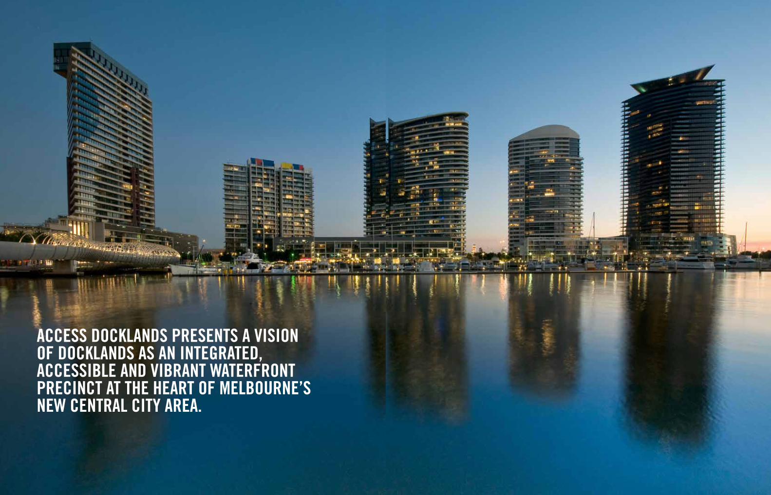
ACCESS DOCKLANDS PrESENtS A viSiON OF DOCKLANDS AS AN iNtEgrAtED, ACCESSibLE AND vibrANt WAtErFrONt PrECiNCt At tHE HEArt OF mELbOurNE’S NEW CENtrAL City ArEA.

ExECutivE SummAry

1110 access Docklands
PurPOSE OF ACCESS DOCKLANDS
access Docklands has been prepared by Places Victoria and the city of Melbourne, in conjunction with Urbantrans. Key contributors to the project include Docklands residents, workers, business owners and a range of government agencies.
access Docklands examines transport issues and opportunities in and around the Melbourne Docklands precinct. the study provides recommendations for improving access and mobility at Docklands, as well as between Docklands and surrounding central city areas.
access Docklands will be used by government agencies and community stakeholders to prioritise and coordinate the delivery of transport infrastructure and programs to support the ongoing growth and development of Docklands and the central city more generally.
StuDy mEtHOD
access Docklands has been developed through an extensive program of consultation and analysis, including:
• Thedeploymentoftravelneedsandbehavioursurveystomorethan 19,000 Docklands workers, Docklands residents and over 3,000 Docklands visitors;
• Thedevelopmentofadetailedtransportmodeltoestimate likely future travel demands in and around Docklands over the next decade and beyond; and
• Assessmentofthecapacityofinfrastructurenetworkstoaccommodate the forecast demand and the determination of high priority infrastructure and program requirements.
ExECutivE SummAry
KEy FiNDiNgS OF ACCESS DOCKLANDS
Docklands travel patterns
Melbourne Docklands is performing as a successful transit oriented development, with very high proportions of walking, cycling and public transport use and low levels of car dependency. In many ways, Docklands exemplifies the sustainable transport benefits that can be derived from urban consolidation around major infrastructure, activity and employment nodes.
Future transport demands
Very significant residential and worker growth is expected in and around Docklands over the next decade and beyond. Existing and planned central city growth areas around Docklands could accommodate up to 400,000 new workers and residents, representing potential travel demands equivalent to the entire population of canberra.
central city growth of this magnitude has the potential to deliver significant economic, social and environmental benefits for Melbourne and Victoria. there is an opportunity to boost Melbourne’s competitive advantages and economic productivity, by bringing people and jobs closer together spatially and through the provision of high quality transport links.
For Docklands specifically, the significant growth still to occur in and around the precinct represents an enormous opportunity to further activate spaces and enhance the precinct’s social and economic vitality.
Docklands as a demonstration of transit oriented development
the transport challenge in Docklands and central Melbourne more generally is to improve livability, accessibility and productivity in the context of limited road space, congested public transport services and rapidly increasing travel demands.
the challenge is particularly pronounced in Docklands, as vehicle access to the precinct is unusually limited by structural barriers including the water, Port of Melbourne land uses, rail infrastructure and congestion on the surrounding arterial network.
access Docklands responds to this challenge by embracing the opportunity to confirm and strengthen Docklands’ position as a world class transit oriented development. For government and the community, a commitment to this approach means:
• Deliveringthehighestqualitywalking,cyclingandpublictransportinfrastructure to and through the Melbourne Docklands precinct, even whilst parts of the precinct are still being developed;
• Managingtheroadnetworkbettertoreducetraveltimes,particularly peak hour travel times between Docklands and surrounding arterial roads;
• Workingwiththestrongresidentialandcorporatecommunityin Docklands to deliver innovative travel policies and programs which foster reduced vehicle dependence; and
• Overthelongerterm,deliveringregionaltransportprojectswhich facilitate Melbourne’s growth as a true transit city.
18000
Inbo
und
Empl
oym
ent
Trip
s
16000
14000
12000
10000
8000
6000
4000
2000
0Current (67%)
Sustainable Transport Mode Share
90% Sustainable Transport
Mode Share
80% Sustainable Transport
Mode Share
2025 Walking Trips
2025 Cycling Trips
2025 Public Transport Trips
2025 Vehicle Trips
2025 Other Trips
2011 Public Transport Trips
2011 Vehicle Trips
Figure 2: Docklands Travel Demand Forecasts, 2025Figure 1: Docklands Resident and Worker Growth, 2011-2025
0
10000
Year
20000
30000
40000
50000
60000
70000
80000
2011 2025
Res
iden
ts a
nd W
orke
rs
Workers
Residents
Total
0
10000
Year
20000
30000
40000
50000
60000
70000
80000
2011 2025
Res
iden
ts a
nd W
orke
rs
Workers
Residents
Total
1110 access Docklands
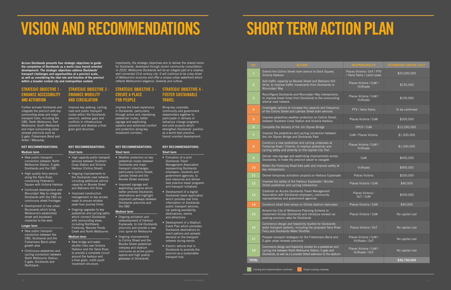
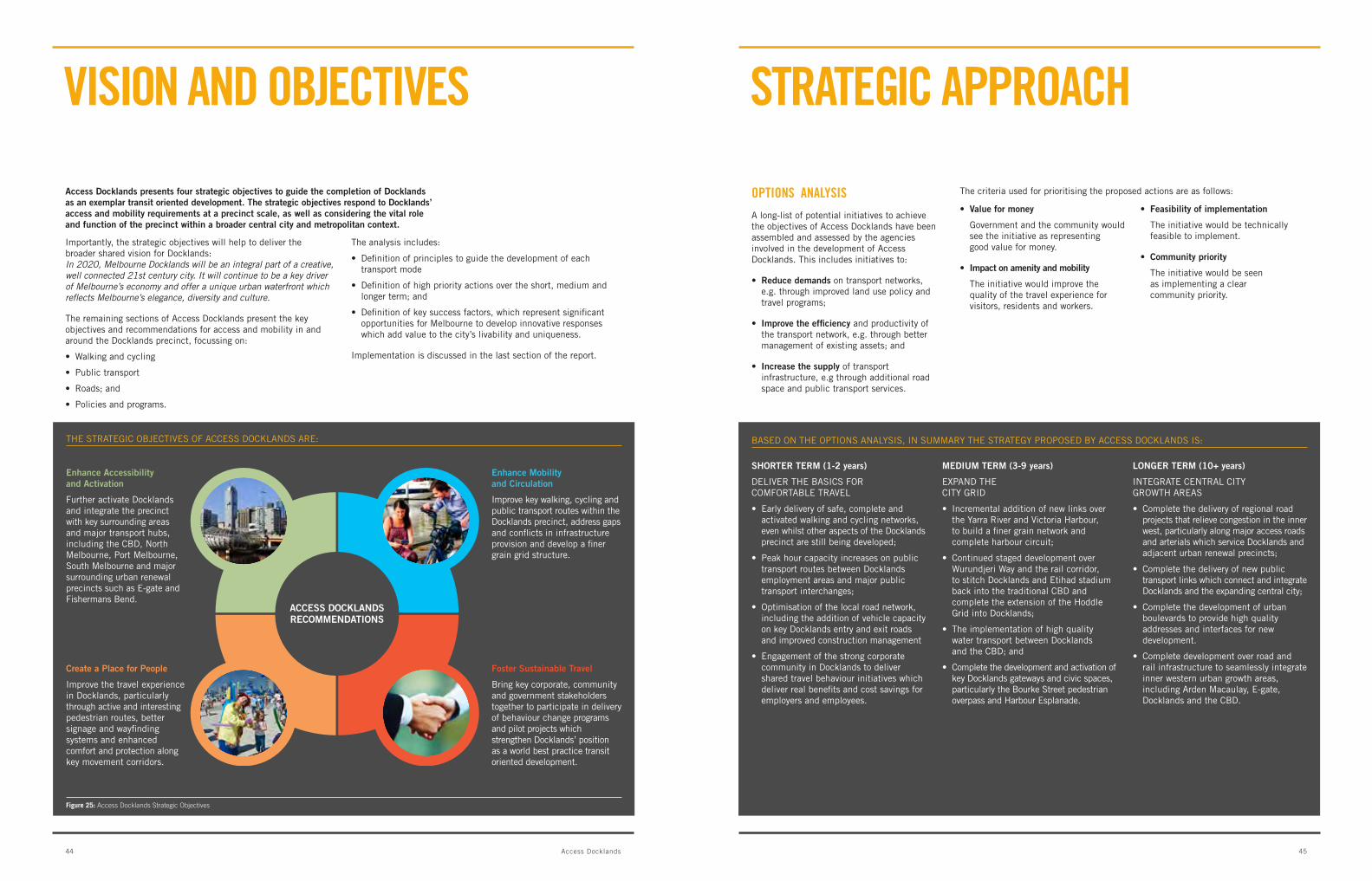
Access Docklands presents four strategic objectives to guide the completion of Docklands as a world class transit oriented development. The strategic objectives address Docklands’ transport challenges and opportunities at a precinct scale, as well as considering the vital role and function of the precinct within a broader central city and metropolitan context.
Importantly, the strategic objectives aim to deliver the shared vision for Docklands, developed through recent community consultation: In 2020, Melbourne Docklands will be an integral part of a creative, well connected 21st century city. It will continue to be a key driver of Melbourne’s economy and offer a unique urban waterfront which reflects Melbourne’s elegance, diversity and culture.
viSiON AND rECOmmENDAtiONS
13
StrAtEgiC ObjECtivE 1 - ENHANCE ACCESSibiLity AND ACtivAtiON
Further activate Docklands and integrate the precinct with key surrounding areas and major transport hubs, including the cbD, north Melbourne, Port Melbourne, South Melbourne and major surrounding urban renewal precincts such as E-gate, Fishermans bend and arden / Macaulay.
StrAtEgiC ObjECtivE 2 - ENHANCE mObiLity AND CirCuLAtiON
Improve key walking, cycling, road and public transport routes within the Docklands precinct, address gaps and conflicts in infrastructure provision and develop a finer grain grid structure.
StrAtEgiC ObjECtivE 3 - CrEAtE A PLACE FOr PEOPLE
Improve the travel experience in Docklands, particularly through active and interesting pedestrian routes, better signage and wayfinding systems and enhanced comfort and protection along key movement corridors.
StrAtEgiC ObjECtivE 4 - FOStEr SuStAiNAbLE trAvEL
bring key corporate, community and government stakeholders together to participate in delivery of behaviour change programs and pilot projects which strengthen Docklands’ position as a world best practice, transit oriented development.
SHOrt tErm ACtiON PLAN
No. AcTioN RespoNsibiliTy esTimATeD cApiTAl cosT
1Extend the collins Street tram service to Dock Square, Victoria harbour
Places Victoria / Dot / PtV / Yarra trams / lend lease
$20,000,000
2add traffic capacity on bourke Street and batmans hill Drive, to improve traffic movements from Docklands to wurundjeri way
Places Victoria / coM / Vicroads
$150,000
3reconfigure Docklands and wurundjeri way intersections, to improve travel times from Docklands to the surrounding arterial road network
Places Victoria / coM / Vicroads
$100,000
4Investigate options to increase the capacity and frequency of the collins Street and latrobe Street tram services
PtV / Yarra trams to be confirmed
5Improve pedestrian weather protection on collins Street, between Southern cross Station and Victoria harbour
Places Victoria / coM $200,000
6 complete the delivery of the Jim Stynes bridge DPcD / coM $12,200,000
7Improve the pedestrian and cycling connection between the Jim Stynes bridge and Docklands Park
coM / Places Victoria $1,500,000
8construct a new pedestrian and cycling underpass at Footscray road / citylink, to improve pedestrian and cycling safety and amenity on the capital city trail
Places Victoria / coM / Vicroads
$1,000,000
9Deliver new signage and wayfinding improvements across Docklands, to make the precinct easier to navigate
coM $400,000
10widen the Footscray road bike path and improve safety at key intersections
Vicroads $400,000
11 Deliver temporary activation projects on harbour Esplanade Places Victoria $200,000
12Improve the safety of the harbour Esplanade / bourke Street pedestrian and cycling intersection
Places Victoria / coM $40,000
13Establish an access Docklands travel Management association with Docklands employers, community representatives and government agencies
Places Victoria / Dot / coM
$500,000
14 construct small bike ramps on Etihad stadium staircases Places Victoria / coM $40,000
15amend the city of Melbourne Planning Scheme to implement access Docklands and introduce revised car parking provision rates for Docklands
Places Victoria / coM no capital cost
16commence design and feasibility studies for Docklands water transport systems, including the proposed Yarra river Ferry and Docklands water Shuttles
Places Victoria / Dot no capital cost
17Prepare transport strategies for the Fishermans bend and E-gate urban renewal precincts
Places Victoria / coM / Vicroads / Dot
no capital cost
18commence design and feasibility studies for a pedestrian and cycling link between north Melbourne Station, E-gate and Docklands, as well as a lonsdale Street extension to the stadium
Places Victoria / coM / Vicroads / Dot
no capital cost
ToTAl $36,730,000
Key RecommeNDATioNs:
medium term
• Newpublictransportconnection between north Melbourne Station, E-gate, Docklands and the cbD
• Highqualityferryservicealong the Yarra river, connecting Federation Square with Victoria harbour
• Continueddevelopmentoverwurundjeri way to integrate Docklands with the cbD via continuous street frontages
• Developmentofnewurbanboulevards which bring Melbourne’s established street and boulevard character to the west
longer term
• Newpublictransportconnection between the cbD, Docklands and the Fishermans bend urban growth area
• Continuouspedestrianandcycling connection between north Melbourne Station, E-gate, Docklands and northbank.
Key RecommeNDATioNs:
short term
• Highcapacitypublictransportservices between Southern cross Station and Victoria harbour (collins Street)
• Ongoingimprovementstothe Docklands road network, including additional vehicle capacity on bourke Street and batmans hill Drive
• Improvedconstructionmanagement on key access roads to ensure reliable peak hour journey times
• Ongoingupgradestokeypedestrian and cycling paths which connect Docklands with surrounding areas, including northbank, Footscray, Moonee Ponds creek and north Melbourne
medium term
• Newbridgeandwatershuttle links over Victoria harbour and the Yarra river, to provide a complete circuit around the harbour and a finer grain, north-south movement structure.
Key RecommeNDATioNs:
short term
• Weatherprotectiononkeypedestrian routes between Docklands and major transport interchanges, particularly collins Street, latrobe Street and the bourke Street overpass
• Improvedsignageandwayfinding systems which better promote Docklands destinations and highlight important pathways between Docklands precincts and the cbD
medium term
• Ongoingactivationandredevelopment of harbour Esplanade, to link Docklands precincts and provide a new civic spine for Melbourne
• Ongoingimprovementsto collins Street and the bourke Street pedestrian overpass and stadium concourse as active public spaces and high quality gateways to Docklands.
Key RecommeNDATioNs:
short term
• FormationofajointDocklands travel Management association representing Docklands employers, residents and government agencies, to pool resources and deliver best practice travel programs and transport initiatives
• DevelopmentofadigitalDocklands travel application which provides real time information on Docklands public transport services, car parking availability, destinations, events and attractions
• DevelopmentofaStadiumEvent Plan which promotes Docklands destinations to event patrons and spreads demand on the transport network during events
• ElectricvehicletrialinDocklands to promote the precinct as a sustainable transport hub.
Funding and implementation confirmed Project scoping underway
131312 access Docklands

151514 access Docklands
CONCEPt PLAN
potential deck over Wurundjeri Way creates a new pedestrian and cycling path, connecting Northbank through to North melbourne
lonsdale street extension and bourke street overpass bring Docklands, the stadium and cbD together
longer term bridges create walkable spacings between yarra River crossings and a Victoria Harbour circuit whilst maintaining boat access
New public transport link extends collins street through to Fishermans bend
iconic ferry service connects Docklands, the yarra and the cbD
Development over road and rail connects Docklands with North melbourne
Urban boulevard integrates Docklands with e-gate
Water shuttles provide pedestrian and cycling links between the north and south sides of Victoria Harbour and the yarra River
linking over water
Affordable public transport innovation
Concept Docklands land ferry
Transalon concept eco bus by Xiao-Fang Shen, China
building over road and rail
Media House and Collins Street Bridge, Docklands
Central city strategic linkages
expanding the city grid
35
Royal Botanic
EtihadStadium
Garden
Royal Park
Flemington Racecourse
MCG
Footscray Road
Westgate Freeway
Lorimer Street
CityL
ink
Yarraville
Footscray
Kensington
North MelbourneCollingwood
East Melbourne
SouthMelbourne
West Melbourne
Yarra River
Albert ParkLake
Port Phillip Bay
Flemington Road
St Kilda R
oad
Roy
al P
arad
e
Dynon RoadA
bbot
sfor
d S
tree
t
Clarendon Street
Carlton Gardens
Victoria Parade
0 500 1000 1500m
Collins S
treet
Latrobe S
treet
Londsale Stree
t
Bourke Stree
t
Flinders Stree
t
FISHERMAN’S BEND
MELBOURNE PORT
ARDEN-MACAULAY
E-GATE
DOCKLANDS
CITY NORTH
SOUTHBANK
DYNON CORRIDOR
FOOTSCRAY CENTRAL

DOCKLANDS iS A PLACE PEOPLE EmbrACE tO WOrK, LivE AND viSit AND HAS AttrACtED ArOuND 8,000 rESiDENtS AND 30,000 WOrKErS tO DAtE.
ACCESS DOCKLANDSA StrAtEgy FOr tHE DOCKLANDS trANSPOrt NEtWOrK

iNtrODuCtiON
ACCESS DOCKLANDS HAS bEEN PrEPArED by PLACES viCtOriA AND tHE City OF mELbOurNE, iN COLLAbOrAtiON WitH urbANtrANS. KEy StAKEHOLDErS CONSuLtED DuriNg DEvELOPmENt OF tHE PrOjECt iNCLuDE DOCKLANDS rESiDENtS, WOrKErS, buSiNESS OWNErS, PrECiNCt DEvELOPErS AND tHE WiDEr COmmuNity. A number of government agencies have also provided input to the project, including the Victorian Department of Transport, public Transport Victoria, VicRoads, the Victorian Department of planning and community Development and the port of melbourne.
Access Docklands examines transport opportunities and challenges in Docklands and the surrounding central city area. The study provides a suite of recommendations for improving access and mobility to and within the Docklands and the surrounding area over the short, medium and longer term.
Access Docklands will be used by government agencies and community stakeholders to prioritise and coordinate the delivery of transport infrastructure and programs, to support the ongoing growth and development of Docklands and the central city more generally.
Figure 3: Docklands regional context
2120 Access Docklands
Access Docklands has been developed through an extensive research program including consultation, strategic analysis and transport modelling. The research program included:
• ConsultationwithDocklandsresidents,workers,businesses,visitors and community stakeholders regarding Docklands access and mobility issues, opportunities and needs;
• Deploymentoftravelbehavioursurveystomorethan19,000Docklands workers, Docklands residents and over 3,000 Docklands visitors, to understand Docklands travel patterns and likely infrastructure requirements from the perspective of users;
• PreparationofaDocklandsTransportModeltoquantifyfuturetravel demands, including future walking, cycling, public transport and vehicle trips through and within the Docklands precinct;
• Integratedlanduseandtransportplanningtoidentifythehighest priority access and mobility initiatives and policy directions required in Docklands and surrounding areas over the next decade and beyond.
This report presents the key findings and recommendations of the Access Docklands study. The report builds on the following background reports, which may be read separately:
• DocklandsPrecinctTrafficAnalysisatKeyIntersections,Urbantrans, January 2011
• DocklandsTransportModelTechnicalReport,UrbanTrans,august 2011
• DocklandsTransportPlanBackgroundReport,UrbanTrans,December 2011
• DocklandsTravelTimeComparisons,UrbanTrans,2011
The remaining sections of this report include:
• Anoverviewofthestrategicandpolicycontextinfluencingaccess and mobility within and around Docklands;
• PresentationofDocklandstravelbehaviourfindings,includingsurveys results from Docklands residents, workers and visitors;
• EstimatesoflikelyfuturetraveldemandsatDocklands,including future public transport, vehicle, pedestrian and cycling trips at full precinct build out;
• DiscussionoftheDocklandstransportnetwork,focussingonkeychallenges and opportunities; and
• StrategicrecommendationsforaccessandmobilityatDocklands,including infrastructure priorities, policies and programs.
DEvELOPmENt OF ACCESS DOCKLANDS
ACCESS DOCKLANDS
RECOMMENDATIONS
OPTIONSANALYSIS
TRANSPORTMODEL
DEVELOPMENT
EMPLOYEESURVEYS
RESIDENTSURVEYS
VISITORSURVEYS
RESEARCH
STAKEHOLDERCONSULTATION
Figure 5: Development of Access Docklands
the aim builds on the early vision of Docklands as a demonstration of sustainable urban development, which paved the way for very significant investment in transport infrastructure early in the life of the project. this included the provision of new tram services into newQuay and Victoria harbour, new road connections into the cbD via collins Street, latrobe Street and bourke Street, and the creation of a new waterfront civic spine along harbour Esplanade. In total, by 1993 approximately $250 million had been invested into road, public transport and trunk infrastructure to support Docklands’ early development.
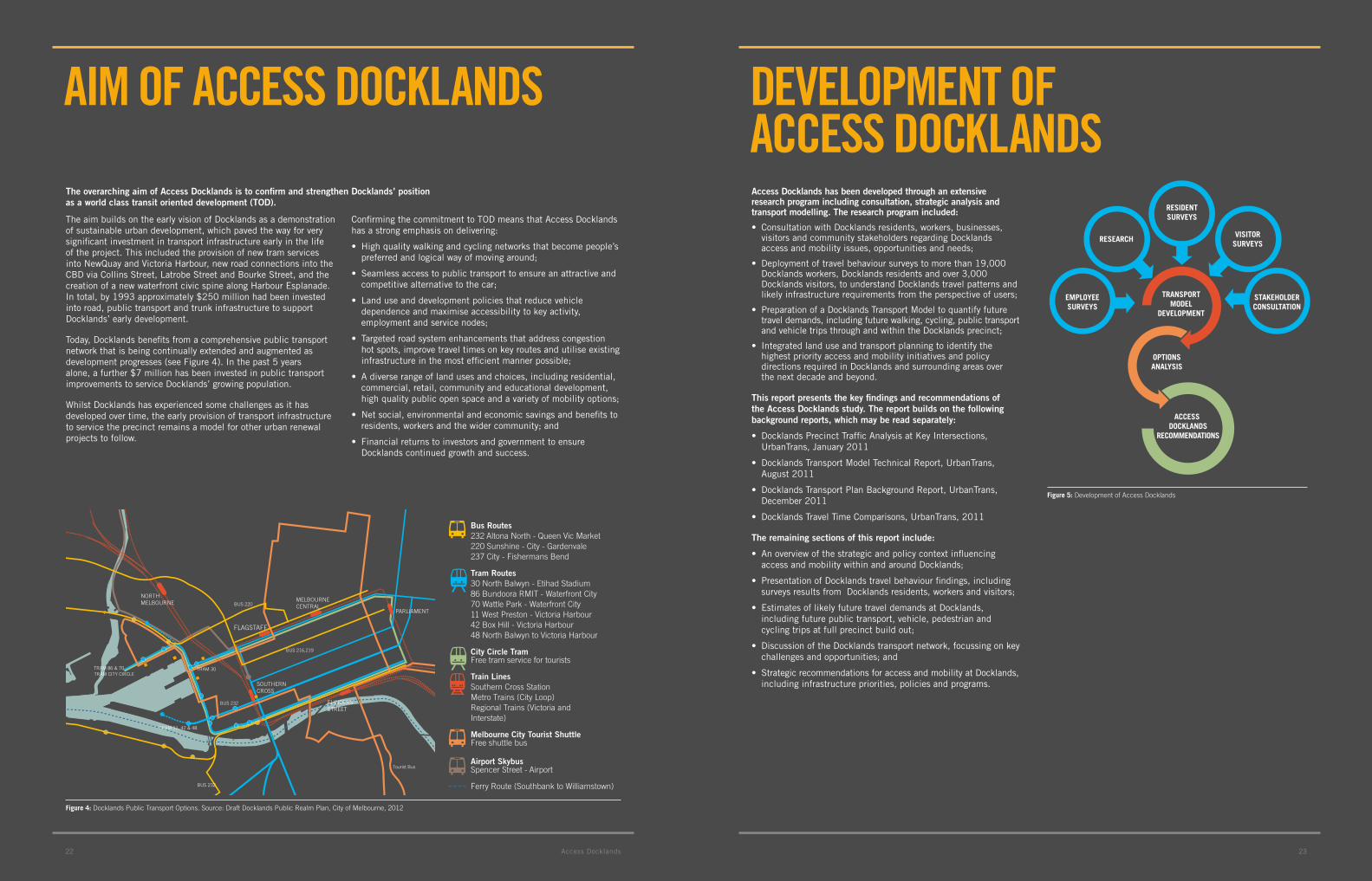
today, Docklands benefits from a comprehensive public transport network that is being continually extended and augmented as development progresses (see Figure 4). In the past 5 years alone, a further $7 million has been invested in public transport improvements to service Docklands’ growing population.
whilst Docklands has experienced some challenges as it has developed over time, the early provision of transport infrastructure to service the precinct remains a model for other urban renewal projects to follow.
confirming the commitment to toD means that access Docklands has a strong emphasis on delivering:
• Highqualitywalkingandcyclingnetworksthatbecomepeople’spreferred and logical way of moving around;
• Seamlessaccesstopublictransporttoensureanattractiveandcompetitive alternative to the car;
• Landuseanddevelopmentpoliciesthatreducevehicledependence and maximise accessibility to key activity, employment and service nodes;
• Targetedroadsystemenhancementsthataddresscongestionhot spots, improve travel times on key routes and utilise existing infrastructure in the most efficient manner possible;
• Adiverserangeoflandusesandchoices,includingresidential,commercial, retail, community and educational development, high quality public open space and a variety of mobility options;
• Netsocial,environmentalandeconomicsavingsandbenefitstoresidents, workers and the wider community; and
• FinancialreturnstoinvestorsandgovernmenttoensureDocklands continued growth and success.
The overarching aim of Access Docklands is to confirm and strengthen Docklands’ position as a world class transit oriented development (ToD).
Aim OF ACCESS DOCKLANDS
Figure 4: Docklands Public Transport Options. Source: Draft Docklands Public Realm Plan, City of Melbourne, 2012
TRAM 86 & 70TRAM CITY CIRCLE
TRAM 11, 42 & 48
FLINDERS STREET
SOUTHERNCROSS
FLAGSTAFF
BUS 216,219
BUS 232
MELBOURNECENTRALBUS 220
BUS 232
Tourist Bus
PARLIAMENT
TRAM 30
Bus Routes232 Altona North - Queen Vic Market220 Sunshine - City - Gardenvale237 City - Fishermans Bend
Tram Routes30 North Balwyn - Etihad Stadium86 Bundoora RMIT - Waterfront City70 Wattle Park - Waterfront City11 West Preston - Victoria Harbour42 Box Hill - Victoria Harbour48 North Balwyn to Victoria Harbour
City Circle TramFree tram service for tourists
Train LinesSouthern Cross StationMetro Trains (City Loop)Regional Trains (Victoria andInterstate)
Melbourne City Tourist ShuttleFree shuttle bus
Airport SkybusSpencer Street - Airport
Ferry Route (Southbank to Williamstown)
NORTHMELBOURNE
2322 access Docklands

FrOm ONE OF viCtOriA’S FirSt POrtS tO AN iNDuStriAL PrECiNCt iN tHE 1990s, DOCKLANDS iS bEiNg trANSFOrmED iNtO A mODErN rESiDENtiAL, COmmErCiAL AND viSitOr DEStiNAtiON iN tHE HEArt OF mELbOurNE.
From one of Victoria’s first ports to an industrial precinct in the 1990s, Docklands is rapidly being transformed into a modern residential, commercial and visitor destination in the heart of melbourne.
to date, Docklands has attracted more than $8.5 billion worth of private investment, with the precinct now accommodating some australia’s biggest businesses including the nab, anZ, aMP, Myer, channel 7, channel 9 and Fairfax. the economic success of the precinct is underscored by the fact that, at project completion, more than $100 of private sector investment will have been generated for every $1 of public expenditure at Docklands.
Docklands has grown into a place people embrace to work, live and visit, attracting more than 8,000 residents and 30,000 workers to date.
by 2025, Docklands is expected to become:
• Hometo20,000people
• Workplaceto60,000
• Destinationformillionsofvisitorsannually
in line with its role as a nationally significant employment precinct, Docklands has evolved into a westerly extension of melbourne’s central business District (cbD). The significance of the precinct as a major residential and employment hub is demonstrated by the fact that, with a site area of 190 hectares, Docklands is the same size as the traditional cbD and has effectively doubled the city’s overall footprint.
while Docklands is part of the cbD, the precinct is also located at the centre of a large urban renewal corridor flanking the northern, western and southern parts of the cbD. In this way, Docklands will play a vital ‘linking and connecting role’ between some of central Melbourne’s most significant urban growth areas. these include:
•Tothenorth,potentialurbanrenewalareasatE-gate, arden – Macaulay and along the Dynon corridor
•Tothenorth-east,theCityNortharea,includingthe biomedical research and university precincts
•Tothesoutheast,Southbank
•Tothesouth,potentialurbanrenewalareasatFishermans bend and South Melbourne
•Tothewest,theDynonRoadurbangrowthcorridortoFootscray.
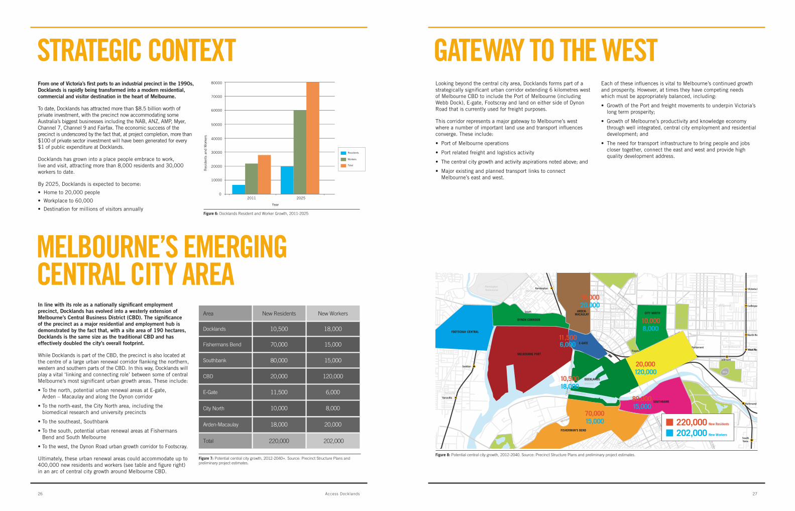
Ultimately, these urban renewal areas could accommodate up to 400,000 new residents and workers (see table and figure right) in an arc of central city growth around Melbourne cbD.
looking beyond the central city area, Docklands forms part of a strategicallysignificanturbancorridorextending6kilometreswestof Melbourne cbD to include the Port of Melbourne (including webb Dock), E-gate, Footscray and land on either side of Dynon road that is currently used for freight purposes.
this corridor represents a major gateway to Melbourne’s west where a number of important land use and transport influences converge. these include:
• PortofMelbourneoperations
• Portrelatedfreightandlogisticsactivity
• Thecentralcitygrowthandactivityaspirationsnotedabove;and
• MajorexistingandplannedtransportlinkstoconnectMelbourne’s east and west.
Each of these influences is vital to Melbourne’s continued growth and prosperity. however, at times they have competing needs which must be appropriately balanced, including:
• GrowthofthePortandfreightmovementstounderpinVictoria’slong term prosperity;
• GrowthofMelbourne’sproductivityandknowledgeeconomythrough well integrated, central city employment and residential development; and
• Theneedfortransportinfrastructuretobringpeopleandjobscloser together, connect the east and west and provide high quality development address.
StrAtEgiC CONtExt gAtEWAy tO tHE WESt
mELbOurNE’S EmErgiNg CENtrAL City ArEA
0
10000
Year
20000
30000
40000
50000
60000
70000
80000
2011 2025
Res
iden
ts a
nd W
orke
rs
Workers
Residents
Total
Figure 6: Docklands Resident and Worker Growth, 2011-2025
Figure 8: Potential central city growth, 2012-2040. Source: Precinct Structure Plans and preliminary project estimates.Figure 7: Potential central city growth, 2012-2040+. Source: Precinct Structure Plans and preliminary project estimates.
Area New Residents New Workers
Docklands 10,500 18,000
Fishermans Bend 70,000 15,000
Southbank 80,000 15,000
CBD 20,000 120,000
E-Gate 11,500 6,000
Arden-Macaulay 18,000 20,000
City North 10,000 8,000
Total 220,000 202,000
35
EtihadStadium
Royal Botanic Garden
Royal Park
Flemington Racecourse
MCG
Footscray Road
Westgate Freeway
City
Link
Yarraville
Footscray
Kensington
North MelbourneCollingwood
East Melbourne
SouthMelbourne
West Melbourne
VictoriaHarbour
Yarra River
Albert ParkLake
Port Phillip Bay
St Kilda Road
Flemington Road
Dynon Road
Clarendon Street
Victoria Street
Carlton Gardens
NorthMelbourne
SouthernCross
Flagsta�
MelbourneCentral
FlindersStreet
Parliament
Jolimont
Kensington
Newmarket FlemingtonBridge
Macaulay
SouthKensington
Footscray
Seddon
West Richmond
North Richmond
Collingwood
West Richmond
Victoria Park
Richmond
SouthYarra
Prahran
Yarraville
Spotswood
NorthMelbourne
SouthernCross
Flagsta�
MelbourneCentral
FlindersStreet
Parliament
Jolimont
Kensington
Newmarket FlemingtonBridge
Macaulay
SouthKensington
Footscray
Seddon
West Richmond
North Richmond
Collingwood
West Richmond
Victoria Park
Richmond
SouthYarra
Prahran
Yarraville
Spotswood
Latrobe Street
Londsale Street
Bourke Street
Collins Street
Flinders Street
0 500 1000 1500m
N
FISHERMAN’S BEND
SOUTHBANK
MELBOURNE PORT
DYNON CORRIDOR
ARDEN-MACAULAY
E-GATE
DOCKLANDS
CITY NORTH
FOOTSCRAY CENTRAL
20,000
10,50018,000
70,00015,000
120,000
10,0008,000
80,00015,000
11,5006,000
18,00020,000
220,000202,000 New Workers
New Residents
2726 Access Docklands
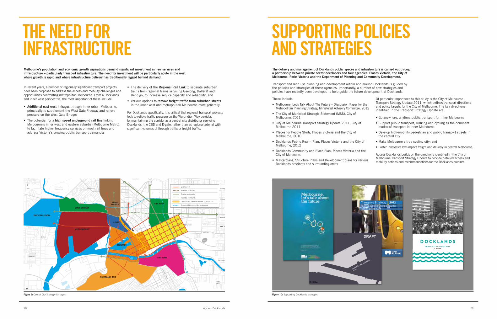
melbourne’s population and economic growth aspirations demand significant investment in new services and infrastructure – particularly transport infrastructure. The need for investment will be particularly acute in the west, where growth is rapid and where infrastructure delivery has traditionally lagged behind demand.
In recent years, a number of regionally significant transport projects have been proposed to address the access and mobility challenges and opportunities confronting metropolitan Melbourne. From a Docklands and inner west perspective, the most important of these include:
• Additional east-west linkages through inner urban Melbourne, principallytosupplementtheWestGateFreewayandrelievepressureontheWestGateBridge;
• Thepotentialforahigh speed underground rail line linking Melbourne’s inner west and eastern suburbs (Melbourne Metro), to facilitate higher frequency services on most rail lines and address Victoria’s growing public transport demands;
• ThedeliveryoftheRegional Rail link to separate suburban trainsfromregionaltrainsservicingGeelong,Ballaratandbendigo, to increase service capacity and reliability; and
• Variousoptionstoremove freight traffic from suburban streets in the inner west and metropolitan Melbourne more generally.
For Docklands specifically, it is critical that regional transport projects look to relieve traffic pressure on the wurundjeri way corridor, by maintaining the corridor as a central city distributor servicing Docklands, the cbD and E-gate, rather than as regional arterial with significant volumes of through traffic or freight traffic.
tHE NEED FOr iNFrAStruCturE
The delivery and management of Docklands public spaces and infrastructure is carried out through a partnership between private sector developers and four agencies: places Victoria, the city of melbourne, parks Victoria and the Department of planning and community Development.
transport and land use planning and development within and around Docklands is guided by the policies and strategies of these agencies. Importantly, a number of new strategies and policies have recently been developed to help guide the future development at Docklands.
these include:
• Melbourne,Let’sTalkAboutTheFuture–DiscussionPaperfortheMetropolitan Planning Strategy, Ministerial advisory commitee, 2012
• TheCityofMunicipalStrategicStatement(MSS),CityofMelbourne, 2011
• CityofMelbourneTransportStrategyUpdate2011,CityofMelbourne 2011
• PlacesforPeopleStudy,PlacesVictoriaandtheCityofMelbourne, 2010
• DocklandsPublicRealmPlan,PlacesVictoriaandtheCityofMelbourne, 2012
• DocklandsCommunityandPlacePlan,PlacesVictoriaandthecity of Melbourne
• Masterplans,StructurePlansandDevelopmentplansforvariousDocklands precincts and surrounding areas.
of particular importance to this study is the city of Melbourne transport Strategy Update 2011, which defines transport directions and policy targets for the city of Melbourne. the key directions identified in the transport Strategy Update are:
•Goanywhere,anytimepublictransportforinnerMelbourne
•Supportpublictransport,walkingandcyclingasthedominantmodes of transport in inner Melbourne
•Develophigh-mobilitypedestrianandpublictransportstreetsinthe central city
•MakeMelbourneatruecyclingcity;and
•Fosterinnovativelow-impactfreightanddeliveryincentralMelbourne.
access Docklands builds on the directions identified in the city of Melbourne transport Strategy Update to provide detailed access and mobility actions and recommendations for the Docklands precinct.
SuPPOrtiNg POLiCiES AND StrAtEgiES
Figure 9: Central City Strategic Linkages Figure 10: Supporting Docklands strategies
35
Royal Botanic
EtihadStadium
Garden
Royal Park
Flemington Racecourse
MCG
Footscray Road
Westgate Freeway
Lorimer Street
CityL
ink
Yarraville
Footscray
Kensington
North MelbourneCollingwood
East Melbourne
SouthMelbourne
West Melbourne
Yarra River
Albert ParkLake
Port Phillip Bay
Flemington Road
St Kilda R
oad
Roy
al P
arad
e
Dynon Road
Abb
otsf
ord
Str
eet
Clarendon Street
Carlton Gardens
Victoria Parade
NorthMelbourne
SouthernCross
Flagstaff
MelbourneCentral
FlindersStreet
Parliament
Jolimont
Kensington
Newmarket FlemingtonBridge
Macaulay
SouthKensington
Footscray
Seddon
West Richmond
North Richmond
Collingwood
West Richmond
Victoria Park
Richmond
SouthYarra
Prahran
Yarraville
Spotswood
0 500 1000 1500m
N
Collins S
treet
Latrobe S
treet
Londsale Stree
t
Bourke Stree
t
Flinders Stree
t
FISHERMAN’S BEND
SOUTHBANK
MELBOURNE PORT
DYNON CORRIDOR
ARDEN-MACAULAY
E-GATE
DOCKLANDS
CITY NORTH
FOOTSCRAY CENTRAL
Proposed Melbourne Metro alignment
melbourne.vic.gov.au/futuregrowth
Transport Strategy 2012PLANNING FOR FUTURE GROWTHMARCH 2012 DRAFT
1 docklands community hub (temporary building)Opened to the public: July 2007
2 the harbour Family children’s centreOpened to the public: January 2009
3 medibank icehouseOpened to the public: February 2010
4 kangan instituteOpened to the public: September 2006
5 etihad stadiumOpened to the public: March 2000
6 public berthsOpened to the public: various with ongoing delivery as development progresses
7 sea pavilion (temporary installation)Opened to the public: November 2011
8 community garden at victoria harbourOpened to the public: April 2012
9 melbourne city sportsOpened to the public: TBA
10 marketsOpened to the public: various
docklands community and place planDrawing together ideas from the community, lessons learnt from development so far, and future sustainability measures, Places Victoria and the City of Melbourne have prepared the Docklands Community and Place Plan which is available from www.docklands.com/docklandscommunityandplaceplan
It sets out clear directions that underpin the Community and Place projects to be delivered in Docklands over the next 10 years and beyond.
hoW do i get more inFormation?To stay informed about the delivery of projects in Docklands go to
minister’s message Sed pharetra bibendum faucibus. Proin sit amet sagittis nunc. Lorem ipsum dolor sit amet, consectetur adipiscing elit. Maecenas fringilla mauris vel lectus aliquam dictum. Sed facilisis mattis ultrices. Morbi feugiat nisl at odio molestie auctor. Aliquam mollis vulputate metus, non convallis nibh elementum at. Cras congue tristique diam, a porttitor urna vulputate non.
lord mayor’s message Pellentesque aliquam scelerisque felis quis tristique. Quisque turpis sem, imperdiet id pulvinar vitae, pulvinar nec nunc. Nam purus orci, vulputate nec bibendum quis, vulputate at magna. In orci lectus, accumsan id ultricies non, volutpat ut lectus. Aliquam lacus enim, blandit ut varius non, imperdiet a erat. Suspendisse imperdiet pellentesque purus vitae aliquam. Pellentesque ornare vehicula augue.
The Honourable Matthew Guy MLCMinister for Planning
The Rt Hon. Robert DoyleLord Mayor of Melbourne
over the last 18 months, places victoria and the city oF melbourne have met With thousands oF people to plan For the Future oF docklands. this exercise and ongoing development has articulated a series oF issues at docklands that Will need addressing in the short, medium and long term. this map begins to address the need For increased community Facilities, Which Will see docklands become a place For people.
11 Fox classic car museum and exhibition spaceDelivering a classic car museum for the public and providing community and exhibition spaces that will draw car enthusiasts from across the country.
Anticipated Delivery: 2012 Funding Parties: Private sector, Places Victoria, City of Melbourne
12 garden shelterThe Garden Shelter will provide a comfortable public place for people to meet, rest and enjoy the surrounding park and community garden.
Anticipated Delivery: 2012 Funding Parties: City of Melbourne
13 southern star observation WheelA private sector led project The Southern Star Observation Wheel is currently under construction and is hoped to be a unique attractor to the area.
Anticipated Delivery: TBA Funding Parties: Developer
23 neighbourhood community centre at yarra’s edgeA community centre will provide amenities for local group events, services and meetings.
Anticipated Delivery: 2014 Funding Parties: Developer, City Of Melbourne (fitout)
24 enhanced pedestrian routesGuided by the Public Realm Plan, the quality of the walking experience will be improved through various measures.
Anticipated Delivery: 2013 (onwards) Funding Parties: Places Victoria, City of Melbourne
25 spaces For community and creative enterprisesShort to medium-term tenancies for creative enterprises to activate key areas and diversify the business community.
Anticipated Delivery: 2013 Funding Parties: Developers
26 outdoor multi-purpose courtCentrally located courts will provide a place to meet and play sport with friends and colleagues. Potential use: basketball, soccer and netball courts.
Anticipated Delivery: 2012 Funding Parties: City of Melbourne
14 running and Walking tracksA running and walking track will trace along Docklands’ promenade, attracting residents, workers and visitors to the waterfront. (Various routes under investigation.)
Anticipated Delivery: Ongoing as development progresses Funding Parties: City of Melbourne
15 Facilities to support recreational FishingImproved facilities for Docklands’ recreational fishing community could include improved amenities such as pontoons for safe fishing.
Anticipated Delivery: 2013 Funding Parties: City of Melbourne, Places Victoria, TBA
16 temporary marketsClose to the water, these regular markets, that will move locations as development continues, will bring life and colour to Docklands, drawing residents and visitors to the waterfront. (One of several possible activities occurring on Harbour Esplanade.)
Anticipated Delivery: 2013 (onwards) Funding Parties: City of Melbourne, Developers and /or Private Sector
27 park improvementsThe improvements to outdoor facilities will enable more activities to take place with the addition of more outdoor seating, shelters, drinking fountains, barbeques, picnic tables, rest areas , additional play environments and increased connections to surrounding areas, including the extension of Docklands park.
Anticipated Delivery: 2014, with ongoing upgrades Funding Parties: Developer
28 Water FerriesWater ferries to better connect Docklands with the Central City, providing a sustainable transport option for residents workers and visitors. (A pilot study for a water ferry is currently underway – other water transport modes may follow.)
Anticipated Delivery: Pilot underway Funding Parties: Business
29 improved Way-Finding signage Key pedestrian routes in and around Docklands, will soon see improved way-finding signage installed to ease navigation for visitors
Anticipated Delivery: 2012, with ongoing installation throughout development. Funding Parties: City of Melbourne
30 aboriginal heritage trail Celebrating Docklands’ early history, the Heritage trail will explore the Aboriginal history of the area.
Anticipated Delivery: 2013 Funding Parties: Developers
17 harbour esplanade redevelopment The Harbour Esplanade redevelopment will ultimately see this important public space transformed into a new harbourside destination for Melbourne. The redevelopment will include an investigation to restore heritage sheds along Harbour Esplanade.
Anticipated Delivery: TBA Funding Parties: TBA
18 Water based artWorksArtworks inspired by the harbour and water will delight and surprise onlookers.
Anticipated Delivery: 2013 Funding Parties: Developers
19 Floating (barge) stage For events With more than 40 hectares of water, Docklands provides the perfect place for waterside events to take place on the water.
Anticipated Delivery: TBA Funding Parties: TBA
20 community recreational sWimming poolA recreational swimming pool will attract more people to the harbour, providing swimming opportunities for visitors and locals alike.
Anticipated Delivery: TBA Funding Parties: Developer, Department of Planning and Community Development
21 community boating hub at victoria harbourThe Community Boating Hub will house Docklands’ existing boating community, and provide a place for the broader community to experience the waterfront through boating activities.
Anticipated Delivery: 2014 Funding Parties: Places Victoria, City of Melbourne
22 the docklands library and community centreThe Docklands Library and Community Centre will provide a meeting place and information centre for the local community.
Anticipated Delivery: 2013 Funding Parties: Places Victoria, City of Melbourne, Developer
31 maritime heritage trailTen key heritage landmarks including key buildings and locations will be part of a trail that interprets Docklands’ unique maritime history.
Anticipated Delivery: 2013 Funding Parties: Places Victoria, City of Melbourne, Developers
32 community and sporting Facility in north-West docklandsSports park and oval with community facilities in north-west Docklands.
Anticipated Delivery: 2015 Funding Parties: Tenants, Developer, TBA
33 school siteA public primary school, to be located in Docklands would serve the growing Docklands area.
Anticipated Delivery: 2016* Funding Parties: Department of Education and Early Childhood
*Subject to feasibility by the Department of Education and Early Childhood Development (DEECD)
34 exhibition venue A flexible venue designed to encourage varied exhibitions.
Anticipated Delivery: 2015 Funding Parties: Developer, Businesses
35 public vieWing platForm at victoria harbour control toWerBringing to life part of Docklands’ maritime history, the Victoria Harbour control tower will be restored with a public viewing platform, providing unrivalled views back into the CBD.
Anticipated Delivery: 2022 Funding Parties: Developer, TBA
36 perFormance event venue A state-of-the-art performance and exhibition venue would attract local and international visitors alike, becoming a permanent landmark for Docklands. Central Pier’s iconic location and maritime history provide the perfect setting for it’s redevelopment into a destination of regional importance.Anticipated Delivery: TBA Funding Parties: TBA
37 charles grimes bridge pedestrian and cyclist linkUnder Charles Grimes Bridge, a new pedestrian and cycling connection will better connect Docklands to the North Bank precinct.
Anticipated Delivery: 2014 Funding Parties: Department of Planning and Community Development, City of Melbourne
In 2010, the City of Melbourne and Places Victoria (successor to VicUrban) embarked on a community engagement program to determine and test the priorities for future development in Docklands.
The community’s input, together with in-depth planning and design studies, helped shape the community and place projects outlined on this map, to create a place for people; a place where liveability is a priority, made possible by quality community infrastructure, welcoming open spaces, interactive street frontages and a vibrant waterfront destination for recreation and leisure.
This document showcases priority projects committed to date by Places Victoria, the City of Melbourne, the State Government and the private sector to be delivered over the short, medium and long term.
Further announcements over the coming months will address transport initiatives, housing diversity, retail mix and Docklands as a cultural precinct.
The projects outlined in this guide will also be delivered alongside ongoing infrastructure projects such as improved public spaces, additional popular parks, improved pedestrian routes and the expansion of the business networks along with the continued delivery of community infrastructure such as a place of worship and public art projects.
d o c k l a n d sc o m m u n i t y a n d p l a c e p l a n
a g u i d e
d o c k l a n d s
Docklands Public Realm Plan
April 2012
DRAFTPage 3 of 75
2928 Access Docklands

iN LiNE WitH itS rOLE AS A NAtiONALLy SigNiFiCANt EmPLOymENt PrECiNCt, DOCKLANDS HAS AttrACtED mOrE tHAN 40 mAjOr COrPOrAtiONS tO tHE ArEA, briNgiNg WitH tHEm mOrE tHAN 30,000 WOrKErS DAiLy.

in July and August 2011, travel behaviour surveys were issued to more than 19,000 Docklands workers, 6,500 residents, 2,500 football spectators and 900 visitors in Docklands, representing one of the largest transport surveys to be ever undertaken in melbourne.
the travel behaviour surveys were designed to help understand travelling habits to and from Docklands and to inform forecasts of future transport demands at key stages of Docklands development.
based on the survey results, residents and workers in Docklands exhibit highly sustainable travel behaviour patterns, characterised by high levels of walking, cycling and public transport use, and low levels of car dependency. Visitors, on the other hand, rely heavily on the car as the preferred mode of travel to Docklands.
Key findings of the travel pattern analysis are highlighted in the following sections. More detailed data is provided in the background report – Docklands transport Model technical report.
trAvEL mODE SPLit
Docklands residents use sustainable transport (including public transport, cycling or walking) nearly three times more than the average person in wider metropolitan Melbourne (VISta 2007).
• 34%ofresidentswalktowork–tentimesmorethanthemetropolitanaverageof3%.
• 70%ofresidentsusesustainabletransportmodestotraveltowork–comparedwith25%formetropolitanMelbourneand59%forinnerMelbourne.
• 30%ofresidentstravelbycartowork–comparedwith75%formetropolitanMelbourneand41%ininnerMelbourne.
trAvEL PAttErNS
• MostDocklandsresidentsleavehomeinthemorningandreturnhome in the evening, for the purpose of going to work.
• Over70%ofresidentsleavehomebetween8and9am. Ofthese,nearlyall(82%)lefthometogotowork.
• Over60%ofresidentsreturnhomebetween5and6pm. Ofthese,nearlyall(85%)returnedhomeafterwork.
• 9%ofDocklandsresidentsworkinDocklands
• 43%workintheCBD
• Morethan40%workindestinationsthatarebeyondtheCBD,Southbank and Docklands.
• 30%ofDocklandsresidentsusethecarfortheirjourneytowork.this demonstrates that even for longer distance trips, many Docklands residents are willing to use sustainable transport modes.
DOCKLANDS trAvEL PAttErNS rESiDENt trAvEL PAttErNS
Figure 11: Docklands Travel Mode Split, 2011
Public Transport
Cars
Foot
Bikes
30%
30%
34%
6%
RESIDENTS
Public Transport
Cars
Foot
Bikes
59%
32%
3%
6%
WORKERS
75%
19%
3%3%
30%
30%
34%
6%
41%
33%
13%
12%
WALK
BIKE
PUBLIC TRANSPORT
CAR
MSD INNER CITY METROPOLITAN AVERAGEDOCKLANDS
Figure 12: Docklands Resident Travel Mode Split 2011
CBD
DOCKLANDS
SOUTHBANK
OTHERS
45% 43%
3% 9%
46% 43%
3% 8%
CBD
DOCKLANDS
SOUTHBANK
OTHERS
AM PEAK PM PEAK
43%
Figure 13: Docklands Resident Origins and Destinations
3332 Access Docklands

Figure 18: Docklands Transport Needs Survey
Enhanced tram services
Enhanced train services
Enhanced weather protection for pedestrians
Better information on public transport options
Better street crossings for pedestrians
Enhanced bus services
More cycle parking facilities
More interesting street fronts
Ferry connections to Flinders Station
Enhanced facilities for casual cyclists
Dedicated routes for higher-speed cyclists
Better information on cycling options
More taxi ranks
Wider footpaths
More motorbike/scooter parking
More shower and change room facilities
More car-share vehicles
More shared bike stations
Charging points for electric vehicles (cars and scooters)
0% 20% 40% 60% 80% 100%
Docklands Transport Needs Survey
PO
TEN
TIA
L IM
PR
OVE
MEN
TS
PERCENT OF RESPONDENTS WHO NOMINATED IMPORTANT OR VERY IMPORTANT
trAvEL mODE SPLit
In comparing Docklands workers to their inner city counterparts (Melbourne, Port Phillip, Yarra and Stonnington, Vista 2007 / Census2006):
• 59%ofDocklandsworkerstraveltoworkbypublictransport–comparedwith33%acrosstheinnerfourmunicipalities, and62%ofCBDworkers
• 67%ofDocklandsworkersusesustainabletransportmodestotraveltowork–comparedwith58%acrosstheinnerfourmunicipalitiesand72%ofCBDworkers
• 32%ofDocklandsworkerstraveltoworkbycar–comparedwith42%acrosstheinnerfourmunicipalitiesand27%of cbD workers.
trAvEL PAttErNS
the peak hour travel periods in Docklands are highly concentrated and unusually short, representing an opportunity to relieve congestion by spreading demand over longer aM and PM time periods through workplace policy and travel behaviour initiatives:
• 58%ofemployeesarrivewithintheAMpeakhour(8-9am)
• 49%ofemployeesdepartworkwithinthePMpeakhour(5-6pm)
• Duringtheday,themajorityofDocklandsworkerstraveltotheretail heart of the cbD, presenting an opportunity to improve retailserviceswithintheDocklandsprecinct(seeFigure16).
WOrKEr trAvEL PAttErNS viSitOr trAvEL PAttErNS
trANSPOrt uSEr NEEDS
Figure 14: Worker Travel Mode Split 2011
Figure 15: Worker Peak Travel Periods 2011
Figure 16: Docklands Worker Travel Destinations, daytime lunch hours 2011
59%
3%6%
32%Walk
Bike
Public Transport
Car
Both Peaks
0%
10%
20%
30%
40%
50%
60%
70%
0 1 2 3 4 5 6 7 8 9 10 11 12 13 14 15 16 17 18 19 20 21 22 23
Hour
Percentage of Employees Arriving Into Docklands
Percentage of Employees Departing Docklands
Visitor travel patterns have been assessed in Waterfront city, Harbour Town, NewQuay and the retail sections of Victoria Harbour. The analysis reveals that most after hours and weekend visitors to the retail and entertainment areas in Docklands rely on access by private car (between 60 and 80%). in contrast, business hours weekday users of these same areas appear to be local workers and residents as car usage is only 8%.
Spectator travel patterns for three successive aFl games at Etihad stadium were also assessed. Irrespective of the teams playing, an overwhelming majority of spectators arrived at the stadium from the areas to the north and west of central Melbourne. this highlights the potential to capitalise on the presence of north Melbourne station immediately north of Docklands as a supplementary point of departure and arrival for many spectators and visitors.
Day of the week Number of visitorssurveyed
Mode Share Docklands OriginCar Public Transport Walk
Friday (5-8pm) 290 78% 14% 8% 20%
Saturday (2-6pm) 280 65% 20% 15% 15%
Tuesday (11am-3pm) 350 8% 10% 82% 87%
Figure 17: Visitor Survey Results
participants in the Docklands transport survey were asked to rank the relative importance of potential improvements to the transport network. The results of the analysis are presented in the graph below.
Key findings include:
• Nearly100%ofrespondentsnominatedenhanced tram services as a high or very high priority transport need for Docklands;
• Overthreequartersofrespondentshighlighted enhanced weather protection as a high or very high priority need;
• Morecarandbikesharestationswereconsidered a relatively low priority.
3534 Access Docklands
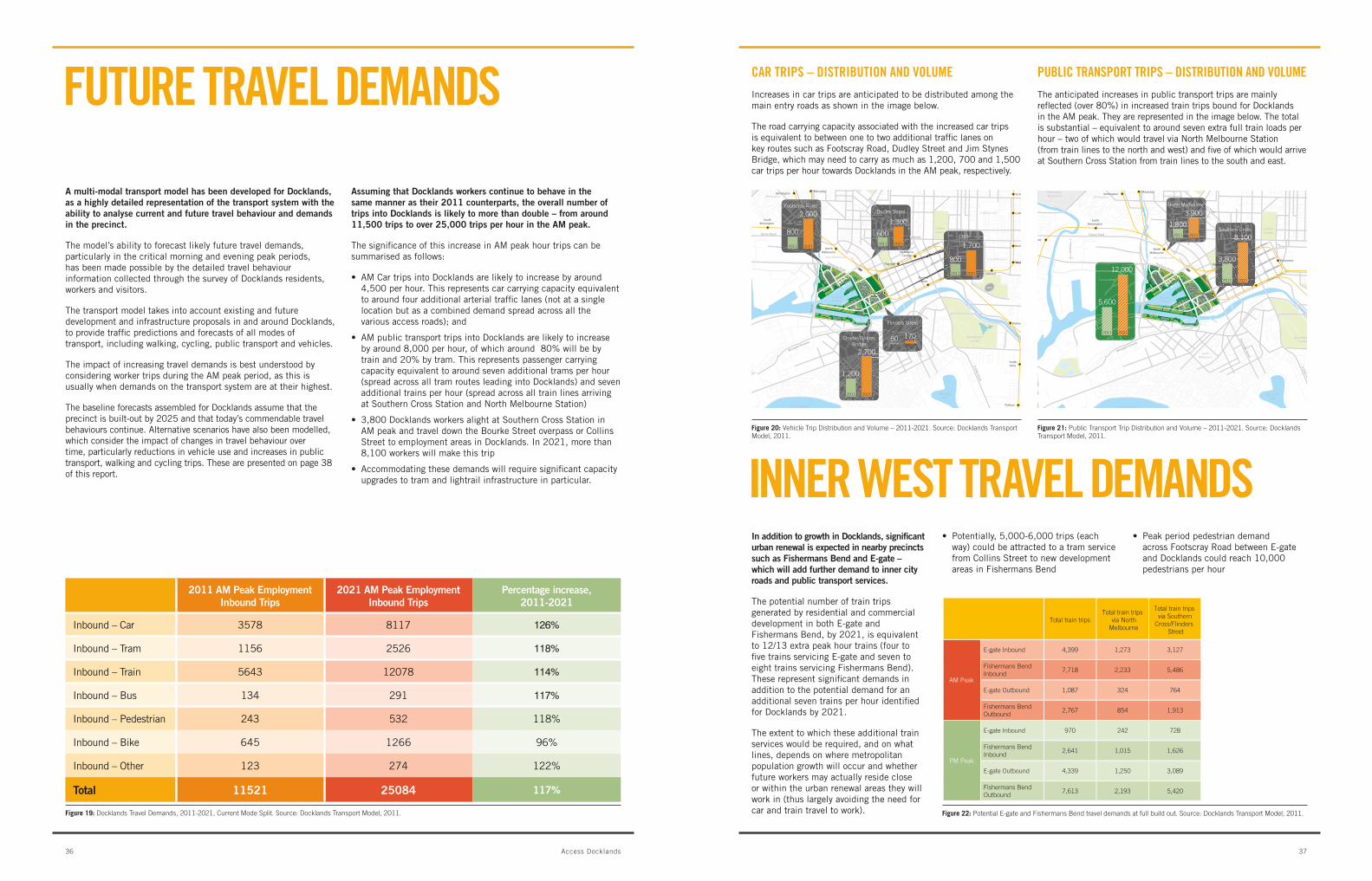
FuturE trAvEL DEmANDS
in addition to growth in Docklands, significant urban renewal is expected in nearby precincts such as Fishermans bend and e-gate – which will add further demand to inner city roads and public transport services.
the potential number of train trips generated by residential and commercial development in both E-gate and Fishermans bend, by 2021, is equivalent to 12/13 extra peak hour trains (four to five trains servicing E-gate and seven to eight trains servicing Fishermans bend). these represent significant demands in addition to the potential demand for an additional seven trains per hour identified for Docklands by 2021.
the extent to which these additional train services would be required, and on what lines, depends on where metropolitan population growth will occur and whether future workers may actually reside close or within the urban renewal areas they will work in (thus largely avoiding the need for car and train travel to work).
A multi-modal transport model has been developed for Docklands, as a highly detailed representation of the transport system with the ability to analyse current and future travel behaviour and demands in the precinct.
the model’s ability to forecast likely future travel demands, particularly in the critical morning and evening peak periods, has been made possible by the detailed travel behaviour information collected through the survey of Docklands residents, workers and visitors.
the transport model takes into account existing and future development and infrastructure proposals in and around Docklands, to provide traffic predictions and forecasts of all modes of transport, including walking, cycling, public transport and vehicles.
the impact of increasing travel demands is best understood by considering worker trips during the aM peak period, as this is usually when demands on the transport system are at their highest.
the baseline forecasts assembled for Docklands assume that the precinct is built-out by 2025 and that today’s commendable travel behaviours continue. alternative scenarios have also been modelled, which consider the impact of changes in travel behaviour over time, particularly reductions in vehicle use and increases in public transport, walking and cycling trips. these are presented on page 38 of this report.
Assuming that Docklands workers continue to behave in the same manner as their 2011 counterparts, the overall number of trips into Docklands is likely to more than double – from around 11,500 trips to over 25,000 trips per hour in the Am peak.
the significance of this increase in aM peak hour trips can be summarised as follows:
• AMCartripsintoDocklandsarelikelytoincreasebyaround4,500 per hour. this represents car carrying capacity equivalent to around four additional arterial traffic lanes (not at a single location but as a combined demand spread across all the various access roads); and
• AMpublictransporttripsintoDocklandsarelikelytoincreasebyaround8,000perhour,ofwhicharound80%willbebytrainand20%bytram.Thisrepresentspassengercarryingcapacity equivalent to around seven additional trams per hour (spread across all tram routes leading into Docklands) and seven additional trains per hour (spread across all train lines arriving at Southern cross Station and north Melbourne Station)
• 3,800DocklandsworkersalightatSouthernCrossStationinaM peak and travel down the bourke Street overpass or collins Street to employment areas in Docklands. In 2021, more than 8,100 workers will make this trip
• Accommodatingthesedemandswillrequiresignificantcapacityupgrades to tram and lightrail infrastructure in particular.
2011 Am peak employment inbound Trips
2021 Am peak employment inbound Trips
percentage increase, 2011-2021
Inbound – car 3578 8117 126%
Inbound – tram 1156 2526 118%
Inbound – train 5643 12078 114%
Inbound – bus 134 291 117%
Inbound – Pedestrian 243 532 118%
Inbound – bike 645 1266 96%
Inbound – other 123 274 122%
Total 11521 25084 117%
Figure 19: Docklands Travel Demands, 2011-2021, Current Mode Split. Source: Docklands Transport Model, 2011.
35
EtihadStadium
Royal Botanic Garden
Royal Park
Flemington Racecourse
MCG
Footscray Road
Westgate Freeway
City
Link
Yarraville
Footscray
Kensington
North MelbourneCollingwood
East Melbourne
SouthMelbourne
West Melbourne
VictoriaHarbour
Yarra River
Albert ParkLake
Port Phillip Bay
St Kilda Road
Flemington Road
Dynon Road
Clarendon Street
Victoria Street
Carlton Gardens
NorthMelbourne
SouthernCross
Flagsta�
MelbourneCentral
FlindersStreet
Parliament
Jolimont
Kensington
Newmarket FlemingtonBridge
Macaulay
SouthKensington
Footscray
Seddon
West Richmond
North Richmond
Collingwood
West Richmond
Victoria Park
Richmond
SouthYarra
Prahran
Yarraville
Spotswood
Latrobe Street
Londsale Street
Bourke Street
Collins Street
Flinders Street
0 500 1000 1500m
N
20212011
2,000
800
Footscray Road
Clarendon Stdon
renrendodo
CCla
20212011
17050
Flinders Street
ns
ParliamentarP iaeeteet
StreetStStreet
derders StreetSt
ers Streett
ders StrSders Streders treet 20212011
1,700
800
CBD
elbourneurnelbe belbelb nenrnr
gton Roadoad
VictoriV to
20212011
1,300
600
Dudley Street
SoutSoutMelbouelboelbouM
20212011
2,700
1,200
Charles GrimesBridge
Londsale S
Londsale Street
ndsStre
dersdersSt
Collins SCoCollins S
EtihadStadium
outhernuthSoutheernSouS herneernththhSouthernhehhehehehthhhththhthhhhtththhhhhhheehehhhhhehhhhthttttttthhhhhhhhhhhhhththethhhethhheuthheeerernS uuoooS rnoutouttttSoSossssssCroCCroCCrossCr
Figure 20: Vehicle Trip Distribution and Volume – 2011-2021. Source: Docklands Transport Model, 2011.
Figure 21: Public Transport Trip Distribution and Volume – 2011-2021. Source: Docklands Transport Model, 2011.
35
EtihadStadium
Royal Botanic Garden
Royal Park
Flemington Racecourse
MCG
Footscray Road
Westgate Freeway
City
Link
Yarraville
Footscray
Kensington
North MelbourneCollingwood
East Melbourne
SouthMelbourne
West Melbourne
VictoriaHarbour
Yarra River
Albert ParkLake
Port Phillip Bay
St Kilda Road
Flemington Road
Dynon Road
Clarendon Street
Victoria Street
Carlton Gardens
NorthMelbourne
SouthernCross
Flagsta�
MelbourneCentral
FlindersStreet
Parliament
Jolimont
Kensington
Newmarket FlemingtonBridge
Macaulay
SouthKensington
Footscray
Seddon
West Richmond
North Richmond
Collingwood
West Richmond
Victoria Park
Richmond
SouthYarra
Prahran
Yarraville
Spotswood
Latrobe Street
Londsale Street
Bourke Street
Collins Street
Flinders Street
0 500 1000 1500m
N
20212011
12,000
5,600
Victoria Streeta V to eeSt t
�agstaa�sta���
MelbourneouelbouCentraltraral
FlinderFli erderStreetStrStrStr
LatroatrLatro
LoLo
North MelbouuN MelbNorth MeN thth Mh bo elbelb
Flemingto
Fleming
20212011
8,100
3,800
20212011
3,900
1,800
North Melbourne
Southern Cross
CAr triPS – DiStributiON AND vOLumE
Increases in car trips are anticipated to be distributed among the main entry roads as shown in the image below.
the road carrying capacity associated with the increased car trips is equivalent to between one to two additional traffic lanes on key routes such as Footscray road, Dudley Street and Jim Stynes bridge, which may need to carry as much as 1,200, 700 and 1,500 car trips per hour towards Docklands in the aM peak, respectively.
PubLiC trANSPOrt triPS – DiStributiON AND vOLumE
the anticipated increases in public transport trips are mainly reflected(over80%)inincreasedtraintripsboundforDocklands in the aM peak. they are represented in the image below. the total is substantial – equivalent to around seven extra full train loads per hour – two of which would travel via north Melbourne Station (from train lines to the north and west) and five of which would arrive at Southern cross Station from train lines to the south and east.
iNNEr WESt trAvEL DEmANDS• Potentially,5,000-6,000trips(each
way) could be attracted to a tram service from collins Street to new development areas in Fishermans bend
• Peakperiodpedestriandemandacross Footscray road between E-gate and Docklands could reach 10,000 pedestrians per hour
Total train tripsTotal train trips
via North Melbourne
Total train tripsvia Southern
Cross/Flinders Street
AM Peak
E-gate Inbound 4,399 1,273 3,127
Fishermans Bend Inbound
7,718 2,233 5,486
E-gate Outbound 1,087 324 764
Fishermans Bend Outbound
2,767 854 1,913
PM Peak
E-gate Inbound 970 242 728
Fishermans Bend Inbound
2,641 1,015 1,626
E-gate Outbound 4,339 1,250 3,089
Fishermans Bend Outbound
7,613 2,193 5,420
Figure 22: Potential E-gate and Fishermans Bend travel demands at full build out. Source: Docklands Transport Model, 2011.
3736 Access Docklands
DOCKLANDS trAvEL tArgEtS
38 Access Docklands
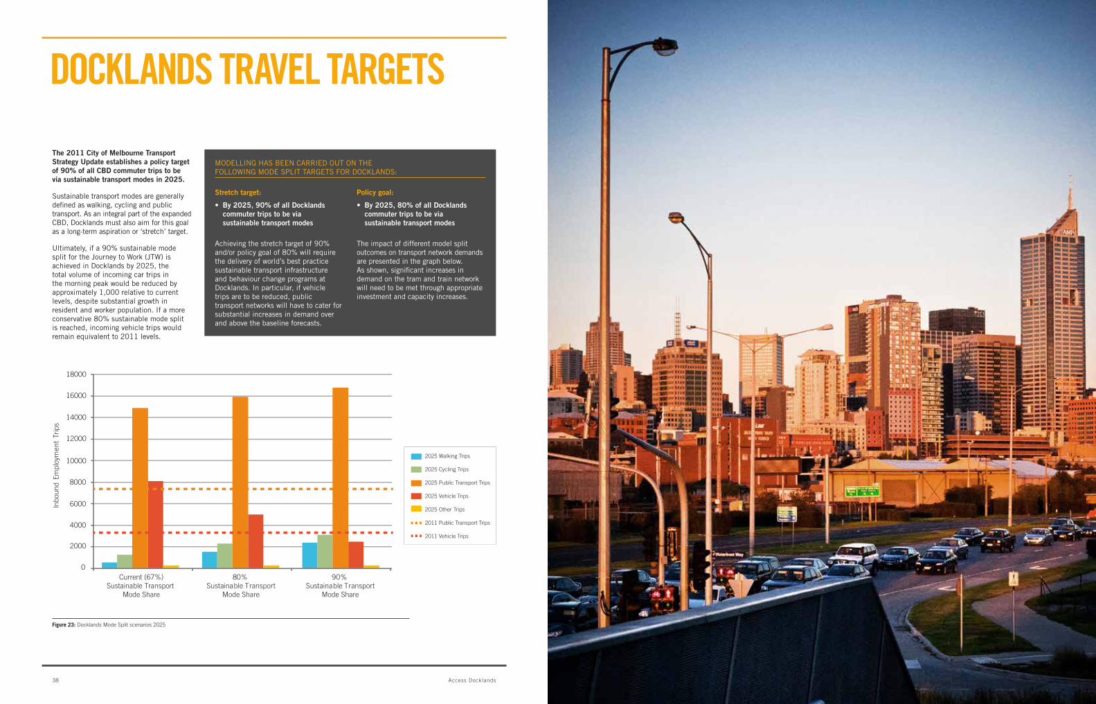
The 2011 city of melbourne Transport strategy Update establishes a policy target of 90% of all cbD commuter trips to be via sustainable transport modes in 2025.
Sustainable transport modes are generally defined as walking, cycling and public transport. as an integral part of the expanded cbD, Docklands must also aim for this goal as a long-term aspiration or ‘stretch’ target.
Ultimately,ifa90%sustainablemodesplit for the Journey to work (Jtw) is achieved in Docklands by 2025, the total volume of incoming car trips in the morning peak would be reduced by approximately 1,000 relative to current levels, despite substantial growth in resident and worker population. If a more conservative80%sustainablemodesplitis reached, incoming vehicle trips would remain equivalent to 2011 levels.
Achievingthestretchtargetof90%and/orpolicygoalof80%willrequirethe delivery of world’s best practice sustainable transport infrastructure and behaviour change programs at Docklands. In particular, if vehicle trips are to be reduced, public transport networks will have to cater for substantial increases in demand over and above the baseline forecasts.
the impact of different model split outcomes on transport network demands are presented in the graph below. as shown, significant increases in demand on the tram and train network will need to be met through appropriate investment and capacity increases.
MODELLINGHASBEENCARRIEDOUTONTHE FOLLOWINGMODESPLITTARGETSFORDOCKLANDS:
stretch target:
• By2025,90%ofallDocklandscommuter trips to be via sustainable transport modes
policy goal:
• by 2025, 80% of all Docklands commuter trips to be via sustainable transport modes
18000
Inbo
und
Empl
oym
ent
Trip
s
16000
14000
12000
10000
8000
6000
4000
2000
0
2025 Walking Trips
2025 Cycling Trips
2025 Public Transport Trips
2025 Vehicle Trips
2025 Other Trips
2011 Public Transport Trips
2011 Vehicle Trips
Current (67%)Sustainable Transport
Mode Share
90% Sustainable Transport
Mode Share
80% Sustainable Transport
Mode Share
Figure 23: Docklands Mode Split scenarios 2025
ACCESS DOCKLANDS FOCuSES ON FOur StrAtEgiC ObjECtivES CONSiDErED vitAL tO tHE ONgOiNg SuCCESS OF DOCKLANDS AS AN iNtEgrAtED, ACCESSibLE AND vibrANt CbD PrECiNCt LOCAtED ON mELbOurNE’S WAtErFrONt.
SpencVictoriYarra’sEtihad
955m
1055m
600m
935m
100m
1000m
380m
530m
315m
• Docklandsremainsonly50%developed,providing the ideal context to deliver public realm, infrastructure and buildings that reduce vehicle dependence and position Docklands as an exemplar sustainable transport precinct.
• Docklandshasaspatiallydefined,closely connected corporate and residential community. there is an opportunity for the local community and government agencies to pool resources and work collaboratively to define and deliver innovative travel programs and transport initiatives.
• ThetravelbehavioursofDocklandsworkers and residents are extremely commendable. Docklands residents exhibit the most sustainable travel behaviours in the inner melbourne area, whilst Docklands workers exhibit travel behaviours similar to their cbD counterparts. there is an opportunity to consolidate and promote this strength.
• Docklands is strategically located at the centre of a large urban growth and renewal corridor flanking the northern, western and southern parts of the cbD. residential and employment growth in and around these areas has the potential to dramatically activate Docklands, enhance the vitality of the precinct and contribute to the Victorian economy.
• Withtheongoingre-developmentof areas to the north, south and west of Docklands, there is a ‘once off’ opportunity to secure important walking, cycling and public transport connections that physically, socially and economically integrate Melbourne’s emerging central city landscape.
• Thereispotentialtobuildafinergraingrid structure in Docklands and better connect area by building over major road and rail infrastructure, introducing connections over the water and requiring public access through large block developments. whilst the east-west elements of the traditional cbD grid already extend into Docklands, new connections will focus on extending the north-south elements.
• TheDocklandswaterfrontprovidesanewpublic realm experience for Melbourne and helps to define Docklands as a place. the waterside promenades provide walking, jogging and cycling routes that extend for long distances without having to cross vehicular traffic routes, including a potential 2.5km circuit around Victoria Harbour. they provide a foundation for a pedestrian and cycle-friendly environment, as well as recreational opportunities that are rare elsewhere in the central city.
• Water transport along the yarra River and within Victoria Harbour can play a major role in improving access to and activating Docklands and various Yarra river precincts. a new water based transport service for Melbourne will be integrated with the wider public transport system, offer a high quality service, and be designed as a Melbourne icon which promotes the city’s waterfront.
• Train services to southern cross station support commuter and recreation demands at Docklands, including demands during events at Etihad stadium. the train provides convenient transport to the east end of Docklands with tram services and shuttle buses connecting people to the north and west. North melbourne train station is physically close to Docklands and there is the potential to better link the precinct with this station through the development of E-gate.
• Tram services at Docklands provide a choice of routes and a high frequency timetable, including strong connections back into the central city.
• Asthecentralcityexpands,thereisanopportunity to extend melbourne’s iconic street amenity and boulevard character into new urban areas, particularly in the inner west.
mAiN OPPOrtuNitiES
Figure 24: Accessibility to Docklands is constrained by the Yarra River, Victoria Harbour, the stadium and major road and rail corridors. Docklands is about the same size as the Hoddle Grid, with significant walking distances between key destinations.
major barriers to movement A sample of walking distances
as development in Docklands continues, the precinct is growing into a westerly extension of the Melbourne cbD. Some peak hour congestion on both the road and public transport network is therefore to be expected, as it is in the remainder of the cbD and other major employment precincts around the world.
the main challenge in Docklands is similar to that of most developing cities – to manage significant growth in transport demand without major increases in road capacity.
however, the task for Docklands is made more complex by the fact that access to Docklands is unusually constrained by the water, port land, regional rail infrastructure and congestion on the surrounding arterial network.
against these challenges, Docklands remains only50%developed,providingtheidealcontext to deliver public realm, infrastructure and buildings that reduce vehicle dependence and position Docklands as an exemplar transit oriented development.
the main challenges and opportunities for access and mobility at Docklands are summarised in the table below.
During the first decade of development, Docklands benefitted from very low levels of peak hour demands on the transport network. significant road, public transport, walking and cycling infrastructure was delivered ahead of demand, meaning that users enjoyed relatively unconstrained access to the precinct. even today, Am and pm peak hour travel times into and out of Docklands are better than for comparable routes in the traditional cbD1.
mAiN CHALLENgES AND OPPOrtuNitiES
• Forecast growth in resident and worker populations in and around Docklands will place significant demands on transport infrastructure networks. Early investment in public transport, walking and cycling infrastructure and programs is required to accommodate demand, facilitate the early adoption of sustainable travel behaviours and reduce vehicle dependence. this is particularly important in the context of constrained road capacity in Docklands and the central city area.
• Wurundjeri Way is the primary local access road for Docklands, yet it is also a major east-west arterial route carrying significant volumes of through traffic. Peak hour traffic congestion at the major wurundjeri way intersections (Dudley Street / Footscray road and Montague Street / Jim Stynes bridge / westgate Fwy) constrains vehicle access into and out of Docklands and the southern parts of the central city.
• Walking, cycling and public transport connections between Docklands and areas to the north, south and west are poor. this constrains access to Docklands and, therefore, activation of the precinct.
• Rail infrastructure, arterial roads and the stadium represent barriers to movement between Docklands and surrounding areas. these need to be permeated to enhance precinct connectivity and activation.
• The Docklands local road network has limited through connections, as much of the precinct is bound by water, Port of Melbourne land uses, rail infrastructure and arterial roads. the local road network is predominantly a cul-de-sac, making traffic management more complex.
• ConditionsinDocklandscanbeunfavourable for sustainable travel, with public transport services at capacity in peak periods, sometimes poor climatic conditions and streetscapes that can lack human comfort. the quality of the travel experience between Southern cross Station and the major employment areas at Victoria harbour should be addressed as a priority.
• The bourke street pedestrian overpass is a poor gateway to Docklands. this is due largely to confusing level changes, lack of shelter, poor signage and wayfinding, inadequate cycling infrastructure and inactive streetscapes.
• Wayfinding at Docklands can be confusing, with a need to better emphasise and promote major gateways, landmarks, destinations and pathways through appropriate urban design and signage.
• Thereareconflicts, long wait times and/or poor crossings at key parts of the Docklands walking and cycling network, including:
- bourke Street and harbour Esplanade
- Footscray road and Moonee Ponds creek
- Docklands Drive and harbour Esplanade
- wurundjeri way and batmans hill Drive
- Missing links between lorimer Street and Docklands
- Missing links between Docklands and northbank.
• Docklandsischallengedbyaperceptionand expectation that it is one neighbourhood and therefore should be easily traversed by foot, yet the area of Docklands is about the same size as the hoddle grid. The significant walking distances in Docklands can be exacerbated by large staircases, a lack of shelter, passive ground floor uses and lack of interesting street life.
mAiN CHALLENgES
1 Docklands travel time comparisons, Urbantrans, 2011
4342 Access Docklands
viSiON AND ObjECtivES StrAtEgiC APPrOACH
sHoRTeR TeRm (1-2 years)
DElIVEr thE baSIcS For coMFortablE traVEl
• Earlydeliveryofsafe,completeandactivated walking and cycling networks, even whilst other aspects of the Docklands precinct are still being developed;
• Peakhourcapacityincreasesonpublictransport routes between Docklands employment areas and major public transport interchanges;
• Optimisationofthelocalroadnetwork,including the addition of vehicle capacity on key Docklands entry and exit roads and improved construction management
• Engagementofthestrongcorporatecommunity in Docklands to deliver shared travel behaviour initiatives which deliver real benefits and cost savings for employers and employees.
meDiUm TeRm (3-9 years)
ExPanD thE CITyGRID
• Incrementaladditionofnewlinksoverthe Yarra river and Victoria harbour, to build a finer grain network and complete harbour circuit;
• Continuedstageddevelopmentoverwurundjeri way and the rail corridor, to stitch Docklands and Etihad stadium back into the traditional cbD and complete the extension of the hoddle GridintoDocklands;
• Theimplementationofhighqualitywater transport between Docklands and the cbD; and
• Completethedevelopmentandactivationofkey Docklands gateways and civic spaces, particularly the bourke Street pedestrian overpass and harbour Esplanade.
loNGeR TeRm (10+ years)
INTEGRATECENTRALCITy GROWTHAREAS
• Completethedeliveryofregionalroadprojects that relieve congestion in the inner west, particularly along major access roads and arterials which service Docklands and adjacent urban renewal precincts;
• Completethedeliveryofnewpublictransport links which connect and integrate Docklands and the expanding central city;
• Completethedevelopmentofurbanboulevards to provide high quality addresses and interfaces for new development.
• Completedevelopmentoverroadandrail infrastructure to seamlessly integrate inner western urban growth areas, including arden Macaulay, E-gate, Docklands and the cbD.
Figure 25: Access Docklands Strategic Objectives
CONNECTIVITY AND CIRCULATIONImprove key walking, cycling and public transport routes; develop a finer grain grid structure; and make better use of the water as a transport corridor.
LEADERSHIP ANDCOLLABORATIONBring corporate, community and governmentstakeholders together to participate in the definition and delivery of innovative programs, policies and statutorymechanisms that strengthen Docklands'position as a world’s best practice, sustainable transport precinct.
INTEGRATION
A PLACEFOR PEOPLEImprove the travel experiencein Docklands through active pedestrian routes, better signage and wayfinding, and enhanced comfort and protection.
ACCESS DOCKLANDSRECOMMENDATIONS
Facilitate access to Docklands by better integrating the precinct with key surrounding areas, including the CBD, North Melbourne, Port Melbourne, South Melbourne, and major surrounding urban renewal precincts such as E-Gate and Fisherman’s Bend.
enhance Accessibility and Activation
Further activate Docklands and integrate the precinct with key surrounding areas and major transport hubs, including the cbD, north Melbourne, Port Melbourne, South Melbourne and major surrounding urban renewal precincts such as E-gate and Fishermans bend.
enhance mobility and circulation
Improve key walking, cycling and public transport routes within the Docklands precinct, address gaps and conflicts in infrastructure provision and develop a finer grain grid structure.
create a place for people
Improve the travel experience in Docklands, particularly through active and interesting pedestrian routes, better signage and wayfinding systems and enhanced comfort and protection along key movement corridors.
Foster sustainable Travel
bring key corporate, community and government stakeholders together to participate in delivery of behaviour change programs and pilot projects which strengthen Docklands’ position as a world best practice transit oriented development.
Importantly, the strategic objectives will help to deliver the broader shared vision for Docklands: In 2020, Melbourne Docklands will be an integral part of a creative, well connected 21st century city. It will continue to be a key driver of Melbourne’s economy and offer a unique urban waterfront which reflects Melbourne’s elegance, diversity and culture.
the remaining sections of access Docklands present the key objectives and recommendations for access and mobility in and around the Docklands precinct, focussing on:
• Walkingandcycling
• Publictransport
• Roads;and
• Policiesandprograms.
the analysis includes:
• Definitionofprinciplestoguidethedevelopmentofeachtransport mode
• Definitionofhighpriorityactionsovertheshort,mediumandlonger term; and
• Definitionofkeysuccessfactors,whichrepresentsignificantopportunities for Melbourne to develop innovative responses which add value to the city’s livability and uniqueness.
Implementation is discussed in the last section of the report.
OPtiONS ANALySiS
a long-list of potential initiatives to achieve the objectives of access Docklands have been assembled and assessed by the agencies involved in the development of access Docklands. this includes initiatives to:
• Reduce demands on transport networks, e.g. through improved land use policy and travel programs;
• improve the efficiency and productivity of the transport network, e.g. through better management of existing assets; and
• increase the supply of transport infrastructure, e.g through additional road space and public transport services.
THESTRATEGICOBjECTIVESOFACCESSDOCKLANDSARE: BASEDONTHEOPTIONSANALySIS,INSUMMARyTHESTRATEGyPROPOSEDByACCESSDOCKLANDSIS:
• Valueformoney
Governmentandthecommunitywouldsee the initiative as representing good value for money.
• Impactonamenityandmobility
the initiative would improve the quality of the travel experience for visitors, residents and workers.
• Feasibilityofimplementation
the initiative would be technically feasible to implement.
• Communitypriority
the initiative would be seen as implementing a clear community priority.
the criteria used for prioritising the proposed actions are as follows:Access Docklands presents four strategic objectives to guide the completion of Docklands as an exemplar transit oriented development. The strategic objectives respond to Docklands’ access and mobility requirements at a precinct scale, as well as considering the vital role and function of the precinct within a broader central city and metropolitan context.
4544 Access Docklands
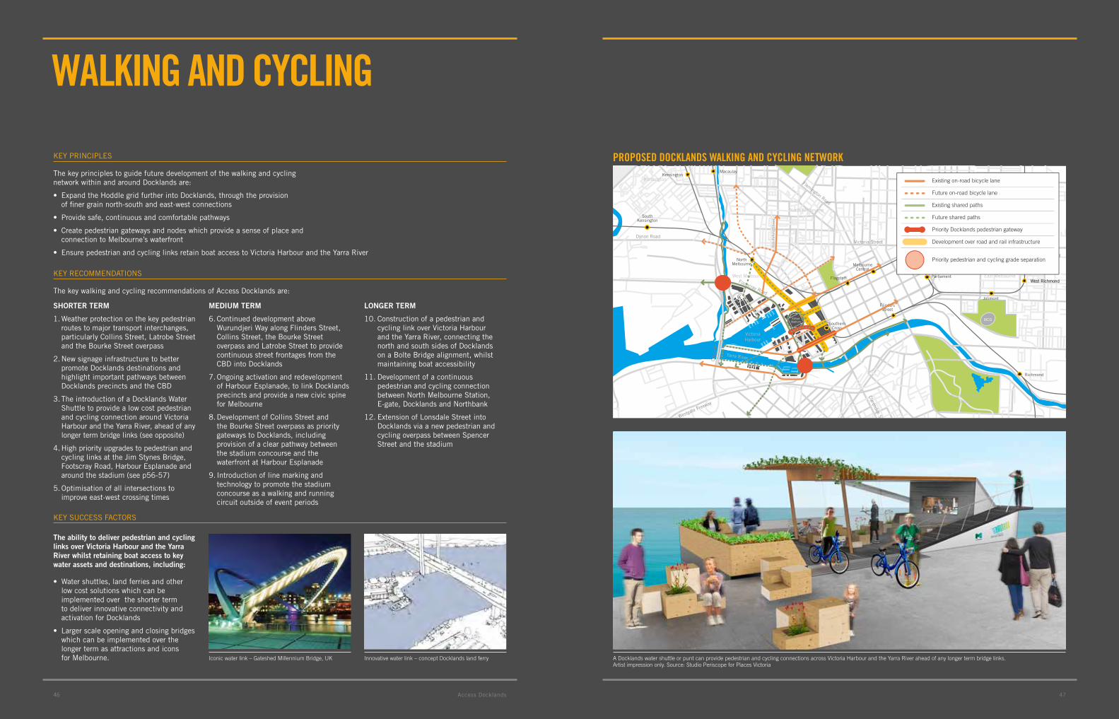
47
WALKiNg AND CyCLiNg
the key principles to guide future development of the walking and cycling network within and around Docklands are:
• ExpandtheHoddlegridfurtherintoDocklands,throughtheprovision of finer grain north-south and east-west connections
• Providesafe,continuousandcomfortablepathways
• Createpedestriangatewaysandnodeswhichprovideasenseofplaceand connection to Melbourne’s waterfront
• EnsurepedestrianandcyclinglinksretainboataccesstoVictoriaHarbourandtheyarraRiver
the key walking and cycling recommendations of access Docklands are:
sHoRTeR TeRm
1. weather protection on the key pedestrian routes to major transport interchanges, particularly collins Street, latrobe Street and the bourke Street overpass
2. new signage infrastructure to better promote Docklands destinations and highlight important pathways between Docklands precincts and the cbD
3. the introduction of a Docklands water Shuttle to provide a low cost pedestrian and cycling connection around Victoria harbour and the Yarra river, ahead of any longer term bridge links (see opposite)
4. high priority upgrades to pedestrian and cycling links at the Jim Stynes bridge, Footscray road, harbour Esplanade and aroundthestadium(seep56-57)
5. optimisation of all intersections to improve east-west crossing times
meDiUm TeRm
6.Continueddevelopmentabovewurundjeri way along Flinders Street, collins Street, the bourke Street overpass and latrobe Street to provide continuous street frontages from the cbD into Docklands
7. ongoing activation and redevelopment of harbour Esplanade, to link Docklands precincts and provide a new civic spine for Melbourne
8. Development of collins Street and the bourke Street overpass as priority gateways to Docklands, including provision of a clear pathway between the stadium concourse and the waterfront at harbour Esplanade
9. Introduction of line marking and technology to promote the stadium concourse as a walking and running circuit outside of event periods
loNGeR TeRm
10. construction of a pedestrian and cycling link over Victoria harbour and the Yarra river, connecting the north and south sides of Docklands on a bolte bridge alignment, whilst maintaining boat accessibility
11. Development of a continuous pedestrian and cycling connection between north Melbourne Station, E-gate, Docklands and northbank
12. Extension of lonsdale Street into Docklands via a new pedestrian and cycling overpass between Spencer Street and the stadium
The ability to deliver pedestrian and cycling links over Victoria Harbour and the yarra River whilst retaining boat access to key water assets and destinations, including:
• Watershuttles,landferriesandotherlow cost solutions which can be implemented over the shorter term to deliver innovative connectivity and activation for Docklands
• Largerscaleopeningandclosingbridgeswhich can be implemented over the longer term as attractions and icons for Melbourne.
KEY PrIncIPlES
KEY rEcoMMEnDatIonS
KEY SUccESS FactorS
35
EtihadStadium
Royal Botanic Garden
Royal Park
Flemington Racecourse
MCG
Footscray Road
Westgate Freeway
CityL
ink
Yarraville
Footscray
Kensington
North MelbourneCollingwood
East Melbourne
SouthMelbourne
West Melbourne
VictoriaHarbour
Yarra River
Albert ParkLake
Port Phillip Bay
St Kilda R
oad
Flemington Road
Dynon Road
Abb
otsf
ord
Str
eet
Clarendon Street
Victoria Street
Carlton Gardens
NorthMelbourne
SouthernCross
Flagstaff
MelbourneCentral
FlindersStreet
Parliament
Jolimont
Kensington
Newmarket FlemingtonBridge
Macaulay
SouthKensington
Footscray
Seddon
West Richmond
North Richmond
Collingwood
West Richmond
Victoria Park
Richmond
SouthYarra
Prahran
Yarraville
Spotswood
0 500 1000 1500m
N
Existing on-road bicycle lane
Future on-road bicycle lane
Existing shared paths
Future shared paths
Priority Docklands pedestrian gateway
Development over road and rail infrastructure
Priority pedestrian and cycling grade separation
Iconic water link – Gateshed Millennium Bridge, UK Innovative water link – concept Docklands land ferry
PrOPOSED DOCKLANDS WALKiNg AND CyCLiNg NEtWOrK
A Docklands water shuttle or punt can provide pedestrian and cycling connections across Victoria Harbour and the Yarra River ahead of any longer term bridge links. Artist impression only. Source: Studio Periscope for Places Victoria
474746 access Docklands

49
PubLiC trANSPOrt
the key principles to guide future development of the public transport network within and around Docklands are:
• Providedirectandintuitiveroutesthatminimisetraveltime
• Createaccessibilityandaddressforcentralcitygrowthareasthrough public transport provision
• Connectpeoplewithimportantemploymentandactivityareas
the key public transport recommendations of access Docklands are:
sHoRTeR TeRm
1. Extend the collins Street tram service to Dock Square, Victoria harbour
2. high capacity peak hour public transport services between Southern cross Station and Victoria harbour (collins Street alignment)
3. Develop a Docklands travel application which provides real time information on Docklands public transport services, car parking availability, events and key destinations
4. Ensure Docklands public transport options are highlighted in all marketing and promotional campaigns
meDiUm TeRm
4. new tram connection between north Melbourne Station, E-gate, Docklands and the cbD, to position north Melbourne Station as a public transport interchange for Docklands
5. Provision of a Yarra river Ferry Service with the following key attributes:
•Purposedesignedlowwake, low height vessel which fulfils Yarra river functionality requirements (see concept design opposite)
•FullintegrationwithMelbourne’swiderpublic transport ticketing system
•Ferryarrivalsanddeparturesevery 30 minutes minimum, to provide an ‘eye-ball’ timetable; and
•Arrivalanddeparturepointsatkey tourism destinations including Melbourne Park, Federation Square, crown casino, Southbank, world trade centre, bourke Dock (Docklands) and waterfront city (Docklands)
loNGeR TeRm
6. Highcapacitypeakhourpublictransport services between Flagstaff Station and Docklands north (latrobe Street to Docklands Drive)
7. new light rail connection between Footscray and the cbD, following a Dynon road to Victoria Street alignment to directly connect Footscray into Melbourne’s north-south tram network
8. new light rail connection between the cbD, Docklands and the Fishermans bend urban growth area, following a collins Street alignment to directly extend collins Street into Fishermans bend via an iconic Yarra river crossing and green transport link
9. Potential ferry service bringing commuters from the western suburbs into Docklands and the cbD
10. Investigate the potential to open Flagstaff Station on the weekends, to improve public transport services to key visitor and tourist attractions as Docklands approaches completion
The ability to deliver innovative, cost effective public transport systems in the short term:
• Shortertermecobusesandshuttleswhichare well designed, innovatively branded and can potentially operate in tram reserves
• Longertermlightraillinkswhichcatalyseand add amenity to new development at Docklands, arden Macaulay, E-gate and Fishermans bend.
KEY PrIncIPlES
KEY rEcoMMEnDatIonS
KEY SUccESS FactorS
Concept Yarra River ferry (see key recommendation 5)
DOCKLANDS PubLiC trANSPOrt NEtWOrK
2012 Melbourne tram Transalon concept eco bus by Xiao-Fang Shen, China
35
EtihadStadium
Royal Botanic Garden
Royal Park
Flemington Racecourse
MCG
Footscray Road
Westgate Freeway
CityL
ink
Yarraville
Footscray
Kensington
North MelbourneCollingwood
East Melbourne
SouthMelbourne
West Melbourne
VictoriaHarbour
Yarra River
Albert ParkLake
Port Phillip Bay
St Kilda R
oad
Flemington Road
Dynon Road
Abb
otsf
ord
Str
eet
Clarendon Street
Victoria Street
Carlton Gardens
NorthMelbourne
SouthernCross
Flagstaff
MelbourneCentral
FlindersStreet
Parliament
Jolimont
Kensington
Newmarket FlemingtonBridge
Macaulay
SouthKensington
Footscray
Seddon
West Richmond
North Richmond
Collingwood
West Richmond
Victoria Park
Richmond
SouthYarra
Prahran
Yarraville
Spotswood
0 500 1000 1500m
N
Future interchange
Yarra River ferry investigation corridor options
Commuter ferry investigation corridor
Existing tram services
Existing bus services
Tram / Lightrail investigation corridor
494948 access Docklands
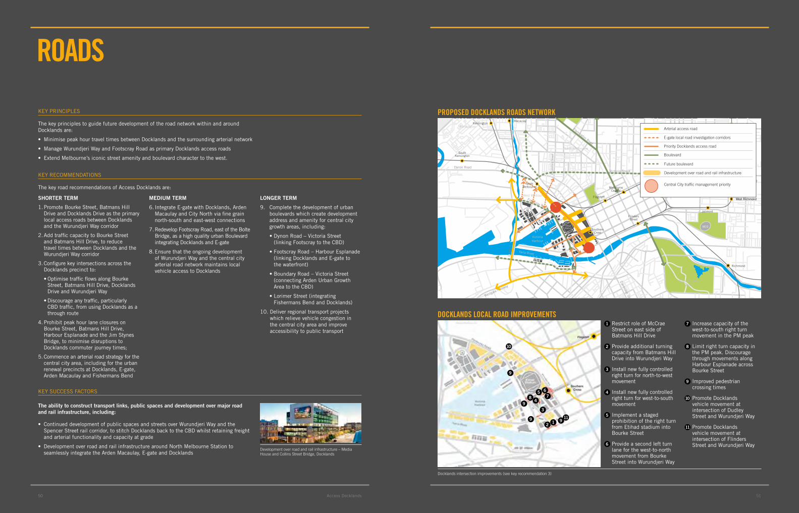
51
rOADS
the key principles to guide future development of the road network within and around Docklands are:
• MinimisepeakhourtraveltimesbetweenDocklandsandthesurroundingarterialnetwork
• ManageWurundjeriWayandFootscrayRoadasprimaryDocklandsaccessroads
• ExtendMelbourne’siconicstreetamenityandboulevardcharactertothewest.
the key road recommendations of access Docklands are:
sHoRTeR TeRm
1. Promote bourke Street, batmans hill Drive and Docklands Drive as the primary local access roads between Docklands and the wurundjeri way corridor
2. add traffic capacity to bourke Street and batmans hill Drive, to reduce travel times between Docklands and the wurundjeri way corridor
3. configure key intersections across the Docklands precinct to:
•OptimisetrafficflowsalongBourkeStreet, batmans hill Drive, Docklands Drive and wurundjeri way
•Discourageanytraffic,particularlycbD traffic, from using Docklands as a through route
4. Prohibit peak hour lane closures on bourke Street, batmans hill Drive, harbour Esplanade and the Jim Stynes bridge, to minimise disruptions to Docklands commuter journey times;
5. commence an arterial road strategy for the central city area, including for the urban renewal precincts at Docklands, E-gate, arden Macaulay and Fishermans bend
meDiUm TeRm
6.IntegrateE-gatewithDocklands,ArdenMacaulay and city north via fine grain north-south and east-west connections
7. redevelop Footscray road, east of the bolte bridge, as a high quality urban boulevard integrating Docklands and E-gate
8. Ensure that the ongoing development of wurundjeri way and the central city arterial road network maintains local vehicle access to Docklands
loNGeR TeRm
9. complete the development of urban boulevards which create development address and amenity for central city growth areas, including:
•DynonRoad–VictoriaStreet (linking Footscray to the cbD)
•FootscrayRoad–HarbourEsplanade(linking Docklands and E-gate to the waterfront)
•BoundaryRoad–VictoriaStreet(connectingArdenUrbanGrowtharea to the cbD)
•LorimerStreet(integratingFishermans bend and Docklands)
10. Deliver regional transport projects which relieve vehicle congestion in the central city area and improve accessibility to public transport
KEY PrIncIPlES
KEY rEcoMMEnDatIonS
Docklands intersection improvements (see key recommendation 3)
PrOPOSED DOCKLANDS rOADS NEtWOrK
DOCKLANDS LOCAL rOAD imPrOvEmENtS
Development over road and rail infrastructure – Media House and Collins Street Bridge, Docklands
35
EtihadStadium
Royal Botanic Garden
Royal Park
Flemington Racecourse
MCG
Footscray Road
Westgate Freeway
CityL
ink
Yarraville
Footscray
Kensington
North MelbourneCollingwood
East Melbourne
SouthMelbourne
West Melbourne
VictoriaHarbour
Yarra River
Albert ParkLake
Port Phillip Bay
St Kilda R
oad
Flemington Road
Dynon Road
Abb
otsf
ord
Str
eet
Clarendon StreetVictoria Street
Carlton Gardens
0 500 1000 1500m
N
NorthMelbourne
SouthernCross
Flagstaff
MelbourneCentral
FlindersStreet
Parliament
Jolimont
Kensington
Newmarket FlemingtonBridge
Macaulay
SouthKensington
Footscray
Seddon
West Richmond
North Richmond
Collingwood
West Richmond
Victoria Park
Richmond
SouthYarra
Prahran
Yarraville
Spotswood
Development over road and rail infrastructure
Priority Docklands access road
Future boulevard
Central City traffic management priority
E-gate local road investigation corridors
12
3
4
5 678
9
9
9 9
1 restrict role of Mccrae Street on east side of batmans hill Drive
2 Provide additional turning capacity from batmans hill Drive into wurundjeri way
3 Install new fully controlled right turn for north-to-west movement
4 Install new fully controlled right turn for west-to-south movement
5 Implement a staged prohibition of the right turn from Etihad stadium into bourke Street
6 Provide a second left turn lane for the west-to-north movement from bourke Street into wurundjeri way
7 Increase capacity of the west-to-south right turn movement in the PM peak
8 limit right turn capacity in the PM peak. Discourage through movements along harbour Esplanade across bourke Street
9 Improved pedestrian crossing times
Promote Docklands vehicle movement at intersection of Dudley Street and wurundjeri way
Promote Docklands vehicle movement at intersection of Flinders Street and wurundjeri way
The ability to construct transport links, public spaces and development over major road and rail infrastructure, including:
• ContinueddevelopmentofpublicspacesandstreetsoverWurundjeriWayandtheSpencer Street rail corridor, to stitch Docklands back to the cbD whilst retaining freight and arterial functionality and capacity at grade
• DevelopmentoverroadandrailinfrastructurearoundNorthMelbourneStationtoseamlessly integrate the arden Macaulay, E-gate and Docklands
KEY SUccESS FactorS
515150 access Docklands

PrOgrAmS AND POLiCiES
the key principles to guide the development of transport policies and programs for Docklands are:
• Fostersustainabletravelbehaviour
• Deliverbenefitsforworkers,residentsandvisitors
• Poolresourcesandworktogether.
the key program and policy recommendations of access Docklands are:
sHoRTeR TeRm
1. Establish and fund a joint Docklands travel Management association representing Docklands employers, residents and government agencies, to pool resources and deliver innovative travel programs and transport initiatives at Docklands
2. Develop a digital Docklands travel application which provides real time information on Docklands public transport services, car parking availability, destinations events and attractions
3. Develop a Stadium Event Plan which promotes Docklands visitor attractions to event patrons and spreads peak demand on the transport network during events
4. Establish a shared electric vehicle trial in Docklands to further promote the precinct as a demonstration of sustainable transport outcomes
5. amend car parking provision rates in Docklands to align with broader cbD rates
6.Completeroadandpublictransportstrategies for the central city area, including the E-gate and Fishermans bend urban renewal precincts
meDiUm TeRm
7. Implement land use policy which spatially consolidates housing, employment and activity areas, to minimise travel times and vehicle dependence
8. review access Docklands every five years, with a specific focus on whether the strategy is achieving the travel behaviour targets which have been established for Docklands
KEY PrIncIPlES
KEY rEcoMMEnDatIonS
At a basic level, TmAs are simply an organisational framework. They provide a platform for businesses and governments to work together in a collaborative effort to improve transport conditions in a defined geographic area.
tMas bring together a variety of interested stakeholders, and provide a central coordinating entity to facilitate and implement programs outlined by the group.
broadly, tMas share the following characteristics:
• Theyprovideanorganisationalframeworkforaddressing transport issues
• Theyidentifythespecifictransport-relatedchallenges impacting their area, and develop tailored solutions uniquely suited to that area
• Theyfocusontransportissues,primarilyutilisingtransport “management” strategies, potentially encompassing both demand-side and supply-side management strategies
• Theyservewell-knownanddistinctgeographicareas,such as a central business district (cbD), activity centre, business park, or major transport corridor
• Theyareoftenaformal,legallyconstitutedorganisation
• Theyareledbytheprivatesectorwhichcaninclude major employers, business association representatives, property developers, retail centre/district representatives, institutional leaders (ie, schools, hospitals), privately-owned public transport operators, business park managers, and others
• Theyareacollaborativepartnershipbetweenbusinessesand relevant public-sector transport agencies (transport planners and engineers, tDM planners, public transport providers, land planners, etc.)
• Theyexisttosolvetransportproblems.
tMas are not, in and of themselves, a strategy to improve access to and within a particular area, but instead simply represent the most efficient organisational framework for collaborative development and implementation of strategies to improve transport problems. the strength of the tMa as an organisational concept lies in the synergy between multiple organisations and individuals. together, they often have a greater chance of addressing difficult transport challenges than any one government agency, employer, developer, or individual traveller could accomplish alone.
In addition, the local geographic knowledge of the key stakeholders of a tMa, and their commitment to the process, helps ensure that any transport strategies developed through the tMa have a greater chance of success than those developed by an external stakeholder less familiar with local conditions and priorities.
the motivation for business involvement in tMas stems from the impact that transport problems have on business (congestion-related travel delays, employee or shopper access issues, parking shortages, etc.), and from the beneficial impact that business decisions can have on the transport system.
Every tMa focuses on the issues most relevant to their local context. tMas are not typically constrained by political boundaries, which sometimes are not contiguous with activity centres, corridors, or other areas with transport issues or travel patterns in common.
Importantly, tMas are not designed to replace or replicate services provided by government. Instead, tMas seek to foster innovative new programs, enhanced coordination, and provide unique and valuable services to area organisations and area travellers.
Examples of innovative transport applications which could be developed by a Travel Management Association:
1) SF Park, by the San Francisco Municipal Transportation Agency, which provides real time car parking information to San Francisco drivers; and
2) Lets Go Together, by Access Melbourne, which allows users to post and accept car pooling opportunities.
Source: San Francisco Municipal Transportation Agency, Access Melbourne, Apple iTunes Store, 2012
There is an opportunity to enhance Docklands social and economic vitality by promoting Docklands events and attractions to stadium patrons
WHAt iS A trAvEL mANAgEmENt ASSOCiAtiON?
52 access Docklands 53

AS DOCKLANDS mOvES tHrOugH itS SECOND DECADE OF DEvELOPmENt, tHE PrECiNCt iS grOWiNg iNtO A NAtiONALLy SigNiFiCANt EmPLOymENt AND rESiDENtiAL Hub AND AN iNtEgrAL PArt OF tHE mELbOurNE CbD.

Delivery of transport policies and infrastructure at Docklands occurs under a whole of government partnership between the city of melbourne, Department of Transport, public Transport Victoria, VicRoads and places Victoria.
other key stakeholders involved in transport at Docklands include bicycle network Victoria, the Department of Planning and community Development and various community organisations.
Specific delivery responsibilities include:
• Localroadmanagement–CityofMelbourne;
• Arterialroadmanagement–VicRoads;
• Publictransportprovision–DepartmentofTransportand Public transport Victoria;
• Facilitationandcoordination–PlacesVictoria;and
• Publicrealmdesignanddevelopment,includingwalkingandcycling networks – city of Melbourne and Places Victoria.
the local road, public realm, walking and cycling recommendations established by access Docklands will be taken forward for delivery by Places Victoria and the city of Melbourne. Projects will be funded via budget allocations and development contributions over the short, medium and longer term.
Places Victoria and the city of Melbourne will work with the Department of transport, Public transport Victoria and Vicroads to ensure that recommendations relating to public transport and arterial roads are taken forward for further development and consideration by those agencies, particularly through relevant transport planning for the central city area and designated specific urban renewal precincts. In general, arterial road and public transport projects to service central city growth areas will be articulated in the relevant precinct Structure Plans, and funded by a mix of development contributions, negotiated agreements and government budget allocations.
imPLEmENtAtiON
Artistic impression – Jim Stynes Bridge (subject to change). Source: Aurecon Group / Cox Architects / Oculus Landscape Architects for the Department of Planning and Community Development. Artistic impression – Capital City Trail Footscray Road underpass (subject to change). Source: Hyder Consulting for Places Victoria.
35
EtihadStadium
Royal Botanic Garden
Royal Park
Flemington Racecourse
MCG
Footscray Road
Westgate Freeway
CityL
ink
Yarraville
Footscray
Kensington
North MelbourneCollingwood
East Melbourne
SouthMelbourne
West Melbourne
VictoriaHarbour
Yarra River
Albert ParkLake
Port Phillip Bay
St Kilda R
oad
Flemington Road
Dynon Road
Abb
otsf
ord
Str
eet
Clarendon Street
Victoria Street
Carlton Gardens
NorthMelbourne
SouthernCross
Flagstaff
MelbourneCentral
FlindersStreet
Parliament
Jolimont
Kensington
Newmarket FlemingtonBridge
Macaulay
SouthKensington
Footscray
Seddon
West Richmond
North Richmond
Collingwood
West Richmond
Victoria Park
Richmond
SouthYarra
Prahran
Yarraville
Spotswood
0 500 1000 1500m
N
POtENtiAL DOCKLANDS PEDEStriAN AND CyCLiSt WAtEr SHuttLE CirCuit
35
EtihadStadium
Royal Botanic Garden
Royal Park
Flemington Racecourse
MCG
Footscray Road
Westgate Freeway
CityL
ink
Yarraville
Footscray
Kensington
North MelbourneCollingwood
East Melbourne
SouthMelbourne
West Melbourne
VictoriaHarbour
Yarra River
Albert ParkLake
Port Phillip Bay
St Kilda R
oad
Flemington Road
Dynon Road
Abb
otsf
ord
Str
eet
Clarendon Street
Victoria Street
Carlton Gardens
0 500 1000 1500m
N
NorthMelbourne
SouthernCross
Flagstaff
MelbourneCentral
FlindersStreet
Parliament
Jolimont
Kensington
Newmarket FlemingtonBridge
Macaulay
SouthKensington
Footscray
Seddon
West Richmond
North Richmond
Collingwood
West Richmond
Victoria Park
Richmond
SouthYarra
Prahran
Yarraville
Spotswood
12
34
5
6
78
9
Docklands water shuttle circuit
Collins Landing
Point Park
Bourke Dock
Yarra’s Edge West
Sir John Coode Park
Western Park
Waterfront City Marina
Dock Square
1
2
3
4
5
6
7
8
5756 Access Docklands