Transport Strategy Report
151
Transport Strategy Report Georges River Transport Strategy 27 October 2021 Cardno i Transport Strategy Report Georges River Transport Strategy 80020042 Prepared for Georges River Council 27 October 2021
Transcript of Transport Strategy Report

Transport Strategy Report Georges River Transport Strategy
27 October 2021 Cardno i
Transport Strategy Report
Georges River Transport Strategy
80020042
Prepared for
Georges River Council
27 October 2021

Transport Strategy Report Georges River Transport Strategy
© Cardno. Copyright in the whole and every part of this document belongs to Cardno and may not be used, sold, transferred, copied or reproduced in whole or in part in any manner or form or in or on any media to any person other than by agreement with Cardno.
This document is produced by Cardno solely for the benefit and use by the client in accordance with the terms of the engagement. Cardno does not and shall not assume any responsibility or liability whatsoever to any third party arising out of any use or reliance by any third party on the content of this document.
Our report is based on information made available by the client. The validity and comprehensiveness of supplied information has not been independently verified and, for the purposes of this report, it is assumed that the information provided to Cardno is both complete and accurate. Whilst, to the best of our knowledge, the information contained in this report is accurate at the date of issue, changes may occur to the site conditions, the site context or the applicable planning framework. This report should not be used after any such changes without consulting the provider of the report or a suitably qualified person.
80020042 | 27 October 2021 ii
Contact Information Document Information
Cardno (NSW/ACT) Pty Ltd
ABN 95 001 145 035
Level 9 - The Forum
203 Pacific Highway
St Leonards NSW 2065
PO Box 19
www.cardno.com
Phone +61 2 9496 7700
Fax +61 2 9439 5170
Prepared for Georges River Council
Project Name Georges River Transport
Strategy
File Reference 20210910 FINAL GR
Transport Strategy Report
with track changes.docx
Job Reference 80020042
Date 27 October 2021
Version Number 10
Document History
Version Effective Date Description of Revision Prepared by Reviewed by
1 14/02/2020 Working Draft
Rusiru Wanasinghe
Elizabeth Muscat
Lukas Labutis
Larissa Miller
Chris Slenders
2 22/09/2020 Working Draft 02 Shobhan Baranwal
Elizabeth Muscat Chris Slenders
3 12/03/2021 Working Draft 03 (Strategic Context relocated in separate report)
Elizabeth Muscat
May Chew Chris Slenders
4 01/04/2021 Draft with executive summary update. Elizabeth Muscat Chris Slenders
5 26/04/2021 Draft 2 – minor amendments and revised centres actions
Elizabeth Muscat Chris Slenders
6 30/04/2021 Draft 3 – minor amendments for public exhibition
Chris Slenders Chris Slenders
7 03/05/2021 Draft 4 – minor text updates Chris Slenders Chris Slenders
8 07/06/2021 Draft 4 – amendments to action wording Chris Slenders Chris Slenders
9 25/06/2021 Draft 5 – amendments to action May Chew Chris Slenders
10 21/09/2021 Final - following public consultation Elizabeth Muscat Chris Slenders
11 26/10/2021 Final – following adoption on
25/10/2021 Elizabeth Muscat Chris Slenders

Transport Strategy Report Georges River Transport Strategy
80020042 | 27 October 2021| 1
Acronyms and terms
Term Description
AADT Annual average daily traffic
ABS Australian Bureau of Statistics
ADT Average daily traffic
ALOS Average length of stay
CBD Central Business District
Council Georges River Council
CPTED Crime prevention through environmental design
CSP Community Strategic Plan
DA Development Application
DCP Development Control Plan
DDA Disability Discrimination Act 1992
DPIE Department of Planning, Industry and Environment
ERP Estimated residential population
FT56 Future Transport 2056
GMA Greater Metropolitan Area
GPS Global Positioning System
GRC Georges River Council
GSC Greater Sydney Commission
GSRP Greater Sydney Region Plan
GTFS General Transit Feed Specification
HIA Housing Investigation Area
HTS Household Travel Survey
INSW Infrastructure New South Wales
JTW Journey to Work
LEP Local Environmental Plan
LGA Local Government Area, the physical geography
LSPS Local Strategic Planning Statement
MaaS Mobility as a Service
PAMP Pedestrian Access and Mobility Plan
RMS Roads and Maritime Services
RNP Road Network Plan
RSL Returned and Services League
SA1 Statistical Area 1
SA2 Statistical Area 2
TAP Transport Access Program
TfNSW Transport for New South Wales
TIA Traffic Impact Assessment
TMAP Transport Management and Accessibility Plan

Transport Strategy Report Georges River Transport Strategy
80020042 | 27 October 2021| 2
Executive summary
Purpose
The Georges River Transport Strategy (the Transport Strategy) provides policy and directives for Georges River Council to enhance existing transport network and plan for increased demand. The Transport Strategy aligns with existing state and local strategies and plans.
The Transport Strategy consists of two reports, the Strategic Context Report and the Transport Strategy Report. The Strategic Context Report outlines the existing demography, travel demand and behaviour, land use and provides a basis for the strategies and actions for future transport networks and services in the Georges River LGA contained in the Transport Strategy Report.
The recommendations are developed through consultation with the community and other stakeholders.
Aims of the Transport Strategy
> Integrating transport planning and land-use planning;
> Identification of transport vision and objectives in alignment with state, regional and local planning;
> Addressing the challenges of the existing transport network within Georges River LGA in the context of Sydney;
> Addressing the growth and the needs of community, businesses and visitors;
> Informing and supporting the Council’s strategic plans; and
> Identification of actions for improvement of infrastructure, services, policy and behaviour.
Study area
The Transport Strategy includes the entire Georges River LGA, shown below, while considering existing and planned land uses and transport projects with the broader region.
Study area

Transport Strategy Report Georges River Transport Strategy
80020042 | 27 October 2021| 3
Strategic Context
The Transport Strategy was developed in alignment with the various State and Local Government strategies and plans. These include but are not limited to:
> Land use:
- Georges River Local Strategic Planning Statement 2040
- Draft Georges River Local Environmental Plan (GRLEP 2020);
- Beverly Hills Masterplan; and
- Mortdale Local Centre Masterplan.
> Transport:
- Future Transport Strategy 2056 (FT56);
- Georges River Car Parking Strategy and Position Paper; and
- Hurstville City Centre Transport Management and Accessibility Plan.
Major planned land use
Key planned land use changes that will affect Georges River include:
> The Hurstville Revitalisation Project
> The Kogarah Collaboration Area;
> Riverwood Estate and Riverwood Planning Precinct;
> Penshurst Park Sporting Hub;
> Green Grid Priority Corridor Salt Pan Creek; and
> Georges River Parklands.
The Transport Strategy considers the existing and planned land uses and proposes integrated strategies to create high functioning places.
Existing and future transport network
The current networks, travel demand and behaviours were analysed to pin point gaps in the existing transport networks and inform future transport networks and strategies. This includes the road network, pedestrian and cycling network, public transport network, the freight network and parking.
Future projects will also shape the transport network. The Stage 1 M6 extension is set to open in 2025 and will reduce traffic congestion, particularly along Princes Highway. In future stages, through traffic can potentially bypass Georges River LGA.

Transport Strategy Report Georges River Transport Strategy
80020042 | 27 October 2021| 4
SWOT
The strengths, weaknesses, opportunities and threats that inform the vision and objectives for Georges River LGA are summarised as below.
Strengths, Opportunities, Weaknesses, Threats
Strengths
▪ Central location within the Eastern Harbour City, with close proximity to Sydney Airport, Sydney CBD and Port Botany.
▪ Most residents are within 30 minute public transport catchments of strategic centres.
▪ High local employment and knowledge based jobs.
▪ Strong health and education workforce.
▪ Centres offer a mix of cultural, retail, entertainment and community facilities.
▪ Regionally attractive land uses including health, education and retail.
▪ Access to two railway lines.
▪ M5 motorway/ Princes Highway.
Weaknesses
▪ Limited connected cycleways.
▪ Some peak public transport services are at capacity.
▪ Limited express public transport services.
▪ Timetabling of public transport outside of weekday commuter AM and PM peak periods.
▪ Bus connectivity to rail and locations away from the rail network.
▪ Limited urban tree canopy cover.
▪ Traffic congestion on major roads and in centres impeding access.
▪ Challenging connections to Parramatta and other economic centres.
▪ Transport corridors such as train lines are physical barriers to connectivity.
▪ Limited night-time economy.
▪ Pressure on and deficiency of open spaces.
▪ Bus reliability is affected by low travel speeds due to congestion.
▪ High density of car parking causing congestion in some centres.
▪ Existing crash clusters, especially those involving pedestrians and cyclists.
Opportunities
▪ Proposed major transport infrastructure projects from the NSW State Government linking to Parramatta, Macquarie Park, Randwick and Miranda.
▪ Revitalisation of Riverwood to provide an opportunity for a transport interchange to link the T4 and T8 rail lines and other growth precincts in the LGA.
▪ Principal Bicycle Network and the Sydney Green Grid.
▪ Pedestrianisation to support revitalisation.
▪ On demand public transport to improve the public transport catchment.
▪ Update of existing planning and parking controls.
▪ Low average trip distance for private vehicle trips.
▪ Work with health and education industry partners to encourage the use of active and public transport to access work.
▪ Autonomous vehicles and other emerging technologies to improve transport options and sustainability.
▪ Align speed limits with surrounding land uses.
Threats
▪ Growing population.
▪ Housing affordability is decreasing.
▪ Large amount of low density housing.
▪ Transport accounts for a large percentage of greenhouse gas emissions.
▪ Continued reliance on private vehicles.
▪ Older council assets nearing the end of the life cycle.
▪ Potential for increased local traffic congestion after completion of M6 Extension.
▪ Development in Kogarah North, Rockdale and other centres will put pressure on existing infrastructure and transport networks in Georges River.

Transport Strategy Report Georges River Transport Strategy
80020042 | 27 October 2021| 5
Vision, themes and objectives
The transport vision, themes and objectives guide the recommendations of the Transport Strategy.
Vision
Georges River Council has a sustainable transport network that safely connects people to jobs, services and great places.
Theme 1: Sustainability
▪ Reduced reliance on private vehicles and shift towards sustainable modes of transport.
▪ Land use development is supported by transport improvements.
▪ Parking serves its intended purpose.
▪ The transport network is resilient to climate change and is less affected by natural events.
▪ Preparedness for emerging technology
Theme 2: Safety
▪ Roads, footpaths and cycleways are safe.
▪ Crashes do not result in death or injury.
▪ NSW Government Towards Zero vision is achieved.
▪ Safe system aligned infrastructure is provided.
Theme 3: Connectivity
▪ Georges River has a range of frequent, efficient transport options to connect people and places.
Theme 4: Access to jobs, services and places
▪ Inclusive access to jobs, services, social, recreational and cultural opportunities
▪ Local deliveries and regional freight movements are supported.
▪ Georges River to lead through planning, collaboration and investment programs to support growth and its place in Greater Sydney.
Strategies
The Transport Strategy includes the following strategies:
Report Section Strategy
5.2 Integrated land use, transport planning and travel demand management strategy
5.3 Active transport strategy
5.4 Public transport strategy
5.5 Road network and freight strategy
5.6 Enhancement recommendations for Council’s Car Parking Strategy and Position Paper
5.7 Centres transport strategy
These strategies and the associated actions outlined in the following pages will help Georges River achieve its transport vision and objectives.
Actions
Through consultation, land use and transport analytics, a range of transport actions have been developed to improve the network for Georges River’s current and future residents, workers and visitors. The actions are summarised following from the strategy maps.

Transport Strategy Report Georges River Transport Strategy
80020042 | 27 October 2021| 6
Strategic pedestrian network
Transport Strategy Report Georges River Transport Strategy
80020042 | 27 October 2021| 7
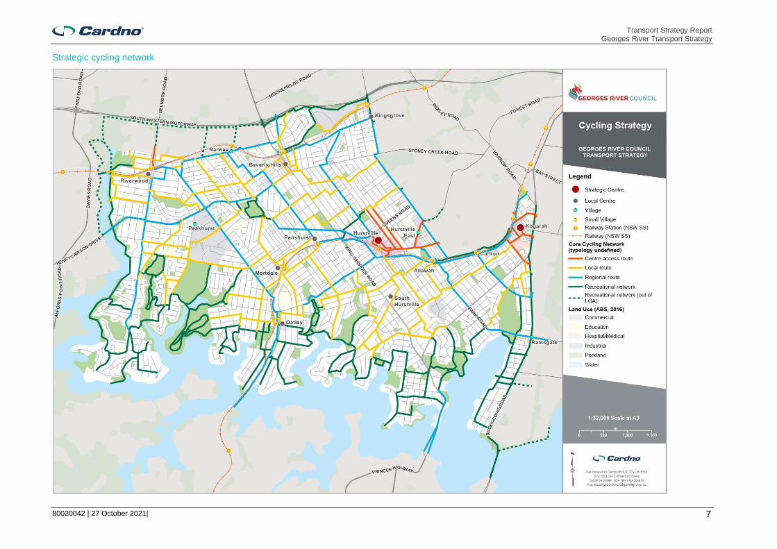
Strategic cycling network

Transport Strategy Report Georges River Transport Strategy
80020042 | 27 October 2021| 8
Strategic active transport network infrastructure improvements

Transport Strategy Report Georges River Transport Strategy
80020042 | 27 October 2021| 9
Strategic public transport network

Transport Strategy Report Georges River Transport Strategy
80020042 | 27 October 2021| 10
Strategic ferry route (for investigation of feasibility)

Transport Strategy Report Georges River Transport Strategy
80020042 | 27 October 2021| 11
Strategic road network

Transport Strategy Report Georges River Transport Strategy
80020042 | 27 October 2021| 12
Centres strategy

Transport Strategy Report Georges River Transport Strategy
80020042 | 27 October 2021| 13
Land use
LU1 Plan for higher land use densities around public transport interchanges.
LU2
In masterplanning of its centres, Council consider the actions of the Transport Strategy and work with TfNSW to identify future mass transit station locations and to ensure that land around stations is retained for transport related development.
LU3 Undertake masterplanning for all key centres referencing the transport
vision, objectives and actions of the Transport Strategy.
LU4 Prioritise new residential and commercial development with appropriate buffers from existing and any proposed freight corridors and industrial land uses to protect them. (Connected to Fr1).
LU5
Develop an internal GIS map-based portal for Council staff to provide oversight of integrated planning and capital works, infrastructure and asset management systems; that is regularly updated as decisions are made and links to relevant planning frameworks.
LU6 Review transport infrastructure funding opportunities for non-residential development.
Travel demand management
TDM1
Mandate Travel Plans for major employers in Georges River such as
hospitals, education campuses and Council so as to identify and communicate sustainable travel choices for staff.
TDM2 Develop a Car Share Policy that supports the uptake of car share in Georges River LGA.
Sustainable transport
STI Support, encourage and develop sustainable transport initiatives that reduce reliance on private vehicles, e.g. Mobility as a Service (MaaS) system, electric buses.
Active transport
AT1 Work with TfNSW to provide Sydney Green Grid links through Georges River which link into neighbouring local government areas.
AT2
Review street trees and canopy cover to improve shade and reduce the urban heat island effect. (This includes supporting/ improving the Green Grid and linking transport to centres, schools and open space).
Additional plantings should not interfere with sight lines or contribute to footpath clutter.
AT3 Prioritise footpath, shared path and cycleway upgrades in the 800 metre catchment of schools.
AT4
Implement the strategic walking, cycling and public transport networks to improve public transport and improve pedestrian and cycling facilities within Georges River and along Southern Sydney Corridor, including
connection between the T4 and T8 train lines.
AT5 Advocate for the completion of the Illawarra Rail Line corridor active transport route.
Pedestrian
Ped1 Adopt consistent footpath standards for Georges River, specifically adopting wider footpaths along higher demand areas/ routes within
centres to support walking, cycling and accessibility.
Ped2 Adopt a policy of a footpath on at least one side of the road where pedestrian movements are permitted.
Ped3 Implement the strategic pedestrian network that will provide a fully connected and accessible pedestrian network throughout Georges
River.
Ped4 Provide separation/ space/ landscaped buffer between footpaths and vehicle travel lanes along freight routes using on-street parking or
landscaping and/ or investigate opportunities for speed limit reductions.
Ped5 Investigate locations for potential pedestrian priority treatments, including High Pedestrian Activity Areas, Shared Zones and 40 km/h or
lower speed limit zones.
Ped6 Identify opportunities for redevelopment sites to provide through site links and adequate pedestrian space on footpaths and for waiting at intersections.
Ped7 Develop and implement a consistent wayfinding program for strategic centres in Georges River.
Pedestrian crossings
PX1
Prioritise additional pedestrian crossings along arterial roads with lengths of 450 metres or greater without a crossing, 200 metres in residential/ industrial areas, and every 100 metres in centres (off state
roads) where desire lines exist.
PX2
Identify intersections where additional pedestrian crossing legs could be provided subject to the location having a pedestrian desire line.
Advocate to TfNSW for upgrades.
PX3 Investigate the feasibility of active pedestrian detection technology at signalised intersections to adjust pedestrian crossing times in real-time
(shorter or longer) based on customer needs.
PX4
Advocate for pedestrian head start crossing movement at all signalised intersections and the removal of green light vehicle turning movements
when pedestrians have green crossing light.
Bike
Bk1 Implement the strategic bicycle network for a safe, connected network throughout Georges River integrating with neighbouring local
government areas and regional links.
Bk2 Collaborate with TfNSW to develop and implement the Principal Bicycle
Network links within Georges River.
Bk3 Advocate to TfNSW for additional cycle parking (including rails and bike
sheds) at train stations, particularly at Kogarah and Hurstville stations.
Bk4
Provide bicycle parking in the public domain at all centres. Target at least 5% of the quantum of Council on and off-street parking located at car parks and/ or distributed around centres, i.e. integrated with sign poles and/ or bicycle parking areas in off-street car parks located in a
conspicuous location.
Bk5
New business/ commercial/ industrial developments to provide 5% bike parking based on the total number of car parking spaces provided. Developments should have 1 change room and shower facilities per 10
spaces with a minimum of 1.
Bk6 New residential development should have at least 1 secure multi-purpose space that can function as bike parking per dwelling and at
least 5% visitor bicycle parking provided in a conspicuous location.
Public transport
PT1
Work with TfNSW to deliver Future Transport Strategy 2056 with
consideration of Georges River local transport needs, including:
> 2056 indicative future rail network; and
> 2036 rapid bus lines.
PT2
Advocate to TfNSW to improve the connectivity and frequency of bus and rail services to, from and within Georges River, particularly in areas of Georges River that do not have 30-minute access to a strategic
centre.
PT3
Work with TfNSW to provide full Disability Discrimination Act compliant accessibility for public transport; particularly buses, for people with mobility challenges. Extend this to providing infographics for people with
linguistic challenges.
PT4 Investigate where more accessible car parking spaces at public
transport interchanges should be provided.
PT5 Advocate to TfNSW for first and last mile on-demand transport services
where patronage levels do not justify a timetabled service provision.
PT6 Improve public transport interchanges within the existing network to improve safety and accessibility for all users. This is to consider
reduction in speed limits in interchange areas.
Rail
Rail 1 Support TfNSW to improve rail services and infrastructure. i.e. More trains more services and Future Transport Strategy 2056 initiatives like Parramatta to Kogarah and Hurstville to Macquarie Park.
Bus
Bu1 Work with TfNSW to improve the existing bus network to rationalise
routes and improve service quality and frequency on existing routes.
Bu2 Support TfNSW in the implementation of Future Transport Strategy 2056 including reviewing and investigating bus routes with the view to
improve connectivity, efficiency and accessibility.
Bu3
Advocate for and provide input to the NSW Government's proposed strategic bus network, including dedicated bus priority infrastructure for
improved efficiency and reliability. (Concept network arrangement in this
strategy)
Bu4 Support TfNSW to implement bus priority infrastructure such as bus
jump start lanes along key bus routes.
Bu5 Advocate to TfNSW for bus performance studies on key routes to
identify priority measures in areas of congestion.
Bu6 Advocate for increased public transport capacity on routes and in
periods of high demand, e.g. Queens Road.
Bu7 Advocate for improved public transport accessibility, e.g., services later
at night, and/ or on-demand buses to support localities with low demand.
Bu8
Investigate the need for any additional community bus services within Georges River, including inclusive access - this should focus on larger
buses to accommodate bigger groups to reduce costs.
Bus stop
BS1 Undertake Disability Discrimination Act compliance audit of relevant bus stops, and prioritise upgrades based on patronage, community
consultation and access to nearby destinations.
BS2 Improve accessible footpath connections at bus stops within Georges
River.
BS3
Investigate funding opportunities (TfNSW and third party providers) for new Disability Discrimination Act compliant bus shelters, including tendering to outdoor advertising companies while retaining functionality
for buses, safety, and customer experience.
BS4 Advocate for real time information displays at key bus stops. I.e.
Hurstville and Kogarah.
Ferry/ boat
Fy1 Investigate the feasibility of a Georges River ferry route or scenic/ recreational tour route; utilising Georges River for water-based transport
connections, including ferries and water taxis.
Roads
Rd1
Use the Movement and Place framework as a tool in planning improvements of places and road network including aligning speed limits
with surrounding land uses.
Rd2 Support opportunities to trial technology that meets transport objectives
in Georges River e.g. autonomous vehicles or electric buses.

Transport Strategy Report Georges River Transport Strategy
80020042 | 27 October 2021| 14
Rd3 Advocate for the fast tracking M6 Stage 2 motorway for through traffic to
bypass Georges River.
Rd4 Work with TfNSW to improve key intersections, as identified in the Traffic Modelling Report for Kogarah Local Environmental Plan
Rezoning.
Road safety
RS1
Continue to work with TfNSW to improve safety at crash cluster locations with consideration of the Towards Zero Road Safety Plan
2021.
RS2 Investigate funding opportunities to improve safety at crash clusters through the Australian Government’s Black Spot Programme or the
NSW Government’s Safer Roads Program.
RS3
Advocate to TfNSW for reduced speed limits (where feasible) in high pedestrian and cyclist areas to 30 km/h. (Note 30km/h limits supports
safer vehicle/ bicycle mixed use road space)
RS4 Ensure provisions for pedestrians and bicycles are provided as part of construction activities impacting the transport network in addition to the
requirements of TfNSW Traffic control at work sites Technical Manual.
RS5 Identify any gaps in street lighting and improve the coverage of street
lighting on roads throughout Georges River.
Freight and servicing
Fr1 Protect existing freight corridors from adjacent land uses that will reduce
the effectiveness of the corridor. (Related to LU4)
Fr2 Support initiatives and technology advances that achieve objectives for
first and last mile deliveries in strategic and local centres.
Fr3 Plan for freight access, site servicing and movement in centre
masterplanning.
Car parking
CP1
Implement actions from the Georges River Car Parking Strategy to improve the provision and use of parking for all purposes including
freight and servicing.
CP2 Review the Georges River Car Parking Strategy and Position Paper in
accordance with the recommendations in the Transport Strategy.
CP3 Support the expansion of car share within Georges River Council,
subject to car share providers sharing utilisation data.
CP4 Identify locations for short-term parking/ loading zones in areas of high residential density to cater for increases in small parcel deliveries and
ride sharing vehicles.
CP5 Implement and maintain a GIS-based parking inventory for all on-street
and Council owned/ managed off-street car parking areas.
Strategic centres
AT4
Implement the strategic walking, cycling and public transport networks to improve public transport and improve pedestrian and cycling facilities within Georges River and along Southern Sydney Corridor, including
connection between the T4 and T8 train lines.
AT5 Advocate for the completion of the Illawarra Rail Line corridor active
transport route.
Bk3 Advocate to TfNSW for additional cycle parking (including rails and bike
sheds) at train stations, particularly at Kogarah and Hurstville stations.
PT1
Work with TfNSW to deliver Future Transport Strategy 2056 with
consideration of Georges River local transport needs, including:
> 2056 indicative future rail network; and
> 2036 rapid bus lines.
CP1
Implement actions from the Georges River Car Parking Strategy to improve the provision and use of parking for all purposes including
freight and servicing.
Kogarah specific actions
Kog1 Provide an active transport link along the Muddy Creek Canal.
Kog2 Improve laneways in the Kogarah centre for walking and cycling.
Kog3 Investigate the installation of ground sensors in 1/2P and 1P spaces as
a trial.
Kog4 Introduce additional car sharing zones adjacent to the station.
Kog5 Review pricing strategy for the Town Square Car Park, considering the
opportunities for employee parking.
Kog6 Promote the Derby Street car park for daily employee parking.
Kog7 Introduce on-street paid parking in key locations within the centre.
Kog8 Establish Kiss & Ride zones, particularly near schools in the Kogarah
education precinct.
Kog9
Negotiate with businesses in Kogarah and the Leagues Club to provide all day parking. If demand warrant, a shuttle bus service could be
provided between the Leagues Club and Kogarah town centre.
Hurstville specific actions
Hur1 Implement recommendations from the 2018 Hurstville City Centre TMAP.
Hur2 Investigate expansion of bus and train services to cater for the growing
night time economy.
Hur3 Investigate ways to encourage longer stay parking to be consolidated to
the periphery of the centre.
Hur4 Investigate paid all-day parking at Gloucester Road, Park Road and Woniora Road.
Hur5 Prepare integrated signage plans and use real time data to inform
drivers of parking availabilities.
Hur6 Introduce additional car sharing zones adjacent to the station.
Local centres
LU3 Undertake masterplanning for all key centres referencing the transport
vision, objectives and actions of the Transport Strategy.
AT4
Implement the strategic walking, cycling and public transport networks to improve public transport and improve pedestrian and cycling facilities
within Georges River and along Southern Sydney Corridor, including
connection between the T4 and T8 train lines.
AT5 Advocate for the completion of the Illawarra Rail Line corridor active
transport route.
Bk4
Provide bicycle parking in the public domain in all centres. Target at least 5% of the quantum of Council on and off-street parking located at
car parks and/ or distributed around centres, i.e. integrated with sign poles and/ or bicycle parking areas in off-street car parks located in a
conspicuous location.
Beverly Hills specific actions
Bev1 Work with the DPIE to implement the Beverly Hills Masterplan.
Bev2 Work with TfNSW to improve the frequency and amenity of pedestrian
crossings on King Georges Road.
Bev3 Work with TfNSW to provide secure bicycle parking facilities at Beverly
Hills Station.
Bev4 Advocate for the upgrade of Beverly Hills Station including
improvements to accessibility.
Bev5
Investigate a pedestrian crossing across King Georges Road: > At/ near Tooronga Terrace
> At Edgbaston Road
Bev6 Investigate continuous footpath treatments across: > Frederick Avenue at King Georges Road
> Norfolk Avenue at King Georges Road
Kingsgrove specific actions
King1 Prepare a Kingsgrove Local Centre Masterplan and work with DPIE for
its implementation.
King2 NSW government to investigate the benefits and impacts a new on/off ramp to the M5 motorway to improve access to Western Sydney at
Kingsgrove.
King3
Collaborate with the NSW Government to regularly monitor and improve the transport corridors from Kingsgrove and Kogarah to Sydney CBD,
Sydney Airport and Port Botany.
King4 Collaborate with adjoining councils to improve the public domain.
King5 Investigate the feasibility of a 40km/h or lower High Pedestrian Activity Area for Kingsgrove Road between Morton Avenue and Commercial
Road.
King6
Investigate continuous footpath treatments across: > Paterson Avenue at Kingsgrove Road
> The Avenue at Kingsgrove Road
Mortdale specific actions
Mort1 Work with the DPIE to implement the Mortdale Masterplan.
Mort2 Work with TfNSW to optimise bus and train services in Mortdale centre
and secure bicycle parking facilities at the Mortdale station.
Penshurst specific actions
Pens1 Prepare a Penshurst Local Centre Masterplan and work with DPIE for its
implementation.
Pens2 Work with TfNSW to provide secure bicycle parking facilities at
Penshurst Station.
Pens3
Investigate and incorporate pedestrian infrastructure enhancements as part of a masterplanning study, including feasibility of a 40km/h or lower High Pedestrian Activity Area along The Strand/ Bridge Street/ Penshurst Street and on Bridge Street between Penshurst Street and
Connelly Street.
Pens4
Investigate pedestrian crossing treatments and safety improvements at the following intersections: > Across Bridge Street (east leg) at Penshurst Street > The Strand and Bridge St
> Penshurst Street and Austral Street
Pens5 Investigate in-lane bus stops along Penshurst Street.

Transport Strategy Report Georges River Transport Strategy
80020042 | 27 October 2021| 15
Riverwood specific actions
Riv1
Prepare a Riverwood Local Centre Masterplan and work with DPIE for its implementation - Leverage off work being undertaken as part of the
Planned Precinct and Investigation Area.
Riv2
Collaborate with the City of Canterbury Bankstown to improve active transport links between the Riverwood planned precinct and Riverwood
Station.
Riv3 Advocate for the completion of the Salt Pan Creek Corridor as part of
the Sydney Green Grid and the Principal Bicycle network.
Riv4 Consolidate bus stops to key locations outside of the Riverwood Plaza
and north of Riverwood Station.
Riv5 Investigate the feasibility of a 40km/h or lower High Pedestrian Activity
Area for streets in the centre.
Riv6
Investigate continuous footpath treatments on both sides of: > Belmore Road at Coleridge Street > Belmore Road at Eldon Street
> across Killara Avenue at Belmore Road North.
Oatley specific actions
Oat1 Prepare an Oatley Local Centre Masterplan and work with DPIE for its
implementation.
Oat2 Work with TfNSW to provide secure bicycle parking facilities at Oatley
Station.
Oat3 Improve the intersection of Oatley Parade and Frederick Street to
consider and increase safety for all road users.
Oat4 Investigate in-lane bus stops on Frederick Street.
Oat5
Investigate a pedestrian priority crossing treatment on Oatley Avenue (north leg) and Frederick Street and the feasibility of a 40km/h or lower
High Pedestrian Activity Area street on Frederick Street between Oatley
Parade and Rosa Street.
Villages and small villages
LU3 Undertake masterplanning for all key centres referencing the transport
vision, objectives and actions of the Transport Strategy.
AT4
Implement the strategic walking, cycling and public transport networks to improve active transport connections within Georges River, including
connection between the T4 and T8 train lines.
AT5 Advocate for the completion of the Illawarra Rail Line corridor active
transport route.
Bk4
Provide bicycle parking in the public domain in all centres. Target at least 5% of the quantum of Council on and off-street parking located at car parks and/ or distributed around centres, i.e. integrated with sign
poles and/ or bicycle parking areas in off-street car parks located in a
conspicuous location.
Allawah specific actions
Alla1 Prepare an Allawah Masterplan and work with DPIE for its
implementation.
Alla2 Work with TfNSW to provide secure bicycle parking facilities at Allawah
Station.
Alla3 Investigate a raised shared space at the intersection of Mona Street and
Lancelot Street.
Alla4 Investigate the feasibility of a 40km/h or lower High Pedestrian Activity Area street on Railway Parade between Illawarra Street and Elizabeth
Street.
Carlton specific actions
Carl1 Prepare a Carlton Masterplan and work with DPIE for its
implementation.
Carl2 Work with TfNSW to provide secure bicycle parking facilities at Carlton
Station.
Carl3
Investigate the feasibility of a 40km/h or lower High Pedestrian Activity Area street on: > Railway Parade between Garfield Street and Buchanan Street
> Carlton Parade between High Street and Willison Road
Narwee specific actions
Nar1 Prepare a Narwee Village Masterplan and work with DPIE for its
implementation.
Nar2 Collaborate with the City of Canterbury-Bankstown for infrastructure and
public domain improvements.
Nar3 Investigate the feasibility of a 40km/h or lower High Pedestrian Activity
Area for streets in the centre.
Nar4 Investigate a pedestrian priority crossing treatment across Broadarrow
Road.

Transport Strategy Report Georges River Transport Strategy
80020042 | 27 October 2021 16
Table of Contents
Acronyms and terms 1
Executive summary 2
1 Introduction 18
1.1 Aims of the Transport Strategy 18
1.2 Study area 18
2 Consultation summary 20
2.1 Where do we want to be? 20
2.2 How do we get there? 21
2.3 Have we got it right? 25
3 Strengths, Weaknesses, Opportunities and Threats 26
4 Transport vision, themes and objectives 28
4.1 Vision, themes and objectives 28
4.2 Performance measures and targets 30
5 Transport strategies and actions 34
5.1 Action summary 34
5.2 Integrated land use and transport planning and travel demand management strategy 42
5.3 Active transport strategy 43
5.4 Public transport strategy 54
5.5 Road network and freight strategy 62
5.6 Car parking strategy 71
5.7 Centres transport strategy 74
6 Implementation 87
6.1 Active transport network implementation 87
6.2 Staging plan 88
7 Monitoring 97
7.1 Measuring and monitoring 97
Appendices
Appendix A Stakeholder Consultation Summary Report
Tables
Table 2-1 Project stages 20
Table 2-2 Consultation outcomes summary 20
Table 2-3 BUG survey outcomes (specific locations) 22
Table 4-1 Performance measures and targets 30
Table 5-1 Indicative timeframes for cycle route types 44

Transport Strategy Report Georges River Transport Strategy
80020042 | 27 October 2021 17
Table 5-2 Active transport infrastructure standards 51
Table 5-3 Active transport infrastructure recommendations 52
Table 5-4 Strategic public transport routes 55
Table 5-5 Strategic ferry route stops 58
Table 5-6 Car parking strategy enhancement recommendations 71
Table 5-7 Centres classification 74
Table 5-8 Strategic centre general actions 76
Table 5-9 Centre specific actions – Kogarah 77
Table 5-10 Centre specific actions – Hurstville 78
Table 5-11 Local centre general actions 79
Table 5-12 Centre specific actions – Beverly Hills 80
Table 5-13 Centre specific actions – Kingsgrove 81
Table 5-14 Centre specific actions – Mortdale 81
Table 5-15 Centre specific actions – Penshurst 82
Table 5-16 Centre specific actions – Riverwood 83
Table 5-17 Centre specific actions – Oatley 83
Table 5-18 Village and small village general actions 84
Table 5-19 Centre specific actions - Allawah 84
Table 5-20 Centre specific actions - Carlton 85
Table 5-21 Centre specific actions - Narwee 86
Table 6-1 Adopted standard unit rates 87
Table 6-2 Cost estimates for infrastructure recommendations 87
Table 6-3 Staging plan 89
Figures
Figure 1-1 Study area 19
Figure 2-2 BUG survey outcomes 24
Figure 5-1 Strategic pedestrian network 45
Figure 5-2 Strategic cycling network 46
Figure 5-3 Strategic active transport network infrastructure type recommendations 53
Figure 5-4 Strategic public transport network 57
Figure 5-5 Strategic ferry route (for investigation) 59
Figure 5-6 Strategic road network 63
Figure 5-7 Movement and place functions 64
Figure 5-8 Georges River modal hierarchy 65
Figure 5-9 Centres strategy 75

Transport Strategy Report Georges River Transport Strategy
80020042 | 27 October 2021 18
1 Introduction
The Georges River Council (Georges River) Transport Strategy identifies opportunities to address the changing nature of the transport network in the local government area (LGA). The Transport Strategy aligns with, informs and supports Council’s strategic plans, including the Community Strategic Plan and the Local Strategic Planning Statement. It also acknowledges and reflects Future Transport 2056 (FT56) and the South District Plan’s outcomes and initiatives, guiding the integration of land use and transport infrastructure as the LGA grows over the next 20 years.
Key stages in the GRC Transport Strategy are as follows:
The Transport Strategy consists of two reports, the Strategic Context Report and the Transport Strategy Report (this Report). The Strategic Context Report (Where are we now) outlines the existing demography, travel demand and behaviour, land use and provides evidence and the basis for the strategies and actions for future transport networks and services in the Georges River LGA contained in the Transport Strategy Report.
The recommendations are developed through consultation with the community and other stakeholders.
The Transport Strategy Report includes the stages: Where do we want to be? How do we get there? and Have we got it right? Following from public exhibition between 7 July 2021 and 6 August 2021, the Transport Strategy has been finalised.
1.1 Aims of the Transport Strategy
> Integrating transport planning and land-use planning;
> Identification of transport vision and objectives in alignment with state, regional and local planning;
> Addressing the challenges of the existing transport network within Georges River LGA in the context of Sydney;
> Addressing the growth and the needs of community, businesses and visitors;
> Informing and supporting the Council’s strategic plans; and
> Identification of the actions for improvement of infrastructure, services, policy and behaviour.
1.2 Study area
The Transport Strategy includes the entire Georges River LGA, shown below in Figure 1-1, while considering existing and planned land uses and transport projects with the broader region.

Transport Strategy Report Georges River Transport Strategy
80020042 | 27 October 2021 19
Figure 1-1 Study area

Transport Strategy Report Georges River Transport Strategy
80020042 | 27 October 2021 20
2 Consultation summary
Consultation for the Transport Strategy has been conducted over three of the five stages, summarised in Table 2-1.
Table 2-1 Project stages
Task Name Summary Engagement activities
1 Where are we now?
A review of the Community Strategic Plan, existing land use strategies and plans and the existing and already planned transport network and how it is used.
-
2 Where do we want to be?
Formulation of a vision and objectives for the transport network in alignment with existing strategies and plans representative of the community’s lifestyle aspirations. Identify key performance measures.
Workshops/ webinars with:
▪ Council staff workshop
▪ Government agencies webinar
▪ Interest groups webinar
▪ Councillor webinar
3 How do we get there?
Identify the gap between the existing transport network and the desired transport network operation characteristics. This identifies strategies including policy, recommendations and actions.
▪ Actions webinar with Council staff.
▪ Online survey with Bicycle User Group
4 Have we got it right? (This stage)
Confirm that the Georges River Transport Strategy (GRTS) is generally supported by the community.
▪ Public exhibition of draft Transport Strategy
▪ Three stakeholder webinars (as per Task 2)
▪ 1-2 community webinars
▪ Councillor webinar
5 Finalisation Final refinements to the Transport Strategy, endorsement and implementation.
-
The Stakeholder Consultation Summary Report is provided in Appendix A.
2.1 Where do we want to be?
Key stakeholders were invited to workshop sessions through webinars to discuss land use and transport matters. These sessions were used to inform the Transport Strategy, identifying issues, constraints and opportunities to explore to benefit users of the transport network.
Stakeholder sessions and representatives for the ‘Task 2 – Where do we want to be?’ engagement activities are listed in Table 2-2.
Table 2-2 Consultation outcomes summary
Workshop group
Consultation outcomes summary
GRC staff workshop
▪ Potential for opening waterways for public transport connecting to other places.
▪ Future Transport 2056 considers a Great Georges River Walk. It would be a good recreation link but there is a need to extend the waterfront active transport links.
▪ Rail link between Parramatta and Kogarah is promoted for investigation as a 20+ year investigation. Council would like this project fast tracked as per the GRC advocacy paper.
▪ Southern Sydney Corridor project to be considered regarding core walking and cycling network for the GRTS.
▪ A rapid bus corridor between Kogarah and Miranda on Rocky Point Road is being introduced by December 2021. There are currently minor works underway. The route will consist of five to seven-minute frequency bus services with rationalised stops.

Transport Strategy Report Georges River Transport Strategy
80020042 | 27 October 2021 21
Workshop group
Consultation outcomes summary
Government agencies workshop
▪ Key themes of the Principal Bicycle Network are focusing on connections to centres such as Kogarah, Campsie and Hurstville, and ensuring that cycleways are safe, comfortable and connected.
▪ Existing on-road cycleways with high speeds and volumes will not be appropriate for all cyclists.
▪ It is important to provide cycling connections along the rail corridor as it is a key link to the Sydney CBD as well as accessing centres.
Community interest group workshop
▪ Only two options for community transport are currently available; leading to a high cost and limited availability. Community bus capacity, usually 23, is insufficient – two buses need to be hired which doubles the cost.
▪ There are limited areas for people with disabilities to catch buses.
▪ Cost of public transport, especially during peak times, can be expensive especially for large families.
▪ Buses are harder to access, especially for newly arrived migrants, as it is harder to understand the route and it requires apps or searching online and they may have difficulties with requesting stops.
▪ Trains are easier as the route is more easily understood and there is digital signage.
▪ Needing mode changes (such as train to bus) can discourage travel, especially for people with mobility issues and difficulties with accessing buses.
▪ There is a lack of trains in the south-west of the LGA, beyond Kogarah and Hurstville. People there would prefer travelling by private vehicle. A mode shift would be difficult and there needs to be a focus on mobility.
▪ Bikes are not a commonly used transport option. Sometimes used for recreation by children.
▪ Roads with large trucks travelling to Port Botany are intimidating to cycle alongside.
2.2 How do we get there?
2.2.1 Georges River Councillor briefing consultation
The draft strategic transport networks and actions were presented to Georges River Councillors. A summary of feedback from Georges River Councillors with respect to the cycling network is as follows:
> Locals prefer to cycle for recreational purposes instead of completing trips to and from work or school;
> Access to busy centres not supported due to concerns about pedestrian and cyclist conflicts;
> Shared paths may cause loss in lanes and parking space on existing roads which have high volume of traffic;
> Shared paths on wider streets connecting green spaces can enhance existing uptake of cycling for recreational purposes;
> Preference should be given to recreational routes (these were not defined differently to the rest of the network at the Councillor meeting); and
> Further community engagement to understand local needs and characteristics to be undertaken as part of the public exhibition of the drat Transport Strategy.
2.2.2 Bicycle user group online survey consultation
Bicycle User Group (BUG) was asked to provide comments on the draft core cycling network.
Key findings are summarised below:
> Families living in Georges River LGA are keen to ride bicycles during the Covid-19 pandemic. Increase in cycling has highlighted the lack of cycling infrastructure in the area.
> Golf courses should be utilised for cycling. Golf courses in Cammeray, Mona Vale, Marrickville and Cromer provide cycling access.
> Primary schools need bike lanes so parents can ride after drop-off and to pick up safely.
> State roads should be lined with 2.5 metre shared paths as these are the most direct routes between destinations and on-road cycling is not suitable.

Transport Strategy Report Georges River Transport Strategy
80020042 | 27 October 2021 22
> Quality of the road surface is the biggest factor contributing to safety and comfort (especially for those on road bikes).
> If cyclists were allowed to ride on footpaths there would not be as many issues with cycling.
> Cycling infrastructure seems to be aimed at recreational use rather than to facilitate transport. Shared paths in parks are great but typically do not connect with road infrastructure well, requiring users to drive to the location.
> Speed limits should be lowered to 30 kilometres per hour in residential streets as it is safer and quieter.
> There is a need for divided paths, clear marking and signage. Cyclists do not feel safe cycling in their local area and are exposed to abuse from road users.
> Existing bike lanes are too close to parked cars.
A summary of cycling issues and recommendations for specific locations only from the BUG survey results is provided in Table 2-3 and Figure 2-1.
Table 2-3 BUG survey outcomes (specific locations)
BUG Survey Results
No. Description
Cycling Issue
1 King Georges Road Crossing over M5 takes too long.
2 Insufficient secure bike parking and cycle connections to Oatley Station.
3 Insufficient secure bike parking and cycle connections to Mortdale Station.
4 Insufficient secure bike parking and cycle connections to Penshurst Station.
5 Insufficient secure bike parking and cycle connections to Riverwood Station.
6 There is a lack of safe, connected and protected cycle routes around the main shopping areas of Mortdale.
7 There is a lack of safe, connected and protected cycle routes around the main shopping areas of Oatley.
8 Cycling is banned on Frederick Street footpath. There are no safe options for kids to ride.
9 Princes Highway has high density residential buildings but no cycle paths.
10 Pamela Avenue is too steep.
11 Loss of parking on Gungah Bay Road due to cycle lanes.
12 Lack of cycleway and footpaths for kids to ride to Oatley West Public School safely.
Upgrade existing infrastructure
13 Como rail bridge is a heavily utilised cycle link and is too narrow and bumpy. Pedestrians and cyclists are too close together. It should be widened to two lanes for cycling and one for pedestrians.
14 Improve the bridges in Salt Pan Creek at the end of Lillian Road.
15 Improve the bike trail over Salt Pan Creek on Henry Lawson Drive.
16 Improve Jindabyne Crescent so people can ride around Gannons Park.
17 Pathways on the Rocky Point Road bridge are 1.4m in width (too narrow for bi-directional shared paths). For cyclists and pedestrians, ideally northbound movements should occur on the western side and southbound movements on the eastern side.
Provide new infrastructure
18 Cycleway in Hurstville Golf Course could link Mortdale to Peakhurst Heights (Pamela Avenue is too steep).
19 Woronora Parade could accommodate a bike lane without loss of parking, instead of using Gungah Bay Road.
20 Provide a cycleway between Condor Crescent and Connells Point Road.
21 Provide a cycle path on Forest Road between Queens Road and Bridge Street with link to Gloucester Road as there is no right turn onto Bridge Street from Forest Road and no right turn into Pearl Street from Forest Road.
22 Promote a Georges River coastal route (on-road) from Carss Bush Park to Henry Lawson Drive via Kyle Bay, Oatley and Lugarno.

Transport Strategy Report Georges River Transport Strategy
80020042 | 27 October 2021 23
BUG Survey Results
No. Description
23 Provide a link to Penshurst Park as it contains a cricket centre and aquatic centre.
24 Provide a crossing over Stoney Creek Road around Penshurst Street.
25 Dedicated bike lane/ path on Bonney Street, San Souci to link up with Russell Avenue.
26 Provide regional cycle links to Tom Uglys Bridge which is a regional cycle link between major centres.
27 Create safe and accessible pathways across the LGA that link up with existing networks in neighbouring LGAs via the airport, Arncliffe, Tempe/Marrickville, Como and Ramsgate.
28 Dedicated cycle paths along significant roads such as Forest Road, Hillcrest Avenue and Morts Road.
29 Improve and increase connection to M5 cycleway
The BUG survey has shown that there are many gaps in the current cycleway in Georges River LGA. There is a strong desire for more safe, connected and protected cycleways to link residents to key destinations including schools, shopping areas, railway stations and parks. Some current cycle lanes are too narrow, and cyclists feel unsafe cycling on these paths. The BUG survey results, other consultation outcomes and strategic objectives inform the strategic cycling network in Section 5.3.1.
Initial consultation with Councillors and Bicycle User Groups shows there are several differences in perceptions in the community about cycling. The consultation activities associated with this report will be used to collate more thoughts from a wider range of people to inform the directives and priorities for cycling in Georges River.

Transport Strategy Report Georges River Transport Strategy
80020042 | 27 October 2021 24
Figure 2-1 BUG survey outcomes

Transport Strategy Report Georges River Transport Strategy
80020042 | 27 October 2021 25
2.3 Have we got it right?
2.3.1 Public exhibition
The Draft Transport Strategy was on public exhibition between 7 July 2021 and 6 August 2021. All submissions were reviewed and relevant changes were made to update the report to the Final version.
The outcomes of the consultation period and the updates to the Final Transport Strategy are provided in Appendix A – Consultation Summary Report.
Inputs a summarised as follows.
Community inputs.
> Feedback not supportive of new on/ off ramps
> A request for more footpaths and a timeline.
> Queries for the development of the Bike network
> Support for the bike network, with suggestions for more to be done.
Associations
> A request for a footpath on at least one-side of each road.
> A request to amend the transport vision.
> General support for the bike network with requests for more to be done.
Council inputs
> Georges River Council requested specific information around mass transit, electric vehicle charging and Kogarah and Hurstville specific comments.
> Bankstown-Canterbury and Bayside Councils provided written submissions reiterating parts of the strategy and both indicated a willingness to work continuously with Georges River.
Transport for NSW
Transport for NSW provided a detailed review with a long list of queries and more detail relating to safety, land use plans, freight, interchanges and requests for updates due to updates to the TfNSW Future Transport Strategy 2056 document in 2021.

Transport Strategy Report Georges River Transport Strategy
80020042 | 27 October 2021 26
3 Strengths, Weaknesses, Opportunities and Threats
The strategic context review and initial stakeholder consultation identified key strengths, weaknesses, opportunities and threats, outlined as follows:
S t r e n g t h s , O p p o r t u n i t i e s , W e a k n e s s e s , T h r e a t s
Strengths
▪ C e n t r a l l o c a t i o n w i t h i n t h e E a s t e r n H a r b o u r C i t y , w i t h c l o s e p r o x i m i t y t o S y d n e y A i r p o r t , S y d n e y C B D a n d P o r t B o t a n y .
▪ M o s t r e s i d e n t s a r e w i t h i n 3 0 m i n u t e p u b l i c t r a n s p o r t c a t c h m e n t s o f s t r a t e g i c c e n t r e s .
▪ H i g h l o c a l e m p l o y m e n t a n d k n o w l e d g e b a s e d j o b s .
▪ S t r o n g h e a l t h a n d e d u c a t i o n w o r k f o r c e .
▪ C e n t r e s o f f e r a m i x o f c u l t u r a l , r e t a i l , e n t e r t a i n m e n t a n d c o m m u n i t y f a c i l i t i e s .
▪ R e g i o n a l l y a t t r a c t i v e l a n d u s e s i n c l u d i n g h e a l t h , e d u c a t i o n a n d r e t a i l .
▪ A c c e s s t o t w o r a i l w a y l i n e s .
▪ M 5 m o t o r w a y / P r i n c e s H i g h w a y .
Weaknesses
▪ L i m i t e d c o n n e c t e d c y c l e w a y s .
▪ S o m e p e a k p u b l i c t r a n s p o r t s e r v i c e s a r e a t c a p a c i t y .
▪ L i m i t e d e x p r e s s p u b l i c t r a n s p o r t s e r v i c e s .
▪ T i m e t a b l i n g o f p u b l i c t r a n s p o r t o u t s i d e o f w e e k d a y c o m m u t e r A M a n d P M p e a k p e r i o d s .
▪ B u s c o n n e c t i v i t y t o r a i l a n d l o c a t i o n s a w a y f r o m t h e r a i l n e t w o r k .
▪ L i m i t e d u r b a n t r e e c a n o p y c o v e r .
▪ T r a f f i c c o n g e s t i o n o n m a j o r r o a d s a n d i n c e n t r e s i m p e d i n g a c c e s s .
▪ C h a l l e n g i n g c o n n e c t i o n s t o P a r r a m a t t a a n d o t h e r e c o n o m i c c e n t r e s .
▪ T r a n s p o r t c o r r i d o r s s u c h a s t r a i n l i n e s a r e p h y s i c a l b a r r i e r s t o c o n n e c t i v i t y .
▪ L i m i t e d n i g h t - t i m e e c o n o m y .
▪ P r e s s u r e o n a n d d e f i c i e n c y o f o p e n s p a c e s .
▪ B u s r e l i a b i l i t y i s a f f e c t e d b y l o w t r a v e l s p e e d s d u e t o c o n g e s t i o n .
▪ H i g h d e n s i t y o f c a r p a r k i n g c a u s i n g c o n g e s t i o n i n s o m e c e n t r e s .
▪ E x i s t i n g c r a s h c l u s t e r s , e s p e c i a l l y t h o s e i n v o l v i n g p e d e s t r i a n s a n d c y c l i s t s .

Transport Strategy Report Georges River Transport Strategy
80020042 | 27 October 2021 27
S t r e n g t h s , O p p o r t u n i t i e s , W e a k n e s s e s , T h r e a t s
Opportunities
▪ P r o p o s e d m a j o r t r a n s p o r t i n f r a s t r u c t u r e p r o j e c t s f r o m t h e N S W S t a t e G o v e r n m e n t l i n k i n g t o P a r r a m a t t a , M a c q u a r i e P a r k , R a n d w i c k a n d
M i r a n d a .
▪ R e v i t a l i s a t i o n o f R i v e r w o o d t o p r o v i d e a n o p p o r t u n i t y f o r a t r a n s p o r t i n t e r c h a n g e t o l i n k t h e T 4 a n d T 8 r a i l l i n e s a n d o t h e r g r o w t h p r e c i n c t s i n
t h e L G A .
▪ P r i n c i p a l B i c y c l e N e t w o r k a n d t h e S y d n e y G r e e n G r i d .
▪ P e d e s t r i a n i s a t i o n t o s u p p o r t r e v i t a l i s a t i o n .
▪ O n d e m a n d p u b l i c t r a n s p o r t t o i m p r o v e t h e p u b l i c t r a n s p o r t c a t c h m e n t .
▪ U p d a t e o f e x i s t i n g p l a n n i n g a n d p a r k i n g c o n t r o l s .
▪ L o w a v e r a g e t r i p d i s t a n c e f o r p r i v a t e v e h i c l e t r i p s .
▪ W o r k w i t h h e a l t h a n d e d u c a t i o n i n d u s t r y p a r t n e r s t o e n c o u r a g e t h e u s e o f a c t i v e a n d p u b l i c t r a n s p o r t t o a c c e s s w o r k .
▪ A u t o n o m o u s v e h i c l e s a n d o t h e r e m e r g i n g t e c h n o l o g i e s t o i m p r o v e t r a n s p o r t o p t i o n s a n d s u s t a i n a b i l i t y .
▪ A l i g n s p e e d l i m i t s w i t h s u r r o u n d i n g l a n d u s e s .
Threats
▪ G r o w i n g p o p u l a t i o n .
▪ H o u s i n g a f f o r d a b i l i t y i s d e c r e a s i n g .
▪ L a r g e a m o u n t o f l o w d e n s i t y h o u s i n g .
▪ T r a n s p o r t a c c o u n t s f o r a l a r g e p e r c e n t a g e o f g r e e n h o u s e g a s e m i s s i o n s .
▪ C o n t i n u e d r e l i a n c e o n p r i v a t e v e h i c l e s .
▪ O l d e r c o u n c i l a s s e t s n e a r i n g t h e e n d o f t h e l i f e c y c l e .
▪ P o t e n t i a l f o r i n c r e a s e d l o c a l t r a f f i c c o n g e s t i o n a f t e r c o m p l e t i o n o f M 6 E x t e n s i o n .
▪ D e v e l o p m e n t i n K o g a r a h N o r t h , R o c k d a l e a n d o t h e r c e n t r e s w i l l p u t p r e s s u r e o n e x i s t i n g i n f r a s t r u c t u r e .

Transport Strategy Report Georges River Transport Strategy
80020042 | 27 October 2021 28
4 Transport vision, themes and objectives
The transport vision, themes and objectives were developed with Georges River Council’s appreciation and understanding of their communities needs and aspirations through previous consultations.
The transport vision and objectives guide the development of the transport strategy for Georges River, and ultimately:
> Align with existing strategies and plans including the Georges River Council Community Strategic Plan;
> Align with the six outcomes from Future Transport 2056 and planning priorities from the South District Plan;
> Address the specific strengths, weaknesses, opportunities and threats for Georges River; and
> Focus on integrating land use with the transport network, improving multi-modal integration, supporting urban access and equity, and facilitating economic productivity.
Performance measures and targets assess achievement against each objective.
4.1 Vision, themes and objectives
The Georges River transport vision is presented in this section. It is a union of ideas, incorporating sustainability, safety and connection.
The following expands on key themes in the vision:
> Sustainability refers to the endurance of transport systems and a shift away from dependence on private vehicles.
> Safety means reducing transport safety incidents, and their impacts on people and property.
> Connectivity means creating an interconnected network of people, places and open spaces.
> Access to jobs, services and great places means businesses and people are well-connected.
Objectives are also provided. They were developed following from the in depth transport and land use plans and strategies reviewed as part of the background analysis, and incorporate key directions from GRC and the NSW state government.

Transport Strategy Report Georges River Transport Strategy
80020042 | 27 October 2021 29
Vision
Georges River Council has a sustainable transport network that safely connects people to jobs, services and great places
Themes
Sustainability Safety Connectivity Access to jobs, services and great
places
Objectives
Reduced reliance on private vehicles and shift towards
sustainable modes of transport
Roads, footpaths and cycleways are safe
Georges River has a range of frequent, efficient transport
options to connect people and places
Inclusive access to jobs, services, social, recreational
and cultural opportunities
Land use development is supported by transport
improvements
Crashes do not result in death or injury
Local deliveries and regional freight movements are
supported
Parking serves its intended purpose
NSW Government Towards Zero vision is achieved
Georges River to lead through planning, collaboration and
investment programs to support growth and its place
in Greater Sydney
T h e t r a n s p o r t n e t w o r k i s r e s i l i e n t
t o c l i m a t e c h a n g e a n d i s l e s s
a f f e c t e d b y n a t u r a l e v e n t s
Safe system aligned infrastructure is provided
Preparedness for emerging technology

Transport Strategy Report Georges River Transport Strategy
80020042 | 27 October 2021 30
4.2 Performance measures and targets
Performance measures to address the vision and objectives of the GRCTS are shown in Table 4-1, as well as the current benchmark, targets and methods of measuring success.
Table 4-1 Performance measures and targets
P r i n c i p l e O b j e c t i v e P e r f o r m a n c e m e a s u r e C u r r e n t b e n c h m a r k 2 0 4 0 T a r g e t D a t a s o u r c e
Su
sta
inab
ilit
y
R e d u c e d r e l i a n c e
o n p r i v a t e v e h i c l e s
a n d s h i f t t o w a r d s
s u s t a i n a b l e m o d e s
o f t r a n s p o r t
D a i l y t r i p m o d e s h a r e p e r c e n t a g e o f w a l k i n g H T S 2 0 1 7 / 1 8 – 1 6 % I n c r e a s e d H T S m o d e s h a r e
D a i l y t r i p m o d e s h a r e p e r c e n t a g e o f c y c l i n g H T S 2 0 1 7 / 1 8 – 1 % ( o t h e r ) I n c r e a s e d H T S m o d e s h a r e
D a i l y t r i p m o d e s h a r e p e r c e n t a g e o f p u b l i c t r a n s p o r t H T S 2 0 1 7 / 1 8 – T r a i n 1 1 % , B u s
3 % I n c r e a s e d H T S m o d e s h a r e
D i s t a n c e b e t w e e n p e d e s t r i a n c r o s s i n g s
V a r i e s b e t w e e n 5 0 m e t r e s t o
4 5 0 m e t r e s a s s h o w n i n
Georges River Transport Strategy - Strategic Context Report.
D e c r e a s e d A e r i a l i m a g e r y / G I S
i n v e n t o r y
P r o p o r t i o n o f p e o p l e u s i n g a c t i v e t r a n s p o r t f o r s h o r t t r i p s T o b e d e t e r m i n e d I n c r e a s e d H T S m o d e s h a r e
U s e o f M o b i l i t y a s a S e r v i c e ( M a a S ) N o c u r r e n t u s e o f M a a S
O p p o r t u n i t y f o r a l l
o f t h e c o m m u n i t y
t o u t i l i s e t h i s
T f N S W
I n c r e a s e d u s e o f c a r s h a r e ( w i t h r e d u c t i o n o f c a r o w n e r s h i p ) N o n e I n c r e a s e c a r
s h a r i n g
▪ C a r S h a r e d a t a
p r o v i d e d b y
s e r v i c e p r o v i d e r s
▪ C a r o w n e r s h i p
d a t a
L a n d u s e
d e v e l o p m e n t i s
s u p p o r t e d b y
t r a n s p o r t
i m p r o v e m e n t s
D e n s i t y o f l a n d u s e s a r o u n d p u b l i c t r a n s p o r t i n t e r c h a n g e s
A s p e r Georges River Transport Strategy - Strategic Context Report.
I n c r e a s e L a n d u s e d a t a ( A B S /
C o u n c i l )
P e r c e n t a g e o f d e v e l o p m e n t a p p l i c a t i o n s t h a t p r o v i d e
s u s t a i n a b l e t r a n s p o r t o p t i o n s T o b e d e t e r m i n e d I n c r e a s e d
D e v e l o p m e n t
a p p l i c a t i o n s
P a r k i n g s e r v e s i t s
i n t e n d e d p u r p o s e
D e m a n d f o r o n s t r e e t c a r p a r k i n g
A s p e r Georges River Transport Strategy - Strategic Context Report.
R e d u c e d ( L S P S ) P a r k i n g d e m a n d
s u r v e y
N u m b e r o f s h o r t t e r m p a r k i n g z o n e s t o s u p p o r t l o c a l s h o p s
a n d d e l i v e r y v e h i c l e s S u p p o r t e x i s t i n g d e m a n d S u p p o r t d e m a n d
▪ P a r k i n g s u r v e y
▪ B u s i n e s s
f e e d b a c k

Transport Strategy Report Georges River Transport Strategy
80020042 | 27 October 2021 31
P r i n c i p l e O b j e c t i v e P e r f o r m a n c e m e a s u r e C u r r e n t b e n c h m a r k 2 0 4 0 T a r g e t D a t a s o u r c e
T h e t r a n s p o r t
n e t w o r k i s r e s i l i e n t
t o c l i m a t e c h a n g e
a n d i s l e s s a f f e c t e d
b y n a t u r a l e v e n t s
U r b a n t r e e c a n o p y c o v e r 2 0 1 8 - 3 8 % ( L S P S ) 2 0 3 8 – 4 0 %
( L S P S ) A u d i t
C a r b o n e m i s s i o n s f r o m t r a n s p o r t T o b e d e t e r m i n e d R e d u c e d ( L S P S ) A u d i t / t e s t i n g
T r a i n s e r v i c e f r e q u e n c y a f f e c t e d b y e x t r e m e w e a t h e r e v e n t s T o b e d e t e r m i n e d R e d u c e d T f N S W t r a i n s e r v i c e
d a t a
P r e p a r e d n e s s f o r
e m e r g i n g
t e c h n o l o g y
N u m b e r o f e m e r g i n g t e c h n o l o g y t r i a l s c a r r i e d o u t N o n e I n c r e a s e d C o u n t
N u m b e r o f p e o p l e u s i n g c a r s h a r e
N o n e I n c r e a s e d i n l i n e
w i t h r e d u c e d c a r
o w n e r s h i p
C a r s h a r e s e r v i c e
p r o v i d e r s
N u m b e r o f e l e c t r i c v e h i c l e c h a r g i n g s p o t s 2 ( P l u g S h a r e ) I n c r e a s e d G I S i n v e n t o r y
Sa
fety
R o a d s , f o o t p a t h s
a n d c y c l e w a y s a r e
s a f e
N u m b e r o f c r a s h e s p e r y e a r 4 2 8 ( 2 0 1 4 - 2 0 1 8 a v e r a g e ) 0 T f N S W c r a s h d a t a
N u m b e r o f r o a d d e a t h s p e r y e a r 1 . 8 ( 2 0 1 4 - 2 0 1 8 y e a r l y a v e r a g e ) 0 ( T o w a r d s Z e r o ) T f N S W c r a s h d a t a
P r o p o r t i o n o f c y c l i n g n e t w o r k s e p a r a t e d f r o m v e h i c l e s
( g r e a t e r t h a n 3 0 k m / h s p e e d s ) a n d p e d e s t r i a n s 0 % 2 0 k i l o m e t r e s G I S i n v e n t o r y
P e r c e p t i o n o f s a f e t y f o r r e s i d e n t s 2 0 1 8 – 8 5 % ( L S P S ) I n c r e a s e d ( L S P S )
S u r v e y a s p a r t o f
C o m m u n i t y S t r a t e g i c
P l a n n i n g
C o v e r a g e o f s t r e e t l i g h t i n g N o n e I n c r e a s e d A u d i t
R e s i d e n t s a t i s f a c t i o n w i t h t h e c o n d i t i o n o f l o c a l r o a d s ,
f o o t p a t h s a n d c y c l e w a y s 2 0 1 9 – 7 8 % ( L S P S )
T r e n d i n g t o w a r d s
1 0 0 % S u r v e y
Co
nn
ec
tivit
y
G e o r g e s R i v e r h a s
a r a n g e o f
f r e q u e n t , e f f i c i e n t
t r a n s p o r t o p t i o n s t o
c o n n e c t p e o p l e
a n d p l a c e s
P e r c e n t a g e o f d w e l l i n g s l o c a t e d w i t h i n 3 0 m i n u t e s b y p u b l i c
t r a n s p o r t o f a s t r a t e g i c c e n t r e
A s p e r Georges River Transport Strategy - Strategic Context Report.
A l l G T F S
G r e e n G r i d c o n n e c t i o n s d e l i v e r e d 2 A l l C o u n t
N u m b e r o f c y c l i n g r o u t e s c o n n e c t i n g t o l o c a l a n d s t r a t e g i c
c e n t r e s
A s p e r Georges River Transport Strategy - Strategic Context Report.
A s p e r Georges River Transport Strategy - Strategic Context Report.
▪ A u d i t
▪ C o u n t
N u m b e r o f p e a k h o u r s e r v i c e s t o a n d f r o m H u r s t v i l l e ,
K o g a r a h a n d R i v e r w o o d
A s p e r Georges River Transport Strategy - Strategic Context Report.
I n c r e a s e d ( L S P S ) G T F S
P r o p o r t i o n o f r e s i d e n t s a t i s f a c t i o n w i t h N S W G o v e r n m e n t
p u b l i c t r a n s p o r t 2 0 1 8 – 6 1 % ( L S P S ) I n c r e a s e d ( L S P S ) S u r v e y

Transport Strategy Report Georges River Transport Strategy
80020042 | 27 October 2021 32
P r i n c i p l e O b j e c t i v e P e r f o r m a n c e m e a s u r e C u r r e n t b e n c h m a r k 2 0 4 0 T a r g e t D a t a s o u r c e
I n c r e a s e d p r o p o r t i o n o f l o c a l j o b s f o r l o c a l r e s i d e n t s 2 0 1 6 – 3 7 % ( L S P S ) I n c r e a s e d ( L S P S ) ▪ A B S c e n s u s d a t a
▪ S u r v e y
I n c r e a s e d r e s i d e n t s e n s e o f l i v i n g i n a c o m m u n i t y 2 0 1 8 – 6 1 % ( L S P S ) I n c r e a s e d ( L S P S ) S u r v e y
P r o p o r t i o n o f p r i v a t e v e h i c l e o w n e r s h i p 2 0 1 6 – 8 8 . 5 % ( A B S ) R e d u c e d A B S c e n s u s d a t a
Acc
es
s t
o j
ob
s,
se
rvic
es
an
d g
rea
t p
lac
es
I n c l u s i v e a c c e s s t o
j o b s , s e r v i c e s ,
s o c i a l , r e c r e a t i o n a l
a n d c u l t u r a l
o p p o r t u n i t i e s
C a t c h m e n t o f a c c e s s i b l e f r e q u e n t p u b l i c t r a n s p o r t s e r v i c e s
A s p e r Georges River Transport Strategy - Strategic Context Report. M o s t b u s e s a r e
a c c e s s i b l e . B e x l e y N o r t h a n d
T u r r e l l a S t a t i o n a r e c u r r e n t l y n o t
a c c e s s i b l e .
A l l o f L G A G T F S
C a t c h m e n t o f p u b l i c t r a n s p o r t s t o p s
A s p e r Georges River Transport Strategy - Strategic Context Report.
I n c r e a s e d ▪ M a p p i n g t o o l s
▪ G T F S
P r o p o r t i o n o f D D A c o m p l i a n t b u s s t o p s , t r a i n s t a t i o n s a n d
p e d e s t r i a n n e t w o r k T o b e d e t e r m i n e d A l l
▪ S u r v e y
▪ A u d i t
C o v e r a g e a n d f r e q u e n c y o f c o m m u n i t y b u s s e r v i c e s
A s p e r Georges River Transport Strategy - Strategic Context Report.
M e e t i n g d e m a n d S u r v e y
R e l a t i v e c o s t o f p u b l i c t r a n s p o r t ( L S P S ) A f f o r d a b l e f o r m o s t r e s i d e n t s
P u b l i c t r a n s p o r t
i s m a i n t a i n e d a s
a c o s t e f f e c t i v e
m e a n s o f t r a v e l
S u r v e y
R e s i d e n t s a t i s f a c t i o n w i t h t h e q u a l i t y o f l i f e i n t h e l o c a l
g o v e r n m e n t a r e a 2 0 1 8 – 8 3 % ( L S P S ) I n c r e a s e d ( L S P S ) S u r v e y
L o c a l d e l i v e r i e s
a n d r e g i o n a l f r e i g h t
m o v e m e n t s a r e
s u p p o r t e d
S a t i s f a c t i o n o f r o a d n e t w o r k b y f r e i g h t o p e r a t o r s T o b e d e t e r m i n e d I n c r e a s e d S u r v e y
F r e i g h t v e h i c l e t r a v e l t i m e a n d t r a v e l s p e e d s T o b e d e t e r m i n e d
M a i n t a i n e d w i t h
m o r e b y p a s s
o p p o r t u n i t i e s
p r o v i d e d . i . e .
t u n n e l s /
a l t e r n a t i v e r o u t e s
f o r t h r o u g h
v e h i c l e s
T r a f f i c v o l u m e c o u n t s

Transport Strategy Report Georges River Transport Strategy
80020042 | 27 October 2021 33
P r i n c i p l e O b j e c t i v e P e r f o r m a n c e m e a s u r e C u r r e n t b e n c h m a r k 2 0 4 0 T a r g e t D a t a s o u r c e
G e o r g e s R i v e r t o
l e a d t h r o u g h
p l a n n i n g ,
c o l l a b o r a t i o n a n d
i n v e s t m e n t
p r o g r a m s t o
s u p p o r t g r o w t h a n d
i t s p l a c e i n G r e a t e r
S y d n e y
G e o r g e s R i v e r r e s i d e n t s a t i s f a c t i o n w i t h d e v e l o p m e n t p l a n s 2 0 1 8 – 3 4 % ( L S P S ) I n c r e a s e d ( L S P S ) S u r v e y
C o m m u n i t y i n v o l v e m e n t i n p l a n n i n g f o r G R C
4 8 p e r c e n t o f t h e s u r v e y g r o u p
h a d s e e n / h e a r d / r e a d G R C
c o m m u n i c a t i o n s f r o m i t s w e b s i t e
i n t h e p a s t m o n t h . 2 4 p e r c e n t
a r e m o s t i n t e r e s t e d i n
d e v e l o p m e n t o r b u i l d i n g
a p p l i c a t i o n s .
M a i n t a i n e d o r
i n c r e a s e d
▪ C o m m u n i t y
c o n s u l t a t i o n
▪ S u r v e y
D e l i v e r y o f j o i n t t r a n s p o r t p r o j e c t s / p l a n s A s p e r F T 5 6 A s p e r F T 5 6 C o u n t

Transport Strategy Report Georges River Transport Strategy
80020042 | 27 October 2021 34
5 Transport strategies and actions
The transport strategies and actions presented in this section propose to achieve the vision, objectives and targets for Georges River. These have been informed by needs and aspirations identified in initial consultation activities.
5.1 Action summary
Actions are categorised into:
> Land use planning;
> Travel demand management;
> Sustainable transport;
> Active transport;
> Pedestrian;
> Pedestrian crossing;
> Bike;
> Public transport;
> Rail;
> Bus;
> Bus stop;
> Roads;
> Road safety;
> Freight and servicing; and
> Car parking;
> Kogarah specific;
> Hurstville specific;
> Kingsgrove specific;
> Narwee specific;
> Beverly Hills specific;
> Riverwood specific;
> Strategic centres;
> Local Centres;
> Villages and Small Villages
The actions are listed as follows and discussed further in the following sections.
Land use
LU1 Plan for higher land use densities around public transport interchanges.
LU2 In masterplanning of its centres, Council consider the actions of the Transport Strategy and work with TfNSW to identify future mass transit station locations and to ensure that land around stations is retained for transport related development.
LU3 Undertake masterplanning for all key centres referencing the transport vision, objectives and actions of the Transport Strategy.
LU4 Prioritise new residential and commercial development with appropriate buffers from existing and any proposed freight corridors and industrial land uses to protect them. (Connected to Fr1)
LU5 Develop an internal GIS map-based portal for Council staff to provide oversight of integrated planning and capital works, infrastructure and asset management systems; that is regularly updated as decisions are made and links to relevant planning frameworks.
LU6 Review transport infrastructure funding opportunities for non-residential development.
Travel demand management
TDM1 Mandate Travel Plans for major employers in Georges River such as hospitals, education campuses and Council so as to identify and communicate sustainable travel choices for staff.
TDM2 Develop a Car Share Policy that supports the uptake of car share in Georges River LGA.
Sustainable transport
STI Support, encourage and develop sustainable transport initiatives that reduce reliance on private vehicles, e.g. Mobility as a Service (MaaS) system, electric buses.

Transport Strategy Report Georges River Transport Strategy
80020042 | 27 October 2021 35
Active transport
AT1 Work with TfNSW to provide Sydney Green Grid links through Georges River which link into neighbouring local government areas.
AT2 Review street trees and canopy cover to improve shade and reduce the urban heat island effect. (This includes supporting/ improving the Green Grid and linking transport to centres, schools and open space). Additional plantings should not interfere with sight lines or contribute to footpath clutter.
AT3 Prioritise footpath, shared path and cycleway upgrades in the 800 metre catchment of schools.
AT4 Implement the strategic walking, cycling and public transport networks to improve public transport and improve pedestrian and cycling facilities within Georges River and along Southern Sydney Corridor, including connection between the T4 and T8 train lines.
AT5 Advocate for the completion of the Illawarra Rail Line corridor active transport route.
Pedestrian
Ped1 Adopt consistent footpath standards for Georges River, specifically adopting wider footpaths along higher demand areas/ routes within centres to support walking, cycling and accessibility.
Ped2 Adopt a policy of a footpath on at least one side of the road where pedestrian movements are permitted.
Ped3 Implement the strategic pedestrian network that will provide a fully connected and accessible pedestrian network throughout Georges River.
Ped4 Provide separation/ space/ landscaped buffer between footpaths and vehicle travel lanes along freight routes using on-street parking or landscaping and/ or investigate opportunities for speed limit reductions.
Ped5 Investigate locations for potential pedestrian priority treatments, including High Pedestrian Activity Areas, Shared Zones and 40 km/h or lower speed limit zones.
Ped6 Identify opportunities for redevelopment sites to provide through site links and adequate pedestrian space on footpaths and for waiting at intersections.
Ped7 Develop and implement a consistent wayfinding program for strategic centres in Georges River.
Pedestrian crossings
PX1 Prioritise additional pedestrian crossings along arterial roads with lengths of 450 metres or greater without a crossing, 200 metres in residential/ industrial areas, and every 100 metres in centres (off state roads) where desire lines exist.
PX2 Identify intersections where additional pedestrian crossing legs could be provided subject to the location having a pedestrian desire line. Advocate to TfNSW for upgrades.
PX3 Investigate the feasibility of active pedestrian detection technology at signalised intersections to adjust pedestrian crossing times in real-time (shorter or longer) based on customer needs.
PX4 Advocate for pedestrian head start crossing movement at all signalised intersections and the removal of green light vehicle turning movements when pedestrians have green crossing light
Bike
Bk1 Implement the strategic bicycle network for a safe, connected network throughout Georges River integrating with neighbouring local government areas and regional links.
Bk2 Collaborate with TfNSW to develop and implement the Principal Bicycle Network links within Georges River.
Bk3 Advocate to TfNSW for additional cycle parking (including rails and bike sheds) at train stations, particularly at Kogarah and Hurstville stations.
Bk4 Provide bicycle parking in the public domain at all centres. Target at least 5% of the quantum of Council on and off-street parking located at car parks and/ or distributed around centres, i.e. integrated with sign poles and/ or bicycle parking areas in off-street car parks located in a conspicuous location.
Bk5 New business/ commercial/ industrial developments to provide 5% bike parking based on the total number of car parking spaces provided. Developments should have 1 change room and shower facilities per 10 spaces with a minimum of 1.

Transport Strategy Report Georges River Transport Strategy
80020042 | 27 October 2021 36
Bike
Bk6 New residential development should have at least 1 secure multi-purpose space that can function as bike parking per dwelling and at least 5% visitor bicycle parking provided in a conspicuous location.
Public transport
PT1
Work with TfNSW to deliver Future Transport Strategy 2056 with consideration of Georges River local transport needs, including: > 2056 indicative future rail network; and
> 2036 rapid bus lines.
PT2 Advocate to TfNSW to improve the connectivity and frequency of bus and rail services to, from and within Georges River, particularly in areas of Georges River that do not have 30-minute access to a strategic centre.
PT3 Work with TfNSW to provide full Disability Discrimination Act compliant accessibility for public transport; particularly buses, for people with mobility challenges. Extend this to providing infographics for people with linguistic challenges.
PT4 Investigate where more accessible car parking spaces at public transport interchanges should be provided.
PT5 Advocate to TfNSW for first and last mile on-demand transport services where patronage levels do not justify a timetabled service provision.
PT6 Improve public transport interchanges within the existing network to improve safety and accessibility for all users. This is to consider reduction in speed limits in interchange areas.
Rail
Rail 1 Support TfNSW to improve rail services and infrastructure. i.e. More trains more services and Future Transport Strategy 2056 initiatives like Parramatta to Kogarah and Hurstville to Macquarie Park.
Bus
Bu1 Work with TfNSW to improve the existing bus network to rationalise routes and improve service quality and frequency on existing routes.
Bu2 Support TfNSW in the implementation of Future Transport Strategy 2056 including reviewing and investigating bus routes with the view to improve connectivity, efficiency and accessibility.
Bu3 Advocate for and provide input to the NSW Government's proposed strategic bus network, including dedicated bus priority infrastructure for improved efficiency and reliability. (Concept network arrangement in this strategy)
Bu4 Support TfNSW to implement bus priority infrastructure such as bus jump start lanes along key bus routes.
Bu5 Advocate to TfNSW for bus performance studies on key routes to identify priority measures in areas of congestion.
Bu6 Advocate for increased public transport capacity on routes and in periods of high demand, e.g. Queens Road.
Bu7 Advocate for improved public transport accessibility, e.g., services later at night, and/ or on-demand buses to support localities with low demand.
Bu8 Investigate the need for any additional community bus services within Georges River, including inclusive access - this should focus on larger buses to accommodate bigger groups to reduce costs.

Transport Strategy Report Georges River Transport Strategy
80020042 | 27 October 2021 37
Bus stop
BS1 Undertake Disability Discrimination Act compliance audit of relevant bus stops, and prioritise upgrades based on patronage, community consultation and access to nearby destinations.
BS2 Improve accessible footpath connections at bus stops within Georges River.
BS3
Investigate funding opportunities (TfNSW and third party providers) for new Disability Discrimination Act compliant bus shelters, including tendering to outdoor advertising companies while retaining functionality for buses, safety, and customer experience.
BS4 Advocate for real time information displays at key bus stops. I.e. Hurstville and Kogarah.
Ferry/ boat
Fy1 Investigate the feasibility of a Georges River ferry route or scenic/ recreational tour route; utilising Georges River for water-based transport connections, including ferries and water taxis.
Roads
Rd1 Use the Movement and Place framework as a tool in planning improvements of places and road network including aligning speed limits with surrounding land uses.
Rd2 Support opportunities to trial technology that meets transport objectives in Georges River e.g. autonomous vehicles or electric buses.
Rd3 Advocate for the fast tracking M6 Stage 2 motorway for through traffic to bypass Georges River.
Rd4 Work with TfNSW to improve key intersections, as identified in the Traffic Modelling Report for Kogarah Local Environmental Plan Rezoning.
Road safety
RS1 Continue to work with TfNSW to improve safety at crash cluster locations with consideration of the Towards Zero Road Safety Plan 2021.
RS2 Investigate funding opportunities to improve safety at crash clusters through the Australian Government’s Black Spot Programme or the NSW Government’s Safer Roads Program.
RS3 Advocate to TfNSW for reduced speed limits (where feasible) in high pedestrian and cyclist areas to 30 km/h. (Note 30km/h limits supports safer vehicle/ bicycle mixed use road space).
RS4 Ensure provisions for pedestrians and bicycles are provided as part of construction activities impacting the transport network in addition to the requirements of TfNSW Traffic control at work sites Technical Manual.
RS5 Identify any gaps in street lighting and improve the coverage of street lighting on roads throughout Georges River.
Freight and servicing
Fr1 Protect existing freight corridors from adjacent land uses that will reduce the effectiveness of the corridor. (Related to LU4)
Fr2 Support initiatives and technology advances that achieve objectives for first and last mile deliveries in strategic and local centres.
Fr3 Plan for freight access, site servicing and movement in centre masterplanning.

Transport Strategy Report Georges River Transport Strategy
80020042 | 27 October 2021 38
Car parking
CP1 Implement actions from the Georges River Car Parking Strategy to improve the provision and use of parking for all purposes including freight and servicing.
CP2 Review the Georges River Car Parking Strategy and Position Paper in accordance with the recommendations in the Transport Strategy.
CP3 Support the expansion of car share within Georges River Council, subject to car share providers sharing utilisation data.
CP4 Identify locations for short-term parking/ loading zones in areas of high residential density to cater for increases in small parcel deliveries and ride sharing vehicles.
CP5 Implement and maintain a GIS-based parking inventory for all on-street and Council owned/ managed off-street car parking areas.
Strategic centres
AT4 Implement the strategic walking, cycling and public transport networks to improve public transport and improve pedestrian and cycling facilities within Georges River and along Southern Sydney Corridor, including connection between the T4 and T8 train lines.
AT5 Advocate for the completion of the Illawarra Rail Line corridor active transport route.
Bk3 Advocate to TfNSW for additional cycle parking (including rails and bike sheds) at train stations, particularly at Kogarah and Hurstville stations.
PT1
Work with TfNSW to deliver Future Transport Strategy 2056 with consideration of Georges River local transport needs, including:
> 2056 indicative future rail network; and
> 2036 rapid bus lines.
CP1 Implement actions from the Georges River Car Parking Strategy to improve the provision and use of parking for all purposes including freight and servicing.
Kogarah specific actions
Kog1 Provide an active transport link along the Muddy Creek Canal.
Kog2 Improve laneways in the Kogarah centre for walking and cycling.
Kog3 Investigate the installation of ground sensors in 1/2P and 1P spaces as a trial.
Kog4 Introduce additional car sharing zones adjacent to the station.
Kog5 Review pricing strategy for the Town Square Car Park, considering the opportunities for employee parking.
Kog6 Promote the Derby Street car park for daily employee parking.
Kog7 Introduce on-street paid parking in key locations within the centre.
Kog8 Establish Kiss & Ride zones, particularly near schools in the Kogarah education precinct.
Kog9 Negotiate with businesses in Kogarah and the Leagues Club to provide all day parking. If demand warrant, a shuttle bus service could be provided between the Leagues Club and Kogarah town centre.

Transport Strategy Report Georges River Transport Strategy
80020042 | 27 October 2021 39
Hurstville specific actions
Hur1 Implement recommendations from the 2018 Hurstville City Centre TMAP.
Hur2 Investigate expansion of bus and train services to cater for the growing night time economy.
Hur3 Investigate ways to encourage longer stay parking to be consolidated to the periphery of the centre.
Hur4 Investigate paid all-day parking at Gloucester Road, Park Road and Woniora Road.
Hur5 Prepare integrated signage plans and use real time data to inform drivers of parking availabilities.
Hur6 Introduce additional car sharing zones adjacent to the station.
Local centres
LU3 Undertake masterplanning for all key centres referencing the transport vision, objectives and actions of the Transport Strategy.
AT4 Implement the strategic walking, cycling and public transport networks to improve public transport and improve pedestrian and cycling facilities within Georges River and along Southern Sydney Corridor, including connection between the T4 and T8 train lines.
AT5 Advocate for the completion of the Illawarra Rail Line corridor active transport route.
Bk4 Provide bicycle parking in the public domain in all centres. Target at least 5% of the quantum of Council on and off-street parking located at car parks and/ or distributed around centres, i.e. integrated with sign poles and/ or bicycle parking areas in off-street car parks located in a conspicuous location.
Beverly Hills specific actions
Bev1 Work with the DPIE to implement the Beverly Hills Masterplan.
Bev2 Work with TfNSW to improve the frequency and amenity of pedestrian crossings on King Georges Road.
Bev3 Work with TfNSW to provide secure bicycle parking facilities at Beverly Hills Station.
Bev4 Advocate for the upgrade of Beverly Hills Station including improvements to accessibility.
Bev5 Investigate a pedestrian crossing across King Georges Road: > At/ near Tooronga Terrace > At Edgbaston Road.
Bev6 Investigate continuous footpath treatments across: > Frederick Avenue at King Georges Road > Norfolk Avenue at King Georges Road.
Kingsgrove specific actions
King1 Prepare a Kingsgrove Local Centre Masterplan and work with DPIE for its implementation.
King2 Advocate to the NSW government to investigate a new on/off ramp to the M5 motorway to improve access to Western Sydney at Kingsgrove.
King3 Collaborate with the NSW Government to regularly monitor and improve the transport corridors from Kingsgrove and Kogarah to Sydney CBD, Sydney Airport and Port Botany.
King4 Collaborate with adjoining councils to improve the public domain.
King5 Investigate the feasibility of a 40km/h or lower High Pedestrian Activity Area for Kingsgrove Road between Morton Avenue and Commercial Road.
King6 Investigate continuous footpath treatments across: > Paterson Avenue at Kingsgrove Road > The Avenue at Kingsgrove Road.

Transport Strategy Report Georges River Transport Strategy
80020042 | 27 October 2021 40
Mortdale specific actions
Mort1 Work with the DPIE to implement the Mortdale Masterplan.
Mort2 Work with TfNSW to optimise bus and train services in Mortdale centre and secure bicycle parking facilities at the Mortdale station.
Penshurst specific actions
Pens1 Prepare a Penshurst Local Centre Masterplan and work with DPIE for its implementation.
Pens2 Work with TfNSW to provide secure bicycle parking facilities at Penshurst Station.
Pens3 Investigate and incorporate pedestrian infrastructure enhancements as part of a masterplanning study, including feasibility of a 40km/h or lower High Pedestrian Activity Area along The Strand/ Bridge Street/ Penshurst Street and on Bridge Street between Penshurst Street and Connelly Street.
Pens4
Investigate pedestrian crossing treatments and safety improvements at the following intersections: > Across Bridge Street (east leg) at Penshurst Street > The Strand and Bridge St > Penshurst Street and Austral Street.
Pens5 Investigate in-lane bus stops along Penshurst Street.
Riverwood specific actions
Riv1 Prepare a Riverwood Local Centre Masterplan and work with DPIE for its implementation - Leverage off work being undertaken as part of the Planned Precinct and Investigation Area.
Riv2 Collaborate with the City of Canterbury Bankstown to improve active transport links between the Riverwood planned precinct and Riverwood Station.
Riv3 Advocate for the completion of the Salt Pan Creek Corridor as part of the Sydney Green Grid and the Principal Bicycle network.
Riv4 Consolidate bus stops to key locations outside of the Riverwood Plaza and north of Riverwood Station.
Riv5 Investigate the feasibility of a 40km/h or lower High Pedestrian Activity Area for streets in the centre.
Riv6
Investigate continuous footpath treatments on both sides of: > Belmore Road at Coleridge Street > Belmore Road at Eldon Street > across Killara Avenue at Belmore Road North.
Oatley specific actions
Oat1 Prepare an Oatley Local Centre Masterplan and work with DPIE for its implementation.
Oat2 Work with TfNSW to provide secure bicycle parking facilities at Oatley Station.
Oat3 Improve the intersection of Oatley Parade and Frederick Street to consider and increase safety for all road users.
Oat4 Investigate in-lane bus stops on Frederick Street.
Oat5 Investigate a pedestrian priority crossing treatment on Oatley Avenue (north leg) and Frederick Street and the feasibility of a 40km/h or lower High Pedestrian Activity Area street on Frederick Street between Oatley Parade and Rosa Street.

Transport Strategy Report Georges River Transport Strategy
80020042 | 27 October 2021 41
Villages and small villages
LU3 Undertake masterplanning for all key centres referencing the transport vision, objectives and actions of the Transport Strategy.
AT4 Implement the strategic walking, cycling and public transport networks to improve public transport and improve pedestrian and cycling facilities within Georges River and along Southern Sydney Corridor, including connection between the T4 and T8 train lines.
AT5 Advocate for the completion of the Illawarra Rail Line corridor active transport route.
Bk4 Provide bicycle parking in the public domain in all centres. Target at least 5% of the quantum of Council on and off-street parking located at car parks and/ or distributed around centres, i.e. integrated with sign poles and/ or bicycle parking areas in off-street car parks located in a conspicuous location.
Allawah specific actions
Alla1 Prepare an Allawah Masterplan and work with DPIE for its implementation.
Alla2 Work with TfNSW to provide secure bicycle parking facilities at Allawah Station.
Alla3 Investigate a raised shared space at the intersection of Mona Street and Lancelot Street.
Alla4 Investigate the feasibility of a 40km/h or lower High Pedestrian Activity Area street on Railway Parade between Illawarra Street and Elizabeth Street.
Carlton specific actions
Carl1 Prepare a Carlton Masterplan and work with DPIE for its implementation.
Carl2 Work with TfNSW to provide secure bicycle parking facilities at Carlton Station.
Carl3 Investigate the feasibility of a 40km/h or lower High Pedestrian Activity Area street on: > Railway Parade between Garfield Street and Buchanan Street > Carlton Parade between High Street and Willison Road
Narwee specific actions
Nar1 Prepare a Narwee Village Masterplan and work with DPIE for its implementation.
Nar2 Collaborate with the City of Canterbury-Bankstown for infrastructure and public domain improvements.
Nar3 Investigate the feasibility of a 40km/h or lower High Pedestrian Activity Area for streets in the centre.
Nar4 Investigate a pedestrian priority crossing treatment across Broadarrow Road.

Transport Strategy Report Georges River Transport Strategy
80020042 | 27 October 2021 42
5.2 Integrated land use and transport planning and travel demand management strategy
It is essential that land use and the transport network are planned at the same time to create high functioning communities. Particular emphasis must be placed on walking, cycling and public transport opportunities, as these offer the most sustainable options for residents, visitors and employees. Future growth within Georges River needs to be supported by infrastructure, including maximising the efficiency and use of existing assets to ensure that provisions are available prior to expected growth. Efficient and reliable public transport interchanges are important for higher density populations, and improved connectivity to these nodes will promote a shift towards more sustainable modes, reducing reliance on private vehicles.
Vibrant centres are places that people want to walk to, spend time socialising, and access consolidated goods and services. Local businesses benefit from increased night and day activity, and are supported by appropriate parking controls. People are given priority over vehicles, with safe and legible active transport paths and crossings. Having centres with goods, services, healthcare, education and employment co-located, reduces the need to travel long distances and increased the opportunity for sustainable modes to be used including walking, cycling, bus and train. Masterplanning within Georges River should extend to all strategic and local centres, to develop and achieve a strategic vision that aligns with the aspirations of the community.
As technology advances, the transport network will experience a change from shifting travel choices, vehicle types and payment options. Emerging trends that are likely to affect the transport network include the vehicle sharing economy, Mobility as a Service (MaaS), alternative delivery vehicles, smart infrastructure, connected and automated vehicles and electric vehicles. Car share schemes are an emerging trend that supports higher density residential populations and reduces the need to own a private vehicle. Georges River planning controls must be conducive to creating vibrant centres. It is important that Georges River be supportive for trials of new technology and be prepared for changing needs user requirements.
5.2.1 Planning and travel demand management strategy actions
Land use
LU1 Plan for higher land use densities around public transport interchanges.
LU2 In masterplanning of its centres, Council consider the actions of the Transport Strategy and work with TfNSW to identify future mass transit station locations and to ensure that land around stations is retained for transport related development.
LU3 Undertake masterplanning for all key centres referencing the transport vision, objectives and actions of the Transport Strategy.
LU4 Prioritise new residential and commercial development with appropriate buffers from existing and any proposed freight corridors and industrial land uses to protect them. (Connected to Fr1)
LU5 Develop an internal GIS map-based portal for Council staff to provide oversight of integrated planning and capital works, infrastructure and asset management systems; that is regularly updated as decisions are made and links to relevant planning frameworks.
LU6 Review transport infrastructure funding opportunities for non-residential development.
Travel demand management
TDM1 Mandate Travel Plans for major employers in Georges River such as hospitals, education campuses and Council so as to identify and communicate sustainable travel choices for staff.
TDM2 Develop a Car Share Policy that supports the uptake of car share in Georges River LGA.
Sustainable transport
STI Support, encourage and develop sustainable transport initiatives that reduce reliance on private vehicles, e.g. Mobility as a Service (MaaS) system, electric buses.

Transport Strategy Report Georges River Transport Strategy
80020042 | 27 October 2021 43
5.3 Active transport strategy
Active transport generally refers to non-motorised forms of transport involving physical activity. Active transport covers walking (including by wheelchair or other mobility devices), cycling and other micro-mobility options such as scooters and skateboards. Increasingly, electric powered micro-mobility devices are grouped with active transport and cycling as there is cross over with the types of infrastructure they can share. It should also be noted that many electrically powered micro-mobility devices cannot legally be used on footpaths or roads in NSW.
Active transport supports centres, schools, recreational and other high activity locations in Georges River. Infrastructure and initiatives should be designed to promote active transport as the first choice for shorter trips, resulting in health, economic and sustainability benefits.
The strategic transport vision for Georges River promotes active transport as safe, direct, enjoyable and comfortable for people of all ages and abilities. Active transport routes must be direct, following desire lines and connecting people to jobs, services, shopping and social activities. Desire lines should be supported with formal pedestrian crossings connecting to key land uses. Infrastructure must be appropriate to the street or path function in which it is located, including separation of pedestrians from faster moving cyclists where possible. Recommendations for best practice design are outlined in Section 5.3.4.
Footpaths must align with moderately graded kerb ramps to allow people with mobility impairment to travel easily, aligning with the Disability Discrimination Act (1992), which makes it unlawful to discriminate against someone with a physical or other disability. Pedestrian amenity also extends to bus stops as a large number of pedestrian journeys involve access to bus services via bus stops, with consideration for boarding spaces. It is also important that active transport links are comfortable, with adequate width, shelter for protection from the sun and rain, and have high quality pavements that reduce the chance for slips and trips.
Cycling infrastructure must reflect the road environment on which it is located, including mixing with vehicles allowed only on slower speed streets (recommended 30 km/h limits on mixed cycling/ vehicle traffic roads) and separated with off road infrastructure on roads that are more dangerous to cyclists. Cycle lanes must be wide enough to avoid conflict, and should not be placed in parked car door-opening zones that could lead to injury. Cycling infrastructure should be designed so that:
> Cyclists and other road users are safe;
> Routes are direct and connected;
> Cyclists of all ages and abilities can comfortably ride at their own pace; and
> They are located in safe, attractive and well-designed public places with bicycle parking.
Cyclist journeys do not always start and finish on cycleways. Parking and other end of trip facilities should be provided at journey end locations to further support riders and encourage participation. Wayfinding supports visitors to vibrant centres by clearly articulating and communicating the most efficient and safest route. Signage style for wayfinding should be consistent throughout Georges River.
Electric scooters are considered viable as a form of micro-mobility in Georges River; however trials are not yet supported without provision of appropriate infrastructure and legislation is highly restrictive of where micro-mobility devices can be used.
5.3.1 Strategic active transport network plans
A strategic pedestrian network has been identified which forms the basis of a Pedestrian Access Mobility Plan and a strategic cycling network has been identified which provides the basis of a Bike Plan for the LGA.
This provides Council a starting point to focus investment and to ensure equity of service and provision across the LGA. It does not preclude the provision of improved pedestrian and cycling in locations where this is not nominated, improvements can and should be implemented within other projects such as centres masterplanning and general footpath upgrades, shared path and kerb ramp maintenance and renewal programs.
Council may identify later that more detailed pedestrian access and mobility plans be required at a centre level. Similarly, bike plans generally require more detailed studies on a route basis to investigate the finer details required for implementation. These are informed by community and stakeholder inputs as well as community and land use plans to consider the wide range of issues, needs and desires. Consultation outcomes show that the community have a desire for a footpath on at least one side of every road in Georges River, and this should be adopted as a planning policy.

Transport Strategy Report Georges River Transport Strategy
80020042 | 27 October 2021 44
The strategic pedestrian network focuses on connecting between high demand and strategic locations and homes in Georges River. Key high demand land uses include:
> Strategic centres – where residents access jobs, services, education and public transport interchanges. Strategic centres must have robust active transport links to residential areas to promote walking and cycling.
> Local centres, villages and local villages – provide access to local jobs and shopping opportunities. Residents can continue their journey from their walk or cycle to catch a bus or train.
> Schools – travel to and from school are essential weekday trips for families. It is important to provide safe, efficient and separated connections to schools so that families can walk or ride together, or older children can independently go to school.
> Recreational areas – open spaces for leisure and exercise, including scenic walks and cycling.
Similarly, the cycling network connects key attractors in Georges River, via more appropriate streets. The cycling network avoids roads like King Georges Road, the Princes Highway and other roads with higher vehicle volumes and speeds. Quieter streets have been selected for cycling as they provide cyclists a safer option and avoid conflict with high numbers of pedestrians. Existing land use and road space allocation on King Georges Road and Princes Highway also present challenges to providing separated cycleways. The cycling network was subject to a pre-review and additional comments and inputs from Councillors and Bicycle User Groups as summarised in Section 2.2.1 and Section 2.2.2.
The LSPS identifies the need to better connect the T4 and T8 rail lines via active transport. In addition to this, the two key Sydney Green Grid corridors identified by DPIE form part of the strategic active transport network. They are:
> Georges River Parklands;
> Salt Pan Creek Open Space Corridor; and
> Illawarra Rail Line corridor.
These signature active transport projects are discussed further in Section 5.3.2. The strategic pedestrian and cycling networks are shown in Figure 5-1 and Figure 5-2. These networks display strategic routes only, without setting specific typologies at this stage.
For cycling, the indicative timeframes for the different route types are tabulated in below in Table 5-1.
Table 5-1 Indicative timeframes for cycle route types
Priority Indicative time
Route type Description
1 0 – 5 years Recreational routes Along green/ blue grid, parks and recreational space.
2 5 – 10 years Centre access routes/ regional routes
Links between centres, public transport corridors and to neighbouring LGAs. Some of these would be completed with recreational routes.
3 5 – 15 years Local routes The routes through GRC linking the day to day needs of the community.
These strategic network plans do not preclude the need for other enhancements to the active transport network. Often opportunities come about through broader road projects i.e., intersection improvements and centre masterplanning, where layouts and pedestrian and cycling movements can be examined at a centre and Council- level. These could include:
> Centre masterplanning and urban domain and active transport detailed reviews.
> LGA-wide active transport network audits

Transport Strategy Report Georges River Transport Strategy
80020042 | 27 October 2021 45
Figure 5-1 Strategic pedestrian network

Transport Strategy Report Georges River Transport Strategy
80020042 | 27 October 2021 46
Figure 5-2 Strategic cycling network

Transport Strategy Report Georges River Transport Strategy
80020042 | 27 October 2021 47
5.3.2 Signature active transport projects
This section discusses signature land mark active transport projects that should be investigated further in conjunction with the strategic walking and cycling network. They have been selected as projects that would greatly benefit residents of Georges River and beyond, in aspects such as health, social and transport connectivity, improving overall attractiveness for visitors to Georges River.
Salt Pan Creek – Sydney Green Grid Priority Project
Salt Pan Creek is identified as a Green Grid Priority Corridor in the Sydney Green Grid, marked as a waterway corridor project.
This project would strengthen the connection between the Bankstown CBD and Riverwood via the Salt Pan Creek, improve trails and recreational opportunities surrounding adjacent development uplift, improve bridge crossings and provide connections to urban centres. This opportunity would also provide residents with greater access to open space.
The key issue with the Salt Pan Creek corridor is the built up areas consisting of industrial and infrastructure land uses developed close to the water’s edge.
The Sydney Green Grid outlines this link as a ‘recreational’ dominant grid layer, and may as a result have state government funding opportunities.
Image source: adapted from Sydney Green Grid Plan 5 South District, Office of the Government Architect.

Transport Strategy Report Georges River Transport Strategy
80020042 | 27 October 2021 48
Illawarra Rail Line: Wolli Creek to Sutherland – Sydney Green Grid
The Sydney Green Grid Plan identifies the Illawarra Rail Line: Wolli Creek to Sutherland as a strategic transport connection. This link could create a continuous route between Miranda, Sutherland, Georges River, Wolli Creek, Sydney Airport and further north to the Sydney CBD. The connectivity of this route could attract increased visits to Georges River and improve its liveability.
Image source: adapted from Sydney Green Grid Plan 5 South District, Office of the Government Architect.
Active transport link between the T4 and the T8 train lines
Community consultation undertaken for the Georges River LSPS identified that improved connection between the T4 Eastern Suburbs and Illawarra line and T8 Airport and South Line is needed to support growth within the LGA. A key action outlined in the LSPS is to prioritise and identify a preferred corridor for public and active transport between the two rail lines as part of the Riverwood Planned Precinct. This connection can occur via multiple routes, shown in the below image. Improved connections would allow residents and visitors to access train services linking to different parts of Sydney including the airport.

Transport Strategy Report Georges River Transport Strategy
80020042 | 27 October 2021 49
Georges River Bay Parks
Georges River Bay Parks is a cluster of projects located on the foreshore of Georges River as identified in the Sydney Green Grid – South District The initiative involves improving connectivity to and enhancing the riverside parks including Len Reynolds Reserve, Northcote Street Reserve, Sans Souci Park, Claydon Reserve, Carss Bush Park Reserve, Shipwrights Bay Reserve, Bald Face Point Reserve, Poulton Park, Moore Reserve, Como Pleasure Grounds and Coronation Bay. The project will also involve connecting and facilitating active transport across the three bridges crossing Georges River - Como Bridge, Tom Uglys Bridge and Captain Cook Bridge.
5.3.3 Active transport strategy actions
Active transport
AT1 Work with TfNSW to provide Sydney Green Grid links through Georges River which link into neighbouring local government areas.
AT2 Review street trees and canopy cover to improve shade and reduce the urban heat island effect. (This includes supporting/ improving the Green Grid and linking transport to centres, schools and open space). Additional plantings should not interfere with sight lines or contribute to footpath clutter.
AT3 Prioritise footpath, shared path and cycleway upgrades in the 800 metre catchment of schools.
AT4 Implement the strategic walking, cycling and public transport networks to improve public transport and improve pedestrian and cycling facilities within Georges River and along Southern Sydney Corridor, including connection between the T4 and T8 train lines.
AT5 Advocate for the completion of the Illawarra Rail Line corridor active transport route.

Transport Strategy Report Georges River Transport Strategy
80020042 | 27 October 2021 50
Pedestrian
Ped1 Adopt consistent footpath standards for Georges River, specifically adopting wider footpaths along higher demand areas/ routes within centres to support walking, cycling and accessibility.
Ped2 Adopt a policy of a footpath on at least one side of the road where pedestrian movements are permitted.
Ped3 Implement the strategic pedestrian network that will provide a fully connected and accessible pedestrian network throughout Georges River.
Ped4 Provide separation/ space/ landscaped buffer between footpaths and vehicle travel lanes along freight routes using on-street parking or landscaping and/ or investigate opportunities for speed limit reductions.
Ped5 Investigate locations for potential pedestrian priority treatments, including High Pedestrian Activity Areas, Shared Zones and 40 km/h or lower speed limit zones.
Ped6 Identify opportunities for redevelopment sites to provide through site links and adequate pedestrian space on footpaths and for waiting at intersections.
Ped7 Develop and implement a consistent wayfinding program for strategic centres in Georges River.
Pedestrian crossings
PX1 Prioritise additional pedestrian crossings along arterial roads with lengths of 450 metres or greater without a crossing, 200 metres in residential/ industrial areas, and every 100 metres in centres (off state roads) where desire lines exist.
PX2 Identify intersections where additional pedestrian crossing legs could be provided subject to the location having a pedestrian desire line. Advocate to TfNSW for upgrades.
PX3 Investigate the feasibility of active pedestrian detection technology at signalised intersections to adjust pedestrian crossing times in real-time (shorter or longer) based on customer needs.
PX4 Advocate for pedestrian head start crossing movement at all signalised intersections and the removal of green light vehicle turning movements when pedestrians have green crossing light
Bike
Bk1 Implement the strategic bicycle network for a safe, connected network throughout Georges River integrating with neighbouring local government areas and regional links.
Bk2 Collaborate with TfNSW to develop and implement the Principal Bicycle Network links within Georges River.
Bk3 Advocate to TfNSW for additional cycle parking (including rails and bike sheds) at train stations, particularly at Kogarah and Hurstville stations.
Bk4 Provide bicycle parking in the public domain at all centres. Target at least 5% of the quantum of Council on and off-street parking located at car parks and/ or distributed around centres, i.e. integrated with sign poles and/ or bicycle parking areas in off-street car parks located in a conspicuous location.
Bk5 New business/ commercial/ industrial developments to provide 5% bike parking based on the total number of car parking spaces provided. Developments should have 1 change room and shower facilities per 10 spaces with a minimum of 1.
Bk6 New residential development should have at least 1 secure multi-purpose space that can function as bike parking per dwelling and at least 5% visitor bicycle parking provided in a conspicuous location.
5.3.4 Infrastructure standards and recommendations
Infrastructure improvements are recommended for the key walking and cycling networks at a high level approach. The recommendations were based on rapid assessment of road types and existing infrastructure, and further examination of the road carriageway environment is needed for more detailed costing purposes.
In line with the active transport strategy, infrastructure is recommended under the following considerations:
> Shared paths are recommended adjacent to roads with a higher speed (above 30 km/h) and/ or volume environment.

Transport Strategy Report Georges River Transport Strategy
80020042 | 27 October 2021 51
> On-road mixed cycling routes are recommended on lower speed (30 km/h) road environments with predominantly residential land uses.
> Footpath construction is recommended on a single side of roads in the strategic walking network that are missing footpaths.
Infrastructure standards for recommended infrastructure are presented in Table 5-2. These are generally advised from Austroads guidelines.
Table 5-2 Active transport infrastructure standards
Item Standard Compliance Consideration
Footpath
Austroads Guide to Road Design Part 6A: Paths for Walking and Cycling (AGRD06A-17); Section 5.1
1.2 metre minimum for low volume footpaths 2.4 metre minimum for high volume footpaths
1.8 metres is recommended to allow two prams/ wheelchairs to pass in the opposite direction.
If a low amount of cycling is desired, provide a minimum 2.5 metre path with a preferred Shared path width of 3.5 metres.
Shared path
Austroads Guide to Road Design Part 6A: Paths for Walking and Cycling (AGRD06A-17); Section 5.1
Minimum 2.5 metre width, preferred minimum 3.5 metre
Where space permits and volumes are high, separate pedestrian and cycle paths can be provided in parallel.
On-road bicycle stencils
Australian Standard Manual of uniform traffic control devices Part 9: Bicycle facilities AS 1742.9:2018
Delineation Section 12 - Pavement markings for bicycle facilities, RTA
Faded or missing Position on road min 0.6 metres from parked cars, typically not closer than 3.0 metres to kerb.
Cycling in mixed traffic is considered relatively safe where vehicle speeds are 30 km/h or less. Implementing 30 km/h limit streets negates the need for separate bicycle infrastructure. (Note: 30km/h limits are yet to be endorsed with legislation by the NSW government)
Signage
Australian Standard Manual of uniform traffic control devices Part 9: Bicycle facilities AS 1742.9:2018
Regulatory signs provided generally in accordance with the standard.
Consider signage clutter, choose carefully based on context and identify opportunities to consolidate signs/ poles/ utility poles.
Bicycle parking facilities
Australian Standard Parking facilities, Part 3: Bicycle Parking AS 2890.3:2015
As per standards or functionally acceptable
Provide in easily accessible, visible locations.
Infrastructure type recommendations are shown in Figure 5-3, including the differentiation of the signature active transport projects. The breakdown of each infrastructure type and the total length of the network is described in Table 5-3.

Transport Strategy Report Georges River Transport Strategy
80020042 | 27 October 2021 52
Table 5-3 Active transport infrastructure recommendations
Route type Recommendation Total length in strategic network*
Strategic pedestrian network (not including signature projects)
Provide footpath 1.8 metres wide where it is missing
16.1 kilometres
Strategic cycling network (not including signature projects)
On road mixed route Provide bike stencils and signage 85.5 kilometres
Off road route Provide shared path 3.5 metres wide 30.9 kilometres
Salt Pan Creek
Off road route/ non-standard terrain Provide shared path 3.5 metres wide 5.8 kilometres
Railway corridor
Off road route Provide shared path 3.5 metres wide 9.9 kilometres
Connection of T4 and T8 rail lines
On road mixed route Provide bike stencils and signage 1.9 kilometres
Off road route Provide shared path 3.5 metres wide 13.7 kilometres
* The length measurement is high level and should be rationalised upon detailed investigations.
Further consideration should be given to more recent pedestrian and cycling guidance including:
> Walking Space Guide, Towards Pedestrian Comfort and Safety, Transport for NSW, 2020; and
> Cycleway Design Toolbox, Designing for cycling and micromobility, Transport for NSW, 2020.
These documents are located in the Tools and Advisory notes on the following website:
https://www.transport.nsw.gov.au/industry/nsw-movement-and-place-framework
These documents outline a contemporary understanding of pedestrian and cycling needs and incorporate place marking aspects into active transport network provision.
High level cost estimation is provided in Section 6 Implementation.

Transport Strategy Report Georges River Transport Strategy
80020042 | 27 October 2021 53
Figure 5-3 Strategic active transport network infrastructure type recommendations

Transport Strategy Report Georges River Transport Strategy
80020042 | 27 October 2021 54
5.4 Public transport strategy
Responsibility
The NSW State Government is responsible for the planning, maintenance and operation of the public transport networks. It is recommended that Georges River Council continues to work with TfNSW to plan for a sustainable, connected and accessible network. It is also important to ensure that each planned major public transport project is supported by comprehensive walking and cycling infrastructure.
The Georges River Public Transport Strategy provides a clear position of the Georges River Council to TfNSW of the local needs and desires of as the LGA fits into the broader public transport network.
Public transport overview
Georges River has a well-developed public transport network, with access to the two rail lines, T4 Eastern Suburbs and Illawarra Line and the T8 Airport and South Line, and a comprehensive bus network. Service frequency and interchange however is not maximised, and this is can be a major deterrent for people choosing to use public transport in Georges River.
Journey to Work
Journey to Work data reveals that this is consistent with the areas of Georges River that have the highest private vehicle mode share, being those in the southern areas along the Georges River. These areas should be targeted with permanent, community or on-demand bus services to promote the shift away from dependence on private vehicles.
Journey to Work data from 2016 indicated that a large number of residents in Georges River (37 per cent) also work in the LGA. There could be local benefits by strengthening the public transport opportunities connecting to key employment areas within the LGA, including Hurstville, South Hurstville, Kogarah, Oatley, Peakhurst industrial area, Riverwood and Kingsgrove industrial area.
State transport strategy
To reach the 2056 vision set out in FT56, further refinement of staging of infrastructure projects is required. Options for staging and investment will be assessed decade by decade to determine the greatest potential to serve the government’s three cities vision. Major transport projects outlined by FT56 that would greatly impact public transport opportunities in Georges River includes:
> 2056 Indicative future rail network. This may encompass fast rail, metro trains, suburban trains, ‘light’ metro or intercity/ regional trains.
> 2036 Rapid bus lines. These lines will be supported by dedicated bus lanes, priority infrastructure and technology and high quality bus stop infrastructure, and will integrate with local bus routes.
The strategy can be viewed at https://future.transport.nsw.gov.au/sites/default/files/media/documents/2021/FutureTransportStrategy2056.pdf
Georges River Council presents a strong position supporting the Kogarah to Parramatta mass transit link, further described in the Georges River Transport Strategy - Strategic Context Report. The City of Parramatta Council also supports this initiative as it would contribute towards the 30 minute city target. Further assessment will determine if a stop along the line will be provided either at Bexley North or at Kingsgrove.
30-minute city
FT56 outlines the concept and target of the 30 minute city, in which most residents can access key employment, health and education land uses provided in strategic centres within 30 minutes by public or active transport. Currently, there is a discrepancy within the LGA of suburbs that can fulfil this 30 minute city target, including the suburbs of Lugarno, Peakhurst, Riverwood, Mortdale, Oatley, Kyle Bay and Blakehurst which consistently fall outside of the catchment at different times of the day. This shortfall greatly reduces the attractiveness of choosing public transport.
Strategic centres
Georges River contains two key strategic centres within the wider Sydney context, Hurstville and the Kogarah health and education precinct. Strategic centres offer large employment opportunities as well as services, retail and social destinations, and as such, need to be supported by well-connected and efficient public transport options. Interchange between public transport services at strategic centres needs to be easy and efficient in order to maximise productivity of the city.

Transport Strategy Report Georges River Transport Strategy
80020042 | 27 October 2021 55
Bus infrastructure
Buses should be supported by infrastructure and given priority within local and strategic centres to reduce existing and potential congestion or delays. Bus stops must be accessible with Disability Discrimination Act compliance to support those with special mobility needs, and real time information displays should be investigated. Funding for bus stop improvements should be considered by contributions through development applications. Hurstville’s emerging night time economy must be supported by reliable public transport services outside of traditional peak periods and extend also to weekend periods.
Water transport
The Georges River waterway presents an opportunity for east-west transport corridor servicing the southern suburbs of the LGA. The majority of the coastline is privately owned, built up land use, however pockets of recreational and parkland uses are available, presenting ideal locations for ferry stops. Providing places for public or private boats to dock could allow for better access to green space and recreational land uses along the Georges River. A potential public transport ferry route could provide services along Georges River and needs to be investigated for feasibility.
5.4.1 Strategic public transport network
The Georges River strategic public transport network is shown in Figure 5-4 and incorporates the following route types:
> Collector routes are high frequency, high reliability public transport routes that connect between strategic and metropolitan centres. Interchange with these routes must be easy and efficient and fully accessible. Collector routes should be high performing with high people carrying capacity. Services should be high frequency at all times of the day. The preferred infrastructure/ vehicle types for collector routes are heavy rail, metro and rapid bus routes.
> Feeder routes are generally bus routes that connect residential areas and local centres with collector routes at strategic centres or other high employment areas. These routes should be frequent during peak periods of the day. The feeder routes proposed in this section refer to the core feeder network, and must be supported by existing local bus routes servicing suburban areas.
> FT56 rapid bus network.
> FT56 indicative future rail network.
Other key considerations for developing the strategic public transport network are:
> Consultation with stakeholders;
> Consideration of the 30-minute city target, not only within Georges River, but elsewhere in Sydney;
> Rationalisation of existing bus routes; and
> Minimising duplication of routes along a corridor.
Key public transport routes proposed in the strategic bus network are outlined in Table 5-4.
Table 5-4 Strategic public transport routes
Type Route Description
Collector route (FT56 indicative future rail network)
Norwest to Miranda Line (River Rail)
Rapid connection between Norwest and Miranda via Parramatta, Bankstown, Kingsgrove (or Bexley North depending on further study) and Kogarah.
Macquarie Park to Randwick Line
Rapid connection between Macquarie Park, Olympic Park, Strathfield, Kingsgrove, Kogarah, Sydney Airport and Randwick.
Collector route (FT56 strategic (2036 rapid bus lines))
Harbour CBD to Kogarah and Miranda
Rapid bus link connecting between Miranda and Kogarah via Rocky Point Road.
Macquarie Park to Campsie, Kingsgrove and Hurstville
Rapid bus link that connects the Macquarie Park, Hurstville and Campsie strategic centres via Kingsgrove.
Rhodes to Beverly Hills and Hurstville
Rapid bus link that connects the strategic centres of Bankstown and Hurstville with Beverly Hills, Riverwood and Narwee.
Parramatta to Bankstown, Padstow and Hurstville
Rapid bus link connecting between Hurstville, Padstow, Panania, Picnic Point and Voyager Point.

Transport Strategy Report Georges River Transport Strategy
80020042 | 27 October 2021 56
Type Route Description
Other collector bus route
Existing 971 bus route – Cronulla to Hurstville
High frequency and reliability bus route between Miranda and Hurstville along Princes Highway.
Strathfield to Kogarah High frequency and reliability bus route that connects neighbourhoods in Kogarah, Bexley and Bexley North with Strathfield.
Rockdale to Bankstown High frequency and reliability bus route between Rockdale and Bankstown via Stoney Creek Road and Fairford Road.
Feeder bus route
Kogarah to Hurstville via East Hurstville
Connects between Kogarah and Hurstville via multiple schools along Forest Road.
Kogarah to Riverwood via southern suburbs
Connects neighbourhoods in Riverwood, Peakhurst, Mortdale, Hurstville Grove, Blakehurst, Kogarah Bay and Beverly Park with collected route services at local centres and train stations.
Hurstville to Brighton Le Sands
Connects neighbourhoods in Bayside Council, Beverly Park, and Allawah with Hurstville strategic centre.
Riverwood to Hurstville via Oatley
Connects residential areas to the nearest train station or collector public transport route. This route services the southern and western suburbs of Georges River.
Existing 943 bus route – Lugarno to Hurstville
Connects between Lugarno, Peakhurst, Penshurst, Hurstville and Rockdale.

Transport Strategy Report Georges River Transport Strategy
80020042 | 27 October 2021 57
Figure 5-4 Strategic public transport network

Transport Strategy Report Georges River Transport Strategy
80020042 | 27 October 2021 58
5.4.2 Ferry
Stakeholder consultation indicated a desire to leverage and provide access to the natural and scenic values of Georges River with a ferry service.
The proposed ferry route has been proposed for investigation of feasibility and includes an east-west route with stops located at open parkland and recreational areas. Proposed stops are shown in Table 5-5. Outside of Georges River, the network may extend to Kurnell and La Perouse.
Table 5-5 Strategic ferry route stops
Stop Description
Sans Souci Park A park with barbeque and picnic facilities, play equipment, a bike track and a walking track.
Claydon Park Reserve
A nature reserve with sports fields, play equipment and picnic facilities.
Carss Park A nature reserve with recreational facilities including sports fields, bushland, playground areas and picnic and barbeque facilities.
Bald Face Point A bushland reserve with popular fishing spots and picnic facilities.
Kyle Bay A suburb with mainly residential land use and riverside parks and reserves including Merriman Reserve, which has bowling greens.
Connells Point A suburb with mainly residential land use and recreational land uses including Donnelly Park, which has playgrounds and picnic facilities, and the Donnelly Park jetty which offers access to the Georges River.
Moore Reserve A park with barbeque and picnic facilities, play equipment, bike track, walking track and unleashed dog areas.
Oatley Bath A historically-significant swimming spot on the Georges River. The Oatley Pleasure Grounds, a bush park, is located nearby.
Oatley Park A historically-significant reserve with play equipment, bushland and notable plant and animal life where visitors can partake in recreational activities including picnics, walking and cycling.
Peakhurst Heights A suburb with mainly residential land use and open green space along Boggywell Creek, including Gannons Park which has a bike track, walking track and unleashed dog areas.
Lugarno A suburb with mainly residential land use and a number of recreational land uses, including the Lugarno Boardwalk, Moon Bays, which are popular for fishing, and the HV Evatt Park which has sports facilities.
Beauty Point Reserve
A nature reserve which is a potential focus area in the Salt Pan Creek Sydney Green Grid priority corridor.
Georges River National Park
A protected Australian National Park with notable plant and animal life where visitors can partake in recreational activities such as bush walking, boating, fishing and picnics.
The strategic ferry route is shown in Figure 5-5.

Transport Strategy Report Georges River Transport Strategy
80020042 | 27 October 2021 59
Figure 5-5 Strategic ferry route (for investigation)

Transport Strategy Report Georges River Transport Strategy
80020042 | 27 October 2021 60
5.4.3 Public transport strategy actions
Public transport
PT1
Work with TfNSW to deliver Future Transport Strategy 2056 with consideration of Georges River local transport needs, including: > 2056 indicative future rail network; and
> 2036 rapid bus lines.
PT2 Advocate to TfNSW to improve the connectivity and frequency of bus and rail services to, from and within Georges River, particularly in areas of Georges River that do not have 30-minute access to a strategic centre.
PT3 Work with TfNSW to provide full Disability Discrimination Act compliant accessibility for public transport; particularly buses, for people with mobility challenges. Extend this to providing infographics for people with linguistic challenges.
PT4 Investigate where more accessible car parking spaces at public transport interchanges should be provided.
PT5 Advocate to TfNSW for first and last mile on-demand transport services where patronage levels do not justify a timetabled service provision.
PT6 Improve public transport interchanges within the existing network to improve safety and accessibility for all users. This is to consider reduction in speed limits in interchange areas.
Rail
Rail 1 Support TfNSW to improve rail services and infrastructure. i.e. More trains more services and Future Transport Strategy 2056 initiatives like Parramatta to Kogarah and Hurstville to Macquarie Park.
Bus
Bu1 Work with TfNSW to improve the existing bus network to rationalise routes and improve service quality and frequency on existing routes.
Bu2 Support TfNSW in the implementation of Future Transport Strategy 2056 including reviewing and investigating bus routes with the view to improve connectivity, efficiency and accessibility.
Bu3 Advocate for and provide input to the NSW Government's proposed strategic bus network, including dedicated bus priority infrastructure for improved efficiency and reliability. (Concept network arrangement in this strategy)
Bu4 Support TfNSW to implement bus priority infrastructure such as bus jump start lanes along key bus routes.
Bu5 Advocate to TfNSW for bus performance studies on key routes to identify priority measures in areas of congestion.
Bu6 Advocate for increased public transport capacity on routes and in periods of high demand, e.g. Queens Road.
Bu7 Advocate for improved public transport accessibility, e.g., services later at night, and/ or on-demand buses to support localities with low demand.
Bu8 Investigate the need for any additional community bus services within Georges River, including inclusive access - this should focus on larger buses to accommodate bigger groups to reduce costs.

Transport Strategy Report Georges River Transport Strategy
80020042 | 27 October 2021 61
Bus stop
BS1 Undertake Disability Discrimination Act compliance audit of relevant bus stops, and prioritise upgrades based on patronage, community consultation and access to nearby destinations.
BS2 Improve accessible footpath connections at bus stops within Georges River.
BS3 Investigate funding opportunities (TfNSW and third party providers) for new Disability Discrimination Act compliant bus shelters, including tendering to outdoor advertising companies while retaining functionality for buses, safety, and customer experience.
BS4 Advocate for real time information displays at key bus stops. I.e. Hurstville and Kogarah.
Ferry/ boat
Fy1 Investigate the feasibility of a Georges River ferry route or scenic/ recreational tour route; utilising Georges River for water-based transport connections, including ferries and water taxis.

Transport Strategy Report Georges River Transport Strategy
80020042 | 27 October 2021 62
5.5 Road network and freight strategy
Roads form a fundamental part of the transport network and serve a wide range of purposes for residents, workers and visitors. They facilitate vehicle movements for drivers travelling to and from different land uses within and external to Georges River. This extends to buses using the many routes in Georges River, delivery vehicles to businesses and residences and people travelling to work, the shops, sports grounds, dropping someone off at a train station or other reasons people need to drive or be driven around. Many road users in Georges River are undertaking regional trips and pass through the LGA. This requires ongoing considerations to mitigate these impacts.
Planning for the road network requires consideration of all the users and their needs and an understanding of when vehicle trips should be provided for. This is particularly important in built-up areas like Georges River, where there is visible road network congestion throughout the day and week and increased development is planned to occur.
It is critical to identify opportunities for people to use other modes or choose to travel at more appropriate times to keep traffic demand within the limit of the road network. These changes would reduce the negative impacts of traffic congestion, including pollution, noise, increased trip times and increased parking demand in centres.
5.5.1 Strategic road network
The strategic road network identifies key roads that will generally accommodate higher volumes of motorised vehicles including buses, trucks and private vehicles. It is likely that the significance of the strategic road network and motorised vehicles is likely to remain at a similar level for the foreseeable future. This must be considered when undertaking any movement and place review in Georges River. Movement and place is discussed in the next section.
The Georges River strategic road network is shown in Figure 5-6.

Transport Strategy Report Georges River Transport Strategy
80020042 | 27 October 2021 63
Figure 5-6 Strategic road network

Transport Strategy Report Georges River Transport Strategy
80020042 | 27 October 2021 64
5.5.2 Movement and place
The road network in Georges River supports Movement and Place through a range of functions, including local access, through movements, and places for people to meet, shop and access services. In order to provide a common structure for place-based transport and city planning across NSW, the Government Architect has developed a practitioner’s guide on how to apply Movement and Place. Streets are classified as:
1. Civic spaces – Pedestrian oriented streets with significant meaning and importance to the community.
2. Local streets – Residential or lesser activity streets with important local place quality. These are the majority of streets in the transport network with less intense activity levels but significant meaning for locals.
3. Main streets – Both significant movement and place functions, which can be challenging to balance.
4. Main roads – Essential routes for movement of people and freight. These are not limited to streets that carry lots of cars. They include key urban pedestrian corridors, the Principal Bicycle Network, major public transport routes and motorways .
The classification of each street is determined through analysis of the relationship between Movement and Place, shown in the framework in Figure 5-7.
Figure 5-7 Movement and place functions
The Movement and Place framework is a tool to initiate discussions when land use and road planning, helping to use space efficiently to support the needs of all users. It is important to balance the need for both use and movement to and from/ through/ within and the space. While different streets will have different demands for movement and place-making, they should be designed with consideration to safety, accessibility, character, amenity and greenery.
The Movement and Place framework should be used when considering changes to the movement function of roads and place functions adjacent to those roads.
5.5.3 Road safety
Crash clusters in the Georges River road network are focused at key intersections of major roads and within centres. Providing roads that are safe is a top planning priority for Georges River Council, as identified in the LSPS. Each crash cluster location should be investigated for improvements to reduce the number and severity of crashes. Initiatives through road design, operations and road space allocation can contribute to a
Source: Government Architect Practitioners Guide to Movement and Place

Transport Strategy Report Georges River Transport Strategy
80020042 | 27 October 2021 65
much safer road environment. The NSW Government’s Towards Zero Road Safety Strategy1 should be considered when investigating improvements. This Strategy sets a target of zero fatalities and serious injuries on our roads by 2056.
Councils can seek funding for treatment of crash clusters through the following programs:
> Australian Government Black Spot Program.
> NSW Government Safer Roads Program.
More information can be found at: https://roads-waterways.transport.nsw.gov.au/business-industry/partners-suppliers/lgr/grant-programs/black-spots.html
5.5.4 Local streets
Local streets connect residents to their homes, schools, recreational areas and local centres. They are generally quieter neighbourhood streets suitable for walking and cycling with minimal through traffic movements.
The proposed modal hierarchy for local streets in Georges River prioritises the movement of people over the movement of private vehicles, in a safe, efficient and accessible way. It is presented in Figure 5-8. This level of prioritisation may not be applicable in all scenarios, but should be considered in future street and development planning. Freight activities are limited to deliveries and services on local streets.
Local streets are suitable for mixed on road cycling as the lower vehicle speeds and volumes are less dangerous.
Figure 5-8 Georges River modal hierarchy
5.5.5 Key roads
Main streets and main roads form the key roads in the network. Each key road is comprised of segments of varying movement and place values, depending on the associated land uses and road functions, which is a common challenge for integrated transport planning.
General key road opportunities for improvement that have been developed in TfNSW’s suite of Road Network Plans for key roads in Georges River are:
> Investigate safety improvements locations with crash clusters;
> Intersection improvements to minimise pinch points;
> Public realm improvements/ enhanced urban design within centres to improve Place function; and
> Consider the recommendations of the active and public transport network when implementing road upgrades.
The following section provides key road specific opportunities identified for further investigation in TfNSW’s Road Network Plans and other Georges River Council supported documents.
1 NSW Government, Towards Zero Road Safety Plan 2021, https://towardszero.nsw.gov.au/sites/default/files/2018-02/road-safety-plan.pdf.
Walking, cycling, micro-mobility and mobilty parking
Train, bus, on-demand services and community buses
Freight, services and deliveries
Rideshare, carpool, carshare and motorcycles
Private cars

Transport Strategy Report Georges River Transport Strategy
80020042 | 27 October 2021 66
Key road Princes Highway
Overview
TfNSW’s The Kogarah Collaboration Area Place Strategy outlines that the Princes Highway will be a main connector that joins Georges River to the east and Bayside to the west with the Rockdale and Kogarah centres. Between Kogarah and Rockdale, it will have high quality and efficient pedestrian crossing points and reduced traffic upon completion of the M6 Motorway.
It will be important for the Princes Highway to continue operating as an efficient movement corridor until the future M6 Motorway is built or substantial north-south freight movements can be shifted to rail. The Princes Highway corridor is expected to continue to support a strong movement function upon completion of the M6 Motorway, given population and employment growth resulting in increased local trips.
Future place functions of the corridor within Georges River must be supported by well-connected and efficient public and active transport systems. A key challenge for the Princes Highway is Limited road carriageway width, requiring reallocation of space to better accommodate walking, cycling and public transport.
Key opportunities for investigation
▪ Bus priority measures connecting to Kogarah and Rockdale, and bus stop improvements.
▪ Improved freight loading facilities near the Kogarah centre.
▪ Investigate opportunities to reallocate road space with the opening of the M6 Stage 1 and 2 to better cater for people walking, cycling and catching public transport.
▪ Collaborate with the NSW Government to regularly monitor and explore options to alleviate current and future congestion on the Princes Highway.
Key road King Georges Road
Overview King Georges Road is a significant movement corridor and primary freight route for vehicles travelling between southern Sydney, Georges River and Parramatta.
The Beverly Hills Masterplan identifies the heavy traffic flow, wide carriageway and high amounts of vehicle pollution as a significant barrier to revitalisation. The Beverly Hills interchange is a key strategic location accessed via King Georges Road, and requires a high level of amenity and service for active and public transport. This can be achieved through improved pedestrian connectivity across the carriageway, and improving priority for people.
The supported vision for King Georges Road in the Beverly Hills centre is to create safe, attractive laneways that promote accessibility for pedestrians, cyclists and vehicles.
TfNSW is upgrading King Georges Road between Beverly Hills and Hurstville to help ease congestion, increase safety and improve travel times. This includes widening of the carriageway and a new southbound right turn bay accessing Percival Street.
Key opportunities for investigation
▪ Investigate and address journey time reliability for buses and private vehicles along the corridor.
▪ Provide connected cycle links on or on nearby parallel routes to the corridor.
▪ Investigate opportunities for improving pedestrian connectivity, accessibility and priority along and across the corridor.
▪ Collaborate with the NSW Government to regularly monitor and explore options to alleviate current and future congestion on King Georges Road.

Transport Strategy Report Georges River Transport Strategy
80020042 | 27 October 2021 67
Key road Henry Lawson Drive
Overview
Henry Lawson Drive is an important east-west movement corridor that connects the Peakhurst local centre and industrial area, and other major arterial roads including the M5, A6 and A3. The corridor is a tertiary freight route linking the M5 and the A3 primary corridors.
The movement and place function for the corridor within Georges River is expected to be maintained, however due to expected growth in the Peakhurst local centre, amenity of the road carriageway should be enhanced.
Key opportunities for investigation
▪ Widening of narrow lanes in the middle of the corridor to better accommodate freight.
▪ Improved bus connectivity from Peakhurst local centre improved crossing facilities, footpaths and cycling facilities around Peakhurst.
▪ Improve public and active transport facilities in Peakhurst.
Key road Forest Road/ Croydon Road/ Queens Road
Overview Forest Road/ Croydon Road/ Queens Road is a key east-west route that provides direct access to the Hurstville Strategic Centre and interchange.
Currently there are capacity constraints on the road network, particularly at the intersections of Forest Road and King Georges Road, and Queens Road with Park Road, The Avenue, and Dora Street. Congestion at these intersections affects bus service reliability and these locations should be investigated for bus priority measures to support the Hurstville strategic centre.
Key opportunities for investigation
▪ Investigate upgrades to reduce congestion at the following intersections:
– Forest Road and King Georges Road;
– Dora Street and Queens Road;
– Park Road and Queens Road; and
– Forest Road and Hudson Street.
▪ Investigate the feasibility of introducing bus priority on strategic bus corridors.
▪ Investigate public domain improvements, especially within the Hurstville centre to support for better amenity of Place.

Transport Strategy Report Georges River Transport Strategy
80020042 | 27 October 2021 68
Key road Rocky Point Road
Overview Rocky Point Road is a north-south route along the Sandringham Peninsula, providing access between the Kogarah strategic centre, Brighton Le Sands local centre, Ramsgate local centre and the Miranda strategic centre in the Sutherland Shire. Rocky Point Road is a high movement corridor, providing inter-regional movement and forming part of the regional suburban bus network.
There are traffic speed and reliability issues on Rocky Point Road at the intersection with Sandringham Street, and buses experience delays on Rocky Point Road within the Ramsgate centre, and at the Sans Souci shopping strip.
The Captain Cook Bridge, joining Rocky Point Road with Taren Point Road in the Sutherland Shire, has potential structural issues and is higher mass limit restricted. The bridge condition should be investigated by TfNSW.
Key opportunities for investigation
▪ Investigate opportunities to improve bus performance and service amenity on Rocky Point Road.
▪ TfNSW to investigate opportunities to improve the structural performance of Captain Cook Bridge.
Key road Stoney Creek Road
Overview Stoney Creek Road provides east-west access through Georges River, including southern access to the Beverly Hills centre.
Future transport projects likely to affect Stoney Creek Road include the M6 Motorway Stage 1 and WestConnex. Strategic transport modelling findings conclude that traffic volume growth will be concentrated on Stoney Creek Road and other parts of the network.
Bus performance is affected by traffic pinch points and capacity constraints at key intersections, including the intersection of King Georges Road and Stoney Creek Road.
Key opportunities for investigation
▪ Investigate opportunities to improve bus performance and service amenity on Stoney Creek Road.
5.5.6 Freight and deliveries
Thriving communities rely on deliveries and services. Good urban planning enables freight and delivery tasks to operate without greatly affecting the movement of people and remaining inconspicuous in the transport network. Key planning principles for the freight and delivery network in Georges River are:
> Place making objectives: - the design and provision of loading facilities should reflect the land uses of the street/ precinct in which it is located.
> Prioritise in planning stage: - facilities for loading and services should be planned for in the initial stages of development planning, and not left to be retrofitted.
> Improve off-street loading zones: - Developments should consider off street/ laneway loading and delivery zones to support demand.
> Optimise kerbside provisions: - Incorporate kerbside management methods such as time of day demand designation, short term parking zones, evening and overnight loading zones and leverage opportunities provided by nearby side streets.
Georges River centres and industrial precincts generally have the largest freight and servicing needs.
Road freight activity in Georges River is typically carried out by through movements accessing Port Botany, Sydney Airport, Botany industrial lands and the Cooks River intermodal Terminal. Although there are no major freight destinations within the LGA, King Georges Road and the Princes Highway provide key north-east and north-west movements.
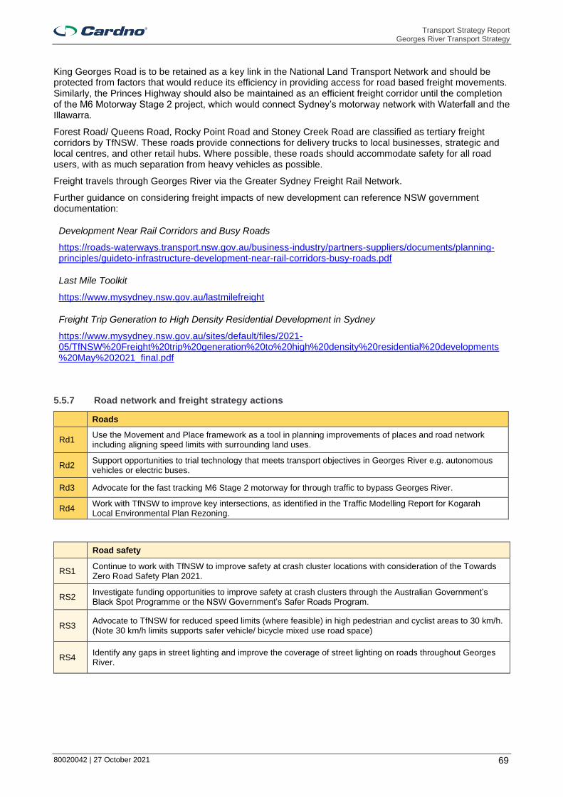
Transport Strategy Report Georges River Transport Strategy
80020042 | 27 October 2021 69
King Georges Road is to be retained as a key link in the National Land Transport Network and should be protected from factors that would reduce its efficiency in providing access for road based freight movements. Similarly, the Princes Highway should also be maintained as an efficient freight corridor until the completion of the M6 Motorway Stage 2 project, which would connect Sydney’s motorway network with Waterfall and the Illawarra.
Forest Road/ Queens Road, Rocky Point Road and Stoney Creek Road are classified as tertiary freight corridors by TfNSW. These roads provide connections for delivery trucks to local businesses, strategic and local centres, and other retail hubs. Where possible, these roads should accommodate safety for all road users, with as much separation from heavy vehicles as possible.
Freight travels through Georges River via the Greater Sydney Freight Rail Network.
Further guidance on considering freight impacts of new development can reference NSW government documentation:
Development Near Rail Corridors and Busy Roads
https://roads-waterways.transport.nsw.gov.au/business-industry/partners-suppliers/documents/planning-principles/guideto-infrastructure-development-near-rail-corridors-busy-roads.pdf
Last Mile Toolkit
https://www.mysydney.nsw.gov.au/lastmilefreight
Freight Trip Generation to High Density Residential Development in Sydney
https://www.mysydney.nsw.gov.au/sites/default/files/2021-05/TfNSW%20Freight%20trip%20generation%20to%20high%20density%20residential%20developments%20May%202021_final.pdf
5.5.7 Road network and freight strategy actions
Roads
Rd1 Use the Movement and Place framework as a tool in planning improvements of places and road network including aligning speed limits with surrounding land uses.
Rd2 Support opportunities to trial technology that meets transport objectives in Georges River e.g. autonomous vehicles or electric buses.
Rd3 Advocate for the fast tracking M6 Stage 2 motorway for through traffic to bypass Georges River.
Rd4 Work with TfNSW to improve key intersections, as identified in the Traffic Modelling Report for Kogarah Local Environmental Plan Rezoning.
Road safety
RS1 Continue to work with TfNSW to improve safety at crash cluster locations with consideration of the Towards Zero Road Safety Plan 2021.
RS2 Investigate funding opportunities to improve safety at crash clusters through the Australian Government’s Black Spot Programme or the NSW Government’s Safer Roads Program.
RS3 Advocate to TfNSW for reduced speed limits (where feasible) in high pedestrian and cyclist areas to 30 km/h. (Note 30 km/h limits supports safer vehicle/ bicycle mixed use road space)
RS4 Identify any gaps in street lighting and improve the coverage of street lighting on roads throughout Georges River.

Transport Strategy Report Georges River Transport Strategy
80020042 | 27 October 2021 70
Freight and servicing
Fr1 Protect existing freight corridors from adjacent land uses that will reduce the effectiveness of the corridor. (Related to LU5)
Fr2 Support initiatives and technology advances that achieve objectives for first and last mile deliveries in strategic and local centres. (Related to PT6/ PT5 - amended)
Fr3 Plan for freight access, site servicing and movement in centre masterplanning.

Transport Strategy Report Georges River Transport Strategy
80020042 | 27 October 2021 71
5.6 Car parking strategy
Parking is a key transport necessity that supports access to centres, homes, jobs, goods and services. An oversupply of parking can result in continued higher driver mode share, occupying land that could be used to transport higher numbers of people, and is related to increased congestion.
When planning for increased development and urban renewal, it is important to consider the effects on the parking demand and supply. Parking demand is generated from land use activity, park and ride for public transport services, and residential vehicle ownership. The efficiency of parking supply is influenced by its location, accessibility and restriction management. It is controlled by public parking infrastructure, and Council’s DCPs.
Council has a Car Parking Strategy (the Strategy) which provides a review and recommendations on the existing public car parking available in commercial centres across the LGA, and an accompanying Position Paper which provides the Council’s position on the strategies and recommendations in the Strategy. The documents are outlined in Section 3.2.2.3 of the Georges River Transport Strategy - Strategic Context Report.
The Strategy accompanied by the Position Paper is generally sufficient for an interim period. It is recommended that a more comprehensive parking study be completed by 2025. Table 5-6 lists recommendations for completion of an updated car parking strategy.
Table 5-6 Car parking strategy enhancement recommendations
Matter Recommendation Rationale
Accessible parking
Any changes to accessible parking should be undertaken only in consultation with the Access and Inclusion Reference Group and other local disability services.
The best information is provided by users and user representatives.
Demand management
Establish a clear Demand Responsive Pricing policy which establishes a link between parking fees and occupancy and sets a starting fee for new installations.
The fees can be used to provide equilibrium in the supply and demand. Fees should be used to pay for parking infrastructure and support initiatives to promote sustainable transport modes.
Create a policy/ strategy for the delivery of monitoring technology, potentially as a precursor to paid parking implementation. This should include a business case that considers staged roll-out of the system, and all infrastructure and maintenance impacts.
Paid parking is a complex matter and has significant costs to implement. These need to be analysed to determine the impacts to the area and the surrounds.
Demand modelling
Undertake analytics of existing parking demand and projected parking demand. Establish clear objectives for public and private parking supply based on a target mode share.
Parking supply and management is a significant tool to affect mode shift to more sustainable modes.
Land use and parking modelling
Undertake a land-use survey and parking demand modelling exercise to establish a baseline for commercial demand within the Centre. This should include some consideration for internal trip capture by residents and employees, and an understanding of time-of-day profiles for parking occupancy.
Detailed understanding of land use and area provides Council with the tool to model car parking demand, assess the ability for shared car parking provisions and test scenarios based on changes to policy, supply, fees and other parameters.
Objectives Incorporate the supply objectives into strategic planning for DCP rates and public parking provision.
This makes it clear to developers the intent of parking controls in Georges River.
Parking cap (maximum precinct provision)
Using the results of future road network capacity constraint modelling, determine a maximum ‘parking cap’ for each centre, to include both public and private supply. Use this revised parking target to set fair and equitable DCP rates.
The road network has a finite limit.
Priority users
Where on-street parking is used by multiple groups, ensure parking management is consistent with the hierarchy, through the use of timing restrictions, paid parking and permits, as necessary.
Parking controls such as time restrictions, fees and permits are tools to prioritise use of parking.

Transport Strategy Report Georges River Transport Strategy
80020042 | 27 October 2021 72
Matter Recommendation Rationale
Create a more fine-grained parking hierarchy that references a street’s typology or function.
Parking controls are one tool to support the desired Place aspirations and prioritise the user groups that support the vibrancy of a place.
Establish a more detailed structure for on-street parking management that identifies the particular priority user groups and provides guidance for duration restrictions based on need.
This would provide transparency and rationale behind parking controls.
Do not use surveys to inform changes to time restrictions for free parking.
Parking controls should be determined based on the priority user they need to serve. Shorter time restrictions for free parking can result in users moving vehicles within the same area.
Private parking
Undertake private property inventory counts for centres, with sample occupancy surveys to establish the approximate utilisation of these facilities.
Private car parking provisions form part of and influence parking demand.
Public transport effect
Undertake more detailed journey-to-work data analysis to investigate the link between public transport accessibility and car-as-driver mode share.
Prove with data if a relationship exists between public transport provision and private vehicle demands.
Parking rates Retain the simplified rates table as proposed in the Car Parking Strategy.
This creates a more effective planning system and unique land uses can assess their transport needs and impacts prior to development.
Residential land use intensification
Consider the impact of residential growth at a local scale, potentially through an Economic Needs Assessment, across the axes of employee and visitor demands.
Each location has a unique context and uniform behaviour does not occur. New residential development near an abundant supply of unrestricted parking is likely to have different demands to residential development without any nearby free unrestricted car parking.
Residential on-street demand
Undertake an analysis of ABS Census data (dwelling type/ size vs vehicle ownership) to estimate the extent of residential parking overspill and complete a night time ‘snapshot survey’ to count on-street parking occupancy. This could be related to a midday count via license plate recognition (LPR) data capture to determine the proportion of parking spaces consumed by residential vehicles parked all-day.
This will provide Council with an indication of the level of car parking being subsided by rate payers for private use. This will also help to identify issues around private parking spaces being used for purposes other than parking.
Road network capacity
Apply a flexible approach to setting parking restrictions encompassing parking as part of the road network.
The road network and parking will reach a tipping point where the road network cannot support more vehicles and parking provisions will need to be capped.
Council determined new car parking rates which are now set for an interim period outlined in Section 3.2.2.3 of the Georges River Transport Strategy Strategic Context Report. These are generally appropriate. For Medical Centre land use, it is recommended parking rates be determined through a site specific parking study in locations where overspill cannot be easily accommodated.

Transport Strategy Report Georges River Transport Strategy
80020042 | 27 October 2021 73
5.6.2 Car parking strategy actions
Car parking
CP1 Implement actions from the Georges River Car Parking Strategy to improve the provision and use of parking for all purposes including freight and servicing.
CP2 Review the Georges River Car Parking Strategy and Position Paper in accordance with the recommendations in the Transport Strategy.
CP3 Support the expansion of car share within Georges River Council, subject to car share providers sharing utilisation data.
CP4 Identify locations for short-term parking/ loading zones in areas of high residential density to cater for increases in small parcel deliveries and ride sharing vehicles.
CP5 Implement and maintain a GIS-based parking inventory for all on-street and Council owned/ managed off-street car parking areas.

Transport Strategy Report Georges River Transport Strategy
80020042 | 27 October 2021 74
5.7 Centres transport strategy
Centres are an important aspect of society, as they provide access to jobs, education, health services and opportunities to travel. The hierarchy and function for each centre type as described by the Georges River Council Commercial Centres Strategy is described in the following sections.
The CSP recognises that the best opportunities to embrace population growth in Georges River is to plan for higher density population development in centres connected to transport and services. This ensures that the character of the quieter streets or suburbs is protected from development that does not fit the local character and the additional residents are connected to jobs and services by active and public transport. Specific centres are discussed in the following sections.
It is important to satisfy the transport demands for different types of centre users, including residents, employees and visitors.
Employees spend longer periods of time within a centre and should be encouraged to use public or active transport.
Visitors generally spend shorter periods of time and travel a shorter distance to access a centre and should be encouraged to use active and public transport where possible, while supporting vehicle trips where this is essential.
Commuters should be supported by walking and cycling catchments connecting to centres, where they can easily interchange to collector or feeder public transport services to continue their journey.
Residents who live in or near a centre should be supported with car share opportunities to reduce overall car ownership. Residents should be encouraged to choose active and public transport.
The chosen centres for analysis in more detail are shown in Table 5-7 and in Figure 5-9. The centres were selected due to their significant locations attached to train stations, as these are the locations most likely to receive employment or residential growth.
Table 5-7 Centres classification
Centre GRC Commercial Centres Strategy – Part 1 classification
Main location
Kogarah Strategic Centre Kogarah Town Centre
Hurstville Strategic Centre Hurstville City Centre
Penshurst B2 - Local Centre Penshurst Street
Mortdale B2 - Local Centre Morts Road
Riverwood B2 - Local Centre Belmore Road
Beverly Hills B2 – Local Centre King Georges Road
Kingsgrove B2 - Local Centre Kingsgrove Road
Oatley B1 – Local Centre Mulga Road
Narwee B2 - Village Broad Arrow Road
Allawah B2 - Small Village Railway Parade
Carlton B2 – Small Village Railway Parade
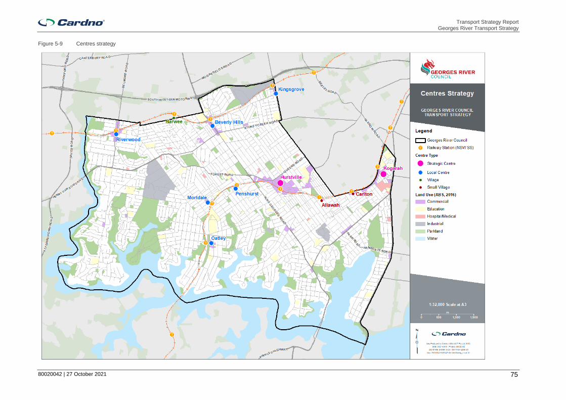
Transport Strategy Report Georges River Transport Strategy
80020042 | 27 October 2021 75
Figure 5-9 Centres strategy

Transport Strategy Report Georges River Transport Strategy
80020042 | 27 October 2021 76
5.7.2 Strategic centres
Strategic centres are regionally significant commercial hubs that provide access to major employment, health and education land uses. They are nominated by the
Greater Sydney Commission in the Greater Sydney Region Plan and the supportive District Plans and are important Sydney Metropolitan destinations.
Strategic centres are supported by high quality public transport interchanges, with services connecting between metropolitan, strategic and local centres. TfNSW supports strategic centres by delivering Future Transport 56 which includes investigating major public transport projects such as metro rail, light
rail and rapid bus routes as city shaping corridors. Residential populations are connected to strategic centres via feeder public transport services and large walking and cycling catchments. The proposed strategic active and public transport networks are designed to provide greater access to strategic centres.
Provisions for parking and loading facilities should be reflective of the land use that they intend to serve and be considered in the planning for future developments in strategic centres. These aspects are discussed further in Sections 5.5.6 and 5.6. Bike parking in strategic centres should be consolidated in key locations, and major employers should be encouraged to provide showers and lockers.
When planning for development in strategic centres, it is important to consider the effects on parking demand. As a high number of residents’ work outside Georges River, it is possible that as public transport mode share increases, there could be increased parking demand near transit hubs. Timing restrictions, paid parking and permits should be used to prioritise user groups based on parking location and nearby land uses. In general, longer stay parking should use off-street car parks in the periphery of the centre. Parking in the centre should consider the nearby land uses and visitor purpose to support the fairest use of parking through management systems such as having paid parking or duration restrictions. Technology, including in-ground sensors or cameras, can be used to assist in enforcement and compliance.
General strategic centre actions are consistent with actions from preceding sections and are provided in Table 5-8. The strategic centres discussed in further details within Georges River are Hurstville and Kogarah.
Table 5-8 Strategic centre general actions
Strategic centres
AT4 Implement the strategic walking, cycling and public transport networks to improve public transport and improve pedestrian and cycling facilities within Georges River and along Southern Sydney Corridor, including connection between the T4 and T8 train lines.
AT5 Advocate for the completion of the Illawarra Rail Line corridor active transport route.
Bk3 Advocate to TfNSW for additional cycle parking (including rails and bike sheds) at train stations, particularly at Kogarah and Hurstville stations.
PT1
Work with TfNSW to deliver Future Transport Strategy 2056 with consideration of Georges River local transport needs, including:
> 2056 indicative future rail network; and
> 2036 rapid bus lines.
CP1 Implement actions from the Georges River Car Parking Strategy to improve the provision and use of parking for all purposes including freight and servicing.

Transport Strategy Report Georges River Transport Strategy
80020042 | 27 October 2021 77
5.7.2.1 Kogarah - Strategic Centre
The vision for Kogarah is to establish a connected, safe and high performing local transport network that efficiently connects people to the significant health and education land uses in the centre.
TfNSW presents strategic plans for public transport infrastructure connecting to Kogarah that would greatly increase accessibility of metropolitan and strategic centres in Sydney,
including:
> Parramatta to Bankstown to Hurstville/ Kogarah rapid bus link (for investigation 0 to 10 years);
> Parramatta to Kogarah Mass Transit/ Train Link (for investigation 10 to 20 years); and
> The extension of South East Mass Transit/ Train Link to Miranda (for investigation 20+ years).
The Muddy Creek Canal is a key missing link in the active transport network, with potential to connect Brighton Le Sands and Rockdale with Kogarah Station. Revitalisation of the canal would also provide opportunities to maximise open space. The completion of the Muddy Creek link would connect Kogarah Station with active transport links in Bayside Council, including Hogben Park, Rockdale Plaza, Bay Street, and the plans for the M6 Stage 1 active transport route.
Illawarra Rail Line corridor is nominated as a key active transport route in both the Principal Bicycle network and the Sydney Green Grid. This link could provide a route connecting between Miranda, Sutherland, Hurstville, Kogarah, Wolli Creek, Sydney Airport and further north to the Sydney CBD.
The Kogarah Place Strategy recommends improving provisions for active transport on Wicks Lane, O’Keefe’s Lane and Bank Lane in Bayside Council to provide safer alternate routes for accessing key land uses. Workers, residents and visitors in the area would benefit from the introduction of shared zones in laneways with speed limits of ten kilometres per hour, accommodating safer movement. Laneways should be supported by adequate lighting to minimise opportunities for crimes at night.
Currently, the Princes Highway is the primary north-south freight route in the area, with Rocky Point Road, President Avenue and Bay Street connecting freight to key land uses. The completion of the M6 Stage 1 project is expected to slightly reduce vehicles counts on the Princes Highway north of President Avenue, including freight vehicles.
The M6 Extension Stage 1 project in Bayside Council includes plans for an active transport corridor, starting from the existing cycleway at Muddy Creek next to Bestic Street, Brighton-Le-Sands, connecting south to Kogarah through Rockdale Bicentennial Park. The plans include a shared cycle and pedestrian bridge over President Avenue.
Opportunities to improve the efficiency and effectiveness of parking in Kogarah include better monitoring of parking, improving drop-offs around schools, park and ride provisions and promoting car share. There is also a need to better manage employee parking within the centre through the use of pricing and potentially facilitating discussions for employees to park in the Leagues Club.
General strategic centre actions are provided in Section 5.7.2, and centre specific actions for the Kogarah strategic centre are presented in Table 5-9.
Table 5-9 Centre specific actions – Kogarah
Kogarah specific actions
Kog1 Provide an active transport link along the Muddy Creek Canal.
Kog2 Improve laneways in the Kogarah centre for walking and cycling.
Kog3 Investigate the installation of ground sensors in 1/2P and 1P spaces as a trial.
Kog4 Introduce additional car sharing zones adjacent to the station.
Kog5 Review pricing strategy for the Town Square Car Park, considering the opportunities for employee parking.
Kog6 Promote the Derby Street car park for daily employee parking.
Kog7 Introduce on-street paid parking in key locations within the centre.
Kog8 Establish Kiss & Ride zones, particularly near schools in the Kogarah education precinct.
Kog9 Negotiate with businesses in Kogarah and the Leagues Club to provide all day parking. If demand warrant, a shuttle bus service could be provided between the Leagues Club and Kogarah town centre.

Transport Strategy Report Georges River Transport Strategy
80020042 | 27 October 2021 78
5.7.2.2 Hurstville - Strategic Centre
The Hurstville strategic centre is a significant retail destination in Sydney’s South District. The centre supports a growing population through high accessibility to public transport, with access to both bus and train services. The South District Plan recommends that improvements to Hurstville’s public domain and improved integration with shopping centres will help activate streets, attract visitors, and drive employment activity.
The desire for Hurstville to improve its night time economy is presented in the LSPS, including improving night time entertainment, dining and other recreational opportunities. This can only be successful if the transport network provides viable options outside of regular peak periods.
Hurstville’s significance is supported by the commitment to investigate FT56 public transport projects over the next 20 years to improve regional connectivity between the centre and key employment areas. These projects are:
> Train/ mass transit link between Macquarie Park and Hurstville via Rhodes; and
> Parramatta to Hurstville/ Kogarah rapid bus route.
The LSPS identifies the need to link the T4 Eastern Suburbs and Illawarra line with the T8 Airport and South train line to improve connectivity within the LGA as the Riverwood Planned Precinct is developed. An option for this linkage may be the Parramatta/ Bankstown to Hurstville/ Kogarah rapid bus link presented in FT56.
The Illawarra rail line corridor has been identified as a key corridor for an active transport link for both the Sydney Green Grid and the Principal B Network. This land mark link could provide a route connecting between Miranda, Sutherland, Hurstville, Kogarah, Wolli Creek, Sydney Airport and further north to the Sydney CBD.
Key recommendations from the 2018 Hurstville City centre TMAP are:
> Develop a Hurstville City centre Urban Design Strategy;
> Investigate options for key road and intersection improvements to improve road performance;
> Investigate rail and bus service capacity improvements;
> Investigate feasibility of bus priority infrastructure on strategic bus corridors;
> Target a Hurstville City Centre active transport mode share of 20 per cent;
> Pedestrian and cycling safety improvements along City Centre routes;
> Develop a 2036 Hurstville City Centre Bike Plan and PAMP;
> Review and update wayfinding within the city centre;
> Provide guidance and advice for provision of end of trip facilities; and
> Investigate the feasibility of Introducing Car-Sharing Schemes.
Opportunities to manage parking demand in Hurstville include encouraging long-stay employee parking on the periphery of the centre rather than in the centre, introducing car-share near the station and using real time data to inform drivers of parking availabilities.
General strategic centre actions are provided in Section 5.7.2, and centre specific actions for the Hurstville strategic centre are given in Table 5-10.
Table 5-10 Centre specific actions – Hurstville
Hurstville specific actions
Hur1 Implement recommendations from the 2018 Hurstville City Centre TMAP.
Hur2 Investigate expansion of bus and train services to cater for the growing night time economy.
Hur3 Investigate ways to encourage longer stay parking to be consolidated to the periphery of the centre.
Hur4 Investigate paid all-day parking at Gloucester Road, Park Road and Woniora Road.
Hur5 Prepare integrated signage plans and use real time data to inform drivers of parking availabilities.
Hur6 Introduce additional car sharing zones adjacent to the station.

Transport Strategy Report Georges River Transport Strategy
80020042 | 27 October 2021 79
5.7.3 Local centres
Local centres are important community areas that support day to day access to goods and services, close to where people live. The Greater Sydney Commission identifies local centres as targets for housing and employment development, especially in centres that have a large supermarket. Local centres provide residents with public transport services connecting to schools or other strategic and metropolitan centres. They are also supported by large walking and cycling catchments as outlined in the strategic active transport network.
When planning for development in local centres, it is important to consider the effects on parking demand. Residential development in a local centre with access to high quality public transport generally results in lower private vehicle ownership, whereas residential development away from a local centre and away from high quality public transport results in increased parking demand at the centre and the public transport hub. Parking restrictions within local centres should support short term parking for dropping off and picking up passengers and short-stay retail. Local shops should also be supported by loading zones and accessible parking spaces. Cyclists should be supported by bike parking in local centres.
The local centres discussed in further detail within Georges River are Penshurst, Mortdale, Riverwood, Beverly Hills, Kingsgrove (Kingsgrove Road) and Oatley. General actions for local centres are provided in Table 5-11.
Table 5-11 Local centre general actions
Local centres
LU3 Undertake masterplanning for all key centres referencing the transport vision, objectives and actions of the Transport Strategy.
AT4 Implement the strategic walking, cycling and public transport networks to improve public transport and improve pedestrian and cycling facilities within Georges River and along Southern Sydney Corridor, including connection between the T4 and T8 train lines.
AT5 Advocate for the completion of the Illawarra Rail Line corridor active transport route.
Bk4 Provide bicycle parking in the public domain in all centres. Target at least 5% of the quantum of Council on and off-street parking located at car parks and/ or distributed around centres, i.e. integrated with sign poles and/ or bicycle parking areas in off-street car parks located in a conspicuous location.
5.7.3.2 Beverly Hills - Local Centre
Beverly Hills is located at a key gateway between Georges River and Greater Parramatta, on King Georges Road. The strategy for this centre is based on the vision and recommendations of the Beverly Hills Masterplan, developed by Georges River Council and placed on public exhibition in 2020.
The five big ideas presented in the Plan aim to contribute to renewal, support the night time economy and facilitate growth of the centre. They are:
1. Renewing and revitalising the strip – expansion of the commercial footprint through the introduction of the new East Street, which would be a pedestrian prioritised street with improved access to Beverly Hills Station, increased open space, and car parking that supports places for people night and day.
2. New opportunities for people to live close to transport and services – Medium to high density residential redevelopment in close proximity to the new East Street.
3. A new civic square and community heart – A new open space and community square at the corner of King Georges Road and Frederick Avenue, providing connections between the proposed new East Street and King Georges Road and access to retail and dining.
4. New and improved connections to get from place to place – Development is to include rear service access and car parking. This is critical to achieving the vision for the new East Street pedestrian prioritised link, creating permeability and revitalisation of the centre.
5. New and improved pocket parks – Improved open space and public domain with pocket parks, which contribute to the village atmosphere.
The strategic vision for Beverly Hills includes the following potential opportunities to contribute to revitalisation of Beverly Hills and promote movement and access:

Transport Strategy Report Georges River Transport Strategy
80020042 | 27 October 2021 80
> A new pedestrian link across the railway connecting between Warrawee Place and the proposed East Street.
> Traffic calming on Frederick Avenue at the intersection with King Georges Road to support the pedestrian prioritised area.
> Enhance existing pedestrian crossings on King Georges Road.
> Upgrade Beverly Hills Station with a new lift on the western side of King Georges Road to enhance east-west connectivity and other modernisation improvements.
> Revitalise the existing western laneway parallel to King Georges Road through widening it by three metres, providing parking bays and a shared path.
> Create new links between King Georges Road and the existing western parallel laneway for improved permeability.
> Development of a multistorey car park at the existing Edgbaston Road car park to compensate from loss of parking due to clearway restrictions being implemented.
The Beverly Hills centre could benefit from the FT56 projects for investigation including a rapid bus between Parramatta, Bankstown and Hurstville, and a mass transit link between Macquarie Park and Hurstville via Rhodes. These links would provide enhanced north-south connections to jobs, education and services.
General local centre actions are provided in Section 5.7.3 and the centre specific actions for the Beverly Hills local centre are provided in Table 5-12.
Table 5-12 Centre specific actions – Beverly Hills
Beverly Hills specific actions
Bev1 Work with the DPIE to implement the Beverly Hills Masterplan.
Bev2 Work with TfNSW to improve the frequency and amenity of pedestrian crossings on King Georges Road.
Bev3 Work with TfNSW to provide secure bicycle parking facilities at Beverly Hills Station.
Bev4 Advocate for the upgrade of Beverly Hills Station including improvements to accessibility.
Bev5 Investigate a pedestrian crossing across King Georges Road: > At/ near Tooronga Terrace > At Edgbaston Road
Bev6 Investigate continuous footpath treatments across: > Frederick Avenue at King Georges Road > Norfolk Avenue at King Georges Road
5.7.3.3 Kingsgrove – Local Centre
The vision for Kingsgrove is to be promoted as a regional business park, providing industrial employment to residents and visitors to Georges River. To support this vision, the three adjoining councils of Georges River, Bayside and Canterbury-Bankstown must collaborate to ensure that the Kingsgrove Local Centre is accessible, safe and connected. The increased visitors to Kingsgrove should be supported with public
domain improvements.
Kingsgrove is a key employment hub in Georges River Council, currently providing the second highest floor space and jobs in the LGA. The Georges River Industrial Land Review identifies Kingsgrove as the ideal location and highest suitability in Georges River for industrial growth because of its strategic location near the primary freight route on the M5 Motorway and Kingsgrove Station.
Current access configuration to the M5 Motorway limits access at Kingsgrove to eastbound movements only. Future potential for the centre may be unlocked with a westbound access provided; this needs to be considered against the extra traffic movements that would be associated with this.
Kingsgrove must be supported by improved active and public transport connections to increase the attractiveness and accessibility of the centre. It is proposed to improved connectivity within Georges River by improving connections between the T4 and T8 train lines between Kingsgrove and Hurstville along Kingsgrove Road with a shared path and collector bus route.

Transport Strategy Report Georges River Transport Strategy
80020042 | 27 October 2021 81
General local centres actions are provided in Section 5.7.3 and centre specific actions for the Kingsgrove local centre are provided in Table 5-13.
Table 5-13 Centre specific actions – Kingsgrove
Kingsgrove specific actions
King1 Prepare a Kingsgrove Local Centre Masterplan and work with DPIE for its implementation.
King2 NSW government to investigate the benefits and impacts a new on/off ramp to the M5 motorway to improve access to Western Sydney at Kingsgrove.
King3 Collaborate with the NSW Government to regularly monitor and improve the transport corridors from Kingsgrove and Kogarah to Sydney CBD, Sydney Airport and Port Botany.
King4 Collaborate with adjoining councils to improve the public domain.
King5 Investigate the feasibility of a 40km/h or lower High Pedestrian Activity Area for Kingsgrove Road between Morton Avenue and Commercial Road.
King6 Investigate continuous footpath treatments across: > Paterson Avenue at Kingsgrove Road > The Avenue at Kingsgrove Road.
5.7.3.4 Mortdale - Local Centre
The Mortdale local centre has high accessibility within Georges River. The centre is strategically located with a four minute train journey and a 2.5 kilometre cycle journey to the Hurstville strategic centre via the proposed Illawarra Rail Line corridor active transport route. In August 2020, Council commenced a masterplanning exercise for the Mortdale Local Centre.
The local centre has a range of retail and commercial services which benefit from passing commuter and vehicle traffic. The GRC Draft Commercial Centres Strategy notes there is a lack of dedicated service laneways in the local centre. Mortdale is identified by the LSPS as a location appropriate to accommodate future growth in employment for Georges River, due to its proximity to the railway corridor. Boundary Road/ Bonds Road/ Kemp Street/ Morts Road/ Universal Street is identified in the strategic active transport network as a key route connecting between the T4 and T8 rail lines via active and public transport.
General local centre actions are provided in Section 5.7.3 and centre specific actions for the Mortdale local centre are provided in Table 5-14.
Table 5-14 Centre specific actions – Mortdale
Mortdale specific actions
Mort1 Work with the DPIE to implement the Mortdale Masterplan.
Mort2 Work with TfNSW to optimise bus and train services in Mortdale centre and secure bicycle parking facilities at the Mortdale station.
5.7.3.5 Penshurst – Local Centre
The Penshurst local centre is strategically located less than one kilometre from the Hurstville strategic centre. The two centres are connected via the proposed strategic walking and cycling networks via:
> Key pedestrian route on Forest Road; and
> Key cycling routes on Bridge Street and Woniora Road.
These connections provide efficient access for Penshurst residents to the goods, services and public transport connections provided by the Hurstville strategic centre. Penshurst Street is also identified as a key walking and cycling route for connection between the T4 and T8 train lines within Georges River.
A key strength of Penshurst is the Penshurst Park Regional Sporting Hub, which is currently being upgraded to be a centre for sporting excellence, with improved sports facilities, a 275 seat grandstand and car park upgrade. This site is located approximately 400 metres north of Penshurst Station, and should be supported by installation of a pedestrian crossing on Forest Road.

Transport Strategy Report Georges River Transport Strategy
80020042 | 27 October 2021 82
The Penshurst local centre is identified by the LSPS as a location appropriate to accommodate future growth in employment for Georges River, due to its proximity to the Hurstville strategic centre, and provisions for public transport.
General local centre actions are provided in Section 5.7.3 and centre specific actions for the Penshurst local centre are provided in Table 5-15.
Table 5-15 Centre specific actions – Penshurst
Penshurst specific actions
Pens1 Prepare a Penshurst Local Centre Masterplan and work with DPIE for its implementation.
Pens2 Work with TfNSW to provide secure bicycle parking facilities at Penshurst Station.
Pens3 Investigate and incorporate pedestrian infrastructure enhancements as part of a masterplanning study, including feasibility of a 40km/h or lower High Pedestrian Activity Area along The Strand/ Bridge Street/ Penshurst Street and on Bridge Street between Penshurst Street and Connelly Street.
Pens4
Investigate pedestrian crossing treatments and safety improvements at the following intersections: > across Bridge Street (east leg) at Penshurst Street > The Strand and Bridge St > Penshurst Street and Austral Street
Pens5 Investigate in-lane bus stops along Penshurst Street.
5.7.3.6 Riverwood – Local Centre
Riverwood local centre and surrounds is identified in the South District Plan as a “Planning Precinct” within Georges River LGA and Canterbury-Bankstown LGA. The Riverwood Estate is located within the Riverwood Planned Precinct north of the Riverwood local centre in the Canterbury Bankstown LGA and is set to provide a range of additional affordable and private housing. Currently the land provides 994 dwellings, and this number is expected to increase by 20 per cent. It is important to provide strong
connections from this precinct to the Riverwood local centre, benefiting residents with goods and services, as well as opportunities for public transport. Access via walking, cycling and public transport from the Estate to Riverwood local centre is proposed on Belmore Road.
The Georges River LSPS states the need to link the T4 and T8 train lines together with reliable and efficient active and public transport services, particularly to accommodate for the Riverwood Estate north of the centre and the Riverwood Planned Precinct. This should be achieved with the proposed public and active strategic transport networks, which propose both collector and feeder public transport routes accessing Riverwood via Belmore Road, and a cycling route accessing via Bonds Road. The rapid bus route should be supported with consolidated bus stops at key locations outside of the Riverwood Plaza and north of Riverwood Station.
The Riverwood local centre is in a prime location to benefit from the completion of the Salt Pan Creek Sydney Green Grid priority corridor. This landmark link would improve connections between Georges River and the Bankstown CBD.
General local centre actions are provided in Section 5.7.3 and centre specific actions for the Riverwood local centre are provided in Table 5-16.

Transport Strategy Report Georges River Transport Strategy
80020042 | 27 October 2021 83
Table 5-16 Centre specific actions – Riverwood
Riverwood specific actions
Riv1 Prepare a Riverwood Local Centre Masterplan and work with DPIE for its implementation - Leverage off work being undertaken as part of the Planned Precinct and Investigation Area.
Riv2 Collaborate with the City of Canterbury Bankstown to improve active transport links between the Riverwood planned precinct and Riverwood Station.
Riv3 Advocate for the completion of the Salt Pan Creek Corridor as part of the Sydney Green Grid and the Principal Bicycle network.
Riv4 Consolidate bus stops to key locations outside of the Riverwood Plaza and north of Riverwood Station.
Riv5 Investigate the feasibility of a 40km/h or lower High Pedestrian Activity Area for streets in the centre.
Riv6
Investigate continuous footpath treatments on both sides of: > Belmore Road at Coleridge Street > Belmore Road at Eldon Street > across Killara Avenue at Belmore Road North.
5.7.3.7 Oatley - Local Centre
The Oatley local centre is located approximately three kilometres south west of the Hurstville strategic centre. The GRC Commercial Centres Strategy has found that, under existing controls, the Oatley local centre will not be able to meet employment floor space demands. In response to this, the Strategy suggests investigating the potential of expanding the centre to include the northern side of Mulga Road to provide additional development capacity and reviewing minimum non-residential FSR
requirement in future LEPs.
The LSPS identifies Oatley as a potential location in Georges River to contribute to the accommodation of expected growth of 13,000 jobs by 2036, by adjusting development controls and providing additional employment floor space.
General local centres actions are provided in Section 5.7.3 and centre specific actions for the Oatley local centre are provided in Table 5-17.
Table 5-17 Centre specific actions – Oatley
Oatley specific actions
Oat1 Prepare an Oatley Local Centre Masterplan and work with DPIE for its implementation.
Oat2 Work with TfNSW to provide secure bicycle parking facilities at Oatley Station.
Oat3 Improve the intersection of Oatley Parade and Frederick Street to consider and increase safety for all road users.
Oat4 Investigate in-lane bus stops on Frederick Street.
Oat5 Investigate a pedestrian priority crossing treatment on Oatley Avenue (north leg) and Frederick Street and the feasibility of a 40km/h or lower High Pedestrian Activity Area street on Frederick Street between Oatley Parade and Rosa Street.

Transport Strategy Report Georges River Transport Strategy
80020042 | 27 October 2021 84
5.7.4 Villages and small villages
Villages and small villages support local residents, providing a small amount of retail floor space including a small convenience store or supermarket. Villages and small villages are supported by feeder bus routes and have less frequent train services, connecting residents to other local and strategic centres. Villages and small villages provide short term parking and loading zones supporting local retail, as well as accessible car
parking spaces. It is important to retain the community and neighbourhood feel in villages and local villages, and promote the attraction, accessibility and visitation by
residents. Supporting local businesses is important for maintaining the local character of villages in Georges River. Cyclists should be supported by bike parking in villages and local villages.
The village discussed in further details within Georges River is Narwee, and the small villages discussed are Allawah and Carlton. General actions for villages and small villages are provided in Table 5-18.
Table 5-18 Village and small village general actions
Villages and small villages
LU3 Undertake masterplanning for all key centres referencing the transport vision, objectives and actions of the Transport Strategy.
AT4 Implement the strategic walking, cycling and public transport networks to improve public transport and improve pedestrian and cycling facilities within Georges River and along Southern Sydney Corridor, including connection between the T4 and T8 train lines.
AT5 Advocate for the completion of the Illawarra Rail Line corridor active transport route.
Bk4 Provide bicycle parking in the public domain in all centres. Target at least 5% of the quantum of Council on and off-street parking located at car parks and/ or distributed around centres, i.e. integrated with sign poles and/ or bicycle parking areas in off-street car parks located in a conspicuous location.
5.7.4.2 Allawah – Small village
The Allawah small village is located between the two strategic centres of Kogarah and Hurstville. Allawah and Hurstville are well connected via a two minute train journey, local bus route connections and via a one kilometre walk or cycle. To encourage active transport journeys connecting Allawah and the strategic centres, the strategic transport network including the recommendation for completing the Illawarra Rail Line active
transport corridor should be implemented.
The LSPS identifies Allawah as a potential location to contribute to the accommodation of expected growth of 13,000 jobs across the LGA by 2036. The Commercial Centres Strategy has also identified the Allawah small village as one of the centres that will experience relatively greater demand for additional employment floor space due to its location in an area with high forecasted population growth, its proximity to a railway station and its good visibility from passing trade. It is recommended that this demand be met by adjusting development controls and providing additional employment floor space to activate the centre and ensure its ongoing viability.
General village and small village actions are provided in Section 5.7.4 and centre specific actions for the Allawah small village are provided in Table 5-19.
Table 5-19 Centre specific actions - Allawah
Allawah specific actions
Alla1 Prepare an Allawah Masterplan and work with DPIE for its implementation.
Alla2 Work with TfNSW to provide secure bicycle parking facilities at Allawah Station.
Alla3 Investigate a raised shared space at the intersection of Mona Street and Lancelot Street.
Alla4 Investigate the feasibility of a 40km/h or lower High Pedestrian Activity Area street on Railway Parade between Illawarra Street and Elizabeth Street.

Transport Strategy Report Georges River Transport Strategy
80020042 | 27 October 2021 85
5.7.4.3 Carlton - Small village
The Carlton small village is located approximately one kilometre south west of the Kogarah strategic centre, providing residents with access to health, education and other employment land uses by a one minute train journey. The proposed Illawarra Rail line active transport corridor would provide improved walking and cycling links between the centres and provide safe and efficient alterative travel modes.
The LSPS identifies Carlton as a potential location to contribute to the accommodation of expected growth of 13,000 jobs across the LGA by 2036. The Commercial Centres Strategy has also identified the Carlton small village as one of the centres that will experience relatively greater demand for additional employment floor space due to its location in an area with high forecasted population growth, its proximity to a railway station and its good visibility from passing trade.
This demand should be met by adjusting development controls and providing additional employment floor space. Improvements to the walking and cycling network on Railway Parade may further increase passing trade and contribute to the ongoing viability of the Carlton small village. The predicted increased employment and residential floor space in the Carlton small village suggests that there may need to improve the public domain, active and public transport links and all-day public transport connections to improve the attractiveness of the centre.
General village and small village actions are provided in Section 5.7.4 and centre specific actions for the Carlton small village are provided in Table 5-20.
Table 5-20 Centre specific actions - Carlton
Carlton specific actions
Carl1 Prepare a Carlton Masterplan and work with DPIE for its implementation.
Carl2 Work with TfNSW to provide secure bicycle parking facilities at Carlton Station.
Carl3 Investigate the feasibility of a 40km/h or lower High Pedestrian Activity Area street on: > Railway Parade between Garfield Street and Buchanan Street > Carlton Parade between High Street and Willison Road.
5.7.4.4 Narwee – Village
The Narwee village is located to the north of the LGA and the majority portion of the centre is located in the Canterbury-Bankstown LGA. It is important that a strong relationship is made between the two adjoining councils for collaboration on transport infrastructure and amenity improvements.
The LSPS identifies Narwee as a potential location to contribute to the accommodation of expected growth of 13,000 jobs across the LGA by 2036. Narwee is also identified as a potential location for a small food precinct, boosting the Narwee night time economy. This vision must be supported by improved public domain, pedestrian priority and strong public transport connections day and night to improve the attractiveness of the centre. Proposed improvements to active transport connectivity between the T4 and T8 train lines will also improve accessibility of the centre. Under the draft LEP21, Council is seeking to create additional housing capacity to the south of the Narwee Local Centre. Council is proposing to change the zoning of the land within the Housing Investigation Area (HIA) from R2 Low Density Residential to R3 Medium Density Residential and R4 – High Density Residential.
Narwee has amongst the highest proportion of residents in Georges River that require assistance in their daily lives. Pedestrian infrastructure improvements should focus on DDA compliance and improving priority for pedestrians. Sufficient and suitable accessible parking spaces should also be provided to improve amenity.
General village and small village actions are provided in Section 5.7.4 and centre specific actions for the Narwee village are provided in Table 5-21.

Transport Strategy Report Georges River Transport Strategy
80020042 | 27 October 2021 86
Table 5-21 Centre specific actions - Narwee
Narwee specific actions
Nar1 Prepare a Narwee Village Masterplan and work with DPIE for its implementation.
Nar2 Collaborate with the City of Canterbury-Bankstown for infrastructure and public domain improvements.
Nar3 Investigate the feasibility of a 40km/h or lower High Pedestrian Activity Area for streets in the centre.
Nar4 Investigate a pedestrian priority crossing treatment across Broadarrow Road.

Transport Strategy Report Georges River Transport Strategy
80020042 | 27 October 2021 87
6 Implementation
6.1 Active transport network implementation
This section provides high level strategic cost estimates for the implementation of the strategic walking and cycling networks using standard unit rates. The rates are based on those adopted in other local council areas in Sydney and quantities are subject to change as further investigation is undertaken. Adopted standard unit rates as well as rationale behind them are provided in Table 6-1.
Table 6-1 Adopted standard unit rates
Infrastructure type
Description Unit rate Unit rate rationale
Footpath Provide footpath 1.8 metres wide where it is missing
$324/ metre Based on assessment of applicability for similar rates adopted in other councils in Sydney.
On road mixed cycling route
Provide bike stencils and signage
Bike stencil - $0.6/ metre
Signage - $2.5/ metre
Bike stencil rate based on assessment of applicability for similar rates adopted in other councils in Sydney.
Signage rate based on providing directional signage plates on existing street signage poles at a cost of $500 per installation. The frequency of signs along the route is on an as needs basis (located at intersections), and in this case is assumed to be every 200m.
Off road route Provide shared path 3.5 metres wide
$600/ metre Based on assessment of applicability for similar rates adopted in other councils in Sydney.
Application of the unit rates to the indicative network quantities outlines in Section 5.3.4 are provided in Table 6-2.
Table 6-2 Cost estimates for infrastructure recommendations
Route type Infrastructure type
Description Length (km)
Cost
Strategic pedestrian network (not including signature projects)
Footpath Provide footpath 1.8 metres wide where it is missing
16.1 $5,216,400
Strategic cycling network (not including signature projects)
On road mixed cycling route
Provide bike stencils and signage 85.5 $265,050
Off road route Provide shared path 3.5 metres wide
30.9 $18,540,000
Salt Pan Creek signature project
Off road route/ non-standard terrain
Provide shared path 3.5 metres side
5.8 $3,480,000
Railway corridor signature project
Off road route Provide shared path 3.5 metres wide
9.9 $5,940,000
Connection of T4 and T8 rail lines signature project
On road mixed cycling route
Provide bike stencils and signage 1.9 $5,890
Off road route Provide shared path 3.5 metres wide
13.7 $8,220,000
Total $41,667,340
Note that costs are high level and do not account for site specific considerations such as varying ground conditions and kerb ramps.

Transport Strategy Report Georges River Transport Strategy
80020042 | 27 October 2021 88
The next steps for implementing the strategic active transport networks is to develop a method of prioritisation for infrastructure works identified in the networks. Rationale for this should include consideration of the Active Transport Strategy outlined in Section 5.3, and may be based on:
> Provision of at least one footpath on each side of the road within Georges River;
> Connectivity to key land uses, schools, centres and public transport interchanges;
> Quick win infrastructure provision that benefits the community;
> Funding opportunities through development applications; and
> State or federal government grants.
6.2 Staging plan
Potential timing for delivery of each action has been considered for the following time periods:
> Short term – zero to five years;
> Medium term – five to ten years; and
> Long term – ten to twenty years.
Error! Reference source not found. outlines the indicative staging plan. This is subject to the completion of further studies and funding opportunities.

Transport Strategy Report Georges River Transport Strategy
80020042 | 27 October 2021 89
Table 6-3 Staging plan
Action group Action code Action Staging
Land use
LU1 Plan for higher land use densities around public transport interchanges. Ongoing
LU2 In masterplanning of its centres, Council consider the actions of the Transport Strategy and work with TfNSW to identify future mass transit station locations and to ensure that land around stations is retained for transport related development.
Ongoing
LU3 Undertake masterplanning for all key centres referencing the transport vision, objectives and actions of the Transport Strategy.
Medium
LU4 Prioritise new residential and commercial development with appropriate buffers from existing and any proposed freight corridors and industrial land uses to protect them. (Connected to Fr1)
Ongoing
LU5 Develop an internal GIS map-based portal for Council staff to provide oversight of integrated planning and capital works, infrastructure and asset management systems; that is regularly updated as decisions are made and links to relevant planning frameworks.
Short
LU6 Review transport infrastructure funding opportunities for non-residential development. Ongoing
Travel demand management
TDM1 Mandate Travel Plans for major employers in Georges River such as hospitals, education campuses and Council so as to identify and communicate sustainable travel choices for staff.
Medium
TDM2 Develop a Car Share Policy that supports the uptake of car share in Georges River LGA. Medium
Sustainable transport
STI Support, encourage and develop sustainable transport initiatives that reduce reliance on private vehicles, e.g. Mobility as a Service (MaaS) system, electric buses.
Long
Active transport
AT1 Work with TfNSW to provide Sydney Green Grid links through Georges River which link into neighbouring local government areas.
Ongoing
AT2 Review street trees and canopy cover to improve shade and reduce the urban heat island effect. (This includes supporting/ improving the Green Grid and linking transport to centres, schools and open space). Additional plantings should not interfere with sight lines or contribute to footpath clutter.
Medium
AT3 Prioritise footpath, shared path and cycleway upgrades in the 800 metre catchment of schools. Short
AT4 Implement the strategic walking, cycling and public transport networks to improve public transport and improve pedestrian and cycling facilities within Georges River and along Southern Sydney Corridor, including connection between the T4 and T8 train lines.
Ongoing
AT5 Advocate for the completion of the Illawarra Rail Line corridor active transport route. Ongoing
Pedestrian
Ped1 Adopt consistent footpath standards for Georges River, specifically adopting wider footpaths along higher demand areas/ routes within centres to support walking, cycling and accessibility.
Short
Ped2 Adopt a policy of a footpath on at least one side of the road where pedestrian movements are permitted. Short
Ped3 Implement the strategic pedestrian network that will provide a fully connected and accessible pedestrian network throughout Georges River.
Ongoing

Transport Strategy Report Georges River Transport Strategy
80020042 | 27 October 2021 90
Action group Action code Action Staging
Ped4 Provide separation/ space/ landscaped buffer between footpaths and vehicle travel lanes along freight routes using on-street parking or landscaping and/ or investigate opportunities for speed limit reductions.
Long
Ped5 Investigate locations for potential pedestrian priority treatments, including High Pedestrian Activity Areas, Shared Zones and 40 km/h or lower speed limit zones.
Short
Ped6 Identify opportunities for redevelopment sites to provide through site links and adequate pedestrian space on footpaths and for waiting at intersections.
Ongoing
Ped7 Develop and implement a consistent wayfinding program for strategic centres in Georges River. Long
Pedestrian crossings
PX1 Prioritise additional pedestrian crossings along arterial roads with lengths of 450 metres or greater without a crossing, 200 metres in residential/ industrial areas, and every 100 metres in centres (off state roads) where desire lines exist.
Long
PX2 Identify intersections where additional pedestrian crossing legs could be provided subject to the location having a pedestrian desire line. Advocate to TfNSW for upgrades.
Medium
PX3 Investigate the feasibility of active pedestrian detection technology at signalised intersections to adjust pedestrian crossing times in real-time (shorter or longer) based on customer needs.
Ongoing
PX4 Advocate for pedestrian head start crossing movement at all signalised intersections and the removal of green light vehicle turning movements when pedestrians have green crossing light.
Ongoing
Bike
Bk1 Implement the strategic bicycle network for a safe, connected network throughout Georges River integrating with neighbouring local government areas and regional links.
Ongoing
Bk2 Collaborate with TfNSW to develop and implement the Principal Bicycle Network links within Georges River. Ongoing
Bk3 Advocate to TfNSW for additional cycle parking (including rails and bike sheds) at train stations, particularly at Kogarah and Hurstville stations.
Short
Bk4 Provide bicycle parking in the public domain at all centres. Target at least 5% of the quantum of Council on and off-street parking located at car parks and/ or distributed around centres, i.e. integrated with sign poles and/ or bicycle parking areas in off-street car parks located in a conspicuous location.
Medium
Bk5 New business/ commercial/ industrial developments to provide 5% bike parking based on the total number of car parking spaces provided. Developments should have 1 change room and shower facilities per 10 spaces with a minimum of 1.
Ongoing
Bk6 New residential development should have at least 1 secure multi-purpose space that can function as bike parking per dwelling and at least 5% visitor bicycle parking provided in a conspicuous location.
Ongoing
Public transport PT1
Work with TfNSW to deliver Future Transport Strategy 2056 with consideration of Georges River local transport needs, including:
> 2056 indicative future rail network; and
> 2036 rapid bus lines.
Ongoing

Transport Strategy Report Georges River Transport Strategy
80020042 | 27 October 2021 91
Action group Action code Action Staging
PT2 Advocate to TfNSW to improve the connectivity and frequency of bus and rail services to, from and within Georges River, particularly in areas of Georges River that do not have 30-minute access to a strategic centre.
Ongoing
PT3 Work with TfNSW to provide full Disability Discrimination Act compliant accessibility for public transport; particularly buses, for people with mobility challenges. Extend this to providing infographics for people with linguistic challenges.
Ongoing
PT4 Investigate where more accessible car parking spaces at public transport interchanges should be provided. Short
PT5 Advocate to TfNSW for first and last mile on-demand transport services where patronage levels do not justify a timetabled service provision.
Ongoing
PT6 Improve public transport interchanges within the existing network to improve safety and accessibility for all users. This is to consider reduction in speed limits in interchange areas.
Medium
Rail Rail 1 Support TfNSW to improve rail services and infrastructure. i.e. More trains more services and Future Transport Strategy 2056 initiatives like Parramatta to Kogarah and Hurstville to Macquarie Park.
Ongoing
Bus
Bu1 Work with TfNSW to improve the existing bus network to rationalise routes and improve service quality and frequency on existing routes.
Ongoing
Bu2 Support TfNSW in the implementation of Future Transport Strategy 2056 including reviewing and investigating bus routes with the view to improve connectivity, efficiency and accessibility.
Ongoing
Bu3 Advocate for and provide input to the NSW Government's proposed strategic bus network, including dedicated bus priority infrastructure for improved efficiency and reliability. (Concept network arrangement in this strategy)
Ongoing
Bu4 Support TfNSW to implement bus priority infrastructure such as bus jump start lanes along key bus routes. Ongoing
Bu5 Advocate to TfNSW for bus performance studies on key routes to identify priority measures in areas of congestion.
Ongoing
Bu6 Advocate for increased public transport capacity on routes and in periods of high demand, e.g. Queens Road. Ongoing
Bu7 Advocate for improved public transport accessibility, e.g., services later at night, and/ or on-demand buses to support localities with low demand.
Ongoing
Bu8 Investigate the need for any additional community bus services within Georges River, including inclusive access - this should focus on larger buses to accommodate bigger groups to reduce costs.
Short
Bus stop
BS1 Undertake Disability Discrimination Act compliance audit of relevant bus stops, and prioritise upgrades based on patronage, community consultation and access to nearby destinations.
Short
BS2 Improve accessible footpath connections at bus stops within Georges River. Short
BS3 Investigate funding opportunities (TfNSW and third party providers) for new Disability Discrimination Act compliant bus shelters, including tendering to outdoor advertising companies while retaining functionality for buses, safety, and customer experience.
Ongoing
BS4 Advocate for real time information displays at key bus stops. I.e. Hurstville and Kogarah. Long

Transport Strategy Report Georges River Transport Strategy
80020042 | 27 October 2021 92
Action group Action code Action Staging
Ferry/ boat Fy1 Investigate the feasibility of a Georges River ferry route or scenic/ recreational tour route; utilising Georges River for water-based transport connections, including ferries and water taxis.
Long
Roads
Rd1 Use the Movement and Place framework as a tool in planning improvements of places and road network including aligning speed limits with surrounding land uses.
Short
Rd2 Support opportunities to trial technology that meets transport objectives in Georges River e.g. autonomous vehicles or electric buses.
Ongoing
Rd3 Advocate for the fast tracking M6 Stage 2 motorway for through traffic to bypass Georges River. Short
Rd4 Work with TfNSW to improve key intersections, as identified in the Traffic Modelling Report for Kogarah Local Environmental Plan Rezoning.
Medium
Road safety
RS1 Continue to work with TfNSW to improve safety at crash cluster locations with consideration of the Towards Zero Road Safety Plan 2021.
Ongoing
RS2 Investigate funding opportunities to improve safety at crash clusters through the Australian Government’s Black Spot Programme or the NSW Government’s Safer Roads Program.
Ongoing
RS3 Advocate to TfNSW for reduced speed limits (where feasible) in high pedestrian and cyclist areas to 30 km/h. (Note 30km/h limits supports safer vehicle/ bicycle mixed use road space).
Ongoing
RS4 Ensure provisions for pedestrians and bicycles are provided as part of construction activities impacting the transport network in addition to the requirements of TfNSW Traffic control at work sites Technical Manual.
Ongoing
RS5 Identify any gaps in street lighting and improve the coverage of street lighting on roads throughout Georges River.
Medium
Freight and servicing
Fr1 Protect existing freight corridors from adjacent land uses that will reduce the effectiveness of the corridor. (Related to LU4)
Ongoing
Fr2 Support initiatives and technology advances that achieve objectives for first and last mile deliveries in strategic and local centres.
Ongoing
Fr3 Plan for freight access, site servicing and movement in centre masterplanning. Ongoing
Car parking
CP1 Implement actions from the Georges River Car Parking Strategy to improve the provision and use of parking for all purposes including freight and servicing.
Ongoing
CP2 Review the Georges River Car Parking Strategy and Position Paper in accordance with the recommendations in the Transport Strategy.
Short
CP3 Support the expansion of car share within Georges River Council, subject to car share providers sharing utilisation data.
Short
CP4 Identify locations for short-term parking/ loading zones in areas of high residential density to cater for increases in small parcel deliveries and ride sharing vehicles.
Short

Transport Strategy Report Georges River Transport Strategy
80020042 | 27 October 2021 93
Action group Action code Action Staging
CP5 Implement and maintain a GIS-based parking inventory for all on-street and Council owned/ managed off-street car parking areas.
Ongoing
Strategic centres
AT4 Implement the strategic walking, cycling and public transport networks to improve public transport and improve pedestrian and cycling facilities within Georges River and along Southern Sydney Corridor, including connection between the T4 and T8 train lines.
Ongoing
AT5 Advocate for the completion of the Illawarra Rail Line corridor active transport route. Ongoing
Bk3 Advocate to TfNSW for additional cycle parking (including rails and bike sheds) at train stations, particularly at Kogarah and Hurstville stations.
Short
PT1
Work with TfNSW to deliver Future Transport Strategy 2056 with consideration of Georges River local transport needs, including:
> 2056 indicative future rail network; and
> 2036 rapid bus lines.
Ongoing
CP1 Implement actions from the Georges River Car Parking Strategy to improve the provision and use of parking for all purposes including freight and servicing.
Ongoing
Kogarah specific actions
Kog1 Provide an active transport link along the Muddy Creek Canal. Long
Kog2 Improve laneways in the Kogarah centre for walking and cycling. Long
Kog3 Investigate the installation of ground sensors in 1/2P and 1P spaces as a trial. Long
Kog4 Introduce additional car sharing zones adjacent to the station. Medium
Kog5 Review pricing strategy for the Town Square Car Park, considering the opportunities for employee parking. Short
Kog6 Promote the Derby Street car park for daily employee parking. Short
Kog7 Introduce on-street paid parking in key locations within the centre. Medium
Kog8 Establish Kiss & Ride zones, particularly near schools in the Kogarah education precinct. Medium
Kog9 Negotiate with businesses in Kogarah and the Leagues Club to provide all day parking. If demand warrant, a shuttle bus service could be provided between the Leagues Club and Kogarah town centre.
Long
Hurstville specific actions
Hur1 Implement recommendations from the 2018 Hurstville City Centre TMAP. Ongoing
Hur2 Investigate expansion of bus and train services to cater for the growing night time economy. Ongoing
Hur3 Investigate ways to encourage longer stay parking to be consolidated to the periphery of the centre. Ongoing
Hur4 Investigate paid all-day parking at Gloucester Road, Park Road and Woniora Road. Ongoing
Hur5 Prepare integrated signage plans and use real time data to inform drivers of parking availabilities. Long
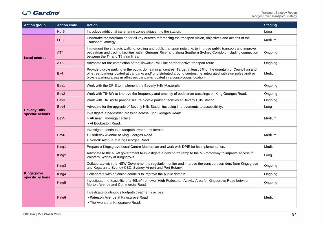
Transport Strategy Report Georges River Transport Strategy
80020042 | 27 October 2021 94
Action group Action code Action Staging
Hur6 Introduce additional car sharing zones adjacent to the station. Long
Local centres
LU3 Undertake masterplanning for all key centres referencing the transport vision, objectives and actions of the Transport Strategy.
Medium
AT4 Implement the strategic walking, cycling and public transport networks to improve public transport and improve pedestrian and cycling facilities within Georges River and along Southern Sydney Corridor, including connection between the T4 and T8 train lines.
Ongoing
AT5 Advocate for the completion of the Illawarra Rail Line corridor active transport route. Ongoing
Bk4 Provide bicycle parking in the public domain in all centres. Target at least 5% of the quantum of Council on and off-street parking located at car parks and/ or distributed around centres, i.e. integrated with sign poles and/ or bicycle parking areas in off-street car parks located in a conspicuous location.
Medium
Beverly Hills specific actions
Bev1 Work with the DPIE to implement the Beverly Hills Masterplan. Ongoing
Bev2 Work with TfNSW to improve the frequency and amenity of pedestrian crossings on King Georges Road. Ongoing
Bev3 Work with TfNSW to provide secure bicycle parking facilities at Beverly Hills Station. Ongoing
Bev4 Advocate for the upgrade of Beverly Hills Station including improvements to accessibility. Long
Bev5
Investigate a pedestrian crossing across King Georges Road:
> At/ near Tooronga Terrace
> At Edgbaston Road.
Medium
Bev6
Investigate continuous footpath treatments across:
> Frederick Avenue at King Georges Road
> Norfolk Avenue at King Georges Road.
Medium
Kingsgrove specific actions
King1 Prepare a Kingsgrove Local Centre Masterplan and work with DPIE for its implementation. Medium
King2 Advocate to the NSW government to investigate a new on/off ramp to the M5 motorway to improve access to Western Sydney at Kingsgrove.
Long
King3 Collaborate with the NSW Government to regularly monitor and improve the transport corridors from Kingsgrove and Kogarah to Sydney CBD, Sydney Airport and Port Botany.
Ongoing
King4 Collaborate with adjoining councils to improve the public domain. Ongoing
King5 Investigate the feasibility of a 40km/h or lower High Pedestrian Activity Area for Kingsgrove Road between Morton Avenue and Commercial Road.
Ongoing
King6
Investigate continuous footpath treatments across:
> Paterson Avenue at Kingsgrove Road
> The Avenue at Kingsgrove Road.
Medium

Transport Strategy Report Georges River Transport Strategy
80020042 | 27 October 2021 95
Action group Action code Action Staging
Mortdale specific actions
Mort1 Work with the DPIE to implement the Mortdale Masterplan. Ongoing
Mort2 Work with TfNSW to optimise bus and train services in Mortdale centre and secure bicycle parking facilities at the Mortdale station.
Ongoing
Penshurst specific actions
Pens1 Prepare a Penshurst Local Centre Masterplan and work with DPIE for its implementation. Medium
Pens2 Work with TfNSW to provide secure bicycle parking facilities at Penshurst Station. Short
Pens3 Investigate and incorporate pedestrian infrastructure enhancements as part of a masterplanning study, including feasibility of a 40km/h or lower High Pedestrian Activity Area along The Strand/ Bridge Street/ Penshurst Street and on Bridge Street between Penshurst Street and Connelly Street.
Medium
Pens4
Investigate pedestrian crossing treatments and safety improvements at the following intersections:
> Across Bridge Street (east leg) at Penshurst Street
> The Strand and Bridge St
> Penshurst Street and Austral Street.
Medium
Pens5 Investigate in-lane bus stops along Penshurst Street. Medium
Riverwood specific actions
Riv1 Prepare a Riverwood Local Centre Masterplan and work with DPIE for its implementation - Leverage off work being undertaken as part of the Planned Precinct and Investigation Area.
Medium
Riv2 Collaborate with the City of Canterbury Bankstown to improve active transport links between the Riverwood planned precinct and Riverwood Station.
Short
Riv3 Advocate for the completion of the Salt Pan Creek Corridor as part of the Sydney Green Grid and the Principal Bicycle network.
Long
Riv4 Consolidate bus stops to key locations outside of the Riverwood Plaza and north of Riverwood Station. Medium
Riv5 Investigate the feasibility of a 40km/h or lower High Pedestrian Activity Area for streets in the centre. Ongoing
Riv6
Investigate continuous footpath treatments on both sides of:
> Belmore Road at Coleridge Street
> Belmore Road at Eldon Street
> Across Killara Avenue at Belmore Road North.
Medium
Oatley specific actions
Oat1 Prepare an Oatley Local Centre Masterplan and work with DPIE for its implementation. Medium
Oat2 Work with TfNSW to provide secure bicycle parking facilities at Oatley Station. Short
Oat3 Improve the intersection of Oatley Parade and Frederick Street to consider and increase safety for all road users. Medium

Transport Strategy Report Georges River Transport Strategy
80020042 | 27 October 2021 96
Action group Action code Action Staging
Oat4 Investigate in-lane bus stops on Frederick Street. Ongoing
Oat5 Investigate a pedestrian priority crossing treatment on Oatley Avenue (north leg) and Frederick Street and the feasibility of a 40km/h or lower High Pedestrian Activity Area street on Frederick Street between Oatley Parade and Rosa Street.
Medium
Villages and small villages
LU3 Undertake masterplanning for all key centres referencing the transport vision, objectives and actions of the Transport Strategy.
Ongoing
AT4 Implement the strategic walking, cycling and public transport networks to improve public transport and improve pedestrian and cycling facilities within Georges River and along Southern Sydney Corridor, including connection between the T4 and T8 train lines.
Ongoing
AT5 Advocate for the completion of the Illawarra Rail Line corridor active transport route. Medium
Bk4 Provide bicycle parking in the public domain in all centres. Target at least 5% of the quantum of Council on and off-street parking located at car parks and/ or distributed around centres, i.e. integrated with sign poles and/ or bicycle parking areas in off-street car parks located in a conspicuous location.
Long
Allawah specific actions
Alla1 Prepare an Allawah Masterplan and work with DPIE for its implementation. Medium
Alla2 Work with TfNSW to provide secure bicycle parking facilities at Allawah Station. Medium
Alla3 Investigate a raised shared space at the intersection of Mona Street and Lancelot Street. Ongoing
Alla4 Investigate the feasibility of a 40km/h or lower High Pedestrian Activity Area street on Railway Parade between Illawarra Street and Elizabeth Street.
Long
Carlton specific actions
Carl1 Prepare a Carlton Masterplan and work with DPIE for its implementation. Medium
Carl2 Work with TfNSW to provide secure bicycle parking facilities at Carlton Station. Ongoing
Carl3
Investigate the feasibility of a 40km/h or lower High Pedestrian Activity Area street on:
> Railway Parade between Garfield Street and Buchanan Street
> Carlton Parade between High Street and Willison Road
Long
Narwee specific actions
Nar1 Prepare a Narwee Village Masterplan and work with DPIE for its implementation. Ongoing
Nar2 Collaborate with the City of Canterbury-Bankstown for infrastructure and public domain improvements. Ongoing
Nar3 Investigate the feasibility of a 40km/h or lower High Pedestrian Activity Area for streets in the centre. Medium
Nar4 Investigate a pedestrian priority crossing treatment across Broadarrow Road. Ongoing

Transport Strategy Report Georges River Transport Strategy
80020042 | 27 October 2021 97
7 Monitoring
It is crucial to monitor and review the Transport Strategy over the next 20 years to ensure that objectives are met and infrastructure works align with the vision themes for Georges River.
7.1 Measuring and monitoring
The Transport Strategy aims to be flexible to emerging technologies and transport trends. Infrastructure that benefits the LGA and aligns with the Georges River vision may not yet be developed. The objectives of the Transport Strategy present a framework for assessing new ideas as they arise, measuring alignment with the overall vision.
Performance measures and targets are outlined in Section 4.2. 2040 targets are provided for each objective; however, it is recommended that progress of the objectives are assessed yearly by the Georges River Traffic and Transport committee. Infrastructure funding for transport related projects should be focused on achieving these objectives.
Action completion or progress should also be recorded in an action register. Any planning for transport related projects within Georges River should align with the vision, themes and objectives of the Transport Strategy, and should include assessment against the actions as well as the objectives.
It is Council’s responsibility to track the achievement and implementation of the Transport Strategy, as well as maintaining its relevance and any required updates addressing changing trends or major state government infrastructure projects.

Transport Strategy Report Georges River Transport Strategy
80020042 | 27 October 2021 98
Georges River Transport Strategy
APPENDIX
STAKEHOLDER CONSULTATION SUMMARY REPORT

Stakeholder Consultation Summary Report Georges River Council Transport Strategy
27 October 2021 Cardno i
Stakeholder Consultation Summary Report
Georges River Council Transport Strategy
80020042
Prepared for
Georges River Council
27 October 2021

© Cardno. Copyright in the whole and every part of this document belongs to Cardno and may not be used, sold, transferred, copied or reproduced in whole or in part in any manner or form or in or on any media to any person other than by agreement with Cardno.
This document is produced by Cardno solely for the benefit and use by the client in accordance with the terms of the engagement. Cardno does not and shall not assume any responsibility or liability whatsoever to any third party arising out of any use or reliance by any third party on the content of this document.
Our report is based on information made available by the client. The validity and comprehensiveness of supplied information has not been independently verified and, for the purposes of this report, it is assumed that the information provided to Cardno is both complete and accurate. Whilst, to the best of our knowledge, the information contained in this report is accurate at the date of issue, changes may occur to the site conditions, the site context or the applicable planning framework. This report should not be used after any such changes without consulting the provider of the report or a suitably qualified person.
80020042 | 27 October 2021 ii
Contact Information Document Information
Cardno (NSW/ACT) Pty Ltd
ABN 95 001 145 035
Level 9 - The Forum
203 Pacific Highway
St Leonards NSW 2065
Australia
www.cardno.com
Phone +61 2 9496 7700
Prepared for Georges River Council
Project Name Georges River Council
Transport Strategy
File Reference 210920 Stakeholder
Consultation Summary
report.docx
Job Reference 80020042
Date 27 October 2021
Version Number 1
Document History
Version Effective Date Description of Revision Prepared by Reviewed by
1 21/09/2021 Final Lukas Labutis
Elizabeth Muscat
Chris Slenders
2. 26/10/2021 Final – adopted 25/10/2021 Lukas Labutis
Elizabeth Muscat
Chris Slenders

80020042 | 27 October 2021 iii
Table of Contents
1 Introduction 1
2 Task 2 – Where do we want to be? 2
2.1 Stakeholder engagement activities and stakeholder representation 2
2.2 Land use and planning 3
2.3 Accessibility 3
2.4 Active transport 4
2.5 Public transport 4
2.6 Modelling 5
2.7 Funding 5
2.8 Key themes 5
2.9 Workshop presentation material 7
2.10 Workshop minutes 14
2.11 Session 1 – State government 14
2.12 Session 2 - Community 16
2.13 Session 3 – George River Council 18
3 Task 3 – How do we get there 19
3.1 Councillor feedback 19
3.2 Online bike user group (BUG) survey 19
4 Task 4 – Have we got it right 21
4.1 Presentation 21
4.2 Public exhibition feedback summaries 31
Tables
Table 1-1 Project stages 1
Table 2-1 Stakeholder representatives 2
Figures
Figure 2-1 Key themes of the stakeholder consultation outcomes 6

80020042 | 27 October 2021 1
1 Introduction
Consultation for the Transport Strategy has been conducted over three of the five stages, summarised in Table 1-1. This report forms part of Task 4.
Table 1-1 Project stages
Task Name Summary Engagement activities
1 Where are we now?
A review of the Community Strategic Plan, existing land use strategies and plans and the existing and already planned transport network and how it is used.
-
2 Where do we want to be?
Formulation of a vision and objectives for the transport network in alignment with existing strategies and plans representative of the community’s lifestyle aspirations. Identify key performance measures.
Workshop for council staff.
Workshop for government agencies.
Workshop for interest groups.
Councillor workshop.
3 How do we get there?
Identify the gap between the existing transport network and the desired transport network operation characteristics. This identifies strategies including policy, recommendations and actions.
Actions workshop
4 Have we got it right?
Confirm that the GRTS is generally supported by the community.
Draft report public exhibition
Three stakeholder engagement workshops (as per Task 2).
Three community drop-in sessions.
Councillor workshop.
5 Finalisation Final refinements to the Transport Strategy, endorsement and implementation.
-
This report outlines the activities and the outcomes for each project task.

80020042 | 27 October 2021 2
2 Task 2 – Where do we want to be?
The stakeholder engagement activities, stakeholder representation and key outcomes for Task 2 – Where do we want to be? are presented in this section.
2.1 Stakeholder engagement activities and stakeholder representation
Stakeholders were invited to workshop sessions to discuss land use and transport matters. These sessions were used to inform the Transport Strategy, identifying issues, constraints and opportunities to explore to benefit users of the transport network. Stakeholder sessions and representatives for the ‘Task 2 – Where do we want to be?’ engagement activities are listed in Table 2-1.
Table 2-1 Stakeholder representatives
Activity Stakeholder group Representatives Apologies
Key Stakeholder Workshop
State Government
Transport for NSW (TfNSW) – Active Transport
TfNSW – Trains
TfNSW – Bus Planning
TfNSW – Roads
TfNSW – Land Use Planning
Department of Planning, Industry and Environment (DPIE)
South Eastern Sydney Local Health District
Georges River Council Project Manager
Bus operators Transit Systems Punchbowl Bus Company
Transdev NSW South
Community Workshop
Interest groups Advance Diversity Services
Chamber of Commerce
Chinese Australian Services Society
Council’s Access and Inclusion Reference Group
Kogarah Community Services
Nepalese community representative
Resourceful Australian Indian Network
St George Police Area Command
St George Community Transport
St George Bicycle Users Group
Youth community representatives
Council Workshop
Georges River Council staff
Transport and Traffic Engineering
Design Section
Strategic Planning
Infrastructure and Asset Management
City Strategy and Innovation
Development Assessment
Regulatory Compliance Group
The following sections summarise key workshop discussion points and outcomes from all stakeholder sessions.

80020042 | 27 October 2021 3
2.2 Land use and planning
2.2.1 Land use
> In relation to the Southern Sydney Corridor Plan:
- Over the next year, the Southern Sydney Corridor Plan will look at Bayside, Georges River and Sutherland LGAs;
- It will incorporate all the megaprojects announced, including the M6 Stage 1;
- It is going through a collaborative co-design process, looking at a vision for the area and taking into consideration Future Transport 2056;
- TfNSW is deciding the best way forward to meet the vision;
- The project is currently in problem definition phase;
- The plan should be considered regarding core walking and cycling networks for the GRTS; and
- A walkability project will identify key walking projects for Hurstville and Kogarah.
2.2.2 Georges River foreshore
> The Georges River foreshore should be opened up with transport linkages;
> Future Transport 2056 considers a Great Georges River Walk. It would be a good recreation link but there is a need to extend waterfront active transport links;
> There are some existing walkways along the foreshore. Much of the foreshore is privately owned. It is difficult to convince people to give up private recreation area for public land;
> The river does not resonate with people. It is difficult to access;
> There is a need to try and make existing public links as accessible and connected as possible; and
> The draft foreshore access plan involves a plan to buy land assets. It has been recommended to be put on public exhibition.
2.3 Accessibility
> There is a lack of locations easily accessible by public transport (that do not need multiple interchanges) and parking. There tends to be either one or the other. For example, Hurstville transport hub has good public transport access but poor parking availability;
> The cost of public transport, especially during the peak, can be expensive especially for large families;
> Accessing public transport can be a challenge for Advance Diversity Services (ADS) clients due to mobility issues;
> Buses are harder to access, especially for newly arrived migrants, since it is harder to understand the route as it requires apps or searching online and they may have difficulties requesting stops;
> Trains are easier as the route is more easily understood and there is digital signage;
> Mode changes (such as train to bus) can discourage travel, especially for people with mobility issues and difficulties accessing buses;
> There is a lack of trains in the south-west of the LGA, beyond Kogarah and Hurstville. People there would prefer travelling by private vehicle. A mode shift would be difficult and there needs to be a focus on mobility;
> Time is still important to people with a disability. Multi-modal trips add difficulty and reduce the attractiveness of taking a trip;
> Buses can be more attractive as they operate closer to a door-to-door service for many people;
> Boarding the bus can be difficult with the gap between the stop and the bus. Customers need a flat and minimal gap between the stop and the bus; and
> Boarding the train can be hard/ less attractive than buses for people with a disability.

80020042 | 27 October 2021 4
2.4 Active transport
2.4.1 Walking
> Newly arrived migrants are happy to walk if they do not have mobility issues or young children.
2.4.2 Cycling
> Bikes are not a commonly used transport option. They are sometimes used for recreation by children;
> Roads with large trucks travelling to Port Botany are intimidating to cycle alongside;
> The idea of cycling can be overwhelming as a good continuous cycle path is lacking. Cyclists need to know to wear a helmet;
> TfNSW is currently working on the Principle Bicycle Network plan:
- This is focused on access to centres (with a railway corridor connection) such as Hurstville, Kogarah and Campsie;
- It will aim to ensure cycleways are safe, comfortable and connected;
- Existing on-road cycleways with high speeds and volumes will not be appropriate for all cyclists;
- A working draft of the plan is going through final business case development; and
> Linking cycling networks along the rail corridor is important as it is a key link to the Sydney CBD as well as accessing centres.
2.5 Public transport
2.5.1 Rail
> The rail link between Paramatta and Kogarah promoted for investigation is currently part of a 20+ years plan. Council would prefer this to be fast-tracked; and
> An advocacy paper has been prepared by Council in relation to this rail link.
2.5.2 Bus
> A rapid bus corridor between Kogarah and Miranda on Rocky Point Road is being introduced by December 2021. There are currently minor works underway. The route will consist of five to seven-minute frequency bus services with rationalised stops;
> An on-demand bus service that connects to the rapid bus line will also be introduced;
> TfNSW suggests the implementation of bus jump start lanes;
> Identifying bus issues is a start and could lead to further investigations (responsibility of TfNSW);
> Bus improvements advocated for by Council should be included within this study; and
> Bus route linkages need to be considered beyond area boundaries.
2.5.3 Community transport
> Advance Diversity Services (ADS) organises activities around the Georges River area for clients. Clients include migrants, individuals with disabilities and the elderly;
> Only two options are available for community transport. It often has a high cost and limited availability. Community bus capacity, usually 23, is insufficient – two buses need to be hired which doubles the cost;
> ADS wants more community transport options, especially for larger groups;
> ADS uses their own bus fleet to transport clients (those in aged care or with a disability) to and from social support group activities; and
> There are limited areas for people with a disability to catch buses from.
2.5.4 Waterways for transport
> There is potential for opening waterways for transport connections to other places (such as water taxis and ferries);

80020042 | 27 October 2021 5
> Historically there were watercraft travelling between Canterbury-Bankstown to the Lugarno seafood restaurant. This may have included the Lugarno-Illawong punt which ceased operation in 1974; and
> The feasibility of using waterways depends on demand since the catchment is only from one side. There are on-demand ferries elsewhere which could be investigated through a case study.
2.6 Modelling
> Traffic modelling is outside the scope of this study, however traffic congestion hotspots will be considered.
2.7 Funding
> Funding opportunities such as Section 7.11 contributions will be addressed in the strategy.
2.8 Key themes
Key themes of the stakeholder consultation outcomes are shown in Figure 2-1.

80020042 | 27 October 2021 6
Figure 2-1 Key themes of the stakeholder consultation outcomes
Land use and planning
•Consideration of the Southern Sydney Corridor Plan and core walking and cycling networks for the LGA
•Improving connectivity and accessibility to the Georges River foreshore
Accessibility
•Lack of accessibility to public transport services, particularly buses
•Importance of time and efficiency, particularly minimising the number of interchanges required
•Consideration of the cost of public transport relative to private vehicle travel
•Difficulty of boarding trains and buses for people with a disability
Active transport
•Low use of bicycles within the LGA
•Lack of continuous cycling infrastructure, particularly to centres and along the rail corridor
•The impact of the Principal Bicycle Network on access, safety and connectivity of the bicycle network
•High freight volumes intimidating cyclists
Public transport
•Fast-tracking the rail link between Parramatta and Kogarah
•Introduction of additional bus services, including a rapid bus route and on-demand bus route
•Further investigations by TfNSW into bus issues identified by Council
•Consideration of the implementation of bus priority infrastructure
•Requirements for additional accessible community transport options
•Potential to use the waterways for tranpsort connections
Key themes

80020042 | 27 October 2021 7
2.9 Workshop presentation material
The presentation material for each of the workshops is presented in this section.

80020042 | 27 October 2021 8

80020042 | 27 October 2021 9

80020042 | 27 October 2021 10

80020042 | 27 October 2021 11

80020042 | 27 October 2021 12

80020042 | 27 October 2021 13

80020042 | 27 October 2021 14
2.10 Workshop minutes
The minutes for each workshop are presented in this section.
2.11 Session 1 – State government
Project: Georges River Council – Transport Strategy Project No: 80020042
Meeting: Workshop 01 – State government stakeholders Date: 12/05/2020
Location: Microsoft Teams Time: 1:00 – 2:00PM
Attendees:
Alex G | DPIE
Benny Horn | TfNSW
Fatima Muhammed | TfNSW
Harkirat Singh | GRC
Jennifer Adam | TfNSW
Kris Walsh | DPIE
Kshitij Shah | TfNSW
Nav Prasad | TfNSW
Nerida Morgan | TfNSW
Rabih Bekdache | TfNSW
Raymond Tsao | TfNSW
Peter Whitney | Transit Systems
Cardno
Chris Slenders | Transport Planning Team Leader
Elizabeth Muscat | Transport Planner
Shobhan Baranwal | Graduate Transport Planner
Catherine Duong | Undergraduate Engineer
No. Item
1 Bicycle network
1.1 BH working on Principle Bicycle Network plan:
▪ Focused on access to centres (railway corridor connection) such as Hurstville, Kogarah and Campsie.
▪ Ensuring cycleways are safe, comfortable and connected.
▪ Existing on-road cycleways with high speeds and volumes will not be appropriate for all cyclists.
▪ Working draft going through final business case development.
▪ Can share proposed higher order network which will be supported by local links – will help identify core cycling network.
RT
▪ Limited connected cycleways. Can you identify a key one?
CS
▪ Core routes along the T4 rail line, with links south to Sutherland and Miranda.
1.2 Importance of linking cycling networks along the rail corridor as it is a key link to the Sydney CBD as well as accessing centres.
2 Bus network
2.1 PW:
▪ Introducing rapid bus corridor between Kogarah and Miranda on Rocky Point Road by December 2021. There are currently minor works underway.
▪ Five to seven-minute frequencies with rationalised stops.
▪ On-demand bus service that connects to the rapid bus line will also be introduced.
▪ Will provide more information re Rapid Bus Lines
2.2 NP:
▪ Suggesting bus jump start lanes.
▪ Will the Transport Strategy look at feasibility and costings to improve connections?
2.3 JA:
▪ Identifying bus issues is a start and could lead to further investigations (responsibility of TfNSW).

80020042 | 27 October 2021 15
No. Item
▪ If Council is advocating for bus improvements then these should be included within the Transport Strategy.
2.4 Bus route linkages need to be considered beyond area boundaries.
3 Land Use
3.1 KW:
▪ Are we considering other strategies Council is working on, like housing?
CS
▪ They have been considered.
4 South Sydney Corridor Plan
4.1 JA:
▪ Over the next year, Southern Sydney Corridor Plan will look at Bayside, Georges River and Sutherland LGAs.
▪ It will incorporate all the megaprojects announced including the M6 Stage 1.
▪ Going through collaborative co-design process, looking at a vision for the area taking into consideration Future Transport 2056.
▪ Deciding what way forward to meet the vision.
▪ Currently in problem definition phase.
▪ GRTS and SSCP to leverage off each other
5 Modelling
5.1 NP
▪ Is traffic modelling to be done?
CS
▪ Traffic modelling would be out of the scope of this work as this is multi modal transport strategy. Traffic congestion hotspots will be considered.
6 Section 94 contributions
6.1 KS:
▪ Will section 94 contributions be part of the work?
▪ The funding opportunities will be addressed in the strategy.

80020042 | 27 October 2021 16
2.12 Session 2 - Community
Project: Georges River Council – Transport Strategy Project No: 80020042
Meeting: Workshop 01 – Session 02: Community representatives Date: 13/05/2020
Location: Microsoft Teams Time: 1:00 – 2:00PM
Attendees:
Harkirat Singh | GRC
Jenny Tang | Advance Diversity Services
Dimi Vourliotis | Advance Diversity Services
Cardno
Chris Slenders | Transport Planning Team Leader
Elizabeth Muscat | Transport Planner
Catherine Duong | Undergraduate Engineer
No. Item
1 Community Transport
1.1 JT:
▪ Organises activities around Georges River area for clients. Clients include migrants, individuals with disabilities and elderly.
▪ Only two options for community transport. Often has a high cost and limited availability. Community bus capacity, usually 23, is insufficient – two buses need to be hired which doubles the cost.
▪ Wants more community transport options, especially for larger groups.
DV:
▪ Uses their own bus fleet to transport clients (those in aged care or with a disability) to and from social support group activities.
▪ Limited areas for people with disability to catch buses.
2 Accessibility for both public transport users and private vehicle users
2.1 JT:
▪ Locations easily accessible by public transport (does not need multiple changes) has along with limited parking are lacking. Tends to be either one or the other. For example, Hurstville transport hub has good public transport access but poor parking availability.
▪ Options with both good public transport access and parking needed to cater for drivers and public transport users.
3 Public transport accessibility
3.1 JT:
▪ Cost of public transport, especially during on-peak, can be expensive especially for large families.
DV:
▪ Accessing public transport can be a challenge for her clients due to mobility issues.
3.2 JT:
▪ Buses are harder to access, especially for newly arrived migrants, as it is harder to understand the route as it requires apps or searching online and they may have difficulties with requesting stops.
▪ Trains are easier as the route is more easily understood and there is digital signage.
▪ Needing mode changes (such as train to bus) can discourage travel, especially for people with mobility issues and difficulties with accessing buses.
3.3 JT regarding objective ‘Reduced reliance on private vehicles and shift towards sustainable modes of transport.’:
▪ There is a lack of trains in the south-west of the LGA, beyond Kogarah and Hurstville. People there would prefer travelling by private vehicle. A mode shift would be difficult and there needs to be a focus on mobility.
4 Active transport
4.1 JT:
▪ Clients (newly arrived migrants) tend to be happy to walk if they do not have mobility issues or young children.

80020042 | 27 October 2021 17
No. Item
4.2 JT:
▪ Bikes are not a commonly used transport option. Sometimes used for recreation by children.
▪ Roads with large trucks travelling to Botany Port are intimidating to cycle alongside.
HS:
▪ The idea of cycling can be overwhelming. A good continuous cycle path is lacking. Need to know to wear a helmet.
Post meeting discussion with Dimi
▪ Time is still important to people with a disability. Multi-modal trips add difficulty and reduce the attractiveness of taking a trip.
▪ Buses can be more attractive as they operate closer to a door to door service for many people.
▪ Boarding the bus can be difficult with the gap between the stop and the bus. Customers need a flat and minimal gap between the stop and the bus.
▪ Boarding the train can be hard/ less attractive than buses for people with a disability.
▪ Advanced Diversity Services offer clients taxi vouchers for some trips.

80020042 | 27 October 2021 18
2.13 Session 3 – George River Council
Project: Georges River Council – Transport Strategy Project No: 80020042
Meeting: Workshop 01 – Session 3 Council internal Date: 14/05/2020
Location: Microsoft Teams Time: 10:00 – 11:00AM
Attendees:
Harkirat Singh | GRC
Catherine McMahon | GRC
Andrew Goodsell | GRC
Nicole Askew | GRC
Shereny Selim | GRC
Hayley Barnes | GRC
Cardno
Chris Slenders | Transport Planning Team Leader
Elizabeth Muscat | Transport Planner
Catherine Duong | Undergraduate Engineer
No. Item
1 Attendees
1.1 AG
▪ In the survey, design and drainage team. Can give information regarding design issues.
SS
▪ Can provide more recent crash data.
2 Waterways for transport
1.1 AG
▪ Potential for opening waterways for transport connecting to other places (such as with water taxis, ferries)? The LGA has a beautiful foreshore.
▪ Historically there was watercraft travelling between Canterbury Bankstown to the Lugarno seafood restaurant. Possibly Lugarno-Illawong punt which ceased operation in 1974.
CS
▪ Depends on demand as catchment only from one side. There are on-demand ferries elsewhere, can do a case study regarding it.
2 Georges River Foreshore
2.1 ▪ Should be opened up with transport linkages.
▪ Future Transport 2056 considers a Great Georges River Walk. It would be a good recreation link but there is a need to extend waterfront active transport links.
▪ There are some existing walkways along the foreshore. A lot of the foreshore is privately owned. Difficult to convince people to give up private recreation area for public land.
▪ The river does not resonate with people. It is difficult to access.
▪ Need to try and make existing public links as accessible and connected as possible.
▪ Draft foreshore access plan – involves plan to buy land assets. Has been recommended to be put on public exhibition. HS will send to Cardno.
3 Rail connection between Parramatta and Kogarah
3.1 ▪ Rail link promoted for investigation. 20+ years plan. Want it to be fast-tracked.
▪ Advocacy paper has been prepared by Council. HB can provide.
4 TfNSW plans
4.1 ▪ Southern Sydney Corridor project to be considered regarding core walking and cycling network for GRCTS. HB can provide.
▪ Walkability project to identify key walking projects for Hurstville and Kogarah. HB can provide.

80020042 | 27 October 2021 19
3 Task 3 – How do we get there
3.1 Councillor feedback
A summary of comments from Georges River Councillors are as follows:
> Locals prefer to cycle for recreational purposes instead of completing trips to and from work or school;
> Shared paths may cause loss in lanes and parking space on existing roads which have high volume of traffic;
> Shared paths on wider streets connecting green spaces can enhance existing uptake of cycling for recreational purposes;
> Further community engagement to understand local needs and characteristics may be required.
3.2 Online bike user group (BUG) survey
People from the Georges River Community were asked to provide general comments on the cycling experience in the LGA.
3.2.1 Respondent comments
> Families living in Georges River LGA are keen to ride bicycles during the pandemic. Increase in cycling has highlighted the lack of cycling infrastructure in the area.
> Council needs to start thinking about more separated cycleways such as Greenway and Scarborough Park.
> Golf courses should be utilized as all green spaces are. Golf courses in Cammeray, Mona Vale, Marrickville and Cromer provide cycling access.
> Primary schools need bike lanes so parents can ride after drop off and to pick up safely.
> No specific cycleways are required, quality of the road surface is the biggest factor contributing to safety and comfort (especially for those on road bikes).
> Wish to feel safe cycling in Georges River LGA as one does in London with dedicated bike lanes separated from the road by barriers.
> The priority should be creating safe and accessible pathways across the LGA that link up with existing networks in neighbouring LGAs via the airport, Arncliffe, Tempe/Marrickville, Como and Ramsgate.
> Cycling infrastructure seems to be aimed at recreational use rather than to facilitate transport. Shared paths in parks are great but typically do not connect with road infrastructure well, requiring users to drive to the location.
> If cyclists were allowed to ride on footpaths there would not be as many issues with cycling.
> Tom Uglys Bridge is Regional Cycle Link between major centres. Both Councils should aim to provide regional cycle links to the bridge in the short to medium term.
> Pathways on the Rocky Point Road bridge are 1.4m in width (too narrow for bi-directional shared paths). For cyclists and pedestrians, ideally northbound movements should occur on the western side and southbound movements on the eastern side.
> Kogarah Collaboration Strategy has a detailed bicycle network map which may be utilized if not already.
> There is a need for divided paths, clear marking and signage. I don’t feel safe cycling in my local area. I ride frequently and am abused by road users unnecessarily. Cycling markers on roads would help.
> It is not apparent from this map what quality this network will deliver. Painting bike decals on roads or bike lanes in the door zone of parked cars does nothing to protect people from injury or death.
> The network doesn’t specify the type of route. Which need to be / will be separated?
> There is a lack of safe, connected and protected cycle routes around the main shopping areas of Oatley and Mortdale.
> Train stations at Oatley, Mortdale, Penshurst and Riverwood have insufficient secure bike parking resulting in theft and deterring riders.

80020042 | 27 October 2021 20
> Some routes shown are steep or busy.
> Existing bike lanes are too close to parked cars.
> Cycling is banned on the Frederick Street footpath in Oatley. There is no safe option for kids to ride.
> Princes Highway has high density residential buildings but no cycle paths.
> Como Bridge is too narrow, bumpy and rutted. It is dangerous as pedestrians and cyclists are too close together. It should be widened to two lanes for cycling and one for pedestrians.
> King Georges Road crossings over the M5 take too long.
3.2.2 Respondent queries
> Does the Transport Strategy have a plan for signposting cycle routes? This is essential for those travelling north across Georges River.
> Will the cycle network be advertised to residents and visitors?
> Where will bike parking infrastructure be installed?
> Can speed limits be lowered to 30km/h in residential streets (safer and quieter)?
3.2.3 Respondent suggestions
> Provision of safe routes and increased secure bike parking at centres would encourage people to ride for short, local journeys to the shops.
> Work on all cycling connections to the train stations (people should be able to cycle or scooter to the stations).
> Consider routes through existing parks and focus attention around schools, sports centres and pool.
> Provide link to Penshurst Park as it contains a cricket centre and aquatic centre.
> Provide a cycleway between Condor Crescent and Connells Point Road, it is nice and level.
> Provide a cycle path on Forest Road between Queens Road and Bridge Street with link to Gloucester Road as there is no right turn onto Bridge Street from Forest Road and no right turn into Pearl Street from Forest Road.
> Cycleway in Hurstville Golf Course could link Mortdale to Peakhurst Heights (Pamela Avenue is too steep).
> Promote a Georges River coastal route (on-road) from Carrs Park to Henry Lawson Drive via Kyle Bay, Oatley and Lugarno.
> State roads should be lined with 2.5m shared paths as these are the most direct between destinations and on-road cycling is not suitable.
> Request for dedicated bike lane/ path on Bonney Street, San Souci to link up with Russell Avenue.
> Improve/ increase connection to the M5 cycleway.
> Provide a crossing over Stoney Creek Road around Penshurst Street.
> Woronora Parade could accommodate a bike lane without loss of parking, instead of using Gungah Bay Road.
> Upgrade and widen the paths to Como Bridge from Oatley. Como rail bridge is a heavily utilised cycle link. Sutherland has recently upgraded the link to the bridge but complaints have been received about the north side.
> Dedicated cycle paths along significant roads such as Forest Road, Hillcrest Avenue and Morts Road.
> Improve the trail down over Salt Pan Creek on Henry Lawson Drive.
> Improve Jindabyne Crescent so people can ride around Gannons Park.
> Fix the bridges in Salt Pan Creek at the end of Lillian Road (high utilisation by food delivery cyclists is appalling).

80020042 | 27 October 2021 21
4 Task 4 – Have we got it right
The Draft Transport Strategy was put on public exhibition between 7 July 2021 and 6 August 2021. Submissions received from TfNSW, members of the community, associations and neighbouring councils are presented in Section 4.2. The outcome of the submissions, their consideration and the recommendation for the Transport Strategy is also indicated.
4.1 Presentation
The presentation notes which were used as a reference point for the presenter are provided as follows:
Study area
All of Georges River LGA.
Consideration of neighbouring LGA’s and connections with all transport modes.
Focus centres determined by working group.
All are along railway corridors and are most likely or planned to have residential and some to have employment increases.
Transport Strategy stages
Where are we now? – as well as identifying existing population, land use and transport networks this leveraged existing plans, frameworks and historic but recent community consultation inputs for works such as the Community Strategic Plan and the Local Strategic Planning Statement.
Where do we want to be? – identifies the transport vision and objectives. Transport supports land use and most importantly land use supports people and community. The vision and objectives were setup to align and help give effect to things like the CSP and LSPS.
How do we get there? – This is essentially a transport gap assessment against existing population and land use and forecast population and land use. The strategies and actions developed in this section are planned for equity, inclusion, sustainability and to keep Georges River thriving and to improve livability.
We consulted with Advance Diversity Services, a local Bike User Group, several Council departments and state government agencies.
Have we got it right? We need to confirm we have done is generally agreed with and is supported by the community. The Transport Strategy is for the community, businesses and visitors to Georges River.
Transport Strategy documents
Strategic context report summarises existing documentation (overview next slide) and draws out the meaning for transport in Georges River. This includes extensive transport analysis to determine the performance of This was completed in Stage 1 – Where are we now?
The Draft Transport Strategy incorporates findings from the later stages of this study.
Strategic context
Metropolitan plans for Greater Sydney commission.
Transport for NSW – 40 year masterplan Future Transport 56
Councils strategies and plans (which form Council policy)
Influencing major projects (Transport)
Vision
Developed with consideration of existing strategies, plans and policies. An extremely important overarching statement that every recommendation and action must relate to.
Coloured text are our transport themes, all transport objectives relate to these.
Themes and objectives
No hierarchy in the themes expect for safety leading followed equally by others.
There are also performance measures and targets (metrics) to allow the strategy to be measured.

80020042 | 27 October 2021 22
Transport Strategy
The next few slides outline the modal strategies and priorities.
These were developed with the rational to connect all key land uses (health, education, shopping, parks sports fields centres and public transport stops/ stations/ hubs. Generally, no location in Georges Rive is more than 400 metres from a priority pedestrian, bicycle network.
The networks consider ideal links to surrounding LGA’s.
Cycling network.
Consideration of the opportunity for people of almost all ages and ability to ride safely.
Designed with the same rationale as the pedestrian network with deliberate avoidance roads with high vehicle speeds and/ or volumes. Minimises running with King Georges Road and Princes Highway. These routes are important parts of the freight network.
Route categorizations include:
> Centre access route.
> Local route
> Regional route
> Recreational route.
Infrastructure configuration provide for indicatively for comment. Options for consideration later would include
> Shared paths
> On or off-road separated cycleways (bi-directional or one-way pairs)
> Mixed traffic on low speed/ local roads.
General network layout to be agreed before infrastructure configuration is determined. Determination requires context review and guidance from the community.
Strategic active transport network.
Priority pedestrian and cycling network identifies the gap or the net requirement. Does not show locations where suitable infrastructure has already been provided.
Strategic public transport network.
The public transport network is the remit of Transport for NSW and bus operators commissioned by Transport for NSW who fund the bus network and determine service routes.
An advocacy piece with the interests of the Georges River community for Council to take to Transport for NSW.
Shows a potential idealised network with a hierarchy of rail, collector (regional) bus routes and feeder (local) bus routes.
Rationale included.
> Use existing resources more effectively, I.e. less overlapping parallel routes in exchange for improved frequency.
> Less circuitous routes/ more direct where possible, while not by-passing Georges River smaller centres.
> Feeder network improved bus and rail interchange opportunities.
> Increase the 30-minute catchment to the Parramatta and Sydney CBDs.
The rail network also serves a significant freight function on the T4 Waterfall line.
Strategic road network
Roads are categorised as state, regional or local roads. Transport for NSW funds and manages state roads, while regional roads are generally funded by the state government and managed by Council and local roads are managed and funded by Council.
Georges River has nationally significant as well as Sydney metropolitan significant roads. Nationally significant roads serve important freight functions for NSW with consideration of routes to/ from Port Botany.
State significant roads are generally set.

80020042 | 27 October 2021 23
Collector roads are prioritised to carry vehicle traffic off local roads which are prioritised for access and lower speeds.
Parking
Council already had a car parking policy and position paper prepared before the Transport Strategy. This has been reviewed with some interim suggestions provided for Georges River including a refresh with an alternative study approach in 2025.
Improve the effectiveness of the car parking supply and its impact to the transport network.
Centres strategy
While the transport modal strategies and priority networks apply to all parts of Georges River, select local centres along the rail corridor were examined further and centre specific transport actions were identified or reiterated from previous studies.
Actions
There are 140 actions. Some were identified from this study and others were brought across from previous studies.
These are designed to close the gaps in the transport network and give effect to the transport vision and objectives.
Slides from Task 4 - Have we got it right? Community webinars are shown as follows.

80020042 | 27 October 2021 24

80020042 | 27 October 2021 25

80020042 | 27 October 2021 26

80020042 | 27 October 2021 27

80020042 | 27 October 2021 28

80020042 | 27 October 2021 29

80020042 | 27 October 2021 30

80020042 | 27 October 2021 31
4.2 Public exhibition feedback summaries
The following sections show the tables that include the submissions received, Council consideration of the submissions and recommendations for any changes to the Transport Strategy. The feedback is categorised by stakeholder type including:
> Community;
> Associations;
> Council – including neighbouring; and
> Transport for NSW.
Many of the responses lead to changes and updating of the Transport Strategy. Other comments are noted and are to be considered and addressed in further studies as more detailed planning for transport occurs in Georges River.
The submissions are summarised in the following sections.

80020042 | 27 October 2021 32
4.2.1 Community
# Objects/ Supports
Summary of Submission Consideration of Submission Recommendation
1. Objects
Objects to the action King2: Advocate to the NSW government to investigate a new on/ off ramp to the M5 motorway to improve access to Western Sydney at Kingsgrove
Submitter does not want to destroy the amenity of the local Kingsgrove environment in the same way as the Beverly Hills' environment was trashed by WestConnex and the M5 entry and exit point. It is a highly unattractive place - the noise, vibrations, pollution, visual ugliness, and decreased pleasantness of the environment and amenities is reflected in lower property values and loss of human and pedestrian traffic and commerce at Beverly Hills.
At the 2019 LSPS workshop in Kingsgrove, the residents’ consensus was about wanting an increase of investment and improvements in public transport services and connections; and not about wanting more investment in motorways or more cars or importing more traffic from other suburbs to transit through Kingsgrove (which just creates more problems without solving existing ones).
The existing eastbound entry ramp onto the M5 and exit ramp for traffic from the east at Kingsgrove Rd has already worsened traffic congestion in the local area and beyond, causing stand still traffic and bottlenecks regularly at peak hour daily on Kingsgrove Rd (with vehicles backing up in both directions and onto all the interconnected streets, including Moorefields Road, Commercial Rd, Shaw St, Morgan St, Stoney Creek Rd, etc.), and placing pressure on already congested parking space in the main Kingsgrove commercial strip and local residential streets (such as shoppers and Pottery apartment residents wishing to enter and exit the Pottery shopping centre/Woolworths car park via Patterson Ave and Mashman Avenue), not to mention the additional pollution from the traffic on the motorway itself and the exhaust fume stacks.
Advocating for this with the NSW Government goes against the GRC's stated objectives of seeking to build a better transport strategy for the LGA, to foster a positive built and natural environment, and improving the livability and retaining the village character of the local area for residents and those who use it including visitors, schools and businesses, and encouraging the use of public transport and less use of cars.
The action: King2: Advocate to the NSW government to investigate a new on/off ramp to the M5 motorway to improve access to Western Sydney at Kingsgrove has been referenced from one of the key actions under Priority P1 of Council’s Local Strategic Planning Statement 2040 (LSPS) in Section 6.2 Delivering the 2040 vision. This action is subject to further investigation including a traffic safety study and consideration of benefits and limitations.
No change to the Transport Strategy.
2. Question
Regarding footpath access along the roads Lugarno Parade, Cedar Street and Moons Avenue. Currently there is no footpath access along major parts of these roads and where there are footpaths there are no on/off ramps making it very hard for wheelchair and pram access. Also having to walk on the roads has become dangerous with added traffic/ buses turning point at Cedar Street is also not ideal.
When will this be rectified?
Comments noted. Future works following from the Transport Strategy include prioritisation of active transport infrastructure in a 20 year plan. This should include a policy of providing a footpath on at least one side of every road in the LGA.
Amend the Transport Strategy by including a new action Ped2 -Adopt a policy of a footpath on at least one side of the road where pedestrian movements are permitted.

80020042 | 27 October 2021 33
# Objects/ Supports
Summary of Submission Consideration of Submission Recommendation
3. Questions
If Council is currently working on a Bike Plan for the Hurstville City Centre, as proposed in the Hurstville City Centre TMAP.
Is Council also considering a Bike Plan for the whole LGA to detail aspects such as current conditions and proposed routes?
What bicycle infrastructure works are planned for this year/ next year (i.e. the near future)?
The Bicycle Network Strategy is the first step towards agreement of a more detailed cycling network through plans and studies.
No change to the Transport Strategy.
4. Support / Suggestions
▪ Supports the bike lanes that are part of the Transport Strategy and suggests
utilising Railway Parade that does not have housing on the side next to the
train lines
▪ Raises a need for bike parking in high density areas, like those along King
Georges Road and Princes Highway
▪ Suggests utilising Hurstville Golf Course to make Peakhurst Heights
accessible to get to and from Mortdale train station as Pamela Avenue is too
steep
▪ Connells Point and South Hurstville should be considered to have safe cycling
routes; keeping in mind the increased densities anticipated in the future.
▪ Supports plans for more active transport links to and from Mortdale Town
Centre
▪ Suggests that the members of the traffic committee should have experience in
cycling as form of transport.
Comments noted.
▪ The Transport Strategy is a visionary document that does not prescribe infrastructure type. Following from this, further studies will determine the most suitable infrastructure type subject to funding opportunities.
▪ Development to include easy to access bicycle parking for residents and visitors (see action BK6).
▪ This includes the need for parking to be visible.
▪ Should the Golf Course land ever be sub-divided, transport opportunities and options may be considered. Currently not feasible to have cyclists use golf course land.
▪ The strategic cycling network considers cycling routes in Connells Point and South Hurstville.
▪ Mortdale Centre Study is exploring new active transport links.
No change to the Transport Strategy.
5. Support
▪ Provides support for creating an active transport plan, they have been an
effective tool in other LGAs and mean that works can be strategic rather than
reactive.
▪ Identifies areas where strategic improvements can be made:
Comments noted and have been considered in the development of the strategic pedestrian and cycling strategies.
No change to the Transport Strategy.

80020042 | 27 October 2021 34
# Objects/ Supports
Summary of Submission Consideration of Submission Recommendation
▪ Complete absence of commuter cycling infrastructure (recreational cycling is
better catered for, although there are no BMX tracks or pump tracks for kids to
gain skills),
▪ Paths are narrow and obstructed,
▪ Works on infrastructure occur without (visible) consideration on the impact on
cycling or pedestrians amenity,
▪ Paths tend to be narrow and older paths often lack prams ramps,
▪ Motor vehicle movements are prioritised around schools without mitigation of
the impacts on active transport
Feasibility studies for mountain bike riding in the LGA are currently underway.
4.2.2 Associations
# Objects/ Supports
Summary of Submission Consideration of Submission Recommendation
6. Suggestions
South Hurstville should be discussed in detail in the Transport Strategy similar to the other Local Centres as it is a unique local centre and a choke point for transport for the following reasons:
▪ Located on a major regional road – King Georges Road.
▪ Located on a designated freight corridor.
▪ The convergence of 4 bus routes.
▪ Limited options for local traffic to cross and join a major regional road.
▪ Area designated for housing density increase.
▪ Increased traffic for high school and primary school at drop off and pick up
times
Ormonde Pde. - Rail Interchange, Hurstville - Planning needs to be provided for how this interchange will be expanded due to increased population and usage.
Pedestrian Strategy Actions - The following action should be included in the Pedestrian Strategy Actions to ensure pedestrian safety and comfort in traveling along a road:
Prepare a program to have, over time, a formed hard foot path on at least one side of every road in the LGA.
Amend the vision of the draft Transport Strategy by replacing the word ‘great’ with ‘all’ , i.e. from
Centres chosen to focus on are those located on rail corridors because of the transport opportunities that they present. Non-rail centres are to be explored at a later time.
Following from this study, detailed transport and traffic modelling will be undertaken to determine future needs of the transport network.
Having a footpath on at least on one side of every road has been included in action Ped2 (See Submission 2 in 4.2.1 above).
Comment regarding Vision is noted - all of Georges River is a collection of great places.
No change to the Transport Strategy.

80020042 | 27 October 2021 35
# Objects/ Supports
Summary of Submission Consideration of Submission Recommendation
Georges River Council has a sustainable transport network that safely connects people to jobs, services and great places.
to
Georges River Council has a sustainable transport network that safely connects people to jobs, services and all places.
7. Support and suggestions
Bicycle NSW has provided a detailed submission propagating the improvement of active and public transport infrastructure and increasing the take up of people walking, cycling and catching public transport that will ultimately reduce the number of people choosing to drive. Their key recommendations include:
▪ Deliver the active transport network as soon as possible
▪ Future proof the active transport network
▪ Provide segregated infrastructure rather than shared paths in most locations
▪ Reduce speed limits to 30km/h on local streets with on-road cycle routes
▪ Set targets to increase the mode share of walking, cycling and public transport
▪ Maintain a focus on the important details of the cycle network
▪ In addition, Bicycle NSW support the following specific requests made by St
George BUG:
▪ Prioritise a safe and convenient crossing of King Georges Road along the M5
cycle path
▪ Add bike lanes to Mortdale shopping area and move parking away from the
street if necessary
▪ Widen the shared path north of Como Bridge to reduce conflict between
people cycling and walking
▪ Add one-way cycle paths to each side of Captain Cook Bridge.
▪ Ensure that cycle parking at stations included secure bike cages.
▪ Bicycle NSW note that the City of Parramatta and City of Sydney have
demonstrated that building safe, well-connected cycleways works to induce
mode-shift to active transport.
Specific requests are noted and will be considered in future studies.
The next steps in delivering the active transport network are to prioritise quick wins that benefit the most people until funding is secured for larger projects including bicycle separation. This transport strategy will be used as a guiding document to do so.
Continual engagement and consultation with the community will be required as the plan and implementation will evolve with changing needs in years to come.
No change to the Transport Strategy.

80020042 | 27 October 2021 36
4.2.3 Councils – including neighbouring councils
# Objects/ Supports
Summary of Submission Consideration of Submission Recommendation
8. Suggestions
Question regarding the need for River Rail to pass through Kingsgrove rather than Bexley North. Need to plan for Electric Vehicle charging infrastructure (as this is something Council staff are working on with Ausgrid),
Comments specific to Kogarah and Hurstville:
1. Advocate for green grid and cycle ways along the M6 as a connector into
the Kogarah Town Centre
2. Erect way-finding in Kogarah CBD to support walk-ability
3. Erect way-finding in Hurstville CBD to support walk-ability
4. Deliver the Hurstville Revitalisation Project focused on improving the
pedestrian movement and experience along Forest Road
5. Table 5-5 - Suggest removing mention of the pool
Comments noted.
Council and TfNSW need to consider alternative options and routes for River Rail.
In terms of electrical vehicle charging, Council needs to formulate a policy, which may form part of the updated Car Parking Strategy.
Connections between M6 corridor and Kogarah have been provided in strategic active transport networks. Forest Road has been included in the strategic walking network.
In terms of the way-finding in
Kogarah and Hurstville CBDs, a
new action Ped7 Develop and
implement a consistent
wayfinding program for strategic
centres in Georges River has
been added.
The reference to pool has been
removed from Table 5-5.
9. Support and suggestions
▪ Canterbury-Bankstown support Council’s transport vision and provide
comments in relation to the following actions:
▪ AT1- Work with TfNSW to provide Sydney Green Grid links through Georges
River which link into neighbouring local government areas. – CBC support
initiatives that improve active transport options along the corridor and
recognise its importance in providing a connection to the M5 Linear Path and
the Bankstown CBD, while acknowledging the need to improve connectivity to
the Alfords point bridge cycle path.
▪ AT4- Implement the strategic walking, cycling and public transport networks to
improve public transport and improve pedestrian and cycling facilities within
Georges River and along Southern Sydney Corridor, including connection
between the T4 and T8 train lines - Route 5 (a route connecting Narwee town
centre with the Southwest Metro line), Route 6 (a route connecting Kingsgrove
town centre into the Southwest Metro line), and Route 9 (further development
and enhancement of the M5 Linear Path) of CBC’s Active Transport Plan
(adopted April 2021) are of particular relevance to Georges River.
▪ BK1- Implement the strategic bicycle network for a safe, connected network
throughout Georges River integrating with neighbouring local government
areas and regional links - See comment on AT4.
▪ PT1- Work with TfNSW to deliver Future Transport Strategy 2056 with
consideration of Georges River local transport needs, including:
- Parramatta to Bankstown to Hurstville/ Kogarah Rapid Bus Link;
These comments are noted and have been considered in the development of the Transport Strategy.
In terms of the on/off ramp to the M5 motorway, further investigation will determine if this ramp will be beneficial. Refer to Submission 1 in section 4.2.1 above.
No change to the Transport Strategy.

80020042 | 27 October 2021 37
# Objects/ Supports
Summary of Submission Consideration of Submission Recommendation
- Parramatta to Kogarah Mass Transit/ Train Link;
- Train/ Mass Transit Link Macquarie Park to Hurstville via Rhodes; and
- Extension of South East Mass Transit/ Train Link to Miranda.
CBCity supports this action to work for the delivery of Future Transport 2056, but also believes that Central City Councils should be advocating for TfNSW to reprioritise these initiatives and bring forward their delivery to see real improvements in movement and Connectivity, sooner for our residents. Corridor studies should be initiated to examine all the options and provide greater clarity for planning at a local, as well as regional level.
▪ RAIL1- Support TfNSW to improve rail services and infrastructure. i.e. More
trains more services and Future Transport Strategy 2056 initiatives like
Parramatta to Kogarah and Hurstville to Macquarie Park - See comment on
PT1.
▪ RIV2- Collaborate with the City of Canterbury Bankstown to improve active
transport links between the Riverwood planned precinct and Riverwood
Station - This initiative is supported by CBCity.
▪ RIV3- Advocate for the completion of the Salt Pan Creek Corridor as part of
the Sydney Green Grid and the Principal Bicycle Network - See comment on
AT1.
▪ NAR2- Collaborate with the City of Canterbury-Bankstown for infrastructure
and public domain improvements - Connective City 2036, the CBCity local
strategic planning statement, identifies Narwee as a village centre. CBCity
supports work commensurate to the size of the centre and welcomes the
opportunity to plan in partnership with Georges River Council.
▪ KING2- Advocate to the NSW government to investigate a new on/off ramp to
the M5 motorway to improve access to Western Sydney at Kingsgrove -
CBCity requests further detail and discussion on this proposal.
10 Support and suggestions
Bayside Council generally supports the Draft Georges River Transport Strategy, and notes in particular the following actions:
Integrated land use, transport planning and travel demand management strategy
▪ Apply applications of Movement/Place land use planning principles to develop
walkable urban centres with accessible and integrated public transport;
▪ Develop initiatives for new business and residential developments to reduce
private vehicle dependency through initiatives such as expanded car share
provision, improved public transport access and other sustainable travel
options for Georges River's growing population; and,
▪ Implement objectives associated with the Kogarah Collaboration Strategy in
order to strengthen Kogarah and Rockdale’s community linkages. These
Comments are noted and have been considered in the development of the Transport Strategy.
It is suggested that adjoining Councils should team up and develop a mutually beneficial car share policy and program.
Adjoining Councils need to identify reciprocal contacts to update each other on any changes to network plans as they
No change to the Transport Strategy.

80020042 | 27 October 2021 38
# Objects/ Supports
Summary of Submission Consideration of Submission Recommendation
include projects involving the Muddy Creek green grid, and Keats Avenue
pedestrian corridors.
Active transport strategy
▪ Improve path infrastructure across the strategic pedestrian network (i.e.
increased path width and tree canopy)
▪ Seek improvements to pedestrian crossing infrastructure along main roads.
Bayside acknowledges there is a lack of crossing opportunities on the Princes
Highway and Rocky Point Road, and support advocacy for additional crossing
points on these roads at regular intervals or where established pedestrian
desire lines exist;
▪ Pursue the Illawarra Rail Line active transport corridor linking Como Bridge,
Hurstville, Allawah, Kogarah, Rockdale to Wolli Creek. Bayside looks forward
to undertaking a collaborative project on this action in the near future;
▪ Strengthen green grid linkages in the Georges River LGA. Bayside looks
forward to working with Georges River Council to increase accessibility to the
Bardwell Valley and the Rockdale Wetland corridors; and
▪ Develop a high-quality, separated regional cycling network (the PBN) with the
state government and surrounding Councils.
Bayside also advocates for:
▪ A formal on-road cycling network for the Georges River LGA. Road and
cycleway markings along key routes will support an uptake of active transport
in the LGA and serve to increase awareness of vulnerable road users on the
road network.
Public transport strategy
▪ Improve public transport amenity including upgrades to bus shelters along key
routes.
▪ Increased rollout of electric buses across the bus network;
▪ Improved user experience with real-time digital information boards across the
bus network; and,
▪ Implementation of priority bus routes, particularly express BRT services on
major movement corridors.
Road network and freight strategy
▪ Manage freight movement away from urban 'Places' and local centres;
▪ Deliver safe pedestrian and bicycle facilities away from on-road freight routes;
and
▪ Advocate for the progression of the M6 stage 2.
happen. They also need to consider developing a shared GIS web portal.

80020042 | 27 October 2021 39
# Objects/ Supports
Summary of Submission Consideration of Submission Recommendation
Car parking strategy
▪ Investigate further opportunities for car-share and electric vehicle charging
infrastructure across the road network.
Centres transport strategy
▪ Investigations to implement slow-speed local streets including HPAA zones,
and shared pedestrian/vehicle areas;
▪ Allocate funding for sustainable transport infrastructure through development
contributions and VPA’s. This will contribute to shared paths connections from
key developments to local centres and open space; and
▪ Plan for site through-links in master planning projects to enable community
access to local destinations, open space, and green-grid corridors. This is
relevant as Bayside has a number of recreation and open spaces utilised by
the Georges River's community.

80020042 | 27 October 2021 40
4.2.4 Submission 11 - Transport for New South Wales
TS Page TS Section Summary of feedback Council response Recommendation
3 Executive summary - Existing and future transport network
In the second sentence please expand to include cycling network - "This includes the road network, pedestrian and cycling network, public transport network….."
Comments noted. Relevant section of Transport Strategy updated.
4 Executive Summary - SWOT
Please consider listing as a weakness "existing crash cluster locations, especially those involving pedestrians and cyclists".
Comments noted. SWOT (Weaknesses) of Transport Strategy updated.
4 Executive Summary - SWOT
Please consider capturing opportunity to "align speed limits with surrounding land uses".
Comments noted. SWOT (Opportunities) of Transport Strategy updated.
5 Executive Summary - Vision, themes and objectives
Under theme 2 please considering capturing "A transport network free from death and serious injury".
Comments noted.
Executive Summary (Theme 2) has been updated to:
‘…crashes do not result in death or serious injury’. This is typical language quoted in many Australian and New Zealand Transport documents.
9, 13, 35, 57, 75
Action PT1: With the Refresh of Future Transport in March 2021, the “Extension of South East Mass Transit” is not actually an extension of the South East Mass Transit. It is a new line from Kogarah to Miranda as indicated in:
https://future.transport.nsw.gov.au/future-transportstrategy/greater-sydney-network/greater-sydney-networkrefinement
Comment noted.
Action PT1 of the Transport Strategy updated to be:
Work with TfNSW to deliver Future Transport Strategy 2056 with consideration of Georges River local transport needs, including: > 2056 indicative future rail network; and
> 2036 rapid bus lines.
Information is organised into relevant heads in Section 5.4, information is added to the Public Transport network in Section 5.4.1 and table 5-4.
9,13, 35, 54, 55, 57, 75
Action PT1: Parramatta to Hurstville/ Kogarah rapid bus route. There is not a rapid bus route between Hurstville and Kogarah following the March 2021 refresh, there is a Parramatta to Hurstville rapid bus route. Please refer to https://future.transport.nsw.gov.au/future-transportstrategy/greater-sydney-network/greater-sydney-networkrefinement
Comment noted. Action PT1 of the Transport Strategy updated as stated in the point above.
10 Strategic ferry network
Needs to mention this is still under investigation for feasibility as mentioned later on in the document
Comment noted. Transport Strategy updated in relevant places clarifying that

80020042 | 27 October 2021 41
TS Page TS Section Summary of feedback Council response Recommendation
the ferry route needs to be investigated for feasibility.
13 Objective PX4 Please consider expanding to include the removal of all green on green conflicts - that is where pedestrians and turning vehicles are both given a green signal to proceed at the same time.
Comment noted.
Action PX4 updated to:
Advocate for pedestrian head start crossing movement at all signalised intersections and the removal of green light vehicle turning movements when pedestrians have green crossing light.
13 Public transport objectives
Please consider capturing additional objective on reducing speed limits at public transport interchanges to provide safe and integrated facilities for all users.
Comment noted.
Add new Action PT6 Improve public transport interchanges within the existing network to improve safety and accessibility for all users. This is to consider reduction in speed limits in interchange areas added.
13 Roads objectives Please consider adding additional objective to "proactively remove risk across the transport network by implementing safe system aligned infrastructure".
Comment noted.
Strategy updated by adding “Safe System aligned infrastructure is provided” under Theme 2: Safety.
13 Ped4 Shared Zones, 40km/hr or lower speed limit would need to be self-enforcing. Reference should be made to the NSW Speed Zoning Guidelines.
Comment noted. NSW Speed Zoning Guidelines do not currently account for 30km/h limits. This is a visionary document.
This advocacy will work include updating the Guidelines.
Update Action Ped5 in the Strategy relating to speed limits amended to 40km/h or lower.
13 Pedestrian Crossings, PX1
For the provision of a signalised pedestrian crossing, the warrants under the Traffic Signal Design Guide would need to be satisfied.
Comment noted. A more holistic thinking of users and local context opportunities guided by the metrics of the Traffic Signal
No change to the Transport Strategy.

80020042 | 27 October 2021 42
TS Page TS Section Summary of feedback Council response Recommendation
Design Guide is suggested.
13 Pedestrian Crossings, PX3
The phase times for pedestrian crossings at all signalised intersections already accommodates vulnerable community groups with a universal default setting (i.e. 1.2 seconds per metre) applied for all pedestrian crossings at every signalised intersection.
Comment noted.
Phase times at pedestrian crossings will continue to be dealt with on a case by case basis.
Action PX3 updated to:
Investigate the feasibility of active pedestrian detection technology at signalised intersections to adjust in real-time pedestrian crossing times (shorter or longer) based on customer needs.
13 Pedestrian Crossings, PX4
All existing pedestrian phases at signalised intersections already have a minimum period of full protection from turning vehicles, which is affectively a head start.
Comment noted.
Action PX4 updated as stated in the previous page to:
Advocate for pedestrian head start crossing movement at all signalised intersections and the removal of green light vehicle turning movements when pedestrians have green crossing light.
13 Roads, RD1
As Council would be aware, TfNSW provided a detailed submission to Council on the Traffic Modelling Report for Kogarah LEP Rezoning in a letter of 19 December 2019 and will continue to work collaboratively with Council going forward.
Comment noted. No change to the Transport Strategy.
13-14 Actions LU1, LU4 and Fr1
The higher land use densities around public transport interchanges identified in LU1 needs to take into account freight movements on the Illawarra rail line as well as actions LU4 and Fr1, both of which look to protect freight corridors from encroachment.
The Illawarra rail line is a strategic rail freight corridor in the
Georges River LGA that links Sydney and the Illawarra and has a significant number of rail movements which are generally during off-peak or overnight periods. Some of these public transport interchanges are also on the freight network, such as Allawah, Hurstville, Penshurst, Mortdale, Oatley stations on the Illawarra rail line. Any increases in land use densities around these stations will need to take into account freight movements on the rail line and allow it to operate at maximum efficiency.
New developments will need to mitigate against noise and air emissions, and vibrations from the freight network. Please refer to the Interim Guideline: https://roads-waterways.transport.nsw.gov.au/businessindustry/partners-suppliers/documents/planning-
Development applications are assessed against existing planning controls.
The Interim Guideline referred is primarily a land use policy consideration.
It remains optimal to place higher development near mass transit links.
Development to occur in line with noise considerations. This
No change to the Transport Strategy.

80020042 | 27 October 2021 43
TS Page TS Section Summary of feedback Council response Recommendation
principles/guideto-infrastructure-development-near-rail-corridorsbusy-roads.pdf is already accounted for in Georges River planning framework.
14 Action CP4
See resource related to this assessment
https://www.mysydney.nsw.gov.au/sites/default/files/2021-05/TfNSW%20Freight%20trip%20generation%20to%20high%20
density%20residential%20developments%20May%202021_final
.pdf provided as part of our Last Mile Toolkit
Comment noted.
Strategy amended by providing reference to the resource in Section 5.5.6 Freight and deliveries.
14
Road Safety, RS1 – Continue to work to improve safety at crash cluster locations.
Advocate TfNSW to investigate opportunities to improve safety at state road crash clusters.
For Blackspot funding, Council may wish to utilise the process and criteria under the Australian Government’s Black Spot Programme and the NSW Government’s Safer Roads Program. Further information is available via the following web link:
https://www.rms.nsw.gov.au/business-industry/partnerssuppliers/lgr/grant-programs/black-spots.html
Comment noted.
Strategy amended by providing reference to the Black Spot and Safer Roads programs in the Road Network and Freight Strategy section under the heading of Road Safety (Section 5.5.3).
14
Road Safety,
RS2 –
Advocate to TfNSW for reduced speed limits (where feasible) in high pedestrian and cyclists areas to 30km/h.
Reference should be made to NSW Speed Zoning Guidelines for consistent application of engineering principles to speed zoning in NSW. Any 30km/h speed limit would require the road to be appropriately designed for this low speed limit to be self-enforcing.
NSW Speed Zoning Guidelines do not currently account for 30km/h limits. This advocacy work includes updating the Guidelines and legislative framework to facilitate this.
No change to the Transport Strategy.
14
Road Safety, RS3 – Ensure provisions for pedestrians and bicycles are provided as part of construction activities impacting the transport network in addition to the requirements for TfNSW Traffic Control at Work Sites Technical Manual.
It is already mandatory for any Traffic Control Plan (TCP) to include measures to address pedestrian and cyclist safety. A TCP and Traffic Management Plan should be incorporated as a consent condition for any development application for implementation for any construction on-site.
It is noted that TCP’s already mandates pedestrian and cyclist safety, and that the DCP is used to assess all development applications including consent conditions.
Previous action RS3: - “Ensure provisions for pedestrians and bicycles are provided as part of construction activities impacting the transport network in addition to the requirements of TfNSW Traffic control at work sites Technical Manual” has been removed from actions.

80020042 | 27 October 2021 44
TS Page TS Section Summary of feedback Council response Recommendation
14 -15 Local centres
A number of the local centre specific actions refer to 40km/h high pedestrian activity areas - please consider capturing 40km/h or lower as this allows scope for the rollout of 30km/h zones in the future which is more in line with Towards Zero thinking.
Comment noted. Transport Strategy updated by amending Local Centre Actions to “40km/h or lower”.
19 Car Parking Strategy
Given the constrained nature of the existing road network in the Town Centres within the Georges River Council LGA and limited opportunity to provide additional road capacity (expensive land components required) TfNSW is of the view that any new developments prepare a Travel Demand Management Plan (TDMP) to minimise the traffic generating impact of the proposal. This TDMP should include, but not limited to, the following:
• Improving pedestrian and active transport connections to the bus interchanges and rail stations.
• Decoupling parking spaces from any proposed residential apartment building.
• Minimal parking provision for the residential and employment (commercial land uses) components.
TDMP is assessed under planning controls in the DCP. Council may require a detailed Traffic & Parking Study to be prepared for major development types or types of development not listed in the DCP.
See link.
No change to the Transport Strategy.
21 2.2.2 bicycle user group online survey consultation
TfNSW recommends separating pedestrians and cyclists rather than shared infrastructure
The TfNSW Cycleway Design Toolbox provides guidance on this at
https://www.transport.nsw.gov.au/system/files/media/documents
/2021/Cycleway-Design-Toolbox-Web.pdf
Separation of cyclists and pedestrians is preferred and subject to funding. In lieu of this infrastructure, shared infrastructure is preferred over no infrastructure as advised by community outcomes.
No change to the Transport Strategy.
24 figure 2-2 Change to proposed infrastructure for upgrade
This map is showing the outcomes of bicycle user group consultation and should not be amended.
No change to the Transport Strategy.
28 4.1 Vision On the vision table summary please consider adding a vision under the safety banner to achieve the Towards Zero vision.
Comment noted.
Strategy amended by including ‘achieve the Towards Zero vision’ under the theme for safety.

80020042 | 27 October 2021 45
TS Page TS Section Summary of feedback Council response Recommendation
28 Vision plan "Parking serves its intended purpose" should also extend to that provided for Freight and servicing
Comment noted. Parking purpose already extends to the needs of freight and servicing.
No change to the Transport Strategy.
30 4.2 Performance measures and targets - Safety
Please consider adding a proactive risk measure such as "number of crossings with pedestrian protection', 'number of lower speed transport interchanges', or 'number of raised threshold pedestrian crossings' (to reduce vehicle speed and severity of crash).
The Strategy aims to be flexible without prescribing future transport technology or infrastructure.
No change to the Transport Strategy.
31 4.2 Satisfaction of road network by freight operators achieve this by monitoring average travel times for large vehicles. Some permanent count & classifiers are in place on King Georges Road and Princes Highway
This is to remain the responsibility of TfNSW. They need to share this with Councils including Georges River.
No change to the Transport Strategy.
33 5.1
Land Use - establish maximum car parking rates for new developments for all land uses. These rates can be scaled according to public transport accessibility or location within certain town centres/ master planning boundaries. This is essential to reducing demand on the network and improving sustainability outcomes.
This is to be considered in the update of the parking study.
No change to the Transport Strategy.
33 5.1 Land use LU1 When planning for higher land use densities around public transport interchanges consider the elevated amount of freight traffic that will be generated
Comment noted. No change to the Transport Strategy.
33 5.1 Land use LU4
Residential developments increasingly generate large amounts of freight activity. This resource may help inform
https://www.mysydney.nsw.gov.au/sites/default/files/2021-
05/TfNSW%20Freight%20trip%20generation%20to%20high%20 density%20residential%20developments%20May%202021_final
Comment noted. No change to the Transport Strategy.
34 5.1
Action AT2 - As part of the review ensure that where there are opportunities to increase street tree planting there is also sufficient setback from the kerbside on existing bus routes/ corridors to avoid impacting bus sight lines and operations on approach and departure from bus stops. General reduction in street clutter and scope for pedestrian amenity improvements (e.g. kerb ramps) and widening of footpaths / shared paths should be included as part of this review.
Comment noted.
Action AT2 of the Transport Strategy updated to:
Review street trees and canopy cover to improve shade and reduce the urban heat island effect. (This includes supporting/ improving the Green Grid and linking transport to centres, schools and open space).

80020042 | 27 October 2021 46
TS Page TS Section Summary of feedback Council response Recommendation
Additional plantings should not interfere with sight lines or contribute to footpath clutter.
34 5.1
Action PX3 - In addition to investigating opportunities for longer green time for pedestrians at intersections with high volumes of vulnerable users expand the scope to identify opportunities and then scope solutions to reduce pedestrian crossing distances at these locations (e.g. kerb buildouts). This will reduce the time needed to cross intersections for vulnerable users.
Comment noted.
The main issue is on busy roads (Princes Highway and King Georges Road) where kerb buildouts are generally not feasible.
No change to the Transport Strategy.
36 5.1
Freight - ensure that the freight and servicing demands of all new developments (including residential) can be wholly accommodated within the site boundary. Reliance on the kerbside for freight and servicing can be detrimental to place making and active transport outcomes - kerbside space is not guaranteed for the life of development and may be reallocated to other uses to improve place making within centres, etc. For more information on freight and servicing see TfNSW’s 2021
Freight and Servicing Last Mile Toolkit
(https://www.mysydney.nsw.gov.au/lastmilefreight)
This is to be considered on a needs basis as per planning controls.
No change to the Transport Strategy.
37 Action CP1 Incorporate Freight and Servicing parking into this Comment noted.
This is incorporated in FR3 and action CP1 is updated to:
“Implement actions from the Georges River Car Parking Strategy to improve the provision and use of parking for all purposes including freight and servicing.”
41 5.2.1 Action TDM2. Car share policy should include provision for car share parking in new medium to large residential and commercial developments.
Georges River DCP has provisions for this. See the link:
This will also be investigated in the updated car parking strategy.
No change to the Transport Strategy.
41 5.2.1 Action ST1 is a bit vague, sustainable transport covered in numerous other initiatives
This is an overarching action that allows for
No change to the Transport Strategy.

80020042 | 27 October 2021 47
TS Page TS Section Summary of feedback Council response Recommendation
flexibility and longevity of the strategy.
55 Table 5.4 Strategic Public Transport Routes
“Extension of the Sydney CBD and South East Light Rail to Kogarah and Miranda.” It is not an extension of this light rail line. Please refer to the most recent Future Transport 2056 for indicative Mass Transit corridors for investigation.
Comment noted.
Wording changes done to Table 5.4 of the Transport Strategy:
• Collector route (FT56 indicative future rail network) in terms of Route and Description
• Other Collector bus route in terms of Description
60 5.4.3 Public transport strategy actions - Public transport
Please consider capturing additional action on "improving the safe integration of transport interchanges with the existing network to provide safe and connected interchanges that are safe for all users".
Comment noted.
Strategy updated by adding a new action PT6 - Improve public transport interchanges within the existing network to improve safety and accessibility for all users. This is to consider reduction in speed limits in interchange areas.
60 5.4.3 Action PT3, Disability Discrimination Act does not apply to linguistic abilities. Does this action advocate multilingual apps/signage? Not clear
Comment noted.
Action PT3 updated to -Work with TfNSW to provide full Disability Discrimination Act compliant accessibility for public transport, particularly buses, for people with mobility challenges. Extend this to providing infographics for people with linguistic challenges.
65 5.5.5 Key roads Please consider a key road opportunity to proactively upgrade to safe system aligned infrastructure.
Comment noted.
Transport Strategy updated by adding reference to ‘Towards Zero NSW government initiative’ in Theme 2 – Safety of the Vision.
68 5.5.1
The approaches suggested are all good and valid. This must also extend into statutory planning approaches to support the goals. We would welcome a further conversation. You might also wish to look at where and how loading docks/ zones are provided to service key areas.
This is accounted for and assessed under the GRC DCP. See link.
No change to the Transport Strategy.

80020042 | 27 October 2021 48
TS Page TS Section Summary of feedback Council response Recommendation
69 5.5.7 Road network and freight strategy actions - Roads Rd1
Please consider expanding action to "include aligning speed limits with surrounding land uses".
Comment noted.
Action Rd1 is updated to:
Use the Movement and Place framework as a tool in planning improvements of places and road network including aligning speed limits with surrounding land uses.
69
5.5.7 Road network and freight strategy actions - Road safety RS1
Please consider expanding or adding new point to include proactive upgrades to reduce areas of risk across the road network.
Comment noted.
Add reference to Towards Zero NSW government initiative in Action RS1 - Continue to work with TfNSW to improve safety at crash cluster locations with consideration of the Towards Zero Road Safety Plan 2021.
69
5.5.7 Road network and freight strategy actions - Road
safety
Please consider adding additional point to capture "mandating road safety audits on all medium and large scale developments to ensure that road safety is considered during design and construction and that these developments are ultimately safely integrated into the road network and provide safe access and egress for all users".
Comment noted.
Road safety audits are not mandated for development unless otherwise stated.
No change to the Transport Strategy.
73 5.7 The centres seem limited to rail stations. What about South Hurstville/Peakhurst as villages?
Centres chosen to focus on are those located on rail corridors. Non-rail centres are to be explored at later time.
No change to the Transport Strategy.
- Support and suggestions
TfNSW notes that the draft Strategy is a high level strategic document that provides policy and direction for Council to enhance the transport network and plan for increased demand. Detailed suggestions have been provided throughout the draft Strategy, covering the Executive Summary, Public Transport Strategy, Road Network and Freight Strategy, Land Use, Centres Strategy, Car Parking Strategy, Bicycle User Group Survey. In relation to the Active Transport component of the draft Strategy, TfNSW’s Active Transport team will contact Council to discuss this in more detail.
Comment noted. No change to the Transport Strategy.