AACCQQUUUIISSSII ITTTIIOOONNN LAND GUUII IDDDEE ... · PDF fileg consulting e land acquisition...
167
S S A A N N R R A A L L L L A A N N D D A A C C Q Q U U I I S S I I T T I I O O N N G G U U I I D D E E L L I I N N E E S S F F O O R R C C O O N N S S U U L L T T I I N N G G E E N N G G I I N N E E E E R R S S
Transcript of AACCQQUUUIISSSII ITTTIIOOONNN LAND GUUII IDDDEE ... · PDF fileg consulting e land acquisition...

LAND
ACQUISITION
GUIDELINES FOR
CONSULTING
ENGINEERS
SSSAAANNNRRRAAALLL LLLAAANNNDDD
AAACCCQQQUUUIIISSSIIITTTIIIOOONNN
GGGUUUIIIDDDEEELLLIIINNNEEESSS
FFFOOORRR
CCCOOONNNSSSUUULLLTTTIIINNNGGG
EEENNNGGGIIINNNEEEEEERRRSSS

SANRAL LAND ACQUISITION GUIDELINE MANUAL Revision 3/2008
2
TABLE OF CONTENTS
1 INTRODUCTION ..............................................................................................................8
2 LIST OF TERMINOLOGY ................................................................................................9
3 THE LEGAL ENVIRONMENT IN WHICH LAND IS ACQUIRED BY SANRAL ...........16
3.1 Ownership of Land and Rights in Land ......................................................... 16
3.1.1 Lease Agreements .....................................................................................17
3.1.2 Servitudes ..................................................................................................19
3.1.3 Informal Rights ...........................................................................................19
3.1.4 Mining and Surface Rights.........................................................................19
3.2 Classification of the Types of Land ................................................................ 20
3.2.1 Existing Road Reserves ............................................................................21
3.2.2 Privately owned land ..................................................................................22
3.2.3 State owned land .......................................................................................24
3.2.3.1 State owned land under control of the Department of
Public Works ...............................................................................28
3.2.3.2 State owned land under control of the Department of
Land Affairs and/or Tribal Authorities .........................................27
3.2.3.3 Transnet and SARCC owned land ........................................... 29
3.2.3.4 Land under control of the Ingonyama Trust ............................. 29
3.2.3.5 State Domestic Land Assets within former Homelands ............ 30
3.2.3.6 Quitrent Titles ..............................................................................31
4 LAND REQUIREMENTS OF SANRAL .........................................................................33
4.1 Road Reserve................................................................................................... 33
4.2 Access Roads .................................................................................................. 33

SANRAL LAND ACQUISITION GUIDELINE MANUAL Revision 3/2008
3
4.2.1 Access Roads acquired by way of a Long Term Wayleave Agreement .. 35
4.2.2 Access Roads acquired by way of a Short Term Wayleave Agreement . 36
4.2.3 Access Roads compensated for in terms of Section 53 (Loss Payment) .36
4.3 Borrow Pits and Quarries................................................................................ 37
4.4 Stockpile Areas and Temporary Deviations .................................................. 39
5 THE LAND ACQUISITION PROCESS ..........................................................................40
5.1 SAP Project Registration ................................................................................ 41
5.2 Design Topographical Survey ........................................................................ 43
5.2.1 Borrow Pit and/or Quarry Surveys .............................................................44
5.3 Cadastral Keyplan ........................................................................................... 46
5.4 Preliminary Engineering Design ..................................................................... 48
5.4.1 Submission of Preliminary Data to SANRAL’s Survey Service Provider ..49
5.4.2 Road Reserve ............................................................................................49
5.4.2.1 Definition of the Existing Road Reserve .....................................50
5.4.3 Access Roads ............................................................................................50
5.4.3.1 Access Roads used by the General Public ................................51
5.4.3.2 Access Roads for Private Usage ................................................52
5.4.4 Temporary Deviations and Stock Pile Areas .............................................53
5.4.5 Borrow Pits or Quarries .............................................................................53
5.4.6 Severed Land .............................................................................................55
5.4.7 Other aspects to take into consideration ...................................................58
5.5 Property Report ............................................................................................... 60
5.5.1 Property Description ..................................................................................61
5.5.2 Landowner Details .....................................................................................61
5.5.3 Classification of type of affected land ........................................................62
5.5.4 Required Area and Required Usage .........................................................63

SANRAL LAND ACQUISITION GUIDELINE MANUAL Revision 3/2008
4
5.5.5 Improvements affected by Acquisition .......................................................63
5.5.6 Occupants ..................................................................................................63
5.5.7 Rights on Property .....................................................................................64
5.5.8 Access to Property .....................................................................................64
5.5.9 Landowner’s Requests or Qualifications ...................................................65
5.5.10 Severed Land .............................................................................................66
5.5.11 Data to be submitted with the Property Report .........................................68
5.6 Final Engineering Design ................................................................................ 71
5.6.1 Submission of Design Data .......................................................................72
5.6.1.1 Design Data Specification: Acquisition of land required
permanently for National Road Reserve purposes ....................72
5.6.1.2 Design Data Specification: Acquisition of land required for
Temporary Deviations, Borrow Pits, Quarries and Access
Roads to Borrow Pits and Quarries ............................................74
5.7 Land Acquisition Key Plans ............................................................................ 77
5.8 Property Data Sourcing ................................................................................... 78
5.9 Acquisition Plans ............................................................................................ 79
5.9.1 Distribution of Acquisition Plans ................................................................80
5.10 Acquisition Documentation ............................................................................ 81
5.11 Acquisition Negotiations ................................................................................ 83
5.11.1 Strip and Case Specific Valuation .............................................................83
5.11.2 Field Inspections and Acquisition Negotiations .........................................84
5.11.2.1 Value of and Compensation payable for required land ..............85
(i) Market Value of affected or required land .............85
(ii) Real Financial Losses ............................................86
(iii) Affected Rights .......................................................86

SANRAL LAND ACQUISITION GUIDELINE MANUAL Revision 3/2008
5
5.11.3 Valuation Documentation ...........................................................................87
5.11.4 Compensation Payment to Landowners ...................................................87
5.11.4.1 Payment for Permanent Acquisition of Land ..............................87
5.11.4.2 Payment for Temporary Acquisition of Land ..............................88
5.11.4.3 Payment for Financial Losses ....................................................88
5.11.5 Expropriation ..............................................................................................88
5.12 Sub-division of Permanently Acquired Land ................................................. 90
5.12.1 Defining the New Cadastral Boundary ......................................................91
5.12.2 Defining the Old Cadastral Boundary ........................................................92
5.12.3 Sub-divisions through Towns ....................................................................93
5.12.4 Programming of the Sub-Divisional Surveys .............................................93
5.12.5 Servitude Surveys ......................................................................................94
5.13 Conveyancing .................................................................................................. 95
6 TYPICAL PITFALLS ENCOUNTERED DURING THE ACQUISITION OF LAND .......96
6.1 Acquiring land that has been developed ....................................................... 96
6.1.1 Improvements and Developments .............................................................96
6.1.2 Boreholes and other Water Sources .........................................................97
6.1.3 Graves ........................................................................................................99
6.1.4 Mine Dumps and/or Mining Rights ..........................................................100
6.1.5 Planned Developments ............................................................................101
6.1.6 Informal Settlements and/or Illegal Occupation ......................................102
6.1.7 Old Borrow Pits ........................................................................................103
6.2 Acquiring Land within a Sectional Title Scheme ......................................... 105
6.3 Acquiring State Owned Land ........................................................................ 105
6.3.1 Acquiring land under Tribal Control .........................................................107
6.4 Acquiring Land left without Access ............................................................. 108

SANRAL LAND ACQUISITION GUIDELINE MANUAL Revision 3/2008
6
6.4.1 Severed Land without Access .................................................................108
6.4.2 Acquiring Borrow Pits and/or Quarry Sites without Access ....................108
6.4.3 Acquiring Borrow Pits or Quarry Sites with Access on adjacent
property (different landowner) .................................................................109
6.4.4 Acquiring an inappropriate or unfeasible Access Road ..........................110
6.5 Acquiring Land without prior or proper Technical Consultation with
landowners .................................................................................................... 111
6.6 Inappropriate Quality Control re the respective design components
dealt with by different role players within a Consulting Engineering
Joint Venture ................................................................................................. 112
6.7 Acquiring land without any or proper Cadastral Boundary Consideration113
6.7.1 Cadastral “Islands” ...................................................................................113
6.7.2 Acquiring Borrow Pits or Quarries across Cadastral Boundaries ...........114
6.7.3 Acquiring land without considering Cadastral Boundaries ......................115
6.8 Using the incorrect Survey Projection Datum ............................................. 117
6.9 Placement of Borrow Pit and/or Quarry Boundaries in relation to
Land Use on property as a whole ................................................................. 118
7 ANNEXURES ...............................................................................................................120
7.1 ANNEXURE 1: Flow Chart in respect of the Land Acquisition Process .... 120
7.2 ANNEXURE 2: Extract of a Declaration done on Co-ordinates .................. 125
7.3 ANNEXURE 3: Extract of a Declaration done on Description ..................... 128
7.4 ANNEXURE 4: Examples of Acquisition Plans ............................................ 129
7.4.1 Notes to Annexures 4A and 4B ...............................................................129
7.4.2 ANNEXURE 4A: Acquisition of a Borrow Pit ...........................................130
7.4.3 ANNEXURE 4B: Acquisition of additional road reserve for the
upgrading of an existing National Road ..................................................132
7.5 ANNEXURE 5: Example of a Property Report .............................................. 134

SANRAL LAND ACQUISITION GUIDELINE MANUAL Revision 3/2008
7
7.5.1 ANNEXURE 5A: Property Schedule Matrix ............................................135
7.5.2 ANNEXURE 5B: Property Report 1:50 000 Layout Drawing ..................138
7.5.3 ANNEXURE 5C: Property Report Design Drawings ...............................139
7.5.4 ANNEXURE 5D: Property Report............................................................140
7.5.5 ANNEXURE 5E: Signed Letter re Landowner’s Confirmation ................143
7.5.6 ANNEXURE 5F: Supporting Documentation ..........................................144
7.5.7 ANNEXURE 5G: Property Report Checklist ...........................................152
7.5.8 ANNEXURE 5H: Form LA 2A: Submission of Design Data ....................155
7.6 ANNEXURE 6: Pro-forma Documentation .................................................... 156
7.6.1 ANNEXURE 6A: Letter requesting Landowner’s Confirmation ..............156
7.6.2 ANNEXURE 6B: Property Report Checklist ............................................159
7.6.3 ANNEXURE 6C: Form LA 1 ....................................................................163
7.6.4 ANNEXURE 6D: Form LA 2 ....................................................................165

SANRAL LAND ACQUISITION GUIDELINE MANUAL Revision 3/2008
8
1 INTRODUCTION
The purpose of this Manual is to provide Consulting Engineers and other Service
Providers of the South African National Roads Agency Limited (SANRAL) with
some guidance relating to land acquisition. It has as its basis, the identification of
various issues and pitfalls that need to be taken into account during the design
phase of roads, with special emphasis on the demarcation of road reserve
boundaries, the location of access roads and the sourcing of land required for the
obtaining of road building material and/or other construction needs.
This Guideline does not constitute instructions to Consulting Engineers and
should in no way be seen as purporting to address all or every issue that might
arise relating to land acquisition. The use of this Manual will in no way
whatsoever attract any liability of SANRAL towards the user hereof.
In keeping with the Geometric Design Manual of SANRAL, this document aims to
reduce the probability of failure to the lowest possible level and, furthermore,
seeks to minimize the consequences of the failures that do occur. The hallmark
of professionalism in road design is the ability to foresee and minimize the
conflicting objectives that are inherent in any project. The most important concept
to keep in mind throughout the highway design process is that every project is
unique. The setting and character of an area, the values of the surrounding
community, the needs of the highway users and the associated physical
challenges and opportunities, are unique factors that highway designers must
always consider with each project.
With that being said, it is important to recognize that an engineering solution is
but part of a project and that the designed solution must ultimately fit within a
specific spatial dimension, i.e. land is always required for a designed engineering
solution to form shape through construction. It is this aspect of designed
solutions that often do not take precedence or are ignored during the process and
this can ultimately influence the realisation or failure of any design. This
Guideline thus serves to enhance the designed solution by providing information
that the designers of roads (and later also the constructors of the designed
solutions) must heed in order to ensure that the holistic philosophy advocated by
the Geometric Design Manual, actually comes to fruition.
SANRAL LAND ACQUISITION GUIDELINE MANUAL Revision 3/2008
9
2 LIST OF TERMINOLOGY
1 Access Roads Permanent or temporary lower order roads
that provide access to specific areas,
properties and/or sites.
2 Acquisition of Land The acquisition of land or the right to use land
required for, as a result of or in connection
with the construction of a road by way of
entering into an Agreement between
SANRAL and a landowner on a “willing buyer
– willing seller” basis.
3 Acquisition Plan A plan prepared by SANRAL’s Survey
Service Provider purely for the purpose of
defining the land parcels or additional land
parcels of a specific property in respect of
which SANRAL have to acquire either full
ownership or the legal right to use such land.
4 Cadastral Key Plan An accurate reconstruction in accordance
with Chapter 6 of the TMH11 Survey
Specifications of the prevailing cadastre in
respect of a strip of land approximately 400
meter wide along the road corridor (i.e.
approximately 200 meters on each side of the
road centre line. Such plans are compiled by
SANRAL’s Survey Service Provider using the
most recently dated SG Diagrams.
5 Consulting
Engineers
Engineering Service Providers appointed by
SANRAL to undertake the Design, Tender
Documentation and/or Supervision phases in
respect of the construction, rehabilitation or
maintenance of specified sections of the
National Road Network.

SANRAL LAND ACQUISITION GUIDELINE MANUAL Revision 3/2008
10
6 Contractor Entity appointed by SANRAL for the actual
construction phase of the construction,
rehabilitation or maintenance of specified
sections of the National Road Network.
7 Deed of Sale Legal document to be entered into between
two parties relating to the transfer of
ownership of a specific property or portion of
a property
8 Design Data The engineering design data that defines the
land requirements in respect of a specific
road section, borrow pit, quarry, etceteras.
9 Expropriation of
Land
The acquisition of land or the right to use land
required for, as a result of or in connection
with the construction of a road by way of
expropriation on behalf of SANRAL by the
Minister of Transport in accordance with the
provisions of Section 41 of the South African
National Roads Agency Limited and National
Roads Act, 1998 (Act 7 of 1998), read with
the Expropriation Act, 1975 (Act 63 of 1975).
10 Land Acquisition
Key Plan
An updated Cadastral Key Plan with the
following information superimposed thereon:
Declared national road reserve
boundary;
Designed new road reserve boundary;
Acquisition Plan numbers;
Differentiation between permanent
and temporary acquisitions;
(Also see paragraph 4.6.4 of Draft 3 of the
N14/5/6/ Guideline Manual.)

SANRAL LAND ACQUISITION GUIDELINE MANUAL Revision 3/2008
11
11 LAC Program Land Acquisition Co-ordination Program as
maintained by SANRAL with the objective to
overall prioritise, co-ordinate and integrate
the acquisition of land with SANRAL’s Project
Implementation Program and strategic
objectives.
12 Land Acquisition
Requirement
An accurate and geo-referenced indication of
all the land to be acquired by SANRAL (either
permanently or temporarily) in respect of
each affected property. This includes the
differentiation between land parcels affected
by the existing road reserve and land parcels
affected by the new road reserve.
13 Land Portfolio
Service Provider
The entity appointed by SANRAL to
undertake the following works relating to the
land acquisition process:
Sourcing of all property related
information such as ownership, title
deeds, SG Diagrams, etceteras
(including contact details of
landowners);
Compilation and distribution of
Acquisition Documentation;
Facilitating of payments to land
owners;
Conveyancing of acquired land into
SANRAL’s name;
Updating and maintenance of
SANRAL’s Land Register; and
Integration of data and records into
SANRAL’s Integrated Transport
Information System (ITIS)

SANRAL LAND ACQUISITION GUIDELINE MANUAL Revision 3/2008
12
14 Letter re
Landowner’s
Confirmation
Letter whereby/in which a landowner –
confirms that he/she has been
approached regarding the proposed
construction activities on his/her land;
indicates his/her willingness to
negotiate regarding the alienation of
ownership/granting of permission for
the right to use the required or
affected portion(s) of his/her land on a
willing buyer-willing seller basis;
specifies the conditions to which the
afore-mentioned will be subject to.
15 Property Report A comprehensive Report to be compiled by
the Consulting Engineers during the design
phase in which(amongst others) the following
aspects are addressed:
The affect on all the cadastral
properties that are/could be affected
by the proposed project.
Detailed information relating to the
registered landowner(s), lessees,
Usufructuaries and all other holders of
registered and unregistered rights in
and to the subject properties.
The known or identified socio-
economical impact of the Project on
the affected properties, especially
those which may render the
acquisition of the required portions
problematic and/or costly.
16 Registrar of Deed Means a person appointed i. t. o. the Deeds
Registries Act, 1937 (Act 47 of 1937), and,
when used in relation to-

SANRAL LAND ACQUISITION GUIDELINE MANUAL Revision 3/2008
13
any Deeds Registry, means the
Registrar in charge of that Deeds
Registry;
a document, means the Registrar in
charge of the Deeds Registry where
that document is or can be registered
or is/is intended to be filed;
17 Road Reserve
Boundary
The line clearly demarcating the outer edge of
a specific road corridor.
18 Road Reserve The area between the specifically defined
road reserve boundaries.
19 SANRAL The South African National Roads Agency
Limited
20 SANRAL Project
Manager
Person employed by SANRAL to oversee and
manage on behalf of SANRAL, all aspects
related to a specific construction, rehabilitation
or maintenance project in respect of a
specified portion of a national road.
21 Surveyor-General In relation to any land or any general plan or
diagram thereof, or in relation to any matter in
connection with any land, means the duly
designated person in charge of each
Surveyor-General's office established in terms
of Section 4 of the Land Survey Act, 1997 (Act
8 of 1997) in the province or area where such
land is situate or such general plan or diagram
is, can or must be registered.
22 Survey Service
Provider
The entity appointed by SANRAL to do engi-
neering and cadastral survey related work re-

SANRAL LAND ACQUISITION GUIDELINE MANUAL Revision 3/2008
14
the integration of data, information and
records re engineering, topographical,
design and cadastral survey into
SANRAL’s Integrated Transport
Information System (ITIS);
the compilation of Acquisition Plans;
the compilation of Cadastral,
Acquisition and Sub-Division Key
Plans;
cadastral surveys for the purpose of
the sub-division of land and/or the
registration of Servitudes;
the preparation of notices and
sketches required for the declaration
and/or amendment of existing
declarations of National Roads.
23 Title Deed A legal document whereby a specific property
is registered in the name of a person/entity.
24 Vacua Possessio Vacant, free and un-encumbered possession.
25 Valuations Service
Provider
Entity appointed by SANRAL to undertake the
following works relating to the Land
Acquisition process:
Preparation of Valuations in terms of
the Valuers Profession Act 2000;
Negotiations with landowners with the
view of obtaining signed Agreements
in respect of, as well as access to
required land;
Compilation of Valuation Certificates
and memoranda to SANRAL’s Board
of Directors re compensation payable
to landowners; and

SANRAL LAND ACQUISITION GUIDELINE MANUAL Revision 3/2008
15
Integration of data and records into
SANRAL’s Integrated Transport
Information System (ITIS)
26 Wayleave
Agreement
Legal document to be entered into between
two parties relating to and specifying the
conditions pertaining to the long or short term
right to use a specific property or portion of a
property

SANRAL LAND ACQUISITION GUIDELINE MANUAL Revision 3/2008
16
3 THE LEGAL ENVIRONMENT IN WHICH LAND IS ACQUIRED
BY SANRAL
3.1 Ownership of Land and Rights in Land
Land and the right to use land is a very important ingredient required for the
construction, upgrading and/or maintenance of National Roads. However,
property related rights are clearly entrenched in the Constitution of the Republic
of South Africa, 1996 (Act 108 of 1996). For instance, in terms of Section 25 of
the Constitution, “…no one may be deprived of property except in terms of law of
general application, and no law may permit arbitrary deprivation of property”. The
Constitution also protects tenure rights of people on land whose tenure is
insecure due to previous discriminatory legislation [Section 25(6)]. Further laws
have also been passed by Parliament to protect these rights, vis a vis The
Extension of Security of Land Tenure Act, 1997 (Act 62 of 1997), etceteras.
Therefore, all land that must be acquired for or as a result of the construction,
upgrading or maintenance of a National Road, not only have to be acquired in
accordance with the provisions of the South African National Roads Agency
Limited and National Roads Act, 1998 (Act 7 of 1998) [the SANRAL Act], but also
the Constitution and all other applicable and relevant legislation.
In contrast to previous legislation that allowed SANRAL’s predecessors to
acquire land or the right to use land by way of expropriation, the provisions of the
SANRAL Act are such that it does not allow SANRAL to expropriate land. The
said provisions are (in fact) very specific and only provide the Minister of
Transport with the authority to (under clearly defined circumstances) expropriate
land on behalf of SANRAL. It further places a clear obligation on SANRAL to
always attempt to acquire land and the right to use land through negotiation. This,
in terms of (amongst others) the Alienation of Land Act, 1981 (Act 68 of 1981),
inter alia requires that SANRAL must always attempt and do everything in their
power to enter into written Agreements with affected landowners. This can in
itself be very a lengthy process and Project Managers and Designers must
therefore ensure that sufficient time for the acquisition of required land is always
provided for during the planning phase of any project in order to ensure that the
project is not delayed because of the required land acquisition phase.

SANRAL LAND ACQUISITION GUIDELINE MANUAL Revision 3/2008
17
It is also important to note that there are many rights in and to property that also
need to be taken into consideration. These rights are mostly divided into the
following distinct categories, namely:
Real Rights, being rights that are enforceable against third parties,
including creditors of a grantor or subsequent title holders, which means
that they even survive changes in ownership of the land ;
Personal Rights, being rights that are only binding on a grantor and not any
third parties; and
Rights other than Real Rights or Personal Rights, being rights that are
enforceable against the gratuitous successors of the landowner and against
purchasers who knew of the existence of such rights when they took
ownership or transfer of the land, but which are not effective against
creditors or purchasers who did not know of their existence
3.1.1 Lease Agreements
One of the best-known examples of a “Real Right” is a Lease Agreement. The
essential features of a Lease are the following:
The Lessee is granted the rights of use and enjoyment of the leased
property, with the corresponding obligation to maintain/restore that property
to its original form as at the commencement of the lease. If the rights
conferred under a contract are wider than such use and enjoyment, that is,
they entitle the “Lessee” to destroy, appropriate or otherwise dispose of the
“leased” property thereby diminishing its original substance, then the
contract is not a Lease; and
The Lessee must pay monetary consideration (fixed or clearly
ascertainable) for his rights of use and enjoyment. The absence of this
obligation indicates a Contract of “Loan”, not a Lease.

SANRAL LAND ACQUISITION GUIDELINE MANUAL Revision 3/2008
18
Several very important legal consequences flow from Leases such as:
the rights of use and enjoyment held by a Lessee in occupation of the
leased premises are (simply stated) “real”;
Long Term Leases (i.e, Leases with a duration of 10 years or more) must
also be registered against the Title Deed of the subject property in order to
ensure that these rights remain “real” over the full duration of the Lease,
failing which these rights (after 10 years and even if the Lessee remains in
occupation) will not generally be enforceable against third parties;
If the Long Term Lease is only in respect of a portion of a property, that
portion will have to be defined by survey. This entails a form of separation
of the relevant portion from the rest of the property as a Lease Diagram that
must be approved by the Surveyor-General, must be prepared in respect
thereof. Such a Lease Diagram must also meet with all the conditions
applicable to a proper Sub-divisional Diagram, as well as any conditions
imposed under applicable municipal by-laws by the responsible Local
Authority.
A registered Long Term Lease can also be hypothecated (mortgaged) in a
Deeds Registry under a Mortgage Bond as it is regarded in law as a form of
immovable property;
Common Law also secures the interests of a Lessor [i.e. a tacit hypothec
(mortgage)] in the movables located on the leased premises which become
operational when rent is overdue; and
It is also a requirement that Stamp Duties must aid on Leases.
Therefore, if land on which a Real Right exists, has to be acquired, cognizance
must be taken of the fact that the acquisition of the land may interfere with the
rights obtained in terms of a Real Right. Such a Real Right may well then either
have to form part of the acquisition, or will have to be acquired separately.

SANRAL LAND ACQUISITION GUIDELINE MANUAL Revision 3/2008
19
3.1.2 Servitudes
Further examples of “Real Rights”, are Servitudes such as Right of Way
Servitudes or Servitudes in favour of providers of services such as electricity and
water. Once again, cognizance must be taken of these Rights as these
Servitudes may have to be acquired or accommodated in the Agreements to be
entered into with landowners, or may have to be acquired or otherwise
accommodated by way of separate Agreements. The possibility that it will be a
requirement that the services that are protected by these Servitudes, will have to
be relocated or re-instated during the relevant construction phase, must also be
taken cognizance of as this may well have severe financial implications.
3.1.3 Informal Rights
In an effort to rectify tenure issues as a result of past discriminatory legislation,
various Acts were (as stated above) promulgated since 1994. These Acts in
effect bestow rights (sometimes referred to as “informal rights”) on various
categories of people and are regulated by, inter alia, the Interim Protection of
Informal Land Rights Act, 1996 (Act 31 of 1996), the Extension of Security of
Tenure Act, 1997 (Act 62 of 1997) and the Land Reform (Labour Tenants) Act
1996 (Act 3 of 1996). However, for the purpose of this document the various
rights will not be discussed in detail, save to reiterate that the rights that have
been bestowed on the various groups of people, have a direct impact on the
acquisition of certain portions of land. For instance, if applicable, such people
must be included in the negotiation process and in some instances, separate
Agreements need to be entered into in order to secure or obtain these rights.
This can have a significant impact on the time period between the design phase
of a road and the obtaining of vacua possessio (vacant possession) of the land
required for construction purposes.
3.1.4 Mining and Surface Rights
Mining and Surface Rights are just as important to take note of during the design
phase of a road. In terms of the Mineral and Petroleum Resources Development
Act, 2002 (Act 28 of 2002), various entities may the holders or owners of Mining
Rights or Permits or duly registered Surface Right Permits relating to required

SANRAL LAND ACQUISITION GUIDELINE MANUAL Revision 3/2008
20
land. Mining or Surface Right Permits are very complex documents and not
easily obtainable and require the assistance of specialists. Due to the complex
nature of these rights and permits, it is advisable that the Consulting Engineer
immediately contact the Land Portfolio Service Providers and Valuers if their
design traverses land within known mining areas or if they suspect that Mining
Permits and/or Surface Rights may be registered against affected properties. For
this document, these types of Rights and Permits will (due to the number of such
rights and complexities attached thereto) not be discussed in detail save to say
that specialists in these fields should be brought on board as soon as possible if it
is suspected or known that such Rights or Permits could be involved. It should
also be noted that the acquisition of such Rights can be extremely expensive and
may even outweigh the costs associated with the possible redesign and/or re-
alignment of the relevant road. It is therefore not only the time factor relating to
the acquisition of these Rights that needs to be taken into account, but also the
costs involved in the acquiring of such Rights and/or Permits.
In summary, it is important to note that during the design phase of a road, due
cognizance must be taken of all rights that may be affected by the proposed
alignment, including the possible socio-economic impact thereof on affected
people and communities. Such rights and the said possible socio-economic
impact must always be considered during the acquisition process and this may
well have serious implications in terms of monetary compensation or the outcome
of negotiations relating to Deeds of Sale or other Agreements. If such rights,
etceteras are ignored, there will be a real risk that the outcome would be a
designed road superior in terms of engineering requirements, but that it may in
reality simply be impossible to construct the designed road due to the impact
thereof on these Rights, people or communities.
3.2 Classification of the Types of Land
The various types or categories of land normally affected by a road alignment,
hold within them the unique factors that will influence the design and ultimate
construction of a road and will dictate the parameters within which a design is
confined. It is therefore also necessary to look at the various types of land that
are normally encountered during any such design.

SANRAL LAND ACQUISITION GUIDELINE MANUAL Revision 3/2008
21
3.2.1 Existing Road Reserves
Existing provincial or secondary roads that are subsequently declared as National
Roads, are (in most cases) spatial defined, i.e. the road reserve boundaries
are/can be defined by co-ordinates. An example of such a declaration (i.e. a road
that was duly declared by co-ordinates), is included herein as Annexure 2:
Extract of National Road Declaration by Co-ordinates.
In such instances, the assumption can be made that the State and/or SANRAL
already holds either formal/registered ownership of the land within the road
reserve (being one of many types of ownership), or a formal right (in some
instances even a Real Right) to construct or maintain a road on such land. Where
the design of any improvements to or upgrading of such a National Road is such
that all construction work will take place within the limits of the declared road
reserve as defined by co-ordinates published in a Government or Provincial
Gazette, it can safely be assumed that no land acquisition will be required prior to
the commencement of construction works. Other administrative actions in order
to secure formal ownership of the relevant road reserve may well be required, but
this is the responsibility of other Service Providers and the Consulting Engineers
are not involved in these actions.
However, where an existing road is declared as a National Road, but such
declaration is not by co-ordinates but by way of description only, the
circumstances differ. An example of such a declaration (i.e. a National Road that
was duly declared by description only), is included herein as Annexure 3: Extract
of National Road Declaration by Description).
In instances where the declaration of the road was done either by only describing
the width thereof over the affected properties or by merely describing the route
followed by the road over the various properties affected by it, the land
acquisition is far more difficult. Normal practice dictates that in such instances
the bending points of the fences that demarcate the road reserve boundaries,
must be surveyed and that the co-ordinates obtained in this manner are to be
regarded as the points that define the proclaimed road reserve. This in itself
poses the question whether the fences were in fact erected on the appropriate

SANRAL LAND ACQUISITION GUIDELINE MANUAL Revision 3/2008
22
boundaries and whether the fences define the land that was acquired for this
purpose in the first place. The only way to determine this fairly accurately is
through an intensive Land Identification process whereby all previous records
that are available, are compared with the surveyed road reserve.
In such circumstances, all land acquisition related issues need to be handled
extremely carefully. This holds many implications for the Consulting Engineer
and may even influence design decisions. However, for the purposes of this
document, the assumption has been made that access to all land within the
surveyed fences of the road reserves, will (in all likelihood) not pose any difficulty,
but it is not necessarily safe to assume that no difficulties will be experienced in
all circumstances.
Each section or portion of the relevant road reserve over a specific property must
therefore be dealt with on its own merits. To ensure that this aspect gets the
attention it deserves and to minimize any possible negative impact, it is of crucial
importance that provision is made for as much time as possible between the
design and construction phases of a project in order to enable SANRAL’s Land
Portfolio and Survey Service Providers to source as much information as possible
to ascertain whether this assumption is in fact true in the specific instance. It is
also important to allow the SANRAL appointed Valuers more than normal
negotiation time as disputes may well arise as to what land was in fact acquired
previously and whether the fences were positioned on the relevant boundaries.
SANRAL’s Survey Service Provider is the custodian of all of its declaration data
and records. The Consulting Engineer must, therefore, always obtain the
declaration data and records relevant to the applicable route/section they will be
dealing with, from the Survey Service Provider at an early stage and must super-
impose same on their design in order to ascertain whether there are any
discrepancies between the declared road reserve and the fenced road reserve.
3.2.2 Privately owned land
“Privately owned land” refers to all land that is registered in the name of any
juristic person other than the State (i.e. private individuals, Companies, Closed
Corporations, Trusts, Municipal Councils, etceteras). From a road design
perspective, the Consulting Engineer needs to take the following into account:

SANRAL LAND ACQUISITION GUIDELINE MANUAL Revision 3/2008
23
Are there any registered or unregistered rights that may pose difficulties,
attached to the required land? This includes the rights of the registered
landowner, as well as all rights of any other party.
Are any improvements, the current or approved and/or potential land usage
or any other assets that add value to the any of the affected properties,
being affected by the relevant road’s designed alignment? The said land
use and/or improvements must be considered by the designer. If this
information is not known, a topographical survey must be undertaken and
the affected properties must be visited by the Consulting Engineer to
ascertain such information. It is important to note that (for example) if a
borehole is situated on the required land, but it is the only available water
source on the specific property, the loss thereof may well result in huge
financial implications. It may even be more cost effective to re-design/re-
align the road than to buy out the entire extent of an affected property.
Furthermore, it is very costly to acquire land utilised for certain crops (such
as trees, fruit trees, vineyards, etceteras) and if at all possible, such land
should not be affected by the road alignment. Rights pertaining to the land
usage (e.g. approved/potential township development rights, commercial
rights, etceteras), must similarly be taken into account during the alignment
of the road reserve. The approved/potential usage of land and rights that
are already in place, influences the price of the required land. For example,
during 2006, normal agricultural grazing were sold for between R1,500 and
R4,000 per hectare, vineyards for between R45,000 and R80,000 per
hectare, whilst land demarcated or used for certain developments (i.e.
township developments and/or golf and security estates, etceteras.) sold for
as much as R100,000 to R850,000 per hectare. Therefore, as the costs in
respect of the acquisition of required land can influence the financial viability
of a construction project, this aspect must always be taken into account
during the relevant design phase.
Is the landowner willing to sell the required land and if yes, will the
conditions under which he is prepared to do so, be attainable and
acceptable to SANRAL? If not, such land must be avoided as far as
possible. A typical example of a letter that was obtained from a Landowner

SANRAL LAND ACQUISITION GUIDELINE MANUAL Revision 3/2008
24
and in which the said owner confirmed that he was willing to discuss the
sale of the required land, is attached as Annexure 5E. Similar consents are
part of the documentation that must be obtained from all affected
landowners during the preparation phase in respect of the Property Report.
(This process and phase is described in more detail later on in this
Guideline Manual).
Will the remaining portion of the subject property have sufficient access
after acquisition of the required portion thereof? If not, how will access be
re-instated and will that require further acquisitions? Access should (as far
as possible and if financially justifiable) always be reinstated to those
portions of properties affected by the designed road that are cut off without
access from the rest thereof. However, the Consulting Engineer should
approach SANRAL if the costs to re-instate such access, outweighs the
costs to buy out the severed portions of the affected property. In such
circumstances, SANRAL may well decide to rather buy out the land and not
to re-instate access to the said severed land.
How will the property be divided as a result of the acquisition? It is
important to note that property can be divided and diminished in size to
such an extent that it would make the remaining portion thereof, an unviable
unit that can, in terms of the Local Authority’s by-laws, no longer be
regarded as an independent unit. Although the rule of thumb is that only
property situated within the actual road reserve should be acquired, in
certain instances property situated outside the actual road reserve can also
be bought out/acquired by SANRAL, but then only if no other or more cost
effective measures can be taken. However, the onus will always be on the
designer to convince SANRAL that no better or more cost effective
measures are available.
3.2.3 State owned land
State owned land refers to all properties that are registered in the name of or
under the control of the Republic of South Africa or any State Department,
including all un-surveyed and/or un-registered State owned land (that is
commonly known as Un-alienated State owned land) which will be discussed in
more detail under paragraphs 3.2.3.1 and 3.2.3.2 below.

SANRAL LAND ACQUISITION GUIDELINE MANUAL Revision 3/2008
25
3.2.3.1 State owned land under control of the Department of Public Works
The acquisition of this type of property holds within itself various problems, the
most common being that such land cannot be alienated by the State without
going through a very lengthy approval procedure. This usually results in a delay
in concluding the acquisition of all required land and can hold up construction. A
further problem is that the Department of Public Works (who is usually the
custodian of land on behalf of the State) do not always know who the User
Department of such land is due to various legacies of the past. This causes
delays as the User Department firstly needs to be established whereafter their
approval must be obtained before the approval process can be finalized. The
process can take up to a year or even longer to finalise. Designers are well
advised to be mindful of this and to avoid this type of land if at all possible.
In terms of the Constitution of the Republic of South Africa, 1996 (Act 108 of
1996), all State owned land has to be “vested” (i.e. to confer the right of
ownership) in a specific State Department or Organ of State before it can be
alienated. This is a lengthy procedure undertaken by the various Regional Land
Disposal Committees and includes a requirement that the Minister of the
Department of Land Affairs must sign what is commonly known as an Item 28(1)
Certificate in order to give effect to such a vesting. Where such vesting has not
taken place, the required process must be undertaken before a decision or
approval can be made as to the alienation of the required portion thereof. This is
an extremely lengthy process, especially where the land in question is still un-
surveyed and/or un-registered State owned land (such as many properties under
the control of the Department of Water Affairs and Forestry). This can obviously
impact negatively on the delivery of vacant posession of a required construction
site to an appointed Contractor.
The current or earmarked use of State owned land must also be taken into
account, especially as projects initiated by Government in the interest of the
public good and/or to give fruition to legislation or Government set goals, could
negatively impact on the availability of such land for road building purposes. In
this instance, specific care should be taken where land is used or earmarked for
(amongst others) the following:

SANRAL LAND ACQUISITION GUIDELINE MANUAL Revision 3/2008
26
Land Reform, including Land Reform for Agricultural Development (LRAD)
Housing or School projects
Defence or Police Services
Research (including land belonging to the Agricultural Research Council)
On very rare occasions, roads traverse riparian reserves or land that is regulated
in terms of the provisions of the Sea-shore Act (No. 21 of 1935). In terms of the
last-mentioned Act, the sea-shore is defined as the water and land between the
low-water mark and the high-water mark and can include tidal lagoons and tidal
rivers in which a rise and fall of the water levels takes place as a result of the
action of tides. However, any portion of the sea and sea-shore that was alienated
before the commencement of this Act (i.e. 10 April 1935), shall be deemed to
have been lawfully alienated and will, therefore, not fall under the provisions of
this Act.
The said Act had as its main purpose, the following goals:
To declare the State President to be the owner of the sea-shore and the
sea within the territorial waters of the Republic;
To provide for the granting of rights in respect of the sea-shore and the sea;
and
for matters incidental to the afore-mentioned.
The provisions of the Sea-shore Act deal specifically with the leasing of portions
of the sea and sea-shore, the sale or donation of any portion of the sea or sea-
shore to a Local Authority, the use of any portion of the sea or sea-shore for
government purposes and the promulgation of regulations concerning the control
and use of the sea and the sea-shore. It is however a very involved and difficult
process to obtain ownership of such land. As far as possible, designers should
avoid land affected by this legislation.

SANRAL LAND ACQUISITION GUIDELINE MANUAL Revision 3/2008
27
3.2.3.2 State owned land under the control of the Department of Land Affairs and/or Tribal Authorities
Various tracts of land are either held by the State or are under the control of the
Department of Land Affairs as, in terms of the Constitution of South Africa, the
Minister of Land Affairs is the custodian of the land on behalf of (inter alia)
various Tribal Authorities. Most of these properties are within former Homelands
and are linked to Chieftainship boundaries to which no property rights are or were
ever linked. In the interim, an apartheid era titling approach called the Permission
to Occupy (PTO), is still being used in these areas. However, except in the
Province of KwaZulu-Natal, this system has no legal foundation.
Because of the many difficulties associated with the delivering of freehold titles,
many people in the former Homelands are still using and relying on PTO’s.
Furthermore and as was stated before, various Acts which have given recognition
to so-called Informal Rights over land, have also been introduced since 1994.
This legislation includes the Extension of Security of Tenure Act, 1997 (Act 62 of
1997), the Land Reform (Labour Tenants) Act, 1996 (Act 3 of 1996) and the
Interim Protection of Informal Land Rights Act, 1996 (Act 31 of 1996).
However, in a number of urban areas, apartheid type titles have not yet been
upgraded, either because of administrative problems (underlying titles have to be
cleaned up), or because of planning problems (as-built plans do not conform to
the applicable planning norms), or because people simply prefer not to be
granted full free hold title as the Banks cannot foreclose on their properties
currently held under so-called R293 title.
In some cases, formal ownership of unregistered State owned land is registered
in terms of Certificates of Registered State Title (CRST). Such titles are mostly
registered in order to facilitate the parcelling or further sub-division of such land,
or to facilitate the land management and/or spatial information management of
such land. That is, no new rights and no existing rights (i.e. neither those of the
State, nor those of the owners or occupants) are registered or altered through the
issuing of CRST’s. The process does, however, involve the undertaking of full
cadastral survey to freehold accuracies, as well as the formal registration by the
State Attorney of Title Deeds in the relevant Deeds Registry.

SANRAL LAND ACQUISITION GUIDELINE MANUAL Revision 3/2008
28
As indicated above, this process has special relevance in respect of un-alienated
State owned land, but it is also applied in respect of land that was previously held
by or under the control of the former Homeland Governments and/or the former
South African Development Trust and which land is now under the control of the
Department of Land Affairs. The reasons for the issuing of CRST’s are mainly
related to the complexities associated with and lack of legal clarity regarding
overlapping laws (especially at the procedural level) and general legal confusion
prevailing in these areas.
Designers should therefore (as far as possible) avoid include such land as part of
their design. However, it is often inevitable that such land must be required. In
such instances, the Designers should pre-warn SANRAL to set measures in
place to acquire such land. Furthermore, where such land is affected or required,
Designers should ensure that their design proposals are available well in
advance in order to allow for sufficient time in which the various legally required
meetings can be held with the representatives of the Department of Land Affairs,
the Traditional Leaders, the Tribal Authorities, as well as the affected
Communities and people.
Provided sufficient cadastral information, etceteras are available, the legally
prescribed procedures to be followed in order to acquire portions of such land,
takes at least 12 (twelve) to 18 (eighteen) months to get through. Acquiring this
type of land can therefore seriously hamper construction works as vacant
possession thereof cannot be given or guaranteed before all the required and
prescribed formalities have not been concluded.
3.2.3.3 Land under the control of or registered in the name of Transnet and the SARCC
Where required land belongs to either Transnet or the South African Rail
Commuter Corporation (SARCC), a somewhat different scenario arises. The
acquisition of this type of land depends largely on two factors, namely who was
first (i.e. the rail or the road) and where bridges are involved, who occupies the
actual surface of the land?

SANRAL LAND ACQUISITION GUIDELINE MANUAL Revision 3/2008
29
If the railway line was first and/or is occupying the surface of the land, ownership
of such land can not be acquired and a Wayleave or Bridge Agreement will have
to be entered into between SANRAL and the relevant Rail Authority. Where a
Bridge Agreement needs to be negotiated, SANRAL (or the designer if so
appointed by SANRAL) will be responsible for the negotiations with the Rail
Authority and not the Land Portfolio Service Provider or the Valuers. If a
Wayleave Agreement is required, the designer must negotiate the specific
Agreement and the conditions relating to the rail crossing with either Transnet or
the SARCC, but SANRAL will sign the Agreement.
If the road was first and/or is occupying the surface of the land in question,
ownership of the land can be obtained, but the same approach relating to Bridge
Agreements as mentioned above, needs to be followed. The only difference will
be that SANRAL will then be the grantor of the Agreement to the Rail Authority.
Of importance to the designer, is that any design involving railroads, must be
done in conjunction with and collaboration of the relevant Rail Authority.
3.2.3.4 Land under the control of or registered in the name of the Ingonyama Trust
A few days prior to South Africa’s first democratic election, the majority of the
former State owned land in the Province of KwaZulu-Natal, i.e. the surface area
of the former Homeland of KwaZulu, officially became the property of the King of
the Zulus. All this land is covered by customary tenure and Chieftainships. The
State previously worked closely with the King of the Zulus in managing this land,
but following the promulgation of The Ingonyama Trust Act, the Ingonyama Trust
Board was created to take over this task.
Similar to all un-alienated State owned land in the rest of the former Homelands,
the available records and spatial information in respect of the land transferred to
the Ingonyama Trust, were fairly limited. Therefore, the first step to the
successful managing of the land in question was to commence with the creation
of a property data base and a plan on which all the relevant chieftainships, as
well as the State Domestic Assets (which had to be excised from the King’s land)
could be mapped.

SANRAL LAND ACQUISITION GUIDELINE MANUAL Revision 3/2008
30
At the top of the hierarchy is the Ingonyama (King) and under him are the
Traditional Authorities with their respective proclaimed or as yet un-proclaimed
areas of jurisdiction. Within these areas of jurisdiction, some land are utilised by
and controlled by Tribes, whilst other land parcels are owned by individuals under
freehold title. These individual freehold owners can choose whether or not they
wish their land to be included in the Traditional Authority’s area of jurisdiction, or
the residents of such freehold areas can also choose to create a Community
Authority Area rather than being subjected to the jurisdiction of a Traditional
Authority. This Community Authority Area is effectively the same as a Communal
Property Association.
The Ingonyama Trust resolved to (as a first step) register Certificates of
Registered Title (CRT’s) in respect of each Traditional Authority’s area of
jurisdiction and/or each property within such an area of jurisdiction. A CRT
consists of a cadastral survey and a formal registration of land in the office of the
Registrar of Deeds, but it does not necessarily affect any rights of the occupants
of the land (e.g. freehold land will remain freehold).
Consulting Engineers are advised to as soon as possible, seek expert advice on
how best to deal with such land. Either the Land Portfolio Service Providers or
other experts should be requested by the Consulting Engineer to advise how best
to address the circumstances that are specific to the relevant land that is affected
by the road’s design.
3.2.3.5 State Domestic Land Assets within the former Homelands
In the 87 percent of South Africa that was not part of the former Homelands, most
State Domestic Land Assets were registered in the name of the RSA and were
being managed by the National or Provincial Departments of Public Works.
However, this was not done in the former Homelands and there are tens of
thousands of State Domestic Land Assets in these areas for which there is no
spatial information. Under the new dispensation, Departments with facilities
located in the former Homelands, are accountable for the facilities in these areas,
but the land on which these facilities are located, still need to be registered as
part of the State Assets of either the National or applicable Provincial Department
of Public Works. The Department responsible for the facility will simultaneously

SANRAL LAND ACQUISITION GUIDELINE MANUAL Revision 3/2008
31
be named in the relevant Title Deed. Until such time this has been done, delays
may be experienced in acquiring portions of such land and Consulting Engineers
are advised to, if possible, rather steer clear of such land. If it is inevitable,
Consulting Engineers should liaise as soon as possible with the Land Portfolio
Service Providers and is advised to allow sufficient time to enable SANRAL to
secure ownership of or access to such land.
3.2.3.6 Land held under Quitrent Title
A Quitrent Title is a form of title granted to an individual and is closely
comparable to a Freehold Title. These types of “land allocations” were originally
introduced in the Cape by the Glen Grey Act and were later extended to the
former Transkei. Before 1969, the granting of Quitrent was confined to surveyed
areas within some Districts in the former Ciskei and Transkei. It is an extremely
strong and secure form of tenure. Under the Glen Grey Act, land was surveyed
into small plots that were allotted to individuals under quitrent title. The allotment
usually involves the payment of an annual quitrent fee. Dominium (or ownership)
of the allotted land remains with the State as such land can not be transferred,
mortgaged, leased, sub-let or disposed of without the approval of the Secretary
for Local Government and Land Tenure. Government also retains the right to use
the land for State Domestic and Public purposes. The law relating to Quitrent
Titles is fairly complicated, but in essence, Quitrent Titles were granted to
individuals in terms of Proclamations 227 of 1898, 16 of 1905 and 196 of 1920. In
certain instances, the conditions subject to which the Quitrent Titles were
granted, were not complied with and full ownership of the land was accordingly
forfeited back to the State.
This system was later replaced by the promulgation of Proclamation R188 of
1969 by virtue of which Quitrent as a form of tenure, was retained. It recognised
existing grants, but introduced a range of conditions, e.g. land could be sold
subject to approval being obtained and also introduced permissions to occupy.
Under this Proclamation, Quitrent Title was usually issued for residential sites
(0.43 ha) and arable allotments (3.43 ha). However, rights holders were not given
formal Title Deeds such as those applicable to surveyed land that are registered
in the Deeds Registration system. The grants were mostly in respect of un-
surveyed and un-alienated State owned land within the former Transkei and
Ciskei.

SANRAL LAND ACQUISITION GUIDELINE MANUAL Revision 3/2008
32
The afore-mentioned informal land rights are, however, protected in a number of
ways, the most notable being by the provisions of the Interim Protection of
Informal Land Rights Act, 1996 (Act 31 of 1996) and the responsibilities it has
imposed on the Minister of Land Affairs, who is the legal Trustee of such land. In
spite of this protection, however, the effects of unregistered land rights that are
held outside both the cadastre and the registry systems, are fairly detrimental in
that land development is constrained in a number of ways and exacerbated by a
number of factors. All rights held under Quitrent Titles were therefore upgraded
to full ownership rights in terms of the Upgrading of Land Tenure Rights Act,
1991 (Act 112 of 1991).
Please note that delays may be experienced in acquiring this type of land and
Consulting Engineers are advised to, if possible, rather steer clear of such land.
If it is inevitable, Consulting Engineers should liaise as soon as possible with the
Land Portfolio Service Providers and is advised to allow sufficient time to enable
SANRAL to secure ownership of or access to such land.

SANRAL LAND ACQUISITION GUIDELINE MANUAL Revision 3/2008
33
4 LAND REQUIREMENTS OF SANRAL
SANRAL usually required land for the following purposes:
4.1 Road Reserve
Land required for road reserve purposes include all those parcels of land that will
fall within the boundaries of a declared National Road and will (after construction)
represent all the land taken up by the actual road pavement, verge breaks,
shoulders, median and any other land situated within the road reserve. Full
ownership of such land must be obtained, i.e. it must be acquired by way of a
signed Agreement entered into between the landowner and SANRAL or by way
of formal expropriation, it must be surveyed and sub-divided and must ultimately
be transferred into the name of SANRAL.
In the event of a design being done on an existing road, it is also important to
note that the actual road reserve of the existing road may be defined by way of a
declaration and not necessarily by the fences that are in place. It is therefore of
the utmost importance that Consulting Engineers must obtain the relevant
declaration data from SANRAL’s Survey Service Provider in order to determine
which portions of the land affected by the design, fall within the existing declared
road reserve and which portions fall outside of the declared road reserve and will
have to be acquired prior to commencement of construction.
4.2 Access Roads
Access management is aimed at maintaining an effective and efficient
transportation system for the movement of people and goods, simultaneously
supporting the development of the adjacent land use. Increasingly intensive land
usage generally leads to demand for improved road infrastructure and the
improved infrastructure makes access to it very attractive. Allowing access
simply on the basis of it meeting some or other minimum geometric requirement,
results in increasing traffic conflicts and reduction in capacity so that the benefit
of the original road improvement is lost. This then leads to demands for further
road improvements.

SANRAL LAND ACQUISITION GUIDELINE MANUAL Revision 3/2008
34
It logically follows that the Consulting Engineer should, at the outset of the design
process, clarify the manner in which the access management should be addressed
along the portion of National Road affected by the construction / rehabilitation
project. It is also important to note that National Roads are generally declared
having either a limited access statutory status or prohibiting any direct access.
Therefore, details of the access status relating to the relevant road, need to be
procured from SANRAL.
It must be noted that the only way to safeguard access roads, as well as to
safeguard landowners’ rights to access, is either by way of obtaining and
registering access road servitudes over the affected portions, or having new
access roads officially declared as such by the relevant Provincial Administration.
Access road servitudes (or the lack thereof) also affect the value of property and
hold certain legal implications should the access not be registered against the Title
Deed of the affected property. Access roads are thus not merely the “provision of
access”, but hold within themselves, legal consequences that need to be taken into
account during the design phase. For the Consulting Engineer, it is critical to
ascertain the legal consequences when designing such access roads and the
following must always be taken into account:
The current status and use of an existing access road (i.e. is it for public
use or does it only provide access to a specific property or properties?).
The legal status of an existing access road ( i.e. is it a registered servitude
of right of way or was it declared as a road by a competent Roads Authority,
has SANRAL provided statutory consent for the establishment and if so,
were specific conditions imposed in respect thereof, or it just an internal
road on a property). In any event, before redesigning or designing new
access roads, the Consulting Engineer must discuss and get the necessary
approval or buy-in from the relevant competent Authorities (including all
servitude owners). Such approvals must be provided to SANRAL to include
in their acquisition process.
Cognisance must also be taken of the acquisition implications when
designing new or re-aligned access roads. As an example, an Access Road
traversing the only borehole on a farm, might have significant compensation
implications which could be easily mitigated by re-aligning an access road.

SANRAL LAND ACQUISITION GUIDELINE MANUAL Revision 3/2008
35
Furthermore, if existing servitudes are to be re-aligned, the servitude
owners’ consent must be obtained as a Real Right will be infringed upon
and this may also hold significant compensation implications. In closing
access roads1 and moving such access points as a result of safety issues,
the landowner is also entitled to compensation and real financial losses, the
quantum of which must be ascertained and taken into account during the
design phase. This amount must be determined by the SANRAL appointed
Valuers.
Based on the particular use of an access road, it can be categorised in the
following three types of acquisition:
4.2.1 Access Roads acquired by Long Term Wayleave Agreement
The right to use land on a permanent basis for the purposes of access roads, are
acquired by way of entering into Long Term Wayleave Agreements with the
owners of all affected properties. The termination date of such Agreements shall
be the date on which a Notarial Servitude of Right-of-way is registered over the
affected property or a road is formally declared, or an existing declaration of a
road is amended in terms of existing legislation in such a manner that the
affected land becomes part of a declared road network.
Typical examples of access roads that will be acquired in this manner, are -
collector/feeder roads required as part of an access management plan to
reduce a large number of direct accesses onto the national road;
land required for the realignment of existing provincial / municipal roads;
land required for the provision of revised access to a property (Property A)
over another property (Property B). In such instances a Notarial Servitude
of Right-of-way in favour of Property A, will be registered against the Title
Deed of Property B.
It serves that in these cases SANRAL will remain responsible for the
maintenance on these access roads until such time that either a Notarial
Servitude of Right-of-way is registered, or such access road is declared as a
provincial / municipal road. It is thus imperative that the Consulting Engineer

SANRAL LAND ACQUISITION GUIDELINE MANUAL Revision 3/2008
36
must discuss and get the necessary approval from any competent authority
(including servitude owners) before redesigning or designing access roads which
need to be acquired in this manner. Such approvals must be provided to
SANRAL to assist during their acquisition process.
4.2.2 Access Roads acquired by way of Short Term Wayleave Agreement
The right to use land on a temporary basis for the purposes of access roads, are
acquired by way of entering into Short Term Wayleave Agreements with the
owners of all affected properties. Both the start and termination date to be
included in such Agreements, shall be specified by the Consulting Engineer.
Typical examples of access roads that will be acquired in this manner, are-
temporary deviations;
access roads to Borrow Pits, Spoil Areas, Contractor’s Camp Sites,
etceteras;
access roads to be compensated for in terms of Section 53 of the SANRAL
Act (i.e. loss payments only).
The right to use land that is acquired in this manner relates primarily to cases
where (for example) an access to a national road has to be relocated for one
reason or the other and the internal road reticulation on the farm need to be re-
aligned in order to link the internal road network with the new access position. It
is important to note that whilst the cost for the actual construction of the internal
roads can be covered as part of the construction cost on the project, the
landowner is still legally entitled to a direct financial loss as a result of the loss of
land suffered as a result of the re-alignment of such internal roads. It thus serves
that a design for such internal roads, needs to be provided in order to assess and
determine the direct financial loss of this realignment.

SANRAL LAND ACQUISITION GUIDELINE MANUAL Revision 3/2008
37
4.3 Borrow Pits and Quarries
Several types of road building material are required and/or utilised for
construction purposes. Possible sources of such material are identified by way of
geotechnical investigations. The available or required quantity of a specific
material type, will determine the extent and/or area of the relevant property in
respect of which the right to use the land, need to be acquired. Full ownership of
land required for borrow pit purposes, is very rarely taken for a myriad of reasons,
but the full legal implications thereof will not be discussed in this document. In
most cases, only an Agreement whereby SANRAL only obtains the right to use
the land for a pre-determined period, will be entered into between the landowner
and SANRAL. However, the negotiations relating to the obtaining of the right to
use such land, are similar to the methods used for acquiring land in respect of
which full title will ultimately be taken, i.e. the compensation payable will still be
calculated by determining the full market value of the affected land, as well as
any real financial losses that will be suffered by the owner as a result of the
SANRAL using the said portions.
Please note that the provisions of the Mineral and Petroleum Resources
Development Act, 2002 (Act 28 of 2002) have to be adhered to when land is to
be utilised for a borrow pit or quarry. For example, in some cases a full EIA may
be required before a borrow pit can be opened, whilst it may not be required in
other cases. Act 28 of 2002 also requires that the size of the Borrow Pit or
Quarry must be taken into account. It is advisable that Consulting Engineers
familiarize themselves with the contents of this Act and apply the provisions and
requirements of this Act when identifying land required for Borrow Pits and
Quarries.
Please note that the compliance with the requirements of Act 28 of 2002 is not
the responsibility of the Service Providers involved in the acquisition process.
Depending on the contents of contract entered into between SANRAL and the
Consulting Engineer or Contractor, it forms part of the responsibilities of either
the Design Engineer or the Construction Contractor. It therefore follows that
approvals and permits required for Borrow Pits, Quarries, etceteras, will not be
sourced by the Land Portfolio Service Providers, Survey Service Providers and/or
the Valuers.

SANRAL LAND ACQUISITION GUIDELINE MANUAL Revision 3/2008
38
In respect of the compensation payable for the right to use land for Borrow Pit
and/or Quarry purposes, two basic scenarios are evident:
Firstly, in terms of Act 28 of 2002, the control of all minerals has been
reserved by the State. This means that a landowner is not entitled to the
minerals on his land, nor can a landowner sell such minerals. The
compensation for the right to use land for these purposes, is therefore
based on the actual market value of the portion of land that is required for
the establishment of the borrow pit or quarry, as well as the real financial
losses the owner may suffer as a result of the establishment of the Borrow
Pit or Quarry. Therefore, under normal circumstances the said
compensation can not be based on the amount of material to be removed
from the required land.
The second scenario relates to the few instances where a landowner or
other Rights Holder is in possession of the required mining permits as
contemplated in Act 28 of 2002. In such instances, depending on the type
of permit, a landowner or the holder of the permit is entitled to be
compensated in respect of the volume of material to be excavated. The
costs of commercial sources versus the cost to pay compensation for the
loss of minerals, as well as the costs relating to the excavation of the
required material, therefore need to be compared before a decision is taken
to proceed with the acquisition of the right to use the land on which
approved rights are in place. It is logical that certain minerals might be
more expensive than others and the Consulting Engineers should therefore
familiarize themselves with any permits in respect of minerals on a specific
property and take such information into account when designing and
sourcing materials. Please note that the determining of the value of the
material is a very complicated issue as a myriad of variables are involved.
It is thus of the utmost importance that the SANRAL appointed Valuers
must be involved to determine the value of the compensation payable for
such minerals or rights, at an early stage in order to make an informed
decision on the way forward.

SANRAL LAND ACQUISITION GUIDELINE MANUAL Revision 3/2008
39
4.4 Stockpile Areas and Temporary Deviations
Stockpile areas and temporary deviations are required in most instances where
national roads are constructed and/or upgraded. The land affected by such
deviations or stockpile areas, are not required permanently as the use thereof is
only temporary in nature. However, the Consulting Engineer must ensure that all
possible compensation implications are taken into account. Again, full ownership
is not taken of Stockpile Areas and Temporary Deviations and only an Agreement
to use the land for a specified time period, will be entered into with the landowner.
The negotiations to obtain the right to use such land, are similar to acquiring land
for which full title will be taken, i.e. the compensation will represent the full market
value of the land, as well as compensation based on the real financial losses that
may be suffered by the landowner as a result of the SANRAL utilising the
required land. The rehabilitation of the required areas is also of critical
importance to both the landowners and the Department of Environmental Affairs
and the Consulting Engineer must also devise a plan of action in this regard
during the planning phase.

SANRAL LAND ACQUISITION GUIDELINE MANUAL Revision 3/2008
40
5 THE LAND ACQUISITION PROCESS
The Land Acquisition process can be divided into thirteen distinct processes
briefly described hereunder in broad categories. In order to understand the flow
of required information, as well as the responsibilities of all the parties involved,
your attention is invited to the contents of the full flow chart attached hereto as
Annexure 1.
It is imperative that the process set out hereunder, are read in conjunction with
the flow chart. Kindly take note that during each process, problems may arise
that can result in the entire acquisition process having to start afresh, or require
an action to be re-done. The thirteen processes referred to above, are -
SAP PROJECT REGISTRATION
DESIGN TOPOGRAPHICAL SURVEY
CADASTRAL KEYPLAN
PRELIM ENGINEERING DESIGN
LAND ACQUISITION KEYPLAN
PROPERTY DATA SOURCING
ACQUISITION PLAN
PROPERTY REPORT
FINAL ENGINEERING DESIGN
ACQUISITION DOCUMENTATION
ACQUISITION NEGOTIATIONS
SUB-DIVISION OF LAND
CONVEYANCING

SANRAL LAND ACQUISITION GUIDELINE MANUAL Revision 3/2008
41
5.1 SAP Project Registration
Summary of Activities
Undertaken By: SANRAL Project Manager
Predecessor Activities SANRAL Project Identification;
SANRAL Project Budget Approval
Primary Output of Activity SAP Registration of Project
Project Programme
Tender Documentation, Advertisement and Award of Consulting Engineer’s Tender.
Land Acquisition Introduction Meeting
Submission of Form LA1
Capturing the Project on the LAC Programme
Estimated Duration of Activity
3 – 6 Months
The Land Acquisition Process theoretically starts the moment a construction,
upgrading, rehabilitation or maintenance project is registered on SANRAL’s SAP
Project Register. This registration provides each project with a unique number
against which an approved budget is allocated. Whilst the exact (if any ) extent
of the land acquisition requirements may well be unknown at this stage, the
registration of the project on the LAC Programme will align the efforts and
resources of the various Service Providers involved in the land acquisition
process, well in advance. Please note that no land acquisition can be done if a
project is not registered in SAP and a budget is allocated against such project.
The registration of a project in SAP facilitates the letting and award of the Design,
Tender Documentation and Supervision Tender to an Engineering Consulting
Engineer.
Once the Consulting Engineer has been appointed, it is advisable to have an
introductory meeting between the Service Providers involved with the land
acquisition process and the Consulting Engineer in order to introduce the project
programme, the intended scope of work and possible issues regarding land
acquisition. The SANRAL Project Manager must complete and submit Form LA1
(see Annexure 6C) to all the Service Providers involved in the Land Acquisition
process.

SANRAL LAND ACQUISITION GUIDELINE MANUAL Revision 3/2008
42
This submission will also facilitate the registration of the project on SANRAL’s
ITIS integrated Land Acquisition Co-ordination Programme (LAC programme) in
which the project is programmed against various deadlines whereby certain work
must be finalized by the Service Providers. For the purposes of the said
programming on the LAC programme, the following three (3) dates are most
critical:
The date the design will be finalized: This date fundamentally triggers the
processes involving the preparation of all documentation and diagrams
required in order to attend to the acquisition of the required land and right to
use land.
The Construction Tender Advertisement Date: This date forms the basis on
which all programming for the various Service Providers are based. Please
note that SANRAL will not allow the construction contract to be advertised
until access to a substantial portion of the required site has been procured
and the delivering of access to the outstanding cases will, beyond any
doubt, be dealt with during the tender period
The Construction Start Date:. Determines the date by which access to the
entire site (or all required portions of the affected properties) must be
provided.
It follows that should any-one become aware of change to the above dates during
the design process, it must be communicated to all the Service Providers
involved in the Land Acquisition Process in order to enable them to adjust their
respective programs accordingly.

SANRAL LAND ACQUISITION GUIDELINE MANUAL Revision 3/2008
43
5.2 Design Topographical Survey
Summary of Activity
Undertaken By: External Surveyors appointed by SANRAL
Predecessor Activities Appointment of Consulting Engineers for Design;
Prelim Design Scope of Work – Identification of Topographical Survey requirement;
SAP registration of Project.
Primary Output of Activity Tender Documentation, Advertisement and Award of Survey Tender;
Execution of Photogrammetric and/or Topographical strip surveys;
Request for the compilation of a Cadastral Key Plan
Integration of Survey data and records into SANRAL’s GIS (ITIS)
Estimated Duration of Activity
8 – 12 weeks, depending on scope of survey work
Topographical surveys are commissioned by the Consulting Engineer or
SANRAL in accordance with SANRAL’s protocols for engineering, topographical
and photogrammetric surveys. They are required to accurately determine the
original ground line and to produce a comprehensive topographical strip survey of
the affected area. The survey data and plans are used to derive accurate
horizontal and vertical alignments for design purposes and to quantify
construction volumes. During this process, SANRAL’s Survey Service Provider is
instructed to compile a Cadastral Key Plan which is superimposed onto the
topographical strip survey. Upon completion of the design topographical survey,
SANRAL’s Survey Service Provider is responsible for the integration thereof into
SANRAL’s Integrated Transport Information System (ITIS).
It is important to note that adherence to SANRAL’s protocols for engineering,
topographical and photogrammetric surveys, together with the use of SANRAL’s
Pro-forma Survey Tender Documentation, will facilitate the request by SANRAL
to the Survey Service Provider for the compilation of the required Cadastral Key
Plan. Failure to do so will result in the Cadastral Key Plan being compiled
months later and this can delay the entire land acquisition process.

SANRAL LAND ACQUISITION GUIDELINE MANUAL Revision 3/2008
44
The generation of digital Orthophotos, being one of the products of the design
survey, provides the following advantages to the land acquisition process:
It informs the Consulting Engineer and all Service Providers involved in the
Land Acquisition Process of improvements, developments, land use and
land development potential on a much larger area than a topographical strip
survey (which is usually only done in respect of the area within the road
reserve). This is particularly advantageous when consideration the design
criteria and the determination of land value during the valuation process;
It enables the pro-active identification of potential delays/costly acquisitions
or potential “show-stoppers” fairly early during the design process;
It provides a date stamp on land use, improvements and developments,
which may sometimes become critical during acquisition negotiations; and
It facilitates ease of communication between all role players (including
landowners) due to its user-friendly presentation of the surveyed data.
It is further useful to note that the design survey will be let out on tender, which
will result in a different survey entity undertaking this survey work and not
SANRAL’s Survey Service Provider.
5.2.1 Borrow Pit and/or Quarry Surveys
The execution of the photogrammetric and/or topographical strip surveys for
design purposes, is influenced by the approval of the pavement design, the
identification of potential sources of material and the subsequent material tests
that have to be undertaken. For this purpose provision has been made in
SANRAL’s pro-forma survey tender documentation to have the appointed Survey
Service Provider execute a topographical survey of all identified borrow pit and/or
quarry areas. Further provision has been made to have the external survey entity
stake the boundaries of the borrow pit or quarry after the exact boundaries of
such areas have been determined after due cognisance have been taken of the
volume of required material, haul distances and the availability of the quantities of
material at each of the sources.

SANRAL LAND ACQUISITION GUIDELINE MANUAL Revision 3/2008
45
The SANRAL Project Manager and Consulting Engineer must exercise due
diligence to ensure that the borrow pits and/or quarries are identified as early as
possible in the design process in order to minimise the possibilities of
encountering delays related to the obtaining of access to site.

SANRAL LAND ACQUISITION GUIDELINE MANUAL Revision 3/2008
46
5.3 Cadastral Key Plan
Summary of Activity
Undertaken By: SANRAL’s Survey Service Provider
Predecessor Activities Commissioning the photogrammetric and/or topographical strip surveys for design purposes;
Identification of potential material sources
Primary Output of Activity Cadastral Key Plan in respect of a 400 meter wide strip along the affected route’s centre line;
Cadastral Key Plan in respect of the potential sites for obtaining material sources, spoil areas etceteras;
Integration of Cadastral Key Plan into SANRAL’s GIS (ITIS)
Estimated Duration of Activity
2 - 8 weeks, depending on the number of properties affected by the project.
Qualifications This process is primarily dependant on the performance of the Surveyor General’s respective offices. It is Government’s objective to decentralise the functions of the Surveyor General into each of the Provinces.
Following the commissioning of the design topographical survey, a Cadastral Key
Plan showing the cadastral boundaries of all of the affected properties, can be
prepared. The Cadastral Key Plan is prepared by SANRAL’s Survey Service
Provider. This process involves the sourcing of SG Diagrams and General Plans
from the respective Surveyor General’s Offices in South Africa and the
reconstruction of the cadastral boundaries of the road to an accurately calculated
uniform projection (WGS84), covering a 400 meter wide strip along the affected
route (Refer TMH 11 Survey Specifications).
The Cadastral Key Plan forms the basis from which the land acquisition
requirements are determined and from which the subsequent process of sub-
division actually departs. SANRAL’s Survey Service Provider is contractually
liable for the accuracy of the cadastral data as the digital cadastral data sets
currently provided by the Surveyor General, unfortunately do not conform to the
uniform accuracy standards required in this process and can therefore not be
used. This may, however, change in future.

SANRAL LAND ACQUISITION GUIDELINE MANUAL Revision 3/2008
47
Cadastral Key Plans are not only required in respect of the affected route, i.e. all
properties within and adjoining the designed road reserve from the construction
start point to the termination point of the construction, but also in respect of all
sites identified for borrow pits and quarries, spoil areas and temporary deviations
if they are located outside the coverage of the original Cadastral Key Plan. For
this purpose it is essential that the Consulting Engineer provides SANRAL’s
Survey Service Provider with an appropriate indication of the location of such
borrow pits, quarries, spoil areas, etceteras. This can be done on a 1:50 000
Topo-Cadastral Map, provided that the co-ordinate grid values are retained if
done in digital format.
Illustration 5.3.1: An example of/extract from a Cadastral Key Plan.

SANRAL LAND ACQUISITION GUIDELINE MANUAL Revision 3/2008
48
5.4 Preliminary Engineering Design
Summary of Activity
Undertaken By: Consulting Engineer
Predecessor Activities Photogrammetric and/or topographical strip surveys for design purposes;
Cadastral Key Plan;
Primary Output of Activity Procure co-ordinates of National Road Declaration from SANRAL’s Survey Service Provider;
Property Report
Prelim Design Report
Submission of prelim data to SANRAL’s Survey Service Provider to facilitate the compilation of the Acquisition Key Plan.
Estimated Duration of Activity
1 - 4 months, depending on the scope of work of the specific project
Qualifications The compilation of a Property Report in conjunction with SANRAL’s Land Portfolio Service Provider and Valuers is an output of this process which informs the approval of the design by SANRAL. However, for the sake of clarity, the Property Report is discussed as a separate process under paragraph 5.5 of this Guideline Manual.
The design is the most important element governing the entire land acquisition
process and any change thereto or oversight therein, can delay all the processes
down the line. A change in design has the effect that work has to be re-done with
subsequent financial losses to SANRAL and its other Service Providers.
In order to shortening the period required to address all facets of the acquisition
process, certain tasks can be dealt with in parallel. For instance, it will be useful if
the Consulting Engineer submit a preliminary design to both the Survey and Land
Portfolio Service Providers in order to enable them to simultaneously start with
the sourcing of different types of property information. However, this does not
mean that the design process can take longer to complete. The final design might
affect further properties for which the period in which to source the required
property information can again compromise the meeting of the allotted deadlines.
Borrow Pits can be indicated on a 1:50 000 map to enable the sourcing of the
required property information.

SANRAL LAND ACQUISITION GUIDELINE MANUAL Revision 3/2008
49
It is imperative that consideration be given to the following aspects during the
design process in order to eliminate the need to address them later on during
negotiations with the affected landowners:
5.4.1 Submission of Preliminary Data to SANRAL’s Survey Service Provider
Upon the identification of any land acquisition requirement (road reserve, borrow
pits, quarries, stockpile areas, access roads1 or temporary deviations), it is
imperative to submit the data as soon as possible in the correct format to
SANRAL’s Survey Service Provider in order to facilitate the compilation of the
Land Acquisition Key Plan. Timely submission of this data allows all other
Service Providers to start their work on time. The data that must be submitted to
SANRAL’s Survey Service Provider, must be submitted in accordance with the
specifications stipulated under item 5.6.1 below.
5.4.2 Road Reserve
The areas required for additional road reserve purposes, constitute permanent
land acquisitions and will ultimately be sub-divided from the parent properties and
will be formally transferred into the name of SANRAL. It follows that any
improvements, services, infrastructure, development and registered or
unregistered rights within the said areas, will (either temporarily or permanently)
have to be re-instated, relocated or compensated for.
It is therefore imperative that the Consulting Engineers must supply sufficient
data that indicate both the existing road reserve, as well as the proposed
widening of the existing road reserves. This information is critical for the
preparation of acquisition documentation as the existing road reserve will serve
as the basis, not only for determining compensation, but also for the method of
transferring the affected portions of the relevant properties into the name of
SANRAL and to satisfy the appropriate requirements of the Deeds Registry Act.

SANRAL LAND ACQUISITION GUIDELINE MANUAL Revision 3/2008
50
5.4.2.1 Definition of the Existing Road Reserve
The road reserves of national roads are defined by declarations based on either
co-ordinates or description. The latter is particularly applicable to those portions
of the provincial road network that was incorporated by SANRAL as part of the
Primary Road Network. SANRAL’s Survey Service Provider has been appointed
to maintain and update the national road declarations. The Consulting Engineer
must obtain the relevant declaration/s of the affected route from SANRAL’s
Survey Service Provider.
In the case of a declaration by description, the rule of thumb is that the existing
fence lines defines the existing road reserve boundary, but due cognisance must
also be taken of the cadastral boundaries and the published width of the
proclaimed road reserve. However, if there are no existing fences or no indication
of where the fences had been erected, the definition of the road reserve shall be
determined in collaboration with SANRAL’s Survey Service Provider.
During the incorporation of certain provincial roads into the Primary Road
Network, SANRAL did not always incorporate the sections of those roads that go
through towns. The start and end points before and after towns are commonly
referred to as terminal points of the national road declaration. Detailed
information regarding the relevant terminal points, can also be obtained from
SANRAL’s Survey Service Provider.
5.4.3 Access Roads
Right at the start of the design process, the Consulting Engineer must clarify the
terms of its appointment with regard to access management on the specific
section of road. The design process must be integrated with the statutory
classification and management of any access to and from a National Road and
thus, the following must always be considered during the design phase:
Route Access Classification: National roads are declared with a limited or
restricted access status, or with a status that prohibit all access to and
egress from the road. A change in this status may necessitate the revision
of the design in order to provide for under or over passes to cater for
livestock or implements crossing from one side to the other side of the road.

SANRAL LAND ACQUISITION GUIDELINE MANUAL Revision 3/2008
51
Statutory Access Use Classification: Based on the specific use, access
roads are classified into four major categories, being (i) access onto a
Public Road (i.e. a declared Provincial or Municipal Road), or in the case of
a private use access, (ii) a Business Access, (iii) a Farm Access and (iv) a
Camp Access. Each of the afore-mentioned types of accesses has different
geometric design standards relating to the roadway and the at-grade
intersection design.
It is also important to note that the “Bell-mouth” at an access, was previously
excluded from the land that had to be acquired for road reserve purposes and/or
included in the defined road reserve that is to be declared by SANRAL. This has
now changed and the “Bell-mouth” now forms part of the road reserve to be
declared and thus, the land affected by the “Bell-mouth”, must also be acquired.
5.4.3.1 Access Roads used by the General Public
It is important to determine the legal status of al public access roads at the outset
and to obtain copies of the governing declarations that vest the public road under
the authority of the Provincial, Local or District Authority. The Consulting
Engineer must discuss and get the necessary approval from the relevant
Authority (including servitude owners) before re-designing any existing or
designing any new access roads. These approvals must be provided to SANRAL
as reference thereto must be included in the land acquisition process. SANRAL
will then acquire the additional land that is required subject to the terms of the
agreement that was reached with or conditions that were imposed by the relevant
Authority or right holder. If required, the said land will then be surveyed and sub-
divide whereafter the land will firstly be transferred into the name of SANRAL, but
will later be transferred into the name of the Authority under whose jurisdiction
the relevant Access Road will fall. The last-mentioned transfer will, however, be
subject to the amendment of the relevant municipal or provincial road declaration.
In most cases, SANRAL’s Survey Service Provider will prepare the required
amending declaration documentation (including the de-declaration of the old
alignment) and will submit same to the relevant Authority to publish the
declaration amendment. Until the publication of the amending declaration, the
responsibility to maintain the Access Road will be with SANRAL.

SANRAL LAND ACQUISITION GUIDELINE MANUAL Revision 3/2008
52
Full and unencumbered ownership of land that is no longer required for road
building purposes, may revert back to the landowner upon the declaration of the
new alignment. However, this will depend on the provisions of the applicable
provincial legislation that was initially used at the time to obtain ownership of the
land or right to use the land affected by the old alignment of the Provincial Road.
5.4.3.2 Access Roads for Private Usage
In terms of the provisions of the Land Survey Act, 1997 (Act 8 of 1997) no
property may be left without a formal and/or registered access to such property.
New access roads are usually required to provide access to properties whose
access has been cut off as a result of the construction of a National Road, or if an
existing access to a National Road has to be closed and re-located for safety
reasons. Full ownership of land required for access road purposes is usually not
required. However, the only way to safeguard access roads, as well as to
safeguard all landowners’ rights to access, is by way of servitude registration.
Therefore, an Agreement whereby the access road is to be formalized and
whereby SANRAL is granted authority to register a Right-of-way Servitude
against the Title Deed of the affected property, has to be entered into between
SANRAL and the affected landowner.
When existing access roads are closed and the access points are moved as a
result of safety issues, the affected landowners are also entitled to compensation
for the loss of the land required for the relocation of the access roads and any
real financial losses that may be suffered as a result thereof. The quantum of
such compensation must also be taken into account during the design phase.
Consideration must also be given to the specific use of an access road (i.e. is it a
public, business, farm or camp access). In particular, the Consulting Engineer
must determine the size and type of vehicles or farming equipment that will be
using a specific access in order to design and ensure a safe entrance to or exit
from the national road. Attention must also be given to ensure that the bell-
mouth design allows for sufficient space that any such vehicles or farming
equipment can be safely off the roadway before entering the gate at the access
point. It is therefore very important that the affected landowner must be consulted
before the access road design is finalized. The process to be followed during the

SANRAL LAND ACQUISITION GUIDELINE MANUAL Revision 3/2008
53
compiling of a Property Report, also allows for this interaction between the
Consulting Engineer and the affected landowners.
5.4.4 Temporary Deviations and Stock Pile Areas
The required use of the land for temporary deviations and stockpile areas, is of a
temporary nature. Therefore, the Agreement that will be entered into with the
affected landowners will in such instances, provide for a clearly specified time
period during which the required land may be used. The negotiation process
followed in order to obtain the right to use such land, as well as the determining
of the quantum of the compensation payable in respect thereof, are similar to
those relating to the acquiring of land in respect of which full title will ultimately be
taken. The quantum of the compensation will for instance also represent the full
market value of the affected land, as well as an amount to make good any real
financial losses a landowner may suffer as a result of the use of the land. The
Consulting Engineer must, when compiling the required Property Report,
ascertain the rehabilitation requirements for these temporary deviations in
collaboration with the landowner. The Consulting Engineer must specify the
usage period for each property (inclusive of the rehabilitation period) and must
communicate the relevant start and termination dates as early as possible,
preferably simultaneous with the providing of the design data to SANRAL and its
Service Providers involved in the land acquisition process.
5.4.5 Borrow Pits and Quarries
Full ownership of borrow pits and quarries are only taken upon the explicit
instruction to do so by SANRAL. In most cases, only an Agreement will be
entered into for a specified time period in which the required land can be utilised.
However, the negotiation process to obtain the temporary right to use such land,
is similar to the acquiring of full ownership of affected land. The compensation
payable for the right to use the land temporarily, will also represent the full market
value of the affected land, as well as an amount to make good any real financial
loss the owner may suffer as a result of the use of the land. The Consulting
Engineer must therefore determine the required usage period for each borrow pit
and quarry (inclusive of the rehabilitation period) and must communicate the
relevant start and termination dates as early as possible, preferably simultaneous
with the providing of the design data to SANRAL and its Service Providers
involved in the land acquisition process.

SANRAL LAND ACQUISITION GUIDELINE MANUAL Revision 3/2008
54
It is again reiterated that the complying with all the requirements of the Mineral
and Petroleum Resources Development Act, 2002 (Act 28 of 2002), is not part of
the responsibilities of the Service Providers involved in the acquisition process.
Depending on the contents of the design or the construction contracts that
SANRAL entered into, it will be part of the responsibilities imposed on either the
Design Engineer or the Contractor responsible for the ultimate construction.
Therefore, approvals and permits required for the establishing of Borrow Pits and
Quarries will not be sourced or applied for by the Land Portfolio Service
Providers, Survey Service Providers and/or the Valuers.
In as far as the design requirements are concerned, it is important to note that the
original boundaries of the survey done of a proposed borrow pit or quarry area,
do not represent the design boundaries of the borrow pit or quarry. The
Consulting Engineer must, after having taken the material and geotechnical
investigations, the haul distance and material requirements into account, design
the exact boundaries of the borrow pit or quarry. During the design of these
boundaries, due consideration must be given to cadastral boundaries, camp
boundaries, relative location of the borrow pit or quarry in relation to the land use
on a farm, as well as access to such a borrow pit or quarry. Even if there is an
existing private access road, such access must be communicated to the Service
Providers as formal approval must still be obtained for the use thereof by
construction vehicles. The location of such access roads must be determined in
collaboration with the landowner, giving due consideration to minimising the
impact it may have on the specific land use and/or agricultural activities.
In respect of the compensation payable for the right to use land for Borrow Pit
and/or Quarry purposes, it is again reiterated that two basic scenarios can be
applicable:
Firstly, in terms of Act 28 of 2002, the control of all minerals has been
reserved by the State. This means that a landowner is not entitled to the
minerals on his land, nor can a landowner sell such minerals. The
compensation for the right to use land for these purposes, is therefore
based on the actual market value of the portion of land that is required for
the establishment of the borrow pit or quarry, as well as the real financial
losses the owner may suffer as a result of the establishment of the Borrow

SANRAL LAND ACQUISITION GUIDELINE MANUAL Revision 3/2008
55
Pit or Quarry. Therefore, under normal circumstances the said
compensation can not be based on the amount of material to be removed
from the required land.
The second scenario relates to the few instances where a landowner or
other Rights Holder is in possession of the required mining permits as
contemplated in Act 28 of 2002. In such instances, depending on the type
of permit, a landowner or the holder of the permit is entitled to be
compensated in respect of the volume of material to be excavated. The
costs of commercial sources versus the cost to pay compensation for the
loss of minerals, as well as the costs relating to the excavation of the
required material, therefore need to be compared before a decision is taken
to proceed with the acquisition of the right to use the land on which
approved rights are in place. It is logical that certain minerals might be
more expensive than others and the Consulting Engineers should therefore
familiarize themselves with any permits in respect of minerals on a specific
property and take such information into account when designing and
sourcing materials. Please note that the determining of the value of the
material is a very complicated issue as a myriad of variables are involved.
It is thus of the utmost importance that the SANRAL appointed Valuers
must be involved to determine the value of the compensation payable for
such minerals or rights, at an early stage in order to make an informed
decision on the way forward. It should also be noted that the compensation
in this regard is not always dealt with on a “pay-as-you-go” basis during the
construction period and compensation, but is often paid out up-front based
on the estimated quantum of material to be removed, which estimation is to
be provided by the Consulting Engineer. Exceeding the original estimated
quantities may therefore result in further claims from the affected
landowner. However, if a smaller quantum is ultimately used, it will not
reduce the contractual compensation amount that was paid out up-front.
5.4.6 Severed Land
It is inevitable that properties will be severed by road reserves. A typical example
is indicated below within the red circle (Example 1). In this instance, a portion is
severed in such a way that it is render useless to the owner and will also not be
able to exist as an independent unit. Furthermore, access to the severed land
will in most instances not exist. However, we do find cases where access is

SANRAL LAND ACQUISITION GUIDELINE MANUAL Revision 3/2008
56
available to the small portion of the property and the larger portion is then
severed without access. This poses an even greater financial liability if access is
not provided. Care should be taken to ensure that access is, as far as possible,
always available to those portions of properties that are severed by the road,
especially if large portions of land are being severed.
We also find that in certain cases, the road reserve divides a property in half. In
example 2, below, a property is halved in such a manner. The relevant property
is encircled in red below. Note should be taken of the existing land usage. If it is
grazing land, the effect would be less on the owner compared to intensive
farming, though careful consideration needs to be given to the need for
agricultural under- or over-passes in view of the grazing camp rotational scheme
commonly implemented in the agricultural sector.
EXAMPLE 1
EXAMPLE 2

SANRAL LAND ACQUISITION GUIDELINE MANUAL Revision 3/2008
57
Although the provision of such agricultural under or over-passes is costly, it is
important to note that SANRAL is legally obliged to put the landowner in the
same or in a similar position than that what he/she was in before the construction
of the road. This may well require the comparing of the costs related to the
provision of an agricultural underpass with the costs associated with the
acquisition of the severed portion of land. It also need to be noted that where
severed portions of properties are acquired, they must be subjected to being sub-
divided in terms of Act 70 of 1970 (which governs that agricultural land being sub-
divided, should be able to function as an independent economically viable unit) in
order to facilitate the transfer of the severed land to SANRAL. If the consent
required in terms of Act 70 of 1970 can not be obtained, it may result in SANRAL
being obliged to acquire the entire property, irrespective of whether access is
available to a large portion thereof.
The same situation prevails in respect of properties other than agricultural land. If
it happens to be commercial land, the cost would be far greater than residential
land. In the case of a “green fields” scenario, it is not always possible to cross
land with out dividing properties. The Consulting Engineer should, however tri to
minimize such divisions as far as possible.
With the upgrading of an existing road, another scenario presents itself. In
Example 3 below, the red line indicates the widening of a road reserve. The
portion shown in purple is thus the severed portion that needs to be acquired.
EXAMPLE 3

SANRAL LAND ACQUISITION GUIDELINE MANUAL Revision 3/2008
58
If we assume that the portion in green is commercial land that has been zoned as
such subject to certain conditions regarding bulk coverage, etceteras, the
acquisition of the portion in purple may reduce the size of the green portion to
such an extent that the zoning may not be possible or an envisaged commercial
development may no longer be allowed. It is thus of importance to take into
account these circumstances and to design the road to minimize the impact on
the property as far as possible.
5.4.7 Other aspects to take into consideration
Drainage: This is particularly sensitive where agricultural activities are being
undertaken. The Consulting Engineer must ensure that proper consultation
take place with the affected landowner regarding the location and nature of
drainage structures to be provided under the construction project.
Fencing: The principle is that SANRAL must put a landowner in exactly the
same or similar position than that what he/she was in prior to the
construction of the road. The Consulting Engineer must firstly ensure that
the exact specifications in respect of the existing fencing on each of the
affected properties are determined and are measured during the
topographical surveys. In taking it forward one could have more than one
approach, i.e –
o the Consulting Engineer makes no provision under the contract for
any other type of fencing other than the standard fencing normally
provided by SANRAL. Compensation for different types of fencing
would therefore need to be paid under the land acquisition process.
This compensation is subject to the obtaining of quotes, co-ordinating
the removal of fence material which can be re-used and the timeous
removal of the fence. However, there is a risk that the landowner can
either use the monies paid to him for something else or have to wait
for SANRAL to pay him first before being able to relocate the fence,
thereby passing the liability directly onto SANRAL for the potential
standing time of the Contractor; or
o the Consulting Engineer makes provision for the erection of the
specific fencing type under the construction contract. The advantage
of this approach is that risks are much more appropriately addressed
and manageable.

SANRAL LAND ACQUISITION GUIDELINE MANUAL Revision 3/2008
59
Servitudes: If existing servitudes are to be re-located, the servitude owner’s
consent must be obtained as a Real Right will effectively be infringed upon
and this may hold significant compensation implications. It should be noted
that only servitudes indicated on the Surveyor General’s General Plans, will
be reflected on the Cadastral Key Plan compiled by SANRAL’s Survey
Service Provider. Notarised Servitudes reflected or referred to in Title
Deeds, are not captured on the Key Plan, unless the Survey Service
Provider is specifically requested to do so by either the Consulting Engineer
or SANRAL’s Land Portfolio Service Provider, or upon identification by the
Consulting Engineer of such right being infringed upon during the
compilation of the relevant Property Report. In such cases the Consulting
Engineer must provide a geo-referenced indication of the existing notarised
servitude to the Survey Service Provider, together with the design for the
reinstatement or re-alignment of such rights to another location if applicable.
Services: The Consulting Engineer must address existing services with
sensitivity as they may have been in existence for a long period of time.
SANRAL may have inherited the prevailing situation during the
incorporation of provincial roads into the primary road network. For this
reason it may be advisable to make provision under the construction
contract to formalise these services in a proper manner. The alternative
may be to pursue the expropriation route if an amicable Agreement with the
landowner or service owner can not be reached.
It is also important to note that during the original design topographical and/or
photogrammetric survey, only visible services would have been recorded. A
whole host of existing services may be situated below the surface and their actual
positions may not always be recorded in the office of the Surveyor General. The
Consulting Engineer must therefore question landowners, Municipal Service
Delivery Departments and other Service Providers such as ESKOM, Telkom,
etceteras, to ensure that an accurate indication of these services is obtained.
If a specific service has to be relocated, it is imperative that the process and
costs associated with the procurement of the land onto which the service is to be
relocated, is discussed with SANRAL and SANRAL’s Land Portfolio Service
Provider.

SANRAL LAND ACQUISITION GUIDELINE MANUAL Revision 3/2008
60
5.5 Property Report
Summary of Activity
Undertaken By: Consulting Engineer in consultation with SANRAL’s Valuer and SANRAL’s Land Portfolio Service Provider
Predecessor Activities Prelim Design – Identification of Land Acquisition requirements on each property;
Material and Geotechnical Investigations – Identification of potential material sources;
Access Management Plan – Identification of land requirements for access roads1; and
Identification of land requirements for traffic accommodation (temporary deviations)
Primary Output of Activity Property Report;
Letters from Landowners confirming willingness to negotiate re the alienation of the affected land;
Achievable land acquisition within the timeframes provided in program
Estimated Duration of Activity
1 - 4 weeks dependant on the number of properties / landowners affected by the specific project
Qualifications The compilation of a Property Report in conjunction with SANRAL’s Land Portfolio Service Provider and Valuers forms part of the Prelim Design Process and informs the approval of the design by SANRAL. For the sake of total clarity, the preparation of the Property Report is discussed as a separate process in this Guideline Manual.
This process entails the interviewing of each of the affected landowners during
the design phase of the works. Such interviews are to be conducted by the
Consulting Engineer and (where necessary) in collaboration with SANRAL’s
Valuer and the objective of the interviews should be the –
identifying in a pro-active manner of any design changes that may be
required in order to accommodate legal requirements and/or reasonable
requirements of the landowners that could influence the successful
acquisition of the affected land;
identifying of the most cost effective solution to the acquiring of specific land
parcels and the comparing of various design solutions and associated costs

SANRAL LAND ACQUISITION GUIDELINE MANUAL Revision 3/2008
61
with the compensation value of severed land which may have to be
acquired; and
pro-active addressing of potential delays, impossible or difficult acquisitions,
potential expropriations and costly acquisitions with alternative geometric
design solutions and/or contractual provisions.
It should be noted that the Property Report to be submitted by the Consulting
Engineer, is regarded as a first draft upon which SANRAL’s Land Portfolio
Service Provider will expand following the process of Property Data Sourcing.
The Property Report to be submitted by the Consulting Engineer should include
the following information on each affected property where land needs to be
temporarily or permanently acquired:-
5.5.1 Property Description
A full and detailed property description must be provided, together with an
indication of the extent of the full property, the Title Deed Number it is held under
and the Province in which the property is situated. This information can be
sourced electronically from the Registrar of Deeds via the Internet
[www.windeed.co.za], or [Deedsweb on www.deeds.gov.za]
5.5.2 Landowner’s Details
Full details of the registered owner of each affected property, must be provided.
In the event that such landowner is –
a natural person/s, the identity number/s of such person/s must be
provided. If the person is married within community of property, their
spouse/s detail and identity number(s) must also be provided;
a Company, Trust or Closed Corporation, the entity’s registration number
must be provided. The entity must be requested to either furnish a
resolution delegating a natural person with whom the land acquisition may
be negotiated, or provide an indication of the process and time frames
required to submit and obtain approval of an offer of compensation and to
have the necessary acquisition documentation signed.

SANRAL LAND ACQUISITION GUIDELINE MANUAL Revision 3/2008
62
All contact details of an affected landowner, including the physical address where
the property owner or his/her representative can be contacted, as well as a postal
address, telephone number and cellular phone number, must be provided. In the
case of Trusts, Close Corporations and Companies, the contact details of the
relevant authorized and/or legal representatives of the landowner, must be
provided.
5.5.3 Classification of the type of the affected land
An indication of the classification of the land to be acquired, must be provided.
The following classification must be used for this purpose:
Differentiate firstly between whether the land to be acquired will be for the
purpose of the widening of an existing national road or constructing a
“Green fields“ road (new alignment);
Differentiate secondly if the land to be acquired is in the ownership or under
the control of -
o a private individual (the details of which has already been captured
under item 5.5.2);
o the State, in which case the details of the User Department or
Authority controlling the land, must also be provided if possible and
specific reference must be made if the land is used or earmarked for
any the following: -
Land Reform and Land Reform for Agricultural Development
(LRAD);
Housing or School Projects;
Defence or Police Services;
Research (including land belonging to/under the control of the
Agricultural Research Council); or
o Transnet or SARCC, in which case the details and contact details of
the entity’s representative must be provided;
o a Tribal Authority, such as un-alienated State Land and Tribal Land, in
which case the details of the relevant representative at the
Department of Land Affairs, as well as the details of the Tribal Chief
and the representative of the affected community or people, must be
provided if at all possible. Specific notice should also be made if the
said land is -

SANRAL LAND ACQUISITION GUIDELINE MANUAL Revision 3/2008
63
held by the Ingonyama Trust;
part of a State Domestic Land Asset; or
held under Quitrent Title
The zoning of the property must be recorded. In the case of built-up areas
or where the landowner indicates that he/she is in the process of acquiring
development rights on the property, it is crucial to procure the municipal
town planning zoning of the relevant property as it may render such land
extremely costly to acquire.
The current use of the land (differentiating between agricultural, residential
and commercial usage), must also be provided.
5.5.4 Required Area and Required Usage
The approximate extent of the portion of the property that is required, must be
recorded together with an indication of the purpose for which the portion of land is
to be used (i.e. road widening, new road reserve (“Green fields”), access road,
borrow pit, an access road to a borrow pit a temporary deviation, etceteras). In
the event that more than one use is envisaged, please indicate the required area
for each use separately.
5.5.5 Improvements affected by the Land Acquisition
All improvements situated within the area to be acquired, must be recorded.
Improvements should not only be seen as structures, but also improvements
such as boreholes, electrical installations (including sub-surface installations),
water pipes and any other movable improvements such as animal drinking
troughs, borehole pumps, etceteras. The type of crops on agricultural land, the
envisaged date when these crops will be harvested, as well as full details
regarding the type and specification of the existing fencing, must also be
recorded. The list of affected improvements must be as comprehensive as
possible and must address all matters that can affect the value of the land.
5.5.6 Occupants
The names and identity numbers of all occupants living within the area to be
acquired, must be recorded meticulously together with the date from which they
occupy the affected land as they may have rights to the property in terms of
various legislation. Details of the structures in which the occupants live must be
recorded and must be supplemented with photographs. Details of livestock
grazing the affected area or the adjacent area must also be recorded.

SANRAL LAND ACQUISITION GUIDELINE MANUAL Revision 3/2008
64
In the case of an obvious illegal occupation of the affected land, it is advisable to
make copies of the identity documents of all the occupants and to inform
SANRAL, as a matter of urgency, of the suspected illegal occupation. Security
measures should be implemented in such cases in order to prohibit an escalation
of occupants within the affected area. It is important to note that SANRAL can
not incur any expenses on land which it has not acquired as yet. It should be
further attempted to procure as much as possible information (including
information obtained from the Local Authority) regarding whether these illegal
occupants have been put on a waiting list for a housing subsidy scheme. It is
essential to determine a realistic time program for the relocation of these illegal
occupants.
5.5.7 Rights on Property
Any and all rights registered against the property shall be recorded by the Land
Portfolio Service Provider (Including any Servitudes, Deeds of Restraints, Lease
Agreements, Usufructuaries, Bonds, etceteras.) However, the Consulting
Engineer must question the landowner in order to ascertain whether there are
any rights to the property which are not recorded in the Title Deed. A meticulous
approach must be followed with respect to existing mining and/or surface rights.
Permits of whatsoever nature must be recorded and if possible, copies thereof
must be obtained. As much as possible information regarding any rights and the
holder of such rights (including contact details) must also be obtained.
5.5.8 Access to Property
As already indicated in Item 5.4.2 and 5.4.3 above, due consideration must
always be given to the following:
SANRAL’s Access Management requirements for the affected section of
national road, i.e. limited/restricted access versus prohibiting any access to
and from the national road;
The access classification applicable to all access points to the affected
section of national road, i.e. in the case of a declared public road, whether
it is a Municipal or Provincial road, or in the case of a private usage road,
whether it is being used as a business access, a farm access or a camp
access road;

SANRAL LAND ACQUISITION GUIDELINE MANUAL Revision 3/2008
65
In the case of public roads, the legal status of such road (i.e. the Municipal
or Provincial declaration details) must be procured and full details with
regard to approvals relating to (for instance) re-alignments or closure of
such public roads, must be provided. Details regarding the approach that
was followed with regard to the acquisition of the right to use the affected
land, the subsequent transfer of the land to the relevant Authority (if
applicable), as well as details relating to the amendment of the relevant
declarations, also need to be provided;
In the case of private use access roads, special consideration must be
given to the following matters:-
o No property may be left without a formal, approved or registered
access;
o If access to a property is being negatively affected by the road
construction or required land acquisition, please indicate how access
to the property will be re-instated. An indication must be given
whether the location and nature of the new Access Road has been
discussed with the landowner and if the landowner is agreeable to the
proposed solution;
o Any foreseen real and direct financial losses that may be suffered as a
result of the relocation of the Access Road, need to be recorded;
o “Bell-mouth” design requirements for each of the access points, need
to be recorded;
o In the event that a Right-of-way Servitude needs to be registered over
a specific property in favour of another party/other parties, the
necessary consent must be procured from each of the parties that will
be affected by such Servitude.
5.5.9 Landowner’s Requests or Qualifications
This item in the Property Report refers to any requests or qualifications made by
the landowner. It is of the utmost importance that these conditions and requests,
together with the Consulting Engineer’s proposed solutions are meticulously
recorded. It follows that if such a qualification or requests requires the attention
of or inputs from SANRAL, any of the Service Providers involved in the Land
Acquisition process, or any other role player or Service Provider (such as the
Environmental Consultants), the particular matter should be brought to the
relevant role player’s attention as soon as possible. The following detail should
be recorded:

SANRAL LAND ACQUISITION GUIDELINE MANUAL Revision 3/2008
66
The amount of the compensation requested by the landowner for the
affected land. Differentiate between the unit prize required for grazing, dry
lands, irrigated lands (differentiating further between normal irrigation and
pivot points) and developed/developable land. This compensation or unit
values should represent the landowner’s perspective of what will represent
a fair market value.
Any identified or potential financial losses to be suffered by the landowner
as a result of the road construction, must be recorded in detail, as well as
an estimated value for such financial loss.
Any design changes or additions required by a landowner, together with the
estimate design costs should such design costs be considered to have
been excluded from the original scope of work and appointment/tender,
must be listed and provided. In the case of an alternative design solution
being offered to minimise land acquisition costs, a cost comparison need to
be provided with supporting documentation (including an estimate of the
construction cost).
All qualifications and requests made by the landowner, together with the
proposed action or consideration pertaining to each qualification or request,
must be clearly listed. If any qualification or request needs to be referred to
another role-player for consideration or action, the recorded data must
clearly identify the relevant role player.
5.5.10 Severed Land
When the road reserve divides a property or severs a portion of a subject
property, irrespective if the need for the acquisition of land arises from the
upgrading of an existing road or the construction of a new road alignment (i.e. a
“Green fields” scenario), careful consideration must be given to the following:
In the case of the upgrading of an existing road, the following information must be
obtained when land is being severed:
The land use on the portions of the affected property on both sides of the
road reserve (i.e. the severed land and the rest of the mother property).
The approximate extent of the land which is being severed, together with an
indication of all existing developments on the severed portion of land.

SANRAL LAND ACQUISITION GUIDELINE MANUAL Revision 3/2008
67
Access details to both portions of the affected property. If no access exists
to either portion of the property, it is imperative to ascertain–
o whether access to the said portion was lost as a result of the proposed
upgrading of the road, in which case it must be established whether a
suitable access can be provided. (The position and nature of such a
new access must be determined in conjunction with the landowner, as
well as SANRAL’s Survey Service Provider, Valuer and Land Portfolio
Service Provider.); or
o whether access to the said portion was lost as a result of the initial
construction of the road, in which case it must be ascertained why the
former roads authority did not re-instate access to the said portion. (In
the past some road authorities, especially if it was more cost effective,
elected to rather pay the landowner the full market value of the
severed land than to re-instate access to the said portion, i.e. the
market value of the severed land was reduced to R0.00 and thus, it
will still be more cost effective for SANRAL to rather buy out the land
at a zero or nominal value than to provide access to it.)
The landowner’s written indication regarding whether or not he/she would (if
necessary) be prepared to alienate such severed land to SANRAL and if so,
under what conditions.
In the case of the construction of a new road alignment, i.e. through a “Green
fields” scenario, the following information must be obtained when land is being
severed or a property is being divided by the road alignment:
The land use on the portions of the affected property on both sides of the
road reserve (i.e. the severed land and the rest of the mother property).
The approximate extent of the land which is being severed, together with an
indication of all existing developments on the severed portion of land.
Access details to both portions of the affected property. If access to either
portion of the property will be lost as a result of the proposed construction of
the road, it must be established whether a suitable and cost effective
access can be provided to the said portion. The position and nature of the
new access must be determined in conjunction with the landowner and
SANRAL’s Valuer, and Survey and Land Portfolio Service Providers.

SANRAL LAND ACQUISITION GUIDELINE MANUAL Revision 3/2008
68
The landowner’s written indication regarding whether or not he/she would (if
necessary) be prepared to alienate such severed land to SANRAL and if so,
under what conditions.
Especially where landowners do not wish to sell the severed land,
comprehensive details regarding the land use and the manner in which
provision has been made in the design to provide for cross access between
the relevant portions in order to allow for movement of cattle, agricultural
implements, etceteras, must be recorded. The decision by the landowner
not to sell such severed portion of land, must be recorded in the data.
5.5.11 Data to be submitted with the Property Report
An example of a fairly comprehensive Property Report is included in this
Guideline Manual as Annexure 5. It is important to note that the Report in
respect of each affected property can constantly evolve in parallel with the
progress made with the design and/or subsequent land acquisition.
If the preliminary design data (defining the land acquisition requirement) has
been submitted in time, the Land Acquisition Key Plan would have been compiled
and the property sourcing process by SANRAL’s Land Portfolio Service Provider
will be well under way or completed. It follows that the section of the Property
Report dealing with the rights on the property (Refer Item 5.5.7) will be
corroborated by SANRAL’s Land Portfolio Service Provider. It is thus of utmost
importance that as soon as the first/preliminary draft of the Property Report is
available, it should be provided to SANRAL’s Land Portfolio Service Provider.
Once the relevant Title Deeds have been sourced, outstanding information can
be added or already available information can be verified, whereafter the updated
Property Report will be returned to the Consulting Engineer for consideration,
approval by SANRAL and distribution. The Consulting Engineer or Designers
should especially take note whether any previously unknown servitudes or other
rights which may impact on the design, were identified by the Land Portfolio
Service Provider.
As indicated in Annexure 5, a typical Property Report in respect of all
construction projects, must include at least the following:

SANRAL LAND ACQUISITION GUIDELINE MANUAL Revision 3/2008
69
Schedule of affected properties (in MS Excel): A list of all properties on the
project that is/may be affected by land acquisition. An example of such a
schedule is included as Annexure 5A in the example of a Property Report
annexed to this Guideline Manual. Provision must be made in this schedule
to capture at least the following fields for each respective case requiring
land acquisition:
o Property Description.
o Required/Intended use of affected portion(s).
o The type of land affected by the proposed/required acquisition.
o Type of Ownership of the affected property.
o Landowner’s contact details.
Property Report: The actual Property Report must contain all the
information referred to in Items 5.5.1 to 5.5.10 above with regard to each
and every property affected by land acquisition requirements. Data to be
submitted in hardcopy (ISO A4 paper) and digital format (MS Word and/or
MS Excel format). Please refer to the example attached as Annexure 5D.
Design Drawings: Each affected land parcel or set of land parcels that
required acquisition, a drawing must be submitted in digital (PDF) format.
The required area(s) must be suitably highlighted.
Letters from landowners stating whether they are prepared to negotiate
regarding the alienation of the required land for the purpose it is required:
Letters must be obtained from all landowners affected by land acquisition.
Hard copies thereof must be submitted as part of the Property Report.
Please refer to the example attached as Annexure 5E.
Property Report Check-List: - This Checklist, of which an example is
attached as Annexure 5G, must be completed for each affected case
requiring land acquisition and must be signed off by the Consulting
Engineer, the respective Service Providers and the responsible SANRAL
Project Manager before the Final Property Report can be submitted to
SANRAL.
Other Records: Copies of all other available records relating to the affected
properties (such as Deeds Office Search Reports, written communications
addressed to or received from landowners, etceteras) must also be
attached to the Report.

SANRAL LAND ACQUISITION GUIDELINE MANUAL Revision 3/2008
70
Copies of all Interim, as well as the Final Property Report, must be submitted to
the following role-players:
One (1) copy to SANRAL for the attention of the SANRAL Project Manager.
One (1) copy to SANRAL’s Survey Service Provider.
One (1) copy to SANRAL’s Land Portfolio Service Provider.
One (1) copy to SANRAL’s appointed Valuers;

SANRAL LAND ACQUISITION GUIDELINE MANUAL Revision 3/2008
71
5.6 Final Engineering Design
Summary of Activity
Undertaken By: Consulting Engineer
Predecessor Activities Prelim Design;
Property Report
Primary Output of Activity Final design data defining the land acquisition requirements.
Estimated Duration of
Activity 1 - 2 months depending on the scope of works relating to the specific project
Qualifications The final design phase includes the Compilation of construction tender documentation, the Advertisement of the construction tender and the Tender Evaluation. For the purposes of land acquisition, the final determination of the land requirements is the only requirement to trigger the next process.
Please note that the second most important date in the entire land acquisition
process is the date on which the designs are finalized and handed over to the
relevant role-players as this will trigger all other actions within the land acquisition
process. The successful procurement of access to site within the time allotted or
provided for in the project programming for land acquisition, is directly dependant
on the correct and timeous submission of the design data as this defines the
requirement for all land acquisition. It logically follows that the sooner a design
can be submitted, the more time is available to meet deadlines and the more time
is available to mitigate problems experienced later on during the acquisition
phase. For instance, more time will be available to deal with reluctant or
problematic landowners or accommodate changes to the design necessitated by
practical implications affecting landowners which could not have been foreseen
during the initial design.
It is important to note that required design changes that affect property, have to
be done after the preliminary/initial design was submitted, the Land Acquisition
Key Plan must be amended, additional property data may need to be sourced
and the Property Report (including negotiations with affected landowners) need
to be updated, all of which may result in a delay in the land acquisition process.

SANRAL LAND ACQUISITION GUIDELINE MANUAL Revision 3/2008
72
The final design data must address the acquisition requirements relating to all
land required for additional or new road reserves, borrow pits, quarries, stockpile
areas, access roads and/or temporary deviations required for traffic
accommodation.
5.6.1 Submission of Design Data
Since Land Acquisition Plans form part of the legal documents required to
facilitate the acquisition of land, accuracy and correctness of the information
displayed thereon, is of the utmost importance and hence, so is the quality and
format of the submitted design information. In this regard, specifications are
given hereunder stipulating the format in which design data has to be submitted
to SANRAL’s Survey Service Provider. Please note that non-compliance with
these requirements by the Consulting Engineer will not only result in time delays
and deadlines being missed, but also financial losses to SANRAL.
5.6.1.1 Design Data Specification: Acquisition of land required permanently
for National Road Reserves purposes
The following data must be submitted to SANRAL’s Survey Service Provider:
The original topographical or photogrammetric survey on which the
engineering design is based and which shows the relevant grid in DXF,
DWG or DGN format, must be submitted. The original topographical or
photogrammetric survey digital CAD layer definition would have been
submitted in accordance with the “TMH 11 Specifications for Microstation
and USmart Mapping” and an example thereof has been included in this
Guideline Manual as Annexure 7. It is imperative that the original layer
definition must be retained in the submitted design data to enable
SANRAL’s Survey Service Provider to digitally manipulate the layers in
order to validate the definition of the new road reserve.
The final design, defining the position of the new road reserve, must be
digitally superimposed onto the original topographical or photogrammetric
survey in a separate layer. The design aspects of importance which need
to be reflected in the data to be submitted are -

SANRAL LAND ACQUISITION GUIDELINE MANUAL Revision 3/2008
73
o the definition of the proposed new road reserve; as well as
o the definition of the toe-line at cut and fills
It is of the utmost importance that the design is provided together with the
relevant grid in order to orientate the design for the Southern Hemisphere in
CAD Software (i.e. a process commonly referred to as “Geo-referencing”).
The design must be based on the same Projection Datum as the original
mapping, i.e. the Cape Datum or World Geodetic System (WGS) Datum.
The relevant Projection Datum has to be specified clearly on the provided
drawing. The correct manner in which the relevant Projection Datum must
be recorded, is as follows:
o Cape Datum: Projection Datum: Clark 1880 – LO 27.
o World Geodetic System Datum: Projection Datum: WGS 84 – WG 27
The purpose of the land requirement (i.e. road reserve, borrow pit, access
road, etceteras.) must be clearly defined and a clear differentiation must
also be made between permanent and temporary acquisitions.
The original topographical or photogrammetric survey for design purposes
would have recorded all developments on the affected land at the time of
the survey. There is sometimes a considerable time delay between the
date of the original survey and the date the design is finalised and the
acquisition of the required land can commence. This time delay may even
be so long that the affected land has been developed in the said period. It
is therefore imperative that any additional or further improvements on the
land to be acquisition (as well as those within the immediate vicinity thereof)
are recorded separately in respect of each affected property.
The Cadastral Key Plan that was provided by the Survey Service Provider,
must appropriately also be digitally integrated in accordance with the before
mentioned CAD digital layer specification and must form part of the design
data to be submitted.
The design data must be submitted as follows:
o One (1) digital copy on Compact Disc to SANRAL’s Survey Service
Provider. The compact disc must be clearly marked with the
Construction Project Details, namely the SANRAL Project Number,
the National Road and Route Section Number, the Project
Description, as well as the Consulting Engineer’s contact details
(Name of Firm or Company, Contact Person and Contact Numbers).

SANRAL LAND ACQUISITION GUIDELINE MANUAL Revision 3/2008
74
o The digital data must be accompanied by a letter reflecting the full
directory and file index of the digital data being submitted and a copy
thereof must be submitted to the SANRAL Project Manager.
o Four (4) hardcopies of the design as an overlay on the original
topographical or photogrammetric survey must be submitted in plan
book format. One (1) copy must be distributed to each of the following
role-players:
One (1) copy to SANRAL for the attention of the SANRAL Project
Manager.
One (1) copy to SANRAL’s Survey Service Provider.
One (1) copy to SANRAL’s Land Portfolio Service Provider.
One (1) copy to SANRAL’s appointed Valuers;
o A Locality Plan shall be provided reflecting all the land acquisition
requirements (including road reserve requirements for the widening of
existing roads, new alignments, borrow pits, quarries, access roads1,
temporary deviations etc.) This locality plan shall be on a 1:50 000
Topo-Cadastral map depicting the land acquisition requirements in a
clearly visible, annotated dot on the map.
5.6.1.2 Design Data Specification: Land required for Temporary Deviations,
Borrow Pits, Quarries and Access Roads to Borrow Pits and Quarries
(i) In the case of Borrow Pits and Quarries, the following data must be
submitted to SANRAL’s Survey Service Provider:
The original topographical or photogrammetric survey of the Borrow
Pit or Quarry showing the relevant grid in DXF, DWG or DGN format.
The designed boundaries of the Borrow Pit or Quarry clearly defining
the area that needs to be acquired, must be digitally superimposed in
a separate layer onto the original topographical or photogrammetric
survey.
It is of the utmost importance that the design must be provided with
the relevant grid in order to orientate the design for the Southern
Hemisphere in CAD Software (a process commonly referred to as
“Geo-referencing”).

SANRAL LAND ACQUISITION GUIDELINE MANUAL Revision 3/2008
75
The design of all Borrow Pits and Quarries must be based on the
World Geodetic System Datum (WGS84). The relevant Projection
Datum needs to be clearly specified on the provided drawing. The
correct manner in which the relevant projection datum must be
recorded is “World Geodetic System Datum: Projection Datum -
WGS 84 – WG 27”.
As the majority of all Borrow Pits and Quarries are only acquired
temporarily for a period, it is imperative that the Consulting Engineers
provide a clear indication of the start date from which the Borrow Pit
and/or Quarry has to be acquired, as well as the period for which the
right to use the area has to be acquired. In generally the duration of
temporary acquisitions do not exceed a period of three years. For
longer periods and permanent acquisition, SANRAL’s approval has to
be obtained.
The original topographical or photogrammetric survey for design
purposes would have recorded all developments on the affected land
at the time of the survey. There is sometimes a considerable time
lapse between the date of the original survey and the date the design
is finalised and the acquisition of the land commence. The affect
thereof could be that land has subsequently been developed. It is
therefore imperative that all additional improvements on the land to be
acquired (as well as the land within the immediate vicinity thereof) are
separately recorded for each affected property.
The Cadastral Key Plan provided by the Survey Service Provider must
appropriately be digitally integrated in accordance the mentioned CAD
digital layer specification and must form part of the design data to be
submitted.
The design data must be submitted in the same manner and format as
specified in Item 5.6.1.1.
(ii) The following data needs to be submitted to SANRAL’s Survey Service
Provider in the case of Access Roads to Borrow Pits or Quarries:
The original topographical / photogrammetric survey of the borrow pit
or quarry, showing the relevant grid in DXF, DWG or DGN format.

SANRAL LAND ACQUISITION GUIDELINE MANUAL Revision 3/2008
76
The designed boundaries of the Borrow Pit or Quarry Access Road
(new or existing access road) defining the area that needs to be
acquired, must be digitally superimposed onto the original
topographical or photogrammetric survey in a separate layer. In the
case of only centre line coordinates being available of the specific
Access Road, the Consulting Engineer shall provide an indication of
the road width which needs to be acquired.
It is of the utmost importance that the design must be provided
together with the relevant grid in order to orientate the design for the
Southern Hemisphere in CAD Software (a process commonly referred
to as “Geo-referencing”).
The design of borrow pits and quarries must be based on the World
Geodetic System Datum (WGS84). The relevant Projection Datum
needs to be clearly specified on the drawing provided. The correct
manner in which the relevant projection datum must be recorded is as
follows:
o World Geodetic System Datum:
Projection Datum: WGS 84 – WG 27
Details of any public road to which an access road links up must be
provided (including Route Number, Description and Status of the road)
The Cadastral Key Plan as provided by the Survey Service Provider
must be appropriately digitally integrated in accordance with the
mentioned CAD digital layer specification and must form part of the
design data to be submitted.
The design data must be submitted in the same manner and format as
specified in item 5.6.1.1.

SANRAL LAND ACQUISITION GUIDELINE MANUAL Revision 3/2008
77
5.7 Land Acquisition Key Plans
Summary of Activity
Undertaken By: SANRAL’s Survey Service Provider
Predecessor Activities Prelim Design / Final Design;
Primary Output of Activity Evolved Cadastral Key-plan indicating the land acquisition requirement;
Land Acquisition Requirement schedule.
Estimated Duration of Activity
1 - 2 weeks dependant on the quantum of properties involved on the project.
Qualifications The subsequent processes in the Land Acquisition Process are dependant on the accuracy and up to date definition of the land requirement. Any delays in the registration of cadastral surveys at the offices of the Surveyor General and/or a substantial time lapse in the time period between the compilation of the original cadastral key plan and the finalisation of the design will require a validation of the cadastre data before continuing with the compilation of the acquisition key plan.
Using the originally compiled Cadastral Key Plan as basis, the engineering
design is superimposed to visually reflect the exact land acquisition requirement
for all permanent and temporary acquisitions. In addition to the above, the
following data is also reflected on the Land Acquisition Key Plan:
Declared Road Reserve/s;
All past land acquisition (including expropriations); and
All servitudes and/or restrictive conditions specifically requested by the
Consulting Engineer or Land Portfolio Service Provider.
From this a schedule is compiled of each and every land parcel that has to be
acquired, which, together with the Land Acquisition Key Plan, facilitates
management control on the land acquisition process.
The Acquisition Key Plan is of the utmost importance as all property sourcing
needs to be done based on correct, relevant and up to date property information.

SANRAL LAND ACQUISITION GUIDELINE MANUAL Revision 3/2008
78
5.8 Property Data Sourcing
Summary of Activity
Undertaken By: SANRAL’s Land Portfolio Service Provider
Predecessor Activities Preliminary indication of land acquisition requirement
Land Acquisition Key-plan defining the exact land acquisition requirement;
Primary Output of Activity Title Deeds;
Records and information on historical acquisitions;
Landowner Contact Detail;
Identification of Rights to affected land and any other restrictive conditions
Estimated Duration of Activity
1 – 2 months dependant on the quantity of properties involved on the project.
Qualifications This process is primarily dependant on the accessibility and procurement of title deed documentation at the offices of the Registrar of Deeds. It needs to be noted that the title deed documentation which needs to be procured comprises a copy of the registered title deed which needs to be physically obtained from the offices of the Registrar of Deed, and not the title deed information which can be electronically procured via the Internet.
Using either the preliminary indication provided by the Consulting Engineers
during the preliminary design phase or alternatively, by the Land Acquisition Key
Plan, all cadastral information is used to source property information. The
sourcing of this information is done on behalf of SANRAL by its Land Portfolio
Service Provider. In this regard, Title Deeds, Interdicts and Caveats, Servitudes,
Expropriations, restrictive conditions and property owner information (such as the
name of the property owners, their contact details, etceteras) are sourced. If the
project entails upgrading of an existing road, all past acquisitions must also be
sourced. All the relevant information is then used to supplement the Land
Acquisition Key Plan (see Item 5.7). However, the Registrars of Deeds and
Provincial Authorities have priorities of their own, implying that they should be
given as long as possible to provide required information. A waiting period of up
to 2 months is often experienced when information is requested from these
institutions.

SANRAL LAND ACQUISITION GUIDELINE MANUAL Revision 3/2008
79
Please note that the initial sourcing of Title Deeds will be done by the Land
Portfolio Service Provider on receipt of the Preliminary Property Report from the
Design Consultants. The Land Portfolio Service Provider will then, on receipt of
the Title Deeds, complete the relevant section/s of the Property Report.
5.9 Acquisition Plans
Summary of Activity
Undertaken By: SANRAL’s Survey Service Provider
Predecessor Activities Land Acquisition Key-plan
Property Data Sourcing;
Primary Output of Activity Approved Acquisition Plans;
Estimated Duration of Activity
2 - 3 weeks dependant on the quantum of properties involved on the project.
Qualifications None
Acquisition Plans are required in terms of section 2 of the Alienation of Land Act
(Act 68 of 1981). A further requirement of these plans were established in case
law which stipulated that the Deed of Alienation and the annexed layout plan of
the portion to be transferred, must be identifiable on the ground by a surveyor
without reference to any of the parties. [Vermeulen vs. Goose Valley
Investments (Pty) Ltd 2001(3) SA 896 (SCA) at 998I and Headermans (Vryberg)
(Pty) Ltd v Ping Bai 1997 (3) SA 1004 (SCA) at 1008 J-1009 H]. Therefore, the
more information that is made available, the better.
The Land Acquisition Key Plan, together with the property data that has been
sourced, informs the drafting of Acquisition Plans that are prepared by the Survey
Service Provider. Depending on the number of diagrams to be prepared, the
quality of the information received from the Consulting Engineers and the
availability of required information, Acquisition Plans take approximately 2 to 3
weeks to prepare. The required land parcels, as well all relevant information
(such as owner’s details and any other rights in the land that are known of at the
time), are clearly indicated on these plans.

SANRAL LAND ACQUISITION GUIDELINE MANUAL Revision 3/2008
80
Please note that only SANRAL’s Regional Managers have the delegated
authority to approve Acquisition Plans.
5.9.1 Distribution of Land Acquisition Plans
Before approval of the Land Acquisition Plans, the drafts are circulated to the
Consulting Engineers (DXF Format), the SANRAL Project Manager (PDF
Format) and SANRAL’s Land Portfolio Service Provider (PDF Format) for final
consideration. Any changes or amendments to the draft Acquisition Plans need
to be provided within 5 working days in writing, where after the Survey Service
Provider will seek to obtain approval of the Acquisition Plan/s.
Upon approval of the Acquisition Plans, they are integrated into SANRAL’s GIS
(ITIS) and again circulated to the Consulting Engineers (PDF Format), the
SANRAL Project Manager (PDF Format), and SANRAL’s Land Portfolio Service
Provider (PDF Format) for further action. It is imperative that the Consulting
Engineers ensure that a copy of the approved Acquisition Plan is provided to their
Supervisory Site Staff before the commencement of construction. The Site
Supervisory Staff must in turn ensure that the fences are erected in strict
accordance with the co-ordinates depicted on the Acquisition Plans. It should be
noted that the co-ordinates depicted on the acquisition plans, reflects the final
design co-ordinates and (where applicable) will also be used during the sub-
division of the land,. Any deviation in the erection of fences from the defined co-
ordinates on the acquisition plan may require an amendment to the Purchase or
Wayleave Agreement to be entered into between SANRAL and the affected
landowner, as well as the compensation amount payable in terms of such
contractual agreements. It follows that any deviation from these defined
boundaries during the construction process, must also be reported to SANRAL as
soon as possible.

SANRAL LAND ACQUISITION GUIDELINE MANUAL Revision 3/2008
81
5.10 Acquisition Documentation
Summary of Activity
Undertaken By: SANRAL’s Land Portfolio Service Provider
Predecessor Activities Property Report;
Property Data Sourcing;
Approved Land Acquisition Plans;
EIA / EMP
Primary Output of Activity
Correspondence with landowner/s;
Deed of Sale / any other Agreement required to acquire a permanent / temporary right to the land
Estimated Duration of Activity
2 - 5 weeks dependant on the quantity of properties involved on the project.
Qualifications The process of sourcing the right holder’s contact information takes approximately 80% of the time assigned to this process.
The preparation of acquisition documentation is the responsibility of SANRAL’s
Land Portfolio Service Provider and is prepared on receipt of the Acquisition
Plans from the Survey Service Provider whilst utilising the relevant information
gathered during the Property Data Sourcing process. This documentation
entails, inter alia, the preparation of all required Agreements (being Deeds of
Sale and/or any other Agreements such as Wayleave Agreements), as well as
the documentation required in terms of the provisions of the Alienation of Land
Act, 1981. Provided that all the required information has been obtained during
the preceding processes, this process can take 2 to 5 weeks, depending on the
number of cases of land acquisition to finalise. This includes letters and
Agreements to be sent to the relevant landowners and SANRAL’s Valuers.
Please note that documentation and letters also need to be sent out to all other
holders of Rights in or on a property, such as Bondholders, Usufructuaries,
etceteras. This task is or can be very time consuming as all Rights Holders’
information needs to be sourced during this process.
The Consulting Engineers must always ensure that they provide the Land
Portfolio Service Provider with the details of any obligation recorded or imposed
on SANRAL following the Environmental Impact Assessment (EIA) or
Environmental Management Plan (EMP) processes, which obligations need to be

SANRAL LAND ACQUISITION GUIDELINE MANUAL Revision 3/2008
82
taken into account when concluding the acquisition negotiations with the
respective landowners.
During the distributing of acquisition documentation to the respective landowners,
hardcopies of the covering letters Agreements and Acquisition Plans are also
circulated to the respective SANRAL Regional Office. Upon finalisation of the
acquisition process, copies of either the signed Agreements that were entered
between SANRAL and the affected landowners, or the relevant Expropriation
Notices, are also circulated to the respective SANRAL Regional Office.
The draft Acquisition Documentation contains a clause whereby the landowner
can impose conditions on SANRAL, which conditions have to be complied with
during the construction period. Since these conditions are contractually imposed
on SANRAL, failure to honour any such conditions provides the relevant
landowner with a legal recourse against SANRAL in terms of the Purchase or
Wayleave Agreement entered into between SANRAL and the landowner. It
logically follows that it is of the utmost importance that the SANRAL Project
Manager provides a copy of all signed Agreements to the Consulting Engineer in
order to ensure that any special conditions that were imposed by the landowner,
are honoured.

SANRAL LAND ACQUISITION GUIDELINE MANUAL Revision 3/2008
83
5.11 Acquisition Negotiations
Summary of Activity
Undertaken By: SANRAL’s Valuation Service Provider
Predecessor Activities Property Report
Approved Land Acquisition Plans;
Acquisition Documentation
Primary Output of Activity
Strip Valuation Report;
Field Inspections and Negotiations;
Signed Agreements;
Valuation Documentation and Memoranda to SANRAL Board for approval of compensation
Estimated Duration of Activity
4 - 8 weeks dependant on the number of properties involved on the project.
Qualifications
The negotiation process is the responsibility of SANRAL’s appointed Valuers. In
broad terms this process includes -
the conducting of Strip and Case Specific Valuations;
the execution of Field Inspections;
the conclusion of Acquisition Negotiations; and
the preparation and submission of Valuation Documentation;
which individual aspects are discussed hereafter.
5.11.1 Strip and Case Specific Valuations
Prior to entering into any negotiations with landowners, the Valuers need to
obtain all relevant data relating to land sales within the specific area over a
statistically representative period. This data is required to firstly determine the
land market trends and calculate average values for different classifications of
land within the said area, and secondly to ultimately determine a reasonable and
fair market value of the land to be acquired. Depending on the area, this can be
time consuming. However, the market value of the required land (which is
determined from the strip valuation) must represents the market value at the time
of the acquisition negotiations and therefore, it can not be determined too long
before the date of the acquisition negotiations.

SANRAL LAND ACQUISITION GUIDELINE MANUAL Revision 3/2008
84
5.11.2 Field Inspections and Acquisition Negotiations
Upon receipt of the Acquisition Documentation from SANRAL’s Land Portfolio
Service Provider, the Valuers set up meetings with each affected landowner and
rights holder with the view to negotiate the acquisition of the required land and
the compensation payable in respect thereof. The duration of this process is
directly dependant on:-
The availability and correctness of the landowner’s contact details;
The availability and willingness of landowners to conclude the field
inspections and negotiations;
The classification of the different types of land that has to be acquired, i.e.
privately owned land (taking cognisance of holders of real rights, personal
rights, rights other than real rights, as well as informal rights) versus State
owned land (differentiating between RSA controlled land, Transnet or
SARCC controlled land, Un-alienated State owned land and land under
Tribal control). Each permutation imposes different processes and time
frames required to successfully conclude the relevant negotiations.
The level to which issues that were raised by the landowner during the
preparation of the Property Report, have been dealt with and addressed in
the design. If any issue raised at this late stage, requires a re-design in
order to be addressed successfully, the entire Land Acquisition Processes
in respect of the affected property/ies may have to be revisited before the
relevant negotiations can be concluded.
Past experience has indicated clearly that because of the four qualifications
referred to above, as much time as possible should be allowed for this phase of
the work in order to ensure that all required negotiations can be finalised and the
necessary documentation can be signed.
It is extremely important that the Consulting Engineers and other Service
Providers must record all discussions with landowners and must submit the
relevant information for possible use by the Valuers. Many projects are also
preceded by Environmental Impact Assessments (EIA’s) or preparation of
Environmental Management Plans (EMP), which also involves discussions with
landowners. If any undertakings or promises are made to affected landowners

SANRAL LAND ACQUISITION GUIDELINE MANUAL Revision 3/2008
85
during such assessment periods, complete written reports must (as early as
possible) be provided to both the Land Portfolio Service Providers and the
Valuers. This will enable the said Service Providers to correctly deal with any
issue that may have an affect on rights, agreements or property values.
It is also advisable that the Consulting Engineers should avail themselves to
(where necessary) accompany the Valuers during the negotiation phase.
5.11.2.1 Value of and compensation payable for required land
Compensation is determined in accordance with the provisions of the
Expropriation Act. The determination of compensation is based on two distinct
values, being the market value of the affected/required land and reimbursement
for any financial losses that may be suffered by affected landowners. The
distinction between the two values is of extreme importance to SANRAL as the
land value will be registered in the Deeds Office. This means that if financial
losses are added to the land value, the value of surrounding land will be inflated
as Valuers use the values recorded in the Deeds Office for comparable sales.
The end result would be that land values could be artificially inflated, thereby
negatively influencing not only the property market, but also future land
acquisitions required for road building purposes.
(i) Market Value of affected or required land
The Market Value of land reflects the actual value of the land that is
required (i.e. what a willing buyer would pay for such land in the open
market to a willing seller). The offer of compensation that will be made by
the Valuer, will fundamentally be based on the results of the strip
valuation that was done (see Item 5.11.1). It is important to note that the
potential and best use of affected land is identified and hence, also
compensated for if such potential and best use is -
financially feasible;
economically feasible;
practically feasible; and
legally feasible

SANRAL LAND ACQUISITION GUIDELINE MANUAL Revision 3/2008
86
(ii) Real Financial Losses
Real Financial Losses represent all direct losses that a landowner will
actually suffer, but does not include the value of land. Such real losses
must be a direct and quantifiable loss to which the landowner is legally
entitled. The potential loss of income, however, becomes extremely
complex, and in most cases is considered to be an indirect and
unquantifiable loss for which no compensation is payable. The principle
that is applied as a rule of thumb is to attempt to always place or reinstate
the landowner or rights holder into the same or a similar position as the
one he or she was in before the acquisition of the land (no more, no less).
Examples of such Real Financial Losses for which landowners or rights
holders must be compensated, are -
replacement cost of affected water troughs, boreholes, structures,
infrastructure, immovable improvements, etceteras;
relocation cost of irrigation pipes, people, fences, etceteras; and
planning cost, such as Professional Fees relating to the appointment
of Consulting Engineers, Architects, Town Planners, etceteras.
(iii) Affected Rights
The issue affecting the finalising of a transaction that is the most time
consuming to deal with, is encountered where Rights in or to a property
are held by juristic persons other than the registered landowner. In some
cases, these Rights prohibit the landowner from agreeing to the alienation
of the required land (such as where a Deed of Constraint is registered
against the property or landowner). In such instances, any negotiations
with the landowners are actually fruitless. More importantly, in such
instances the acquisition and compensation payable must be negotiated
simultaneously with all relevant Rights Holders, which often or mostly
result in time delays in finalising the negotiation process. Further
examples of Rights which may be relevant, are -
Lease Agreements or Servitudes;
Informal Rights;
Water Rights (including riparian rights); and
Usufruct.

SANRAL LAND ACQUISITION GUIDELINE MANUAL Revision 3/2008
87
5.11.3 Valuation Documentation
Following the Negotiation Phase, whether a signed Agreement could be obtained
from the landowner or not, the Valuers must submit to SANRAL for further
attention and processing, the motivating documentation comprising of a
Memorandum and a Valuation Report, as well as the signed Agreements (if
applicable and available).
SANRAL’s Chief Executive Officer has the delegated authority to approve
compensation amounts up to the value of R1,5 million per case. Any
compensation values exceeding R1,5 million must be submitted to the SANRAL
Board for approval.
5.11.4 Compensation Payment to Landowners
A differentiation must be made between the compensation payable for the
permanent acquisition of land, the compensation payable for temporary
acquisitions, and compensation for Financial Losses.
5.11.4.1 Payment for the Permanent Acquisition of Land
Land acquired on a permanent basis, will ultimately be surveyed and transferred
into the name of SANRAL. These transactions mostly fall within the ambit of the
Alienation of Land Act, 1981 and payment of the “Purchase Price” is accordingly
regulated by law. Monies are mostly paid out within 60 days from the date of
signature of the Deed of Sale and gets deposited into the Conveyancing
Attorney’s Trust Account. These monies (together with the interest earned
thereon) may only be released to the landowner after the sub-division and the
registration of the land into SANRAL’s name in the offices of the Registrar of
Deeds, have been finalised. Given the possibility of backlogs being experienced
at the offices of the Surveyor General and the Registrar of Deeds, such
compensation is often only paid out to the landowner within 12 to 24 months after
the construction work has been concluded. However, subject to no Occupational
Rental being payable by SANRAL, the landowners do earn interest on the money
whilst it is in the Conveyancing Attorney’s Trust Account.

SANRAL LAND ACQUISITION GUIDELINE MANUAL Revision 3/2008
88
5.11.4.2 Payment for the Temporary Acquisition of Land
Compensation for the temporary acquisition of land is normally paid out within 60
days from the date of signature of the relevant Agreement and (provided that no
other restrictions are applicable) is mostly deposited directly into the Landowners’
bank account.
5.11.4.3 Payment for Financial Losses
Compensation for financial losses is normally paid out within 60 days from the
date of signature of the relevant Agreement and (provided that no other
restrictions are applicable) is mostly deposited directly into the Landowners’ bank
account.
5.11.5 Expropriation
In terms of Section 41 of the National Roads and National Roads Agency Limited
Act, (Act 7 of 1998) the Minister of Transport, if satisfied on reasonable grounds
that SANRAL reasonably requires-
any land for a national road or for works or other purposes connected with a
national road, including any access road, the acquisition, excavation, mining
or treatment of gravel, stone, sand, clay, water or any other material or
substance, the accommodation of road building staff and the storage or
maintenance of any plant, vehicles, machines, equipment, tools, stores or
material, may expropriate that land for SANRAL;
gravel, stone, sand, clay, water or any other material or substance on or in
land for the construction of a road or for works or any of the purposes
mentioned in the above paragraph, may take it for SANRAL or authorise
SANRAL to take it;
the right to use land temporarily for any of the purposes for which the
Minister is competent to expropriate land under the above paragraph, may
take that right for SANRAL or authorise SANRAL to take that right.

SANRAL LAND ACQUISITION GUIDELINE MANUAL Revision 3/2008
89
However, the said Minister may not exercise a power to expropriate land unless
satisfied on reasonable grounds that SANRAL is unable to acquire the land or
anything mentioned in the above mentioned paragraphs, or the right to use the
land temporarily, by agreement with the owner of the land or the holder of any
relevant right in respect of the land, as the case may be.
The process for expropriation is time consuming and can take up to 6 months to
conclude from the date the landowner formally rejects the final offer of
compensation in respect of the land to be acquired. The process comprises the
approval of the SANRAL Board, as well as Ministerial approval before an
Expropriation Notice can be served on the relevant landowner. By law the
Expropriation Notice must make allowance for a “reasonable period” for the
landowner to vacate the land which is being expropriated. Therefore, in the case
of an expropriation, access to site is only obtained once the said “reasonable
period” has lapsed (i.e. normally sixty days from the date the Notice is served on
the landowner). The only legal recourse available to the landowner is the right to
contest the compensation amount in an appropriate Court of Law.

SANRAL LAND ACQUISITION GUIDELINE MANUAL Revision 3/2008
90
5.12 Sub-division of Permanently Acquired Land
Summary of Activity
Undertaken By: SANRAL’s Survey Service Provider
Predecessor Activities Cadastral Key-plan
Land Acquisition Key-plan
Acquisition Plans
Acquisition Negotiation – Signed Agreements.
Primary Output of Activity Approved SG Diagrams
Boundary Certificate
Estimated Duration of Activity
6 - 24 months
Qualifications This process is primarily dependant on the performance of Organs of State for the procurement of the necessary consents and the performance of the respective offices of the Surveyor General.
The sub-division process is attended to by SANRAL’s appointed Survey Service
Provider and is dealt with in terms of the provisions of the Land Survey Act, (Act
8 of 1997), read with the regulations published thereto. Upon obtaining a signed
Purchase Agreement, or as soon as the expropriation process in respect of
required land has been concluded, SANRAL’s Land Portfolio Service Provider will
instruct the Survey Service Provider to sub-divide the affected land as SANRAL’s
Purchase Agreement for the acquisition of land on a permanent basis, as well as
the Expropriation Act, 1975 (Act 63 of 1975), provide for the sub-division of the
land at the cost of SANRAL.
This process normally does not hold up any construction, save to say that an
approved Surveyor General Diagram is required for the transfer of the land and
(in terms of the Alienation of Land Act, 1981) the compensation amount (that is
paid out to the Conveyancing Attorney) may only be paid over to the landowner
once the property has been registered.
In order to compile an SG Diagram required for the sub-dividing of a property, it is
essential to accurately determine the position of both the old and the new
cadastral boundaries.

SANRAL LAND ACQUISITION GUIDELINE MANUAL Revision 3/2008
91
5.12.1 Defining the New Cadastral Boundary
The new cadastral boundary is fundamentally determined by the engineering
design, which also defines the additional land requirement. It follows that the
sub-division boundary will be on the designed new road reserve boundary.
If a new fence has been erected at the time that the sub-divisional survey is
undertaken, it is of the utmost importance to ascertain whether the fences has
physically been erected within 0.5 meter of the designed road reserve boundary
as that is the maximum tolerance that is allowed for by law. A further provision in
this regard is that the position of the new fence in relation to the designed
boundary may not result in a difference of more than 10% in the extent of the
area that was acquired by SANRAL for road reserve purposes and the extent of
the area that was actually utilised for the said road reserve. It is important to note
that SANRAL is both contractually [in terms of the Purchase Agreements entered
into between SANRAL and the landowner] and legally [in terms of the
Expropriation Act, 1975 (Act 63 of 1975)] limited to the said 10% margin.
Should SANRAL require any land over and above this 10% margin because the
new fence was not erected in the correct position, it would require the compilation
of new land Acquisition Plans, new Acquisition Documentation and further
negotiations re the compensation for the additional land, before the land can be
sub-divided. In some instances the additional land can be purchased at the
previously agreed to terms regarding compensation, but it will still result in time
delays and SANRAL incurring unnecessary costs. In such instances, the Land
Surveyor will refer the case to SANRAL who, in conjunction with its Survey
Service Provider and Land Portfolio Service Provider, will then determine the new
cadastral boundary and identify additional land acquisition requirements. The
result hereof could be significant delays in the sub-division of the land and what
can be considered to be fruitless expenditure in having to re-do all the previous
work. Sufficient control over the erection of any new fences during the
construction period is therefore critical as SANRAL may well recover such
fruitless expenditure from the guilty party.

SANRAL LAND ACQUISITION GUIDELINE MANUAL Revision 3/2008
92
The Land Surveyor will reference the new cadastral boundary physically on the
ground in accordance with the provisions of the Land Survey Act, 1987 and
SANRAL and the adjacent landowner will be issued with a Boundary Certificate.
5.12.2 Defining the Old Cadastral Boundary
Determining the old cadastral boundary of the road reserve is more complex and
involved than the determination of the new cadastral boundary. Since 1998,
SANRAL has embarked on a process to sub-divide all properties affected by
national roads. In the case where a national road had been sub-divided prior to
the construction or upgrading thereof, the old cadastral boundary will already be
accurately defined. However, in the event that the sub-division of a particular
route has not been undertaken as yet, the existing road reserve boundary must
firstly be defined accurately. This action (in most cases) requires a
comprehensive cadastral investigation with the objective of matching –
the historic land acquisition data in respect of the existing road reserve
boundaries;
the available data relating to the new road reserve;
all available road declarations;
the definition of the boundary fence on the ground; and
the cadastral boundaries of the road and adjacent properties.
The road reserves of national roads are defined by Declaration based either on
defined co-ordinates or on description. The latter is particularly applicable to
former provincial roads that have been incorporated by SANRAL into the
strategic national road network (also see Item 5.4.2.1). In the case of a
descriptive declaration, the rule of thumb is that the existing fence constitutes the
definition of the prevailing road reserve, taking due cognisance of the cadastral
boundaries and proclaimed road reserve width. Any anomalies found between
an existing fence’s surveyed position and the declared co-ordinates in respect
thereof, can be ascribed to the fact that either -
the fence was not erected in the position as defined by co-ordinates; or
the periodic adjustment and re-fixing of the South African Trigonometric
Network following technological advancement in terrestrial and geodetic
survey measurements, resulted in small differences between the old and/or

SANRAL LAND ACQUISITION GUIDELINE MANUAL Revision 3/2008
93
published coordinate value of the boundary and the newly surveyed value
of the said boundary.
If there is not an existing fence or any indication of where a fence had been
erected, the definition of the road reserve shall be determined in conjunction with
SANRAL’s Survey Service Provider.
If the extent of the area reflected on an Acquisition Plan differs by more than 10%
with the extent of the fenced or declared area, an investigation needs to be
undertaken to determine whether additional land has to be acquired before the
sub-division can be finalised.
5.12.3 Sub-divisions through Towns
It is very important for Consulting Engineers to note that the sub-division of roads
passing through towns, will be subject to the affecting of administrative “street
closures” of all municipal roads intersecting the particular section of the national
road. Since this is either very onerous or nearly impossible in the majority of
cases, it is not advisable to acquire additional land in towns. Should this,
however, be required, it is imperative that the matter be discussed with SANRAL
and its Service Providers prior to the finalisation of the engineering design.
5.12.4 Programming of the Sub-divisional Surveys
SANRAL’s Purchase Agreement in respect of the acquisition of land on a
permanent basis, as well as the Expropriation Act, 1975 (Act 63 of 1975),
provides for the sub-division and transfer of acquired land at SANRAL’s cost.
Sub-divisional surveys should therefore be undertaken as a matter of priority as
soon as possible after a signed agreement for the acquisition of the land has
been procured, or the land has been expropriated. Experience has however,
shown that is usually preferable to undertake the sub-division of the land only
once the construction of the road has been finalised, because of constant
changes to the road reserve being made during construction to cater for design
changes. If changes are foreseen during the construction period, it is critically

SANRAL LAND ACQUISITION GUIDELINE MANUAL Revision 3/2008
94
important that the Consulting Engineers must advise SANRAL and its Service
Providers in order to eliminate the duplication of costs relating to land acquisition.
Although it is generally preferable to only deal with the sub-dividing of acquired
land once the construction work has been completed, there are two risks that
have to be considered.
Firstly, the release of the compensation monies to landowners may, by law,
only take place after the successful sub-division and transfer of the land.
Delays in this process may therefore result in tension between the
Contractor and the affected landowners.
Secondly, access to site may have been granted subject to the sub-division
and transfer of the affected land within an agreed to period. If this period is
exceeded for any reason, either the granting of access to site, or the sale
itself, or both, of may be placed in jeopardy.
5.12.5 Servitude Surveys
Cadastral surveys required for the registration of new servitudes or the re-
alignment of existing servitudes, will be done by SANRAL’s Survey Service
Provider at the same time that sub-divisional surveys in respect of the particular
section of national road are programmed. Should any such surveys require
prioritising, the Consulting Engineer must inform SANRAL and its Survey Service
Provider to ensure that all contractual obligations are met, access to site is
guaranteed, etceteras.
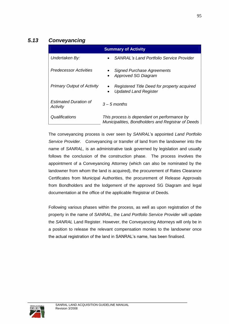
SANRAL LAND ACQUISITION GUIDELINE MANUAL Revision 3/2008
95
5.13 Conveyancing
Summary of Activity
Undertaken By: SANRAL’s Land Portfolio Service Provider
Predecessor Activities Signed Purchase Agreements
Approved SG Diagram
Primary Output of Activity Registered Title Deed for property acquired
Updated Land Register
Estimated Duration of Activity
3 – 5 months
Qualifications This process is dependant on performance by Municipalities, Bondholders and Registrar of Deeds
The conveyancing process is over seen by SANRAL’s appointed Land Portfolio
Service Provider. Conveyancing or transfer of land from the landowner into the
name of SANRAL, is an administrative task governed by legislation and usually
follows the conclusion of the construction phase. The process involves the
appointment of a Conveyancing Attorney (which can also be nominated by the
landowner from whom the land is acquired), the procurement of Rates Clearance
Certificates from Municipal Authorities, the procurement of Release Approvals
from Bondholders and the lodgement of the approved SG Diagram and legal
documentation at the office of the applicable Registrar of Deeds.
Following various phases within the process, as well as upon registration of the
property in the name of SANRAL, the Land Portfolio Service Provider will update
the SANRAL Land Register. However, the Conveyancing Attorneys will only be in
a position to release the relevant compensation monies to the landowner once
the actual registration of the land in SANRAL’s name, has been finalised.

SANRAL LAND ACQUISITION GUIDELINE MANUAL Revision 3/2008
96
6 TYPICAL PITFALLS ENCOUNTERED DURING THE ACQUISITION OF LAND
The typical pitfalls described in this section, are based on actual recorded cases.
Some of the information has been exaggerated slightly for illustration purposes,
as well as to elicit discussion. The typical pitfalls discussed hereunder are in no
way a comprehensive list of the mistakes that can be made during the process of
acquiring land, but should be considered as the most common and frequently
made mistakes that should be avoided. All attempts were also made to omit any
reference to any person or Company.
6.1 Acquiring land that has been developed
6.1.1 Improvements and Developments
In the example below, outdated aerial photography was used to generate line
mapping and a DTM for design purposes. This particular case involved the
acquisition of land (Depicted in blue on the Aerial Photograph) for the purpose of
the realignment of a section of road in order to enhance its horizontal geometry.
A problem arose as at the time the aerial photograph was taken, the visible
structures were captured as uninhabited ruins. By the time the Valuers arrived
on site, the “ruins” had been converted into a Restaurant and residential homes.
A windmill on the land to be acquired had been declared as a National Heritage
Site and had been renovated to serve as a tourist attraction. Although the
Contractor was already established on site, a re-design had to be done and a
particularly onerous negotiation with the landowner had to be entered into.

SANRAL LAND ACQUISITION GUIDELINE MANUAL Revision 3/2008
97
Solution:
Always use up-to-date topographical or photogrammetric survey data for
the design. Should this be impractical, or not cost effective, the use of the
survey data shall be subject to its validation on site;
Identify and record the developments on land comprehensively during the
preparation of the Property Report. Improvements and other related items
that add value to property should be carefully considered during the design
phase of roads. Small improvements to a design can sometimes save
millions of Rands in compensation;
Alternative design solutions must be considered prior to the finalisation of
the acquisition process. This includes the compiling of a cost comparison
between alternatives; and
Farming units, developable land and industrial property are particularly
prone to large compensation amounts. Roads should be designed in such
a way to always minimizing the impact on the required and adjoining land.
6.1.2 Boreholes and other Water Sources
Photogrammetric and topographical survey will only
identify visible services and boreholes. Acquiring land
upon which a water source exists may seem trivial, but the
water source may well be the only available water source
on a farm. This may well have the effect that the whole
farm will have to be acquired or, alternatively, that very expensive drilling and
hydrological test will have to be performed in order
to replace the water source. Water sources are
also subject to statutory approvals from the
Department of Water Affairs and this process may,
in itself, result in delays in the acquisition of the
land. It is extremely important to ascertain the
amount drawn and frequency of use of any water
source, together with the details of its exact use.
Logically, a water source used for 5 cows will
obviously have less of an impact than a water source used for a few thousand
cattle. It will also be different if the water source is being used for irrigation
purposes and the type of crop being irrigated may also influence decisions.

SANRAL LAND ACQUISITION GUIDELINE MANUAL Revision 3/2008
98
Affecting water sources used by rural communities can also
have serious time implications on the finalising of the
acquisition process. The relocation of these water sources are
subject to approval processes involving several Authorities and
a new water source may have to be established before the
original water source can be destroyed.
Careful consideration should also be given to how a water source is to be
relocated or replaced. Provision can be made under the Construction costs, or
alternatively, compensation can be paid to the landowner. The choice of the
most appropriate mechanism must be based on time, costs and associated risks
(such as the liability to provide the same amount and quality of water). It is
advisable that this matter be addressed in the Property Report.
Solution:
Avoid if at all possible;
Identify and address the water sources comprehensively during the
preparation of the Property Report, including the method by which such
water source will be replaced or relocated;
Allow for more time in the acquisition process to obtain access to site.

SANRAL LAND ACQUISITION GUIDELINE MANUAL Revision 3/2008
99
6.1.3 Graves
The existence of graves on land that has to be
acquired, is not always established by visual
inspection alone. It is important to note that graves
are protected by law and requires that the acquisition
of the land on which the graves are located, have to
be negotiated not only with the registered landowner,
but also with the relatives of the deceased. Any of the parties may refuse to have
the graves relocated. However, the relocation of the graves have to be facilitated
by the Contractor responsible for the construction as the relocation of graves are
considered to be part of the relocation of existing services such as power lines
and water pipes.
The identification of relatives of the deceased is
sometimes also problematic an before one can
continue with the process, an advertisement to the
effect that the graves are to be relocated, have to be
published in local newspapers for a specific period of
time. The culture of the deceased may also require
that certain rituals need to be honoured. The relocation of graves will obviously
have time and cost implications. Experience has shown that the identification of
a suitable grave site to which the deceased can be relocated, is also problematic.
The relatives of the deceased and landowners are often not in agreement with
the proposed relocation sites. Provision for the costs relating to the relocation of
the graves, must also be made under the Construction Contract in order to
ensure the timeous relocation thereof.
Solution:
Avoid if at all possible.
Identify and record the existence of graves comprehensively during the
preparation of the Property Report, including the obtaining of contact details
of the relatives of the deceased.
Allow for the costs of relocating the graves under the Construction Contract.
Allow for sufficient time in the acquisition process to procure access to site

SANRAL LAND ACQUISITION GUIDELINE MANUAL Revision 3/2008
100
6.1.4 Mine Dumps and/or Mining Rights
Old Mine Dumps are often identified as a good source of material required for
construction purposes. However, it needs to be pointed out that in most of the
cases experienced to date, more than one Rights
Holder is involved which mean the acquisition of the
land and/or the material has to be negotiated with more
than one party. The acquisition is complex, time
consuming and sometimes even impossible.
With technological advancements in the mining industry, some of these mine
dumps are being re-worked and minerals are again being extracted from them.
In calculating the compensation for this material, cognisance of the potential and
best use of the material must be taken, which often
renders the acquisition very costly. The existence of
Mining Permits held by the Rights Holders, will also
require that compensation has to be paid for the material
and not only for the land.
In a case of alluvial diamond mining in the North West Province, it was found that
SANRAL were required to first stockpile the required material, where-after
allowance had to be made for the Rights Holders to “mine” the material for
alluvial diamonds and then stockpile the material some distance away on another
stockpile area, which had to be acquired in addition to the initial site. This had a
serious cost and time implication on the construction project.
Mining rights are seldom registered at the Registrar of Deeds and are mostly
registered in the Mining Commissioner’s Offices. The procurement of copies of
the relevant documentation is extremely difficult and
time consuming. Unfortunately, the exact nature and
details of the registered mining right are required in
order to determine not only the quantum of the
compensation payable, but also to whom such
compensation is payable.

SANRAL LAND ACQUISITION GUIDELINE MANUAL Revision 3/2008
101
Solution:
Avoid if at all possible.
Identify all Service Rights Holders during the preparation of the Property
Report, together with a clear indication of the processes and the duration
required to finalise the acquisition of the required land and/or material.
Identify any special conditions implied by the registered rights that may
require provisions to be made under the construction contract.
A preliminary valuation is required in order to do a cost comparison
between alternative material sources.
Allowance may have to be made for the cost of acquiring the material under
the Construction Contract.
Allow for additional time to conclude the acquisition process and to procure
access to site.
6.1.5 Planned Developments
Virtually every landowner has either planned or may suddenly start planning to
develop in one way or the other, the land that has to be acquired. With reference
to Item 5.11.2.1 (i) above, the potential and best use of required land must be
identified and hence, compensated for. This principle is subject to the provisos
that the potential and best use are -
financially feasible;
economically feasible;
practically feasible; and
legally feasible.
However, compensation in respect the potential and best use can only be
considered upon satisfaction of the above criteria. Therefore, the landowner has
to provide documentation, plans, all applicable statutory approvals, rezoning
approvals, etceteras, before the said compensation can be based thereon.
Direct quantifiable costs (such as planning costs and professional fees) will then
have to be considered as actual financial losses and landowners will have to be
duly reimbursed.

SANRAL LAND ACQUISITION GUIDELINE MANUAL Revision 3/2008
102
Solution:
Avoid developed or developable land if at all possible. Alternative design
solutions should be considered if the planned development has progressed
substantially.
Identify and address any planned developments comprehensively during
the preparation of the Property Report, including the procuring of all
relevant documentation and plans.
Allow for more time to finalise the acquisition process and to procure access
to site.
6.1.6 Informal Settlements and/or Illegal Occupation
Since 1994, in an effort to rectify tenure issues resulting from past discriminatory
laws, various Acts that bestow “informal rights” on various categories of people,
has been promulgated. It follows that
occupants on land that has to be acquired may
have rights which need to be taken into
account. The process to relocate these
occupants is dictated by legislation and is
extremely time consuming and costly. Legally
alternative accommodation has to be provided before even illegal occupants can
be relocated. The provision of alternative accommodation lies within the
competency of Local Municipal Authorities in conjunction with the Department of
Housing. In most instances, the Local Municipal Authorities have a waiting list for
the provision of what is commonly referred to as RDP houses. The only way
alternative accommodation can therefore be procured, is to register a housing
project specifically with the objective of relocating the illegal occupants, but this is
subject to obtaining the following:
Municipal and Department of Housing approvals and consent to fast track
the housing development application and the implementation thereof.
Securing a budget allocation for the housing project.
Securing land on which the housing development project can be
established.
The appointment of a professional team for the design of bulk services and
reticulation within the housing development scheme.

SANRAL LAND ACQUISITION GUIDELINE MANUAL Revision 3/2008
103
The undertaking of, and lodgement of Environmental Impact Assessments.
The appointment of a Developer and Contractors for construction.
Whilst the availability of “off-the-shelf” housing project proposals within the
specific Municipal Authority may speed up some of these processes, the
provision of alternative accommodation may take a long period to complete and
SANRAL will be required to bear the actual relocation costs (including transport
and labour).
Solution:
Avoid such areas where ever possible. If it can not be avoided, SANRAL
should be notified immediately of the existence of the occupants and
informal rights holders.
Identify and record all occupants on the affected land comprehensively
during the preparation of the Property Report, including the identification of
possible alternative accommodation if the land is occupied illegally.
Allow for substantially more time to finalise the acquisition process and to
conclude access to site.
6.1.7 Old Borrow Pits
Sources of material required for construction purposes, are scarce and with the
ever increasing demand to complete design processes in a shorter period of time,
Consulting Engineers often revert to previously identified or existing provincial or
municipal material sources instead of identifying new borrow pit and quarry sites.
Often, a new borrow pit or quarry is designed to be directly adjacent to an old
municipal or provincial material source. Whilst this approach certainly expedites
the identification of a material source, the following must be noted:
Notwithstanding any practises of the past, current laws stipulate that
materials may not be sold unless the landowner is in possession of a permit
which confers upon him or her the right to the minerals or materials that are
required for road building purposes. However, it has been found that in the
past, other Authorities who had a disregard for the above mentioned
legislation, had incorrectly compensated several landowners for material
per cubic meter. As SANRAL can not deviate from what is legally correct, it

SANRAL LAND ACQUISITION GUIDELINE MANUAL Revision 3/2008
104
may be quite possible that a landowner, who has previously been paid per
cubic meter, will refuse to accept the compensation offered in accordance
with the correct formulas. This may then result in SANRAL having to revert
to expropriation of the required land in order to obtain access to the
required material.
The rehabilitation of the old material source will most likely be attached as a
condition imposed by the relevant landowner, or a requirement in the
approval of the EIA or EMP to be issued by the Department of Mineral and
Energy Affairs.
If it so happens that rehabilitation of a previously mined material source is a
condition or requirement relating to the approval for the further mining of the
source, or other improvements or rights (such as a water source) are
attached to the affected land, it may be difficult or very costly to reinstate
these rights, or may even render the source uneconomical.
If any material is to be mined from the old material source, the required area
within the old material source must be included within the defined
boundaries of the new borrow pit or quarry. However, in such instances the
rights of other Rights Holder may be affected and the intended acquisition
will also have to be negotiated with third parties to whom compensation
may also have to be paid.
Solution:
Ensure that the basis for compensation is complyant to relevant legislation.
Identify and address the rehabilitation of the old material source, as well as
the current and future use thereof, in the Property Report.
Provide for the rehabilitation of the old material source under the
construction contract.
Should a previously mined borrow pit or quarry be required for further
mining, the consent of the relevant Authorities and also (where applicable)
the holders of rights to the material in the borrow pit or quarry, should be
sought. All relevant information pertaining to the contract details and
processes to be followed, must be recorded in the Property Report.

SANRAL LAND ACQUISITION GUIDELINE MANUAL Revision 3/2008
105
6.2 Acquiring land within a Sectional Title Scheme
When land that is subject to sectional title is to be acquired, it must be borne in
mind that the Body Corporate is, in terms of law, the juristic person with whom
the acquisition is to be negotiated. However, a Body Corporate is not able to
conclude a land transaction without it having been referred to and approved by
all the owners of the relevant sectional titles during a Special General Meeting
that was called specifically for the purpose of considering the said transaction.
This (more often than not) either substantially prolongs the period required to
finalise the required land acquisition, or simply makes it impossible to conclude.
Solution:
Avoid such land if at all possible. The more sectional title holders own
rights within the property, the longer it will take to conclude the acquisition.
Obtain all information concerning contact details of the Body Corporate,
ascertain the number of sectional title holders and an indication of the
improvements, as well as other rights that the Body Corporate or specific
sectional title holders may hold and include same in the Property Report.
6.3 Acquiring State Owned Land
As was referred to in Item 3.2.3 above, the difficulty in acquiring State owned
land lies in the time it takes to alienate land owned by the State as very lengthy
approval procedures are involved. In terms of the Constitution of the Republic of
South Africa, 1996 (Act 108 of 1996), land also needs to be “vested” (i.e. to
confer the right to a specific property) in a specific State Department or Entity
before it can be alienated. The first problem lies in the identification of the actual
User Department of the affected land and the obtaining of their approval for the
acquisition of the land. Where vesting has not taken place, this process must first
be completed before a decision can be made or approval can be granted for the
alienation of the land. This is a very lengthy procedure that must go through the
various Land Disposal Committees. The Minister of the Department of Land
Affairs needs to sign a Section 28(1) Certificate in order to give effect to the said
vesting. This in itself, is an extremely lengthy process. Designers are well
advised to be mindful of this and to avoid such land if at all possible.

SANRAL LAND ACQUISITION GUIDELINE MANUAL Revision 3/2008
106
If this is not possible, the current or intended use of the affected land needs to be
established and taken into account, especially as projects initiated by
Government in the interest of the public good, or to give effect to legislation or
Government goals, could negatively impact on the availability of the land.
Specific care should especially be taken where land is used or earmarked for the
following:
Land Reform;
Land Reform for Agricultural Development (LRAD);
Housing projects;
Defence or Police Services;
Research (including land belonging to the Agricultural Research Council);
Schools
In the case of Municipal owned land, it must be noted that the Municipal Officials
must firstly obtain a Council Resolution whereby permission is granted that the
land in question can be alienated and the necessary authority is delegated to a
specific official (normally the Municipal Manager) to negotiate the compensation
and sign the relevant Acquisition Documentation on behalf of the Council.
Experience has shown that this can be a lengthy process and a lot of time is
taken before negotiations are concluded.
Solution:
Avoid such land where-ever possible. If it can not be avoided, SANRAL
should be notified immediately that some form of State owned land is
affected with full details of the relevant Authorities that will be involved in the
land acquisition process.
Provide full details of the relevant processes that have to be followed during
the acquisition of the land, in the Property Report, including contact details
of all personnel from the relevant Authorities that may be involved with the
afore-mentioned processes.
Allow for substantially more time to finalise the acquisition process and to
conclude negotiations to obtain access to site.

SANRAL LAND ACQUISITION GUIDELINE MANUAL Revision 3/2008
107
6.3.1 Acquiring land under Tribal Control
As was mentioned in Item 3.2.4 above, there is often a lack of legal clarity,
overlapping laws and procedures and general legal confusion in areas under
tribal control. This is mainly due to the complexity of the procedures to be
followed and lack of clear demarcation of responsibilities that exist in these areas.
Therefore, Consulting Engineers should as far as possible, not include tribal land
as part of their design. The Consulting Engineer should pre-warn SANRAL to set
measures in place to acquire such land if it is required. Furthermore, Consulting
Engineers should ensure that their design proposals are available well in
advance in order to allow for sufficient time in which the various legally required
meetings with the Department of Land Affairs, the Traditional Leadership, the
Community and the affected persons can take place. Provided that cadastral
information, etceteras is available, the acquisition of Tribal Land takes at least
twelve to 18 months to finalise. Acquiring this type of land can seriously hamper
construction works as vacant possession cannot be given to a Contractor before
all formalities have been not been concluded.
Solution:
Avoid Tribal owned land where-ever possible. If it can not be avoided,
SANRAL should be notified immediately that such land is affected and full
details of the relevant Authorities involved, must be provided.
Provide full details of all processes that must be followed, in the Property
Report. Contact details of all the responsible officials from the relevant
Authorities that are involved with the processes, must be provided where
possible.
Allow for substantially more time within which the acquisition process can
be conclude and access to site can be arranged.

SANRAL LAND ACQUISITION GUIDELINE MANUAL Revision 3/2008
108
6.4 Acquiring land without Access
6.4.1 Land severed without Access
As stated in Item 5.4.6 above, due care and diligence must be exercised by the
Consulting Engineer to ensure that all land parcels adjacent to the national road,
can obtain access from either the relevant national road, or a provincial or
municipal road or by way of a registered right-of-way servitude. Failure to
address access to properties during the design phase, will delay construction
until the relevant acquisition negotiations are completed.
It is again be reiterated that the Surveyor General will not approve any sub-
division of land without satisfying himself that sufficient access is provided to
each property being sub-divided.
Solution:
Address access issues to all land parcels along the national route, during
the design phase.
Validate access designs in collaboration with the affected landowners and
record all agreements or conditions agreed to, or problems identified, in the
Property Report.
6.4.2 Acquiring Borrow Pits or Quarry Sites without Access
With reference to Items 5.4.3 and 5.4.5 above, it is imperative that access is
provided to each Borrow Pit or Quarry. The existence of an existing access road
does not necessarily mean that the said access road does not have to be
acquired. The only time an access road does not have to be acquired, will be
when a Borrow Pit is directly adjacent a National or Provincial Road and access
can be obtained to the Borrow Pit directly from the road reserve of the said
National or Provincial Road.
The use of an existing farm road to obtain access to the required site, must be
discussed with the relevant landowner(s). It is important to note that the right to
use the access road for a specific period of time, will still have to be acquired by
SANRAL thereby providing the Contractor with a legal right to use the access

SANRAL LAND ACQUISITION GUIDELINE MANUAL Revision 3/2008
109
road. Matters pertaining to the fencing of the access road, access control, dust
control, maintenance activities, frequency of use and (if applicable) rehabilitation
of the road by the Contractor, must be agreed upon between the Consulting
Engineer and the landowner(s). In the majority of cases where existing access
roads have been identified to provide access to borrow pits, compensation had to
be paid for direct losses incurred by the landowner due to the haulage of material
across farm access roads as such access roads were key to the agricultural
activities on the property.
Solution:
Ensure that access is provided to each material source. If uncertain,
contact SANRAL or its Service Providers for clarification.
Validate the access designs and evaluate the location thereof in
collaboration with the landowners and record all findings and agreements
during the Property Report phase.
6.4.3 Acquiring Borrow Pits or Quarry Sites with access over
adjacent property (different landowner)
Whilst it may make sense from an engineering and cost perspective to align
haulage roads across two or more cadastral boundaries, experience has proven
this to be problematic. It is difficult to facilitate agreement between adjacent
landowners on the alignment of these haulage roads as what may seem like a
perfect solution for one landowner, may affect another landowner detrimentally.
The alignment of access roads across cadastral boundaries, requires the
preparation of an acquisition plan and documentation for each affected property,
thereby increasing the lead time in the preparatory phases before the land
acquisition can be negotiated and concluded.
Solution:
Avoid aligning haulage roads across two or more cadastral boundaries if at
all possible.
Validate the access designs and evaluate the location thereof in
collaboration with the affected landowners and record all agreements or
identified problems in the Property Report.

SANRAL LAND ACQUISITION GUIDELINE MANUAL Revision 3/2008
110
6.4.4 Acquiring an Inappropriate or Unfeasible Access Road
In the example below, an access road to a Borrow Pit was designed using the
existing farm access (depicted in blue). During negotiations the landowner (rightly
so) insisted that compensation for the relocation of his house and the provision of
new accesses to his new house and other affected infrastructure, should be
included as direct losses resulting from the land acquisition. Further
investigations revealed the existence of another existing access road (which is
depicted in red) to the said borrow pit. This access had much less impact on the
landowner and his agricultural activities and was also substantially shorter in
distance for haulage purposes. Consequently the alternative access road had to
be surveyed, new acquisition plans had to be drafted and revised acquisition
documentation had to be prepared before the negotiations could be concluded
and access to site could be obtained. All of which resulted in a substantial and
unwanted delay in accessing the site.
In the second example below, a short access road (indicated in red) was
designed to a borrow pit in fairly a straight line directly from the existing national
road. During the acquisition negotiations, the landowner pointed out that the
proposed access road traverses over extremely difficult topography, including a
very steep ridge. Following investigations and cost estimations to cut through
this ridge in order to construct the haul road, the access road had to be re-aligned
to a new position. The alternative access road had to be firstly surveyed, new
acquisition plans had to be drafted, and revised acquisition documentation had to
be prepared before the negotiations could be concluded and access to site
obtained.

SANRAL LAND ACQUISITION GUIDELINE MANUAL Revision 3/2008
111
The above two scenarios both resulted directly from the fact that the initial access
roads were designed as part of desktop exercises without site visits having been
undertaken.
Solution:
Validate the access design in the field and establish the location thereof in
collaboration with the landowners and record all agreements or findings in
the Property Report.
6.5 Acquiring land without prior or proper technical consultation with landowners
Whilst the risks associated with not having any or proper technical consultations
with affected landowners, are appropriately addressed in the Items dealing with
the preparation by the Consulting Engineers of a Property Report, it can not be
overemphasized that failure to consult with all affected landowners during the
design phase, will result in time delays in securing access to site. Experience
has shown that in most instances where problems were experienced in acquiring
land within the allotted time, the problems could have been addressed by either
alternative design solutions, or provisions within the design at a very early stage.
Alternatively the delays could have been minimised by proactive identification of
such problems.
Solution:
Address all technical issues comprehensively within the Property Report
during the design phase.
Consult with landowners in detail concerning the proposed design.

SANRAL LAND ACQUISITION GUIDELINE MANUAL Revision 3/2008
112
6.6 Inappropriate Quality Control re the respective design components dealt with by different role players within a Consulting Engineering Joint Venture
More often than not, the geometric design is divided amongst partners in a
Consulting Engineering Joint Venture. Without stating the obvious, sufficient
control over the design is required to ensure the exact integration of all design
components with one another. The submission of the design data in batches
over a period of time, hampers the identification of possible errors in the design,
such as data sets not aligning with one another (see example below). A vast
amount of work is consequently processed before these errors are identified.
This will result in a duplication of work, which obviously has a time and cost
implication, as well as a detrimental affect on the entire land acquisition process.
Solution:
Ensure sufficient control over the integration of design data sets prior to
same being submitted to SANRAL’s Service Providers.
Example of Design Data Sets submitted by different Consulting Engineers in Joint
Venture, but they were not properly integrated with each other as a whole.

SANRAL LAND ACQUISITION GUIDELINE MANUAL Revision 3/2008
113
6.7 Acquiring land without any or proper Cadastral Boundary Consideration
6.7.1 Cadastral “Islands”
The example below illustrates the acquisition requirement defined by Consulting
Engineers for an at-grade intersection between a national and provincial road.
An “island” (labelled “B” and depicted in red) is enclosed within the area to be
acquired (labelled “A” and depicted in green), but excluded from the acquisition
requirement. The problem is that apart from the creation of an area which can
not be accessed for any maintenance activities by the Provincial Authority, the
Surveyor General will not approve the sub-division of land. The required land will
therefore not be transferable into SANRAL’s name.
Solution:
Avoid the creation of “islands” (land-locked parcels) that are excluded from
the land acquisition requirement;

SANRAL LAND ACQUISITION GUIDELINE MANUAL Revision 3/2008
114
6.7.2 Acquiring Borrow Pits or Quarries across Cadastral Boundary
Due cognisance has been taken of the fact that (in many areas) sources for the
obtaining of road building material, are scarce. However, the risk in designing
Borrow Pits or Quarries across cadastral boundaries, lies in the fact that
negotiations need to be concluded with more than one landowner. Any one of the
affected landowners may refuse to agree to the terms of the proposed temporary
acquisition. Practical concerns (such as the specific impact, access control and
security on each of the affected properties) also need to be taken into
consideration. This approach also duplicates the effort and time required to
secure access to the required site.
As existing fences are not always erected on the exact cadastral boundaries, a
practical arrangement in this regard would be to refer the designed borrow pit
boundaries to SANRAL’s Survey Service Provider for consideration in terms of
the cadastral boundaries and to (if possible) amend the designed boundaries to
ensure that the entire required area falls within the cadastral boundaries of one
property.
Solution:
Avoid encroaching on cadastral boundaries if at all possible.
Consider Cadastral Boundaries when designing/determining Borrow Pit and
Quarry boundaries.
If it can not be avoided, the matter should be addressed comprehensively in
the Property Report and any potential problems that may be experienced
during the acquisition process, must be highlighted. Sufficient time should
be allowed to finalise the acquisition process.
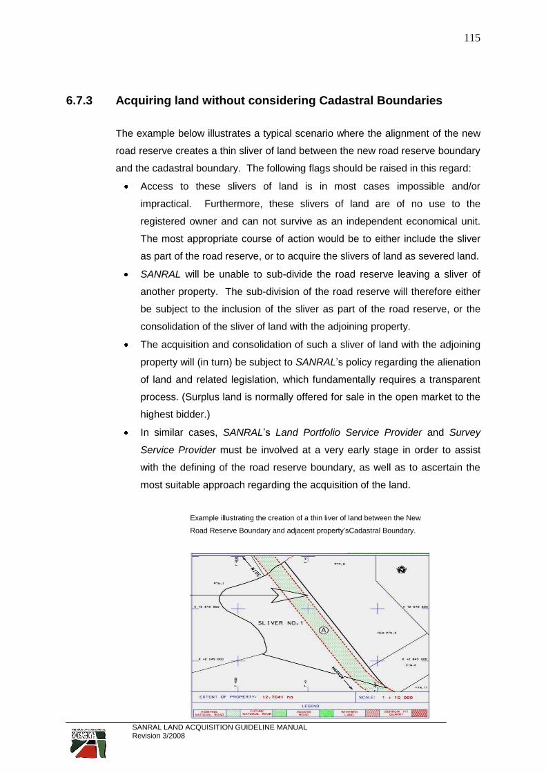
SANRAL LAND ACQUISITION GUIDELINE MANUAL Revision 3/2008
115
6.7.3 Acquiring land without considering Cadastral Boundaries
The example below illustrates a typical scenario where the alignment of the new
road reserve creates a thin sliver of land between the new road reserve boundary
and the cadastral boundary. The following flags should be raised in this regard:
Access to these slivers of land is in most cases impossible and/or
impractical. Furthermore, these slivers of land are of no use to the
registered owner and can not survive as an independent economical unit.
The most appropriate course of action would be to either include the sliver
as part of the road reserve, or to acquire the slivers of land as severed land.
SANRAL will be unable to sub-divide the road reserve leaving a sliver of
another property. The sub-division of the road reserve will therefore either
be subject to the inclusion of the sliver as part of the road reserve, or the
consolidation of the sliver of land with the adjoining property.
The acquisition and consolidation of such a sliver of land with the adjoining
property will (in turn) be subject to SANRAL’s policy regarding the alienation
of land and related legislation, which fundamentally requires a transparent
process. (Surplus land is normally offered for sale in the open market to the
highest bidder.)
In similar cases, SANRAL’s Land Portfolio Service Provider and Survey
Service Provider must be involved at a very early stage in order to assist
with the defining of the road reserve boundary, as well as to ascertain the
most suitable approach regarding the acquisition of the land.
Example illustrating the creation of a thin liver of land between the New
Road Reserve Boundary and adjacent property’sCadastral Boundary.

SANRAL LAND ACQUISITION GUIDELINE MANUAL Revision 3/2008
116
In the next example an Access Road is required to a borrow pit. The design of
the Access Road is of such a nature that it traverses twelve different properties.
It follows that the effort (and hence the risk, costs and time) required to acquire
the right to use the affected land is multiplied twelvefold. This particular problem
arose from the fact that the cadastral boundaries were not fenced in accordance
to the registered cadastral boundaries.
Example illustrating an Access Road that traverses many Properties.
Solution:
Avoid this situation if at all possible.
If it can not be avoided, the definition of the new road reserve boundary
should be determined in conjunction with SANRAL’s Survey Service
Provider and Land Portfolio Service Provider and the matter should be
addressed comprehensively in the Property Report. Any anticipated
problems that may be encountered during the acquisition process, must
also be identified.
Allow for more time to finalise the acquisition of the right to use the required
land.

SANRAL LAND ACQUISITION GUIDELINE MANUAL Revision 3/2008
117
6.8 Using the incorrect Survey Projection Datum
Problems being experienced in this regard, are mostly ascribed to -
inadequate communication between Joint Venture partners regarding the
engineering design parameters;
the use of outdated survey data that is not transformed from Cape Datum
(Clark 1880) to WGS 84 Datum;
the use of As-built data which is still in Cape Datum;
incorrect recording or omitting to record the Survey Projection Datum on
the design data being submitted; and/or
not compliance with the specifications relating to the sub-mission of design
data (see Item 5.6.1 above).
The submission of the design data in batches prevents the identification of
possible errors due to the design data being on different Survey Projection
Datum. The result hereof is that a vast amount of work can potentially be
processed before these errors are identified and this could have a huge time
wasting and cost implication.
Example illustrating the use of incorrect Survey Projection Datum.

SANRAL LAND ACQUISITION GUIDELINE MANUAL Revision 3/2008
118
Solution:
Avoid using the old Cape Datum as far as it is possible.
If Cape Datum (Clark 1880) is used on a project for whatever reason,
SANRAL and its Service Providers must be informed in writing at the outset
of the project.
All survey data and design data must reflect the Survey Projection Datum,
which must be notated in the correct manner.
6.9 Placement of Borrow Pit or Quarry Boundaries in relation to Land Use on the property as a whole
The example below serves to inform Consulting Engineers that the designs of the
boundaries of borrow pits and quarries must minimise the impact on the
remainder of the property (such as locating a borrow pit in such a way to render
large parcels inaccessible for agricultural activities). Failure to take this into
consideration will result in high compensation in as afar as financial losses are
concerned. It is imperative that whilst preparing the Property Report, the location
of the borrow pit is assessed in collaboration with the landowner in order to
identify, address and minimise the impact thereof on the remaining property.
Example illustrating the incorrect placement of Borrow Pit/Quarry boundaries

SANRAL LAND ACQUISITION GUIDELINE MANUAL Revision 3/2008
119
Solution:
Carefully consider the placement of a borrow pit or quarry in relation to the
property as a whole, including access to portions of property directly
adjacent to the proposed site;
Validate the access provisions and evaluate the location of the borrow pit or
quarry in collaboration with the landowners whilst preparing the Property
Report.

SANRAL LAND ACQUISITION GUIDELINE MANUAL Revision 3/2008
120
7 ANNEXURES
7.1 ANNEXURE 1: Flow Chart of the Land Acquisition Process

SANRAL LAND ACQUISITION GUIDELINE MANUAL Revision 3/2008
121

SANRAL LAND ACQUISITION GUIDELINE MANUAL Revision 3/2008
122

SANRAL LAND ACQUISITION GUIDELINE MANUAL Revision 3/2008
123

SANRAL LAND ACQUISITION GUIDELINE MANUAL Revision 3/2008
124

SANRAL LAND ACQUISITION GUIDELINE MANUAL Revision 3/2008
125
7.2 ANNEXURE 2: Extract of a Declaration done on Co-ordinates

SANRAL LAND ACQUISITION GUIDELINE MANUAL Revision 3/2008
126

SANRAL LAND ACQUISITION GUIDELINE MANUAL Revision 3/2008
127

SANRAL LAND ACQUISITION GUIDELINE MANUAL Revision 3/2008
128
7.3 ANNEXURE 3: Extract of a Declaration done on Description

SANRAL LAND ACQUISITION GUIDELINE MANUAL Revision 3/2008
129
7.4 ANNEXURE 4: Example of Acquisition Plans
7.4.1 Notes to Annexure 4A and 4B
1 Property case file number allocated by Land Portfolio Service Provider
2 Acquisition Key Plan number allocated by Survey Service Provider
3 Acquisition Plan Number. Unique to each land acquisition case. Number format G/2/066/13/1A in which G = Type of Acquisition, /2 = Route, /066 = District No, /13 = Property No on Route within specific District, and /1A = Plan & Revision No
Type of Acquisition: “G” = Borrow Pit or Quarry
“O” = Permanent Acquisition, Road Reserve
“DP”= Access Road
4 Route and Section Reference
5 Description of Construction Start and Termination point
6 Description of area to be acquired
7 Cadastral Property Description
8 Magisterial District name
9 Registered Landowner
10 SG Diagram No of property
11 Title Deed no of property
12 SANRAL Approval
13 Total Area to be acquired for purpose of Borrow pit
14 Total Area to be acquired for purpose of Access Road
15 Sketch indicating the area to be acquired in relation to the immediate cadastral boundaries. Sketch is to scale.
16 Size of affected property on which required land is situated as per Title Deed
17 Legend – Intended use of land to be acquired
18 Legend – Current land use of land to be acquired
19 Detail Description of area to be acquired. Details and sizes of each respective area to be provided. Also details with regard to previous acquisitions or expropriations to be stipulated here
20 Co-ordinates of all boundary points.
21 Inset on smaller scale to present details of acquisition to much smaller scale for ease of interpretation.
22 Reference to the Surveyor who drafted the Acquisition Plan

SANRAL LAND ACQUISITION GUIDELINE MANUAL Revision 3/2008
130
7.4.2 ANNEXURE 4A: Acquisition of a Borrow Pit
1 2 3
4 5
6
7
9
12
8
10
11
13 14
15
16
17

SANRAL LAND ACQUISITION GUIDELINE MANUAL Revision 3/2008
131
18
19
20
21
22

SANRAL LAND ACQUISITION GUIDELINE MANUAL Revision 3/2008
132
7.4.3 ANNEXURE 4B: Acquisition of additional road reserve for the upgrading of an existing National Road

SANRAL LAND ACQUISITION GUIDELINE MANUAL Revision 3/2008
133

SANRAL LAND ACQUISITION GUIDELINE MANUAL Revision 3/2008
134
7.5 ANNEXURE 5: Example of a Property Report

SANRAL LAND ACQUISITION GUIDELINE MANUAL Revision 3/2008
135
7.5.1 ANNEXURE 5A: Property Schedule Matrix
Case No
Land-Owner
No Property Intended Use
Type of Land
Zoning Type of
ownership Owner Contact Person
Contact Address
Contact Tel
1
1
Ptn 2 Kalkoenkrans
Road Widening
Private Agricultural Trust William Peter Du Plessis Familie Trust
W.P. Du Plessis PO Box 108, Theunissen, 9410
Tel (057) 212-2571 or Cell 0828211053
2 Temp. Deviation
3 Ptn 6 Kalkoenkrans Road Widening
Private Agricultural Company Gold Price Investments (Pty) Ltd W.P. Du Plessis PO Box 108, Theunissen, 9410
Tel (057) 212-2571 or Cell 0828211053
4
2
Hakkies 742 Borrowpit Private Agricultural CC Jan Blom Boerdery cc J.H. Blom PO Box 275, Virginia, 9430
Tel (057) 212-2875 or Cell 0828200183
5 Hakkies 742 Access Road Private Agricultural CC Jan Blom Boerdery cc J.H. Blom PO Box 275, Virginia, 9430
Tel (057) 212-2875 or Cell 0828200183
6
3
Ptn 16 Virginia 15 Road Widening
Private Agricultural Company Harmony Gold Mine (Pty) Ltd Gerrit Weideman PO Box 20, Welkom, 9460
Tel (057) 901-7046 or Cell 0726597030
7 Milo 639 Road Widening
Private Mining Company Harmony Gold Mine (Pty) Ltd Gerrit Weideman PO Box 20, Welkom, 9460
Tel (057) 901-7046 or Cell 0726597030

SANRAL LAND ACQUISITION GUIDELINE MANUAL Revision 3/2008
136
8 Milo 639 Access Road Private Mining Company Harmony Gold Mine (Pty) Ltd Gerrit Weideman PO Box 20, Welkom, 9460
Tel (057) 901-7046 or Cell 0726597030
9 Ptn 1 Tweepan 678 Road Widening
Private Mining Company Harmony Gold Mine (Pty) Ltd Gerrit Weideman PO Box 20, Welkom, 9460
Tel (057) 901-7046 or Cell 0726597030
10 4 Leeuwkop 277 Borrowpit Private Agricultural Private Owner
F.P.D. Jacobs F.P.D. Jacobs PO Box 243, Theunissen, 9410
Tel (016) 932-4125 or Cell 0829212520
11
5
Ptn 2 Doornrivier Access Road Private Agricultural Trust Mandalay Trust J.H. Oosthuizen PO Box 404, Virginia, 9430
Tel (057) 212-6179 or Cell 0836326900
12 Ptn 3 Doornrivier Road Widening
Private Agricultural Private Owner
J.H. Oosthuizen J.H. Oosthuizen PO Box 404, Virginia, 9430
Tel (057) 212-6179 or Cell 0836326900
13 6 Ptn 5 Doornrivier Road Widening
Private Agricultural Trust Promus Agricola Trust G.C. Saaiman PO Box 408, Virginia, 9430
Tel (057) 215-1233 or Cell 0833245231
14
7
Bloemhoek 509 Road Widening
Private Agricultural Trust B.J.G. Stadtlander Familie Trust B.J.G. Stadtlander PO Box 300, Virginia, 9430
Cell 0829009721
15 Bloemhoek 509 Temp. Deviation
Private Agricultural Trust B.J.G. Stadtlander Familie Trust B.J.G. Stadtlander PO Box 300, Virginia, 9430
Cell 0829009721
16 Ptn 1 Weltevreden 443
Interchange Private Agricultural Trust B.J.G. Stadtlander Familie Trust B.J.G. Stadtlander PO Box 300, Virginia, 9430
Cell 0829009721
17 Ptn 1 Weltevreden 443
Road Widening
Private Agricultural Trust B.J.G. Stadtlander Familie Trust B.J.G. Stadtlander PO Box 300, Virginia, 9430
Cell 0829009721

SANRAL LAND ACQUISITION GUIDELINE MANUAL Revision 3/2008
137
18 Ptn 1 Weltevreden 443
Temp. Deviation
Private Agricultural Trust B.J.G. Stadtlander Familie Trust B.J.G. Stadtlander PO Box 300, Virginia, 9430
Cell 0829009721
19 8 Weltevreden 443 Road Widening
Private Agricultural Trust Weltevrede Trust P.J. Pienaar PO Box 411, Virginia, 9430
Tel (057) 215-1228 or Cell 0825380962
20
9
Rem Doornrivier 330 Interchange Private Agricultural Private Owner
J.M. Human J.M. Human PO Box 1174, Virginia, 9430
Tel (057) 215-1222 or Cell 0823718993
21 Rem Doornrivier 330 Severed Land Private Agricultural Private Owner
J.M. Human J.M. Human PO Box 1174, Virginia, 9430
Tel (057) 215-1222 or Cell 0823718993
22 Rem Doornrivier 330 Severed Land Private Agricultural Private Owner
J.M. Human J.M. Human PO Box 1174, Virginia, 9430
Tel (057) 215-1222 or Cell 0823718993
23 10 Ptn 2 Bloemhoek Road Widening
Private Agricultural Trust Thabo Trust P. Nieman PO Box 412, Virginia, 9430
Tel (057) 215-1238 or Cell 0828231889
24 11 Rondehoek 200 Road Widening
Private Agricultural Trust Etland Trust H.J. Geldenhuys PO Box 275, Ventersburg, 9450
Cell 0834977527

SANRAL LAND ACQUISITION GUIDELINE MANUAL Revision 3/2008
138
7.5.2 ANNEXURE 5B: Property Report 1:50 000 Layout Drawing

SANRAL LAND ACQUISITION GUIDELINE MANUAL Revision 3/2008
139
7.5.3 ANNEXURE 5C: Property Report Design Drawings

SANRAL LAND ACQUISITION GUIDELINE MANUAL Revision 3/2008
140
7.5.4 ANNEXURE 5D: Property Report
PROPERTY REPORT
Property Description
(Insert property description)
Example - Portion 1 (a portion of Portion 35) of the Farm Kleinfontein 453 HS)
Portion 2 of Kalkoenkrans 225
(Insert province in which property is situated) Free State Province
(Insert size of full property in hectares)
856,5320 ha
(Insert Title Deed Number of property)
T001864/2003
Owner details
(Insert Owner name)
In the event of A natural person/s include identity number/s A Company include the company number, A Closed Corporation include the CC number A Trust, the Trust Number.
William Peter du Plessis Familie Trust
Private Land held under Trust
Trust No : TMP 3288
(Insert contact details of owner)
This should include physical address, postal address and telephone / cell phone numbers
Address:
PO Box 108 Theunissen 9410
Tel: -
Fax: (057)-212 2571 / (051)-446 4469
Cell: (082)-821 1053
(Insert name of representative)
Please indicate any representatives that should be contacted (mostly in the cases of companies, trusts and CC’s) and/or the legal representative (Attorney) of the landowner.
Mr William Peter du Plessis
ID No: 610205 5055 006
Type of Land
(Insert the type of land)
Please also refer to the guideline document for types of land - in this instance it is important to note if the property is Tribal Land, Unalienated State Land, Agriculture, Residential, Commercial, Mining etc as it may influence the compensation to be paid.
Private Land held under Trust
Current Land Use - Agricultural
(Insert the zoning of the land if available)
Agricultural

SANRAL LAND ACQUISITION GUIDELINE MANUAL Revision 3/2008
141
Required area and use
(Insert required area/size of property required) 0,404 ha
(Insert the use of which portion of property is required)
Example - road reserve, access road, borrow pit, quarry etc. In the event that more than one use is envisaged please indicate the required area/size for each use
Road Reserve
Drawing 21778/LA/10 = 0,103ha
Temporary bypass
Drawing 21778/LA/10 = 0,301ha
Total = 0,404ha
Improvement affected by acquisition
(Insert any and all improvement within the required area)
Please note that under this section improvements should not only be seen as structures but must also include such improvements as boreholes, electrical installations including sub terrainian installations any other movable improvements currently within the acquired area e.g. animal drinking troughs, borehole pumps etc. Also indicate the type of crops on the affected area if agricultural.
Improvements
Stock proof fence.
Type of crops
Maize.
Occupants
(Insert names and identity numbers of all occupants on the required area as well as the date from which they occupied the area)
Please be very meticulous as certain occupants may have rights in terms of various legislation of which the Extension of Security of Tenure Act is but one.
None.
Rights on property
(Insert any and all rights registered against the property) – This portion to be provided by Land Portfolio Service Provider
In this instance all rights registered against the Title Deed should be listed. This must also include any servitudes, Deeds of Restraints, Lease Agreements, Usufructuaries, Bonds, etc.
Servitude - Eskom.
Servitude - Sedibeng Water Pipeline.
Mining rights - Oryx Gold Holdings Limited
(Insert all rights suspected but not registered against the Title Deed)
In this instance the landowner must be interviewed to make sure that all other rights that may be applicable to the property are listed. Please be very meticulous in this regard and be especially vigilant as regards to mining rights or surface rights. Permits of whatsoever nature must also be indicated here.
The owner could not identify any such rights.

SANRAL LAND ACQUISITION GUIDELINE MANUAL Revision 3/2008
142
Access to property
(Insert a statement as to how access will be gained to the property)
In the event that access is negatively affected by the acquisition please indicate how access will be re-instated. Please indicate whether the access road has been discussed with the landowner and if the landowner is agreeable to such a solution. Also indicate whether the relevant Roads Authority has been contacted and approval been obtained if roads are re-aligned to ensure access.
Access will be gained at current access. Construction Contract to provide for upgrading work to Bell-mouth at current access.
Landowners request
(Insert the market value of the land that the landowner is requesting to be paid)
R6 000/ha - Ploughed fields (Dry lands)
(Insert any financial losses that the landowner is requesting as well as what such financial losses comprise of)
In this instance it is important to also note if the design of the road can be adjusted to minimise any of the financial losses that the landowner will experience.
None. No changes to be affected on design.
(Insert any further request that the landowner may have)
New fence to be erected before old fence is taken down.
Severed land
(Insert a statement if any land is severed or not) Property boundaries coincide with existing
road reserve. No land is severed.
(If severed, insert the approximate extent of land that is severed) Not applicable

SANRAL LAND ACQUISITION GUIDELINE MANUAL Revision 3/2008
143
7.5.5 ANNEXURE 5E: Signed Letter re Landowner’s Confirmation

SANRAL LAND ACQUISITION GUIDELINE MANUAL Revision 3/2008
144
7.5.6 ANNEXURE 5F: Supporting Documentation
WINDEED SEARCH

SANRAL LAND ACQUISITION GUIDELINE MANUAL Revision 3/2008
145

SANRAL LAND ACQUISITION GUIDELINE MANUAL Revision 3/2008
146

SANRAL LAND ACQUISITION GUIDELINE MANUAL Revision 3/2008
147
TITLE DEED

SANRAL LAND ACQUISITION GUIDELINE MANUAL Revision 3/2008
148

SANRAL LAND ACQUISITION GUIDELINE MANUAL Revision 3/2008
149

SANRAL LAND ACQUISITION GUIDELINE MANUAL Revision 3/2008
150

SANRAL LAND ACQUISITION GUIDELINE MANUAL Revision 3/2008
151

SANRAL LAND ACQUISITION GUIDELINE MANUAL Revision 3/2008
152
7.5.7 ANNEXURE 5G: Property Report Checklist

SANRAL LAND ACQUISITION GUIDELINE MANUAL Revision 3/2008
153

SANRAL LAND ACQUISITION GUIDELINE MANUAL Revision 3/2008
154

SANRAL LAND ACQUISITION GUIDELINE MANUAL Revision 3/2008
155
7.5.8 ANNEXURE 5H: Form LA 2A: Submission of Design Data FORM LA 2 A
FORMAT OF SUBMISSION OF DESIGN INFORMATION BY THE DESIGN ENGINEERS FOR THE COMPILATION OF LAND ACQUISITION PLANS
CONTRACT DESCRIPTION:
CONTRACT NO. NRA-R030-030-2007/1 : UPGRADE OF NATIONAL ROUTE R30 SECTION 3 BETWEEN BEATRIX MINE (km 18,1) AND VIRGINIA I/S (km 36,3) : PORTION 2 OF KALKOENKRANS 225
1 Engineering design layout plans (CAD drawings) to be submitted in DXF, DWG or DGN format together with the relevant grid (mark with )
Maximum of 40MB on a CD or 5MB by e-mail
DXF DWG DGN
4 Co-ordinates always to be supplied in WGS 84 for borrow pits and quarries and also for existing or new access roads to borrow pits and quarries.
Yes N/A If not, give reason:
5 Locality plan for all acquisition areas to be depicted on a 1:50 000 topographical map.
Yes If not, give reason:
6 Date of commencement of the construction Date: November 2008
7 Owners’ details supplied on separate sheets (mark with )
Yes No
Owners of affected properties and contact details
to be supplied in the following format:
(Complete separate page for each owner)
Name and Surname
Tel nr. None
Fax nr.
E-mail address None
Postal address
Mobile nr.
Improvements on required
land not shown on the topographical mapping
N/A
8 One set of all above-mentioned documents be submitted to:
Submitted to: Date submitted
The SANRAL Regional Office (in PDF format)
18/04/2008
MANCO JV (in DXF, DWG or DGN format)
18/04/2008
Hermans & Roman (in PDF format)
18/04/2008
CS Massel (in PDF format)
18/04/2008
2 Design layout plans (CAD drawings) to be submitted on the same datum or system as the topographical mapping (Cape Datum or WGS 84 System) (mark with )
Cape
Datum
WGS
System
3 Cadastral boundaries as a layer of the design
to be supplied for affected properties. (Applicable for road design, borrow pits and quarries)
Yes If not, give reason:

SANRAL LAND ACQUISITION GUIDELINE MANUAL Revision 3/2008
156
7.6 ANNEXURE 6: Pro Forma Documentation
7.6.1 ANNEXURE 6A: Letter requesting Landowner’s Confirmation
Engineers Letterhead Recipient Address P O Box 1234 City/Town Postal code Dear Sir/Madam CONTRACT (PROJECT NUMBER): CONSULTING ENGINEERING SERVICES
FOR (PROJECT DESCRIPTION)
(INSERT PROPERTY DESCRIPTION): INFORMATION, PERMISSION TO
ACCESS AN UNDERTAKING FOR FUTURE NEGOTIATIONS
(Company name) have been appointed by the South African National Roads Agency
Limited (SANRAL) for the construction / upgrading / rehabilitation / (Delete as
necessary) of the section of national road between (Insert Description) and (Insert
Description). This project inter alia includes the engineering assessment of gravel
pits and stone quarry material sources for the rehabilitation of the project. At the
moment it is planned that the construction of the work will commence in the year
(Insert year) for a period (Insert period), for completion in (Insert year of completion).
For the planned construction, certain section/s of land on the farm (Insert farm name)
has been identified for permanent and/or temporary acquisition. In order to facilitate
the process for the acquisition of the land, we please require the information
indicated on the attached form, from you.
We thank you for your co-operation in this matter.
Yours sincerely
_________________ Signature of Engineer

SANRAL LAND ACQUISITION GUIDELINE MANUAL Revision 3/2008
157
TO WHOM IT MAY CONCERN
Description of Property:…………………………………………………………………..
1. I, (Insert name of owner) being the owner/ duly authorized representative of
the owner herewith agree to the proposed acquisition of my property by the
SANRAL subject to
a) Fair market value be paid for the land in question
b) Direct financial losses be paid that comprise of:
………………………………………….
……………………………………………
……………………………………………
…………………………………………….
c) The following further conditions:
………………………………………………..
………………………………………………..
…………………………………………………
2 I also acknowledge that the proposed design has been discussed with myself
and that the design is acceptable to myself/the following design changes be
considered to mitigate the following:
…………………………………………………….
……………………………………………………….
………………………………………………………..
…………………………………………………………

SANRAL LAND ACQUISITION GUIDELINE MANUAL Revision 3/2008
158
3. I hereby certify that I will in future be willing to enter into a negotiation process
with SANRAL, or its designated representative, for obtaining the right and
reasonable compensation for the area and/or road building material as may
be required. With this I do not certify that I will accept any
price/compensation, but only that I will be willing to enter into a negotiation
process in this regard.
Thus done and signed at ………………… on this….. day of …………..
………………………….. ………………………… …………………….
Signature of Landowner Signature of Engineer Signature of Valuer

SANRAL LAND ACQUISITION GUIDELINE MANUAL Revision 3/2008
159
7.6.2 ANNEXURE 6B: Property Report Checklist
Note: Only one (1) Checklist, duly signed by the indicated persons, is
required per project.
CONTRACT DESCRIPTION:
CHECKLIST
ITEM YES NO
Has the project been incorporated into the LAC
programme by means of registering it through
SANRAL with the submission of Form LA1 (Refer
Annexure 6C)
Has all required information been submitted in the
formats specified in this Guideline Manual?
Have all the landowners who are affected been
contacted and the Letters of Landowner’s
Confirmation (Refer Annexure 6A) been signed by
the Landowners?
If yes to the above, have the landowners’
suggestions or problems been addressed through
the design?
Are all information and data for the Property Report
submitted in accordance the Land Acquisition
Guideline Manual, Item 5.5.11
Does the design follow cadastral boundaries as far
as possible?
If an existing road is involved - has the definition of
the road reserve boundary been procured from the
Survey Service Provider?

SANRAL LAND ACQUISITION GUIDELINE MANUAL Revision 3/2008
160
ITEM YES NO
Has the contact details (including physical address,
postal address, telephone numbers and cellular
numbers) of all landowners been provided?
Has the land to be acquired been differentiated in
accordance the type of ownership (refer item 5.5.3)
held of such land?
If yes to the above, has the time allowance for the
acquisition of State owned land, Transnet and
SARCC land, Un-alienated State land and Tribal land
been adjusted in conjunction with SANRAL and its
Service Providers?
If State owned land, Transnet and SARCC land, Un-
alienated State land and/or Tribal land needs to be
acquired, has an alternative design been considered
in order to minimize acquisition obstacles posed by
these different land types?
Has the existing use, as well as required use of each
of the land parcels which need to be acquired, been
captured in the Property Report?
Has all improvements affected by the acquisition of
land been identified and addressed by either re-
design, appropriate provision for remedial works
under the construction contract, and/or direct losses
minimised as far as possible?
Has an audit been done to ensure other real and
informal rights are taken into account?
If yes to the above, is the design of such a nature to
minimize acquisition obstacles posed by the different
real rights?
If an access road is involved, has the requisite roads
authority been approached and approval been
obtained? In the alternative, has the landowner been
approached and approval obtained for the alignment
of the access road?

SANRAL LAND ACQUISITION GUIDELINE MANUAL Revision 3/2008
161
ITEM YES NO
If borrow pits and quarries are required, have the
rights to minerals as dictated by Act 28 of 2002 been
sourced and taken into account?
Has the value of the land been taken into account
during the design of the road?
Has the extent of severed land been minimised
during design?
Is the placement of borrow pits and quarries been of
such a nature that it poses the least effect on
properties?
Has any agreement other than the property
acquisition been reached with any landowners, and if
so, has the relevant details been submitted to
SANRAL’s Land Portfolio Service Providers and the
Valuers?
Has the design been done taking into account the
least cost for SANRAL in acquiring the property?
Signed: Consulting Engineer Date
Signed: Land Portfolio Service Provider Date
Signed: Valuer Date

SANRAL LAND ACQUISITION GUIDELINE MANUAL Revision 3/2008
162
Signed: Survey Service Provider Date
Approved / Not Approved
Signed: SANRAL Project Manager Date

SANRAL LAND ACQUISITION GUIDELINE MANUAL Revision 3/2008
163
7.6.3 ANNEXURE 6C: Form LA 1
APPLICATION FOR THE ADDING OF NEW PROJECTS TO THE LAND ACQUISITION COMMITTEE PROGRAM ( LAC PROGRAM)
(To be completed by The SANRAL Regional Representative)
1 REGION: (Mark with “X”
Northern 1
Eastern 2
Southern 3
Western 4
2 REQUESTED BY: Regional Representative
Date that request is submitted to The SANRAL H/O
Date that request is submitted to Hermans & Roman and Manco
4 ROUTE NUMBER SECTION NUMBER
5 NOT A TOLL ROAD PROJECT TOLL ROAD PROJECT
6 PROJECT DESCRIPTION
From
To
7 SANRAL PROJECT ENGINEER
Contact details
Tel
Mobile
Fax
8 CONSULTING ENGINEERING FIRM:
Project Engineer:
Contact details
Tel
Mobile
Fax
9 SCOPE OF WORK (Tick relevant block below)
(Give short description)
“Green fields” (new alignment)
Rehabilitation
Other
9.1 Date on which design of SANRAL approved road reserve and access / secondary road, etc can be expected. (minimum of 9 months prior to site hand over date)
9.2 Land required for road reserve purposes
Estimated number of properties affected
Site handover date:
* Is list of affected properties attached?
YES
NO
3 THE SANRAL CONSTRUCTION PROJECT NUMBER

SANRAL LAND ACQUISITION GUIDELINE MANUAL Revision 3/2008
164
9.3 Date on which final co-ordinates of borrow pits / quarries can be expected (minimum of 9 months prior to site hand over date)
9.4 Land required for borrow pits / quarry sites
Estimated number of borrow pits / quarry sites
Estimated number of properties affected by borrow pits and quarry sites
Site handover date:
* Is list of affected properties attached?
YES
NO
Footnote: * List of affected properties to be attached if available

SANRAL LAND ACQUISITION GUIDELINE MANUAL Revision 3/2008
165
7.6.4 ANNEXURE 6D: Form LA 2
FORM LA 2
FORMAT OF SUBMISSION FOR DESIGN INFORMATION SUPPLIED BY THE DESIGN ENGINEERS FOR THE COMPILATION OF LAND ACQUISITION PLANS
CONTRACT DESCRIPTION:
PROPERTY DESCRIPTION
1 Engineering design layout plans (CAD drawings) to be submitted in DXF, DWG or DGN format together with the relevant grid (mark with ) Maximum of 40MB on a CD or 5MB by e-mail
DXF DWG DGN
4 Co-ordinates always to be supplied in WGS 84 for borrow pits and quarries and also for existing or new access roads to borrow pits and quarries.
Yes
If not, give reason:
5 Locality plan for all acquisition areas to be depicted on a 1:50 000 topographical map.
Yes If not, give reason:
6 Date of commencement of the construction Date:
2 Design layout plans (CAD drawings) to be submitted on the same datum or system as the topographical mapping (Cape Datum or WGS 84 System) (mark with )
Cape
Datum
WGS
System
3 Cadastral boundaries as a layer of the design to be supplied for affected properties. (Applicable for road design, borrow pits and quarries)
Yes
If not, give reason:

SANRAL LAND ACQUISITION GUIDELINE MANUAL Revision 3/2008
166
7 Owners’ details supplied on separate sheets (mark with )
Yes No
Owners of affected properties and contact
details to be supplied in the following format:
(Complete separate page for each owner)
Name and Surname
Tel nr.
Fax nr.
E-mail address
Postal address
Mobile nr.
Improvements on required land not shown on the topographical mapping
8 One set of all above-mentioned documents be submitted in digital format to:
Submitted to: Date submitted
The SANRAL Regional Office (in PDF format)
MANCO JV (in DXF, DWG or DGN format)
Hermans & Roman (in PDF format)
CS Massel (in PDF format)
9 One set of all above-mentioned documents be submitted in hard copy format to:
Submitted to: Date submitted
The SANRAL Regional Office
MANCO JV
Hermans & Roman Property Sollutions
Ndlala Massels Valuation Services

SANRAL LAND ACQUISITION GUIDELINE MANUAL Revision 3/2008
167
- END -