A Sub-Scheme under AMRUT
10
1
Transcript of A Sub-Scheme under AMRUT

1

2
A Sub-Scheme under AMRUT
TITLE–Sub-Mission under AMRUT - Formulation of GIS-Based Master Plans for AMRUT Cities 1. OBJECTIVES The objective is to develop common digital geo-referenced base maps and land use maps using Geographical Information System (GIS) and Master Plan Formulation for500cities that are selected as AMRUT Cities. 2. RATIONALE Use of geospatial technologies is expected to contribute to AMRUT cities in the following ways: Formulate a master plan for decision-making; Effective land use management and utilization; Spatial growth management; Enable project planning and Urban management. These GIS-based Master Plans will help in different types of urban planning exercises, e.g. preparation of master plan, development plan, zonal plan, utility plan, infrastructure plan, etc. to be simplified by using IT tools. The National Remote Sensing Centre (NRSC) provides Q-GIS on Bhuvan Portal, which is open source software and tools to prepare different types of plans. This will be made available for all AMRUT cities on the Bhuvan Portal. 3. SCOPE AND COVERAGE AMRUT guidelines mandate this reform. The Reform envisages covering 500 Mission cities. The State Mission Directorates who are the implementing agency may prioritise and convey their decision regarding cities to be taken up. The priority may be given to cities which do not have master plans and those cities whose Master Plans are about to expire till 2021. 4. MAJOR DELIVERABLES The major deliverables are: 4.1 Base Map& Thematic Maps: Final base maps in the form of user-friendly spatial products at the functional scale of 1:4000 having defined layers as per Design & Standards. City /town base map and thematic maps including existing landuse map which is prerequisite for formulation of master plan and other plans. 4.2 Urban Database Creation: Sector-wise data collection and data analysis report of 25 aspects as per Design & Standards.
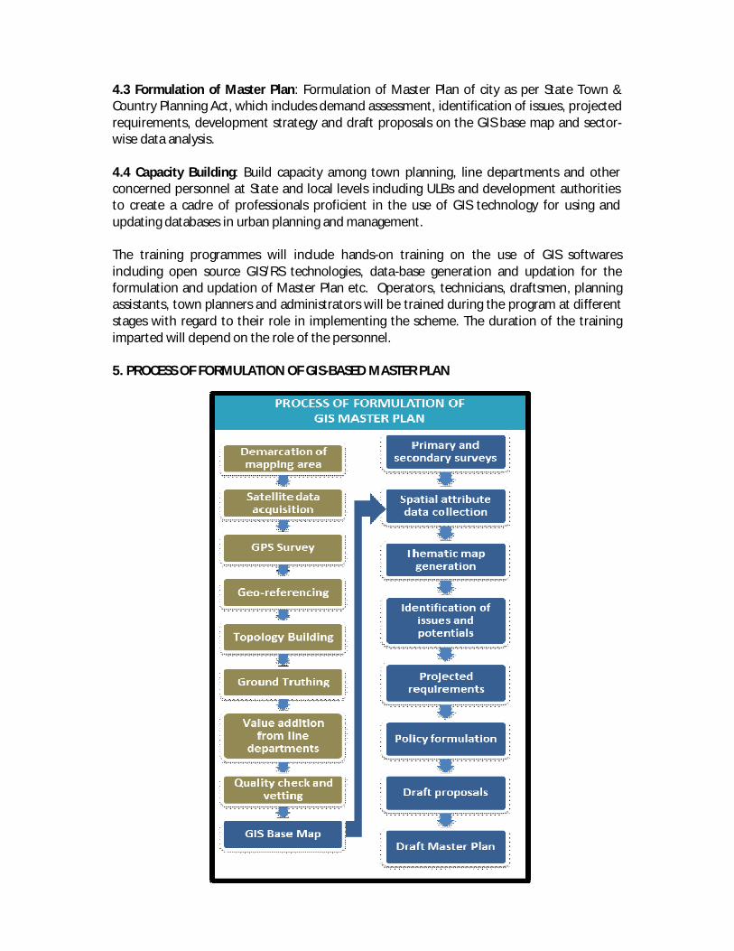
4.3 Formulation of Master Plan: Formulation of Master Plan of city as per State Town & Country Planning Act, which includes demand assessment, identification of issues, projected requirements, development strategy and draft proposals on the GIS base map and sector-wise data analysis. 4.4 Capacity Building: Build capacity among town planning, line departments and other concerned personnel at State and local levels including ULBs and development authorities to create a cadre of professionals proficient in the use of GIS technology for using and updating databases in urban planning and management. The training programmes will include hands-on training on the use of GIS softwares including open source GIS/RS technologies, data-base generation and updation for the formulation and updation of Master Plan etc. Operators, technicians, draftsmen, planning assistants, town planners and administrators will be trained during the program at different stages with regard to their role in implementing the scheme. The duration of the training imparted will depend on the role of the personnel. 5. PROCESS OF FORMULATION OF GIS-BASED MASTER PLAN

4
6. ROLES & RESPONSIBILITIES 6.1 Role of Central Government The MoUD/ Town and Country Planning Organization (TCPO) will monitor and coordinate the implementation of the scheme besides preparation of Design & Standards and model RFP documents etc. for States/Cities for procurement for consultancy services for the Master Plan Formulation component. MoUD will coordinate the satellite data acquisition and final base map preparation at 1:4000 scale will be undertaken by NRSC, Department of Space. 6.2 Role of State Government The AMRUT State Mission Directorate will be the nodal agency implementing the Reform at State level. The implementation will be by ULBs. The identification of priority AMRUT cities and demarcation of area of mapping will be done by respective State Mission Directorate in consultation with State Town Planning Departments and the ULB concerned. The first priority may be given to cities whose existing Master Plans are in force but the
validity is only till 2020 or earlier. For these cities, the new planning process may be already in motion and will be easier to integrate.
The state keeping in mind the size and importance of cities and the status of existing plans or lack of it may decide further priorities.
Ideally, the phasing should not go beyond three years to cover all AMRUT cities. The State Mission Directorate in association with State Town &Country Planning Departments/ ULBs will formulate the GIS based master/ development plans. The procurement of consultancy services for the master plan component (including spatial attribute data collection, urban data collection, and preparation of draft master plan document) will be done by State Mission Directorates in association with State Town & Country Planning Departments/ ULBs. The proposal has to be approved by SLTC and SHPSC as per AMRUT Guidelines and should be included in SAAP. 6.3 Role of Urban Local Bodies Urban Local Bodies will do urban database creation including sector-wise data collection and data analysis report. There is a 25 aspects format provided in the manual for Design & Standards prepared and circulated by the TCPO in August 2015. ULBs will also be responsible for the spatial attribute data collection and vetting of maps, in association with State Mission Directorates.

5
Once prepared, ULBs will have the mandate to put these GIS based maps to maximum use for planning, monitoring and other requirements. 7. TIMELINES Total time period for base map generation including data acquisition,geo-referencing, GPS Survey, data processing, ground truthing, generation of thematic layers, etc. as per Design &Standards for 500 cities would be 24 to 36 months. Time period for urban data collection, data analysis and master plan formulation up to draft proposal stage to be 24 months. The work will be undertaken in four steps. The details are as under:
Step No. of towns
Duration (Months)
Initiation of work
Activities
A. Base Map Generation Implementation Agency: NRSC
I 100 6 Mar 2016 Data acquisition, geo- referencing, GPS survey, data processing, ground truthing, generation of thematic layers
II 100 6 Sep 2016 III 150 6 Mar 2017 IV 150 6 Sep 2017
B. Master Plan Formulation Implementation Agency: State Mission Directorate in association with State Town Planning Departments and ULBs
I 100 24-36 Sep 2016 Attribute collection, vetting of maps, primary and secondary surveys, data collection and analysis, formulation of master plan
II 100 24-36 Mar 2017 III 150 24-36 Sept 2017 IV 150 24-36 Mar 2018
8. BUDGET ESTIMATE Ministry of Urban Development has worked out unit cost norms and estimated expenditure for supporting this activity for 500 AMRUT cities. These will be subject to approval by Apex Committee. As per the estimates,the total cost for five years to support this reform activity is estimated to be Rs. 515.00crores, of which geo-spatial database creation is about Rs. 115.90crores, cost of plan formulation including data collection & analysis is Rs. 388.25 crores and capacity building is Rs.10.85 crores. This will be met out of AMRUT funds under relevant heads including “Capacity Building and Reforms Support” resources. Funding will be provided by Government of India based on existing norms and unit costs set by the Apex Committee following AMRUT guidelines.

6
No separate budget head or scheme is proposed for this. The year wise budget allocation is estimated as under:
Sl. No. Year Budget (Rs. Cr)* 1 2016-17 100.00 2 2017-18 200.00 3 2018-19 215.00 4 Total 515.00
* Budget requirement is subject to the demand from the States.
The detailed cost estimates are at Annexure-1. 9. STRUCTURE OF FUND MANAGEMENT As per AMRUT Mission Statement and Guidelines, funds under AMRUT will be allocated by Ministry of Urban Development to States through the Apex Committee following the mission guidelines. There are three main steps for achieving this reform:
1. Geospatial Database Creation 2. Plan Formulation Component 3. Capacity Building Component
9.1 Funding for Geospatial Database Creation Ministry of Urban Development/ TCPO proposes to coordinate and facilitate procurement of satellite imagery including payments to NRSC (department of Space) on pro-rata basis for the extent of area mapped as proposed and required by State Governments, calculated on the basis of the cost provided by NRSC as given in Annexure-1. Alternatively, if the states require, the responsibility of procuring satellite imagery through NRSC may be done directly by them. The schedule of release of funds will be as per memorandum of understanding between states, MoUD and NRSC. 9.2 Funding for Plan Formulation Component The State Mission Directorate will manage the funds for GIS-based Master Plan Formulation for the plan formulation component. The exact quantum of funds to be sanctioned and released will depend upon the following: The total number of cities for which GIS-based Master Plan Formulation is being taken
up and approved by Apex Committee. Whether work is taken up by State Town & Country Department/ Development
Authority/ ULB or it is outsourced to a Consultant. If it is outsourced to Consultant, then the cost quoted by the Consultant and approved
by SHPSC/ SLTC will be applicable. The cost quoted by the Consultant should roughly conform to the pro-rata estimate given in Annexure-1.

7
The RFP document lays down a schedule of submission and approval of stage reports followed by fund release to the Consultant.
9.3 Funding for Capacity Building Component
The State Mission Directorate will manage the funds for GIS-based Master Plan Formulation for the capacity building component. The convergence with existing schemes for capacity building will be ensured. The pattern for fund sanction and release for capacity building component of the Reform will be as per the cost and Schedule of training proposed by the State Mission Directorate and approved by SHSPC/ SLTC under the overall framework for capacity building. No separate funds are being identified for this. 9.4 Fund Flow The Scheme envisages a pattern of release of funds wherein:
20% of the project cost will be released on approval of the SAAP,as an advance for data acquisition and collection of socio-economic data.
40% of the project cost forbase map & thematic map creation, vetting, and data analysis report.
Next 20% on submission of draft master plan and Final 20% installment on approval of final master plan Funds at every stage will be released subject to furnishing of the utilization
certificate and physical progress of deliverables duly reported by competent authority.
The State may specify the exact pattern of release of funds as per their requirements.
9.5 Admissible Components: Satellite data acquisition, data generation through primary, secondary and DGPS surveys, data analysis, value addition, vetting, capacity building and master plan formulation.
9.6 Inadmissible Components:Hardware &software, site development, wages & staff
component, furniture and fixtures. Further the funding under the Scheme shall not include any recurring costs.
10. REVIEW AND MONITORING MECHANISM Although, all the Reform activities under AMRUT are proposed to be reviewed on a regular basis, this particular reform will be monitored as follows: At State Level: State Level Technical Committee (SLTC) will oversee the progress of the technical
implementation of the Reform. State level High Powered Steering Committee (SHPSC) will look into overall coordination
and implementation of the Reform.

8
At Centre Level:
Periodic and detailed monitoring and review of the reform state-wise will be carried out by Space Technology Application Cell created at TCPO by MoUD.
The above said Cell will examine and submit its recommendations to a Monitoring and Review Committee. The composition of Monitoring and Review Committee is as under:
Chief Planner, TCPO Chairman Group Head, Urban Studies and Geo-informatics, NRSC Member Professor of Planning, School of Planning & Architecture, Delhi Member Town & Country Planner Member Town & Country Planner Member Convener
The Monitoring and Review Committee will report to the Technical Advisory Committee
under the Chairmanship of JS(UD) constituted vide order no. K-14011/2/2012-UCD (part) dated 17.03.2015, which will further report to Apex Committee of AMRUT.
The Apex Committee will monitor/ review overall progress and achievements and
address any inter-agency issues.
***

9
Annexure-1
A. Cost of Mapping at 1:4000 scale for 500 AMRUT Towns
Class No. of towns
Avg. Area of Town (sq. km.) #
Total Area (Sq. Km.)
Mapping Cost * (Rs. in Cr.)
Metro 53 500 26500 26.50 Class I 447 200 89400 89.40 Grand Total 500 115.90
* Cost includes satellite data acquisition, ortho-rectification and geospatial database creation and mapping at 1:4000 scale @Rs. 10000/- per sq. km (approx) as worked out by cost estimates committee of NRSC. # Actual area will be worked out by State Government for each town and accordingly cost will be calculated.
B. Cost of Plan Formulation using Geo-Spatial Database for 500 AMRUT Towns
Class No. of
towns
Plan Formulation Unit Cost (Rs. in lakh/town)*
Plan Formulation Total Cost
(Rs. in crore) Metro 53 100 53.00 Class I 447 75 335.25 Grand Total 500 388.25
As per the rates obtained from State Town Planning Departments
C. Cost of Capacity Building for 500 AMRUT Towns
Class No. of towns
Unit Cost of Capacity Building (Rs. in lakhs/town)
Cost (Rs. in crore)
Metro 53 5 2.65 Class I 447 2 8.94 Grand Total 500 10.85
Total Cost of Formulation of GIS based Master Plan for 500 AMRUT Towns
No. Component Cost (Rs. in crore) 1. Geospatial data creation at 1:4000 scale for 500
AMRUT towns 115.90
2. Plan Formulation using Geospatial database 388.25 3. Capacity Building 10.85
Grand Total 515.00

10
Formulation of GIS based Master Plan for AMRUT Cities
Timelines and Action Plan
BASE
MAP
PRE
PARA
TIO
N
Sl. No.
Activities Agency Responsible
Months Mar 2016
Apr 2016
May 2016
Jun 2016
Jul 2016
Aug 2016
Sep 2016
Oct 2016
Nov 2016
Dec 2016
Jan 2017
Feb 2017
1. Prioritisation of cities MD AMRUT/STPDs 2. Demarcation of area of mapping STPDs/NRSC 3. Procurement of Satellite Images/ Data acquisition TCPO/NRSC 4. Geo-referencing NRSC 5. Base map preparation from Satellite data NRSC 6. Topology building NRSC 7. Ground truthing and incorporation
Value addition from line departments NRSC/ STPDs
8. Quality Check NRSC 9. Draft map generation NRSC 10. Vetting of maps by State Governments STPDs/MD AMRUT 11. Final Map Delivery (Hard/Soft GIS Copy) NRSC
MAS
TER
PLA
N F
ORM
ULAI
ON
12. Finalization of RFPs for plan formulation STPDs/MD AMRUT 13. Tendering & outsourcing for plan formulation STPDs/MD AMRUT 14. Approval by SHPSC STPDs/MD AMRUT 15. Contract signing STPDs/MD AMRUT 16. Data collection & surveys by Consultant Consultant 17. Data analysis report including generation of thematic
maps, charts, diagrams, etc. Consultant
Activities will be carried forward to next year 18. Identification of issues & potentials Consultant
19. Projected Requirements Consultant 20. Draft proposals Consultant 21. Draft master plan STPDs/MD AMRUT