a practical scheme for light rail extensions in inner sydney
26
A PRACTICAL SCHEME FOR LIGHT RAIL EXTENSIONS IN INNER SYDNEY Tony Prescott This article originally appeared in Transit Australia, vol. 63, no. 11 (November 2008), pages 323-330; vol. 63, no. 12 (December 2008), pages 355-360; and vol. 64, no. 1 (January 2009), pages 4-6. It has been edited for digital publication on 14 November 2008. © 2008 Background This article addresses the practicalities of extending inner-Sydney’s light rail network along the corridors broadly suggested in a number of official and community proposals over the last two decades, ranging from the general 1997 Light Rail Strategic Plan (NSW Public Transport Advisory Council) to the detailed 2005 Glazebrook report (Glazebrook Associates 2005), recommendations of which are illustrated in Fig. 1. All schemes have in common lines that run in a mixed-traffic (on-street) environment, often with the objective of replacing congested trunk bus services. The Central-Circular Quay and Hickson Road/Sussex Street proposals are not examined in detail here because they have been the subject of thorough analysis in several reports (City of Sydney Web site). The Glazebrook report presents the best-analysed network proposal and is used as the broad framework for this article. Other schemes, such as that presented on the Metro Light Rail Web site and those of community organisations, vary only in detail rather than basic corridors. These corridors, as identified in the Glazebrook report, are as follows: • Eastern - along Oxford Street and Bondi Road to Bondi Beach. • South Eastern - along Anzac Parade towards Maroubra. • Southern - through the southern industrial/residential area towards Mascot • Inner West - along Parramatta Road to Burwood and extension of the existing light rail line towards Canada Bay The Glazebrook report presents the justification for light rail in inner Sydney and the choice of these route corridors. This article does not revisit that ground but, rather, provides a more specific analysis of the broad physical practicalities of laying light rail lines along these corridors. Given the current debates about urban transport in Sydney, and the critical need for future-proofed solutions based on sustainable, locally-produced energy sources, it is timely to conduct this analysis to prove the concept on the ground, to dispel unfounded and outdated arguments often expressed by the State Government against extending light rail in Sydney and to identify specific alignments for protecting against development, a particular issue in this intensively-developed part of Sydney. In other areas, such as western Sydney, there is often still ample opportunity for developing light rail corridors.
Transcript of a practical scheme for light rail extensions in inner sydney

A PRACTICAL SCHEME FOR LIGHT RAIL EXTENSIONS
IN INNER SYDNEY
Tony Prescott
This article originally appeared in Transit Australia, vol. 63, no. 11 (November 2008), pages 323-330; vol. 63, no. 12 (December 2008), pages 355-360;
and vol. 64, no. 1 (January 2009), pages 4-6. It has been edited for digital publication on 14 November 2008. © 2008
Background This article addresses the practicalities of extending inner-Sydney’s light rail network along the corridors broadly suggested in a number of official and community proposals over the last two decades, ranging from the general 1997 Light Rail Strategic Plan (NSW Public Transport Advisory Council) to the detailed 2005 Glazebrook report (Glazebrook Associates 2005), recommendations of which are illustrated in Fig. 1. All schemes have in common lines that run in a mixed-traffic (on-street) environment, often with the objective of replacing congested trunk bus services. The Central-Circular Quay and Hickson Road/Sussex Street proposals are not examined in detail here because they have been the subject of thorough analysis in several reports (City of Sydney Web site). The Glazebrook report presents the best-analysed network proposal and is used as the broad framework for this article. Other schemes, such as that presented on the Metro Light Rail Web site and those of community organisations, vary only in detail rather than basic corridors. These corridors, as identified in the Glazebrook report, are as follows:
• Eastern - along Oxford Street and Bondi Road to Bondi Beach. • South Eastern - along Anzac Parade towards Maroubra. • Southern - through the southern industrial/residential area towards Mascot • Inner West - along Parramatta Road to Burwood and extension of the existing light
rail line towards Canada Bay The Glazebrook report presents the justification for light rail in inner Sydney and the choice of these route corridors. This article does not revisit that ground but, rather, provides a more specific analysis of the broad physical practicalities of laying light rail lines along these corridors. Given the current debates about urban transport in Sydney, and the critical need for future-proofed solutions based on sustainable, locally-produced energy sources, it is timely to conduct this analysis to prove the concept on the ground, to dispel unfounded and outdated arguments often expressed by the State Government against extending light rail in Sydney and to identify specific alignments for protecting against development, a particular issue in this intensively-developed part of Sydney. In other areas, such as western Sydney, there is often still ample opportunity for developing light rail corridors.

Fig. 1: The sectors and corridors recommended in the Glazebrook report. This analysis is also timely because of consideration by the NSW Government of construction of metro rail lines along certain corridors, including Victoria and Parramatta Roads and Anzac Parade. The comparative merits of light rail and bus have not been analysed in this context and it is to be hoped that scrutiny similar to the Glazebrook report will now be applied to these new proposals, because metro, with its greater station spacings, limited corridors and non-visible and less-accessible underground location is not the best mode for shorter distances with multiple corridors, such as in the eastern suburbs and inner west. There is a danger of a polemic emerging that metro and light rail are an ‘either/or’ alternative when in fact the two are complementary for different circumstances, metro being more suited to corridors with activity nodes over a distance of between about 8 and 20 km from the major centre where its speed advantage starts to outweigh the disadvantage of modal interchange. Some European cities optimistically closed tram lines when their metros were built but are now reopening them because it is now common wisdom that people prefer the convenience of surface transport over shorter distances. Metro does not replace the need for surface transport. The Issues Reservation vs Street Running Tram/light rail systems are at their most effective when they run in their own reservations without having to interact with road motor traffic. The Lilyfield (Inner West) and Anzac Parade (South Eastern) routes have extensive reservations, including space for passenger platforms at stops - although the Anzac Parade route has two stretches in which it must operate in a mixed-traffic environment. The Eastern corridor has some reservation while the Southern corridor has almost no potential for reservation running. However, in presenting plans that show light rail lines along existing roads in mixed traffic for official and public scrutiny, the case for light rail extensions is immediately challenged by the following issues:

• roadside activity (business and residential strips that rely on the road as their only
means of access); • traffic management (constraining motor traffic and modifying existing facilities such
as turning lanes); and • passenger safety and accessibility (the benchmark being system-wide level platform
access and 100% low-floor trams - see comments below at ‘Solutions - The Routes’). These issues have not been addressed in previous studies considering light rail options in Sydney. Most make hazy presumptions about on-street running, which can be politically disastrous, as the fate of the West London Tramway (UK) proposal shows. (It was to be routed along a narrow road with high levels of vehicle congestion and roadside activity like many of Sydney’s inner suburban roads and led to a strong public reaction.) Such presumptions ignore some of the very factors that brought about the closure of Sydney’s previous tramway system and that continue to plague the Melbourne system. Even currently in Sydney, the opposition by Bondi Road traders to the proposal to create a bus lane to free buses from endemic traffic congestion is a harbinger of the controversy that may be faced by any proposal to create a dedicated transit route along narrow inner-urban roads. It cannot be presumed that popular support for light rail will translate into support for every detail. Thus, there is a need for more detailed route designs to be worked up and tested to justify the case for light rail extensions in mixed-traffic and, above all, to ensure that light rail is significantly value-added and therefore well-justified as a replacement for existing trunk bus systems (this being apart from the issues of the advantages of light rail as a user of non petroleum-based energy and as a positive attractor of car-users to public transport compared to buses). Traffic Management Constraints At the outset it should be stated that, for an on-road tramway to be successful, there should be no motor traffic on the tram lines because traffic building up behind trams and trams stuck behind traffic will cause a delay-wave effect that holds up following trams. In this circumstance, the benefits of light rail will quickly evaporate. This discussion is therefore based on the premise that trunk route tram lines should be quarantined from use by general traffic, either by means of some physical obstruction or using road marking such as red coloured paving that it is illegal for motor vehicles to drive over, as for bus lanes. However, for roads with lower traffic flows, shared use of the tram track lanes may be acceptable - and indeed necessary on narrow streets. Dual-track tram lines running on streets take up the equivalent of two traffic lanes. These are generally median lanes because kerbside lanes have constraints such as pedestrian safety and the need to keep kerbs free for deliveries and breakdowns, or even for parking. If dual tram lanes are to be quarantined, such roads need to be at least four lanes wide. Introduction of dual tram lines on a four-lane road leaves two lanes (one each way) free for traffic/parking/deliveries (see Figs. 2a and 2b). On Sydney’s typical six-lane trunk roads (e.g. Parramatta Road and Oxford Street) four lanes (two each way) are left free. This is obviously going to cause some motor vehicle traffic capacity issues unless an alternative route is available nearby. However, this is not the only issue.

Figs. 2a and 2b: Illustrating the issue. Top image (2a): A typical inner Sydney street, shown here in the 1950s. Two lanes are taken by tram tracks and two lanes by parking, leaving nowhere for moving traffic other than on the tram lines. If the tram lines are to be
kept clear, parking and stopping in the kerb lane have to be prohibited. In addition, with modern light rail a platform is needed at stops to meet current accessibility standards. (Image: Hugh Ballment)
Bottom image (2b): Artist’s impression of the proposed Castlereagh Street tramway. The tram lines are
quarantined by solid painted lines so the car and van shown are presumably moving, as they could not stop without holding up traffic behind them. However, at least the street is still clearly available to motor traffic,
contrary to government claims. There is no tram stop platform visible in this image but, to maintain segregation, it would have to be of the drive-over type described in this article. However, another illustration from this source appears to show a flare-out platform that would force traffic onto the tram line. It is important to be
attentive to these details. (Image: City of Sydney Web site)

The other issue (ignored in the all the discussion papers and maps to date) is tram stops for embarking and disembarking passengers. On outdated mixed-traffic street tramways such as in Melbourne, motor traffic stops while passengers cross the road between the tram and the kerb, creating traffic delays and reducing passenger safety and accessibility (passengers having to climb into the tram from road level). This is recognised as a major problem in Melbourne where there are still some 1,200 such stops (‘kerbside stops’) out of 1,770 tram stops (Currie and Smith 2005). The resultant safety risks and delays to both trams and traffic take the gloss off Melbourne’s reputation as a tram city. It should be noted that Sydney would have exactly the same problem had it retained its previous on-road tram system. (Gibbons 1983) Today, an easy-access platform is required - for modern low-floor trams this is usually about 300 mm high. To introduce such platforms on a six lane road usually means creating traffic pinch-points at regular intervals by narrowing the vehicle lanes from two to one each way and inserting an island platform (the island, in this case, has a road line on one side and a tram track on the other) in each direction as well as installing a pedestrian crossing for passengers to move between the platform and the kerb. Traffic is required to merge while passing the platform (Fig. 3a). Alternatively, if the carriageway is wide enough, it may be possible to preserve two (slightly narrowed) vehicle lanes by offsetting the platforms and slewing the tram lines around them, as illustrated at Fig. 3b. On a four lane road, the platform is either extended from the kerb (a kerb-extension or ‘flare-out’) or is in the form of a drive-over platform (in effect a 300 mm high speed hump) where passengers wait on the footpath and cross the platform when the tram arrives and traffic stops. In such four lane roads, traffic either has to follow the tram around a kerb-extension platform (leading to blocking of the tracks and the delay-wave effect referred to above) or stop and wait to drive over an easy-access platform when it is clear (Figs. 4 and 5) (Currie and Smith 2005). Introduction of a tramway with quarantined tracks and island platform stops to such six-lane major roads as Parramatta Road is going to result in roads that are presently three lanes each way (with no parking) in peak hour becoming two lanes each way in peak, narrowing to a one-lane pinch-point at each tram stop - unless line-slewing with offset platforms can be employed. Off-peak, this may narrow from two to one lane each way, threading its way alternately between parking/delivery zones and tram stops - but with no pinch-points. Four-lane arterial roads, like Bondi Road, will have an even tighter constraint, best illustrated in Fig. 2b. There would be one lane each way for motor vehicles but no stopping, no right-turns (except hook turns or left-around-the-block turns, if possible), no parking and no deliveries. This is a critical issue if such roads contain strip shopping, businesses and residences that have no on-site or rear-accessed parking/delivery facilities.

Fig. 3a (top): Island platforms on a six-lane road, Collins Street, Melbourne. Note that only one lane in each direction is clear for motor traffic at this point. (Image: Bob Wilson)
Fig. 3b (bottom): Island platforms on a six-lane road in Hong Kong, visible in the distance. The platforms are offset and the lines slewed around them, thus preserving two vehicle lanes in each direction. (Image: Alan
Mortimer)

Fig. 4: A kerb-extension or ‘flare-out’ platform in Whitehorse Road, Melbourne. Note how motor traffic is forced onto the tram track by the platform, an undesirable feature on a busy road. (Image: Bob Wilson)
Fig. 5: A drive-over easy-access platform in Danks Street, Melbourne. Waiting area is on the kerb. A tram-activated traffic light may assist safe operation of such stops. (Image: Bob Wilson)

In short, there are significant potential traffic and roadside issues in introducing trams to Sydney’s arterial roads. Both tram lines and tram stops are constraints in mixed traffic situations. The alternative of relocating road traffic away from an artery to make room for trams is very limited in inner Sydney. The major opportunity in the context of the proposed light rail corridors in the Inner West would be the proposed (but by no means certain) construction of the M4 east motorway which would provide an opening for installing tram lines on Parramatta Road west of Haberfield, in the same manner as the Epping Road bus lanes were installed after the opening of the Lane Cove road tunnel. The other option, in the Eastern sector, is Moore Park Road which already provides an alternative to Oxford Street, Paddington. On the positive side, there is, at last, official acceptance of the need to constrain motor traffic as a way of encouraging use of public transport which expands the people-carrying capacity of a road enormously. The constraints of bus lanes (which tram lanes may replace, resulting in no net loss of traffic lanes in such instances) have already started this process on roads such as Oxford Street; where line-slewing and offset platforms cannot be employed, tram stops will be an additional constraint or pinch-point, but with an effect on traffic not dissimilar to that of the interruption caused by bus stops. The positive outcome of this analysis is that the simplistic argument that trams will get stuck in and in turn block mixed traffic (as if buses are not doing this now!) is a fallacy. On the other hand, quarantined tram lines in roads of at least four lanes do not equate to quarantined streets any more than bus lanes do, contrary to the argument raised by the State government against the CBD light rail extension. Trams will, in fact, operate unobstructed and motor traffic will still run along the same streets - more constrained, as it is with bus lanes, but that itself is a desirable objective. The more complex issue is not traffic, but protecting the interests of businesses and residences along trunk routes affected by restrictions on stopping. In the case of four-lane roads (but not six-lane roads), this could be for 18-24 hours a day. Complementing Heavy Rail Part of the inner city (excepting the south-east and the peninsular zone of suburbs along the south shore of the harbour) has the historical legacy of a radial heavy rail system (CityRail) consisting of four lines (Main West, Bankstown, Illawarra and Airport/East Hills), almost parallel in places, that replicate true European metro conditions, being often only two kilometres or so apart with stations often as little as 0.8 km apart - indeed with line-separation they could potentially be converted to metro lines, though, in theory, would be better as light rail lines up to a certain distance. However, this unique level of coverage is already in place and inseparable from the rest of the CityRail system. As there are generally no clear and direct main road routes between these lines, there is probably no significant role for light rail to replace local feeder bus services in this sector, but, by the same token, long-distance trunk bus routes into the CBD should not be competing with these rail lines. However, anywhere on a metro or rail line where the station or line-spacings are greater than this (such as Central/Green Square/Mascot) there is definitely a role for light rail as local surface transport. Solutions General Principles Although it seems superficially logical to place light rail along major trunk roads like Parramatta Road and Bondi Road, this may not be practical because of the difficulty of
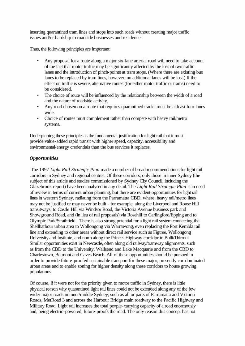
inserting quarantined tram lines and stops into such roads without creating major traffic issues and/or hardship to roadside businesses and residences. Thus, the following principles are important:
• Any proposal for a route along a major six-lane arterial road will need to take account of the fact that motor traffic may be significantly affected by the loss of two traffic lanes and the introduction of pinch-points at tram stops. (Where there are existing bus lanes to be replaced by tram lines, however, no additional lanes will be lost.) If the effect on traffic is severe, alternative routes (for either motor traffic or trams) need to be considered.
• The choice of route will be influenced by the relationship between the width of a road and the nature of roadside activity.
• Any road chosen on a route that requires quarantined tracks must be at least four lanes wide.
• Choice of routes must complement rather than compete with heavy rail/metro systems.
Underpinning these principles is the fundamental justification for light rail that it must provide value-added rapid transit with higher speed, capacity, accessibility and environmental/energy credentials than the bus services it replaces. Opportunities The 1997 Light Rail Strategic Plan made a number of broad recommendations for light rail corridors in Sydney and regional centres. Of these corridors, only those in inner Sydney (the subject of this article and studies commissioned by Sydney City Council, including the Glazebrook report) have been analysed in any detail. The Light Rail Strategic Plan is in need of review in terms of current urban planning, but there are evident opportunities for light rail lines in western Sydney, radiating from the Parramatta CBD, where heavy rail/metro lines may not be justified or may never be built - for example, along the Liverpool and Rouse Hill transitways, to Castle Hill via Windsor Road, the Victoria Avenue business park and Showground Road, and (in lieu of rail proposals) via Rosehill to Carlingford/Epping and to Olympic Park/Strathfield. There is also strong potential for a light rail system connecting the Shellharbour urban area to Wollongong via Warrawong, even replacing the Port Kembla rail line and extending to other areas without direct rail service such as Figtree, Wollongong University and Institute, and north along the Princes Highway corridor to Bulli/Thirroul. Similar opportunities exist in Newcastle, often along old railway/tramway alignments, such as from the CBD to the University, Wallsend and Lake Macquarie and from the CBD to Charlestown, Belmont and Caves Beach. All of these opportunities should be pursued in order to provide future-proofed sustainable transport for these major, presently car-dominated urban areas and to enable zoning for higher density along these corridors to house growing populations. Of course, if it were not for the priority given to motor traffic in Sydney, there is little physical reason why quarantined light rail lines could not be extended along any of the few wider major roads in inner/middle Sydney, such as all or parts of Parramatta and Victoria Roads, MetRoad 3 and across the Harbour Bridge main roadway to the Pacific Highway and Military Road. Light rail increases the total people-carrying capacity of a road enormously and, being electric-powered, future-proofs the road. The only reason this concept has not
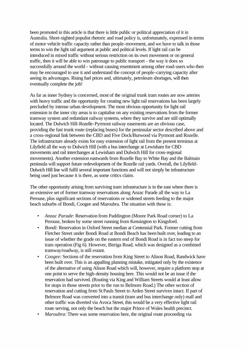
been promoted in this article is that there is little public or political appreciation of it in Australia. Short-sighted populist rhetoric and road policy is, unfortunately, expressed in terms of motor vehicle traffic capacity rather than people-movement, and we have to talk in those terms to win the light rail argument at public and political levels. If light rail can be introduced in mixed traffic without serious restriction on its own movement or on general traffic, then it will be able to win patronage to public transport - the way it does so successfully around the world - without causing resentment among other road-users who then may be encouraged to use it and understand the concept of people-carrying capacity after seeing its advantages. Rising fuel prices and, ultimately, petroleum shortages, will then eventually complete the job! As far as inner Sydney is concerned, most of the original trunk tram routes are now arteries with heavy traffic and the opportunity for creating new light rail reservations has been largely precluded by intense urban development. The most obvious opportunity for light rail extension in the inner city areas is to capitalise on any existing reservations from the former tramway system and redundant railway systems, where they survive and are still optimally located. The Dulwich Hill-Rozelle-Pyrmont railway easements are an obvious case, providing the fast trunk route (replacing buses) for the peninsular sector described above and a cross-regional link between the CBD and Five Dock/Burwood via Pyrmont and Rozelle. The infrastructure already exists for easy extension of light rail from the present terminus at Lilyfield all the way to Dulwich Hill (with a bus interchange at Lewisham for CBD movements and rail interchanges at Lewisham and Dulwich Hill for cross-regional movements). Another extension eastwards from Rozelle Bay to White Bay and the Balmain peninsula will support future redevelopment of the Rozelle rail yards. Overall, the Lilyfield-Dulwich Hill line will fulfil several important functions and will not simply be infrastructure being used just because it is there, as some critics claim. The other opportunity arising from surviving tram infrastructure is in the east where there is an extensive set of former tramway reservations along Anzac Parade all the way to La Perouse, plus significant sections of reservations or widened streets feeding to the major beach suburbs of Bondi, Coogee and Maroubra. The situation with these is:
• Anzac Parade: Reservation from Paddington (Moore Park Road corner) to La Perouse, broken by some street running from Kensington to Kingsford.
• Bondi: Reservation in Oxford Street median at Centennial Park. Former cutting from Fletcher Street under Bondi Road at Bondi Beach has been built over, leading to an issue of whether the grade on the eastern end of Bondi Road is in fact too steep for tram operation (Fig 6). However, Birriga Road, which was designed as a combined tramway/roadway, is still extant.
• Coogee: Sections of the reservation from King Street to Alison Road, Randwick have been built over. This is an appalling planning mistake, mitigated only by the existence of the alternative of using Alison Road which will, however, require a platform stop at one point to serve the high-density housing here. This would not be an issue if the reservation had survived. (Routing via King and William Streets would at least allow for stops in those streets prior to the run to Belmore Road.) The other section of reservation and cutting from St Pauls Street to Arden Street survives intact. If part of Belmore Road was converted into a transit (tram and bus interchange only) mall and other traffic was diverted via Avoca Street, this would be a very effective light rail route serving, not only the beach but the major Prince of Wales health precinct.
• Maroubra: There was some reservation here, the original route proceeding via

Maroubra Road and Mons Avenue. The wide Fitzgerald Avenue may now be a better route, given the subsequent spread of development to the south.
All of these routes are still valid light rail corridors as the pattern of development in the eastern suburbs has not changed, merely intensified. In hindsight, this outstanding, largely reservation-based light rail system should never have been dismantled because it provided capacity that the replacement bus service is now struggling to meet. The big positive of these two reservation systems, to the south-east and to the west, is that, by comparison to the bus system, they provide major fast routes out of the CBD, covering several kilometres (in each direction) of clear running largely unfettered by road traffic and enabling speeds of up to 80 kph in vehicles of huge capacity compared to buses - one tram will take the load of, and replace at least three buses. (The Inner West line also has potential for a five-minute time-saving for fast CBD services by constructing a short tunnel under the freeway at Ultimo between the light rail depot and Wentworth Park station.) As the Glazebrook report recommends, the restructuring of bus services into cross-regional feeders to rail and light rail interchanges, rather than running through to the city, must be an essential part of a long-term integrated transport strategy - together with an integrated journey-based fares system that encourages rather than deters modal interchange and cross-regional travel. The proposed light rail system can help meet this objective by replacing the entire trunk CBD bus services of the South-Eastern suburbs (something a metro could not achieve because of its limited coverage) and all of the through services from west of Leichhardt. This can be reinforced by the rail system also acting as a collector, with modal interchange with outer bus services at Bondi Junction and Edgecliff (existing interchanges) and stations such as Sydenham, Petersham, Newtown and St. Leonards (with new interchanges). Interchanges must be designed to ensure short, easy-access transfer between bus and rail/light rail and serviced with frequencies that minimise waiting times. Light rail has an additional advantage here of being able to provide simple cross-platform transfer between bus and tram, thus maximising time-advantage and providing fully level accessibility unparalleled in Sydney’s public transport.
Fig. 6: Lost opportunities. Lack of planning foresight has resulted in this cutting that eased the grade from Bondi Road to Bondi Beach being closed and built over. Bondi Road, with its grade possibly too steep for
trams, crosses the bridge in the photo. (Image: Hugh Ballment)

Fig. 7a: Proposed routes recommended in this article. The dashed lines are route options. The dotted line is a circumferential connection between Dulwich Hill and Mascot for future consideration. Red circles are light rail/ rail interchanges. Blue circles are existing or suggested purpose-built bus terminal facilities for interchange to
light rail or rail. Yellow areas are major or specialised centres identified in the NSW Metropolitan Strategy. (Map: The Little Website Company for Transit Australia)

Fig. 7b: Proposed routes showing type of track. Black indicates lines on reservation. Red indicates lines on roads but quarantined from mixed traffic. Blue indicates non-quarantined lines running in mixed traffic. Dashed
lines are route options. (The Parramatta route is notional only - the line could take a number of alignments through the Olympic Park/Silverwater area.) (Map: The Little Website Company for Transit Australia)
The Routes Given the constraints and opportunities outlined in this article, the routes described below and illustrated at Fig.7 are recommended for consideration. It can be noted that all of these routes have the potential for terminating as balloon loops (either as such or as a circuit around streets). This expands the capacity of a line as a tram can be turned around quickly at a terminus, particularly important in high intensity service. The driver does not have to change ends and there will be no need for reversing on terminus tracks. Unloading, loading and reversing a bidirectional tram to clear a terminus track for the following tram limits service frequencies to at least 2-3 minutes apart, compared to a potentially continuous frequency with loop termini. Thus, lines with a high intensity service will require balloon loop termini. Loop termini also enable the light rail fleet to include unidirectional trams (driver’s cab at one end only). (Fig. 8) This has two major advantages:
• The cost of the rolling stock will be less as only one driver’s cab and set of controls has to be provided, as well as doors on one side of the vehicle only.
• There will thus be more passenger accommodation (seats and standing) in each car and more provision for a range of passenger amenities – for example, dedicated spaces opposite doors for wheelchairs, prams and bicycles, and having most seating facing forwards (see Fig. 8c).
It is important to consider the advantages of the unidirectional tram in design studies. Platforms, for example, should be on the kerb (left) side of the tram - a factor overlooked, for example, in the Department of Planning’s F6 corridor study which shows platforms being on either side of the tram; this would necessitate doors on both sides. In terms of existing infrastructure, the Lilyfield platform would have to be reconfigured (a small task, however, compared to Melbourne where new accessibility works have committed the city permanently to bidirectional trams). It should also be noted that, whilst satisfactory on the former Lilyfield railway line, the current Variotram is not well-suited to street operation in Sydney, lacking fully pivoting, fully powered bogies (for quick and noise-free cornering and for climbing grades). The only tram currently available with these features, in addition to a 100% low floor, is the Skoda ForCity. Other makes with pivoting bogies have sections of high floor or compromised seating arrangements, which affects accessibility objectives and passenger comfort. Choice of a tram type that meets the above objectives will be critical for attracting passengers and maximising their comfort. Because of their sections with significant grades and curves, the CBD and eastern suburbs routes will be best-served by a tram type with the specifications of the Skoda. The existing Variotrams would be suitable for the relatively flat and straight inner western routes but, unlike the Skoda, would be ill-suited to the others.

Figs. 8a (top), 8b (centre) and 8c (bottom): Skoda ForCity tram. This benchmark-setting Czech design is the only tram in the world to have a true 100% low floor combined with
fully-powered bogies that pivot down to 18m curves (and smaller in depot). The tram is shown here in unidirectional form (also available as bi-directional) and the floorplan clearly shows how the space saved by not having offside doors is available for extra seats plus storage for wheelchairs, prams and bicycles. There is also a GPS-based passenger information system in each carriage providing real-time information via monitor displays
on stops, travel times and connecting service times. As a new system, Sydney has the opportunity to introduce such world’s best-practice at the outset. (Skoda Transportation s.r.o.)

Eastern Eastern and South-Eastern lines should preferably share a common route to Taylor Square, the Darlinghurst area being effectively an extension of the CBD. The launching point (off the Central-Circular Quay via Castlereagh Street line) for eastern suburbs light rail services could be one route or a combination of several options:
• Liverpool/Oxford Street would be the preferred choice. • Alternatively, the line could branch off the Central-Circular Quay line at Campbell
Street and proceed up Campbell Street to Taylor Square (Flinders Street). • If there is a grade issue at lower Campbell Street, the route could go from Goulburn
Street along Hunt Street as did the former tram line. • Given that the proposed lines and the Eastern Suburbs Railway (ESR) between them
could potentially replace all long-haul eastern suburbs bus services to the city, the line to Circular Quay could be routed along Elizabeth Street - which it may ultimately have to be if the capacity of the Castlereagh Street line is filled. (There is also potential for a connection via King Street to the former tram platforms at Wynyard Station and thence across the Harbour Bridge via the former tram route on the eastern side of the bridge roadway.)
• As services to the East/South-East would originate from both Circular Quay and Central Station, the Campbell Street route may well be justified, in any case, as a second route dedicated to journeys originating from Central Station.
From Taylor Square (from where road traffic has the option of proceeding east via Moore Park Road), the line would run along the six-lane Oxford Street to the Ocean Street/Lang Road/Moore Park Road corner. An alternative is for the line to run via Moore Park Road. However, this option has some design issues and, with its feeder tunnels to/from the M1 and Cross-City Tunnel, this road has fully become the traffic bypass to Oxford Street. Oxford Street is clearly the preferable route for the tram line. From the Ocean Street/Lang Road corner of Oxford Street, the line is able to run in the old central tramway reservation (restored to its original width). At the end of the reservation the line would be undergrounded (shallow cut and cover construction) under Syd Einfeld Drive, emerging into the open under the Drive in the carpark area opposite Bondi Junction interchange where there would be a major interchange stop connected by a pedestrian tunnel or covered pedestrian way across Grafton Street to the railway station concourse. The line would then go under the Drive again at Adelaide Street and under Old South Head Road to surface at either Old South Head Road or, preferably, at Victoria Road, Bellevue Hill. The line would then proceed along Birriga Road (which was specifically constructed wide and graded for trams with separate lanes for parking and motor traffic - but will need to be returned to its former configuration) and then run as a one-way loop via Blair Street, Beach Road, Campbell Parade (plaza terminus in front of the Ramada/Swiss Grand Hotel) and Curlewis Street. Journey time between Bondi Junction and Bondi Beach should be about 5 minutes, compared with 10-20 minutes via the present Bondi Road bus service. South-Eastern The route options from the CBD to Taylor Square are described in the previous section. From Taylor Square, the line would then proceed south along the centre of Flinders Street, turning into the reservation at Moore Park Road corner. The line would then use the reservation to
the corner of Alison Road (the junction for a branch to Randwick and Coogee) where it would then proceed to the median/reservation of Anzac Parade through Kensington to Kingsford. At University of NSW a major tram station would have to be constructed, preferably in the form of a plaza across Anzac Parade with road lanes diverted underneath. After Kingsford, the line has the use of reservation all the way to La Perouse. Because of the potential for high-speed running on the Anzac Parade reservations they would need to be properly protected with fencing and controlled crossings for roads. Some minor road-crossings between Kingsford and La Perouse may need to be closed to minimise impact on tram operation. A modal interchange facility would be needed at Kingsford to commence the process of truncating bus services, particularly the 390 series, and interchanging with cross-regional services to and from Bondi Junction. This can be located in the reservation south of the roundabout with buses using the roundabout to turn and approach the opposite sides of the tram platforms to enable cross-platform interchange between trams and buses. The tramline should pass under the roundabout via a cutting as it is not desirable for road safety reasons to have a line through a roundabout on the level. A stub cutting should be made off this cutting for a future Bunnerong Road line. Indeed, if a terminating loop was required at Kingsford (e.g. for peak load university trams), a single track could run into Bunnerong Road and Sturt Street, returning into the interchange at Anzac Parade. With a higher level of investment, the inner Anzac Parade route could be raised to full railway standard by constructing underpasses or bridges across major intersections at Moore Park Road (depending on the depth of the M1 tunnel), Lang Road and Alison Road/Anzac Parade intersection. (Anzac Parade can also be widened south of this intersection using the former tramway reserve beside E.S. Marks Field.) This would enable the running of express services at up to 80 kph between Paddington and Kensington or Darley Road, covering the distance in 2 minutes or less. A busway could also be built along the north/east side of the tramway between Darley Road and Lang Road (with interchange at stops) to enable a Cleveland Street bus service to Central to be retained by diverting the Clovelly bus at Darley Road onto the busway - thus avoiding Alison Road/Anzac Parade traffic. A branch line could also be built from Kingsford along Bunnerong Road (which has a reservation to provide for widening from four to six lanes) to Eastgardens (Pagewood) and then along Fitzgerald Avenue to Maroubra Beach (crossing the Anzac Parade line) and terminating in a loop at Marine Parade/McKern/Fenton Streets, Maroubra Beach. Because of its width, Fitzgerald Avenue is amenable in its entirety to reservation running. Another extension that can be considered, in conjunction with the Southern sector, is to continue south along Bunnerong Road to Port Botany, Botany and Mascot via Botany Road. The Matraville sector, with its important activity nodes at Eastgardens and Port Botany, is presently not well-served by public transport. There is also the possibility of using former tramway reservations to construct peak-load sidings to Sydney Cricket Ground (a former tram road, now bus road, already exists that can be used for this) and Randwick Racecourse. The racecourse branch could use either the Alison Road reservation to Doncaster Avenue or the Abbotsford Street, Kensington former tram reservation. There is a terminus area within the racecourse where the former tram station could be partly reinstated. These sidings would also introduce two additional balloon loops to the line, enabling trams running ‘event specials’ to be turned around without needing to proceed further south to a terminus loop. Finally, the branch to Randwick and Coogee would

be a very significant one, serving a major suburban area of higher residential density than the Anzac Parade corridor, a major beach and the huge Prince of Wales health complex identified in the Metropolitan Strategy. A Belmore Road transit mall would also provide an interchange point with north-south cross-regional bus services. Southern As a range of options has been put forward in this sector (by Sydney City Council, Glazebrook and Metro Light Rail), it is difficult to be specific about suggested routes but the same general principles apply. Mascot rail station would be a good terminus, enabling cross-regional interchange and a Botany Road line could continue to Port Botany and Matraville, as suggested above. However, whichever route is selected, this sector has the disadvantage of generally only having street running available. The level of motor traffic on working days would mean selecting roads of a minimum of four-lanes (for quarantining tram lines), which would mean prohibition of parking and stopping along these routes. Drive-over platforms at stops would thus be generally required. The same factors would apply to the light rail line along Botany Road, Redfern proposed in the City of Sydney Strategic Plan (Sustainable Sydney 2030). A suggestion for this sector is that, rather than entirely parallel the radial Airport rail line, consideration could be given to cross-regional connection to the Anzac Parade light rail line via Dacey Avenue, Epsom Road or Gardeners Road. Not considered in this article, but an option worth analysing, is a cross-regional link between Kingsford/Mascot and Sydenham - and even with the Dulwich Hill line. The metropolitan goods railway runs along part of this route and is in use serving Botany. The alternatives for consideration would be either obtaining an easement for light rail, upgrading the existing route 357 bus service or, ultimately, extending the ESR to Kingsford and Sydenham. Sydenham has unrealised potential as a major rail/tram/bus interchange for the purposes of both cross-regional travel and diverting radial bus trips onto rail. Inner West The existing Lilyfield service can readily be extended along the former goods line to Dulwich Hill, with cross-regional interchanges (using lifts and pedestrian bridges) with Lewisham (Main West line) and Dulwich Hill (Bankstown line) CityRail stations. (There is an existing proposal to extend the service as far as Lewisham.) The Dulwich Hill triangle has space for a balloon loop to enable the use of the suggested unidirectional rolling stock, or, alternatively, there is space for one or two terminating tracks and platforms for bidirectional trams - options that can be chosen according to the service frequency required. Stops could include Charles Street, Leichhardt (interchange with a Five Dock extension) and Lewisham (north of the railway bridge). The purpose of the stop at Lewisham is modal interchange with Parramatta Road buses and with rail at Lewisham. Buses could use the Hathern, Brown and Cook/Barker Streets overbridge circuit to approach a level, covered bus-tram interchange near Barker Street. The method of constructing a pedestrian link with Lewisham Station would be to use a lift and stairs up to the level of the railway line near Old Canterbury Road, then an elevated pathway/bridge along the southern side of the railway to the western end of the Lewisham Station Down platform. The former goods line also provides the take-off point for extending a reservation through open space around the northern side of Haberfield all the way to Parramatta Road at Five Dock - an excellent point for another bus/light rail interchange. (A crossing of Haberfield at

Waratah Street appears to be suggested in the Glazebrook plan. However, this will be a major trunk line, with quarantined tracks and no stopping or parking for motor traffic at the kerbside - not a scenario for a quiet residential street in a conservation area where houses often do not have off-street parking.) This extension would branch off the Dulwich Hill line at Charles Street and follow alongside the southern side of the City West link/Dobroyd Parade to Mortley Avenue, Haberfield, then cross Dobroyd Parade and a bridge across Iron Cove Creek canal to follow the western side of the canal, recrossing the canal to a terminus between Cove Street and Parramatta Road. Acquisition of some property fronting Parramatta Road between the canal and Wolseley Street would provide space for a modal interchange including a balloon loop (if required) and cross-platform bus terminus. Beyond this, the use of Parramatta Road at any point is (at least politically) problematic because of the road traffic volumes and the constraints that both tram lines and tram stops introduce. The only significant possibility for Parramatta Road that opens up is the proposed extension of the M4 east motorway which may be used as an opportunity for introducing light rail on Parramatta Road west of Haberfield. In terms of using parallel routes, the roads in this sector, such as Ramsay Street and Queens Road, have issues similar to Bondi Road. In addition, many of the roads in the inner west are little more than two lanes wide and quarantining of tracks would be impossible. For this reason, busy roads like the two-lane Queens Road are simply not an option. Much of the inner west in the Leichhardt, Ashfield, Canada Bay and Burwood LGAs is a labyrinth of narrow streets, some of which once had tramlines but all of which are now probably more effectively served by bus. The only possible alternative to Parramatta Road is to continue the line south along the canal alignment (by viaduct), turning into Queen Street, Croydon through to Victoria Street, Burwood, a relatively quiet route. Because this is a narrow road, quarantined street tracks and drive-over platforms would not be possible except where Queen Street could possibly be widened into the open space on its north side; thus platforms would be of the ‘flare-out’ type. The reason for an extension west from Five Dock is to connect with the regional centre of Burwood and thus complete the City-Rozelle-Burwood cross-regional link referred to earlier. However, Burwood is located within one of the worst networks of narrow streets. The only substantial access is Burwood Road which is chronically congested with traffic due to the lack of alternative routes. In addition, the railway bridge has a very low clearance. The previous tramway did pass under it but, at 3.6 metres, it is unlikely to meet current clearance requirements. It is also impossible to achieve a quarantined route, other than on Burwood Road, due to surrounding streets being so narrow. The only feasible routes would be one-way circuits along Burwood Road, around Westfield (Victoria and/or Wilga Streets), and along Shaftesbury Road (which would have to be converted to one-way north of Wilga Street). This circuit could be approached by either the Parramatta Road or Queen Street route options. However, a simpler scheme under the Queen Street option (depending on patronage levels) would be to have a single terminating track in Victoria Street beside Westfield. Construction of a flare-out platform for a single terminating track is very feasible outside the Greater Union Cinema building. The line would have to be operated by bidirectional trams in this case. If a balloon loop was required in the future, this can be achieved by the above-described loop around Westfield. From the transport perspective, the choice of Burwood as a regional centre in the Metropolitan Strategy is baffling, not only for the above reasons but because not even all train services stop there. The real transport hub is immediately to the west at Strathfield, extension of the light rail line to which would thus be desirable, as well as for the reason of

connecting to a potential light rail line on the proposed Strathfield-Parramatta transitway (depending on the outcome of the Sydney-Parramatta metro proposal). Although the streets in Strathfield are also narrow, traffic volumes north of the station are not so high as to inhibit a non-quarantined connection off Parramatta Road at Mosely or Roberts Streets. An ‘around-the-block’ single-track loop at Strathfield, via Cooper Street, Wentworth Road and Everton Road, returning into Mosely Street, would provide for terminating trams with a kerbside platform capable of holding two 30 metre trams in Everton Road outside Strathfield Station. If Parramatta Road is not available, a line would be possible, with minor land resumptions, from Burwood Road along Comber and Rowley Streets and the northern edge of Burwood Park. A line from Strathfield to the Parramatta route can simply use Manson Road or Cooper Street west to avoid the existing M4 exit. The other extension project mentioned previously is a branch from Annandale to Balmain via the former White Bay rail corridor. This could include a bus interchange near Victoria Road at White Bay to divert at least some of the 500 series bus services (particularly the 501 to Central). With development of the Rozelle-White Bay rail yards, the Inner West line would be transformed from a ‘back route’ to a core transport corridor for this new activity centre, linking it to the CBD and Ultimo/Pyrmont in one direction and Burwood and Dulwich Hill in the other. In the longer term, the construction of non-quarantined branches into some areas such as the Abbotsford peninsula are physically feasible but the case for viability would have to be studied. Supporting Facilities Apart from running infrastructure like tracks, optional grade separations, overhead wiring and substations, these new systems will require new tram depots to accommodate larger fleets, preferably within reasonable distance of outer termini. In a heavily-developed inner city, with little spare land, the best available locations are likely to be the former Lilyfield/Rozelle rail yard for the inner west and the former Randwick tramway workshops (presently a bus depot, which would be redundant with the light rail system in place) in the east. With extensions to La Perouse and along Bunnerong Road to Botany Road, a third depot would be required, probably best located in or near the Perry Street, Matraville industrial area. An area of some hectares would need to be reserved for each depot, depending on fleet size and requirements (e.g. just a running shed or including a major workshop), and allowing for a loop track within each depot. Other infrastructure is very simple and low-cost by comparison with a heavy rail/metro system. Most of the system would have simple passenger platforms, approximately 300 mm high. At interchange points such as Kingsford, Lewisham and Five Dock these may be dual tram/bus platforms. The use of unidirectional trams may require some intermediate balloon loops for short workings. The scheme outlined in this article provides for these at Moore Park, Kensington, Kingsford and Five Dock and others can be inserted simply by running a line around a block if there is not enough space for a normal loop. Finally, electronic passenger information systems, at least on island platforms, would be a benefit. Conclusion This article has looked at the practical issues relating to light rail extensions in Sydney, based on underlying principles that the advantage of light rail should be optimised through reservation or quarantined running and 100% accessibility, while at the same time having the
smallest possible impact on existing roads and access to roadside activities. It finds that, beyond the reservations, the selection of major arterial roads for mixed-traffic light rail routes can have significant practical and political disadvantages from the perspective of Sydney’s overall road transport movements and for businesses and residences fronting such roads where there may be permanent ‘no-stopping’ zones in front of their premises. However, from an operational perspective, the option on four-lane roads of retaining kerbside stopping for motor traffic and forcing traffic onto tram lines will seriously impact on the benefits of light rail. Thus, in mixed traffic, the optimal running environment would be on either:
• six-lane roads, with side-island platforms at traffic light-controlled pedestrian crossings (or intersections), motor traffic being reduced to one lane each way at these points unless line-slewing with offset platforms can preserve traffic lanes; or
• four-lane roads, using drive-over passenger platforms with no stopping, turning or parking by motor vehicles on such roads, choice of route being determined by whether businesses and residences have off-street parking (on-site or at rear) or can have provision made for it (e.g. by resuming property to create reserved ‘parking lots’ at regular intervals);
• narrower light-traffic roads, with non-quarantined tracks and ‘flare-out’ platforms. With the route adjustments suggested in this article, it is found that the physical feasibility of the proposed light rail extensions is good to excellent in the Eastern/South Eastern sectors and on the reservation sections in the Inner West to Dulwich Hill, White Bay and Five Dock/Croydon. There will be relatively low disruption to existing activities or traffic along these routes. The Southern sector proposals, however, require very detailed analysis of physical practicality while, in the west, construction of the M4 east motorway may be a political prerequisite for an extension along Parramatta Road. On the other hand, the Queen Street, Croydon option is feasible now. In the case of inner Parramatta Road (Haberfield to Glebe), it is likely that the volume of motor traffic is so high, due to lack of alternative routes, that the loss of two to four road lanes (that is, tracks plus possible platform pinch-points) to light rail may be politically unacceptable. At present, there is also a proposal for a metro line (Sydney-Parramatta) along this route, though it will not be a satisfactory alternative to surface transport over shorter distances because of the reasons discussed earlier, exacerbated by wide station spacing. Buses, at least, would need to continue as the supporting surface transit. Bondi Road will not be suitable at all due to roadside activity and lack of alternative traffic routes, a situation that may also apply to many potential routes along four-lane or narrower roads with high traffic and activity levels, such as Norton Street, Leichhardt and Darling Street, Balmain. Narrow roads themselves are not a problem for trams. There are many examples of such operation in Europe, for example, and a tram can operate in confined spaces better than a bus because it is on tracks - also being regarded as more pedestrian-friendly because its route is predictable. The issue in Australian cities is a cultural one: that Australians expect to be able to get a motor vehicle to the ‘door’, whether for parking, dropping off or delivery. Although this expectation is under assault from new traffic management regimes and pedestrianisation projects, it still confines the easy potential for quarantined tramways to wide boulevards and reservations, of which inner-western Sydney in particular has few. On narrower roads it will be a trade-off between roadside stopping for motor vehicles and tram lines. In some strip shopping centres where pedestrianisation projects have resulted in widening of footpaths across one vehicle lane each side, the choice is between two undesirables (cut back the footpaths again so that there are two tram lanes and two vehicle lanes, or force trams and

vehicles to share a lane) and one possible unachievable (make the road lanes tram-only and divert motor traffic to an alternative route – of which there may not be any). It is not the intention of this article to put a dampener on routing tram lines along narrow, busy ‘High Streets’, but rather to encourage rational analysis of the compromises required in the context of a paramount need to keep motor traffic off tram lines (including not turning in front of trams) on such roads. The advantage of the proposals presented in this article over proposals such as those of Glazebrook is that very little of inner Sydney’s trunk road system will be affected by mixed running with trams - only Oxford Street, Flinders Street, part of Anzac Parade at Kensington, a short length of Alison Road, Bunnerong Road and (possibly) part of Parramatta Road west of Haberfield. Oxford/Flinders Streets are already relieved by motorways and Moore Park Road (and Oxford Street is already restricted by two part-time bus lanes which tram lines would replace), while Parramatta Road has an optional tram route (Queen Street, Croydon) or the possibility of the M4 east alternative. This also means that very little of the road system will be affected by traffic pinch-points at tram stops, possibly none if line-slewing with offset platforms can be employed (which is quite likely along Oxford Street between Hyde Park and Paddington). The need for drive-over platforms (where boarding and alighting passengers share road space with motor traffic) is also absolutely minimised in the Eastern/South Eastern and Inner West sectors. The only significant areas where such platforms might be required (apart from the Southern sector) are in some quiet back streets at the outer ends of the Bondi and Coogee routes. All other stops would be the side-island platform type, either in reservations or on six-lane roads. In terms of significant civil engineering works, the South Eastern sector still has its easements in place. If the developed section of the easement paralleling Alison Road is to be recovered, all or parts of three blocks of flats will need to be demolished, otherwise William Street and Alison Road must be used. On the Bondi route, major work is involved under the ends of Syd Einfeld Drive and Old South Head Road (an issue that could have been avoided if there had been proper holistic transport planning when the Drive was built!). On the Lilyfield-Burwood route, three small bridges and two viaducts would be required across the canal channels in Haberfield/Croydon and a bridge from Rozelle Bay MLR station across the City West Road may be required for the White Bay line (or, alternatively, an at-level connection at Lilyfield). Other significant works would be grade-separation cuttings at UNSW and Kingsford and at any other location where grade separation is desirable. Traffic light priority will be vital, as it should be for any road-based public transport system. More importantly, from the political viewpoint, any possible impact affecting motorists and road interests is minimal once the construction phase is completed. The routes proposed in this article will also still provide (as Glazebrook proposes) the opportunity for replacement of congested trunk bus routes. The suggested points of modal interchange are at Five Dock, Lewisham, White Bay, Bondi Junction (rail/light rail), Randwick and Kingsford - of which Lewisham and Kingsford could be implemented first under a staged approach. This would also reduce the interchange load on the CBD periphery light rail loop proposed in the City of Sydney Strategic Plan (Sustainable Sydney 2030). The big value-added benefit to commuters of these remote interchanges should be a faster journey into the CBD and less delay caused by present congestion or future modal interchange within the CBD, combined with the highest benchmark of accessibility. This benefit must be substantial to induce a natural desire for modal interchange. This means that trams would need to be scheduled no more than approximately 5 minutes apart to minimise waiting time (or scheduled to meet buses), otherwise in some cases the direct bus journey may be

quicker. It is also essential that an integrated, journey-based fare system be introduced in conjunction with this. If there is not the political commitment to introduce such a system Sydney-wide, then at least it should be introduced for the light rail and CityRail systems and their connecting (former CBD) bus services. With such complete integration, light rail would replace all CBD bus services in the east/south-east sectors, excepting the Edgecliff/New South Head Road corridor and the 389 (Bondi Junction-City via Glenmore Road). The former route 341 from Clovelly to Central can also be revived to provide a service along Cleveland Street, as previously mentioned. In the west, the CBD sectors of long-distance routes 413, 436-438, 461, 480, 483, L03 and L38-39 (generally those from west of Leichhardt) can be diverted to interchange with the light rail system, as well as the 501. Further south, the heavy rail system is well-structured to meet the potential for modal interchange in a similar manner with long-distance routes such as the 423, L23 and L28. In the case of the inner west, where the light rail line runs well to the north of Parramatta Road, bus routes can be split at the interchange and the inner segments of the routes replaced by a single bus service providing a local stopping service along Parramatta Road between these interchanges and the CBD. Most superseded bus stops along light rail routes would become light rail stops but with some possible stop-rationalisation as a trade-off for service speed. However, stops are unlikely to be more than 400 m apart and much less than the up-to 2 km spacings proposed for metro lines and, thus, still within comfortable walking distance. It is important now to integrate these specific light rail routes into the land-use planning system as soon as possible so that opportunities are not lost as a result of short-sighted development, such as occurred at Randwick (and is still occurring along these potential routes). If the M4 east, for example, proceeds and is designed without considering light rail extensions around north Haberfield and further west and constructed before those extensions, it could conceivably lock out the possibility of such extensions without expensive rectification works. Similarly, light rail needs to be taken into account in consideration of the future of the Rozelle/White Bay rail yards. Also, now that the Hickson Road (city) and Lewisham extensions are on the agenda, it is important that project planning provide for demand being higher than projected and that the capacity of bidirectional trams with single-road termini may be overwhelmed (refer Light Rail Now Project Web site; also the recent experience of the Adelaide extension). The Hickson Road and Lewisham extensions should include balloon loops at their termini: at the Circular Quay end turning from George Street under the railway viaduct (terminus site) and then on a minimum radius curve at Pitt Street into Fairfax Place returning to George Street at Circular Quay; and by means of an easily-constructed extension to a balloon loop at Dulwich Hill at the other end. This then means that unidirectional trams, with their greater turnaround, seating and carrying capacities, can be considered. In terms of light rail and metro rail, they are complementary systems performing different functions over different distances. In the inner west, both the suggested extended light rail and the suggested long-distance Sydney-Parramatta and north-western metros have clear, complementary roles and could perform well together. In the south-eastern suburbs, with its close distances (only 11 km to Malabar), broad settlement pattern and lack of major full-time activity nodes (only the Prince of Wales health complex, which is off the proposed metro route but on a light rail route), this factor is weaker, as a metro would provide huge capacity along one corridor and no service on others. Analysis of this proposal is beyond the scope of this article but, with its single corridor and up-to 2 km station spacings (meaning modal

interchange to surface transport would still be required to fill the gaps and extend its coverage at both suburban and CBD ends), this writer finds it difficult to comprehend what such a metro could achieve that light rail could not. Over such a short distance the metro’s higher average speeds will be negated for most by modal interchange while, on the other hand, it is possible to raise light rail’s average speed (e.g. by use of grade separation at intersections) at far less cost and yet still retain the multiple-route coverage that metro would lack. If a metro is built there would still be a need for light rail to complement it with surface transport and to service the major corridors it would bypass, notably Bondi, Randwick/Coogee, La Perouse and Matraville/Botany. With only a few metro stations proposed along this corridor (due to the cost of building them) people in typical Sydney form will abandon local public transport to drive their cars to the stations, with all the adverse effects on local centres that has. The quoted time-savings for metro along this route will apply only to those travellers located near the stations. Others will probably spend more time travelling due to the need for modal interchange. Further study is required to interrogate the government’s very simplistic assertions, but light rail does seem to have a stronger case than metro in the eastern suburbs. (For a critical analysis of the issues relating to a short metro line relative to surface transit see Urban and Suburban Transit Association 2006.) This writer would prefer to see the metro extended instead from St James south to a new underground station at Central, then to connect to and take over the Airport/Wolli Creek line at Cleveland Street (severing it from the CityRail system) and the two all-stops tracks of the East Hills line from Wolli Creek to Revesby – with an extension via Bankstown Airport to Liverpool. This would free up the city circle and allow CityRail to focus on express suburban services to and from the south-west (Campbelltown/Leppington) via the proposed track amplification through Sydenham, then underground through the unused platforms 26 and 27 at Central, via the proposed cross-harbour link to the Chatswood-Epping railway and on to Rouse Hill. Unfortunately, the proper planning of Sydney’s transport is warped by endemic state transport politics and the schemes we see announced are often compromises dictated by political expediency and road-bias, not sound transport planning. The bottom line should be best bang for bucks: more than one analyst has pointed out that $12 billion spent on a single 40 km line of metro could buy a spread of more than 200 km of light rail and some critically-needed augmentation works for the CityRail system. Certainly metro will not, as some idealists believe, provide for most of the local transport needs of the inner city. The high cost of excavating and fitting out underground stations means that we are unlikely to see station spacings of less than 0.8 km, as is common in European cities – and if those cities are still finding the need to maintain and augment surface tramways above their metros, what hope does a metro with 2 km station spacings have for this purpose? Heavy rail/metro is not sufficiently flexible or cost-effective to provide all the answers to reduction of motor vehicle-dependency in our cities. We are not being presented with all the facts. This article demonstrates that the most effective parts of the eastern and western sectors of the proposed light rail network can be built realistically within the framework of Sydney’s road and traffic system - and, in fact, with remarkably little impact on it - and that all it needed was a more practical and less politically confronting perspective on route alignments than earlier proposals. Now it is vital to specifically plan for the network in the context of a properly-considered, future-proofed transport framework for Sydney (and Newcastle and Wollongong), instead of irrationally encouraging demand for petroleum-fuelled road-based transport while suppressing demand for electric rail-based transport. Australia has several alternative energy sources to produce electricity but only one of any present significance (natural gas) to power motor vehicles. Federal and State Governments should be urgently

investing in electrification of interstate freight railways and in urban electric rail and light rail projects rather than yet more road projects. As we see most other states and territories eclipse NSW in planning for light rail, it becomes obvious that the time to start realistic, holistic and sustainable transport planning for NSW cities is now. References ‘The ABB Variotram’, Transit Australia. Vol. 49, no. 11 (November 1994), pp. 243-248. City of Sydney. Sustainable Sydney 2030: City of Sydney Strategic Plan. 2008. City of Sydney Web site [links to several light rail studies]: www.cityofsydney.nsw.gov.au/AboutSydney/ParkingAndTransport/LightRail.asp Currie, Graham and Smith, Paul . An Innovative Design for Safe and Accessible Light Rail/Tram Stops Suitable for Mixed Traffic with Median Track Operations. Paper presented to 28th Australasian Transport Research Forum, September 2005. Ecotransit Sydney. Transport proposals (Bay Light Express, Coogee Light Rail, Light Rail West): www.ecotransit.org.au/ets/proposals_index Gibbons, Robert, ‘The “fall of the giant”: trams versus trains and buses in Sydney, 1900-1961' in Garry Wotherspoon (ed.), Sydney’s Transport: Studies in Urban History. Sydney, Hale & Iremonger, 1983. Glazebrook Associates in association with Martin Walsh and Associates - Binary Consultants Pty Ltd. Integrated Transport Strategy Mass Transit for CBD and Inner Sydney: Report to City of Sydney. February 2005. Keenan, David . The Eastern Lines of the Sydney Tramway System. Sydney, Transit Press, 1989. Keenan, David. The Rockdale & Enfield Lines of the Sydney Tramway System. Sydney, Transit Press, 1994. Keenan, David. Tramways of Sydney. Sydney, Transit Press, 1979. Keenan, David. The Western Lines of the Sydney Tramway System. Sydney, Transit Press, 1993. Light Rail Now Project. Rail Transit vs. Bus Rapid Transit: Comparative Success and Potential in Attracting Ridership. 2006. www.lightrailnow.org/facts/fa_brt_2006-08a.htm Metro Light Rail Web site: www.metrotransport.com.au/extensionupdate.asp NSW Coordinator-General of Rail (Ron Christie). Long-term Strategic Plan for Rail. 2001. NSW Public Transport Advisory Council. Light Rail Strategic Plan for New South Wales. 1997.

Paxinos, George, ‘Light rail, an option for Sydney’, Transit Australia. Vol. 46, no. 9 (September 1991), pp. 195-198. Skoda Transportation s.r.o. Web site: www.skoda.cz Urban and Suburban Transit Association (VEKE Hungary). The 4th Budapest Metro Line: Wasteful Plans from the Past. 2006. www.veke.hu/download/m4_study.pdf This digital edition published by: Historyworks PO Box 108, Mt Kuring-gai NSW 2080, Australia Telephone (+61 2 or 02) 9456 2191 Email: [email protected] Web site: www.historyworks.com.au