5.0 Campus Planning History - University of Regina · UNIVERSITY OF REGINA / CAMPUS MASTER PLAN /...
26
UNIVERSITY OF REGINA / CAMPUS MASTER PLAN / 2016 / PAGE 95 5.0 Campus Planning History The development of the campus was guided by a series of plans that were reviewed on a regular basis. Each plan was built on the former, but introduced changes driven by new physical, programming and economic requirements.
Transcript of 5.0 Campus Planning History - University of Regina · UNIVERSITY OF REGINA / CAMPUS MASTER PLAN /...

UNIVERSITY OF REGINA / CAMPUS MASTER PLAN / 2016 / PAGE 95
5.0 Campus Planning History
The development of the campus was guided by a series of plans that were reviewed on a regular basis. Each plan was built on the former, but introduced changes driven by new physical, programming and economic requirements.

UNIVERSITY OF REGINA / CAMPUS MASTER PLAN / 2016 / PAGE 96
1962 – Yamasaki/Church Plan
Minoru Yamasaki, architect plan ner, and Thomas D. Church, landscape ad vi sor, prepared the first Master Plan for what was then the Uni ver si ty of Saskatchewan, Regina Campus.
The new University campus plan included five major zones — an ac a dem ic core, un der grad u ate student housing, married student housing, sports fields, and a research area. The academic core was shown as a compact series of build ings placed on one-storey podia and con nect-ed by walk ways; forming a series of courts focused on an im pres sive library which faced north to a large formal entry drive and south to a landscaped “mall”.
An area for research was allocated on the eastern outskirts of the academic core next to the lake, now the site of the First Nations University of Canada. Student dormitories were clustered to wards the geo graph-ic centre of the campus and were to be linear buildings arranged around free-form courtyards.
South of Was cana Park way the land was to be occupied by five quad ran gles of residences for married students. Sports fields were lo cat ed ad ja cent to the “Bypass Ex press way” (now the Trans Canada High-way By pass). The access road system featured a perimeter drive around the site and a cross drive curling south.

UNIVERSITY OF REGINA / CAMPUS MASTER PLAN / 2016 / PAGE 97
1967 Yamasaki/Church Master Plan Review

UNIVERSITY OF REGINA / CAMPUS MASTER PLAN / 2016 / PAGE 98
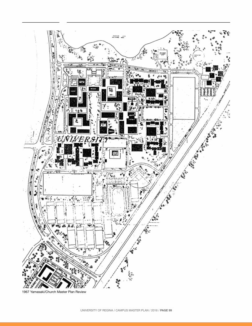
1967 – Yamasaki/Church Review
By 1967, the first of the regular five year plan reviews, the classroom building, laboratory building, central heating plant, physical ed u ca tion centre, and Campion College had been built. The library and education building were either under construction or at the advanced de sign stage. These can be seen on the plan in their present locations and with somewhat more definite form than the future buildings.
The plan retains the idea of quadrangles surrounding a landscaped mall to the south and an entrance court to the north of the library (now much smaller). The proposed student dor mi to ries have been brought into a much closer relationship with the academic buildings.
The sports fields are shown relocated to the south. The north-east research buildings and the pro posed married student quadrangles south of Wascana Park way have not changed.
The extensive surface parking lots interspersed between buildings shown in the 1962 plan are replaced by two huge parking structures and four smaller surface lots, north, south, east and west of the campus build ings.
The road system was modified a little. The perimeter driveway remained, but the “Central Avenue” was straightened and an intermediate road, now University Drive East was introduced; both to provide access to the large parking structures.
UNIVERSITY OF REGINA / CAMPUS MASTER PLAN / 2016 / PAGE 99
1967 Yamasaki/Church Master Plan Review
UNIVERSITY OF REGINA / CAMPUS MASTER PLAN / 2016 / PAGE 100
1972 – Long Plan
The 1972 Plan for the campus was produced by Jack Long of Calgary. By this time, the University had begun hiring Saskatchewan architects for the buildings and the adherence to the concepts of a series of small courtyards and a “podium and upper building” organization began to be abandoned. Luther College, the Education and Maintenance buildings had been built, and College West as well as the “AdHum” building were under con struc tion.
The idea of linked buildings persisted in a somewhat modified form. The focus of the out door space now became a large quadrangle, featuring a circular ornamental pond, rather than a composition of smaller courts. In general, the “build out” territory
remained approximately the same place and ex tent, while the playing fields were strung out as a buffer strip between the buildings and the highway. Much of the remaining land was taken up by a proposed golf course.
The road system began to take on its current layout as a ring road around the central academic buildings, with some meandering to make it more like a scenic drive. Parking was still, with a few exceptions, expected to be housed in multi-level structures, particularly two on either side of the Main te nance building.
The land south of the parkway lost its status as a married student housing district, and was shown as a research park.

UNIVERSITY OF REGINA / CAMPUS MASTER PLAN / 2016 / PAGE 101
1972 Long Master Plan

UNIVERSITY OF REGINA / CAMPUS MASTER PLAN / 2016 / PAGE 102
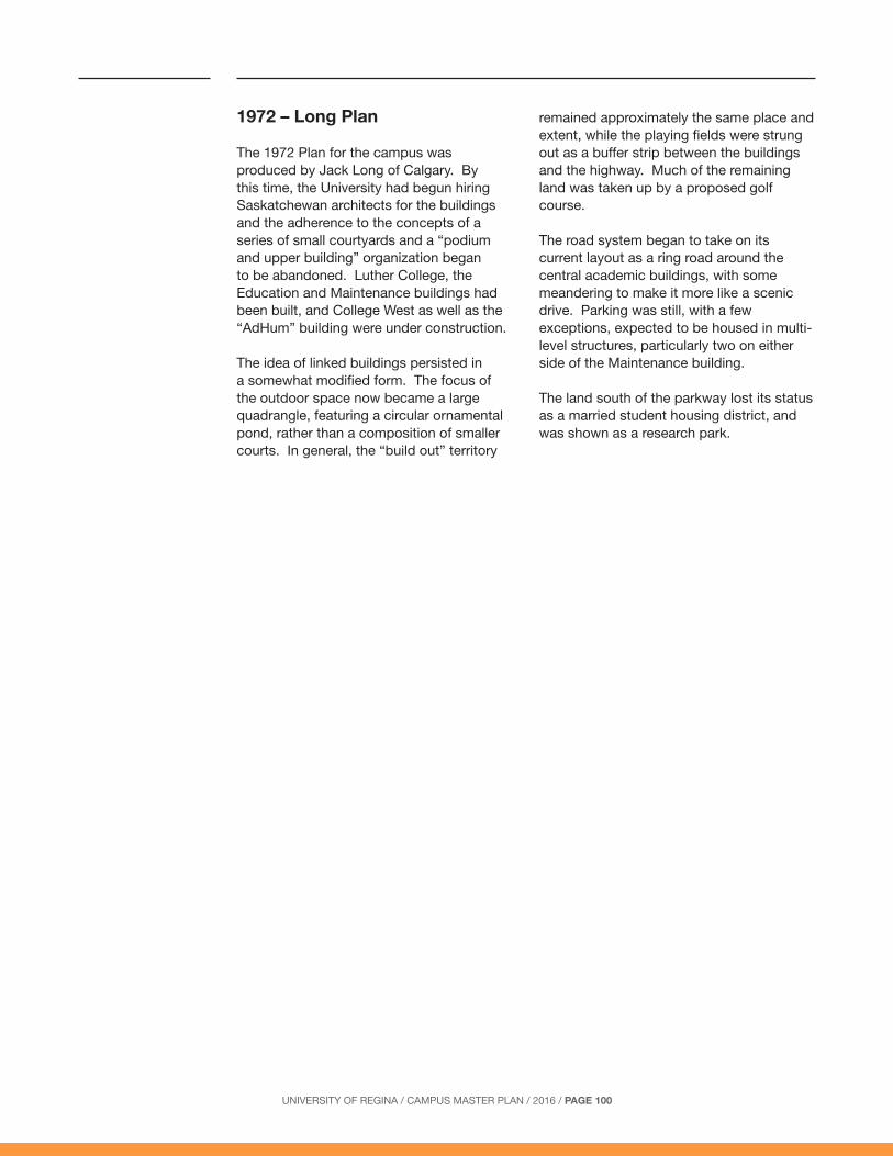
1977 – Long Re view
By 1977 the building boom had ended. Except for the College West/Laboratory Building link built around 1976, a seventeen year hiatus on build ing construction on the campus was underway, only to end in 1991.
The 1977 Plan was much more ten ta-tive than its predecessors, at tempt ing to express principles without too closely defining building form. The road sys tem is simplified, and the in ter nal pedestrian
system ex pressed as a series of dots. The future building forms are vague; but they follow the same basic arrangement as in 1972. Housing was now dropped as a firm feature of the plan, its place south of University Drive South given either to research or residences.
The urge to fill out the site area with future buildings was no longer strong. The Plan was content to leave significant portions of the campus des ig nat ed as a land reserve with unspecified use.
UNIVERSITY OF REGINA / CAMPUS MASTER PLAN / 2016 / PAGE 103
1977 Long Master Plan Review

UNIVERSITY OF REGINA / CAMPUS MASTER PLAN / 2016 / PAGE 104
1982 – du Toit Plan
The 1982 Plan included, for the first time, a written report which identified planning principles (see diagrams, left) as the major component of the plan, with the drawing providing a “demonstration” of the kind of built form that might result if the principles were followed.
Further student housing, as a major land use, was deleted from the plan. The primary organizing features of the campus were seen as the interior pedestrian circulation system (which necessitated linked build-ings) and a landscape structure (which established a “head” and “tail” of Academic Green and University Mall). The Green provided focus to the academic buildings while the Mall provided the organizing structure for future growth to the south, identified as research fa cil i ties. Buildings not in the primary pedestrian loop around the Ac a dem ic Green were connected as arms from it.
A new road parallel to the University Mall was proposed, later to be named “Research Drive”, and the beginnings of a network of streets and blocks shown in the research area.
Parking was to be accommodated in a mixture of surface lots and two parkades, one to the south-west, the other to the north-east. The fields remained as originally proposed in 1972. Once again, no at tempt was made to show built form in areas of the campus where growth was not foreseen for many years.
First Priority: Two Linking Buildings
Open Space Structure
Research extends down University Mall
Later growth extends from Primary Circuit

UNIVERSITY OF REGINA / CAMPUS MASTER PLAN / 2016 / PAGE 105
1982 du Toit Master Plan

UNIVERSITY OF REGINA / CAMPUS MASTER PLAN / 2016 / PAGE 106
1987 – du Toit Allsopp Hillier Plan
In 1987, the Academic Green became more informal, and the campus south of University Drive South was more clearly articulated as a research area with its own focal land scape, the “South Green”. A new north/south road was proposed through the academic core and extending south around the research uses. Sig nifi cant areas were designated as land reserve. The land reserve south of Wascana Parkway was pro posed to be developed as a community garden on an interim basis.
Six major planning objectives were stated:
1. Complete the interior pedestrian circuit and its extensions to allow the academic core of the campus to operate as intended with interior connections between as many buildings as possible.
2. Ensure that each building has a public address, which gives it a public presence, facilitates formal arrival at the main entrance, and assists in wayfinding particularly for visitors but also for regular users of the campus. Public ad dress es
for new and existing build ings east of the Academic Green would be provided by the de vel op ment of the cross campus street connection.
3. Create a strong physical and symbolic focus to the academic core through the landscaping of the Academic Green, linked through gen er ous open space connections to the rest of the campus and lakefront.
4. Establish an appropriate relationship between new buildings and park ing lots through a parkade in the north-east where space is limited and extending surface lots in the south-west. The Plan fore saw that the amount of new development in the academic core would ultimately be limited by the ability to provide adequate and a con ve nient ly located surface or structured parking to serve the build ings.
5. Relieve traffic congestion, particularly at the existing entrances, part ly through the establishment of a new entrance to the campus at Grant Road (now called Research Drive).
6. Expand associated but non-academic uses to the south, including research facilities and surface parking.
Interior Circulation
A Focal Space Expansion to the South

UNIVERSITY OF REGINA / CAMPUS MASTER PLAN / 2016 / PAGE 107
1987 du Toit Allsopp Hillier Plan

UNIVERSITY OF REGINA / CAMPUS MASTER PLAN / 2016 / PAGE 108
1992 – du Toit Allsopp Hillier Plan
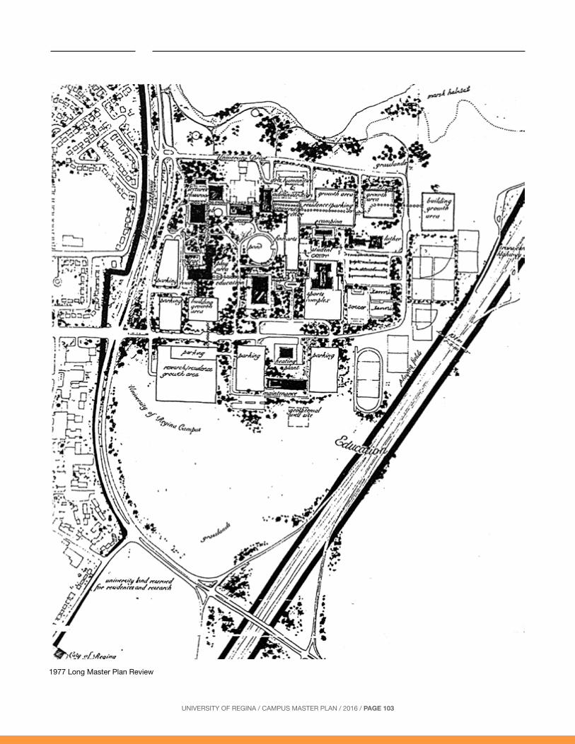
The 1992 Plan was actually com plet ed in 1995 as the roles of the WCA were modified to require Master Plan updates only every seven years versus five. The Lan guage Institute, which brought an end to the long dearth of construction, had been con struct-ed in 1991, Luther Col lege expanded in 1991, the Daycare was built in 1993, and the Uni ver si ty Centre architectural draw ings were complete.
Two research buildings had also been constructed: the ISM Building in 1990 and The Soft ware Technology Centre in 1994.
The Old Fire hall on Grant Road had been turned over to the University and used as a Tech nol o gy Development Centre.
For the first time since 1972, the idea of construction east of University Drive East was considered, paving the way for an institution which “war rant ed an association with the University, but was not de pen dent on the frequent movement of students, staff or faculty between it and other fa cil i ties within the academic core”.
In other respects, the Plan remained unchanged from 1987.
Landscape Structure
UNIVERSITY OF REGINA / CAMPUS MASTER PLAN / 2016 / PAGE 109
1992 du Toit Allsopp Hillier Plan

UNIVERSITY OF REGINA / CAMPUS MASTER PLAN / 2016 / PAGE 110
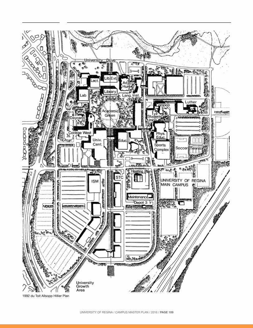
1998 – du Toit Allsopp Hillier Plan
By the 1998 Plan, the University Centre (since named the Dr. William Riddell Centre) was complete and the proposed First Nations University of Canada was shown east of University Drive East. A proposed Winter Sports Complex was located between Physical Education and the Education Building, a parking structure was recommended south of the Colleges, and Luther College was shown expanding eastwards. Courtyard buildings with primary facades towards the Lake were recommended north of the Colleges.
The Academic Green was reduced in size and framed by two symmetrical infill buildings that acted as a gateway to an eastern pedestrian arm, connecting to the First Nations University of Canada. The two buildings were to be linked below-grade to provide access to service/emergency vehicles and to maintain uninterrupted east-west landscape corridors. The
Library addition was illustrated narrowed to preserve the existing trees.
The area south of University Drive was planned as a formalized Research Park to be an entity associated with, but separate from, the University. A focal square was situated at the terminus of north-south pedestrian arm for new buildings to frame and expand outward from.
For the first time since 1982, the concept of a north-south through-road west of Physical Education, connecting to the Research Park, was abandoned in order to maintain a completely pedestrian academic precinct. University Drive West and its corresponding Research Park road was shown shifted east to improve safety at the Wascana Parkway intersections.
Potential locations for routes under the Trans Canada Highway were also proposed in case of the need to site a future campus in Wascana East.
Proposed Interior Concourse Structure
UNIVERSITY OF REGINA / CAMPUS MASTER PLAN / 2016 / PAGE 111
1998 du Toit Allsopp Hiller Plan

UNIVERSITY OF REGINA / CAMPUS MASTER PLAN / 2016 / PAGE 112
1999 - du Toit Allsopp Hillier Research Park Plan
In 1999, the Regina Research Park Plan was developed in greater detail into a Master Site Plan, the plan currently in use. The Loop Road is reconfigured to better respond to the Highway and the Wascana Parkway, by attempting to parallel them, where possible. The Research Quad reflects this change and transforms from a rectangular shape into an octagonal arrangement, with a turning circle at its centre. The circle creates a central node that accommodates visitor parking and provides a terminus to the north-south axis leading to the Academic Green. It and the key “image-creating” building are aligned with the entry road so that it they are in the direct line of sight for drivers arriving to the Park.
Longer term expansion is shown lining the Loop Road and Research Drive, with parking behind. Greater emphasis is put on Research Drive by showing strong building frontages, without parking along its length.
Three parking structures are shown, one of which will replace stalls lost to development of the University surface parking Lot 15, on University Drive South.
The Plan uses eight Site Plan Design Criteria:
1. Building envelopes are typically 37 metres wide and conform to a 9 metre planning grid.
2. A landscape/pedestrian/building articulation zone of 8 metres is provided between i) building envelope face, and ii) curb to street, driveway, or parking bay.
3. Continuous driveways 7 metres wide flank the rear of the buildings and connected parking bays. Loading and fire access is provided from these driveways.
4. Double-loaded parking bays are 18 metres wide. They are interspersed with tree planting strips 3 metres wide.
5. Landscaped walkway bands are 8 metres wide to permit 2.5 metre sidewalks flank by 2.75 metre planting strips.
6. 2.5 metre sidewalks are set back 3 metres from roadway curbs to permit a tree planting and snow-clearing zone.
7. Gross floor area is counted as 90% of the illustrated building envelope footprint.
8. Parking decks are assumed to have 3.5 floors at 350 sq. ft. per stall.

UNIVERSITY OF REGINA / CAMPUS MASTER PLAN / 2016 / PAGE 113
1999 Research Park Plan
UNIVERSITY OF REGINA / CAMPUS MASTER PLAN / 2016 / PAGE 114
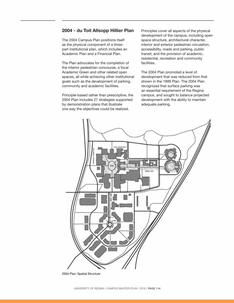
2004 - du Toit Allsopp Hillier Plan
The 2004 Campus Plan positions itself as the physical component of a three-part institutional plan, which includes an Academic Plan and a Financial Plan.
The Plan advocates for the completion of the interior pedestrian concourse, a focal Academic Green and other related open spaces, all while achieving other institutional goals such as the development of parking, community and academic facilities.
Principle-based rather than prescriptive, the 2004 Plan includes 27 strategies supported by demonstration plans that illustrate one way the objectives could be realized.
Principles cover all aspects of the physical development of the campus, including open space structure, architectural character, interior and exterior pedestrian circulation, accessibility, roads and parking, public transit, and the provision of academic, residential, recreation and community facilities.
The 2004 Plan promoted a level of development that was reduced from that shown in the 1999 Plan. The 2004 Plan recognized that surface parking was an essential requirement of the Regina campus, and sought to balance projected development with the ability to maintain adequate parking.
2004 Plan: Spatial Structure

UNIVERSITY OF REGINA / CAMPUS MASTER PLAN / 2016 / PAGE 115
2004 Demonstration Plan
UNIVERSITY OF REGINA / CAMPUS MASTER PLAN / 2016 / PAGE 116
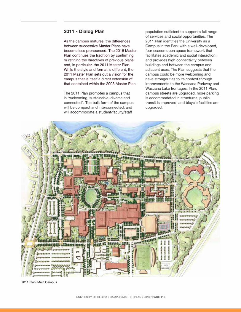
2011 - Dialog Plan
As the campus matures, the differences between successive Master Plans have become less pronounced. The 2016 Master Plan continues the tradition by confirming or refining the directives of previous plans and, in particular, the 2011 Master Plan. While the style and format is different, the 2011 Master Plan sets out a vision for the campus that is itself a direct extension of that contained within the 2003 Master Plan.
The 2011 Plan promotes a campus that is “welcoming, sustainable, diverse and connected”. The built form of the campus will be compact and interconnected, and will accommodate a student/faculty/staff
population sufficient to support a full range of services and social opportunities. The 2011 Plan identifies the University as a Campus in the Park with a well-developed, four-season open space framework that facilitates academic and social interaction, and provides high connectivity between buildings and between the campus and adjacent uses. The Plan suggests that the campus could be more welcoming and have stronger ties to its context through improvements to the Wascana Parkway and Wascana Lake frontages. In the 2011 Plan, campus streets are upgraded, more parking is accommodated in structures, public transit is improved, and bicycle facilities are upgraded.
2011 Plan: Main Campus
UNIVERSITY OF REGINA / CAMPUS MASTER PLAN / 2016 / PAGE 117
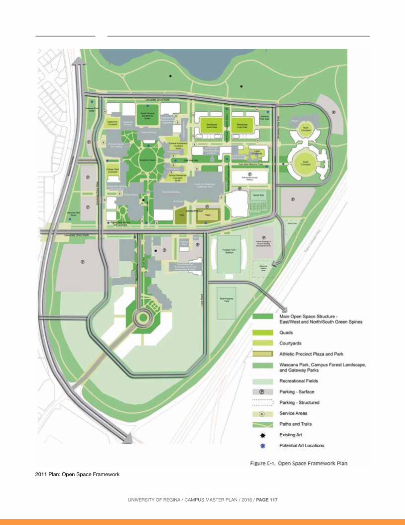
2011 Plan: Open Space Framework

UNIVERSITY OF REGINA / CAMPUS MASTER PLAN / 2016 / PAGE 118
Part of a Larger Development Pattern
The University is both an independent entity and a vital component of Wascana Centre.
The various facilities and land scapes of Wascana Centre have developed in a pattern that reflects both the strong fluid geometries of the lake and the equally strong but regular geometries of the surrounding city.
Almost all buildings, whether single or in groups, are oriented according to the orthogonal grid of the original land survey and the city’s street pattern. Roads, walk-ways and land scapes directly associated with buildings or building groups gen er al ly support this geometry as well, reinforcing the sense of order and con nect ed ness that firmly ties the Centre’s institutions with the city.
In contrast, the larger landscapes of the Centre have evolved according to the informal ge om e tries of the lake and terrain, contrasting with and bal anc ing the discipline of the building groupings. These landscapes, which comprise the greater portion of the Centre, have now a strong sense of presence that ties together the disparate land masses and institutions, creating the co her ent and memorable image for which the Centre is known.
The 2016 Plan confirms the shift in emphasis from development to stewardship. Much of Wascana Centre is mature in the sense that development in those areas is nearing completion and landscapes are well-established. Changes in these areas will largely be limited to modest building renovations and replacements, and to
normal landscape evolution. Currently under cultivation, large parts of the south and east quadrants of Wascana Centre are identified for future, as yet undefined, institutional and parkland development.
The mature landscapes of Wascana Centre are rooted in romantic landscape motifs imported from Europe at the beginning of the 20th Century. These landscapes are cherished and should be maintained. Going forward, however, the natural and cultural prairie setting should be adopted as a basis for future landscape development. These landscapes will be more sustainable, and will reflect a contemporary, localized aesthetic.
Management strategies should be developed that will promote sustainability in the face of increasing diminished water resources. A first strategy will be to prioritize levels of maintenance throughout the established landscapes. A second strategy will be to adopt sustainable, prairie-based approaches to the design of new landscapes.
The 2016 Plan identifies limited areas that should receive high maintenance and expands the extent of low maintenance landscape.
In the 2016 Plan, Wascana Centre as a whole is considered as a Cultural Heritage Landscape based on its longevity, historical associations and the prominence of past designers. The Legislative Building and Grounds currently enjoy federal heritage designation. The 2016 Plan identifies other buildings and landscapes that should be identified for further heritage assessment and possible designation in the near future.

UNIVERSITY OF REGINA / CAMPUS MASTER PLAN / 2016 / PAGE 119
2016 Wascana Centre Master Plan

UNIVERSITY OF REGINA / CAMPUS MASTER PLAN / 2016 / PAGE 120


![ED2 - Project 5.0 (Situation[Campus])](https://static.fdocuments.us/doc/165x107/568c4af31a28ab49169a4805/ed2-project-50-situationcampus.jpg)