4268 Federal Register /Vol. 66, No. 11/Wednesday, January ...
17
4268 Federal Register / Vol. 66, No. 11 / Wednesday, January 17, 2001 / Rules and Regulations DEPARTMENT OF COMMERCE National Oceanic and Atmospheric Administration 15 CFR Part 922 [Docket No. 000510129–1004–02] RIN 0648–A018 Florida Keys National Marine Sanctuary Regulations AGENCY: National Marine Sanctuary Program (NMSP), National Ocean Service (NOS), National Oceanic and Atmospheric Administration (NOAA), Department of Commerce (DOC). ACTION: Final rule; notice of boundary expansion; supplemental management plan. SUMMARY: By this document, NOAA expands the boundary of the Florida Keys National Marine Sanctuary (FKNMS or Sanctuary) in the remote westernmost portion of the Sanctuary by 96 square nautical miles (nm 2 ) and establishes the Tortugas Ecological Reserve (Ecological Reserve or Reserve) (a 151 nm 2 no-take zone) in the expanded area and in 55 nm 2 of the existing Sanctuary, to protect important coral reef resources. This document publishes the boundary coordinates for the expansion area and for the Reserve, announces the availability of the Supplemental Management Plan (SMP) for the Reserve, and publishes the text of the Revised Designation Document for the Sanctuary. The SMP details the goals and objectives, management responsibilities, research activities, interpretive and educational programs, and enforcement, including surveillance activities, for the Reserve. By this document, NOAA also issues regulations to implement the boundary expansion and the establishment of the Reserve and to regulate activities in the Reserve consistent with the purposes of its establishment and to make minor revisions to the existing Sanctuary boundary and to the boundaries of various zoned areas within that boundary to correct errors, provide clarification, and reflect more accurate data. This action is necessary to comprehensively protect some of the healthiest and most diverse coral reefs in the Florida Keys. The intended effect of this rule is to protect the deep water coral reef community in this area from being degraded by human activities. DATE: Pursuant to Section 304(b) of the National Marine Sanctuaries Act (NMSA) 16 U.S.C. 1434(b), the Revised Designation and regulations shall take effect and become final after the close of a review period of 45 days of continuous session of Congress, beginning on the day on which this document is published in the Federal Register, unless the Governor of the State of Florida certifies to the Secretary of Commerce that the Revised Designation or any of its terms is unacceptable, in which case the Revised Designation or any unacceptable term shall not take effect. Announcement of the effective date of the Final Regulations will be published in the Federal Register. ADDRESSES: Copies of the Final Supplemental Environmental Impact Statement/Supplemental Management Plan (FSEIS/SMP) and the Record of Decision for the Tortugas Ecological Reserve are available upon request to the Office of National Marine Sanctuaries, National Ocean Service, National Oceanic and Atmospheric Administration, 1305 East-West Highway, 11th Floor, Silver Spring, MD, 20910, (301) 713–3125. The FSEIS/SMP is also available on the Internet at: http:/ /www.fknms.nos.noaa.gov. Comments regarding the collection-of-information requirements contained in this rule should be sent to the Office of Information and Regulatory Affairs, Office of Management and Budget, Washington, DC, 20503 (Attention: Desk Officer for NOAA) and to Richard Roberts, NOAA, Work Station 8118, 1305 East-West Highway, 8th Floor, Silver Spring, MD, 20910. FOR FURTHER INFORMATION CONTACT: Billy Causey, Sanctuary Superintendent, (305) 743–2437. SUPPLEMENTARY INFORMATION: I. Introduction NOAA establishes the Tortugas Ecological Reserve (a no-take zone) in the Tortugas region (Tortugas or region) of the Florida Keys to protect nationally significant coral reef resources and to protect an area that serves as a source of biodiversity for the Sanctuary as well as for the southwest shelf of Florida. Establishment of the Reserve includes expansion of the Sanctuary boundary to ensure that the Reserve protects sensitive coral habitats lying outside the existing boundary of the Sanctuary. With this expansion, the FKNMS, which was designated by the Florida Keys National Marine Sanctuary and Protection Act (FKNMSPA, Pub. L. 101– 605) on November 16, 1990, consists of approximately 2900 nm 2 (9660 square kilometers) of coastal and oceanic waters, and the submerged lands thereunder, surrounding the Florida Keys and the Dry Tortugas. NOAA expands the boundary of the FKNMS and establishes the Tortugas Ecological Reserve to protect the nationally significant coral reef resources of the Tortugas region. This action furthers the objectives of the National Marine Sanctuaries Act (NMSA, 16 U.S.C. 1431 et seq.) and the FKNMSPA and meets the objectives of E.O. 13089, Coral Reef Protection. With the addition of the Tortugas Ecological Reserve, the network of no-take zones in the FKNMS is increased to 24, two of which are ecological reserves (Western Sambo and Tortugas Ecological Reserves). II. Background The Tortugas region is located in the westernmost portion of the FKNMS approximately 70 miles west of Key West, a very strategic position oceanographically that makes it an ideal location for an ecological reserve. It contains the healthiest coral reefs found in the Sanctuary. Coral pinnacles as high as forty feet with the highest coral cover (>30%) found in the Keys jut up from the ocean floor. These coral formations are bathed by some of the clearest and cleanest waters found in the Florida Keys. This occurs where the tropical waters of the Caribbean mingle with the more temperate waters of the Gulf of Mexico. Recent studies reveal that the Tortugas region is unique in its location and the extent to which oceanographic processes impact the area. The Tortugas plays a dynamic role in supporting marine ecosystems throughout south Florida and the Florida Keys. Larvae that are spawned from adult populations in the Tortugas are spread throughout the Keys and south and southwest Florida by a persistent system of currents and eddies that provide the retention and current pathways necessary for successful recruitment of both local and foreign spawned juveniles with larval stages remaining from hours for some coral species up to one year for spiny lobster. In addition, the upwellings and convergences of the current systems provide the necessary food supplies in concentrated frontal regions to support larval growth stages. The Tortugas is located at the transition between the Gulf of Mexico and the Atlantic and is strongly impacted by two major current systems, the Loop Current in the eastern Gulf of Mexico and the Florida Current in the Straits of Florida, as well as by the system of eddies that form and travel along the boundary of these currents. Of particular importance to the marine communities of the Tortugas and Florida Keys is the formation of a large VerDate 11<MAY>2000 20:09 Jan 16, 2001 Jkt 194001 PO 00000 Frm 00002 Fmt 4701 Sfmt 4700 E:\FR\FM\17JAR5.SGM pfrm08 PsN: 17JAR5
Transcript of 4268 Federal Register /Vol. 66, No. 11/Wednesday, January ...

4268 Federal Register / Vol. 66, No. 11 / Wednesday, January 17, 2001 / Rules and Regulations
DEPARTMENT OF COMMERCE
National Oceanic and AtmosphericAdministration
15 CFR Part 922
[Docket No. 000510129–1004–02]
RIN 0648–A018
Florida Keys National MarineSanctuary Regulations
AGENCY: National Marine SanctuaryProgram (NMSP), National OceanService (NOS), National Oceanic andAtmospheric Administration (NOAA),Department of Commerce (DOC).ACTION: Final rule; notice of boundaryexpansion; supplemental managementplan.
SUMMARY: By this document, NOAAexpands the boundary of the FloridaKeys National Marine Sanctuary(FKNMS or Sanctuary) in the remotewesternmost portion of the Sanctuary by96 square nautical miles (nm2) andestablishes the Tortugas EcologicalReserve (Ecological Reserve or Reserve)(a 151 nm2 no-take zone) in theexpanded area and in 55 nm2 of theexisting Sanctuary, to protect importantcoral reef resources. This documentpublishes the boundary coordinates forthe expansion area and for the Reserve,announces the availability of theSupplemental Management Plan (SMP)for the Reserve, and publishes the textof the Revised Designation Documentfor the Sanctuary. The SMP details thegoals and objectives, managementresponsibilities, research activities,interpretive and educational programs,and enforcement, including surveillanceactivities, for the Reserve. By thisdocument, NOAA also issuesregulations to implement the boundaryexpansion and the establishment of theReserve and to regulate activities in theReserve consistent with the purposes ofits establishment and to make minorrevisions to the existing Sanctuaryboundary and to the boundaries ofvarious zoned areas within thatboundary to correct errors, provideclarification, and reflect more accuratedata. This action is necessary tocomprehensively protect some of thehealthiest and most diverse coral reefsin the Florida Keys. The intended effectof this rule is to protect the deep watercoral reef community in this area frombeing degraded by human activities.DATE: Pursuant to Section 304(b) of theNational Marine Sanctuaries Act(NMSA) 16 U.S.C. 1434(b), the RevisedDesignation and regulations shall takeeffect and become final after the close of
a review period of 45 days ofcontinuous session of Congress,beginning on the day on which thisdocument is published in the FederalRegister, unless the Governor of theState of Florida certifies to the Secretaryof Commerce that the RevisedDesignation or any of its terms isunacceptable, in which case the RevisedDesignation or any unacceptable termshall not take effect. Announcement ofthe effective date of the FinalRegulations will be published in theFederal Register.
ADDRESSES: Copies of the FinalSupplemental Environmental ImpactStatement/Supplemental ManagementPlan (FSEIS/SMP) and the Record ofDecision for the Tortugas EcologicalReserve are available upon request tothe Office of National MarineSanctuaries, National Ocean Service,National Oceanic and AtmosphericAdministration, 1305 East-WestHighway, 11th Floor, Silver Spring, MD,20910, (301) 713–3125. The FSEIS/SMPis also available on the Internet at: http://www.fknms.nos.noaa.gov. Commentsregarding the collection-of-informationrequirements contained in this ruleshould be sent to the Office ofInformation and Regulatory Affairs,Office of Management and Budget,Washington, DC, 20503 (Attention: DeskOfficer for NOAA) and to RichardRoberts, NOAA, Work Station 8118,1305 East-West Highway, 8th Floor,Silver Spring, MD, 20910.
FOR FURTHER INFORMATION CONTACT:Billy Causey, Sanctuary Superintendent,(305) 743–2437.
SUPPLEMENTARY INFORMATION:
I. Introduction
NOAA establishes the TortugasEcological Reserve (a no-take zone) inthe Tortugas region (Tortugas or region)of the Florida Keys to protect nationallysignificant coral reef resources and toprotect an area that serves as a sourceof biodiversity for the Sanctuary as wellas for the southwest shelf of Florida.Establishment of the Reserve includesexpansion of the Sanctuary boundary toensure that the Reserve protectssensitive coral habitats lying outside theexisting boundary of the Sanctuary.
With this expansion, the FKNMS,which was designated by the FloridaKeys National Marine Sanctuary andProtection Act (FKNMSPA, Pub. L. 101–605) on November 16, 1990, consists ofapproximately 2900 nm2 (9660 squarekilometers) of coastal and oceanicwaters, and the submerged landsthereunder, surrounding the FloridaKeys and the Dry Tortugas.
NOAA expands the boundary of theFKNMS and establishes the TortugasEcological Reserve to protect thenationally significant coral reefresources of the Tortugas region. Thisaction furthers the objectives of theNational Marine Sanctuaries Act(NMSA, 16 U.S.C. 1431 et seq.) and theFKNMSPA and meets the objectives ofE.O. 13089, Coral Reef Protection. Withthe addition of the Tortugas EcologicalReserve, the network of no-take zones inthe FKNMS is increased to 24, two ofwhich are ecological reserves (WesternSambo and Tortugas EcologicalReserves).
II. BackgroundThe Tortugas region is located in the
westernmost portion of the FKNMSapproximately 70 miles west of KeyWest, a very strategic positionoceanographically that makes it an ideallocation for an ecological reserve. Itcontains the healthiest coral reefs foundin the Sanctuary. Coral pinnacles ashigh as forty feet with the highest coralcover (>30%) found in the Keys jut upfrom the ocean floor. These coralformations are bathed by some of theclearest and cleanest waters found inthe Florida Keys. This occurs where thetropical waters of the Caribbean minglewith the more temperate waters of theGulf of Mexico.
Recent studies reveal that theTortugas region is unique in its locationand the extent to which oceanographicprocesses impact the area. The Tortugasplays a dynamic role in supportingmarine ecosystems throughout southFlorida and the Florida Keys. Larvaethat are spawned from adultpopulations in the Tortugas are spreadthroughout the Keys and south andsouthwest Florida by a persistent systemof currents and eddies that provide theretention and current pathwaysnecessary for successful recruitment ofboth local and foreign spawnedjuveniles with larval stages remainingfrom hours for some coral species up toone year for spiny lobster. In addition,the upwellings and convergences of thecurrent systems provide the necessaryfood supplies in concentrated frontalregions to support larval growth stages.
The Tortugas is located at thetransition between the Gulf of Mexicoand the Atlantic and is stronglyimpacted by two major current systems,the Loop Current in the eastern Gulf ofMexico and the Florida Current in theStraits of Florida, as well as by thesystem of eddies that form and travelalong the boundary of these currents. Ofparticular importance to the marinecommunities of the Tortugas andFlorida Keys is the formation of a large
VerDate 11<MAY>2000 20:09 Jan 16, 2001 Jkt 194001 PO 00000 Frm 00002 Fmt 4701 Sfmt 4700 E:\FR\FM\17JAR5.SGM pfrm08 PsN: 17JAR5

4269Federal Register / Vol. 66, No. 11 / Wednesday, January 17, 2001 / Rules and Regulations
counterclockwise rotating gyre (largeeddy) that forms just south of theTortugas where the Loop Current turnsabruptly into the Straits of Florida. Thisgyre can persist for several monthsbefore it is forced downstream along theKeys decreasing in size and increasingin forward speed until its demise in themiddle Keys. This gyre serves as aretention mechanism for local recruitsand as a pathway to inshore habitats forforeign recruits. It may also serve as apotential food provider throughplankton production and concentration.
The Tortugas is also located adjacentto two coastal current systems,including the wind-driven currents ofboth the Florida Keys coastal zone andthe west Florida Shelf.
Persistent westward winds over theKeys create a downwelling system thatdrives a westward coastalcountercurrent along the lower Keys tothe Tortugas. The countercurrentprovides a return route to the Tortugasand its gyre-dominated circulation, andonshore surface Ekman transport (aprocess whereby wind-driven upwellingbottom water is transported 45 degreesto the left of the actual wind directionin the northern hemisphere) provide amechanism for larval entry into coastalhabitats. Circulation on the west Floridashelf is strongly influenced by windforcing, but there also appears to be asignificant southward mean flow,possibly due to the Loop Current. Theeffect of these currents on the Tortugasis to provide a larval return mechanismto the Florida Bay nursery groundsduring periods of southeast winds, aswell as the transport mechanism forlow-salinity shelf waters from the northwhen the mean southward flow isstrong.
The combination of downstreamtransport in the Florida Current,onshore Ekman transport along thedownwelling coast, upstream flow inthe coastal countercurrent andrecirculation in the Tortugas gyre formsa recirculating recruitment pathwaystretching from the Dry Tortugas to themiddle Keys that enhances larvalretention and recruitment into the Keyscoastal waters of larvae spawned locallyor foreign larvae from remote upstreamareas of the Gulf of Mexico andCaribbean Sea. Convergences betweenthe Florida Current front and coastalgyres provide a mechanism toconcentrate foreign and local larvae, aswell as their planktonic food supply.Onshore Ekman transport andhorizontal mixing from frontalinstabilities enhance export from theoceanic waters into the coastal zone. Awind- and gyre-driven countercurrentprovides a return leg to aid larval
retention in local waters. Seasonalcycles of the winds, countercurrent andFlorida Current favor recruitment to thecoastal waters during the fall when thecountercurrent can extend the length ofthe Keys from the Dry Tortugas to KeyLargo, onshore Ekman transport ismaximum and downstream flow in theFlorida Current is minimum. The mixand variability of the different processesforming the recruitment conveyorprovide ample opportunity for localrecruitment of species with larval stagesranging from days to several months.For species with longer larval stages,such as the spiny lobster, which has asix to 12-month larval period, a localrecruitment pathway exists that utilizesretention in the Tortugas gyre andsouthwest Florida shelf and return viathe Loop Current and the Keys conveyorsystem. Return from the southwestFlorida shelf could also occur throughwestern Florida Bay and the Keyscoastal countercurrent, due to a netsoutheastward flow recently observedconnecting the Gulf of Mexico to theAtlantic through the Keys.
The Tortugas North portion of theTortugas Ecological Reserve consists ofcoral reef communities that areunparalleled in the Florida Keys in theirdiversity and composition. Severalcarbonate banks of varying size anddepth (30 feet to 75 feet) and low reliefhardbottom habitats with patches ofsand and rubble characterize TortugasNorth. The most prominent features inthe Tortugas North portion of theReserve are Tortugas Bank andSherwood Forest. Tortugas Bank crestsat 66 feet and supports abundantattached reef organisms such assponges, corals, and soft corals. North ofTortugas Bank, in an area previouslybelieved to be composed only of sand,are several pinnacles covered with hardand soft corals and reef fish.
Sherwood Forest is an ancient stonycoral forest exhibiting 30% or morebottom cover located along the westernflank of Tortugas Bank (compared to10% for the rest of the Florida Keys).The area’s name was inspired by thebizarre mushroom-shaped coral headsthat are an adaptation to the low lightconditions. There seem to be indicationsthat the mushroom shape is the result ofa composite of two coral species. Thecoral reef is so well developed, that itforms a veneer over the true bottomapproximately three feet below the reef.It is an area of low relief but high coralcover that rises to a depth of about 65feet and covers an area of many acres.The area exhibits a complex habitatwith various rock ledges, holes, andcaves, providing hiding places formarine life. Unusual coral formations
and previously unidentified coralspecies associations have been observedin this location. Gorgonians and blackcorals (Antipathies sp.), which are notcommon elsewhere in the Florida Keys,are also prolific. An abundance ofgroupers has been documented inSherwood Forest as have sightings ofuncommon and rare fish species such asjewfish, white-eyed goby, andorangeback bass.
The Tortugas South portion of theReserve includes a wide range of deepwater coral reef habitats that will protectand conserve many rare and unusualreef species, and incorporates sufficientarea to provide a buffer to the criticalcoral reef community. The upperportion of Tortugas South includes therelatively shallow Riley’s Hump area inless than 100 feet of water. Riley’sHump consists of attached algae,scattered small coral colonies, sand, andhardbottom habitats. It is also a knownfish aggregating and spawning site forseveral snapper-grouper species.
Deep reef habitats with numerous softcorals but few stony corals are found inTortugas South in depths from 200 to400 feet. A series of small pinnacles thatsurround a larger seamount have beenidentified as part of an east-westrunning ledge that begins around 250feet and drops to close to 400 feet in anearly vertical profile. This is unlikeany other coral reef habitat discoveredwithin Sanctuary waters. Thesecomplex habitats support numerous fishspecies including streamer bass,yellowmouth grouper, snowy grouper,scamp, speckled hind, creole fish, bankbutterflyfish, amberjack, and almaco.
The deepest portions (1,600 to 1,800feet) of Tortugas South encompasslimestone ledges where unusual deep-dwelling sea life such as lantern fish(myctophids), tilefish, golden crabs, andgiant isopods have been observed. Thesand bottom habitat has been observedto be teeming with unique deep seaspecies of shrimp, fish, sea cucumbers,anemones, and crabs.
These critical deep watercommunities of Tortugas South arevulnerable to a wide range of impactsfrom fishing gear including deep watertrawls and traps, and impacts fromanchoring. Fishing gear impacts havebeen observed on sand and limestonesubstrates in some deep water areas.
In order for the Reserve to bebiologically effective and to ensureprotection and conservation of the fullrange of coral reef habitats and speciesin the Tortugas region, it is critical thatall of the various benthic habitats andtheir associated marine communities,from the shallowest to the greatest
VerDate 11<MAY>2000 20:09 Jan 16, 2001 Jkt 194001 PO 00000 Frm 00003 Fmt 4701 Sfmt 4700 E:\FR\FM\17JAR5.SGM pfrm08 PsN: 17JAR5

4270 Federal Register / Vol. 66, No. 11 / Wednesday, January 17, 2001 / Rules and Regulations
depths, be included within theboundary of the Reserve.
Despite its beauty and productivity,the Tortugas has been exploited fordecades, greatly diminishing itspotential as a source of larval recruits tothe downstream portion of the FloridaKeys and to itself. Fish and lobsterpopulations have been significantlydepleted thus threatening the integrityand natural dynamics of the ecosystem.Large freighters have been using Riley’sHump as a secure place to anchorbetween port visits. The several-tonanchors and chains of these ships havedevastated large areas of fragile coralreef habitat that provide the foundationfor economically important fisheries.
Visitation to the Tortugas region hasincreased dramatically over the past 10years. Visitation in the DRTO increased300% from 1984 through 1998. Thepopulation of South Florida is projectedto increase from the current 6.3 millionpeople to more than 12 million by 2050.With continued technologicalinnovations such as global positioningsystems (GPS), electronic fish finders,better and faster vessels, this increase inpopulation will translate to morepressure on the resources in theTortugas. By designating this area anecological reserve, NOAA hopes tocreate a seascape of promise—a placewhere the ecosystem’s full potential canbe realized and a place that humans canexperience, learn from and respect. Thisgoal is consistent with E.O. 13089, CoralReef Protection, and the U.S. Coral ReefTask Force’s recommendations.
The FSEIS/SMP supplements theFinal Environmental Impact Statement/Final Management Plan (FEIS/MP) forthe Sanctuary and fulfills therequirements of the NationalEnvironmental Policy Act of 1969(NEPA) for the Sanctuary boundaryexpansion, the establishment of theReserve, and the issuance of theregulations implementing the boundaryexpansion and the Reserve. Becauseestablishment of the Tortugas EcologicalReserve includes a Sanctuary boundary
expansion NOAA has followed theprocedures and has complied with therequirements of section 304(a) of theNMSA, 16 U.S.C. 1434(a).
Other actions by various otherjurisdictions are underway to ensurecomprehensive protection of the uniqueresources of the Tortugas region:
• The National Park Service (NPS) isrevising the General Management Planfor the Dry Tortugas National Park(DRTO) that will include as thepreferred alternative a proposal to createa Research/Natural Area (RNA) withinthe Park. The proposed boundary andregulations for the RNA will becompatible with the establishment ofthe Tortugas Ecological Reserve.
• Under the Magnuson-StevensFishery Conservation and ManagementAct (Magnuson-Stevens Act), the Gulf ofMexico Fishery Management Council(GMFMC) has primary federalresponsibility and expertise for thedevelopment of fishery managementplans (FMPs) throughout the Gulf ofMexico. The GMFMC has developed anamendment for addressing EssentialFish Habitat requirements for thevarious Gulf of Mexico FisheryManagement Plans (GMFMPs) whichcover the area of the Tortugas EcologicalReserve. The GMFMPs are implementedby regulations promulgated by theNational Marine Fisheries Service(NMFS) (50 CFR part 622). At theGMFMC’s meeting on November 9,1999, the NOS and NMFS requested thatthe GMFMC take steps to prohibitfishing, consistent with the purpose ofthe Tortugas Ecological Reserve. TheGMFMC accepted this request and at itsJuly 10–13, 2000 meeting, adopted theGeneric Amendment for AddressingEssential Fish Habitat Requirements forFishery Management Plans of the Gulfof Mexico. That amendment to theGMFMPs is consistent with the TortugasEcological Reserve and the regulationsgoverning ecological reserves within theFKNMS, at 15 CFR 922.164(d).
• NMFS intends to issue regulationsconsistent with the no-take status of the
Tortugas Ecological Reserve for thespecies covered by the GMFMPs and forAtlantic tunas, Swordfish, sharks, andAtlantic billfishes.
• The State of Florida is draftingregulations to prohibit fishing in thoseportions of Tortugas North that liewithin State waters.
Combined with the establishment ofthe Tortugas Ecological Reserve, theseactions would result in comprehensiveprotection for the nationally significantcoral reef habitats from shallow to deepwater extending from the DRTO intoSanctuary and GMFMC waters.
The process by which NOAA arrivedat its proposal to establish the TortugasEcological Reserve is described in thepreamble to the Proposed Rulepublished on May 18, 2000 (65 FR31634). The five boundary alternativesand the four regulatory alternativesconsidered by NOAA are also set forthand described in the preamble to theProposed Rule and in the FSEIS.
Consistent with the proposal, NOAAhas selected Boundary Alternative III(the Preferred Boundary Alternative)(Figure 1) and expands the boundary ofthe Sanctuary by approximately 96 nm2
to include two significant coral reefareas known as Sherwood Forest andRiley’s Hump. The boundary of theSanctuary in its northwesternmostcorner is expanded by approximately 36nm2 to include Sherwood Forest and inits southwesternmost corner isexpanded by adding a noncontiguousarea of approximately 60 nm2 to includeRiley’s Hump. By the final regulationsissued with this document, NOAAestablishes a Tortugas EcologicalReserve of approximately 151 nm2. TheTortugas Ecological Reserveincorporates the expanded area andapproximately 55 nm2 of the existingSanctuary in its northwest corner. Thearea of the Reserve surroundingSherwood Forest encompassesapproximately 91 nm2 and is calledTortugas North; the area surroundingRiley’s Hump is called Tortugas South.BILLING CODE 3510–08–P
VerDate 11<MAY>2000 20:09 Jan 16, 2001 Jkt 194001 PO 00000 Frm 00004 Fmt 4701 Sfmt 4700 E:\FR\FM\17JAR5.SGM pfrm08 PsN: 17JAR5

4271Federal Register / Vol. 66, No. 11 / Wednesday, January 17, 2001 / Rules and Regulations
While NOAA proposed RegulatoryAlternative C as its Preferred Regulatory
Alternative, NOAA has selectedRegulatory Alternative D and
implements it by the final regulationsissued with this document. The
VerDate 11<MAY>2000 20:09 Jan 16, 2001 Jkt 194001 PO 00000 Frm 00005 Fmt 4701 Sfmt 4700 E:\FR\FM\17JAR5.SGM pfrm08 PsN: 17JAR5

4272 Federal Register / Vol. 66, No. 11 / Wednesday, January 17, 2001 / Rules and Regulations
difference between RegulatoryAlternatives C and D is that RegulatoryAlternative D prohibits access inTortugas South except for continuoustransit, law enforcement, or forscientific research or educationalactivities pursuant to a sanctuarypermit. Under Alternative C, which isless restrictive, access to Tortugas Southwould have been allowed and, exceptfor continuous transit and lawenforcement purposes, would haverequired a simple, no-cost permit andcall-in for entering and leaving.
The GMFMC, at its July 10–13, 2000,meeting, took final action on its GenericAmendment Addressing theEstablishment of Tortugas MarineReserves, which would create theCouncil’s own 60 nm2 marine reserve inthe same location as Tortugas South andin the 13 nm2 portion of Tortugas Norththat is within the Council’s jurisdiction.The GMFMC has proposed a prohibitionon any fishing (consumptive activity) oranchoring by fishing vessels. TheCouncil also requested that NOAAprohibit anchoring by all vessels in thereserve and that NOAA prohibit alldiving in the areas of Tortugas Northand Tortugas South that are subject toCouncil jurisdiction.
The GMFMC expressed concern thatnon-consumptive diving would makethe no-take prohibitions difficult toenforce, particularly with regard todiving for lobsters and spearfishing. TheCouncil believes that eliminating alldiving activities would greatly simplifyenforcement. In addition, the GMFMCstated that non-consumptive diving canimpact and damage bottom habitatthrough the inadvertent contact withcoral or by stirring up sand and silt onthe bottom. The Council also expressedconcern about the biological impact ofdiving on the behavior of reef fishpopulations. Tortugas South is a knownspawning area for many fish includingred snapper, yellow tail snapper,mutton snapper, mangrove snapper,snowy grouper, black grouper, redgrouper, red hind, and rock hind. TheCouncil believes that the potential fordiver impact on fish spawning would beeliminated by the closure. In addition,other commentors expressed concernover the effects of non-consumptivediving on sensitive coral reef resources.
Based on the comments received,NOAA revised the Preferred Alternativein the FSEIS from the PreferredAlternative in the DSEIS to prohibit alldiving in Tortugas South except forresearch or educational activitiespursuant to a Sanctuary permit. Non-consumptive diving will still be allowedin Tortugas North. The resources ofTortugas North are not as sensitive to
diver impacts as those in TortugasSouth and permitting non-consumptivediving in Tortugas North with carefulmonitoring of the impacts of suchdiving will provide exceptional resourceappreciation and public educationbenefits. Also, prohibiting diving inTortugas South will provide a referencefor assessing the impact of divingactivities in Tortugas North.
Socio-economic impacts, determinedby analyzing the costs and benefits ofno-take regulations on variousindustries, indicate moderate impactson fishermen, mostly lobster andhandline fishermen, and somerecreational charter operators, andminimal or small impacts onrecreational fishermen, commercialshippers, and treasure salvors. Thepotential for benefits to non-consumptive users and the scientificcommunity is high due to theeducational and research value of a no-take ecological reserve. Positive effectsto surrounding areas through long-termfisheries replenishment are also likely.
The action taken today adequatelyprotects the nationally significant coralreef resources of the Tortugas region andfulfills the objectives of the FKNMSPAand the National Marine SanctuariesAct (NMSA). The Tortugas EcologicalReserve established by this action is ofsufficient size and the regulationsimpose adequate protective measures toachieve the goals and objectives of theFKNMSPA and the NMSA while notunduly impacting user groups.
III. Revised Designation DocumentThe Designation Document for the
Sanctuary is revised to incorporate thecoordinates for the expanded boundaryof the Sanctuary, to authorize theregulation of entering or leavingspecified areas of the Sanctuary, and tomake necessary technical and editorialcorrections of the DesignationDocument. The text of the RevisedDesignation Document follows:REVISED DESIGNATION DOCUMENT FORTHE FLORIDA KEYS NATIONAL MARINESANCTUARY
Article I. Designation and EffectOn November 16, 1990, the Florida Keys
National Marine Sanctuary and ProtectionAct, Pub. L. 101–605 (16 U.S.C. 1433 note),became law. That Act designated an area ofwaters and submerged lands, including theliving and nonliving resources within thosewaters, as described therein, as the FloridaKeys National Marine Sanctuary (Sanctuary).By this revised Designation Document, theboundary of the Sanctuary is expanded toinclude important coral reef resources andresources in two areas known as SherwoodForest and Riley’s Hump, just beyond thewesternmost portion of the statutorySanctuary boundary.
Section 304 of the National MarineSanctuaries Act (NMSA), 16 U.S.C. 1431 etseq., authorizes the Secretary of Commerce toissue such regulations as are necessary andreasonable to implement the designation,including managing and protecting theconservation, recreational, ecological,historical, scientific, educational, cultural,archaeological or aesthetic resources andqualities of a national marine sanctuary.Section 1 of Article IV of this DesignationDocument lists activities of the type that arepresently being regulated or may have to beregulated in the future, in order to protectSanctuary resources and qualities. Listing insection 1 does not mean that a type ofactivity will be regulated in the future,however, if a type of activity is not listed, itmay not be regulated, except on anemergency basis, unless section 1 isamended, following the procedures fordesignation of a sanctuary set forth inparagraphs (a) and (b) of section 304 of theNMSA, to include the type of activity.
Nothing in this Designation Document isintended to restrict activities that do notcause an adverse effect on the resources orqualities of the Sanctuary or on Sanctuaryproperty or that do not pose a threat of harmto users of the Sanctuary.
Article II. Description of the Area
The Florida Keys National MarineSanctuary boundary encompassesapproximately 2900 nm2 (9,800 squarekilometers) of coastal and ocean waters, andthe submerged lands thereunder,surrounding the Florida Keys in Florida. Theeasternmost point of the Sanctuary is thenortheasternmost point of Biscayne NationalPark and the westernmost point isapproximately 15 kilometers to the west ofthe western boundary of Dry TortugasNational Park, a linear distance ofapproximately 335 kilometers. Thecontiguous area boundary on the AtlanticOcean side of the Florida Keys runs southfrom Biscayne National Park generallyfollowing the 300-foot isobath, curving in asouthwesterly direction along the FloridaKeys archipelago until south of the DryTortugas. The contiguous area boundary onthe Gulf of Mexico side of the Florida Keysruns from this southern point in a straightline to the northwest and then when directlywest of the Dry Tortugas in a straight line tothe north. The boundary then turns to theeast and slightly south and follows a straightline to just west of Key West and then turnsto the northeast and follows a straight lineparallel to the Florida Keys approximatelyfive miles to the south, and then follows theEverglades National Park boundary untilDivision Point where the boundary thenfollows the western shore of Manatee Bay,Barnes Sound, and Card Sound. Theboundary then follows the southernboundary of Biscayne National Park and upits eastern boundary until itsnortheasternmost point. Starting just to theeast of the most western boundary line of thecontiguous portion of the Sanctuary there isa vertical rectangular shape area of 60 nm2
just to the south.The shoreward boundary of the Sanctuary
is the mean high-water mark except around
VerDate 11<MAY>2000 20:09 Jan 16, 2001 Jkt 194001 PO 00000 Frm 00006 Fmt 4701 Sfmt 4700 E:\FR\FM\17JAR5.SGM pfrm08 PsN: 17JAR5

4273Federal Register / Vol. 66, No. 11 / Wednesday, January 17, 2001 / Rules and Regulations
the Dry Tortugas where it is the boundary ofthe Dry Tortugas National Park. TheSanctuary boundary encompasses the entireFlorida coral reef tract, all of the mangroveislands of the Florida Keys, and some of thesea grass meadows of the Florida Keys. Theprecise boundary of the Sanctuary is set forthat the end of this Designation Document.
Article III. Characteristics of the Area ThatGive it Particular Value
The Florida Keys extend approximately223 miles southwest from the southern tip ofthe Florida peninsula. Adjacent to theFlorida Keys land mass are locatedspectacular unique, nationally significantmarine environments, including sea grassmeadows, mangrove islands, and extensiveliving coral reefs. These marineenvironments support rich biologicalcommunities possessing extensiveconservation, recreational, commercial,ecological, historical, research, educational,and aesthetic values which give this areaspecial national significance. Theseenvironments are the marine equivalent oftropical rain forests in that they support highlevels of biodiversity, are fragile and easilysusceptible to damage from human activities,and possess high value to humans if properlyconserved. These marine environments aresubject to damage and loss of their ecologicalintegrity from a variety of sources ofdisturbance.
The Florida Keys are a limestone islandarchipelago. The Keys are located at thesouthern edge of the Florida Plateau, a largecarbonate platform made of a depth of up to7000 meters of marine sediments, whichhave been accumulating for 150 million yearsand which have been structurally modifiedby subsidence and sea level fluctuation. TheKeys region is generally divided into fivedistinct areas: the Florida reef tract, one ofthe world’s largest coral reef tracts and theonly barrier reef in the United States; FloridaBay, described as an active lime-mud factorybecause of the high carbonate content of itssilts and muds; the Southwest ContinentalShelf; the Straits of Florida; and the Keysthemselves.
The 2.5 million-acre Sanctuary containsone of North America’s most diverseassemblages of terrestrial, estuarine, andmarine fauna and flora, including, inaddition to the Florida reef tract, thousandsof patch reefs, one of the world’s largest seagrass communities covering 1.4 million acres,mangrove fringed shorelines, mangroveislands, and various hardbottom habitats.These diverse habitats provide shelter andfood for thousands of species of marineplants and animals, including more than 50species of animals identified under Federalor State law, as endangered or threatened.The Keys were at one time a major seafaringcenter for European and American traderoutes to the Caribbean, and the submergedcultural and historic resources (i.e.,shipwrecks) abound in the surroundingwaters. In addition, the Sanctuary maycontain substantial archaeological resourcesof pre-European cultures.
The uniqueness of the marine environmentdraws multitudes of visitors to the Keys. Themajor industry in the Florida Keys is tourism,
including activities related to the Keys’marine resources, such as dive shops, charterfishing and dive boats and marinas, as wellas hotels and restaurants. The abundance ofthe resources also supports a largecommercial fishing employment sector.
The number of visitors to the Keys growseach year, with a concomitant increase in thenumber of residents, homes, jobs, andbusinesses. As population grows and theKeys accommodate ever-increasing resource-use pressures, the quality and quantity ofSanctuary resources are increasinglythreatened. These pressures requirecoordinated and comprehensive monitoringand researching of the Florida Keys’ region.
Article IV. Scope of Regulations
Section 1. Activities Subject to RegulationThe following activities are subject to
regulation under the NMSA, eitherthroughout the entire Sanctuary or withinidentified portions of it or, as indicated, inareas beyond the boundary of the Sanctuary,to the extent necessary and reasonable. Suchregulation may include prohibitions toensure the protection and management of theconservation, recreational, ecological,historical, scientific, educational, cultural,archaeological or aesthetic resources andqualities of the area. Because an activity islisted here does not mean that such activityis being or will be regulated. All listingmeans is that the activity can be regulated,after compliance with all applicableregulatory laws, without going through thedesignation procedures required byparagraphs (a) and (b) of section 304 of theNMSA, 16 U.S.C. 1434(a) and (b). Further, noregulation issued under the authority of theNMSA except an emergency regulationissued with the approval of the Governor ofthe State of Florida may take effect in thearea of the Sanctuary lying within theseaward boundary of the State of Florida ifthe Governor of the State of Florida certifiesto the Secretary of Commerce that suchregulation is unacceptable within the forty-five-day review period specified in NMSA.Detailed definitions and explanations of thefollowing ‘‘activities subject to regulation’’appear in the Sanctuary Management Plan:
1. Exploring for, developing, or producingoil, gas, and/or minerals (e.g., clay, stone,sand, gravel, metalliferous ores,nonmetalliferous ores) in the Sanctuary;
2. Touching, climbing on, taking,removing, moving, collecting, harvesting,injuring, destroying or causing the loss of, orattempting to take, remove, move, collect,harvest, injure, destroy or cause the loss of,coral in the Sanctuary;
3. Drilling into, dredging or otherwisealtering the seabed of the Sanctuary, exceptincidental to allowed fishing and boatingpractices or construction activities permittedby county, state or federal regulatoryagencies; or constructing, placing orabandoning any structure, material or othermatter on the seabed of the Sanctuary, exceptas authorized by appropriate permits orincidental to allowed fishing practices;
4. Discharging or depositing, within orbeyond the boundary of the Sanctuary, anymaterial that subsequently enters theSanctuary and injures a Sanctuary resourceor quality;
5. Operating water craft in the Sanctuary(a) in a manner that could injure coral,
hardbottoms, seagrass, mangroves, or anyother immobile organism attached to theseabed,
(b) in a manner that could injure orendanger the life of divers, fishermen, boatersor other users of the Sanctuary,
(c) in a manner that could disturb marinemammals, marine reptiles, or bird rookeries;
6. Diving or boating activities in theSanctuary including anchoring that couldharm Sanctuary resources, Sanctuaryproperty, or other users of the Sanctuary;
7. Stocking within the Sanctuary orreleasing within the Sanctuary or frombeyond the boundary of the Sanctuary, nativeor exotic species of plant, invertebrate, fish,amphibian or mammals;
8. Defacing, marking, or damaging in anyway or displacing, removing, or tamperingwith any markers, signs, notices, placards,navigational aids, monuments, stakes, posts,mooring buoys, boundary buoys, trap buoys,or scientific equipment in the Sanctuary;
9. Removing, injuring, preserving, curating,and managing historic resources within theSanctuary without all required state and/orfederal permits;
10. Taking, removing, moving, catching,collecting, harvesting, feeding, injuring,destroying, or causing the loss of, orattempting to take, remove, move, catch,collect, harvest, feed, injure, destroy or causethe loss of any marine mammal, marinereptile, or bird within the Sanctuary, withoutall required state and/or federal permits;
11. Possessing, moving, harvesting,removing, taking, damaging, disturbing,breaking, cutting, spearing, or otherwiseinjuring any marine invertebrate, fish, bottomformation, algae, seagrass or other living ordead organism, including shells, orattempting any of these activities in any areaof the Sanctuary designated as an ExistingManagement Area, Wildlife ManagementArea, Ecological Reserve, SanctuaryPreservation Area, or Special-Use Area;
12. Carrying or possessing specified fishinggear in any area of the Sanctuary designatedas an Existing Management Area, WildlifeManagement Area, Ecological Reserve,Sanctuary Preservation Area, or Special-UseArea except for passage through withoutinterruption;
13. Entering and leaving any WildlifeManagement Area, Ecological Reserve,Sanctuary Preservation Area, or Special-UseArea except for passage through withoutinterruption or for law enforcementpurposes;
14. Harvesting marine life as defined andregulated by the State of Florida under itsmarine life rule;
15. Mariculture;16. Possessing or using explosives or
releasing electrical charges or substancespoisonous or toxic to fish and other livingmarine resources within the Sanctuary orbeyond the boundary of the Sanctuary(possession of ammunition shall not beconsidered possession of explosives);
17. Removing and disposing of lost, out-of-season, or illegal gear discovered within theSanctuary; removing of vessels grounded,lodged, stuck or otherwise perched on coral
VerDate 11<MAY>2000 20:09 Jan 16, 2001 Jkt 194001 PO 00000 Frm 00007 Fmt 4701 Sfmt 4700 E:\FR\FM\17JAR5.SGM pfrm08 PsN: 17JAR5

4274 Federal Register / Vol. 66, No. 11 / Wednesday, January 17, 2001 / Rules and Regulations
reefs, hardbottom, or seagrasses within theSanctuary; and removing and disposing ofderelict or abandoned vessels or other vesselswithin the Sanctuary for which ownershipcannot be determined or for which the ownertakes no action for removal or disposal; andsalvaging and towing of vessels abandoned ordisabled within the Sanctuary vessels or ofvessels within the Sanctuary otherwiseneeding salvaging or towing; and
18. Interfering with, obstructing, delayingor preventing an investigation, search,seizure or deposition of seized property inconnection with enforcement of the NMSA orany regulation or permit issued under theNMSA.
Section 2. Emergency Regulation
Where necessary to prevent or minimizethe destruction of, loss of, or injury to aSanctuary resource or quality; or to minimizethe imminent risk of such destruction, loss orinjury, any activity, including any not listedin Section 1 of this article, is subject toimmediate temporary regulation, includingprohibition. However, no such regulationmay take effect in any area of the Sanctuarylying within the seaward boundary of theState of Florida without the approval of theGovernor of the State of Florida.
Article V. Effect on Leases, Permits, Licenses,and Rights
Pursuant to paragraph (c)(1) of section 304of the NMSA, 16 U.S.C. 1434(c)(1), no validlease, permit, license, approval or otherauthorization issued by any federal, State, orlocal authority of competent jurisdiction, orany right of subsistence use or access, maybe terminated by the Secretary of Commerce,or his or her designee, as a result of adesignation, or as a result of any sanctuaryregulation, if such authorization or right wasin effect on the effective date of thedesignation (November 16, 1990 with respectto the statutory Sanctuary boundary;lllll, 2001 with respect to the revisionto the Sanctuary boundary expansion madeby this Revised Designation Document).
In no event may the Secretary of Commerceor his or her designee issue a permitauthorizing, or otherwise approving: (1) theexploration for, development of, orproduction of oil, gas, or minerals within theSanctuary; or (2) the disposal of dredgedmaterials within the Sanctuary (except bycertification in accordance with applicableNational Marine Sanctuary Programregulations of valid authorizations inexistence on the effective date of Sanctuarydesignation). Any purported authorizationsissued by other authorities after the effectivedate of Sanctuary designation for any of theseactivities within the Sanctuary shall beinvalid.
Article VI. Alteration of this Designation
The terms of designation, as defined inparagraph (a) of section 304 of the NMSA, 16U.S.C. 1434(a), may be modified only by theprocedures outlined in paragraphs (a) and (b)of section 304 of the NMSA, 16 U.S.C.1434(a) and (b), including public hearings,consultation with interested federal, state,and local government agencies, review by theappropriate Congressional committees,review by the Governor of the State of
Florida, and approval by the Secretary ofCommerce, or his or her designee. Nodesignation, term of designation, orimplementing regulation may take effect inthe area of the Sanctuary lying within theseaward boundary of the State of Florida ifthe Governor of the State of Florida certifiesto the Secretary of Commerce that suchdesignation or term of designation regulationis unacceptable within the forty-five-dayreview period specified in NMSA.
Florida Keys National Marine SanctuaryBoundary Coordinates (based on NorthAmerican datum of 1983)
The boundary of the Florida Keys NationalMarine Sanctuary—
(a) begins at the northeasternmost point ofBiscayne National Park located at a pointapproximately 25 degrees 39 minutes northlatitude, 80 degrees 05 minutes westlongitude, then runs eastward to the pointlocated at 25 degrees 39 minutes northlatitude, 80 degrees 04 minutes westlongitude; and
(b) then runs southward and connects insuccession the points at the followingcoordinates:
(i) 25 degrees 34 minutes north latitude, 80degrees 04 minutes west longitude,
(ii) 25 degrees 28 minutes north latitude,80 degrees 05 minutes west longitude,
(iii) 25 degrees 21 minutes north latitude,80 degrees 07 minutes west longitude, and
(iv) 25 degrees 16 minutes north latitude,80 degrees 08 minutes west longitude;
(c) then runs southwesterly and connectsin succession the points at the followingcoordinates:
(i) 25 degrees 07 minutes north latitude, 80degrees 13 minutes west longitude,
(ii) 24 degrees 57 minutes north latitude,80 degrees 21 minutes west longitude,
(iii) 24 degrees 39 minutes north latitude,80 degrees 52 minutes west longitude,
(iv) 24 degrees 30 minutes north latitude,81 degrees 23 minutes west longitude,
(v) 24 degrees 25 minutes north latitude, 81degrees 50 minutes west longitude,
(vi) 24 degrees 22 minutes north latitude,82 degrees 48 minutes west longitude,
(vii) 24 degrees 37 minutes north latitude,83 degrees 06 minutes west longitude,
(viii) 24 degrees 46 minutes north latitude,83 degrees 06 minutes west longitude,
(ix) 24 degrees 46 minutes north latitude,82 degrees 54 minutes west longitude,
(x) 24 degrees 44 minutes north latitude, 81degrees 55 minutes west longitude,
(xi) 24 degrees 51 minutes north latitude,81 degrees 26 minutes west longitude, and
(xii) 24 degrees 55 minutes north latitude,80 degrees 56 minutes west longitude;
(d) then follows the boundary ofEverglades National Park in a southerly thennortheasterly direction through Florida Bay,Buttonwood Sound, Tarpon Basin, andBlackwater Sound;
(e) after Division Point, then departs fromthe boundary of Everglades National Parkand follows the western shoreline of ManateeBay, Barnes Sound, and Card Sound;
(f) then follows the southern boundary ofBiscayne National Park to thesoutheasternmost point of Biscayne NationalPark; and
(g) then follows the eastern boundary ofBiscayne National Park to the beginningpoint specified in paragraph (a).
The shoreward boundary of the FloridaKeys National Marine Sanctuary is the meanhigh-water mark except around the DryTortugas where the boundary isconterminous with that of the Dry TortugasNational Park, formed by connecting insuccession the points at the followingcoordinates:
(i) 24 degrees 34 minutes 0 seconds northlatitude, 82 degrees 54 minutes 0 secondswest longitude;
(ii) 24 degrees 34 minutes 0 seconds northlatitude, 82 degrees 58 minutes 0 secondswest longitude;
(iii) 24 degrees 39 minutes 0 seconds northlatitude, 82 degrees 58 minutes 0 secondswest longitude;
(iv) 24 degrees 43 minutes 0 seconds northlatitude, 82 degrees 54 minutes 0 secondswest longitude;
(v) 24 degrees 43 minutes 32 seconds northlatitude, 82 degrees 52 minutes 0 secondswest longitude;
(vi) 24 degrees 43 minutes 32 secondsnorth latitude, 82 degrees 48 minutes 0seconds west longitude;
(vii) 24 degrees 42 minutes 0 seconds northlatitude, 82 degrees 46 minutes 0 secondswest longitude;
(viii) 24 degrees 40 minutes 0 secondsnorth latitude, 82 degrees 46 minutes 0seconds west longitude;
(ix) 24 degrees 37 minutes 0 seconds northlatitude, 82 degrees 48 minutes 0 secondswest longitude; and
(x) 24 degrees 34 minutes 0 seconds northlatitude, 82 degrees 54 minutes 0 secondswest longitude.
The Florida Keys National MarineSanctuary also includes the area locatedwithin the boundary formed by connecting insuccession the points at the followingcoordinates;
(i) 24 degrees 33 minutes north latitude, 83degrees 09 minutes west longitude,
(ii) 24 degrees 33 minutes north latitude,83 degrees 05 minutes west longitude,
(iii) 24 degrees 18 minutes north latitude,83 degrees 05 minutes west longitude,
(iv) 24 degrees 18 minutes north latitude,83 degrees 09 minutes west longitude, and
(v) 24 degrees 33 minutes north latitude, 83degrees 09 minute west longitude.(End of Revised Designation Document.)
IV. Supplemental Management PlanThe Supplemental Management Plan
(SMP) complements the existingSanctuary Management Plan (MP) inseveral respects. Many of the strategiesdescribed in the MP that are now beingimplemented in the Sanctuary will beapplied to the Tortugas EcologicalReserve. However, due to the uniquecharacteristics of the Tortugas region(remoteness, deep water) some newstrategies have been developed and willbe implemented. Some of thesestrategies are described below. The SMPadds strategies to the Education andOutreach Action Plan, Enforcement
VerDate 11<MAY>2000 20:09 Jan 16, 2001 Jkt 194001 PO 00000 Frm 00008 Fmt 4701 Sfmt 4700 E:\FR\FM\17JAR5.SGM pfrm08 PsN: 17JAR5

4369Federal Register / Vol. 66, No. 11 / Wednesday, January 17, 2001 / Rules and Regulations
benthic habitats in the DSEIS. It was notclear to the County whether the 59% ofunmapped acreage is a less significantarea within the overall total and, if so,that it should be noted. If it is not, theCounty believed that this area needssignificant additional exploration.
The benthic habitats categorized inTable 1 of the FSEIS represent thoseidentified as the result of one mappingproject based on aerial photographs andlimited groundtruthing in the Tortugasregion. Extensive characterization of thebenthic communities within DryTortugas National Park has beencompleted (Agassiz 1883, Davis 1982,and Jaap 1998). Also, scientificexploration of benthic habitats withinthe Tortugas Ecological Reserve area hasoccurred since the completion of theDSEIS (Miller, unpubl. data). However,NOAA agrees that additional mappingand exploration are needed toaccurately assess the full extent ofmarine resources throughout theTortugas region.
Monroe County commented that theFSEIS should include a tablesummarizing the regulatory alternatives.A table summarizing the regulatoryalternatives has been added to theFSEIS.
Unfunded Mandates Reform Act of1995
This rule contains no Federalmandates (under the regulatoryprovisions of Title II of the UnfundedMandates Reform Act of 1995 (UMRA))for State, local, and tribal governmentsor the private sector. Thus, this rule isnot subject to the requirements ofsections 202 and 205 of the UMRA.
List of Subjects in 15 CFR Part 922
Administrative practice andprocedure, Coastal zone, Education,Environmental protection, Marineresources, Penalties, Recreation andrecreation areas, Reporting andrecordkeeping requirements, Research.
Dated: January 8, 2001.Margaret A. Davidson,Acting Assistant Administrator for OceanServices and Coastal Zone Management.
Accordingly, for the reasons set forthin the preamble, 15 CFR part 922 isamended as follows:
PART 922—NATIONAL MARINESANCTUARY PROGRAMREGULATIONS
1. The authority citation for part 922continues to read as follows:
Authority: 16 U.S.C. 1431 et seq.
2. Section 922.161 is revised to readas follows:
§ 922.161 Boundary.The Sanctuary consists of an area of
approximately 2900 square nauticalmiles (9,800 square kilometers) ofcoastal and ocean waters, and thesubmerged lands thereunder,surrounding the Florida Keys in Florida.Appendix I to this subpart sets forth theprecise Sanctuary boundary.
3. In § 922.162, definitions for‘‘Length overall (LOA) or length,’’‘‘Stem,’’ and ‘‘Stern’’ are addedalphabetically as follows:
§ 922.162 Definitions.* * * * *
Length overall (LOA) or length means,as used in § 922.167 with respect to avessel, the horizontal distance, roundedto the nearest foot (with 0.5 ft and aboverounded upward), between the foremost
of the stern, excluding bowsprits,rudders, outboard motor brackets, andsimilar fittings or attachments.* * * * *
Stem means the foremost part of avessel, consisting of a section of timberor fiberglass, or cast, forged, or rolledmetal, to which the sides of the vesselare united at the fore end, with thelower end united to the keel, and withthe bowsprit, if one is present, restingon the upper end.
Stern means the aftermost part of thevessel.* * * * *
4. In § 922.164, paragraphs (d)(1)(v),(d)(1)(vi), and (g) are revised, andparagraphs (d)(1)(viii) and (ix) are addedto read as follows:
§ 922.164 Additional activity regulationsby Sanctuary area.
* * * * *(d) * * *(1) * * *(v) Anchoring in the Tortugas
Ecological Reserve. In all otherEcological Reserves and SanctuaryPreservation Areas, placing any anchorin a way that allows the anchor or anyportion of the anchor apparatus(including the anchor, chain or rope) totouch living or dead coral, or anyattached living organism. Whenanchoring dive boats, the first diverdown must inspect the anchor to ensurethat it is not touching living or deadcoral, and will not shift in such a wayas to touch such coral or other attachedorganism. No further diving shall takeplace until the anchor is placed inaccordance with these requirements.
(vi) Except in the Tortugas EcologicalReserve where mooring buoys must be
used, anchoring instead of mooringwhen a mooring buoy is available oranchoring in other than a designatedanchoring area when such areas havebeen designated and are available.* * * * *
(viii) Except for passage withoutinterruption through the area, for lawenforcement purposes, or for purposesof monitoring pursuant to paragraph(d)(2) of this section: entering theTortugas South area of the TortugasEcological Reserve; or entering theTortugas North area of the TortugasEcological Reserve without a validaccess permit issued pursuant to§ 922.167 or entering or leaving theTortugas North area with a valid accesspermit issued pursuant to § 922.167without notifying FKNMS staff at theDry Tortugas National Park office bytelephone or radio no less than 30minutes and no more than 6 hours,before entering and upon leaving theTortugas Ecological Reserve.
(ix) Tying a vessel greater than 100feet (30.48 meters) LOA, or tying morethan one vessel (other than vesselscarried on board a vessel) if thecombined lengths would exceed 100feet (30.48 meters) LOA, to a mooringbuoy or to a vessel tied to a mooringbuoy in the Tortugas Ecological Reserve.* * * * *
(g) Anchoring on Tortugas Bank.Vessels 50 meters or greater inregistered length, are prohibited fromanchoring on the portion of TortugasBank within the Florida Keys NationalMarine Sanctuary west of the DryTortugas National Park that is outside ofthe Tortugas Ecological Reserve. Theboundary of the area closed toanchoring by vessels 50 meters orgreater in registered length is formed byconnecting in succession the points atthe following coordinates (based on theNorth American Datum of 1983):(1) 24 deg. 32.00′ N 83 deg. 00.05′ W(2) 24 deg. 37.00′ N 83 deg. 06.00′ W(3) 24 deg. 39.00′ N 83 deg. 06.00′ W(4) 24 deg. 39.00′ N 83 deg. 00.05′ W(5) 24 deg. 32.00′ N 83 deg. 00.05′ W
5. Revise the heading of § 922.166 toread as follows:
§ 922.166 Permits other than for access tothe Tortugas Ecological Reserve-application procedures and issuancecriteria.
§ 922.167 [Redesignated as § 922.168]
6. Redesignate § 922.167 as § 922.168and revise it to read as follows:
VerDate 11<MAY>2000 20:09 Jan 16, 2001 Jkt 194001 PO 00000 Frm 00103 Fmt 4701 Sfmt 4700 E:\FR\FM\17JAR5.SGM pfrm08 PsN: 17JAR5
explanation concerning the table of
part of the stem and the aftermost part
Benjamin L. Richards
Benjamin L. Richards
Benjamin L. Richards

4370 Federal Register / Vol. 66, No. 11 / Wednesday, January 17, 2001 / Rules and Regulations
§ 922.168 Certification of preexistingleases, licenses, permits, approvals, otherauthorizations, or rights to conduct aprohibited activity.
(a) A person may conduct an activityprohibited by §§ 922.163 or 922.164 ifsuch activity is specifically authorizedby a valid Federal, State, or local lease,permit, license, approval, or otherauthorization in existence on July 1,1997, or by any valid right ofsubsistence use or access in existenceon July 1, 1997, provided that:
(1) The holder of such authorizationor right notifies the Director, in writing,within 90 days of July 1, 1997, of theexistence of such authorization or rightand requests certification of suchauthorization or right; for the area addedto the Sanctuary by the boundaryexpansion for the Tortugas EcologicalReserve, the holder of suchauthorization or right notifies theDirector, in writing, within 90 days ofthe effective date of the boundaryexpansion, of the existence of suchauthorization or right and requestscertification of such authorization orright.
(2) The holder complies with theother provisions of this § 922.168; and
(3) The holder complies with anyterms and conditions on the exercise ofsuch authorization or right imposed asa condition of certification, by theDirector, to achieve the purposes forwhich the Sanctuary was designated.
(b) The holder of an authorization orright described in paragraph (a) of thissection authorizing an activityprohibited by Secs. 922.163 or 922.164may conduct the activity without beingin violation of applicable provisions ofSecs. 922.163 or 922.164, pending finalagency action on his or her certificationrequest, provided the holder is incompliance with this § 922.168.
(c) Any holder of an authorization orright described in paragraph (a) of thissection may request the Director to issuea finding as to whether the activity forwhich the authorization has beenissued, or the right given, is prohibitedby Secs. 922.163 or 922.164, thusrequiring certification under thissection.
(d) Requests for findings orcertifications should be addressed to theDirector, Office of Ocean and CoastalResource Management; ATTN:Sanctuary Superintendent, Florida KeysNational Marine Sanctuary, P.O. Box500368, Marathon, FL 33050. A copy ofthe lease, permit, license, approval, orother authorization must accompany therequest.
(e) The Director may requestadditional information from thecertification requester as he or she
deems reasonably necessary tocondition appropriately the exercise ofthe certified authorization or right toachieve the purposes for which theSanctuary was designated. Theinformation requested must be receivedby the Director within 45 days of thepostmark date of the request. TheDirector may seek the views of anypersons on the certification request.
(f) The Director may amend anycertification made under this § 922.168whenever additional informationbecomes available justifying such anamendment.
(g) Upon completion of review of theauthorization or right and informationreceived with respect thereto, theDirector shall communicate, in writing,any decision on a certification requestor any action taken with respect to anycertification made under this § 922.168,in writing, to both the holder of thecertified lease, permit, license, approval,other authorization, or right, and theissuing agency, and shall set forth thereason(s) for the decision or actiontaken.
(h) Any time limit prescribed in orestablished under this § 922.168 may beextended by the Director for good cause.
(i) The holder may appeal any actionconditioning, amending, suspending, orrevoking any certification in accordancewith the procedures set forth in§ 922.50.
(j) Any amendment, renewal, orextension made after July 1, 1997, to alease, permit, license, approval, otherauthorization or right is subject to theprovisions of § 922.49.
7. Add a new § 922.167 to read asfollows:
§ 922.167 Permits for access to theTortugas Ecological Reserve.
(a) A person may enter the TortugasNorth area of the Tortugas EcologicalReserve other than for passage withoutinterruption through the reserve, for lawenforcement purposes, or for purposesof monitoring pursuant to paragraph(d)(2) of § 922.164 , if authorized by avalid access permit issued pursuant to§ 922.167.
(b)(1) Access permits must berequested at least 72 hours but no longerthan one month before the date thepermit is desired to be effective. Accesspermits do not require writtenapplications or the payment of any fee.Permits may be requested via telephoneor radio by contacting FKNMS at any ofthe following numbers:Key West office: telephone: (305) 292–
0311Marathon office: telephone: (305) 743–
2437
(2) The following information must beprovided, as applicable:
(i) Vessel name.(ii) Name, address, and telephone
number of owner and operator.(iii) Name, address, and telephone
number of applicant.(iv) USCG documentation, state
license, or registration number.(v) Home port.(vi) Length of vessel and propulsion
type (i.e., motor or sail).(vii) Number of divers.(viii) Requested effective date and
duration of permit (2 weeks, maximum).(c) The Sanctuary Superintendent will
issue a permit to the owner or to theowner’s representative for the vesselwhen all applicable information hasbeen provided. The SanctuarySuperintendent will provide a permitnumber to the applicant and confirm theeffective date and duration period of thepermit. Written confirmation of permitissuance will be provided upon request.
8. Revise Appendices I, II, IV, V, VI,and VII to Subpart P of Part 922 to readas follows:
Appendix I to Subpart P of Part 922—Florida Keys National MarineSanctuary Boundary Coordinates
(Appendix Based on North American Datumof 1983)
(1) The boundary of the Florida KeysNational Marine Sanctuary—
(a) Begins at the northeasternmost point ofBiscayne National Park located atapproximately 25 degrees 39 minutes northlatitude, 80 degrees 05 minutes westlongitude, then runs eastward to the point at25 degrees 39 minutes north latitude, 80degrees 04 minutes west longitude; and
(b) Then runs southward and connects insuccession the points at the followingcoordinates:
(i) 25 degrees 34 minutes north latitude, 80degrees 04 minutes west longitude,
(ii) 25 degrees 28 minutes north latitude,80 degrees 05 minutes west longitude, and
(iii) 25 degrees 21 minutes north latitude,80 degrees 07 minutes west longitude;
(iv) 25 degrees 16 minutes north latitude,80 degrees 08 minutes west longitude;
(c) Then runs southwesterly approximatingthe 300-foot isobath and connects insuccession the points at the followingcoordinates:
(i) 25 degrees 07 minutes north latitude, 80degrees 13 minutes west longitude,
(ii) 24 degrees 57 minutes north latitude,80 degrees 21 minutes west longitude,
(iii) 24 degrees 39 minutes north latitude,80 degrees 52 minutes west longitude,
(iv) 24 degrees 30 minutes north latitude,81 degrees 23 minutes west longitude,
(v) 24 degrees 25 minutes north latitude, 81degrees 50 minutes west longitude,
(vi) 24 degrees 22 minutes north latitude,82 degrees 48 minutes west longitude,
(vii) 24 degrees 37 minutes north latitude,83 degrees 06 minutes west longitude,
VerDate 11<MAY>2000 20:09 Jan 16, 2001 Jkt 194001 PO 00000 Frm 00104 Fmt 4701 Sfmt 4700 E:\FR\FM\17JAR5.SGM pfrm08 PsN: 17JAR5

4371Federal Register / Vol. 66, No. 11 / Wednesday, January 17, 2001 / Rules and Regulations
(viii) 24 degrees 46 minutes north latitude,83 degrees 06 minutes west longitude,
(ix) 24 degrees 46 minutes north latitude,82 degrees 54 minutes west longitude,
(x) 24 degrees 44 minutes north latitude, 81degrees 55 minutes west longitude,
(xi) 24 degrees 51 minutes north latitude,81 degrees 26 minutes west longitude, and
(xii) 24 degrees 55 minutes north latitude,80 degrees 56 minutes west longitude;
(d) Then follows the boundary ofEverglades National Park in a southerly thennortheasterly direction through Florida Bay,Buttonwood Sound, Tarpon Basin, andBlackwater Sound;
(e) After Division Point, then departs fromthe boundary of Everglades National Parkand follows the western shoreline of ManateeBay, Barnes Sound, and Card Sound;
(f) then follows the southern boundary ofBiscayne National Park to thesoutheasternmost point of Biscayne NationalPark; and
(g) then follows the eastern boundary ofBiscayne National Park to the beginningpoint specified in paragraph (a).
(2) The shoreward boundary of the FloridaKeys National Marine Sanctuary is the meanhigh-water mark except around the DryTortugas where the boundary is coterminous
with that of the Dry Tortugas National Park,formed by connecting in succession thepoints at the following coordinates:
(a) 24 degrees 34 minutes 0 seconds northlatitude, 82 degrees 54 minutes 0 secondswest longitude;
(b) 24 degrees 34 minutes 0 seconds northlatitude, 82 degrees 58 minutes 0 secondwest longitude;
(c) 24 degrees 39 minutes 0 seconds northlatitude, 82 degrees 58 minutes 0 secondswest longitude;
(d) 24 degrees 43 minutes 0 seconds northlatitude, 82 degrees 54 minutes 0 secondswest longitude;
(e) 24 degrees 43 minutes 32 seconds northlatitude, 82 degrees 52 minutes 0 secondswest longitude;
(f) 24 degrees 43 minutes 32 seconds northlatitude, 82 degrees 48 minutes 0 secondswest longitude;
(g) 24 degrees 42 minutes 0 seconds northlatitude, 82 degrees 46 minutes, 0 secondswest longitude;
(h) 24 degrees 40 minutes 0 seconds northlatitude, 82 degrees 46 minutes 0 secondswest longitude;
(i) 24 degrees 37 minutes 0 seconds northlatitude, 82 degrees 48 minutes 0 secondswest longitude; and
(j) 24 degrees 34 minutes 0 seconds northlatitude, 82 degrees 54 minutes 0 secondswest longitude.
(3) The Florida Keys National MarineSanctuary also includes the area locatedwithin the boundary formed by connecting insuccession the points at the followingcoordinates:
(a) 24 degrees 33 minutes north latitude, 83degrees 09 minutes west longitude,
(b) 24 degrees 33 minutes north latitude, 83degrees 05 minutes west longitude, and
(c) 24 degrees 18 minutes north latitude, 83degrees 05 minutes west longitude;
(d) 24 degrees 18 minutes north latitude,83 degrees 09 minutes west longitude; and
(e) 24 degrees 33 minutes north latitude, 83degrees 09 minutes west longitude.
Appendix II to Subpart P of Part 922—Existing Management Areas BoundaryCoordinates
(1) The boundary of each of the ExistingManagement Areas is formed by connectingin succession the points at the followingcoordinates:
National Oceanic and Atmospheric Administration
KEY LARGO-MANAGEMENT AREA
[Based on differential Global Positioning Systems data]
Point Latitude Longitude
1 ........................................... 25 deg.19′45″ N .............................................................. 80 deg.12′00″ W.2 ........................................... 25 deg.16′02″ N .............................................................. 80 deg.08′07″ W.3 ........................................... 25 deg.07′05″ N .............................................................. 80 deg.12′05″ W.4 ........................................... 24 deg.58′03″ N .............................................................. 80 deg.19′08″ W.5 ........................................... 25 deg.02′02″ N .............................................................. 80 deg.25′25″ W.6 ........................................... 25 deg.19′45″ N .............................................................. 80 deg.12′00″ W.
LOOE KEY MANAGEMENT AREA
[Based on differential Global Positioning Systems data]
Point Latitude Longitude
1 ........................................... 24 deg.31′62″ N .............................................................. 81 deg.26′00″ W.2 ........................................... 24 deg.33′57″ N .............................................................. 81 deg.26′00″ W.3 ........................................... 24 deg.34′15″ N .............................................................. 81 deg.23′00″ W.4 ........................................... 24 deg.32′20″ N .............................................................. 81 deg.23′00″ W.5 ........................................... 24 deg.31′62″ N .............................................................. 81 deg.26′00″ W.
United States Fish and Wildlife Service
GREAT WHITE HERON NATIONAL WILDLIFE REFUGE
[Based on the North American Datum of 1983]
Point Latitude Longitude
1 ........................................... 24 deg.43.8′ N ................................................................. 81 deg.48.6′ W.2 ........................................... 24 deg.43.8′ N ................................................................. 81 deg.37.2′ W.3 ........................................... 24 deg.49.2′ N ................................................................. 81 deg.37.2′ W.4 ........................................... 24 deg.49.2′ N ................................................................. 81 deg.19.8′ W.5 ........................................... 24 deg.48.0′ N ................................................................. 81 deg.19.8′ W.6 ........................................... 24 deg.48.0′ N ................................................................. 81 deg.14.4′ W.7 ........................................... 24 deg.49.2′ N ................................................................. 81 deg.14.4′ W.8 ........................................... 24 deg.49.2′ N ................................................................. 81 deg.08.4′ W.9 ........................................... 24 deg.43.8′ N ................................................................. 81 deg.08.4′ W.10 ......................................... 24 deg.43.8′ N ................................................................. 81 deg.14.4′ W.11 ......................................... 24 deg.43.2′ N ................................................................. 81 deg.14.4′ W.
VerDate 11<MAY>2000 21:55 Jan 16, 2001 Jkt 194001 PO 00000 Frm 00105 Fmt 4701 Sfmt 4700 E:\FR\FM\17JAR5.SGM pfrm10 PsN: 17JAR5

4372 Federal Register / Vol. 66, No. 11 / Wednesday, January 17, 2001 / Rules and Regulations
GREAT WHITE HERON NATIONAL WILDLIFE REFUGE—Continued[Based on the North American Datum of 1983]
Point Latitude Longitude
12 ......................................... 24 deg.43.2′ N ................................................................. 81 deg.16.2′ W.13 ......................................... 24 deg.42.6′ N ................................................................. 81 deg.16.2′ W.14 ......................................... 24 deg.42.6′ N ................................................................. 81 deg.21.0′ W.15 ......................................... 24 deg.41.4′ N ................................................................. 81 deg.21.0′ W.16 ......................................... 24 deg.41.4′ N ................................................................. 81 deg.22.2′ W.17 ......................................... 24 deg.43.2′ N ................................................................. 81 deg.22.2′ W.18 ......................................... 24 deg.43.2′ N ................................................................. 81 deg.22.8′ W.19 ......................................... 24 deg.43.8′ N ................................................................. 81 deg.22.8′ W.20 ......................................... 24 deg.43.8′ N ................................................................. 81 deg.24.0′ W.21 ......................................... 24 deg.43.2′ N ................................................................. 81 deg.24.0′ W.22 ......................................... 24 deg.43.2′ N ................................................................. 81 deg.26.4′ W.23 ......................................... 24 deg.43.8′ N ................................................................. 81 deg.26.4′ W.24 ......................................... 24 deg.43.8′ N ................................................................. 81 deg.27.0′ W.25 ......................................... 24 deg.43.2′ N ................................................................. 81 deg.27.0′ W.26 ......................................... 24 deg.43.2′ N ................................................................. 81 deg.29.4′ W.27 ......................................... 24 deg.42.6′ N ................................................................. 81 deg.29.4′ W.28 ......................................... 24 deg.42.6′ N ................................................................. 81 deg.30.6′ W.29 ......................................... 24 deg.41.4′ N ................................................................. 81 deg.30.6′ W.30 ......................................... 24 deg.41.4′ N ................................................................. 81 deg.31.2′ W.31 ......................................... 24 deg.40.8′ N ................................................................. 81 deg.31.2′ W.32 ......................................... 24 deg.40.8′ N ................................................................. 81 deg.32.4′ W.33 ......................................... 24 deg.41.4′ N ................................................................. 81 deg.32.4′ W.34 ......................................... 24 deg.41.4′ N ................................................................. 81 deg.34.2′ W.35 ......................................... 24 deg.40.8′ N ................................................................. 81 deg.34.2′ W.36 ......................................... 24 deg.48.0′ N ................................................................. 81 deg.35.4′ W.37 ......................................... 24 deg.39.6′ N ................................................................. 81 deg.35.4′ W.38 ......................................... 24 deg.39.6′ N ................................................................. 81 deg.36.0′ W.39 ......................................... 24 deg.39.0′ N ................................................................. 81 deg.36.0′ W.40 ......................................... 24 deg.39.0′ N ................................................................. 81 deg.37.2′ W.41 ......................................... 24 deg.37.8′ N ................................................................. 81 deg.37.2′ W.42 ......................................... 24 deg.37.8′ N ................................................................. 81 deg.37.8′ W.43 ......................................... 24 deg.37.2′ N ................................................................. 81 deg.37.8′ W.44 ......................................... 24 deg.37.2′ N ................................................................. 81 deg.40.2′ W.45 ......................................... 24 deg.36.0′ N ................................................................. 81 deg.40.2′ W.46 ......................................... 24 deg.36.0′ N ................................................................. 81 deg.40.8′ W.47 ......................................... 24 deg.35.4′ N ................................................................. 81 deg.40.8′ W.48 ......................................... 24 deg.35.4′ N ................................................................. 81 deg.42.0′ W.49 ......................................... 24 deg.36.0′ N ................................................................. 81 deg.42.0′ W.50 ......................................... 24 deg.36.0′ N ................................................................. 81 deg.48.6′ W.51 ......................................... 24 deg.43.8′ N ................................................................. 81 deg.48.6′ W.
KEY WEST NATIONAL WILDLIFE REFUGE
[Based on the North American Datum of 1983]
Point Latitude Longitude
1 ........................................... 24 deg.40.0′ N ................................................................. 81 deg.49.0′ W.2 ........................................... 24 deg.40.0′ N ................................................................. 82 deg.10.0′ W.3 ........................................... 24 deg.27.0′ N ................................................................. 82 deg.10.0′ W.4 ........................................... 24 deg.27.0′ N ................................................................. 81 deg.49.0′ W.5 ........................................... 24 deg.40.0′ N ................................................................. 81 deg.49.0′ W.
(2) When differential Global PositioningSystems data becomes available, thesecoordinates may be publication in theFederal Register to reflect the increasedaccuracy of such data.
Appendix IV to Subpart P of Part 922—Ecological Reserves Boundary
Coordinates
(1) The boundary of the Western SamboEcological Reserve is formed by connecting
in succession the points at the followingcoordinates:
WESTERN SAMBO
[Based on differential Global Positioning Systems data]
Point Latitude Longitude
1 ........................................... 24 deg.33.70′ N ............................................................... 81 deg.40.80′ W.2 ........................................... 24 deg.28.85′ N ............................................................... 81 deg.41.90′ W.
VerDate 11<MAY>2000 20:09 Jan 16, 2001 Jkt 194001 PO 00000 Frm 00106 Fmt 4701 Sfmt 4700 E:\FR\FM\17JAR5.SGM pfrm08 PsN: 17JAR5
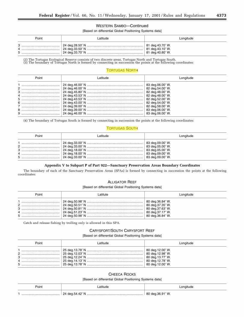
4373Federal Register / Vol. 66, No. 11 / Wednesday, January 17, 2001 / Rules and Regulations
WESTERN SAMBO—Continued[Based on differential Global Positioning Systems data]
Point Latitude Longitude
3 ........................................... 24 deg.28.50′ N ............................................................... 81 deg.43.70′ W.4 ........................................... 24 deg.33.50′ N ............................................................... 81 deg.43.10′ W.5 ........................................... 24 deg.33.70′ N ............................................................... 81 deg.40.80′ W.
(2) The Tortugas Ecological Reserve consists of two discrete areas, Tortugas North and Tortugas South.(3) The boundary of Tortugas North is formed by connecting in succession the points at the following coordinates:
TORTUGAS NORTH
Point Latitude Longitude
1 ........................................... 24 deg.46.00′ N ............................................................... 83 deg.06.00′ W.2 ........................................... 24 deg.46.00′ N ............................................................... 82 deg.54.00′ W.3 ........................................... 24 deg.45.80′ N ............................................................... 82 deg.48.00′ W.4 ........................................... 24 deg.43.53′ N ............................................................... 82 deg.48.00′ W.5 ........................................... 24 deg.43.53′ N ............................................................... 82 deg.52.00′ W.6 ........................................... 24 deg.43.00′ N ............................................................... 82 deg.54.00′ W.7 ........................................... 24 deg.39.00′ N ............................................................... 82 deg.58.00′ W.8 ........................................... 24 deg.39.00′ N ............................................................... 83 deg.06.00′ W.9 ........................................... 24 deg.46.00′ N ............................................................... 83 deg.06.00′ W.
(4) The boundary of Tortugas South is formed by connecting in succession the points at the following coordinates:
TORTUGAS SOUTH
Point Latitude Longitude
1 ........................................... 24 deg.33.00′ N ............................................................... 83 deg.09.00′ W.2 ........................................... 24 deg.33.00′ N ............................................................... 83 deg.05.00′ W.3 ........................................... 24 deg.18.00′ N ............................................................... 83 deg.05.00′ W.4 ........................................... 24 deg.18.00′ N ............................................................... 83 deg.09.00′ W.5 ........................................... 24 deg.33.00′ N ............................................................... 83 deg.09.00′ W.
Appendix V to Subpart P of Part 922—Sanctuary Preservation Areas Boundary CoordinatesThe boundary of each of the Sanctuary Preservation Areas (SPAs) is formed by connecting in succession the points at the following
coordinates:
ALLIGATOR REEF
[Based on differential Global Positioning Systems data]
Point Latitute Longitude
1 ........................................... 24 deg.50.98′ N ............................................................... 80 deg.36.84′ W.2 ........................................... 24 deg.50.51′ N ............................................................... 80 deg.37.35′ W.3 ........................................... 24 deg.50.81′ N ............................................................... 80 deg.37.63′ W.4 ........................................... 24 deg.51.23′ N ............................................................... 80 deg.37.17′ W.5 ........................................... 24 deg.50.98′ N ............................................................... 80 deg.36.84′ W.
Catch and release fishing by trolling only is allowed in this SPA.
CARYSFORT/SOUTH CARYSFORT REEF
[Based on differential Global Positioning Systems data]
Point Latitude Longitude
1 ........................................... 25 deg.13.78′ N ............................................................... 80 deg.12.00′ W.2 ........................................... 25 deg.12.03′ N ............................................................... 80 deg.12.98′ W.3 ........................................... 25 deg.12.24′ N ............................................................... 80 deg.13.77′ W.4 ........................................... 25 deg.14.13′ N ............................................................... 80 deg.12.78′ W.5 ........................................... 25 deg.13.78′ N ............................................................... 80 deg.12.00′ W.
CHEECA ROCKS
[Based on differential Global Positioning Systems data]
Point Latitude Longitude
1 ........................................... 24 deg.54.42′ N ............................................................... 80 deg.36.91′ W.
VerDate 11<MAY>2000 20:09 Jan 16, 2001 Jkt 194001 PO 00000 Frm 00107 Fmt 4701 Sfmt 4700 E:\FR\FM\17JAR5.SGM pfrm08 PsN: 17JAR5
Benjamin L. Richards
Benjamin L. Richards

4374 Federal Register / Vol. 66, No. 11 / Wednesday, January 17, 2001 / Rules and Regulations
CHEECA ROCKS—Continued[Based on differential Global Positioning Systems data]
Point Latitude Longitude
2 ........................................... 24 deg.54.25′ N ............................................................... 80 deg.36.77′ W.3 ........................................... 24 deg.54.10′ N ............................................................... 80 deg.37.00′ W.4 ........................................... 24 deg.54.22′ N ............................................................... 80 deg.37.15′ W.5 ........................................... 24 deg.54.42′ N ............................................................... 80 deg.36.91′ W.
COFFINS PATCH
[Based on differential Global Positioning Systems data]
Point Latitude Longitude
1 ........................................... 24 deg.41.47′ N ............................................................... 80 deg.57.68′ W.2 ........................................... 24 deg.41.12′ N ............................................................... 80 deg.57.53′ W.3 ........................................... 24 deg.40.75′ N ............................................................... 80 deg.58.33′ W.4 ........................................... 24 deg.41.06′ N ............................................................... 80 deg.58.48′ W.5 ........................................... 24 deg.41.47′ N ............................................................... 80 deg.57.68′ W.
CONCH REEF
[Based on differential Global Positioning Systems data]
Point Latitude Longitude
1 ........................................... 24 deg.57.48′ N ............................................................... 80 deg.27.47′ W.2 ........................................... 24 deg.57.34′ N ............................................................... 80 deg.27.26′ W.3 ........................................... 24 deg.56.78′ N ............................................................... 80 deg.27.52′ W.4 ........................................... 24 deg.56.96′ N ............................................................... 80 deg.27.73′ W.5 ........................................... 24 deg.57.48′ N ............................................................... 80 deg.27.47′ W.
Catch and release fishing by trolling only is allowed in this SPA.
DAVIS REEF
[Based on differential Global Positioning Systems data]
Point Latitude Longitude
1 ........................................... 24 deg.55.61′ N ............................................................... 80 deg.30.27′ W.2 ........................................... 24 deg.55.41′ N ............................................................... 80 deg.30.05′ W.3 ........................................... 24 deg.55.11′ N ............................................................... 80 deg.30.35′ W.4 ........................................... 24 deg.55.34′ N ............................................................... 80 deg.30.52′ W.5 ........................................... 24 deg.55.61′ N ............................................................... 80 deg.30.27′ W.
DRY ROCKS
[Based on differential Global Positioning Systems data]
Point Latitude Longitude
1 ........................................... 25 deg.07.59′ N ............................................................... 80 deg.17.91′ W.2 ........................................... 25 deg.07.41′ N ............................................................... 80 deg.17.70′ W.3 ........................................... 25 deg.07.25′ N ............................................................... 80 deg.17.82′ W.4 ........................................... 25 deg.07.41′ N ............................................................... 80 deg.18.09′ W.5 ........................................... 25 deg.07.59′ N ............................................................... 80 deg.17.91′ W.
GRECIAN ROCKS
[Based on differential Global Positioning Systems data]
Point Latitude Longitude
1 ........................................... 25 deg.06.91′ N ............................................................... 80 deg.18.20′ W.2 ........................................... 25 deg.06.67′ N ............................................................... 80 deg.18.06′ W.3 ........................................... 25 deg.06.39′ N ............................................................... 80 deg.18.32′ W.4 ........................................... 25 deg.06.42′ N ............................................................... 80 deg.18.48′ W.5 ........................................... 25 deg.06.81′ N ............................................................... 80 deg.18.44′ W.6 ........................................... 25 deg.06.91′ N ............................................................... 80 deg.18.20′ W.
VerDate 11<MAY>2000 20:09 Jan 16, 2001 Jkt 194001 PO 00000 Frm 00108 Fmt 4701 Sfmt 4700 E:\FR\FM\17JAR5.SGM pfrm08 PsN: 17JAR5
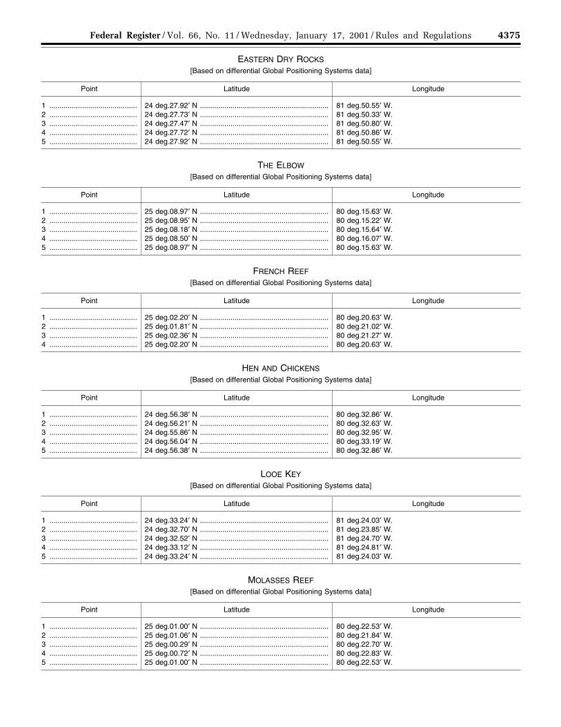
4375Federal Register / Vol. 66, No. 11 / Wednesday, January 17, 2001 / Rules and Regulations
EASTERN DRY ROCKS
[Based on differential Global Positioning Systems data]
Point Latitude Longitude
1 ........................................... 24 deg.27.92′ N ............................................................... 81 deg.50.55′ W.2 ........................................... 24 deg.27.73′ N ............................................................... 81 deg.50.33′ W.3 ........................................... 24 deg.27.47′ N ............................................................... 81 deg.50.80′ W.4 ........................................... 24 deg.27.72′ N ............................................................... 81 deg.50.86′ W.5 ........................................... 24 deg.27.92′ N ............................................................... 81 deg.50.55′ W.
THE ELBOW
[Based on differential Global Positioning Systems data]
Point Latitude Longitude
1 ........................................... 25 deg.08.97′ N ............................................................... 80 deg.15.63′ W.2 ........................................... 25 deg.08.95′ N ............................................................... 80 deg.15.22′ W.3 ........................................... 25 deg.08.18′ N ............................................................... 80 deg.15.64′ W.4 ........................................... 25 deg.08.50′ N ............................................................... 80 deg.16.07′ W.5 ........................................... 25 deg.08.97′ N ............................................................... 80 deg.15.63′ W.
FRENCH REEF
[Based on differential Global Positioning Systems data]
Point Latitude Longitude
1 ........................................... 25 deg.02.20′ N ............................................................... 80 deg.20.63′ W.2 ........................................... 25 deg.01.81′ N ............................................................... 80 deg.21.02′ W.3 ........................................... 25 deg.02.36′ N ............................................................... 80 deg.21.27′ W.4 ........................................... 25 deg.02.20′ N ............................................................... 80 deg.20.63′ W.
HEN AND CHICKENS
[Based on differential Global Positioning Systems data]
Point Latitude Longitude
1 ........................................... 24 deg.56.38′ N ............................................................... 80 deg.32.86′ W.2 ........................................... 24 deg.56.21′ N ............................................................... 80 deg.32.63′ W.3 ........................................... 24 deg.55.86′ N ............................................................... 80 deg.32.95′ W.4 ........................................... 24 deg.56.04′ N ............................................................... 80 deg.33.19′ W.5 ........................................... 24 deg.56.38′ N ............................................................... 80 deg.32.86′ W.
LOOE KEY
[Based on differential Global Positioning Systems data]
Point Latitude Longitude
1 ........................................... 24 deg.33.24′ N ............................................................... 81 deg.24.03′ W.2 ........................................... 24 deg.32.70′ N ............................................................... 81 deg.23.85′ W.3 ........................................... 24 deg.32.52′ N ............................................................... 81 deg.24.70′ W.4 ........................................... 24 deg.33.12′ N ............................................................... 81 deg.24.81′ W.5 ........................................... 24 deg.33.24′ N ............................................................... 81 deg.24.03′ W.
MOLASSES REEF
[Based on differential Global Positioning Systems data]
Point Latitude Longitude
1 ........................................... 25 deg.01.00′ N ............................................................... 80 deg.22.53′ W.2 ........................................... 25 deg.01.06′ N ............................................................... 80 deg.21.84′ W.3 ........................................... 25 deg.00.29′ N ............................................................... 80 deg.22.70′ W.4 ........................................... 25 deg.00.72′ N ............................................................... 80 deg.22.83′ W.5 ........................................... 25 deg.01.00′ N ............................................................... 80 deg.22.53′ W.
VerDate 11<MAY>2000 20:09 Jan 16, 2001 Jkt 194001 PO 00000 Frm 00109 Fmt 4701 Sfmt 4700 E:\FR\FM\17JAR5.SGM pfrm08 PsN: 17JAR5

4376 Federal Register / Vol. 66, No. 11 / Wednesday, January 17, 2001 / Rules and Regulations
NEWFOUND HARBOR KEY
[Based on differential Global Positioning Systems data]
Point Latitude Longitude
1 ........................................... 24 deg.37.10′ N ............................................................... 81 deg.23.34′ W.2 ........................................... 24 deg.36.85′ N ............................................................... 81 deg.23.28′ W.3 ........................................... 24 deg.36.74′ N ............................................................... 81 deg.23.80′ W.4 ........................................... 24 deg.37.00′ N ............................................................... 81 deg.23.86′ W.5 ........................................... 24 deg.37.10′ N ............................................................... 81 deg.23.34′ W.
ROCK KEY
[Based on differential Global Positioning Systems data]
Point Latitude Longitude
1 ........................................... 24 deg.27.48′ N ............................................................... 81 deg.51.35′ W.2 ........................................... 24 deg.27.30′ N ............................................................... 81 deg.51.15′ W.3 ........................................... 24 deg.27.21′ N ............................................................... 81 deg.51.60′ W.4 ........................................... 24 deg.27.45′ N ............................................................... 81 deg.51.65′ W.5 ........................................... 24 deg.27.48′ N ............................................................... 81 deg.51.35′ W.
SAND KEY
[Based on differential Global Positioning Systems data]
Point Latitude Longitude
1 ........................................... 24 deg.27.58′ N ............................................................... 81 deg.52.29′ W.2 ........................................... 24 deg.27.01′ N ............................................................... 81 deg.52.32′ W.3 ........................................... 24 deg.27.02′ N ............................................................... 81 deg.52.95′ W.4 ........................................... 24 deg.27.61′ N ............................................................... 81 deg.52.94′ W.5 ........................................... 24 deg.27.58′ N ............................................................... 81 deg.52.29′ W.
Catch and release fishing by trolling only is allowed in this SPA.
SOMBRERO KEY
[Based on differential Global Positioning Systems data]
Point Latitude Longitude
1 ........................................... 24 deg.37.91′ N ............................................................... 81 deg.06.78′ W.2 ........................................... 24 deg.37.50′ N ............................................................... 81 deg.06.19′ W.3 ........................................... 24 deg.37.25′ N ............................................................... 81 deg.06.89′ W.4 ........................................... 24 deg.37.91′ N ............................................................... 81 deg.06.78′ W.
Catch and release fishing by trolling only is allowed in this SPA.
Appendix VI to Subpart P of Part 922—Special-Use Areas BoundaryCoordinates and Use Designations
The boundary of each of the Special-Use is formed by connecting in succession the points at the following coordinates:
CONCH REEF
(Research Only)—[Based on differential Global Positioning Systems data]
Point Latitude Longitude
1 ........................................... 24 deg.56.83′ N ............................................................... 80 deg.27.26′ W.2 ........................................... 24 deg.57.10′ N ............................................................... 80 deg.26.93′ W.3 ........................................... 24 deg.56.99′ N ............................................................... 80 deg.27.42′ W.4 ........................................... 24 deg.57.34′ N ............................................................... 80 deg.27.26′ W.5 ........................................... 24 deg.56.83′ N ............................................................... 80 deg.27.26′ W.
EASTERN SAMBO
(Research Only)—[Based on differential Global Positioning Systems data]
Point Latitude Longitude
1 ........................................... 24 deg.29.84′ N ............................................................... 81 deg.39.59′ W.2 ........................................... 24 deg.29.55′ N ............................................................... 81 deg.39.35′ W.3 ........................................... 24 deg.29.37′ N ............................................................... 81 deg.39.96′ W.
VerDate 11<MAY>2000 20:09 Jan 16, 2001 Jkt 194001 PO 00000 Frm 00110 Fmt 4701 Sfmt 4700 E:\FR\FM\17JAR5.SGM pfrm08 PsN: 17JAR5

4377Federal Register / Vol. 66, No. 11 / Wednesday, January 17, 2001 / Rules and Regulations
EASTERN SAMBO—Continued(Research Only)—[Based on differential Global Positioning Systems data]
Point Latitude Longitude
4 ........................................... 24 deg.29.77′ N ............................................................... 81 deg.40.03′ W.5 ........................................... 24 deg.29.84′ N ............................................................... 81 deg.39.59′ W.
LOOE KEY
(Research Only)—[Based on differential Global Positioning Systems data]
Point Latitude Longitude
1 ........................................... 24 deg.34.17′ N ............................................................... 81 deg.23.01′ W.2 ........................................... 24 deg.33.98′ N ............................................................... 81 deg.22.96′ W.3 ........................................... 24 deg.33.84′ N ............................................................... 81 deg.23.60′ W.4 ........................................... 24 deg.34.23′ N ............................................................... 81 deg.23.68′ W.5 ........................................... 24 deg.34.17′ N ............................................................... 81 deg.23.01′ W.
TENNESSEE REEF
(Research Only)—[Based on differential Global Positioning Systems data]
Point Latitude Longitude
1 ........................................... 24 deg.44.77′ N ............................................................... 80 deg.47.12′ W.2 ........................................... 24 deg.44.57′ N ............................................................... 80 deg.46.98′ W.3 ........................................... 24 deg.44.68′ N ............................................................... 80 deg.46.59′ W.4 ........................................... 24 deg.44.95′ N ............................................................... 80 deg.46.74′ W.5 ........................................... 24 deg.44.77′ N ............................................................... 80 deg.47.12′ W.
Appendix VII to Subpart P of Part 922—Areas To Be Avoided BoundaryCoordinates
IN THE VICINITY OF THE FLORIDA KEYS
[Reference Charts: United States 11466, 27th Edition—September 1, 1990 and United States 11450, 4th Edition—August 11,1990]
Point Latitude Longitude
1 ........................................... 25 deg.45.00′ N ............................................................... 80 deg.06.10′ W.2 ........................................... 25 deg.38.70′ N ............................................................... 80 deg.02.70′ W.3 ........................................... 25 deg.22.00′ N ............................................................... 80 deg.03.00′ W.4 ........................................... 25 deg.00.20′ N ............................................................... 80 deg.13.40′ W.5 ........................................... 24 deg.37.90′ N ............................................................... 80 deg.47.30′ W.6 ........................................... 24 deg.29.20′ N ............................................................... 81 deg.17.30′ W.7 ........................................... 24 deg.22.30′ N ............................................................... 81 deg.43.17′ W.8 ........................................... 24 deg.28.00′ N ............................................................... 81 deg.43.17′ W.9 ........................................... 24 deg.28.70′ N ............................................................... 81 deg.43.50′ W.10 ......................................... 24 deg.29.80′ N ............................................................... 81 deg.43.17′ W.11 ......................................... 24 deg.33.10′ N ............................................................... 81 deg.35.15′ W.12 ......................................... 24 deg.33.60′ N ............................................................... 81 deg.26.00′ W.13 ......................................... 24 deg.38.20′ N ............................................................... 81 deg.07.00′ W.14 ......................................... 24 deg.43.20′ N ............................................................... 80 deg.53.20′ W.15 ......................................... 24 deg.46.10′ N ............................................................... 80 deg.46.15′ W.16 ......................................... 24 deg.51.10′ N ............................................................... 80 deg.37.10′ W.17 ......................................... 24 deg.57.50′ N ............................................................... 80 deg.27.50′ W.18 ......................................... 25 deg.09.90′ N ............................................................... 80 deg.16.20′ W.19 ......................................... 25 deg.24.00′ N ............................................................... 80 deg.09.10′ W.20 ......................................... 25 deg.31.50′ N ............................................................... 80 deg.07.00′ W.21 ......................................... 25 deg.39.70′ N ............................................................... 80 deg.06.85′ W.22 ......................................... 25 deg.45.00′ N ............................................................... 80 deg.06.10′ W.
IN THE VICINITY OF KEY WEST HARBOR
[Reference Chart: United States 11434, 21st Edition—August 11, 1990]
Point Latitude Longitude
23 ......................................... 24 deg.27.95’ N ............................................................... 81 deg.48.65’ W.24 ......................................... 24 deg.23.00’ N ............................................................... 81 deg.53.50’ W.25 ......................................... 24 deg.26.60’ N ............................................................... 81 deg.58.50’ W.26 ......................................... 24 deg.27.75’ N ............................................................... 81 deg.55.70’ W.
VerDate 11<MAY>2000 20:09 Jan 16, 2001 Jkt 194001 PO 00000 Frm 00111 Fmt 4701 Sfmt 4700 E:\FR\FM\17JAR5.SGM pfrm08 PsN: 17JAR5

4378 Federal Register / Vol. 66, No. 11 / Wednesday, January 17, 2001 / Rules and Regulations
IN THE VICINITY OF KEY WEST HARBOR—Continued[Reference Chart: United States 11434, 21st Edition—August 11, 1990]
Point Latitude Longitude
27 ......................................... 24 deg.29.35’ N ............................................................... 81 deg.53.40’ W.28 ......................................... 24 deg.29.35’ N ............................................................... 81 deg.50.00’ W.29 ......................................... 24 deg.27.95’ N ............................................................... 81 deg.48.65’ W.
AREA SURROUNDING THE MARQUESAS KEYS
[Reference Chart: United States 11434, 21st Edition—August 11, 1990]
Point Latitude Longitude
30 ......................................... 24 deg.26.60’ N ............................................................... 81 deg.59.55’ W.31 ......................................... 24 deg.23.00’ N ............................................................... 82 deg.03.50’ W.32 ......................................... 24 deg.23.60’ N ............................................................... 82 deg.27.80’ W.33 ......................................... 24 deg.34.50’ N ............................................................... 82 deg.37.50’ W.34 ......................................... 24 deg.43.00’ N ............................................................... 82 deg.26.50’ W.35 ......................................... 24 deg.38.31’ N ............................................................... 81 deg.54.06’ W.36 ......................................... 24 deg.37.91’ N ............................................................... 81 deg.53.40’ W.37 ......................................... 24 deg.36.15’ N ............................................................... 81 deg.51.78’ W.38 ......................................... 24 deg.34.40’ N ............................................................... 81 deg.50.60’ W.39 ......................................... 24 deg.33.44’ N ............................................................... 81 deg.49.73’ W.40 ......................................... 24 deg.31.20’ N ............................................................... 81 deg.52.10’ W.41 ......................................... 24 deg.28.70’ N ............................................................... 81 deg.56.80’ W.42 ......................................... 24 deg.26.60’ N ............................................................... 81 deg.59.55’ W.
AREA SURROUNDING THE DRY TORTUGAS ISLANDS
[Reference Chart: United States 11434, 21st Edition—August 11, 1990]
Point Latitude Longitude
43 ......................................... 24 deg.32.00’ N ............................................................... 82 deg.53.50’ W.44 ......................................... 24 deg.32.00’ N ............................................................... 83 deg.00.05’ W.45 ......................................... 24 deg.39.70’ N ............................................................... 83 deg.00.05’ W.46 ......................................... 24 deg.45.60’ N ............................................................... 82 deg.54.40’ W.47 ......................................... 24 deg.45.60’ N ............................................................... 82 deg.47.02’ W.48 ......................................... 24 deg.42.80’ N ............................................................... 82 deg.43.90’ W.49 ......................................... 24 deg.39.50’ N ............................................................... 82 deg.43.90’ W.50 ......................................... 24 deg.35.60’ N ............................................................... 82 deg.46.40’ W.51 ......................................... 24 deg.32.00’ N ............................................................... 82 deg.53.50’ W.
[FR Doc. 01–978 Filed 1–16–01; 8:45 am]BILLING CODE 3510–08–P
VerDate 11<MAY>2000 20:09 Jan 16, 2001 Jkt 194001 PO 00000 Frm 00112 Fmt 4701 Sfmt 4700 E:\FR\FM\17JAR5.SGM pfrm08 PsN: 17JAR5