2017 B. K. Leach Memorial Conservation Area Management Plan
19
B. K. Leach Memorial Conservation Area Ten-Year Area Management Plan FY 2017-2026
Transcript of 2017 B. K. Leach Memorial Conservation Area Management Plan

B. K. Leach Memorial Conservation Area
Ten-Year Area Management Plan FY 2017-2026

201 7 B. K. Leach Memorial Conservation Area 1\llanagement Plan •:• Page 2
B. K. Leach Memorial Conservation Area Management Plan Approval Page
PLANNING TEAM
Gary L. Calvert, Wildlife Management Biologist
Scott Sarantakis, Outdoor Skills Specialist
Jeff Esely, Private Lands Conservationist
Sarah Peper, Fisheries Management Biologist
Tim McDaniel, Conservation Agent
Jeff Bakameyer, Resource Forester
ST. LOUIS REGION
RCT Chair ~ , , ,.;J.017 '
Date
\tVILDLIFE DIVISION
Wildlife Management Chief ~n Date (/ Signature

2017 B. K. Leach Memorial Conservation Area Management Plan Page 3
OVERVIEW
• Official Area Name: B. K. Leach Memorial Conservation Area, #8514 • Year of Initial Acquisition: 1985 • Acreage: 4,307 acres • County: Lincoln • Division with Administrative Responsibility: Wildlife • Division with Maintenance Responsibility: Wildlife • Statement of Primary Purpose:
A. Strategic Direction Provide an opportunity for diverse public use by managing wetland and bottomland natural communities in a way that balances fish, forest, and wildlife resources with public recreational use.
B. Desired Future Condition The desired future condition of B. K. Leach Memorial Conservation Area (CA) is to maintain healthy moist soil, robust perennial emergent marsh, and scrub-shrub wetland communities for the benefit of wildlife by providing a diversity of habitats while promoting Missouri’s outdoor heritage.
C. Federal Aid Statement • This area, or a portion thereof, was developed with Wetland Reserve Program
funds to provide wetland habitat through perpetual easements. • This area, or a portion thereof, was acquired or developed with North American
Wetlands Conservation Act funds to conserve and restore wetland habitats. GENERAL INFORMATION AND CONDITIONS
I. Special Considerations A. Priority Areas: Missouri/Mississippi River Confluence Wetlands – Wetland
Conservation Opportunity Area B. Natural Areas: None
II. Important Natural Features and Resources
A. Species of Conservation Concern: Species of conservation concern are known from this area. Area managers should consult the Natural Heritage Database annually and review all management activities with the natural history biologist.
B. Caves: None C. Springs: None D. Other: B. K. Leach Memorial CA lies within the Mississippi River Alluvial Plain
subsection of the Central Dissected Plains Ecological Section of Missouri, in the St. Charles/Lincoln Alluvial Plain Landtype Association. Historically this landtype

2017 B. K. Leach Memorial Conservation Area Management Plan Page 4
association was dominated by wet prairie and marshes. Timber was restricted to strips bordering active channels of the river and on islands. Most of the acreage has since been converted to agriculture.
III. Existing Infrastructure
• 12 parking lots • Five waterfowl hunting blinds (one is Americans with Disabilities Act [ADA]
accessible) • Eight wetland pump stations • Three metal storage buildings • Three grain bins • Bates Slough fishing lake (10 acres) • Burns Slough fishing lake (7 acres)
IV. Area Restrictions or Limitations
A. Deed Restrictions or Ownership Considerations: None B. Federal Interest:
• Wetland Reserve Program: The wetland conservation easements permanently prohibit use of the affected land as cropland and require permanent maintenance of the wetland conditions, except in the case of natural disaster. After the easement has been perfected, no change will be made in the easement without a written request by the participant and the written consent of the Natural Resources Conservation Service chief. Federal funds may also be used in the management of this land. Fish and wildlife agencies may not allow recreational activities and related facilities that would interfere with the purpose for which the State is managing the land. Other uses may be acceptable and must be assessed in each specific situation.
• North American Wetlands Conservation Act: This land must be used to conserve and restore wetlands. The federal funds made available under the North American Wetlands Conservation Act may not be used for fish and wildlife mitigation purposes under the Fish and Wildlife Coordination Act or the Water Resources Development Act of 1986. Federal funds may also be used in the management of this land. Fish and wildlife agencies may not allow recreational activities and related facilities that would interfere with the purpose for which the State is managing the land. Other uses may be acceptable and must be assessed in each specific situation
C. Easements: Easements exist for county maintained roads, electric utilities, the Wetland Reserve Program, flowage, drainage district, and telephone utilities. The most significant easement is the Wetland Reserve Program easement applied to Bittern Basin and King’s Lake Tract. The drainage district easements are roughly 100

2017 B. K. Leach Memorial Conservation Area Management Plan Page 5
feet wide and are centered on two ditches that border and run through both Wetland Reserve Program additions. Several three-sided inholdings and one four-sided inholding exist on the area.
D. Cultural Resources Findings: Yes, records kept with Missouri Department of Conservation (Department) environmental compliance specialist. Managers should follow best management practices for cultural resources found in the Department Resource Policy Manual.
E. Endangered Species: None observed. F. Boundary Issues: None
MANAGEMENT CONSIDERATIONS
V. Terrestrial Resource Management Considerations Wetland Resources Major wetland types and water regimes include semi-permanent and seasonal scrub-shrub dominated by black willow and buttonbush, and forested wetlands dominated by silver maple, ash, and cottonwood. Seasonal, temporary, and semi-permanent emergent wetlands are dominated by a variety of non-persistent vegetation with a few small areas dominated by persistent emergent vegetation. The deeper sloughs with intermittently exposed water regimes are either classified as unconsolidated bottoms and are largely free of vegetation or are aquatic beds that are dominated mainly with rooted vascular plants including pondweed, water milfoil, and naiads.
Challenges and Opportunities:
1) Control invasive species. 2) Manage and restore wet prairies. 3) Restore, enhance, and maintain a diverse mix of wetland habitat types. 4) Monitor area wildlife.
Management Objective 1: Control invasive species.
Strategy 1: Identify areas where reed canary grass, phragmites, sericea lespedeza, bush honeysuckle, and other invasive species occur. (Wildlife) Strategy 2: Use proven treatment methods to reduce invasive species occurrences. (Wildlife)
Management Objective 2: Conduct wet prairie restoration and management. Strategy 1: Identify areas where wet prairie was historically present. (Wildlife) Strategy 2: Manage these areas with mechanical and chemical disturbance, native vegetation establishment, and prescribed fire to enhance habitat. (Wildlife)
2017 B. K. Leach Memorial Conservation Area Management Plan Page 6
Management Objective 3: Restore, enhance, and maintain a diverse mix of wetland habitat types.
Strategy 1: On an annual basis, seasonally flood between 1,400 and 1,600 acres of wetland for the fall waterfowl, webless bird, shorebirds and other wetland species. Maintain 1,200-1,400 acres of water through the spring migration. (Wildlife) Strategy 2: Continue to manage the majority of emergent wetlands on River Slough Tract and the upper elevations of Kings Lake and Bittern Basin Wetland Reserve Program tracts for moist-soil plant production. (Wildlife)
Management Objective 4: Monitor upland/wetland bird species. Strategy 1: Conduct fall quail covey counts annually between Oct. 1 and Oct. 31. (Wildlife) Strategy 2: Conduct secretive marsh bird surveys in late April and May. (Wildlife)
Forest Resources The forest resources at B. K. Leach Memorial CA consist of approximately 600 acres of typical bottomland hardwoods that present challenges and opportunities. Species composition varies throughout the area primarily as a result of slight variations in elevation that dramatically impact the duration and depth of standing water during flood events, as well as the depth of the water table. In general, non-hard mast producing species such as silver maple, cottonwood, boxelder, sycamore, and green ash are more tolerant of standing water and a high water table than hard mast-producing species such as pin oak, bur oak, pecan, and black walnut. Accordingly, the forest on the unprotected side of the levee is almost entirely composed of non-hard mast-producing species. Forests on the protected side of the levee contain a larger percentage of hard mast species, but several major flood events during the past 20 to 25 years have reduced their numbers greatly. A large-scale tree planting of hard mast species in 2005 still contains some surviving specimens, but a major flood event in 2008 caused a high percentage of mortality in this planting also.
Challenges and Opportunities:
1) Manage area forests.
Management Objective 5: Maintain healthy trees and woodlands with management emphasis on wildlife habitat.
Strategy 1: Manage forest areas through a variety of techniques including forest thinning, creating scattered temporary group openings, prescribed burning,
2017 B. K. Leach Memorial Conservation Area Management Plan Page 7
mechanical/herbicide treatments to manage invasive species, commercial harvest, and other techniques to enhance habitat for forest wildlife. (Forestry, Wildlife) Strategy 2: Perform crop tree release around hard mast species that are present to assist with regeneration of these species. (Forestry, Wildlife) Strategy 3: Continue maintenance around the surviving hard mast species that were part of the tree planting to help with their survival and future regeneration. (Forestry, Wildlife)
VI. Aquatic Resource Management Considerations
Challenges and Opportunities: 1) Maintain and improve open water habitats for maximum benefit of aquatic and
semi-aquatic organisms. 2) Coordinate with the U. S. Army Corps of Engineers on any projects on or near the
area that may affect management of the area.
Management Objective 1: Maintain and improve open water habitats to benefit aquatic and semi-aquatic organisms.
Strategy 1: Maintain connectivity between Burns Pond and Sandy Slough as water levels allow. (Wildlife) Strategy 2: Explore feasibility to remove levees that divide Bates Slough. (Design and Development) Strategy 3: Clear shorelines, as needed, to prevent woody encroachment. (Wildlife) Strategy 4: Consider hinge-cutting trees into water to provide fish cover and basking logs. (Fisheries)
Management Objective 2: Coordinate with the U. S. Army Corps of Engineers on any projects on or near the area that may affect management of the area.
Strategy 1: Keep apprised of U. S. Army Corps of Engineers’ permit notices and projects on or near area and comment as appropriate. (Policy Coordination, Wildlife, Fisheries)
VII. Public Use Management Considerations
Challenges and Opportunities: 1) Provide hunting, trapping, fishing, and wildlife viewing opportunities. 2) Maintain positive relationships with adjacent landowners. 3) Conduct a managed waterfowl drawing. 4) Maintain an archery-only hunting zone.

2017 B. K. Leach Memorial Conservation Area Management Plan Page 8
5) Improve educational and interpretive opportunities. 6) Enforce the Wildlife Code of Missouri during all hunting activities on the areas.
Management Objective 1: Provide hunting, trapping, fishing, and wildlife viewing opportunities.
Strategy 1: Continue to enhance wetland, open land, wet prairie, forest, and aquatic habitats to increase fish and wildlife populations on the area. (Wildlife) Strategy 2: Provide adequate early season wetland habitat for migrating teal, rails, and snipe. Facilitate an open hunting program for teal, rails, and snipe. (Wildlife) Strategy 3: Maintain an archery-only hunting zone during the statewide waterfowl season. Consider expanding the hunting zone to include additional sections of River Slough Tract. (Wildlife) Strategy 4: Conduct regular enforcement patrols during peak hunting seasons. (Protection) Strategy 5: Look into the feasibility of providing additional new hunter/youth hunting opportunities on the area. (Outreach and Education)
Management Objective 2: Maintain positive relationships with adjacent landowners. Strategy 1: Continue to maintain signage in a way that clearly designates Department property boundaries. (Wildlife) Strategy 2: Respond quickly and effectively to neighboring landowner questions, comments, and concerns. (Wildlife) Strategy 3: Provide technical management assistance to adjoining landowners. (Private Lands Services, Wildlife)
Management Objective 3: Conduct managed waterfowl drawings.
Strategy 1: Conduct a managed waterfowl drawing throughout the statewide duck season. (Wildlife) Strategy 2: Conduct a managed youth waterfowl drawing during the statewide youth waterfowl season. (Wildlife)
Management Objective 4: Improve educational and interpretive opportunities on B. K. Leach Memorial CA.
Strategy 1: Communicate to the public recreational opportunities (e.g., using brochures, Atlas database). (Wildlife) Strategy 2: Communicate to teachers the uniqueness of the area to facilitate as a possible destination for ecology classes, school programs, and workshops. (Outreach and Education)

2017 B. K. Leach Memorial Conservation Area Management Plan Page 9
Strategy 3: Investigate possible interpretive opportunities in sign or brochure form. (Outreach and Education, Wildlife) Strategy4: Plan for interpretive signs by ordering from Sign Shop; or budgeting for them, and if approved, ordering during budget cycle. (Administrative Services, Wildlife)
VIII. Administrative Considerations
Challenges and Opportunities:
1) Maintain area infrastructure at current levels. 2) Maintain area boundary signs. 3) Consider acquisition of land.
Management Objective 1: Maintain area infrastructure at current levels.
Strategy 1: Maintain area infrastructure in accordance with Department guidelines. (Wildlife)
Management Objective 2: Maintain boundary signage.
Strategy 1: Check and replace area boundary signs, every five years or as needed. Check and replace waterfowl refuge signs each year prior to the statewide waterfowl season. (Wildlife)
Lands Proposed for Acquisition: When available, adjacent land may be considered for acquisition from willing sellers. Tracts that improve area access, provide public use opportunities, contain unique natural communities and/or species of conservation concern, or meet other Department priorities, as identified in the annual Department land acquisition priorities, may be considered.

2017 B. K. Leach Memorial Conservation Area Management Plan Page 10
MANAGEMENT TIMETABLE
Strategies are considered ongoing unless listed in the following table: FY17 FY18 FY19 FY20 FY21 FY22 FY23 FY24 FY25 FY26 Public Use Management Objective 1 Strategy 3 X Strategy 5 X Objective 4 Strategy 3 X Strategy 4 X Administrative Considerations Objective 2 Strategy 1 X X

2017 B. K. Leach Memorial Conservation Area Management Plan Page 11
APPENDICES
Area Background: The area consists of 4,307 acres. The initial tract consisted of 690 acres and was acquired in 1985. Ninety and 138 acres were added in 1991. The Thompson Tract (186 acres) was added in 1993. The Sherman Tract (309 aces) was acquired in 1994. The two additions, consisting of 942 acres (Bittern Basin) and 1,959 acres (King’s Lake Tract), were acquired in 2001. The original purchase utilized a private donation from Mary Leach in memory of her father along with Department general revenue funds. Prior to acquisition by the Department, the older tracts were managed for agriculture and recreation. Previous owners leased river trailer sites and operated a private waterfowl hunting program on the site. Portions of the area were operated as a private duck club as far back as the 1930s. The older portion of the area was heavily impacted by a severe levee failure in the Flood of 1993. The main river levee break deposited large amounts of sand, damaged interior levees, and destroyed several structures, both on Department property and private property. The sand deposits and flood scattered debris are still obvious over the eastern portions of the area. Current Land and Water Types:
Land/Water Type Acres Miles % of Area Wetland 2,302 53 Forest and Woodland 600 14 Crop Land 500 12 Grassland (non-prairie) 435 10 Old Field 430 10 Lakes 40 <1 Total 4,307 100 Stream Frontage 2.0
Public Input Summary: The draft B.K. Leach Conservation Area Management Plan was available for a public comment period Sept. 1–30, 2016. The Missouri Department of Conservation received comments from five respondents (Appendix A). The B.K. Leach Conservation Area Planning Team carefully reviewed and considered these ideas as they finalized this document. A brief summary of public input themes, including how they were incorporated or why they were not, can be found below. Rather than respond to each individual comment, comments are grouped into general themes and are addressed collectively.

2017 B. K. Leach Memorial Conservation Area Management Plan Page 12
Department responses to themes and issues identified through the B.K. Leach Conservation Area Management Plan public comment period. Suggests planting agricultural crops outside the refuge area. B.K. Leach Memorial Conservation Area is divided into three separate tracts: Bittern Basin Unit, Kings Lake Tract, and River Slough Tract. The Bittern Basin Unit and the Kings Lake Tract were enrolled in a permanent Wetland Reserve Program easement prior to being purchased by the Department. The Wetland Reserve Program is a federal easement that cannot be changed. As part of the easement agreement, we are only allowed to plant 5 percent of the area to food plots. These food plots are planted across the area with a ratio of approximately 25-30 percent of the food plots going in the refuge and the remaining food plots being planted in the hunting pools. There are approximately 11 acres of floodable crops planted on the River Slough Tract with approximately 33 percent being planted in the hunting pools. Suggests adding a boat ramp near Stag Island. The Bittern Basin and Kings Lake tracts are enrolled in a permanent Wetland Reserve Program Easement that does not allow the building of any permanent structure such as boat ramps. Currently, there is a Missouri Department of Conservation boat ramp (Norton Woods), which is approximately 3.5 miles north of Stag Island and a Corps of Engineers boat ramp (Foley) approximately 3 miles south. We believe these two ramps provide adequate access to this stretch of the river. Suggests adding equestrian trails and allowing equestrian use during the off-waterfowl hunting season. The majority of B.K. Leach Memorial CA is wetland, which is managed for a suite of wetland species. Several of the wetland units are kept wet for long periods of the year to provide habitat for wetland-dependent species such as marsh birds, reptiles, amphibians, and waterfowl. This type of habitat is not suitable for equestrian trails. Horseback riding is allowed on roads open to vehicles. Suggests adding more Americans with Disabilities Act (ADA)-accessible waterfowl blinds. Currently, there is one disabled accessible waterfowl blind on the River Slough Tract of B.K. Leach Memorial CA. The other two tracts, Bittern Basin and Kings Lake, are enrolled in a permanent Wetland Reserve Program Easement that does not allow the building of any permanent structure such as blinds. Suggests allowing archery deer hunters access to the area after Oct. 15. Yearly, from Oct. 15 until the end of the north zone duck season, the area is closed to all uses other than waterfowl hunting with the exception of an archery-only deer hunting area. This archery-only designated deer hunting area is approximately 450 acres in size and is open the

2017 B. K. Leach Memorial Conservation Area Management Plan Page 13
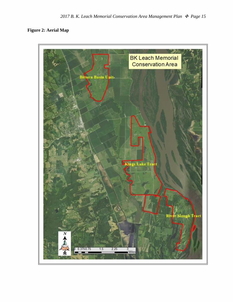
entire archery deer season. Prior to Oct. 15 and after the duck season, all of B.K. Leach Memorial CA is open to archery deer hunting. Concerned about water management at B.K. Leach Memorial CA causing flooding on neighboring property. The discharged water from the River Slough Tract shares a common drainage with all of the landowners in this area. The focus of the area’s management is to provide habitat for migrating waterfowl and a suite of wetland species year around. Water on this area is held longer than most of the private land surrounding this area. Water is drained starting in early March, depending on the level of the Mississippi River. The water is discharged slowly to stimulate moist soil plant germination and to minimize any potential flooding on neighboring properties. Concerned about area users trespassing on to neighboring property. Suggests creating a refuge buffer along private property boundary. On the south end of the River Slough Tract there has been a buffer established between Department public hunting and the neighboring private land. This buffer area has been signed and placed on the maps provided to the hunters that select this portion of the area during the managed waterfowl drawing. In addition, during the morning speech hunters are informed about staying north of the buffer zone. References: Nigh, T. A., & Schroeder, W. A. (2002). Atlas of Missouri ecoregions. Missouri Department of Conservation. Maps: Figure 1: Area Map Figure 2: Aerial Map Figure 3: Cover Types Map Figure 4: Area Easements Additional Appendices: Appendix A. B.K. Leach Memorial Conservation Area Management Plan Public Comments

2017 B. K. Leach Memorial Conservation Area Management Plan Page 14
Figure 1: Area Map
2017 B. K. Leach Memorial Conservation Area Management Plan Page 15
Figure 2: Aerial Map

2017 B. K. Leach Memorial Conservation Area Management Plan Page 16
Figure 3: Cover Types Map

2017 B. K. Leach Memorial Conservation Area Management Plan Page 17
Figure 4: Area Easements

2017 B. K. Leach Memorial Conservation Area Management Plan Page 18
Appendix A. B.K. Leach Memorial Conservation Area Management Plan Public Comments Received during public comment period (Sept. 1-30, 2016): Plant some agricultural crops where possible in the area rather than just in the refuge itself. If an adjustment of wetland reserve agreement is needed to do so that should be attempted. I am not talking huge fields, but some additional small crop plantings intermingled with the moist soil crops in the various hunting units, obviously not possible in all. Thank you Would like to see more ADA blind sites. With the aging population there are more and more of us needing this opportunity. This area would be an excellent place to allow for equestrian use in the off-waterfowl hunting season(s). I would encourage the department to consider adding equestrian trails. Thank you for the chance to make comments about this property that has meant so much to me over the years. I began use of this 25+years ago and have watched it transition into what it is today. I realize that it is primarily a waterfowl based area and its location is perfect for that reason. I do not waterfowl hunt though I love to watch the property transform each year to accommodate the migrating birds. My use of the property has been for archery hunting. I must say that I am disappointed every year that I am shut out of the area on Oct. 15 and miss such a wonderful time in the woods. I remember when all of those trees were planted and the fields looked like a highway construction zone with all of those orange cones. Now those trees are starting to mature and I don't feel like I can fully experience the fruits of that endeavor. Also there used to be much better access to the Stag Island area. I realize flooding is always changing the landscape. A river access in the Stag Island area,especially a boat ramp would be very beneficial. The expansion of the property has been fantastic. Keep up the good work. Please do not close the area for use during such a beautiful time of year. Thank you for your consideration I have a lot of concerns and questions about this plan. My biggest concern is how the water is managed by the area and the effect it has on us on the south end properties. The last year six years we have been flooded due to the untimely release of water through the south end. That water has no place to go but over our land if the river stage is above 25 feet due to the gates on the [neighboring] property. (Willing to discuss my findings for last six years) This was a good year because the water was released before the spring rains(early April I believe) and I believe is a great practice due to the food in the bottoms. (Kudos) I have concerns as well that my water flows north through the bottom of bates slough so trying to understand what your mater plan is for that, we share a water gate. I still have large concerns about being a good neighbor. I had teal hunters on the bates levee on Sunday (ruined my hunt) and I'm tired of having to call you or the risk of running them off as well as multiple trespassers throughout the years. Again the same question is why do you have to put a blind so close to the property line so nobody has a good

2017 B. K. Leach Memorial Conservation Area Management Plan Page 19
hunt we all work the same ducks. I still think a refuge buffer around the property would help everyone even though you don't agree. Ill be honest with you, as your plan suggests, I would be willing to sell my property to the MDC due to the issues I have with BK Leach.