
2014 No. 2950 INFRASTRUCTURE PLANNING · 2014 No. 2950 INFRASTRUCTURE PLANNING ... “the 1981...
108
STATUTORY INSTRUMENTS 2014 No. 2950 INFRASTRUCTURE PLANNING The Walney Extension Offshore Wind Farm Order 2014 Made - - - - 7th November 2014 Coming into force - - 28th November 2014 An application has been made to the Secretary of State in accordance with the Infrastructure Planning (Applications: Prescribed Forms and Procedure) Regulations 2009(a) for an Order under sections 114, 115, 120 and 149A of the Planning Act 2008 (“the 2008 Act”)(b); The application was examined by a Panel appointed as Examining authority by the Secretary of State pursuant to Chapter 4 of Part 6 of the 2008 Act and the Infrastructure Planning (Examination Procedure) Rules(c); The Examining authority, having considered the application together with the documents that accompanied it, and the representations made and not withdrawn, has, in accordance with section 74 of the 2008 Act, made a report and recommendation to the Secretary of State; The Secretary of State, having considered the report and recommendation of the Panel, and decided the application, has determined to make an Order giving effect to the proposals comprised in the application with modifications which in the opinion of the Secretary of State do not make any substantial change to the proposals; The Secretary of State, having considered the report and recommendation of the Panel, is satisfied that open space comprised within the Order land, when burdened with the new rights authorised for compulsory acquisition under the terms of this Order, will be no less advantageous than it was before such acquisition, to the persons in whom it is vested, other persons, if any, entitled to rights of common or other rights, and the public; The Secretary of State, in exercise of the powers conferred by sections 114, 115, 120, 122, 132(2) and (3) and 149A of the 2008 Act makes the following Order: (a) S.I. 2009/2264, as amended by the Localism Act 2011 (Infrastructure Planning) (Consequential Amendments) Regulations 2012 (S.I. 2012/635) and the Infrastructure Planning (Prescribed Consultees and Interested Parties etc) (Amendment) Regulations 2013 (S.I. 2013/522). There are other amendments to the Regulations which are not relevant to this Order. (b) 2008 c. 29. Parts 1 to 7 were amended by Part 6 of Chapter 6 of, and Schedule 13 to, the Localism Act 2011 (c. 20). Section 149A was inserted by paragraph 4 in Part 1 of Schedule 8 to the Marine and Coastal Access Act 2009 (c. 23). Sections 127, 131, 132 and 138 were amended by the Growth and Infrastructure Act 2013. Sections 128, 129 and 137 were repealed by the Growth and Infrastructure Act 2013. (c) S.I. 2010/103, as amended by S.I. 2012/635.
Transcript of 2014 No. 2950 INFRASTRUCTURE PLANNING · 2014 No. 2950 INFRASTRUCTURE PLANNING ... “the 1981...

S T A T U T O R Y I N S T R U M E N T S
2014 No. 2950
INFRASTRUCTURE PLANNING
The Walney Extension Offshore Wind Farm Order 2014
Made - - - - 7th November 2014
Coming into force - - 28th November 2014
An application has been made to the Secretary of State in accordance with the Infrastructure
Planning (Applications: Prescribed Forms and Procedure) Regulations 2009(a) for an Order under
sections 114, 115, 120 and 149A of the Planning Act 2008 (“the 2008 Act”)(b);
The application was examined by a Panel appointed as Examining authority by the Secretary of
State pursuant to Chapter 4 of Part 6 of the 2008 Act and the Infrastructure Planning (Examination
Procedure) Rules(c);
The Examining authority, having considered the application together with the documents that
accompanied it, and the representations made and not withdrawn, has, in accordance with section
74 of the 2008 Act, made a report and recommendation to the Secretary of State;
The Secretary of State, having considered the report and recommendation of the Panel, and
decided the application, has determined to make an Order giving effect to the proposals comprised
in the application with modifications which in the opinion of the Secretary of State do not make
any substantial change to the proposals;
The Secretary of State, having considered the report and recommendation of the Panel, is satisfied
that open space comprised within the Order land, when burdened with the new rights authorised
for compulsory acquisition under the terms of this Order, will be no less advantageous than it was
before such acquisition, to the persons in whom it is vested, other persons, if any, entitled to rights
of common or other rights, and the public;
The Secretary of State, in exercise of the powers conferred by sections 114, 115, 120, 122, 132(2)
and (3) and 149A of the 2008 Act makes the following Order:
(a) S.I. 2009/2264, as amended by the Localism Act 2011 (Infrastructure Planning) (Consequential Amendments) Regulations
2012 (S.I. 2012/635) and the Infrastructure Planning (Prescribed Consultees and Interested Parties etc) (Amendment) Regulations 2013 (S.I. 2013/522). There are other amendments to the Regulations which are not relevant to this Order.
(b) 2008 c. 29. Parts 1 to 7 were amended by Part 6 of Chapter 6 of, and Schedule 13 to, the Localism Act 2011 (c. 20). Section 149A was inserted by paragraph 4 in Part 1 of Schedule 8 to the Marine and Coastal Access Act 2009 (c. 23). Sections 127, 131, 132 and 138 were amended by the Growth and Infrastructure Act 2013. Sections 128, 129 and 137 were repealed by the Growth and Infrastructure Act 2013.
(c) S.I. 2010/103, as amended by S.I. 2012/635.
2
Citation and commencement
1. This Order may be cited as the Walney Extension Offshore Wind Farm Order 2014 and shall
come into force on 28th November 2014.
Interpretation
2.—(1) In this Order—
“the 1961 Act” means the Land Compensation Act 1961(a);
“the 1965 Act” means the Compulsory Purchase Act 1965(b);
“the 1980 Act” means the Highways Act 1980(c);
“the 1981 Act” means the Compulsory Purchase (Vesting Declarations) Act 1981(d);
“the 1990 Act” means the Town and Country Planning Act 1990(e);
“the 1991 Act” means the New Roads and Street Works Act 1991(f);
“the 2004 Act” means the Energy Act 2004(g);
“the 2008 Act” means the Planning Act 2008;
(a) 1961 c. 33. Part 1 of the Act was amended by Schedule 1, paragraph 38 of the Transfer of Tribunal Functions (Lands
Tribunal and Miscellaneous Amendments) Order 2009/1307. There are other amendments to the 1961 Act which are not relevant to this Order.
(b) 1965 c. 56. Section 3 was amended by section 70 of, and paragraph 3 of Schedule 15 to, the Planning and Compensation Act 1991 (c. 34). Section 4 was amended by section 3 of, and Part 1 of Schedule 1 to, the Housing (Consequential Provisions) Act 1985 (c. 71). Section 5 was amended by sections 67 and 80 of, and Part 2 of Schedule 18 to, the Planning and Compensation Act 1991 (c. 34). Section 11(1) and sections 3, 31 and 32 were amended by section 34(1) of, and Schedule 4 to, the Acquisition of Land Act 1981 (c. 67) and by section 14 of, and paragraph 12(1) of Schedule 5 to, the Church of England (Miscellaneous Provisions) Measure 2006 (2006 No.1). Section 12 was amended by section 56(2) of, and Part 1 to Schedule 9 to, the Courts Act 1971 (c. 23). Section 13 was amended by section 139 of the Tribunals, Courts and Enforcement Act 2007 (c. 15). Section 20 was amended by section 70 of, and paragraph 14 of Schedule 15 to, the Planning and Compensation Act 1991 (c. 34). Sections 9, 25 and 29 were amended by the Statute Law (Repeals) Act 1973 (c. 39). Section 31 was also amended by section 70 of, and paragraph 19 of Schedule 15 to, the Planning and Compensation Act 1991 (c. 34) and by section 14 of, and paragraph 12(2) of Schedule 5 to, the Church of England (Miscellaneous Provisions) Measure 2006 (2006 No.1). There are other amendments to the 1965 Act which are not relevant to this Order.
(c) 1980 c. 66. Section 1(1) was amended by section 21(2) of the New Roads and Street Works Act 1991 (c. 22); section 1(2), (3) and (4) was amended by section 8 of, and paragraph 1 of Schedule 4 to, the Local Government Act 1985 (c. 51); section 1(2A) was inserted by, and section 1(3) was amended by, section 259 (1), (2) and (3) of the Greater London Authority Act 1999 (c. 29); sections 1(3A) and 1(5) was inserted by section 22(1) of, and paragraph 1 of Schedule 7 to, the Local Government (Wales) Act 1994 (c. 19). Section 36(2) was amended by section 4(1) of, and paragraph 47 (a) and (b) of Schedule 2 to, the Housing (Consequential Provisions) Act 1985 (c. 71), by S.I. 2006/1177, by section 4 of and paragraph 45(3) of Schedule 2 to, the Planning (Consequential Provisions) Act 1990 (c. 11), by section 64(1) (2) and (3) of the Transport and Works Act 1992 (c. 42) and by section 57 of, and paragraph 5 of Part 1 of Schedule 6 to, the Countryside and Rights of Way Act 2000 (c. 37); section 36(3A) was inserted by section 64(4) of the Transport and Works Act 1992 and was amended by S.I. 2006/1177; section 36(6) was amended by section 8 of, and paragraph 7 of Schedule 4 to, the Local Government Act 1985 (c. 51); and section 36(7) was inserted by section 22(1) of, and paragraph 4 of Schedule 7 to, the Local Government (Wales) Act 1994 (c. 19). Section 329 was amended by section 112(4) of, and Schedule 18 to, the Electricity Act 1989 (c. 29) and by section 190(3) of, and Part 1 of Schedule 27 to, the Water Act 1989 (c. 15). There are other amendments to the 1980 Act which are not relevant to this Order.
(d) 1981 c. 66. Sections 2(3), 6(2) and 11(6) were amended by section 4 of, and paragraph 52 of Schedule 2 to, the Planning (Consequential Provisions) Act 1990 (c. 11). Section 15 was amended by sections 56 and 321(1) of, and Schedules 8 and 16 to, the Housing and Regeneration Act 2008 (c. 17). Paragraph 1 of Schedule 2 was amended by section 76 of, and Part 2 of Schedule 9, to, the Housing Act 1988 (c. 50); section 161(4) of, and Schedule 19 to, the Leasehold Reform, Housing and Urban Development Act 1993 (c. 28); and sections 56 and 321(1) of, and Schedule 8 to, the Housing and Regeneration Act 2008, Paragraph 3 of Schedule 2 was amended by section 76 of, and Schedule 9 to the Housing Act 1988 and section 56 of, and Schedule 8 to, the Housing and Regeneration Act 2008, Paragraph 2 of Schedule 3 was repeated by section 277 of, and Schedule 9 to, the Inheritance Tax Act 1984 (c. 51). There are other amendments to the 1981 Act which are not relevant to this Order.
(e) 1990 c. 8. Section 56(4) was amended by section 32 of, and paragraph 10(2) of Schedule 7 to, the Planning and Compensation Act 1991 (c. 34). Section 106 was substituted, and section 106A inserted, by section 12(1) of the Planning and Compensation Act 1991. Section 206(1) was amended by section 192(8) of, and paragraphs 7 and 11 of Schedule 8 to, the 2008 Act. Sections 272 to 274 and section 279 were amended by section 406(1) of, and paragraph 103 of Schedule 17 to, the Communications Act 2003 (c. 21), and section 280 was amended by section 406(1) of, and paragraph 104 of Schedule 17 to, that Act. Functions under sections 272 to 274 were transferred by S.I. 2011/741 and S.I. 2012/2590. Section 282 was amended by S.I. 2009/1307. There are other amendments to the 1990 Act which are not relevant to this Order.
(f) 1991 c. 22. Section 48(3) was inserted by section 124 of the Local Transport Act 2008 (c. 26). Sections 79(4), 80(4) and 83(4) were amended by section 40 and 47 of, and Schedule 1 to, the Traffic Management Act 2004 (c. 18).
(g) 2004 c. 20. Section 105 was amended by section 69 of the Energy Act 2008 (c. 32).
3
“the 2009 Act” means the Marine and Coastal Access Act 2009(a);
“the 2010 Act” means the Flood and Water Management Act 2010(b);
“ancillary works” means the ancillary works described in Part 2 of Schedule 1 (ancillary
works) and which are not development within the meaning of section 32 of the 2008 Act;
“AOD” means above ordnance datum;
“authorised development” means the development and associated development described in
Part 1 of Schedule 1 (authorised development) which is development within the meaning of
section 32 of the 2008 Act;
“the authorised project” means the authorised development and the ancillary works authorised
by this Order;
“the book of reference” means the book of reference certified by the Secretary of State as the
book of reference for the purposes of the Order;
“building” includes any structure or erection or any part of a building, structure or erection;
“CAA” means the Civil Aviation Authority constituted by the Civil Aviation Act 1982(c);
“cable crossings” means the crossing of existing subsea cables by the inter-array and/or export
cables authorised by the Order together with cable protection;
“cable ducts” means conduits for the installation of cables;
“cable jointing bays” means the underground concrete bays comprised in the connection
works where the onshore export cables are jointed (but does not include the transition joint
bays);
“cable protection” means physical measures for the protection of cables including concrete
mattresses, with or without frond devices, and/or rock placement;
“cables” shall include direct lay cables and/or cables laid in cable ducts and shall include fibre
optic cables either within the cable or laid alongside;
“cable systems” means the three electrical cables and their respective accessories including
cable joints and terminations, with an operating voltage of up to 400kV, necessary to transmit
the power between two electrical nodes within the authorised development, and for the
offshore element of the cable corridor, comprising subsea export cables, the three cables shall
be bundled together as one cable system, and for the onshore element of the cable corridor, the
cable system shall comprise three separate onshore cables, each containing a single conductor,
and the cable system may also include one or more auxiliary cables (normally fibre optic
cables) for the purpose of control, monitoring, protection or general communications;
“carriageway” has the same meaning as in the 1980 Act;
“CoCP” means the document certified by the Secretary of State as the Code of Construction
Practice for the purposes of the Order;
“commence”, unless otherwise provided for, in relation to the authorised project, means—
(a) in relation to works seaward of MHWS the first carrying out of any licensed marine
activities authorised by the deemed marine licences, save for pre-construction surveys
and/or monitoring; and
(b) in relation to all other works, beginning to carry out any material operation (as defined in
Section 56(4) of the 1990 Act) forming part of the authorised project save for operations
consisting of pre-construction surveys and/or monitoring, site clearance, demolition work,
archaeological investigations, environmental surveys, investigations for the purpose of
assessing ground conditions, remedial work in respect of any contamination or other
adverse ground conditions, diversion and laying of services, erection of any temporary
(a) 2009 c. 23. (b) 2010 c. 29. (c) 1982 c. 16.

4
means of enclosure, the temporary display of site notices or advertisements and the words
‘commencement’ and ‘commenced’ shall be construed accordingly;
“connection works” means Work Nos. 3B to 27 and any related further associated
development;
“construction working site” means a construction site associated with the connection works
including hard standings, lay down and storage areas for construction materials and
equipment, areas for spoil, areas for vehicular parking, bunded storage areas, areas for welfare
facilities including offices and canteen and washroom facilities, workshop facilities and
temporary fencing or other means of enclosure and areas for other facilities required for
construction purposes;
“deemed Generator Assets Marine Licence” means the licence set out in Schedule 9 and
deemed by article 37 (deemed marine licences under the Marine and Coastal Access Act
2009) to have been granted under Part 4 of the 2009 Act, by virtue of section 149A of the
2008 Act;
“deemed marine licences” means one or both of the deemed Generator Assets Marine Licence
and the deemed Transmission Assets Marine Licence;
“deemed Transmission Assets Marine Licence” means the licence set out in Schedule 10 and
deemed by article 37 (deemed marine licences under the Marine and Coastal Access Act
2009) to have been granted under Part 4 of the 2009 Act, by virtue of section 149A of the
2008 Act;
“design and access statement” means the document certified by the Secretary of State as the
design and access statement for the purposes of this Order;
“Disposal Site” means the designated disposal site identified as IS215 Walney bounded by the
Order limits described within Point IDs 69 to 100 (inclusively) and Point IDs 216 to 233
(inclusively) in the table that follows paragraph 2(2) of Part 1 of Schedule 1, which are shown
on the Order limits and grid coordinates plan;
“DONG Energy Walney Extension (UK) Limited” means the company registered in England
and Wales as DONG Energy Walney Extension (UK) Limited with number 07306956;
“electrical substation compound” means an onshore substation facility accommodated within a
compound containing electrical equipment including switchgear, transformers, reactive
compensation equipment, harmonic filters, cables, control buildings, communications masts,
lightning protection masts, back-up generators, access, fencing and other associated
equipment, structures or buildings;
“environmental statement” means the document certified as the environmental statement by
the Secretary of State for the purposes of this Order and submitted with the application on
28th June 2013, together with any supplementary or further environmental information
submitted to the Examining authority as part of the examination of the application for this
Order, including but not limited to, the Transport Statement;
“examination” means the examination under Chapter 4 in Part 6 of the 2008 Act into the
application for this Order;
“Examining authority” means the Panel appointed as an Examining authority under Chapter 2
in Part 6 of the 2008 Act to examine the application for this Order;
“fibre optic joint pits” means the underground concrete or plastic pits where the fibre optic
cables are jointed together;
“frond devices” means flow energy dissipation devices, which reduce current velocity and
turbulence and encourage settlement of sediment;
“General Arrangement Drawings” means the drawings certified by the Secretary of State as
the General Arrangement Drawings for the purposes of the Order;
“HAT” means highest astronomical tide;
“highway” has the same meaning as in the 1980 Act;
5
“highway authority” has the same meaning as in the 1980 Act and for the purposes of this
Order includes Lancashire County Council;
“horizontal directional drilling compound” means a construction site associated with the
connection works where horizontal directional drilling is proposed including hard standing,
lay down and storage areas for construction materials and equipment, areas for spoil, areas for
vehicular parking, bunded storage areas, areas comprising water and bentonite tanks, pumps
and pipes, areas for welfare facilities including offices and canteen and washroom facilities,
wheel washing facilities, workshop facilities and temporary fencing or other means of
enclosure and areas for other facilities required for construction purposes;
“the important hedgerows plan” means the plan certified by the Secretary of State as the
important hedgerows plan for the purposes of the Order;
“inter-array cable” means the network of offshore subsea cables connecting the WTGs in
Work No. 1 with the offshore substations in Work No. 2(a);
“jacket structure” means a lattice type structure constructed of steel, which may include scour
protection and additional equipment such as, J-tubes, corrosion protection systems and access
platforms;
“the land plans” means the plans certified by the Secretary of State as the land plans for the
purposes of this Order;
“LAT” means lowest astronomical tide;
“Lead Local Flood Authority” has the same meaning as section 6(7) of the 2010 Act and for
the purposes of this Order includes Lancashire County Council;
“link box” means the underground metal box placed within a plastic or concrete pit where the
metal sheaths between adjacent export cable sections are connected and earthed;
“maintain”, unless otherwise provided for, includes inspect, repair, adjust, alter, remove,
reconstruct and replace any of the authorised development, and any derivative of “maintain”
shall be construed accordingly;
“MCA” means the Maritime and Coastguard Agency;
“mean high water springs”, or “MHWS” means the highest level which spring tides reach on
average over a period of time;
“mean low water” or “MLW” means the average height of all low water above Chart Datum;
“MMO” means the Marine Management Organisation;
“monopile foundation” means a steel cylindrical pile, driven, vibrated and/or drilled into the
seabed and may include scour protection and additional equipment such as, J-tubes, corrosion
protection systems and access platforms;
“Natural England” means the body established by section 1 of the Natural Environment and
Rural Communities Act 2006(a);
“the Noise Monitoring Location Plan” means the document certified by the Secretary of State
as the Noise Monitoring Location Plan for the purposes of the Order;
“offshore substation platform” means a platform with one or more decks, whether open or
fully clad, accommodating medium to high voltage electrical power transformers, medium
and/or high voltage switch gear, fire fighting facilities, workshop facilities, helicopter landing
facilities, potable water storage, black water separation equipment, instrumentation, metering
equipment, control systems, standby electrical generation equipment, auxiliary and
uninterruptible power supply systems, emergency accommodation including mess facilities,
control hub, drainage facilities, access equipment, marking and lighting and other associated
equipment and facilities;
(a) 2006 c. 16. Section 1 was amended by section 311(2) and (3) of the Marine and Coastal Access Act 2009.

6
“onshore cable corridor” means the onshore area of the Order limits between the transition
joint bay compound and the electrical substation compound in which the onshore export
cables will be located;
“the Order land” means the land shown on the land plans which is within the limits of land to
be acquired or used and described in the book of reference;
“the Order limits” means the limits shown on the Order limits and grid coordinates plan within
which the authorised project may be carried out, whose grid coordinates seaward of MHWS
are set out in paragraph 2 of Part 1 of Schedule 1 () to this Order;
“the Order limits and grid coordinates plan” means the plan certified by the Secretary of State
as the Order limits and grid coordinates plan for the purposes of the Order;
“Outline CTMP” means the document certified by the Secretary of State as the Outline
Construction Traffic Management Plan for the purposes of the Order;
“owner” in relation to land, has the same meaning as in section 7 of the Acquisition of Land
Act 1981(a);
“Public Access Strategy” means the document certified by the Secretary of State as the Public
Access Strategy for the purposes of the Order;
“public rights of way plan” means the plan certified by the Secretary of State as the public
rights of way plan for the purposes of this Order;
“relevant planning authority” means Lancaster City Council;
“Renewable Energy Zone” means the areas of the sea designated under the Renewable Energy
Zone (Designation of Area) Order 2004(b);
“Requirements” means those matters set out in Part 3 of Schedule 1 (Requirements) to this
Order;
“Schedule of Offshore Maintenance Activities” means the document certified by the Secretary
of State as the Schedule of Offshore Maintenance Activities for the purposes of the Order;
“scour protection” means measures to prevent loss of seabed sediment around any structure
placed in or on the seabed by use of protective aprons, mattresses with or without frond
devices, or rock and gravel placement;
“stage” means one or more of the stages of the connection works, as agreed with the relevant
planning authority pursuant to Requirement 15;
“street” means a street within the meaning of section 48 of the 1991 Act, together with land on
the verge of a street or between two carriageways, and includes part of a street;
“street authority”, in relation to a street, has the same meaning as in Part 3 of the 1991 Act;
“the street works plan” means the plans certified as the street works plans by the Secretary of
State for the purposes of this Order;
“suction caisson” means a steel cylindrical structure attached to the legs of a jacket structure
which partially or fully penetrates the seabed and remains in place using its own weight and
hydrostatic pressure differential, and may include scour protection and additional equipment
such as J-Tubes;
“territorial waters” means the territorial waters within section 1 of the Territorial Sea Act
1987(c);
“transition joint bay compound” means the area comprised in Work No. 6 in which the
transition joint bays will be constructed;
(a) 1981 c. 67. Section 7 was amended by section 70 of, and paragraph 9 of Schedule 15 to, the Planning and Compensation
Act 1991 (c. 34). There are other amendments to the 1981 Act which are not relevant to this Order. (b) S.I. 2004/2668. (c) 1987 c. 49. There are amendments to the 1987 Act but they are not relevant to this Order.

7
“transition joint bays” means the underground concrete bays in Work No. 6 where the offshore
export cable systems comprised in Work No. 3B are jointed to the onshore export cable
systems;
“transition piece” means the metal structure attached to the top of the foundation where the
base of the wind turbine generator is connected and may include additional equipment such as
J-Tubes, corrosion protection systems, boat access systems, access platforms, craneage, and
associated equipment;
“Transport Statement” means the document certified by the Secretary of State as the Transport
Statement for the purposes of the Order;
“tree preservation order” has the meaning given in section 198 of the 1990 Act;
“the tribunal” means the Lands Chamber of the Upper Tribunal;
“Trinity House” means the Corporation of Trinity House of Deptford Strond;
“undertaker” means DONG Energy Walney Extension (UK) Limited and any other person
who has the benefit of that provision in accordance with article 5;
“vessel” means every description of vessel, however propelled or moved, and includes a non-
displacement craft, a personal watercraft, a seaplane on the surface of the water, a hydrofoil
vessel, a hovercraft or any other amphibious vehicle and any other thing constructed or
adapted for movement through, in, on or over water and which is at the time in, on or over
water;
“watercourse” includes all rivers, streams, ditches, drains, canals, cuts, culverts, dykes,
sluices, sewers and passages through which water flows except a public sewer or drain;
“wind turbine generator” or “WTG” means a structure comprising a tower, rotor system with
three blades, nacelle and ancillary electrical and other associated equipment which may
include lighting, J-tubes, access and rest platforms, access ladders, access lift, boat access
systems, corrosion protection systems, fenders and maintenance equipment, heli-hoist
platform and other associated equipment, fixed to a foundation or transition piece;
“Work No.” means that part of the authorised development with the corresponding number
specified in Part 1 of Schedule 1 of this Order;
“the works plans” means the plans certified as the works plans by the Secretary of State for the
purposes of this Order.
(2) References in this Order to rights over land include references to rights to do or to place and
maintain anything in, on or under land or in the air-space above its surface.
(3) All distances, directions and lengths referred to in this Order are approximate and distances
between points on a work comprised in the authorised development shall be taken to be measured
along that work.
(4) All areas described in square metres in the book of reference are approximate.
(5) Any references in this Order to a work identified by the number of the work is to be
construed as a reference to the work of that number authorised by this Order, except that
references to Work Nos. 1 to 3B in Schedules 9 and 10 shall be construed in accordance with the
provisions of those Schedules.
(6) References in this Order to numbered Requirements are to the Requirements as numbered in
Part 3 of Schedule 1.
(7) The expression “includes” shall be construed without limitation.
Development consent etc. granted by the Order
3.—(1) Subject to the provisions of this Order and to the Requirements in Part 3 of Schedule 1
the undertaker is granted—
(a) development consent for the authorised development in Part 1 of Schedule 1; and
(b) consent for the ancillary works in Part 2 of Schedule 1,
to be carried out within the Order limits.
8
(2) Subject to the Requirements, Work Nos. 1 to 3A shall be constructed anywhere within the
Order limits seaward of mean high water springs and Work Nos. 3B to 27 shall be constructed
anywhere within the Order limits landward of mean low water.
Maintenance of authorised project
4.—(1) The undertaker may at any time maintain the authorised development, except to the
extent that this Order or an agreement made under this Order provides otherwise. No maintenance
works whose likely effects on the environment are not assessed in the environmental statement
shall take effect, unless otherwise approved by the MMO or the relevant planning authority. The
Schedule of Offshore Maintenance Activities identifies those offshore maintenance activities that
have been assessed in the environmental statement.
(2) Where the MMO or relevant planning authority’s approval is required under paragraph (1),
such consent must only be given in relation to immaterial changes where it has been demonstrated
to the satisfaction of discharging authority that the approval is sought is unlikely to give rise to any
materially new or materially different environmental effects from those assessed in the
environmental statement.
Benefit of the Order
5.—(1) Subject to paragraphs (3) and (4), the undertaker may, with the written consent of the
Secretary of State—
(a) transfer to another person (the “transferee”) any or all of the benefit of the provisions of
this Order (excluding the deemed marine licences referred to in paragraph (3) below) and
such related statutory rights as may be agreed between the undertaker and the transferee;
or
(b) grant to another person (the “lessee”) for a period agreed between the undertaker and the
lessee any or all of the benefit of the provisions of this Order (excluding the deemed
marine licences referred to in paragraph (3) below) and such related statutory rights as
may be so agreed.
except where paragraph (6) applies, in which case no such consent shall be required.
(2) Where an agreement has been made in accordance with paragraph (1) references in this
Order to the undertaker, except in paragraphs (3), (5) and (7), shall include references to the
transferee or lessee.
(3) The undertaker may, with the written consent of the Secretary of State—
(a) where an agreement has been made in accordance with paragraph (1)(a), transfer to the
transferee the whole of the deemed Generator Assets Marine Licence and/or the whole of
the deemed Transmission Assets Marine Licence and such related statutory rights as may
be agreed between the undertaker and the transferee; or
(b) where an agreement has been made in accordance with paragraph (1)(b), grant to the
lessee, for the duration of the period mentioned in paragraph (1)(b), the whole of the
deemed Generator Assets Marine Licence and/or the whole of the deemed Transmission
Assets Marine Licence and such related statutory rights as may be so agreed.
except where paragraph (6) applies, in which case no such consent shall be required.
(4) The Secretary of State shall consult the MMO before giving consent to the transfer or grant
to another person of the whole of the benefit of the provisions of the deemed marine licences.
(5) Where the undertaker has transferred any benefit and/or a deemed marine licence, or for the
duration of any period during which the undertaker has granted any benefit and/or a deemed
marine licence, under paragraph (1) or (3)—
(a) the benefit and/or a deemed marine licence transferred or granted (“the transferred
benefit”) shall include any rights that are conferred, and any obligations that are imposed,
by virtue of the provisions to which the benefit relates;
9
(b) the transferred benefit shall reside exclusively with the transferee or, as the case may be,
the lessee and the transferred benefit shall not be enforceable against the undertaker.
(6) This paragraph applies to any provision of this Order and its related statutory rights where—
(a) the transferee or lessee is the holder of a licence under section 6 of the Electricity Act
1989(a); or
(b) the time limits for claims for compensation in respect of the acquisition of land or effects
upon land under this Order have elapsed and—
(i) no such claims have been made,
(ii) any such claim has been made and has been compromised or withdrawn,
(iii) compensation has been paid in final settlement of any such claim,
(iv) payment of compensation into court has taken place in lieu of settlement of any such
claim; or
(v) it has been determined by a tribunal or court of competent jurisdiction in respect of
any such claim that no compensation shall be payable.
(7) Where paragraph (6) applies—
(a) the undertaker shall provide written notification of any transfer and/or grant of any
benefit under paragraph (1), to the Secretary of State; and
(b) the undertaker shall provide written notification of any transfer and/or grant of any
deemed marine licence under paragraph (3), to the MMO.
(8) The provisions of articles 10 (street works), 11 (temporary stopping up of streets), 19
(compulsory acquisition of land), 21 (compulsory acquisition of rights), 27 (temporary use of land
for carrying out the authorised project) and 28 (temporary use of land for maintaining the
authorised project) shall have effect only for the benefit of the named undertaker and a person who
is a transferee or lessee and is also—
(a) in respect of Work Nos. 3B to 27 a person who holds a licence under the Electricity Act
1989, or
(b) in respect of functions under article 10 (street works) relating to a street, a street
authority.
Operation of generating station
6.—(1) The undertaker is hereby authorised to operate the generating station comprised in the
authorised development.
(2) This article does not relieve the undertaker of any requirement to obtain any permit or
licence under any other legislation that may be required to authorise the operation of a generating
station.
Application of the Hedgerows Regulations 1997
7. Regulation 6 of the Hedgerows Regulations 1997(b) shall be modified so as to read for the
purposes of this Order only as if there were inserted after paragraph (1)(j) the following—
“(k) or for carrying out development which has been authorised by a development
consent pursuant to the Planning Act 2008.”.
Defence to proceedings in respect of statutory nuisance
8.—(1) Where proceedings are brought under section 82(1) of the Environmental Protection Act
1990(c) (summary proceedings by person aggrieved by statutory nuisance) in relation to a
(a) 1989 c. 29. Subsection 6(2A) was inserted by sections 145(1) and (6) of the Energy Act 2004 (c. 20). (b) S.I. 1997/1160. There are amendments to this Statutory Instrument which are not relevant to this Order. (c) 1990 c. 43. There are amendments to this Act which are not relevant to this Order.
10
nuisance falling within paragraph (g) of section 79(1) of that Act (noise emitted from premises so
as to be prejudicial to health or a nuisance) no order shall be made, and no fine may be imposed,
under section 82(2) of that Act if—
(a) the defendant shows that the nuisance—
(i) relates to premises used by the undertaker for the purposes of or in connection with
the construction or maintenance of the authorised project and that the nuisance is
attributable to the carrying out of the authorised project in accordance with a notice
served under section 60 (control of noise on construction site), or a consent given
under section 61 (prior consent for work on construction site) or 65 (noise exceeding
registered level), of the Control of Pollution Act 1974(a); or
(ii) is a consequence of the construction or maintenance of the authorised project and
that it cannot reasonably be avoided; or
(b) the defendant shows that the nuisance—
(i) relates to premises used by the undertaker for the purposes of or in connection with
the use of the authorised project and that the nuisance is attributable to the use of the
authorised project which is being used in accordance with Requirement 35; or
(ii) is a consequence of the use of the authorised project and that it cannot reasonably be
avoided.
(2) Section 61(9) (consent for work on construction site to include statement that it does not of
itself constitute a defence to proceedings under section 82 of the Environmental Protection Act
1990) of the Control of Pollution Act 1974 and section 65(8) of that Act (corresponding provision
in relation to consent for registered noise level to be exceeded), shall not apply where the consent
relates to the use of premises by the undertaker for the purposes of or in connection with the
construction or maintenance of the authorised project.
Requirements, appeals etc.
9.—(1) Where an application is made to the relevant planning authority for any consent,
agreement or approval required by Requirements 15 to 42 (Requirements that relate to land above
mean low water), the following provisions apply, so far as they relate to a consent, agreement or
approval of a local planning authority required by a condition imposed on a grant of planning
permission, as if the Requirement was a condition imposed on the grant of planning permission—
(a) sections 78 and 79 of the 1990 Act (right of appeal in relation to planning decisions);
(b) any orders, rules or regulations which make provision in relation to a consent, agreement
or approval of a local planning authority required by a condition imposed on the grant of
planning permission.
(2) For the purposes of paragraph (1), a provision relates to a consent, agreement or approval of
a local planning authority required by a condition imposed on a grant of planning permission in so
far as it makes provision in relation to an application for such a consent, agreement or approval, or
the grant or refusal of such an application, or a failure to give notice of a decision on such an
application.
(3) For the purposes of the application of section 262 of the 1990 Act (meaning of “statutory
undertaker”) to appeals pursuant to this article, the undertaker is deemed to be a holder of a
licence under section 6 of the Electricity Act 1989.
(a) 1974 c. 40. Sections 61(9) and 65(8) were amended by section 162 of, and paragraph 15 of Schedule 15 to, the
Environmental Protection Act 1990 (c. 43). There are other amendments to the 1974 Act which are not relevant to this Order.
11
Street works
10.—(1) The undertaker may, for the purposes of the authorised project, enter on so much of
any of the streets specified in Schedule 2 (streets subject to street works) as is within the Order
limits and may—
(a) break up or open the street, or any sewer, drain or tunnel under it;
(b) tunnel or bore under the street;
(c) place apparatus in the street;
(d) maintain apparatus in the street or change its position; and
(e) execute any works required for or incidental to any works referred to in sub-paragraphs
(a), (b), (c) and (d).
(2) The authority given by paragraph (1) is a statutory right for the purposes of sections 48(3)
(streets, street works and undertakers) and 51(1) (prohibition of unauthorised street works) of the
1991 Act.
(3) The provisions of sections 54 to 106 of the 1991 Act apply to any street works carried out
under paragraph (1).
(4) In this article “apparatus” has the same meaning as in Part 3 of the 1991 Act.
Temporary stopping up of streets
11.—(1) Subject to paragraphs (3), (4) and (5), the undertaker, during and for the purposes of
carrying out the authorised project, may temporarily stop up, alter or divert any street and may for
any reasonable time—
(a) divert the traffic from the street; and
(b) subject to paragraph (3), prevent all persons from passing along the street.
(2) Without prejudice to paragraph (1), the undertaker may use any street temporarily stopped
up under the powers conferred by this article within the Order limits as a temporary working site.
(3) The undertaker must provide reasonable access for pedestrians going to or from premises
abutting a street affected by the temporary stopping up, alteration or diversion of a street under
this article if there would otherwise be no such access.
(4) The undertaker may temporarily stop up, alter or divert the streets specified in columns (1)
and (2) of Schedule 3 (streets to be temporarily stopped up) to the extent specified in column (3)
of that Schedule.
(5) The undertaker must not temporarily stop up, alter, divert or use as a temporary working
site—
(a) any street specified as mentioned in paragraph (4) without first consulting the street
authority; and
(b) any other street without the consent of the street authority which may attach reasonable
conditions to any consent.
(6) Any person who suffers loss by the suspension of any private right of way under this article
shall be entitled to compensation to be determined, in case of dispute, under Part 1 of the 1961
Act.
(7) If a street authority fails to notify the undertaker of its decision within 28 days of receiving
an application for consent under paragraph (5)(b) that street authority shall be deemed to have
granted consent.
Temporary stopping up of public rights of way
12. The undertaker may, in connection with the carrying out of the authorised project,
temporarily stop up each of the public rights of way specified in columns (2) of Schedule 4 (public
rights of way to be temporarily stopped up) to the extent specified in column (3), by reference to
the letters and numbers shown on the public rights of way plans.
12
Access to works
13. The undertaker may, for the purposes of the authorised project—
(a) form and lay out means of access, or improve existing means of access, in the locations
specified in columns (1) and (2) of Schedule 5 (access to works); and
(b) with the approval of the relevant planning authority after consultation with the highway
authority, form and lay out such other means of access or improve existing means of
access, at such locations within the Order limits as the undertaker reasonably requires for
the purposes of the authorised project.
Agreements with street authorities
14.—(1) A street authority and the undertaker may enter into agreements with respect to—
(a) any temporary stopping up, alteration or diversion of a street authorised by this Order;
(b) the carrying out in the street of any of the works referred to in article 10(1) (street works).
(2) Such an agreement may, without prejudice to the generality of paragraph (1)—
(a) make provision for the street authority to carry out any function under this Order which
relates to the street in question;
(b) include an agreement between the undertaker and street authority specifying a reasonable
time for the completion of the works; and
(c) contain such terms as to payment and otherwise as the parties consider appropriate.
Discharge of water
15.—(1) The undertaker may use any watercourse or any public sewer or drain for the drainage
of water in connection with the carrying out construction or maintenance of the authorised project
and for that purpose may lay down, take up and alter pipes and may, on any land within the Order
limits, make openings into, and connections with, the watercourse, public sewer or drain.
(2) Any dispute arising from the making of connections to or the use of a public sewer or drain
by the undertaker pursuant to paragraph (1) shall be determined as if it were a dispute under
section 106 of the Water Industry Act 1991(a) (right to communicate with public sewers).
(3) The undertaker must not discharge any water into any watercourse, public sewer or drain
except with the consent of the person to whom it belongs and such consent may be given subject
to such terms and conditions as that person may reasonably impose, but shall not be unreasonably
withheld.
(4) The undertaker must not make any opening into any public sewer or drain except—
(a) in accordance with plans approved by the person to whom the sewer or drain belongs, but
such approval shall not be unreasonably withheld; and
(b) where that person has been given the opportunity to supervise the making of the opening.
(5) The undertaker must not, in carrying out or maintaining works pursuant to this article,
damage or interfere with the bed or banks of any watercourse forming part of a main river.
(6) The undertaker must take such steps as are reasonably practicable to secure that any water
discharged into a watercourse or public sewer or drain pursuant to this article is as free as may be
practicable from gravel, soil or other solid substance, oil or matter in suspension.
(a) 1991 c. 56. Section 6 was amended by sections 36(2) and 101(1) of, and by Schedule 8 to, the Water Act 2003 (c. 37);
section 102 was amended by sections 96(1) and 101(2) of, and Part 3 of Schedule 9 to, that Act; section 104 was amended by section 96(4) of the Water Act 2003 and by section 42(3) of the Flood and Water Management Act 2010 (c. 29); section 106 was amended by sections 36(2) and 99 of the Water Act 2003, sections 35, 43(2) and 56(7) of, and Schedule 2 to, the Competition and Service (Utilities) Act 1992 (c. 43), and section 32 of, and paragraph 16(2) of Schedule 3 to, the Flood and Water Management Act 2010. There are other amendments to this Act which are not relevant to this Order.
13
(7) This article does not authorise the entry into controlled waters of any matter whose entry or
discharge into controlled waters is prohibited by regulation 12 of the Environmental Permitting
(England and Wales) Regulations 2010(a).
(8) If a person who receives an application for consent or approval fails to notify the undertaker
of a decision within 28 days of receiving an application for consent under paragraph (3) or
approval under paragraph (4)(a) that person shall be deemed to have granted consent or given
approval, as the case may be.
(9) In this article—
(a) “public sewer or drain” means a sewer or drain which belongs to the Environment
Agency, a harbour authority within the meaning of section 57 of the Harbours Act
1964(b) (interpretation), an internal drainage board, a joint planning board, a local
authority, or a sewerage undertaker; and
(b) other expressions, excluding watercourse, used both in this article and in the
Environmental Permitting (England and Wales) Regulations 2010 have the same meaning
as in those Regulations.
Protective work to buildings
16.—(1) Subject to the following provisions of this article, the undertaker may at its own
expense carry out such protective works to any building lying within the Order limits as the
undertaker considers necessary or expedient.
(2) Protective works may be carried out—
(a) at any time before or during the carrying out in the vicinity of the building of any part of
the authorised project; or
(b) after the completion of that part of the authorised project in the vicinity of the building at
any time up to the end of the period of 5 years beginning with the day on which that part
of the authorised project is first opened for use.
(3) For the purpose of determining how the functions under this article are to be exercised the
undertaker may enter and survey any building falling within paragraph (1) and any land within its
curtilage.
(4) For the purpose of carrying out protective works under this article to a building the
undertaker may (subject to paragraphs (5) and (6))—
(a) enter the building and any land within its curtilage; and
(b) where the works cannot be carried out reasonably conveniently without entering land
which is adjacent to the building but outside its curtilage, enter the adjacent land (but not
any building erected on it).
(5) Before exercising—
(a) a right under paragraph (1) to carry out protective works to a building;
(b) a right under paragraph (3) to enter a building and land within its curtilage;
(c) a right under paragraph (4)(a) to enter a building and land within its curtilage; or
(d) a right under paragraph (4)(b) to enter land,
the undertaker must, except in the case of emergency, serve on the owners and occupiers of the
building or land not less than 14 days’ notice of its intention to exercise that right and, in a case
falling within sub-paragraph (a) or (c), specifying the protective works proposed to be carried out.
(6) Where a notice is served under paragraph (5)(a), (c) or (d), the owner or occupier of the
building or land concerned may, by serving a counter-notice within the period of 10 days
(a) S.I. 2010/675, as amended by S.I. 2011/2043, S.I. 2011/2933, S.I. 2012/630, S.I. 2012/811, S.I. 2013/390, S.I. 2013/755,
S.I. 2013/2952 and S.I. 2014/955. (b) 1964 c. 40. Paragraph 9B was inserted into Schedule 2 by the Transport and Works Act 1992 (c. 42), section 63(1) and
Schedule 3, paragraph 9(1) and (5). There are other amendments to the 1964 Act which are not relevant to this Order.
14
beginning with the day on which the notice was served, require the question whether it is
necessary or expedient to carry out the protective works or to enter the building or land to be
referred to arbitration under article 42 (arbitration).
(7) The undertaker must compensate the owners and occupiers of any building or land in
relation to which rights under this article have been exercised for any loss or damage arising to
them by reason of the exercise of those rights.
(8) Where—
(a) protective works are carried out under this article to a building; and
(b) within the period of 5 years beginning with the day on which the part of the authorised
project carried out in the vicinity of the building is first opened for use it appears that the
protective works are inadequate to protect the building against damage caused by the
carrying out or use of that part of the authorised project,
the undertaker must compensate the owners and occupiers of the building for any loss or damage
sustained by them.
(9) Nothing in this article shall relieve the undertaker from any liability to pay compensation
under section 152 of the 2008 Act(a) (compensation in case where no right to claim in nuisance).
(10) Any compensation payable under paragraph (7) or (8) shall be determined, in case of
dispute, under Part 1 of the 1961 Act (determination of questions of disputed compensation).
(11) In this article “protective works” in relation to a building means—
(a) underpinning, strengthening and any other works the purpose of which is to prevent
damage which may be caused to the building by the carrying out, maintenance or use of
the authorised project; and
(b) any works the purpose of which is to remedy any damage which has been caused to the
building by the carrying out, maintenance or use of the authorised project.
Authority to survey and investigate the land
17.—(1) The undertaker may for the purposes of this Order enter on any land landward of
MHWS shown within the Order limits or which may be affected by the authorised project and—
(a) survey or investigate the land;
(b) without prejudice to the generality of sub-paragraph (a), make trial holes in such positions
on the land as the undertaker thinks fit to investigate the nature of the surface layer and
subsoil and remove soil samples;
(c) without prejudice to the generality of sub-paragraph (a), carry out ecological or
archaeological investigations on such land; and
(d) place on, leave on and remove from the land apparatus for use in connection with the
survey and investigation of land and making of trial holes.
(2) No land may be entered or equipment placed or left on or removed from the land under
paragraph (1) unless at least 14 days’ notice has been served on every owner and occupier of the
land.
(3) Any person entering land under this article on behalf of the undertaker—
(a) shall, if so required entering the land, produce written evidence of their authority to do so;
and
(b) may take with them such vehicles and equipment as are necessary to carry out the survey
or investigation or to make the trial holes.
(4) No trial holes shall be made under this article—
(a) in land located within the highway boundary without the consent of the highway
authority; or
(a) 2008 c. 29.
15
(b) in a private street without the consent of the street authority,
but such consent shall not be unreasonably withheld.
(5) The undertaker must compensate the owners and occupiers of the land for any loss or
damage arising by reason of the exercise of the authority conferred by this article, such
compensation to be determined, in case of dispute, under Part 1 (determination of questions of
disputed compensation) of the 1961 Act.
(6) If either a highway authority or a street authority which receives an application for consent
fails to notify the undertaker of its decision within 28 days of receiving the application for
consent—
(a) under paragraph (4)(a) in the case of a highway authority; or
(b) under paragraph (4)(b) in the case of a street authority;
that authority shall be deemed to have granted consent.
Removal of human remains
18.—(1) In this article “the specified land” means the land landward of MHWS within the Order
limits.
(2) Before the undertaker carries out any development or works which will or may disturb any
human remains in the specified land it must remove those human remains from the specified land,
or cause them to be removed, in accordance with the following provisions of this article.
(3) Before any such remains are removed from the specified land the undertaker must give
notice of the intended removal, describing the specified land and stating the general effect of the
following provisions of this article, by—
(a) publishing a notice once in each of two successive weeks in a newspaper circulating in
the area of the authorised project; and
(b) displaying a notice in a conspicuous place on or near to the specified land.
(4) As soon as reasonably practicable after the first publication of a notice under paragraph (3)
the undertaker shall send a copy of the notice to the relevant local authority.
(5) At any time within 56 days after the first publication of a notice under paragraph (3) any
person who is a personal representative or relative of any deceased person whose remains are
interred in the specified land may give notice in writing to the undertaker of that person’s intention
to undertake the removal of the remains.
(6) Where a person has given notice under paragraph (5), and the remains in question can be
identified, that person may cause such remains to be—
(a) removed and re-interred in any burial ground or cemetery in which burials may legally
take place; or
(b) removed to, and cremated in, any crematorium,
and that person shall, as soon as reasonably practicable after such re-interment or cremation,
provide to the undertaker a certificate for the purpose of enabling compliance with paragraph (11).
(7) If the undertaker is not satisfied that any person giving notice under paragraph (5) is the
personal representative or relative as that person claims to be, or that the remains in question can
be identified, the question shall be determined on the application of either party in a summary
manner by the county court, and the court may make an order specifying who shall remove the
remains and as to the payment of the costs of the application.
(8) The undertaker must pay the reasonable expenses of removing and re-interring or cremating
the remains of any deceased person under this article.
(9) If—
(a) within the period of 56 days referred to in paragraph (5) no notice under that paragraph
has been given to the undertaker in respect of any remains in the specified land; or
16
(b) such notice is given and no application is made under paragraph (7) within 56 days after
the giving of the notice but the person who gave the notice fails to remove the remains
within a further period of 56 days; or
(c) within 56 days after any order is made by the county court under paragraph (7) any
person, other than the undertaker, specified in the order fails to remove the remains; or
(d) it is determined that the remains to which any such notice relates cannot be identified,
subject to paragraph (10) the undertaker must remove the remains and cause them to be re-interred
in such burial ground or cemetery in which burials may legally take place as the undertaker thinks
suitable for the purpose; and, so far as possible, remains from individual graves shall be re-interred
in individual containers which shall be identifiable by a record prepared with reference to the
original position of burial of the remains that they contain.
(10) If the undertaker is satisfied that any person giving notice under paragraph (5) is the
personal representative or relative as that person claims to be and that the remains in question can
be identified, but that person does not remove the remains, the undertaker must comply with any
reasonable request that person may make in relation to the removal and re-interment or cremation
of the remains.
(11) On the re-interment or cremation of any remains under this article—
(a) a certificate of re-interment or cremation shall be sent by the undertaker to the Registrar
General by the undertaker giving the date of re-interment or cremation and identifying the
place from which the remains were removed and the place in which they were re-interred
or cremated; and
(b) a copy of the certificate of re-interment or cremation and the record mentioned in
paragraph (9) must be sent by the undertaker to the relevant local authority mentioned in
paragraph (4).
(12) The removal of the remains of any deceased person under this article must be carried out in
accordance with any directions which may be given by the Secretary of State.
(13) Any jurisdiction or function conferred on the county court by this article may be exercised
by the district judge of the court.
(14) Section 25 of the Burial Act 1857(a) (bodies not to be removed from burial grounds, save
under faculty, without licence of Secretary of State) shall not apply to a removal carried out in
accordance with this article.
Compulsory acquisition of land
19.—(1) The undertaker may acquire compulsorily so much of the Order land as is required for
the authorised project or to facilitate, or is incidental, to it.
(2) This article is subject to article 21 (compulsory acquisition of rights) and article 27
(temporary use of land for carrying out the authorised project).
Time limit for exercise of authority to acquire land compulsorily
20.—(1) After the end of the period of 5 years beginning on the day on which this Order is
made—
(a) no notice to treat shall be served under Part 1 of the 1965 Act; and
(b) no declaration shall be executed under section 4 of the 1981 Act as applied by article 23
(application of the Compulsory Purchase (Vesting Declarations) Act 1981).
(2) The authority conferred by article 27 (temporary use of land for carrying out the authorised
project) shall cease at the end of the period referred to in paragraph (1), save that nothing in this
paragraph shall prevent the undertaker remaining in possession of land after the end of that period,
if the land was entered and possession was taken before the end of that period.
(a) 1857 c. 81. There are amendments to this Act which are not relevant to this Order.
17
Compulsory acquisition of rights
21.—(1) The undertaker may acquire compulsorily such rights over the Order land, or impose
such restrictive covenants affecting the land, as may be required for any purpose for which that
land may be acquired under article 19 (compulsory acquisition of land), by creating them as well
as by acquiring rights already in existence.
(2) Subject to the provisions of this article, article 22 (private rights), article 27 (temporary use
of land for carrying out the authorised project), article 28 (temporary use of land for maintaining
the authorised project) and article 29 (statutory undertakers), in the case of the Order land
specified in column (1) of Schedule 6 (land in which new rights etc. may be acquired) the
undertaker’s powers of compulsory acquisition are limited to the acquisition of such new rights or
the imposition of restrictive covenants affecting the land for the purpose specified in relation to
that land in column (2) of that Schedule.
(3) Subject to section 8 of the 1965 Act (as substituted by paragraph 5 of Schedule 7
(modification of compensation and compulsory purchase enactments for creation of new rights)),
where the undertaker acquires a right over land or the benefit of a restrictive covenant under
paragraph (1) or (2), the undertaker shall not be required to acquire a greater interest in that land.
(4) Schedule 7 shall have effect for the purpose of modifying the enactments relating to
compensation and the provisions of the 1965 Act in their application in relation to the compulsory
acquisition under this article of a right over land by the creation of a new right or the imposition of
a restrictive covenant.
(5) In any case where the acquisition of new rights under paragraph (1) or the imposition of
restrictive covenants under paragraph (4) is required for the purpose of diverting, replacing or
protecting apparatus of a statutory undertaker the undertaker may, with the consent of the
Secretary of State, transfer the power to acquire such rights or impose such covenants to the
statutory undertaker in question.
(6) The exercise by a statutory undertaker of any power in accordance with a transfer under
paragraph (5) shall be subject to the same restrictions, liabilities and obligations as would apply
under this Order if that power were exercised by the undertaker.
(7) Any person who suffers loss as a result of the extinguishment or suspension of any private
right of way under this article shall be entitled to compensation to be determined, in case of
dispute, under Part 1 of the 1961 Act(a).
Private rights
22.—(1) Subject to the provisions of this article, all private rights over land subject to
compulsory acquisition under this Order shall be extinguished—
(a) as from the date of acquisition of the land by the undertaker, whether compulsorily or by
agreement; or
(b) on the date of entry on the land by the undertaker under section 11(1) of the 1965 Act
(power of entry),
whichever is the earlier.
(2) Subject to the provisions of this article, all private rights over land subject to the compulsory
acquisition of rights under this article (and including those lands specified in column (1) of
Schedule 6 (land in which only new rights etc. may be acquired)) shall be extinguished in so far as
their continuance would be inconsistent with the exercise of the right or the imposition of
restrictive covenants under the Order—
(a) as from the date of the acquisition of the right or the benefit of the restrictive covenant by
the undertaker, whether compulsorily or by agreement; or
(b) on the date of entry on the land by the undertaker under section 11(1) of the 1965 Act
(power of entry),
(a) 1961 c. 33. Sections 2 and 3 were repealed by S.I. 2009/1307.

18
whichever is the earlier.
(3) Subject to the provisions of this article, all private rights over land owned by the undertaker
which, being within the limits of land which may be acquired or used shown on the land plans, are
required for the purposes of this Order shall be extinguished on the appropriation of the land by
the undertaker for any of those purposes.
(4) Subject to the provisions of this article, all private rights over land of which the undertaker
takes temporary possession under this Order shall be suspended and unenforceable for as long as
the undertaker remains in lawful possession of the land.
(5) Any person who suffers loss by the extinguishment or suspension of any private right under
this article shall be entitled to compensation in accordance with the terms of section 152 of the
2008 Act to be determined, in case of dispute, under Part 1 of the 1961 Act.
(6) This article does not apply in relation to any right to which section 138 of the 2008 Act
(extinguishment of rights, and removal of apparatus, of statutory undertakers etc.) or article 29
(statutory undertakers) applies.
(7) Paragraphs (1) to (4) shall have effect subject to—
(a) any notice given by the undertaker before—
(i) the completion of the acquisition of the land or the acquisition of rights or the
imposition of restrictive covenants over or affecting the land,
(ii) the undertaker’s appropriation of it,
(iii) the undertaker’s entry onto it, or
(iv) the undertaker’s taking temporary possession of it,
that any or all of those paragraphs shall not apply to any right specified in the notice; and
(b) any agreement made at any time between the undertaker and the person in or to whom the
right in question is vested or belongs.
(8) If any such agreement as is referred to in paragraph (7)(b)—
(a) is made with a person in or to whom the right is vested or belongs; and
(b) is expressed to have effect also for the benefit of those deriving title from or under that
person,
it shall be effective in respect of the persons so deriving title, whether the title was derived before
or after the making of the agreement.
(9) Reference in this article to private rights over land includes reference to any trusts or
incidents to which the land is subject.
Application of the Compulsory Purchase (Vesting Declarations) Act 1981
23.—(1) The 1981 Act shall apply as if this Order were a compulsory purchase order.
(2) The 1981 Act, as so applied, shall have effect with the following modifications.
(3) In section 3 (preliminary notices), for subsection (1) there shall be substituted—
“(1) Before making a declaration under section 4 with respect to any land which is subject
to a compulsory purchase order, the acquiring authority shall include the particulars
specified in subsection (3) in a notice which is—
(a) given to every person with a relevant interest in the land with respect to which the
declaration is to be made (other than a mortgagee who is not in possession); and
(b) published in a local newspaper circulating in the area in which the land is
situated.”.
(4) In that section, in subsection (2), for “(1)(b)” there shall be substituted “(1)” and after
“given” there shall be inserted “and published”.
(5) In that section, for subsections (5) and (6) there shall be substituted—
“(5) For the purposes of this section, a person has a relevant interest in land if—
19
(a) that person is for the time being entitled to dispose of the fee simple of the land,
whether in possession or in reversion; or
(b) that person holds, or is entitled to the rents and profits of, the land under a lease or
agreement, the unexpired term of which exceeds one month.”.
(6) In section 5 (earliest date for execution of declaration)—
(a) in subsection (1), after “publication” there shall be inserted “in a local newspaper
circulating in the area in which the land is situated”; and
(b) subsection (2) shall be omitted.
(7) In section 7 (constructive notice to treat), in subsection (1)(a), the words “(as modified by
section 4 of the Acquisition of Land Act 1981)” shall be omitted.
(8) References to the 1965 Act in the 1981 Act shall be construed as references to that Act as
applied by section 125 of the 2008 Act to the compulsory acquisition of land under this Order.
Acquisition of subsoil only
24.—(1) The undertaker may acquire compulsorily so much of, or such rights in, the subsoil of
the land referred to in paragraph (1) of article 19 (compulsory acquisition of land) as may be
required for any purpose for which that land may be acquired under that provision instead of
acquiring the whole of the land.
(2) Where the undertaker acquires any part of, or rights in, the subsoil of land under paragraph
(1), the undertaker shall not be required to acquire an interest in any other part of the land.
(3) Paragraph (2) shall not prevent article 25 (acquisition of part of certain properties) from
applying where the undertaker acquires a cellar, vault, arch or other construction forming part of a
house, building or manufactory.
Acquisition of part of certain properties
25.—(1) This article shall apply instead of section 8(1) of the 1965 Act (other provisions as
divided land) (as applied by section 125 of the 2008 Act) where—
(a) a notice to treat is served on a person (“the owner”) under the 1965 Act (as so applied) in
respect of land forming only part of a house, building or manufactory or of land
consisting of a house with a park or garden (“the land subject to the notice to treat”); and
(b) a copy of this article is served on the owner with the notice to treat.
(2) In such a case, the owner may, within the period of 21 days beginning with the day on which
the notice was served, serve on the undertaker a counter-notice objecting to the sale of the land
subject to the notice to treat which states that the owner is willing and able to sell the whole (“the
land subject to the counter-notice”).
(3) If no such counter-notice is served within that period, the owner shall be required to sell the
land subject to the notice to treat.
(4) If such a counter-notice is served within that period, the question whether the owner shall be
required to sell only the land subject to the notice to treat shall, unless the undertaker agrees to
take the land subject to the counter-notice, be referred to the tribunal.
(5) If on such a reference the tribunal determines that the land subject to the notice to treat can
be taken—
(a) without material detriment to the remainder of the land subject to the counter-notice; or
(b) where the land subject to the notice to treat consists of a house with a park or garden,
without material detriment to the remainder of the land subject to the counter-notice and
without seriously affecting the amenity and convenience of the house,
the owner shall be required to sell the land subject to the notice to treat.
(6) If on such a reference the tribunal determines that only part of the land subject to the notice
to treat can be taken—
20
(a) without material detriment to the remainder of the land subject to the counter-notice; or
(b) where the land subject to the notice to treat consists of a house with a park or garden,
without material detriment to the remainder of the land subject to the counter-notice and
without seriously affecting the amenity and convenience of the house,
the notice to treat shall be deemed to be a notice to treat for that part.
(7) If on such a reference the tribunal determines that—
(a) the land subject to the notice to treat cannot be taken without material detriment to the
remainder of the land subject to the counter-notice; but
(b) the material detriment is confined to a part of the land subject to the counter-notice,
the notice to treat shall be deemed to be a notice to treat for the land to which the material
detriment is confined in addition to the land already subject to the notice, whether or not the
additional land is land which the undertaker is authorised to acquire compulsorily under this
Order.
(8) If the undertaker agrees to take the land subject to the counter-notice, or if the tribunal
determines that—
(a) none of the land subject to the notice to treat can be taken without material detriment to
the remainder of the land subject to the counter-notice or, as the case may be, without
material detriment to the remainder of the land subject to the counter-notice and without
seriously affecting the amenity and convenience of the house; and
(b) the material detriment is not confined to a part of the land subject to the counter-notice,
the notice to treat shall be deemed to be a notice to treat for the land subject to the counter-notice
whether or not the whole of that land is land which the undertaker is authorised to acquire
compulsorily under this Order.
(9) Where, by reason of a determination by the tribunal under this article, a notice to treat is
deemed to be a notice to treat for less land or more land than that specified in the notice, the
undertaker may, within the period of 6 weeks beginning with the day on which the determination
is made, withdraw the notice to treat; and, in that event, shall pay the owner compensation for any
loss or expense occasioned to the owner by the giving and withdrawal of the notice, to be
determined in case of dispute by the tribunal.
(10) Where the owner is required under this article to sell only part of a house, building or
manufactory or of land consisting of a house with a park or garden, the undertaker must pay the
owner compensation for any loss sustained by the owner due to the severance of that part in
addition to the value of the interest acquired.
Rights under or over streets
26.—(1) The undertaker may enter on and appropriate so much of the subsoil of, or air-space
over, any street within the Order land as may be required for the purposes of the authorised project
and may use the subsoil or air-space for those purposes or any other purpose ancillary to the
authorised project.
(2) Subject to paragraph (3), the undertaker may exercise any power conferred by paragraph (1)
in relation to a street without being required to acquire any part of the street or any easement or
right in the street.
(3) Paragraph (2) shall not apply in relation to—
(a) any subway or underground building; or
(b) any cellar, vault, arch or other construction in, on or under a street which forms part of a
building fronting onto the street.
(4) Subject to paragraph (5), any person who is an owner or occupier of land appropriated under
paragraph (1) without the undertaker acquiring any part of that person’s interest in the land, and
who suffers loss as a result, shall be entitled to compensation to be determined, in case of dispute,
under Part 1 of the 1961 Act.
21
(5) Compensation shall not be payable under paragraph (4) to any person who is an undertaker
to whom section 85 of the 1991 Act (sharing cost of necessary measures) applies in respect of
measures of which the allowable costs are to be borne in accordance with that section.
Temporary use of land for carrying out the authorised project
27.—(1) The undertaker may, in connection with the carrying out of the authorised project—
(a) enter on and take temporary possession of—
(i) the land specified in columns (1) and (2) of Schedule 8 (land of which temporary
possession may be taken) for the purpose specified in relation to that land in column
(3) of that Schedule relating to the part of the authorised project specified in column
(4) of that Schedule;
(ii) subject to paragraph (11), any other Order land in respect of which no notice of entry
has been served under section 11 of the 1965 Act (other than in connection with the
acquisition of rights only) and no declaration has been made under section 4 of the
1981 Act;
(b) remove any buildings and vegetation from that land;
(c) construct temporary works (including the provision of means of access), haul roads,
security fencing, bridges, structures and buildings on that land;
(d) use the land for the purposes of a construction working site with access to the
construction working site in connection with the authorised development; and
(e) construct any works, or to use the land, as specified in relation to that land in column (3)
of Schedule 8, or any mitigation works.
(2) Not less than 14 days before entering on and taking temporary possession of land under this
article the undertaker must serve notice of the intended entry on the owners and occupiers of the
land.
(3) The undertaker may not, without the agreement of the owners of the land, remain in
possession of any land under this article—
(a) in the case of land specified in paragraph (1)(a)(i), after the end of the period of one year
beginning with the date of completion of the part of the authorised project specified in
relation to that land in column (4) of Schedule 8; and
(b) in the case of land referred to in paragraph (1)(a)(ii), after the end of the period of one
year beginning with the date of completion of the work for which temporary possession
of this land was taken unless the undertaker has, before the end of that period, served a
notice of entry under section 11 of the 1965 Act or made a declaration under section 4 of
the 1981 Act.
(4) Before giving up possession of land of which temporary possession has been taken under
this article, the undertaker must remove all temporary works and restore the land to the reasonable
satisfaction of the owners of the land; but the undertaker shall not be required to—
(a) replace a building removed under this article;
(b) restore the land on which any works have been constructed under paragraph (1)(e), or
(c) remove any ground strengthening works which have been placed in that land to facilitate
construction of the authorised development.
(5) The undertaker must pay compensation to the owners and occupiers of land of which
temporary possession is taken under this article for any loss or damage arising from the exercise in
relation to the land of the provisions of any power conferred by this article.
(6) Any dispute as to a person’s entitlement to compensation under paragraph (5), or as to the
amount of the compensation, shall be determined under Part 1 of the 1961 Act.
(7) Nothing in this article shall affect any liability to pay compensation under section 152 of the
2008 Act (compensation in case where no right to claim in nuisance) or under any other enactment

22
in respect of loss or damage arising from the carrying out of the authorised project, other than loss
or damage for which compensation is payable under paragraph (5).
(8) The undertaker may not compulsorily acquire under this Order the land referred to in
paragraph (1) except that the undertaker shall not be precluded from—
(a) acquiring new rights or imposing restrictive covenants over any part of that land under
article 21 (compulsory acquisition of rights); or
(b) acquiring any part of the subsoil (or rights in the subsoil) of that land under article 24
(acquisition of subsoil only).
(9) Where the undertaker takes possession of land under this article, the undertaker shall not be
required to acquire the land or any interest in it.
(10) Section 13 of the 1965 Act (refusal to give possession to acquiring authority) shall apply to
the temporary use of land pursuant to this article to the same extent as it applies to the compulsory
acquisition of land under this Order by virtue of section 125 of the 2008 Act (application of
compulsory acquisition provisions).
(11) Paragraph (1)(a)(ii) shall not authorise the undertaker to take temporary possession of any
land which it is not authorised to acquire under article 19 (compulsory acquisition of land).
(12) Nothing in this article shall prevent the taking of temporary possession more than once in
relation to any land specified in Schedule 8.
Temporary use of land for maintaining the authorised project
28.—(1) Subject to paragraph (2), at any time during the maintenance period relating to any part
of the authorised project, the undertaker may—
(a) enter on and take temporary possession of any land within the Order limits if such
possession is reasonably required for the purpose of maintaining the authorised project;
and
(b) construct such temporary works (including the provision of means of access) and
buildings on the land as may be reasonably necessary for that purpose.
(2) Paragraph (1) shall not authorise the undertaker to take temporary possession of—
(a) any house or garden belonging to a house; or
(b) any building (other than a house) if it is for the time being occupied.
(3) Not less than 28 days before entering on and taking temporary possession of land under this
article the undertaker must serve notice of the intended entry on the owners and occupiers of the
land.
(4) The undertaker may only remain in possession of land under this article for so long as may
be reasonably necessary to carry out the maintenance of the part of the authorised project for
which possession of the land was taken.
(5) Before giving up possession of land of which temporary possession has been taken under
this article, the undertaker must remove all temporary works and restore the land to the reasonable
satisfaction of the owners of the land.
(6) The undertaker must pay compensation to the owners and occupiers of land of which
temporary possession is taken under this article for any loss or damage arising from the exercise in
relation to the land of the provisions of this article.
(7) Any dispute as to a person’s entitlement to compensation under paragraph (6), or as to the
amount of the compensation, shall be determined under Part 1 of the 1961 Act.
(8) Nothing in this article shall affect any liability to pay compensation under section 152 of the
2008 Act (compensation where no right to claim in nuisance) or under any other enactment in
respect of loss or damage arising from the maintenance of the authorised project, other than loss or
damage for which compensation is payable under paragraph (6).
(9) Where the undertaker takes possession of land under this article, the undertaker shall not be
required to acquire the land or any interest in it.

23
(10) Section 13 of the 1965 Act (refusal to give possession to acquiring authority) shall apply to
the temporary use of land pursuant to this article to the same extent as it applies to the compulsory
acquisition of land under this Order by virtue of section 125 of the 2008 Act (application of
compulsory acquisition provisions).
(11) In this article “the maintenance period”, in relation to any part of the authorised project,
means the period of 5 years beginning with the date on which that part of the authorised project is
first opened for use.
Statutory undertakers
29. Subject to the provisions of Schedule 12 (Protective Provisions), the undertaker may—
(a) acquire compulsorily the land, or new rights or impose restrictive covenants over the
land, belonging to statutory undertakers shown on the land plans within the limits of the
land to be acquired and described in the book of reference;
(b) extinguish the rights of, remove or reposition the apparatus belonging to, statutory
undertakers over or within the Order land.
Recovery of costs of new connections
30.—(1) Where any apparatus of public utility undertakers or of a public communications
provider is removed under article 29 (statutory undertakers) any person who is the owner or
occupier of premises to which a supply was given from that apparatus shall be entitled to recover
from the undertaker compensation in respect of expenditure reasonably incurred by that person, in
consequence of the removal, for the purpose of effecting a connection between the premises and
any other apparatus from which a supply is given.
(2) Paragraph (1) shall not apply in the case of the removal of a public sewer but where such a
sewer is removed under article 29 (statutory undertakers) any person who is—
(a) the owner or occupier of premises the drains of which communicated with that sewer; or
(b) the owner of a private sewer which communicated with that sewer,
shall be entitled to recover from the undertaker compensation in respect of expenditure reasonably
incurred by that person, in consequence of the removal, for the purpose of making the drain or
sewer belonging to that person communicate with any other public sewer or with a private
sewerage disposal plant.
(3) In this article—
“public communications provider” has the same meaning as in section 151(1) of the
Communications Act 2003(a); and
“public utility undertaker” has the same meaning as in the 1980 Act.
Application of landlord and tenant law
31.—(1) This article applies to—
(a) any agreement for leasing to any person the whole or any part of the authorised project or
the right to operate the same; and
(b) any agreement entered into by the undertaker with any person for the construction,
maintenance, use or operation of the authorised project, or any part of it,
so far as any such agreement relates to the terms on which any land which is the subject of a lease
granted by or under that agreement is to be provided for that person’s use.
(2) No enactment or rule of law regulating the rights and obligations of landlords and tenants
shall prejudice the operation of any agreement to which this article applies.
(a) 2003 c. 21.
24
(3) Accordingly, no such enactment or rule of law shall apply in relation to the rights and
obligations of the parties to any lease granted by or under any such agreement so as to—
(a) exclude or in any respect modify any of the rights and obligations of those parties under
the terms of the lease, whether with respect to the termination of the tenancy or any other
matter;
(b) confer or impose on any such party any right or obligation arising out of or connected
with anything done or omitted on or in relation to land which is the subject of the lease, in
addition to any such right or obligation provided for by the terms of the lease; or
(c) restrict the enforcement (whether by action for damages or otherwise) by any party to the
lease of any obligation of any other party under the lease.
Operational land for the purposes of the 1990 Act
32. Development consent granted by this Order shall be treated as specific planning permission
for the purposes of section 264(3) of the 1990 Act (cases in which land is to be treated as
operational land for the purposes of that Act).
Felling or lopping of trees and the removal of hedgerows
33.—(1) The undertaker may fell or lop any tree that is not subject to a tree preservation order or
shrub within the Order limits or cut back its roots, if it reasonably believes it to be necessary to do
so to prevent the tree or shrub from obstructing or interfering with the construction, maintenance
or operation of the authorised project or any apparatus used with the authorised project.
(2) In carrying out any activity authorised by paragraph (1), the undertaker shall do no
unnecessary damage to any tree or shrub and shall pay compensation to any person for any loss or
damage arising from such activity.
(3) The undertaker may remove any hedgerows within the Order limits that may be required for
the purposes of the carrying out of the authorised development.
(4) The undertaker may remove the important hedgerows as are within the Order limits and
specified in Schedule 11 (removal of important hedgerows) and identified on the important
hedgerows plan.
(5) The undertaker shall not be required to comply with the requirements of regulation 5 of the
Hedgerow Regulations 1997 in exercising the authority given by paragraphs (3) and (4) and it
shall not be guilty of an offence under regulation 7(1) of the said Regulations if it does so.
(6) Any dispute as to a person’s entitlement to compensation under paragraph (2), or as to the
amount of compensation, shall be determined under Part 1 of the 1961 Act.
(7) In this article “hedgerow” and “important hedgerow” have the same meaning as in the
Hedgerow Regulations 1997.
Trees subject to tree preservation orders
34.—(1) The undertaker may fell or lop any tree within or overhanging land within the Order
limits subject to a tree preservation order which was made after 28th June 2013, or cut back its
roots, if it reasonably believes it to be necessary to do so in order to prevent the tree from
obstructing or interfering with the construction, maintenance or operation of the authorised project
or any apparatus used in connection with the authorised project.
(2) In carrying out any activity authorised by paragraph (1)—
(a) the undertaker shall do no unnecessary damage to any tree and shall pay compensation to
any person for any loss or damage arising from such activity; and
(b) the duty contained in section 206(1) of the 1990 Act (replacement of trees) shall not
apply.
(3) The authority given by paragraph (1) shall constitute a deemed consent under the relevant
tree preservation order.
25
(4) Any dispute as to a person’s entitlement to compensation under paragraph (2), or as to the
amount of compensation, shall be determined under Part 1 of the 1961 Act.
Public rights of navigation
35.—(1) Subject to paragraphs (2) to (4), the rights of navigation over the places in the sea
within territorial waters where any of the wind turbine generators and offshore substation
platforms (“the Installations”), including their foundations, comprising part of the authorised
development are located (“the relevant rights of navigations”), shall be extinguished.
(2) The extinguishment of the relevant rights of navigation over the places identified in
paragraph (1) shall take effect 14 days after the undertaker has submitted a plan to the Secretary of
State, Trinity House, the MCA and the MMO showing the precise locations of the foundations of
each of the Installations to be constructed as part of the authorised development.
(3) In respect of the location of any individual wind turbine generator or offshore substation,
paragraph (1) shall cease to have effect as soon as that wind turbine generator or offshore
substation has been decommissioned and permanently removed, and the relevant rights of
navigation shall resume.
(4) The plan submitted in accordance with paragraph (2) shall be published by the undertaker in
such form and manner as required by the Secretary of State.
Abatement of works abandoned or decayed
36.—(1) Where Work No. 1 and Work No. 2 or one or both of them, or any part of them, is
abandoned or allowed to fall into decay the Secretary of State may, following consultation with
the undertaker, by notice in writing require the undertaker at its own expense either to repair and
restore one or both of those Works, or any relevant part of them, or to remove them and, without
prejudice to any notice served under section 105(2) of the 2004 Act restore the site to a safe and
proper condition, to such an extent and within such limits as may be specified in the notice.
(2) If the undertaker fails to comply in any respect with a notice served under this article within
the period of 30 days beginning with the date of service of the notice, the Secretary of State may
take whatever steps the Secretary of State considers appropriate to achieve the result required by
the notice; and any expenditure incurred by the Secretary of State in doing so shall be recoverable
from the undertaker.
Deemed licences under the Marine and Coastal Access Act 2009
37. The deemed marine licences set out in Part 1 of Schedules 9 (deemed generator assets
marine licence under the Marine and Coastal Access Act 2009) and 10 (deemed transmission
assets marine licence under the Marine and Coastal Access Act 2009) respectively, are deemed to
be granted to the undertaker under Part 4 of Chapter 1 of the 2009 Act, subject to the conditions
set out in Part 2 of each of those Schedules.
Saving for Trinity House
38. Nothing in this Order prejudices or derogates from any of the rights, duties or privileges of
Trinity House.
Crown rights
39.—(1) Nothing in this Order affects prejudicially any estate, right, power, privilege, authority
or exemption of the Crown and in particular, nothing in this Order authorises the undertaker—
(a) to take, use, enter upon or in any manner interfere with any land or rights of any
description (including any portion of the shore or bed of the sea or any river, channel,
creek, bay or estuary)—
26
(i) belonging to Her Majesty in right of the Crown and forming part of The Crown
Estate without the consent in writing of the Crown Estate Commissioners;
(ii) belonging to Her Majesty in right of the Crown and not forming part of The Crown
Estate without the consent in writing of the government department having the
management of that land;
(iii) belonging to a government department or held in trust for Her Majesty for the
purposes of a government department without the consent in writing of that
government department; or
(iv) belonging to Her Majesty in right of the Duchy of Lancaster, without the consent in
writing of the Chancellor of the Duchy; or
(b) to exercise any right under this Order compulsorily to acquire an interest in any land
which is Crown Land which is for the time being held otherwise than by or on behalf of
the Crown without the consent in writing of the appropriate Crown authority.
(2) A consent under paragraph (1) may be given unconditionally or subject to terms and
conditions.
Certification of plans etc.
40.—(1) The undertaker must, as soon as practicable after the making of this Order, submit to
the Secretary of State copies of—
(a) the book of reference;
(b) the CoCP;
(c) the design and access statement;
(d) the environmental statement;
(e) the General Arrangement Drawings;
(f) the important hedgerows plan;
(g) the land plans;
(h) the Noise Monitoring Location Plan;
(i) the Order limits and grid coordinates plan;
(j) the Outline CTMP;
(k) the Public Access Strategy;
(l) the public rights of way plan;
(m) the Schedule of Offshore Maintenance Activities;
(n) the street works plan;
(o) the Transport Statement; and
(p) the works plans,
for certification that they are true copies of the documents referred to in this Order.
(2) A plan or document so certified shall be admissible in any proceedings as evidence of the
contents of the document of which it is a copy.
Protective provisions
41. Schedule 12 (protective provisions) shall have effect.

27
Arbitration
42. Any difference under any provision of this Order, unless otherwise provided for, shall be
referred to and settled by a single arbitrator to be agreed between the parties or, failing agreement,
to be appointed on application of either party (after giving notice in writing to the other) by the
Secretary of State.
Signed by authority of the Secretary of State for Energy and Climate Change
Giles Scott
Head of National Infrastructure Consents
7th November 2014 Department of Energy and Climate Change
SCHEDULE 1 Article 3
AUTHORISED PROJECT
PART 1
Authorised Development
1. A nationally significant infrastructure project as defined in sections 14 and 15 of the 2008 Act
on the bed of the Irish Sea approximately 19 kilometres off the Isle of Walney coast and partly
within the Renewable Energy Zone, comprising—
Work No. 1 –
(a) an offshore wind turbine generating station with a gross electrical output capacity of up to
750MW comprising up to 207 wind turbine generators with rotating blades, each fixed to
the seabed by one of two foundation types, namely monopile foundation or jacket
structure (in conjunction with suction caissons or steel piles), and situated within the
coordinates for the Order limits seaward of MHWS and further comprising (b) below;
(b) a network of subsea inter-array cables laid within the Order limits seaward of MHWS
between the WTGs and Work No. 2(a), for the transmission of electricity and electronic
communications between these different structures, including up to twenty cable
crossings;
and associated development within the meaning of section 115(2) of the 2008 Act comprising—
Work No. 2 –
(a) up to three offshore substation platforms fixed to the seabed within the Order limits
seaward of MHWS by one of two foundation types, namely monopole foundations or
jacket structure (in conjunction with suction caissons or steel piles), and further
comprising (b) below;
(b) offshore connection works consisting of up to five export cable systems between Work
No. 2(a) and Work No. 3A for the transmission of electricity and electronic
communications each consisting of a single subsea cable and one cable duct laid along
routes within the Order limits seaward of MHWS;
Work No. 3A – offshore connection works consisting of up to five export cable systems between
Work No. 2 and Work No. 3B for the transmission of electricity and electronic communications
each consisting of a single subsea cable and one cable duct laid along routes within the Order
limits seaward of MHWS, including up to seventy cable crossings;

28
In the county of Lancashire, district of City of Lancaster
Work No. 3B – onshore connection works consisting of up to five export cable systems for the
transmission of electricity and electronic communications each consisting of a single subsea cable
and one cable duct laid underground from MLW at Middleton Sands to Work No. 6, together with
a new temporary access track and a new temporary horizontal directional drilling compound to the
west of the saltmarsh, and a new temporary construction working site and a new temporary access
track between the existing sea defence and Work No. 6;
Work No. 4 – a new temporary vehicular access track to the south east of Potts Corner and
between Work No. 3B and Work No. 5;
Work No. 5 – modifications to and upgrading of an existing vehicular access track running in a
north westerly direction from Work No. 4 to the adopted highway on Carr Lane, together with
modifications to the junction of the upgraded vehicular access track and the adopted highway at
Carr Lane;
Work No. 6 – onshore connection works located to the north east of the existing sea defence
consisting of—
(a) up to five export cable systems for the transmission of electricity and electronic
communications connecting Work No. 3B to Work No. 8 each consisting of—
(i) a single subsea cable and one cable duct; or
(ii) three onshore cables and three cable ducts, and up to two fibre optic cables and up to
two fibre optic cable ducts;
(b) up to five transition joint bays;
(c) up to ten pits for the fibre optic joints and link boxes with associated cables;
(d) a new temporary horizontal directional drilling compound;
(e) a new temporary construction working site; and
(f) a new temporary access track;
Work No. 7 – a new temporary construction working site and a new temporary access track to the
north east of the existing sea defence and adjoining Work No. 3B and Work No. 6 and Work No.
8;
Work No. 8 – onshore connection works consisting of up to five export cable systems for the
transmission of electricity and electronic communications connecting Work No. 6 to Work No. 12,
passing through an existing access track to Middleton Lake, each consisting of three onshore
cables and three cable ducts, as well as up to two fibre optic cables and up to two fibre optic cable
ducts, and up to ten cable jointing bays, and up to ten pits for the fibre optic joints and link boxes,
with associated cables, laid underground, together with new temporary construction working sites
and a new temporary vehicular access track;
Work No. 9 – a new temporary vehicular access running from a point on Carr Lane south of
Middle Brows in an easterly direction to the point at which Work No. 9 abuts Work No. 11 and
another new temporary vehicular access running in a southerly direction and then south easterly
direction from that point to Work No. 8 at a point north east of Work No. 6, including new
temporary construction working sites and modifications to the adopted highway on Carr Lane to
create a new temporary junction with the temporary access track;
Work No. 10 – a new temporary vehicular access running from a point on Carr Lane north of
Middle Brows in a southerly direction to the point at which Work No. 10 abuts Work No. 9,
including new temporary construction working sites and modifications to the adopted highway on
Carr Lane to create a new temporary junction with the temporary access track;
Work No. 11 – a new temporary vehicular access running in an easterly direction from the point at
which Work No. 9 abuts Work No. 11 to the point at which Work No. 11 abuts Work No. 8,
including new temporary construction working sites;

29
Work No. 12 – onshore connection works consisting of up to five export cable systems for the
transmission of electricity and electronic communications connecting Work No. 8 to Work No. 13,
passing through Trunk Dyke West and an existing public right of way known as Footpath (3)
located to the west of Marsh Lea Farm, each consisting of three onshore cables and three cable
ducts, as well as up to two fibre optic cables and up to two fibre optic cable ducts, and up to ten
cable jointing bays, and up to ten pits for the fibre optic joints and link boxes, with associated
cables, laid underground, together with new temporary construction working sites and a new
temporary vehicular access track;
Work No. 13 – onshore connection works consisting of up to five export cable systems for the
transmission of electricity and electronic communications running from Work No. 12 passing
through the existing access track to the north of Marsh Lea Farm and then in a north easterly
direction, passing through Trunk Dyke East and an existing public right of way known as Footpath
(1), and then in a northerly direction, passing through an existing public right of way known as
Footpath (5), and continuing to Work No. 14, each consisting of three onshore cables and three
cable ducts, as well as up to two fibre optic cables and up to two fibre optic cable ducts, and up to
ten cable jointing bays, and up to ten pits for the fibre optic joints and link boxes, with associated
cables, laid underground, together with new temporary construction working site and a new
temporary vehicular access track;
Work No. 14 – onshore connection works consisting of up to five export cable systems for the
transmission of electricity and electronic communications running from Work No. 13 passing
through land known as Middleton Playing Fields and then through Middleton Road to Work No.
15, each consisting of three onshore cables and three cable ducts, as well as up to two fibre optic
cables and up to two fibre optic cable ducts, and up to ten cable jointing bays, and up to ten pits
for the fibre optic joints and link boxes, with associated cables, laid underground, together with
new temporary construction working sites and a new temporary horizontal directional drilling
compound and a new temporary vehicular access track, and modifications to the adopted highway
on Middleton Road to create a new temporary junction with the new temporary access track to the
south of Middleton Road;
Work No. 15 – onshore connection works consisting of up to five export cable systems for the
transmission of electricity and electronic communications running from Work No. 14 at a point
adjacent to Middleton Road in a north westerly direction to Work No. 18 each consisting of three
onshore cables and three cable ducts, as well as up to two fibre optic cables and up to two fibre
optic cable ducts, and up to ten cable jointing bays, and up to ten pits for the fibre optic joints and
link boxes, with associated cables, laid underground, together with new temporary construction
working sites and a new temporary horizontal directional drilling compound and a new temporary
vehicular access track, and modifications to the adopted highway on Middleton Road to create a
new temporary junction with the temporary access track to the north of Middleton Road;
Work No. 16 – a new temporary construction working site and a new temporary vehicular access
track to the north of Middleton Road and adjoining Work No. 15;
Work No. 17 – a new temporary construction working site to the east of Middleton Business Park
and adjoining Work No. 15;
Work No. 18 – onshore connection works consisting of up to five export cable systems for the
transmission of electricity and electronic communications running from Work No. 15 in a
northerly direction to Work No. 22 each consisting of three onshore cables and three cable ducts,
as well as up to two fibre optic cables and up to two fibre optic cable ducts, and up to ten cable
jointing bays, and up to ten pits for the fibre optic joints and link boxes, with associated cables,
laid underground, together with a new temporary horizontal directional drilling compound and
new temporary construction working sites and new temporary vehicular access tracks, to the south
of the A683 Heysham – Morecambe Bypass;
Work No. 19 – modifications to Imperial Road to create a new temporary access to and junction
with the new temporary vehicular access tracks comprised in Work No. 18;

30
Work No. 20 – a new temporary vehicular access track from Work No. 18 running in an easterly
direction to Work No. 21;
Work No. 21 – a new temporary vehicular access track running in a northerly direction from Work
No. 20 to the adopted highway of the A683 Heysham – Morecambe Bypass, together with
modifications to the A683 Heysham – Morecambe Bypass to create a new junction with the new
temporary vehicular access track;
Work No. 22 – onshore connection works consisting of up to five export cable systems for the
transmission of electricity and electronic communications running from Work No. 18 in a
northerly direction passing through the A683 Heysham – Morecambe Bypass to Work No. 23,
each consisting of three onshore cables and three cable ducts, as well as up to two fibre optic
cables and up to two fibre optic cable ducts, laid underground;
Work No. 23 – onshore connection works consisting of up to five export cable systems for the
transmission of electricity and electronic communications running from Work No. 22 to Work No.
25, each consisting of three onshore cables and three cable ducts, as well as up to two fibre optic
cables and up to two fibre optic cable ducts, and up to ten cable jointing bays, and up to ten pits
for the fibre optic joints and link boxes, with associated cables, laid underground, together with
landscaping and a new temporary horizontal directional drilling compound and new temporary
construction working sites and a new temporary vehicular access track, to the north of the A683
Heysham – Morecambe Bypass;
Work No. 24 – a new temporary construction working site and a new temporary vehicular access
track to the north of the A683 Heysham – Morecambe Bypass and adjoining Work No. 23 and
Work No. 25;
Work No. 25 – an electrical substation compound and adjoining apparatus and facilities including
(but not limited to) offices, administration and services facilities, security accommodation, parking
areas, private access road, hardstanding and landscaping to the north of the A683 Heysham –
Morecambe Bypass;
Work No. 26 – onshore connection works consisting of up to two 400kV export cable systems for
the transmission of electricity and electronic communications running from the new electrical
substation compound at Work No. 25 in a north westerly direction to Work No. 27, each
consisting of three onshore cables and three cable ducts, as well as up to two fibre optic cables and
up to two fibre optic cable ducts, laid underground, together with a new temporary construction
working site to the north west of Work No. 23, landscaping, and a new permanent vehicular access
road between Work No. 25 and the roundabout at the junction of the A683 Heysham –
Morecambe Bypass and Imperial Road and modifications to that roundabout to create a new
junction with the new permanent vehicular access road;
Work No. 27 – onshore connection works consisting of up to two 400kV export cable systems for
the transmission of electricity and electronic communications running from Work No. 26 in a
north westerly direction to a new National Grid substation to the north west of the junction of the
A683 Heysham – Morecambe Bypass and Imperial Road, each consisting of three onshore cables
and three cable ducts, as well as up to two fibre optic cables and up to two fibre optic cable ducts,
laid underground, together with landscaping, and a new temporary construction working site and a
new temporary vehicular access track to the north west of Work No. 26;
and in connection with such Work Nos. 1 to 3A and to the extent that they do not otherwise form
part of any such work, further associated development comprising such other works as may be
necessary or expedient for the purposes of or in connection with the relevant part of the authorised
development and which fall within the scope of the work assessed by the environmental statement,
including—
(a) scour protection around the foundations of the offshore structures;
(b) cable protection measures such as the placement of rock and/or concrete mattresses, with
or without frond devices; and
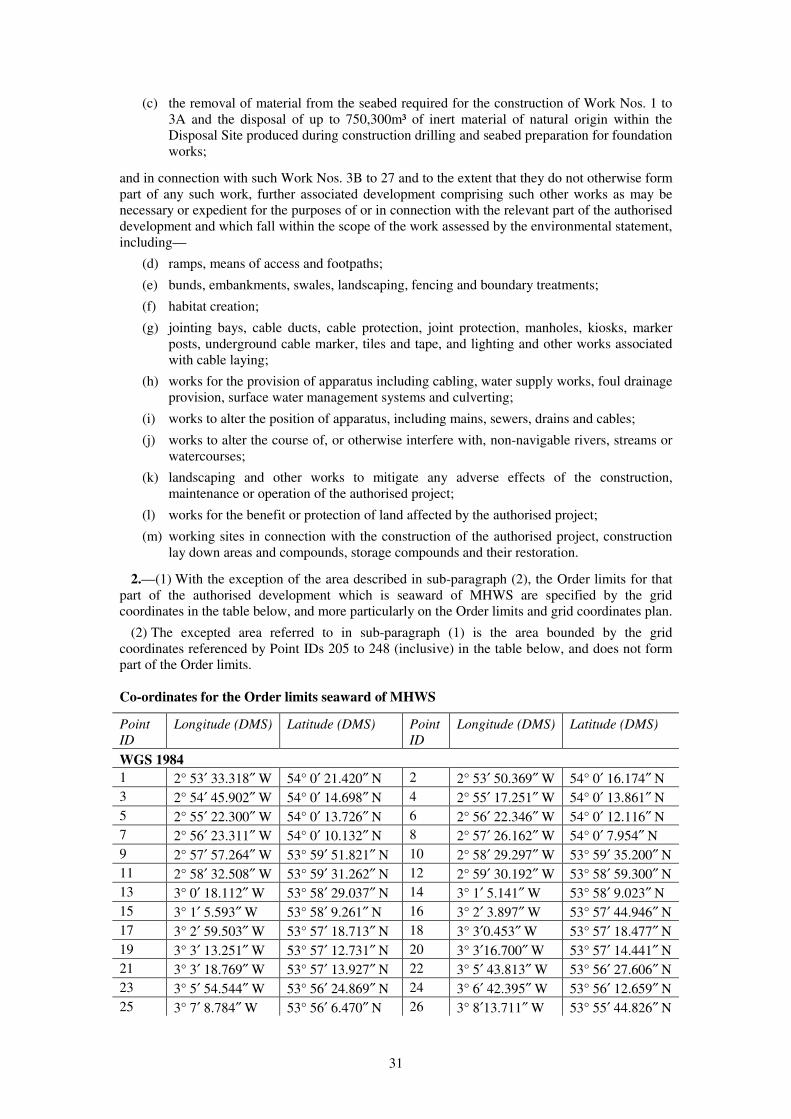
31
(c) the removal of material from the seabed required for the construction of Work Nos. 1 to
3A and the disposal of up to 750,300m³ of inert material of natural origin within the
Disposal Site produced during construction drilling and seabed preparation for foundation
works;
and in connection with such Work Nos. 3B to 27 and to the extent that they do not otherwise form
part of any such work, further associated development comprising such other works as may be
necessary or expedient for the purposes of or in connection with the relevant part of the authorised
development and which fall within the scope of the work assessed by the environmental statement,
including—
(d) ramps, means of access and footpaths;
(e) bunds, embankments, swales, landscaping, fencing and boundary treatments;
(f) habitat creation;
(g) jointing bays, cable ducts, cable protection, joint protection, manholes, kiosks, marker
posts, underground cable marker, tiles and tape, and lighting and other works associated
with cable laying;
(h) works for the provision of apparatus including cabling, water supply works, foul drainage
provision, surface water management systems and culverting;
(i) works to alter the position of apparatus, including mains, sewers, drains and cables;
(j) works to alter the course of, or otherwise interfere with, non-navigable rivers, streams or
watercourses;
(k) landscaping and other works to mitigate any adverse effects of the construction,
maintenance or operation of the authorised project;
(l) works for the benefit or protection of land affected by the authorised project;
(m) working sites in connection with the construction of the authorised project, construction
lay down areas and compounds, storage compounds and their restoration.
2.—(1) With the exception of the area described in sub-paragraph (2), the Order limits for that
part of the authorised development which is seaward of MHWS are specified by the grid
coordinates in the table below, and more particularly on the Order limits and grid coordinates plan.
(2) The excepted area referred to in sub-paragraph (1) is the area bounded by the grid
coordinates referenced by Point IDs 205 to 248 (inclusive) in the table below, and does not form
part of the Order limits.
Co-ordinates for the Order limits seaward of MHWS
Point
ID
Longitude (DMS) Latitude (DMS) Point
ID
Longitude (DMS) Latitude (DMS)
WGS 1984
1 2° 53′ 33.318″ W 54° 0′ 21.420″ N 2 2° 53′ 50.369″ W 54° 0′ 16.174″ N
3 2° 54′ 45.902″ W 54° 0′ 14.698″ N 4 2° 55′ 17.251″ W 54° 0′ 13.861″ N
5 2° 55′ 22.300″ W 54° 0′ 13.726″ N 6 2° 56′ 22.346″ W 54° 0′ 12.116″ N
7 2° 56′ 23.311″ W 54° 0′ 10.132″ N 8 2° 57′ 26.162″ W 54° 0′ 7.954″ N
9 2° 57′ 57.264″ W 53° 59′ 51.821″ N 10 2° 58′ 29.297″ W 53° 59′ 35.200″ N
11 2° 58′ 32.508″ W 53° 59′ 31.262″ N 12 2° 59′ 30.192″ W 53° 58′ 59.300″ N
13 3° 0′ 18.112″ W 53° 58′ 29.037″ N 14 3° 1′ 5.141″ W 53° 58′ 9.023″ N
15 3° 1′ 5.593″ W 53° 58′ 9.261″ N 16 3° 2′ 3.897″ W 53° 57′ 44.946″ N
17 3° 2′ 59.503″ W 53° 57′ 18.713″ N 18 3° 3′0.453″ W 53° 57′ 18.477″ N
19 3° 3′ 13.251″ W 53° 57′ 12.731″ N 20 3° 3′16.700″ W 53° 57′ 14.441″ N
21 3° 3′ 18.769″ W 53° 57′ 13.927″ N 22 3° 5′ 43.813″ W 53° 56′ 27.606″ N
23 3° 5′ 54.544″ W 53° 56′ 24.869″ N 24 3° 6′ 42.395″ W 53° 56′ 12.659″ N
25 3° 7′ 8.784″ W 53° 56′ 6.470″ N 26 3° 8′13.711″ W 53° 55′ 44.826″ N

32
Point
ID
Longitude (DMS) Latitude (DMS) Point
ID
Longitude (DMS) Latitude (DMS)
WGS 1984
27 3° 8′ 13.737″ W 53° 55′ 45.023″ N 28 3° 9′ 13.690″ W 53° 55′ 23.693″ N
29 3° 9′ 48.444″ W 53° 55′ 9.265″ N 30 3° 10′ 37.024″ W 53° 54′ 48.620″ N
31 3° 10′ 49.239″ W 53° 54′ 42.972″ N 32 3° 12′ 22.668″ W 53° 53′ 59.742″ N
33 3° 12′ 23.270″ W 53° 54′ 0.247″ N 34 3° 12′ 49.670″ W 53° 54′ 2.654″ N
35 3° 12′ 52.456″ W 53° 54′ 2.687″ N 36 3° 17′ 6.270″ W 53° 54′ 28.567″ N
37 3° 26′ 26.669″ W 53° 55′ 25.214″ N 38 3° 26′ 37.660″ W 53° 55′ 26.317″ N
39 3° 27′ 3.079″ W 53° 55′ 28.867″ N 40 3° 27′ 18.555″ W 53° 55′ 30.418″ N
41 3° 29′ 50.937″ W 53° 55′ 45.664″ N 42 3° 30′ 3.624″ W 53° 55′ 43.059″ N
43 3° 30′ 30.452″ W 53° 55′ 54.247″ N 44 3° 30′ 29.997″ W 53° 55′ 54.544″ N
45 3° 34′ 7.698″ W 53° 57′ 35.322″ N 46 3° 34′ 7.209″ W 53° 57′ 35.365″ N
47 3° 37′ 35.577″ W 53° 59′ 11.544″ N 48 3° 37′ 34.781″ W 53° 59′ 11.548″ N
49 3° 41′ 30.681″ W 54° 1′ 0.522″ N 50 3° 41′ 29.995″ W 54° 1′ 0.584″ N
51 3° 44′ 18.958″ W 54° 2′ 18.969″ N 52 3° 44′ 18.798″ W 54° 2′ 19.017″ N
53 3° 47′ 22.145″ W 54° 3′ 41.872″ N 54 3° 47′ 27.048″ W 54° 3′ 41.853″ N
55 3° 50′ 7.591″ W 54° 4′ 20.464″ N 56 3° 50′ 30.606″ W 54° 4′ 27.329″ N
57 3° 52′ 35.173″ W 54° 5′ 4.454″ N 58 3° 52′ 35.893″ W 54° 5′ 27.530″ N
59 3° 52′ 30.274″ W 54° 5′ 34.138″ N 60 3° 52′ 18.993″ W 54° 5′ 47.403″ N
61 3° 52′ 14.971″ W 54° 5′ 52.133″ N 62 3° 52′ 14.528″ W 54° 5′ 52.628″ N
63 3° 52′ 13.616″ W 54° 5′ 53.649″ N 64 3° 52′ 13.582″ W 54° 5′ 53.687″ N
65 3° 52′ 13.580″ W 54° 5′ 53.689″ N 66 3° 52′ 13.579″ W 54° 5′ 53.690″ N
67 3° 52′ 13.577″ W 54° 5′ 53.693″ N 68 3° 52′ 13.576″ W 54° 5′ 53.693″ N
69 3° 52′ 13.576″ W 54° 5′ 53.694″ N 70 3° 52′ 13.657″ W 54° 5′ 53.720″ N
71 3° 52′ 28.915″ W 54° 5′ 58.451″ N 72 3° 55′ 6.038″ W 54° 6′ 47.128″ N
73 3° 55′ 8.026″ W 54° 8′ 10.360″ N 74 3° 53′ 41.626″ W 54° 7′ 56.485″ N
75 3° 53′ 37.752″ W 54° 7′ 56.773″ N 76 3° 49′ 34.856″ W 54° 9′ 30.726″ N
77 3° 39′ 20.455″ W 54° 6′ 19.663″ N 78 3° 40′ 10.211″ W 54° 5′ 35.819″ N
79 3° 40′ 2.050″ W 54° 5′ 24.439″ N 80 3° 39′ 34.391″ W 54° 4′ 45.872″ N
81 3° 39′ 20.491″ W 54° 4′ 26.490″ N 82 3° 39′ 4.540″ W 54° 4′ 8.303″ N
83 3° 38′ 34.710″ W 54° 3′ 34.297″ N 84 3° 37′ 28.711″ W 54° 3′ 26.435″ N
85 3° 36′ 6.282″ W 54° 3′ 7.704″ N 86 3° 35′ 29.688″ W 54° 2′ 56.515″ N
87 3° 35′ 2.285″ W 54° 2′ 48.138″ N 88 3° 34′ 25.262″ W 54° 2′ 33.068″ N
89 3° 33′ 48.240″ W 54° 2′ 17.999″ N 90 3° 33′ 48.186″ W 54° 2′ 17.988″ N
91 3° 32′ 51.202″ W 54° 1′ 46.816″ N 92 3° 31′ 58.620″ W 54° 1′ 8.425″ N
93 3° 31′ 33.298″ W 54° 0′ 44.201″ N 94 3° 34′ 3.925″ W 54° 0′ 13.597″ N
95 3° 37′ 57.802″ W 54° 1′ 26.958″ N 96 3° 38′ 35.961″ W 54° 1′ 38.908″ N
97 3° 38′ 37.941″ W 54° 1′ 39.528″ N 98 3° 38′ 38.113″ W 54° 1′ 39.582″ N
99 3° 38′ 38.136″ W 54° 1′ 39.589″ N 100 3° 38′ 38.137″ W 54° 1′ 39.589″ N
101 3° 38′ 38.136″ W 54° 1′ 39.588″ N 102 3° 38′ 38.136″ W 54° 1′ 39.585″ N
103 3° 38′ 38.135″ W 54° 1′ 39.557″ N 104 3° 38′ 38.135″ W 54° 1′ 39.550″ N
105 3° 38′ 37.814″ W 54° 1′ 32.453″ N 106 3° 38′ 37.736″ W 54° 1′ 30.739″ N
107 3° 38′ 35.483″ W 54° 0′ 40.901″ N 108 3° 38′ 34.329″ W 54° 0′ 15.381″ N
109 3° 36′ 18.089″ W 53° 59′ 12.083″ N 110 3° 36′ 18.013″ W 53° 59′ 12.112″ N
111 3° 32′ 54.558″ W 53° 57′ 37.375″ N 112 3° 29′ 43.507″ W 53° 56′7.888″ N
113 3° 23′ 28.273″ W 53° 55′ 30.504″ N 114 3° 21′ 22.439″ W 53° 55′17.891″ N
115 3° 17′ 6.328″ W 53° 54′ 52.098″ N 116 3° 16′ 51.776″ W 53° 54′ 50.628″ N

33
Point
ID
Longitude (DMS) Latitude (DMS) Point
ID
Longitude (DMS) Latitude (DMS)
WGS 1984
117 3° 13′ 19.548″ W 53° 54′ 29.125″ N 118 3° 13′ 21.515″ W 53° 54′ 27.216″ N
119 3° 12′ 52.745″ W 53° 54′ 16.308″ N 120 3° 12′ 37.818″ W 53° 54′ 24.884″ N
121 3° 12′ 30.762″ W 53° 54′ 24.167″ N 122 3° 11′ 53.533″ W 53° 54′ 41.184″ N
123 3° 11′ 46.361″ W 53° 54′ 44.462″ N 124 3° 8′ 17.617″ W 53° 56′ 19.742″ N
125 3° 8′ 3.775″ W 53° 56′ 24.509″ N 126 3° 5′ 36.260″ W 53° 56′ 54.770″ N
127 3° 5′ 33.104″ W 53° 56′ 55.897″ N 128 3° 3′ 59.223″ W 53° 57′29.379″ N
129 3° 3′ 35.027″ W 53° 57′ 41.707″ N 130 3° 3′ 12.770″ W 53° 57′ 54.699″ N
131 3° 3′ 1.921″ W 53° 58′ 1.031″ N 132 3° 2′ 50.675″ W 53° 58′6.814″ N
133 3° 2′ 29.445″ W 53° 58′ 18.224″ N 134 3° 2′ 26.366″ W 53° 58′ 19.879″ N
135 3° 2′ 18.381″ W 53° 58′ 21.914″ N 136 3° 1′ 57.695″ W 53° 58′ 29.947″ N
137 3° 0′ 59.498″ W 53° 58′ 54.481″ N 138 3° 0′ 17.205″ W 53° 59′ 21.263″ N
139 2° 59′ 50.041″ W 53° 59′ 23.845″ N 140 2° 59′ 48.659″ W 53° 59′ 21.447″ N
141 2° 58′ 39.981″ W 53° 59′ 56.787″ N 142 2° 58′ 22.348″ W 54° 0′ 6.797″ N
143 2° 58′ 17.509″ W 54° 0′ 9.544″ N 144 2° 57′ 52.475″ W 54° 0′ 21.929″ N
145 2° 57′ 40.585″ W 54° 0′ 27.810″ N 146 2° 56′ 43.833″ W 54° 0′ 27.583″ N
147 2° 56′ 36.086″ W 54° 0′ 27.798″ N 148 2° 55′ 33.076″ W 54° 0′ 29.540″ N
149 2° 55′ 24.257″ W 54° 0′ 29.783″ N 150 2° 55′ 17.716″ W 54° 0′ 29.964″ N
151 2° 54′ 28.827″ W 54° 0′ 31.307″ N 152 2° 54′ 28.613″ W 54° 0′ 31.313″ N
153 2° 54′ 7.050″ W 54° 0′ 31.904″ N 154 2° 54′ 0.064″ W 54° 0′ 32.095″ N
155 2° 53′ 50.559″ W 54° 0′ 24.974″ N 156 2° 53′ 50.558″ W 54° 0′ 24.973″ N
157 2° 53′ 50.137″ W 54° 0′ 24.658″ N 158 2° 53′ 48.738″ W 54° 0′ 24.687″ N
159 2° 53′ 48.373″ W 54° 0′ 24.694″ N 160 2° 53′ 48.071″ W 54° 0′ 24.700″ N
161 2° 53′ 47.607″ W 54° 0′ 24.710″ N 162 2° 53′ 47.270″ W 54° 0′ 24.717″ N
163 2° 53′ 47.131″ W 54° 0′ 24.720″ N 164 2° 53′ 47.070″ W 54° 0′ 24.721″ N
165 2° 53′ 46.869″ W 54° 0′ 24.725″ N 166 2° 53′ 46.825″ W 54° 0′ 24.727″ N
167 2° 53′ 46.705″ W 54° 0′ 24.884″ N 168 2° 53′ 46.472″ W 54° 0′ 25.188″ N
169 2° 53′ 46.283″ W 54° 0′ 25.434″ N 170 2° 53′ 46.208″ W 54° 0′ 25.533″ N
171 2° 53′ 46.115″ W 54° 0′ 25.654″ N 172 2° 53′ 46.079″ W 54° 0′ 25.739″ N
173 2° 53′ 46.067″ W 54° 0′ 25.826″ N 174 2° 53′ 46.070″ W 54° 0′ 25.856″ N
175 2° 53′ 46.077″ W 54° 0′ 25.912″ N 176 2° 53′ 46.001″ W 54° 0′ 25.898″ N
177 2° 53′ 45.896″ W 54° 0′ 25.878″ N 178 2° 53′ 45.062″ W 54° 0′ 25.722″ N
179 2° 53′ 44.966″ W 54° 0′ 25.704″ N 180 2° 53′ 44.992″ W 54° 0′ 25.694″ N
181 2° 53′ 45.026″ W 54° 0′ 25.674″ N 182 2° 53′ 45.054″ W 54° 0′ 25.651″ N
183 2° 53′ 45.075″ W 54° 0′ 25.626″ N 184 2° 53′ 45.088″ W 54° 0′ 25.599″ N
185 2° 53′ 45.109″ W 54° 0′ 25.475″ N 186 2° 53′ 45.182″ W 54° 0′ 25.230″ N
187 2° 53′ 45.198″ W 54° 0′ 25.196″ N 188 2° 53′ 45.235″ W 54° 0′ 25.110″ N
189 2° 53′ 45.288″ W 54° 0′ 24.990″ N 190 2° 53′ 45.326″ W 54° 0′ 24.924″ N
191 2° 53′ 45.329″ W 54° 0′ 24.887″ N 192 2° 53′ 45.322″ W 54° 0′ 24.851″ N
193 2° 53′ 45.304″ W 54° 0′ 24.817″ N 194 2° 53′ 45.296″ W 54° 0′ 24.807″ N
195 2° 53′ 45.319″ W 54° 0′ 24.782″ N 196 2° 53′ 43.200″ W 54° 0′ 24.861″ N
197 2° 53′ 41.929″ W 54° 0′ 24.908″ N 198 2° 53′ 41.759″ W 54° 0′ 24.839″ N
199 2° 53′ 39.885″ W 54° 0′ 23.983″ N 200 2° 53′ 38.298″ W 54° 0′ 23.259″ N
201 2° 53′ 36.899″ W 54° 0′ 22.822″ N 202 2° 53′ 36.045″ W 54° 0′ 22.555″ N
203 2° 53′ 33.360″ W 54° 0′ 21.439″ N 204 2° 53′ 33.318″ W 54° 0′ 21.420″ N
205 3° 39′ 19.856″ W 54° 1′ 37.228″ N 206 3° 39′ 21.169″ W 54° 1′ 49.244″ N
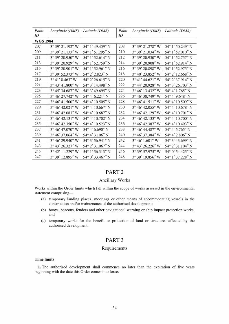
34
Point
ID
Longitude (DMS) Latitude (DMS) Point
ID
Longitude (DMS) Latitude (DMS)
WGS 1984
207 3° 39′ 21.192″ W 54° 1′ 49.459″ N 208 3° 39′ 21.278″ W 54° 1′ 50.249″ N
209 3° 39′ 21.133″ W 54° 1′ 51.295″ N 210 3° 39′ 21.034″ W 54° 1′ 52.010″ N
211 3° 39′ 20.950″ W 54° 1′ 52.614″ N 212 3° 39′ 20.930″ W 54° 1′ 52.757″ N
213 3° 39′ 20.929″ W 54° 1′ 52.759″ N 214 3° 39′ 20.908″ W 54° 1′ 52.914″ N
215 3° 39′ 20.901″ W 54° 1′ 52.961″ N 216 3° 39′ 20.898″ W 54° 1′ 52.975″ N
217 3° 39′ 52.373″ W 54° 2′ 2.823″ N 218 3° 40′ 23.852″ W 54° 2′ 12.668″ N
219 3° 41′ 8.463″ W 54° 2′ 26.615″ N 220 3° 41′ 44.621″ W 54° 2′ 37.914″ N
221 3° 43′ 41.800″ W 54° 3′ 14.498″ N 222 3° 44′ 20.928″ W 54° 3′ 26.703″ N
223 3° 45′ 34.687″ W 54° 3′ 49.695″ N 224 3° 46′ 13.432″ W 54° 4′ 1.765″ N
225 3° 46′ 27.742″ W 54° 4′ 6.221″ N 226 3° 46′ 38.749″ W 54° 4′ 9.648″ N
227 3° 46′ 41.500″ W 54° 4′ 10.505″ N 228 3° 46′ 41.511″ W 54° 4′ 10.509″ N
229 3° 46′ 42.021″ W 54° 4′ 10.667″ N 230 3° 46′ 42.055″ W 54° 4′ 10.678″ N
231 3° 46′ 42.083″ W 54° 4′ 10.687″ N 232 3° 46′ 42.129″ W 54° 4′ 10.701″ N
233 3° 46′ 42.131″ W 54° 4′ 10.702″ N 234 3° 46′ 42.133″ W 54° 4′ 10.700″ N
235 3° 46′ 42.350″ W 54° 4′ 10.523″ N 236 3° 46′ 42.387″ W 54° 4′ 10.493″ N
237 3° 46′ 47.070″ W 54° 4′ 6.690″ N 238 3° 46′ 44.487″ W 54° 4′ 5.765″ N
239 3° 46′ 37.064″ W 54° 4′ 3.106″ N 240 3° 46′ 37.384″ W 54° 4′ 2.806″ N
241 3° 46′ 29.940″ W 54° 3′ 56.941″ N 242 3° 46′ 1.601″ W 54° 3′ 43.699″ N
243 3° 43′ 26.327″ W 54° 2′ 31.067″ N 244 3° 43′ 26.226″ W 54° 2′ 31.104″ N
245 3° 42′ 11.229″ W 54° 1′ 56.313″ N 246 3° 39′ 57.975″ W 54° 0′ 54.425″ N
247 3° 39′ 12.895″ W 54° 0′ 33.467″ N 248 3° 39′ 19.856″ W 54° 1′ 37.228″ N
PART 2
Ancillary Works
Works within the Order limits which fall within the scope of works assessed in the environmental
statement comprising—
(a) temporary landing places, moorings or other means of accommodating vessels in the
construction and/or maintenance of the authorised development;
(b) buoys, beacons, fenders and other navigational warning or ship impact protection works;
and
(c) temporary works for the benefit or protection of land or structures affected by the
authorised development.
PART 3
Requirements
Time limits
1. The authorised development shall commence no later than the expiration of five years
beginning with the date this Order comes into force.

35
Detailed offshore design parameters
2.—(1) Subject to sub-paragraph (2), no wind turbine generator forming part of the authorised
development shall—
(a) exceed a height of 222 metres when measured from MHWS to the highest point of the
rotating blade of the WTG;
(b) exceed a height of 122 metres to the height of the centreline of the generator shaft
forming part of the WTG nacelle when measured from MHWS;
(c) exceed a rotor diameter of 200 metres, or have a rotor diameter of less than 120 metres;
(d) be less than 737 metres from the nearest WTG in either direction perpendicular to the
approximate prevailing wind direction (crosswind) or be less than 737 metres from the
nearest WTG in either direction which is in line with the approximate prevailing wind
direction (downwind);
(e) have a distance of less than 22 metres between the lowest point of the rotating blade of
the WTG and MHWS.
(2) References to the location of a wind turbine generator are references to the centre point of
that WTG.
3.—(1) The total number of offshore substations forming part of the authorised development
shall not exceed three.
(2) The dimensions of any offshore substation forming part of the authorised development
(excluding any towers, helipads, masts and cranes) shall not exceed 75 metres in height when
measured from LAT, 50 metres in length and 50 metres in width.
4.—(1) The number of cable systems forming part of the authorised development laid in the
cable corridor forming part of the Order limits between reference point AA and reference point
BB and reference point CC shown on the works plans shall not exceed five.
(2) The total length of the cables comprising Work No. 1(b) shall not exceed 270 kilometres.
(3) The total length of the cables comprising Work No. 3A shall not exceed 480 kilometres.
5.—(1) The total number of monopole foundations forming part of the authorised development
shall not exceed 207 and no monopile foundation for use with any wind turbine generator or
offshore substation forming part of the authorised development shall have a diameter greater than
9 metres.
(2) No jacket structure for use with any wind turbine generator forming part of the authorised
development shall have—
(a) a width spacing between each leg at the level of the seabed of more than 40 metres and at
the level of LAT which is greater than 20 metres;
(b) more than four legs;
(c) a leg diameter of more than 3 metres;
(d) more than one pile per leg;
(e) a pile diameter of more than 3 metres;
(f) more than one suction caisson per leg;
(g) a suction caisson diameter of greater than 10 metres.
(3) No jacket structure for use with any offshore substation forming part of the authorised
development, when used in conjunction with steel piles or suction caissons, shall have—
(a) a width spacing between each leg at the level of the seabed of more than 70 metres and at
the level of LAT which is greater than 40 metres;
(b) more than 4 legs;
(c) a leg diameter of more than 4 metres;
(d) more than four piles per leg;
36
(e) a pile diameter of more than 3.5 metres;
(f) more than three suction caissons per leg;
(g) a suction caisson diameter of greater than 25 metres each.
6. The total volume of scour protection for use with WTGs within Work No. 1(a) shall not
exceed 2,277,000m³.
7. The total volume of scour protection for use with the offshore substation platforms within
Work No. 2(a) shall not exceed 125,100m³.
8. The total volume of cable protection (excluding cable crossings) included within Work No.
1(b) shall not exceed 27,000m³ with a maximum footprint of 35,000m².
9. The total volume of cable protection associated with cable crossings included within Work
No. 1(b) shall not exceed 64,328m³ with a maximum footprint of 74,480m².
10. The total volume of cable protection (excluding cable crossings) for Work No. 3A shall not
exceed 109,650m³ with a maximum footprint of 142,139m².
11. The total volume of cable protection associated with cable crossings included within Work
No. 3A shall not exceed 125,955m³ with a maximum footprint of 144,548m².
Air traffic services at Warton Aerodrome
12.—(1) No construction of any wind turbine generator forming part of the authorised
development shall commence until the Secretary of State, having consulted with the Ministry of
Defence and the Operator, confirms in writing that he is satisfied that appropriate mitigation will
be implemented and maintained for the life of the authorised development and that arrangements
have been put in place with the Operator to ensure that such appropriate mitigation is
implemented.
(2) For the purposes of this Requirement—
“appropriate mitigation” means measures to prevent or remove any adverse impacts which the
operation of the authorised development will have on the Operator’s ability to provide safe
and efficient air traffic services for Warton Aerodrome during the life of the authorised
development;
“approved mitigation” means the appropriate mitigation measures agreed with the Ministry of
Defence and the Operator at the time the Secretary of State confirms in writing that he is
satisfied in accordance with sub-paragraph (1);
“Ministry of Defence” means as represented by Defence Infrastructure Organisation –
Safeguarding, Kingston Road, Sutton Coldfield, B75 7RL or any successor body;
“Operator” means BAE Systems (Operations) Limited incorporated under the Companies Act
2006 (Company Number 01996687) whose registered office is Warwick House, PO Box 87,
Farnborough Aerospace Centre, Farnborough, Hants, GU14 6YU or such other organisation as
is licensed from time to time under sections 5 and 6 of the Transport Act 2000 to provide air
traffic services for Warton Aerodrome.
(3) The undertaker shall thereafter comply with all other obligations contained within the
approved mitigation for the life of the authorised development.
Primary surveillance radars at St Annes and Lowther Hill
13.—(1) No construction of any wind turbine generator forming part of the authorised
development shall commence until the Secretary of State, having consulted with the Operator,
confirms in writing that he is satisfied that a primary radar mitigation scheme will be implemented
in order to avoid the impact of the development on the primary radar of the Operator located at St
Annes and Lowther Hill and on associated air traffic management operations.
37
(2) No construction of any wind turbine generator forming part of the authorised development
shall commence until the Operator has confirmed to the Secretary of State that an approved
primary radar mitigation scheme has been implemented and the development shall thereafter be
operated fully in accordance with such approved scheme.
(3) For the purposes of this Requirement—
“Operator” means NATS (En Route) plc, incorporated under the Companies Act 2006
(4129273) whose registered office is 4000 Parkway, Whiteley, Fareham, Hampshire, PO15
7FL or such other organisation licensed from time to time under sections 5 and 6 of the
Transport Act 2000 to provide air traffic services to the relevant managed area (within the
meaning of section 40 of that Act);
“primary radar mitigation scheme” means a scheme agreed with the Operator which sets out
the measures to prevent or remove any adverse impacts which the operation of the proposed
development will have on the Operator’s ability to provide safe and efficient air traffic
management services from the St Annes and Lowther Hill primary radars.
Offshore decommissioning
14. No part of the authorised development seaward of MHWS shall commence until a written
decommissioning programme in compliance with any notice served upon the undertaker by the
Secretary of State pursuant to section 105(2) of the 2004 Act has been submitted to the Secretary
of State for approval. The undertaker must consult the MMO, Natural England and the relevant
planning authority on the proposed decommissioning activity no less than four months prior to
submission of the proposed decommissioning programme to the Secretary of State.
Stages of authorised development onshore
15.—(1) The connection works shall not be commenced until a written scheme setting out all the
stages of the connection works has been submitted to and approved by the relevant planning
authority.
(2) The scheme shall be implemented as approved.
Detailed design approval onshore
16.—(1) No stage of the connection works shall commence until details of the layout, scale,
levels and external appearance of that stage have been submitted to and approved by the relevant
planning authority. The connection works must be carried out in accordance with the approved
details.
(2) Any works approved by the relevant planning authority under sub-paragraph (1) must accord
with the plans (or relevant parts of plans) listed in Requirement 17 and the principles set out in the
design and access statement and be within the Order limits.
(3) The connection works and maintenance thereof comprised within the area of onshore cable
corridor between points XX and YY shown on the works plans for Work No. 3B shall—
(a) only be undertaken by means of horizontal directional drilling from construction working
sites located west of point XX and/or east of point YY;
(b) comprise a horizontal directional drilling entry/exit point no less than 50 metres west of
point XX on the works plans for Work No. 3B;
(c) comprise a horizontal directional drilling entry/exit point no less than 20 metres east of
point YY on the works plans for Work No. 3B; and
(d) not involve the placing or transportation of any plant, apparatus, cables, cable ducts or
any other materials required for the carrying out of the connection works on or over that
land, provided that the undertaker may place or transport (by hand and on foot only) such
equipment and/or means of enclosure, on or over that land, as may be required to—
(i) contain and/or remove fluid used in the horizontal directional drilling process
including the placing of hoses along the northern Order limit between points XX and
38
YY shown on the works plans for Work No. 3B as approved by the relevant planning
authority, in consultation with Natural England and the MMO; and
(ii) mitigate the horizontal directional drilling process in accordance with the
environmental management and monitoring plan approved pursuant to this
Requirement.
(4) The connection works comprised in Work Nos. 3A and 3B between points XX and YY
shown on the works plans must not be commenced until an environmental management and
monitoring plan has been approved by the relevant planning authority, in consultation with
Natural England and the MMO. The environmental management and monitoring plan must be
submitted for approval at least four months prior to the commencement of those connection works,
or within such other timescale as agreed with the relevant planning authority.
(5) The environmental management and monitoring plan must include details of the location,
method and timing of surveys of the land within the Order limits between points XX and YY
shown on the works plans to—
(a) establish the pre-construction baseline condition of the saltmarsh and the distribution of
the Lycia zonaria britannica (Belted Beauty Moth) in that location; and
(b) record within a five year period following completion of construction the ecological
recovery of the saltmarsh and the distribution of the Lycia zonaria britannica (Belted
Beauty Moth) in that location and, if applicable, any receptor site to which the Lycia
zonaria britannica (Belted Beauty Moth) has been translocated.
(6) The environmental management and monitoring plan must include details of the
methodology for undertaking the connection works comprised in Work Nos. 3A and 3B between
points XX and YY shown on the works plans by horizontal directional drilling, and mitigation
measures relating thereto, including—
(a) details of the equipment required to contain and/or remove fluid used in the horizontal
directional drilling process;
(b) details of means of enclosure to be deployed (if any);
(c) the use of a drill bit of no less than 12.25 inches;
(d) the use of a real time downhole annular pressure monitor;
(e) details of how the length of each drill path will be minimised;
(f) details of the training of personnel to be employed in relation to the horizontal directional
drilling and/or mitigation measures;
(g) the employment of an Ecological Clerk of Works and scope of duties relating to that role;
(h) details of how the number of trips made between points XX and YY shown on the works
plans will be minimised;
(i) details of the methodology and location of suitable receptor sites associated with the
translocation of the Lycia zonaria britannica (Belted Beauty Moth), should such
translocation be required by the relevant planning authority, having consulted with
Natural England and the MMO;
(j) details of the methodology for preventing birds from nesting above the alignment of each
horizontal directional drill, such methodology may include visual and/or sound deterrents,
and/or physical barriers; and
(k) details of how the connection works will be maintained (if applicable).
(7) The environmental management and monitoring plan must be implemented as approved,
except to the extent that any changes to the plan are agreed by the relevant planning authority, in
consultation with Natural England and the MMO, and provided that the undertaker shall not be
required to carry out the post-construction monitoring of the ecological recovery of the saltmarsh
in sub-paragraph (5)(b) in the event that no fluid used in the horizontal directional drilling process
is released into the saltmarsh between points XX and YY shown on the works plans.
(8) No part of Work No. 6 shall—
(a) comprise more than five transition joint bays;

39
(b) comprise a transition joint bay having a length greater than 14 metres and a width greater
than 4 metres and a depth of greater than 2 metres;
(c) comprise more than ten pits for the fibre optic joints and link boxes;
(d) comprise a fibre optic joint pit having a length greater than 1.5 metres and a width greater
than 1.5 metres and a depth of greater than 2 metres;
(e) comprise a link box pit having a length greater than 1.5 metres and a width greater than
1.5 metres and a depth of greater than 2 metres;
(f) comprise a combined pit for the fibre optic joint and link box having a length greater than
3 metres and a width greater than 3 metres and a depth of greater than 2 metres.
(9) The total footprint of Work No. 6 shall not exceed 100 metres in length and 100 metres in
width.
(10) No part of the onshore cable corridor occupied by the connection works shall—
(a) comprise more than two cable trenches, each having a width greater than 3.6 metres or a
depth greater than 3 metres;
(b) comprise more than fifteen horizontal directional drill holes;
(c) comprise horizontal directional drill holes at a depth greater than 40 metres below
existing ground level.
(11) The onshore cable corridor shall comprise—
(a) no more than 25 cable jointing bays, each having a length no greater than 10 metres and a
width no greater than 3 metres and a depth of no greater than 2 metres;
(b) no more than 50 pits for the fibre optic joints and link boxes;
(c) a fibre optic joint pit having a length no greater than 1.5 metres and a width no greater
than 1.5 metres and a depth of no greater than 2 metres;
(d) a link box pit having a length no greater than 1.5 metres and a width no greater than 1.5
metres and a depth of no greater than 2 metres;
(e) a combined pit for the fibre optic joint and link box having a length no greater than 3
metres and a width no greater than 3 metres and a depth of no greater than 2 metres.
(12) No building(s) forming part of Work No. 25 shall exceed—
(a) a height of 15 metres above developmental ground level or 21 metres above AOD;
(b) a total footprint of 170 metres in length and 170 metres in width, unless otherwise agreed
by the relevant planning authority.
(13) The developmental ground level of the building(s) forming part of Work No. 25 must not
be lower than 5.1 metres AOD or higher than 6 metres above AOD, unless otherwise agreed by
the relevant planning authority.
(14) The fenced compound comprised in Work No. 25 must not exceed 170 metres by 170
metres.
(15) No external equipment or apparatus comprised in Work No. 25 shall exceed 23 metres
above developmental ground level or 29 metres above AOD.
17. The connection works must be carried out in accordance with the plans submitted with the
application for this Order, or subsequently in connection with the examination of this Order, and
certified by the Secretary of State unless otherwise agreed by the relevant planning authority.
Provision of landscaping
18.—(1) The works comprising Work No. 25 must not commence until a written landscaping
scheme and associated work programme (which accords with the principles set out in the CoCP
and the design and access statement) has been submitted to and approved by the relevant planning
authority.
40
(2) The landscaping scheme must include details of all proposed hard and soft landscaping
works, including—
(a) location, number, species, size and planting density of any proposed planting, including
any trees;
(b) pre-cultivation, cultivation and other operations to ensure plant establishment;
(c) the type, storage, and handling of imported materials;
(d) proposed finished ground levels;
(e) hard surfacing materials;
(f) vehicular and pedestrian access, parking and circulation areas;
(g) minor structures, such as furniture, refuse or other storage units, signage and lighting;
(h) proposed and existing functional services above and below ground, including drainage,
power and communications cables and pipelines, manholes and supports;
(i) details of existing trees to be retained, with measures for their protection during the
construction period;
(j) retained historic landscape features and proposals for restoration, where relevant;
(k) implementation timetables for all landscaping works; and
(l) future maintenance regimes.
Implementation and maintenance of landscaping
19.—(1) All landscaping works, including replacement planting carried out in accordance with
sub-paragraph (2), must be carried out in accordance with a landscaping scheme approved under
Requirement 18 and to a standard in accordance with the relevant recommendations of appropriate
British Standards or other recognised codes of good practice.
(2) Any tree or shrub planted as part of any landscaping scheme approved under Requirement 18
that, within a period of five years after planting, is removed, dies or becomes, in the opinion of the
relevant planning authority, seriously damaged or diseased, must be replaced in the first available
planting season with a specimen of the same species and size as that originally planted, unless
otherwise agreed by the relevant planning authority.
Highway accesses
20.—(1) No stage of the connection works shall commence until written details of the siting,
design, levels and layout of any new permanent or temporary means of access to a highway to be
used by vehicular traffic, or any alteration to an existing means of access to a highway used by
vehicular traffic, for that stage, has, after consultation with the highway authority, been submitted
to and approved by the relevant planning authority. The written details submitted must be in
accordance with the General Arrangement Drawings.
(2) The highway accesses for each stage must be constructed in accordance with the approved
details.
Public Access Strategy
21. All connection works must be undertaken in accordance with the principles set out in the
Public Access Strategy unless otherwise agreed by the relevant planning authority.
Public rights of way
22.—(1) No stage of the connection works shall commence until a public rights of way
diversion and closure scheme for that stage which accords with the principles of the Public Access
Strategy, has, after consultation with the highway authority, been submitted to and approved by
the relevant planning authority and that scheme shall include a programme for the temporary
41
closure and re-opening of the public rights of way specified at Schedule 4 (public rights of way to
be temporarily stopped up).
(2) Each stage of the connection works must be carried out in accordance with the approved
scheme.
Fencing and other means of enclosure
23.—(1) No stage of the connection works shall commence until written details of all proposed
permanent and temporary fences, walls or other means of enclosure for the relevant stage have
been submitted to and approved by the relevant planning authority.
(2) All fencing must be erected in accordance with the approved details.
(3) All construction sites must remain securely fenced at all times during construction of the
connection works.
(4) Any temporary fencing must be removed on completion of the connection works.
(5) Any approved permanent fencing in relation to Work No. 25 must be completed before the
relevant work is brought into use.
Surface and foul water drainage
24.—(1) No stage of the connection works shall commence until for that stage written details of
the surface and (if any) foul water drainage system (including means of pollution control) have,
after consultation with the relevant sewerage and drainage authorities and the Environment
Agency, been submitted to and approved by the relevant planning authority.
(2) The surface and foul water drainage system for each stage must be constructed in accordance
with the approved details.
Contaminated land and contaminated groundwater
25.—(1) No stage of the connection works shall commence until a written scheme to deal with
the contamination of any land comprised in that stage, including groundwater, within the Order
limits which is likely to cause significant harm to persons or pollution of controlled waters or the
environment has, after consultation with the relevant planning authority and the Environment
Agency, been submitted to and approved by the relevant planning authority.
(2) The scheme must include a desk study and assessment report, informed as necessary by an
intrusive site investigation, prepared by a specialist consultant approved by the relevant planning
authority, to identify the extent of any contamination within the Order limits and mitigation
measures to be undertaken to limit impacts arising from the potential release of contaminants.
(3) Such remediation as may be identified in the approved scheme must be carried out in
accordance with the approved scheme.
(4) If during the construction of the connection works further contamination not previously
identified is found to be present at the site then no further work shall be carried out on that part of
the site until—
(a) a risk assessment has been carried out and the results of the risk assessment have been
provided to the relevant planning authority; and
(b) such additional mitigation measures (if any) as may be identified by the risk assessment
have been incorporated into the approved scheme.
Archaeology onshore
26.—(1) No stage of the connection works shall commence until in relation to that stage a
written scheme for the investigation of areas of archaeological interest has been submitted to and
approved by the relevant planning authority.

42
(2) The scheme must identify areas where field work and/or a watching brief are required, and
the measures to be taken to protect, record or preserve any significant archaeological remains that
may be found, including—
(a) a programme of auger survey to determine the extent and depth of the peat basin in Site
30 (as identified in Chart 27.1 of the environmental statement), followed by an
assessment of the core samples;
(b) a targeted programme of evaluation to focus the approach to ‘strip, map and record’ on
the land comprised within the Order limits north of the A683, which is not occupied by
former railway sidings;
(c) a watching brief during all archaeologically relevant ground works of land comprised
within the Order limits south of the A683; and
(d) a programme of post-fieldwork assessment, analysis, reporting and archiving.
(3) Any archaeological works or watching brief carried out under the approved scheme must be
by a suitably qualified person or body approved by the relevant planning authority.
(4) Any archaeological works or watching brief for each stage must be carried out in accordance
with the approved scheme.
Code of Construction Practice (CoCP)
27. All connection works must be undertaken in accordance with the principles set out in the
CoCP unless otherwise agreed by the relevant planning authority.
Construction and environmental management plan
28.—(1) No stage of the connection works shall commence until a construction and
environmental management plan (CEMP) for that stage has been submitted to and approved by the
relevant planning authority, in consultation with Natural England.
(2) The CEMP must be submitted to the relevant planning authority and Natural England at least
four months prior to the commencement of the relevant stage of the connection works.
(3) The CEMP must cover all the subject areas set out in the certified CoCP and any other
matters the relevant planning authority, having consulted with Natural England, reasonably
requires.
(4) The CEMP for each stage must be implemented as approved.
Emergency response plan
29.—(1) No stage of the connection works shall commence until an emergency response plan
relating to the construction and operation of that stage of the relevant works has been submitted
for approval by the relevant planning authority after consultation with the Heysham Power Station
Emergency Planning Consultative Committee (of which the relevant planning authority is a
member) for the nuclear site licences at Heysham Power Station.
(2) The emergency response plan must be carried out as approved in relation to the relevant
stage of the relevant works, except to the extent that any changes to the plan are agreed by the
relevant planning authority after consultation with the Emergency Planning Consultative
Committee.
European protected species
30.—(1) No stage of the connection works shall commence until—
(a) the methodology for the preconstruction survey work required to establish whether a
European protected species is present on any of the land affected, or likely to be affected,
by the relevant stage or in any of the trees to be lopped or felled as part of the relevant
stage, has been submitted to and approved by the relevant planning authority in
consultation with Natural England; and

43
(b) the preconstruction survey work for that stage has been carried out in accordance with the
approved methodology.
(2) Where a European protected species is shown to be present the relevant stage of the
connection works shall not begin until, after consultation with Natural England, a scheme of
protection and mitigation measures has been submitted to and approved by the relevant planning
authority. The relevant works must be carried out in accordance with the approved scheme.
(3) “European protected species” has the same meaning as in regulations 40 and 44 of the
Conservation of Habitats and Species Regulations 2010(a).
Construction Traffic Management Plan
31.—(1) No stage of the connection works shall commence until a construction traffic
management plan (CTMP) for that stage has been submitted to and approved by the relevant
planning authority, in consultation with the highway authority, in accordance with the Outline
CTMP.
(2) The CTMP for each stage must be implemented as approved.
Port Construction Traffic Management Plan (Port CTMP)
32.—(1) No authorised development or part of the authorised development shall commence
until a port construction traffic management plan (Port CTMP) for the port-related traffic, to and
from the selected base port or ports for offshore construction and/or operation of the authorised
development, has been submitted to and approved by the relevant planning authority.
(2) The Port CTMP must not be submitted to the relevant planning authority for approval until
the undertaker has consulted with the relevant planning authority, adjacent planning authority and
relevant highway authority in relation to the terms of the Port CTMP, a transport assessment, air
quality assessment and offshore construction travel plan relating to the port-related traffic to and
from the selected base port or ports for offshore construction and/or operation of the authorised
development, unless otherwise agreed with the relevant planning authority.
(3) When the Port CTMP is submitted to the relevant planning authority it must be accompanied
by a transport assessment, air quality assessment and offshore construction travel plan relating to
the port-related traffic to and from the selected base port or ports for offshore construction and/or
operation of the authorised development, unless otherwise agreed with the relevant planning
authority.
(4) If the transport assessment and air quality assessment submitted with the Port CTMP identify
likely significant effects in terms of transport and/or air quality, the Port CTMP must include
details of the measures required to mitigate those likely significant effects and a programme for
the implementation of those measures.
(5) The Port CTMP must, unless otherwise agreed with the relevant planning authority, set out
the particulars of—
(a) the proposed vehicle routeing plans;
(b) the proposed scheduling and timing of vehicle movements;
(c) the details of the port handling facilities for deliveries, including a parking management
plan for heavy goods vehicles and construction workers’ vehicles;
(d) the swept path analysis of the proposed vehicle routes;
(e) the scope of surveys to be carried out to record the condition of the public highway,
including proposed highway inspection regimes, and the proposed highway maintenance
scheme to remediate damage to the highway (if any) that may be caused by construction
vehicles;
(f) the details of any highway works proposed; and
(a) S.I. 2010/490. There are amendments to these Regulations which are not relevant to this Order.
44
(g) the details of any traffic management proposed.
(6) The relevant planning authority must not—
(a) approve the Port CTMP unless and until it has consulted with and had regard to the
representations of the adjacent planning authority and relevant highway authority in
relation to any or all of the Port CTMP, the transport assessment, the air quality
assessment and the offshore construction travel plan; or
(b) grant any other approval, or waive any obligation of the undertaker, under the terms of
this Requirement unless and until it has consulted with and had regard to the
representations of the adjacent planning authority and relevant highway authority.
(7) The Port CTMP must be implemented as approved at all times specified within the Port
CTMP during the offshore construction and/or operation of the authorised development.
(8) For the purposes of this Requirement—
“adjacent planning authority” means the planning authority or authorities whose
administrative area(s) is/are adjacent to the administrative area(s) in which the selected base
port(s) is/are located;
“air quality assessment” means a document that accords with the principles of Environmental
Protection UK Guidance “Development Control: Planning for Air Quality” and “Technical
Guidance LAQM.TG(09)” published by the Department for Environment, Food and Rural
Affairs and agreed with the relevant planning authority for the area required to be assessed;
“base ports” means the port or ports used for construction and/or operation of the authorised
development;
“offshore construction travel plan” means a document which outlines the management of the
travel requirements associated with the offshore construction of the authorised development,
including a programme of measures aimed at encouraging more sustainable travel, with an
emphasis on reducing single occupancy car use;
“parking management plan” means a document which sets out the parking arrangements at the
selected base ports for vehicles associated with the offshore construction of the authorised
development and how these will be managed to ensure impacts associated with unauthorised
parking on the public highway are adequately mitigated;
“relevant highway authority” means the highway authority or authorities—
(a) in whose administrative areas the selected base ports are located; and/or
(b) whose administrative areas are adjacent to that/those areas; and/or
(c) the Highways Agency;
“relevant planning authority” means the planning authority or authorities in whose
administrative areas the selected base ports are located;
“selected base port” or “ports” means a base port or ports situated in England; and
“transport assessment” means a document that accords with the principles set out in the
Transport Statement and the national guidance given in the Guidance on Transport
Assessment (2007) published by the Department for Transport and Department for
Communities and Local Government, and includes an assessment of those vehicle routes
agreed with the relevant highway authority or authorities.
Construction hours
33.—(1) Construction work for the connection works and any construction-related traffic
movements to or from the site of the relevant works must not take place other than between 0700
hours and 1900 hours Monday to Friday, 0700 hours and 1400 hours on Saturdays, with no
activity on Sundays or bank holidays, save—
(a) where continuous periods of operation are required, such as concrete pouring and drilling;
(b) for the delivery of abnormal loads to the relevant works, which may cause congestion on
the local road network;

45
(c) where works are being carried out on the foreshore;
or unless otherwise agreed with the relevant planning authority in accordance with sub-paragraph
(2).
(2) All construction operations which are to be undertaken outside the hours specified in sub-
paragraph (1) must be agreed with the relevant planning authority in advance, and shall be carried
out within the agreed times.
Control of noise during construction
34.—(1) No stage of the connection works shall commence until a Construction Noise
Management Plan (CNMP) for that stage has been submitted to and approved by the relevant
planning authority.
(2) The CNMP must set out the particulars of—
(a) the construction works, and the method by which they are to be carried out;
(b) the noise attenuation and mitigation measures to be taken to minimise noise resulting
from the construction works, including any noise limits;
(c) a scheme for monitoring the noise during the construction works to ensure compliance
with the noise limits and effectiveness of the attenuation and mitigation measures.
(3) The CNMP for each stage must be implemented as approved.
Control of noise during operational phase
35.—(1) The noise emanating from the operation of Work No. 25 (including transformers,
cooling fans, switch gear and power lines) (including any relevant penalties for tonal or impulsive
noise in accordance with section 8 of BS4142:1997) must not exceed the following levels by
reference to the specified points marked on the Noise Monitoring Location Plan—
(a) 35dB(A) when measured at Mossgate Park (R1); and
(b) 35dB(A) when measured at Borrans Lane Static Homes (R2).
(2) Noise measurements shall be expressed as 5 minute L(A)eq values.
(3) All standby generator testing in relation to the connection works must be undertaken during
the hours of 0900 to 1700 on Mondays to Saturdays, and not at all on Sundays or bank holidays,
unless otherwise agreed with the relevant planning authority.
Control of air quality
36.—(1) No stage of the connection works shall commence until a Construction Phase Air
Quality Management Plan (AQMP) for that stage has been submitted to and approved by the
relevant planning authority.
(2) The AQMP must cover all the subject areas set out in the certified CoCP and any other
matters the relevant planning authority reasonably requires.
(3) The AQMP for each stage must be implemented as approved.
Control of artificial light emissions
37.—(1) No stage of the connection works shall commence until a written scheme for the
management and mitigation of artificial light emissions during the construction and/or operation
of the relevant stage has been submitted to and approved by the relevant planning authority, in
consultation with Natural England.
(2) The scheme for the management and mitigation of artificial light emissions for each stage
must be implemented as approved.
46
Flood risk
38.—(1) No stage of the connection works shall commence until a written scheme for the
mitigation of flood risk during the construction and/or operation of the relevant stage has been
submitted to and, after consultation with the Environment Agency and the Lead Local Flood
Authority, approved by the relevant planning authority.
(2) The scheme referred to in sub-paragraph (1) shall be prepared in accordance with the
principles set out in the environmental statement and the flood risk assessment annexed thereto.
(3) The scheme of flood risk mitigation for each stage must be implemented as approved.
Restoration of land used temporarily for construction
39. Any land landward of mean low water level within the Order limits which is used
temporarily for construction of the connection works, and not incorporated in permanent works or
approved landscaping, must be reinstated to its former condition, or such condition as the relevant
planning authority may approve, within six months of completion of the onshore works, or such
other period as the relevant planning authority may approve.
Onshore decommissioning
40.—(1) Upon the cessation of commercial operation of the onshore substation and restoration
of the substation site identified in Work No. 25, a written scheme for the demolition and removal
of that substation, and the final proposed condition of the relevant land, including a proposed
timetable, must be submitted to and approved by the relevant planning authority, in consultation
with Natural England.
(2) The scheme for decommissioning shall be implemented as approved.
Requirement for written approval
41. Where under any of the above Requirements the approval or agreement of the Secretary of
State, the relevant planning authority or another person or body is required, notification of such
approval or agreement must be given in writing.
Amendments to approved details
42.—(1) With respect to any Requirement which requires the authorised development to be
carried out in accordance with the details approved by the relevant planning authority or another
approval authority as specified in the Requirement (the “discharging authority”), the approved
details must be carried out as approved unless an amendment or variation is agreed in advance by
the discharging authority, in accordance with sub-paragraph (2), and in consultation with any body
specified in the relevant Requirement.
(2) Where any Requirement specifies “unless otherwise agreed” by the discharging authority
such agreement shall not be given except in relation to immaterial changes where it has been
demonstrated to the satisfaction of the discharging authority that the agreement sought is unlikely
to give rise to any materially new or materially different environmental effects from those
assessed in the environmental statement.
(3) The approved details shall include any amendments that may subsequently be agreed by the
discharging authority.
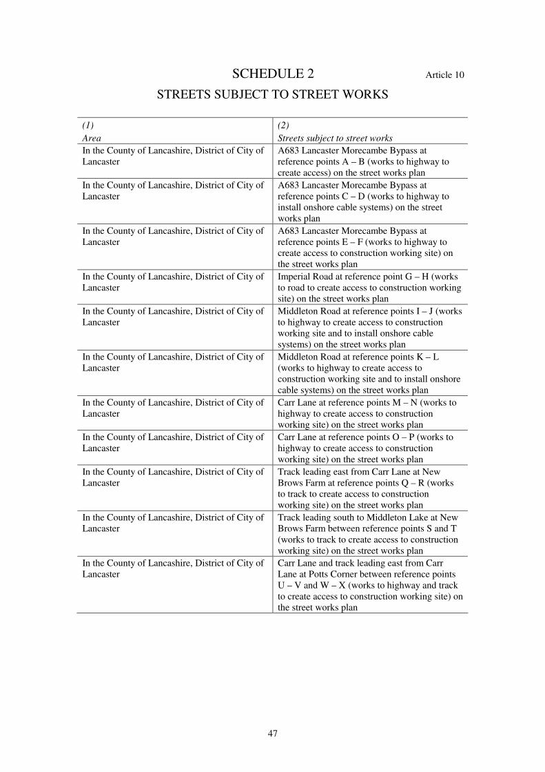
47
SCHEDULE 2 Article 10
STREETS SUBJECT TO STREET WORKS
(1)
Area
(2)
Streets subject to street works
In the County of Lancashire, District of City of
Lancaster
A683 Lancaster Morecambe Bypass at
reference points A – B (works to highway to
create access) on the street works plan
In the County of Lancashire, District of City of
Lancaster
A683 Lancaster Morecambe Bypass at
reference points C – D (works to highway to
install onshore cable systems) on the street
works plan
In the County of Lancashire, District of City of
Lancaster
A683 Lancaster Morecambe Bypass at
reference points E – F (works to highway to
create access to construction working site) on
the street works plan
In the County of Lancashire, District of City of
Lancaster
Imperial Road at reference point G – H (works
to road to create access to construction working
site) on the street works plan
In the County of Lancashire, District of City of
Lancaster
Middleton Road at reference points I – J (works
to highway to create access to construction
working site and to install onshore cable
systems) on the street works plan
In the County of Lancashire, District of City of
Lancaster
Middleton Road at reference points K – L
(works to highway to create access to
construction working site and to install onshore
cable systems) on the street works plan
In the County of Lancashire, District of City of
Lancaster
Carr Lane at reference points M – N (works to
highway to create access to construction
working site) on the street works plan
In the County of Lancashire, District of City of
Lancaster
Carr Lane at reference points O – P (works to
highway to create access to construction
working site) on the street works plan
In the County of Lancashire, District of City of
Lancaster
Track leading east from Carr Lane at New
Brows Farm at reference points Q – R (works
to track to create access to construction
working site) on the street works plan
In the County of Lancashire, District of City of
Lancaster
Track leading south to Middleton Lake at New
Brows Farm between reference points S and T
(works to track to create access to construction
working site) on the street works plan
In the County of Lancashire, District of City of
Lancaster
Carr Lane and track leading east from Carr
Lane at Potts Corner between reference points
U – V and W – X (works to highway and track
to create access to construction working site) on
the street works plan
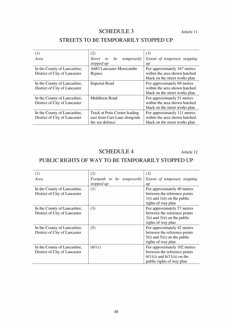
48
SCHEDULE 3 Article 11
STREETS TO BE TEMPORARILY STOPPED UP
(1)
Area
(2)
Street to be temporarily
stopped up
(3)
Extent of temporary stopping
up
In the County of Lancashire,
District of City of Lancaster
A683 Lancaster Morecambe
Bypass
For approximately 167 metres
within the area shown hatched
black on the street works plan
In the County of Lancashire,
District of City of Lancaster
Imperial Road For approximately 69 metres
within the area shown hatched
black on the street works plan
In the County of Lancashire,
District of City of Lancaster
Middleton Road For approximately 51 metres
within the area shown hatched
black on the street works plan
In the County of Lancashire,
District of City of Lancaster
Track at Potts Corner leading
east from Carr Lane alongside
the sea defence
For approximately 111 metres
within the area shown hatched
black on the street works plan
SCHEDULE 4 Article 12
PUBLIC RIGHTS OF WAY TO BE TEMPORARILY STOPPED UP
(1)
Area
(2)
Footpath to be temporarily
stopped up
(3)
Extent of temporary stopping
up
In the County of Lancashire,
District of City of Lancaster
(1) For approximately 40 metres
between the reference points
1(i) and 1(ii) on the public
rights of way plan
In the County of Lancashire,
District of City of Lancaster
(3) For approximately 57 metres
between the reference points
3(i) and 3(ii) on the public
rights of way plan
In the County of Lancashire,
District of City of Lancaster
(5) For approximately 42 metres
between the reference points
5(i) and 5(ii) on the public
rights of way plan
In the County of Lancashire,
District of City of Lancaster
(6/11) For approximately 102 metres
between the reference points
6/11(i) and 6/11(ii) on the
public rights of way plan
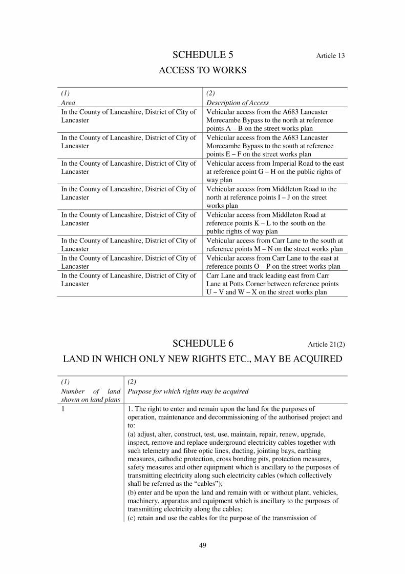
49
SCHEDULE 5 Article 13
ACCESS TO WORKS
(1)
Area
(2)
Description of Access
In the County of Lancashire, District of City of
Lancaster
Vehicular access from the A683 Lancaster
Morecambe Bypass to the north at reference
points A – B on the street works plan
In the County of Lancashire, District of City of
Lancaster
Vehicular access from the A683 Lancaster
Morecambe Bypass to the south at reference
points E – F on the street works plan
In the County of Lancashire, District of City of
Lancaster
Vehicular access from Imperial Road to the east
at reference point G – H on the public rights of
way plan
In the County of Lancashire, District of City of
Lancaster
Vehicular access from Middleton Road to the
north at reference points I – J on the street
works plan
In the County of Lancashire, District of City of
Lancaster
Vehicular access from Middleton Road at
reference points K – L to the south on the
public rights of way plan
In the County of Lancashire, District of City of
Lancaster
Vehicular access from Carr Lane to the south at
reference points M – N on the street works plan
In the County of Lancashire, District of City of
Lancaster
Vehicular access from Carr Lane to the east at
reference points O – P on the street works plan
In the County of Lancashire, District of City of
Lancaster
Carr Lane and track leading east from Carr
Lane at Potts Corner between reference points
U – V and W – X on the street works plan
SCHEDULE 6 Article 21(2)
LAND IN WHICH ONLY NEW RIGHTS ETC., MAY BE ACQUIRED
(1)
Number of land
shown on land plans
(2)
Purpose for which rights may be acquired
1 1. The right to enter and remain upon the land for the purposes of
operation, maintenance and decommissioning of the authorised project and
to:
(a) adjust, alter, construct, test, use, maintain, repair, renew, upgrade,
inspect, remove and replace underground electricity cables together with
such telemetry and fibre optic lines, ducting, jointing bays, earthing
measures, cathodic protection, cross bonding pits, protection measures,
safety measures and other equipment which is ancillary to the purposes of
transmitting electricity along such electricity cables (which collectively
shall be referred as the “cables”);
(b) enter and be upon the land and remain with or without plant, vehicles,
machinery, apparatus and equipment which is ancillary to the purposes of
transmitting electricity along the cables;
(c) retain and use the cables for the purpose of the transmission of
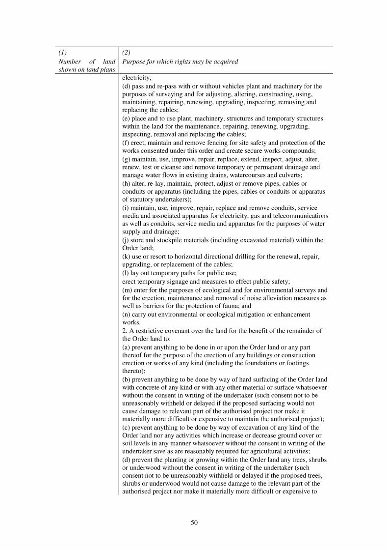
50
(1)
Number of land
shown on land plans
(2)
Purpose for which rights may be acquired
electricity;
(d) pass and re-pass with or without vehicles plant and machinery for the
purposes of surveying and for adjusting, altering, constructing, using,
maintaining, repairing, renewing, upgrading, inspecting, removing and
replacing the cables;
(e) place and to use plant, machinery, structures and temporary structures
within the land for the maintenance, repairing, renewing, upgrading,
inspecting, removal and replacing the cables;
(f) erect, maintain and remove fencing for site safety and protection of the
works consented under this order and create secure works compounds;
(g) maintain, use, improve, repair, replace, extend, inspect, adjust, alter,
renew, test or cleanse and remove temporary or permanent drainage and
manage water flows in existing drains, watercourses and culverts;
(h) alter, re-lay, maintain, protect, adjust or remove pipes, cables or
conduits or apparatus (including the pipes, cables or conduits or apparatus
of statutory undertakers);
(i) maintain, use, improve, repair, replace and remove conduits, service
media and associated apparatus for electricity, gas and telecommunications
as well as conduits, service media and apparatus for the purposes of water
supply and drainage;
(j) store and stockpile materials (including excavated material) within the
Order land;
(k) use or resort to horizontal directional drilling for the renewal, repair,
upgrading, or replacement of the cables;
(l) lay out temporary paths for public use;
erect temporary signage and measures to effect public safety;
(m) enter for the purposes of ecological and for environmental surveys and
for the erection, maintenance and removal of noise alleviation measures as
well as barriers for the protection of fauna; and
(n) carry out environmental or ecological mitigation or enhancement
works.
2. A restrictive covenant over the land for the benefit of the remainder of
the Order land to:
(a) prevent anything to be done in or upon the Order land or any part
thereof for the purpose of the erection of any buildings or construction
erection or works of any kind (including the foundations or footings
thereto);
(b) prevent anything to be done by way of hard surfacing of the Order land
with concrete of any kind or with any other material or surface whatsoever
without the consent in writing of the undertaker (such consent not to be
unreasonably withheld or delayed if the proposed surfacing would not
cause damage to relevant part of the authorised project nor make it
materially more difficult or expensive to maintain the authorised project);
(c) prevent anything to be done by way of excavation of any kind of the
Order land nor any activities which increase or decrease ground cover or
soil levels in any manner whatsoever without the consent in writing of the
undertaker save as are reasonably required for agricultural activities;
(d) prevent the planting or growing within the Order land any trees, shrubs
or underwood without the consent in writing of the undertaker (such
consent not to be unreasonably withheld or delayed if the proposed trees,
shrubs or underwood would not cause damage to the relevant part of the
authorised project nor make it materially more difficult or expensive to

51
(1)
Number of land
shown on land plans
(2)
Purpose for which rights may be acquired
access the relevant part of the authorised project).
2
6-10
41
1. The right to enter and remain upon the land for the purposes of
operation, maintenance and decommissioning of the authorised project and
to:
(a) adjust, alter, construct, use, maintain, repair, renew, upgrade, inspect,
remove and replace underground electricity cables together with such
telemetry and fibre optic lines, ducting, and other apparatus, protection
measures, safety measures and other equipment which is ancillary to the
purposes of transmitting electricity along such electricity cables (which
collectively shall be referred as the “cables”);
(b) retain and use the cables for the purpose of the transmission of
electricity;
(c) alter, re-lay, maintain, protect, adjust or remove pipes, cables or
conduits or apparatus (including the pipes, cables or conduits or apparatus
of statutory undertakers);
(d) maintain, use, improve, repair, replace and remove conduits, service
media and associated apparatus for electricity, gas and telecommunications
as well as conduits, service media and apparatus for the purposes of water
supply and drainage;
(e) enter for the purposes of ecological and for environmental surveys and
for the erection, maintenance and removal of noise alleviation measures as
well as barriers for the protection of fauna; and
(f) carry out environmental or ecological mitigation or enhancement works.
2. A restrictive covenant over the land for the benefit of the remainder of
the Order land to:
(a) prevent anything to be done in or upon the Order land or any part
thereof for the purpose of the erection of any buildings or construction
erection or works of any kind (including the foundations or footings
thereto);
(b) prevent anything to be done by way of hard surfacing of the Order land
with concrete of any kind or with any other material or surface whatsoever
without the consent in writing of the undertaker (such consent not to be
unreasonably withheld or delayed if the proposed surfacing would not
cause damage to relevant part of the authorised project nor make it
materially more difficult or expensive to maintain the authorised project);
(c) prevent anything to be done by way of excavation of any kind of the
Order land nor any activities which increase or decrease ground cover or
soil levels in any manner whatsoever without the consent in writing of the
undertaker save as are reasonably required for agricultural activities;
(d) prevent the planting or growing within the Order land any trees, shrubs
or underwood without the consent in writing of the undertaker (such
consent not to be unreasonably withheld or delayed if the proposed trees,
shrubs or underwood would not cause damage to the relevant part of the
authorised project nor make it materially more difficult or expensive to
access the relevant part of the authorised project).
11
14-18
29-40
42
44
46
47
1. The right to enter and remain upon the land for the purposes of
construction, installation, operation, maintenance and decommissioning of
the authorised project and to:
(a) lay down, install, adjust, alter, construct, test, use, maintain, repair,
renew, upgrade, inspect, remove and replace underground electricity cables
together with such telemetry and fibre optic lines, ducting, jointing bays,
earthing measures, cathodic protection, cross bonding pits, manhole covers
and other apparatus, protection measures, safety measures and other
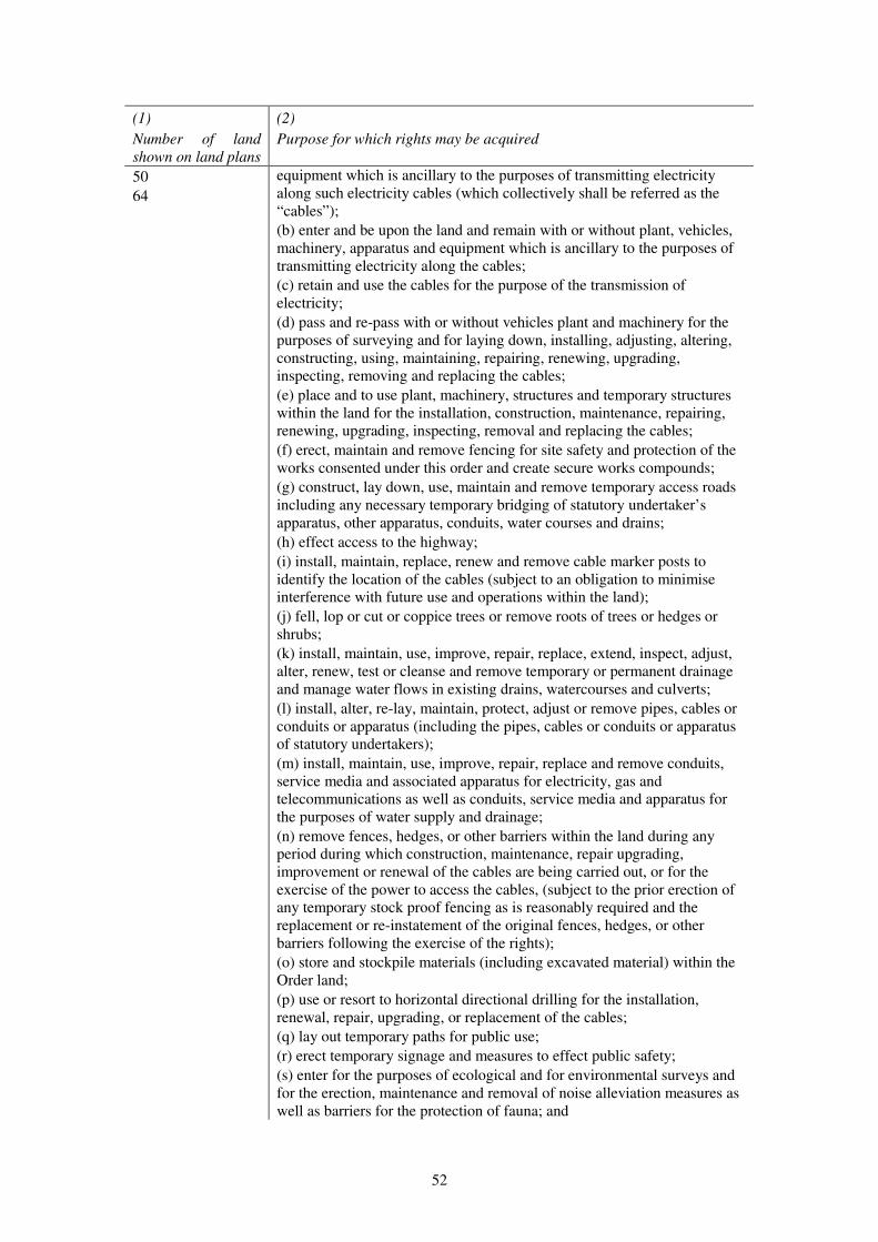
52
(1)
Number of land
shown on land plans
(2)
Purpose for which rights may be acquired
50
64
equipment which is ancillary to the purposes of transmitting electricity
along such electricity cables (which collectively shall be referred as the
“cables”);
(b) enter and be upon the land and remain with or without plant, vehicles,
machinery, apparatus and equipment which is ancillary to the purposes of
transmitting electricity along the cables;
(c) retain and use the cables for the purpose of the transmission of
electricity;
(d) pass and re-pass with or without vehicles plant and machinery for the
purposes of surveying and for laying down, installing, adjusting, altering,
constructing, using, maintaining, repairing, renewing, upgrading,
inspecting, removing and replacing the cables;
(e) place and to use plant, machinery, structures and temporary structures
within the land for the installation, construction, maintenance, repairing,
renewing, upgrading, inspecting, removal and replacing the cables;
(f) erect, maintain and remove fencing for site safety and protection of the
works consented under this order and create secure works compounds;
(g) construct, lay down, use, maintain and remove temporary access roads
including any necessary temporary bridging of statutory undertaker’s
apparatus, other apparatus, conduits, water courses and drains;
(h) effect access to the highway;
(i) install, maintain, replace, renew and remove cable marker posts to
identify the location of the cables (subject to an obligation to minimise
interference with future use and operations within the land);
(j) fell, lop or cut or coppice trees or remove roots of trees or hedges or
shrubs;
(k) install, maintain, use, improve, repair, replace, extend, inspect, adjust,
alter, renew, test or cleanse and remove temporary or permanent drainage
and manage water flows in existing drains, watercourses and culverts;
(l) install, alter, re-lay, maintain, protect, adjust or remove pipes, cables or
conduits or apparatus (including the pipes, cables or conduits or apparatus
of statutory undertakers);
(m) install, maintain, use, improve, repair, replace and remove conduits,
service media and associated apparatus for electricity, gas and
telecommunications as well as conduits, service media and apparatus for
the purposes of water supply and drainage;
(n) remove fences, hedges, or other barriers within the land during any
period during which construction, maintenance, repair upgrading,
improvement or renewal of the cables are being carried out, or for the
exercise of the power to access the cables, (subject to the prior erection of
any temporary stock proof fencing as is reasonably required and the
replacement or re-instatement of the original fences, hedges, or other
barriers following the exercise of the rights);
(o) store and stockpile materials (including excavated material) within the
Order land;
(p) use or resort to horizontal directional drilling for the installation,
renewal, repair, upgrading, or replacement of the cables;
(q) lay out temporary paths for public use;
(r) erect temporary signage and measures to effect public safety;
(s) enter for the purposes of ecological and for environmental surveys and
for the erection, maintenance and removal of noise alleviation measures as
well as barriers for the protection of fauna; and

53
(1)
Number of land
shown on land plans
(2)
Purpose for which rights may be acquired
(t) carry out environmental or ecological mitigation or enhancement works.
2. A restrictive covenant over the land for the benefit of the remainder of
the Order land to:
(a) prevent anything to be done in or upon the Order land or any part
thereof for the purpose of the erection of any buildings or construction
erection or works of any kind (including the foundations or footings
thereto);
(b)prevent anything to be done by way of hard surfacing of the Order land
with concrete of any kind or with any other material or surface whatsoever
without the consent in writing of the undertaker (such consent not to be
unreasonably withheld or delayed if the proposed surfacing would not
cause damage to relevant part of the authorised project nor make it
materially more difficult or expensive to maintain the authorised project);
(c) prevent anything to be done by way of excavation of any kind of the
Order land nor any activities which increase or decrease ground cover or
soil levels in any manner whatsoever without the consent in writing of the
undertaker save as are reasonably required for agricultural activities;
(d) prevent the planting or growing within the Order land any trees, shrubs
or underwood without the consent in writing of the undertaker (such
consent not to be unreasonably withheld or delayed if the proposed trees,
shrubs or underwood would not cause damage to the relevant part of the
authorised project nor make it materially more difficult or expensive to
access the relevant part of the authorised project).
12 1. The right to enter and remain upon the land for the purposes of
construction, installation, operation, maintenance and decommissioning of
the authorised project and to:
(a) lay down, install, adjust, alter, construct, test, use, maintain, repair,
renew, upgrade, inspect, remove and replace underground electricity cables
together with such telemetry and fibre optic lines, ducting, jointing bays,
earthing measures, cathodic protection, cross bonding pits, manhole covers
and other apparatus, protection measures, safety measures and other
equipment which is ancillary to the purposes of transmitting electricity
along such electricity cables (which collectively shall be referred as the
“cables”);
(b) enter and be upon the land and remain with or without plant, vehicles,
machinery, apparatus and equipment which is ancillary to the purposes of
transmitting electricity along the cables;
(c) retain and use the cables for the purpose of the transmission of
electricity;
(d) lay down, install, adjust, alter, construct, use, maintain, repair, renew,
upgrade, inspect, remove and replace underground transition jointing bays
and associated pits for the connection of offshore cables to onshore cables;
(e) pass and re-pass with or without vehicles plant and machinery for the
purposes of surveying and for laying down, installing, adjusting, altering,
constructing, using, maintaining, repairing, renewing, upgrading,
inspecting, removing and replacing the cables;
(f) place and to use plant, machinery, structures and temporary structures
within the land for the installation, construction, maintenance, repairing,
renewing, upgrading, inspecting, removal and replacing the cables;
(g) erect, maintain and remove fencing for site safety and protection of the
works consented under this order and create secure works compounds;
(h) construct, lay down, use, maintain and remove temporary access roads
including any necessary temporary bridging of statutory undertaker’s
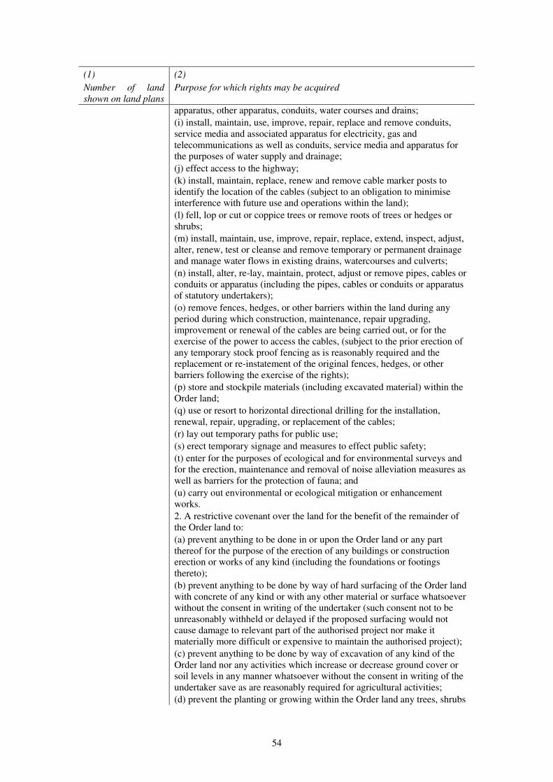
54
(1)
Number of land
shown on land plans
(2)
Purpose for which rights may be acquired
apparatus, other apparatus, conduits, water courses and drains;
(i) install, maintain, use, improve, repair, replace and remove conduits,
service media and associated apparatus for electricity, gas and
telecommunications as well as conduits, service media and apparatus for
the purposes of water supply and drainage;
(j) effect access to the highway;
(k) install, maintain, replace, renew and remove cable marker posts to
identify the location of the cables (subject to an obligation to minimise
interference with future use and operations within the land);
(l) fell, lop or cut or coppice trees or remove roots of trees or hedges or
shrubs;
(m) install, maintain, use, improve, repair, replace, extend, inspect, adjust,
alter, renew, test or cleanse and remove temporary or permanent drainage
and manage water flows in existing drains, watercourses and culverts;
(n) install, alter, re-lay, maintain, protect, adjust or remove pipes, cables or
conduits or apparatus (including the pipes, cables or conduits or apparatus
of statutory undertakers);
(o) remove fences, hedges, or other barriers within the land during any
period during which construction, maintenance, repair upgrading,
improvement or renewal of the cables are being carried out, or for the
exercise of the power to access the cables, (subject to the prior erection of
any temporary stock proof fencing as is reasonably required and the
replacement or re-instatement of the original fences, hedges, or other
barriers following the exercise of the rights);
(p) store and stockpile materials (including excavated material) within the
Order land;
(q) use or resort to horizontal directional drilling for the installation,
renewal, repair, upgrading, or replacement of the cables;
(r) lay out temporary paths for public use;
(s) erect temporary signage and measures to effect public safety;
(t) enter for the purposes of ecological and for environmental surveys and
for the erection, maintenance and removal of noise alleviation measures as
well as barriers for the protection of fauna; and
(u) carry out environmental or ecological mitigation or enhancement
works.
2. A restrictive covenant over the land for the benefit of the remainder of
the Order land to:
(a) prevent anything to be done in or upon the Order land or any part
thereof for the purpose of the erection of any buildings or construction
erection or works of any kind (including the foundations or footings
thereto);
(b) prevent anything to be done by way of hard surfacing of the Order land
with concrete of any kind or with any other material or surface whatsoever
without the consent in writing of the undertaker (such consent not to be
unreasonably withheld or delayed if the proposed surfacing would not
cause damage to relevant part of the authorised project nor make it
materially more difficult or expensive to maintain the authorised project);
(c) prevent anything to be done by way of excavation of any kind of the
Order land nor any activities which increase or decrease ground cover or
soil levels in any manner whatsoever without the consent in writing of the
undertaker save as are reasonably required for agricultural activities;
(d) prevent the planting or growing within the Order land any trees, shrubs

55
(1)
Number of land
shown on land plans
(2)
Purpose for which rights may be acquired
or underwood without the consent in writing of the undertaker (such
consent not to be unreasonably withheld or delayed if the proposed trees,
shrubs or underwood would not cause damage to the relevant part of the
authorised project nor make it materially more difficult or expensive to
access the relevant part of the authorised project).
43
59
1. The right to enter and remain upon the land for the purposes of
construction, installation, operation, maintenance and decommissioning of
the authorised project and to:
(a) lay down, install, adjust, alter, construct, test, use, maintain, repair,
renew, upgrade, inspect, remove and replace underground electricity cables
together with such telemetry and fibre optic lines, ducting, earthing
measures, cathodic protection, manhole covers and other apparatus,
protection measures, safety measures and other equipment which is
ancillary to the purposes of transmitting electricity along such electricity
cables (which collectively shall be referred as the “cables”);
(b) enter and be upon the land and remain with or without plant, vehicles,
machinery, apparatus and equipment which is ancillary to the purposes of
transmitting electricity along the cables;
(c) retain and use the cables for the purpose of the transmission of
electricity;
(d) pass and re-pass with or without vehicles plant and machinery for the
purposes of surveying and for laying down, installing, adjusting, altering,
constructing, using, maintaining, repairing, renewing, upgrading,
inspecting, removing and replacing the cables;
(e) place and to use plant, machinery, structures and temporary structures
within the land for the installation, construction, maintenance, repairing,
renewing, upgrading, inspecting, removal and replacing the cables;
(f) erect, maintain and remove fencing for site safety and protection of the
works consented under this order and create secure works compounds;
(g) construct, lay down, use, maintain and remove temporary access roads
including any necessary temporary bridging of statutory undertaker’s
apparatus, other apparatus, conduits, water courses and drains;
(h) effect access to the highway;
(i) fell, lop or cut or coppice trees or remove roots of trees or hedges or
shrubs;
(j) install, maintain, use, improve, repair, replace, extend, inspect, adjust,
alter, renew, test or cleanse and remove temporary or permanent drainage
and manage water flows in existing drains, watercourses and culverts;
(k) install, alter, re-lay, maintain, protect, adjust or remove pipes, cables or
conduits or apparatus (including the pipes, cables or conduits or apparatus
of statutory undertakers);
(l) install, maintain, use, improve, repair, replace and remove conduits,
service media and associated apparatus for electricity, gas and
telecommunications as well as conduits, service media and apparatus for
the purposes of water supply and drainage;
(m) remove fences, hedges, or other barriers within the land during any
period during which construction, maintenance, repair upgrading,
improvement or renewal of the cables are being carried out, or for the
exercise of the power to access the cables, (subject to the prior erection of
any temporary stock proof fencing as is reasonably required and the
replacement or re-instatement of the original fences, hedges, or other
barriers following the exercise of the rights);
(n) use or resort to horizontal directional drilling for the installation,
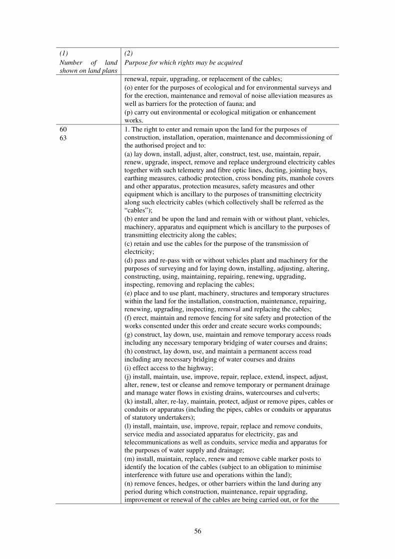
56
(1)
Number of land
shown on land plans
(2)
Purpose for which rights may be acquired
renewal, repair, upgrading, or replacement of the cables;
(o) enter for the purposes of ecological and for environmental surveys and
for the erection, maintenance and removal of noise alleviation measures as
well as barriers for the protection of fauna; and
(p) carry out environmental or ecological mitigation or enhancement
works.
60
63
1. The right to enter and remain upon the land for the purposes of
construction, installation, operation, maintenance and decommissioning of
the authorised project and to:
(a) lay down, install, adjust, alter, construct, test, use, maintain, repair,
renew, upgrade, inspect, remove and replace underground electricity cables
together with such telemetry and fibre optic lines, ducting, jointing bays,
earthing measures, cathodic protection, cross bonding pits, manhole covers
and other apparatus, protection measures, safety measures and other
equipment which is ancillary to the purposes of transmitting electricity
along such electricity cables (which collectively shall be referred as the
“cables”);
(b) enter and be upon the land and remain with or without plant, vehicles,
machinery, apparatus and equipment which is ancillary to the purposes of
transmitting electricity along the cables;
(c) retain and use the cables for the purpose of the transmission of
electricity;
(d) pass and re-pass with or without vehicles plant and machinery for the
purposes of surveying and for laying down, installing, adjusting, altering,
constructing, using, maintaining, repairing, renewing, upgrading,
inspecting, removing and replacing the cables;
(e) place and to use plant, machinery, structures and temporary structures
within the land for the installation, construction, maintenance, repairing,
renewing, upgrading, inspecting, removal and replacing the cables;
(f) erect, maintain and remove fencing for site safety and protection of the
works consented under this order and create secure works compounds;
(g) construct, lay down, use, maintain and remove temporary access roads
including any necessary temporary bridging of water courses and drains;
(h) construct, lay down, use, and maintain a permanent access road
including any necessary bridging of water courses and drains
(i) effect access to the highway;
(j) install, maintain, use, improve, repair, replace, extend, inspect, adjust,
alter, renew, test or cleanse and remove temporary or permanent drainage
and manage water flows in existing drains, watercourses and culverts;
(k) install, alter, re-lay, maintain, protect, adjust or remove pipes, cables or
conduits or apparatus (including the pipes, cables or conduits or apparatus
of statutory undertakers);
(l) install, maintain, use, improve, repair, replace and remove conduits,
service media and associated apparatus for electricity, gas and
telecommunications as well as conduits, service media and apparatus for
the purposes of water supply and drainage;
(m) install, maintain, replace, renew and remove cable marker posts to
identify the location of the cables (subject to an obligation to minimise
interference with future use and operations within the land);
(n) remove fences, hedges, or other barriers within the land during any
period during which construction, maintenance, repair upgrading,
improvement or renewal of the cables are being carried out, or for the
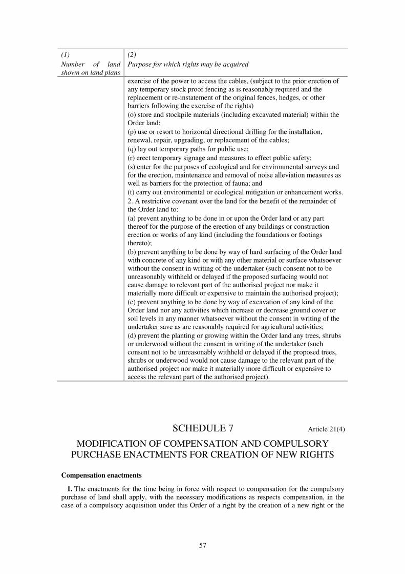
57
(1)
Number of land
shown on land plans
(2)
Purpose for which rights may be acquired
exercise of the power to access the cables, (subject to the prior erection of
any temporary stock proof fencing as is reasonably required and the
replacement or re-instatement of the original fences, hedges, or other
barriers following the exercise of the rights)
(o) store and stockpile materials (including excavated material) within the
Order land;
(p) use or resort to horizontal directional drilling for the installation,
renewal, repair, upgrading, or replacement of the cables;
(q) lay out temporary paths for public use;
(r) erect temporary signage and measures to effect public safety;
(s) enter for the purposes of ecological and for environmental surveys and
for the erection, maintenance and removal of noise alleviation measures as
well as barriers for the protection of fauna; and
(t) carry out environmental or ecological mitigation or enhancement works.
2. A restrictive covenant over the land for the benefit of the remainder of
the Order land to:
(a) prevent anything to be done in or upon the Order land or any part
thereof for the purpose of the erection of any buildings or construction
erection or works of any kind (including the foundations or footings
thereto);
(b) prevent anything to be done by way of hard surfacing of the Order land
with concrete of any kind or with any other material or surface whatsoever
without the consent in writing of the undertaker (such consent not to be
unreasonably withheld or delayed if the proposed surfacing would not
cause damage to relevant part of the authorised project nor make it
materially more difficult or expensive to maintain the authorised project);
(c) prevent anything to be done by way of excavation of any kind of the
Order land nor any activities which increase or decrease ground cover or
soil levels in any manner whatsoever without the consent in writing of the
undertaker save as are reasonably required for agricultural activities;
(d) prevent the planting or growing within the Order land any trees, shrubs
or underwood without the consent in writing of the undertaker (such
consent not to be unreasonably withheld or delayed if the proposed trees,
shrubs or underwood would not cause damage to the relevant part of the
authorised project nor make it materially more difficult or expensive to
access the relevant part of the authorised project).
SCHEDULE 7 Article 21(4)
MODIFICATION OF COMPENSATION AND COMPULSORY
PURCHASE ENACTMENTS FOR CREATION OF NEW RIGHTS
Compensation enactments
1. The enactments for the time being in force with respect to compensation for the compulsory
purchase of land shall apply, with the necessary modifications as respects compensation, in the
case of a compulsory acquisition under this Order of a right by the creation of a new right or the
58
imposition of a restrictive covenant as they apply as respects compensation on the compulsory
purchase of land and interests in land.
2.—(1) Without prejudice to the generality of paragraph 1, the Land Compensation Act 1973(a)
shall have effect subject to the modifications set out in sub-paragraphs (2) and (3).
(2) In section 44(1) (compensation for injurious affection), as it applies to compensation for
injurious affection under section 7 of the 1965 Act as substituted by paragraph 4—
(a) for the words “land is acquired or taken” there shall be substituted the words “a right or
restrictive covenant over land is purchased from or imposed on”; and
(b) for the words “acquired or taken from him” there shall be substituted the words “over
which the right is exercisable or the restrictive covenant enforceable”.
(3) In section 58(1) (determination of material detriment where part of house etc. proposed for
compulsory acquisition), as it applies to determinations under section 8 of the 1965 Act as
substituted by paragraph 5—
(a) for the word “part” in paragraphs (a) and (b) there shall be substituted the words “a right
over or restrictive covenant affecting land consisting”;
(b) for the word “severance” there shall be substituted the words “right or restrictive
covenant over or affecting the whole of the house, building or manufactory or of the
house and the park or garden”;
(c) for the words “part proposed” there shall be substituted the words “right or restrictive
covenant proposed”; and
(d) for the words “part is” there shall be substituted the words “right or restrictive covenant
is”.
Application of the 1965 Act
3.—(1) The 1965 Act shall have effect with the modifications necessary to make it apply to the
compulsory acquisition under this Order of a right by the creation of a new right, or to the
imposition under this Order of a restrictive covenant, as it applies to the compulsory acquisition
under this Order of land, so that, in appropriate contexts, references in that Act to land are read
(according to the requirements of the particular context) as referring to, or as including references
to—
(a) the right acquired or to be acquired; or
(b) the land over which the right is or is to be exercisable.
(2) Without prejudice to the generality of sub-paragraph (1), Part 1 of the 1965 Act shall apply
in relation to the compulsory acquisition under this Order of a right by the creation of a new right
with the modifications specified in the following provisions of this Schedule.
4. For section 7 of the 1965 Act (measure of compensation) there shall be substituted the
following section—
“7. In assessing the compensation to be paid by the acquiring authority under this Act,
regard shall be had not only to the extent (if any) to which the value of the land over which
the right is to be acquired or the restrictive covenant is to be imposed is depreciated by the
acquisition of the right or the imposition of the covenant but also to the damage (if any) to
be sustained by the owner of the land by reason of its severance from other land of the
owner, or injuriously affecting that other land by the exercise of the powers conferred by
this or the special Act.”.
5. For section 8 of the 1965 Act (provisions as to divided land) there shall be substituted the
following section—
(a) 1973 c. 26.
59
“8.—(1) Where in consequence of the service on a person under section 5 of this Act of a
notice to treat in respect of a right over land consisting of a house, building or manufactory
or of a park or garden belonging to a house (“the relevant land”)—
(a) a question of disputed compensation in respect of the purchase of the right or the
imposition of the restrictive covenant would apart from this section fall to be
determined by the Upper Tribunal (“the tribunal”); and
(b) before the tribunal has determined that question the tribunal is satisfied that the
person has an interest in the whole of the relevant land and is able and willing to
sell that land and—
(i) where that land consists of a house, building or manufactory, that the right
cannot be purchased or the restrictive covenant imposed without material
detriment to that land; or
(ii) where that land consists of such a park or garden, that the right cannot be
purchased or the restrictive covenant imposed without seriously affecting the
amenity or convenience of the house to which that land belongs,
the Walney Extension Offshore Wind Farm Order 2014 (“the Order”) shall, in relation to
that person, cease to authorise the purchase of the right and be deemed to authorise the
purchase of that person’s interest in the whole of the relevant land including, where the land
consists of such a park or garden, the house to which it belongs, and the notice shall be
deemed to have been served in respect of that interest on such date as the tribunal directs.
(2) Any question as to the extent of the land in which the Order is deemed to authorise the
purchase of an interest by virtue of subsection (1) of this section shall be determined by the
tribunal.
(3) Where in consequence of a determination of the tribunal that it is satisfied as
mentioned in subsection (1) of this section the Order is deemed by virtue of that subsection
to authorise the purchase of an interest in land, the acquiring authority may, at any time
within the period of 6 weeks beginning with the date of the determination, withdraw the
notice to treat in consequence of which the determination was made; but nothing in this
subsection prejudices any other power of the authority to withdraw the notice.”.
6. The following provisions of the 1965 Act (which state the effect of a deed poll executed in
various circumstances where there is no conveyance by persons with interests in the land), that is
to say—
(a) section 9(4) (failure by owners to convey);
(b) paragraph 10(3) of Schedule 1 (owners under incapacity);
(c) paragraph 2(3) of Schedule 2 (absent and untraced owners); and
(d) paragraphs 2(3) and 7(2) of Schedule 4 (common land);
shall be so modified as to secure that, as against persons with interests in the land which are
expressed to be overridden by the deed, the right which is to be compulsorily acquired or the
restrictive covenant which is to be imposed is vested absolutely in the acquiring authority.
7. Section 11 of the 1965 Act (powers of entry) shall be so modified as to secure that, as from
the date on which the acquiring authority has served notice to treat in respect of any right it has
power, exercisable in equivalent circumstances and subject to equivalent conditions, to enter for
the purpose of exercising that right or enforcing that restrictive covenant (which shall be deemed
for this purpose to have been created on the date of service of the notice); and sections 12 (penalty
for unauthorised entry) and 13 (entry on warrant in the event of obstruction) of the 1965 Act shall
be modified correspondingly.
8. Section 20 of the 1965 Act (protection for interests of tenants at will, etc.) shall apply with the
modifications necessary to secure that persons with such interests in land as are mentioned in that
section are compensated in a manner corresponding to that in which they would be compensated
on a compulsory acquisition under this Order of that land, but taking into account only the extent
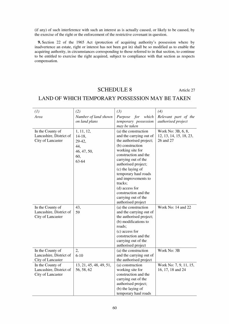
60
(if any) of such interference with such an interest as is actually caused, or likely to be caused, by
the exercise of the right or the enforcement of the restrictive covenant in question.
9. Section 22 of the 1965 Act (protection of acquiring authority’s possession where by
inadvertence an estate, right or interest has not been got in) shall be so modified as to enable the
acquiring authority, in circumstances corresponding to those referred to in that section, to continue
to be entitled to exercise the right acquired, subject to compliance with that section as respects
compensation.
SCHEDULE 8 Article 27
LAND OF WHICH TEMPORARY POSSESSION MAY BE TAKEN
(1)
Area
(2)
Number of land shown
on land plans
(3)
Purpose for which
temporary possession
may be taken
(4)
Relevant part of the
authorised project
In the County of
Lancashire, District of
City of Lancaster
1, 11, 12,
14-18,
29-42,
44,
46, 47, 50,
60,
63-64
(a) the construction
and the carrying out of
the authorised project;
(b) construction
working site for
construction and the
carrying out of the
authorised project;
(c) the laying of
temporary haul roads
and improvements to
tracks;
(d) access for
construction and the
carrying out of the
authorised project
Work No: 3B, 6, 8,
12, 13, 14, 15, 18, 23,
26 and 27
In the County of
Lancashire, District of
City of Lancaster
43,
59
(a) the construction
and the carrying out of
the authorised project;
(b) modifications to
roads;
(c) access for
construction and the
carrying out of the
authorised project
Work No: 14 and 22
In the County of
Lancashire, District of
City of Lancaster
2,
6-10
(a) the construction
and the carrying out of
the authorised project
Work No: 3B
In the County of
Lancashire, District of
City of Lancaster
13, 21, 45, 48, 49, 51,
56, 58, 62
(a) construction
working site for
construction and the
carrying out of the
authorised project;
(b) the laying of
temporary haul roads
Work No: 7, 9, 11, 15,
16, 17, 18 and 24
61
(1)
Area
(2)
Number of land shown
on land plans
(3)
Purpose for which
temporary possession
may be taken
(4)
Relevant part of the
authorised project
and improvements to
tracks;
(c) access for the
carrying out of the
authorised project;
In the County of
Lancashire, District of
City of Lancaster
3, 4, 19, 20,
24,
26-28,
52-54
(a) the laying of
temporary haul roads
and improvements to
tracks;
(b) access for the
carrying out of the
authorised project
Work No: 4, 5, 9, 10,
20 and 21
In the County of
Lancashire, District of
City of Lancaster
5, 22, 23, 25, 55, 57 (a) modifications to
roads;
(b) access for the
carrying out of the
authorised project
Work No: 9, 10, 19
and 21
SCHEDULE 9 Article 37
DEEMED GENERATOR ASSETS MARINE LICENCE UNDER THE
MARINE AND COASTAL ACCESS ACT 2009
PART 1
Licensed Marine Activities
Interpretation
1.—(1) In this licence—
“the 2004 Act” means the Energy Act 2004;
“the 2008 Act” means the Planning Act 2008;
“the 2009 Act” means the Marine and Coastal Access Act 2009;
“ancillary works” means the ancillary works described in paragraph 2(2) of Part 1 of this
licence;
“Annex I Habitat” means any benthic habitat type listed in Annex 1 of the EU Council
Directive 92/43/EEC on the Conservation of Natural Habitats and of Wild Fauna and Flora(a);
“authorised deposits” means the substances and articles specified in paragraph 2(4) of Part 1
of this licence;
“authorised development” means the works described in paragraph 2(2) of Part 1 of this
licence or any part of those works;
(a) OJ No L 206, 22.7.1992, p7, last amended by Council Directive 2013/17/EU (OJ No L 158, 10.6.2013, p193).
62
“cable crossings” means the crossing of existing subsea cables by the inter-array and/or export
cables authorised by the Order together with cable protection;
“cable ducts” means conduits for the installation of cables;
“cable protection” means physical measures for the protection of cables including concrete
mattresses, with or without frond devices, and/or rock placement;
“cables” shall include direct lay cables and/or cables laid in cable ducts and shall include fibre
optic cables either within the cable or laid alongside;
“cable systems” means the three electrical cables and their respective accessories including
cable joints and terminations, with an operating voltage of up to 400kV, necessary to transmit
the power between two electrical nodes within the authorised development, and for the
offshore element of the cable corridor, comprising subsea export cables, the three cables shall
be bundled together as one cable system, and for the onshore element of the cable corridor, the
cable system shall comprise three separate onshore cables, each containing a single conductor,
and the cable system may also include one or more auxiliary cables (normally fibre optic
cables) for the purpose of control, monitoring, protection or general communications;
“Cefas” means the Centre for Environment, Fisheries and Aquaculture Science;
“commence” means the first carrying out of any part of the licensed activities, save for pre-
construction surveys and/or monitoring and the words “commencement” and “commenced”
shall be construed accordingly;
“debris” means any material left on the seabed as a result of the licensed works;
“Disposal Site” means the designated disposal site identified as IS215 Walney bounded by the
Order limits described in paragraph 2(3) of Part 1 of this licence, which are shown on the
Order limits and grid coordinates plan;
“enforcement officer” means a person authorised to carry out enforcement duties under
Chapter 3 of the 2009 Act;
“the environmental statement” means the document certified as the environmental statement
by the Secretary of State for the purposes of the Order and submitted with the application on
28th June 2013 together with any supplementary or further environmental information
submitted to the Examining authority as part of the examination of the application for the
Order;
“frond devices” means flow energy dissipation devices, which reduce current velocity and
turbulence and encourage settlement of sediment;
“Greenwich Mean Time” or “GMT” means the time measured from the Greenwich Meridian
Line at the Royal Observatory in Greenwich;
“Hydrographic Office” means the United Kingdom Hydrographic Office of Admiralty Way,
Taunton, Somerset, TA1 2DN;
“inter-array cable” means the network of offshore subsea cables connecting the WTGs in
Work No. 1 with the offshore substations in Work No. 2(a);
“jacket structure” means a lattice type structure constructed of steel, which may include scour
protection and additional equipment such as, J-tubes, corrosion protection systems and access
platforms;
“JNCC” means the Joint Nature Conservation Committee;
“the Kingfisher Fortnightly Bulletin” means the bulletin produced by Kingfisher Information
Services at the Sea Fish Industry Authority or such other alternative publication approved by
the MMO;
“LAT” means lowest astronomical tide;
“the licence conditions” means the conditions set out in Part 2 of this licence;
“licensed activities” means the activities below MHWS specified in Part 1 of this licence;
“maintain” includes inspect, repair, adjust, alter, remove, reconstruct and replace any of the
authorised development, and any derivative of “maintain” shall be construed accordingly;

63
“major storm event” means a greater than 1 in 10 year wave event within the Order limits
seaward of MHWS, measured by reference to the height of waves recorded at the nearest
wave buoy to the authorised development as agreed with the MMO, and the WaveNet data
published by Cefas, or such other means of measurement as may be agreed with the MMO;
“the Marine Management Organisation” or “MMO” means the body created under the 2009
Act which is responsible for the monitoring and enforcement of this licence;
“the Maritime and Coastguard Agency” or “MCA” means the executive agency of the
Department for Transport;
“mean high water springs” or “MHWS” means the highest level which spring tides reach on
average over a period of time;
“mean low water” or “MLW” means the average height of all low water above Chart Datum;
“monopile foundation” means a steel cylindrical pile, driven, vibrated and/or drilled into the
seabed and may include scour protection and additional equipment such as, J-tubes, corrosion
protection systems and access platforms;
“Natural England” means the body established by section 1 of the Natural Environment and
Rural Communities Act 2006;
“notice to mariners” includes any notice to mariners which may be issued by the undertaker,
Admiralty, Trinity House, Queen’s harbourmasters, government departments and harbour and
pilotage authorities;
“offshore substation platform” means a platform with one or more decks, whether open or
fully clad, accommodating medium to high voltage electrical power transformers, medium
and/or high voltage switch gear, fire fighting facilities, workshop facilities, helicopter landing
facilities, potable water storage, black water separation equipment, instrumentation, metering
equipment, control systems, standby electrical generation equipment, auxiliary and
uninterruptible power supply systems, emergency accommodation including mess facilities,
control hub, drainage facilities, access equipment, marking and lighting and other associated
equipment and facilities;
“the Order” means the Walney Extension Offshore Wind Farm Order 2014;
“the Order limits” means the limits shown on the Order limits and grid coordinates plan within
which the authorised project may be carried out, whose grid coordinates seaward of MHWS
are set out in paragraph 2(3) of Part 1 of this licence;
“the Order limits and grid coordinates plan” means the plan certified as the Order limits and
grid coordinates plan by the Secretary of State for the purposes of the Order;
“relevant planning authority” means Lancaster City Council;
“Renewable Energy Zone” means the areas of the sea designated under the Renewable Energy
Zone (Designation of Area) Order 2004;
“Schedule of Offshore Maintenance Activities” means the document certified as the Schedule
of Offshore Maintenance Activities by the Secretary of State for the purposes of the Order;
“scour protection” means measures to prevent loss of seabed sediment around any structure
placed in or on the seabed by use of protective aprons, mattresses with or without frond
devices, or rock and gravel placement;
“suction caisson” means a steel cylindrical structure attached to the leg(s) of a jacket structure
which partially or fully penetrates the seabed and remains in place using its own weight and
hydrostatic pressure differential, and may include scour protection and additional equipment
such as J-Tubes;
“transition piece” means the metal structure attached to the top of the foundation where the
base of the wind turbine generator is connected and may include additional equipment such as
J-Tubes, corrosion protection systems, boat access systems, access platform(s), craneage, and
associated equipment;
“Trinity House” means the Corporation of Trinity House of Deptford Strond;
64
“undertaker” means in respect of any provision of this licence, DONG Energy Walney
Extension (UK) Limited;
“vessel” means every description of vessel, however propelled or moved, and includes a non-
displacement craft, a personal watercraft, a seaplane on the surface of the water, a hydrofoil
vessel, a hovercraft or any other amphibious vehicle and any other thing constructed or
adapted for movement through, in, on or over water and which is at the time in, on or over
water;
“VHF” means very high frequency;
“wind turbine generator” or “wind turbine” or “WTG” means a structure comprising a tower,
rotor system with three blades, nacelle and ancillary electrical and other equipment which may
include lighting, J-tubes, access and rest platforms, access ladders, access lift, boat access
systems, corrosion protection systems, fenders and maintenance equipment, heli-hoist
platform and other associated equipment, fixed to a foundation or transition piece;
“Work No. 2(a)” means up to three offshore substation platforms fixed to the seabed within
the Order limits seaward of MHWS by one of two foundation types, namely monopole
foundation or jacket structure (in conjunction with suction caissons or steel piles); and
“the works plan” means the plans certified as the works plans by the Secretary of State for the
purposes of the Order.
(2) References in this licence to any statute, order, regulation or similar instrument shall be
construed as a reference to the statute, order, regulation or instrument as amended by any
subsequent statute, order, regulation or instrument or as contained in any subsequent re-enactment.
(3) Unless otherwise indicated—
(a) all times shall be taken to be Greenwich Mean Time; and
(b) all co-ordinates shall be taken to be latitude and longitude degrees, minutes and seconds.
(4) Except where otherwise notified in writing by the relevant organisation, the primary point of
contact with the organisations listed below and the address for returns and correspondence shall
be—
(a) Marine Management Organisation
Marine Licensing Team
Lancaster House
Hampshire Court
Newcastle upon Tyne
NE4 7YH
Tel: 0300 123 1032
Email: [email protected];
(b) Marine Management Organisation – Whitehaven office
Fish Hall
North Harbour
North Shore
Whitehaven
Cumbria
CA28 7XY
Tel: 01946 591 287
Email: [email protected];
(c) Trinity House
Tower Hill
London

65
EC3N 4DH
Tel: 020 7481 6900;
(d) The United Kingdom Hydrographic Office
Admiralty Way
Taunton
Somerset
TA1 2DN
Tel: 01823 337 900;
(e) Maritime and Coastguard Agency
Navigation Safety Branch
Bay 2/04
Spring Place
105 Commercial Road
Southampton
SO15 1EG
Tel: 023 8032 9191;
(f) Centre for Environment, Fisheries and Aquaculture Science
Pakefield Road
Lowestoft
Suffolk
NR33 0HT
Tel: 01502 562 244;
(g) JNCC
Inverdee House
Baxter Street
Aberdeen
AB11 9QA;
(h) Natural England
Foundry House
3 Millsands
Riverside Exchange
Sheffield
S3 8NH
Tel: 0845 600 3078;
(i) Natural England – North West Regional Office
Juniper House
Murley Moss
Oxenholme Road
Kendal
Cumbria
LA9 7RL
Tel: 0300 060 2122.
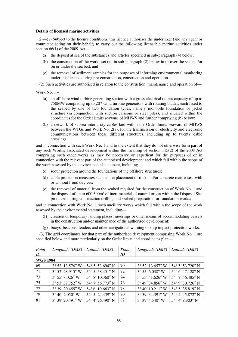
66
Details of licensed marine activities
2.—(1) Subject to the licence conditions, this licence authorises the undertaker (and any agent or
contractor acting on their behalf) to carry out the following licensable marine activities under
section 66(1) of the 2009 Act—
(a) the deposit at sea of the substances and articles specified in sub-paragraph (4) below;
(b) the construction of the works set out in sub-paragraph (2) below in or over the sea and/or
on or under the sea bed; and
(c) the removal of sediment samples for the purposes of informing environmental monitoring
under this licence during pre-construction, construction and operation.
(2) Such activities are authorised in relation to the construction, maintenance and operation of—
Work No. 1 –
(a) an offshore wind turbine generating station with a gross electrical output capacity of up to
750MW comprising up to 207 wind turbine generators with rotating blades, each fixed to
the seabed by one of two foundation types, namely monopile foundation or jacket
structure (in conjunction with suction caissons or steel piles), and situated within the
coordinates for the Order limits seaward of MHWS and further comprising (b) below;
(b) a network of subsea inter-array cables laid within the Order limits seaward of MHWS
between the WTGs and Work No. 2(a), for the transmission of electricity and electronic
communications between these different structures, including up to twenty cable
crossings;
and in connection with such Work No. 1 and to the extent that they do not otherwise form part of
any such Works, associated development within the meaning of section 115(2) of the 2008 Act
comprising such other works as may be necessary or expedient for the purposes of or in
connection with the relevant part of the authorised development and which fall within the scope of
the work assessed by the environmental statement, including—
(c) scour protection around the foundations of the offshore structures;
(d) cable protection measures such as the placement of rock and/or concrete mattresses, with
or without frond devices;
(e) the removal of material from the seabed required for the construction of Work No. 1 and
the disposal of up to 600,300m³ of inert material of natural origin within the Disposal Site
produced during construction drilling and seabed preparation for foundation works;
and in connection with Work No. 1 such ancillary works which fall within the scope of the work
assessed by the environmental statement, including—
(f) creation of temporary landing places, moorings or other means of accommodating vessels
in the construction and/or maintenance of the authorised development;
(g) buoys, beacons, fenders and other navigational warning or ship impact protection works.
(3) The grid coordinates for that part of the authorised development comprising Work No. 1 are
specified below and more particularly on the Order limits and coordinates plan—
Point
ID
Longitude (DMS) Latitude (DMS) Point
ID
Longitude (DMS) Latitude (DMS)
WGS 1984
69 3° 52′ 13.576″ W 54° 5′ 53.694″ N 70 3° 52′ 13.657″ W 54° 5′ 53.720″ N
71 3° 52′ 28.915″ W 54° 5′ 58.451″ N 72 3° 55′ 6.038″ W 54° 6′ 47.128″ N
73 3° 55′ 8.026″ W 54° 8′ 10.360″ N 74 3° 53′ 41.626″ W 54° 7′ 56.485″ N
75 3° 53′ 37.752″ W 54° 7′ 56.773″ N 76 3° 49′ 34.856″ W 54° 9′ 30.726″ N
77 3° 39′ 20.455″ W 54° 6′ 19.663″ N 78 3° 40′ 10.211″ W 54° 5′ 35.819″ N
79 3° 40′ 2.050″ W 54° 5′ 24.439″ N 80 3° 39′ 34.391″ W 54° 4′ 45.872″ N
81 3° 39′ 20.491″ W 54° 4′ 26.490″ N 82 3° 39′ 4.540″ W 54° 4′ 8.303″ N
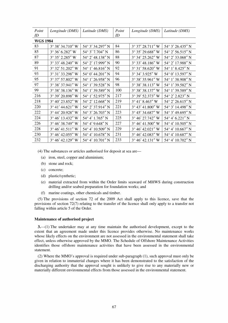
67
Point
ID
Longitude (DMS) Latitude (DMS) Point
ID
Longitude (DMS) Latitude (DMS)
WGS 1984
83 3° 38′ 34.710″ W 54° 3′ 34.297″ N 84 3° 37′ 28.711″ W 54° 3′ 26.435″ N
85 3° 36′ 6.282″ W 54° 3′ 7.704″ N 86 3° 35′ 29.688″ W 54° 2′ 56.515″ N
87 3° 35′ 2.285″ W 54° 2′ 48.138″ N 88 3° 34′ 25.262″ W 54° 2′ 33.068″ N
89 3° 33′ 48.240″ W 54° 2′ 17.999″ N 90 3° 33′ 48.186″ W 54° 2′ 17.988″ N
91 3° 32′ 51.202″ W 54° 1′ 46.816″ N 92 3° 31′ 58.620″ W 54° 1′ 8.425″ N
93 3° 31′ 33.298″ W 54° 0′ 44.201″ N 94 3° 34′ 3.925″ W 54° 0′ 13.597″ N
95 3° 37′ 57.802″ W 54° 1′ 26.958″ N 96 3° 38′ 35.961″ W 54° 1′ 38.908″ N
97 3° 38′ 37.941″ W 54° 1′ 39.528″ N 98 3° 38′ 38.113″ W 54° 1′ 39.582″ N
99 3° 38′ 38.136″ W 54° 1′ 39.589″ N 100 3° 38′ 38.137″ W 54° 1′ 39.589″ N
216 3° 39′ 20.898″ W 54° 1′ 52.975″ N 217 3° 39′ 52.373″ W 54° 2′ 2.823″ N
218 3° 40′ 23.852″ W 54° 2′ 12.668″ N 219 3° 41′ 8.463″ W 54° 2′ 26.615″ N
220 3° 41′ 44.621″ W 54° 2′ 37.914″ N 221 3° 43′ 41.800″ W 54° 3′ 14.498″ N
222 3° 44′ 20.928″ W 54° 3′ 26.703″ N 223 3° 45′ 34.687″ W 54° 3′ 49.695″ N
224 3° 46′ 13.432″ W 54° 4′ 1.765″ N 225 3° 46′ 27.742″ W 54° 4′ 6.221″ N
226 3° 46′ 38.749″ W 54° 4′ 9.648″ N 227 3° 46′ 41.500″ W 54° 4′ 10.505″ N
228 3° 46′ 41.511″ W 54° 4′ 10.509″ N 229 3° 46′ 42.021″ W 54° 4′ 10.667″ N
230 3° 46′ 42.055″ W 54° 4′ 10.678″ N 231 3° 46′ 42.083″ W 54° 4′ 10.687″ N
232 3° 46′ 42.129″ W 54° 4′ 10.701″ N 233 3° 46′ 42.131″ W 54° 4′ 10.702″ N
(4) The substances or articles authorised for deposit at sea are—
(a) iron, steel, copper and aluminium;
(b) stone and rock;
(c) concrete;
(d) plastic/synthetic;
(e) material extracted from within the Order limits seaward of MHWS during construction
drilling and/or seabed preparation for foundation works; and
(f) marine coatings, other chemicals and timber.
(5) The provisions of section 72 of the 2009 Act shall apply to this licence, save that the
provisions of section 72(7) relating to the transfer of the licence shall only apply to a transfer not
falling within article 5 of the Order.
Maintenance of authorised project
3.—(1) The undertaker may at any time maintain the authorised development, except to the
extent that an agreement made under this licence provides otherwise. No maintenance works
whose likely effects on the environment are not assessed in the environmental statement shall take
effect, unless otherwise approved by the MMO. The Schedule of Offshore Maintenance Activities
identifies those offshore maintenance activities that have been assessed in the environmental
statement.
(2) Where the MMO’s approval is required under sub-paragraph (1), such approval must only be
given in relation to immaterial changes where it has been demonstrated to the satisfaction of the
discharging authority that the approval sought is unlikely to give rise to any materially new or
materially different environmental effects from those assessed in the environmental statement.
68
Duration
4. This licence shall remain in force until the authorised development has been decommissioned
in accordance with a programme approved by the Secretary of State under section 106 of the 2004
Act, including any modification to the programme under section 108, and the completion of such
programme has been confirmed by the Secretary of State in writing.
PART 2
Licence Conditions
Design parameters for wind turbines
1.—(1) Subject to sub-paragraph (2), no wind turbine generator forming part of the authorised
development shall—
(a) exceed a height of 222 metres when measured from MHWS to the highest point of the
rotating blade of the WTG;
(b) exceed a height of 122 metres to the height of the centreline of the generator shaft
forming part of the WTG nacelle when measured from MHWS;
(c) exceed a rotor diameter of 200 metres, or have a rotor diameter of less than 120 metres;
(d) be less than 737 metres from the nearest WTG in either direction perpendicular to the
approximate prevailing wind direction (crosswind) or be less than 737 metres from the
nearest WTG in either direction which is in line with the approximate prevailing wind
direction (downwind); and
(e) have a distance of less than 22 metres between the lowest point of the rotating blade of
the WTG and MHWS.
(2) References to the location of a wind turbine generator are references to the centre point of
that turbine.
Design Parameters for WTG foundations
2.—(1) The total number of monopole foundations forming part of the authorised development
shall not exceed 207 and no monopile foundation for use with any WTG or offshore substation
forming part of the authorised development shall have a diameter greater than 9 metres.
(2) No jacket structure for use with any WTG forming part of the authorised development shall
have—
(a) a width spacing between each leg at the level of the seabed of more than 40 metres and at
the level of LAT which is greater than 20 metres;
(b) more than four legs;
(c) a leg diameter of more than 3 metres;
(d) more than one pile per leg;
(e) a pile diameter of more than 3 metres;
(f) more than one suction caisson per leg; and
(g) a suction caisson diameter of greater than 10 metres.
Design parameters for inter-array cables
3. The total length of the cables comprising Work No. 1(b) shall not exceed 270 kilometres.

69
Design parameters for other deposits
4.—(1) The total volume of scour protection for use with WTGs within Work No. 1(a) shall not
exceed 2,277,000m³.
(2) The total volume of cable protection (excluding cable crossings) included within Work No.
1(b) shall not exceed 27,000m³ with a maximum footprint of 35,000m².
(3) The total volume of cable protection associated with cable crossings included within Work
No. 1(b) shall not exceed 64,328m³. The total footprint of this cable protection shall not exceed
74,480m².
Notifications and inspections
5.—(1) The undertaker must ensure that—
(a) a copy of this licence and any subsequent amendments or revisions to it are provided to—
(i) all agents and contractors notified to the MMO in accordance with condition 6 of this
licence; and
(ii) the masters and transport managers responsible for the vessels notified to the MMO
in accordance with condition 6 of this licence;
(b) within 28 days of receipt of a copy of this licence those persons referred to at sub-
paragraph (i) above must provide a completed confirmation form to the MMO confirming
their understanding of the terms and conditions of this licence.
(2) Only those persons and vessels notified to the MMO in accordance with condition 6 are
permitted to carry out the licensed activities.
(3) Copies of this licence must also be available for inspection by an enforcement officer at all
reasonable times at the following locations—
(a) the undertaker’s registered address;
(b) any site office located at or adjacent to the construction site and used by the undertaker or
its agents and contractors responsible for the loading, transportation or deposit of the
authorised deposits and works; and
(c) on board each vessel or at the office of any transport manager with responsibility for
vessels from which authorised deposits are to be made or authorised works undertaken.
(4) The undertaker must provide access, and if necessary appropriate transportation, to the
offshore construction site or the ancillary works or vessels to facilitate any inspection that the
MMO or Trinity House considers necessary to meet any mandatory health and safety requirements
or inspect the works during construction and operation of the authorised development.
(5) The undertaker must inform the MMO marine licensing team and the coastal MMO office
specified in paragraph 1(4)(a) above, and the Hydrographic Office, the MCA, and Trinity House,
in writing at least five working days prior to the commencement of the licensed activities or any
part of them.
(6) The undertaker must publish in the Kingfisher Fortnightly Bulletin details of the vessel
routes, timings and locations relating to the construction of the authorised development, or
relevant part, at least five working days prior to the commencement of the licensed activities or
any part of them.
(7) The undertaker must ensure that a notice to mariners is issued at least ten days prior to the
commencement of Work No. 1 advising of the start date of those licensed activities and the
expected vessel routes from the local service ports to the turbine locations.
(8) The undertaker must ensure that the notices to mariners are agreed with the MMO and the
MCA in accordance with the construction programme approved under licence condition 11(1)(a).
Such notices must be—
(a) updated and reissued at regular intervals; and
(b) supplemented with VHF radio broadcasts.
70
Copies of all notices must be provided to the MMO.
Reporting of engaged agents, contractors and vessels
6.—(1) The undertaker must provide the following information to the MMO—
(a) the name and function of any agent or contractor appointed to engage in the licensed
activities, at least five working days prior to the commencement of the licensed activities
or any part of them; and
(b) each week during the construction of the authorised development a completed
Hydrographic Note H102 listing the vessels to be used in relation to the licensed
activities.
(2) Any changes to the supplied details must be notified to the MMO in writing at least five
working days prior to the agent, contractor or vessel engaging in the licensed activities.
Equipment and operation of vessels engaged in licensed activities
7.—(1) All vessels employed to perform the licensed activities must be constructed and
equipped to be capable of the proper performance of such activities in accordance with the
conditions of this licence and must comply with sub-paragraphs (2) to (5) below.
(2) All motor powered vessels must be fitted with the following equipment—
(a) electronic positioning aid to provide navigational data;
(b) radar;
(c) echo sounder;
(d) multi-channel VHF, and
no vessel shall engage in the licensed activities until all such equipment is fully operational.
(3) All vessels’ names or identification must be clearly marked on the hull or superstructure of
the vessel.
(4) All vessels must exhibit signals in accordance with the requirements of the International
Regulations for the Prevention of Collisions at Sea.
(5) All communication on VHF working frequencies must be in English.
Chemicals, drilling and debris
8.—(1) All chemicals used in the construction of the authorised development must be selected
from the List of Notified Chemicals approved for use by the offshore oil and gas industry under
the Offshore Chemicals Regulations 2002(a), unless otherwise agreed by the MMO.
(2) All protective coatings and paints must be suitable for use in the marine environment.
Details of such coatings and paints and how they will be used must be submitted to the MMO as
part of the construction method statement required under condition 11(1)(c).
(3) The storage, handling, transport and use of fuels, lubricants, chemicals and other substances
must be undertaken so as to prevent releases into the marine environment including bunding of
110 per cent of the total volume of all reservoirs and containers.
(4) Where foundation drilling works are proposed, in the event that any system other than water
based mud is proposed, the MMO’s written approval in relation to the proposed disposal of any
arisings must be obtained before the drilling commences.
(5) The undertaker must ensure that only inert material of natural origin, produced during
construction drilling and seabed preparation for foundation works shall be disposed of within the
Disposal Site.
(a) S.I. 2002/1355, as amended by S.I. 2011/982. There are amendments to that instrument not relevant to this Order.
71
(6) The undertaker must inform the MMO of the location and quantities of inert material
disposed of each month under this licence, by submission of a disposal return by 31st January each
year for disposals occurring during the months July to December inclusive of the preceding year,
and by 31st July each year for disposals occurring during the months January to June inclusive of
that year.
(7) The undertaker must notify the MMO within 48 hours of the completion of the final disposal
of inert material at the Disposal Site.
(8) The undertaker must ensure that any debris arising from the construction of the authorised
development or temporary works placed below MHWS are removed on completion of the
construction of the authorised development, unless otherwise agreed with the MMO.
(9) At least two months prior to the commencement of the licensed activities the undertaker
must submit to the MMO a transportation audit sheet covering the construction of the authorised
development. No works shall commence until the audit sheet content has been agreed with the
MMO. The audit sheet must include details of—
(a) loading facilities;
(b) vessels;
(c) equipment;
(d) shipment routes;
(e) working schedules; and
(f) all components and materials to be used in the construction of the authorised
development.
(10) The audit sheet must be maintained throughout the construction of the authorised
development and any changes notified immediately in writing to the MMO. The audit sheet will
be made available for inspection by the MMO within 12 hours of the undertaker’s receipt of a
request made by the MMO.
(11) In the event that the MMO becomes aware that any of the materials on the audit sheet
cannot be accounted for it shall require the undertaker in writing to carry out a side scan sonar
survey to plot all obstructions across the relevant areas within the Order limits seaward of MHWS
where construction works and related activities have been carried out. Local fishermen must be
invited to send a representative to be present during the survey. Any new obstructions that the
MMO reasonably concludes are associated with the authorised development must be removed, as
directed by the MMO in writing, at the undertaker’s expense.
Force majeure
9. If, due to stress of weather or any other cause the master of a vessel determines that it is
necessary to deposit the authorised substances and/or articles within or outside of the Order limits
seaward of MHWS because the safety of human life and/or of the vessel is threatened full details
of the circumstances of the deposit must be notified to the MMO within 48 hours, and the
undertaker must—
(a) as soon as reasonably practicable following such notification, submit a method statement
and programme for the removal of the deposit; and
(b) undertake the removal of the deposit in accordance with the approved method statement
and programme, unless otherwise agreed with the MMO.
Seasonal restrictions in respect of fish spawning
10.—(1) The undertaker must ensure that no percussive piling activity takes place during the
cod spawning period from 15th February to 31st March (inclusive) of any year.
(2) The undertaker must ensure that no percussive piling activity takes place during the herring
spawning period from 15th September to 15th November (inclusive) for any year, within such
areas as agreed with the MMO prior to the commencement of construction. The undertaker must
72
provide to the MMO the results of noise modelling prepared to an agreed methodology to inform
the selection of such areas.
Pre-construction plans and documentation
11.—(1) The licensed activities shall not commence until the following have been submitted to
and approved by the MMO and, in relation to paragraphs (a) to (g), (j) and (k), following
consultation with Natural England. Each programme, statement, plan, protocol, scheme or other
detail required to be approved under this condition must be submitted to the MMO for approval at
least four months prior to the commencement of works, except where otherwise stated or unless
otherwise agreed by the MMO—
(a) a construction and monitoring programme to include details of—
(i) the proposed construction start date;
(ii) timings for mobilisation of plant, delivery of materials and installation works;
(iii) proposed pre-construction surveys/monitoring, baseline reporting format and
content, construction surveys/monitoring, post-construction surveys/monitoring and
related reporting in accordance with licence conditions 12 to 14;
(iv) a design plan at a scale of between 1:25,000 and 1:50,000, including detailed
representation on the most suitable scaled Admiralty Chart, as agreed with the
MMO, in consultation with Trinity House, the MCA and Natural England, which
shows any archaeological exclusion zones identified under paragraph (h), and any
exclusion zones and/or micrositing requirements identified in any mitigation scheme
pursuant to paragraph (j); and
(v) proposed timings for the disposal of material produced during construction drilling
and seabed preparation for foundation works;
(b) a plan to be agreed with the MMO in consultation with Trinity House and the MCA
setting out proposed details of the authorised development, specifying the—
(i) number, specification(s) and dimensions of each WTG;
(ii) number, dimensions and foundation type(s) and depth for each WTG;
(iii) the grid coordinates of the centre point of the proposed location for each WTG;
(iv) proposed layout of all cables; and
(v) the proposed location(s) for the disposal of material produced during construction
drilling and seabed preparation for foundation works;
(c) a construction method statement in accordance with the construction methods assessed in
the environmental statement and including details of—
(i) foundation installation, including any seabed preparation, drilling and disposal of
arisings methods;
(ii) turbine installation, including any seabed preparation and scour protection;
(iii) cable installation, including cable protection;
(iv) protective coatings and paints as required under condition 8(2);
(v) contractors;
(vi) vessels and vessel transit corridors;
(vii) ancillary works; and
(viii) drilling methods and disposal of material produced during construction drilling and
seabed preparation for foundation works;
(d) a project environmental management and monitoring plan to include details of—
(i) a marine pollution contingency plan to address the risks, methods and procedures to
deal with any spills and collision incidents during construction and operation of the
authorised development in relation to all activities carried out below MHWS;

73
(ii) a chemical risk assessment to include information regarding how and when
chemicals are to be used, stored and transported in accordance with recognised best
practice guidance;
(iii) a method statement for the taking of sediment samples;
(iv) waste management and disposal arrangements including a protocol covering
potential finds of objects associated with the legacy of disposal at sea of material
from the nuclear industry; and
(v) the appointment and responsibilities of a fisheries liaison officer and an
environmental liaison officer;
(e) a scour protection management plan providing details of the need, type, sources, quantity
and installation methods for scour protection;
(f) a marine mammal mitigation protocol, including a requirement for a soft start procedure,
when driven or part-driven pile foundations are used;
(g) cable specification and installation plan in accordance with the methodology assessed in
the environmental statement, to include—
(i) technical specification of cable systems, including a desk-based assessment of
attenuation of electro-magnetic field strengths, shielding and cable burial depth in
accordance with industry good practice; and
(ii) a detailed cable laying plan for the Order limits seaward of MHWS, incorporating
geotechnical data and a cable burial risk assessment to inform cable burial depths
and cable laying techniques, including contingency measures, in the event cable
burial is not achieved by the methods proposed in that plan;
(h) a written scheme of archaeological investigation in relation to the Order limits in
accordance with industry good practice and developed in consultation with English
Heritage to include—
(i) details of responsibilities of the undertaker, archaeological consultant and contractor;
(ii) a methodology for any further site investigation including any specifications for
geophysical, geotechnical and diver or remotely operated vehicle investigations;
(iii) a programme for the analysis and reporting of survey data, and timing, which is to be
submitted to the MMO within four months of the survey being completed, unless
otherwise agreed with the MMO;
(iv) details of any mitigation including, where necessary, archaeological exclusion zones;
(v) details of monitoring during and post construction, including a conservation
programme for finds and publication of reports, developed in consultation with
English Heritage, associated with the consented development;
(vi) details of methods for archiving of archaeological material; and
(vii) a reporting and recording protocol, including reporting of any wreck or wreck
material during construction, operation and decommissioning of the authorised
development;
(i) a written scheme, developed in consultation with the Ministry of Defence, detailing any
potential survey and/or construction vessel transit through, or temporary presence within,
the Eskmeals firing range (Danger Areas D406 and D406B) associated with the
construction of the authorised development and a communications protocol between the
undertaker and the Ministry of Defence’s range controllers relating thereto;
(j) a mitigation scheme for any Annex I Habitat identified by the survey referred to in
condition 12(2)(a);
(k) an offshore operations and maintenance plan that must be submitted to the MMO at least
four months prior to commencement of the operation of the licensed activities and include
provision for the review and resubmission of that plan every three years during the
operational phase. The offshore operations and maintenance plan must include details
of—
74
(i) information on the presence of Annex I Habitat as identified in condition 12(2)(a);
(ii) information on, including likely schedule of, corrective and preventative
maintenance activities proposed during the operation of the licensed activities, as
identified in the environmental statement and Schedule of Offshore Maintenance
Activities;
(iii) a summary of the environmental impact of the activities listed under sub-paragraph
(ii), as identified in the environmental statement and Schedule of Offshore
Maintenance Activities, and having regard to sub-paragraph (i); and
(iv) the anticipated maintenance activities that exceed the frequency and/or scope of
licensable activities identified in the environmental statement and Schedule of
Offshore Maintenance Activities, and the proposed approach to the licensing of these
activities,
and each programme, statement, plan, protocol, scheme or other detail required to be
approved under this condition must be submitted to the MMO for approval at least four
months prior to the commencement of works, except where otherwise stated or unless
otherwise agreed by the MMO.
(2) The undertaker must ensure that a copy of any agreed archaeological report is deposited with
the National Monuments Record, in accordance with the Online AccesS to the Index of
archaeological investigationS (OASIS) system.
(3) The licensed activities must be carried out in accordance with any programme, statement,
plan, protocol, scheme or other details approved under this licence condition, unless otherwise
agreed by the MMO.
Pre-construction surveying and monitoring
12.—(1) The undertaker must, in discharging condition 11(1)(a) submit details for approval by
the MMO in consultation with Natural England of proposed pre-construction surveys, including
methodologies and timings, and a proposed format and content for a pre-construction baseline
report at least 4 months prior to surveys commencing.
(2) The pre-construction surveys referred to in sub-paragraph (1) must unless otherwise agreed
with the MMO have due regard to the need to undertake—
(a) surveys to determine the location, extent and composition of any benthic habitats of
conservation, ecological and/or economic importance (including Annex I Habitat) inside
the area(s) within the Order limits seaward of MHWS in which it is proposed to carry out
construction works;
(b) a high resolution swath-bathymetry survey and side-scan sonar survey of the areas within
the Order limits seaward of MHWS in which it is proposed to carry out construction
works, including a 500 metre buffer area around the site of each work inclusive of seabed
anomalies or sites of historic or archaeological interest that lie within that 500 metre
buffer; and
(c) debris surveys, including a side scan sonar survey, across the area(s) within the Order
limits seaward of MHWS in which it is proposed to carry out construction works.
(3) The undertaker must carry out the surveys agreed under sub-paragraph (1) and provide the
baseline report to the MMO in the agreed format in accordance with the agreed timetable, unless
otherwise agreed by the MMO.
(4) The undertaker must not commence construction until the baseline report has been agreed by
the MMO.
Construction monitoring
13.—(1) The undertaker must, in discharging condition 11(1)(a), submit details for approval by
the MMO in consultation with Natural England of any proposed surveys or monitoring, including
75
methodologies and timings, to be carried out during the construction of the authorised
development.
(2) A scheme for noise monitoring must be submitted for approval by the MMO prior to the
commencement of any piling activity, which scheme must include details for measurements of
noise generated at a minimum of four piling locations.
(3) The undertaker must carry out the surveys approved under sub-paragraph (1), including any
further noise monitoring required in writing by the MMO, and provide the agreed reports in the
agreed format in accordance with the agreed timetable, unless otherwise agreed with the MMO.
(4) The results of the initial noise measurements provided in accordance with sub-paragraph (3)
must be provided to the MMO within six weeks of the installation of the first monitored pile
approved pursuant to sub-paragraph (1), unless otherwise agreed with the MMO.
(5) Unless otherwise agreed with the undertaker, within 6 weeks of the submission of results of
the initial noise measurements provided in accordance with sub-paragraph (3) the MMO must,
having regard to those results, determine whether or not any further noise monitoring is required
and confirm this to the undertaker.
Post construction monitoring
14.—(1) The undertaker must, in discharging condition 11(1)(a), submit details for approval by
the MMO in consultation with Natural England of proposed post-construction surveys, including
methodologies and timings, and proposed format, content and timings for providing reports on the
results. Subject to receipt of specific proposals, it is expected that acceptable post-construction
surveys will comprise, in outline—
(a) surveys of any benthic communities/benthos constituting Annex I Habitat inside the
area(s) within the Order limits seaward of MHWS in which construction works were
carried out; and
(b) high resolution swath-bathymetric surveys of such representative areas within the Order
limits seaward of MHWS as may be agreed with the MMO in which construction works
were carried out to assess any changes to bed form morphology and such further
monitoring as may be agreed to ensure that the cables have been buried.
(2) Following the completion of the authorised development, the undertaker must carry out the
surveys referred to in sub-paragraph (1) for three years, which may be non-consecutive years, and
provide reports in the agreed format in accordance with the agreed timetable, unless otherwise
agreed with the MMO following consultation with Natural England.
(3) If a major storm event occurs at any time between the completion of the authorised
development and the completion of the third year of surveys required under sub-paragraph (2), the
undertaker must carry out a side scan sonar and bathymetry survey within the Order limits
seaward of MHWS in which the construction works were carried out, in accordance with such
timetable as may be agreed with the MMO following consultation with Natural England.
Offshore Decommissioning
15. No part of the authorised development seaward of MHWS shall commence until a written
decommissioning programme in compliance with any notice served upon the undertaker by the
Secretary of State pursuant to section 105(2) of the 2004 Act has been submitted to the Secretary
of State for approval. The undertaker must consult the MMO, Natural England and the relevant
planning authority on the proposed decommissioning activity no less than four months prior to
submission of the proposed decommissioning programme to the Secretary of State.
Offshore Safety Management
16.—(1) No authorised development seaward of MHWS shall commence until the MMO, in
consultation with the MCA, has given written approval of a plan for an active safety management
system which includes an emergency response and co-operation plan (ERCoP) for the
construction, operation and decommissioning phases of the authorised development in accordance
76
with the MCA’s recommendations in MGN 371 “Offshore Renewable Energy Installations
(OREIs) – Guidance on UK Navigational Practice, Safety and Emergency Response Issues”.
(2) No authorised development seaward of MHWS shall commence until the MMO, in
consultation with the MCA, has confirmed in writing that the undertaker has taken into account
and adequately addressed all MCA recommendations as appropriate to the authorised development
contained within the document MGN 371 “Offshore Renewable Energy Installations (OREIs) –
Guidance on UK Navigational Practice, Safety and Emergency Response Issues” and its annexes.
(3) The active safety management system and ERCoP must be implemented as approved unless
otherwise agreed by the MMO in consultation with the MCA.
Aids to navigation
17.—(1) The undertaker must at or near the authorised development during the whole period of
the construction, operation, alteration, replacement or decommissioning of the authorised
development seaward of MHWS exhibit such lights, marks, sounds, signals and other aids to
navigation, and to take such other steps for the prevention of danger to navigation, as Trinity
House may from time to time direct.
(2) The undertaker must provide information to the Hydrographic Office on the position and
nature of works to facilitate the issuing of notices and warnings to mariners.
(3) The undertaker must keep the Hydrographic Office, the MCA, Trinity House and the MMO
informed of progress with the authorised development and will provide—
(a) notice of commencement within 24 hours of commencement having occurred;
(b) as soon as reasonably practicable notification of the provision of any aids to navigation
required by the licence conditions;
(c) reports on the working condition of aids to navigation as requested by Trinity House;
(d) notice to Trinity House and the MMO of any failure of aids to navigation, and the plans
for remedying such failures, as soon as practicable and within 24 hours of such failure
being identified;
(e) notification of completion within 2 weeks of completion of the authorised development.
(4) The undertaker must paint yellow (colour code RAL 1023) all structures to be constructed as
part of the authorised development seaward of MHWS from at least HAT to a height directed by
Trinity House. Unless the MMO otherwise directs, the undertaker must paint the remainder of the
structures submarine grey (colour code RAL 7035).
(5) The undertaker must exhibit such lights, with such shape, colour and character as are
required by Air Navigation Order 2009, or as directed by the CAA, and must notify the CAA and
the MMO of any failure of those lights and the timescales in which such failure will be remedied,
as soon as possible and no later than 24 hours following the undertaker becoming aware of any
such failure.
Provision against danger to navigation
18. In case of damage to, or destruction or decay of, the authorised development seaward of
MHWS or any part thereof the undertaker must as soon as reasonably practicable notify Trinity
House and must lay down such buoys, exhibit such lights and take such other steps for preventing
danger to navigation as Trinity House may from time to time direct.
Requirement for written approval
19. With respect to any condition of this licence which requires the licensed activities to be
carried out in accordance with any details approved by the MMO, notification of such approval
must be given in writing.

77
Amendments to approved details
20.—(1) With respect to any condition which requires the licensed activities to be carried out in
accordance with the details approved by the MMO, the approved details shall be carried out as
approved unless an amendment or variation is agreed in advance by the MMO pursuant to the
relevant condition, in accordance with sub-paragraph (2), and in consultation with any body
specified in the relevant condition.
(2) Where any condition specifies “unless otherwise agreed” by the MMO such agreement shall
not be given except in relation to immaterial changes where it has been demonstrated to the
satisfaction of the MMO that the agreement sought is unlikely to give rise to any materially new or
materially different environmental effects from those assessed in the environmental statement.
(3) The approved details shall be taken to include any amendments that may subsequently be
approved by the MMO.
SCHEDULE 10 Article 37
DEEMED TRANSMISSION ASSETS MARINE LICENCE UNDER
THE MARINE AND COASTAL ACCESS ACT 2009
PART 1
Licensed Marine Activities
Interpretation
1.—(1) In this licence—
“the 2004 Act” means the Energy Act 2004;
“the 2008 Act” means the Planning Act 2008;
“the 2009 Act” means the Marine and Coastal Access Act 2009;
“ancillary works” means the ancillary works authorised by paragraph 2(2) of Part 1 of this
licence;
“Annex I Habitat” means any benthic habitat type listed in Annex 1 of the EU Council
Directive 92/43/EEC on the Conservation of Natural Habitats and of Wild Fauna and Flora;
“authorised deposits” means the substances and articles specified in paragraph 2(4) of Part 1
of this licence;
“authorised development” means the works described in paragraph 2(2) of Part 1 of this
licence or any part of those works;
“CAA” means the Civil Aviation Authority constituted by the Civil Aviation Act 1982;
“cable crossings” means the crossing of existing subsea cables by the inter-array and/or export
cables authorised by the Order together with cable protection;
“cable ducts” means conduits for the installation of cables;
“cable protection” means physical measures for the protection of cables including concrete
mattresses, with or without frond devices, and/or rock placement;
“cables” shall include direct lay cables and/or cables laid in cable ducts and shall include fibre
optic cables either within the cable or laid alongside;
“cable systems” means the three electrical cables and their respective accessories including
cable joints and terminations, with an operating voltage of up to 400kV, necessary to transmit

78
the power between two electrical nodes within the authorised development, and for the
offshore element of the cable corridor, comprising subsea export cables, the three cables shall
be bundled together as one cable system, and for the onshore element of the cable corridor, the
cable system shall comprise three separate onshore cables, each containing a single conductor,
and the cable system may also include one or more auxiliary cables (normally fibre optic
cables) for the purpose of control, monitoring, protection or general communications;
“Cefas” means the Centre for Environment, Fisheries and Aquaculture Science;
“commence” means the first carrying out of any part of the licensed activities, save for pre-
construction surveys and/or monitoring and the words “commencement” and “commenced”
shall be construed accordingly;
“debris” means any material left on the seabed as a result of the licensed works;
“Disposal Site” means the designated disposal site identified as IS215 Walney bounded by the
Order limits within Point IDs 69 to 100 (inclusively) and Point IDs 216 to 233 (inclusively)
described in the table that follows paragraph 2(4) of Part 1 of this licence, which are shown on
the Order limits and grid coordinates plan;
“enforcement officer” means a person authorised to carry out enforcement duties under
Chapter 3 of the 2009 Act;
“the environmental statement” means the document certified as the environmental statement
by the Secretary of State for the purposes of the Order and submitted with the application on
28th June 2013 together with any supplementary or further environmental information
submitted to the Examining authority as part of the examination of the application for the
Order;
“frond devices” means flow energy dissipation devices, which reduce current velocity and
turbulence and encourage settlement of sediment;
“Greenwich Mean Time” or means the time measured from the Greenwich Meridian Line at
the Royal Observatory in Greenwich;
“High Tide” means the state of the tide when it reaches its highest level during a tidal cycle, as
may be published from time to time on the United Kingdom Hydrograph Office Admiralty
EasyTide Website, or such other publication as may be approved by the MMO;
“Hydrographic Office” means the United Kingdom Hydrographic Office of Admiralty Way,
Taunton, Somerset, TA1 2DN;
“inter-array cable” means the network of offshore subsea cables connecting the WTGs in
Work No. 1 with the offshore substations in Work No. 2(a);
“Inter-tidal Area” means the area of land between MLW and MHWS at Middleton Sands,
Heysham;
“jacket structure” means a lattice type structure constructed of steel, which may include scour
protection and additional equipment such as, J-tubes, corrosion protection systems and access
platform(s);
“JNCC” means the Joint Nature Conservation Committee;
“the Kingfisher Fortnightly Bulletin” means the bulletin produced by Kingfisher Information
Services at the Sea Fish Industry Authority or such other alternative publication approved by
the MMO;
“LAT” means lowest astronomical tide;
“the licence conditions” means the conditions set out in Part 2 of this licence;
“licensed activities” means the activities below MHWS specified in Part 1 of this licence;
“maintain” includes inspect, repair, adjust, alter, remove, reconstruct and replace any of the
authorised development and any derivative of “maintain” shall be construed accordingly;
“major storm event” means a greater than 1 in 10 year wave event within the Order limits
seaward of MHWS, measured by reference to the height of waves recorded at the nearest
wave buoy to the authorised development as agreed with the MMO, and the WaveNet data
published by Cefas, or such other means of measurement as may be agreed with the MMO;

79
“the Marine Management Organisation” or “MMO” means the body created under the 2009
Act which is responsible for the monitoring and enforcement of this licence;
“the Maritime and Coastguard Agency” or “MCA” means the executive agency of the
Department for Transport;
“mean high water springs” or “MHWS” means the highest level which spring tides reach on
average over a period of time;
“mean low water” or “MLW” means the average height of all low water above Chart Datum;
“monopile foundation” means a steel cylindrical pile, driven, vibrated and/or drilled into the
seabed and may include scour protection and additional equipment such as, J-tubes, corrosion
protection systems and access platforms;
“Natural England” means the body established by section 1 of the Natural Environment and
Rural Communities Act 2006;
“notice to mariners” includes any notice to mariners which may be issued by the undertaker,
Admiralty, Trinity House, Queen’s harbourmasters, government departments and harbour and
pilotage authorities;
“offshore substation platform” means a platform with one or more decks, whether open or
fully clad, accommodating medium to high voltage electrical power transformers, medium
and/or high voltage switch gear, fire fighting facilities, workshop facilities, helicopter landing
facilities, potable water storage, black water separation equipment, instrumentation, metering
equipment, control systems, standby electrical generation equipment, auxiliary and
uninterruptible power supply systems, emergency accommodation including mess facilities,
control hub, drainage facilities, access equipment, marking and lighting and other associated
equipment and facilities;
“the Order” means the Walney Extension Offshore Wind Farm Order 2014;
“the Order limits” means the limits shown on the Order limits and grid coordinates plan within
which the authorised project may be carried out, whose grid coordinates seaward of MHWS
are set out in paragraph 2 of Part 1 of Schedule 1 (authorised project) of the Order;
“the Order limits and grid coordinates plan” means the plan certified as the Order limits and
grid coordinates plan by the Secretary of State for the purposes of the Order;
“relevant planning authority” means Lancaster City Council or any successor to its statutory
functions;
“Renewable Energy Zone” means the areas of the sea designated under the Renewable Energy
Zone (Designation of Area) Order 2004;
“Schedule of Offshore Maintenance Activities” means the document certified as the Schedule
of Offshore Maintenance Activities by the Secretary of State for the purposes of the Order;
“scour protection” means measures to prevent loss of seabed sediment around any structure
placed in or on the seabed by use of protective aprons, mattresses with or without frond
devices, or rock and gravel placement;
“suction caisson” means a steel cylindrical structure attached to the leg(s) of a jacket structure
which partially or fully penetrates the seabed and remains in place using its own weight and
hydrostatic pressure differential, and may include scour protection and additional equipment
such as J-Tubes;
“transition piece” means the metal structure attached to the top of the foundation where the
base of the wind turbine generator is connected and may include additional equipment such as
J-Tubes, corrosion protection systems, boat access systems, access platform(s), craneage, and
associated equipment;
“Trinity House” means the Corporation of Trinity House of Deptford Strond or any successor
to its statutory functions;
“undertaker” means in respect of any provision of this licence, DONG Energy Walney
Extension (UK) Limited;

80
“vessel” means every description of vessel, however propelled or moved, and includes a non-
displacement craft, a personal watercraft, a seaplane on the surface of the water, a hydrofoil
vessel, a hovercraft or any other amphibious vehicle and any other thing constructed or
adapted for movement through, in, on or over water and which is at the time in, on or over
water;
“VHF” means very high frequency;
“wind turbine generator” or “wind turbine” or “WTG” means a structure comprising a tower,
rotor system with three blades, nacelle and ancillary electrical and other equipment which may
include lighting, J-tube(s), access and rest platforms, access ladders, access lift, boat access
systems, corrosion protection systems, fenders and maintenance equipment, heli-hoist
platform and other associated equipment, fixed to a foundation or transition piece;
“Work No.” means that part of the authorised development with the corresponding number
specified in paragraph 2(2) of Part 1 of this licence;
“Work No. 1”—
(a) an offshore wind turbine generating station with a gross electrical output capacity of up to
750MW comprising up to 207 wind turbine generators with rotating blades, each fixed to
the seabed by one of two foundation types, namely monopile foundation or jacket
structure (in conjunction with suction caissons or steel piles), and situated within the
coordinates for the Order limits seaward of MHWS and further comprising
(b) a network of subsea inter-array cables laid within the Order limits seaward of MHWS
between the WTGs and Work No. 2(a), for the transmission of electricity and electronic
communications between these different structures, including up to twenty cable
crossings; and
“the works plan” means the plans certified as the works plans by the Secretary of State for the
purposes of the Order.
(2) References in this licence to any statute, order, regulation or similar instrument shall be
construed as a reference to the statute, order, regulation or instrument as amended by any
subsequent statute, order, regulation or instrument or as contained in any subsequent re-enactment.
(3) Unless otherwise indicated—
(a) all times shall be taken to be Greenwich Mean Time; and
(b) all co-ordinates shall be taken to be latitude and longitude degrees, minutes and seconds.
(4) Except where otherwise notified in writing by the relevant organisation, the primary point of
contact with the organisations listed below and the address for returns and correspondence shall
be—
(a) Marine Management Organisation
Marine Licensing Team
Lancaster House
Hampshire Court
Newcastle upon Tyne
NE4 7YH
Tel: 0300 123 1032
Email: [email protected];
(b) Marine Management Organisation – Whitehaven office
Fish Hall
North Harbour
North Shore
Whitehaven
Cumbria

81
CA28 7XY
Tel: 01946 591 287
Email: [email protected];
(c) Trinity House
Tower Hill
London
EC3N 4DH
Tel: 020 7481 6900;
(d) The United Kingdom Hydrographic Office
Admiralty Way
Taunton
Somerset
TA1 2DN
Tel: 01823 337 900;
(e) Maritime and Coastguard Agency
Navigation Safety Branch
Bay 2/04
Spring Place
105 Commercial Road
Southampton
SO15 1EG
Tel: 023 8032 9191;
(f) Centre for Environment, Fisheries and Aquaculture Science
Pakefield Road
Lowestoft
Suffolk
NR33 0HT
Tel: 01502 562 244;
(g) JNCC
Inverdee House
Baxter Street
Aberdeen
AB11 9QA;
(h) Natural England
Foundry House
3 Millsands
Riverside Exchange
Sheffield
S3 8NH
Tel: 0845 600 3078;
(i) Natural England – North West Regional Office
Juniper House
Murley Moss

82
Oxenholme Road
Kendal
Cumbria
LA9 7RL
Tel: 0300 060 2122.
Details of licensed marine activities
2.—(1) Subject to the licence conditions, this licence authorises the undertaker (and any agent or
contractor acting on their behalf) to carry out the following licensable marine activities under
section 66(1) of the 2009 Act—
(a) the deposit at sea of the substances and articles specified in sub-paragraph (5) below;
(b) the construction of the works set out in sub-paragraph (2) below in or over the sea and/or
on or under the sea bed; and
(c) the removal of sediment samples for the purposes of informing environmental monitoring
under this licence during pre-construction, construction and operation.
(2) Such activities are authorised in relation to the construction, maintenance and operation of—
Work No. 2 –
(a) up to three offshore substation platforms fixed to the seabed within the Order limits
seaward of MHWS by one of two foundation types, namely monopole foundation or
jacket structure (in conjunction with suction caissons or steel piles), and further
comprising (b) below;
(b) offshore connection works consisting of up to five export cable systems between Work
No. 2(a) and Work No. 3A for the transmission of electricity and electronic
communications each consisting of a single subsea cable and one cable duct laid along
routes within the Order limits seaward of MHWS;
Work No. 3A – offshore connection works consisting of up to five export cable systems between
Work No. 2 and Work No. 3B for the transmission of electricity and electronic communications
each consisting of a single subsea cable and one cable duct laid along routes within the Order
limits seaward of MHWS, including up to seventy cable crossings;
Work No. 3B – onshore connection works consisting of up to five export cable systems for the
transmission of electricity and electronic communications each consisting of a single subsea cable
and one cable duct laid underground, together with a new temporary access track and a new
temporary horizontal directional drilling compound to the west of the saltmarsh, in the Inter-tidal
Area;
and in connection with such Work Nos. 2 and 3A and 3B and to the extent that they do not
otherwise form part of any such Works, associated development within the meaning of section
115(2) of the 2008 Act comprising such other works as may be necessary or expedient for the
purposes of or in connection with the relevant part of the authorised development and which fall
within the scope of the work assessed by the environmental statement, including—
(a) scour protection around the foundations of the offshore structures;
(b) cable protection measures such as the placement of rock and/or concrete mattresses, with
or without frond devices;
(c) the removal of material from the seabed required for the construction of Work Nos. 2 and
3A and 3B and the disposal of up to 150,000m³ of inert material of natural origin within
the Disposal Site produced during construction drilling and seabed preparation for
foundation works
and in connection with Work Nos. 2 and 3A and 3B such ancillary works which fall within the
scope of the work assessed by the environmental statement, including—
(d) creation of temporary landing places, moorings or other means of accommodating vessels
in the construction and/or maintenance of the authorised development;
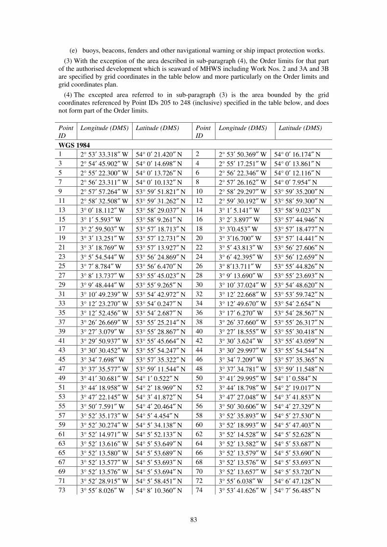
83
(e) buoys, beacons, fenders and other navigational warning or ship impact protection works.
(3) With the exception of the area described in sub-paragraph (4), the Order limits for that part
of the authorised development which is seaward of MHWS including Work Nos. 2 and 3A and 3B
are specified by grid coordinates in the table below and more particularly on the Order limits and
grid coordinates plan.
(4) The excepted area referred to in sub-paragraph (3) is the area bounded by the grid
coordinates referenced by Point IDs 205 to 248 (inclusive) specified in the table below, and does
not form part of the Order limits.
Point
ID
Longitude (DMS) Latitude (DMS) Point
ID
Longitude (DMS) Latitude (DMS)
WGS 1984
1 2° 53′ 33.318″ W 54° 0′ 21.420″ N 2 2° 53′ 50.369″ W 54° 0′ 16.174″ N
3 2° 54′ 45.902″ W 54° 0′ 14.698″ N 4 2° 55′ 17.251″ W 54° 0′ 13.861″ N
5 2° 55′ 22.300″ W 54° 0′ 13.726″ N 6 2° 56′ 22.346″ W 54° 0′ 12.116″ N
7 2° 56′ 23.311″ W 54° 0′ 10.132″ N 8 2° 57′ 26.162″ W 54° 0′ 7.954″ N
9 2° 57′ 57.264″ W 53° 59′ 51.821″ N 10 2° 58′ 29.297″ W 53° 59′ 35.200″ N
11 2° 58′ 32.508″ W 53° 59′ 31.262″ N 12 2° 59′ 30.192″ W 53° 58′ 59.300″ N
13 3° 0′ 18.112″ W 53° 58′ 29.037″ N 14 3° 1′ 5.141″ W 53° 58′ 9.023″ N
15 3° 1′ 5.593″ W 53° 58′ 9.261″ N 16 3° 2′ 3.897″ W 53° 57′ 44.946″ N
17 3° 2′ 59.503″ W 53° 57′ 18.713″ N 18 3° 3′0.453″ W 53° 57′ 18.477″ N
19 3° 3′ 13.251″ W 53° 57′ 12.731″ N 20 3° 3′16.700″ W 53° 57′ 14.441″ N
21 3° 3′ 18.769″ W 53° 57′ 13.927″ N 22 3° 5′ 43.813″ W 53° 56′ 27.606″ N
23 3° 5′ 54.544″ W 53° 56′ 24.869″ N 24 3° 6′ 42.395″ W 53° 56′ 12.659″ N
25 3° 7′ 8.784″ W 53° 56′ 6.470″ N 26 3° 8′13.711″ W 53° 55′ 44.826″ N
27 3° 8′ 13.737″ W 53° 55′ 45.023″ N 28 3° 9′ 13.690″ W 53° 55′ 23.693″ N
29 3° 9′ 48.444″ W 53° 55′ 9.265″ N 30 3° 10′ 37.024″ W 53° 54′ 48.620″ N
31 3° 10′ 49.239″ W 53° 54′ 42.972″ N 32 3° 12′ 22.668″ W 53° 53′ 59.742″ N
33 3° 12′ 23.270″ W 53° 54′ 0.247″ N 34 3° 12′ 49.670″ W 53° 54′ 2.654″ N
35 3° 12′ 52.456″ W 53° 54′ 2.687″ N 36 3° 17′ 6.270″ W 53° 54′ 28.567″ N
37 3° 26′ 26.669″ W 53° 55′ 25.214″ N 38 3° 26′ 37.660″ W 53° 55′ 26.317″ N
39 3° 27′ 3.079″ W 53° 55′ 28.867″ N 40 3° 27′ 18.555″ W 53° 55′ 30.418″ N
41 3° 29′ 50.937″ W 53° 55′ 45.664″ N 42 3° 30′ 3.624″ W 53° 55′ 43.059″ N
43 3° 30′ 30.452″ W 53° 55′ 54.247″ N 44 3° 30′ 29.997″ W 53° 55′ 54.544″ N
45 3° 34′ 7.698″ W 53° 57′ 35.322″ N 46 3° 34′ 7.209″ W 53° 57′ 35.365″ N
47 3° 37′ 35.577″ W 53° 59′ 11.544″ N 48 3° 37′ 34.781″ W 53° 59′ 11.548″ N
49 3° 41′ 30.681″ W 54° 1′ 0.522″ N 50 3° 41′ 29.995″ W 54° 1′ 0.584″ N
51 3° 44′ 18.958″ W 54° 2′ 18.969″ N 52 3° 44′ 18.798″ W 54° 2′ 19.017″ N
53 3° 47′ 22.145″ W 54° 3′ 41.872″ N 54 3° 47′ 27.048″ W 54° 3′ 41.853″ N
55 3° 50′ 7.591″ W 54° 4′ 20.464″ N 56 3° 50′ 30.606″ W 54° 4′ 27.329″ N
57 3° 52′ 35.173″ W 54° 5′ 4.454″ N 58 3° 52′ 35.893″ W 54° 5′ 27.530″ N
59 3° 52′ 30.274″ W 54° 5′ 34.138″ N 60 3° 52′ 18.993″ W 54° 5′ 47.403″ N
61 3° 52′ 14.971″ W 54° 5′ 52.133″ N 62 3° 52′ 14.528″ W 54° 5′ 52.628″ N
63 3° 52′ 13.616″ W 54° 5′ 53.649″ N 64 3° 52′ 13.582″ W 54° 5′ 53.687″ N
65 3° 52′ 13.580″ W 54° 5′ 53.689″ N 66 3° 52′ 13.579″ W 54° 5′ 53.690″ N
67 3° 52′ 13.577″ W 54° 5′ 53.693″ N 68 3° 52′ 13.576″ W 54° 5′ 53.693″ N
69 3° 52′ 13.576″ W 54° 5′ 53.694″ N 70 3° 52′ 13.657″ W 54° 5′ 53.720″ N
71 3° 52′ 28.915″ W 54° 5′ 58.451″ N 72 3° 55′ 6.038″ W 54° 6′ 47.128″ N
73 3° 55′ 8.026″ W 54° 8′ 10.360″ N 74 3° 53′ 41.626″ W 54° 7′ 56.485″ N
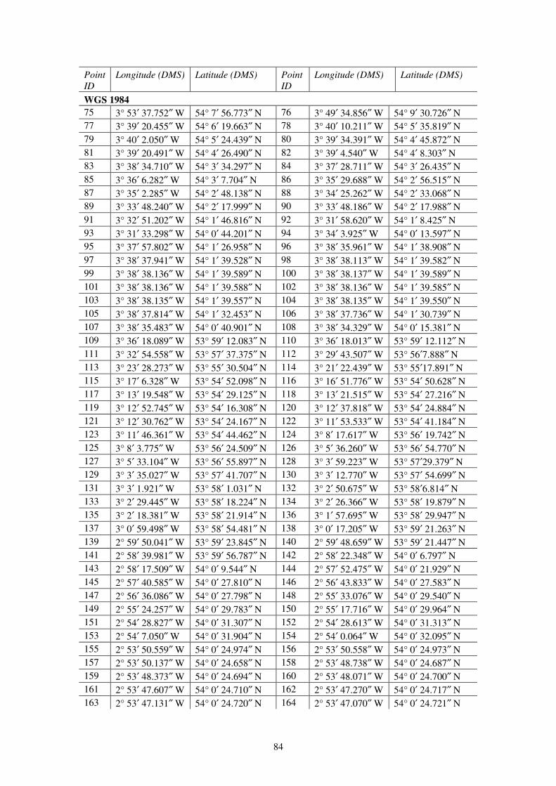
84
Point
ID
Longitude (DMS) Latitude (DMS) Point
ID
Longitude (DMS) Latitude (DMS)
WGS 1984
75 3° 53′ 37.752″ W 54° 7′ 56.773″ N 76 3° 49′ 34.856″ W 54° 9′ 30.726″ N
77 3° 39′ 20.455″ W 54° 6′ 19.663″ N 78 3° 40′ 10.211″ W 54° 5′ 35.819″ N
79 3° 40′ 2.050″ W 54° 5′ 24.439″ N 80 3° 39′ 34.391″ W 54° 4′ 45.872″ N
81 3° 39′ 20.491″ W 54° 4′ 26.490″ N 82 3° 39′ 4.540″ W 54° 4′ 8.303″ N
83 3° 38′ 34.710″ W 54° 3′ 34.297″ N 84 3° 37′ 28.711″ W 54° 3′ 26.435″ N
85 3° 36′ 6.282″ W 54° 3′ 7.704″ N 86 3° 35′ 29.688″ W 54° 2′ 56.515″ N
87 3° 35′ 2.285″ W 54° 2′ 48.138″ N 88 3° 34′ 25.262″ W 54° 2′ 33.068″ N
89 3° 33′ 48.240″ W 54° 2′ 17.999″ N 90 3° 33′ 48.186″ W 54° 2′ 17.988″ N
91 3° 32′ 51.202″ W 54° 1′ 46.816″ N 92 3° 31′ 58.620″ W 54° 1′ 8.425″ N
93 3° 31′ 33.298″ W 54° 0′ 44.201″ N 94 3° 34′ 3.925″ W 54° 0′ 13.597″ N
95 3° 37′ 57.802″ W 54° 1′ 26.958″ N 96 3° 38′ 35.961″ W 54° 1′ 38.908″ N
97 3° 38′ 37.941″ W 54° 1′ 39.528″ N 98 3° 38′ 38.113″ W 54° 1′ 39.582″ N
99 3° 38′ 38.136″ W 54° 1′ 39.589″ N 100 3° 38′ 38.137″ W 54° 1′ 39.589″ N
101 3° 38′ 38.136″ W 54° 1′ 39.588″ N 102 3° 38′ 38.136″ W 54° 1′ 39.585″ N
103 3° 38′ 38.135″ W 54° 1′ 39.557″ N 104 3° 38′ 38.135″ W 54° 1′ 39.550″ N
105 3° 38′ 37.814″ W 54° 1′ 32.453″ N 106 3° 38′ 37.736″ W 54° 1′ 30.739″ N
107 3° 38′ 35.483″ W 54° 0′ 40.901″ N 108 3° 38′ 34.329″ W 54° 0′ 15.381″ N
109 3° 36′ 18.089″ W 53° 59′ 12.083″ N 110 3° 36′ 18.013″ W 53° 59′ 12.112″ N
111 3° 32′ 54.558″ W 53° 57′ 37.375″ N 112 3° 29′ 43.507″ W 53° 56′7.888″ N
113 3° 23′ 28.273″ W 53° 55′ 30.504″ N 114 3° 21′ 22.439″ W 53° 55′17.891″ N
115 3° 17′ 6.328″ W 53° 54′ 52.098″ N 116 3° 16′ 51.776″ W 53° 54′ 50.628″ N
117 3° 13′ 19.548″ W 53° 54′ 29.125″ N 118 3° 13′ 21.515″ W 53° 54′ 27.216″ N
119 3° 12′ 52.745″ W 53° 54′ 16.308″ N 120 3° 12′ 37.818″ W 53° 54′ 24.884″ N
121 3° 12′ 30.762″ W 53° 54′ 24.167″ N 122 3° 11′ 53.533″ W 53° 54′ 41.184″ N
123 3° 11′ 46.361″ W 53° 54′ 44.462″ N 124 3° 8′ 17.617″ W 53° 56′ 19.742″ N
125 3° 8′ 3.775″ W 53° 56′ 24.509″ N 126 3° 5′ 36.260″ W 53° 56′ 54.770″ N
127 3° 5′ 33.104″ W 53° 56′ 55.897″ N 128 3° 3′ 59.223″ W 53° 57′29.379″ N
129 3° 3′ 35.027″ W 53° 57′ 41.707″ N 130 3° 3′ 12.770″ W 53° 57′ 54.699″ N
131 3° 3′ 1.921″ W 53° 58′ 1.031″ N 132 3° 2′ 50.675″ W 53° 58′6.814″ N
133 3° 2′ 29.445″ W 53° 58′ 18.224″ N 134 3° 2′ 26.366″ W 53° 58′ 19.879″ N
135 3° 2′ 18.381″ W 53° 58′ 21.914″ N 136 3° 1′ 57.695″ W 53° 58′ 29.947″ N
137 3° 0′ 59.498″ W 53° 58′ 54.481″ N 138 3° 0′ 17.205″ W 53° 59′ 21.263″ N
139 2° 59′ 50.041″ W 53° 59′ 23.845″ N 140 2° 59′ 48.659″ W 53° 59′ 21.447″ N
141 2° 58′ 39.981″ W 53° 59′ 56.787″ N 142 2° 58′ 22.348″ W 54° 0′ 6.797″ N
143 2° 58′ 17.509″ W 54° 0′ 9.544″ N 144 2° 57′ 52.475″ W 54° 0′ 21.929″ N
145 2° 57′ 40.585″ W 54° 0′ 27.810″ N 146 2° 56′ 43.833″ W 54° 0′ 27.583″ N
147 2° 56′ 36.086″ W 54° 0′ 27.798″ N 148 2° 55′ 33.076″ W 54° 0′ 29.540″ N
149 2° 55′ 24.257″ W 54° 0′ 29.783″ N 150 2° 55′ 17.716″ W 54° 0′ 29.964″ N
151 2° 54′ 28.827″ W 54° 0′ 31.307″ N 152 2° 54′ 28.613″ W 54° 0′ 31.313″ N
153 2° 54′ 7.050″ W 54° 0′ 31.904″ N 154 2° 54′ 0.064″ W 54° 0′ 32.095″ N
155 2° 53′ 50.559″ W 54° 0′ 24.974″ N 156 2° 53′ 50.558″ W 54° 0′ 24.973″ N
157 2° 53′ 50.137″ W 54° 0′ 24.658″ N 158 2° 53′ 48.738″ W 54° 0′ 24.687″ N
159 2° 53′ 48.373″ W 54° 0′ 24.694″ N 160 2° 53′ 48.071″ W 54° 0′ 24.700″ N
161 2° 53′ 47.607″ W 54° 0′ 24.710″ N 162 2° 53′ 47.270″ W 54° 0′ 24.717″ N
163 2° 53′ 47.131″ W 54° 0′ 24.720″ N 164 2° 53′ 47.070″ W 54° 0′ 24.721″ N

85
Point
ID
Longitude (DMS) Latitude (DMS) Point
ID
Longitude (DMS) Latitude (DMS)
WGS 1984
165 2° 53′ 46.869″ W 54° 0′ 24.725″ N 166 2° 53′ 46.825″ W 54° 0′ 24.727″ N
167 2° 53′ 46.705″ W 54° 0′ 24.884″ N 168 2° 53′ 46.472″ W 54° 0′ 25.188″ N
169 2° 53′ 46.283″ W 54° 0′ 25.434″ N 170 2° 53′ 46.208″ W 54° 0′ 25.533″ N
171 2° 53′ 46.115″ W 54° 0′ 25.654″ N 172 2° 53′ 46.079″ W 54° 0′ 25.739″ N
173 2° 53′ 46.067″ W 54° 0′ 25.826″ N 174 2° 53′ 46.070″ W 54° 0′ 25.856″ N
175 2° 53′ 46.077″ W 54° 0′ 25.912″ N 176 2° 53′ 46.001″ W 54° 0′ 25.898″ N
177 2° 53′ 45.896″ W 54° 0′ 25.878″ N 178 2° 53′ 45.062″ W 54° 0′ 25.722″ N
179 2° 53′ 44.966″ W 54° 0′ 25.704″ N 180 2° 53′ 44.992″ W 54° 0′ 25.694″ N
181 2° 53′ 45.026″ W 54° 0′ 25.674″ N 182 2° 53′ 45.054″ W 54° 0′ 25.651″ N
183 2° 53′ 45.075″ W 54° 0′ 25.626″ N 184 2° 53′ 45.088″ W 54° 0′ 25.599″ N
185 2° 53′ 45.109″ W 54° 0′ 25.475″ N 186 2° 53′ 45.182″ W 54° 0′ 25.230″ N
187 2° 53′ 45.198″ W 54° 0′ 25.196″ N 188 2° 53′ 45.235″ W 54° 0′ 25.110″ N
189 2° 53′ 45.288″ W 54° 0′ 24.990″ N 190 2° 53′ 45.326″ W 54° 0′ 24.924″ N
191 2° 53′ 45.329″ W 54° 0′ 24.887″ N 192 2° 53′ 45.322″ W 54° 0′ 24.851″ N
193 2° 53′ 45.304″ W 54° 0′ 24.817″ N 194 2° 53′ 45.296″ W 54° 0′ 24.807″ N
195 2° 53′ 45.319″ W 54° 0′ 24.782″ N 196 2° 53′ 43.200″ W 54° 0′ 24.861″ N
197 2° 53′ 41.929″ W 54° 0′ 24.908″ N 198 2° 53′ 41.759″ W 54° 0′ 24.839″ N
199 2° 53′ 39.885″ W 54° 0′ 23.983″ N 200 2° 53′ 38.298″ W 54° 0′ 23.259″ N
201 2° 53′ 36.899″ W 54° 0′ 22.822″ N 202 2° 53′ 36.045″ W 54° 0′ 22.555″ N
203 2° 53′ 33.360″ W 54° 0′ 21.439″ N 204 2° 53′ 33.318″ W 54° 0′ 21.420″ N
205 3° 39′ 19.856″ W 54° 1′ 37.228″ N 206 3° 39′ 21.169″ W 54° 1′ 49.244″ N
207 3° 39′ 21.192″ W 54° 1′ 49.459″ N 208 3° 39′ 21.278″ W 54° 1′ 50.249″ N
209 3° 39′ 21.133″ W 54° 1′ 51.295″ N 210 3° 39′ 21.034″ W 54° 1′ 52.010″ N
211 3° 39′ 20.950″ W 54° 1′ 52.614″ N 212 3° 39′ 20.930″ W 54° 1′ 52.757″ N
213 3° 39′ 20.929″ W 54° 1′ 52.759″ N 214 3° 39′ 20.908″ W 54° 1′ 52.914″ N
215 3° 39′ 20.901″ W 54° 1′ 52.961″ N 216 3° 39′ 20.898″ W 54° 1′ 52.975″ N
217 3° 39′ 52.373″ W 54° 2′ 2.823″ N 218 3° 40′ 23.852″ W 54° 2′ 12.668″ N
219 3° 41′ 8.463″ W 54° 2′ 26.615″ N 220 3° 41′ 44.621″ W 54° 2′ 37.914″ N
221 3° 43′ 41.800″ W 54° 3′ 14.498″ N 222 3° 44′ 20.928″ W 54° 3′ 26.703″ N
223 3° 45′ 34.687″ W 54° 3′ 49.695″ N 224 3° 46′ 13.432″ W 54° 4′ 1.765″ N
225 3° 46′ 27.742″ W 54° 4′ 6.221″ N 226 3° 46′ 38.749″ W 54° 4′ 9.648″ N
227 3° 46′ 41.500″ W 54° 4′ 10.505″ N 228 3° 46′ 41.511″ W 54° 4′ 10.509″ N
229 3° 46′ 42.021″ W 54° 4′ 10.667″ N 230 3° 46′ 42.055″ W 54° 4′ 10.678″ N
231 3° 46′ 42.083″ W 54° 4′ 10.687″ N 232 3° 46′ 42.129″ W 54° 4′ 10.701″ N
233 3° 46′ 42.131″ W 54° 4′ 10.702″ N 234 3° 46′ 42.133″ W 54° 4′ 10.700″ N
235 3° 46′ 42.350″ W 54° 4′ 10.523″ N 236 3° 46′ 42.387″ W 54° 4′ 10.493″ N
237 3° 46′ 47.070″ W 54° 4′ 6.690″ N 238 3° 46′ 44.487″ W 54° 4′ 5.765″ N
239 3° 46′ 37.064″ W 54° 4′ 3.106″ N 240 3° 46′ 37.384″ W 54° 4′ 2.806″ N
241 3° 46′ 29.940″ W 54° 3′ 56.941″ N 242 3° 46′ 1.601″ W 54° 3′ 43.699″ N
243 3° 43′ 26.327″ W 54° 2′ 31.067″ N 244 3° 43′ 26.226″ W 54° 2′ 31.104″ N
245 3° 42′ 11.229″ W 54° 1′ 56.313″ N 246 3° 39′ 57.975″ W 54° 0′ 54.425″ N
247 3° 39′ 12.895″ W 54° 0′ 33.467″ N 248 3° 39′ 19.856″ W 54° 1′ 37.228″ N
(5) The substances or articles authorised for deposit at sea are—
(a) iron, steel, copper and aluminium;

86
(b) stone and rock;
(c) concrete;
(d) plastic/synthetic;
(e) material extracted from within the Order limits seaward of MHWS during construction
drilling and/or seabed preparation for foundation works; and
(f) marine coatings, other chemicals and timber.
(6) The provisions of section 72 of the 2009 Act shall apply to this licence, save that the
provisions of section 72(7) relating to the transfer of the licence shall only apply to a transfer not
falling within article 5 of the Order.
Maintenance of authorised project
3.—(1) The undertaker may at any time maintain the authorised development, except to the
extent that an agreement made under this licence provides otherwise. No maintenance works
whose likely effects on the environment are not assessed in the environmental statement shall take
effect, unless otherwise approved by the MMO. The Schedule of Offshore Maintenance Activities
identifies those offshore maintenance activities that have been assessed in the environmental
statement.
(2) Where the MMO’s approval is required under sub-paragraph (1), such approval must only be
given in relation to immaterial changes where it has been demonstrated to the satisfaction of the
discharging authority that the approval sought is unlikely to give rise to any materially new or
materially different environmental effects from those assessed in the environmental statement.
Duration
4. This licence shall remain in force until the authorised development has been decommissioned
in accordance with a programme approved by the Secretary of State under section 106 of the 2004
Act, including any modification to the programme under section 108, and the completion of such
programme has been confirmed by the Secretary of State in writing.
PART 2
Licence Conditions
Design parameters for offshore substation platforms and export cable systems
1.—(1) The total number of offshore substations forming part of the authorised development
shall not exceed three.
(2) The dimensions of any offshore substation forming part of the authorised development
(excluding any towers, helipads, masts and cranes) shall not exceed 75 metres in height when
measured from LAT, 50 metres in length and 50 metres in width.
(3) No jacket structure for use with any offshore substation forming part of the authorised
development, when used in conjunction with steel piles or suction caissons, shall have—
(a) a width spacing between each leg at the level of the seabed of more than 70 metres and at
the level of LAT which is greater than 40 metres;
(b) more than 4 legs;
(c) a leg diameter of more than 4 metres;
(d) more than four piles per leg;
(e) a pile diameter of more than 3.5 metres;
(f) more than three suction caissons per leg;
(g) a suction caisson diameter of greater than 25 metres each.
87
(4) The number of cable systems forming part of the authorised development laid in the cable
corridor forming part of the Order limits between reference point AA and reference point BB and
reference point CC shown on the works plans shall not exceed five.
(5) The total length of the cables comprising Work No. 3A shall not exceed 480 kilometres.
Design parameters for other deposits
2.—(1) The total volume of scour protection for use with the offshore substation platforms in
Work No. 2(a) shall not exceed 125,100m³.
(2) The total volume of cable protection (excluding cable crossings) within Work No. 3A shall
not exceed 109,650m³ with a maximum footprint of 142,139m².
(3) The total volume of cable protection associated with cable crossings included within Work
No. 3A shall not exceed 125,955m³ with a maximum footprint of 144,548m².
Notifications and inspections
3.—(1) The undertaker must ensure that—
(a) a copy of this licence and any subsequent amendments or revisions to it are provided to—
(i) all agents and contractors notified to the MMO in accordance with condition 4 of this
licence; and
(ii) the masters and transport managers responsible for the vessels notified to the MMO
in accordance with the condition 4 of this licence;
(b) within 28 days of receipt of a copy of this licence those persons referred to at sub-
paragraph (i) above must provide a completed confirmation form to the MMO confirming
their understanding of the terms and conditions of this licence.
(2) Only those persons and vessels notified to the MMO in accordance with condition 4 are
permitted to carry out the licensed activities.
(3) Copies of this licence must also be available for inspection by an enforcement officer at all
reasonable times at the following locations—
(a) the undertaker’s registered address;
(b) any site office located at or adjacent to the construction site and used by the undertaker or
its agents and contractors responsible for the loading, transportation or deposit of the
authorised deposits and works; and
(c) on board each vessel or at the office of any transport manager with responsibility for
vessels from which authorised deposits are to be made or authorised works undertaken.
(4) The undertaker must provide access, and if necessary appropriate transportation, to the
offshore construction site or the ancillary works or vessels to facilitate any inspection that the
MMO or Trinity House considers necessary to meet any mandatory health and safety requirements
or inspect the works during construction and operation of the authorised development.
(5) The undertaker must inform the MMO marine licensing team and the coastal MMO office
specified in paragraph 1(4)(a) above, and the Hydrographic Office, the MCA, and Trinity House,
in writing at least five working days prior to the commencement of the licensed activities or any
part of them.
(6) The undertaker must publish in the Kingfisher Fortnightly Bulletin details of the vessel
routes, timings and locations relating to the construction of the authorised development, or
relevant part, at least five working days prior to the commencement of the licensed activities or
any part of them.
(7) The undertaker must ensure that a notice to mariners is issued at least ten days prior to the
commencement of Work Nos. 2 and 3A and 3B advising of the start date of those licensed
activities and the expected vessel routes from the local service ports to the areas in which those
works are to be carried out.

88
(8) The undertaker must ensure that the notices to mariners are agreed with the MMO and the
MCA in accordance with the construction programme approved under licence condition 9(1)(a).
Such notices must be—
(a) updated and reissued at regular intervals; and
(b) supplemented with VHF radio broadcasts.
Copies of all notices must be provided to the MMO.
Reporting of engaged agents, contractors and vessels
4.—(1) The undertaker must provide the following information to the MMO—
(a) the name and function of any agent or contractor appointed to engage in the licensed
activities, at least five working days prior to the commencement of the licensed activities
or any part of them; and
(b) each week during the construction of the authorised development a completed
Hydrographic Note H102 listing the vessels to be used in relation to the licensed
activities.
(2) Any changes to the supplied details must be notified to the MMO in writing at least five
working days prior to the agent, contractor or vessel engaging in the licensed activities.
Equipment and operation of vessels engaged in licensed activities
5.—(1) All vessels employed to perform the licensed activities must be constructed and
equipped to be capable of the proper performance of such activities in accordance with the
conditions of this licence and must comply with sub-paragraphs (2) to (5) below.
(2) All motor powered vessels must be fitted with the following equipment—
(a) electronic positioning aid to provide navigational data;
(b) radar;
(c) echo sounder;
(d) multi-channel VHF, and
no vessel shall engage in the licensed activities until all such equipment is fully operational.
(3) All vessels’ names or identification must be clearly marked on the hull or superstructure of
the vessel.
(4) All vessels must exhibit signals in accordance with the requirements of the International
Regulations for the Prevention of Collisions at Sea.
(5) All communication on VHF working frequencies must be in English.
Chemicals, drilling and debris
6.—(1) All chemicals used in the construction of the authorised development must be selected
from the List of Notified Chemicals approved for use by the offshore oil and gas industry under
the Offshore Chemicals Regulations 2002, unless otherwise agreed by the MMO.
(2) All protective coatings and paints must be suitable for use in the marine environment.
Details of such coatings and paints and how they will be used must be submitted to the MMO as
part of the construction method statement required under condition 9(1)(c).
(3) The storage, handling, transport and use of fuels, lubricants, chemicals and other substances
must be undertaken so as to prevent releases into the marine environment including bunding of
110 per cent of the total volume of all reservoirs and containers.
(4) Where foundation drilling works are proposed, in the event that any system other than water
based mud is proposed, the MMO’s written approval in relation to the proposed disposal of any
arisings must be obtained before the drilling commences.

89
(5) The undertaker must ensure that only inert material of natural origin, produced during
construction drilling and seabed preparation for foundation works shall be disposed of within the
Disposal Site.
(6) The undertaker must inform the MMO of the location and quantities of inert material
disposed of each month under this licence, by submission of a disposal return by 31st January each
year for disposals occurring during the months July to December inclusive of the preceding year,
and by 31st July each year for disposals occurring during the months January to June inclusive of
that year.
(7) The undertaker must notify the MMO within 48 hours of the completion of the final disposal
of inert material at the Disposal Site.
(8) The undertaker must ensure that any debris arising from the construction of the authorised
development or temporary works placed below MHWS are removed on completion of the
construction of the authorised development, unless otherwise agreed with the MMO.
(9) At least two months prior to the commencement of the licensed activities the undertaker
must submit to the MMO a transportation audit sheet covering the construction of the authorised
development. No works shall commence until the audit sheet content has been agreed with the
MMO. The audit sheet must include details of—
(a) loading facilities;
(b) vessels;
(c) equipment;
(d) shipment routes;
(e) working schedules; and
(f) all components and materials to be used in the construction of the authorised
development.
(10) The audit sheet must be maintained throughout the construction of the authorised
development and any changes notified immediately in writing to the MMO. The audit sheet will
be made available for inspection by the MMO within 12 hours of the undertaker’s receipt of a
request made by the MMO.
(11) In the event that the MMO becomes aware that any of the materials on the audit sheet
cannot be accounted for it must require the undertaker in writing to carry out a side scan sonar
survey to plot all obstructions across the relevant areas within the Order limits seaward of MHWS
where construction works and related activities have been carried out. Local fishermen must be
invited to send a representative to be present during the survey. Any new obstructions that the
MMO reasonably concludes are associated with the authorised development must be removed, as
directed by the MMO in writing, at the undertaker’s expense.
Force majeure
7. If, due to stress of weather or any other cause the master of a vessel determines that it is
necessary to deposit the authorised substances and/or articles within or outside of the Order limits
seaward of MHWS because the safety of human life and/or of the vessel is threatened full details
of the circumstances of the deposit must be notified to the MMO within 48 hours, and the
undertaker must—
(a) as soon as reasonably practicable following such notification, submit a method statement
and programme for the removal of the deposit; and
(b) undertake the removal of the deposit in accordance with the approved method statement
and programme, unless otherwise agreed with the MMO.
Restrictions on works in the Inter-tidal Area
8.—(1) The undertaker must not construct or install those licensable activities comprised in
Work Nos. 3A and 3B in the Inter-tidal Area—
90
(a) between 1st October and 31st March (inclusive); and
(b) the period of time commencing two hours before High Tide and ending two hours after
High Tide between 1st April and 14th April (inclusive), unless otherwise approved by the
MMO, in consultation with Natural England.
(2) Those licensable activities comprised in Work Nos. 3A and 3B between points XX and YY
shown on the works plans must—
(a) only be undertaken by means of horizontal directional drilling from construction working
sites located west of point XX and/or east of point YY;
(b) comprise a horizontal directional drilling entry/exit point no less than 50 metres west of
point XX on the works plans; and
(c) not involve the placing or transportation of any plant, apparatus, cables, cable ducts or
any other materials required for the carrying out of the connection works on or over that
land, provided that the undertaker may place or transport (by hand and on foot only) such
equipment and/or means of enclosure, on or over that land, as may be required to—
(i) contain and/or remove fluid used in the horizontal directional drilling process
including the placing of hoses along the northern Order limit between points XX and
YY shown on the works plans for Work No. 3B as approved pursuant to
Requirement 16 of Part 3 of Schedule 1 to the Order; and
(ii) mitigate the horizontal directional drilling process in accordance with environmental
management and monitoring plan approved pursuant to Requirement 16 of Part 3 of
Schedule 1 to the Order.
(3) The connection works comprised in Work Nos. 3A and 3B between points XX and YY
shown on the works plans must not be commenced until an environmental management and
monitoring plan has been approved pursuant to Requirement 16 of Part 3 of Schedule 1 to the
Order. The environmental management and monitoring plan must be submitted for approval at
least four months prior to the commencement of those connection works, or within such other
timescale as agreed pursuant to Requirement 16 of Part 3 of Schedule 1 to the Order.
(4) The environmental management and monitoring plan must include details of the location,
method and timing of surveys of the land within the Order limits between points XX and YY
shown on the works plans to—
(a) establish the pre-construction baseline condition of the saltmarsh and the distribution of
the Lycia zonaria britannica (Belted Beauty Moth) in that location; and
(b) record within a five year period following completion of construction the ecological
recovery of the saltmarsh and the distribution of the Lycia zonaria britannica (Belted
Beauty Moth) in that location and, if applicable, any receptor site to which the Lycia
zonaria britannica (Belted Beauty Moth) has been translocated.
(5) The environmental management and monitoring plan must include details of the
methodology for undertaking the connection works comprised in Work Nos. 3A and 3B between
points XX and YY shown on the works plans by horizontal directional drilling, and mitigation
measures relating thereto, including—
(a) details of the equipment required to contain and/or remove fluid used in the horizontal
directional drilling process;
(b) details of means of enclosure to be deployed (if any);
(c) the use of a drill bit of no less than 12.25 inches;
(d) the use of a real time downhole annular pressure monitor;
(e) details of how the length of each drill path will be minimised;
(f) details of the training of personnel to be employed in relation to the horizontal directional
drilling and/or mitigation measures;
(g) the employment of an Ecological Clerk of Works and scope of duties relating to that role;
(h) details of how the number of trips made between points XX and YY shown on the works
plans will be minimised;

91
(i) details of the methodology and location of suitable receptor sites associated with the
translocation of the Lycia zonaria britannica (Belted Beauty Moth), should such
translocation be required by the relevant planning authority, having consulted with
Natural England and the MMO;
(j) details of the methodology for preventing birds from nesting above the alignment of each
horizontal directional drill, such methodology may include visual and/or sound deterrents,
and/or physical barriers; and
(k) details of how the connection works will be maintained (if applicable).
(6) The environmental management and monitoring plan must be implemented as approved,
unless otherwise approved pursuant to Requirement 16 of Part 3 of Schedule 1 to the Order, and
provided that the undertaker shall not be required to carry out the post-construction monitoring of
the ecological recovery of the saltmarsh in sub-paragraph (4)(b) in the event that no fluid used in
the horizontal directional drilling process is released into the saltmarsh between points XX and
YY shown on the works plans.
Seasonal restrictions in respect of fish spawning
9.—(1) The undertaker must ensure that no percussive piling activity takes place during the cod
spawning period from 15th February to 31st March (inclusive) of any year.
(2) The undertaker must ensure that no percussive piling activity takes place during the herring
spawning period from 15th September to 15th November (inclusive) for any year, within such
areas as agreed with the MMO prior to the commencement of construction. The undertaker must
provide to the MMO the results of noise modelling prepared to an agreed methodology to inform
the selection of such areas.
Pre-construction plans and documentation
10.—(1) The licensed activities must not commence until the following have been submitted to
and approved by the MMO and, in relation to paragraphs (a) to (g), (i) and (j), following
consultation with Natural England—
(a) a construction and monitoring programme to include details of—
(i) the proposed construction start date;
(ii) timings for mobilisation of plant, delivery of materials and installation works;
(iii) proposed pre-construction surveys/monitoring, baseline reporting format and
content, construction surveys/monitoring, post-construction surveys/monitoring and
related reporting in accordance with licence conditions 10 and 11;
(iv) a design plan at a scale of between 1:25,000 and 1:50,000, including detailed
representation on the most suitable scaled Admiralty Chart, as agreed with the
MMO, in consultation with Trinity House, the MCA and Natural England, which
shows any archaeological exclusion zones identified under paragraph (h), and any
exclusion zones and/or micrositing requirements identified in any mitigation scheme
pursuant to paragraph (i); and
(v) proposed timings for the disposal of material produced during construction drilling
and seabed preparation for foundation works;
(b) a plan to be agreed with the MMO in consultation with Trinity House and the MCA
setting out proposed details of the authorised development, specifying the—
(i) number, dimensions and foundation type(s) and depth for each offshore substation
platform;
(ii) the grid coordinates of the centre point of each offshore substation platform;
(iii) proposed layout of all cables; and
(iv) the proposed location(s) for the disposal of material produced during construction
drilling and seabed preparation for foundation works;

92
(c) a construction method statement in accordance with the construction methods assessed in
the environmental statement and including details of—
(i) foundation installation, including any seabed preparation, drilling and disposal of
arisings methods;
(ii) offshore substation installation, including any seabed preparation and scour
protection;
(iii) cable installation, including cable protection, the method and specification for seabed
reinstatement relating to open cut trenches excavated in the Inter-tidal Area, and the
method and frequency of post-construction surveys required to monitor physical and
biological recovery of the seabed following such reinstatement;
(iv) protective coatings and paints as required under condition 6(2);
(v) contractors;
(vi) vessels and vessel transit corridors;
(vii) ancillary works; and
(viii) drilling methods and disposal of material produced during construction drilling and
seabed preparation for foundation works;
(d) a project environmental management and monitoring plan to include details of—
(i) a marine pollution contingency plan to address the risks, methods and procedures to
deal with any spills and collision incidents during construction and operation of the
authorised development in relation to all activities carried out below MHWS and
Work Nos. 4 to 7 (inclusive);
(ii) a chemical risk assessment to include information regarding how and when
chemicals are to be used, stored and transported in accordance with recognised best
practice guidance;
(iii) a method statement for the taking of sediment samples;
(iv) waste management and disposal arrangements including a protocol covering
potential finds of objects associated with the legacy of disposal at sea of material
from the nuclear industry; and
(v) the appointment and responsibilities of a fisheries liaison officer and an
environmental liaison officer;
(e) a scour protection management plan providing details of the need, type, sources, quantity
and installation methods for scour protection;
(f) a marine mammal mitigation protocol, including a requirement for a soft start procedure,
when driven or part-driven pile foundations are used;
(g) cable specification and installation plan in accordance with the methodology assessed in
the environmental statement, to include—
(i) technical specification of off-shore cables, including a desk-based assessment of
attenuation of electro-magnetic field strengths, shielding and cable burial depth in
accordance with industry good practice; and
(ii) a detailed cable laying plan for the Order limits seaward of MHWS, incorporating
geotechnical data and a cable burial risk assessment to inform cable burial depths
and cable laying techniques, including contingency measures, in the event cable
burial is not achieved by the methods proposed in that plan;
(h) a written scheme of archaeological investigation in relation to the Order limits in
accordance with industry good practice and developed in consultation with English
Heritage, and where applicable, the relevant local authority, to include—
(i) details of responsibilities of the undertaker, archaeological consultant and contractor;
(ii) a methodology for any further site investigation including any specifications for
geophysical, geotechnical and diver or remotely operated vehicle investigations;
93
(iii) a programme for the analysis and reporting of survey data, and timing, which is to be
submitted to the MMO within four months of the survey being completed, unless
otherwise agreed with the MMO;
(iv) details of any mitigation including, where necessary, archaeological exclusion zones;
(v) details of monitoring during and post construction, including a conservation
programme for finds and publication of reports, developed in consultation with
English Heritage, associated with the consented development;
(vi) details of methods for archiving of archaeological material; and
(vii) a reporting and recording protocol, including reporting of any wreck or wreck
material during construction, operation and decommissioning of the authorised
development;
(i) a mitigation scheme for any Annex I Habitat identified by the survey referred to in
condition 10(2)(a);
(j) an offshore operations and maintenance plan that must be submitted to the MMO at least
four months prior to commencement of the operation of the licensed activities and include
provision for the review and resubmission of that plan every three years during the
operational phase. The offshore operations and maintenance plan must include details
of—
(i) information on the presence of Annex I Habitat as identified in condition 10(2)(a);
(ii) information on, including likely schedule of, corrective and preventative
maintenance activities proposed during the operation of the licensed activities, as
identified in the environmental statement and Schedule of Offshore Maintenance
Activities;
(iii) a summary of the environmental impact of the activities listed under sub-paragraph
(ii), as identified in the environmental statement and Schedule of Offshore
Maintenance Activities, and having regard to sub-paragraph (i); and
(iv) the anticipated maintenance activities that exceed the frequency and/or scope of
licensable activities identified in the environmental statement and Schedule of
Offshore Maintenance Activities, and the proposed approach to the licensing of these
activities.
and each programme, statement, plan, protocol, scheme or other detail required to be approved
under this condition must be submitted to the MMO for approval at least four months prior to the
commencement of works, except where otherwise stated or unless otherwise agreed by the MMO.
(2) The undertaker must ensure that a copy of any agreed archaeological report is deposited with
the National Monuments Record, in accordance with the Online AccesS to the Index of
archaeological investigationS (OASIS) system.
(3) The licensed activities must be carried out in accordance with any programme, statement,
plan, protocol, scheme or other details approved under this licence condition, unless otherwise
agreed by the MMO.
Pre-construction surveying and monitoring
11.—(1) The undertaker must, in discharging condition 10(1)(a) submit details for approval by
the MMO in consultation with Natural England of proposed pre-construction surveys, including
methodologies and timings, and a proposed format and content for a pre-construction baseline
report at least 4 months prior to surveys commencing.
(2) The pre-construction surveys referred to in sub-paragraph (1) must unless otherwise agreed
with the MMO have due regard to the need to undertake—
(a) surveys to determine the location, extent and composition of any benthic habitats of
conservation, ecological and/or economic importance (including Annex I Habitat) inside
the area(s) within the Order limits seaward of MHWS in which it is proposed to carry out
construction works;

94
(b) a high resolution swath-bathymetry survey and side-scan sonar survey of the areas within
the Order limits seaward of MHWS in which it is proposed to carry out construction
works, including a 500 metre buffer area around the site of each work inclusive of seabed
anomalies or sites of historic or archaeological interest that lie within that 500 metre
buffer;
(c) debris surveys, including a side scan sonar survey, across the area(s) within the Order
limits seaward of MHWS in which it is proposed to carry out construction works; and
(d) surveys of the baseline environment of the Inter-tidal Area within the Order limits
seaward of MHWS in which it is proposed to carry out construction works.
(3) The undertaker must carry out the surveys agreed under sub-paragraph (1) and provide the
baseline report to the MMO in the agreed format in accordance with the agreed timetable, unless
otherwise agreed by the MMO.
(4) The undertaker must not commence construction until the baseline report has been agreed by
the MMO.
Construction monitoring
12.—(1) The undertaker must, in discharging condition 10(1)(a), submit details for approval by
the MMO in consultation with Natural England of proposed surveys or monitoring, including
methodologies and timings, to be carried out during the construction of the authorised
development.
(2) A scheme for noise monitoring must be submitted for approval by the MMO prior to the
commencement of any piling activity, which scheme must include details for measurements of
noise generated at a minimum of three piling locations.
(3) The undertaker must carry out the surveys approved under sub-paragraph (1), including any
further noise monitoring required in writing by the MMO, and provide the agreed reports in the
agreed format in accordance with the agreed timetable, unless otherwise agreed with the MMO.
(4) The results of the initial noise measurements provided in accordance with sub-paragraph (3)
must be provided to the MMO within six weeks of the installation of the first monitored pile
approved pursuant to sub-paragraph (1), unless otherwise agreed with the MMO.
(5) Unless otherwise agreed with the undertaker, within 6 weeks of the submission of results of
the initial noise measurements provided in accordance with sub-paragraph (3) the MMO must,
having regard to those results, determine whether or not any further noise monitoring is required
and confirm this to the undertaker.
Post construction monitoring
13.—(1) The undertaker must, in discharging condition 10(1)(a), submit details for approval by
the MMO in consultation with Natural England of proposed post-construction surveys, including
methodologies and timings, and proposed format, content and timings for providing reports on the
results. Subject to receipt of specific proposals, it is expected that acceptable post-construction
surveys will comprise, in outline—
(a) a survey of any benthic communities/benthos constituting Annex I Habitat inside the
area(s) within the Order limits seaward of MHWS in which construction works were
carried out;
(b) high resolution swath-bathymetric surveys to assess any changes to bed form
morphology, and to ensure that the cables have been buried, to be undertaken as
follows—
(i) the first survey shall be undertaken across the entirety of the area within the Order
limits seaward of MHWS in which construction works were carried out; and
(ii) any subsequent surveys shall be undertaken across such representative areas within
the Order limits seaward of MHWS as may be agreed with the MMO, and such
further monitoring as may be agreed with the MMO; and

95
(c) surveys of the Inter-tidal Area within the Order limits seaward of MHWS in which
construction works were carried out, to determine the extent and success of physical and
biological recovery following cable installation.
(2) Following the completion of the authorised development, the undertaker must carry out the
surveys referred to in sub-paragraph (1) for three years, which may be non-consecutive years, and
provide reports in the agreed format in accordance with the agreed timetable, unless otherwise
agreed with the MMO following consultation with Natural England.
(3) If a major storm event occurs at any time between the completion of the authorised
development and the completion of the third year of surveys required under sub-paragraph (2), the
undertaker must carry out a side scan sonar and bathymetry survey within the Order limits
seaward of MHWS in which the construction works were carried out, in accordance with such
timetable as may be agreed with the MMO following consultation with Natural England.
Offshore Decommissioning
14. No part of the authorised development seaward of MHWS shall commence until a written
decommissioning programme in compliance with any notice served upon the undertaker by the
Secretary of State pursuant to section 105(2) of the 2004 Act has been submitted to the Secretary
of State for approval. The undertaker must consult the MMO, Natural England and the relevant
planning authority on the proposed decommissioning activity no less than four months prior to
submission of the proposed decommissioning programme to the Secretary of State.
Offshore Safety Management
15.—(1) No authorised development seaward of MHWS shall commence until the MMO, in
consultation with the MCA, has given written approval of a plan for an active safety management
system which includes an emergency response and co-operation plan (ERCoP) for the
construction, operation and decommissioning phases of the authorised development in accordance
with the MCA’s recommendations in MGN 371 “Offshore Renewable Energy Installations
(OREIs) – Guidance on UK Navigational Practice, Safety and Emergency Response Issues”.
(2) No authorised development seaward of MHWS shall commence until the MMO, in
consultation with the MCA, has confirmed in writing that the undertaker has taken into account
and adequately addressed all MCA recommendations as appropriate to the authorised development
contained within the document MGN 371 “Offshore Renewable Energy Installations (OREIs) –
Guidance on UK Navigational Practice, Safety and Emergency Response Issues” and its annexes.
(3) The active safety management system and ERCoP must be implemented as approved unless
otherwise agreed by the MMO in consultation with the MCA.
Aids to navigation
16.—(1) The undertaker must at or near the authorised development during the whole period of
the construction, operation, alteration, replacement or decommissioning of the authorised
development seaward of MHWS exhibit such lights, marks, sounds, signals and other aids to
navigation, and to take such other steps for the prevention of danger to navigation, as Trinity
House may from time to time direct.
(2) The undertaker must provide information to the Hydrographic Office on the position and
nature of works to facilitate the issuing of notices and warnings to mariners.
(3) The undertaker must keep the Hydrographic Office, the MCA, Trinity House and the MMO
informed of progress with the authorised development and will provide—
(a) at least 24 hours’ notice of commencement within 24 hours of commencement having
occurred;
(b) as soon as reasonably practicable notification of the provision of any aids to navigation
required by the licence conditions;
(c) reports on the working condition of aids to navigation as requested by Trinity House;
96
(d) notice to Trinity House and the MMO of any failure of aids to navigation, and the plans
for remedying such failures, as soon as practicable and within 24 hours of such failure
being identified;
(e) notification of completion within 2 weeks of completion of the authorised development.
(4) The undertaker must paint yellow (colour code RAL 1023) all structures to be constructed as
part of the authorised development seaward of MHWS from at least HAT to a height directed by
Trinity House. Unless the MMO otherwise directs, the undertaker must paint the remainder of the
structures submarine grey (colour code RAL 7035).
(5) The undertaker must exhibit such lights, with such shape, colour and character as are
required by Air Navigation Order 2009, or as directed by the CAA, and must notify the CAA and
the MMO of any failure of those lights and the timescales in which such failure will be remedied,
as soon as possible and no later than 24 hours following the undertaker becoming aware of any
such failure.
Provision against danger to navigation
17. In case of damage to, or destruction or decay of, the authorised development seaward of
MHWS or any part thereof the undertaker must as soon as reasonably practicable notify Trinity
House and must lay down such buoys, exhibit such lights and take such other steps for preventing
danger to navigation as Trinity House may from time to time direct.
Requirement for written approval
18. With respect to any condition of this licence which requires the licensed activities to be
carried out in accordance with any details approved by the MMO, notification of such approval
must be given in writing.
Amendments to approved details
19.—(1) With respect to any condition which requires the licensed activities to be carried out in
accordance with the details approved by the MMO, the approved details shall be carried out as
approved unless an amendment or variation is agreed in advance by the MMO pursuant to the
relevant condition, in accordance with sub-paragraph (2) and in consultation with any body
specified in the relevant condition.
(2) Where any condition specifies “unless otherwise agreed” by the MMO such agreement shall
not be given except in relation to immaterial changes where it has been demonstrated to the
satisfaction of the MMO that the agreement sought is unlikely to give rise to any materially new or
materially different environmental effects from those assessed in the environmental statement.
(3) The approved details shall be taken to include any amendments that may subsequently be
approved by the MMO.
SCHEDULE 11 Article 33(4)
REMOVAL OF IMPORTANT HEDGEROWS
(1)
Area
(2)
Reference of hedgerow
In the County of Lancashire, District of City of
Lancaster
The important hedgerow marked 1 on the
Hedgerow Plan

97
(1)
Area
(2)
Reference of hedgerow
In the County of Lancashire, District of City of
Lancaster
The important hedgerow marked 2 on the
Hedgerow Plan
In the County of Lancashire, District of City of
Lancaster
The important hedgerow marked 3 on the
Hedgerow Plan
In the County of Lancashire, District of City of
Lancaster
The important hedgerow marked 4 on the
Hedgerow Plan
In the County of Lancashire, District of City of
Lancaster
The important hedgerow marked 5 on the
Hedgerow Plan
In the County of Lancashire, District of City of
Lancaster
The important hedgerow marked 6 on the
Hedgerow Plan
In the County of Lancashire, District of City of
Lancaster
The important hedgerow marked 7 on the
Hedgerow Plan
In the County of Lancashire, District of City of
Lancaster
The important hedgerow marked 8 on the
Hedgerow Plan
In the County of Lancashire, District of City of
Lancaster
The important hedgerow marked 9 on the
Hedgerow Plan
In the County of Lancashire, District of City of
Lancaster
The important hedgerow marked 12 on the
Hedgerow Plan
In the County of Lancashire, District of City of
Lancaster
The important hedgerow marked 13 on the
Hedgerow Plan
In the County of Lancashire, District of City of
Lancaster
The important hedgerow marked 14 on the
Hedgerow Plan
In the County of Lancashire, District of City of
Lancaster
The important hedgerow marked 15 on the
Hedgerow Plan
In the County of Lancashire, District of City of
Lancaster
The important hedgerow marked 16 on the
Hedgerow Plan
In the County of Lancashire, District of City of
Lancaster
The important hedgerow marked 18 on the
Hedgerow Plan
SCHEDULE 12 Article 41
PROTECTIVE PROVISIONS
PART 1
Protection for Environment Agency
1.—(1) The following provisions shall apply for the protection of the drainage authority unless
otherwise agreed in writing between the undertaker and the drainage authority.
(2) In this Part of this Schedule—
“construction” includes execution, placing, altering, replacing, relaying and removal and
“construct” and “constructed” shall be construed accordingly;
“drainage authority” means the Environment Agency;
“drainage work” means any watercourse and includes any land which provides or is expected
to provide flood storage capacity for any watercourse and any bank, wall, embankment or
other structure, or any appliance, constructed or used for land drainage, flood defence or tidal
monitoring;
98
“the fishery” means any waters containing fish and the spawn, habitat or food of such fish;
“plans” includes sections, drawings, specifications and method statements;
“specified work” means so much of the authorised development as is in, on, under, over or
within 16 metres of a drainage work or is otherwise likely to affect any drainage work;
“watercourse” includes all rivers, streams, ditches, drains, cuts, culverts, dykes, sluices, sewers
and passages through which water flows except a public sewer.
2.—(1) Before beginning to construct any specified work, the undertaker shall submit to the
drainage authority plans of the specified work and such further particulars available to it as the
drainage authority may within 28 days of the submission of the plans reasonably require.
(2) Any such specified work shall not be constructed except in accordance with such plans as
may be approved in writing by the drainage authority, or determined under paragraph 11.
(3) Any approval of the drainage authority required under this paragraph—
(a) shall not be unreasonably withheld or delayed;
(b) shall be deemed to have been given if it is neither given nor refused within 2 months of
the submission of the plans for approval and, in the case of a refusal, accompanied by a
statement of the grounds of refusal; and
(c) may be given subject to such reasonable requirements as the drainage authority may make
for the protection of any drainage work or the fishery or for the protection of water
resources for the prevention of pollution or in the discharge of its environmental duties.
(4) The drainage authority shall use its reasonable endeavours to respond to the submission of
any plans before the expiration of the period mentioned in sub-paragraph (3)(b).
3. Without limiting the scope of paragraph 2, the requirements which the drainage authority may
make under that paragraph include conditions requiring the undertaker at its own expense to
construct such protective works, whether temporary or permanent, during the construction of the
specified works (including the provision of flood banks, walls or embankments or other new
works and the strengthening, repair or renewal of existing banks, walls or embankments) as are
reasonably necessary—
(a) to safeguard any drainage work against damage; or
(b) to secure that its efficiency for flood defence purposes is not impaired and that the risk of
flooding is not otherwise increased,
by reason of any specified work.
4.—(1) Subject to sub-paragraph (2), any specified work, and all protective works required by
the drainage authority under paragraph 3, shall be constructed—
(a) without unreasonable delay in accordance with the plans approved or deemed to have
been approved or settled under this Part of this Schedule; and
(b) to the reasonable satisfaction of the drainage authority,
and an officer of the drainage authority shall be entitled to watch and inspect the construction of
such works.
(2) The undertaker shall give to the drainage authority not less than 14 days’ notice in writing of
its intention to commence construction of any specified work and notice in writing of its
completion not later than 7 days after the date on which it is brought into use.
(3) If any part of a specified work or any protective work required by the drainage authority is
constructed otherwise than in accordance with the requirements of this Part of this Schedule, the
drainage authority may by notice in writing require the undertaker at the undertaker’s own
expense to comply with the requirements of this Part of this Schedule or (if the undertaker so
elects and the drainage authority in writing consents, such consent not to be unreasonably withheld
or delayed) to remove, alter or pull down the work and, where removal is required, to restore the
site to its former condition to such extent and within such limits as the drainage authority
reasonably requires.
99
(4) Subject to sub-paragraph (5), if within a reasonable period, being not less than 28 days from
the date when a notice under sub-paragraph (3) is served upon the undertaker, it has failed to begin
taking steps to comply with the requirements of the notice and subsequently to make reasonably
expeditious progress towards their implementation, the drainage authority may execute the works
specified in the notice and any expenditure incurred by it in so doing shall be recoverable from the
undertaker.
(5) In the event of any dispute as to whether sub-paragraph (3) is properly applicable to any
work in respect of which notice has been served under that sub-paragraph, or as to the
reasonableness of any requirement of such a notice, the drainage authority shall not except in
emergency exercise the powers conferred by sub-paragraph (4) until the dispute has been finally
determined.
5.—(1) Subject to sub-paragraph (5) the undertaker shall from the commencement of the
construction of the specified works maintain in good repair and condition and free from
obstruction any drainage work which is situated within the Order limits on land held by the
undertaker for the purposes of or in connection with the specified works, whether or not the
drainage work is constructed under the powers conferred by this Order or is already in existence.
(2) If any such drainage work which the undertaker is liable to maintain is not maintained to the
reasonable satisfaction of the drainage authority, the drainage authority may by notice in writing
require the undertaker to repair and restore the work, or any part of such work, or (if the
undertaker so elects and the drainage authority in writing consents, such consent not to be
unreasonably withheld or delayed), to remove the work and restore the site to its former condition,
to such extent and within such limits as the drainage authority reasonably requires.
(3) If, within a reasonable period being not less than 28 days beginning with the date on which a
notice in respect of any drainage work is served under sub-paragraph (2) on the undertaker, the
undertaker has failed to begin taking steps to comply with the reasonable requirements of the
notice and has not subsequently made reasonably expeditious progress towards their
implementation, the drainage authority may do what is necessary for such compliance and may
recover any expenditure reasonably incurred by it in so doing from the undertaker.
(4) In the event of any dispute as to the reasonableness of any requirement of a notice served
under sub-paragraph (2), the drainage authority shall not except in a case of emergency exercise
the powers conferred by sub-paragraph (3) until the dispute has been finally determined.
(5) This paragraph does not apply to—
(a) drainage works which are vested in the drainage authority, or which the drainage
authority or another person is liable to maintain and is not prescribed by the powers of the
Order from doing so; and
(b) any obstruction of a drainage work for the purpose of a work or operation authorised by
this Order and carried out in accordance with the provisions of this Part of this Schedule.
6. If by reason of the construction of any specified work or of the failure of any such work the
efficiency of any drainage work for flood defence purposes is impaired, or that drainage work is
otherwise damaged, such impairment or damage shall be made good by the undertaker to the
reasonable satisfaction of the drainage authority and if the undertaker fails to do so, the drainage
authority may make good the impairment or damage and recover from the undertaker the expense
reasonably incurred by it in doing so.
7.—(1) The undertaker shall take all such measures as may be reasonably practicable to prevent
any interruption of the free passage of fish in the fishery during the construction of any specified
work.
(2) If by reason of—
(a) the construction of any specified work; or
(b) the failure of any such work,
damage to the fishery is caused, or the drainage authority has reason to expect that such damage
may be caused, the drainage authority may serve notice on the undertaker requiring it to take such
100
steps as may be reasonably practicable to make good the damage, or, as the case may be, to protect
the fishery against such damage.
(3) If within such time as may be reasonably practicable for that purpose after the receipt of
written notice from the drainage authority of any damage or expected damage to a fishery, the
undertaker fails to take such steps as are described in sub-paragraph (2), the drainage authority
may take those steps and may recover from the undertaker the expense reasonably incurred by it in
doing so.
(4) In any case where immediate action by the drainage authority is reasonably required in order
to secure that the risk of damage to the fishery is avoided or reduced, the drainage authority may
take such steps as are reasonable for the purpose, and may recover from the undertaker the
reasonable cost of so doing provided that notice specifying those steps is served on the undertaker
as soon as reasonably practicable after the drainage authority has taken, or commenced to take, the
steps specified in the notice.
8. The undertaker shall indemnify the drainage authority in respect of all costs, charges and
expenses which the drainage authority may reasonably incur or have to pay or which it may
sustain—
(a) in the consideration or approval of plans under this Part of this Schedule; and
(b) in the inspection of the construction of the specified works or any protective works
required by the drainage authority under this Part of this Schedule.
9.—(1) Without prejudice to the other provisions of this Part of this Schedule, the undertaker
shall indemnify the drainage authority from all claims, demands, proceedings, costs, damages,
expenses or loss, which may be made or taken against, recovered from, or incurred by, the
drainage authority by reason of—
(a) any damage to any drainage work so as to impair its efficiency for the purposes of flood
defence;
(b) any raising or lowering of the water table in land adjoining the authorised works or any
sewers, drains and watercourses;
(c) any flooding or increased flooding of any such lands;
(d) any damage to the fishery;
(e) inadequate water quality in any watercourse or other surface waters or in any
groundwater,
which is caused by the construction of any of the specified works or any act or omission of the
undertaker, its contractors, agents or employees whilst engaged upon the work.
(2) The drainage authority shall give to the undertaker reasonable notice of any such claim or
demand and no settlement or compromise shall be made without the agreement of the undertaker
which agreement shall not be unreasonably withheld or delayed.
10. The fact that any work or thing has been executed or done by the undertaker in accordance
with a plan approved or deemed to be approved by the drainage authority, or to its satisfaction, or
in accordance with any directions or award of an arbitrator, shall not relieve the undertaker from
any liability under the provisions of this Part of this Schedule.
11. Nothing in this Part of this Schedule shall affect the provisions of any enactment or
agreement regulating the relations between the undertaker and the Environment Agency in respect
of land belonging to the undertaker on the date on which the Order is made.

101
PART 2
PROTECTION FOR OPERATORS OF ELECTRONIC COMMUNICATIONS
CODE NETWORKS
1.—(1) For the protection of any operator, the following provisions shall, unless otherwise
agreed in writing between the undertaker and the operator, have effect.
(2) In this Part of this Schedule—
“conduit system” has the same meaning as in the electronic communications code and
references to providing a conduit system shall be construed in accordance with paragraph
1(3A) of that code;
“electronic communications apparatus” has the same meaning as in the electronic
communications code;
“the electronic communications code” has the same meaning as in Chapter 1 of Part 2 of the
Communications Act 2003(a);
“electronic communications code network” means—
(a) so much of an electronic communications network or conduit system provided by an
electronic communications code operator as is not excluded from the application of the
electronic communications code by a direction under section 106 of the 2003 Act; and
(b) an electronic communications network which the Secretary of State is providing or
proposing to provide;
“electronic communications code operator” means a person in whose case the electronic
communications code is applied by a direction under section 106 of the 2003 Act; and
“operator” means the operator of an electronic communications code network.
2. Paragraph 23 of Schedule 2 to the Telecommunications Act 1984(b) (which provides a
procedure for certain cases where works involve the alteration of electronic communications
apparatus), shall apply in relation to the exercise of the powers of article 29 (statutory
undertakers).
3.—(1) Subject to sub-paragraphs (2) to (4), if as the result of the authorised development or
their construction, or of any subsidence resulting from any of those works—
(a) any damage is caused to any electronic communications apparatus belonging to an
operator (other than apparatus the repair of which is not reasonably necessary in view of
its intended removal for the purposes of those works, or other property of an operator); or
(b) there is any interruption in the supply of the service provided by an operator, the
undertaker shall bear and pay the cost reasonably incurred by the operator in making
good such damage or restoring the supply and shall—
(i) make reasonable compensation to an operator for loss sustained by it; and
(ii) indemnify an operator against claims, demands, proceedings, costs, damages and
expenses which may be made or taken against, or recovered from, or incurred by, an
operator by reason, or in consequence of, any such damage or interruption.
(2) Nothing in sub-paragraph (1) shall impose any liability on the undertaker with respect to any
damage or interruption to the extent that it is attributable to the act, neglect or default of an
operator, its officers, servants, contractors or agents.
(3) The operator shall give the undertaker reasonable notice of any such claim or demand and no
settlement or compromise of the claim or demand shall be made without the consent of the
(a) 2003 c. 21. There are amendments to this Act, which are not relevant to this Order. (b) 1984 c. 12, as amended by Schedule 3, paragraphs 1 and 5(a), and (d) to the Communications Act 2003, section 190 of, and
Schedule 25, paragraph 68 and Schedule 27, Part 1 to, the Water Act 1989, section 112 (4) of, and Schedule 18 to, the Electricity Act 1989 and section 106(2) of, and Schedule 3 paragraphs 1 and 8 to, the Communications Act 2003.
102
undertaker which, if it withholds such consent, shall have the sole conduct of any settlement or
compromise or of any proceedings necessary to resist the claim or demand.
(4) Any difference arising between the undertaker and the operator under this paragraph shall be
referred to and settled by arbitration under article 42 (arbitration) of this Order.
4. This Part of this Schedule shall not apply to any apparatus in respect of which the relations
between the undertaker and an operator are regulated by the provisions of Part 3 of the 1991
Act(a).
5. Nothing in this Part of this Schedule shall affect the provisions of any enactment or agreement
regulating the relations between the undertaker and an operator in respect of any apparatus laid or
erected in land belonging to the undertaker on the date on which the Order is made.
PART 3
FOR THE PROTECTION OF UTILITY UNDERTAKERS
1. For the protection of the utility undertakers referred to in this Part of this Schedule the
following provisions shall, unless otherwise agreed in writing between the undertaker and the
utility undertakers concerned, have effect.
2. In this Part of this Schedule—
“alternative apparatus” means alternative apparatus adequate to enable the undertaker in
question to fulfil its statutory functions in a manner not less efficient than previously;
“apparatus” means—
(a) in the case of an electricity undertaker, electric lines or electrical plant (as defined in the
Electricity Act 1989) belonging to or maintained by that undertaker;
(b) in the case of a gas undertaker, any mains, pipes or other apparatus belonging to or
maintained by a gas transporter for the purposes of gas supply;
(c) in the case of a water undertaker—
(i) mains, pipes or other apparatus belonging to, or maintained by, the undertaker for the
purposes of water supply; and
(ii) any water mains or service pipes (or part of a water main or service pipe) that is the
subject of an agreement to adopt made under section 51A of the Water Industry Act
1991;
(d) in the case of a sewerage undertaker—
(i) any drain or works vested in the undertaker under the Water Industry Act 1991; and
(ii) any sewer which is so vested or is the subject of a notice of intention to adopt given
under section 102(4) of that Act or an agreement to adopt made under section 104 of
that Act,
and includes a sludge main, disposal main (within the meaning of section 219 of that Act)
or sewer outfall and any manholes, ventilating shafts, pumps or other accessories forming
part of any such sewer, drain or works,
and includes any structure in which apparatus is or is to be lodged or which gives or will give
access to apparatus;
“functions” includes powers and duties;
“in”, in a context referring to apparatus or alternative apparatus in land, includes a reference to
apparatus or alternative apparatus under, over or upon land; and
“utility undertaker” means—
(a) 1991 c. 22.
103
(a) any licence holder within the meaning of Part 1 of the Electricity Act 1989, save that this
shall not include National Grid Electricity Transmission plc or any affiliate or successor
body thereof;
(b) a gas transporter within the meaning of Part 1 of the Gas Act 1986;
(c) a water undertaker within the meaning of the Water Industry Act 1991; and
(d) a sewerage undertaker within the meaning of Part 1 of the Water Industry Act 1991,
for the area of the authorised development landward of mean low water level, and in relation
to any apparatus, means the utility undertaker to whom it belongs or by whom it is maintained.
3. This Part of this Schedule does not apply to apparatus in respect of which the relations
between the undertaker and the utility undertaker are regulated by the provisions of Part 3 of the
1991 Act.
4. Regardless of any provision in this Order or anything shown on the land plan the undertaker
shall not acquire any apparatus other than by agreement.
5.—(1) If, in the exercise of the powers conferred by this Order, the undertaker acquires any
interest in any land in which any apparatus is placed, that apparatus shall not be removed under
this Part of this Schedule and any right of a utility undertaker to maintain that apparatus in that
land shall not be extinguished until alternative apparatus has been constructed and is in operation
to the reasonable satisfaction of the utility undertaker in question.
(2) If, for the purpose of executing any works in, on or under any land purchased, held,
appropriated or used under this Order, the undertaker requires the removal of any apparatus placed
in that land, it shall give to the utility undertaker in question written notice of that requirement,
together with a plan and section of the work proposed, and of the proposed position of the
alternative apparatus to be provided or constructed and in that case (or if in consequence of the
exercise of any of the powers conferred by this Order a utility undertaker reasonably needs to
remove any of its apparatus) the undertaker shall, subject to sub-paragraph (3), afford to the utility
undertaker the necessary facilities and rights for the construction of alternative apparatus in other
land of the undertaker and for the subsequent maintenance of that apparatus.
(3) If alternative apparatus or any part of such apparatus is to be constructed elsewhere than in
other land of the undertaker, or the undertaker is unable to afford such facilities and rights as are
mentioned in sub-paragraph (2), in the land in which the alternative apparatus or part of such
apparatus is to be constructed, the utility undertaker in question shall, on receipt of a written notice
to that effect from the undertaker, as soon as reasonably possible use all reasonable endeavours to
obtain the necessary facilities and rights in the land in which the alternative apparatus is to be
constructed.
(4) Any alternative apparatus to be constructed in land of the undertaker under this Part of this
Schedule shall be constructed in such manner and in such line or situation as may be agreed
between the undertaker in question and the undertaker or in default of agreement settled by
arbitration in accordance with article 42 (arbitration).
(5) The utility undertaker in question shall, after the alternative apparatus to be provided or
constructed has been agreed or settled by arbitration in accordance with article 42, and after the
grant to the utility undertaker of any such facilities and rights as are referred to in sub-paragraph
(2) or (3), proceed without unnecessary delay to construct and bring into operation the alternative
apparatus and subsequently to remove any apparatus required by the undertaker to be removed
under the provisions of this Part of this Schedule.
(6) Regardless of anything in sub-paragraph (5), if the undertaker gives notice in writing to the
utility undertaker in question that it desires itself to execute any work, or part of any work in
connection with the construction or removal of apparatus in any land controlled by the undertaker,
that work, instead of being executed by the utility undertaker, shall be executed by the undertaker
without unnecessary delay under the superintendence, if given, and to the reasonable satisfaction
of the utility undertaker.
104
(7) Sub-paragraph (6) applies to any part of any work necessary in connection with construction
of alternative apparatus, or the removal of apparatus required to be removed, as will take place in
any land of the undertaker.
(8) Nothing in sub-paragraph (6) shall authorise the undertaker to execute the placing,
installation, bedding, packing, removal, connection or disconnection of any apparatus, or execute
any filling around the apparatus (where the apparatus is laid in a trench) within 300 millimetres of
the apparatus.
6.—(1) Where, in accordance with the provisions of this Part of this Schedule, the undertaker
affords to a utility undertaker facilities and rights for the construction and maintenance in land of
the undertaker of alternative apparatus in substitution for apparatus to be removed, those facilities
and rights shall be granted upon such terms and conditions as may be agreed between the
undertaker and the utility undertaker in question or in default of agreement settled by arbitration in
accordance with article 42 (arbitration).
(2) In settling those terms and conditions in respect of the alternative apparatus to be
constructed, the arbitrator shall—
(a) give effect to all reasonable requirements of the undertaker for ensuring the safety and
efficient operation of the electricity generating station and for securing any subsequent
alterations or adaptations of the alternative apparatus which may be required to prevent
interference with any proposed works of the undertaker; and
(b) so far as it may be reasonable and practicable to do so in the circumstances of the
particular case, give effect to the terms and conditions, if any, applicable to the apparatus
constructed for which the alternative apparatus is to be substituted.
(3) If the facilities and rights to be afforded by the undertaker in respect of any alternative
apparatus, and the terms and conditions subject to which those facilities and rights are to be
granted, are in the opinion of the arbitrator less favourable on the whole to the utility undertaker in
question than the facilities and rights enjoyed by it in respect of the apparatus to be removed and
the terms and conditions to which those facilities and rights are subject, the arbitrator shall make
such provision for the payment of compensation by the undertaker to that undertaker as appears to
the arbitrator to be reasonable having regard to all the circumstances of the particular case.
7.—(1) Not less than 28 days before starting the execution of any works of the type referred to
in paragraph 5(2) that are near to, or will or may affect, any apparatus the removal of which has
not been required by the undertaker under paragraph 6(2), the undertaker shall submit to the utility
undertaker in question a plan, section and description of the works to be executed.
(2) Those works shall be executed only in accordance with the plan, section and description
submitted under sub-paragraph (1) and in accordance with such reasonable requirements as may
be made in accordance with sub-paragraph (3) by the utility undertaker for the alteration or
otherwise for the protection of the apparatus, or for securing access to it, and an officer of the
utility undertaker shall be entitled to watch and inspect the execution of those works.
(3) Any requirements made by the utility undertaker under sub-paragraph (2) shall be made
within a period of 21 days beginning with the date on which a plan, section and description under
sub-paragraph (1) are submitted to it.
(4) If a utility undertaker in accordance with sub-paragraph (3) and in consequence of the works
proposed by the undertaker, reasonably requires the removal of any apparatus and gives written
notice to the undertaker of that requirement, paragraphs 5 and 6 shall apply as if the removal of the
apparatus had been required by the undertaker under paragraph 5(2).
(5) Nothing in this paragraph shall preclude the undertaker from submitting at any time or from
time to time, but in no case less than 28 days before commencing the execution of any works, a
new plan, section and description instead of the plan, section and description previously
submitted, and having done so the provisions of this paragraph shall apply to and in respect of the
new plan, section and description.
(6) The undertaker shall not be required to comply with sub-paragraph (1) in a case of
emergency but in that case it shall give to the utility undertaker in question notice as soon as is
reasonably practicable and a plan, section and description of those works as soon as reasonably
105
practicable subsequently and shall comply with sub-paragraph (2) in so far as is reasonably
practicable in the circumstances.
8.—(1) If in consequence of the exercise of the powers conferred by this Order the access to any
apparatus is materially obstructed the undertaker shall provide such alternative means of access to
such apparatus as will enable the undertaker to maintain or use the apparatus no less effectively
than was possible before such obstruction.
(2) Subject to the following provisions of this paragraph, the undertaker shall repay to a utility
undertaker the reasonable expenses incurred by that utility undertaker in, or in connection with,
the inspection, removal, alteration or protection of any apparatus or the construction of any new
apparatus which may be required in consequence of the execution of any such works as are
referred to in paragraph 5(2).
(3) There shall be deducted from any sum payable under sub-paragraph (2) the value of any
apparatus removed under the provisions of this Part of this Schedule, that value being calculated
after removal.
(4) If in accordance with the provisions of this Part of this Schedule—
(a) apparatus of better type, of greater capacity or of greater dimensions is placed in
substitution for existing apparatus of worse type, of smaller capacity or of smaller
dimensions; or
(b) apparatus (whether existing apparatus or apparatus substituted for existing apparatus) is
placed at a depth greater than the depth at which the existing apparatus was,
and the placing of apparatus of that type or capacity or those dimensions or the placing of
apparatus at that depth, as the case may be, is not agreed by the undertaker or, in default of
agreement, is not determined by arbitration in accordance with article 42 (arbitration) to be
necessary, then, if such placing involves cost in the construction of works under this Part of this
Schedule exceeding that which would have been involved if the apparatus placed had been of the
existing type, capacity or dimensions, or at the existing depth, as the case may be, the amount
which apart from this sub-paragraph would be payable to the undertaker in question by virtue of
sub-paragraph (2), shall be reduced by the amount of that excess.
(5) For the purposes of sub-paragraph (4)—
(a) an extension of apparatus to a length greater than the length of existing apparatus shall
not be treated as placing of apparatus of greater dimensions than those of the existing
apparatus; and
(b) where the provision of a joint in a cable is agreed, or is determined to be necessary, the
consequential provision of a jointing chamber or of a manhole shall be treated as if it also
had been agreed or had been so determined.
(6) An amount which apart from this sub-paragraph would be payable to an undertaker in
respect of works by virtue of sub-paragraph (2) shall, if the works include the placing of apparatus
provided in substitution for apparatus placed more than 7 years and 6 months earlier so as to
confer on the undertaker any financial benefit by deferment of the time for renewal of the
apparatus in the ordinary course, be reduced by the amount which represents that benefit.
9.—(1) Subject to sub-paragraphs (2) and (3), if by reason or in consequence of the construction
of any of the works referred to in paragraph 5(2), any damage is caused to any apparatus (other
than apparatus the repair of which is not reasonably necessary in view of its intended removal for
the purposes of those works) or property of a utility undertaker, or there is any interruption in any
service provided, or in the supply of any goods, by any utility undertaker, the undertaker shall—
(a) bear and pay the cost reasonably incurred by that utility undertaker in making good such
damage or restoring the supply; and
(b) make reasonable compensation to that utility undertaker for any other expenses, loss,
damages, penalty or costs incurred by the utility undertaker, by reason or in consequence
of any such damage or interruption,
by reason or in consequence of any such damage or interruption.

106
(2) Nothing in sub-paragraph (1) shall impose any liability on the undertaker with respect to any
damage or interruption to the extent that it is attributable to the act, neglect or default of a utility
undertaker, its officers, servants, contractors or agents.
(3) A utility undertaker shall give the undertaker reasonable notice of any such claim or demand
and no settlement or compromise shall be made without the consent of the undertaker, which, if it
withholds such consent, shall have the sole conduct of any settlement or compromise or of any
proceedings necessary to resist the claim or demand.
10. Nothing in this Part of this Schedule shall affect the provisions of any enactment or
agreement regulating the relations between the undertaker and a utility undertaker in respect of
any apparatus laid or erected in land belonging to the undertaker on the date on which the Order is
made.
EXPLANATORY NOTE
(This note is not part of the Order)
This Order grants development consent for, and authorises DONG Energy Walney Extension
(UK) Limited to construct, operate and maintain a generating station in the Irish Sea
approximately 19 kilometres off the Isle of Walney coast, together with all necessary and
associated development. For the purposes of the development that it authorises, DONG Energy
Walney Extension (UK) Limited is authorised by the Order compulsorily or by agreement to
purchase land and rights in land to use land, as well as to override easements and other rights. The
Order also provides a defence in proceedings in respect of statutory nuisance and to discharge
water. The Order imposes requirements in connection with the development for which it grants
development consent.
The Order also grants two deemed marine licences (one in respect of generation assets and one
in respect of transmission assets) for the marine licensable activities, being the deposit of
substances and articles and the carrying out of works, involved in the construction of the
generating station and associated development. The deemed marine licences impose conditions in
connection with the deposits and works for which they grants consent.
A copy of the plans and book of reference referred to in this Order and certified in accordance
with article 40 (certification of plans, etc.) of this Order may be inspected free of charge at
Morecambe Library, Central Drive, Morecambe, Lancashire, LA4 5DL.
© Crown copyright 2014
Printed and published in the UK by The Stationery Office Limited under the authority and superintendence of Carol Tullo,
Controller of Her Majesty’s Stationery Office and Queen’s Printer of Acts of Parliament.


UK201411072 11/2014 19585
http://www.legislation.gov.uk/id/uksi/2014/2950