2013 Space 134 Vision Plan
68
SPACE 134 VISION PLAN
-
Upload
community-development-department-glendale-ca -
Category
Government & Nonprofit
-
view
212 -
download
0
Transcript of 2013 Space 134 Vision Plan

SPACE 134 VISION PLAN

B1

CREDITSThis study was made possible by a Southern California Association of Governments (SCAG) Compass Blueprint Grant awarded to the City of Glendale. The City thanks SCAG for their support of the project and other cap parks throughout the region, through their SCAG Cap Parks Coalition.
CITY OF GLENDALE
CITY COUNCILDave Weaver, Mayor Laura FriedmanAra NajarianFrank Quintero Zareh Sinanyan
GLENDALE CITY STAFF
Scott Ochoa, City Manager COMMUNITY DEVELOPMENT DEPARTMENTHassan Haghani, AICP, Director of Community DevelopmentAlan Loomis, Principal Urban DesignerMichael Nilsson, AICP CTP, Mobility Planner
SUPPORT TEAMAnnette Vartanian, Program Supervisor, Library, Arts, and CulureEmil Tatevosian, Park Planning and Development AdministratorKathryn Engel, Transit ManagerKevin Carter, Engineering Manager
CONSULTANT TEAM Melani Smith, AICP, MelendrezAmber Hawkes, AICP, MelendrezShannon Davis, MelendrezDavid Koo, MelendrezAllyn Rifkin, PE Rifkin Transportation Planning GroupMichael Metcalfe, APA, Metcalfe AssociatesRobert Dannenbrink, FAICP, AIA, Dannenbrink Design and PlanningTodd Graham, PE, DPE, KPFF
JUNE 2013
METCALFE ASSOCIATES Urban Design
Development Planning


CHAPTER 1: INTRODUCTIONIntroductionSituating the Study AreaRegional ContextPolicy ContextProject Study AreaLand Use and DemographicsNew Development in DowntownTransportation ContextPublic TransitCongestion and the Frontage Road OptionLocal CirculationOther Cap ParksUnderstanding ScaleTheme and BrandProcess
CHAPTER 2: THE VISIONPlanning GoalsThe VisionThe LoopThree Character AreasDesign Themes5-Year Vision20-Year VisionSpace 134 West: Downtown ParkSpace 134 Central: Neighborhood ParkSpace 134 East: Downtown EastCirculationFrontage Road Alternative
Structural Considerations
CHAPTER 3: LOOKING FORWARD Weighing the Benefits and Costs How Much Will it CostFundingNext StepsAdditional Resources
APPENDIX
11 - 11 - 21 - 31 - 41 - 51 - 61 - 71 - 81 - 91 - 101 - 111 - 121 - 131 - 141 - 15
22 - 12 - 22 - 32 - 42 - 62 - 82 - 102 - 112 - 142 - 172 - 102- 202 - 21
33 - 13 - 23 - 33 - 43 - 5
i
and Team
and Team
SPACE 134 VISION PLAN

F1

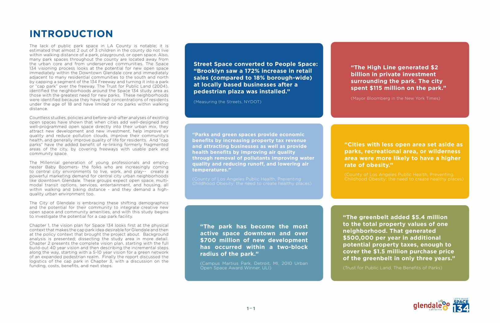
INTRODUCTION

THIS PAGE LEFT INTENTIONALLY BLANK
11
Street Space converted to People Space: “Brooklyn saw a 172% increase in retail sales (compared to 18% borough-wide) at locally based businesses after a pedestrian plaza was installed.”
(Measuring the Streets, NYDOT)
“Parks and green spaces provide economic benefits by increasing property tax revenue and attracting businesses as well as provide health benefits by improving air quality through removal of pollutants improving water quality and reducing runoff, and lowering air temperatures.”
(County of Los Angeles Public Health, Preventing Childhood Obesity: the need to create healthy places)
“The High Line generated $2 billion in private investmentsurrounding the park. The city spent $115 million on the park.”
(Mayor Bloomberg in the New York Times)
“The park has become the most active space downtown and over $700 million of new development has occurred within a two-block radius of the park.”(Campus Martius Park, Detroit, MI, 2010 Urban Open Space Award Winner, ULI)
“The greenbelt added $5.4 million to the total property values of one neighborhood. That generated $500,000 per year in additional potential property taxes, enough to cover the $1.5 million purchase price of the greenbelt in only three years.”(Trust for Public Land, The Benefits of Parks)
INTRODUCTION
“Cities with less open area set aside as parks, recreational area, or wilderness area were more likely to have a higher rate of obesity.”(County of Los Angeles Public Health, Preventing Childhood Obesity: the need to create healthy places)
The lack of public park space in LA County is notable; it is estimated that almost 2 out of 3 children in the county do not live within walking distance of a park, playground, or open space. Also, many park spaces throughout the county are located away from the urban core and from underserved communities. The Space 134 visioning process looks at the potential for new open space immediately within the Downtown Glendale core and immediately adjacent to many residential communities to the south and north by capping a segment of the 134 Freeway and turning it into a park or “cap park” over the freeway. The Trust for Public Land (2004), identified the neighborhoods around the Space 134 study area as those with the greatest need for new parks. These neighborhoods were identified because they have high concentrations of residents under the age of 18 and have limited or no parks within walking distance.
Countless studies, policies and before-and-after analyses of existing open spaces have shown that when cities add well-designed and well-programmed open space directly into their urban mix, they attract new development and new investment, help improve air quality and reduce pollution clouds, improve their community’s health, and generally improve quality of life for residents. And “cap parks” have the added benefit of re-linking formerly fragmented areas of the city, by covering freeways with usable park and community space.
The Millennial generation of young professionals and empty-nester Baby Boomers- the folks who are increasingly coming to central city environments to live, work, and play-- create a powerful marketing demand for central city urban neighborhoods like downtown Glendale. These groups expect open space, multi-modal transit options, services, entertainment, and housing, all within walking and biking distance - and they demand a high-quality urban environment too.
The City of Glendale is embracing these shifting demographics and the potential for their community to integrate creative new open space and community amenities, and with this study begins to investigate the potential for a cap park facility.
Chapter 1, the vision plan for Space 134 looks first at the physical context that makes the cap park idea desirable for Glendale and then at the policy context that brought the project about. Background analysis is presented; dissecting the study area in more detail. Chapter 2 presents the complete vision plan, starting with the full build-out 40 year vision and then describing the incremental steps along the way, starting with a 5-10 year vision for a green network of an expanded pedestrian realm. Finally the report discussed the logistics of the cap park in Chapter 3, with a discussion on the funding, costs, benefits, and next steps.

SITUATING THE STUDY AREA
DOWNTOWN
ROSSMOYNE
PELANCONIWOODBURY
GLENWOOD
VINEYARDCITRUS GROVE
“Having parkland and recreational programs nearby significantly reduced children’s risk of overweight and obesity when they reached age 18. Recreational programming affected children’s body mass index much more than parkland.”(University of California, Berkeley)
21
OPEN/ PARK SPACE
SPACE 134
1/4 AND 1/2 MILE RADIUS
134 Freeway
Space 134 is located atop the SR-134 Freeway as it travels through downtown Glendale. As indicated on the diagram at right, while a majority of the city is located north of the 134 Freeway, the downtown core which is located in the southern part of the city, is bisected almost in two by the freeway itself. The freeway passes 20 or so feet below the grade of downtown and as shown on following pages, is crossed by a handful of pedestrian-only and vehicular/pedestrian bridges. Space 134 would connect the civic, cultural, retail, and business core of downtown Glendale with the City’s residential neighborhoods that flank it on either side on the north and south. This critical connection links also to a variety of nearby schools and community gardens.
ADDING PARK SPACE WHERE IT IS NEEDED MOST
The communities that stand to benefit most from Space 134 are the densely-urbanized and comparatively park-poor neighborhoods of downtown Glendale, shown on the map, right. Per the 2009 City Glendale Quality of Life Indicators, the distribution of developed parkland in Glendale indicated that the majority of parks were found in the eastern and northern sections of the city where there are between 3.35 and 6.67 acres of parkland per 1,000 residents in areas that are the least populated. In the southern section of Glendale, in areas of highest density, 0.64 to 0.017 acres per 1,000 residents are provided. The freeway cap would help resolve the inequity in park space by providing open space and recreational amenities within a five minute walk for Downtown and downtown adjacent residents.
ADDRESSING THE BARRIER CREATED BY THE SR-134 FREEWAY
CITY OF GLENDALE
SPACE 134134 Freeway
DOWNTOWN CORE

Downtown LA
Griffith Park
Rose Hill ParkMount Washington
LA River
LA River
LA River
Verdugo Wash
CENTRAL GLENDALE
NORTHGLENDALE
Santa Monica Mountains
VerdugoMountains
VerdugoMountains
REGIONAL CONTEXT
La River Master Plan
Regional ContextWatershed Map (National Park Service, 2006)
Study Area
Glendale Narrows
In a larger regional context, the City of Glendale is encircled by various riparian systems, natural habitat areas, and public recreational places and finds itself at the center of a series of mountain ranges nearly on all sides, including the Verdugo Mountains, the Santa Monica Mountains and Mount Washington. In fact the name, Glendale means “valley” in Scottish and Gaelic. The city also sits within the geographical triangle of the Sierra Madre foothills, the Los Angeles River, and the Arroyo Seco. The Verdugo Wash links into the Los Angeles River and the whole city is part of the LA River watershed.
At the confluence of all of these amazing natural resources and features, the city center has little open space resources in terms of active and passive park land. Space 134 not only has the potential to add new park space to the downtown core, but also to connect to the broader regional network of water and open space, via the adjacent Verdugo Wash which at some points travels as close as 300 feet from the freeway edge.
City of GlendaleGlenoaks Canyon
31
“Research shows that when people have access to parks, they are more likely to exercise, which can reduce obesity and its associated health risks and costs”(Gies, E. (2006). The Health Benefits of Parks, in Lau, C Urban Freeway Cap Parks Policy Briefing Paper, USC).

POLICY CONTEXTSUPPORT FROM THE DOWNTOWN SPECIFIC PLAN
Initial visioning for a Glendale cap park was proposed in the Parks and Open Space Chapter of the Downtown Glendale Specific Plan. The 134 Freeway was capped between Central Avenue and Brand Boulevard. The Specific Plan suggests that a cap park could enhance Downtown connectivity and feature a regional transit center. A visualization of what the potential cap park could look like from the Specific Plan is included below.
OTHER POLICY DOCUMENTS
In addition to the Downtown Specific Plan, support for the Space 134 concept is provided through many policy documents that promote broad policy goals such as providing multi-modal connections, creating walkable environments, and increasing the availability and adjacency of public recreational spaces. These policy goals are realized by aspects of the Space 134 project.
The matrix, right highlights just some of these strategies, policies, objectives, and goals, established in various of the City’s policy documents.
A table of relevant City documents with policies that support aspects of the Space 134 project.
GREENER GLENDALE PLAN
DOWNTOWN SPECIFIC PLAN
SAFE AND HEALTHY STREETS PLAN GENERAL PLAN
Urban NatureObjective #4
Ensure there is accessible park and recreational open space to serve residents
Strategy A Identify those areas not within 1/3 mile of recreational open space, and develop strategies to provide parks or recreational open space in those areas.
Strategy B Take advantage of opportunities to provide parks and open space through greenways and green streets, particularly in areas where park space is not available.
Walking Distance Open Space Policies
Provide public open space within walking distance of all Downtown residents and employees.
Goal
Continue to enhance pedestrian and bicyclist safety in all Capital Improvement Projects. use best practices to improve and enhance ease of use and safety, ensuring routine accommodation of pedestrians and bicyclists.
Recreation Element
Glendale has a deficit of both community and neighborhood park facilities. The city currently has a parkland to resident ratio of approximately 1.4 acres of parkland for every 1,000 residents while the City’s park planning standard is 1 acre of neighborhood parks and 5 acres of community parkland per 1,000 residents.
Glendale has an extreme shortage of athletic fields which are traditionally located in community parks.
Excellent Design
Make the new public parks, plazas and courtyards harmonious, inspirational, and sources of community pride and identity through design excellence.
Goal
Maintain and update traffic calming measures in the Glendale Traffic Calming Program
Circulation Element
Goal #4
Functional and safe streetscapes that are aesthetically pleasing for both pedestrians and vehicular.
- Provide and maintain high quality streetscape and pedestrian amenities (i.e. bus shelters, street trees, street furniture, wide sidewalks, etc.).
- Support the enhancement of existing and creation of new pedestrian-oriented retail centers.
Urban Design Objective #3
Continue to implement Southern California Association of Governments Compass Blueprint Strategies in Glendale to coordinate with regional efforts to increase stainability and liveable environments.
Mobility Policy
Maintain, re-establish, and enhance the street grid, to promote flexibility of movement through greater street connectivity, capture natural views, and retain the historic relationships between various streets.
Goal
Continue expanding the City’s bicycle parking facilities. Include installation of secure parking facilities for downtown or the Glendale Transportation Center.
Goal #5
Land use which can be supported within the capacity constraints of existing and realistic future infrastructure.
Visualization from the Downtown Specific Plan illustrating the potential cap park over the 134 freeway between Brand Boulevard and Central Avenue.
41

Bra
nd B
lvd
Cen
tral
Ave
Loui
se S
t
Jack
son
St
Gen
eva
St
Gle
ndal
e Av
e
Doran St
Pioneer Dr
Glenoaks Blvd
Monterey RdPo
rtola Av
e
Co
lum
bus
Ave
Pac
ific
Ave
Ken
ilwo
rth
Ave
PROJECT STUDY AREA
Pedestrian-Only Bridge
Pedestrian Tunnel
Existing Bridges: Vehicular and Pedestrian Overpass
Cul-de-sac: No Thru-Connection
Verdugo Wash
Bra
nd B
lvd
Loui
se S
t
Jack
son
St
Gen
eva
St
Gle
ndal
e Av
e
Cen
tral
Ave
Co
lum
bus
Ave
Pac
ific
Ave
Ken
ilwo
rth
Ave
The Space 134 project area is an approximately 1.25 mile-long corridor between Pacific Avenue and Glendale Avenue. The 134 Freeway (Ventura Freeway) is a major east-west freeway that extends from Ventura to Pasadena and has approximately five lanes (four general access lanes and one carpool lane) in each direction with a sloped embankment on each side. Several pedestrian bridges, tunnels, and overpasses connect across the freeway while some north-south streets have no thru-access, and this contributes to the physical separation of north and south Glendale. These streets end in cul-de-sacs at the freeway edge. Pedestrian-only bridges are located at Woodrow Wilson Middle School (bridge currently closed) just east of Glendale Avenue and at Columbus Avenue (bridge currently open). The only tunnel under the freeway is at Kenilworth Avenue, adjacent to Fremont Park. The tunnel is minimally lit and narrow, but frequently used by pedestrians and bicyclists.
The distance between crossings ranges from 700 ft to over 1,300ft. Immediately north of the study area is the Verdugo Wash, a channelized tributary to the Los Angeles River.
EXISTING CONNECTIONS
PROJECT STUDY AREA
Verdugo Wash
51
SPACE 134

LAND USE
DEMOGRAPHICS
The Downtown Specific Plan runs south from the Freeway and includes Special District Zoning along the core downtown streets, Brand Boulevard and Central Avenue. The community commercial area continues to the west along Glenoaks and there is another node of commercial activity at where Glendale Avenue crosses the 134 freeway. This eastern node of downtown activity indicates a major opportunity for Glendale to expand pedestrian-friendly commercial uses to the east. High and medium density residential neighborhoods surround the study area, with a low-density residential neighborhood, Rossmoyne, to the northeast of the freeway.
The makeup of residents living in the zip code areas adjacent to Space 134 is similar to that of the city as a whole, in terms of race and age, as well as household occupancy and commute mode. The average income in these areas however is less than the city as a whole.
61
LOW-DENSITY RESIDENTIAL
NEIGHBORHOOD COMMERCIAL
MODERATE DENSITY RESIDENTIAL
COMMUNITY COMMERCIAL
MEDIUM DENSITY RESIDENTIAL
DOWNTOWN SPECIFIC PLANSPECIAL DISTRICTS
MEDIUM HIGH DENSITY RESIDENTIAL
HIGH DENSITY RESIDENTIAL
1 3 4 F R E E W A Y
BR
AN
D B
LVD
JAC
KS
ON
ST
LOU
ISE
ST
GE
NE
VA
ST
GLE
ND
ALE
AV
E
CE
NT
RA
L A
VE
PAC
IFIC
AV
E
CO
LUM
BU
S A
VE
GLENOAKS BLVD
MONTEREY RD
Study Area
48,537Total Population
9,730Children Population
(Age 0-19)
2.17 HouseholdOccupancy
$67,500 Avg. Income
3012.04
3018.01
3018.02
3011
3019
3020.023020.03
3020.04
3021.04
3010
SPACE 134134 Freeway
Census Tracts, Study Area
Land Use Map
Commute Mode, Study Area
COMMUTER MODESSINGLE OCCUPANCY VEHICLE CARPOOL VEHICLEPUBLIC TRANSITWALKINGBIKINGOTHER MEANS
2,000
4,000
6,000
80,000
10,00012,00014,000
16,000
18,000
20,000
Race, Study Area
RACE
WHITE - %77ASIAN - %16.2
BLACK - %2OTHER - %5
City of Glendale
40,328Children Population
(Age 0-19)
2.63HouseholdOccupancy
$78,393 Avg. Income
193,111 Total Population
*All Data from 2012 Community Survey, US Census.gov*Study area includes census tracts depicted right

BID BOUNDARY
I–134 FREEWAY
COLORADO
ELK
HARVARD
CEN
TRA
L
BRA
ND
GLE
ND
ALE
LEXINGTON
DORAN
MONTEREYBURCHET
ARDEN
CO
LUM
BUS
MILFORD
GLENOAKS
MA
RYLA
ND
LOU
ISE
KEN
WO
OD
JAC
KSO
N
ISA
BEL
ORA
NG
E
Glendale Downtown Specific Plan as adopted on November 7 2006
N
CALIFORNIA
WILSON
BROADWAY
0’ 150’ 300’ 600’
MRYTLE
SALEM
DORAN
PIONEER
ORANGE GROVE
1
5 6
9 10
11
12
18
22 23
7
project list updated April 11 2013
14
Under Construction
Entitled
17
4
19
8
2
3
Major Renovations
13
16
15
20
21
Pipeline Projects1: Verdugo Gardens 2 at 610 N Central 6-story, 220-unit residential (Stage II.rev May 17 2012)
2: Carmel Partners Site A 5-story, 315-unit residential (Stage I Apr 2 2013)
3: Carmel Partners Site B 5-story, 192-unit residential (Stage I Apr 2 2013)
4: The Lex on Orange 6-story, 309-unit mixed use (Under Construction)
5: 301 N Central 6-story, 84-unit mixed-use (Stage II Mar 12 2013)
6: Legendary Tower at 300 N Central 6-story, 80-unit mixed use (Under Construction)
7: Marriott Courtyard Hotel at 225 W Wilson 11 story, 172-room hotel (Stage II Dec 1 2009)
8: Cental + Wilson 6-story, 153-unit residential (Stage 1 Mar 19 2013)
9: Orange + Wilson 6-story, 166-unit residential (Stage II Oct 30 2012)
10: Brand+Wilson 6 story, 235-unit mixed-use (Stage II Sept 11 2012)
11: Alex Theatre Expansion 2-story back-of-house facilities (HPC Dec 12 2011)
12: Laemmle Cinema Lofts 4-story, 42-unit mixed use (Stage II Nov 29 2011)
13: Five Star Cinema 10-screen movie theatre renovation (Under Construction)
14: Louise Gardens 6-story, 63-unit residential (Stage II Dec 18 2008)
15: Glendale Galleria Comprehensive Renovation (Under Construction)
16: Bloomingdale’s 120,000sf department store (Under Construction)
17: Eleve at 200 E Broadway 6-story, 208-unit mixed use (Under Construction)
18: Kenwood Terrace at 118 S Kenwood 5-story, 35-unit residential (Under Construction)
19: Nordstrom at Americana 119,119sf department store (Under Construction)
20: MONA (Museum of Neon Art) 9000sf museum/gallery (Under Construction)
21: Masonic Temple Adaptive Reuse (Under Construction)
22: 124 W Colorado 5 story, 50-unit residential (Stage II Nov 15 2011)
23: Hampton Inn and Suites 5 story, 94-room hotel (Stage I&II Feb 26 2013)
NEW DEVELOPMENT IN DOWNTOWNKey new development projects are highlighted, right. These pipeline projects are currently planned or underway and would provide over 700 housing units directly to the central city core, where Space 134 would be located. Beyond this, however, there are currently over 2,152 new units planned for Downtown Glendale. The Downtown Specific Plan contemplates major growth in the Downtown area, but in a balanced way to create a vibrant multi-use downtown of residents and business. Up to 1.7 million square feet of retail/office development is also contemplated, which will add some 3,390 jobs. These residences and new businesses will demand and benefit from an increase in park and amenity space in Downtown.
A NOTE ON PARKING
One of the major strategies that the City has been pursuing is to manage parking supply and demand in the Downtown. During a field visit with staff of the study area; parking spillover into the residential neighborhood from the commercial district was noted. Much of the parking on the bridges over the 134 freeway currently serves Downtown employees. Space 134 should consider parking consolidation and sharing, rather than new parking development to support the park. This is especially true, in light of the large amount of new development coming to Downtown. A comprehensive strategy when it comes to planning for and requiring new parking should be pursued.
71

81
Beyond its placemaking aspects, Space 134 may also help the city to respond to the need to establish a central city transit hub for east-west commuter light rail or bus rapid transit, which may be planned along the 134 Freeway in the future. Because the 134 Freeway is significant to the City’s mobility and access needs, the Space 134 project must consider the transportation context for the area surrounding it.
The 2007 Downtown Mobility Study helps to establish the background transportation policies and programs that are critical for Space 134. Other recently adopted policy documents including the 2006 Beeline Short Range Transit Plan (SRTP) and the 2012 Glendale Bicycle Transportation Plan (GBTP) are also critical policy background documents when it comes to designing Space 134 within its transportation context.
THE DOWNTOWN MOBILITY STUDY
The transportation system context for this project is summarized best by the recently adopted 2007 Downtown Mobility Study (DMS), which, in support of the Downtown Specific Plan, describes the City’s vision for a comprehensive mobility program. The DMS outlines the following broad goals to balance mobility needs for a growing Downtown:
1. Manage traffic congestion and parking demand downtown through a combination of infrastructure improvements and policies that encourage the use of alternative modes for travel to and within downtown.
2. Increase the percentage of trips made on transit by improving the quantity and quality of transit service: making transit a fast, reliable, and attractive option.
3. Manage parking supply and demand downtown to ensure that a growing downtown does not impact residential neighborhoods and to generate revenue for downtown area improvements.
4. Improve the coordination of Glendale’s on-street and off-street parking policies with its transportation demand management strategies.
5. Increase the percentage of trips made by walking and biking through infrastructure improvement and new programs and policies that make walking and biking downtown easy, safe, and enjoyable.
6. Manage right of way to improve movement of people rather than just moving vehicles.
7. Develop financing strategies that allocate the cost of improvements appropriately to new and existing development and to the people who live, work, and visit downtown.
TRANSPORTATION CONTEXT
Further discussion of some of the DMS mobility strategies as they relate to the study area follow.
THE 134 FREEWAY
The 134 Freeway is significant to the Downtown access program as it serves as the major automobile access for employees and shoppers. Conversely, the Freeway’s limited access points (Pacific Avenue, Central/Brand Boulevard and Glendale Avenue) have become the most heavily congested sections of the City street system. A related condition to the congestion is the high volume of traffic on adjacent residential neighborhood streets which must deal with commuter traffic seeking to bypass the congested freeway ramps. In particular, complaints about traffic volumes and speeds on Doran Street during the commuter hours are a recurring issue for the City (see additional discussion below). The current freeway east bound ramp system at Glendale Avenue represents a major impediment to completing a potential parallel frontage roadway that could mitigate the residential impacts.
Caltrans is responsible for the operation and planning for the Freeway as a link in the statewide and regional highway network. The Los Angeles County Metropolitan Transit Authority (Metro) provides coordinated funding for future improvements to the transportation network including the Freeway system and both of these regional agencies must be consistent with the SCAG Regional Transportation Plan to maintain eligibility for federal transportation funding. Policy documents for all three of these agencies were reviewed to determine the regional transportation context.The Caltrans 2002 Transportation Concept Report (TCR) represents the
most current focused planning document for the 134 Freeway with an emphasis on determining the ultimate need for freeway right of way. While the report acknowledges recurring congestion on the segment approaching the interchange of the Freeway with the I-5 Freeway (just to the west of the study area) the report does not contemplate further highway capacity enhancements beyond the recently completed high occupancy vehicle (HOV) lane and four mixed flow lanes in each direction.
The DMS suggests that an east-west transit connection to the adjacent cities of Pasadena and Burbank along the 134 Freeway corridor is an important strategy to meet future mobility needs. The Caltrans TCR, consistent with planning documents of both SCAG and Metro does not contemplate rail transit in this corridor. Instead the TCR acknowledged the potential for bus rapid transit (BRT) in the median of the freeway to complete a regional transit network. BRT in the median of the 134 Freeway is mentioned and is the basis for the ultimate transit concept (UTC) governing the Caltrans desire to maintain enough right of way for double HOV lanes in each direction.
Measure R Projects MapTransportation Context, Beeline & Metro Routes
¹
¹
¹
¹ ¹
¹¹
¹
¹
¹
¹
¹ ¹
¹¹
¹
¹
¹
¹
¹
¹
¹
Æb
Æb
Æb
Æc
Æc
Æc
Æc
Æc
Æc
Æc
Æc
Æc
Æc
Æc
Æc
Æc
Æc
®v
®v
®v
®v
å
å
å
å
å
å
å
å
!
!
!
!
!
!
!
!
!
!
!
!
!
!
!
!
!
!
!
!
!
!
!
!!!
! !
!
!
!
!
!
!
!
!
!
!
!
!
!
!
!
!
! !
!
!
!
!
!
!
!
!
!
!
!
!
!
!
!
!
!
!
!
!
!
!
!
!
!
!
!
!
!
!
!
!
!
!
!
!
!
!
!
!
!
!
!
!
!
!
!
!
!
!
!
!
!
!
!
!
!
!
!
!
!
!
!
!
!
!
!
!
!
!
!
!
!
!
!
!
!
!
!
!
!
!
!
!
!
!
!
!
!
!
!
!
!
!
!
!
!
!
!
!
!
!
!
!
!
!
!
!
!
!
!
!
!
!
!
!
!
!
!
!
!
!
!
!
!
!
!
!
!
!
!
!
!
!
!
!
!
!
!
!
!!
!
!
!
!
!
!
!
!
!
!
!!
!
!!
!
!
!
!
!
!
!
!
!
!
!
!
!
!
!
!
!
!
!
!
!
!
!
!
!
!
!
!
!
!
!
!
!
!
!
!
!
!
!
!
!
!
! !!
!
!
!
!
!
!!!
! !
!
!
!
!
!
!
!
!
!
!
!
!
!
!
!
!
!
!!
!
!
!
!
!
!
!
!
!
!
!
!
!
!
!
!
!
!
!
!
!
!
!
!
!
!
!
!
!
!
!
!
!
!
!
!
!
!
!
!
!
!
!
!
!
!
!
!
!
!
!
!
!
!
!
!
!
!
!
!
!
!
!
!
!
!
!
!
!
!
!
!
!
!
!
!
!
!
!
!
!
!
!
!
!
!
!
!
!
!
!
!
!
!
!
!
!
!
!
!
!
!
!
!
!
!
!
!
!
!
!
!
!
!
!
!
!
!
!
!
!
!
!
!
!
!
!
!
!
!
!
!
!
!
!
!
!
!
!
!
!
!
!
!
!
!!
!
!
!
!
!
!
!
!
!
!
!!
!
!!
!
!
!
!
!
!
!
!
!
!
!
!
!
!
!
!
!
!
!
!
!
!
!
!
!
!
!
!
!
!
!
!
!
!
!
!
!
!
!
!
!
!
!
!
!
!
!
!
!
!
!
!!
!
!
!
!
!
!
!
!
!
!
!
!
!
!
!
!
!
!
!
!
!
!
!
!
!
!
! !
!
!
!
!!
!
!
!
!
!
!!
!
!
!
!
!
!
!
!
!
!
!
!
!
!
!
!
!
!
!
!
!
!
!
!
!
!
!
!!
!
!
!
!
!
!
!
!!
!
!
!
!
!
!
!
!
!
!
!
!
!
!
!
!
!
!
!
!
!!
!
!
!
!
!
!
!
!
!
!
!!
!
!
!
!
!
!
!!
!!
!
!
!
!
!
!
!
!!
!!
!!
!!!
!
!
!
!
!!
!
!
!
!!
!
!
!
!
!
!
!
!
!
!
!!
!
!
!
!
!
!
!
!
!!
!!
!
!
!!
!!
!!
!
!
!
!!
!!
!
! !!
!!
!!
!!
!! !
!!
!
!
!
!
!!
!
!
!
!!
!!
!
!!
!
!
!
! !
!
!
!
!
!
!
!
!
!
!
!
!
!
!
!
!
!
!
!
!
!!
!
!
!
!
!
!!
!
!
!!
!!
!
!
!
!
!
!!
!!
!
!
!
!
!
!
!
!
!
!!
!
!
!
!
!
!
!
!
! !
!
!
!
!!
!!
!
!
!!
!!
!
!
!
!
!
!
!
!
!!
!!
!
!
!!
!
!
!!
!
!
!
!
!
!
!
!
!
!
!
!
!
!
!
!
!
!
!
!
!
!
!
!!
!
!
!
!
!
!
!
!
!
!
!
!!
!!
!
!!!!
!!
! !
!
!
!
!
!
!
!
!
!
!
!
!
!!
!
!
!
!
!
!
!
!
!!
!
!
!
!
!
!
!
!
!
!
!
! !
!
!
!
!
!
!
!
!!
!
!!
!
!
!
!
!
!!
!
!
!
!
!
!
!
!
!
!
!
LCHS
GHS
ST. JAMES
TOBINWORLD
HOLYFAMILY
CLARKMAGNET
HS
ZIONLUTHERAN
ST. FRANCISHS
HHS
FLINTRIDGEPREP
CALVARYCHRISTIAN
GLENDALEADVENTISTACADEMY
RENAISSANCEACADEMY
DAILYHSN
CHAMILIAN
FIRSTLUTHERAN
DAY
TOLLMS
WILSONMS
ROOSEVELTMS
GPD
ALEXTHEATRE
BRAND LIBRARY
POLICESTATION
BURBANK CITYHALL
GRANDVIEWLIBRARY
SAN RAFAELLIBRARY
LOWELLPARK &
RIDE
RANCHOMARKETPLACE
BUENA VISTALIBRARY
VERDUGOPARK &
RIDE
CHEVY CHASELIBRARY
LA CRESCENTALIBRARY
BURBANK PUBLICLIBRARY
RTE 134 & 2PARK & RIDE
CASA ADOBE DESAN RAPHAEL
EAGLE ROCKBRANCH LIBRARY
VERDUGO ADOBEHISTORIC SITE
PACIFICCOMMUNITY
CENTER & PARK
ATWATER VILLAGEBRANCH LIBRARY NORTHEAST
DIVISION POLICESTATION
FOOTHILL BLVD
WOLIVE AV
YORK BLVD
W ALAMEDA AV
AVISTA
ST
LINC
OLN
AV
EAGL
ERO
CKBL
VD
WGLENOAKS BLVD
COLORADO BLVD
CANA
DABL
VD
SBR
AND
BLVD
E BROADWAY
LACR
ESCE
NTA
AV
HONOLULU AV
SGL
ENDA
LEAV
NVERDUGO
RD
N GLENOAKS BLVD
LA LOMA RD
E COLORADO ST
CHEV
YCH
ASE
DR
WESTERNAV
VICTORY PL
VERDUGORD
VERDUGO BLVD
W BROADWAY
4
NBR
AND
BLVD
S VICTORY BLVD
OCE
ANVI
EWBL
VD
SVERDUGO
RD
NVICTORY
BLVD
E CHEVY CHASE DR
W CALIFORNIA BLVD
SCH
EVY
CHAS
EDR
E OLIVE AV
VICTORY BLVD
S SAN FERNANDO BLVD
NGLE
NDALEAV
SBUENA
VISTAST
NCE
NTRA
LAV
E ALAMEDA AV
W LOS FELIZ RD
SCE
NTRA
LAV
E MAGNOLIABLV
D
W CHEVY CHASE DR
S GLENOAKS BLVD
PENN
SYLV
ANIA
AV
DO BLVD
E BURBANK BLVD
****
*N
OCE
ANVI
EWBL
VD
NLI
NCO
LNAV
FIGU
EROA
ST
SCE
NTRA
LAV
N GLENOAKS BLVD
NVE
RDUG
ORD
W COLORADO ST
NCE
NTRA
LAV
HONOLULU AV
SANFERNANDO
RD
WBROADWAY
VICTORY BLVD
LA LOMA RD
E CHEVY CHASE DR
LINC
OLN
AV
BLVD
FOOTHILL BLVD
VENTURA
VENTURA
VENTURA
Ã2
Ã134
Ã2
Ã134
§̈¦210
§̈¦210
§̈¦5
§̈¦5
Ç2
Ç11
Ç1
Ã2
Ã134
Ç5
Ç7
Ç6
Ç6
Ç4
Ç12
Ç34
Ç33
183780
180/181780 90
91
92
92
92
9091
183 183
183685
180/181780
201
183
94794
94183794 92
9091
Ç3
Ç3
Ç7
91
90
90
91
91
Ç33
MONTROSELIBRARY
RIVERSIDERANCHO
ADVENTIST
MEMORIAL
ST. JOSEPH
603
Ç7
Ç7
Ç5 Ç1
Ç2
Ç11
Ç11
Ç3
Ç3
Ç31
Ç3
Ç3Ç33
201201
Ç6
Ç4
Ç4
Ç12
Ç12
Ç3
VERDUGO HILLS
CVHS
Ç31
Ç34
Ç34
90/91
201
603201
180/181
603
183
685
685
183
183
SALEMLUTHERAN
¶¶
¶¶
¶¶
¶
¶
¶
¶¶
¶
¶
¶
¶
¶
¶
¶
¶
¶
¶
¶
¶
¶
¶
¶
¶¶
¶
¶
¶
¶
¶
¶
¶
¶
¶
GLENDALEGALLERIA
¶ ¶
¶
177
Ç31
Ç32
¶
¶
¶
Ç32Ç31
¶¶¶
Ç12
CIVICCENTER
GRIFFTHPARK
AMER
ICAN
A
Ã2
¶
JET PROPULSIONLABORATORY(JPL)
TOWN CENTER
FASHION CENTER
MARKETPLACE
PLAZA DE LACANADA
GLENDALE LARRYZARIAN
TRANSPORTATIONCENTER (GTC)
GCC GARFIELDCAMPUS
GLENDALE CIVICAUDITORIUM
BURBANKTRANSPORTATION
CENTER
BRAND
LA TUNA CANYON
HAHAMONGNAWATERSHED
WILDWOOD CANYON
STOUGH
BROOKSIDE
DESCANSO GARDEN
DE BELLMUNICIPAL
LOS ANGELES ZOO
VERDUGO
ARROYO
OAK GROVE
HAINES CANYON
LOWER ARROYO
VERDUGO MOUNTAI
EAGLE ROCK
NORTH ATWATER
MCCAMBRIDGE
BRACE CANYON
BUENA VISTA
GEORGE IZAYGRANDVIEWMEMORIAL
GARVANZA
EAGLE ROCKHILLSIDE
SCHOLL CANYON
FREMONT
JOHNNY CARSON
DUNSMORE
UPPER ARROYO
MAPLE
PELANCONI
GLENDALE SPORTSCOMPLEX
GLORIETTA
LA GLENDALEWATER
RECLAMATION
PALM
PALMER
MONTROSECOMMUNITY
EMERALD ISLE
NIBLEY
CARR
MAYORSBICENTENNIAL
BEL AIRE
OAKMONT VIEW
JUNTOS
MOUNTAIN VIEW
GLENOAKS
DEFENDERS
LINCOLN
CHEVY CHASE
NEW YORK
EARTHWALK
GLENOLA
CERRITOS
GLASSELL PARK &REC CTR
YOSEMITERECREATION
CENTER
FEHLHABERHOUK
JOAQUIN MILLER
SAN RAFAEL
LANARK/SHELBY
BROOKSIDE GOLFCOURSE
WILSONMUNICIPAL GOLF
COURSE
ANNANDALE GOLFCOURSE
HARDINGMUNICIPAL GOLF
COURSE
DE BELLMUNICIPAL GOLF
COURSE
OAKMONT COUNTRYCLUB
SCHOLL CANYONGOLF COURSE
ROOSEVELTMUNICIPAL GOLF
COURSE
VERDUGO HILLSGOLF COURSE
LA CANADAFLINTRIDGE GOLF
COURSE
CHEVY CHASECOUNTRY CLUB
LOS FELIZMUNICIPAL GOLF
COURSE
ARROYO SECOGOLF COURSE
GLENDALECOMMUNITY
COLLEGE
BURBANK EMPIRECENTER
MEDIA CITYCENTER
WESTFIELDSHOPPINGTOWN
ALLEN AV
LIND
AVI
STA
AV
ZOO DR
GRIFFITHPARK
DR
SCOTTRD
WKENNETH RD
NPA
CIFI
CAV
SONORAAV
ROSE
MON
TAV
LIDA ST
MERIDIAN ST
MONTROSE AV
E WILSON AV
YOSEMITE DR
BRIG
GS
AV
NVE
RDUG
ORD
AVEN
UE64
CRYSTALSPRINGS
DR
YORK BLVD
BOST
ONAV
E MOUNTAIN ST
GRAN
DVIE
WAV
N KENNETH RD
CROW
NAV
NEW
YORK
AV
HIGHLAND DR
E OLIVE AV
SAD
AMS
ST
OCE
ANVI
EWBL
VD
HIG
HLAN
DAV
DUNS
MO
REAV
FOREST LAWN DR
WALNUT AV
W WILSON AV
WESTERN AV
W VERDUGO AV
MOUNT HOLLYWOOD
DR
WMOUNTAIN ST
VISTADEL VALLE
DR
LOW
ELLA
V
SM
AINST
PENN
SYLV
ANIA
AV
BERKSHIRE AV
LACR
ESCE
NTA
AV
W COLORADO BLVD
SECO
ST
E LEXINGTON DR
GLENWOOD RD
OAK GROVE DR
COUNTRY CLUB DR
SPA
CIFI
CAV
NARROYO
BLVD
DESCANSO DR
E STOCKER ST
NFRONT
ST
ELLE
NWO
OD
DR
FIGUEROAST
E MAGNOLIABLV
D
STARLIGHT CREST DR
VENTURA ST
RIVERSIDE DR
CHANDLER BLVD
SO
RANGE
GRO
VEBLVD
S KENNETH RD
EL PASODR
SARRO
YOBLVD
NCE
NTRA
LAV
NAV
ENUE
64
W WASHINGTON BLVD
NAD
AMS
ST
CASI
TAS
AV
LIND
AVI
STA
RD
5TH ST
W STOCKER ST
SSAN
RAFAELAV
ALUMNI AV
ARRO
YODR
E GLENOAKS BLVD
NBR
AND
BLVD
EAGLEVIS
TADR
NAV
ENUE
51
NSAN
RAFAELAV
ALAMEDAAV
MOUNTAIN ST
W WOODBURY RD
N SAN FERNANDO BLVD
W MONTANA ST
NBEACHWOOD
DR
W LEXINGTON DR
COLORADO BLVD
N SUNSET CANYON DR
ROSE
LAW
NAV
E VERDUGOAV
FOOTHILL BLVD
CAMBRIDGE DR
TUJUNGACANYON
BLVD
SANTA CARLOTTA ST
FLETCHER DR
S SUNSET CANYON DR
NAV
ENUE
50
CUMBERLAND RD
VERMONTCANYON
RD
SAN PASCUALAV
W RIVERSIDE DR
TOW
NSEN
DAV
BERKSHIRE PL
ORANGE AV
LINCOLN
AV
S FRONT ST
ROCKDELL ST
NOR
ANGE
GROV
EBL
VD
EMPIRE AV
ORANG
EGRO
VEAV
GLENOAKS
BLVD
SAN FERNANDOBLVD
ROSS
MOY
NEAV
W DORAN ST
NW
INDS
OR
AV
ALTA
CANY
ADA
RD
SAN
PASQ
UAL A
V
CANADAAV
PARK
VIEW
AV
ARROYOBLVD
VERDUGODR
W WALNUT ST
W ALTADENA DR
N VERMONT AV
E DORAN ST
HONOLULU PL
ARDEEVIN
AV
NARRO
YOBLVD
W DORAN ST
E GLENOAKS BLVD
E GLENOAKS BLVD
ORANGE AV
S SAN RAFAELAV
NAR
ROYO
BLVD
SADAMS
ST
CRYSTALSPRING
SDR
NW
IND
SOR
AV
N ARROYO BLVD
ELLENWOOD
DR
BRIG
GS
AV
CHANDLER BLVD
HIG
HLAN
DAV
SSAN
RAFAELAV
SADAMS
ST
NARRO
YOBLVD
RIVERSIDE DR
E GLENOAKS BLVD
SARRO
YOBLVD
W RIVERSIDE DR
ORANGE AV
ARRO
YOBL
VD
ANGE
LES
CRES
T
VERDUGO MTWY
N 6TH ST
FLOWER ST
*****
HILL DR
RAM
SDEL
LAV
WEST
DR
PALM
DR
ELMAV
GO
ULD
AV
NLO
UISE
ST
ALTURA AV
E PALMAV
AIR WY
FIRERD
IRVIN
GAV
ROSEMONT
AV
CANYON DR
HARVARDRD
OAK
WO
OD
AV
N 3RD ST
ARROYO
SECORD
SKYLINE MTWY
W OAK ST
LASFLO
RESM
TWY
IVY ST
NJA
CKSO
NST
E WINDSOR RD
S LAKE ST
E ACACIA AV
CLARK AV
LAKE ST
BRUNSWICK AV
SG
RAND
AV
ALABAMA ST
N BEL AIRE DR
SALEM ST
TOLAND WY
HERMOSAAV
E TUJUNGAAV
FOREST AV
E HARVARD ST
COM
MO
NWEA
LTH
AV
INVERNESS DR
NORTH TR
VINE ST
GREEN LN
RIDGE MTWY
E ANGELENO
AV
BETHANY RD
EL CAMINITO
FERN LN
GLENWOOD RD
E PROVIDENCIA
AV
SANJO
SE AV
ALTA
CANY
ADA
RD
LOS OLIVOS LN
S 6TH ST
LARO
DAAV
RAYMOND
AV
AMHERST DR
THOMPSON AV
HAVEN WY
E SANTAANITA
AV
OLIVE LN
W ELK AV
NPARISH
PL
MONTEREY RD
HOLLYRID
GEDR
HILL
ARD
AV
LACA
NADA
BLVD
JOLLEYDR
SPAR
RBL
VD
TUFTS AV
NREESE
PL
CAMINOSAN
RAFAEL
CONC
ORD
ST
ENCINAL AV
BRAND PARK MTWY
HAM
PSTE
ADRD
MINERAL WELLS TR
NM
YERSST
PATRICIAN WY
E CALIFORNIA AV
LAGUNA RD
VIRO
RDS
MARIPOSA
ST
STEVENS ST
OLMSTED DR
IRVIN
GDR
GRINNELL
DR
NAR
ROYO
BLVD
E GARFIELD AV
JUSTIN
AV
N KENNETH RD
ESTEPA DR
ROY ST
ETON
DR
MEMORIAL DR
LOLE
TAAV
EDENHURST AV
MYRTLE ST
W CALIFORNIA AV
SSPARKS
ST
E VERDUGOAV
ETHEL ST
ROYAL BLVD
LINDEN AV
HOSTETTERMTW
Y
E GLENOAKS BLVD
EL LADODR
NAV
ENUE
56
GROTON
DR
KNIGHT WY
HARVE
YDR
ANDOVERDR
PROSPECT AV
NSPARKS
ST
NKEYSTONE
ST
E ORANGE GROVE AV
EVERGREEN DR
WINCHESTER
AV
SYCAMORE AV
CAST
LERD
COUN
TRY
CLUB
DR
SPARISH
PL
EARL CANYON MTWY
E DRYDEN STFLINTRIDGE
AV
RALEIGH ST
FAIR
MOUNT RD
BROADVIEW DR
N 1ST ST
WSAN
FERNANDORD
SPAZIER
AV
ADDISON WY
LAUD
ERDA
LEAV
SOUTH ST
EAST TR
MARIE
AV
DURANDDR
E CEDARAV
NAV
ENUE
46
BOYCE AV
E ELK AV
GLEN
OAKS
BLVD
WILDWOOD FIRE RD
MOUNT LUKENS TKTR
ARDEN AV
WAW
ONA
ST
RUBERTAAV
CAMPUS RD
MAYFIELD AV
WABASSO WY
DOVER ST
NOLD
ENST
LINC
OLN
AV
BEUL
AHDR
WIO
TAST
YOSEMITEWY
NAV
ENUE
53
OAK ST
NM
ARIPOSAST
NORCHARD
DR
GOULD MTWY
NLINCOLN
ST
HOW
ARD
ST
CANADA AV
WO
ODL
EIG
HLN
HERM
OSIT
ADR
BEAUDRY NORTH MTWY
OPECHEE WY
S BEL AIRE DR
SORCHARD
DR
BALTIMORE ST
1ST AV
HOLLISTER TER
NFI
GUERO
AST
GREENBRIAR RD
N ZOO DR
BEAUDRY SOUTH
5TH AV
REVEREAV
ZOODR
GRAY
NOLD
AV
VINE
TAAV
2ND AV
SBEACHW
OODDR
VALL
EVI
STAMTW
Y
3RD AV
SLAM
ERST
WIN
GST
ZANJA ST
HENRIETTA AV
SGRIFFITH
PARKDR
MONTLA
KEDR
LYANS DR
ENCI
NAS
DR
E PALMER AV
BROOKHILL ST
VALLEYVIEW
RD
SLO
UISE
ST
UNIVERSITY AV
ANNAN WY
S 7TH ST
ORANGE GROVE AV
WAL
NUT
AV
NIS
ABEL
ST
MED
LOW
AV
NKE
NWO
OD
ST
BIRMIN
GHAMRD
NLAM
ERST
DREWST
FIGUEROA DR
UCLAN
DR
HILLSIDE DR
CLEV
ELAN
DRD
SUNSHINE DR
EDISON
RD
RANGE VIEW AV
EAST AV
S 3RD ST
PROSPECTBLVD
RIDGEVIEW AV
NO
RANG
EST
CAM
PBEL
LST
COMMUNITY AV
CORINGA DR
WILDWOOD DR
GLADYSMTW
Y
CATHEDRAL DR
NEOLA ST
SENECAAV
OMAR STBURCHETT ST
CHURCH ST
STRATFORD RD
IDLE
WO
OD
RDAL
MA
ST
CANY
ON
CRES
TRD
EMERALDISLE
DR
HAM
PTO
NRD
NBEACHW
OODDR
SKYLINE TR
ERINW
Y
GEORGIAN RD
MULHOLLANDHW
Y
BELA
IRDR
AVOCA
ST
PALI
AV
RIVERDALE DR
SKEYSTONE
ST
CLO
UDAV
ALBERTA ST
BRUC
EAV
BAPTISTE WY
W HARVARD ST
SHIELDS ST
NAV
ENUE66
INNSDALE DR
MARIO
NDR
NM
AYW
OO
DAV
JOAQUINDR
SUNVIEW DR
ROYCE ST
SCANDIA WY
VINCENTAV
RANDALL ST
DYER
ST
WALTONIA DR
COONS
RD
HAWTHORNE ST
RABER ST
S 1ST ST
MILLS AV
SKYPARK
RD
ALPHA RD
HILL
ST
FISC
HER
ST
PARKPL
FLORENCITA AV
GRI
SMER
AV
NBRIGHTON
ST
SOLWAY
ST
DAHL
IADR
WELDON AV
ARBOR ST
WAVENUE
40
WAVENUE
41
ARGUS
DR
NGRIFFITH
PARKDR
TOW
NSENDAV
W HOWARD ST
LAS
PALM
ASAV
W PALM AV
MONTROSE AV
NCE
DAR
ST
PEYTON AV
CRESTHAVENDR
RIDGE
DR
NLAKE
ST
GRAND CENTRALAV
BURLEIGH DR
HASK
ELL
ST
SAN GABRIEL AV
PORT
ERST
FIGUEROAST
CHES
TER
ST
ALM
INAR
AV
CORN
ISHO
NAV
HEPNER AV
E ELMWOOD AV
EDWARDS PL
KIRKHAM DR
DELE
VAN
DR
MOUNTAIN VIEW ST
MESA LILA RD
MENLO DR
GREENRIDGE DR
SGLENW
OODPL
GLENOAKS BLVD
DESCANSO MTWY
SCO
LUM
BUS
AV
PINE
GLE
NRD
CALEDONIA
WY
CAPISTRANO AV
EL VAGO ST
DEL MONTE ST
THUR
BER
PL
BELDEN DR
BEMIS ST
SUNS
ETAV
NOLAN AV
WPROVID
ENCIAAV
ANITADR
NLOM
ITAST
PIONEER DR
NORWALK AV
ANG
ELUS
AV
ADAMS ST
LAGR
ANAD
AW
Y
PASA GLEN DR
VICK
ERS
DR
KENN
ETH
WY
ANDRITA ST
TEASLEY ST
LOM
AVI
STA
DR
BRAZIL ST
GLENFELIZBLVD
SPENCER ST
ALDAMA
ST
RADIO LATERAL
MANHATTAN AV
ALLEN AV
CHAPMAN ST
RANCHO AV
BONITA AV
GEN
EVA
ST
E CYPRESS AV
ARM
ADAL
EAV
CHILTON DR
COOLIDGE TR
ESTARAAV
STANLEY AV
ARMADADR
RODERICK RD
RISIN
GHILL
RD
LELAND WY
MAGNOLIA DR
EVELYN ST
WVERDUGO
AV
VALL
EYW
Y
CASC
ADIA
DR
LOY
LN
GLENCOE WY
MILW
AUKE
EAV
LARK
ERAV
WHOLLY ST
BEL AIRE DR
W HARRIET ST
WSPAZIER
AV
CROSBY ST
LASH
EART
DR
CASITAS AV
DELAWARE RD
DEVI
LSGA
TERE
SSH
R
ONT
ARIO
AV
BRADFORD ST
GLE
NIR
ISAV
HOUSEMAN ST
RODERICK PL
NORENST
W DRYDEN ST
RIDG
EWAY
DR
GARDENAV
FAIRFIELD ST
IMPERIAL DR
LA LOMA RD
INDI
ANA
AV
GARDNERPL
SVIRGINIA
AV
AVONOAK TER
CORO
NADR
NM
ARYL
AND
AV
W MARIPOSA ST
DOVE
RRD
BUCHANAN ST
FREE
MAN
AV
EILINITA AV
EARLMONT AV
COVENANT WY
MONCADO DR
SECOST
FRANCES AV
SEV
ERET
TST
PAULETTE PL
CREEMORE DR
APPLETON ST
ELRI
OAV
DOANDR
PARKVIEWAV
MAR
YLAN
DAV
FLOR
ECIT
ADR
FAIRMONT AV
LINDAVISTA
MTWY
HERMOSA ST
KAWEAH DR
NSHELTON
ST
LEWIS
ST
CORNELLDR
W MILFORD ST
ROSEBO
WL
DR
VIA MONTANA
BROADWAY
SM
YERSST
EMBURNS DR
CHESTNUT ST
S 9TH ST
SHERER LN
OLIVE AV
S 5TH ST
ROSE
MAR
YAV
HART
WIC
KST
RIGALI AV
SANBORN AV
N 5TH ST
N 7TH ST
N 9TH ST
DIXON ST
KING DAVID DR
SHANNON RD
NORT
ONAV
SIER
RAVI
STA
AV
HOLLY DR
PALMERSTONE DR
ISABEL ST
RANGELATERAL
STANTON ST
MO
ORE
ST
THURLENE RD
DOW
NING
AV
BEAUDRYTER
DE BELL DR
BRIXTO
NRD
ROSITA AV
RUTL
AND
AV
GLEN
ULLE
NDR
VALLEY DR
AVENUE63
SANM
IGUEL RD
FREEDOM WY
ELMHURST DR
BELLEVUE DR
JESSENDR
RICHMONDRD
SCHOLL CANYON RD
ALMADEN DR
CROSS ST
EASY STVASSAR AV
GLE
NMO
REBL
VD
ESTE
LLE
AV
DEL VALLE AV
SHERIDAN RD
E CYPRESS ST
BLUE HILL RD
SCOTTRD
WYOMING ST
STONEHURST DR
TYLE
RST
OBERLINDR
E LOMITA AV
BLAK
EST
DALE
RIDG
ERD
GOODWIN AV
WEDG
EWO
ODLN
TULARE AV
PAULA
AV
BEN
LOM
OND
DR
BRAND LATERAL
STEPHEN
RD
DERONDA DR
VIEWCREST DR
ARLINGTON RD
ARD
EEVI
NAV
SBOB
HOPEDR
FALLSTON ST
4TH AV
REVE
RIE
RD
KIPLING AV
FOXK
IRK
RD
BURNINGTREE
DR
CHEVY CHASE DR
DELPHI ST
PUEB
LADR
COLI
NADR
DAVIS
AV
HILLDALE DR
NAVENUE
63
MATILIJA RD
CADMAN DR
SOM
ERS
AV
LAVERNA AV
BEAUDRY BLVD
PEPPER ST
AVENUE 45
ALCALDE WY
MOUNT SINAI DR
PIEDMONT AV
PHILL
IPS
WY
YOSEMITE DR
KILDONAN DR
ALVE
ORD
NAV
ENUE52
KAREN ST
LACLEDE AV
TRAN
QUILDR
CHAVEZ ST
PONTIAC ST
ZOOK DR
ARAL
IARD
ROCK
LAND
PL
RANGERD
GOLF CLUB DR
HILLSIDETER
NEO
LAPL
LUTGE AV
GREENWICH RD
EXPLORER RD
NITHSDALE RD
TAHOE DR
BUEN
AVI
STA
AV
JESSE AV
CONISTON RD
STAR
DUST
RD
KENN
ING
TON
DR
SHEARINAV
EL PRIETO
RD
ALTA TER
MO
UNTLEE
DR
ALTA
VIST
ADR
W GARFIELD AV
HILL
CRES
TAV
ROBINHILL RD
MONT EAGLE PL
FILIONST
W LORAINE ST
AGUILAR ST
GLENSUMM
ERRD
POLARIS DR
LEG
RAY
AV
SHAR
ON
AV
MAGNOLIA AV
SCENIC DR
BARNETT DR
GERTRUDE AV
CANY
ONSI
DERD
W LOMITA AV
CARM
ELRD
E MAPLE ST
ADEL
ANTE
AV
W CYPRESS ST
DEVONRD
MEL
ROSE
AV
SANTA CARLOTTA ST
SLOM
ITAST
LAND
ISST
ANNANDALERD
HUB ST
MONTEREY AV
TAM
ARAC
DR
MAGINN DR
SLINCOLN
ST
ESTES RD
COLUMBIA DR
BELLEFONTAINE ST
TIPTON WY
CASTERAAV
CRYSTALVIEW
DR
AFTON ST
KIRKBY RD
VISTALN
PATTERSON AV
MADISON RD
ARBOLES
DR
PRIN
CESS
ANNE
RD
SUNSET RD
BERKSHIRE AV
STARVALERD
BARNES CIR
STOUG
HCANYO
NAV
CAVA
NAGH
RD
LYNNHAVEN LN
BIRCH LN
PAULHAN AV
HAHN AV
RIMCREST DR
VIST
AM
IGUE
LDR
CORONADO DR
ALEXANDER ST
MILMADA DR
HAYM
ANAV
VALENTINE DR
BRACE CANYON RD
ELDER ST
VALLE VISTA DR
GLEN ARBOR AV
OAK TREE DR
FRANCES ST
CUMBERLAND RD
OAK GROVE DR
GRA
NADA
ST
RISADR
NIO
DRAR
ADR
ARBOR DR
OLYM
PIC
DR
SEQUOIA ST
MADELINE DR
REDWOOD
DR
NEVAPL
PARK AV CHER
RYDR
CANYADAAV
LOS ENCINOS AV
NEWBY ST
SEQUOIADR
REPTON ST
PARWAY
DR
ELLE
NWO
OD
DR
BAYWOOD ST
LENORE
DR
BAYBERRY DR
ARAT
INA
ST
COLGIN
CT
MARKRIDGE RD
E FAIRVIEW AV
FAIRVIEW DR
LOS AMIGOS ST
NKENILW
ORTHAV
ELARBOLITA
DR
EDMONTON
RD
WHITTIER DR
LAUGHLIN ST
HARMONY PL
ARVIN DR
CALLECANTA
ORCHARD LN
MARY ST
EL MIRADERO
AV
FOXWOOD RD
AMBER LN
DON CARLOS AV
WHITINGWOODS RD
SHASTA CIR N
FLORISTAN
AV
GLENWOOD AV
LINDA VISTA AV
SCOT
TPL
ROMULUS DR
SHEP
HERD
SLN
BROWN
DR
SAN LUIS REY DR
SREESE
PL
PERLITAAV
DOROTHY
DR
MORENO
DR
RICHARD ST
BOYN
TON
ST
DEL
MO
NTE
RD
SPERRY ST
CHERRY CANYON MTWY
PINERIDGE DRRETA ST
TYROLEAN DR
WCA
LIFO
RNIA
TER
MALCOLMDR
GLO
RYAV
WVALE
NCIAAV
VALVERDE PL
SAN AUGUSTINE DR
STRICKLAND AV
CHER
YLAV
SAXON DR
GREEN ST
WESTM
INSTERRD
FORT
UNE
WY
RUBY PL
W HAMMOND ST
PALOMA AV
LILACLN
MOSS ST
FERN
DR
LUTO
NDR
PALISADE ST
CALAFIA ST
GODBEY DR
TOLA
AV
VISTA DEL VALLE RD
NPACIFIC
AV
LAVENDER LN
MONTECITODR
GRANDVIEWAV
EL RITO AV
KENT PL
NESMUTH RD
LINDA RIDGE RD
W ORANGE GROVE AV
JANET LEE DR
LANGDALE AV
TOOLEN PL
GARDEN ST
PORT
OLAAV
NG
RANDAV
ROCK GLEN AV
ELGIN ST
FAIR PARK AV
VISTA CT
VIRG
INIA
AV
NAVENUE
57
VALANE DR
GLEN
AV
INA DR
PEGFAIR ESTATES DR
HILL
SIDE
RD
SAN
RAFA
ELAV
DALEAV
RANG
ERRD
W LEXINGTON DR
EAL
AMED
AAV
MO
NTEBO
NITODR
ASCENSION
RD
VISTADR
ELSE
RENO
AV
OAKMONT VIEWDR
CORT
EZDR
ROCK
LAND
AV
MONARCH DR
OLD
PHIL
LIPS
RD
CIELITODR
PENN
SYLV
ANIA
AV
LEGIO
NLN
MELWOOD
DR
RUTHAV
NEWLAND
ST
HOBB
SDR
SCHOLL DR
VERDANT ST
WILLARD
AV
GARDENAAV
NAVENUE
45
MISTY ISLE DR
ROHR
ST
DANA ST
COLORADO BLVD
HAIN
ESCA
NYO
NAV
ALAMEDAAV
MERTON AV
LARCO WY
MARW
OOD
DR
VESELICH AV
W MAPLE ST
DRAGONFLY ST
BELLEAU RD
STANCREST DR
W PALMER AV
NAV
ENUE
55
BELI
TALN
PRICE
DR
LIBE
RTY
AV
ATKINSDR
CRESCENT AV
DEVIRIAN PL
EMM
ONS
RD
WES
TERN
HERI
TAG
EW
Y
WLIN
DENAV
WCEDAR AV
DUBL
INDR
ROCKDALE AV
SANTA ROSA AV
MEM
ORY
LN
EL ROBLE DR
UPPER TER
SPRINGVALE DR
E CHESTNUT ST
UPPERTON AV
WICKS RD
SKE
NWO
OD
ST
MO
UNTRO
YALDR
HAZEL ST
VISTAPL
W MENDOCINO ST
ELCA
MIN
OCO
RTO
SBRIGHTON
ST
CRES
TFOR
DDR
LEIR
DR
HILLCROFT RD
EL MORENO ST
W CLAREMONT ST
PELANCONI AV
POPP
YST
ALCO
RNDR
CHEHALEM RD
YALE DR
TONDOLEA LN
CHADNEYDR
NAD
AMS
ST
ELLIS ST
EDEN AV
MERO LN
CLIF
TON
PL
BURWOOD AV
GOODE AV
WTUJU
NGAAV E
CASP
ARAV
ALLEY
SCHO
OL
ST
ARRO
WHE
ADDR
FLINTRIDGE DR
LOMBARDY DR
KEMPER AV
SAN
REM
ORD
GREEN OAK DR
OAK VALLEY RD
NONA
ME
COO
PER
AV
OAKRIDGE
DR
LA PRADA ST
MAR
IPO
SAST
TYBURN ST
OCEA
NVI
EWBL
VD
GRI
SWO
LDST
EDGEHILL PL
BALMORAL DR
VALLEY HEART DR
SALVIA CANYON RD
WIN
DERM
ERE
AV
EMANUEL DR
LAKE
VIEW
RD
PALMETTO DR
WOODFIELDRD
NAV
ENUE
65
BRANCHST
E SPAZIER AV
DANNY ST
BYWOOD DR
WILADONDA DR
TOLE
DOST
WELM
WOOD AV
OAK
GLE
NRD
HALE ST
ASH AV
SUNNYCRESTDR
LIND
AVI
STA
DR
PARAISO WY
MYOSOTIS ST
WALDORF DR
KELLOG
GAV
GRACE
LAND
WY
CUNARD ST
DOLORITA AV
BRIARTREEDR
SLEEPY HOLLOW PL
CANYON OAK PL
VALLEYBRINK
RD
WINONAAV
SYLVANLN
GRA
NDAV
CRESTWOOD WY
ROSEDALEAV
DOVER PL
LEE
DR
RISA PL
PARKVISTA DR
HAZBETH LN
E VALENCIA
AV
OLEANDERDR
NGLENW
OODPL
VERMONT ST
HAMILTON LN
WOODCLIF
FERD
PARKSIDE AV
HILLWAY DR
BRAND PARK DR
LISMORE
LN
MIS
SIO
NRD
JOURNEYS
ENDDR
TORRES DR
VISC
ANO
DR
TRAMM
ELLRD
FAYDR
NM
OSSST
TRAFALGERDR
LEDGEWOOD
DR
MELLOWLN
POLLARD ST
HEATHER RIDGE DR
LINDAGLEN
DR
MUN
SON
AV
URQUIDEZ
AV
JARV
ISAV
LILA LN
J LEE
CIR
SHERLOCK DR
MEADO
WG
ROVE
PL
HOLLYVISTADR
HILDA AV
ANDENES DR
EMENS WY
PICKENS ST
REVL
ON
DR
WONDERVIEW DR
HILLANDALE DR
HART
ERLN
FAYETTE ST
BRYANT ST
WELLER RD
WANGELE
NOAV
ALCALDE DR
NEL
SOLA
V
RANCHEROS RD
VIST
ALA
GUN
ATE
R
ROSS ST
CYPR
ESS
LN
EAG
LERO
CKBL
VD
PALMER DR
ALGERST
HILTON DR
RAMONA AV
ABEL
LAST
EO
BSERVATORY
RD
LIDA
LN
CALLELA
PRIMAVERACOSMIC
WY
HYLER AV
FAIRWAY AV
LAS
FLO
RES
DR
REDWILLOW LN
LORETO
DR
LASI
ERRA
DR
WO
TKYNSDR
LOWRY RD
ASHINGTO
NDR
SLEEPY HOLLOW DR
LOW
ELL
AV
ROMNEYDR
GRANGE ST
CHARRICKDR
MEADOWVIEW
DR
SNI
AGAR
AST
NEW
YORK
AV
CARR
DR
STAT
EST
ALUMNI AV
MO
UNT
CARM
ELDR
HARL
OWDR
ARDM
ORE
AV
NNAOM
I ST
DELISLE CT
CRESTON DR
GLORIETTA AV
SAN JUAN WY
NAV
ENUE
47
LOS
ALTO
SDR
BLYTHE RD
W ACACIA AV
DARTMOUTHRD
EDGEWICK RD
VALLEY SUN LN
PEPP
ERW
Y
VALI
HIW
Y
VIRGINIA ST
ROSE
BANK
DR
SHELLY ST
RUSTICLN
SSHELTON
ST
N AVENUE 67
EATON ST
PADRES TR
W DORAN ST
W MORNINGSIDE DR
GLEN AYLSA AV
W AVENUE 43
WESTDALE AV
RAYCT
LINDA ROSA AV
FISHERST
MIRA VISTA TER
JUNIPER DR
KARENLY
NNDR
ELNI
DODR
SKYL
INE
DR
KADLETZ
RD
NARA
NJA
DR
SANCHEZ DR
CEDARBEND DR
SANTA MARIA AV
STANFORD
RD
MAYLIN ST
KIRBYST
BARA RD
FOOTHILL DR
BERK
ELEY
DR
CRESTSHIRE DR
HILLMONT AV
LEITH RD
POPPY PEAK DR
N YUCCA LN
REMY PL
E CYPRESS AVW
TREN
TW
Y
E LINDEN AV
KEMPTON RD
ELECTRONICS PL
PHEASANT ST
BURRITT WY
FAIR
LAW
NDR
PARN
ELL
WY
SFREDERIC
ST
DEL MAR RD
MADISON WY
CLEMENT DR
FAIRESTA ST
FYLER PL
HAVEN ST
MOORSIDE DR
ONT
EORA
WY
LIRI
OLN
COLB
YDR
KEEL
ERST
BANYAN ST
EARL DR
WALDRAN AV
SANTA INEZ WY
YOUN
GDR
W WINDSOR RD
NELDOME ST
GLAC
IER
DR
MOUNTAIN PINE DR
LOUI
SEDR
CAMBRIDGE RD
GALER PL
OLIVETA PL
HAZE
LWO
ODAV
WAM
EDA
AV
CIRCLE
SEVENDR
SAGAMORE WY
CASTLEMAN
LN
MAR
ELLE
NPL
W EULALIA ST
WAL
MAR
AV
FRANKLIN ST
ROCKWO
OD
RD
NEAL
DR
NCO
LUMBUS
AV
MACDONALD ST
WILLOW
ST
STARLANE DR
WSANTA
ANITAAV
CIRCLE DR
LUKE
NSPL
LIVE
OAK
VIEW
AV
ILAM
AEPL
BARRYKNOLL DR
GLEN
ADA
AV
ALTA PARK LN
NEV
ERET
TST
COLL
EGE
VIEW
AV
UTLEY RD
KINCHELOE DR
LAUREL ST
FAIRMOUNT AV
PASO ALTO
ELRE
POSO
DR
LYTE
LLE
PL
WENDOVER RD
LARCH
LN
SAINTG
REGO
RYRD
BUCKINGHAM RD
LAWNDALE DR
CANY
ON
RIDG
EDR
NVARNEY
ST
VESPER DR
LA SHELL DR
VERDUGO VIEW DR
S VARNEY ST
ORIOLE RD
TRANQUIL PL
BAERRD
ROGERS PL
AHLINDR
WO
ODB
URY
RD
EDM
UND
AV
INDI
ANO
LAW
Y
DOREMUS
RDBRAEM
ARRD
ACACIALN
SIER
RAVI
LLA
DR
BIRDRD
DEL MONTE DR
DICTURN ST
HOLBROOK ST
CHUL
ASE
NDA
LN
DOVERWOOD
DR
CORLINGTON RD
PELHAM
PL
CRESTVIEW AV
VALLEY CREST ST
ELMWOOD DR
CORD
OVA
AV
LAFO
RESTDR
5TH ST
CAMERON PL
BEULAH ST
MARYANN ST
SUMNE
RAV
CARM
ENDR
KNOLLWOOD DR
NORTHWOODS LN
LAMER ST
VERDUGO VISTA DR
LOSANGELES
ST
OLDTO
LLRD
SANTA BARBARA AV
DUNDEE DR
REEVES PL
CEDA
REDG
EAV
AMIGOS DR
ANDERSON AV
SIS
ABEL
ST
GLEN OAK
LAS COLINAS AV
LAGUNITA RD
MERIDIAN ST
LOCK
HAVE
NAV
BLUE BELL LN
MARGUERITE ST
TEHAMA ST
SINA
LOA
DR
CHAPMAN RD
MERIDIAN
TER
RAVISTA LN
CECILV
ILLE
AV
STO
NE
SINC
LAIR
AV
BRANTA DR
ORILLA AV
SCE
DAR
ST
CARACAS ST
FIERRO ST
STANDARD AV
FAIRCHILD ST
GRIFFITHVIEW
DR
TULIP TREE LN
BURG
OYNE
LN
E GRAHAMPL
CRYSTAL LN
STARTREK
DR
OAK LN
BUEN
AVI
STA TE
R
ELMCT
FAIRHURST DR
MANFO
RDW
Y
MESA VISTA DR
OAKENGATE DR
JACK
SON
ST
CANYONLN
DE NOVA ST
IVAFERNLN
WAVENUE
42
AVONG
LENTER
ROCK PINE LN
WIL
LALE
EAV
SOLI
TARD
DRURY LN
CHICKASAW AV
CHARLES ST
INVALE DR
JAMESTO
WN
RD
STERLING PL
CALE
BST
DORA
VERD
UGO
DR
LA REINA DR
ORCHARD AV
GLEN HOLLY
SACRAMENTO ST
KESWICK RD
WAR
DST
BAY
LN
PINEWOOD LN
CLUB
RD
CHAMBERLAIN RD
CAMANN ST
LA MESA PL
7TH PL
ROBI
NG
LEN
DR
ARROYO
VIEWDR
COLUMBIA ST
MAY
NARD
ST
WALDO
PL
LAWSON PL
VERD OAKS DR
JAYM
ALN
CUTTER ST
LAKE HOLLYWOOD DR
BIGBRIAR WY
LANT
ANA
DR
CAM
PUS
ST
PUTNEY RD
WABASH ST
CALLE DEL PACIFICO
CORD
IAL
LN
DAISY LN
MILLAR DR
ALAMO DR
MOUNTAIN AV
NAV
ENUE
49
LANCASHIRE PL
SOLL
IDEN
LN
PICKENS CANYON RD
ONARGAAV
GLENGARRY RD
CINDY LN
NAV
ENUE
54
AMESBURY
RD
SANGORGONIO
RD
HIGHLAND
VIEWAV
SEINA
LN
EL MIRADOR DR
CANON DE PARAISO LN
PATAGONIA DR
LACUM
BREDR
ALLANJAY PL
CAPINERODR
CORLISS ST
PLUMAS ST
DEL ROSA DR
MONTROSE LN
UPPERTON PL
HOLLYBURNECT
E LAUREL ST
BUBBLINGW
ELLLN
LOCKSLEY PL
HARMON PL
FORE
STG
LEN
DR
PASEO DE CIMA
TRUITT ST
ROSSLYN ST
CHARTER OAK ST
CORAL WY
VISTA RDGE
INDIANDR
WIS
HING
HILL
DR
KINGRIDGE WY
VIEW CREST RD
CREST RIDGE DR
EASTVIEWDR
LA TAZA DR
EVEN
ING
CANY
ON
DR
ROUNDTO
PDR
NGLENM
ONTDR
BROOKHILL AV
SBE
LMO
NTST
GLENOVER DR
HAMLINE PL
VISTA RD
MONTE VISTA AV
ROLLINGRIDGE
DR
GLENCT
BELL
MOR
EW
Y
TREADWELL ST
PINE
GROV
EAV
CALLE SIRENA
E DORAN ST
CANTERBURY RD
NANCY WY
W GREEN ST
SAYLIN LN
DEVO
NSHI
RELN
HIG
HGAT
EAV
W CERRITOS AV
YORK HILL PL
CAND
ACE
PL
OAK CIRCLE DR
LUANA LN
CALLEBELLA
LAM
IRAD
ARD
SKE
NILW
ORT
HAV
BASS
OTE
R
GRANDOLA AV
BRAMBLEWOOD RD
AYERS WY
CALLE AMABLE
CREEMORE PL
CAROLUS DR
LAVI
STA
PL
E PROSPECT AV
CUMBERLA
NDTE
R
ROSITA DR
RANONS AV
HEATHERSIDE RD
CHEVY KNOLL DR
PROSPECT TER
GREAT OAK CIR
MO
UNT
HELE
NAAV
LEAT
ALN
CALDERO LN
SEAPINE LN
HANN
ING
AV
*****RD
JANV
IER
WY
VIAALT
A
VICTORIA
PL
BAGDAD PL
LINDEN
CT
BONI
TADR
RICH
EYDR
TOLAND PL
CELE
STIA
LDR
BETH PL
FLANDERS RD
ZERRCT
WELLING
TON
AV
VERDUGO LN
LA RAMBLA
PANAMINT ST
MAT
LEY
RD
CORN
WAL
L DR
N WEIMAR AV
VICTORY CT
PASADENAAV
CANALDA DR
TRYO
NPL
WEX
FORD
DR
BERW
ICK
DR
NFERN
LN
DUNS
MO
REAV
CHEV
RON
CT
VISTASUPERBA
DR
MIG
ORLN
KINGSWAY DR
RANG
EVIE
WDR
OAKENDALE PL
STAR
LAND
DR
COVINGTON PL
LAMPOST LN
SO
RANG
EST
GOLD PL
NIAGARA WY
HERMOSA RD
FALL
HAVE
NLN
CAM
BRID
GE
DR
PITM
ANAV CYPRESS
AV
GIBSONCT
PRES
TWIC
KDR
RAFAEL TER
MESA VERDE DR
PARKMAN DR
CRAIG AV
GREENMONT DR
WILSO
NCT
CRESTMONT CT
DURWOOD DR
WAV
ENUE
35
DEERMO
NTRD
SIER
RAPL
VIA SALDIVAR
HAVERSTOCK RD
DUNS
MER
ERD
COMMONWEALTH
CANYONDR
GESE
LLST
ROCKDELL ST
RAIN
EYPL
TERRACEDR
SIERRAVIEW
RD
PENNERTON DR
ROW
AL
TRENTON AV
W KENNETH RD
ARROYO SQ
ALTA
PASE
O
LYO
NSDR
CALLE AZUL
MERITA PL
COUN
TRY
CLUB
PL
NAV
ENUE
51
CYPR
ESS
DR
PINE OAK LN
MYSTIC VIEWPL
FLINTRIDGECIR
CALLE DULCE
MO
ORESQ
UEDR
KITTYS LN
SALISBURY RD
PRO
SPEC
TDR
GROVE
PL
WOODHAVEN
DR
CARO
LILN
ANNANTER
CATHAYST
CARMEL ST
TONONI AV
SG
AYLORD
DR
ROSE
WAL
KW
Y
SILVERWO
OD
LN
VIA
SERR
ANO
ESCA
LANT
EDR
LAMBERT PL
LYNGLEN DR
TOPOCK ST
OLD LANDMARK LN
BEG
ONI
AAV
CARLS
ONDR
MAJ
ESTI
CW
Y
CORO TER
MC
HENR
YRD
WINDERMERE PL
PETE
RSCI
R
EDIS
ON
PL
BALB
OAAV
RANSOM RD
ALLER CT
MAURINE AV
STUARTW
K
DOMAL
LN
GREENCRESTRD
MERRIM
ANDR
UNION
ST
GROVEVIEW LN
HAMPTON LN
BRIER LN
EATO
NTE
R
BOHLIG RD
EASTGATEPL
LOMAY PL
POMANDERPL
CHURCHPL
COUNTRYMAN LN
BOST
ONAV
LA PORTE DR
DOLORES ST
FREM
ONT
DR
TUSTIN RD
GLENFLOW CT
MAY
VIEW
LN
COM
MER
CIAL
ST
OMER LN
MAURITA PL
NORDYKE ST
GLADDEN PL
CARRIELN
HOO
KTRE
ERD
ACORNPL
RICE
ST
FULLMOON DR
WESTOVER PL
OAK CREST WY
MANOR CT
KENTUCKY PL
JACKSON PL
MESA VERDE RD
ANTIGUA DR
BEARD ST
PALMVIEW
DR
ROCK
VIEW
TER
DAVE
RAV
ORO
SCO
DR
CANTERBURY ST
DEL ORO DR
EUSTON PL
LELA
NDPL
ANDERSON PL
WINDSOR PL
LAVEREDA
RD
KENSINGTON PL
BRUCE LN
CHARTERS AV
FLORECITA LN
PLEASANT VIEW TER
JANETPL
GARDEN LN
HERM
OSA
PL
FARRINGTON LN
CATH
WEL
LLN
PICKWICK ST
LEHMAN RD
STON
ERID
GEDR
JUNE LN
NEKOMA ST
MARYLAND PL
OAKMONT TER
PERKINS CIR
FLETCHER DR
KERW
INPL
MAI
SON
AV
NORMANDYCT
ASHWIN DR
AMARILLO DR
LECHNER PL
CARLA DR
HEATHER DR
BABY
LAND
DURHAMPL
S BONNYWOOD PL
LICK ST
DANNY DR
REBECCAAV
SELVAS PL
CALLE SONRISA
WAS
ATCH
DR
CHULA VISTA PL
BELDAY RD
WIL
EYLN
VIA CARMELITA
PARH
AMAV
FIVE
OAK
SDR
SAN RAFAEL LN
BUSCH PL
CAM
INIT
OLN
WESTMINSTER DR
SERVICE DR
ORA
NGE
KNO
LLAV
PALOMA DR
KILMARY LN
HIG
HLAN
DAV
REYN
OLD
SDR
CARN
ARVO
NDR
SPIRSA WK
CANED
OPL
MANISTEE DR
SUNSHINE
CT
EDINBURGH LN
ELPO
RTOLO
CHATHAM PL
RESTHAVEN DR
MAYGREEN CT
LATO
URW
Y
LASHEARTDR
HENRIETTA AV
****
*
*****
*****
E VALENCIA
AV
HENRIETTA AV
FAIR PARK AV
*****
NAV
ENUE
54
FAIR PARK AV
TOLE
DOST
E ELK AV
PALISADE ST
BEL AIRE DR
W DRYDEN ST
*****
FIRE RD
ARGU
SDR
E VALENCIA
AV
*****
EL RITO AV
****
*
NAVENUE
45
NORT
ONAV
*****
WAVENUE
43
*****
FAIR
MOUNT AV
*****
WAW
ONA
ST
*****
SECO ST
GARDEN ST
*****
CORNELLDR
*****
HAMPTON
RD
*****
MOUNTAIN PINE DR
ARM
ADA
DRCA
SITA
SAV
COLL
EGE
VIEW
AVLOCK
HAVE
NAV
*****
*****
*****
CROSS ST
SECO ST
*****
ELMAV
*****
E MAPLE ST
RAYM
OND
AV
SANTA INEZ WY
UNIVERSITY AV
CHUR
CHST
ELMAV
VIST
APL
LINDA ROSA AV
*****
NO
RCHA
RDDR
BALB
OAAV
*****
*****
W ELK AV
IRVI
NGAV
*****
LOS OLIVOS LN
AVONOAK TER
CORD
OVA
AV
DAVIS
AV
W MAPLE ST
JUSTIN
AV
NCO
LUM
BUS
AV
HOLLISTER TER
AFTON ST
WLIN
DENAV
MO
UNT
ROYA
LDR
FAIRESTA ST
RANGE VIEW AV
*****
EVA
LENCIA
AV
HOW
ARD
ST
CASI
TAS
AV
NELDOME ST
*****
W DRYDEN ST
PATTERSON AV
GLE
NWO
OD
AV
*****
NONAME
NAV
ENUE
65
VINC
ENT
AV
GARDENAAV
*****
*****
POPPY PEAK DR
HILL DR
GROVE
PL
*****
*****
MARY ST
*****
VISTACT
GENE
VAST
ELMAV
*****
GLEN
HOLL
Y
MANHATTAN AV
INDI
ANO
LAW
Y
STEVENS ST
ARDEN AV
HAYM
ANAV
ALLE
NAV
FAIRESTA ST
*****
MARY ST
E ELK AV
*****
LINDA ROSA AV
*****
*****
ABELLA ST
HILLDR
COLINA DR
CLO
UDAV
*****
RIDGE MTW
Y
LAS FLORES DR
NSP
ARKS
ST
W LOMITA AV
PONTIAC ST
WINONA AV
MALCO
LMDR
NZO
ODR
DOROTHY
DR
*****
PIEDMONT AV
WAWONA ST
N 5TH ST
*****
*****
*****
IDLE
WO
OD
RD
*****
*****
NO
RCHA
RDDR
VINC
ENT
AV
*****
NPA
RISH
PL
*****
*****
OAKWOOD AV
NPARISH
PL
****
*
NLAM
ERST
NOLD
ENST
CLO
UDAV
GREEN ST
4TH AV
ALTURA AV
E VALENCIA
AV
MERTON AV
*****
NREESE
PL
*****
CLO
UDAV
****
*
LOM
AVI
STA
DR
ALGERST
ASCENSION RD
*****
*****
MOUNTAIN AV
N 6TH ST
*****
*****
IRVIN
GAV
ELNI
DODR
VISTA CT
ARDEN AV
LOMA
VIST
ADR
PALM DR
ALTURA AV
RUBY PL
KEEL
ERST
THOMPSON AV
LINDEN
CT
COLLEGE VIEW
AV
*****
NSPARKS
ST
VERDANT ST
*****
E GARFIELD AV
PIEDMONT AV
NM
ARYL
AND
AV
BERW
ICK
DR
LOS AMIGOS ST
TONDOLEA LN
SCHOLL CANYONRD
THOMPSON AV
*****
*****
WVA
LENC
IAAV
WCEDAR AV
****
****
**
AFTON ST
MEMORY LN
RUBERTAAV
*****
LINDA ROSA AV
NCO
LUMBUS
AV
*****
COSMIC WY
NAV
ENUE
45
FAIRWAY AV
HARMONY PL
E CALIFORNIA AV
LINCOLN AV
NCO
LUM
BUS
AV
DAHLIA
DR
E CYPRESS AV
EMENSW
Y
IRVIN
GAV
SKYL
INE
DR
*****
ALTURA AV
HIG
HLAN
DVI
EWAV
NPA
RISH
PL
CAST
LERD
VALLE VISTA DR
5TH ST
LAUD
ERDA
LEAV
*****
NEV
ERET
TST
*****
ASCENSION RD
MONTROSE AV
HARMONY PL
RUBERTAAV
*****
FAIRMOUNT AV
*****
*****
*****
*****
*****
EL CAMINITO
SREESE
PL
*****
2ND AV
RAYMOND
AV
NGRIFFITH
PARKDR
MARY ST
*****
BRUC
EAV
STRATFORD RD
*****
*****
LOS AMIGOS ST
*****
PAULA
AV
VIRG
INIA
AV
*****
*****
*****
HAMPTON
RD
*****
COMMUNITY AV
IDLE
WO
OD
RD
E CEDARAV
WAVENUE
42
INDI
ANO
LAW
Y
FAIRWAY AV
FIRE RDLINDA VISTA AV
*****
CORLISS ST
DELEVAN DR
*****
SAGAMORE WY
*****
LOY LN
ROSEDALEAV
*****
ENCI
NAS
DR
ROCK GLEN AV
CONC
ORD
ST
VICKERS DR
MAYFIELD AV
GLORIETTA AV
GRA
NDAV
ROUN
DTO
PDR
NORTH TR
*****
*****
*****
NCE
DAR
ST
PHIL
LIPS
WY
*****
*****
VIRG
INIA
AV
NBE
ACHW
OO
DDR
CHICKASAW AV
FAIRMOUNT AV
ASH AV
FRANCES AV
RANONS
AV
CHERRYDR
NORTHTR
FAIR PARK AV
HART
WIC
KST
MAR
IPO
SAST
WAVENUE
42
E MAPLE ST
SUNS
ETAV
WINCHESTER AV
NRE
ESE
PL
*****
*****
LOLE
TAAV
*****
BUCHANAN ST
NAV
ENUE
52
HERM
OSA
AV
FISC
HER
ST
*****
WOODBURY RD
HERMO
SAAV
BURCHETT ST
ALM
AST
*****
MAYFIELD AV
PROSPECT AV
RAYMOND
AV
*****
VALL
EY DR
*****
PALM DR
HAZE
LWO
ODAV
NIS
ABEL
ST
ASH AV
ANITA DR
S 5TH ST
STAR
DUST
RD
MAYFIELD AV
N LAKE ST
STER
LING
PL
E GARFIELD AV
*****
*****
IDLE
WO
OD
RD
NRE
ESE
PL
*****
*****
OLIVE LN
*****
E ELMW
OOD AV
*****
PRO
SPEC
TAV
*****
*****
PIONEER DR
CLO
UDAV
*****
NORWALK AV
NAV
ENUE
47
*****
*****
DEL MAR RD
*****
JANET LEE DR
*****
*****
LINC
OLN
AV
*****
*****
*****
E ELMW
OOD AV
NAV
ENUE
51
ZOO DR
WAVENUE
40
PALM DR
EPALM
ERAV
*****
*****
*****
****
*
PARAISO WY
HILLCREST AV
COMMUNITY AV
EL CAMINITO
CHARLES ST
****
*
TIPTON WY
*****
*****
SHEA
RIN
AV
E CEDARAV
NBEACHW
OODDR
WLIN
DENAV
NORTONAV
CUMBERLAND RD
HARMONY PL
FRANKLIN ST
VINE
TAAV
NEV
ERET
TST
ROSE
BOW
L DR
*****
MO
UNT
ROYA
LDR
*****
W OAK ST
****
*
*****
*****
*****
IRVIN
GAV
****
*
FERNDR
NLOMITA
ST
*****
NRE
ESE
PL
HILL DR
CANY
ON
DR
N LAMER ST
EL CAMINITO
NORCHARD
DR
CORONA
DR
NAV
ENUE
55
NEV
ERET
TST
*****
N 7TH ST
*****
PORT
ERST
WINCHESTER
AV
NEW
YORK
AV
*****
RAYMOND
AV
DAVIS
AV
VIST
ALN
PALM DR
KIPLING AV
*****
HARMONY PL
NSP
ARKS
ST
STANFO
RDRD
W MILFORD ST
WELM
WOOD AV
*****
PROSPECT AV
DELAWARE RD
LINDEN AV
LINDEN
AV
FIRE RD
FIRERD
LOS AMIGOS ST
*****
ENCINAL AV
*****
FAYETTE ST
*****
SALISBURY RD
SEQUOIA DR
*****
HILLCREST AV
HILLANDALE DR
GLENDALEBURBANK
MONTROSE
LA CRESCENTA µL:\LIS_Projects\transit\Beeline Transit Map 1-24-12
EAGLE ROCK
PASADENA
LA CANADAFLINTRIDGE
Created By Edmond Petrosyan
Legend! Bus Stop
å Point of Interest
¹ School
Route 1
Route 2
Route 3/31/32
Route 3 Saturday
Route 4
Route 5
Route 6
Route 7
Route 11 Morning
Route 11 Afternoon
Route 12
LCF Shuttle 33/34
Metro Routes
0 0.5 10.25 Miles

LIGHT RAIL PROTOTYPE(AT-GRADE) :
BUS RAPID TRANSIT PROTOTYPE (AT-GRADE):
SidewalkVaries
Traffic LanesVaries
Traffic LanesVaries
Median8’
Transit Way24’ Min.
Platform 8’ Min.
91
PUBLIC TRANSITPublic transit service in Glendale is very good and is a key part of the Downtown Mobility strategy. Transit in Downtown Glendale is served by Beeline local routes operated by the City and regional transit bus services operated by Metro. In addition, LADOT runs a commuter express service along the 134 Freeway with stops at Sanchez Drive at Brand Boulevard and Goode Avenue at Brand Boulevard. The DMS makes an important point that to keep the vibrancy of the Downtown the planned transit system must connect the local transit buses to the regional system. Currently, Beeline transit routes focus on the Larry Zarian Transit Center, an Amtrak/Metrolink station to the south of Downtown Glendale, and to a Bus Rapid Transit link at the hub of Brand Boulevard and Broadway but there is potential to link the local system into the regional system at Space 134.
OPTIONS FOR STATION LOCATIONS
Unlike the Caltrans TCR, the east-west transit connection, as described in the DMS, is an off-line transit center on either side of the 134 Freeway between Central Avenue and Brand Boulevard. East-bound BRT buses would stop on Sanchez Road and west-bound BRT buses would stop on Goode Avenue (See BRT station location Option 1, right). This configuration would coordinate with a BRT route that would travel to the west along Glenoaks Boulevard, south to the Brand/Colorado Boulevard intersection and then easterly along Colorado Boulevard. That configuration could also work with the Caltrans suggestion that the BRT route would be in the 134 median, but with some additional bus ramps to connect the City street system to the Freeway median.
A simpler BRT station configuration would be on either side of Brand Boulevard connecting to the possible freeway median BRT system as described by Caltrans (see BRT station location Option 2, right). Freeway would need to be substantially widened to accommodate two-way drop-off / loading of passengers from BRT buses. As of May, 2013 Metro is conducting a feasibility study to further refine the concept for BRT in this corridor. Metro is currently favoring the Option 2 alignment.
CO
LU
MB
US
CE
NT
RA
L
PA
CIF
IC
BR
AN
D
LOU
ISE
VONS
RD WHITE
ELEMENTARY
WOODROW WILSON MIDDLE SCHOOL
Bike Sharrows1
2
BRT Stations Option 1
BRT Stations Option 2
BRT Route Option 1
BRT Route Option 2
1
122
Example of a BRT Station
GLENOAKS
GLE
ND
ALE
MONTEREY
GOODE
SANCHEZ

101
CONGESTION IMPACTS TO ADJACENT NEIGHBORHOODS
A high level of commuter traffic through the residential neighborhoods adjacent to Downtown is also highlighted in the DMS strategy. To mitigate excessive traffic volumes on these streets, the DMS describes possible changes to implement a continuous freeway access frontage road system adjacent to the freeway, focusing on Sanchez Road on the south side and Monterey Road/Goode Street on the north side.
According to the DMS, the following changes are recommended for relieving congestion and improving freeway access (See figures, right):
• Restripe Goode Avenue to add a fourth westbound travel lane. Widen Sanchez Drive on the south side and restripe to add a fourth eastbound travel lane.
• Extend Orange Street north to Goode Avenue, including right-of-way acquisition (currently a 1,000-space parking garage is on this site).
There are various options for Sanchez Drive which remain under consideration and will require further study:
• Extend Sanchez Drive east to Maryland Avenue as an eastbound one-way
• Extend Sanchez Drive further east as a two-way street to Geneva Street, including right-of-way acquisition.
• Extend Sanchez Drive to Geneva Street as an eastbound one-way and convert Monterey Road to one-way westbound between Geneva Street and Brand Boulevard.
Another option in the long term for improving Freeway access is to extend Monterey Road over the Verdugo Wash with a bridge to connect to Glenoaks Boulevard. This would require right-of-way acquisition as well as a partial street closure on Glenoaks Boulevard.
The project team was asked to look at a frontage road option in light of a new park space atop the greenway, specifically on how the road would function, how it would contribute to a well-functioning park, and how it should be designed to best respond to the needs of Space 134. The concept designs for this frontage road option are included in Chapter 2.
CONGESTION AND THE ‘FRONTAGE ROAD OPTION’
Proposed Frontage Road Modifications from the Downtown Mobility Study

LOCAL CIRCULATIONCurrently, access to the project area is primarily by vehicular travel, as well as pedestrian travel to a lesser extent. However, proposed bike facilities, street enhancements, and public transportation amenities will increasingly provide connectivity opportunities for cyclists and pedestrians.
LINKAGES AND ENHANCEMENTS
Key takeaways from an analysis of linkages and street enhancements include:
• Several new bike facilities are proposed under Glendale’s recently adopted Bicycle Transportation Plan. Within the Space 134 study area, these facilities are sharrows rather than painted lanes or separated tracks.
• Monterey Road and Doran Street are major east west connectors through the study area, carrying heavy amounts of cut through, commuter, and local traffic.
• The Beeline bus will travel along Brand and through the Downtown core as a local bus circulator.
• The entire length of Geneva Street is a critical north south neighborhood linkage from the Rossmoyne neighborhood to RD White Elementary and is already identified by the City as a safe-routes-to-school route, with new improvements installed at Doran Street and Geneva Street, including bulb-outs and enhanced crossings.
• A segment was previously identified by the city for a “road diet” or street narrowing and traffic calming along Glenoaks Boulevard between Geneva Street and Louise Street.
The Freeway represents a physical barrier between the residential districts to the north of and south of the Freeway. Other than the vehicular arteries serving the freeway ramp system, Louise, Jackson and Geneva Avenues are the only local road bridges over the Freeway. The Freeway connections at Pacific Avenue, Central Avenue, Brand Boulevard and Glendale Avenue are so heavily congested that it is difficult to provide for good pedestrian and bicycle access. The few local street connections across the Freeway may require physical improvements to provide the desired pedestrian and bicycle access in the context of the requisite automobile access.
The City of Glendale has notable Safe Routes to School programs for its schools. Connectivity between local schools and the attending students is also impeded by the Freeway in this corridor. Students from R.D. White Elementary and Woodrow Wilson Middle Schools have to take circuitous routes to travel between their respective homes and schools.
VEHICULAR TRAFFIC FLOWAfter the 134 Freeway, which carries the highest amount of vehicular traffic the major north-south streets, Glendale Avenue, Central Avenue, and Brand Boulevard have the highest volumes of traffic throughout the day. Glenoaks Boulevard, Monterey Road, and Doran Street also have substantial volumes of traffic and are used by commuters as freeway bypasses.
LINKAGES AND ENHANCEMENTS VEHICULAR TRAFFIC FLOW
111
Legend
Road Diet Area
Safe-Routes-to-School Intersection Treatment
Path of Travel for Students to RD White
Substantial Cut-Through Traffic
Pedestrian and Vehicular Bridge Across 134
Pedestrian Only Bridge Across 134
Proposed Street Enhancements
Critical Linkages and Paths
Proposed Freeway Access Improvements
OFF
TRAFFIC FLOW
Legend
Proposed Freeway Enhancement Areas
Higher Vehicular Flow
Lower Vehicular Flow
Monterey Rd
Bran
d Blvd
Maryl
and
Ave
Kenw
ood S
t
Oran
ge S
t
Centr
al Av
e
Jack
son S
t
Isabe
l St
Howa
rd S
t
Louis
e St
Gene
va S
tGe
neva
St
E Doran St
E Lexington Dr
E California Ave
E Wilson Ave
E Broadway
Maurita PlJackson PlMaryland PlSanchez Dr
Goode Ave
Glen
dale A
ve
Colum
bus
Ave
Monterey Rd
Glenoaks Blvd
Burchett St
Arden Ave
Glenoaks Blvd
E Dryden St
E Stocker St
Pacifi
c Av
e
CHESS PARK
1/2 Mile and 1/4 Mile, (5- and 10-Minute) Walk Radii
0 40 800 400’ 800’
Vehicular Flow Intensity
On- and Off- Ramps, 134 Freeway
1/2 Mile and 1/4 Mile, (5- and 10-Minute) Walk Radii
Legend
Bran
d Blvd
Maryl
and A
ve
Kenw
ood S
t
Oran
ge S
t
Centr
al Av
e
Jack
son S
t
Isabe
l St
Howa
rd S
t
Ever
ette S
t
Louis
e St
Gene
va S
tGe
neva
St
Glen
dale
Ave
E Doran St
E California Ave
E Wilson Ave
E Broadway
Maurita PlJackson PlMaryland PlSanchez Dr
Pioneer Dr
Goode Ave
Colum
bus A
ve
Pacif
ic Av
e
Monterey Rd
Glenoaks Blvd
Burchett St
Arden Ave
Glenoaks Blvd
E Dryden St
E Stocker St KEY CONNECTIONS
Legend
Bike Lane (Class II)
B-Type Sharrow (Class III)
Sharrow (Class III)
Bike Path (Class I)
Road Diet Area
Safe-Routes-to-School Intersection Treatment
Path of Travel for Students to RD White
Substantial Cut-Through Tr c
Ped and Vehicular Connectors Across 134
Ped Only Connectors Across 134
Colored Bike Lane (Class II)
Proposed Bike Facilities
Proposed Street Enhancements
Critical Linkages and Paths
0 40 800 400’ 800’
1/2 Mile and 1/4 Mile, (5- and 10-Minute) Walk Radii
134-SR
1
5
11
Bike Lane (Class II)Sharrow (Class III)Bike Path: Along Verdugo Wash (Class I)
Beeline Route 1Beeline Route 2
Community Gardens
Colored Bike Lane (Class II)Proposed Bike Facilities
Bus Facilities
Community Facilities
Beeline Route 7
Beeline Route 3Beeline Route 5
Beeline Route 11 (AM)11
Beeline Route 11 (PM)11
7
5
3
2
1
3
7
92
2
11
ROSSMOYNE
CENTRAL PARKPUBLIC LIBRARY
GALLERIA/AMERICANA
HARVARDMINI PARK
VERDUGOVIEJO
CENTRAL BUSINESS DISTRICT
Metro Bus 9292
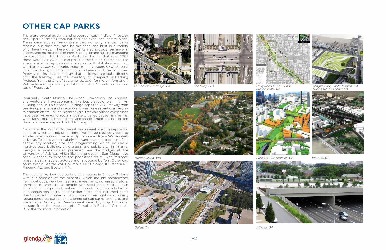
There are several existing and proposed “cap”, “lid”, or “freeway deck” park examples from national and even local communities. These case studies demonstrate that not only are cap parks feasible, but they may also be designed and built in a variety of different ways. These other parks also provide guidance in understanding methods for constructing, financing, and managing for Space 134. The Trust for Public Land found that as of 2007 there were over 20 built cap parks in the United States and the average size for cap parks is nine acres (both statistics from Lau, C Urban Freeway Cap Parks Policy Briefing Paper, USC). Several locations throughout the country also have structures built over freeway decks, that is to say that buildings are built directly atop the freeway, See the Inventory of Comparative Decking Projects from the City of Sacramento, 2001 for more information. Wikipedia also has a fairly substantial list of “Structures Built on top of Freeways.”
Regionally, Santa Monica, Hollywood, Downtown Los Angeles, and Ventura all have cap parks in various stages of planning. An existing park in La Canada Flintridge caps the 210 Freeway with passive open space and a gazebo and was done as part of a freeway mitigation effort. In San Diego several freeway bridge overpasses have been widened to accommodate widened pedestrian realms, with transit plazas, landscaping, and shade structures. In addition there is a 4-acre cap with a full freeway lid.
Nationally, the Pacific Northwest has several existing cap parks, some of which are pictured, right, from large passive greens to smaller urban plazas. The recently completed Klyde Warren Park in Dallas Texas is a particularly relevant example because of its central city location, size, and programming, which includes a multi-purpose building, civic green, and public art. In Atlanta, Georgia a smaller-scaled precedent are the bridges at the University of Atlanta, which like the bridges in San Diego have been widened to expand the pedestrian-realm, with terraced grassy areas, shade structures and landscape buffers. Other cap parks exist in Seattle, WA; Columbus, OH; Chicago, IL; Trenton NJ; Phoenix, AZ; and Boston, MA.
The costs for various cap parks are compared in Chapter 3 along with a discussion of the benefits, which include reconnected neighborhoods, new business and investment, increased visitors, provision of amenities to people who need them most, and an enhancement of property values. The costs include a substantial land acquisition costs, construction costs, and increased costs due to project complexity. Acquisition of air rights and leasing regulations are a particular challenge for cap parks. See “Creating Sustainable Air Rights Development Over Highway Corridors: Lessons from the Massachusetts Turnpike in Boston,” Campbell, B., 2004 for more information.
OTHER CAP PARKS
121
La Canada Flintridge, CA San Diego, CA
Dallas, TX Atlanta, GA
Mercer Island, WA Park 101, Los Angeles, CA Ventura, CA
Tongva Park, Santa Monica, CA(Not a full cap concept)
Hollywood Central Park, Los Angeles, CA

UNDERSTANDING SCALEThe Space 134 study area covers a large swath of Downtown, with approximately 36 acres from Central Avenue in the west to Glendale Avenue in the east and spans anywhere between 470ft and 270ft wide north to south. It is about seven city blocks from one end to another. To put this in context, this is 12 acres larger than Millennium Park in Chicago (approximately 24 acres).
In terms of spatial requirements, Space 134 can accommodate active courts and fields, basketball, volley ball, bocce, little league baseball, even one regulation size soccer field, although the soccer field would leave little room for spectators. Other programmable spaces can also fit, such as multi-purpose / outdoor yoga fields, convention tents, concert arenas and a farmers market.
Truly Space 134 provides a unique opportunity to host various cultural, artistic, and civic activities in the heart of Glendale. Imagine an open air ethnic food festival, local music fair, animation exhibition, a regular farmers market, or a movie night in the park.
FIGURE x
Pioneer Square, Portland Campus Martius, DetroitJameson Square, Portland Bryant Park, NY
Size: 1.2 ACHardscape: 65%Softcape: 25%Amenities: 10%
Size: 1.2 ACHardscape: 75%Softscape: 00%Amenities: 25%
Size: 2.1 ACHardscape: 55%Softscape: 20%Amenities: 15%
Size: 6.6 ACHardscape: 50%Softscape: 20%Amenities: 30%
hard
soft
soft
soft
amenityamenity
amenity
amen
ity
hardhard hard
Yerba Buena Gardens, SF
Size: 4.5 ACHardscape: 35%Softscape: 40%Amenities: 25%
hard
soft
amenity
LA Events Center Open space Investigations06.20.11
p.2
Union Square, SF
Size: 3.5 ACHardscape: 45%Softscape: 20%Amenities: 35%
hard
soft
amenity
Plazas:Program Comparison
LA Events Center Open space Investigations06.20.11
Grand Hope Park, LA One Colorado, PasadenaMaguire Gardens, LA Pershing Square, LANokia Plaza, LAGilbert Lindsay Plaza, LA
Size: .8 ACHardscape: 85%Softscape: 15%Amenities: 00%
Size: 3 AC (incl. street)Hardscape: 90%Softscape: 8%Amenities: 2%
Size: 1.1 ACHardscape: 35%Softscape: 50%Amenities: 15%
Size: 4.3 ACHardscape: 50%Softscape: 25%Amenities: 25%
Size: 2.5 ACHardscape: 65%Softscape: 30%Amenities: 5%
Size: .25 ACHardscape: 90%Softscape: 00%Amenities: 05%
Plazas:Program Comparison
hardhard
hard
hard
hard
hard
soft
soft so
ft
soft
soft
amenity amenity
amen
ity
amenity
amen
ity
p.1
Pioneer Square, Portland Campus Martius, DetroitJameson Square, Portland Bryant Park, NY
Size: 1.2 ACHardscape: 65%Softcape: 25%Amenities: 10%
Size: 1.2 ACHardscape: 75%Softscape: 00%Amenities: 25%
Size: 2.1 ACHardscape: 55%Softscape: 20%Amenities: 15%
Size: 6.6 ACHardscape: 50%Softscape: 20%Amenities: 30%
hard
soft
soft
soft
amenityamenity
amenity
amen
ity
hardhard hard
Yerba Buena Gardens, SF
Size: 4.5 ACHardscape: 35%Softscape: 40%Amenities: 25%
hard
soft
amenity
LA Events Center Open space Investigations06.20.11
p.2
Union Square, SF
Size: 3.5 ACHardscape: 45%Softscape: 20%Amenities: 35%
hard
soft
amenity
Plazas:Program Comparison
Pioneer Square, Portland
Campus Martius, Detroit
Jameson Square, Portland
Bryant Park, NY
Yerba Buena Gardens, SF
Union Square, SF
One Colorado, Pasadena
Maguire Gardens, LA
Pershing Square, LA
Nokia Plaza, LA
1 AC 2 AC
3
0.8
1.1
4.3
.25
3.5
4.5
1.2
1.2
2.1
6.6
3 AC 4 AC 5 AC 6 AC
Plazas:SizeComparison
Gilbert Lindsay Plaza, LA
LA Events Center Open space Investigations06.20.11
p.3
Space 134 and Scale
131
SCALE AND SIZEWhat Fits?
In order to get a feel for the size and scale of the area and widths that may be capped:
half court / 3 on 3 basketball tournament8 - 50’x50’ courts (with 20’ buffer)
Bran
d Blvd
Maryl
and A
ve
kenw
ood S
t
Oran
ge S
t
Centr
al Av
e
Jack
son S
t
Louis
e St
Jackson PlMaryland PlSanchez Dr
Burchett St
Arden Ave
0 40 800 200’ 400’
1
2
3
4
5
6
7
8
9
10
full court / 5 on 5 basketball tournament8 - 50’ x 100’ courts (with 20’ buffer)
Farmers Market Booths or art in the park80 - 10’x10’ booths (4 rows with 20 per row)
Little League baseball1 Field
Regulation soccer1 Full size FieldLarge garden event space
10,000 sf (700–1,000 ppl.)
Convention / event tent140’x300’
concert in the park40,000 sf open lawn seating with Stage(2,700 spectators)
outdoor yoga60’x100’ = 100 ppl.
small movie in the park1,500 blankets = 2,500+ ppl, screen 30 ft. wide
1 2 3 4 5 6 7 8 9 10
1
2
3
4
5
6
7
8
9
10
Half court / 3 on 3 basketball tournament8 - 50’x50’ courts (with 20’ buffer)
Full court / 5 on 5 basketball tournament8 - 50’ x 100’ courts (with 20’ buffer)
Large garden event space10,000 sf (700–1,000 ppl.)
Convention / event tent140’x300’
Concert in the park40,000 sf open lawn seating with Stage (2,700 spectators)
Farmers Market Booths or art in the park80 - 10’x10’ booths (4 rows with 20 per row)
Little League baseball Field1 Field
Regulation soccer1 Full size Field
Outdoor Yoga60’x100’ = 100 ppl.
Small movie in the park1,500 blankets = 2,500+ ppl, screen 30 ft. wide
Amenities Softscape Hardscapes
A Comparison of Scale of Parks and Plazas

THEME AND BRAND
Glendale is “Southern California community full of character where imaginations and visionary minds create and animate films, neighborhoods, and some of the world‘s most recognizable brands.”(City of Glendale, Branding Report)
“Look for ways to create and market ‘being space/third places’ in downtown.”(City of Glendale, Branding Report)
141
In 2011, Glendale completed a Branding Report that lays out a vision for an updated brand strategy, including logo, tag lines, creative brand collateral material, and brand implementation and management. Space 134 should build upon this brand, especially in terms of the elements that were identified that differentiate the City from its competitors.
Here is what the Branding Report described as Glendale’s strengths:• Neighborhoods: Glendale has 33 neighborhoods throughout
the City. Each neighborhood is unique and distinct and brings a different flavor to the community.
• Strong mix of business: Glendale has a strong economic base that is dominated by financial services, retail, service industries, healthcare, and manufacturing companies. The City is home to several small businesses and concept stores as well as corporate headquarters to companies such as Nestle and IHOP.
• Creative Corridor: Creative entertainment companies such as Disney and DreamWorks call Glendale home.
• Accessibility: The City has excellent accessibility in Southern California via freeways and the convenience of the Los Angeles and Burbank airports.
• City Services: The research showed that Glendale has a well managed City government, and the City is considered to be safe and clean.
• Diversity: Glendale‘s resident base is diverse with more than 65 different languages represented among the City‘s residents.
• Village Feel: Even though Glendale is a large City, a village atmosphere permeates through the many neighborhood districts. This emphasizes quality of life attributes and positions Glendale as a great place to raise a family.
• Parks and Recreation: The residents rate the city parks highly, and cite them as a point of community pride. The outdoor recreation is a draw for people in neighboring communities. The Brand Library is a gateway to many hiking trails throughout the City.
• Education: Glendale Community College is an excellent higher education institution that serves a large student population and contributes to the trained and educated workforce.
• Restaurants: Glendale is home to many ethnic cuisines. There are a variety of restaurants here for everyone.
• Retail: The City is known as a strong retail destination with shopping at the Glendale Galleria, Americana at Brand, Glendale Marketplace, and the Glendale Fashion Center.
And Glendale’s opportunities:• Creative Corridor: With anchors like Dreamworks and Disney,
attracting creative industries in the San Fernando Road Corridor is a natural fit for Glendale.
• Start-ups/concept stores: Glendale has a number of small businesses that are locally-owned. The city could make supporting entrepreneurs a priority by offering incentives, business classes, or creating an incubator program complete with work space for up-and-coming companies. With a history as an early-influencer among retailers, Glendale should tell
that story to attract the next concept store success story. • Public Art: The urban art program was recently expanded as a City-
wide program that will develop public art for the community. This will add to the culture and enrich the community if properly funded.
• Community College: A strong partnership between Glendale Community College and the Glendale business community will enhance workforce development programs.
• Cohesive Message: As a result of this branding initiative, Glendale will have a cohesive message to communicate to residents as well as the Southern California audience.
• Tourism: Glendale is already a destination for great shopping. There is opportunity in expanding (and marketing existing) visitor attractions to retail visitors and business travelers.
• Events: Glendale has some strong events such as Cruise Night, Harley Love Ride and Farmers Markets. The City has an opportunity to make a name for itself with more unique events that are family-oriented and celebrate the various neighborhood districts.
• Signage and Marketing: Entryway and wayfinding signage (wayfinding project underway) will allow the City to begin the campaign of reintroducing itself to audiences. The marketing of a new identity to target markets has a real opportunity to quickly impact economic growth.
Space 134 should be designed to capitalize on these assets and build the brand, from the creative industries that call the city home, with an emphasis on animation studios, to the diversity in cultures, food, and languages, and the village-feel of the city itself. The City’s tag line, “Glendale. Animated.” or “Your Life. Animated.” “Live. Animated.” Etc., can encapsulate the feel and taste of Space 134, as a place where “creativity is produced and enjoyed… a place of fun and entertainment… and a great place to be rather than a place between two others.” (Branding Report, p. 8). It is truly “Downtown. Animated.”
Space 134 can be what the branding report refers to as a “Being Space in Downtown” where people can come out, gather, produce, create, and collaborate in the outdoor, urban realm. These types of spaces will be increasingly critical as the Millennial generation of young professionals and empty-nester Baby Boomers- the folks who are increasingly coming to central city environments to live, work, and play-- create a powerful marketing demand for central city urban neighborhoods like downtown Glendale. These groups expect open space, multi-modal transit options, services, entertainment, and housing, all within walking and biking distance - and they demand a high-quality urban environment too.
Space 134 should:• Respect & Build the Brand• Showcase the Brand • Enhance Opportunities to Live, Work, & Play• Position Downtown as THE Hub of Activity, Creativity Movement,
Excitement
It is not only the end product that can reflect the city’s brand, the look of the signage, the programming of the park itself, rather the process of designing and conceptualizing Space 134 should be branded to match. The “Let’s Make Space 134” logo and tag line (right) has started to take hold as a process brand which engages community members in a collaborative process.
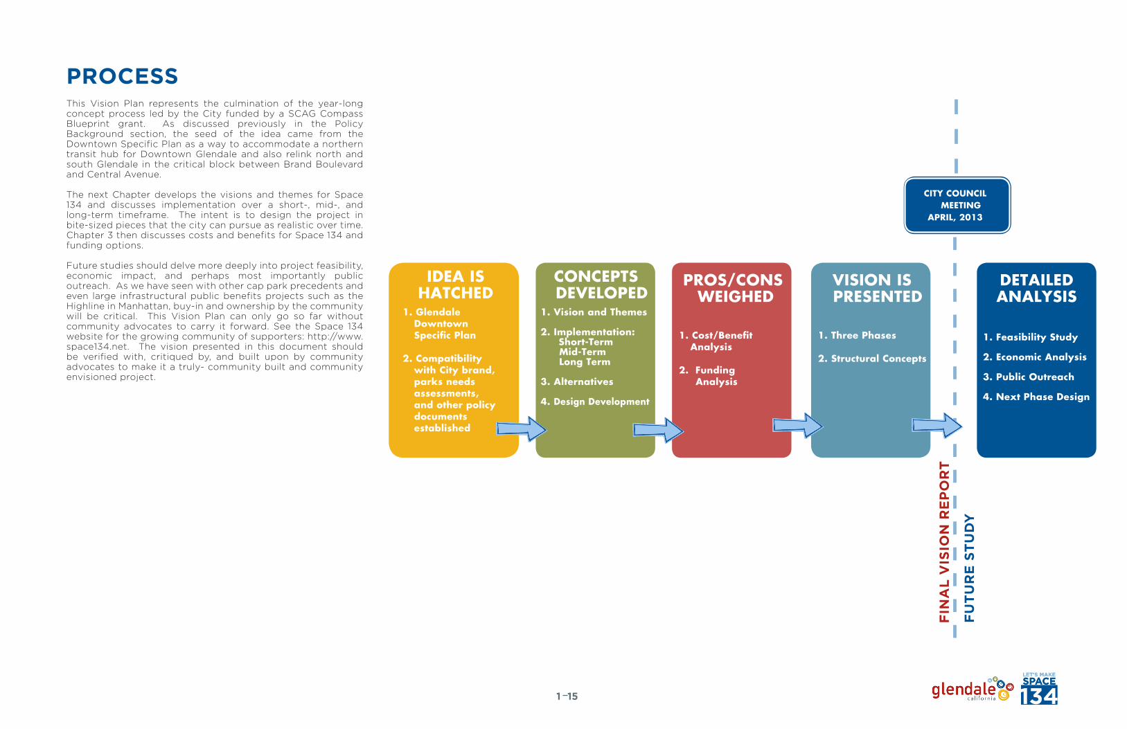
PROCESS
151
This Vision Plan represents the culmination of the year-long concept process led by the City funded by a SCAG Compass Blueprint grant. As discussed previously in the Policy Background section, the seed of the idea came from the Downtown Specific Plan as a way to accommodate a northern transit hub for Downtown Glendale and also relink north and south Glendale in the critical block between Brand Boulevard and Central Avenue.
The next Chapter develops the visions and themes for Space 134 and discusses implementation over a short-, mid-, and long-term timeframe. The intent is to design the project in bite-sized pieces that the city can pursue as realistic over time. Chapter 3 then discusses costs and benefits for Space 134 and funding options.
Future studies should delve more deeply into project feasibility, economic impact, and perhaps most importantly public outreach. As we have seen with other cap park precedents and even large infrastructural public benefits projects such as the Highline in Manhattan, buy-in and ownership by the community will be critical. This Vision Plan can only go so far without community advocates to carry it forward. See the Space 134 website for the growing community of supporters: http://www.space134.net. The vision presented in this document should be verified with, critiqued by, and built upon by community advocates to make it a truly- community built and community envisioned project.
IDEA ISHATCHED
1. Glendale Downtown Specific Plan
2. Compatibility with City brand, parks needs assessments, and other policy documents established
PROS/CONS WEIGHED
VISION IS PRESENTED
1. Cost/Benefit Analysis
2. Funding Analysis
1. Three Phases
2. Structural Concepts
CONCEPTS DEVELOPED
1. Vision and Themes
2. Implementation: Short-Term
Mid-Term Long Term
3. Alternatives
4. Design Development
DETAILEDANALYSIS
1. Feasibility Study
2. Economic Analysis
3. Public Outreach
4. Next Phase Design
FIN
AL
VIS
ION
RE
PO
RT
FU
TU
RE
ST
UD
Y
CITY COUNCIL MEETING
APRIL, 2013

THIS PAGE LEFT INTENTIONALLY BLANK

SPACE 134: THE VISION

THIS PAGE LEFT INTENTIONALLY BLANK
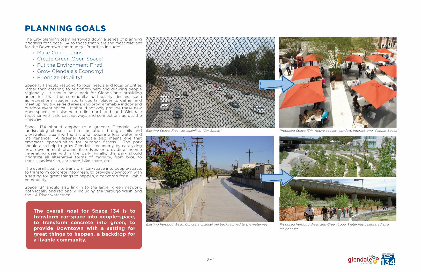
PLANNING GOALSThe City planning team narrowed down a series of planning priorities for Space 134 to those that were the most relevant for the Downtown community. Priorities include:
• Make Connections!• Create Green Open Space!• Put the Environment First!• Grow Glendale’s Economy!• Prioritize Mobility!
Space 134 should respond to local needs and local priorities rather than catering to out-of-towners and drawing people regionally. It should be a park for Glendalian’s providing amenities that the community particularly desires, such as recreational spaces, sports courts, places to gather and meet up, multi-use field areas, and programmable indoor and outdoor event space. It should not only provide these new open spaces, but also help to link north and south Glendale together with safe passageways and connections across the Freeway.
Space 134 should emphasize a greener Glendale, with landscaping chosen to filter pollution through soils and bio-swales, cleaning the air, and requiring less water and maintenance. A greener Glendale also means one that embraces opportunities for outdoor fitness. The park should also help to grow Glendale’s economy, by catalyzing new development around its edges or providing income generating uses within the park. Finally, the park should prioritize all alternative forms of mobility, from bike, to transit, pedestrian, car share, bike share, etc.
The overall goal is to transform car-space into people-space, to transform concrete into green, to provide Downtown with a setting for great things to happen, a backdrop for a livable community.
Space 134 should also link in to the larger green network, both locally and regionally, including the Verdugo Wash, and the LA River watershed.
PLANNING GOALS
Existing Space: Freeway, chainlink. “Car-Space”
Existing Verdugo Wash: Concrete channel. All backs turned to the waterway
Proposed Space 134: Active spaces, comfort, interest, and “People-Space”
Proposed Verdugo Wash and Green Loop: Waterway celebrated as a major asset
The overall goal for Space 134 is to transform car-space into people-space, to transform concrete into green, to provide Downtown with a setting for great things to happen, a backdrop for a livable community.
12
Verdugo Wash

THE VISION: SPACE 134. ANIMATED.The vision for Space 134 is a multi-purpose community space with passive open space, programmed community and civic buildings, and a new eastern development node. Space 134 will reflect Glendale’s diverse culture and it’s creative industry and provide space for the growing Downtown to evolve as a livable community.
The Space 134 “cap park” will re-link north and south Glendale and repair the urban fabric that was ripped apart by the 134 Freeway, revitalizing highway-adjacent Downtown communities. It will catalyze new development and investment in the city and to become the next great place in Glendale. More specifically it will fulfill the city’s visions for the Downtown Area as put forth in the Downtown Specific Plan and the City’s recent branding effort and create a real “people space”, bringing people out into the public realm.
By promoting Downtown Glendale’s identity as an attractive cutting-edge regional destination, and providing much-needed open space amenities to the City’s many residents, the energy that is focused into the Downtown area will help make Downtown a “complete neighborhood”. The “cap park” will help sustain the larger urban context, allowing Downtown Glendale to increase its density while maintaining ample space that caters to alternative transportation, health, recreation, and resource conservation. Space 134 will live up to the City’s identity as a forward thinking, well-rounded place, a regional commercial and cultural center, both a “destination” and a “home”.
The 40-year full build-out vision includes a major new passive and active park with neighborhood-serving uses, evolution of a “Green Loop”, where the Freeway overpasses will be widened, enhancement of the City’s green network with a walk and bike “active Glendale” loop, and a main park at Brand Boulevard and Central Avenue with conference and event facilities, an outdoor plaza and programmable outdoor space immediately responding to the needs of Downtown residents. At the same time a more neighborhood-scaled park along a Safe Routes to School street is envisioned in the east at a critical link between north and south Glendale.
22
0’ 400’ 800’
Outdoor Dining and Pavilion Cafe The Great LawnAn 18-hour Downtown Experience Hip Things to Do and See
TIMEFRAME: 40+ yRSOPEN SPACE / CAP: 28 ACRES
The Space 134 Vision Concept

THE LOOPCentral to the Space 134 concept is “The Loop”. The Loop is a set of physical elements in the park and even in adjacent streets that draw the user through the space and tie it together along a main spine path with stops along the way where people can move, interact, innovate, engage, and learn. These “stations” may include interactive public art, fitness stations, innovative technology displays, and outdoor musical instruments. They should happen every 300 – 500 ft along the main path network and will be linked with the overall signage program. They will help to break the space down into human-scaled, manageable increments.
A continuous visual element such as a linear, winding bench may pop up in places to reinforce the loop, or may manifest in a re-occurring color or signage elements.
This main park loop should be linked into the bigger green loop that is discussed in the short-term vision later on in this section, that is to say the green loop of enhanced overpasses and streets to link Space 134 to the Verdugo Wash and the regional greenspace network.
Move
Touch / Interact
Innovate
Engage / Learn
32
Digital Studios
Music Place
Nature Garden
OutdoorTheater/Art Park
Playfi eldsCentral Market/ Local Cuisines
Verdugo Trail
Ferris Wheel
Fitness StationOutdoor Music / Interactive Art
Cell Phone BoothBike Station / Amenity
The Green Loop Concept Envisioned: Plan, Bench Concept, and Signage

THREE CHARACTER AREASAlong the project corridor, there are three distinct character areas defined by changing land use patterns, community character and urban form:
AREA 1Due to its close proximity to the Glendale Central Business District this area is more civic/commercial in character and denser in building typologies. Space 134 in this area should reflect a bustling, 18-hour Downtown environment, with programmable spaces, more hardscaping and spaces that respond in size and scale to the Downtown milieu.
AREA 2Area 2 is much more residential in character. Multi-family residential units are located to both the north and south of the 134 Freeway, with scattered single-family dwellings as well, some of which are historically relevant. Streets are smaller in scale, as are buildings. Space 134 should have a more neighborhood-oriented recreational identity in this area, providing residents with areas to gather, play, and exercise on a small-scale.
AREA 3The defining characteristic of Area 3 has to do with its potential for redevelopment and its current land use classification, as well as its proximity to Downtown. This area is currently dominated by a collection of auto-oriented commercial uses, which suggest great potential for redevelopment into a more pedestrian- and bicyclist-friendly eastern node, with a more dynamic mix of uses. Space 134 should respond to this potential in the eastern segment.
Area 1: Critical to the concept are street frontages that activate the street. Pictured here: Brand Avenue at the new Animation Studio and mixed-use building
42
Area 1 Area 2 Area 3
MA
RY
LA
ND
AV
EM
AR
YL
AN
D A
VE
MA
RY
LA
ND
AV
E
KE
NW
OO
D S
TK
EN
WO
OD
ST
KE
NW
OO
D S
T
OR
AN
GE
ST
OR
AN
GE
ST
OR
AN
GE
ST
OR
AN
GE
ST
OR
AN
GE
ST
OR
AN
GE
ST
CE
NT
RA
L A
VE
JA
CK
SO
N S
TJ
AC
KS
ON
ST
JA
CK
SO
N S
T
HO
WA
RD
ST
HO
WA
RD
ST
HO
WA
RD
ST
GE
NE
VA
ST
GE
NE
VA
ST
GE
NE
VA
ST
GE
NE
VA
ST
GE
NE
VA
ST
GE
NE
VA
ST
E D O R A N S TE D O R A N S TE D O R A N S TE D O R A N S TE D O R A N S TE D O R A N S TE D O R A N S TE D O R A N S T
J A C K S O N P L
G O O D E A V EG O O D E A V E
S A N C H E Z D RS A N C H E Z D RS A N C H E Z D R
GL
EN
DA
LE
AV
E
M O N T E R E Y R D
G L E N O A K S B L V DG L E N O A K S B L V DG L E N O A K S B L V D
B U R C H E T T S TB U R C H E T T S TB U R C H E T T S TB U R C H E T T S T
A R D E N A V EA R D E N A V EA R D E N A V E
G L E N O A K S B L V DG L E N O A K S B L V DG L E N O A K S B L V D
E D R Y D E N S T
MA
RY
LA
ND
AV
EM
AR
YL
AN
D A
VE
E D O R A N S TE D O R A N S TE D O R A N S TE D O R A N S TE D O R A N S TE D O R A N S TE D O R A N S TE D O R A N S TE D O R A N S TE D O R A N S TE D O R A N S TE D O R A N S TE D O R A N S TE D O R A N S TE D O R A N S TE D O R A N S TE D O R A N S TE D O R A N S TE D O R A N S TE D O R A N S TE D O R A N S TE D O R A N S TE D O R A N S TE D O R A N S TE D O R A N S TE D O R A N S TE D O R A N S TE D O R A N S TE D O R A N S TE D O R A N S TE D O R A N S T
A R D E N A V EA R D E N A V E
B U R C H E T T S TB U R C H E T T S TB U R C H E T T S TB U R C H E T T S TB U R C H E T T S TB U R C H E T T S TB U R C H E T T S TB U R C H E T T S TB U R C H E T T S TB U R C H E T T S TB U R C H E T T S TB U R C H E T T S TB U R C H E T T S TB U R C H E T T S TB U R C H E T T S T M O N T E R E Y R DM O N T E R E Y R DM O N T E R E Y R DM O N T E R E Y R D
E D R Y D E N S TE D R Y D E N S T
J A C K S O N P LJ A C K S O N P LJ A C K S O N P LJ A C K S O N P L
LO
UIS
E S
TL
OU
ISE
ST
LO
UIS
E S
TL
OU
ISE
ST
LO
UIS
E S
TBr
and B
lvdL
OU
ISE
ST
Bran
d Blvd
LO
UIS
E S
TL
OU
ISE
ST
Bran
d Blvd
LO
UIS
E S
TL
OU
ISE
ST
Bran
d Blvd
LO
UIS
E S
T
KE
NW
OO
D S
TK
EN
WO
OD
ST
KE
NW
OO
D S
TMa
rylan
d Ave
Maryl
and A
veMa
rylan
d Ave
Maryl
and A
veK
EN
WO
OD
ST
Maryl
and A
veK
EN
WO
OD
ST
KE
NW
OO
D S
TMa
rylan
d Ave
KE
NW
OO
D S
TK
EN
WO
OD
ST
Maryl
and A
veK
EN
WO
OD
ST
Maryl
and A
veMa
rylan
d Ave
Maryl
and A
veMa
rylan
d Ave
Maryl
and A
veMa
rylan
d Ave
Maryl
and A
veMa
rylan
d Ave
Maryl
and A
veMa
rylan
d Ave
Maryl
and A
ve
ISA
BE
L S
TIS
AB
EL
ST
ISA
BE
L S
TKe
nwoo
d St
Kenw
ood S
tKe
nwoo
d St
ISA
BE
L S
TKe
nwoo
d St
ISA
BE
L S
TIS
AB
EL
ST
Kenw
ood S
tIS
AB
EL
ST
ISA
BE
L S
TKe
nwoo
d St
ISA
BE
L S
T
MA
RY
LA
ND
AV
EM
AR
YL
AN
D A
VE
MA
RY
LA
ND
AV
EM
AR
YL
AN
D A
VE
MA
RY
LA
ND
AV
EOr
ange
St
Oran
ge S
tOr
ange
St
Oran
ge S
tOr
ange
St
Oran
ge S
tOr
ange
St
Oran
ge S
tOr
ange
St
Oran
ge S
tOr
ange
St
Oran
ge S
tOr
ange
St
Oran
ge S
tM
AR
YL
AN
D A
VE
Oran
ge S
tM
AR
YL
AN
D A
VE
MA
RY
LA
ND
AV
EOr
ange
St
MA
RY
LA
ND
AV
EM
AR
YL
AN
D A
VE
Oran
ge S
tM
AR
YL
AN
D A
VE
Oran
ge S
tM
AR
YL
AN
D A
VE
Oran
ge S
tM
AR
YL
AN
D A
VE
Oran
ge S
tM
AR
YL
AN
D A
VE
Oran
ge S
tM
AR
YL
AN
D A
VE
Oran
ge S
tOr
ange
St
Oran
ge S
tOr
ange
St
Oran
ge S
tOr
ange
St
BR
AN
D B
LV
DB
RA
ND
BL
VD
BR
AN
D B
LV
DB
RA
ND
BL
VD
BR
AN
D B
LV
DCe
ntral
Ave
Centr
al Av
eCe
ntral
Ave
BR
AN
D B
LV
DCe
ntral
Ave
BR
AN
D B
LV
DB
RA
ND
BL
VD
Centr
al Av
eB
RA
ND
BL
VD
BR
AN
D B
LV
DCe
ntral
Ave
BR
AN
D B
LV
DB
RA
ND
BL
VD
Centr
al Av
eB
RA
ND
BL
VD
BR
AN
D B
LV
DCe
ntral
Ave
BR
AN
D B
LV
D
HO
WA
RD
ST
HO
WA
RD
ST
HO
WA
RD
ST
Jack
son S
tJa
ckso
n St
Jack
son S
tH
OW
AR
D S
TJa
ckso
n St
HO
WA
RD
ST
HO
WA
RD
ST
Jack
son S
tH
OW
AR
D S
TH
OW
AR
D S
TJa
ckso
n St
HO
WA
RD
ST
GE
NE
VA
ST
GE
NE
VA
ST
GE
NE
VA
ST Isa
bel S
tIsa
bel S
tIsa
bel S
tIsa
bel S
tIsa
bel S
tG
EN
EV
A S
T Isabe
l St
GE
NE
VA
ST
GE
NE
VA
ST Isa
bel S
tG
EN
EV
A S
TG
EN
EV
A S
T Isabe
l St
GE
NE
VA
ST
JA
CK
SO
N S
TJ
AC
KS
ON
ST
JA
CK
SO
N S
TLo
uise S
tLo
uise S
tLo
uise S
tLo
uise S
tJ
AC
KS
ON
ST
Louis
e St
JA
CK
SO
N S
TJ
AC
KS
ON
ST
Louis
e St
JA
CK
SO
N S
TJ
AC
KS
ON
ST
Louis
e St
JA
CK
SO
N S
T
Gene
va S
tGe
neva
St
Gene
va S
tGe
neva
St
Gene
va S
t
Verdugo Wash
GLENDALE SHOPPING GLENDALE SHOPPING GLENDALE SHOPPING GLENDALE SHOPPING GLENDALE SHOPPING GLENDALE SHOPPING GLENDALE SHOPPING GLENDALE SHOPPING GLENDALE SHOPPING GLENDALE SHOPPING GLENDALE SHOPPING GLENDALE SHOPPING GLENDALE SHOPPING GLENDALE SHOPPING GLENDALE SHOPPING GLENDALE SHOPPING GLENDALE SHOPPING GLENDALE SHOPPING GLENDALE SHOPPING GLENDALE SHOPPING GLENDALE SHOPPING GLENDALE SHOPPING GLENDALE SHOPPING GLENDALE SHOPPING GLENDALE SHOPPING GLENDALE SHOPPING GLENDALE SHOPPING GLENDALE SHOPPING GLENDALE SHOPPING GLENDALE SHOPPING GLENDALE SHOPPING GLENDALE SHOPPING GLENDALE SHOPPING GLENDALE SHOPPING GLENDALE SHOPPING GLENDALE SHOPPING GLENDALE SHOPPING GLENDALE SHOPPING GLENDALE SHOPPING GLENDALE SHOPPING PLAZA PLAZA PLAZA PLAZA PLAZA PLAZA PLAZA PLAZA PLAZA PLAZA PLAZA PLAZA PLAZA
RD WHITE RD WHITE RD WHITE RD WHITE RD WHITE RD WHITE RD WHITE RD WHITE RD WHITE RD WHITE RD WHITE RD WHITE RD WHITE RD WHITE RD WHITE RD WHITE RD WHITE RD WHITE RD WHITE RD WHITE RD WHITE RD WHITE RD WHITE RD WHITE RD WHITE RD WHITE RD WHITE RD WHITE RD WHITE RD WHITE RD WHITE RD WHITE RD WHITE RD WHITE RD WHITE RD WHITE RD WHITE RD WHITE RD WHITE RD WHITE RD WHITE RD WHITE ELEMENTARy ELEMENTARy ELEMENTARy ELEMENTARy ELEMENTARy ELEMENTARy ELEMENTARy ELEMENTARy ELEMENTARy ELEMENTARy ELEMENTARy ELEMENTARy ELEMENTARy ELEMENTARy ELEMENTARy ELEMENTARy ELEMENTARy ELEMENTARy ELEMENTARy ELEMENTARy ELEMENTARy ELEMENTARy ELEMENTARy
SCHOOLSCHOOLSCHOOLSCHOOLSCHOOLSCHOOLSCHOOLSCHOOLSCHOOLSCHOOLSCHOOLSCHOOLSCHOOLSCHOOLSCHOOLSCHOOLSCHOOLSCHOOL
WOODROW WOODROW WOODROW WOODROW WOODROW WOODROW WOODROW WOODROW WOODROW WOODROW WOODROW WOODROW WOODROW WOODROW WOODROW WOODROW WOODROW WOODROW WOODROW WOODROW WOODROW WOODROW WOODROW WOODROW WOODROW WOODROW WOODROW WOODROW WOODROW WOODROW WOODROW WOODROW WOODROW WOODROW WOODROW WOODROW WOODROW WOODROW WOODROW WOODROW WOODROW WOODROW WOODROW WOODROW WILSONWILSONWILSONWILSONWILSONWILSONWILSONWILSONWILSONWILSONWILSONWILSONWILSONWILSONWILSONWILSONWILSONWILSONWILSONWILSONWILSONWILSONWILSONWILSONWILSONWILSONWILSONWILSONWILSONWILSONWILSONWILSONWILSONWILSONWILSONWILSONWILSONWILSONSCHOOLSCHOOLSCHOOLSCHOOLSCHOOLSCHOOLSCHOOLSCHOOLSCHOOLSCHOOLSCHOOLSCHOOLSCHOOLSCHOOLSCHOOLSCHOOLSCHOOLSCHOOLSCHOOLSCHOOLSCHOOLSCHOOLSCHOOLSCHOOLSCHOOLSCHOOLSCHOOLSCHOOLSCHOOLSCHOOLSCHOOL
DOWNTOWN GLENDALEDOWNTOWN GLENDALEDOWNTOWN GLENDALEDOWNTOWN GLENDALEDOWNTOWN GLENDALEDOWNTOWN GLENDALEDOWNTOWN GLENDALEDOWNTOWN GLENDALEDOWNTOWN GLENDALEDOWNTOWN GLENDALEDOWNTOWN GLENDALEDOWNTOWN GLENDALEDOWNTOWN GLENDALEDOWNTOWN GLENDALEDOWNTOWN GLENDALEDOWNTOWN GLENDALEDOWNTOWN GLENDALEDOWNTOWN GLENDALEDOWNTOWN GLENDALEDOWNTOWN GLENDALEDOWNTOWN GLENDALEDOWNTOWN GLENDALEDOWNTOWN GLENDALEDOWNTOWN GLENDALEDOWNTOWN GLENDALEDOWNTOWN GLENDALEDOWNTOWN GLENDALEDOWNTOWN GLENDALEDOWNTOWN GLENDALEDOWNTOWN GLENDALEDOWNTOWN GLENDALEDOWNTOWN GLENDALEDOWNTOWN GLENDALEDOWNTOWN GLENDALEDOWNTOWN GLENDALEDOWNTOWN GLENDALEDOWNTOWN GLENDALEDOWNTOWN GLENDALEDOWNTOWN GLENDALEDOWNTOWN GLENDALEDOWNTOWN GLENDALEDOWNTOWN GLENDALEDOWNTOWN GLENDALEDOWNTOWN GLENDALEDOWNTOWN GLENDALEDOWNTOWN GLENDALEDOWNTOWN GLENDALEDOWNTOWN GLENDALEDOWNTOWN GLENDALEDOWNTOWN GLENDALEDOWNTOWN GLENDALEDOWNTOWN GLENDALEDOWNTOWN GLENDALEDOWNTOWN GLENDALEDOWNTOWN GLENDALEDOWNTOWN GLENDALEDOWNTOWN GLENDALEDOWNTOWN GLENDALEDOWNTOWN GLENDALEDOWNTOWN GLENDALEDOWNTOWN GLENDALEDOWNTOWN GLENDALEDOWNTOWN GLENDALEDOWNTOWN GLENDALEDOWNTOWN GLENDALEDOWNTOWN GLENDALEDOWNTOWN GLENDALEDOWNTOWN GLENDALEDOWNTOWN GLENDALEDOWNTOWN GLENDALEDOWNTOWN GLENDALEDOWNTOWN GLENDALEDOWNTOWN GLENDALEDOWNTOWN GLENDALEDOWNTOWN GLENDALEDOWNTOWN GLENDALEDOWNTOWN GLENDALEDOWNTOWN GLENDALEDOWNTOWN GLENDALEDOWNTOWN GLENDALEDOWNTOWN GLENDALEDOWNTOWN GLENDALEDOWNTOWN GLENDALEDOWNTOWN GLENDALEDOWNTOWN GLENDALEDOWNTOWN GLENDALEDOWNTOWN GLENDALEDOWNTOWN GLENDALEDOWNTOWN GLENDALEDOWNTOWN GLENDALEDOWNTOWN GLENDALEDOWNTOWN GLENDALEDOWNTOWN GLENDALE
E Doran SE Doran SE Doran SE Doran SE Doran SE Doran SE Doran SE Doran SE Doran SE Doran SE Doran SE Doran SE Doran SE Doran SE Doran SE Doran SE Doran SE Doran SE Doran SE Doran SE Doran SE Doran SE Doran SE Doran SE Doran SE Doran SE Doran SE Doran SE Doran SE Doran SE Doran SE Doran SE Doran SE Doran Sttttttttt
Maurita PlMaryland PlSanchez DrSanchez DrSanchez DrSanchez DrSanchez DrS A N C H E Z D RSanchez DrS A N C H E Z D RS A N C H E Z D RSanchez DrS A N C H E Z D RS A N C H E Z D RSanchez DrS A N C H E Z D R
G O O D E A V EG O O D E A V EGoode AveGoode AveGoode AveG O O D E A V EGoode AveG O O D E A V EG O O D E A V EGoode AveG O O D E A V EGoode AveGoode Ave
CE
NT
RA
L A
VE
Colum
bus A
veC
EN
TR
AL
AV
ECo
lumbu
s Ave
CE
NT
RA
L A
VE
Colum
bus A
veCo
lumbu
s Ave
Colum
bus A
veCo
lumbu
s Ave
Glenoaks BlvdGlenoaks BlvdGlenoaks Blvd
Burchett StBurchett StBurchett StBurchett StBurchett StBurchett StBurchett StBurchett StBurchett St
Arden AveArden AveArden AveArden AveArden AveArden AveArden AveArden AveArden AveArden AveArden AveArden AveArden Ave
E Dryden StE Dryden StE Dryden StE Dryden StE Dryden StE Dryden StE Dryden StE Dryden StE Dryden StE Dryden StE Dryden StE Dryden StE Dryden StE Dryden StE Dryden StE Dryden StE Dryden StE Dryden StE Dryden StE Dryden StE Dryden StE Dryden St
Maurita PlMaurita PlMaurita PlJ A C K S O N P LM A R Y L A N D P LM A R Y L A N D P LM A R Y L A N D P LM A R Y L A N D P LM A R Y L A N D P L J A C K S O N P LJ A C K S O N P LJ A C K S O N P LJ A C K S O N P LJ A C K S O N P LJ A C K S O N P LJ A C K S O N P LJ A C K S O N P LM A R Y L A N D P LM A R Y L A N D P LM A R Y L A N D P LM A R Y L A N D P LM A R Y L A N D P LM A R Y L A N D P L Maryland PlMaryland PlMaryland PlJ A C K S O N P LMaryland PlJ A C K S O N P LJ A C K S O N P LMaryland PlJ A C K S O N P LJ A C K S O N P LMaryland PlJ A C K S O N P LMaryland PlJ A C K S O N P LMaryland PlJ A C K S O N P LJ A C K S O N P LMaryland PlJ A C K S O N P LJ A C K S O N P LMaryland PlJ A C K S O N P LMaryland PlJ A C K S O N P LMaryland PlJ A C K S O N P LJ A C K S O N P LMaryland PlJ A C K S O N P LJ A C K S O N P LMaryland PlJ A C K S O N P LMaryland PlMaryland PlMaryland PlJ A C K S O N P LMaryland PlJ A C K S O N P LJ A C K S O N P LMaryland PlJ A C K S O N P LJ A C K S O N P LMaryland PlJ A C K S O N P LMaryland PlJ A C K S O N P LMaryland PlJ A C K S O N P LMaryland PlMaryland PlMaryland PlMaryland Pl M A U R I T A P LM A U R I T A P LM A U R I T A P LM A U R I T A P LM A U R I T A P LJ A C K S O N P L M A U R I T A P LM A U R I T A P LM A U R I T A P LM A U R I T A P LM A U R I T A P LM A U R I T A P LM A U R I T A P LM A U R I T A P LM A U R I T A P LM A U R I T A P LM A U R I T A P LM A U R I T A P LM A U R I T A P LM A U R I T A P LM A U R I T A P LM A U R I T A P LM A U R I T A P LM A U R I T A P LJ A C K S O N P LJ A C K S O N P LJ A C K S O N P LJ A C K S O N P L Maurita PlMaurita PlMaurita PlMaurita PlMaurita PlJackson PlJackson PlJackson PlM A U R I T A P LJackson PlM A U R I T A P LJackson PlJackson PlJackson PlJackson PlJackson PlJackson PlJackson PlJackson Pl
Maurita Pl
AREA 2AREA 1 AREA 3
GE
NE
VA
ST
GE
NE
VA
ST
GE
NE
VA
ST
G L E N O A K S B L V DG L E N O A K S B L V DG L E N O A K S B L V D
M O N T E R E Y R DM O N T E R E Y R DM O N T E R E Y R DM O N T E R E Y R DM O N T E R E Y R DM O N T E R E Y R DM O N T E R E Y R DM O N T E R E Y R DM O N T E R E Y R DM O N T E R E Y R DM O N T E R E Y R DM O N T E R E Y R DM O N T E R E Y R DM O N T E R E Y R DM O N T E R E Y R DM O N T E R E Y R DM O N T E R E Y R DM O N T E R E Y R DM O N T E R E Y R DM O N T E R E Y R DMonterey RdMonterey RdMonterey RdMonterey RdMonterey RdMonterey RdMonterey RdMonterey RdMonterey RdMonterey RdMonterey RdMonterey RdMonterey RdMonterey RdMonterey RdMonterey RdMonterey RdMonterey RdMonterey RdMonterey RdMonterey RdM O N T E R E Y R DMonterey RdM O N T E R E Y R DM O N T E R E Y R DMonterey RdM O N T E R E Y R DM O N T E R E Y R DMonterey RdM O N T E R E Y R DMonterey RdMonterey RdMonterey RdMonterey RdMonterey RdMonterey RdMonterey RdM O N T E R E Y R DMonterey RdM O N T E R E Y R DM O N T E R E Y R DMonterey RdM O N T E R E Y R DM O N T E R E Y R DMonterey RdM O N T E R E Y R DMonterey RdM O N T E R E Y R DMonterey RdM O N T E R E Y R DM O N T E R E Y R DMonterey RdM O N T E R E Y R DM O N T E R E Y R DMonterey RdM O N T E R E Y R DMonterey RdM O N T E R E Y R DMonterey RdM O N T E R E Y R DM O N T E R E Y R DMonterey RdM O N T E R E Y R DM O N T E R E Y R DMonterey RdM O N T E R E Y R DMonterey RdM O N T E R E Y R DMonterey RdM O N T E R E Y R DM O N T E R E Y R DMonterey RdM O N T E R E Y R DM O N T E R E Y R DMonterey RdM O N T E R E Y R DMonterey RdM O N T E R E Y R DMonterey RdM O N T E R E Y R DM O N T E R E Y R DMonterey RdM O N T E R E Y R DMonterey RdMonterey RdMonterey RdMonterey RdMonterey RdMonterey Rd
G L E N O A K S B L V DG L E N O A K S B L V DG L E N O A K S B L V DG L E N O A K S B L V DG L E N O A K S B L V DG L E N O A K S B L V DG L E N O A K S B L V DGlenoaks BlvdGlenoaks BlvdGlenoaks BlvdGlenoaks BlvdGlenoaks BlvdGlenoaks BlvdGlenoaks BlvdG L E N O A K S B L V DGlenoaks BlvdG L E N O A K S B L V DG L E N O A K S B L V DGlenoaks BlvdG L E N O A K S B L V DG L E N O A K S B L V DGlenoaks BlvdG L E N O A K S B L V DG L E N O A K S B L V DGlenoaks BlvdG L E N O A K S B L V DG L E N O A K S B L V DGlenoaks BlvdG L E N O A K S B L V DGlenoaks BlvdGlenoaks BlvdGlenoaks BlvdG L E N O A K S B L V DGlenoaks BlvdG L E N O A K S B L V DGlenoaks BlvdGlenoaks BlvdGlenoaks BlvdG L E N O A K S B L V DGlenoaks BlvdG L E N O A K S B L V DGlenoaks BlvdGlenoaks BlvdGlenoaks BlvdGlenoaks BlvdGlenoaks BlvdGlenoaks Blvd
Monterey Rd
Verdugo Wash
Verdugo Wash
Verdugo Wash
Verdugo Wash
Verdugo Wash
Verdugo Wash
Verdugo Wash
Verdugo Wash
Verdugo Wash
Verdugo Wash
Verdugo Wash
Verdugo Wash
Verdugo Wash
Verdugo Wash
Verdugo Wash
Verdugo Wash
Verdugo Wash
Verdugo Wash
Verdugo Wash
Verdugo Wash
Verdugo Wash
Verdugo Wash
Verdugo Wash
Verdugo Wash
Verdugo Wash
Verdugo Wash
Verdugo Wash
Verdugo Wash
Verdugo Wash
Verdugo Wash
Verdugo Wash
Verdugo Wash
Verdugo Wash
Verdugo Wash
Verdugo Wash
Verdugo Wash
Verdugo Wash
Verdugo Wash
Verdugo Wash
Verdugo Wash
Verdugo Wash
Verdugo Wash
Verdugo Wash
Verdugo Wash
Verdugo Wash
WOODROW WOODROW WOODROW WOODROW WOODROW WOODROW
Three character areas along the 134 Freeway

DORAN
MARyLAND
PIONEER
FRONTAGE
134 Freeway
BURCHETT
GLENOAKS
CE
NT
RA
L
BR
AN
D
LOU
ISE
AREA 1: CENTRAL TO LOUISE
POTENTIAL FOR:
• Conference facility / outdoor amphitheater uses and / or rentable, occupiable pavilions, multi-purpose space, or buildings. Other revenue-generating uses such as an art museum, etc.
• True 18-hour activation and creative programming that supports the “creative Glendale” brand.
• Memorable and Imaginable major art attraction, central attraction hub, eye-catching element visible from the Freeway and iconic to Glendale.
• Regional transit plaza, node, or station.
• Enhanced crossings and north-south linkages.
• Linkages to the existing adjacent corporate plaza and corporate uses.
• Corporate sponsorships.
• Bike-share, bike station, or car share. Shared parking with adjacent uses on nights and weekends.
• Infill of adjacent parcels with hotels as mutually-supporting with Space 134.
AREA 2: LOUISE TO GENEVA
POTENTIAL FOR:
• Passive open space areas, such as multi-purpose fields, picnic areas, courtyards, plazas, and walking trails, including art walks and art fields.
• Active open space that is neighborhood-scaled, such as basketball, volleyball, bocce, tetherball, or giant chessboard.
• Tot lots and playgrounds to work in tandem with safe routes to school improvements in the area.
• New pedestrian connections north-south through Space 134 at existing cul-de-sac streets and along key desire lines.
• Eventual redevelopment of parcels along the Space 134 edge for park-oriented development and eyes-on-the-park.
• New “woonerf” or neighborhood street east-west along the edge of Space 134 for maximum access, improved circulation, and eyes-on-the-park.
• Supportive uses such as cafe(s), bike facilities, bike share, bathrooms for park users.
DORAN
134 Freeway
MONTEREy
GLENOAKS
LOU
ISE
JAC
KS
ON
GE
NE
VA
AREA 3: GENEVA TO GLENDALE
POTENTIAL FOR:
• A wider cap park with a mix of built areas and open space areas for a new Glendale eastern node.
• A civic-scaled green space surrounded by new residential, mixed-use, and live-work development.
• New pedestrian connections north-south to reconnect streets, especially those that help to link to the new commercial core and to the schools to the north and south.
• Incorporation of the large shopping center property into the cap in terms of its design, new development, etc.
• Consolidation of on- and off-ramps to
accomplish a more substantial capping.
• An iconic design for the Glendale overpass bridge as an eye-catching element visible from the Freeway to brand the space and announce the city from those traveling from the east.
North
GLE
NDA
LE
MONTEREy
DORAN
134 Freeway
VONS
GE
NE
VA
THREE CHARACTER AREAS
52

NATURAL GLENDALEThe “natural” theme celebrates Glendale’s nature story, its proximity to the mountains, the Verdugo Wash, natural habitat, and it brings touches of nature into the heart of Downtown.
• Get connected to nature while being in the heart of Glendale • Views to the mountains / bringing the mountains ‘closer’• Chaparral, birds, local planting• Water play for children• Learning moments• Celebrate the transect of mountains, water, valley, through
design and programming. Symbolic transect: Mountains, Arroyo, Citrus Groves as link to agricultural past
• Link open-space-rich north Glendale, with more urban south Glendale
INTRODUCTIONA series of design concepts have been identified to unify Space 134 and provide themes which designers and planners can refer to and get inspiration from in future phases. The roles of these themes are to:
• Tie the Space together, guiding the design and arrangement of the Space
• Inform the programming of the areas within the park
• Link the Space into the larger Glendale context and the Glendale brand
• Market and “sell” it to constituents• Get people excited so they can see the
potential of what Space 134 can become
The themes are not mutually exclusive and several can be used at the same time to brand and identify the space.
LOCAL GLENDALEThe “local” theme celebrates Glendale’s rich ethnic panoply through food, cultures, music, and design.
• Places for independent businesses • Local cuisines and cultures / A Taste of Glendale • Work with the Americana at Brand not against • Places for food trucks • Occupiable flexible structure • Rentable space for weddings • Iconic design of pavilion by local designer • Art in the Park
DESIGN THEMES
Teardrop Park, New York
Franklin Park, Los Angeles
Portland, OR. Wave Fountain
St Louis City Garden. Arroyo Chess Park, Glendale, CAPortos Bakery, Glendale, CA
Portos Bakery, Glendale, CA
Local Food Trucks
Lucky’s on the Green, Tulsa, OK
Musical Instruments Playground
Playground Rock Climber
62

CELEBRATION OF THE CAPThis theme relates to the cap structure itself as inspiration for the park, both in terms of a celebration of its construction and engineering, and also in terms of the vehicles that are traveling beneath. The proximity and relationship to vehicles can be celebrated, rather than concealed.
• Connection to Glendale’s auto industry• Exposed support structures and trusses• Transparent walkways over Freeway • Play with Freeway walls in terms of art, lighting. Car lights
as art. • Gateway element visible from Freeway as iconic branding
element for people traveling on Freeway• A signature series of “red bridges” element to brand Space
134 and make it identifiable and memorable
ACTIVE GLENDALEThe “active” theme is focused on encouraging sports, walking, jogging, bicycling, etc., At Space 134, especially a walking and biking circuit or “green loop” link to Verdugo Wash and Fremont Park and to the larger LA River, Glendale Narrows, and the regional park network.
• Glendale-specific active recreation• Mobility hub• Links to bikeways and existing parks• Health stats and exercise circuit• Sports fields and courts • Pollution-screening trees and vegetation• Given the adjacency to the Verdugo Wash, Space 134
can be conceived of as a “green loop” with enhanced streetscaping, active recreation trails, and green improvements to the Wash
GLENDALE. ANIMATED.This final theme celebrates Glendale’s tie to the animation community and to its creative industries. This theme could manifest in a variety of ways from screened and framed moments and playful installations using light and sound to programmable outdoor space for plays, movies, and related events.
• Viewing portals to the Freeway• Outdoor movies and shows• Connection to animation studios• Interactive public art• Shadows and light play• Potential for corporate sponsorship to link theme and
brand of city
Guadalupe River Park and Gardens, San Jose, CA
Guadalupe River Park and Gardens, San Jose, CA
Stoner Skate Park, Los Angeles, CA Multi-age recreation
Westminster, CO
Jeffrey Open Space Trail, Irvine, CA
City Garden, St Louis, MO Lightboxes at Triangle Park, St Louis, MO.
Art Basel Convention, Miami, FL
High Line, New York, NY
Central Park, Redwing, MN
Union Square, San Francisco, CATianmen Mountain, China
ARoS Aarhus Kuntsmuseum, Denmark
Black Pool Tower, England
High Line, New York
Aquarena, San Marcos, Texas
Glass portals through cap to Freeway below
Mary Bartelme Park, Chicago, IL
Jewish Museum, Germany
72

The first stage of the Space 134 vision starts with a series of linear walkways and enhanced sidewalks to better link north and south Glendale. Freeway capping does not occur during this phase, rather attention is focused on the improvement of the pedestrian realm as well as enhanced facilities for bicyclists.
From Central Avenue to Balboa Avenue a segment of the Caltrans right-of-way is reclaimed for a bike and walk path along the south edge (see illustrative section, below right). The path, delineated with decomposed granite, special pavement, and directional / wayfinding signage begins to establish the “green loop” concept central to later phases of Space 134. East-west connectivity is enhanced and car-space is gradually transferred into people space. New pollution-screening landscaping along this edge, along with the running bench element help define the space.
The block-long segments of Maurita Place Jackson Place, and Maryland Place are reclaimed as pocket parks which can accommodate tot lots and passive open space with landscaping and places to sit. These parks will require demolition of existing street improvements (pavement, curbs, gutters, catch basins). Existing utilities will likely require some adjustments and/or relocations to accommodate the layout of park features.
On main north-south streets, street trees and pedestrian lighting are enhanced and a reoccurring signage or graphic element ties these streets into the green loop. Connections are made apparent to the Verdugo Wash.
At Central Avenue the overpass bridge structure is widened on one side to expand the pedestrian realm and mitigate the noise and experience of the Freeway while walking over it. Iconic art is installed onto the safety fence, an eye-catching piece visible from the Freeway beneath. Likewise at Balboa Avenue the cul-de-sac condition at the Freeway is ameliorated with a new eye-catching pedestrian- and bike-only bridge over the Freeway. As the gateway element from the east, this structure should be compatible with the visual voice at the western end of the Freeway at Central Avenue.
A PHASED APPROACH: 5-yEAR VISION FOR A GROWING PARK
82
TIMEFRAME: 1-5 yRSNEW OPEN SPACE: 5 ACRES
Interactive Public Art, Expanded Pedestrian Realm
A series of navigable “green loops through the Space 134 enhancement area
Multi-use Path with Fitness Stations
Bike Share/StationContinuous Path and Branded Art on Existing Fence, Sidewalk Widened
0’ 400’ 800’
Illustrative section through “green loop” trail on south edge of Freeway, east of Louise Street.
65’
134 Freeway Open Space
SetbackBike Path
Landscape Buffer
Ped.Trail
15’12’5’ 8’ 5’

NB
DR
IVE LA
NE
NB
DR
IVE LA
NE
EXISTIN
G SID
EWA
LK
EXTEN
DED
SIDEW
ALK
SB D
RIV
E LAN
E
SB LEFT TU
RN
LAN
EN
B LEFT TU
RN
LAN
EN
B LEFT TU
RN
LAN
E
SB D
RIV
E LAN
E
1 1 ’ 1 1 ’ 1 1 ’ 1 1 ’1 0 ’ 1 0 ’ 1 0 ’
1 2 ’
1 2 ’ 1 2 ’
1 2 ’74’98’ ROW
1 1 ’ 1 1 ’ 1 1 ’ 1 1 ’ 1 2 ’
1 2 ’
1 0 ’ 1 0 ’ 1 0 ’
2 2 ’
2 2 ’
74’108’ ROW
NB
DR
IVE LA
NE
NB
DR
IVE LA
NE
SB D
RIV
E LAN
E
SB D
RIV
E LAN
E
SB LEFT TU
RN
LAN
E
NB
LEFT TUR
N LA
NE
NB
LEFT TUR
N LA
NE
EXISTIN
G SID
EWA
LK
EXISTIN
G SID
EWA
LK
NB
DR
IVE LA
NE
NB
DR
IVE LA
NE
EXISTIN
G SID
EWA
LK
EXTEN
DED
SIDEW
ALK
SB D
RIV
E LAN
E
SB LEFT TU
RN
LAN
EN
B LEFT TU
RN
LAN
EN
B LEFT TU
RN
LAN
E
SB D
RIV
E LAN
E
1 1 ’ 1 1 ’ 1 1 ’ 1 1 ’1 0 ’ 1 0 ’ 1 0 ’
1 2 ’
1 2 ’ 1 2 ’
1 2 ’74’98’ ROW
1 1 ’ 1 1 ’ 1 1 ’ 1 1 ’ 1 2 ’
1 2 ’
1 0 ’ 1 0 ’ 1 0 ’
2 2 ’
2 2 ’
74’108’ ROW
NB
DR
IVE LA
NE
NB
DR
IVE LA
NE
SB D
RIV
E LAN
E
SB D
RIV
E LAN
E
SB LEFT TU
RN
LAN
E
NB
LEFT TUR
N LA
NE
NB
LEFT TUR
N LA
NE
EXISTIN
G SID
EWA
LK
EXISTIN
G SID
EWA
LK
ExISTING PROPOSEDEX
TEND
ED SID
EWA
LK
EXTEN
DED
SIDEW
ALK
PAR
KIN
G
PAR
KIN
G
NB
BIK
E LAN
E (1’ BU
FFER)
NB
DR
IVE LA
NE
SB D
RIV
E LAN
E
SB B
IKE LA
NE (1’ B
UFFER
)
EXISTIN
G SID
EWA
LK
EXISTIN
G SID
EWA
LK
PAR
KIN
G
PAR
KIN
G
NB
DR
IVE LA
NE
SB D
RIV
E LAN
E
1 7 ’7 ’ 17’
7 ’
7 ’
7 ’
9 ’ 9 ’
52’66’ ROW
12’ 12’ 1 7 ’
1 7 ’1 7 ’
1 7 ’
52’86’ ROW
9 ’ 9 ’ 5 ’ 5 ’
EXTEN
DED
SIDEW
ALK
EXTEN
DED
SIDEW
ALK
PAR
KIN
G
PAR
KIN
G
NB
BIK
E LAN
E (1’ BU
FFER)
NB
DR
IVE LA
NE
SB D
RIV
E LAN
E
SB B
IKE LA
NE (1’ B
UFFER
)
EXISTIN
G SID
EWA
LK
EXISTIN
G SID
EWA
LK
PAR
KIN
G
PAR
KIN
G
NB
DR
IVE LA
NE
SB D
RIV
E LAN
E
1 7 ’7 ’ 17’
7 ’
7 ’
7 ’
9 ’ 9 ’
52’66’ ROW
12’ 12’ 1 7 ’
1 7 ’1 7 ’
1 7 ’
52’86’ ROW
9 ’ 9 ’ 5 ’ 5 ’
ExISTING
PROPOSED
SECTION A - CENTRAL AVENUE BRIDGE
SECTION B - GENEVA AVENUE BRIDGE
A PHASED APPROACH: 5-yEAR VISION FOR A GROWING PARKAs mentioned on the previous page, central to the 5-year vision is the re-visioning of the overpass bridge structures over the 134 Freeway. Proposed modifications to the Central Avenue bridge and the Geneva bridge are illustrated to the right. In both cases a widened sidewalk on one side makes for a more comfortable pedestrian realm.
Incremental improvements also include introduction of new street trees in raised planters, continuous wayfinding and branding/signage elements, shade structures and landscaped setback areas to soften the experience of the Freeway beneath (Geneva Avenue), and iconic entry art on the eastern most and western most fence faces (Central Avenue and Glendale Avenue) as visible from the Freeway beneath. The goal is not only to create a more comfortable environment for people walking and biking over the Freeway, but also to establish a memorable visual cue from the Freeway that they are traveling through the heart of Glendale.
TUNNEL ENHANCEMENTSEnhancements to the existing tunnel beneath the Freeway at Kenilworth Avenue are included in the “green loop” enhancements. The current tunnel does not provide adequate clear width for the safe passage of pedestrians and bikes. Widening the existing tunnel would likely be expensive, difficult, and generally impractical. Constructing a new tunnel would also present a number of challenges. In order to avoid significant impacts to Freeway traffic, the tunnel would likely need to be constructed completely from below the road. Tunneling techniques to consider might include jack and bore, pipe arch canopy, soil grouting, lattice girder and shotcrete, and boring with a tunneling machine. Note that all of these options are relatively expensive and have more potential risk when compared to an above grade crossing alternative. Good subsurface information is important when deciding which tunnel method to select. In order to obtain competitive pricing it will be important to develop tunnel requirements that will allow for different tunnel technologies to bid on the project (for example, allow either a rectangular or arched tunnel cross section).
92
Atlanta, GAPeggy Rockefeller University, NYPerk Park, Cincinnati, OH
SECTION A
Nagoya Pedestrian Bridge, JapanLocation Key
SECTION B

A PHASED APPROACH: 20-yEAR VISION FOR A GROWING PARKThe full 40-year vision can be realized in a set of incremental improvements. In the 20 year vision, the first full Freeway caps are constructed from Central Avenue to just east of Brand Boulevard and from Howard Street to Balboa Avenue. These two areas were chosen for capping because of their critical importance to their surrounding neighborhoods and their different character that allows Space 134 to respond to the needs of multiple user groups from the Downtown worker, to the resident of the neighborhoods along Geneva Avenue, and the children and families traveling to school along Geneva Avenue.
In addition to these two cap park areas, a re-visioned Vons shopping area along Glendale Avenue includes a new street with street fronting retail or mixed-use with a commercial anchor tenant along Glendale Avenue and parking tucked behind the buildings with their back to the Freeway. This concept for this area shows one variation for redevelopment and is not drawn cumulatively as the other areas are.
The Brand Boulevard to Central Avenue cap takes a more urban, central city character with the conference facility, café, civic green and plaza area with street-fronting active uses along Brand Boulevard. See page 2-12 for more information on this segment. The Howard Street to Balboa Avenue cap is a smaller and more residentially-oriented in terms of scale and design. Basketball courts, a small café or multipurpose room, a tot lot playground and new north-south pathways are introduced along this critical safe-routes-to-school route.
102
TIMEFRAME: 20+ yRSOPEN SPACE / CAP: 15 ACRES
Iconic Public Art Neighborhood-Scaled Active Recreation
The Glendale Pavilion at Brand Park Play Areas and Activities for all Ages
0’ 400’ 800’ 20-Year Vision Plan
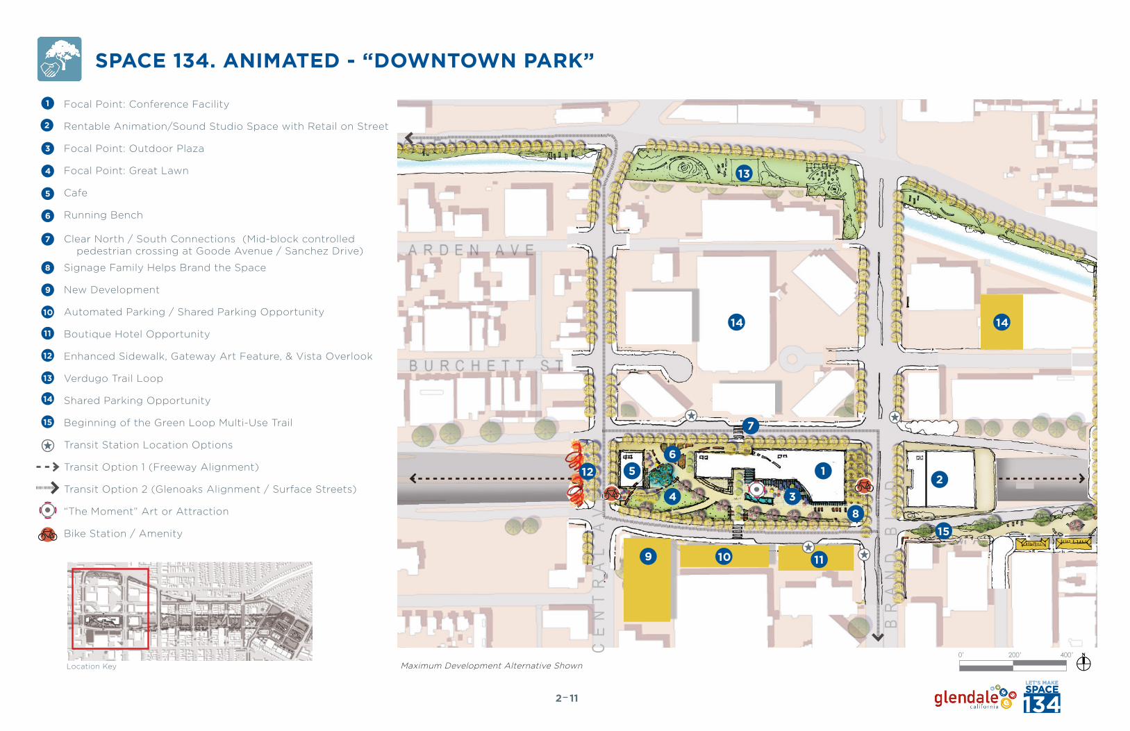
Focal Point: Conference Facility
Rentable Animation/Sound Studio Space with Retail on Street
Focal Point: Outdoor Plaza
Focal Point: Great Lawn
Cafe
Running Bench
Clear North / South Connections (Mid-block controlled pedestrian crossing at Goode Avenue / Sanchez Drive)
Signage Family Helps Brand the Space
New Development
Automated Parking / Shared Parking Opportunity
Boutique Hotel Opportunity
Enhanced Sidewalk, Gateway Art Feature, & Vista Overlook
Verdugo Trail Loop
Shared Parking Opportunity
Beginning of the Green Loop Multi-Use Trail
Transit Station Location Options
Transit Option 1 (Freeway Alignment)
Transit Option 2 (Glenoaks Alignment / Surface Streets)
“The Moment” Art or Attraction
Bike Station / Amenity
Location Key
SPACE 134. ANIMATED - “DOWNTOWN PARK”
Maximum Development Alternative Shown
15
112
0’ 200’ 400’
1
2
3
4
5
6
7
8
9
10
11
12
13
14
234
56
7
8
9 10
15
11
12
13
1414
BR
AN
D B
LV
D
CE
NT
RA
L A
VE
1

SPACE 134. ANIMATED - “DOWNTOWN PARK”The conference facility sits within the existing Downtown context where buildings are seven or more stories tall. Designed at two stories and taking up about 1/3 of the full block, the facility helps to break Space 134 into human-scaled increments, carving out plaza space and green space around it.
Goode Avenue and Sanchez Drive remain one-way and are faced with windows and wide sidewalks. These streets now accommodate new Bus Rapid Transit stations for regional transit connectivity into the heart of Glendale.
Upon future redevelopment, south side parcels may be infilled with park-supportive uses, such as a boutique hotel and shared parking configurations with an automated parking facility. The hotel can house people coming for conferences and events in the Space 134 facility. Other infill may include office space or more likely, new housing that overlooks the park.
122
Visualization of the new conference facility and grand civic plaza
Illustrative Section - Goode Avenue to Sanchez Drive (not to scale)
Bus Rapid Transit Shelter
Bus Rapid Transit Shelter
Wind Turbines
Existing Office Building
Conference Center
Potential Office / Mixed Use / Residential
Potential Boutique Hotel
Potential Automated Parking
Green RoofPlaza
134 Freeway
Shade Trellisover outdoor seating areas
GOODEAVENUE
SANCHEZDRIVE
Section Location
Visualization location
Location Map

This central core area of Space 134 lies in the heart of Downtown Glendale, between Central Avenue and Brand Boulevard. The multi-story buildings on either side of the park embrace the space and provide eyes on the park for safety. This block is unique in that there is a frontage road on either side of the Freeway. This means that buildings actually face the park, rather than turning their back or side to it, as is the case in other areas of the park.
The vision for this park is an urban park with a plaza, hardscape, water feature, cafe, and a conference/events facility of two to three stories. A large central green space can accommodate picnics and impromptu gatherings, as well as organized community events, meet-ups, group yoga, and outdoor movies. Adjacent to this green space, a cafe building anchors the west side of the park. Visually porous and light on the ground, the cafe looks out onto the park and has outdoor cafe tables and chairs. The first of two bike share stations can sit along Central Avenue, easily-accessible from the street.
Walking from the cafe east through a shaded grove and main pathway you arrive at the conference facility and main plaza with interactive fountain, public art and places to sit and people watch. The east side of the space can accommodate transit stations and is designed with active street-fronting uses along the conference facility edge, such as a cafe, or retail uses. A deep sidewalk and setback allows for a double row of trees along Brand Boulevard,
with enhanced streetscaping, signage, and paving. The Space 134 signage system weaves throughout the park, with a series of wayfinding pylons and directional cues.
The Freeway edge on Central Avenue is designed with an eye-catching public art display on or adjacent to the overpass fence, to be visible from passing vehicles beneath. The street edge along Brand Boulevard is embraced with active use along the east side, with a new animation studio and mixed-use building. The north-south transition is thus eased and most pedestrians would be unaware that they are traveling over the Freeway as it is no longer visible or audible. North and south Glendale are rejoined.
Pollution-screening trees are drawn into the main green space area and wind-turbines and solar roof panels help to tell the “healthy Glendale” story. Bioswales pick their way along the main pathway spine. Public art stopping points and interactive stations dot the park along the main pathway and showcase Glendale creativity, telling the “animated Glendale” story.
SPACE 134. ANIMATED - “DOWNTOWN PARK”
132
Location Map
SECTION A - CENTRAL AVENUE TO BRAND BOULEVARD
Illustrative Section - Central Avenue to Brand Boulevard (not to scale)
Section Location
CafeIconic
Gateway Bridge“Vista Point”
Great Park &Plaza
Solar PanelsShaded Grove
EXISTING BUILDINGEXISTING BUILDINGEXISTING BUILDINGEXISTING BUILDING
EXISTING BUILDINGEXISTING BUILDING EXISTING BUILDINGEXISTING BUILDING
Shade Trellisover Outdoor Seating Areas Wind Turbines
134 Freeway
Green Roofs Conference CenterSpace 134
Studios
Retail edge and outdoor dining to create pedestrian activity and
animation of street
B R A N DB O U L E V A R D
C E N T R A LA V E N U E

SPACE 134. ANIMATED - “NEIGHBORHOOD PARK”
142
Location Key
Focal Point: Community/Pavilion Cafe
Focal Point: Water Play
Running Bench
Main Bike, Walk Loop Path
Clear North/South Connection
Bocce
Focal Point: Great Lawn
“Move” Station: Workout Equipment
Branded Signage
Volleyball
Focal Point: Art
Infill Development
“Play” Station: Playground
Parking
Basketball
Focal Point: Verdugo Wash as People Space
Redeveloped Lots
Future Park-Oriented Development Potential
Bike Station / Amenity
1
2
3
4
5
6
7
8
9
10
11
12
13
14
15
16
17
JA
CK
SO
N S
T
LO
UIS
E S
T
1
2
3
4
5
67
89
10
11
12
1314
15
16
17
Neighborhood Park Concept Plan 0’ 200’ 400’

Between Jackson Street and Geneva Street the character of the park morphs to reflect the residential adjacencies. Space 134 here is softer in design, more landscaped, with more passive recreation opportunities and a smaller scale of spaces.
At Jackson Street a bike-share facility along the street edge and the Space 134 signage pylon announce the park, describing the uses within. The main east-west spine is the green loop multi-use trail, with a two-way bike path and a decomposed granite walking and running path next to it, separated by a low landscaping strip. Occasionally along the path there are fitness stations and bench nooks for resting or working out. Bike racks are along this path at key nodes, allowing people to park and enter the park. The running bench element is carried along the green loop pathway, manifesting as a continuous bench, tables, even a slide or interactive play element for children. East-west across Jackson Street and Geneva Street, new continental crosswalks and flashing warning lights facilitate the movement of people along the multi-purpose trail.
This section of the park has volleyball courts and basketball courts, along with bocce courts with viewing areas and team meeting areas. Interspersed with these active recreational uses are passive open spaces/greens for picnics, barbecues, and small community or neighbor events. A tot lot or playground area near Isabel Street or Howard Street is cited for easy community access.
Critical to this segment of the park are new north-south connections at the existing cul-de-sac streets of Isabel Street and Howard Street. These new pedestrian pathways connect down to the multi-purpose green loop trail.
At Geneva Street, a critical safe-routes-to-school connection, a tot lot or playground on the east side of the street (not shown in section) provide a place to stop and play for families and children traveling along the street. Geneva Street which is a bike enhanced street in the City’s Bicycle Transportation Plan, contains another bike share facility and bike racks along the park edge. Public restrooms near the basketball courts and street edge serve the park west and east of Geneva Street.
Pollution-screening trees are drawn into the main green space area and wind-turbines help to tell the “healthy Glendale” story. Bioswales pick their way along the main pathway spine. Public art stopping points and interactive stations dot the park along the main pathway and showcase Glendale creativity, telling the “animated Glendale” story.
SPACE 134. ANIMATED - “NEIGHBORHOOD PARK”
152
Location Map
Illustrative Section - Jackson Street to Geneva Street (not to scale)
SECTION C - JACKSON STREET TO GENEVA STREET
Section Location
Public Art/Picnic Area
The Running Bench
Bocce Ball Court
Tot Lot and Play Area
134 FREEWAY
Basketball Courts Restrooms and Streetscaping
Volleyball Courts Passive Open Space
Wandering Grove
H O W A R DS T R E E T(Beyond)
I S A B E LS T R E E T(Beyond)
G E N E V AS T R E E T
J A C K S O NS T R E E T

SPACE 134. ANIMATED - “NEIGHBORHOOD PARK”Central to the Neighborhood Park, is the multi-purpose walking, jogging, and biking green loop, pictured below, right. This neighborhood scaled space will have high-quality design. Park elements should be chosen to demonstrate a strong Space 134 brand through color and material such as those depicted right and below. Notice how the color red becomes a branding element for the space and pathway hierarchies are defined by variations in ground plane materials.
Rubberized Surface: Primary CirculationPedestrian and Bike
Concrete: Primary and Secondary Pedestrian Walkways
Concrete Pavers: Used at Plazas and Entrances
Cobble Pavers: Used at Secondary Entrances
Branded tree grates. Tell the Glendale story.
Frequent places to sit and gather
The Neighborhood Park and Green Loop Trail
Decomposed Granite: Used at Tertiary Pathways
Concrete Pavers: Used at Plazas and Entrances
Pathways may be Separated by Curb or Marking
162
Picnic Table Pre-Cast Concrete Seat Walls Poly-carbonate Bench Poly-carbonate Bench Parc Centre Chair and Ottoman

SPACE 134. ANIMATED - “VILLAGE CENTER”
Pavilion Cafe in park Office Mixed Use (3 to 4 Stories)
Residential Mixed Use Buildings (3 to 4 Stories) Playroom: Kid’s Play
Woonerf
Shared Street
The eastern node of Space 134 is visualized as a new village center. It is organized around a new civic park with a cafe, great lawn, and places to walk and people watch. New residential development faces the park and is designed as podium courtyard buildings. In essence this vehicular-oriented place is turned into a more livable and people-friendly space.
New streets carve out blocks with walkable lengths, while also leaving room for structured parking within the blocks, which is wrapped by active uses on the ground floors. Along Glendale Avenue the buildings would be more commercial and mixed-use, rather than single-use and auto oriented.
Where the existing shopping center is located, a new retail street is configured, with parking tucked behind and wide sidewalks for strolling. The new street that wraps around the civic park is a “shared-street” that is to say that the sidewalk and street are at the same level and may be separated by bollards or other vertical controls (see image, lower right for an example shared street). The paving material for the sidewalk and the street is the same, further reinforcing the idea that the street should be shared between vehicles, pedestrians, bicyclists, and the like. The new civic park can also serve as the eastern hub for bike share or a city bike station.
The Glendale Avenue overpass has iconic public art on the side that is visible from the freeway.
A new Civic Park
172

SPACE 134. ANIMATED - “VILLAGE CENTER”
182
Location Key
New Village Center
Civic Park
Focal Point: Pavilion Cafe
Retail or Mixed Use
Residential
Consolidated Parking
Shopper’s Plaza
Enhanced Sidewalk and Gateway Art Feature
Focal Point: Community Pavilion Cafe/Bike Station
“Play” Station: Tot Lot
Innovation Station: Cell Phone Booth
Open Lawn
New Pedestrian / Bike Connection
Relocated On-Ramp
Shared Streetspace
Development Potential
Bike Station / Amenity
NOTE: This iteration shows removal of the east-bound and westbound off ramps and relocation of the eastbound on ramp.
1
2
3
4
5
6
7
8
9
10
11
12
13
14
15
GL
EN
DA
LE
AV
E
D O R A N S T
3
6
“Downtown East” Concept Plan 0’ 200’ 400’
1
23
4
4
5
5
6
10
11 12 13
151
23
4
4
4
5
5
68
9
10
11 12 13
15
77
14
G L E N O A K S B L V D
M O N T E R E Y R D

A critical goal of the planning process is to improve circulation and assure that Space 134 contributes to an enhanced mobility network, rather than detracting from it. As envisioned Space 134 provides a thoroughly enhanced network of pathways for pedestrians traveling north-south and east-west along the corridor. The pathways have been organized to respond to the community and have been delineated into primary and secondary pathways, which will be differentiated by scale, pavement material, programming, signage variations, etc.
Beyond providing these pathways, Space 134 will also introduce wayfinding, both passive and active, which assists people walking, by directing them to key destinations in the Downtown area and within the park.
Bicycle access is accommodated via a new west-east connection along the south side of the cap along the multi-purpose pathway spine, as a two-way bike path. The park also links in to the City’s proposed bike lane and sharrow network and includes recommendations for bike stations and bike share kiosks along these bikeways.
192
Walk, Bike, Run: Green LoopPrimary Pedestrian PathSecondary Pedestrian Path
Bicycle Circulation from City’s Bike PlanNew Space 134 Bicycle CirculationBike Station or Amenity
Primary Entry PointSecondary Entry PointVehicular Entry Point
Bike Parking, Bike Station, & Bike Share: Space 134 will be equipped for multiple types of facilities
GOODE
SANCHEZ
SPACE 134 CIRCULATION
CE
NT
RA
L
BR
AN
D
LO
UI
SE
JA
CK
SO
N
GE
NE
VA
GOODE GOODE
SANCHEZSANCHEZ
CE
NT
RA
LC
EN
TR
AL
BR
AN
DB
RA
ND
LO
UI
SE
LO
UI
SE
LO
UI
SE
LO
UI
SE
LO
UI
SE
LO
UI
SE
JA
CK
SO
NJ
AC
KS
ON
GE
NE
VA
GE
NE
VA
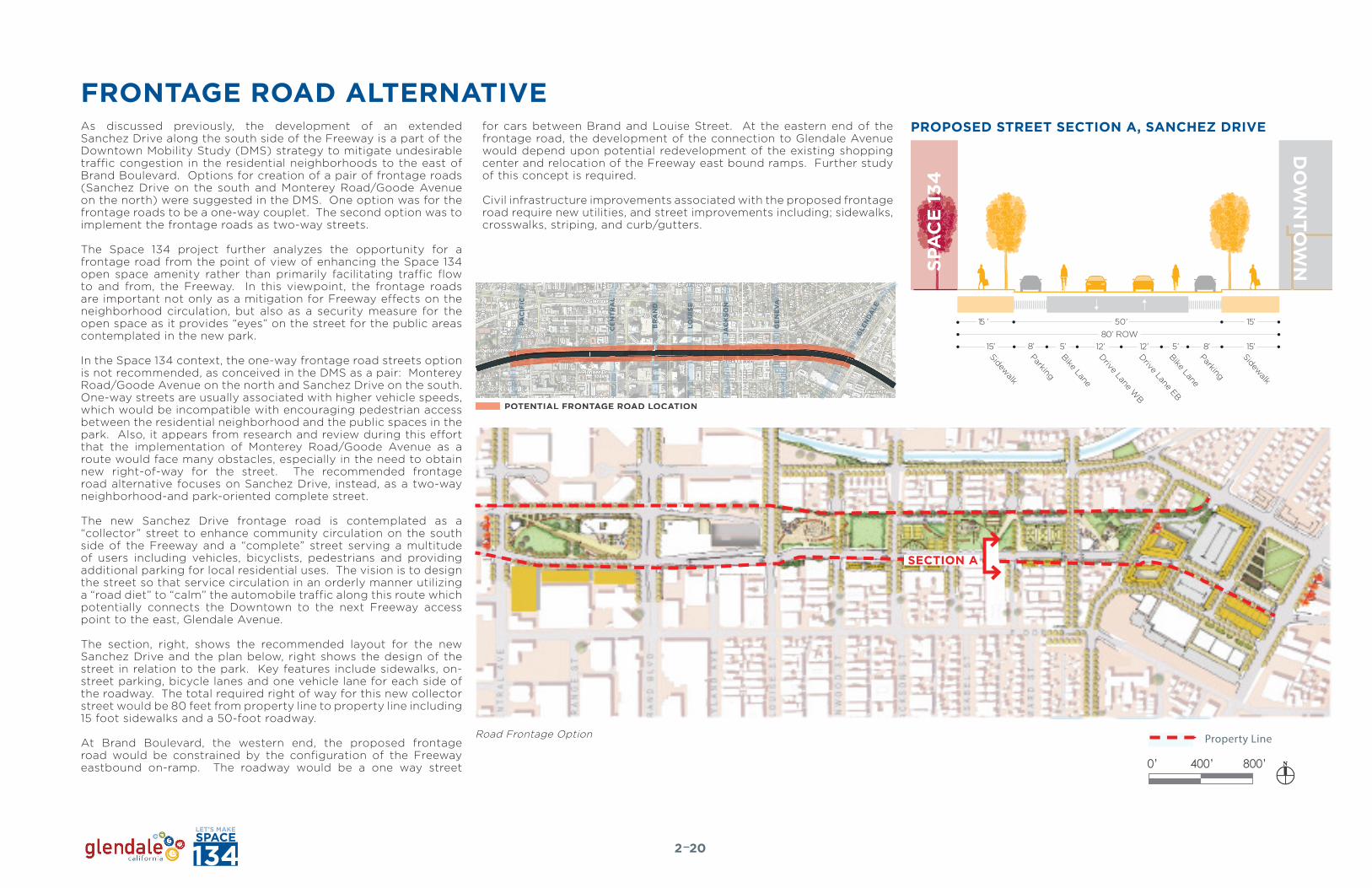
FRONTAGE ROAD ALTERNATIVEPROPOSED STREET SECTION A, SANCHEZ DRIVE
15 ’ 15’
15’8’
50’80’ ROW
5’12’5’ 12’8’15’
Bike LaneParking
Drive Lane EB
Bike Lane
Drive Lane WB
Parking
Sidewalk
Sidewalk
202
POTENTIAL FRONTAGE ROAD LOCATION
BR
AN
D
LOU
ISE
JAC
KS
ON
GE
NE
VA
CE
NT
RA
L
PAC
IFIC
GLE
NDA
LE
and Team
7
15 ’ 15’
15’8’
50’80’ ROW
5’12’5’ 12’8’15’
Bike LaneParking
Drive Lane EB
Bike Lane
Drive Lane WB
Parking
Sidewalk
Sidewalk
FRONTAGE ROAD ALTERNATIVE
AA
SECTION A-A
Property Line
134
vv
0’ 400’ 800’
SECTION A
Road Frontage Option
As discussed previously, the development of an extended Sanchez Drive along the south side of the Freeway is a part of the Downtown Mobility Study (DMS) strategy to mitigate undesirable traffic congestion in the residential neighborhoods to the east of Brand Boulevard. Options for creation of a pair of frontage roads (Sanchez Drive on the south and Monterey Road/Goode Avenue on the north) were suggested in the DMS. One option was for the frontage roads to be a one-way couplet. The second option was to implement the frontage roads as two-way streets.
The Space 134 project further analyzes the opportunity for a frontage road from the point of view of enhancing the Space 134 open space amenity rather than primarily facilitating traffic flow to and from, the Freeway. In this viewpoint, the frontage roads are important not only as a mitigation for Freeway effects on the neighborhood circulation, but also as a security measure for the open space as it provides “eyes” on the street for the public areas contemplated in the new park.
In the Space 134 context, the one-way frontage road streets option is not recommended, as conceived in the DMS as a pair: Monterey Road/Goode Avenue on the north and Sanchez Drive on the south. One-way streets are usually associated with higher vehicle speeds, which would be incompatible with encouraging pedestrian access between the residential neighborhood and the public spaces in the park. Also, it appears from research and review during this effort that the implementation of Monterey Road/Goode Avenue as a route would face many obstacles, especially in the need to obtain new right-of-way for the street. The recommended frontage road alternative focuses on Sanchez Drive, instead, as a two-way neighborhood-and park-oriented complete street.
The new Sanchez Drive frontage road is contemplated as a “collector” street to enhance community circulation on the south side of the Freeway and a “complete” street serving a multitude of users including vehicles, bicyclists, pedestrians and providing additional parking for local residential uses. The vision is to design the street so that service circulation in an orderly manner utilizing a “road diet” to “calm” the automobile traffic along this route which potentially connects the Downtown to the next Freeway access point to the east, Glendale Avenue.
The section, right, shows the recommended layout for the new Sanchez Drive and the plan below, right shows the design of the street in relation to the park. Key features include sidewalks, on-street parking, bicycle lanes and one vehicle lane for each side of the roadway. The total required right of way for this new collector street would be 80 feet from property line to property line including 15 foot sidewalks and a 50-foot roadway.
At Brand Boulevard, the western end, the proposed frontage road would be constrained by the configuration of the Freeway eastbound on-ramp. The roadway would be a one way street
for cars between Brand and Louise Street. At the eastern end of the frontage road, the development of the connection to Glendale Avenue would depend upon potential redevelopment of the existing shopping center and relocation of the Freeway east bound ramps. Further study of this concept is required.
Civil infrastructure improvements associated with the proposed frontage road require new utilities, and street improvements including; sidewalks, crosswalks, striping, and curb/gutters.

Location Key
STRUCTURAL CONSIDERATIONS- CAP STRATEGIESThe long-term vision for Space 134 would be realized structurally with a bridge cap likely consisting of a two-span arrangement with the intermediate support located in the existing Freeway median (see elevations, right). These capping structures would need to support significant superimposed dead loads from the various park appurtenances and landscaping while not restricting the vertical clearance for the Freeway underneath.
One recommended method for bridge cap construction is presented to the right both as a general loading alternative and an alternative that could accommodate heavier loads, i.e. buildings. For this bridge type, post-tensioned concrete girders would serve as the primary longitudinal members, with a cast-in-place concrete bottom slab spanning between girders.
In order to minimize the required structure depth, size of members, and amount of post-tensioning, the design should seek out creative methods for minimizing the structure’s self-weight. Particularly effective methods include:
1. Use voided deck slabs: Portions of the concrete deck slab would be replaced with lighter materials such as rigid foam or air.
2. Replace unnecessary portions of landscaping soil with lighter weight materials: Any excess soil depth could be replaced with foam or similar light-weight material.
3. Use lighter-weight concrete in lieu of normal weight concrete.
4. Use light-weight landscaping soils.
5. Coordinate bridge design with future heavier park loads, such as for light-framed buildings, to avoid unnecessarily conservative design loads.
6. Use post-tensioning and high strength concrete to reduce the size of concrete sections.
The depth of the girders will need to strike a balance among several factors such as: minimum cover requirements for the landscaping, vertical clearance restrictions with the Freeway below, as well as the requisite structural demands.
Tightening the girder spacings and installing more post-tensioning are two methods for increasing the capacity of the girders without affecting their depth. However, there are structural limits beyond which the girder depths typically should not exceed. For a typical pedestrian bridge, the minimum span-to-(superstructure)depth ratio is limited to about 30. It should be expected that actual span-to-depth for these capped bridges will be lower (i.e. the superstructure will be deeper) due to the heavier than normalsuperimposed dead loads.
212
ELEVATION 1 ELEVATION 2
A
ELEVATION 1 - NEW BRIDGE CAP FOR HEAVIER LOADS
A
PARTIAL SECTION - NEW BRIDGE CAP FOR HEAVIER LOADS
B
Scale 1” = 50’
ELEVATION 2 - NEW BRIDGE CAP GENERAL LOADING
B
A
PARTIAL SECTION - NEW BRIDGE CAP GENERAL LOADINGScale 1” = 50’
Scale 1” = 12.5’
Scale 1” = 12.5’

BRIDGE CAP FOR HEAVIER LOADS
It may be desirable to construct heavier steel or concrete-framed buildings on the capped structures at some locations. The key actions for accommodating these heavier loads include most efficiently are described below. (A section view of this type of heavier loaded cap structure is provided on the previous page).
1. Coordinate bridge girder layout to closely align with building point loads: This will help to minimize or avoid unnecessarily conservative design loads.
2. Provide additional transfer beams above and within the deck to transfer building loads to primary bridge members.
3. Limit heavier building loads to specific portions of the bridge cap best able to support the loads: For example, keep heavy loads nearer to the bent supports).
OTHER CONSIDERATIONS
The bridge cap structure will also need to effectively resist corrosion due to being in relatively constant contact with moist soils. Furthermore, it will be very difficult to inspect and monitor the condition of the obscured portions of the cap after the soil has been placed, so protection systems need to be highly reliable.
A sampling of key techniques for improving the bridge’s corrosion resistance includes the following:
1. Install waterproofing membrane over all surfaces that will be in contact with the soil.
2. Use concrete rather than structural steel.
3. Provide well-designed and easily-maintained landscape drainage systems.
4. Use post-tensioning to reduce concrete cracking.
5. Use effective post-tension duct grouting methods to protect steel strands.
6. Provide additional clear cover to deck and girder reinforcing steel.
7. Apply additional corrosion-resistant coatings or cathodic protection to reinforcing steel.
8. Limit chloride use throughout the cap park area.
STRUCTURAL CONSIDERATIONS- BRIDGE WIDENING
222
Cantilevering off of existing bridge without added girders or substructure
The near-term 5-year vision plan, includes plans for a widened pedestrian realm along the existing Jackson Street, Central Avenue, Brand Boulevard, Louise Street, and Geneva Avenue bridges to improve pedestrian and bicycle access. These existing vehicular bridges are each two-span structures with an intermediate bent located in the center median of the Freeway. Generally, the bridges consist of reinforced concrete girders supporting a cast-in-place concrete roadway deck along with sidewalks. The substructures typically consist of an intermediate bent with reinforced concrete crossbeam and columns. Each bridge is approximately 200ft – 225 ft long. There are several feasible, structural options for widening these existing bridges. The most viable options include:
• Cantilevering a new light-weight structure off of the existing bridge, or;
• Constructing a new superstructure and substructure independently supported.
A summary of key elements, along with advantages and disadvantages of each approach is provided below. Note that the bridge widening concepts assume that storm drainage for the added surface area will be collected and piped under the structure, via a hanger system, to existing storm drain lines beyond the bridge abutments for further conveyance.
CANTILEVERING OFF OF ExISTING BRIDGE WITHOUT ADDED GIRDERS OR SUBSTRUCTURE
For this approach (see typical section drawing, above right), new width is added to the existing bridge by connecting a new cantilevered deck and barrier / fencing along the outside edge of the existing structure. This approach is appropriate for a more narrow widening of the bridge. The key issues associated with cantilevering off of the existing structure include:
KEy ISSUE #1: This approach should be less costly to construct than other options. Assuming limited upgrades are required to the existing structure, this approach should be less expensive and disruptive to construct than constructing a completely new and independent structure.
KEy ISSUE #2: This approach could be constructed with minimal impact to traffic. The widening work could primarily be completed from deck level, with limited temporary impacts to Freeway traffic. Work on the deck could also be staged so that at least one existing sidewalk remains open throughout construction. Similarly, vehicular traffic across the bridge could likely be maintained during the work. The result would be lower temporary traffic control costs and fewer impacts to motorist and pedestrian mobility. KEy ISSUE #3: This approach imparts new and additional loads to the existing bridge. Additional analyses would be required during the design phase for the widening to determine if the existing structure would need to be strengthened. The scope of these modifications could be relatively small such as strengthening local portions of the deck or girders, or the modifications could be larger in scale such as for strengthening the substructure or foundations. An effective strategy for mitigating these impacts and avoiding substantial modifications to the existing structure would be to use light-weight materials such as steel and fiber reinforced
“NARROW” WIDENING OF EXISTING BRIDGE
“WIDE” WIDENING OF EXISTING BRIDGE

STRUCTURAL CONSIDERATIONS- RETAINING WALLSIn the near-term vision concept, new retaining walls are being considered along the outside of the Freeway as a means to regain more usable space along the frontage roads. Currently, this space consists of steep cut slopes and shorter walls, neither of which can support build-out up to frontage road level without significant modifications. An important consideration with building any new retaining walls along an existing Freeway right-of-way would be ensuring that future Freeway widening or ramp modifications would not be impeded. Transportation agencies are frequently reluctant to allow permanent restrictions on their facilities due to the uncertainty of how these installations might “box them in” later on. Therefore, establishing acceptable setbacks from the Freeway for the walls would be a key step. All potential retaining wall design options would need to consider accommodations for future Freeway cap structures. This may include designing for future bridge load allowances or ensuring the walls can accommodate a range of potential future bridge foundations. Two structurally feasible options for constructing walls between the Freeway and frontage roads are presented to the right and described in more detail below. Option 1 is believed to be the more cost-effective alternative.
WALL OPTION #1Option 1 consists of a mechanically stabilized earth (MSE) wall with pre-cast concrete facing panels. This is a conventional and effective wall type widely-used to support roadway fills.
The general steps to construct this type wall would include:
1. Drive temporary sheet piles behind the planned wall location. The line of sheets would be located behind the planned permanent wall a distance approximately 0.8 x the wall height to allow for the subsequent installation of soil reinforcing.
2. Excavate the existing toe of the slope from in front of the sheets.3. Construct the lower portion of the MSE wall including soil
reinforcing strips, backfill, and pre-cast facing panels.4. Continue building up the MSE wall and backfilling to a level even
with the top of the sheet piles.5. Extract the temporary sheets.6. Continue constructing the wall and backfill up to the frontage
road elevation. 7. Construct roadway pavements or landscaping on the fill, as
required.
WALL OPTION #2Option 2 consists of a tied-back, steel soldier pile wall with a cast-in-place concrete facing. These walls are typically more expensive to construct than MSE walls and do not offer significant advantages. The wedge-shaped backfill between the existing slope and the back of the walls, as well as the staged installation of the permanent tie-back anchors may be challenging to construct. This option is likely more expensive than Option 1 with MSE walls.
STRUCTURAL CONSIDERATIONS- BRIDGE WIDENING
232
polymer (FRP) and employ efficient framing systems for the new widenings. Furthermore, the total width of the potential widening may be restricted by the existing structure’s residual capacity.
KEy ISSUE #4: This approach would require approval by Caltrans. Many transportation agencies are obligated to upgrade existing facilities to meet current seismic design codes if significant modifications are planned. It would be important to understand Caltrans’s position on this issue during preliminary widening design so that the required level of technical analysis and stakeholder responsibilities are well-defined and understood. Seismic retrofits for bridges can be complex and costly. This add-on type widening would also likely impact the bridge’s aesthetics and long-term inspection and maintenance needs. Caltrans would need to be consulted and their approval gained.
CONSTRUCTING ADDITIONAL SUBSTRUCTURE AND SUPERSTRUCTUREFor this approach, the widening would be supported with a new substructure and foundation and be seismically isolated from the existing bridge. See the previous page for a sketch of this option.
KEy ISSUE #1: This approach should not impart additional loads to the existing bridge. By isolating the new widening structure from the existing, it should be possible to avoid having to upgrade or strengthen the existing bridge.
KEy ISSUE #2: This approach could accommodate more widening width and heavier loadings. The new structure could be designed to support more widening and higher live loads than the cantilever option. This approach may integrate better with the long-term vision of capping the entire Freeway since it could be designed to accommodate those potential heavier future loads and therefore would not restrict future uses and access as much as the cantilever option.
KEy ISSUE #3: This approach should facilitate approvals by Caltrans. Since direct impacts to the existing bridge would be minimal, this should be a “cleaner” approach than building off of the existing bridge and improve the odds of receiving Caltrans approval. Likewise, the aesthetics for the new widening structure could be better matched up to those of the existing bridges. This should help with local buy-in as well as help with gaining Caltrans approvals.
KEy ISSUE #4: This approach would likely have significant impacts to Freeway traffic and cost more to construct. This approach would require significant work in the center Freeway median to construct the intermediate pier. This could result in lane closures or lane shifts lasting several weeks.
Also, setting new girders or installing falsework could negatively affect Freeway mobility. Overall costs to construct this type of widening would likely be between $400 and $500 per square foot of widening.
WALL OPTION #2SOLDIER PILE/SHEET PILE WITH C.I.P. CONCRETE FACING
WALL OPTION #1MECHANICALLY STABILIZED EARTH (MSE) WALL

OTHER STRUCTURAL CONSIDERATIONS
Dreamy Draw, Phoenix, AZ
Craigieburn Bypass Trail, Melbourne, Australia La Roche-sur-Yon, France
Port of Nagoya Pedestrian Bridge, Japan Helix Bridge, Singapore Zubizuri Bridge, Bilbao, Spain
242
ICONIC PEDESTRIAN BRIDGES
An iconic pedestrian bridge approximately 300 ft-long x 16 ft-wide is planned for crossing the Freeway near Balboa Avenue. Likewise the existing pedestrian bridge at Columbus Avenue could be replaced or enhanced. Unique, iconic bridges frequently use less common structural systems to convey specific themes or architectural characteristics. Examples of bridges that are typically not cost competitive with standard girder-type bridges but are usually grouped into the iconic or special category include: arches, cable-stayed, suspension, or special trusses. The form of the bridge is often driven by a bridge architect and the desires of the owner or key stakeholders. Site conditions also help to dictate what bridge form is sensible to use. For example, suspension and pure arch bridges are more efficient when sound rock is close to the surface. Conversely, cable-stayed and special steel trusses are likely more efficient when sound rock is located deeper below ground. Other site criteria such as wind and seismic performance, local availability of materials and skilled labor, construction accessibility, required vertical clearances, and horizontal / vertical alignments all play a key role in considering what types of iconic bridge structures to build and how much they would cost.
Construction costs for a typical, girder-type pedestrian bridge at this location would likely be between $400 - $500 per square foot of deck, in today’s dollars. An iconic bridge would likely cost considerably more to construct. A possible range of costs would be between $900 to $2,000 per square foot of deck and is based on a sampling of other iconic-type pedestrian bridges built around the country over the last decade. The extent of architectural features and the complexity of design would help determine where within this broad range of costs this particular iconic bridge would lie.

LOOKING FORWARD

THIS PAGE LEFT INTENTIONALLY BLANK

WEIGHING THE BENEFITS AND COSTS
13
In the long-run the benefits of this amenity for the City of Glendale will likely outweigh the costs. The benefits of such a project include first and foremost a livable city. This means a better quality of life for residents, which in turn helps to attract new development and investment and increase property tax revenue. The project would relink the city north to south and provide recreational amenities in one of the most under-served neighborhoods in the city. There are no major park facilities within 1/2 mile of the study area. The park could also help improve air quality through filtration of particulate matter from the freeway, filtration of stormwater runoff, and lowering of temperatures.
NEW DEVELOPMENTSpace 134 would likely create a demand for new development and redevelopment around its edges. As described by the Urban Land Institute (ULI), regarding their 2010 Urban Open Space Award Winner, Campus Martius Park in Detroit Michigan, the areas around the park have become the most active space downtown and over $700 million of new development has occurred within a two-block radius of the park. Park 101, a cap project proposed in Downtown Los Angeles, expects that construction of the park will attract 600-800 new residential units, with $490 million to the area.
PROPERTY VALUESIntroduction of new park space in central city environments has been shown to Increase rental and property values. According to the Downtown Los Angeles Park 101 Feasibility Report, there is a premium of 10%-40% for commercial rent in park adjacent buildings. Several examples of the impact of new park space on rental and property values are included in this study. For example, 2 years after Bryant Park in New York City opened, leasing activity on the adjacent street increased by 60% in the first 8 months and in the 10 years after park opened, rents for nearby commercial space around the park increased 115% to 315 %, while surrounding markets saw a much smaller increase (41% to 73% in similar commercial properties).
Similar adjacency to Millennium Park in Chicago created a 33% increase in overall residential property value. This price premium was also noted in: Philadelphia, PA where city wide residential units with park proximity are 5% higher than others; Boulder, CO where the value of properties adjacent to a greenbelt are 32% higher than those located 3,200 feet away; and Austin, TX, where premiums for properties adjacent to a greenbelt and wilderness park there range from 6% to 20%.
Director of the New York City Department of City Planning and Chair of the City Planning Commission, Amanda Burden reported that after the High Line was constructed, the price of apartments adjacent to the park has doubled (New York Times, 6/6/11). “The Benefits of Parks” by the Trust for Public Land noted that in Boulder, Colorado the addition of a new greenbelt added $5.4 million to the total property values of the neighborhood and generated $500,000 per year in additional potential property taxes, enough to cover the $1.5 million purchase price of the greenbelt in only three years.
RETAIL SALES AND NEW JOBSSpace 134 would likely positively impact retail sales and jobs in the area. NYDOT’s “Measuring the Streets”, a helpful summary of the impact of street improvements and urban design interventions throughout New York, described how the borough of Brooklyn saw a 172% increase in retail sales (compared to 18% borough-wide) at locally-based businesses after a pedestrian plaza was installed there. The same report indicated that there was a 14% increase in sales at fronting businesses after a pedestrian seating area was installed in Manhattan. Both of these examples point to the power that cities have when converting under-utilized space into “people space” to bring economic benefits to their communities.
Space 134 would likely bring new jobs, both directly and indirectly to Glendale, including new permanent jobs. It will also likely attract tourists and visitors and bring increased earnings for hotels. Reports the ULI, regarding its 2011 Amanda Burden Open Space Award winner, Citygarden in St Louis, “Hotel bookings are 18% ahead of the ten-year average, and local shops and ground-floor retail establishments have benefitted from the increased foot traffic that Citygarden is producing.” Chicago’s Millennium Park sees 3 million visitors a year resulting in $1.9 – 2.6 billion in visitor spending over 10 years (Park 101 District Freeway Cap Feasibility Study)
COSTSInitial costs outlays are high and include planning, design, environmental review, coordination, acquisitions, land lease, and construction. While ongoing costs include operations, programming, and maintenance. As a point of reference, Millennium Park spends about $13 million per year on operations. (Park 101 District Freeway Cap Feasibility Study)
Dollar costs estimates for construction for Space 134 are summarized on the following page, along with a matrix presenting comparison costs for our sister cap park projects already constructed or in the planning stage both locally and nationally as points of comparison.

HOW MUCH WILL IT COST?
Margaret T Hance Park, Phoenix, AZ$4 million / acre (1990s)$105 million, 29 acres
Freeway Park, Seattle, WA$2.7 million / acre (1970s)$14 million, 5.2 acres
South River Walk Park, Trenton, NJ$23 million / acre (2004)$150 million, 6.5 acres
Hollywood Central Park, Los Angeles, CA
$22 million/acre$950 million, 44 acres
Olympic Sculpture Park, Seattle, WA$9.5 million / acre (early 2000’s. Not all capped)
$85 million, 9 acres
23
Park 101, Los Angeles, CA:$24 million / acre$825 million over 25 years/34 acres (Includes cap park, land acquisition, streetscape)
Downtown Cap Park, Ventura, CA$57 million / acre(including all public facilities, cap, grading, roadways, etc)
$330 million, 5.7 acres
The Appendix to this report presents detail on an order-of-magnitude cost analysis for the Space 134 cap park, arranged into the three cumulative phases: near-, mid-, and long-term, as per the design vision. Costs are based on 2013 values and are provided in today’s dollars. The estimate is not reflective of detailed civil, topographical, and other engineering information, nor of refined urban design, landscape architecture, traffic studies or design drawings. It rather represents a best-estimate based on concept plans, team drawings, and real-world comparisons. The bridge widening estimate does not include full seismic upgrade or other code upgrades which may be required by Caltrans. Per acre costs are included for each cap park segment, along with grand totals by phase. A separate contingency amount has not been included in the estimate at this time. These estimates will be refined upon future economic and feasibility study. To the right are comparable costs for several of the cap parks that were mentioned in Chapter 1.
With the limitations stipulated above, the hard costs for each of the three phases for Space 134 are estimated at:
LONG-TERM@ 25 acres
$337.90 million(In addition to costs of previous phases)
MID-TERM@ 15 acres
$230.13 million(In addition to costs of previous phase)
NEAR-TERMBridge Widening, New East-West Trail &
Streetscape Improvements
$50.00 million
The estimated costs for the above projects have been extracted from the Park 101 Feasibility Study, the Hollywood Central Park Feasibility Study, the Ventura Beach and Town Project White Paper and the Urban Freeway Cap Parks Policy Briefing Paper by Clement Lau, USC. See references at the end of this document.
Klyde Warren Park, Dallas, TX$22 million / acre$110 million, 5 acres

FUNDING GOVERNANCEGUIDING PRINCIPLES
Best practices and review of similar projects indicate a set of guiding principles when it comes to funding Space 134:
• Build and nurture a relationship between city leaders and the philanthropic community.
• Identify a Steering Committee and/or a “Friends of Space 134” group.
• Identify potential public-private partnerships and naming rights opportunities.
• Clearly identify a lead agency or developer to apply for, administer, monitor, and evaluate grants and funding.
POTENTIAL FUNDING SOURCES
Funding for Space 134 would likely come from a variety of local, regional, state, and federal sources. Some of these entities also may be appropriate management entities. Identified sources include the following, listed in alphabetical order:
Local• Benefit Assessment District• Business Improvement District (BID)• Capital Improvement Projects (CIP)• Community Facilities District (CFD)• Development Impact Fees. Fees charged on new
developments within the Project Area, during the permitting process. These fees need to be set carefully so as to not negatively impact new development.
• Disposition and Development Agreement (DDA)• Foundation/Private Funds. Private foundation backing from
local/regional sources or donations from local individuals /developers. May include naming rights or a “Friends of Space 134” group.
• Infrastructure financing district• Mello-Roos Community Facilities Districts. Similar to special
assessment districts, but may be more flexible. A tax used to pay for public facilities or services.
• Parking Fees and Revenues• Parking Tax District• Public / Private Joint Development Agreement• Quimby Act Park Funds. Developers pay into a fund, which
supports park and recreational facilities.• Tax Increment Financing (TIF). Increased assessment on
properties within the area to finance aspects of the park.• Sale / Lease of Air Rights. City would sell the air rights
above the freeway deck or immediately adjacent. City would lease spaces in the park to tenants, vendors, developers for building pads / sites.
• Sale of new development parcels
GUIDING PRINCIPLES
As with lessons-learned from the funding of cap parks, there are important takeaways from how the parks are governed and managed. Guiding principles for governance include:
• Cooperation between public and private entities is key.• Initial fund-raising should include endowments for
maintenance.• Private funds and public funds should be kept distinct
from one another to give private donors more control, accountability, and incentive.
• Consider using MOU, MOA, Inter-agency Development Agreement, and/or Joint-Use Maintenance Agreement
GOVERNANCE MODELS
1. Lead Agency. As with funding management and administration, identify “one leader” to oversee the management of the park. This entity can be a private foundation or a public agency.
2. “Committee as Leader”. This may include a Joint Powers Authority and is a system by which resources are shared.
3. Public-Private Partnership
4. A Hybrid Approach. Using a combination of governance options.
• Special Events. May include conference events in the facility on the cap, rentable events space, farmers markets, etc. Generates revenue for operations and maintenance.
• Transfer of Development Rights. Transfer development rights (TDR) from one site to another and using the economic benefit from the increased density, to finance portions of the Park. Local TDR examples include: Burbank, Irvine, Pasadena (non-cap related). Typically used to finance capital improvements or land acquisitions, rather than maintenance or operations.
• Glendale’s Urban Art Fund
Regional / State• Caltrans Environmental Justice and Transportation Planning Grants• Carbon Reduction Mitigation Funds• Measure R funds• Metro funds• Prop 1B Funds• Prop 1C Funds• Prop 84, Urban Greening Grants• Public Health funds• Safe Routes to Schools• State Transportation Improvement Fund (STIP) • Transportation Development Act (Bike and Pedestrian Funds)
FederalFederal funding is an essential component of these projects. As an example the Margaret T Hance cap park in Phoenix, AZ used 92% FHWA funding for the freeway and deck (100% City funds for the park itself).
• CDBG funds• Congestion Mitigation Air Quality (CMAQ) Improvement Program• FHWA assistance program• HUD Funding• New Market Tax Credits• Recreational Trails Program (RTP)• Surface Transportation Program (STP)• Sustainable Communities Grants• Transit Enhancement Funds• TIGER Grants
33
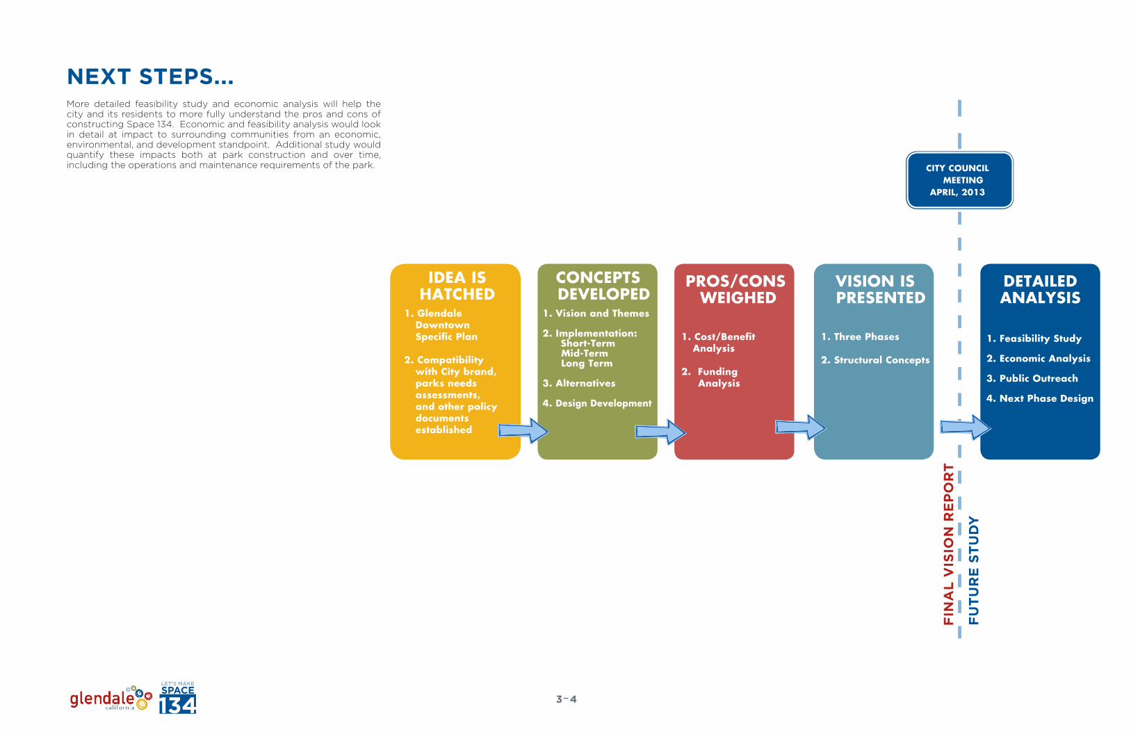
NEXT STEPS...More detailed feasibility study and economic analysis will help the city and its residents to more fully understand the pros and cons of constructing Space 134. Economic and feasibility analysis would look in detail at impact to surrounding communities from an economic, environmental, and development standpoint. Additional study would quantify these impacts both at park construction and over time, including the operations and maintenance requirements of the park.
IDEA ISHATCHED
1. Glendale Downtown Specific Plan
2. Compatibility with City brand, parks needs assessments, and other policy documents established
PROS/CONS WEIGHED
VISION IS PRESENTED
1. Cost/Benefit Analysis
2. Funding Analysis
1. Three Phases
2. Structural Concepts
CONCEPTS DEVELOPED
1. Vision and Themes
2. Implementation: Short-Term
Mid-Term Long Term
3. Alternatives
4. Design Development
DETAILEDANALYSIS
1. Feasibility Study
2. Economic Analysis
3. Public Outreach
4. Next Phase Design
FIN
AL
VIS
ION
RE
PO
RT
FU
TU
RE
ST
UD
Y
CITY COUNCIL MEETING
APRIL, 2013
43
ADDITIONAL RESOURCESResources used during the Space 134 study and the compilation of the final report are listed to the right. Several are useful research documents presenting compelling information specifically about cap parks and urban parks in general.
CAP PARK CASE STUDIES AND RELATED RESEARCH
• “Creating Sustainable Air Rights Development Over Highway Corridors: Lessons from the Massachusetts Turnpike in Boston” Bonnie E. Campbell. Massachusetts Institute of Technology, Department of Urban Studies and Planning. 2004.
• “Hollywood Freeway Central Park Feasibility Report” EDAW/AECOM. October, 2008.
• “Klyde Warren Park Klyde Warren Park Press Kit”. Dallas, TX.
• List of Structures Built on Top of Freeways. Wikipedia.
• “Park 101 District Feasibility Study” AECOM. August 2012.
• “Park 101 District Governance Analysis White Paper” Iteris, SCAG. May, 2012.
• “Urban Freeway Cap Parks Policy Briefing Paper, Considering the Barriers and Opportunities for More Park Space in Los Angeles” Clement Lau, AICP Candidate, Doctor of Policy, Planning, and Development University of Southern California. 2010.
• “Ventura Beach + Town Project White Paper” Roesling Nakamura Terada Architects, Inc, Kimley Horn and Associates, Inc., Economic Planning Systems, Inc., Van Atta Associates. June 2012.
SPACE 134 BACKGROUND INFO
Base Maps
• General Plan Land Use Map• Glendale Zoning Map
Land Use/Land Value
• Downtown Specific Plan Projects Map• Downtown Specific Plan Project Spreadsheet
Mobility
• 2005 Traffic Counts • 2009 / 2010 Bike and Pedestrian Count Report• 2030 Traffic Counts• Beeline System Map• City of Glendale Bicycle Transportation Plan. May, 2012. • City of Glendale Public Works Department Study. State
Route 134 East On-ramp at Brand Boulevard, 2008• Downtown Mobility Study. 2007.• Downtown Specific Plan. July, 2012.• Downtown Specific Plan Projects Map.• Glendale Safe & Heathy Streets Plan. 2011.• OLDA- Orangeline High Speed Rail• “Take back the burbs: A Case Study, the Glendale Experiment”
Sunset Magazine. June, 2012.
Other
• Glendale Urban Art Program Guidelines. December, 2010.• Greener Glendale 2010 Report.• Greener Glendale Plan - Community Activities. 2012.• Greener Glendale Plan - Municipal Operations. 2011.• Comprehensive Design Guidelines- City of Glendale, 2011.• Glendale, CA BrandAMP Report. July 2011.
BENEFITS OF PARKS AND OPEN/CIVIC SPACE
• “The Benefits of Parks: Why America Needs More City Parks and Open Space” Paul M Sherer. The Trust for Public Land. 2006.
• “The Health Benefits of Parks, how parks help keep Americans and their communities fit and healthy” Erica Gies. The Trust for Public Land. 2006.
• “Preventing Childhood Obesity: The Need to Create Healthy Places - Office of Health Assessment and Epidemiology” County of Los Angeles Public Health. October, 2007.
• “Measuring the Street: New Metrics for 21st Century Streets” New York Department of Transportation. 2012
53

THIS PAGE LEFT INTENTIONALLY BLANK

i - I
APPENDIX

COST ANALYSIS DETAILThe following pages describe the near-, mid-, and long-term cost assumptions which the team used to arrive at the totals presented in Chapter 3.
Costs are based on 2013 values and are provided in today’s dollars. The estimate is not reflective of detailed civil, topographical, and other engineering information, nor of refined urban design, landscape architecture, traffic studies or design drawings, rather represents a best-estimate based on concept plans, team drawings, and real-world comparisons. Bridge widening estimate does not include full seismic upgrade or other code upgrade which may be required by Caltrans. Per acre costs are included for each cap park segment, along with grand totals by phase. A separate contingency amount has not been included in the estimate at this time. These estimates will be refined upon future economic and feasibility study. To the right are comparable costs for several of the cap parks that were mentioned in Chapter 1.
IIi
Replacement of existing fence $48,000
Installation of iconic art on fence $45,000
New special paving $72,000
Street trees in planters $100,000
Bridge drainage (drains and pipe system) $70,000
Subtotal $335,000

NEAR TERM: GREEN LOOP - $50,003,900
i - III
and Team
11
CONCEPT 1: NEAR-TERM
0’ 400’ 800’
“THE GREEN LOOP” TIMEFRAME: 1-5 YRSNEW OPEN SPACE: 5 ACRES
Green Loop Connection to Park
Green Loop Connection to Park
Bridge Enhancement A: Streetscaping Only. One (1) Bridge
Project A
Replacement of existing fence $48,000
Installation of iconic art on fence $45,000
New special paving $72,000
Street trees in planters $100,000
Bridge drainage (drains and pipe system) $70,000
Subtotal $335,000
Total TotalLine Items
Project B
and Team
11
CONCEPT 1: NEAR-TERM
0’ 400’ 800’
“THE GREEN LOOP” TIMEFRAME: 1-5 YRSNEW OPEN SPACE: 5 ACRES
Green Loop Connection to Park
Green Loop Connection to Park
Bridge Enhancement B: Sidewalk Extensions and Streetscaping. Five (5) Bridges
Replacement of existing fence $48,000
Installation of iconic art on fence $45,000
New special paving $108,000
Street trees in planters $100,000
Landscape between guard rail and walk $450,000
Planter wall $60,000
Seat Wall $105,000
Arcade over sidewalk $150,000
Widen bridge 10’ each side (20’ total) $2,700,000
Bridge drainage (drains and pipe system) $70,000
Subtotal (1 bridge) $3,836,000
Subtotal (5 bridges) $19,180,000
TotalLine Items Line Items
Installation of new pedestrian / bicycle bridge $6,000,000
New special paving $72,000
Pedestrian lighting $66,000
Public art (1.5%) $94,500
Landscape at bridge entry $108,000
Paving at bridge entry $43,200
Directional signage $15,000
Subtotal (1 bridge) $6,398,700
Subtotal (2 bridges) $12,797,400
and Team
11
CONCEPT 1: NEAR-TERM
0’ 400’ 800’
“THE GREEN LOOP” TIMEFRAME: 1-5 YRSNEW OPEN SPACE: 5 ACRES
Green Loop Connection to Park
Green Loop Connection to Park
Bridge Enhancement C: Pedestrian- and Bike-Only Bridges (2)
COLUMBUS
Project C

IVi
Project D Project E Project F
Continuous loop line paint $90,000
Bike striping / buffer $86,250
Identification pole signage $105,000
Exercise station $50,000
Streetscaping $1,020,000
Additional landscape enhancement $50,000
Pedestrian lighting - pedestrian level $550,000
Informational “health” signage $15,000
Bike station $15,000
Bike signage $30,000
Subtotal $2,011,250
Green Loop A: Street ID and Enhancement
New paving - pedestrian path $504,000
New paving - Bike path $268,800
Landscape buffer $910,000
Pedestrian lighting $517,000
Trees $61,100
Signage $52,500
Exercise station $40,000
Seating nodes $30,000
Retaining walls along freeway edge $8,040,000
Utilities $585,000
Subtotal $11,008,400
Green Loop B: Walk / Bike Path, Southern Edge of the 134 Freeway, over Existing Embankment
TotalLine Items TotalLine Items TotalLine Items
Pacific Avenue Tunnel Enhancement (Vehicular and Pedestrian)
Public art 1.5% $15,000
Pole mounted pedestrian lights $66,000
New enhanced paving $72,000
Signage $15,000
Subtotal $168,000

i - V
Special paving $62,400
Public art 1.5% $1,900
Wall mounted pedestrian lighting $25,000
Lighting at entry $33,000
Special paving at two entries $28,800
Landscape at two entries $20,000
Site furnishings $10,000
Signage $15,000
Construct replacement tunnel $1,560,000
Subtotal $1,756,100
Special paving $171,000
New landscape $1,068,750
Trees $39,000
Pedestrian lighting $165,000
Seating nooks $45,000
Tot- Lot (3-5 yr.) with resilient surface $60,000
Signage $45,000
Paving demolition $285,000
Utilities $123,000
Cul de sac $250,000
Subtotal $2,251,750
Vegetative swales $216,000
Vegetative swale trees $26,000
New planting in parking $136,000
Landscape renovation of existing planters in parking $20,000
New shade trees in parking $22,100
Asphalt concrete and base demolition $34,500
Base material for permeable paving $20,400
Flush concrete header $19,500
Striping $1,500
Subtotal $496,000
Kenilworth Avenue Tunnel Enhancement (Pedestrian- and Bike Only) Block-Long Pocket Parks along South Edge of Freeway Greening of Vons Parking Lot
Project G Project H Project I
TotalLine Items TotalLine Items TotalLine Items
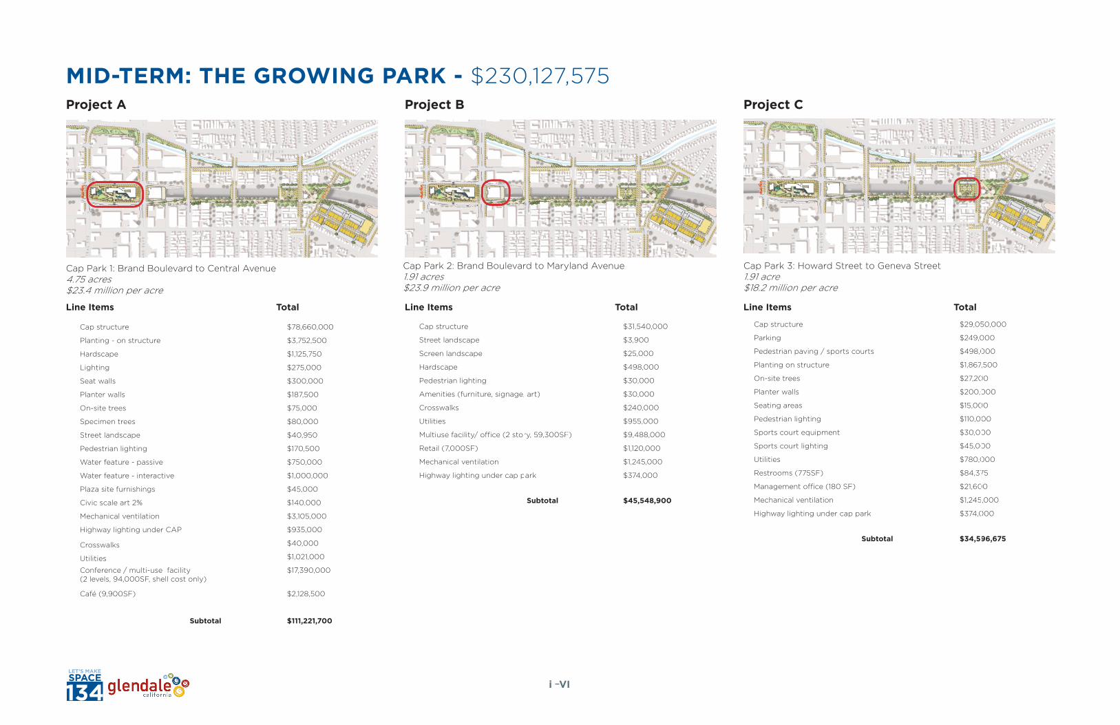
MID-TERM: THE GROWING PARK - $230,127,575
VIi
Cap Park 1: Brand Boulevard to Central Avenue4.75 acres$23.4 million per acre
Cap Park 2: Brand Boulevard to Maryland Avenue1.91 acres$23.9 million per acre
Cap Park 3: Howard Street to Geneva Street 1.91 acre$18.2 million per acre
Project A Project B Project C
TotalLine Items TotalLine Items TotalLine Items
Cap structure $78,660,000
Planting - on structure $3,752,500
Hardscape $1,125,750
Lighting $275,000
Seat walls $300,000
Planter walls $187,500
On-site trees $75,000
Specimen trees $80,000
Street landscape $40,950
Pedestrian lighting $170,500
Water feature - passive $750,000
Water feature - interactive $1,000,000
Plaza site furnishings $45,000
Civic scale art 2% $140,000
Mechanical ventilation $3,105,000
Highway lighting under CAP $935,000
Crosswalks $40,000
Utilities $1,021,000
Conference / multi-use facility (2 levels, 94,000SF, shell cost only)
$17,390,000
Café (9,900SF) $2,128,500
Subtotal $111,221,700
Cap structure $31,540,000
Street landscape $3,900
Screen landscape $25,000
Hardscape $498,000
Pedestrian lighting $30,000
Amenities (furniture, signage, art) $30,000
Crosswalks $240,000
Utilities $955,000
Multiuse facility/ office (2 story, 59,300SF) $9,488,000
Retail (7,000SF) $1,120,000
Mechanical ventilation $1,245,000
Highway lighting under cap park $374,000
Subtotal $45,548,900
Cap structure $29,050,000
Parking $249,000
Pedestrian paving / sports courts $498,000
Planting on structure $1,867,500
On-site trees $27,200
Planter walls $200,000
Seating areas $15,000
Pedestrian lighting $110,000
Sports court equipment $30,000
Sports court lighting $45,000
Utilities $780,000
Restrooms (775SF) $84,375
Management office (180 SF) $21,600
Mechanical ventilation $1,245,000
Highway lighting under cap park $374,000
Subtotal $34,596,675
Cap structure $30,800,000
Site landscape $2,082,500
Pedestrian paving $499,800
Planter walls $220,000
Tot-lot playground $90,000
Pedestrian lighting $302,500
Site furnishings $25,000
Fountain -interactive $425,000
Utilities $780,000
Café (4,700SF) $1,010,500
Full service bike station (3,600SF) $450,000
Mechanical ventilation $1,320,000
Highway lighting under cap park $396,000
Subtotal $38,401,300

i - VII
Cap Park 4: Geneva Street to New Pedestrian- and Bike- Bridge2.02 acres$19.0 million per acre
Station Plaza for Bus Transit Interactive Stations
Project D Project E Project F
TotalLine Items TotalLine Items TotalLine Items
Interactive stations (location TBD) $125,000
Bike stations $50,000
Subtotal $175,000
Pedestrian paving $24,000
Site furnishings $60,000
Bus pullout $100,000
Subtotal $184,000
Cap structure $30,800,000
Site landscape $2,082,500
Pedestrian paving $499,800
Planter walls $220,000
Tot-lot playground $90,000
Pedestrian lighting $302,500
Site furnishings $25,000
Fountain -interactive $425,000
Utilities $780,000
Café (4,700SF) $1,010,500
Full service bike station (3,600SF) $450,000
Mechanical ventilation $1,320,000
Highway lighting under cap park $396,000
Subtotal $38,401,300

LONG-TERM: SPACE 134 ANIMATED - $337,896,915
VIIIi
Cap Park 5: Louise Street to Howard Street8.17 acres$18.7 million per acre
Cap Park 6: Glendale East (New Village Center, Includes Main Development Sites over the Freeway) 6.89 acres$26.8 million per acre
Project A Project B Project C
TotalLine Items TotalLine Items TotalLine Items
Cap structure $124,600,000
Planting on structure $10,479,000
Hardscape $1,757,040
Pedestrian lighting $891,000
Seat walls / built site seating $472,500
Planter walls $445,000
On-site trees $188,000
Specimen trees $300,000
Water feature - passive $350,000
Water feature - interactive $1,000,000
Plaza site furnishings $150,000
Civic scale art 1% $1,470,000
Utilities $1,910,000
Café (6,700SF) $1,440,500
Restrooms (675SF) $84,375
Full service bike station (3,600SF) $450,000
Mechanical ventilation $5,340,000
Highway lighting under cap $1,595,000
Subtotal $152,922,415
Cap structure $105,000,000
On-site landscape $3,600,000
Hardscape $864,000
Enhanced roadway paving $720,000
Pedestrian lighting $440,000
Seat walls / built site seating $245,000
Planter walls $375,000
On-site trees $64,000
Specimen trees $80,000
Water feature - passive $350,000
Plaza Site furnishings $50,000
Civic Scale Art 1% $1,220,000
Enhanced Crosswalks $10,000
Cafés (two in park) (3,600SF) $774,000
Full service bike station (3,600SF) $450,000
Utilities $2,700,000
Roadway $4,500,000
Mechanical ventilation $2,010,000
Highway lighting under cap $1,347,500
New mixed use residential - Site 1 (3 floors, 30 du/flr, 86,000 SF)
$20,000,000
New mixed use residential - Site 2 (3 floors, 30 du/flr, 86,000 SF)
$20,000,000
New mixed use residential - Site 3 (3 floors, 30 du/flr, 86,000 SF)
$20,000,000
Subtotal $184,799,500
Interactive Stations (in addition to Mid-Term, F)
Interactive stations (location TBD) $125,000
Bike stations $50,000
Subtotal $175,000
Project A
and Team
15
CONCEPT 3: LONG-TERMSPACE 134. ANIMATED. TIMEFRAME: 20+ YRS
OPEN SPACE / CAP: 28 ACRES
0’ 400’ 800’
Crosswalks $1,835,000
Utilities $3,055,000
Subtotal $4,890,000
Cap Park 5: Louise to Howard8.17 acres$18.7 million per acre
TotalLine Items