Impacts of Interstate Road Construction in Mountain Terrain.
134 Construction Impacts and Mitigation
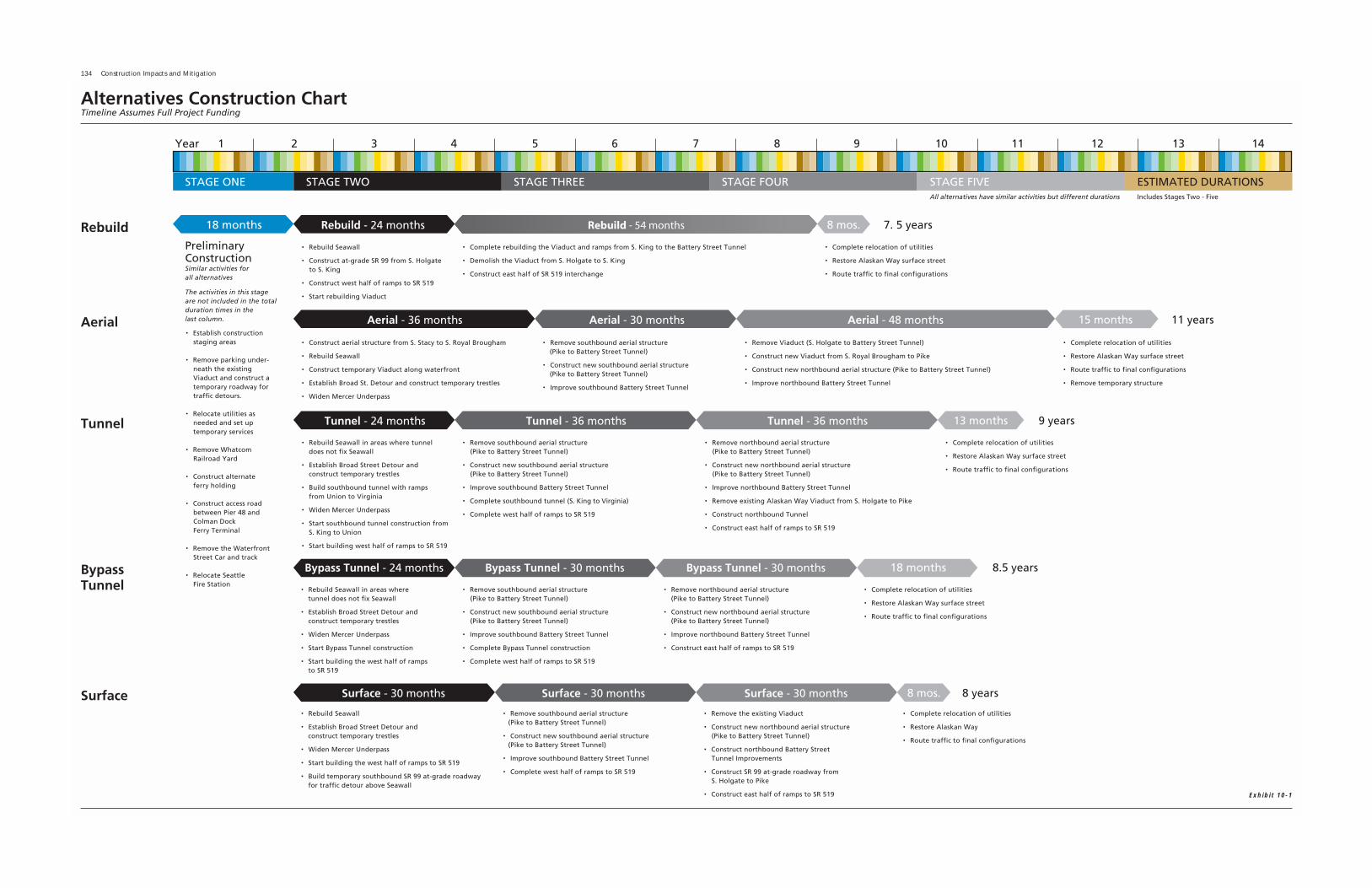
Exhibit 10-1
Alaskan Way Viaduct & Seawall Replacement Project Draft Environmental Impact Statement 135
1 How long will it take to build the project?
How will this project be built, how long will it take,how much will it cost, and how will people in andaround the city be affected? As we answer these ques-tions and plan for the future, it is important toremember our past. Did you know that it took over 8years to build the original viaduct back in the 1950s?That was before the viaduct was part of a major statehighway route supporting over 110,000 trips a day.The seawall was built separately from the viaduct, andit took more than 3 years to build.
So, how long will it take to build a replacementviaduct and seawall? Current estimates show that itwill take between 7.5 and 11 years. These durationsdo not include an additional 18 months that will berequired to begin relocating utilities and prepare thesite for construction. These preliminary constructionactivities could begin in mid-2006, with major con-struction activities beginning in 2008.
The order of major construction activities and thetime it will take to build the project are shown inExhibit 10-1. Construction activities have been organ-ized into five stages that are defined by proposed traf-fic detours. The timeframes assume that constructioncould occur 24 hours a day, 7 days a week.Continuous construction is proposed to minimizeoverall project costs and to shorten the time it takesto build the project.
The construction sequences and timelines have onlybeen developed for the proposed alternatives.Estimates will be developed for options if they areselected as part of the preferred alternative. The esti-mated construction durations were developed using
WSDOT's Cost Estimate Validation Process (CEVP®).The durations represent the 90th percentile value forestimated construction duration. This means thatthere is a 90 percent chance that the constructionduration will be less than this value and a 10 percentchance that it will be greater.
To estimate construction durations, some overallassumptions had to be made. The estimated durationsfor each alternative are contingent upon these twoprimary assumptions:
1 All of the money needed to build the entire proj-ect will be available when construction begins.
2 SR 99 would not be completely closed. Two lanesof traffic would be maintained in the AWVCorridor during peak traffic hours or an alternateroute would be provided. Some partial closures ofSR 99 would be allowed. These partial closuresare described in more detail in Question 4 of thischapter.
If these baseline assumptions were changed, then theestimated construction durations and overall costswould also change. As the project evolves, these base-line assumptions may change as engineers continue totry to find new ways to shorten the construction dura-tions and/or lower the project cost. One way to short-en construction may be to completely close SR 99 forseveral years. Although this would cause congestionand disrupt traffic throughout much of the Seattlearea, it could lessen the total construction time.Shortened construction time could save many mil-lions of dollars because there would be less exposureto inflation and lower construction period financingcosts. If SR 99 were completely closed, methods tomitigate and reduce the impacts would be identified.
2 How would the alternatives and options be built?
Exhibit 10-2 shows the type of construction activitiesfor each alternative and option. Many constructionactivities are similar between the alternatives andoptions (e.g., soil improvements) and some of themare unique (e.g., tunnel construction).
Construction will occur simultaneously at several loca-tions throughout the project area. The intensity ofconstruction activities will vary. At times, there maynot be any work being done in front of a specificproperty (such as a business located along the water-front). However, for all of the alternatives, construc-tion will pass by properties located in the constructionzone more than once.
The text below describes how components of thealternatives and options are proposed to be built.
At-Grade Roadway Construction
All of the alternatives have sections of at-grade road-way construction. At-grade roadways would be builtby clearing and grading the area, laying the aggregateroadway foundation, and placing an asphalt overlay.Construction equipment such as backhoes, excava-tors, front loaders, pavement grinders, jackhammers,trucks, and grading and paving equipment would be used.
Aerial Structure Construction
All of the alternatives include constructing new aerialstructures somewhere in the project area. Aerial struc-tures would be supported by drilled shafts or drivenpiles. Aboveground structures would be built of con-crete columns, crossbeams, girders, roadway decks,
CHAPTER 10 - CONSTRUCTION IMPACTS AND MITIGATION
How long will it take to build the project?
The estimated construction time for each of the alterna-tives is shown below:
Rebuild = 7.5 years
Aerial = 11 years
Tunnel = 9 years
Bypass Tunnel = 8.5 years
Surface = 8 years
What is the CEVP®?
Construction durations and overall project costs weredetermined using the Cost Estimate Validation Process(CEVP®). CEVP® is not a casual look at a project; rather,CEVP® is the outcome of an intense workshop process,somewhat resembling the design review process calledvalue engineering.
A CEVP® examines the project by using top engineersfrom private firms and public agencies around the countrywho are experienced in project management delivery.
WSDOT, FHWA and City of Seattle engineers are alsoinvolved in the workshop process.
The CEVP® helps determine overall project costs and con-struction durations by considering preliminary engineer-ing plans, project risks, individual unit costs, and inflation.
The durations presented in this chapter represent the 90thpercentile value for estimated construction time. Thismeans there is a 90 percent chance that the constructionduration will be less than this value and a 10 percentchance that it will be greater.

136 Construction Impacts and Mitigation
Exhibit 10-2

Alaskan Way Viaduct & Seawall Replacement Project Draft Environmental Impact Statement 137
and traffic rail. Most of the concrete for the aerialstructures would be cast-in-place, though precast com-ponents could be used.
New aerial structures would be supported under-ground by drilled shafts or driven piles. Drilled shaftswould range from 8 to 14 feet in diameter and wouldextend between 60 and 150 feet into the soil, depend-ing on the soil conditions in the immediate area. Ingeneral, drilled shafts are built by drilling soils out tothe desired circumference and depth, installing rebar,and filling the hole with the concrete that forms thenew drilled shaft. The stability of the excavated holemay be maintained either by keeping the hole contin-uously filled with a sealing mixture or by advancing asteel casing concurrently with the drilling operation.
In some areas, driven piles will be used to supportaerial structures instead of drilled shafts. For this proj-ect, piles with footings would most likely be used forconstruction of new aerial structures south of S.Atlantic Street proposed with the Aerial Alternativeand for rebuilding the existing viaduct foundations inthe central section.
Piles can be constructed in various sizes using severaldifferent materials. At this time, it is expected that 30-inch-diameter piles would be constructed of steel cas-ings filled with reinforced concrete. A cluster of sever-al piles will be driven into the ground to support onecolumn of the aerial structure.
There are two ways that pile casings are typicallyinstalled:
� A steel plate is welded onto the tip of the pile cas-ing. This provides a dry, clean hole, which will befilled with reinforced concrete.
� If the pile casing is driven with an open end, thesoil and water in the casing will be drilled orpumped out and the bottom of the empty casingwill be filled with concrete to create an impervi-ous plug.
Once the required number of piles is driven, a pilecap is built to connect the piles together and supportthe load from the column of the aerial structure. Pilecaps are built by excavating soils, placing a concrete
form, installing rebar, and filling the hole with con-crete. After the foundation of the aerial structure isbuilt, construction of the aboveground columns andgirders proceeds. The columns and girders are typi-cally cast-in-place using concrete forms.
Construction equipment used for aerial structure con-struction includes cranes, pile drivers, drilling rigsand augers, backhoes and excavators, jackhammers,concrete pumping equipment, and slurry processingequipment.
Soil Improvements
Soil improvements are proposed in many areas tostrengthen existing liquefiable soils. Soil improve-ments will be required for all of the alternatives southof S. King Street where aerial structures are pro-posed. Soil improvements are also proposed as partof replacing the seawall in the central and northwaterfront areas.
Deep soil mixing and jet grouting are the methodsthat will most likely be used for this project. Deep soilmixing will most likely be used to improve soils sup-porting aerial structures in the south. Jet grouting willmost likely be used as part of seawall construction.
Soil improvements involve installing a series of mix-ing augers, 18 to 36 inches in diameter, attached tocrane-supported equipment. As the augers areadvanced into the ground, a cement grout is injectedunder pressure into the soil. The auger penetratesand breaks the soil loose and lifts it to the mixingblades, which blends the soil and cement grout. Asthe auger continues to advance, additional mixingblades remix the soil and slurry. Individual columnsare constructed in an overlapping manner to createcontinuous zones of improved soil.1
The extent of soil improvements required for southend construction depends on the alternative oroption selected. The stacked aerial structure pro-posed as part of the Aerial Alternative would requirea larger area of soil improvements compared with thesingle-level aerial structures proposed for the otheralternatives.
Jet grouting will most likely be used where the seawallwill be rebuilt. Jet grouting is also a process by whichcement grout is injected into weak soils under highpressure and then mixed. Jet grouting would create asolid block of improved soil behind the existing sea-wall that is imbedded into competent soils. Theextent of soil improvements for this project dependson the type of roadway or seawall being built and thesoil conditions at the site.
Construction equipment needed for making soilimprovements includes drilling rigs and augers, con-crete pumping equipment, and slurry processingequipment.
Appendix B contains additional information about con-struction activities.
What is a girder?
A girder is a beam often used as a main horizontal sup-port in bridge construction.
What is an auger?
An auger is a construction tool used to drill holes in the ground.
Deep Soil Mixing
1Parsons Brinckerhoff 2003
Exhibit 10-3
Simulation of the temporary aerial structure.

138 Construction Impacts and Mitigation
Step 1 - Excavate Tunnel
1. Remove existing waterfront streetcar track.
2. Temporarily or permanently relocate utilities as required for tunnel excavation and construction.
3. Detour Alaskan Way traffic to 1 lane in each direction under existing viaduct.
4. Construct east wall.
5. Construct west wall replacing seawall in sections along alignment.
A. Install silt curtain outboard of seawall adjacent to work zones.
B. Excavate adjacent to and in stages along seawall to top of relieving platform. Temporarily brace existing seawall panels.
C. Perform limited soil improvement, dewatering and temporary bracing to enable installation of west wall.
D. Install west wall.
E. Remove existing seawall panels.
Step 2
1. Excavate to top of relieving platform the full width of the tunnel.
2. Install dewatering wells and begin dewatering.
3. Install top level bracing and tiebacks.
4. lnstall traffic deck where required to maintain surface traffic and local access to waterfront.
5. Begin removal of seawall relieving platform.
Step 3
1. Excavate in stages to 2 ft. below each tieback or bracing level.
2. Install tiebacks at each level prior to excavating tothe next level.
3. Maintain dewatering.
4. Excavate in stages to the next level.
Step 4 -Construct Tunnel
1. Maintain dewatering.
2. Construct tunnel concrete subslab and waterproofing.
3. Construct interior walls and roadway slab.
4. Remove lower level brace.
5. Detension tieback in lower rows.
6. Install bracing between interior walls.
Step 5
1. Maintain dewatering.
2. Detension second row of tiebacks and install wall waterproofing to roof level.
3. Construct roof structure.
4. Install roof waterproofing.
5. Construct roof top slab.
6. Remove bracing.
7. Discontinue tunnel dewatering.
Step 6
1 Remove traffic decking and detension upper row of tiebacks.
2. Backfill above tunnel and remove top level bracing. Relocate utilities to permanent or temporary locations.
3. Complete installation of seawall face panels and sidewalk.
4. Construct Alaskan Way surface street on top of tunnel.
5. Complete ventilation tunnel finishes, systems, and exit stairs.
6. Shift SR 99 traffic into tunnel, Alaskan Way surface traffic to above.
7. Complete aerial connection to Battery Street Tunnel, then shift traffic from existing viaduct into southbound tunnel.
8. Remove existing Alaskan Way Viaduct.
9. Restore Waterfron Streetcar (Bypass only).
10. The Bypass Tunnel is complete. Continue to Step 7 for description of remaining steps for the Tunnel Alternative
Tunnel Construction
Exhibit 10-4
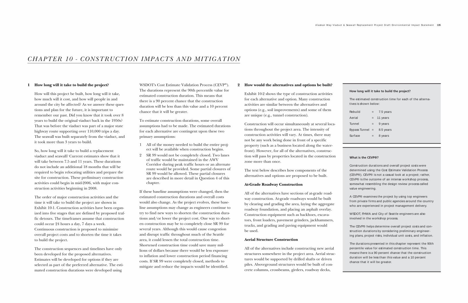
Building the Colman Dock Ferry Terminal Access Road
All of the alternatives propose to construct a new over-water pier between S. Washington Street and YeslerWay. The new pier would extend over Elliott Bay andconnect to the Colman Dock Ferry Terminal. It wouldbe constructed by placing steel or precast concretepiles and by placing a precast or cast-in-place over-water roadway deck on the piling. Equipment neededfor building the access road includes pile-placementequipment, cranes, a barge, and silt curtains.
Rebuilding the Existing Double-Level Viaduct
The Rebuild Alternative proposes to rebuild theviaduct in the central area from Yesler Way to PikeStreet.The foundation of the existing viaduct will berebuilt by replacing the existing piles, pile caps, andfootings. The construction methods used for rebuild-ing the foundation are similar to what was describedfor constructing new aerial structures.
In addition to replacing the foundations, the support-ing side columns, upper and lower supporting beams,roadway decking, and traffic rails will be replaced orstrengthened. It is anticipated that most of the newviaduct components will be constructed of cast-in-place concrete. The viaduct would be supported byexternal bracing and supports during construction sothat people could continue to drive on it.
Retrofitting the Single-Level Viaduct
For the Rebuild Alternative, the existing ramps atColumbia and Seneca Streets and the single-levelstructures from Pike Street up to the Battery StreetTunnel would be retrofitted. That means that theexisting structures will be improved by addingcolumns, steel jackets, strengthened girders, andimproved foundations to meet structural require-ments. In addition, the existing decking will beremoved and replaced as part of the retrofit.
To maintain traffic during the retrofit, the sections ofsingle-level viaduct would be externally braced andsupported as needed during construction. Equipmentneeded includes cranes, excavators, concrete equip-
ment, pile drivers, drilling equipment, and some dem-olition equipment.
Building the Temporary Viaduct
The Aerial Alternative requires building a temporaryviaduct as a construction detour. The temporaryviaduct would be a single-level aerial structure withtwo lanes in each direction. The length of the tempo-rary viaduct will depend upon the type of roadwayselected in the south end and the detour route select-ed, but generally, it would run from S. RoyalBrougham Way to just north of Pike Street.
The temporary viaduct structure would be built withsimilar methods previously described for new aerialstructures. The temporary structure is expected toremain in place for 4 to 7 years, depending on thedetour used. It would be constructed immediatelyafter the seawall was replaced. Traffic would beremoved from the existing viaduct to allow the exist-ing viaduct to be removed and replaced with the newaerial structure.
Building a Tunnel
The construction approach for the tunnel is bestshown in Exhibits 10-4 and 10-5. Specific componentsof this construction sequence are described below.
Excavation
Construction of either tunnel alternative wouldrequire extensive excavation of soils. Soils would beexcavated and tested for contamination. Once tested,the soils would be transported to an appropriate dis-posal facility. Soils would be transported by truck, rail,or barge.
Dewatering
Tunnel construction would require dewatering inadvance of excavation to keep construction areas dryand to control the stability of the excavation. Waterpumped out of the tunnel construction zone wouldmost likely be clean enough for discharge into ElliottBay. If water quality monitoring indicated that thewater required treatment, it would be treated prior tobeing discharged.
Secant Pile Wall Construction
The western wall of either tunnel alternative wouldmost likely be a secant pile wall. The secant pile wallwould serve a dual purpose. It would replace the exist-ing seawall, and it would form the outer wall of thetunnel.
The wall would be constructed of 4-foot-diameterdrilled shafts that would extend up to 90 feet belowthe ground. The shafts would overlap to form a con-tinuous wall from where the tunnel begins near S.King Street to where the tunnel ends near Pike Street.For the most part, the secant pile wall would be con-
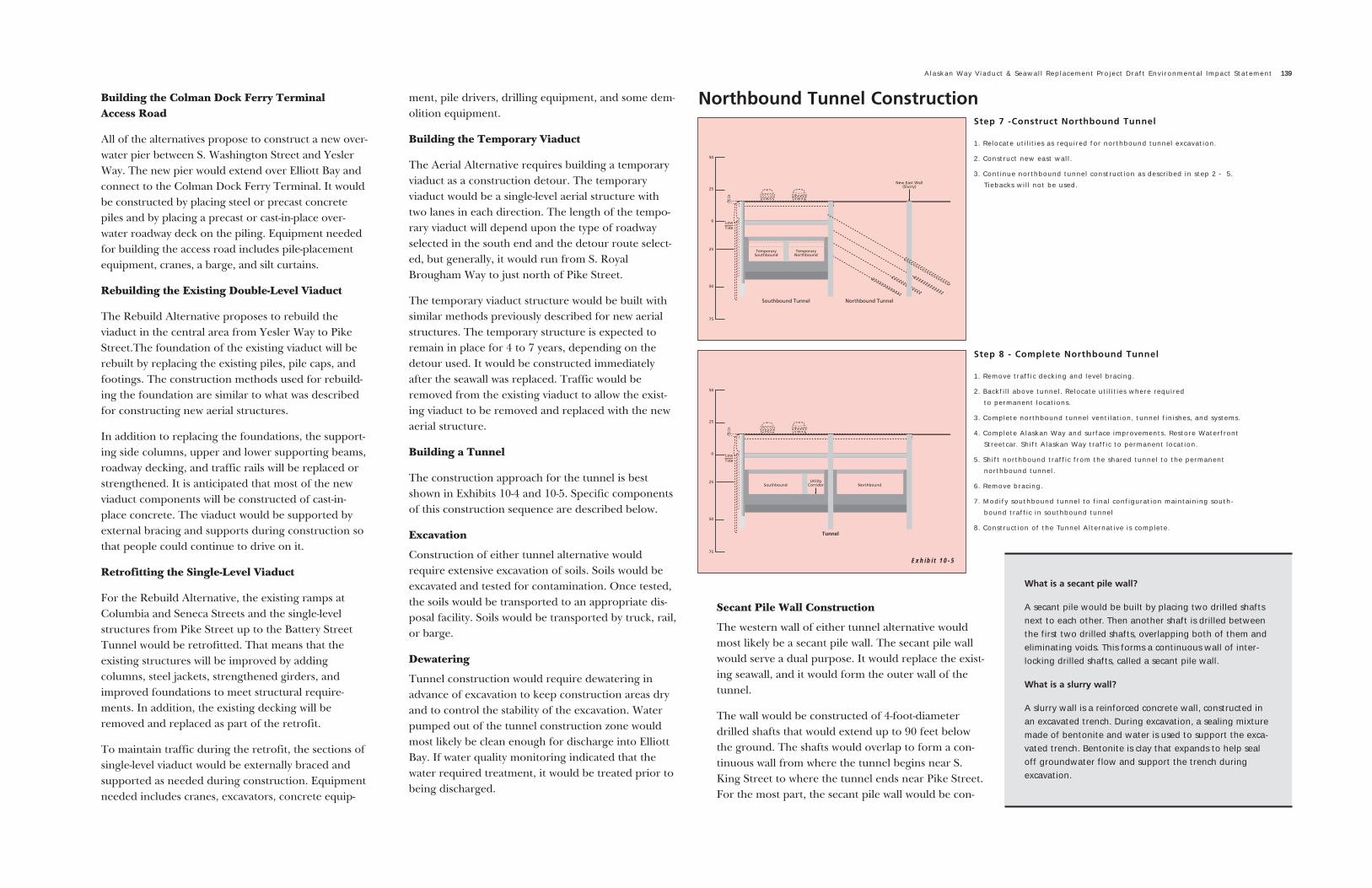
Step 7 -Construct Northbound Tunnel
1. Relocate utilities as required for northbound tunnel excavation.
2. Construct new east wall.
3. Continue northbound tunnel construction as described in step 2 - 5.Tiebacks will not be used.
Step 8 - Complete Northbound Tunnel
1. Remove traffic decking and level bracing.
2. Backfill above tunnel. Relocate utilities where required to permanent locations.
3. Complete northbound tunnel ventilation, tunnel finishes, and systems.
4. Complete Alaskan Way and surface improvements. Restore WaterfrontStreetcar. Shift Alaskan Way traffic to permanent location.
5. Shift northbound traffic from the shared tunnel to the permanentnorthbound tunnel.
6. Remove bracing.
7. Modify southbound tunnel to final configuration maintaining south-bound traffic in southbound tunnel
8. Construction of the Tunnel Alternative is complete.
Northbound Tunnel Construction
Alaskan Way Viaduct & Seawall Replacement Project Draft Environmental Impact Statement 139
What is a secant pile wall?
A secant pile would be built by placing two drilled shaftsnext to each other. Then another shaft is drilled betweenthe first two drilled shafts, overlapping both of them andeliminating voids. This forms a continuous wall of inter-locking drilled shafts, called a secant pile wall.
What is a slurry wall?
A slurry wall is a reinforced concrete wall, constructed inan excavated trench. During excavation, a sealing mixturemade of bentonite and water is used to support the exca-vated trench. Bentonite is clay that expands to help sealoff groundwater flow and support the trench duringexcavation.
Exhibit 10-5

140 Construction Impacts and Mitigation
structed behind the existing Alaskan Way Seawall.Between Pier 48 and Colman Dock, a section of thesecant pile wall would extend into Elliott Bay.
The equipment used would be similar to what is need-ed to build drilled shafts and would include cranes,drilling rigs and augers, concrete pumping equip-ment, and slurry processing equipment.
Slurry Wall Construction
A slurry wall would most likely be constructed to formthe eastern tunnel wall. The wall would be about 3feet wide and 90 feet deep along the entire length ofthe proposed tunnel.
In general, slurry walls are constructed as describedbelow:
� A section of the proposed wall area would beexcavated.
� Guide walls would be inserted into the excavatedarea and excavation would proceed between theguide walls. Excavated material would be replacedwith slurry. The slurry material keeps the walls ofthe hole from caving in as the excavation pro-gresses. The excavation and slurry injectionwould continue down to the desired depth of thewall (which ranges from 75 to 90 feet).
� Once the area is excavated, rebar (or steel beams)will be lowered into the hole.
� The hole would be filled with concrete. The slurrymaterial will be pumped out of the hole andreused as the operation continues. Slurry wallconstruction continues until the wall is thedesired length.
Equipment used for tunnel construction includescranes, drilling rigs and augers, backhoes and excava-tors, concrete pumping equipment, slurry processingequipment, and pumps for dewatering.
Removing the Viaduct
Under all of the proposed alternatives, all of theviaduct (or portions of the viaduct, in the case of theRebuild Alternative) would be removed and demol-ished. The timing for removing the viaduct and theamount of material removed varies between alterna-
tives; however, the methods of removing the viaductare the same or very similar.
The viaduct would be demolished by cutting and lift-ing segments out of the structure, pulverizing andshearing the structure, and jackhammering and coredrilling to break up concrete. Concrete from theviaduct could be ground into aggregate to be reusedon-site as part of the construction operation, or itcould be hauled to an off-site location for processing.Rebar in the existing structure may be separated andrecycled. The old viaduct material will be hauled awayby truck, rail, or barge.
Depending upon the alternative, the quantity of con-crete expected to be demolished and removed fromthe existing viaduct ranges from 80,000 to 110,000cubic yards plus up to 40,000 cubic yards of concreteremoved from the temporary trestles, aerial struc-tures, roadway slabs, and other existing concretestructures.
Rebuilding the Seawall
The seawall will be replaced by constructing concretedrilled shafts in combination with a continuous blockof jet-grouted soil behind the existing seawall.Replacing the seawall is proposed in various locationsfor all of the alternatives being analyzed. The only dif-ference between the alternatives is where the seawallwill be replaced with soil improvements and drilledshafts or where other methods (such as the tunnel orthe Seawall Frame option) might be used.
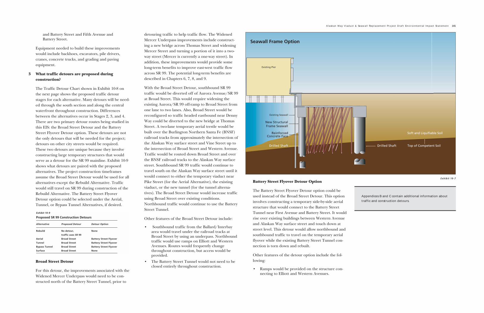
Building the Seawall Frame Option
The Seawall Frame option would replace the seawallwith a structural frame. A continuous secant pile wallwould be constructed directly behind the existing sea-wall, and a row of drilled shafts (spaced 10 to 20 feetapart) would be constructed 30 to 60 feet east of theseawall. The secant pile wall and drilled shafts wouldbe connected by concrete beams with up to 15 feet offill on top of the concrete frame. The concrete beamwould be constructed in a similar manner as a pilecap. The secant pile wall and drilled shafts would beconstructed using methods previously described.
Upgrading the Battery Street Tunnel
Fire and life safety improvements to the Battery StreetTunnel are proposed for all of the alternatives exceptthe Rebuild Alternative. Construction activities associ-ated with the proposed Battery Street Tunnelimprovements include the following:
� Extend the tunnel portals. The northbound tun-nel portal will be extended about 130 feet to thesouth, and the southbound tunnel portal will beextended about 120 feet to the north of the exist-ing tunnel portals. The extension is required toconstruct jet fans needed to improve tunnel venti-lation.
� Construct air intakes on the south and north endsof the existing tunnel.
� Build tunnel vent support structures near theintersections of Western Avenue and BatteryStreet and John Street and Eighth Avenue.
� Construct up to four emergency egress points(two on each side of the tunnel). These emer-gency egress points are expected to be locatednear the intersections of Second Avenue
Exhibit 10-6
and Battery Street and Fifth Avenue and Battery Street.
Equipment needed to build these improvementswould include backhoes, excavators, pile drivers,cranes, concrete trucks, and grading and pavingequipment.
3 What traffic detours are proposed during construction?
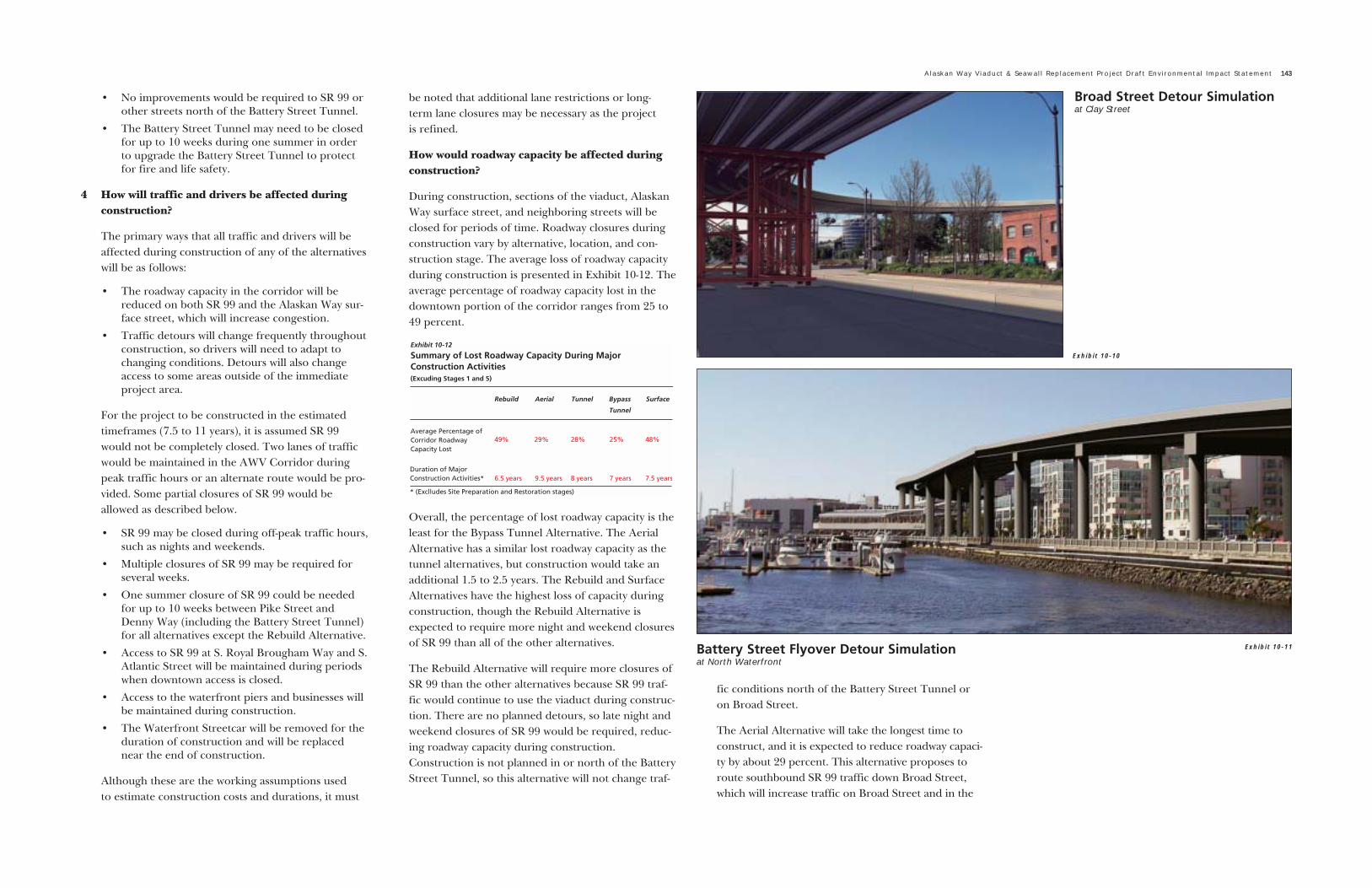
The Traffic Detour Chart shown in Exhibit 10-8 onthe next page shows the proposed traffic detourstages for each alternative. Many detours will be need-ed through the south section and along the centralwaterfront throughout construction. Differencesbetween the alternatives occur in Stages 2, 3, and 4.There are two primary detour routes being studied inthis EIS: the Broad Street Detour and the BatteryStreet Flyover Detour option. These detours are notthe only detours that will be needed for the project;detours on other city streets would be required.These two detours are unique because they involveconstructing large temporary structures that wouldserve as a detour for the SR 99 mainline. Exhibit 10-9shows what detours are paired with the proposedalternatives. The project construction timeframesassume the Broad Street Detour would be used for allalternatives except the Rebuild Alternative. Trafficwould still travel on SR 99 during construction of theRebuild Alternative. The Battery Street FlyoverDetour option could be selected under the Aerial,Tunnel, or Bypass Tunnel Alternatives, if desired.
Broad Street Detour
For this detour, the improvements associated with theWidened Mercer Underpass would need to be con-structed north of the Battery Street Tunnel, prior to
detouring traffic to help traffic flow. The WidenedMercer Underpass improvements include construct-ing a new bridge across Thomas Street and wideningMercer Street and turning a portion of it into a two-way street (Mercer is currently a one-way street). Inaddition, these improvements would provide somelong-term benefits to improve east-west traffic flowacross SR 99. The potential long-term benefits aredescribed in Chapters 6, 7, 8, and 9.
With the Broad Street Detour, southbound SR 99traffic would be diverted off of Aurora Avenue/SR 99at Broad Street. This would require widening theexisting Aurora/SR 99 off-ramp to Broad Street fromone lane to two lanes. Also, Broad Street would bereconfigured so traffic headed eastbound near DennyWay could be diverted to the new bridge at ThomasStreet. A two-lane temporary aerial trestle would bebuilt over the Burlington Northern Santa Fe (BNSF)railroad tracks from approximately the intersection ofthe Alaskan Way surface street and Vine Street up tothe intersection of Broad Street and Western Avenue.Traffic would be routed down Broad Street and overthe BNSF railroad tracks to the Alaskan Way surfacestreet. Southbound SR 99 traffic would continue totravel south on the Alaskan Way surface street until itwould connect to either the temporary viaduct nearPike Street (for the Aerial Alternative), the existingviaduct, or the new tunnel (for the tunnel alterna-tives). The Broad Street Detour would increase trafficusing Broad Street over existing conditions.Northbound traffic would continue to use the BatteryStreet Tunnel.
Other features of the Broad Street Detour include:
� Southbound traffic from the Ballard/Interbayarea would travel under the railroad tracks atBroad Street by using an underpass. Northboundtraffic would use ramps on Elliott and WesternAvenues. Routes would frequently changethroughout construction, but access would beprovided.
� The Battery Street Tunnel would not need to beclosed entirely throughout construction.
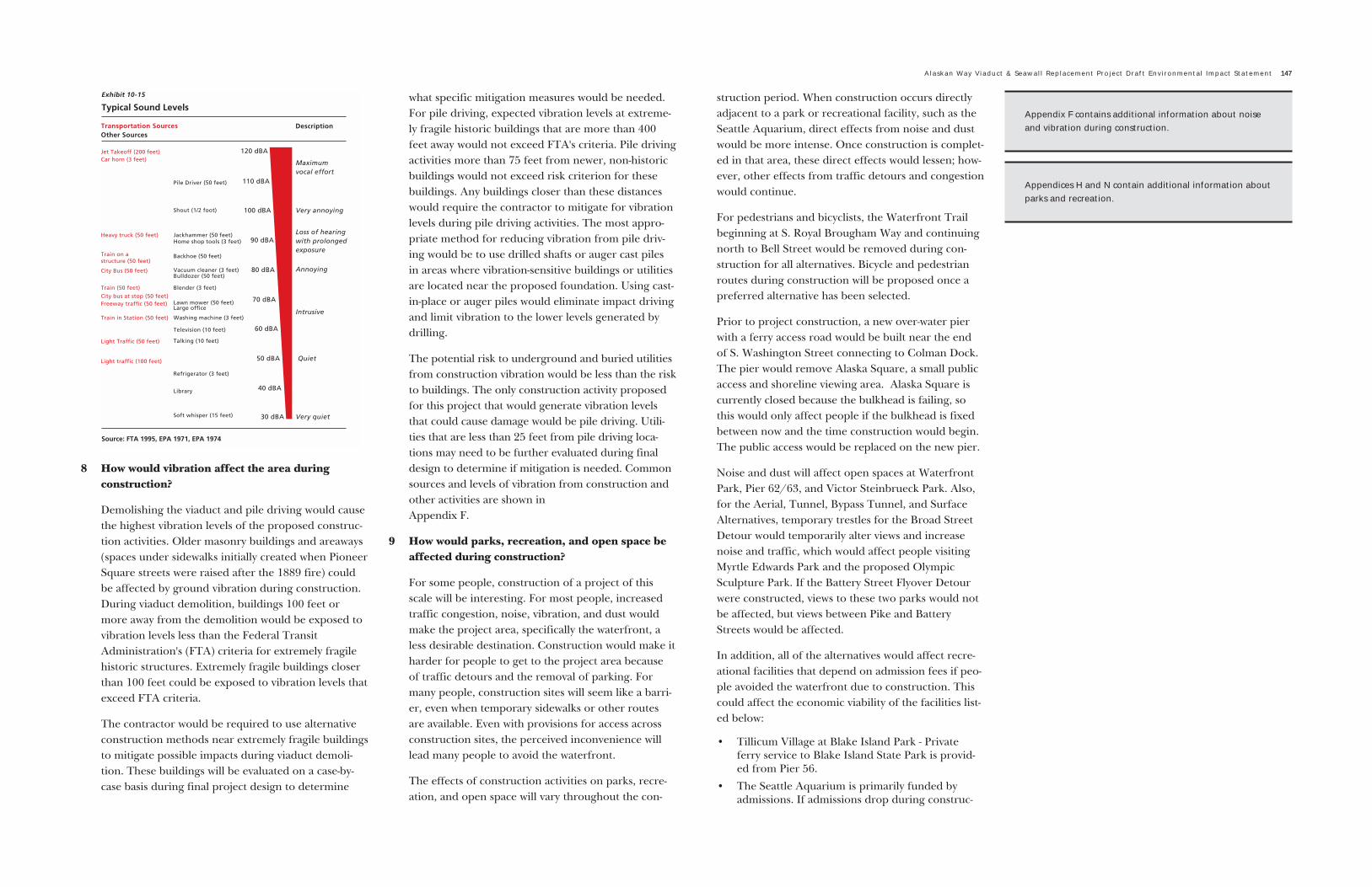
Battery Street Flyover Detour Option
The Battery Street Flyover Detour option could beused instead of the Broad Street Detour. This optioninvolves constructing a temporary side-by-side aerialstructure that would connect to the Battery StreetTunnel near First Avenue and Battery Street. It wouldrise over existing buildings between Western Avenueand Alaskan Way surface street and touch down atstreet level. This detour would allow northbound andsouthbound traffic to travel on the temporary aerialflyover while the existing Battery Street Tunnel con-nection is torn down and rebuilt.
Other features of the detour option include the fol-lowing:
� Ramps would be provided on the structure con-necting to Elliott and Western Avenues.
Alaskan Way Viaduct & Seawall Replacement Project Draft Environmental Impact Statement 141
Exhibit 10-7
Appendices B and C contain additional information abouttraffic and construction detours.

142 Construction Impacts and Mitigation
Exhibit 10-8
� No improvements would be required to SR 99 orother streets north of the Battery Street Tunnel.
� The Battery Street Tunnel may need to be closedfor up to 10 weeks during one summer in orderto upgrade the Battery Street Tunnel to protectfor fire and life safety.
4 How will traffic and drivers be affected duringconstruction?
The primary ways that all traffic and drivers will beaffected during construction of any of the alternativeswill be as follows:
� The roadway capacity in the corridor will bereduced on both SR 99 and the Alaskan Way sur-face street, which will increase congestion.
� Traffic detours will change frequently throughoutconstruction, so drivers will need to adapt tochanging conditions. Detours will also changeaccess to some areas outside of the immediateproject area.
For the project to be constructed in the estimatedtimeframes (7.5 to 11 years), it is assumed SR 99would not be completely closed. Two lanes of trafficwould be maintained in the AWV Corridor duringpeak traffic hours or an alternate route would be pro-vided. Some partial closures of SR 99 would beallowed as described below.
� SR 99 may be closed during off-peak traffic hours,such as nights and weekends.
� Multiple closures of SR 99 may be required forseveral weeks.
� One summer closure of SR 99 could be neededfor up to 10 weeks between Pike Street andDenny Way (including the Battery Street Tunnel)for all alternatives except the Rebuild Alternative.
� Access to SR 99 at S. Royal Brougham Way and S.Atlantic Street will be maintained during periodswhen downtown access is closed.
� Access to the waterfront piers and businesses willbe maintained during construction.
� The Waterfront Streetcar will be removed for theduration of construction and will be replacednear the end of construction.
Although these are the working assumptions used to estimate construction costs and durations, it must
be noted that additional lane restrictions or long-term lane closures may be necessary as the project is refined.
How would roadway capacity be affected duringconstruction?
During construction, sections of the viaduct, AlaskanWay surface street, and neighboring streets will beclosed for periods of time. Roadway closures duringconstruction vary by alternative, location, and con-struction stage. The average loss of roadway capacityduring construction is presented in Exhibit 10-12. Theaverage percentage of roadway capacity lost in thedowntown portion of the corridor ranges from 25 to49 percent.
Overall, the percentage of lost roadway capacity is theleast for the Bypass Tunnel Alternative. The AerialAlternative has a similar lost roadway capacity as thetunnel alternatives, but construction would take anadditional 1.5 to 2.5 years. The Rebuild and SurfaceAlternatives have the highest loss of capacity duringconstruction, though the Rebuild Alternative isexpected to require more night and weekend closuresof SR 99 than all of the other alternatives.
The Rebuild Alternative will require more closures ofSR 99 than the other alternatives because SR 99 traf-fic would continue to use the viaduct during construc-tion. There are no planned detours, so late night andweekend closures of SR 99 would be required, reduc-ing roadway capacity during construction.Construction is not planned in or north of the BatteryStreet Tunnel, so this alternative will not change traf-
fic conditions north of the Battery Street Tunnel oron Broad Street.
The Aerial Alternative will take the longest time toconstruct, and it is expected to reduce roadway capaci-ty by about 29 percent. This alternative proposes toroute southbound SR 99 traffic down Broad Street,which will increase traffic on Broad Street and in the
Alaskan Way Viaduct & Seawall Replacement Project Draft Environmental Impact Statement 143
Exhibit 10-10
Broad Street Detour Simulationat Clay Street
Battery Street Flyover Detour Simulationat North Waterfront
Exhibit 10-11

144 Construction Impacts and Mitigation
north end of the project area. This detour will increasethe amount of time it takes for southbound trips com-ing from Aurora Avenue/SR 99 since drivers will beforced to travel on surface streets instead of a free-flowing highway. If the Battery Street Flyover Detouroption is used, impacts to Broad Street would beavoided and travel time increases for southbound SR99 traffic would be minimized. However, this wouldaffect additional buildings and views in the corridor.
The Tunnel Alternative is expected to affect trafficslightly more than the Bypass Tunnel Alternativebecause the tunnel is wider than the bypass tunneland it will take longer to build. Detour routes havesimilar tradeoffs to those discussed for the AerialAlternative.
The Bypass Tunnel Alternative is expected to have theleast overall effect on traffic operations throughoutthe corridor. The same detour routes are proposedwith this alternative as with the Aerial Alternative, andits effects will be similar to those described above.
The Surface Alternative will reduce roadway capacitymore than the Aerial, Tunnel, and Bypass TunnelAlternatives because the viaduct would be removedearlier in construction phasing. The Broad StreetDetour will be used for this alternative, and its effectswill be similar to those described for the AerialAlternative.
It is likely that some drivers may shift to other routessuch as I-5 or local city streets during construction.During construction, travel times through the corri-dor will increase, overall roadway capacity willdecrease, and travel speeds will also decrease.Congestion at intersections in downtown will alsoincrease during periods of construction. Additionalinformation describing how SR 99 and the AlaskanWay surface street will operate during constructionwill be presented in the Final EIS.
How would construction materials be transported?
For all alternatives and options, trucks will most likelybe the primary mode for transporting materials either
into or out of the project area, though rail cars orbarges may also be used.
All of the alternatives would increase the number oftrucks in the area, since equipment, soil, and materialswould be trucked in and out of the area. The TunnelAlternative would require the most truck trips of all ofthe alternatives. The Bypass Tunnel Alternative wouldrequire fewer trips than the Tunnel Alternative, butmore than the Rebuild, Aerial, and SurfaceAlternatives. The tunnel alternatives require moretrucks because a large volume of soil would need to beexcavated. Truck traffic volumes would be highest dur-ing the 2- to 4-year period when the tunnel was beingconstructed. Specific truck routes will be developed tohelp minimize possible effects to traffic in the area.Possible truck haul routes are described below.
� South end haul routes - Trucks in the south willuse existing established truck routes at E.Marginal Way, SR 99, Michigan Street, S.Spokane Street, and I-5. SR 519 at S. AtlanticStreet will also provide access to this section ofthe project area.
� Central and north waterfront haul routes - Truckaccess will be provided by routes described forthe south and north.
� North end haul routes - Project haul routes forconstruction in the north end have not yet beenidentified; however, established truck routesbetween I-5 and Elliott Avenue/15th Avenue willbe used. Trucks will predominantly use ElliottAvenue for deliveries in the north end.
How would transit be affected during construction?
For all of the alternatives, the Waterfront Streetcarwould be removed for the entire construction period.It would be replaced at the end of construction. Ashuttle service could be provided through the con-struction area to mitigate this loss. Other transit serv-ice would be affected by route changes, and traveltimes may increase due to additional congestion inthe area. Transit currently uses the corridor by reach-ing downtown via the Columbia/Seneca ramps andthe Denny Way ramps. During construction, theseaccess points would be maintained or alternate routes
would be provided. As part of the project, the leadagencies will work with transit providers to discussconstruction activities that would affect transit routesand work on finding acceptable alternate routes asneeded. In addition, the lead agencies will providefunds to enhance transit during construction, andtransit priority measures may also be provided as partof the overall project mitigation strategy and flexibletransportation package.
How would ferry traffic be accommodated during construction?
In the early phase of project construction, a new road-way will be built that provides access to and fromColman Dock. This roadway will help to separate ferrytraffic from traffic on the Alaskan Way surface street,which will help to minimize effects to operations atColman Dock. During construction, access to andfrom Colman Dock will be maintained at all times.
How would freight be affected duringconstruction?
Since capacity will be reduced in the corridor, it isexpected that there will be increased travel times forall vehicles, including freight. FHWA, WSDOT, andthe City will work to keep the freight communityinformed of detours throughout the project so thatdrivers can make adjustments as needed.
How would rail yard operations be affected dur-ing construction?
For all alternatives except the Aerial Alternative, theWhatcom Rail Yard would be relocated into the BNSFSeattle International Gateway (SIG) Rail Yard. TheWhatcom Rail Yard would be closed while it wasbeing relocated, and the BNSF SIG Rail Yard wouldremain open while it is being reconfigured. For thesealternatives, the tail track would also be moved. Theexisting tail track would be maintained during con-struction of the new tail track.
For the Aerial Alternative, the Whatcom Rail Yardlocated at the south end of the project area would beclosed for the entire construction period. The BNSF

SIG Rail Yard and tail track would not need to bereconfigured.
In the central and north waterfront areas, potentialeffects to the BNSF mainline will be less than thosedescribed in the south end. There will be times whenconstruction would occur over the existing BNSFtracks; however, the rail line would remain openthroughout the construction period.
The lead agencies will carefully coordinate construc-tion activities with the BNSF and Union PacificRailroads to maintain the functions of their tracksduring project construction.
How would parking be affected during construction?
About 1,100 on-street parking stalls in the projectarea will be removed, including parking spaces underthe existing Alaskan Way Viaduct and under the rampon Railroad Avenue S. Farther away from the projectzone, on-street parking spaces in other locations mayneed to be removed to make room for maintainingsmooth traffic flow for diverted traffic. All of thealternatives propose to use the parking lot at SeattleCenter as a staging or parking area during construc-tion. This parking lot would still remain open to sup-port Seattle Center events as a first priority.
Most of the stalls along the waterfront are for short-term parking, while the majority of stalls in the stadi-um area are long-term (free) parking spaces.Businesses along the central waterfront and PioneerSquare area rely on this short-term parking to providepeople with access to their facilities. Therefore, somemitigation would be provided to mitigate for short-term losses.
Removal of short-term parking could be mitigated bya combination of increasing utilization of other exist-ing parking facilities, leasing an existing parking facili-ty and converting it to short-term parking, or purchas-ing property and building new short-term parking. Aparking mitigation strategy will be included in theFinal EIS that will mitigate losses of short-term park-
ing during and after construction of the preferredalternative.
What would be done to minimize traffic impactsduring construction?
The lead agencies will fund specific transportationimprovements to decrease reliance on single-occupancy vehicles and increase other modes of trans-portation during construction. These improvementsare proposed for all the alternatives. The transporta-tion improvements and management strategies will be implemented to minimize and manage traffic during construction. These management strategiesare part of the project's proposed FlexibleTransportation Package.
The proposed Flexible Transportation Packageincludes several different programs and tools torespond to varying needs in the corridor. The man-agement strategies proposed as part of this projectare identified briefly below. They are described inmore detail in Appendix B, Section 3.1.8. A specificplan incorporating the strategies will be included inthe Final EIS.
� Direct transit enhancements, including possiblewater taxi service
� Construction worker/commuter shuttle service
� Expansion of FlexPass program duringconstruction
� Traveler information systems
� Conversion of long-term downtown commuterparking to short-term and carpool parking
� Implementation of truck/commercial vehiclerestrictions and prioritizations
� Event management system
� Smart work zones
� Enhanced traffic signal systems and programs
� Incident management systems
� Expand vanpool/vanshare program
� Small employer market development
� Parking lot guidance systems
� Flexible transportation program management and monitoring/demonstration and research programs
� Transit priority systems
� Personalized transportation consultation
5 What properties would be required for construc-tion, and would construction affect land use?
Construction staging areas will be needed throughoutthe corridor to provide adequate space for construc-tion equipment, construction materials, materialsstockpiling, and parking. In general, the number ofproperties affected by construction would be similarbetween the alternatives. The fewest sites are neededfor the Rebuild Alternative because no improvementsare planned north of the Battery Street Tunnel.Specific staging areas would be identified through fur-ther project planning and design.
Construction staging areas would be purchased orleased from their respective owners before construc-tion begins. After construction, the properties couldbe leased to new tenants, redeveloped, or sold.
Construction is not expected to permanently changeland uses in the corridor. However, constructionactivities will affect all of the different land uses in thecorridor by introducing a multi-year, large-scale con-struction project to the area. This will affect proper-ties and their uses in many ways. The specific effectsare described in more detail below.
6 How would views be affected during construction?
For any of the alternatives, construction equipmentand materials will clutter views in the corridor. Also,lights used for nighttime construction could affectpeople within one or two blocks of construction orstaging areas. The Aerial Alternative would have thegreatest effect on views because a new temporary aeri-al structure would stretch the entire length of thewaterfront for up to 7 years during construction.
In general, the primary change to views with theRebuild Alternative is that the viaduct will be bracedduring construction. Therefore, the structure willappear to have more bulk, and it will be difficult tosee through open areas in the viaduct where therecurrently is no concrete.
Alaskan Way Viaduct & Seawall Replacement Project Draft Environmental Impact Statement 145
Additional details about tools proposed for the FlexibleTransportation Package are contained in Appendix B, inSection 3.1.8.
The Land Use and Shorelines Technical Memorandum(Appendix G) discusses this topic more extensively andlooks at the alternatives with an eye toward their consis-tency with current local land use plans and policies.
Appendices D and E contain more information on visualchanges.

146 Construction Impacts and Mitigation
For the Aerial Alternative, a single-level aerial struc-ture would be built over the Alaskan Way surfacestreet beginning on the south end near S. RoyalBrougham Way up to near Pike Street. From PikeStreet to Lenora Street, the aerial structure woulddescend to meet the Alaskan Way surface street. Inthe south end of the corridor, the temporary struc-ture would have minimal effects on the industriallandscape. Along the waterfront, the temporary aerialstructure would tower above the pedestrian corridor,shadow the area, and overwhelm views from the his-toric waterfront piers. It would also obstruct viewsfrom buildings located in the space between AlaskanWay surface street and the viaduct. The temporaryviaduct for the Aerial Alternative would be in placefor about 7 years with the Broad Street Detour. If theBattery Street Flyover Detour option were built, thestructure would remain in place about 4 years.
As part of the Broad Street Detour proposed for allalternatives except the Rebuild Alternative, a trestlewould be built over Broad Street beginning near VineStreet and continuing to Western Avenue. The trestlewould obstruct views from Pier 70, the proposedOlympic Sculpture Park, and the Old SpaghettiFactory restaurant.
If the Battery Street Flyover Detour option were con-structed instead of the Broad Street Detour, it wouldrequire building the temporary aerial structure up toBattery Street. Near Battery Street, an aerial flyoverstructure would rise and curve to match into theBattery Street Tunnel. This detour option wouldobstruct views along the waterfront between PikeStreet and Battery Street. This detour would affectviews from nearby buildings, including the BelltownLofts, the Austin Bell Building, and the BarnesBuilding. Views from the Seattle Art Institute, MarriottHotel, Waterfront Landings, and Pier 66 would alsobe affected by the Battery Street Flyover Detour.
7 What would noise be like during construction?
Noise during the construction period would be both-ersome and annoying to nearby residents, visitors,tourists, and businesses, particularly since construc-tion activities will occur 24 hours per day.
All of the alternatives would generate similar types ofnoise that would occur sporadically in different loca-tions throughout the 7.5- to 11-year construction peri-od. The most common noise source in constructionareas would be from engine-powered machinery suchas earth-moving equipment (bulldozers), material han-dling equipment (cranes), and stationary equipment(generators). Mobile equipment (like trucks and exca-vators) operates in a cyclic manner, while stationaryequipment (generators and compressors) generatesnoise at fairly constant levels. The loudest and mostdisruptive construction activities would be pile driving(including driving sheet pile), followed by demolitionwork with jackhammers and hoe rams. The RebuildAlternative is likely to generate the most overall con-struction noise heard by the public, since it wouldinclude more pile placement near businesses and resi-dences than the other alternatives.
Typical noise levels from construction equipmentrange from 69 to 106 dBA at 50 feet from the source;however, the majority of typical construction activitiesfall within the 75 to 85 dBA range at 50 feet. Peaknoise levels from pile driving are about 106 dBA at 50feet. The use of drilled or vibrated piles could reducepeak noise levels by between 15 and 25 dBA.
To the human ear, noise at 65 dBA is intrusive and 80dBA is disruptive. At 80 dBA, people must shout tobe heard. Hearing protection is recommended atnoise levels above 90 dBA. Noise levels between 110and 120 dBA are typical of a rock concert. Exhibit 10-14 shows the range of noise levels that can be expect-ed from different types of construction equipment.Exhibit 10-15 may be compared to Exhibit 10-14 toget a better sense of how construction equipmentnoise levels might compare with typical sounds.
Construction noise at locations farther away than 50feet would decrease at a rate of 6 to 8 dBA per dou-bling of the distance from the source. For example, ifthe noise level is 90 dBA at 50 feet from a jackham-mer, then it would reduce to approximately 83 dBA at100 feet and 76 dBA at 200 feet. For all of the alterna-tives, construction noise from some activities, such asdemolition of the existing viaduct, could exceed the
City of Seattle's daytime noise regulations at somelocations. A variance would be required for theseactivities. Also, a variance would be needed to allownighttime construction. These permits would specifymitigation measures to minimize effects by limitingthe time of day that certain activities could occur.
Mitigation requirements would be defined in contrac-tor specifications and by the noise variance; they mayinclude a management and monitoring plan that setsnoise limits. Possible mitigation measures to reducenoise could include constructing temporary noise bar-riers or curtains around equipment or work areas andequipping construction equipment engines with ade-quate mufflers and intake silencers. Additional strate-gies for mitigation are described in Chapter 8 ofAppendix F.
Exhibit 10-13Temporary Aerial Viaduct Simulationnorth of Union Street
8 How would vibration affect the area during construction?
Demolishing the viaduct and pile driving would causethe highest vibration levels of the proposed construc-tion activities. Older masonry buildings and areaways(spaces under sidewalks initially created when PioneerSquare streets were raised after the 1889 fire) couldbe affected by ground vibration during construction.During viaduct demolition, buildings 100 feet ormore away from the demolition would be exposed tovibration levels less than the Federal TransitAdministration's (FTA) criteria for extremely fragilehistoric structures. Extremely fragile buildings closerthan 100 feet could be exposed to vibration levels thatexceed FTA criteria.
The contractor would be required to use alternativeconstruction methods near extremely fragile buildingsto mitigate possible impacts during viaduct demoli-tion. These buildings will be evaluated on a case-by-case basis during final project design to determine
what specific mitigation measures would be needed.For pile driving, expected vibration levels at extreme-ly fragile historic buildings that are more than 400feet away would not exceed FTA's criteria. Pile drivingactivities more than 75 feet from newer, non-historicbuildings would not exceed risk criterion for thesebuildings. Any buildings closer than these distanceswould require the contractor to mitigate for vibrationlevels during pile driving activities. The most appro-priate method for reducing vibration from pile driv-ing would be to use drilled shafts or auger cast pilesin areas where vibration-sensitive buildings or utilitiesare located near the proposed foundation. Using cast-in-place or auger piles would eliminate impact drivingand limit vibration to the lower levels generated bydrilling.
The potential risk to underground and buried utilitiesfrom construction vibration would be less than the riskto buildings. The only construction activity proposedfor this project that would generate vibration levelsthat could cause damage would be pile driving. Utili-ties that are less than 25 feet from pile driving loca-tions may need to be further evaluated during finaldesign to determine if mitigation is needed. Commonsources and levels of vibration from construction andother activities are shown in Appendix F.
9 How would parks, recreation, and open space beaffected during construction?
For some people, construction of a project of thisscale will be interesting. For most people, increasedtraffic congestion, noise, vibration, and dust wouldmake the project area, specifically the waterfront, aless desirable destination. Construction would make itharder for people to get to the project area becauseof traffic detours and the removal of parking. Formany people, construction sites will seem like a barri-er, even when temporary sidewalks or other routesare available. Even with provisions for access acrossconstruction sites, the perceived inconvenience willlead many people to avoid the waterfront.
The effects of construction activities on parks, recre-ation, and open space will vary throughout the con-
struction period. When construction occurs directlyadjacent to a park or recreational facility, such as theSeattle Aquarium, direct effects from noise and dustwould be more intense. Once construction is complet-ed in that area, these direct effects would lessen; how-ever, other effects from traffic detours and congestionwould continue.
For pedestrians and bicyclists, the Waterfront Trailbeginning at S. Royal Brougham Way and continuingnorth to Bell Street would be removed during con-struction for all alternatives. Bicycle and pedestrianroutes during construction will be proposed once apreferred alternative has been selected.
Prior to project construction, a new over-water pierwith a ferry access road would be built near the endof S. Washington Street connecting to Colman Dock.The pier would remove Alaska Square, a small publicaccess and shoreline viewing area. Alaska Square iscurrently closed because the bulkhead is failing, sothis would only affect people if the bulkhead is fixedbetween now and the time construction would begin.The public access would be replaced on the new pier.
Noise and dust will affect open spaces at WaterfrontPark, Pier 62/63, and Victor Steinbrueck Park. Also,for the Aerial, Tunnel, Bypass Tunnel, and SurfaceAlternatives, temporary trestles for the Broad StreetDetour would temporarily alter views and increasenoise and traffic, which would affect people visitingMyrtle Edwards Park and the proposed OlympicSculpture Park. If the Battery Street Flyover Detourwere constructed, views to these two parks would notbe affected, but views between Pike and BatteryStreets would be affected.
In addition, all of the alternatives would affect recre-ational facilities that depend on admission fees if peo-ple avoided the waterfront due to construction. Thiscould affect the economic viability of the facilities list-ed below:
� Tillicum Village at Blake Island Park - Privateferry service to Blake Island State Park is provid-ed from Pier 56.
� The Seattle Aquarium is primarily funded byadmissions. If admissions drop during construc-
Alaskan Way Viaduct & Seawall Replacement Project Draft Environmental Impact Statement 147
Appendix F contains additional information about noiseand vibration during construction.
Appendices H and N contain additional information aboutparks and recreation.

148 Construction Impacts and Mitigation
tion, programs may be compromised and plans toupgrade the facility may be delayed. In addition,the animals at the Aquarium may be affected byconstruction due to noise.
� The summer concert series at the Pier 62/63 Parkcould be affected by construction noise.
In addition to the effects described above, the AerialAlternative would increase proximity impacts such asincreased noise to parks and recreational areas alongthe waterfront more than the other alternativesbecause a temporary aerial structure would be builtdirectly adjacent to the waterfront between S. RoyalBrougham Way and Pike Street.
Specific mitigation measures identifying possiblepedestrian and bicycle routes and mitigation meas-ures for parks and recreational facilities will be devel-oped as part of the Final EIS.
10 How would neighborhoods be affected duringconstruction?
For people working or living right next to the work-site, construction will sometimes be inconvenient andat other times will be quite disruptive. Constructionnoise, lights, and traffic changes could affect peoplewithin one to two blocks of the corridor or a stagingarea. The noise and visual effects of construction arediscussed elsewhere in this chapter.
For many people, construction sites will seem like abarrier, even when temporary sidewalks or otherroutes are available. Because they are perceived asbarriers, construction sites will temporarily increaseseparation between parts of each neighborhood. TheSurface Alternative would have the least perceivedseparation. The Tunnel and Bypass TunnelAlternatives have a lot of work below ground, whichlessens some of the perceived separation, while theRebuild and Aerial Alternatives, with a lot of tempo-rary aboveground structures, would have the mostperceived separation.
Because the construction zone will be closed, therewill be many temporary road closures and detours.Some will be needed for only weeks or months, whileothers will be in place for years. The closures and
detours will be inconvenient or disruptive to adjacentbusinesses and residents. The specific closure anddetour routes will be developed for the preferredalternative and during detailed design. FHWA,WSDOT, and the City will work with local residentsand businesses to keep disruption to a minimum.
11 Would the elderly, disabled, low-income, orminorities be affected during construction?
Construction impacts to disadvantaged communitiesinclude increased congestion, reduced mobility,increased response time for emergency services, andincreased noise. For all alternatives, temporary con-gestion during construction would affect low-income,homeless, elderly, or disabled people and the organi-zations that strive to serve them. These people areheavily dependent on transit, whose service will behampered by overall congestion. As part of the proj-ect mitigation strategy, funding will be provided toenhance transit operations during construction asdescribed in Question 4 of this chapter. Congestionwould also make deliveries to service providers moredifficult. Construction activities may bring additionaleffects to portions of the homeless community.Traffic detours, barricades, and other temporary con-struction measures can present hurdles for all of thesedisadvantaged communities.
Although construction impacts to disadvantaged com-munities are probable, it appears they can be avoided,minimized, or mitigated. During discussions with serv-ice providers, the lead agencies have been able toidentify potential solutions to offset constructionimpacts. At this point, it is too early to develop a spe-cific construction mitigation strategy for disadvan-taged communities; however, continued outreachwith service providers will be critical to minimizingand avoiding effects, where feasible. This mitigationwill be developed for the preferred alternative andincluded in the Final EIS.
12 How would construction affect historic resources?
Possible effects to historic resources from construc-tion activities are similar to potential effects to otherbuildings and areas located along the corridor. Pos-
sible effects include increased vibration, increasedcongestion, loss of parking, increased noise and dust,and loss of business if people avoid the area duringconstruction.
Construction effects will vary during the constructionperiod. Direct effects will be more intense when con-struction is adjacent to an area and less intense whenthe activity moves elsewhere. During some parts of thedemolition and construction period, Pioneer Squarewould be affected by increased traffic congestion, lossof parking, and changes to business access. Traffic bar-riers and detours may make it harder for people to getto the area. Those businesses and residents closest tothe project would experience noise and dust. Theseimpacts may lead to people avoiding the area, result-ing in a decline in sales and a negative economicimpact on the owners of historic buildings. Many ofthese effects could be mitigated or at least minimized,as described in Question 14 of this chapter.
Similar effects would occur along the waterfront,affecting businesses located on the historic piers. Con-gestion and lack of parking on the waterfront couldalso affect the Pike Place Market, which depends on itsdirect connection to waterfront parking and attrac-tions. Both of these historic areas could see reducedsales. Many of these effects could be mitigated orreduced, as described in Question 14 of this chapter.
During demolition and construction, some historicbuildings in Pioneer Square, on the waterfront, and inBelltown may be exposed to vibration levels highenough to cause damage. Before demolition begins,the closest buildings will be evaluated to determinetheir vulnerability to damage. Where necessary, thecontractor will be required to use less-hazardous dem-olition and construction methods. The Rebuild Alter-native is likely to generate the greatest vibration im-pacts. Refer to Question 8 of this chapter for furtherdetail on potential effects due to increased vibration.
Some alternatives include temporary detour struc-tures, which could have visual effects on buildings inBelltown and the central waterfront. These impactsare described in Question 6 of this chapter.
Possible construction mitigation measures are identified inAppendix B, in Section 3.1.8.
Appendices I and J contain additional information aboutneighborhoods and disadvantaged communities.
Finally, the historic Washington Street Boat Landingwould be removed during construction. Once con-struction was completed, it would be relocated about150 feet west of its existing location.
Mitigation measures will be described in a Memo-ran-dum of Agreement or a Programmatic Agreementamong the City of Seattle, WSDOT, the Washing-tonState Office of Archaeology and HistoricPreservation, and FHWA. The agreement will be pre-pared after the preferred alternative is selected andprior to preparation of final construction designs.Mitigation measures could include monitoring build-ings and areaways for vibration impacts and reinforc-ing them if needed; restrictions on construction meth-ods to control noise and vibration; provision of alter-native parking and access; and support for programsto assist in maintaining neighborhood business viabili-ty throughout construction.
13 How would utilities and public services be affect-ed during construction?
An extensive network of utilities is located in theAWV Corridor. For all of the alternatives, many ofthese utilities will need to be moved at least once dur-ing construction. For any of the alternatives, relocat-ing utilities is an engineering issue that must be care-fully planned before and during construction. Someof the initial utility relocation will take place duringan 18-month construction preparation period prior tothe start of major roadway and seawall constructionactivities. Utilities will be relocated throughout theentire construction period.
Engineering for all of the alternatives is still prelimi-nary, so effects to utilities from the alternatives canonly be generalized. Engineering work will continueto refine construction details throughout the designprocess.
Among the alternatives, the Tunnel Alternative willrequire the most effort to relocate utilities, followedby the Bypass Tunnel Alternative.
During construction, unplanned interruptions or acci-dental disconnections associated with utility reloca-
tions could occur. Planned interruptions may berequired to relocate some services. The interruptionof the service could affect individual customers andbusinesses. In addition, when utilities are relocated,there are times when reliability of the utility systemsmay be reduced. These risks can be reduced throughadvanced planning and coordination.
One mitigation option to reduce unplanned interrup-tions could include requiring the contractor to devel-op a contingency plan and measures such as stand-bycrews to minimize risks. Planned interruptions couldbe mitigated by developing customer service plans tominimize disruptions. Specific mitigation measuresaddressing interruptions would be developed uponselection of the preferred alternative.
Improving or excavating soil could affect utilities ifthe activity is not properly planned and performed. Amitigation strategy would be developed with utilityproviders on a case-by-case basis to make sure thatutilities are not disturbed by these activities.
Public services, including emergency services, schoolbuses, and garbage collections, would be affected bytraffic delays and detours. Emergency serviceproviders would be informed of planned detoursahead of time, so appropriate response plans could bedeveloped. Other non-emergency services would alsobe informed of detours as needed.
Fire Station No. 5, located adjacent to Colman Dockon the waterfront, would be relocated prior to con-struction; however, the new location has not yet beendetermined. FHWA, WSDOT, and the City will workwith the Fire Department to ensure that services arerelocated in an adequate location.
14 How would the economy and local businesses beaffected during construction?
Approximately 1,100 businesses have been identifiedwithin one block of the project area. These businessesinclude a mix of commercial, retail, industrial, andservice-related enterprises that would be affected byconstruction in different ways. Some businesses in theconstruction area may be periodically inconvenienced
by noise from the construction, while other business-es, such as those located along the waterfront, couldbe negatively affected by a decline in sales if peoplechoose to avoid the area during construction. Thenumber of buildings located within 50 feet of theproject area is shown in Exhibit 10-16. Overall, theRebuild Alternative is located near the fewest build-ings in the area.
The intensity of construction activities will varythroughout the multi-year construction time period.At times, there may not be any work being done infront of a business; however, for all of the alterna-tives, construction will pass by properties located nearthe construction zone more than once.
Waterfront businesses, particularly retail, restaurants,and tourist-related businesses, would be most affectedby construction activities. Waterfront businesses wouldbe affected by traffic detours, congestion, noise, dust,changes to access, and removed parking. Also, whileutilities are being relocated, it is likely that some busi-nesses may have temporary utility connections. Therecould be temporary controlled outages when switchingto and from the temporary utilities.
The combination of these construction effects couldcause people to avoid the waterfront, which couldreduce business revenues. Access to waterfront busi-nesses would be maintained throughout construction,but additional mitigation measures will clearly beneeded to help minimize construction effects.
The Pioneer Square Historic District would also beaffected by construction. Noise and dust would affectbusinesses located in close proximity to the water-front. However, effects to this area would mostly bedue to increased congestion from traffic detours andremoved parking. Effects to other areas located nearthe corridor, such as the Pike Place Market areas,would be similar to those described above.
In the south end of the project area, businesses wouldalso be affected by noise, dust, detours, and conges-tion. Construction effects from congestion would beexacerbated when games or events take place at thestadiums.
Alaskan Way Viaduct & Seawall Replacement Project Draft Environmental Impact Statement 149
Appendix L contains additional information about historic resources.
Possible construction mitigation measures are identified inAppendix B, in Section 3.1.8.
Appendix O contains additional information about utili-ties and public services.
A discussion of possible construction mitigation strategiesfor utility relocation and service interruptions is containedin Appendix B, in Section 3.1.8.
Appendix P contains additional information about economics.

150 Construction Impacts and Mitigation
Effects to the north end of the corridor would bemostly related to increased congestion. All alterna-tives except for the Rebuild Alternative wouldincrease the volume of traffic using Broad Street ifthe Broad Street Detour is selected. If congestion wassevere, potential customers could choose to avoid thearea, causing reduced revenues.
Specific mitigation measures for affected businesseswill be provided in the Final EIS. Business mitigationpossibilities are presented in Appendix B and includethe following measures:
� Conduct a public information campaign.
� Provide signage, lighting, or other information.
� Maintain vehicular and pedestrian access duringimportant business seasons and minimize theduration of modified or lost access.
� Implement measures to reduce dust, noise, andvibration.
� Provide mitigation for losses to short-term park-ing.
Other sectors of the economy, such as contractors,construction materials providers, and concrete com-panies, would benefit from the infusion of dollarsinto the local economy over the course of many yearsof construction. Potentially billions of dollars will beplaced into and circulated through the local andregional economy to build this project. This will addtax revenue, wages, and new economic activity in thearea. An estimated 940 to 1,300 people2 would beemployed annually by the project for construction-related work. While this is a lot of workers, it is asmall percentage of the regional workforce. Few peo-ple are expected to move here to find work on thisproject.
15 How would air quality be affected by construction?
Dust from construction and demolition activitieswould affect air quality directly adjacent to the con-struction area. However, dust would be minimized bywatering down the construction site and containmentareas and by incorporating other management prac-tices as discussed in Section 9.2 of Appendix Q.Emissions from construction equipment would also
affect air quality in localized areas. Equipment wouldbe maintained with all appropriate air quality controlsto minimize emissions. After selection of a preferredalternative, a detailed analysis of construction emis-sions and construction period traffic emissions will becompleted. The analysis will provide informationneeded to develop specific, detailed mitigation strate-gies to limit effects from air pollutants. Because of thelong duration and complexity of this project, trafficmanagement and air pollution control plans will needto be coordinated with other planned constructionprojects in the region.
16 How would fish and wildlife be affected by construction?
For all the alternatives, construction of the over-waterpier between S. Washington Street and Yesler Wayand seawall construction near S. King Street up toPike Street will require some in-water work. In-waterconstruction would take place along about 3,350 lin-ear feet of the shoreline. In-water construction activi-ties such as placing piles for the over-water pier orremoving the existing seawall would disturb sedi-ments along the shoreline.
Any aquatic organisms in the immediate area wheresediments are disturbed would be displaced, thoughthey may recolonize quickly. Also, disturbed sedi-ments would temporarily cause water to become tur-bid, or cloudy. If it's not adequately contained,increased turbidity can distress fish and aquaticorganisms in the vicinity. Sediments in some of theproject area may be contaminated, which could leadto toxic effects on fish and aquatic organisms. Alongthe waterfront, water currents have a low velocity andrun parallel to the end of the piers, so any temporaryincrease in turbidity would likely stay in the work areaand not affect off-site areas. Best ManagementPractices (BMPs) will be used to contain turbid waterand reduce effects to aquatic resources.
All alternatives would strengthen soil with cementgrout behind the sheet pile wall from S. King Street tonear S. Washington Street. The sheet pile wall will beremoved, which could require working in the water.Effects to fish and wildlife during sheet pile removal
are similar to effects described above, and mitigationwould also be similar.
The Rebuild, Aerial, and Surface Alternatives wouldreplace the seawall from S. Washington Street up toabout Pike Street using soil improvements and drilledshafts. Possible effects are the same as previouslydescribed. Potential noise impacts to fish, wildlife, orbald eagles from pile placement may be avoided orminimized by using BMPs such as bubble curtains.
For the Tunnel and Bypass Tunnel Alternatives, theseawall would become the outer wall of the new tun-nel, beginning at S. Washington Street and continuingto about Pike Street. A secant pile wall (similar to arow of continuous drilled shafts) would be constructedinstead of soil improvements. In most places, the tun-nel wall would be built behind the existing seawall,though between S. Washington Street and Yesler Way,the wall would extend between 21 and 58 feet out intoElliott Bay depending on which tunnel is constructed.
For all alternatives, from Pike Street to MyrtleEdwards Park, no in-water work is proposed. If theSeawall Frame option were built, in-water work wouldbe required as described above from S. WashingtonStreet up to Pike Street.
Specific mitigation measures for possible constructioneffects to fish and wildlife have not yet been deter-mined. However, potential mitigation and enhance-ment opportunities are discussed in the Fisheries,Wildlife, and Habitat Discipline Report contained
Exhibit 10-16
2Appendix P, Economic Technical Memorandum
Possible construction mitigation measures for businessesare identified in Appendix B, in Section 3.1.8.
Appendix Q contains additional information about air quality.
Appendix R contains additional information about fishand wildlife.

Alaskan Way Viaduct & Seawall Replacement Project Draft Environmental Impact Statement 151
in Appendix R. A mitigation strategy including possi-ble enhancements will be developed and presented in the Final EIS once a preferred alternative has been identified.
17 How would water quality be affected by construction?
A variety of construction activities could affect waterquality for all of the alternatives. Potential effects towater quality have been grouped into four main cate-gories: (1) potential erosion in construction and stag-ing areas; (2) seawall, in-water, and over-water work;(3) soil improvements; and (4) dewatering. Theseactivities are discussed below.
Potential Erosion in Construction and Staging Areas
Water quality could be temporarily affected by ero-sion of disturbed soil areas or soil stockpiles. In addi-tion, pH could be altered if runoff is in contact withconcrete during the curing process or while demoli-tion is underway. Soil erosion from stockpiles canincrease turbidity and affect other water qualityparameters, such as the level of dissolved oxygen inthe water. Stormwater runoff may also carry othercontaminants, such as fuel or oil from constructionoperations, particularly at staging areas. To avoid andminimize possible effects to water quality, aTemporary Erosion and Sediment Control plan willbe developed for the project. This plan will includeseveral BMPs that will be implemented during con-struction to avoid or minimize the overall water quali-ty effects as required by regulators.
Seawall, In-Water, and Over-Water Work
Potential water quality effects and proposed actionsto minimize these effects are described above inQuestion 16. In addition, for the Tunnel and BypassTunnel Alternatives, the 72-inch S. Washington Streetstormwater outfall and the 24-inch combined seweroutfall would need to be extended further into ElliottBay. This construction would be completed as part ofthe tunnel wall construction, and similar BMPs wouldbe used.
Spoils From Soil Improvements, Drilled Shafts,and Slurry Walls
Soil improvements, drilled shafts, and slurry wall con-struction will mix existing soil with cement and/or abentonite slurry. The mixing will create spoils, whichwould need to be dried on-site prior to being dis-posed of at an off-site location. The spoils will containa high percentage of water that could have a pHapproaching 10 (which is too high-a pH of 7 is consid-ered to be normal). This water will be treated as need-ed to reduce pH, total suspended solids (soil parti-cles), and other pollutants. The Aerial and RebuildAlternatives will have the greatest volume of spoilsfrom drilled shafts and soil improvements, with com-parable volumes for the Tunnel, Bypass Tunnel, andSurface Alternatives.
The amount of spoil material anticipated for eachalternative is shown below.
� Rebuild - 256,000 cubic yards
� Aerial - 286,000 cubic yards
� Tunnel - 241,000 cubic yards
� Bypass Tunnel - 201,000 cubic yards
� Surface - 178,000 cubic yards
Dewatering
Dewatering may be needed for all alternatives duringconstruction at various locations within the entire cor-ridor. In these cases, the water will be conveyed to atreatment system and treated prior to discharge. How-ever, for both the Tunnel and Bypass Tunnel Alter-natives, continuous dewatering of the cut-and-covertunnel would be required. Based on preliminary calcu-lations, if 1,500 feet of the area were being excavated:
� Dewatering flow rates south of University Streetwill average 0.7 gallons per minute per lineal footof excavation, which is typical for these types ofexcavations in Seattle.
� Dewatering flow rates north of University Streetwill average 7.0 gallons per minute per lineal footof excavation. This is higher than typical volumes,but treatment is feasible.
Based on preliminary monitoring data, potential con-taminants of concern are total suspended solids, tur-bidity, and trace organic compounds.
Dewatering flow rates will vary over the excavationand dewatering period based on location and otherfactors normally affecting groundwater flow. Currentestimates range from 1,050 to 6,090 gallons perminute3. The higher flow rates are primarily associat-ed with work north of University Street. The TunnelAlternative would require dewatering for a longerperiod of time than the Bypass Tunnel Alternativebecause it will take longer to build the larger tunnel.Additional information on dewatering can be foundin Appendix S.
18 How would soil and contaminated materials beaffected during construction?
All of the alternatives would expose and change soilsfound in the project area. Soil excavation and stock-piling increases the potential for erosion in theabsence of BMPs. Stockpiling fill material or spoilscould also cause erosion. Erosion can affect waterquality, as discussed above in Question 17.
In areas where soils are excavated and dewateringoccurs, it is possible that surrounding soils could set-tle (i.e., sink or shift). More detailed research will beconducted during project design to determine areaswhere soils could settle. If areas are prone to settle-ment, engineers will propose measures to minimizeeffects. In addition, soils supporting roads or otherareas could settle because of heavy constructionequipment. In this case, settlement damage would berepaired either during or after construction.
In addition, for all the alternatives, the strength ofsoils in the area will be improved by mixing them withcement grout. This would occur in the south end ofthe project area and along the seawall. In addition,where drilled shafts are proposed, the existing soilswould be removed and replaced with concrete.
The total volume of soil that will likely be excavatedfor each alternative is shown below. It also includesthe estimated volume of contaminated material and
Appendix S contains additional information about water quality.
What is pH?
pH is a measurement of the acidity or alkalinity in a sub-stance. A pH level of 7 is considered normal. If runoffbecomes too basic (too alkaline) or too acidic, it can harmaquatic life when discharged.
What is turbidity?
Turbidity occurs when sediment is stirred up or suspended,causing water to be cloudy.
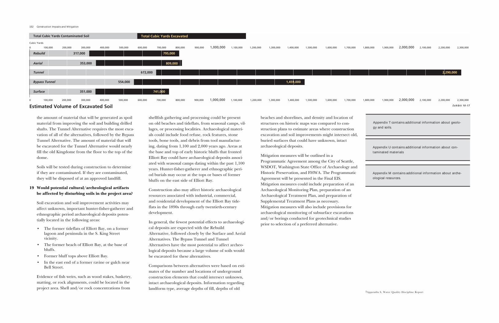
152 Construction Impacts and Mitigation
the amount of material that will be generated as spoilmaterial from improving the soil and building drilledshafts. The Tunnel Alternative requires the most exca-vation of all of the alternatives, followed by the BypassTunnel Alternative. The amount of material that willbe excavated for the Tunnel Alternative would nearlyfill the old Kingdome from the floor to the top of thedome.
Soils will be tested during construction to determineif they are contaminated. If they are contaminated,they will be disposed of at an approved landfill.
19 Would potential cultural/archeological artifactsbe affected by disturbing soils in the project area?
Soil excavation and soil improvement activities mayaffect unknown, important hunter-fisher-gatherer andethnographic period archaeological deposits poten-tially located in the following areas:
� The former tideflats of Elliott Bay, on a formerlagoon and peninsula in the S. King Street vicinity.
� The former beach of Elliott Bay, at the base ofbluffs.
� Former bluff tops above Elliott Bay.
� In the east end of a former ravine or gulch nearBell Street.
Evidence of fish weirs, such as wood stakes, basketry,matting, or rock alignments, could be located in theproject area. Shell and/or rock concentrations from
shellfish gathering and processing could be presenton old beaches and tideflats, from seasonal camps, vil-lages, or processing localities. Archaeological materi-als could include food refuse, rock features, stonetools, bone tools, and debris from tool manufactur-ing, dating from 1,100 and 2,000 years ago. Areas atthe base and top of early historic bluffs that frontedElliott Bay could have archaeological deposits associ-ated with seasonal camps dating within the past 1,100years. Hunter-fisher-gatherer and ethnographic peri-od burials may occur at the tops or bases of formerbluffs on the east side of Elliott Bay.
Construction also may affect historic archaeologicalresources associated with industrial, commercial, and residential development of the Elliott Bay tide-flats in the 1890s through early twentieth-centurydevelopment.
In general, the fewest potential effects to archaeologi-cal deposits are expected with the RebuildAlternative, followed closely by the Surface and AerialAlternatives. The Bypass Tunnel and TunnelAlternatives have the most potential to affect archeo-logical deposits because a large volume of soils wouldbe excavated for these alternatives.
Comparisons between alternatives were based on esti-mates of the number and locations of undergroundconstruction elements that could intersect unknown,intact archaeological deposits. Information regardinglandform type, average depths of fill, depths of old
beaches and shorelines, and density and location ofstructures on historic maps was compared to con-struction plans to estimate areas where constructionexcavation and soil improvements might intersect old,buried surfaces that could have unknown, intactarchaeological deposits.
Mitigation measures will be outlined in aProgrammatic Agreement among the City of Seattle,WSDOT, Washington State Office of Archaeology andHistoric Preservation, and FHWA. The ProgrammaticAgreement will be presented in the Final EIS.Mitigation measures could include preparation of anArchaeological Monitoring Plan, preparation of anArchaeological Treatment Plan, and preparation ofSupplemental Treatment Plans as necessary.Mitigation measures will also include provisions forarchaeological monitoring of subsurface excavationsand/or borings conducted for geotechnical studiesprior to selection of a preferred alternative.
3Appendix S, Water Quality Discipline Report
Appendix T contains additional information about geolo-gy and soils.
Appendix U contains additional information about con-taminated materials
Exhibit 10-17Estimated Volume of Excavated Soil
Appendix M contains additional information about arche-ological resources.