13 Natural Setting Element - Grant County, Washington · 13 Natural Setting Element ... the...
21
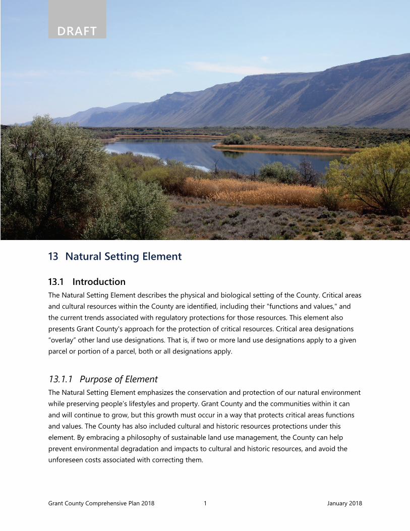
Grant County Comprehensive Plan 2018 1 January 2018 DRAFT 13 Natural Setting Element Introduction The Natural Setting Element describes the physical and biological setting of the County. Critical areas and cultural resources within the County are identified, including their "functions and values," and the current trends associated with regulatory protections for those resources. This element also presents Grant County's approach for the protection of critical resources. Critical area designations “overlay” other land use designations. That is, if two or more land use designations apply to a given parcel or portion of a parcel, both or all designations apply. 13.1.1 Purpose of Element The Natural Setting Element emphasizes the conservation and protection of our natural environment while preserving people’s lifestyles and property. Grant County and the communities within it can and will continue to grow, but this growth must occur in a way that protects critical areas functions and values. The County has also included cultural and historic resources protections under this element. By embracing a philosophy of sustainable land use management, the County can help prevent environmental degradation and impacts to cultural and historic resources, and avoid the unforeseen costs associated with correcting them.
Transcript of 13 Natural Setting Element - Grant County, Washington · 13 Natural Setting Element ... the...
Grant County Comprehensive Plan 2018 1 January 2018
DRAFT
13 Natural Setting Element
Introduction The Natural Setting Element describes the physical and biological setting of the County. Critical areas and cultural resources within the County are identified, including their "functions and values," and the current trends associated with regulatory protections for those resources. This element also presents Grant County's approach for the protection of critical resources. Critical area designations “overlay” other land use designations. That is, if two or more land use designations apply to a given parcel or portion of a parcel, both or all designations apply.
13.1.1 Purpose of Element The Natural Setting Element emphasizes the conservation and protection of our natural environment while preserving people’s lifestyles and property. Grant County and the communities within it can and will continue to grow, but this growth must occur in a way that protects critical areas functions and values. The County has also included cultural and historic resources protections under this element. By embracing a philosophy of sustainable land use management, the County can help prevent environmental degradation and impacts to cultural and historic resources, and avoid the unforeseen costs associated with correcting them.

Grant County Comprehensive Plan 2018 2 January 2018
DRAFT The Natural Setting Element serves two purposes:
• The first is to clarify the relationship between the natural environment and built environments (see Section 13.2)
• The second is to carry forward the intent of the Grant County Unified Development Code (GCC) related to natural resources and the environment (Section 13.3 through 13.5)
Existing Conditions
13.2.1 Natural Setting Grant County is located within the Columbia River Basin in central Washington and bound by the Columbia River to the west and southwest. Agriculture, land use, hydrology, and habitat in the County are heavily influenced by the Columbia Basin Project (CBP), which delivers water from the Grand Coulee Dam for agricultural and municipal uses. The CBP also brought about major changes to the hydrology and land use in the region through the diversion of water to the historically semi-arid region.
The County includes portions of six watersheds, which are known as Water Resource Inventory Areas (WRIAs). Most of the County is in the Lower Crab (WRIA 41). The southern portion of the County is in the Esquatzel Coulee (WRIA 36). The northern portion of the County is largely in the Grand Coulee (WRIA 42), with portions in the Upper Crab-Wilson (WRIA 43), Moses Coulee (WRIA 44), and Lower Lake Roosevelt (WRIA 53).
13.2.1.1 Climate Grant County falls within the Central Basin region of Washington, which has the lowest precipitation rates within the state. Annual precipitation in the areas of Saddle Mountain, Frenchman Hills, and Rattlesnake Mountain average around 7 inches and precipitation is commonly associated with summer thunderstorms and winter rains and snowfall. Snowfall depths rarely exceed 8 to 15 inches and occur from December through February. High temperatures in January can range from 30 to 40 degrees with low temperatures between 15 to 25 degrees. Summer high temperatures are usually in the lower 90s with low temperatures in the upper 50s (WRCC 2012a).
13.2.1.2 Topography The topography in Grant County is variable, ranging from low rolling hills in the north to smooth, south-sloping plains in the south. The plains and hills are dissected by channeled scablands and coulees. Ground surface elevation ranges from 380 feet Mean Sea Level (MSL) at the south end of the County along the Columbia River to about 2,880 feet MSL at Monument Hill.

Grant County Comprehensive Plan 2018 3 January 2018
DRAFT
13.2.1.3 Soils The U.S. Soil Conservation Service has generally characterized the surficial soils in Grant County as very shallow to very deep and well-drained to excessively drained. The northern portion of the County is characterized by soils that formed in highly erodible wind-blown sediments, known as loess, dissected by channeled scablands largely stripped of soils by glacial floodwaters. Soils in this region are primarily used for dryland farming, livestock, and wildlife habitat near the Columbia River The glacial outwash and the alluvium along existing streams such as Crab Creek yield large quantities of water. The southern portion of the County consists of smooth plains (southward-sloping) periodically broken up by Frenchman Hills and the Saddle Mountains (USDA 1984).
13.2.2 Water Resources
13.2.2.1 Introduction As with much of the West, water in Grant County serves competing, and often conflicting, uses. Securing certainty in the water supply will be a major issue over the 20-year planning period. Reliable access to water is necessary for direct human uses like household, agricultural, commercial, and industrial operations, and for indirect human needs such as recreation. Today, irrigated agriculture is the biggest user of water. But recently the needs of other surface water uses, particularly those dealing with the protection and restoration of anadromous fish runs, have been fiercely pursued at all levels of government.
Specifically, major elements in the water supply are:
• Columbia Basin Project. The CBP currently serves about 671,000 acres of desert that have been transformed into some of the most productive agricultural land in the country. The CBP has fueled extensive growth in Grant County’s agriculture industry, which has led to growth in complementary industries such as food processing, agricultural services, warehousing, and trucking. In terms of farm-gate production value, Grant County is the second largest (behind Yakima) in the state.
• ESA-listed species needs. ESA-listed fish species in Grant County include spring Chinook salmon and steelhead. These species are anadromous fish, which are born in fresh water and eventually migrate out to sea where they spend a large part of their life. Ultimately, they attempt to return to the fresh water stream in which they were hatched in order to reproduce. These species are dependent on certain habitat requirements, including water temperatures and water depth.
• Municipal groundwater supply. Groundwater supply and groundwater quality for municipal and rural use are described in further detail in this section. Demand for municipal and rural use are expected to increase as development continues. Since the last Comprehensive Plan
Grant County Comprehensive Plan 2018 4 January 2018
DRAFT update, technological use has significantly increased in the County due to lower-than-average electricity costs and high reliability.
• Rural groundwater supply. As rural development continues, groundwater use is expected to increase. Recent state court decisions on the requirements of the GMA and County land use plans have resulted in a duty for Grant County to ensure that water for development is legally and physically available.
In Grant County, the impact to water quality is predominantly influenced by the CBP. Those impacts have been largely beneficial ones. Prior to implementation of the CBP, many water bodies in the County were seasonally fed, becoming stagnant pools during dry summer months. Development of the CBP enhanced such water bodies, created significant amounts of fish and wildlife habitat, and enhanced water quality.
If the County is to sustain growth, every resident and jurisdiction must meet the ongoing challenge of protecting and managing our water resources, and resisting proposals for elimination of the public investment made in reclamation and flood control projects and in economic and environmentally sustainable electrical power production.
13.2.2.2 Surface Water Surface water systems in the County are significantly affected by the CBP. Approximately 4% (110 square miles) of Grant County surface area is water, which is somewhat striking when considering that the County receives less than 10 inches of precipitation annually. The CBP is a large multi-purpose development that uses Columbia River water for irrigation, power, recreation, and flood control. Potholes Reservoir and O’Sullivan Dam are the key structures that facilitate water conservation for the CBP (Anchor Environmental 2007).
Development of the CBP has also caused an increase in water available for recreation. Before the CBP was developed, there were 35 lakes in the project area, including portions of Grant, Lincoln, Adams, and Franklin counties. There are now more than 140 lakes, ponds, and reservoirs (USBR 2011).
The Columbia River is the primary source of surface water in Grant County. The Columbia River is regulated through the operation of multiple hydroelectric dams within and upstream of the County. Columbia River flows are dependent on the coordination of dam operations of all seven dams in the mid-Columbia River, which range from Grand Coulee Dam to Priest Rapids Dam. Flows and water levels for the Columbia River within Grant County are directly regulated by operations of Wanapum and Priest Rapids dams in accordance with Federal Energy Regulatory Commission (FERC) licensing for the Priest Rapids Hydroelectric Project.

Grant County Comprehensive Plan 2018 5 January 2018
DRAFT In addition to the lakes noted as part of the CBP, Moses Lake also receives most of its water from the Columbia River in the form of irrigation return flows, canal water, and groundwater seepage. It also receives some water from Crab Creek, a small tributary with its headwaters west of Spokane, and Rocky Ford Creek, a spring-fed creek that originates south of Soap Lake. Flows in Rocky Ford Creek increased after irrigation began in the Columbia River Basin.
The County also contains many canals, ditches, and wasteways that carry irrigation water, as well as creeks and streams that have resulted from irrigation-related groundwater recharge and surface water runoff. There are also seep lakes, small ponds, and detention basins resulting from irrigation. Major canals, ditches, wasteways, and other surface waters are show in Appendix A: Map Folio – Figure X.
13.2.2.2.1 Surface Water Quality Water quality within the CBP has been influenced significantly by the introduction of irrigation waters to the area. Streams that had been intermittent prior to the CBP have become and are becoming flowing streams on a year-round basis. Irrigation return waters and subsurface and surface agricultural drainage comprise the flows of waterways within the project area and have created year-round reservoirs and lakes, such as the Potholes Reservoir and Banks Lake, which provide habitat for fish and wildlife. The flows created by the CBP also enhance the shallow regional aquifers, thereby supporting sustainable resource development.
Water quality standards for Washington State are established in WAC 173-201A. The objectives of the WAC are the protection of beneficial uses of these waters, including drinking water supplies, irrigation, stock watering, fish and wildlife habitat, food processing, and recreation.
Columbia Basin Project The CBP is a network of dams, pumping plants, and irrigation canals and reservoirs that provide irrigation water over 670,000 acres. The water for these facilities is supplied by Grand Coulee D
am and Franklin D. Roosevelt Lake. Once water enters the irrigation system, it is used multiple times, through runoff, collection in reservoirs, and reuse, before returning to the Columbia River. In total, irrigators use approximately 2.5 million acre feet (annually) of water though the CBP. In addition to providing irrigation water to Grant County the CBP also generates power, provides recreation opportunities, controls floods, and aids navigation (USBR 2016).

Grant County Comprehensive Plan 2018 6 January 2018
DRAFT Water quality concerns for the major water resources in Grant County are summarized below:
• Columbia River: Primary concerns include levels of dissolved gases above biological thresholds for fish species using the river. The hydroelectric projects on the Columbia River in Grant County are “run-of-river” with reservoirs that have little storage capacity. Water velocities are fast enough to prevent the formation of a thermocline (Grant PUD 2010).
• Crab Creek: Crab Creek is on the Washington Department of Ecology’s (Ecology’s) proposed list of water quality limited streams for temperature and pH. Crab Creek should not be used as a source of domestic water supply nor for primary contact recreation, such as swimming or water skiing.
• Banks Lake: Banks Lake is one of the principal reservoirs of the CBP and impaired by invasive exotic species (Eurasian water-milfoil).
• Moses Lake –: Water quality in Moses Lake is of concern to residents as well as downstream users of Potholes Reservoir waters. The lake has been classified as “hyper-eutrophic,” which indicates that it is receiving excessive nutrient loading (such as nitrogen and phosphorus). The primary water quality problem is overproduction of algae, particularly blue-green algae, which form unsightly, floating mats during the summer recreation season. Dilution water from the East Low Canal and improvement in irrigation techniques have provided some relief from nuisance algae blooms in recent years.
• Billy Clapp Lake: Water quality concerns in Billy Clapp Lake are due to invasive exotic species such as Eurasian water-milfoil.
• Potholes Reservoir: Comparison of water quality at the head of Potholes Canal with that of inflows indicates considerable removal of nutrients, bacteria, and suspended solids by Potholes Reservoir.
• Soap Lake: Soap Lake is recognized worldwide for its unique mineral content and therapeutic value. Soap Lake represents an economic, cultural, recreational, geologic, and environmental benefit to the region. Of concern is potential dilution and pollution of the waters of the lake as well as recreational use that may be incompatible with its therapeutic use. This Plan recognizes the unique functions and values that Soap Lake provides, and intends that the goals and policies of this Natural Setting Element pertaining to water resources and shoreline management protect this important aquatic resource.
13.2.2.3 Groundwater Groundwater is water located within the subsurface of the earth that supplies, or is capable of supplying, water to wells and springs. Groundwater is typically located in porous material such as fractured rock or the weathering products of rock, such as sand. Groundwater is used for drinking water (treated and untreated), irrigation, livestock watering, and manufacturing processes. Groundwater is the major source of drinking water in Grant County.

Grant County Comprehensive Plan 2018 7 January 2018
DRAFT The Columbia Plateau aquifer system is subdivided into four aquifers: the suprabasalt sediment (overburden) aquifer system, Saddle Mountains aquifer, Wanapum aquifer, and Grande Ronde aquifer. The overburden aquifers are found within the main structural basins (such as Quincy Basin) and are the main recipients of surface recharge water, primarily from the CBP (GWMA 2001).
The CBP has impacted Grant County groundwater levels within the project area. The extensive canal system of the CBP combined with non-uniformity in sediment characteristics largely influences groundwater movement (GWMA 2001). For example, before the CBP, Upper Crab Creek only connected to Moses Lake during high water conditions. Today, several springs join the Crab Creek channel because of elevated groundwater from the CBP development (USBR 2007).
13.2.2.3.1 Groundwater Management Areas A portion of eastern Grant County is within the Odessa Groundwater Management Subarea (Odessa Subarea), an area designated by Washington State Legislature in 1967 due to groundwater declines. Since the 1980s, groundwater levels in the Odessa Subarea have declined as much as 200 feet (USBR and Ecology 2012).
A major portion of central Grant County is within the Quincy Groundwater Management Subarea (Quincy Subarea), an area designated by Washington State Legislature in 1969 to establish boundaries and depth zones to develop a groundwater management program for the area (WAC 173-124).
13.2.2.3.2 Groundwater Quality Grant County is one of four counties that make up the Columbia River Basin Ground Water Management Area (GWMA). The GWMA was designated by Ecology in 1998 due to concerns over high nitrate concentrations in groundwater. In 1998, median nitrate-N values were 3.7 milligrams per liter (mg/L) in Grant County.
Nitrate contamination is common in groundwater and can be traced to a variety of agricultural and non-agricultural uses. Agricultural sources of nitrate include inorganic fertilizer and manure. Nitrate can also be derived from vehicles, fertilized lawns, and septic systems. In groundwater, nitrate occurs primarily in upper aquifer wells drilled in the lower lying areas of the County. The correlation between elevated concentrations of nitrates in groundwater and irrigated lands indicates that the
County Regional Aquifers Groundwater in Grant County is part of the Columbia Plateau regional aquifer system. This system occupies about 50,600 square miles and extends across northern Idaho, northeastern Oregon, and a large part of southeastern Washington. Miocene basaltic rocks are the major aquifers in the Columbia Plateau regional aquifer system.
Unconsolidated deposits are also a major source of groundwater, and some unconsolidated-deposit aquifers in Grant County are up to 1,000 feet thick and can yield as much as 3,200 gallons per minute. Miocene basaltic rocks that underlie the unconsolidated deposits yield as much as 4,800 gallons per minute (Whitehead 1994).

Grant County Comprehensive Plan 2018 8 January 2018
DRAFT major sources include applied fertilizers on irrigated lands such as crops, lawns, golf courses, parks, and other similarly managed lands. In general, shallow wells had higher nitrate levels than deep wells, which suggests that surface application is the primary source of nitrate loading (GWMA 2001).
Several federal, state, and local regulations are in place to help minimize negative impacts to groundwater quality. These include regulations on drinking water wells, septic tanks, and runoff from landscaping practices.
In general, groundwater is the major source of drinking water in Washington State, including Grant County. To protect groundwater used for drinking water supplies as required by the federal Safe Drinking Water Act, the Washington State Department of Health requires all Group A public water systems (those that serve 25 or more people or 15 or more connections) that use groundwater as their supply source to implement a wellhead protection program. The wellhead protection program has several requirements that are designed to prevent contamination of groundwater used for drinking water (DOH 2010).
Septic (on-site sewage) systems that are improperly sited, operated, or maintained can affect groundwater quality by discharging contaminants to groundwater. WAC Chapter 246-272A regulates on-site sewage system location, design, installation, operation, maintenance, and monitoring to limit the discharge of contaminants and to minimize public health impacts from septic systems. The Grant County Health Department is the authority in Grant County regarding on-site sewage systems.
13.2.3 Air The attractiveness and livability of communities are directly related to air quality. Polluted air contributes to a variety of health problems and consumes millions of dollars in medical costs each year. Polluted air also obscures visibility, creates unpleasant odors, and adversely affects animal and plant life.
In Grant County, current air quality is, on average, good, because of the County’s lack of industrial development and low population density. The agencies that monitor air quality, Ecology and the U.S. Environmental Protection Agency (EPA), have designated Grant County as an area currently in attainment for all standards.
However, because the primary source of air pollution in the County is from motor vehicle operation, and despite existing state and federal emission regulations, maintaining or improving air quality will become a challenge for the County as growth continues, particularly in urban areas. The County can also expect to experience negative effects due other sources, such as increased dust from additional traffic on unpaved roads in residential and agricultural areas and commercial and industrial operations.

Grant County Comprehensive Plan 2018 9 January 2018
DRAFT Additionally, at times, air quality can be negatively affected due to wind erosion. Because of the general lack of industrial sources, agricultural sources are of greater importance due to the prevalence of wind erosion from range areas, gravel roads, and cultivated fields. Wind erosion is greatest during the spring and fall, when high winds and dry soil conditions create dust storms of varying severity. The severity of dust storms is exacerbated by dryland agricultural practices, which expose the soil during spring cultivation and fall harvesting periods.
13.2.4 Vegetation The majority of Grant County is native rangeland characterized by steppe vegetation comprised mainly of grasses, forbs, and shrubs. The Artemisia/Agropyron (sagebrush/wheat grass) association forms the climax species for this zone and is the most extensive association of the steppe vegetation of the eastern Columbia River Basin. Very similar communities are also found in British Columbia, Central Oregon, Southern Idaho, and Montana. Low precipitation levels serve to maintain this association and generally prevent growth of trees except along water courses and in low, wet depressions.
The vegetation in the Artemisia/Agropyron association can be divided into four layers:
1. Shrub layer dominated by sage brush 2. Perennial grass layer with blue-bunch wheatgrass and needle and thread grass typically
occurring in dense tufts 3. Mixed herbaceous layer of prostrate plants such as cheat grass 4. Surface crust of lichens and mosses
In addition, along the mainstem of the Columbia River and its adjacent stream corridors are vegetative belts that contain various shrubs, trees, and grasses. Water-loving trees like black cottonwood, aspen, and alder are found along many stream banks. These well vegetated stream-side riparian zones provide substantial food and shelter for wildlife. Many aquatic organisms feed on leaf litter and woody debris that collect in these streams. Insects and other invertebrates falling from these plants provide an important source of food for many fish species. Birds and land animals depend on stream-side vegetated areas for food, thermal protection, visual cover, and as a migratory corridor to other parts of their habitat. It is the sum of these parts, from microorganism to migrating fish that make habitat vibrant and healthy.
Critical Areas and Cultural Resources Critical areas are protected ecosystems, landforms, or processes that are protected under the Washington State GMA for the biological or physical functions and values that they provide. Critical
Grant County Comprehensive Plan 2018 10 January 2018
DRAFT areas are categorized by Grant County Code (GCC) Critical Areas Ordinance (CAO) 24.08.020 as follows:
• Wetlands • Frequently Flooded Areas • Critical Aquifer Recharge Areas • Geologically Hazardous Areas • Fish and Wildlife Habitat Conservation Areas • Cultural Resource Areas
Critical areas such as wetlands, open spaces, and fish and wildlife habitat contain much of the fish and wildlife, their habitats and other natural resources valued by County residents. Other sensitive areas, such as land located outside fire districts or those prone to flooding are important because of the risk to lives and property posed by developing in them. Critical areas in Grant County also include cultural and historic resources which include those areas or structures that have historic or archaeological significance. Cultural and historic resources protections help the County comply with state and federal laws and regulations as they protect these sensitive resources. Critical Areas and Cultural Resources (GCC Chapter 24.08) is being updated in 2018 to include the latest information and standards for designating and protecting natural resources and critical area lands.
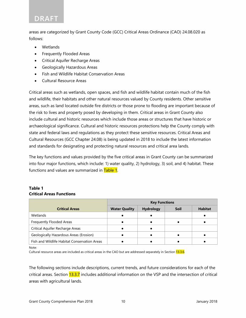
The key functions and values provided by the five critical areas in Grant County can be summarized into four major functions, which include: 1) water quality, 2) hydrology, 3) soil, and 4) habitat. These functions and values are summarized in Table 1.
Table 1 Critical Areas Functions
Critical Areas
Key Functions
Water Quality Hydrology Soil Habitat
Wetlands ● ● ●
Frequently Flooded Areas ● ● ● ●
Critical Aquifer Recharge Areas ● ●
Geologically Hazardous Areas (Erosion) ● ● ● ●
Fish and Wildlife Habitat Conservation Areas ● ● ● ● Note: Cultural resource areas are included as critical areas in the CAO but are addressed separately in Section 13.3.6.
The following sections include descriptions, current trends, and future considerations for each of the critical areas. Section 13.3.7 includes additional information on the VSP and the intersection of critical areas with agricultural lands.

Grant County Comprehensive Plan 2018 11 January 2018
DRAFT
13.3.1 Maps and References The Grant County Current Planning Department maintains a series of data maps containing the best available graphic depiction of critical areas in Grant County for the purpose of administering GCC Chapter 24.08 – Critical Areas and Cultural Resources. These maps are for information and illustrative purposes only and are not regulatory in nature.
The maps are intended to alert the development community, appraisers, and current or prospective owners of a potential encounter with a use or development limiting factor based on the natural systems present. The indication of the presence of a critical area on the maps is sufficient cause for the County to request a site-specific analysis for the critical areas identified prior to acceptance of a development application as being complete and ready for processing.
The maps are to be used as a general guide to the location and extent of critical areas. Critical areas indicated on the maps are presumed to exist in the locations shown. The exact location and extent of critical areas shall be determined by the applicant as a result of field investigations performed by qualified professionals using the definitions found GCC Chapter 24.08 – Critical Areas and Cultural Resources. Also see Figures 8 through 13 of Appendix A: Map Folio for the general location of critical areas in Grant County.
13.3.2 Wetlands Wetlands are important ecosystems that serve many beneficial functions. Wetlands can help reduce erosion and siltation; provide filtration and produce cleaner water; retain water to reduce flooding and support base flows; and provide wildlife, plant, and fisheries habitats. Vegetative growth along waterways and canals in Grant County improves food, cover, and nesting habitats for many wildlife species, which also provide recreational opportunities.
In Grant County, the wetland environment is predominantly a function of irrigation, which has created mostly freshwater emergent seasonal wetlands in portions of the County. The CBP has provided beneficial wetlands to more than 110,000 acres of naturally drainage-impaired lands. In Grant County, wetlands have formed along reservoirs, streams, and creeks receiving return flows from the CBP including Crab Creek, Lower Crab Creek, Rocky Ford Creek, and Lind Coulee. Wetlands have also formed in proximity to CBP main canals, laterals, and wasteways including the Winchester and Frenchman Hills wasteways. Reservoirs and lakes, including Potholes and Banks Lake, also include wetland complexes that have formed over time as a result of the CBP.
Many wetlands within Grant County are considered unintentional wetlands, resulting from localized conditions such as unlined irrigation ditches and tailwater from surface irrigated fields. These types of wetlands are considered jurisdictional wetlands regulated by state wetland law. However, if the irrigation practices and infrastructure upgrades are changed (such as implementation of water

Grant County Comprehensive Plan 2018 12 January 2018
DRAFT conservation practices and lining and piping ditches), and the wetland dries up and no longer performs wetland functions, then no mitigation is required (Ecology 2010).
In Grant County, wetlands are protected under the CAO as a resource vital to sustaining biological productivity and water quality. Wetland habitat is commonly affected by development, resulting in habitat fragmentation and/or losses. Other activities affecting wetlands include agricultural practices and changes in irrigation efficiencies. Wetland destruction or impairment may result in increased public and private costs or property loss.
Recent updates to the CAO have been made to improve protection of wetlands from these activities using best available science, and consistent with the Grant County SMP (Anchor QEA 2014). The Comprehensive Plan is also intended to protect natural wetlands from non-agricultural developments and protect previously unfarmed wetlands from new agriculture. The VSP Work Plan, described in Section 13.3.7, is being implemented by Grant County and participating agricultural producers to protect and voluntarily enhance wetlands and other critical areas (Anchor QEA 2017). Currently available resources for determining the approximate location of wetlands in Grant County include:
• U.S. Fish and Wildlife Service National Wetlands Inventory (https://www.fws.gov/wetlands/) • WDFW Priority Habitats and Species Maps (http://wdfw.wa.gov/mapping/phs/) • Grant County Geographic Information System Maps (http://www.grantcountywa.gov/GIS/)
To confirm if wetlands are present, a wetland delineation is conducted by a professional using methods approved by the U.S. Army Corps of Engineers and verified using local rating systems. The Ecology Wetland Rating System is used to rate wetland soils in Washington State. Wetland delineation and verification resources are available here:
• Ecology Wetlands Page (http://www.ecy.wa.gov/programs/sea/wetlands/ratingsystems/index.html)
13.3.3 Frequently Flooded Areas Frequently flooded areas are defined as floodplains or other areas designated as being within a 100-year or greater floodplain by the Federal Emergency Management Agency’s (FEMA’s) Federal Insurance Rate Maps. FEMA has defined the extent of the 100-year floodplain to establish actuarial flood insurance rates and to assist communities in efforts to promote sound floodplain management. Frequently flooded areas primarily occur on waterways and drainages. In Grant County, these mainly include Banks Lake, Crab Creek, Lower Crab Creek, Dry Creek, and Potholes Reservoir.
Frequently flooded areas protect public health and safety by providing temporary flood water storage and conveyance. They also provide riparian habitat and other wildlife benefits, and can improve water quality and recharge groundwater. Frequently flooded areas also affect surface and

Grant County Comprehensive Plan 2018 13 January 2018
DRAFT groundwater quality and hydrology (timing and magnitude of flows, and alluvial aquifer recharge), improve or degrade soil health based on vegetative conditions, contribute to riparian habitat diversity, and provide natural areas and rich agricultural lands.
Flooding in the County is typically caused by either heavy snowfall followed by warm temperatures or by high-intensity, short-duration rainfall during winter months (December to February). Flash floods are sometimes seen in the County and can be particularly damaging due to the short warning time. Human activities such as development within the floodplain may increase the frequency, magnitude, and displacement of the flood, hence causing flooding in other areas of a stream. Flood hazards in these areas include periodic inundation ranging in severity, with the potential to result in the loss of life, loss of property, health and safety hazards, disruption of commerce and governmental services, and extraordinary public expenditures for flood protection and relief.
To limit damage to individuals, property, and natural systems, Grant County requires compliance with the provisions of the County’s Flood Damage Prevention Ordinance, CAO, Zoning Ordinance, SMP, Platting and Subdivision Ordinances, and the Short Plat and Short Subdivision Ordinance. The intent of these policies is to promote the efficient use of land and water resources by allocating frequently flooded areas to the uses for which they are best suited. These regulations are intended to discourage obstructions to floodways and prohibit uses that pollute or deteriorate natural waters and watercourses. New development should be reviewed by Grant County for compliance with local, state, and federal regulations for development within frequently flooded areas.
FEMA works with the County to update floodplain mapping. No updates to the mapping are currently underway in Grant County; any changes to the FEMA maps in the future would be available at the following resources:
• FEMA Flood Map Service Center (https://msc.fema.gov/portal) • Grant County Geographic Information System Maps (http://www.grantcountywa.gov/GIS/)
13.3.4 Critical Aquifer Recharge Areas Critical aquifer recharge areas are groundwater aquifers that provide protections to public drinking water supplies and are typically located near cities and towns. Grant County’s potable water comes from groundwater and surface water supplies, including the critical aquifer recharge areas. Once a potable water source is contaminated, it is difficult, costly, and sometimes impossible to clean up. Therefore, preventing contamination of these water sources is necessary to avoid public costs, hardships, and potential physical harm to people.
As precipitation reaches the earth it typically forms into snow pack, enters lakes, streams, rivers, oceans, or wetlands, seeps into the soil and plant roots, or filters into the ground into groundwater basins. The land surface where this filtering process takes place is called an aquifer recharge zone.
Grant County Comprehensive Plan 2018 14 January 2018
DRAFT Aquifer recharge zones warrant special protection from surface pollution to protect the quality of the groundwater in the area. Groundwater often moves through the ground, eventually discharging to surface water features, such as lakes, streams, or rivers, which in turn recharges the groundwater. The water remaining in the ground makes up the aquifer.
Grant County is located within the Columbia River Basin GWMA, an area designated for protecting groundwater and addressing groundwater issues. Of the 176 public water supply system wells recorded within Grant County, more than half of them are shallow wells that could be considered domestic supply wells with the highest potential susceptibility to contamination. The remaining public water supply wells are deeper wells, which likely receive their recharge outside of the wellhead protection areas. Consequently, the deeper wells would be considered to have lower susceptibility to contamination from surface activities occurring within Grant County, as recharge occurs outside of the County (EA 2017).
Continued protection and management of critical aquifer recharge areas in and around Grant County is imperative to reducing pollution and maintaining water storage levels for future use. The Grant County Conservation District provides resources to landowners to educate them on the impact of land management practices on groundwater and groundwater quality. Programs include irrigation water management, lawn care, livestock management, and water quality and quantity programs. Other groundwater-related information is available at the following resources:
• U.S. Geological Survey Groundwater Information Pages (https://water.usgs.gov/ogw/) • Ecology Groundwater Quality Webpage
(http://www.ecy.wa.gov/programs/wq/grndwtr/index.html) • Columbia River Basin Groundwater Management Area Subsurface Mapping and Aquifer
Assessment Project (CBGWMA 2009) • Grant County Conservation District webpage (http://www.columbiabasincds.org/)
13.3.5 Geologically Hazardous Areas Geologically hazardous areas are defined per RCW 36.70A.030 (10) as "areas that, because of their susceptibility to erosion, sliding, earthquake or other geologic events, are not suited to the siting of commercial, residential or industrial development consistent with public health or safety concerns." According to the Grant County CAO, geologically hazardous areas include:
• Erosion Hazards: Areas identified by the U.S. Department of Agriculture Natural Resources Conservation Service as having high or very high water erosion hazard
• Landslide Hazards: Areas potentially subject to landslides based on a combination of related geologic, topographic, and hydrologic conditions (e.g., steep slopes, alluvial fans, high-velocity stream banks)

Grant County Comprehensive Plan 2018 15 January 2018
DRAFT • Mine Hazards: Areas within or within 100 horizontal feet of a mine opening at the surface or
those areas designated by the Washington State Department of Natural Resources as a mine hazard area
• Seismic Hazards: Areas subject to severe risk of damage as a result of earthquake-induced ground shaking, slope failure, settlement, soil liquefaction, or surface faulting
Development within geologically hazardous areas can result in a potential risk to health and safety. In some cases, the risk can be reduced or mitigated to acceptable levels by engineering design or modified construction practices. However, when the risks cannot be sufficiently mitigated, development should be prohibited. Future development within or near geologically hazardous areas should be carried out consistent with Grant County CAO. The Grant County CAO includes a list of references for identifying geologically hazardous areas. Additionally, site assessment protocols, protection requirements, and mitigation measures are provided for development within each geologically hazardous area type.
The following references are available for determining the general location and extent of geologically hazardous areas:
• U.S. Geologic Survey Geologic Hazards Science Center (https://www.usgs.gov/centers/geohazards)
• Washington State Department of Natural Resources Geologic Information Portal (https://www.dnr.wa.gov/geologyportal)
• Grant County Geographic Information System Maps (http://www.grantcountywa.gov/GIS/)
Erosion Hazards. Erosion is a common occurrence in Grant County due to hydrologic and geologic characteristics, vegetative conditions, wind and human land use. Grant County soils are generally characterized by loess, which are very deep, fertile, and highly erodible soils deposited through lake settling or by wind from the post-glacial outwash. As shown in Figure 12 in Appendix A: MapFolio, erosive soils are located throughout Grant County. These areas are predominantly located along the Columbia River, Lower Crab Creek, and near Grand Coulee. Minimizing or mitigating for development in these areas can help to reduce the damage to natural and built environments.
Landslide Hazards. Landslide hazard areas are those areas within Grant County that are subject to potential slope failure. Steep slopes in Grant County are generally located near rivers and streams where erosive forces have steepened slopes over time. Steep slopes are predominantly located along the Columbia River Basin and Lower Crab Creek (Grant County 2017). Regulations should continue to be followed to protect public health and safety from development located on, or adjacent to, steep slope or landslide areas, preserve the scenic quality and natural character of Grant County's hillsides, and to protect water quality.

Grant County Comprehensive Plan 2018 16 January 2018
DRAFT Seismic Hazards. Seismic hazard areas are generally associated with active fault areas and earthquakes. While earthquakes cannot be eliminated, there are no areas in Grant County that have been identified that pose significant, predictable hazards to life and property resulting from the associated ground shaking, differential settlement, and/or soil liquefaction. The U.S. Department of Agriculture Natural Resource Conservation Service provides soil information indicating areas of risk for liquefaction.
Mine Hazards. Mine hazard areas are defined as "areas directly underlain by, adjacent to, or affected by mine workings such as adits, tunnels, drifts, or air shafts." Mine hazards may also include steep and unstable slopes created by open mines. There has been minimal, if any, historical subsurface mining in Grant County due to the geology in the area.
13.3.6 Fish and Wildlife Habitat Conservation Areas Fish and wildlife habitat conservation areas include streams, riparian vegetation, and upland habitats that provide habitat to support fish and wildlife species throughout their life stages. These include ranges and habitat elements where endangered, threatened, and sensitive species may be found, and areas that serve a critical role in sustaining needed habitats and species for the functional integrity of the ecosystem, and which, if altered, may reduce the likelihood that the species will persist over the long term. These areas provide key ecological functions for water quality, hydrology, soil health, and habitat.
Grant County provides habitat for a variety of birds and large mammals, particularly near Lynch Coulee, the Winchester and Frenchman Hills wasteways, and around the Banks Lake area. Bird species and habitat identified by the WDFW in these areas include sage grouse, Ferruginous hawk, American white pelican, bald eagle, sandhill crane, western grebe, and a variety of shorebird and waterfowl concentrations. Mule deer is the most common large mammal, with wide-ranging habitat across Grant County.
Priority habitats in Grant County include cliffs and bluffs, riparian areas, shrub-steppe habitat, and wetlands. These habitats serve a variety of functions in Grant County for locally protected species. These habitats are largely affected by various anthropogenic activities including agricultural practices and development. A decline in these locally important habitats can also affect the species that rely on them.
Species such as sage grouse have historically been on the decline in Grant County. WDFW completed a recovery plan in 2004 and has since worked with landowners to enroll thousands of acres in federal conservation programs, tailored to address the needs of the specific property in order to keep working lands working while also providing conservation actions compatible with the federal Sage Grouse Initiative and related conservation programs (WDFW 2015).

Grant County Comprehensive Plan 2018 17 January 2018
DRAFT Shrub-steppe upland habitat is the largest native land cover type in Grant County. The shrub-steppe habitat provides many ecosystem services including soil stabilization, wildfire moderation, and overall biodiversity. Shrub-steppe also provides habitat to many species that are endemic to the region, such as sage grouse. Recommendations provided in the Grant County SMP Final Draft Shoreline, Inventory, Analysis, and Characterization Report for preserving shrub-steppe habitat include limiting development footprints including agricultural land cover changes, limiting road and utility corridors to avoid fragmenting habitat, restricting vegetation clearing, keeping domestic pets and livestock out of sensitive species habitat, limiting fencing to avoid barriers to native wildlife, and limiting irrigation canals through shrub-steppe habitat (Anchor QEA 2013).
Many of the habitat conservation areas in Grant County are managed to protect species and natural geographic distribution to avoid fragmenting habitat. In these cases, cooperative and coordinated land use planning is critical for not only the natural environment, but to the quality of life in Grant County. Several managed and protected fish and wildlife habitat areas are located in Grant County as described below:
• Columbia River: The Columbia River provides habitat to a variety of aquatic and terrestrial species in Grant County. The Columbia River supports more than 40 fish species, including individuals from 14 families of freshwater fishes, and 6 anadromous species (including Chinook salmon, sockeye salmon, coho salmon, steelhead, and Pacific and river lamprey). Anadromous salmonids are present only downstream of Chief Joseph Dam on the mid-Columbia River. The U.S. Bureau of Reclamation, Northwest Power and Conservation Council, Grant County PUD, and Columbia River Basin Hydropower manage hydroelectric activities in the Columbia River Basin to enhance and facilitate the downstream migration of juvenile salmonids throughout the year. This streamflow allocation for fisheries protection and enhancement is intended to provide favorable flow conditions during peak passage times. These agencies, the WDFW, and other agencies also implement fish habitat enhancement programs on the Columbia River.
• Banks Lake: Banks Lake is a 27-mile manmade irrigation impoundment that receives water directly from Lake Roosevelt via pumping and serves as the irrigation equalizing reservoir for the CBP. Banks Lake supports nongame, warmwater, and coldwater game fish and a valuable, year-round sport fishery for kokanee, smallmouth bass, walleye, and other species. The WDFW supplements the kokanee population with hatchery fry plants, and also plants rainbow trout through a cooperative agreement with the local community. The area surrounding Banks Lake also provides habitat for birds and large mammals.
• Potholes Reservoir: The Potholes Reservoir was formed in the early 1950s with the completion of O’Sullivan Dam and is considered to have the most diverse, well-used fishery in the Columbia River Basin. The Potholes Reservoir is managed by the U.S. Bureau of Reclamation, in coordination with the Washington State Parks and WDFW. At least ten game

Grant County Comprehensive Plan 2018 18 January 2018
DRAFT fish are known to exist in the reservoir, with yellow perch, black crappie, largemouth bass, bluegill sunfish, walleye, and rainbow trout being the most popular. Rainbow trout are stocked annually in the reservoir, and the other species are self-sustaining. The area surrounding the Potholes Reservoir provides habitat for a variety of large mammals such as elk, deer, and bighorn sheep.
• Other Water Bodies: The U.S. Bureau of Reclamation and the WDFW have investigated the fisheries resources of nearly 200 lakes and 40 streams or stream segments comprising 425 miles of flowing water in the Columbia River Basin. Lakes directly connected to the irrigation system are dominated by yellow perch, whereas rainbow trout dominate the seep lakes indirectly affected by irrigation. Other abundant game fish species in both lake groups include black crappie, largemouth bass, and pumpkinseed sunfish. The most abundant nongame fish are Tui chub, common carp, and sucker, all of which occur only in lakes directly connected to the irrigation system.
As the conversion of untouched land to agriculture and development continues, habitat fragmentation will further reduce biological productivity and diversity. Conservation areas, such as public holdings, hold promise for successfully protecting eastern Washington's natural wildlife heritage. The acreage and benefits of these conservation areas may be improved by lands protected and enhanced through the VSP and other programs carried out by Grant County and the Grant County Conservation District. Future considerations for Grant County include:
• Conserving existing public or private lands for habitat purposes, augmented where needed by additional purchases, exchanges, conservation easements to "connect" large tracts of habitat (e.g., wetlands, shrub-steppe) into functional systems
• Applying and monitoring for effectiveness of regulatory provisions to protect and enhance near-shore riverine and wetland environments
• Applying water conservation standards to non-farm developments • Increasing watershed storage capacity to provide additional low season flows and reduce the
competition between in- and out-of-stream uses for available water supplies • Encouraging land use practices that eliminate or significantly reduce non-point source
pollution • In concert with state resources agencies, undertaking local educational outreach programs
including grant monies for demonstration projects on private lands associated with sensitive resource issues
The following references are available for determining the general location and extent of fish and wildlife habitat conservation areas:
• National Oceanographic and Atmospheric Administration Fisheries Service Critical Habitat (http://www.nmfs.noaa.gov/pr/species/criticalhabitat.htm)

Grant County Comprehensive Plan 2018 19 January 2018
DRAFT • U.S. Fish and Wildlife Service Environmental Conservation Online System
(https://ecos.fws.gov/ecp/report/table/critical-habitat.html) • U.S. Fish and Wildlife Service National Wetlands Inventory (https://www.fws.gov/wetlands/) • WDFW Priority Habitats and Species Interactive Mapping (http://wdfw.wa.gov/mapping/phs/) • WDFW SalmonScape (http://apps.wdfw.wa.gov/salmonscape/) • Washington State Department of Natural Resources Natural Heritage Program
(https://www.dnr.wa.gov/natural-heritage-program) • Grant County Conservation District webpage (http://www.columbiabasincds.org/) • Grant County Geographic Information System Maps (http://www.grantcountywa.gov/GIS/)
13.3.7 Cultural Resource Areas Cultural resources are identified in the Grant County CAO as those areas that have been identified as having lands, sites, and structures that have historical or archaeological significance. Native Americans, like the Columbia and Wanapum people, have traveled over the landscape that is now Grant County harvesting the roots and plants for food and medicine, taking shelter where the land suited them. Cultural resources include archaeological sites and objects, traditional cultural lands, food gathering areas, and burial grounds. Preservation of Grant County’s cultural resources through records and other means of preservation is important to Grant County’s past, current, and future residents.
Future development should be consistent with the local, state, and federal regulations for protection of cultural resources and archaeological sites. The Grant County CAO provides maps and references for identifying archaeological sites and potential cultural resources areas. Additionally, site assessment requirements and protection standards are provided for future development. Where archaeological sites or cultural resources are identified, development should be coordinated with the tribes to avoid, minimize, or mitigate for potential impacts.
In addition to the Grant County CAO, the following resources are available for determining the potential for encountering archaeological sites or cultural resources:
• Washington State Department of Archaeology and Historic Preservation Washington Information System for Architectural and Archaeological Records Data (https://dahp.wa.gov/project-review/wisaard-system)
• Grant County PUD Artifact Protection webpage (http://www.gcpud.org/environment/artifact-protection)

Grant County Comprehensive Plan 2018 20 January 2018
DRAFT
13.3.8 Voluntary Stewardship Program Grant County opted into the Voluntary Stewardship Program (VSP) in 2012 and developed an approved Grant County VSP Work Plan in 2017 (Anchor QEA 2017) to protect and voluntarily enhance critical areas in places where agricultural activities are conducted, while maintaining and enhancing the long-term viability of agriculture.
Agricultural lands have little intersect with critical areas in Grant County. Geologically hazardous areas have the greatest at 38% intersect with private agricultural lands. Fish and wildlife habitat conservation areas have a 10% intersect with private agricultural lands. Frequently flooded areas, geologically hazardous areas, and wetlands all have a 2 percent or less intersect with private agricultural lands.
To protect and/or voluntarily enhance critical areas with an intersect with private agricultural lands, Grant County Conservation District collaborated with a local Work Group to develop and implement the Grant County VSP Work Plan (Anchor QEA 2017). For the purposes of the Work Plan, the Work Group identified eight community planning areas within the County to help develop a more localized planning approach during implementation of the Work Plan. The community planning areas include: Black Sands, Ephrata, Hartline, Mattawa, Moses Lake, Quincy, Royal Slope, and Warden. More information on the VSP can be found in the VSP Work Plan (Anchor QEA 2017). The Grant County Conservation District webpage also contains additional information at http://www.columbiabasincds.org/vsp.
Shoreline Master Program The Washington State Shoreline Management Act (SMA) was enacted in 1971 to provide for the management and protection of shorelines of the state by regulating development in the shoreline area. The SMA requires cities and counties to adopt a SMP to regulate shoreline development and accommodate all reasonable and appropriate uses. Grant County completed an updated Shoreline Master Program as required by Chapter 90.58 RCW in 2014 (Anchor QEA 2014).
The GMA requires counties with an adopted SMP to include the goals and policies of such program in the county’s comprehensive plan. The SMP goals and policies are to be considered an element of the comprehensive plan and the regulations are to be considered a part of the county’s development regulations (RCW 36.70A.480). The goals and policies set forth in this Comprehensive Plan reflect the
The Voluntary Stewardship Program (RCW 36.70A.700) The GMA was amended in 2011 to establish the VSP, a new, non-regulatory, and incentive-based approach that balances the protection of critical areas on agricultural lands while promoting agricultural viability, as an alternative to managing agricultural activities in Grant County under the CAO.
VSP is not a replacement for compliance with other local, state, or federal laws and regulations, but participation in VSP will help to show how much effort the County’s agricultural producers are investing in meeting these requirements and to document the benefits of these efforts in protecting and enhancing critical area functions and values.
Grant County Comprehensive Plan 2018 21 January 2018
DRAFT guiding principles of Grant County’s SMP, with the remainder of the SMP adopted by reference. Chapter 4 of the Comprehensive Plan provides the framework for future decision-making and is a guide for future development of lands within the County’s shoreline jurisdiction boundaries. Additional information is included in the SMP (Anchor QEA and Oneza & Associates 2014).
Fire Hazards Fire hazards are a serious and growing threat in the United States, particularly in drier regions that are more susceptible to fires. Whether wildfire occurs in urban areas, shrub-steppe, wheat fields, or grasslands, the potential loss to life and property is a concern to both property owners and firefighters. Grant County receives little natural precipitation and is highly susceptible to fire hazard during much of the year. In August 2017, a 500-acre wildfire was sparked in Quincy, Washington, forcing the evacuation of many residents and damaging at least two homes. Similar wildfires have occurred in the region that are attributed to dry summers with little to no precipitation for months at a time.
As development expands into rural areas, the need to provide adequate and efficient fire services increases. Future development should consider potential fire hazards and proximity to more susceptible areas. Grant County GCC Chapter 6.10 includes provisions related to fire hazards, including regulations pertaining to vegetation pile burning and recreational fires. Other resources available for fire hazard education and prevention include:
• Grant County Conservation District Agricultural Burn Permits Program (http://www.columbiabasincds.org/publications-)
• Washington Burn Bans for Grant County (https://waburnbans.net/recent-burn-bans/grant/) • Grant County Fire Marshall (http://www.grantcountywa.gov/Fire-Marshal/)