120258 Grants Mill Road Residential Turn Lane Warrant Memo · 6:00 -7:00 288 277 565 496 350 846...
22
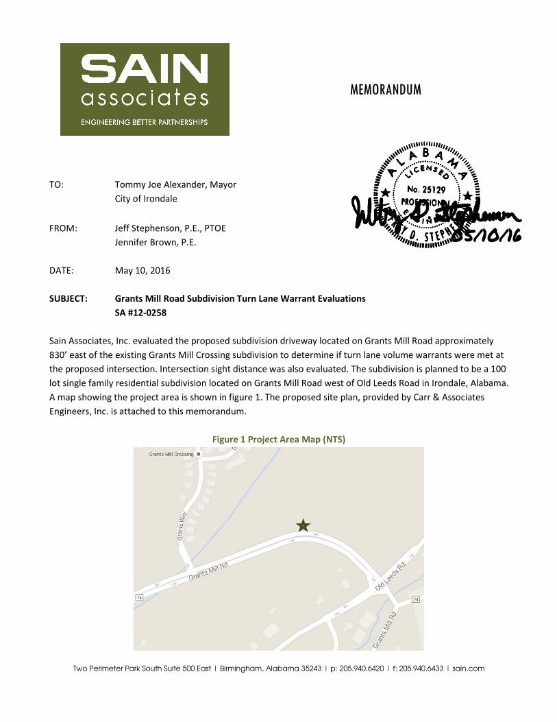
Two Perimeter Park South Suite 500 East | Birmingham, Alabama 35243 | p: 205.940.6420 | f: 205.940.6433 | sain.com MEMORANDUM TO: Tommy Joe Alexander, Mayor City of Irondale FROM: Jeff Stephenson, P.E., PTOE Jennifer Brown, P.E. DATE: May 10, 2016 SUBJECT: Grants Mill Road Subdivision Turn Lane Warrant Evaluations SA #12-0258 Sain Associates, Inc. evaluated the proposed subdivision driveway located on Grants Mill Road approximately 830’ east of the existing Grants Mill Crossing subdivision to determine if turn lane volume warrants were met at the proposed intersection. Intersection sight distance was also evaluated. The subdivision is planned to be a 100 lot single family residential subdivision located on Grants Mill Road west of Old Leeds Road in Irondale, Alabama. A map showing the project area is shown in figure 1. The proposed site plan, provided by Carr & Associates Engineers, Inc. is attached to this memorandum. Figure 1 Project Area Map (NTS) 05/10/16
Transcript of 120258 Grants Mill Road Residential Turn Lane Warrant Memo · 6:00 -7:00 288 277 565 496 350 846...
Two Perimeter Park South Suite 500 East | Birmingham, Alabama 35243 | p: 205.940.6420 | f: 205.940.6433 | sain.com
MEMORANDUM
TO: Tommy Joe Alexander, Mayor
City of Irondale
FROM: Jeff Stephenson, P.E., PTOE
Jennifer Brown, P.E.
DATE: May 10, 2016
SUBJECT: Grants Mill Road Subdivision Turn Lane Warrant Evaluations
SA #12-0258
Sain Associates, Inc. evaluated the proposed subdivision driveway located on Grants Mill Road approximately
830’ east of the existing Grants Mill Crossing subdivision to determine if turn lane volume warrants were met at
the proposed intersection. Intersection sight distance was also evaluated. The subdivision is planned to be a 100
lot single family residential subdivision located on Grants Mill Road west of Old Leeds Road in Irondale, Alabama.
A map showing the project area is shown in figure 1. The proposed site plan, provided by Carr & Associates
Engineers, Inc. is attached to this memorandum.
Figure 1 Project Area Map (NTS)
05/10/16

Grants Mill Road Subdivision
May 10, 2015
Page 2
Two Perimeter Park South Suite 500 East | Birmingham, Alabama 35243 | p: 205.940.6420 | f: 205.940.6433 | sain.com
Existing Conditions Grants Mill Road is a 4-lane divided east-west roadway with a posted speed limit of 45 miles per hour.
Directional hourly traffic count data was collected for a 24-hour period beginning at 10:00AM on Tuesday, April
26, 2016 along Grants Mill Road adjacent to the proposed subdivision site. The traffic volumes are summarized
in Table 1. Our traffic count reports indicate that the morning peak hour is 7:15-8:15 with a volume of 694 for
the westbound direction and 701 for the eastbound direction for a total volume of 1395. The afternoon peak
hour is 4:45-5:45 with a volume of 603 for the westbound direction and 840 for the eastbound direction for a
total volume of 1443. Raw traffic count data reports are included as an attachment to this memorandum.
Table 1 Existing Traffic Counts
Hour Begins AM PM
EB WB Total EB WB Total
12:00-1:00 29 23 52 416 384 800
1:00-2:00 11 11 22 427 402 829
2:00-3:00 12 10 22 476 389 865
3:00-4:00 7 9 16 530 595 1125
4:00-5:00 23 27 50 724 519 1243
5:00-6:00 79 66 145 802 597 1399
6:00-7:00 288 277 565 496 350 846
7:00-8:00 674 652 1326 315 252 567
8:00-9:00 476 546 1022 193 179 372
9:00-10:00 334 375 709 108 132 240
10:00-11:00 320 333 653 88 68 156
11:00-12:00 399 392 791 55 40 95
Trip Generation We used the Institute of Transportation Engineers publication Trip Generation Manual, (9th Edition) to prepare a
trip generation for the proposed subdivision. Land Use Code 210 (Single-Family Detached Housing) is the
applicable land use for the development. The estimated trip generation is summarized in Table 2.
Table 2 Trip Generation
Land Use
(ITE Code) Size Weekday
AM New PM New
IN OUT IN OUT
Single-Family Detached Housing (210) 100 dwelling units 1050 20 60 66 39

Grants Mill Road Subdivision
May 10, 2015
Page 3
Two Perimeter Park South Suite 500 East | Birmingham, Alabama 35243 | p: 205.940.6420 | f: 205.940.6433 | sain.com
Using procedures outlined in NCHRP Report 457 – Evaluating Intersection Improvements, turn lane warrant
analysis was performed at the intersection of the proposed subdivision and Grants Mill Road. The results of the
analysis are summarized in Table 3. Detailed analysis printouts are attached to this memorandum. The
directional distribution of new traffic to be generated by the proposed subdivision was estimated based on the
existing traffic volumes along Grants Mill Road.
Table 3 Turn Lane Warrant Analysis Summary
Intersection Left Turn Lane Right Turn Lane
AM PM AM PM
Subdivision and Grants Mill Road NO YES NO NO
According to our analysis, a left turn lane is warranted during the PM peak hour and should be installed on
Grants Mill Road. A concept plan showing the left turn lane is attached to this memorandum. The storage and
taper lengths for this turn lane were ascertained from the Alabama Department of Transportation’s Access
Management Manual 2014. Table 4.6 of this manual provides turn lane storage and taper lengths based on the
design speed of the roadway. The speed limit for Grants Mill Road is posted at 45 miles per hour; however the
measured 85th percentile speed is 50 miles per hour. Therefore, we used a 50 mile per hour speed to determine
a left turn lane storage length of 325’ with a 100’ taper length. The cost for installing a left turn is estimated at
$109,208.75. A detailed cost estimate is attached to this memorandum.
Right turn lane warrants are not met for the projected peak hour traffic conditions. Therefore, we do not
recommend the installation of a right turn lane at the intersection of Grants Mill Road and the proposed
subdivision.
Sight Distance Evaluation In addition to evaluating turn lane warrants, intersection sight distance was also evaluated at the proposed
subdivision driveway location. Equation 9-1 in A Policy on Geometric Design of Highways and Streets (2011) is
used to determine the required sight distance for left turns from a side street as a function of speed and the
time gap for a minor road vehicle to enter the major road. The default time gap for passenger cars is 7.5
seconds. A time gap of 8.5 seconds was used to calculate the required sight distance for left turns at the
proposed subdivision driveway. An additional second was added to the time gap since Grants Mill Road is a
multi-lane, divided highway. The 85th percentile speed, 50 miles per hour, was also used to calculate the
required sight distance for left turns, 625’. Table 9-8 in A Policy on Geometric Design of Highways and Streets
(2011) was used to ascertain the required sight distance for right turns, 480’. Measurements were taken in the
field and it was determined that the intersection sight distance exceeded the minimum requirement for left and
right turns from the proposed subdivision intersection.

ATTACHMENTS

SITE PLAN

TO
WE
R D
EV
EL
OP
ME
NT
CIT
Y O
F IR
ON
DA
LE
JE
FF
ER
SO
N C
OU
NT
Y, A
LA
BA
MA
ZO
NIN
G P
LA
N
76.191
SITE INFORMATION PROPOSED ZONINGSITE
I-20
I-459

TRAFFIC COUNT DATA


ANALYSIS PRINTOUTS

GMR ResidentialLeft Turn Lane Warrant
AM Future
4-lane roadwayINPUT
Value10711704
OUTPUT
Guidance for determining the need for a major-road left-turn bay:
CALIBRATION CONSTANTSValue4.06.0
VariableAverage time for making left-turn, s:Critical headway, s:
VariableLeft-turning volume (VL), veh/h:
Figure 2 - 5. Guideline for determining the need for a major-road left-turn bay at a two-way stop-controlled intersection.
Combined volume (VA and VO) check:
Left-turn treatment NOT warranted.
Advancing volume (VA), veh/h:Opposing volume (VO), veh/h:
O.K.O.K.
Variable MessageOpposing volume (Vo) check:
Note: When VO < 400 veh/h (dashed line), a left-turn lane is not normally warranted unless the advancing volume (VA) in the same direction as the left-turning traffic exceeds 400 veh/h (VA > 400 veh/h).
0
500
1000
1500
2000
0 5 10 15 20 25 30
Op
po
sing
Vo
lum
e (V
O),
veh
/h
Left-Turning Volume (VL), veh/h
Four-Lane Undivided Road
Left-turn treatmentnot warranted.
Left-turn treatmentwarranted.

GMR ResidentialLeft Turn Lane Warrant
PM Future
4-lane roadwayINPUT
Value39879631
OUTPUT
Guidance for determining the need for a major-road left-turn bay:
CALIBRATION CONSTANTSValue4.06.0
Left-turn treatment warranted.
VariableAverage time for making left-turn, s:Critical headway, s:
Variable MessageOpposing volume (Vo) check: O.K.Combined volume (VA and VO) check: O.K.
Figure 2 - 5. Guideline for determining the need for a major-road left-turn bay at a two-way stop-controlled intersection.
VariableLeft-turning volume (VL), veh/h:Advancing volume (VA), veh/h:Opposing volume (VO), veh/h:
Note: When VO < 400 veh/h (dashed line), a left-turn lane is not normally warranted unless the advancing volume (VA) in the same direction as the left-turning traffic exceeds 400 veh/h (VA > 400 veh/h).
0
500
1000
1500
2000
0 5 10 15 20 25 30
Op
po
sing
Vo
lum
e (V
O),
veh
/h
Left-Turning Volume (VL), veh/h
Four-Lane Undivided Road
Left-turn treatmentnot warranted.
Left-turn treatmentwarranted.

GMR ResidentialRight Turn Lane Warrant
AM Future
Figure 2 - 6. Guideline for determining the need for a major-road right-turn bay at a two-way stop-controlled intersection.
INPUT
Value5070410
OUTPUTValue
34
right-turn bay for a 4-lane roadway:Do NOT add right-turn bay.
Roadway geometry:
Variable
Variable
Guidance for determining the need for a major-road
Major-road speed, mph:Major-road volume (one direction), veh/h:Right-turn volume, veh/h:
Limiting right-turn volume, veh/h:
0
20
40
60
80
100
120
140
200 400 600 800 1000 1200 1400 1600
Rig
ht-
Tu
rn V
olu
me,
veh
/h
Major-Road Volume (one direction), veh/h
Add right - turn bay
4-lane roadw ay

GMR ResidentialRight Turn Lane Warrant
PM Future
Figure 2 - 6. Guideline for determining the need for a major-road right-turn bay at a two-way stop-controlled intersection.
INPUT
Value5063128
OUTPUTValue
39
right-turn bay for a 4-lane roadway:
VariableLimiting right-turn volume, veh/h:Guidance for determining the need for a major-road
Do NOT add right-turn bay.
Roadway geometry:
VariableMajor-road speed, mph:Major-road volume (one direction), veh/h:Right-turn volume, veh/h:
0
20
40
60
80
100
120
140
200 400 600 800 1000 1200 1400 1600
Rig
ht-
Tu
rn V
olu
me,
veh
/h
Major-Road Volume (one direction), veh/h
Add right - turn bay
4-lane roadw ay

CONCEPT PLAN

Service Layer Credits: Source: Esri,DigitalGlobe, GeoEye, Earthstar Geographics,CNES/Airbus DS, USDA, USGS, AEX,Getmapping, Aerogrid, IGN, IGP, swisstopo,and the GIS User Community
M
N
N
NM
â
M
M
Old Leeds Rd
Proposed Subdivision Entrance Conceptual LayoutI Grants Mill Road Residential Traffic Study
Irondale, Alabama
P:\20
15\15
0098
\SaG
is\Da
ta\GM
R_Su
bdCo
ncep
t01.m
xd
Grants Mill Rd
Grants Way
Proposed SubdivisionEntrance
1 in = 100 ft

COST ESTIMATE

OPINION OF PROBABLE COSTPrepared: 6-May-16
Prepared by: Sain Associates, Inc.Project: Grants Mill Road ResidentialClient: City of Irondale
County: JeffersonDescription:
Quantity Unit TotalUnit Quantity Price Price
LS 1 $800.00 $800.00CY 420 $20.00 $8,400.00CY 45 $15.00 $675.00CY 15 $15.00 $225.00CY 8 $30.00 $240.00CY 14 $15.00 $210.00SY 85 $5.00 $425.00
RBST 4 $200.00 $800.00
SY 670 $25.00 $16,750.00
SY 670 $2.00 $1,340.00GALLON 21 $2.00 $42.00
TON 56 $50.00 $2,800.00Binder (389 lb/sy - 3.5") TON 131 $80.00 $10,480.00
LF 220 $30.00 $6,600.00Slope Paving CY 4 $250.00 $1,000.00Storm Inlets EACH 1 $2,500.00 $2,500.00Roadway Pipe LF 30 $50.00 $1,500.00
LS 1 $8,000.00 $8,000.00EACH 3 $250.00 $750.00
LS 1 $1,500.00 $1,500.00MILE 0.1 $2,500.00 $250.00MILE 0.2 $2,500.00 $500.00
LF 100 $2.00 $200.00SF 231 $5.00 $1,155.00SF 45 $5.00 $225.00LS 1 $20,000.00 $20,000.00
$87,367.00$21,841.75
$109,208.75
Solid Sodding
Type N Curb
Solid White Strip
Bituminous Treatment A
Installation of Left Turn Lane on Grants Mill Road
UnitItem Description
Clearing and Grubbing ($4000/acre)Unclassified ExcavationBorrow ExcavationStructure ExcavationFoundation Backfill, CommercialTopsoil
Roadbed ProcessingCrushed Aggregate Base Course, Type B, Plant Mixed, 6" Compacted Thickness
Tack CoatWearing (165 lb/sy - 1.5")
MobilizationInlet Protection, Stage 3 or 4Geometric Controls
Yellow Traffic StripeDotted White Traffic StripeTraffic Control MarkingsTraffic Control Legends
NOTE: ENGINEER'S OPINION OF PROBABLE CONSTRUCTION COST PROVIDED IS MADE ON THE BASIS OF ENGINEER'S EXPERIENCES AND QUALIFICATION AND REPRESENTS ENGINEER'S BEST JUDGMENT WITH THE INDUSTRY. ENGINEER DOES NOT GUARANTEE THAT PROPOSALS, BIDS, OR ACTUAL COST WILL NOT VARY FROM ENGINEER'S OPINION OF PROBABLE COST.
Traffic Control Plan
Total:Contingency (25%):Construction Total: