11 Land use and zoning - South Australia - Welcome
10
Northern Expressway Environmental Report 11-1 11 Land use and zoning 11.1 Introduction Major infrastructure such as the proposed Northern Expressway can have a dramatic effect on surrounding land uses, as well as on areas that are served by that infrastructure. This section examines: • how the proposed Northern Expressway fits within State and local planning strategies • current land uses within the study area • the effect that the Expressway would have on these uses. Figure 11.1 shows the existing zoning within the study area. Preliminary community consultation raised the matter of future land use for agricultural land between existing suburbs and the proposed Expressway. This is a matter which requires broader regional and longer term consideration beyond the scope of this project and report. The investigations into land use and zoning included the following: • review of State and local strategic documents such as South Australia’s Strategic Plan, the Planning Strategy, South Australian Infrastructure Plan and local council strategic plans • review of zoning within the study area • review of land uses (incorporating site inspections) • analysis of potential implications of the project on land uses within the study area • analysis of potential implications of changes to access within the study area • discussion with representatives from the local councils within the study area • consultation with PIRSA regarding horticultural effects. 11.2 State and local planning strategies Section 4 summarises the national, regional and local planning and transport strategies supporting the proposal. The following addresses State plans and strategies relevant to the project. 11.2.1 Planning Strategy, South Australia Planning Strategy for Metropolitan Adelaide The Planning Strategy for Metropolitan Adelaide was released in August 2006, following review and public consultation. The August 2006 Planning Strategy has been prepared with regard to the Strategic Plan for South Australia and incorporates many of the directions. The Planning Strategy addresses issues facing planning in metropolitan Adelaide. Of particular relevance to this project is integrated energy provision, transport planning and land use planning.
Transcript of 11 Land use and zoning - South Australia - Welcome
N o r t h e r n E x p r e s s w a y E n v i r o n m e n t a l R e p o r t
11-1
11 Land use and zoning
11.1 Introduction
Major infrastructure such as the proposed Northern Expressway can have a dramatic effect on surrounding land uses, as well as on areas that are served by that infrastructure. This section examines:
• how the proposed Northern Expressway fits within State and local planning strategies
• current land uses within the study area
• the effect that the Expressway would have on these uses.
Figure 11.1 shows the existing zoning within the study area.
Preliminary community consultation raised the matter of future land use for agricultural land between existing suburbs and the proposed Expressway. This is a matter which requires broader regional and longer term consideration beyond the scope of this project and report.
The investigations into land use and zoning included the following:
• review of State and local strategic documents such as South Australia’s Strategic Plan, the Planning Strategy, South Australian Infrastructure Plan and local council strategic plans
• review of zoning within the study area
• review of land uses (incorporating site inspections)
• analysis of potential implications of the project on land uses within the study area
• analysis of potential implications of changes to access within the study area
• discussion with representatives from the local councils within the study area
• consultation with PIRSA regarding horticultural effects.
11.2 State and local planning strategies
Section 4 summarises the national, regional and local planning and transport strategies supporting the proposal. The following addresses State plans and strategies relevant to the project.
11.2.1 Planning Strategy, South Australia
Planning Strategy for Metropolitan Adelaide
The Planning Strategy for Metropolitan Adelaide was released in August 2006, following review and public consultation. The August 2006 Planning Strategy has been prepared with regard to the Strategic Plan for South Australia and incorporates many of the directions.
The Planning Strategy addresses issues facing planning in metropolitan Adelaide. Of particular relevance to this project is integrated energy provision, transport planning and land use planning.

N o r t h e r n E x p r e s s w a y E n v i r o n m e n t a l R e p o r t
11-2
The Planning Strategy introduces an Urban Boundary. The boundary seeks to consolidate urban development in metropolitan Adelaide, with Gawler, Angle Vale, Virginia and St Kilda defined within separate township boundaries. It is envisaged that urban development would be located within the metropolitan boundary.
The Planning Strategy identifies indicative connection points of a ‘Northern Expressway’ at Gawler and on Port Wakefield Road.
The following priorities are drawn from the Planning Strategy and are considered relevant to this project:
• optimising integration between land use and the transport network
• facilitating an effective freight network that is protected from encroachment by incompatible activities
• potential for intermodal transport transfer station in northern Adelaide (near Waterloo Corner and Heaslip Road)
• the range of employment options and locations throughout metropolitan Adelaide are enhanced (or at best not compromised), in particular in Edinburgh Parks estate and Burton area
• protection of areas of primary production significance including land on the Northern Adelaide Plains
• integrated transport and land use to improve quality of life for communities.
Planning Strategy for the Outer Metropolitan Adelaide Region
The Planning Strategy for the Outer Metropolitan Adelaide Region was released in August 2006, following review and public consultation. The August 2006 Outer Metropolitan Planning Strategy has also been prepared with regard to the Strategic Plan for South Australia.
The strategy identifies the Barossa Valley as a key tourist destination within South Australia with the proposed Northern Expressway to provide direct linkages from the city to the Baross region.
The strategy also identifies where the major freight roads through the outer metropolitan Adelaide region link the Spencer Gulf cities and Eyre Peninsula to Adelaide. The proposed Northern Expressway will provide direct linkages with the Sturt Highway which is also identified as a primary freight route within South Australia.
The strategy seeks to protect agricultural land and focus urban development into the designated townships.
11.2.2 Local development plans
Development plans (DPs) frame the local planning policy for each local government area. The relevant DPs for land affected or in proximity to the Northern Expressway are those applicable to the City of Salisbury, City of Playford, Town of Gawler and Light Regional Council. A number of references relevant to the desired future of the areas adjacent to and near the road corridor need to be considered.
• The Playford DP refers to the Adelaide plains ‘foodbowl’ noting that this area’s economic future must be protected, as it provides the State with much of its fruit and vegetables.
• The Gawler and Playford DPs both refer to the open space system that needs to be maintained along the Gawler River, as well as to the flood management scheme for this area.

o
ParafieldAirport
o
RAAF BaseEd inburgh Elizabeth
Main N or th
Road
Angle Vale Road
Port Wakefield Road
Two Wells Road
Heaslip
Road
Salisbu
ry Highw
ay
Bridge
Road
Kings Road
Water loo Corner Road
Womma Road
Penfield Road
Angle Vale
Virginia
Zoning
±0 2
km
E n v i r o n m e n t a l R e p o r tN o r t h e r n E x p r e s s w a y
Figure 11.1 Flood plainExcludedRural (Aircraft Noise)Horticulture
Industr ialCentresPrimaryRecreation/MOSS
Multi- function PolisResidentialSpecial useRural Living
Rural2Rural1
St Kilda
Gawler
Modbury
11.3

N o r t h e r n E x p r e s s w a y E n v i r o n m e n t a l R e p o r t
11-4
• The Playford DP provides for some of the land adjacent to Womma Road currently used for horticulture to be used for industrial purposes.
• The Light Regional Council DP supports rural living areas at Gawler Belt (outside flood prone areas), seeks to protect the drainage and amenity function of the Gawler River, and supports the continuation of the farming and horticultural areas.
In addition, the City of Salisbury is currently pursuing two land use zoning amendments which support industrial development in the area. These provide for a road/rail intermodal precinct and for the rezoning of land currently zoned as deferred industry to industry in Direk.
11.2.3 Draft Metropolitan Industrial Land Strategy
The March 2006 Draft Metropolitan Industrial Land Strategy sets out a policy framework to meet industry’s short-term and long-term needs. In doing so, the strategy has identified the need for a 3–5 year supply of ‘development-ready’ industrial land and a rolling 15-year land-bank to ensure supply for the future. The most ‘development ready’ land for industry in northern metropolitan Adelaide is in the Edinburgh–Edinburgh Parks area. North-western Adelaide towards Port Adelaide has extensive ‘constrained’ land requiring infrastructure improvements.
The strategy identifies the development of the Northern Expressway and Mawson Connector as important freight routes for the development of industry in northern metropolitan Adelaide.
Issues identified in the strategy which are relevant to the Northern Expressway include:
• maintaining large allotment sizes adjacent (and accessible) to key transport routes
• the Gawler–Elizabeth–Bolivar trunk sewer requires duplication or an alternative means to process waste to facilitate industrial and residential development in northern Adelaide
• potential for an intermodal transport terminal in the northern areas of metropolitan Adelaide (now nominated near Waterloo Corner and Heaslip roads).
11.2.4 Residential Metropolitan Development Program
The Residential Metropolitan Development Program of the Planning Strategy for Metropolitan Adelaide supports South Australia’s Strategic Plan to develop and support sustainable communities and, in particular, to optimise the use of available infrastructure in supplying residential land for the period 2005–2008.
The South Australian Government through the Land Management Corporation (LMC) and other agencies is responsible for 49% of land suitable for residential development. The areas of Playford and Gawler are growth areas. Major residential areas in northern Adelaide relevant to this project are as follows:
• Munno Para West/Playford North (the Peachey Belt)
• Evanston South
• Blakeview
• Evanston Gardens
• Evanston Park
• Hillier.

N o r t h e r n E x p r e s s w a y E n v i r o n m e n t a l R e p o r t
11-5
The residential development of these areas necessitates wastewater and water supply infrastructure as well as road and public transport, shopping, community and recreational facilities. The proposed Northern Expressway will be a significant addition to the road transport options available to residents.
11.2.5 Housing Plan for South Australia
The Housing Plan aims to make affordable housing available to more people, particularly those in greatest need, and to renew and invigorate neighbourhoods. Housing projects in the Peachey Belt and Blakeview on land presently owned by the South Australian Government are relevant to meeting the aims of the plan.
11.3 Existing land use around the proposed Northern Expressway
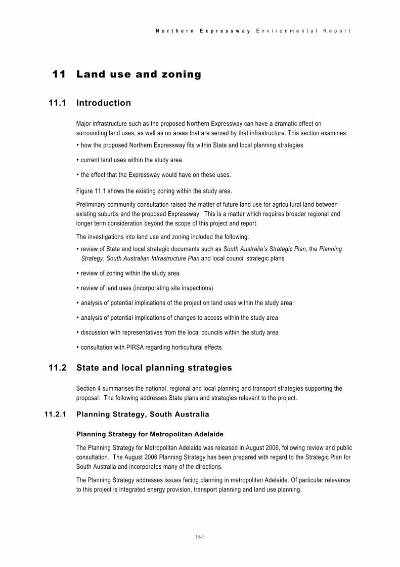
Figure 11.2 illustrates the general land use pattern throughout the study area and Figure 11.3 shows the diversity of land use in the study area. This typically comprises open rural land used for agriculture, intensive horticulture and rural living. The urban areas to the east together with RAAF Base Edinburgh and industrial development in Waterloo Corner defines the metropolitan Urban Boundary.
Major retail, health, education and related community services are focused to the east in proximity to Main North Road within the Elizabeth, Salisbury, Munno Para and Gawler centres.
11.3.1 Existing land use
Gawler Bypass to Gawler River
The land use between the Gawler Bypass and the Gawler River includes a mixture of agriculture, horticulture, rural living and recreation. The area includes the Gawler Soaring Club and the Gawler Harness Racing Track.
Gawler River to Curtis Road
The land use between the Gawler River and Curtis Road is dominated by horticultural land used for market gardening, floriculture, plant nurseries and some general farming.
Curtis Road to Heaslip Road–Womma Road
The land uses between Curtis Road and Heaslip Road–Womma Road are horticultural, primarily market gardening, including greenhouses, olives, vineyards, horse keeping, some grazing, rural living areas and residential areas.
The Macdonald Park–Penfield Gardens rural living area lies to the west of the proposed Northern Expressway. Rural living allotments may have a dwelling constructed on them, but not all allotments have at present making further development likely.
The residential area of Andrews Farm is situated east of Andrews Road.
Heaslip Road from Womma Road to Port Wakefield Road, Edinburgh
The area either side of the proposed Heaslip Road interchange provides a transition between horticultural land and rural living/rural land uses.

N o r t h e r n E x p r e s s w a y E n v i r o n m e n t a l R e p o r t
11-6
Immediately to the south of the interchange is RAAF Base Edinburgh, a major active facility. The base has a 2.6 km north–south runway that has beacons close to the proposed alignment. The runway may be extended in the future.
The land along the rest of the route is primarily horticultural and grazing, and the landscape is dominated by greenhouses, especially to the west.
11.4 Effects of the project
The key land use effect of the proposed Northern Expressway is the potential to facilitate development change as has occurred elsewhere throughout Australia (and internationally) in response to such new road infrastructure.
Almost all the proposed Northern Expressway route is on rural land that is zoned horticulture, rural living, recreation or similar and is outside the Urban Boundary.
The expected effects of the proposed route on land use include the severance and loss of agricultural, horticultural and recreational land, and open space. In particular, the existing Gawler Harness Racing Track and a portion of the Gawler Soaring Club land will need to be acquired to enable the construction of the Northern Expressway. It is estimated that a total of 2.5% of horticultural land in the Virginia triangle will be lost to the Northern Expressway. However, this is considered minor in comparison to the 6–7% annual growth of horticulture within the region as land use changes to horticulture.
The proposed Northern Expressway is expected to directly affect (through land acquisition) some 54 agricultural and horticultural properties and will divide productive functions on that land. The number of properties affected may change as detailed design continues. In some cases, it may be possible to adjust land parcels to offset any losses of land and/or adjust for loss through suitable monetary compensation.
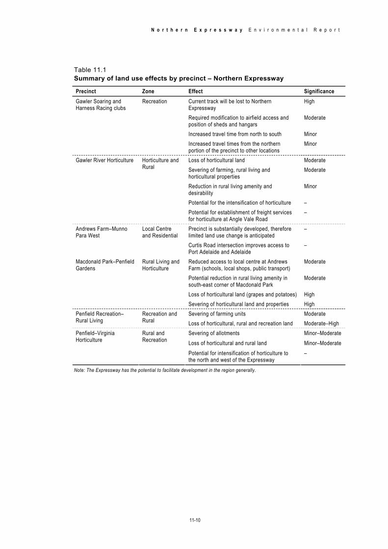
The expected effects are summarised by precinct in Table 11.1.
11.5 Conclusion
The construction and operation of the proposed Northern Expressway will have medium to high effects on the land use of properties that will be acquired to create the Expressway corridor, minor to medium effects for properties adjacent to the route, and minor effects away from the route within the study area.
Land use will, in general, not be significantly altered as a direct result of the proposed Northern Expressway; however, there is likely to be potential for development as has been experienced elsewhere in Australia and internationally.

o
ParafieldAirport
o
RAAF BaseEd inburgh
McIntyre Road
Elizabeth
Main No rth R
oad
Angle Vale Road
Port Wakef ield Road
Two Wells Road
Heaslip R
oad
Salisbury
Highway
Bridge Ro
ad
Kings Road
Waterloo Corner Road
Womm a Road
Penf ield Road
Angle Vale
Virginia
General land use pattern
±0 2km
E n v i r o n m e n t a l R e p o r tN o r t h e r n E x p r e s s w a y
Figure 11.2 OtherAgricultureCommercialEducation
Food industryHorticultureRecreationResidential
Retail commercialRural residentialUti lity industryVacant
Gawler
St Kilda
Modbury
11-7

N o r t h e r n E x p r e s s w a y E n v i r o n m e n t a l R e p o r t
11-8

Figure 11.3 Land use diversity
Horticultural cropCereal crops to the north of Two Wells Road
OrchardIrrigated crop
Crops and irrigationMarket Garden
Crops north of Gawler RiverVineyard
N o r t h e r n E x p r e s s w a y E n v i r o n m e n t a l R e p o r t
11-9
N o r t h e r n E x p r e s s w a y E n v i r o n m e n t a l R e p o r t
11-10
Table 11.1 Summary of land use effects by precinct – Northern Expressway
Precinct Zone Effect Significance Current track will be lost to Northern Expressway
High
Required modification to airfield access and position of sheds and hangars
Moderate
Increased travel time from north to south Minor
Gawler Soaring and Harness Racing clubs
Recreation
Increased travel times from the northern portion of the precinct to other locations
Minor
Loss of horticultural land Moderate Severing of farming, rural living and horticultural properties
Moderate
Reduction in rural living amenity and desirability
Minor
Potential for the intensification of horticulture –
Gawler River Horticulture Horticulture and Rural
Potential for establishment of freight services for horticulture at Angle Vale Road
–
Precinct is substantially developed, therefore limited land use change is anticipated
– Andrews Farm–Munno Para West
Local Centre and Residential
Curtis Road intersection improves access to Port Adelaide and Adelaide
–
Reduced access to local centre at Andrews Farm (schools, local shops, public transport)
Moderate
Potential reduction in rural living amenity in south-east corner of Macdonald Park
Moderate
Loss of horticultural land (grapes and potatoes) High
Macdonald Park–Penfield Gardens
Rural Living and Horticulture
Severing of horticultural land and properties High Severing of farming units Moderate Penfield Recreation–
Rural Living Recreation and Rural Loss of horticultural, rural and recreation land Moderate–High
Severing of allotments Minor–Moderate Loss of horticultural and rural land Minor–Moderate
Penfield–Virginia Horticulture
Rural and Recreation
Potential for intensification of horticulture to the north and west of the Expressway
–
Note: The Expressway has the potential to facilitate development in the region generally.