Land Use and Zoning - FRCOG
23
Land Use and Zoning CHAPTER 7
Transcript of Land Use and Zoning - FRCOG
Land Use and Zoning
CHAPTER 7
ROUTE 122 SCENIC BYWAY — Franklin County Section 93
Land Use
The Route 122 Scenic Byway study area is
defined as Route 122 in Orange and New
Salem, and a half-mile buffer along each side
of the road. The land uses within the Scenic
Byway study area vary dramatically in each
town. The northwestern terminus of the
Byway is in downtown Orange at the
intersection of Route 2A (East and West
Main Streets) and Route 122 (South Main
Street). This is the center of the downtown
and is densely developed with commercial,
industrial, and residential uses. Just south of
downtown Orange, there is a dense,
residential neighborhood. After the dense
residential neighborhoods fade away, and
there are intermittent commercial
establishments along the road. Traveling
south on the Byway the development
transitions to land use that is less dense and
also more agricultural and rural in nature.
There is forest and farmland along the
southernmost section of the Byway in
Orange. In New Salem the Byway travels
through landscape that is predominantly
forested and natural where it passes through
the Quabbin Reservoir lands.
As indicated in Table 7-1, overall, an
estimated 64% of the Byway study area is
forestland (MassGIS, 2005). Residential is
he Land Use and Zoning Chapter is based on information gathered from a
variety of sources. The land use and protected open space data came from
the Massachusetts Office of Geographic and Environmental Information
(referred to as MassGIS) and was updated by the FRCOG. Town zoning
information was reviewed. Additionally, information from field observations,
communications with local officials and residents, and discussions at the Route 122
Scenic Byway Committee meetings is included. Recent updates to Community
Development Plans, Master Plans, and Open Space and Recreation Plans for Orange
and New Salem were also examined.
T CHAPTER 7
Table 7-1: Land Uses within the Scenic Byway Corridor Study Area*
Source: MassGIS 2005 Land Use Data.
Land Use Type Acreage Percentage of To-
tal
Forest 3,221 64%
Agriculture 314 6%
Water and Wetlands 490 10%
Residential 630 13%
Commercial 22 >1%
Industrial & Transportation 131 3%
Other Open Space & Recreation 197 4%
Total 5005 100%
CHAPTER 7: Land Use and Zoning 94
the next largest acreage with 13% of the acres
along the Byway. Water bodies and wetlands
comprise 10%. More detailed information on
land use within the Byway study area in each
town is provided later in this section.
The land use figures presented in this
chapter are based on data provided by
MassGIS, which classifies land uses based on
aerial photography interpretation. Statewide
data are available for 2005, 1999, 1985, and
1971. MassGIS uses 38 land use
classifications in the 2005 data, an increase
from the 21 codes in the 1999 dataset. These
38 classifications have been grouped into
seven broader categories for the purposes of
this plan: forest; agriculture; water and
wetlands; residential; commercial; industrial
and transportation; and other open space
and recreation. The forest category includes
all land classified as forest by MassGIS.1 The
agriculture category includes cropland,
pasture, orchards and nurseries. The water
and wetlands category contains all areas
classified as water or as wetlands by
MassGIS.1 The residential land use category
includes single-family homes, duplexes and
multi-unit housing complexes and
structures. The commercial land use
category contains all land defined as
commercial by MassGIS. The industrial and
transportation category includes light and
heavy industry, mining and waste disposal
facilities, junkyards, and transportation
infrastructure (such as highways, airports,
railroads, and freight storage). The open
space and recreation category includes
abandoned agriculture, areas of no
vegetation, areas under power lines,
brushland, parks, cemeteries, public and
institutional green spaces and buildings,
vacant undeveloped land in urbanized areas,
and recreation sites (such as playgrounds,
golf courses, tennis courts, beaches,
swimming pools, marinas, fairgrounds, race
tracks, and stadiums).
It is important to note that the land use
classifications do not indicate whether land is
permanently protected from development.
Land that is categorized as forest or
agricultural land, or that falls into the non-
agricultural open space and recreation
category may or may not be protected from
future development. A discussion of land
that is protected from development appears
later in this chapter.
Orange
As previously noted, the northwestern
terminus of the Byway is at the intersection
of Route 2A (the Mohawk Trail Scenic
Byway) and Route 122 in downtown Orange.
This intersection is within the Orange Center
National Historic District, which was added
to the National Register of Historic Places in
1989. Orange is a center for employment
and the third largest town in terms of
population in Franklin County after
Greenfield and Montague. The Town has a
population of 7,699 (U.S. Census Bureau,
2009 Population Estimates) and a labor
force of 3,835 workers (MA Executive Office
of Labor and Workforce Development,
2010). Orange has a strong manufacturing
history tied to the Millers River. Currently
manufacturing remains the largest industry
sector in Town, employing an average of over
500 workers per month during 2009
according to the MA Executive Office of
Labor and Workforce Development (2010).
The Rodney Hunt Company is the largest
private sector employer in downtown Orange
with more than 200 employees. It produces
equipment for industrial and municipal
water and wastewater flow management.
Orange also has two industrial parks. Both
of the industrial parks are located near the
Orange Municipal Airport, but one, the
Randall Pond Industrial Park, is located
1. Forested wetlands are included in the forest category, not the water and wetlands category.
ROUTE 122 SCENIC BYWAY — Franklin County Section 95
directly near . The Randall Pond Industrial
Park is located directly off of the Byway
approximately 1.5 miles south of downtown.
Downtown Orange features 19th Century
architecture, red brick factory buildings,
retail storefronts, parks and the Millers
River. There is a mix of civic, business, and
residential land uses. There are also a few
prominent vacant lots and structures, which
are the focus of redevelopment initiatives
that are being actively pursued. One of the
vacant lots is located at the corner of Route
122 and 2A directly on the Byway. The
Putnam Hall Building is located on East
Main Street near the Byway and also is
vacant. Funding for rehabilitation of this
building is being sought. In 2007, the Town
and the FRCOG, completed the development
of the Orange Riverfront Park, located on
East River Street close to the Byway, on a
brownfields site where the town highway
garage was previously located.
The development pattern of Orange today
reflects its original settlement. In parts of
downtown, the minimum lot size is either
5,000 or 10,000 square feet per dwelling unit
[5,000 in the CARD district or 10,000 in the
A(r) district], less than one-quarter acre, for
homes served by water and sewer. In rural
residential areas, the minimum lot size is 2
acres. In recent years, new single-family
homes have been increasingly built outside of
the village centers. The town’s housing stock
consists of 21% of multi-family housing
containing three or more units (2000 U.S.
Census). In the downtown, there are a
number of former multi-storied mill
buildings that are currently vacant or
underutilized and could potentially be
redeveloped.
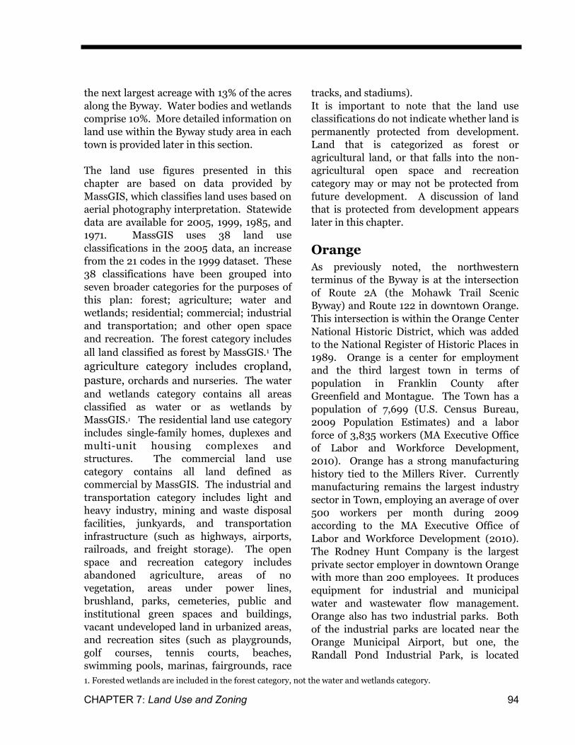
Orange has a total acreage of 23,030 acres
(Table 7-2). Approximately 10% of the town
(2,206 acres) falls within the Route 122
Byway study area. Within the Orange section
of the Byway section, the primary land use is
forest (49% of the Byway study area),
followed by residential (24%). Agricultural
uses are 9% of the Byway study area in
Orange, while recreational uses and other
Table 7-2: Acreages for Different Land Uses, Orange
Source: MassGIS 2005 Land Use Data. *The Byway study area is defined as ½ mile on each side of Route 122 in Orange. See Byway Base Map for more details.
Land Use Type
Acres in Byway Study Area*
Percentage of Byway Study
Area*
Acres in Town
Percentage of Town
Forest 1,077 49% 17,282 75%
Agriculture 189 9% 1,260 5%
Water and Wetlands 67 3% 1,310 6%
Residential 536 24% 1,788 8%
Commercial 22 1% 165 1%
Industrial & Transportation 131 6% 713 3%
Other Open Space & Recreation
183 8% 511 2%
Total 2,206 100% 23,030 100%
CHAPTER 7: Land Use and Zoning 96
open space comprise 8% of the land uses in
the corridor. Industrial and transportation
uses make up approximately 8% of the study
area, water and wetlands 3%, and
commercial uses comprise roughly 1%.
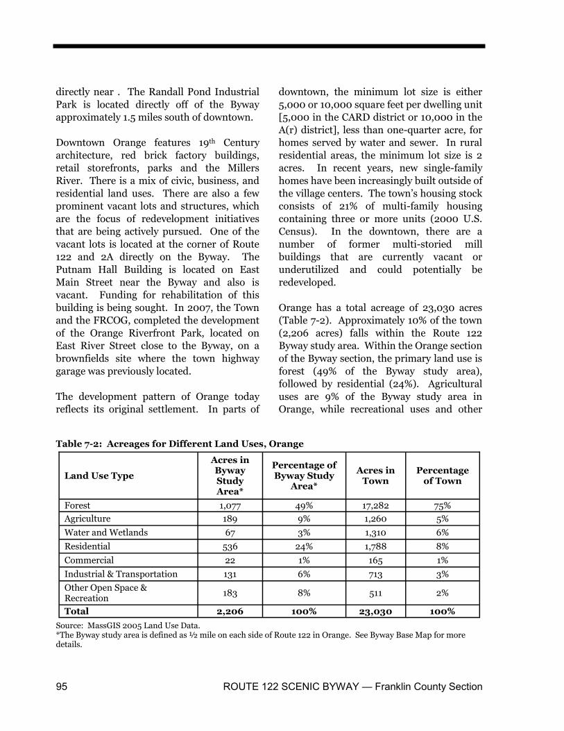
New Salem
The Byway travels through the northeast
section of New Salem. This area is a mostly
forested landscape along the northern
section of the Quabbin Reservoir. New
Salem has a population of 957, making it the
seventh least populated town in Franklin
County (U.S. Census Bureau, 2009
Population Estimates). However, in terms of
geography it has the most acreage of all of
the towns in Franklin County, covering
roughly 37,556 acres or 59 square miles. It
has the most acres of forest land and water
bodies of all of the Franklin County towns.
Route 122 and Route 202 are the major
transportation routes in Town. New Salem’s
town center is located about 3-miles south of
the Byway just east of Route 202. Its
quintessential New England common, which
was designated a National Register Historic
District in 1978, serves as the cultural and
civic center of the community and is
surrounded by historic buildings and homes.
Nearly 80% of the land in New Salem is
publicly owned for the conservation of water
resources, forests and wildlife (New Salem
Open Space and Recreation Plan, 2004).
The 12,100 acre Prescott Peninsula
comprises the southern half of New Salem
and is a Restricted Area that is reserved to
protect the public water supply of the
Quabbin Reservoir. This area is closed to the
public and only limited access is allowed for
research. The State-owned lands in and
around the Quabbin Reservoir are under the
authority of the Department of Conservation
and Recreation (DCR). The Reservoir itself
comprises nearly 9,000 acres of the Town’s
area.
The amount of publicly-owned land has
reduced the area in the Town that is
developable. According to New Salem’s
Table 7-3: Acreages for Different Land Uses, New Salem
Source: MassGIS 2005 Land Use Data. *Byway study area is defined as including ½ mile on each side of Route 122 in New Salem. See Byway Base Map for more details.
Land Use Type
Acres in Byway Study Area*
Percentage of Byway
Study Area*
Acres in Town
Percentage of Town
Forest 2,144 77% 25,836 69%
Agriculture 124 4% 540 1%
Water and Wetlands 423 15% 9,830 26%
Residential 94 3% 415 1%
Commercial 0 0% 7 >1%
Industrial & Transportation 0 0% 11 >1%
Other Open Space & Recreation
14 >1% 917 2%
Total 2,799 100% 37,556 100%
ROUTE 122 SCENIC BYWAY — Franklin County Section 97
Zoning Bylaw, the entire Town is a “Primary
Residential-Agricultural District” with a
minimum lot size of two acres. There are
very few industrial or commercial uses in
Town (see Table 7-3). However, new
residential development has been occurring,
with 50 building permits issued for new
housing units between 2000 and 2009. An
estimated 7% (2,799 acres) of the Town’s
area falls within the Byway study area. A
large majority (77%) of the Byway corridor in
New Salem is forested. Water and wetlands
comprise 15% of the land use within the
corridor, followed by agriculture (4%) and
residential uses (3%). Other open space and
recreation uses make up less than 1% of the
land use in the corridor, while there are no
commercial, industrial, or transportation
uses.
Land Use Changes for the
Entire Byway
From 1971 to 2005
The land use figures presented in this section
are based on data provided by MassGIS.
MassGIS classifies land uses based on aerial
photograph interpretation conducted by the
Department of Forestry’s Resource Mapping
Project at the University of Massachusetts in
Amherst. Statewide data including all
municipalities are available for 2005, 1999,
1985, and 1971.2 For the years 1999, 1985
and 1971, the analysis was conducted
through manual interpretation of the aerial
photos. In 2005, changes were made to the
method of interpreting the data and semi-
automated methods were used. In 2005,
MassGIS used 38 land use classifications, an
increase from the 21 codes in the 1999
dataset. These changes are important to
consider when comparing the land use data
over the years. Consequently, the comparing
Table 7-4: Land Use Changes within the Byway Study Area*, 1971 – 2005**
Source: MassGIS 1971 and 2005 Land Use Data. *Byway study area is defined as including ½ mile on each side of Route 122 in Orange and New Salem. ** Due to different data collection and analysis methodologies, direct comparisons cannot be made with precision between the 1971 and 2005 datasets. Readers should exercise caution in comparing land use data. Such compari-sons can provide only an estimation of the trends.
Land Use Type
1971 Acres in Byway Study Area
1971 Per-centage of
Byway Study Area
2005 Acres in Byway Study Area r
2005 Per-centage of
Byway Study Area
Change in Acreage,
1971 - 2005
Forest 3,374 67% 3,221 64% -153
Agriculture 275 5% 314 6% 39
Water and Wetlands 485 10% 490 10% 5
Residential 591 12% 630 13% 40
Commercial 55 1% 22 >1% -33
Industrial & Transpor-tation
99 2% 131 3% 32
Other Open Space & Recreation
132 3% 197 4% 65
Total 5010 100% 5005 100%
2. The first statewide land use maps were created in 1953-54 from 1951-52 aerial photos. These maps were never digitized. They are available in the Map Collection Archives at the W.E.B. DuBois Library at the University of Massachusetts, Amherst.
CHAPTER 7: Land Use and Zoning 98
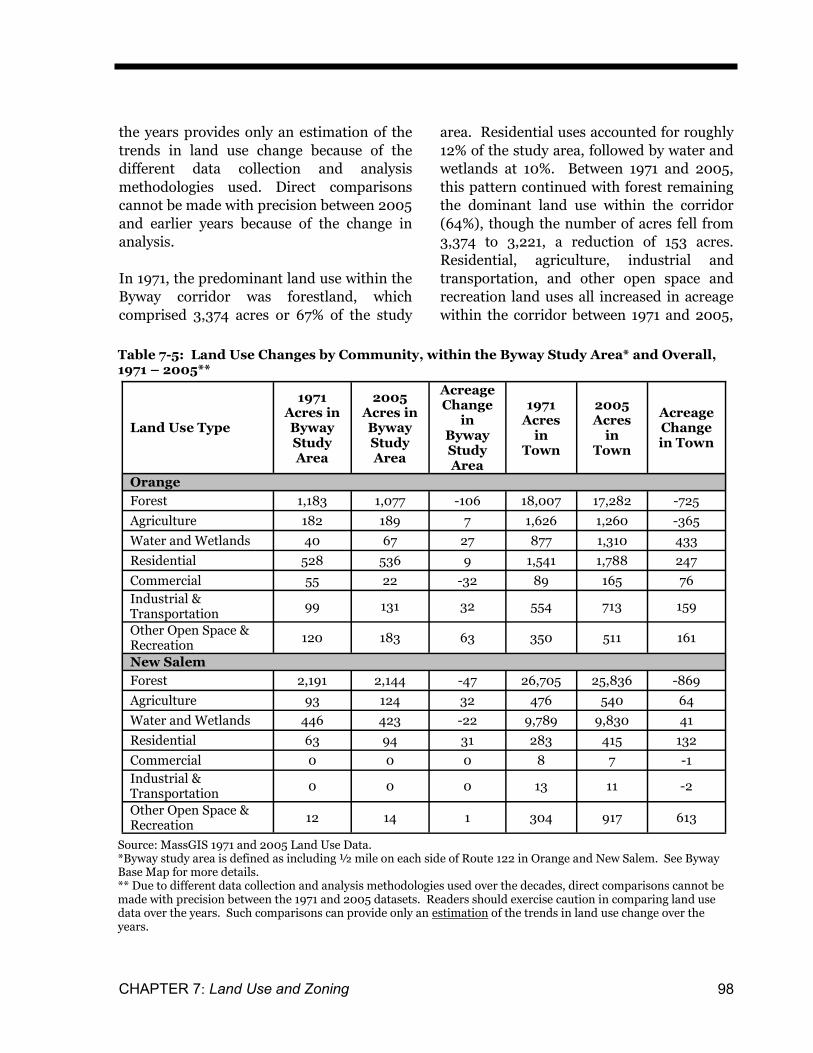
the years provides only an estimation of the
trends in land use change because of the
different data collection and analysis
methodologies used. Direct comparisons
cannot be made with precision between 2005
and earlier years because of the change in
analysis.
In 1971, the predominant land use within the
Byway corridor was forestland, which
comprised 3,374 acres or 67% of the study
area. Residential uses accounted for roughly
12% of the study area, followed by water and
wetlands at 10%. Between 1971 and 2005,
this pattern continued with forest remaining
the dominant land use within the corridor
(64%), though the number of acres fell from
3,374 to 3,221, a reduction of 153 acres.
Residential, agriculture, industrial and
transportation, and other open space and
recreation land uses all increased in acreage
within the corridor between 1971 and 2005,
Table 7-5: Land Use Changes by Community, within the Byway Study Area* and Overall, 1971 – 2005**
Source: MassGIS 1971 and 2005 Land Use Data. *Byway study area is defined as including ½ mile on each side of Route 122 in Orange and New Salem. See Byway Base Map for more details. ** Due to different data collection and analysis methodologies used over the decades, direct comparisons cannot be made with precision between the 1971 and 2005 datasets. Readers should exercise caution in comparing land use data over the years. Such comparisons can provide only an estimation of the trends in land use change over the years.
Land Use Type
1971 Acres in Byway Study Area
2005 Acres in Byway Study Area
Acreage Change
in Byway Study Area
1971 Acres
in Town
2005 Acres
in Town
Acreage Change in Town
Orange
Forest 1,183 1,077 -106 18,007 17,282 -725
Agriculture 182 189 7 1,626 1,260 -365
Water and Wetlands 40 67 27 877 1,310 433
Residential 528 536 9 1,541 1,788 247
Commercial 55 22 -32 89 165 76
Industrial & Transportation
99 131 32 554 713 159
Other Open Space & Recreation
120 183 63 350 511 161
New Salem
Forest 2,191 2,144 -47 26,705 25,836 -869
Agriculture 93 124 32 476 540 64
Water and Wetlands 446 423 -22 9,789 9,830 41
Residential 63 94 31 283 415 132
Commercial 0 0 0 8 7 -1
Industrial & Transportation
0 0 0 13 11 -2
Other Open Space & Recreation
12 14 1 304 917 613
ROUTE 122 SCENIC BYWAY — Franklin County Section 99
while commercial land use decreased over
the same time period.
Between 1971 and 2005, Orange and New
Salem had land use changes that generally
mirrored the trends of the entire Byway area
(Table 7-5). There was a decrease in
forestland and an increase in residential
land. New Salem experienced a 50%
increase in residential development and this
rise occurred within the Byway study area
and throughout the Town.
The number of acres in agricultural uses
within the Byway study area increased in
both Towns. However, there was a decrease
of acres of agriculture in Orange overall and
an increased number of acres in agricultural
land uses in New Salem. There was also an
increase in commercial land uses in Orange,
while commercial uses within the Byway
corridor fell by more than half. This may
reflect the loss of commercial uses in the
downtown area over time accompanied by
the increase of auto-oriented commercial
development along major transportation
routes such as Route 2A and Daniel Shays
Highway (Route 202) near the interchange
with Route 2.
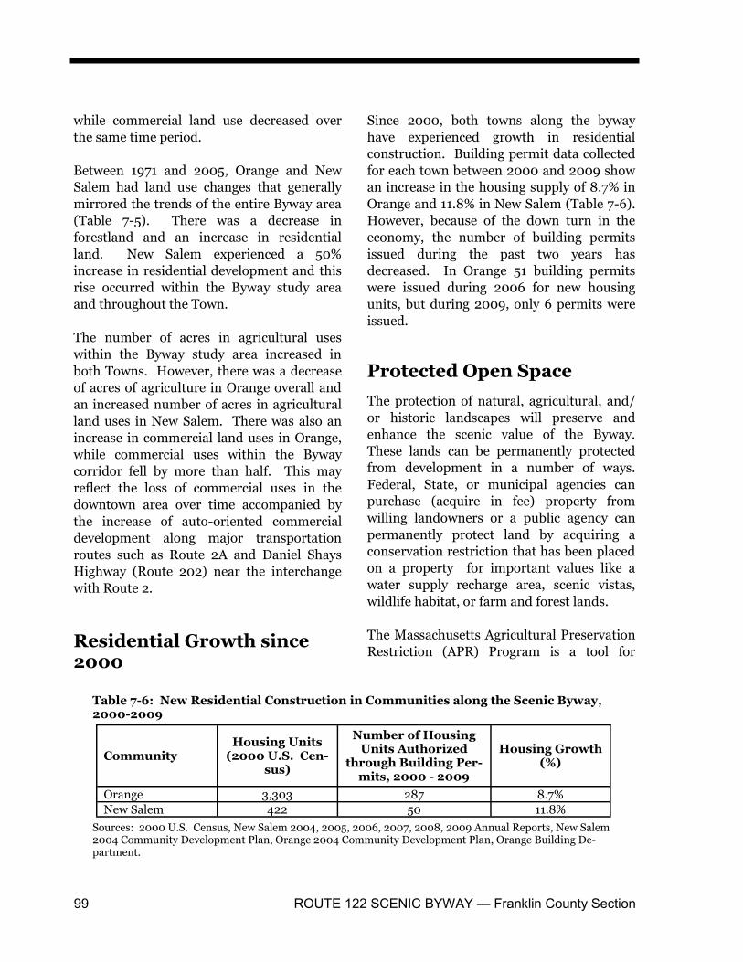
Residential Growth since 2000
Since 2000, both towns along the byway
have experienced growth in residential
construction. Building permit data collected
for each town between 2000 and 2009 show
an increase in the housing supply of 8.7% in
Orange and 11.8% in New Salem (Table 7-6).
However, because of the down turn in the
economy, the number of building permits
issued during the past two years has
decreased. In Orange 51 building permits
were issued during 2006 for new housing
units, but during 2009, only 6 permits were
issued.
Protected Open Space
The protection of natural, agricultural, and/
or historic landscapes will preserve and
enhance the scenic value of the Byway.
These lands can be permanently protected
from development in a number of ways.
Federal, State, or municipal agencies can
purchase (acquire in fee) property from
willing landowners or a public agency can
permanently protect land by acquiring a
conservation restriction that has been placed
on a property for important values like a
water supply recharge area, scenic vistas,
wildlife habitat, or farm and forest lands.
The Massachusetts Agricultural Preservation
Restriction (APR) Program is a tool for
Table 7-6: New Residential Construction in Communities along the Scenic Byway, 2000-2009
Sources: 2000 U.S. Census, New Salem 2004, 2005, 2006, 2007, 2008, 2009 Annual Reports, New Salem 2004 Community Development Plan, Orange 2004 Community Development Plan, Orange Building De-partment.
Community Housing Units
(2000 U.S. Cen-sus)
Number of Housing Units Authorized
through Building Per-mits, 2000 - 2009
Housing Growth (%)
Orange 3,303 287 8.7%
New Salem 422 50 11.8%
CHAPTER 7: Land Use and Zoning 100
permanently protecting active farmland. It is
administered by the Massachusetts
Department of Agricultural Resources
(MDAR) and can be used to purchase a
development restriction on agricultural land
that meets the requirements of the program.
Funding is available through the APR
Program to purchase the development rights
of prime farmland which permanently
protects the land for agriculture. The APR is
recorded with the Registry of Deeds and
continues in perpetuity with the land.
In addition, a conservation restriction
(referred to as a CR) can be purchased or
acquired to permanently protect land. A CR
is a legally binding agreement between a
landowner and the CR holder, usually a
public agency or a private land trust,
whereby the landowner agrees not to develop
the land in order to protect certain
conservation values. The conservation
restriction may run for a period of years or in
perpetuity, and is recorded at the applicable
Registry of Deeds. All permanent
conservation restrictions must be approved
by the Massachusetts Executive Office of
Energy and Environmental Affairs (EOEEA).
Land that is enrolled in the Massachusetts
Chapter 61 tax abatement programs (Mass
General Law, Chapter 61) and land with
limited term conservation restrictions are
considered to be temporarily protected from
development. Eligible landowners who
enroll in the Chapter 61 Program get a
reduction in their local property taxes in
return for maintaining land in productive
forestry, agricultural or recreational use for a
certain period of time. The Chapter 61
Program provides many public benefits,
including maintaining wildlife habitat,
recreational open space and sustaining rural
character.
The Chapter 61 Program also provides towns
with an opportunity to permanently protect
the land. When land that is enrolled in the
Chapter 61 Program is put up for sale and
will be converted to a use that would make it
ineligible for Chapter 61, there is a 120-day
waiting period during which the town where
the land is located may exercise its right of
first refusal to purchase the property at fair
market value and preserve it permanently. A
principal challenge for towns in exercising
the right of first refusal is raising the funds to
purchase the parcel within the short time
frame. However, towns can assign their right
of first refusal to a land conservation
Table 7-7: Protected Open Space
Town Within the Byway Study Area
Within the Town Total Acres in Byway Study Area
Total Acres in Town
Perma-nently Protected (in acres)
Limited Protec-tion (in acres)
Tempo-rary Protec-tion (in acres)
Perma-nently Protected (in acres)
Limited Protec-tion (in acres)
Tempo-rary Pro-tection (in acres)
Orange 2.66 183.96 81.67 5,886.86 275.76 2,958.86 2,206 23,030
New Salem
1,662.44 0 0 22,676.00 0 0 2,799 37,556
Total 1,665.1 183.96 81.67 28,562.86 275.76 2,958.86
ROUTE 122 SCENIC BYWAY — Franklin County Section 101
organization (land trust), which may have
more capital available.
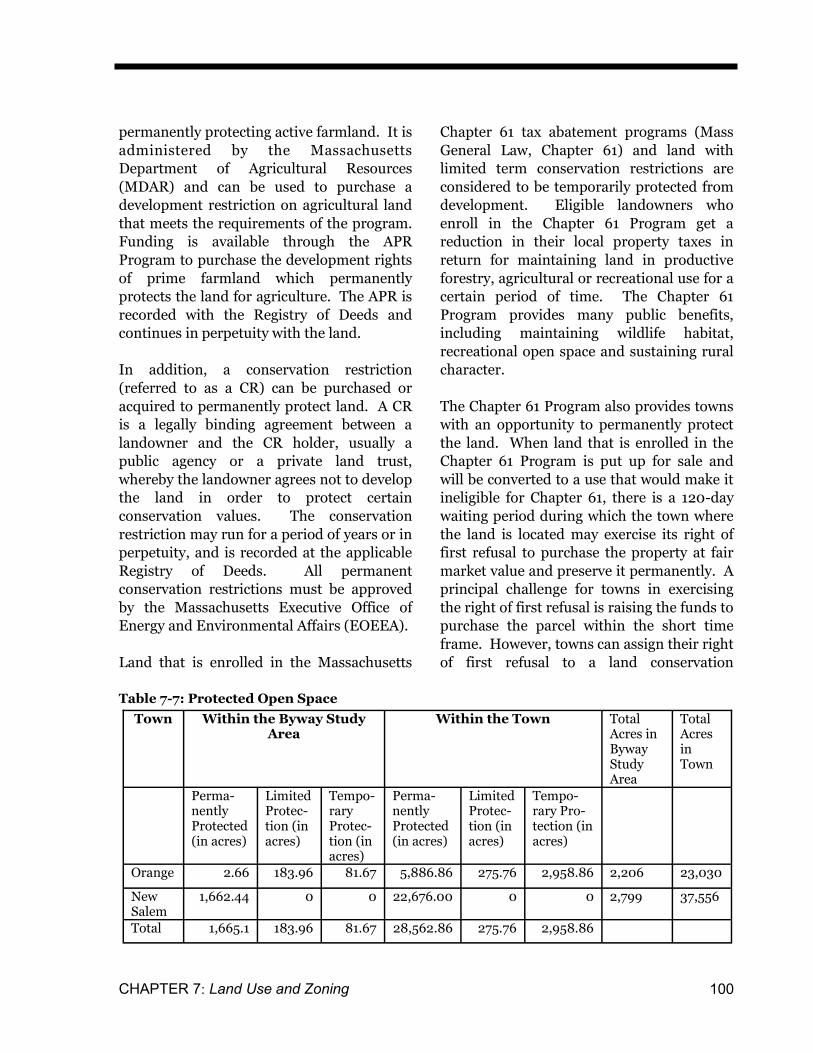
Table 7-7 lists the permanently and
temporarily protected land within the Byway
study area. The figures in the table are based
on Open Space data from MassGIS.
MassGIS’s Open Space data is regularly
updated using information provided by the
EOEEA, DAR, and land trusts.
Of the 5,005 acres within the Byway study
area in Orange and New Salem, 33% (1,665.1
acres) is permanently protected. Almost all
of the permanently protected land is located
in New Salem. Within the Byway area in
Orange, there is a very limited amount of
land that is permanently protected, while
approximately 12% of the Byway within
Orange is under limited or temporary
protection (Chapter 61). Approximately,
59% of the Byway study area in New Salem is
permanently protected.
The Orange Open Space and Recreation
Plan was updated in 2008. The purpose of
the OSRP is “to identify the town’s unique
agricultural, historical, recreational, natural
and scenic resources and to provide a
framework for the town’s future decisions
regarding land conservation and
development.” The OSRP includes a Five-
Year Action Plan which identifies steps to
guide decision-making regarding open space
and recreation needs. The plan recognizes
that extensive regional land protection
efforts have taken place already and
highlights additionally opportunities to
expand this network of protected natural
areas. The Five-Year Action Plan includes
objectives and actions to permanently
protect additional open space in town,
particularly important agricultural areas.
New Salem has an Open Space and
Recreation Plan (OSRP) that is more than
five years old. It is important that New
Salem have a current five year OSRP in order
to identify priority areas for protection and
recreational facilities needed. An OSRP
approved by the State is also a requirement
in applying for funding from grant programs
administered by the Massachusetts Executive
Office of Energy and Environmental Affairs
and the Massachusetts Department of
Conservation and Recreation (such as the
LAND and PARC grant programs).
1950 Map of New Salem
CHAPTER 7: Land Use and Zoning 102
Zoning Along the Scenic Byway
The future pattern of growth along the Route
122 Scenic Byway will be influenced by
zoning and the nature of the land available
for development. The zoning along the
Byway differs in Orange and New Salem and
is summarized in this section. The
discussion focuses on the zoning in each
town and how it benefits and protects the
Byway’s character (historic, rural, natural,
scenic and recreational resources) while
promoting economic development. The
discussion recognizes that zoning changes
are a local issue and require a 2/3 majority
vote at Town Meeting.
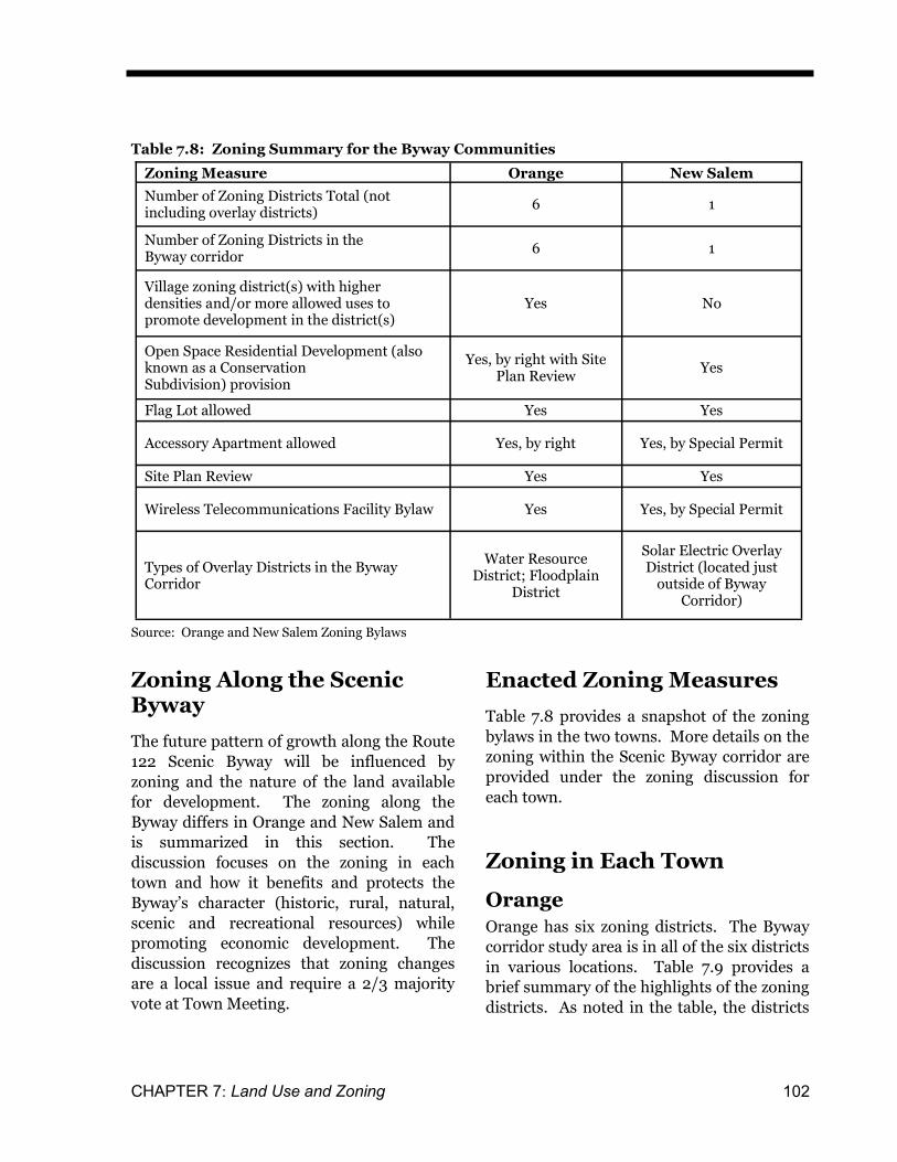
Enacted Zoning Measures
Table 7.8 provides a snapshot of the zoning
bylaws in the two towns. More details on the
zoning within the Scenic Byway corridor are
provided under the zoning discussion for
each town.
Zoning in Each Town
Orange
Orange has six zoning districts. The Byway
corridor study area is in all of the six districts
in various locations. Table 7.9 provides a
brief summary of the highlights of the zoning
districts. As noted in the table, the districts
Table 7.8: Zoning Summary for the Byway Communities
Source: Orange and New Salem Zoning Bylaws
Zoning Measure Orange New Salem
Number of Zoning Districts Total (not including overlay districts)
6 1
Number of Zoning Districts in the Byway corridor
6 1
Village zoning district(s) with higher densities and/or more allowed uses to promote development in the district(s)
Yes No
Open Space Residential Development (also known as a Conservation Subdivision) provision
Yes, by right with Site Plan Review
Yes
Flag Lot allowed Yes Yes
Accessory Apartment allowed Yes, by right Yes, by Special Permit
Site Plan Review Yes Yes
Wireless Telecommunications Facility Bylaw Yes Yes, by Special Permit
Types of Overlay Districts in the Byway Corridor
Water Resource District; Floodplain
District
Solar Electric Overlay District (located just
outside of Byway Corridor)
ROUTE 122 SCENIC BYWAY — Franklin County Section 103
have different minimum lot size
requirements in areas with and without
public sewer service.
In the center of downtown the Byway is
within the Commercial Area Redevelopment
District (also referred to as the CARD
district). The CARD district is approximately
10 blocks in size, and was created to
encourage high-density development and
redevelopment in downtown. Within the
CARD district, there are no onsite parking
requirements, buildings can occupy 100% of
a lot area and can be up to five stories in
height, and multi-family homes over two
units are allowed by right. The CARD district
is the only zoning district in Orange with
complete sewer access. The Village
Table 7.9: Zoning Districts within the Orange Section of the Byway Study Area
* 21,780 square feet equals a half-acre; 43,560 square feet equals one acre; 87,120 square feet equal two acres. a. Wider side yards are required for multi-family dwellings with more than 4 housing units. b. There are currently no parts of the Rural Residential District that have sewer access. Source: Town of Orange Zoning Bylaw, October 2010.
District
Minimum Standards
Lot Size, total or for first housing
unit (sq ft)*
Area for each
additional housing
unit (sq ft)
Lot Frontage
(ft)
Front Yard (ft)
Side Yard (ft)a
Rear Yard (ft)
Village Residential/Commercial (A(c)) and Village Residential (A(r))
10,000 with sewer; 21,780
(½ acre) without sewer
10,000 with sewer;
20,000 without sewer
50 20 10 15
Commercial Area Revitalization District (CARD)
5,000 5,000 50 0 0 0
Residential/ Commercial (B)
21,780 (1/2 acre)
with sewer; 43,560 (1 acre) without sewer
20,000 with sewer;
40,000 without sewer
100 20 10 15
Residential (C) 43,560 (1 acre)
20,000 with sewer;
40,000 without sewer
100 35 15 25
Rural Residential (D) 87,120 (2 acre)
40,000 with sew-
erb; 80,000 without sewer
200 35 20 35
CHAPTER 7: Land Use and Zoning 104
Residential District (A(r)) is also located in
downtown Orange surrounding the
commercial core. It allows for denser
residential development on small lots.
To the south of the downtown the Byway
enters the Residential District (C) and the
Residential/Commercial District (B). In
these two districts the minimum lot size
requirements are larger. The Residential/
Commercial District (B) lies in the
southeastern section of town and includes
the Orange Municipal Airport and the town’s
two industrial parks.
In the Residential/Commercial District (B),
the Village Residential/Commercial (A(c))
and CARD districts, a number of commercial
uses are allowed by right, such as inns/
hotels, bed and breakfasts, and restaurants.
Other small retail and commercial offices (of
2,000 square feet or less) are allowed by
right in these districts. Also, they are allowed
in the Village Residential (A(r)) District if
businesses can meet requirements regarding
parking, noise, lighting, and screening for
adjacent properties. Larger retail and
commercial offices (up to 5,000 square feet)
and light industrial businesses (up to 10,000
square feet) are generally allowed by right if
they can meet a more detailed list of
performance standards regarding their
impact on other properties. Businesses that
cannot meet the performance standards may
still be allowed by special permit.
Performance standards were added to
Orange’s zoning in 2006. They were created
to make the zoning bylaws more flexible and
to help the town attract a variety of
commercial enterprises. Prior to the
establishment of performance standards,
more commercial and light industrial uses
required special permits. The Orange Zoning
Bylaw states (Section 4600) that the
“performance standard section provides an
alternative to the special permit process and
should save applicants time and expense.”
The performance standards address a variety
of characteristics of potential businesses that
could impact nearby properties and the
community overall, including traffic
generation, noise, wastewater treatment,
storm-water runoff, parking and loading
areas, lighting, buffering from adjacent
properties, and hours of operation.
A n u m b e r o f z o n i n g r e l a t e d
recommendations were made in the 2005
Orange Master Plan and the 2004
Community Development Plan that have
been implemented during recent years
including:
Revisions to the open space development
provisions to allow this type of
development by right with site plan
review. These revisions were made to
promote this development option and to
encourage new construction which
permanently preserves open space;
Changes to allow accessory apartments
and flag lots to encourage infill
residential development;
An increase in the minimum lot size in
the rural residential district to two acres
from one acre in order to reduce the
allowable density and development
pressures in the rural areas of Orange
and to help these areas remain rural; and
Revisions to the site plan review
guidelines to make the procedures and
requirements more clear.
New Salem
New Salem has one zoning district. It is the
Primarily Residential-Agricultural District,
and covers the whole town. Building lots for
single family homes are required to be at
least two acres in size, unless the home is
ROUTE 122 SCENIC BYWAY — Franklin County Section 105
located on a rear lot (i.e. flag lot), in which
case the minimum lot size is four acres. New
Salem’s Zoning Bylaws allow a limited
number of uses by-right, including single-
family homes, rental of rooms to no more
than four persons, agricultural uses including
the sale of products principally raised in the
town, lumbering and sawmill operations on a
site for no more than one year, and home
occupations that conform to certain
conditions. Accessory apartments and the
conversion of a single-family dwelling to a
two-family dwelling are allowed by Special
Permit, along with a number of commercial
uses.
In recent years some changes have been
made to the zoning code that had been
recommended in town master plans and
other reports. In 2005, Annual Town
Meeting voted to change the minimum lot
size from one to two acres. In 2007 a
provision to allow for accessory apartments
by special permit was added to the Zoning
Bylaw. General conditions for the
apartments ensure that the single-family
residential character of the Town is
preserved.
In 2010, Site Plan Review was added to the
Town’s Zoning Bylaw with the purpose of
reasonably protecting the environmental
resources and scenic qualities of the Town’s
neighborhoods. The following projects
require Site Plan Review: subdivisions
resulting in two or more building lots; the
installation of ground mounted or roof
mounted solar electric installations
generating more than 10kW or occupying
more than one acre; and non-residential or
non-agricultural uses that create more than
5,000 square feet of enclosed floor area,
require ten or more parking spaces, or result
in a parking area 2,000 square feet or greater
(Section 11A).
New Salem also added a Solar Electric
Overlay District to its Zoning Bylaw in 2010.
The overlay district allows for ground-
mounted solar electric installations of up to 1
MW in capacity, and that occupy no more
than two acres, by right with Site Plan
Review. The district is made up of various
areas in the northwestern section of Town
and falls just outside of the Byway study
area.
Potential for Future Development
This section briefly describes the areas with
the greatest development potential in each of
the towns within the Byway study area. The
assessment of development potential is based
largely on land characteristics such as slopes,
wetlands, public water and sewer
infrastructure, and on current zoning
regulations.
Orange
In 2004, as part of the town’s Community
Development Plan, Orange considered the
best locations for future potential growth.
The Plan identified five potentially suitable
locations for future industrial or large-
commercial (greater than 5,000 square feet)
growth. Two of these areas are located
within the Byway study area, near the
Randall Pond Industrial Park. It will be
essential for these locations to be
investigated further before development is
pursued at these sites. For each location, an
engineering feasibility study will be needed
to fully evaluate the site’s development
CHAPTER 7: Land Use and Zoning 106
potential, possible environmental
constraints, including wetlands issues, and
the costs of extending water and sewer
services as necessary.
The downtown was identified as the best area
for future small commercial and mixed use
development in the 2004 Community
Development Plan. Orange has been
pursuing the redevelopment of vacant and
under-utilized buildings in the downtown
area, such as the Putnam Hall building, as
part of its downtown revitalization activities.
Putnam Hall is one of a few large, historic
brick buildings in the downtown area. It has
five floors and a total of approximately
20,000 square feet of space and is owned by
the Town of Orange. Renovation of the
building is being proposed by the Town of
Orange in partnership with the North
Quabbin Woods, an organization that seeks
to promote forestry and forest products in
the region. North Quabbin Woods would be
the anchor tenant of the building once it is
redeveloped. One potential challenge for the
redevelopment of the historic mill buildings
is that they do not contain elevators and
elevator installation can be very expensive.
The 2009 Mohawk Trail East Scenic Byway
Corridor Management Plan notes that
Putnam Hall or other historic buildings in
downtown Orange could be considered for
use as a tourist information center and/or
interpretive center for the Mohawk Trail
Scenic Byway. A tourist information center
in the downtown could provide information
to visitors about both Scenic Byways as well
as other area attractions.
In addition to new commercial uses, the
2004 Community Development Plan
identified the downtown area as an
appropriate location for residential infill
development and new residential growth
because of access to sewer and water as well
as services such as stores, offices, Town Hall,
and the library. An additional area within
the Byway corridor identified for potential
residential development is located between
the Byway and Walnut Hill Road, south of
the downtown area. The portion of the
Byway study area south of Route 2 in Orange
is constrained from development by a Zone
II Wellhead Protection Area, which
surrounds the Town’s public water supply, as
well as the presence of prime farmland soils.
New Salem
As mentioned previously, almost 80% of New
Salem’s land area is permanently protected
from development, largely limiting areas in
Town where new development can occur.
The 2004 New Salem Community
Development Plan identifies several areas
where new residential and small business
growth could occur. Most of the focus is on
the area just west of the town center on
Route 202, where several businesses already
exist. The plan recommends the creation of a
“Village Center” zoning district that could
allow for higher density infill residential
development mixed with small business uses.
Currently the minimum lot size throughout
the Town is two acres, making infill
development in the village center area
difficult.
Also, the area located north of the
intersection of Route 202 and 122 in New
Salem where the two roads merge was
identified as potentially suitable for
economic uses. The remaining sections of
the Byway study area within New Salem are
largely constrained from development due to
the Quabbin Reservoir, protected
forestlands, and wetlands and water bodies.
In general the 2004 plan notes that residents
ROUTE 122 SCENIC BYWAY — Franklin County Section 107
seem supportive of some new business
growth, but only if new development
enhances the Town’s rural character. Small
enterprises such as bed and breakfasts and
farm stands are currently allowed by right in
Town and could help support tourism along
the Byway.
Scenic Views along the Byway
There are a number of scenic vistas along the
Byway that were identified as outstanding
during the visual assessment. These scenic
views are noted with a viewshed icon on the
Open Space Map at the back of this chapter.
The areas with panoramic or medium range
views have also been noted and are discussed
below. Further discussion of the scenic views
along the Byway appears in the Scenic
Resources Chapter of this plan.
Several factors were considered when
assessing the scenic qualities of a medium-
or long-range vista or roadway corridor.
Medium and long-range vistas are more
breathtaking when they contain both an
expansive field of view and depth of view.
The field of view is the horizontal width of
the view, while the depth of view is how far
away one can see. Contrast and focal points
are elements that add interest to what is
being seen. Contrast means the differences
seen in the vista, such as landscape
differences. Focal points are elements in the
landscape that draw the eye.
In Orange, the historic streetscape is an
important feature of the downtown. This is
an important viewshed to protect. The
historic character of this area should be
considered as future rehabilitation and infill
development within the downtown is
planned and developed. Additionally, the
area to the north of the intersection of
Routes 122 and 202 is agricultural and has
important views of classic farm settings. The
section of the Byway that is in Orange where
Route 122 and Route 202 have merged and
become one have rural views of mature tree
stands amidst fields and stonewalls.
In New Salem, the Byway travels along areas
near the Quabbin Reservoir that are
permanently protected.
Tools and Strategies to Preserve the Scenic Byway Resources
This section provides an overview of tools
and strategies that can be used by towns and
regional organizations to help preserve
historic, scenic, and open space resources
and enhance tourism along the Route 122
Scenic Byway. The strategies fall into four
categories: land protection, historic
preservation restrictions, funding programs,
and zoning and other town bylaws.
Land Protection
Conservation Restrictions (CR) Scenic, open space, forest, and agricultural
resources can be protected through the use of
conservation restrictions. A conservation
restriction is a legally binding agreement
between the landowner and a government
agency or qualified conservation
organization, such as a land trust, that places
constraints on the use of a property in order
to protect its scenic or open space values.
With a conservation restriction, land uses are
typically limited to forestry, farming, and/or
passive recreational activities, and
development is prohibited except if it is
related to those uses (such as a barn for
farming purposes). Scenic easements and
CHAPTER 7: Land Use and Zoning 108
conservation restrictions can be donated or
sold by a landowner. A donation of such a
scenic easement can yield a significant tax
benefit. The Federal Scenic Byway program
can provide funding for acquisition of scenic
easements from willing property owners.
Agricultural Preservation Restriction (APR) Program The Agricultural Preservation Restriction
(APR) Program protects prime farmland
from development. The APR Program is a
voluntary program that offers a non-
development alternative to farmers and other
owners of prime agricultural land and other
farmland of statewide importance that are
faced with a decision regarding the future use
and disposition of their farms. The program
offers to pay farmers the difference between
the "development value" and the
"agricultural value" of their farmland in
exchange for a permanent deed restriction
which precludes any use of the property that
will have a negative impact on its agricultural
viability. The APR Program is run through
the Massachusetts Department of
Agricultural Resources.
Chapter 61 Programs Parcels enrolled in the property tax
abatement programs under Chapter 61 of the
Massachusetts General Laws are temporarily
protected from development. The Chapter 61
programs offer landowners reduced local
property taxes in return for maintaining land
in productive forestry, agricultural or open
space or passive recreational use for a certain
period of time, usually at least 10 years. One
important feature of the Chapter 61
programs is that they offer towns the
opportunity to protect land permanently if
land that has been enrolled in programs is
being sold or converted to another use, and
will leave Chapter 61. The town where the
parcel is located has a 120-day period during
which it can exercise, or assign, its right of
first refusal to purchase the property at fair
market value or meet the conversion price
offer, and preserve it permanently.
Historic Preservation
Historic Preservation Restrictions A preservation restriction is a mechanism
that is used to preserve a property’s historic
character. It is a legally binding agreement
that is used to protect historic resources,
such as historically significant buildings,
landscape features or landscape areas.
Preservation restrictions can be written to
list the specific features of the historic
property to be protected. Preservation
restrictions are enabled under Massachusetts
General Law Chapter 184 Sections 31-34.
The preservation restriction must be held by
a government or non-profit. Preservation
restrictions are recorded in the local Registry
of Deeds. The preservation restriction
ensures that the specified features of the
historic property will not be altered in the
future and will be preserved for future
generations.
Sources of Funding
Community Preservation Act (CPA) Signed into law in 2000, the Massachusetts
Community Preservation Act (M.G.L.,
Chapter 44B), gives communities a funding
source for projects related to historic
preservation, open space protection, and
affordable housing. Municipalities adopt the
Community Preservation Act (CPA) on a
local basis, through a ballot referendum.
Communities that approve the CPA can
impose a property tax surcharge of up to 3%.
The funds collected through this surcharge
are set aside in a local Community
Preservation Fund along with a State match.
Monies accruing in this fund are to be spent
on historic preservation, open space
ROUTE 122 SCENIC BYWAY — Franklin County Section 109
(excluding recreation), and affordable
housing with at least 10% of the annual
receipts going toward each category.
Spending can be deferred until needed. The
community determines how it would like to
distribute the remaining 70% of funds to any
or a combination of the three categories,
including public recreation. For the first six
years of the program, from 2002 through
2007, the State match rate was 100%.
Beginning in 2008, as more communities
adopted the CPA, the average State match to
communities has decreased. In 2010, the
average statewide match was 31.5% of local
surcharge revenue collected. Depending on a
community’s population and property values,
the percentage may be higher or lower than
the average. As of November 2010, neither
of the towns along the Scenic Byway has
adopted the CPA.
LAND - Local Acquisitions for Natural Diversity Grant Program (formerly Self-Help Program) Provides grant assistance to city and town
conservation commissions for the acquisition
of open space for conservation and passive
recreation purposes. The program is
administered by the Massachusetts Executive
Office of Energy and Environmental Affairs
(EEA) and the Massachusetts Department of
Conservation and Recreation (DCR). The
LAND Program helps preserve lands and
waters in their natural state and the program
offers funding to preserve areas that contain
unique natural, historical or cultural features
or extensive water resources. The program
encourages compatible passive outdoor
recreational uses such as hiking, fishing,
hunting, cross-country skiing, and wildlife
observation. General public access must be
allowed, and the Town must have an up to
date Open Space and Recreation Plan to
apply. The LAND Program pays for up to
80% of a municipality’s costs for the
acquisition of land, or a partial interest (such
as a conservation restriction), and ancillary
land acquisition costs. The grants range in
size from $75,000 to $500,000.
Parkland Acquisitions and Renovations for Communities (PARC) (formerly the Urban Self-Help Program) Provides grant assistance to cities and towns
to acquire parkland, develop new parks, or
renovate existing outdoor public recreation
facilities. The program is also administered
by Massachusetts Executive Office of Energy
and Environmental Affairs (EEA) and the
Massachusetts Department of Conservation
and Recreation (DCR). Any city or town with
a population of 35,000 or more, or any city
regardless of size, which has an authorized
park or recreation commission, is eligible to
participate. Grants can also be issued to
smaller communities for projects that have
regional or statewide significance. Projects
for outdoor recreation purposes, whether
active or passive in nature, are considered for
funding. Grants are available for the
acquisition of land and the construction,
restoration, or rehabilitation of land for park
and outdoor recreation purposes such as
athletic playing fields, playgrounds, game
courts, and swimming pools. Access by the
general public must be allowed and the Town
must have an up to date Open Space and
Recreation Plan. The grants reimburse a
significant portion of total project costs. The
grants range in size from $50,000 to
$500,000.
The Town of Orange received an Urban Self-
Help (now PARC) Grant for funding to
construct the Orange Riverfront Park. The
riverfront park provides canoe and kayak
access to the Millers River and a rest stop for
travelers along the Route 122 Scenic Byway.
CHAPTER 7: Land Use and Zoning 110
Massachusetts Recreational Trails Grants Program The Recreational Trails Program provides
grants ranging from $2,000 to $50,000 on a
reimbursement basis for a variety of trail
protection, construction, and stewardship
projects throughout Massachusetts. It is part
of the national Recreational Trails Program,
which is funded through the Federal
Highway Administration (FHWA). Funds
are disbursed to each state to develop and
maintain recreational trails and trail-related
facilities for both non-motorized and
motorized recreational trail uses. In
Massachusetts, funds are administered by
the Department of Conservation and
Recreation (DCR), in partnership with the
Massachusetts Recreational Trails Advisory
Board. Eighty percent of the project costs
are reimbursed to grantees, but at least 20%
of the total project value must come from
other sources.
Brownfields Assistance There are a number of programs to assist in
the cleanup and redevelopment of
brownfields sites. Both of the communities
along the Scenic Byway contain properties
that have been identified as brownfields, with
most of these brownfields being located in or
near historic town centers where industries
were traditionally located. Brownfield
cleanup is regulated in Massachusetts under
Massachusetts General Law, Chapter 21E. In
1998, the State Legislature amended Chapter
21E to establish significant liability relief to
encourage the redevelopment of brownfield
s ites, whi le ensuring that the
Commonwealth’s environmental standards
are met. The Massachusetts Department of
Environmental Protection (DEP) administers
the State’s cleanup laws and regulations.
DEP offers technical assistance for the
cleanup of brownfields sites.
The Franklin Regional Council of
Governments (FRCOG) coordinates a
regional Brownfields Site Assessment
Program for Franklin County funded through
the U. S. Environmental Protection Agency.
In addition to the Site Assessment Program,
the FRCOG coordinates a Rural Brownfields
Clean-up Revolving Loan Fund to help fund
brownfields clean-up and redevelopment
activities in Franklin County communities.
The program could be of particular benefit to
downtowns that have historic mill buildings
which are vacant or underutitilized and could
be redeveloped. The restoration and reuse of
these structures is important for the Byway.
MassWorks Infrastructure Program The MassWorks Infrastructure Program
consolidates six public infrastructure grant
programs (Public Works Economic
Development (PWED) Grants, Community
Development Action Grant (CDAG), Growth
District Initiative (GDI) Grants,
Massachusetts Opportunity Relocation and
Expansion Program (MORE), Small Town
Rural Assistance Program (STRAP), and the
Transit Oriented Development (TOD) Grant
Program) formerly administered by different
agencies into one administrative program
under the Executive Office of Housing and
Community Development. The program
provides grant funding for publicly owned
infrastructure including, but not limited to
sewers, utility extensions, streets, roads, curb
-cuts, parking facilities, site preparation,
demolit ion, pedestrian walkways,
streetscape, and water treatment systems.
Community Development Block Grant Program (CDBG) The Community Development Block Grant
(CDBG) program is a federally funded,
competitive grant program run through the
Massachusetts Department of Housing and
ROUTE 122 SCENIC BYWAY — Franklin County Section 111
Community Development that is designed to
help small cities and towns meet a broad
range of needs. Eligible CDBG projects
include, but are not limited to, business
assistance, infrastructure, community/public
facilities, housing rehabilitation or
development, and downtown revitalization.
Communities may apply for funds on behalf
of a specific developer or property owner,
and may apply regionally with one lead
community.
Both Orange and New Salem have received
CDBG funds for housing rehabilitation. In
addition, in 2009 the Town of Orange
completed an inventory of the Commercial
Area Revitalization District (CARD) in
downtown Orange using CDBG funding. The
inventory determined that the district
qualifies as a slum and blighted area. The
designation as “Slum and Blighted” allows
the Town to apply for additional CDBG
funding critical to the revitalization of the
area. Specifically, the designation and
available funding will allow the Town to
begin eliminating the current conditions of
blight on an area basis and also prevent
further blight by addressing marginal
properties that could, if left unassisted,
deteriorate further.
Expedited Permitting Process In 2006, the State Legislature enacted
regulations (Massachusetts General Laws,
Chapter 43D) to support an expedited and
streamlined municipal permit process for
targeted economic development projects. An
established, predictable local permitting
process is considered advantageous by
potential developers. For towns that choose
to enact “Expedited Local Permitting”, this
program gives them the ability to promote
commercial/industrial development on pre-
approved parcels, known as “Priority
Development Sites,” by offering an
expedited, streamlined local permitting
process. The goal is to create a transparent
and efficient municipal process, which
guarantees local permitting decisions on
designated “Priority Development Sites”
within 180 days. This requires the
coordination of municipal staff and town
boards including the Planning Board, Zoning
Board of Appeal, Conservation Commission,
Fire Chief, the Historic Commission, and
Board of Health.
Eligible “Priority Development Sites” are
sites that have been identified and approved
by the town with permission from the
property owner(s) that are in a commercial,
industrial or mixed use zone and can
accommodate the development or re-
development of a building(s) of at least
50,000 square feet. Communities with
“Priority Development Sites” will receive
priority consideration for economic
development grant programs such as the
MassWorks Infrastructure Program and
brownfields funding. The FRCOG provides
technical assistance to towns exploring
designation through “Expedited Permitting
(Chapter 43D). The Town of Orange, with
the FRCOG’s assistance, has designated three
Priority Development Sites in downtown all
of which are located within the Byway area.
The sites are the Putnam Hall block, the
South Main Street block, and the West River
Street block.
Local Bylaws and Zoning Options
Corridor Overlay District Scenic Byway communities may consider the
creation of a zoning district that overlays the
Byway corridor. Uses underlying the
corridor district would continue to be
allowed, but new development would be

CHAPTER 7: Land Use and Zoning 112
required to meet additional design
standards. These standards could limit the
amount of lot clearing, call for maintaining
roadside vegetation and trees, favor curved
over straight driveways, limit the size of large
commercial buildings and storage facilities,
keep exterior lighting to a minimum, and
introduce special regulations for signs within
the district. Additional requirements could
include the identification of existing scenic
vistas from the Byway and proposed
measures to avoid impacting those vistas,
such as locating buildings, structures, and
power lines out of the sight-way.
Performance incentives could be developed
to allow an increase in use, density, or other
bonuses if a developer meets or exceeds the
design standards of the bylaw.
Local Historic Districts A local historic district is established and
administered by a community to protect the
distinctive characteristics of important areas,
and to encourage new structural designs that
are compatible with the area's historic
setting. Prior to the establishment of a local
historic district, a district study committee is
appointed to conduct a survey of the area and
to prepare a preliminary report for local and
state review. A final report is then submitted
to the local governing body for approval of
the local historic district ordinance or by-law.
Once a local historic district is established, a
local historic district commission is
appointed to review all applications for
exterior changes to properties within the
district. This design review process assures
that changes to properties will not detract
from the district's historic character. The
review criteria are determined by each city
and town and are specific to each local
historic district.
Architectural Preservation Districts (also referred to as
Neighborhood Conservation Districts) An architectural preservation district is a
defined area in which additions, major
alterations, demolition and new construction
are reviewed. An architectural preservation
district bylaw protects the overall character
of an area by regulating major alterations
and demolitions, and by ensuring that new
construction is completed in keeping (scale,
massing, street pattern, setback and
materials) of the existing buildings. An
architectural preservation district is an
alternative to a local historic district for areas
where some alterations have already
occurred but protection of the overall scale,
streetscape and historic buildings is a
priority.
Village Center Zoning The creation of village center zoning districts
helps direct future growth and development
to those areas and therefore helps preserve
rural and open space areas elsewhere.
Village center districts are usually
established in existing villages, or in other
parts of town that have the infrastructure
(water, sewer, roads, etc.) to support more
development. Village center districts
typically have higher densities (smaller lot
sizes and frontage) and encourage more
intensive residential uses, such as multi-
family homes, and commercial uses to locate
in the village centers instead of elsewhere in
town.
Growth in village centers is also promoted
through flag lot provisions which allow
development on lots without the standard
required frontage behind existing
development in areas with sewer and water
service. Another important provision is a
waiver of lot size and front setback
requirements, in older neighborhoods where
many properties do not meet the standards.
ROUTE 122 SCENIC BYWAY — Franklin County Section 113
Orange has village center zoning in its
downtown that allows for greater densities
and a mix of uses. New Salem has informally
considered one, but has taken no action yet.
Open Space Residential Development Open space residential developments
(OSRD) can help preserve open space and
reduce residential development costs. In
OSRDs, homes are built on smaller than
regular lots in exchange for some of the
remaining area being set-aside as protected
open space and the clustering of homes helps
preserve open space and natural resources.
Orange has adopted provisions to allow
OSRD by right with Site Plan Review to help
encourage its use.
Sign Regulations Both of the communities along the Scenic
Byway have sign regulations in place. Sign
regulations can be incorporated into a
community’s zoning bylaws or general
bylaws. The sign regulations in each
community could be reviewed to see if they
should be strengthened to protect the
community character overall and the scenic
character of the Byway corridor specifically.
One option could be to have more detailed
regulations and design guidelines for signs
within a Byway corridor overlay district to
help enhance the Scenic Byway. A
community could also have different sign
limits in rural zoning districts than in
commercial areas.
Lighting Regulations Communities can establish regulations
regarding external lighting to help preserve
rural and scenic character. Regulations can
be designed to address the brightness, color,
and height of external lighting and can also
call for lighting fixtures to project light
downward to limit their impact on
neighboring properties, on the night sky, and
on night flying insects. There can also be
design guidelines for lighting fixtures in local
historic districts or as part of Site Plan
Review.
Phased Growth Bylaw Phased growth bylaws limit the number of
homes that are allowed to be built each year.
The purpose of a phased growth bylaw is to
help ensure that growth does not strain a
community’s ability to provide basic public
CHAPTER 7: Land Use and Zoning 114
Findings and Recommendations
Findings
There are historically significant commercial and industrial buildings in downtown Orange
and New Salem Village center that are underutilized.
There are some areas along the Byway that have outstanding scenic views and are worthy of
protection.
Downtown Orange would greatly benefit from continued revitalization efforts that highlight
and enhance the historic and industrial heritage of the area.
The industrial heritage is significant and should be highlighted as an important feature of
the Byway.
Open Space and Recreation and other important local plans should be updated and kept
current.
Recommendations
Seek funding to purchase conservation restrictions and/or Agricultural Preservation Re-
strictions for land from willing property owners in important scenic and natural areas.
Enhance the public visibility of agricultural and forestry businesses in the Byway towns and
promote the purchase of local forest and farm products.
Provide information about the tax credit and funding which can assist private property
owners with restoration and rehabilitation projects for historic and architecturally signifi-
cant buildings.
Pursue funding (grants and other available sources) to complete redevelopment and revi-
talization projects in downtown centers and at former mill building sites.
Encourage appropriate and sustainable economic development where wanted by towns.
Support the review and revision of local zoning bylaws to enhance and protect the character
and resources of the Scenic Byway corridor.
Encourage commercial establishments to have signage, external lighting, building charac-
teristics, and landscaping that complement the scenic, historic, and natural characteristics
of the Byway.
Consider strengthening local regulations to discourage signs and outside lights that detract
from the scenic nature of the Byway. This may include adopting more detailed regulations
and design guidelines for signs and lighting within the Byway corridor to help enhance the
Scenic Byway.
Pursue options to preserve and promote historic resources along the Route 122 Scenic By-
way, such as the development of architectural guidelines for historic structures to assist
property owners when completing historic renovation or restoration projects.
Support the completion of an updated open space and recreation plan for New Salem.
Evaluate zoning bylaws and districts to direct commercial growth and avoid “strip” devel-
opment.