10 varied walks around Whitchurch, Shropshire WHITCHURCH
24
10 varied walks around WHITCHURCH Shropshire 10 varied walks around WHITCHURCH, Shropshire – Whitchurch Walkers Whitchurch Walkers 10 varied walks around Whitchurch, Shropshire www.whitchurchwalkers.co.uk 9 780956 902122 ISBN 978-0-9569021-2-2 Price: £5.00
Transcript of 10 varied walks around Whitchurch, Shropshire WHITCHURCH

10 varied walks around
WHITCHURCHShropshire
10 v
aried w
alks aro
un
d W
HIT
CH
UR
CH
, Sh
rop
shire –
Wh
itchu
rch W
alkers
Whitchurch Walkers
10 varied walks around Whitchurch, Shropshire
www.whitchurchwalkers.co.uk9 780956 902122
ISBN 978-0-9569021-2-2
Price: £5.00

E D G E L E Y R O A D
Chemistry
WHITCHURCH
Grindley Brook
Bubney
Kiln Green
Hall Green
Belton
Broughall
Edgeley
PreesHeath
HintonOld Hall
Hill ValleyGolf Club
Pan CastleMotte & Bailey
BrownMoss
Danson’s Bridge
Alport
Ash MagnaAsh Parva
Higher Heath
Whitewell
Alkington Hall
WALK 6
WALK 5
WALK 2
WALK 1
WALK 8
WALK 4
WALK 3WALK 9WALK 7
WALK 10
A49
A49
A495
A41
A41
Whitchurch Town Centre
Car parking
Public House
Church
Toilets
Picnic area
Refreshments
Bus service or bus station
Walk Routes
Footpath
Bridleway
A-road
B-road
Minor road
Railway with station
Golf course
Nature reserve
Leisure & sports centre
Camping & caravan site
Built-up area
Woodland
Streams, ponds and lakes
Key to map symbols
G R E EN EN D
BARGATES
HIGH STREET
ST MARY
S S
T
BARK HILL
PEPPERST
MILL S
TREET
W R E X H A M R O A D B5364
S E D G F O R D B5395
WATERGATE D O D I N G T O N
C ASTLE HILL
NEWTOWN
SHERRYMILL HILL
S M A L L B R O O K R OA DROSEMARY LAN E
A L KI N
G T O N R O A D
B54
76
E D G E L E Y R O A D
YARDINGTON
C H E S T E R R O A D B5395
BRIDGEWATER STREET
BROWNLOW STREET
LONDON ROAD
NEWPORT ROAD
S T A T I O N R O A D
TA L B OT S T R E E T
P R E E S R A O D A41
Chemistry
Hospital(minor injuries)
Supermarket
Supermarket
Swimming PoolA495
GreenfieldsNature Reserve
Canal
CricketGround
JubileePark
CivicCentreCivic
Centre
HeritageCentre
© Copyright Ordnance Survey Open Source data
10 Walks Around Whitchurch, Shropshire
WHITCHURCHWrexham
OswestryEllesmere
Ellesmere Port
ShrewsburyWelshpool
Bridgnorth
Ludlow
Wolverhampton
Birmingham
Kidderminster
Cannock
Sta�ord
Market Drayton
Mold Chester
Northwich
Runcorn
Warrington
Stoke-on-Trent
Maccles�eld
A49
A49
A495
A483
M6
M6
A5
M5
A41
A41
A56
A54
A62
ISBN 978-0-9569021-2-2
Published byWhitchurch Walkers / Oswestry Ramblers
45
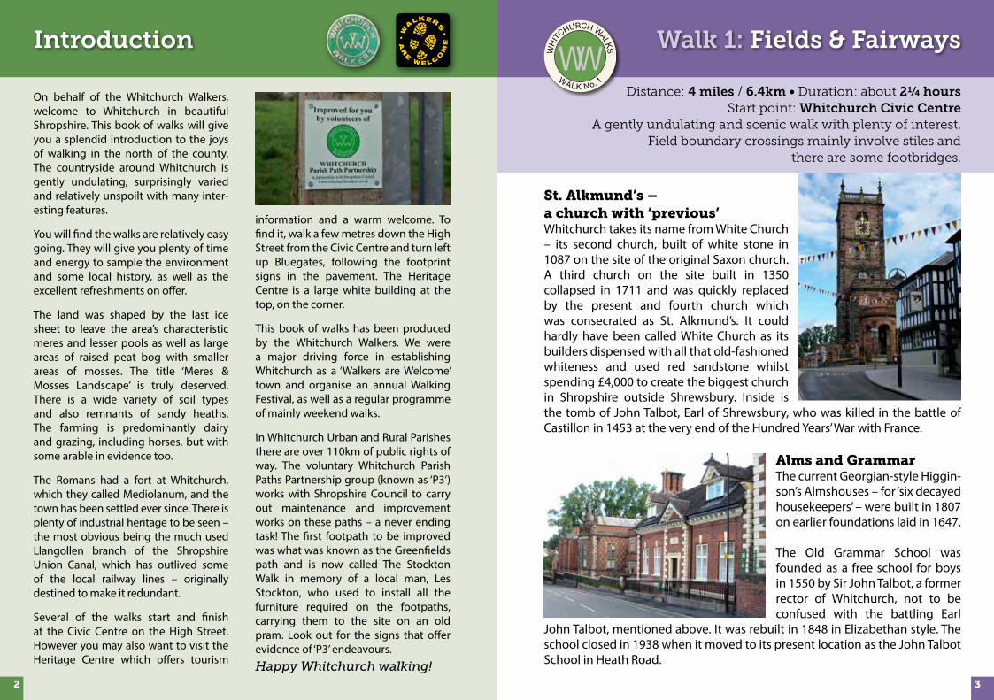
St. Alkmund’s – a church with ‘previous’ Whitchurch takes its name from White Church – its second church, built of white stone in 1087 on the site of the original Saxon church. A third church on the site built in 1350 collapsed in 1711 and was quickly replaced by the present and fourth church which was consecrated as St. Alkmund’s. It could hardly have been called White Church as its builders dispensed with all that old-fashioned whiteness and used red sandstone whilst spending £4,000 to create the biggest church in Shropshire outside Shrewsbury. Inside is the tomb of John Talbot, Earl of Shrewsbury, who was killed in the battle of Castillon in 1453 at the very end of the Hundred Years’ War with France.
Alms and GrammarThe current Georgian-style Higgin-son’s Almshouses – for ‘six decayed housekeepers’ – were built in 1807 on earlier foundations laid in 1647.
The Old Grammar School was founded as a free school for boys in 1550 by Sir John Talbot, a former rector of Whitchurch, not to be confused with the battling Earl
John Talbot, mentioned above. It was rebuilt in 1848 in Elizabethan style. The school closed in 1938 when it moved to its present location as the John Talbot School in Heath Road.
Distance: 4 miles / 6.4km • Duration: about 2¼ hoursStart point: Whitchurch Civic Centre
A gently undulating and scenic walk with plenty of interest. Field boundary crossings mainly involve stiles and
there are some footbridges.
Walk 1: Fields & Fairways
WH
IT
CHURCH WALKS
WALK No. 1
Introduction
32
On behalf of the Whitchurch Walkers, welcome to Whitchurch in beautiful Shropshire. This book of walks will give you a splendid introduction to the joys of walking in the north of the county. The countryside around Whitchurch is gently undulating, surprisingly varied and relatively unspoilt with many inter-esting features.
You will find the walks are relatively easy going. They will give you plenty of time and energy to sample the environment and some local history, as well as the excellent refreshments on offer.
The land was shaped by the last ice sheet to leave the area’s characteristic meres and lesser pools as well as large areas of raised peat bog with smaller areas of mosses. The title ‘Meres & Mosses Landscape’ is truly deserved. There is a wide variety of soil types and also remnants of sandy heaths. The farming is predominantly dairy and grazing, including horses, but with some arable in evidence too.
The Romans had a fort at Whitchurch, which they called Mediolanum, and the town has been settled ever since. There is plenty of industrial heritage to be seen – the most obvious being the much used Llangollen branch of the Shropshire Union Canal, which has outlived some of the local railway lines – originally destined to make it redundant.
Several of the walks start and finish at the Civic Centre on the High Street. However you may also want to visit the Heritage Centre which offers tourism
information and a warm welcome. To find it, walk a few metres down the High Street from the Civic Centre and turn left up Bluegates, following the footprint signs in the pavement. The Heritage Centre is a large white building at the top, on the corner.
This book of walks has been produced by the Whitchurch Walkers. We were a major driving force in establishing Whitchurch as a ‘Walkers are Welcome’ town and organise an annual Walking Festival, as well as a regular programme of mainly weekend walks.
In Whitchurch Urban and Rural Parishes there are over 110km of public rights of way. The voluntary Whitchurch Parish Paths Partnership group (known as ‘P3’) works with Shropshire Council to carry out maintenance and improvement works on these paths – a never ending task! The first footpath to be improved was what was known as the Greenfields path and is now called The Stockton Walk in memory of a local man, Les Stockton, who used to install all the furniture required on the footpaths, carrying them to the site on an old pram. Look out for the signs that offer evidence of ‘P3’ endeavours.Happy Whitchurch walking!

Walk 1: Fields & Fairways
G R E EN EN D
BARGATES ST
HIGH STREET
ST JOHN ST
ST MARY
S S
T
BARK HILL
PEPPERST
MILL S
TREET
W R E X H A M R O A D B5398
S E D G F O R D B5395
WATERGATE STREET
C ASTLE HILL
NEWTOWN
SHERRYMILL HILL
SHARPS DRIVE
LINDEN AV
C HEMISTRY SM A L L B R O O K R OA D
ROSEMARY LAN E
A L KI N
G T O N R O A D
B E L T O N R O A D
E D G E LE Y R O A D
YARDINGTON
C H E S T E R R O A D B5395
T AR
P OR
L E Y RO
AD
B5476
BRIDGEWATER STREET
BROWNLOW STREET
LONDON ROAD
NEWPORT ROAD
STATION RD
TA L B OT S T
MI L
E BA N K R
O A D
A L P O R T RO
AD
CLAY
PIT ST
T E R R I C K R O A D
Chemistry
Brooklands
Belton
Moat
DISMANTLED RAILWAY
BridgeHouse
The FieldsFarm
HintonOld Hall
Mount Farm
Hinton Manor
Hospital
Supermarkets
Supermarket
Hill ValleyGolf Club
Hotel
Swimming PoolA495
A49A41
COUNTRYPARK
CricketGround
JubileePark
A41
B EECH AVENUEQ U E E N W A Y
GrindleyBrook
HintonBank
Hotel
Reservoir
Reservoir
South CheshireWay
Bishop BennetWay
0 ½KILOMETRES
0 MILES ¼
Route Description
From the Civic Centre 1 go up the High Street and past the church of St. Alkmund’s.
Pass some Almshouses and flats occupying the Old Grammar School on your right. Cross the roundabouts and go along the left side of Tarporley Road to ‘Westmore House' 2, after the next house a wooden fingerpost will direct you down a stony track.
Turn right and cross the first field 3, along a permissive path, joining the old Chester Railway branch line; turn left and walk along the old track-bed. Turn off at the next stile to a small footbridge; follow the hedge a short way then cross a corner of a field to a stile leading on to the A49 bypass road 4.
Cross the road with care – the traffic can be fast – and go over the stile opposite into a field, bearing left towards a wooden telegraph pole, and then keep on the line of an ancient hedge to your right. This field can be wet and muddy in places, especially where you cross a stile and footbridge, which are partly hidden by a holly hedge. Here bear right of a telegraph pole to cross a stile in a wire fence. Bear left and cross another footbridge, which is hidden in the hedge. Now head towards a prominent mound in this large field and go right at the hedge to a stile 5.
Turn right here and carry on 30 metres to a field gate. You are now on a delightful tree-lined sunken green lane and have joined the South Cheshire Way.
With a white house in sight there are two gates and a stile to your left. The gate by the stile offers the easiest access to the driveway leading to Hinton Manor 6. Continue on to cross the A49 7 and on to the driveway opposite signed The Bishop Bennet Way. After about 180 metres turn right over a stile 8, and up a grassy bank through shrubs and you will find yourself on the golf course.
Turn left along a tarmac path leading past a pool on your left. Bear right at a waymarker post, following the line of a ditch, across two fairways and a tarmac path to reach another waymarker post by a reed-filled pool 9.
Look out for golfers and show consideration to them as this is a walker-friendly course. Turn right down the tarmac path, which goes through part of the hotel !. You will pass under a glass-covered walkway with the restaurant and swimming pool to your left and then past a small wooden pavilion to your right.
At the next waymarker post # turn right and re-join the tarmac path. At a further waymarker post turn left and cross the old Chester
Railway $ again. Look for the small railway relic by the stile.
Cross into a field, over a footbridge – and then over another footbridge into the next field and pass a pool, which may have Canada Geese on it.
The path leads to Tarporley Road %. Turn left, cross by the roundabout – there is a pedestrian crossing nearby – and back towards the church and the High Street.
© Copyright Ordnance Survey Open Source data
54

An abandoned branchThe London and North West Railway opened the Tattenhall to Whitchurch branch in 1872 to link the Crewe to Chester and Crewe to Shrewsbury lines. On weekdays in 1910 there were seven trains in each direction. The line diverged from the Chester to Crewe line at Tattenhall Junction four miles SE of Chester and headed south bridging the Chester to Whitchurch road (now the A41). For most of the six miles from Tattenhall it was climbing at around 1 in 115 reaching the summit of the line south of Malpas.
A meeting of WaysJust after point 5 on a sunken green lane known locally as Fairy Glen, our walk converges with two other routes. The South Cheshire Way is a splendid 34-mile walk along canals and through wonderful Shropshire and Cheshire countryside from Grindley Brook, near Whitchurch, to Mow Cop near Congleton.
The Bishop Bennet Way, also 34 miles long, is a horse riding route in south west Cheshire which can also be used by walkers and cyclists. It is named after William Bennet (1745 – 1820), Bishop of Cork and Ross and subsequently Bishop of Cloyne, who carried out detailed surveys of Roman roads including those between Deva (Chester) and Mediolanum (Whitchurch). The Way starts near Beeston Castle and finishes near Wirswall on the Cheshire-Shropshire border.
Tarporley goose chaseLook out for lively Canada Geese at the delightful pool near the Tarporley Road (just north of map point %).
Hill Valley GolfThe golf courses of The Macdonald Hill Valley Hotel and Spa are criss-crossed by a number of rights of way. Happily, walkers and golfers co-exist easily thanks to some sensible management and mutual respect.
Walk 1: Fields & Fairways
Man, pram and dogThis route, opened in 2011, is named in memory of Les Stockton, a founder member of the local walking group – the Whitchurch Walkers. The section from Sherrymill Hill to Danson’s Wood was the first path improved by the Whitchurch Walkers after its formation in 1976. Les did most of the work, carting his tools and materials across the fields in an old pram and always accom-panied by his black dog.
St. Alkmund’s ChurchThe church was completed in 1713 to replace a previous building which collapsed in 1711. It is open every day and well worth a visit. The tall tower has a clock made by illustrious local clockmakers JB Joyce, a peal of 8 bells and is a prominent landmark from all directions.
Roman Whitchurch and a 15th century garageIn Roman times Whitchurch was known as Mediolanum – Latin for ‘middle of the plain’. It was a staging post midway between Wroxeter and Deva (Chester). Part of a Roman fort wall and other remains were found in the Yardington area. These are commemorated in the garden opposite the west end of the church.
More history is in evidence in the High Street Garage. Its upper floor has been dated to the 15th century.
Distance: 2.8 miles / 4.5km • Duration: about 1¼ hoursStart point: Whitchurch Civic Centre
An easy walk with some gentle slopes between points 4 and 6 with gates but no stiles.
Walk 2: The Stockton WalkWALK No. 2
THE
STOCKTON WALK
76

Walk 2: The Stockton Walk
GR EEN END
BARGATES ST
HIGH STREET
ST JOHN ST
ST MARYS ST
BARK HILL
PEPPERST
MILL STREET
WR E X H
AM R
OA
D B
5398
S E D G F O R D B5395
WATERGATE STREET
CASTL E
HILL
NEWTOWN
SHERRYMILL HILL
LINDEN AV
SHARP S DRIVE C HEMISTRY
SM
ALLBROOK ROAD
PE
AR
TR
E E L ANE
ROSEM
ARY LANE
A L K I N G T O N R O A D
BELTON ROAD
T I L S T O C K R O A D B5476
EDGELEY
RO
AD
YARDINGTON
CHE S
T ER
RO
AD
B53
95
TARPORLEY ROAD B5476
BRIDGEWATER STREET B R OW N LO W STREE
T
LOND O N
ROA
D
NEWPORT ROAD
STATION
ROAD
TALBOT STREET
B L A C K P A R K R O A D
Chemistry
Belton
Moat
DISM
ANTLED
RAILWAY
BridgeHouse
LlangollenCanal Wrexham
BridgeDanson’s
Wood
Shropshire Way
Sandstone Trail
Hospital
Supermarkets
Supermarket
SwimmingPool
A525
A49
CountryPark
Greenfields NatureReserve
JubileePark
Danson’sBridge
A41
BEECH AVENUEQ
UE E N
WA Y
YockingsG
ate
0 ½KILOMETRES
0 MILES ¼
Route Description
From the Civic Centre 1 walk up the High Street towards St. Alkmund’s Church 2. Turn left into Yardington and right at the mini-roundabout and down Sherrymill Hill to the next mini-roundabout3.
Turn right into Waterside Close keeping to the footpath on the right hand side. Follow the path towards the canal, crossing the road at the bottom of the Firs.
Continue until you reach a signpost for Danson’s Farm 4. Turn right here on the tarmac path between some houses, follow the path across a road and then go left through a kissing gate.
Walk diagonally to the right and through the kissing gate in the far right hand corner. Continue across the next field, again to the far right hand corner.
Go through the gate and turn left towards the next gate some 50 metres up from the bottom left hand corner of the field. Continue towards the far right hand corner and through another gate 5.
Walk diagonally to the right up the slope and through a gate left of the middle of the hedge. Turn left towards the gate in the centre of the field boundary facing you. On a clear day, excellent views of the Welsh hills can be seen from here.
Cross the next small field, go through the gate and down the path to the Whitchurch bypass. There is a good view either way but traffic can be busy so take care crossing. Head slightly to your left and up the driveway towards an opening to the left of a gate.
You are now entering Danson’s Wood 6. Follow the fence line for about 20 metres past the Woodland Trust’s interpretation panel. Turn left straight down the slope towards the canal. If you want to extend your walk through this small but pleasant wood, there are paths to the left and right, both of which loop round to rejoin the main path by the canal bridge.
Go over Danson’s Bridge (No 30) and through both gates taking you to the towpath of the Llangollen Canal. Turn right and under the bridge along the towpath following the Sandstone Trail and Shropshire Way towards Whitchurch. Continue along the canal until, after about 550 metres, you reach a black and white lift-up bridge 7.
Cross this bridge and walk along the towpath beside the Whitchurch arm of the canal.
Possible detour: On the bend in the Whitchurch arm you can make an attractive detour by taking the gate to the left, down the track and across the valley to Greenfields Nature Reserve 8.
Once in the reserve, keep to the right up the steps, and you will eventually rejoin the walk at Greenfields Way, near point 9.
Cross the road diagonally and continue along the path. In about 250 metres you will rejoin your outward route at point 4.
© Copyright Ordnance Survey Open Source data98

Smells from the pastThe Whitchurch arm of what is now the Llangollen Canal once came right into the town centre to a wharf at Mill Street. Waterside Close follows the line of the canal which passed under the road and through the valley opposite, which is now occupied
by the extended Jubilee Park. The town gas works were located on either side of Sherrymill Hill and coal was delivered to the works by canal boat.
New life for the Whitchurch ArmThe first stretch of the arm from the main canal was restored by the Whitchurch Waterway Trust. It was reopened in 1993 and provides both permanent and 48 hour moorings. The Whitchurch Waterway Trust is currently working on plans to take the canal through the next two bridges and build a basin for 8 boats next to the car park beyond the second bridge. This car park can be used as an alternative starting point for the walk.
Danson’s Wood and FarmDanson’s Wood on part of the site of the former Danson’s Farm is a ‘Millennium Wood’ and was planted in 2001 by the Woodland Trust with the help of a large band of local volunteers.
Greenfields Nature Reserve, Country Park and Staggs BrookThis important green wedge follows the line of Staggs Brook, which is inhabited by water voles and otters. The nature reserve features both meadow and woodland and is managed by volunteers from the Whitchurch Branch of the Shropshire Wildlife Trust.
Walk 2: The Stockton Walk
Forgotten lines Whitchurch was a junction of the Whitchurch to Tattenhall branch line which linked the Chester to Crewe and Shrewsbury to Chester lines. It was part of the London and North Western network. As well as its own passenger and freight services, this line was a useful short cut for freight traffic to and from Chester and North Wales avoiding Crewe. It was closed on 16 September 1957.
Bridge by Brymbo (1857) The cast iron bridge at point 4 which takes the Shrewsbury-Crewe line over Black Park Rd was made by the Brymbo Ironworks.
John Wilkinson’s original Brymbo Ironworks near Wrexham was resurrected as a successful industrial concern in 1841 – 16 years before this bridge was constructed. In 1854 the directors took each other to court to gain sole control of the company. Allegedly, Robert Roy and Henry Robertson decided to settle their dispute with a horse race. The owner of the horse that reached the ironworks first could buy the other out. The workforce favoured Robertson and ensured that his horse won. Robertson went on to transform Brymbo into a major steel works.
Distance: 4 miles / 6.4km • Duration: about 2¾ hoursStart point: Whitchurch Civic Centre
A walk over varied but mainly field (some cropped) terrain with some slopes. The going can be muddy and wet in some areas.
Walk 3: To Broughall (pronounced Broffal) and back
Top: Dennis Fire Engine 1925 outside Whitchurch Fire Station. Above: The old
Fire Station (point 2) was built in 1900 and was paid for and run by local Assurance
Companies. It is currently a dentist's.
WH
IT
CHURCH WALKS
WALK No. 3
1110

Walk 3: Broughall & back
GREEN E ND
B ARGATES ST
HIGH STREET
ST JOHN ST
ST MARYS ST
BARK HILL
PEPPERST
MILL STREET
S E D G F O R D B5395
WATERGATE STREETCAST
LE H
ILL
NEWTOWN
SHERRYMILL HILL
ROSEM
ARY LANE
T I L S T O C K R O A D B5476
E D G E L E Y R
OAD
YARDINGTON
BRIDGEWATER STREET B R OW N L O W STREET
LONDON ROAD
NEWPORT ROAD
S T AT I O
N R
O A D
TALBOT STREET
M I L E B A N K R O A D
A L P O R T R O A D
CLAYPIT ST
B L A C K P A R K R O A D
T E R R I C K R O A D
Broughall
EdgeleyHouse
BroughallHouse
White HouseFarm
TheOaklands
Old�elds
Moat
DISM
ANTLED
RAILWAY
Hospital
Supermarkets
Supermarket
Hill ValleyGolf Club
Hotel
Cemetery
SwimmingPoolCricket
Ground
N A NT W
I C H R OAD
A525
P R E E S R O A D
BEECH AVENUEQ
U E E NW
A Y
Black Park
Alport
Villa Farm
The Moss
The Lodge
BlakemereCottage
YockingsGate
Hotel
Crab Mill
BlakeMere
0 ½KILOMETRES
0 MILES ¼
WaymillsIndustrial
Estate
Route Description
From the Civic Centre 1 go down the High Street, turn left at the bottom into Green End and then left again into Deermoss Lane. Go over the pedestrian crossing opposite the old Fire Station (currently a dentist’s) 2 and take the path to the left of the building alongside a playing field.
Cross over into Elizabeth Street and carry on to the end where you turn left into George Street. Here you will see a gate 3 at the end, leading into a field. It is possible that this section of path may be subject to a diversion order at some point. Follow the waymarked path across two fields then cross an old brick/stone Whitchurch to Chester railway bridge into another field. At a waymarked stile, turn diagonally right and down towards a stile at the roadside.
Turn left along the road and under an iron railway bridge 4 marked Brymbo 1857. Carry on along the lane until you come to meet and turn on to a bridleway on your right 5. Follow the waymarked route through gates across three fields to a stile on your left 6. Given a clear day there is a fine view over Blakemere towards the town.
At this point you must decide what you want to do. The longer route to the east is interesting but challenging due to a number of only semi-accessible hedge and ditch crossings plus a slurry-filled
lane all of which are subject to ongoing negotiations with the local farmer. The shorter route is altogether easier and more direct but means you miss some attractive countryside.
The shorter route:
Do not cross the stile but carry on ahead through more bridleway gates to a field gate on to a quiet lane. Go down the lane to meet the busy A525 Nantwich-Whitchurch road 7.
The longer route:
Turn left by crossing the stile and keep the hedgeline to your right passing a small pond on your right. At the far right hand end of the field cross a stile and carry on with the hedge to your right towards a black and white cottage (Lower Lodge) and after about 150 metres turn right across a stile by a large tree into the next field A. This area can get very wet!
Follow the hedgeline to your left and cross the stile in the far left hand corner. There is another stile ahead but don’t cross this – instead turn right and go up to the top right hand corner where you will cross a ditch and a double stile. Turn right and follow the hedgeline to yet another double stile and ditch B. Cross this, keep to the hedgeline and head for the next stile in the right hand corner of the field.
© Copyright Ordnance Survey Open Source data
Directions continue overleaf
1312

Suspension BridgeThe suspension bridge over the Shrewsbury-Crewe railway line is over a century old and is a unique grade II listed structure. It was closed for over a year in 1997 having been declared unsafe. Local goups including the Whitchurch Walkers campaigned to save the bridge and eventually Railtrack agreed to a complete renovation. The Institute of Civil Engineers declared the bridge to be ‘a Victorian gem’.
The A-frame wooden vertical supports with iron bracing and joints are linked at the base to curved stone foundation blocks by iron rods. The decking has wooden planks set into an iron frame with thin iron balustrades. The original suspension cables were made of forged iron link chains from which the flat decking was hung by iron rods.
Looking along the line to the south you can see Whitchurch station and to the north the remains of the goods yards where originally horse-drawn carts would have delivered and taken away the freight carried by trains. Horses are not good at reversing which is why such a large space was needed to allow a broad sweep for forward turning.
Walk 3: Broughall & back
Distance: 3.7 miles / 5.9km • Duration: about 2 hoursStart point: Whitchurch Civic Centre
A largely level walk with a mixture of gates and stiles. There is also a flight of steps in Jubilee Park but these are easily
avoided using the map as a guide.
Shops and pubsOn the High Street, look out for Walkers, the bakery shop which is on the left, going down. Sometimes known as ‘the old shop’, parts of it date back to 1450 but most is 17th century.
Joyce’s ClocksAt the bottom of the High Street, is a modern clock by the Whitchurch clockmakers JB Joyce. The firm has operated in Whitchurch since the 18th century and its clocks can be seen in churches and many prominent buildings as far afield as South America and China. Naturally, St. Alkmund’s in Whitchurch has a Joyce clock. For more information turn to page 19.
A famous son of WhitchurchThe composer, and also Mayor of Whitchurch, Sir Edward German was born in the Old Town Hall Vaults pub at the junction of High Street and St. Mary’s Street in 1862. You can see his portrait in the Civic Centre.
Walk 4: The Belton BracerCross this and bear left, up and diagonally across to a stile to the right of a gate by some trees C. Walk up the right hand side of the field, through a gate in the top right hand corner into the next field and along the hedgeline to your left up the hill to a gate.
You are now on a concrete track D but it can be calf deep in slurry even at the edge. Go down through the next gate and turn right on to a lane by Villa Farm. Continue along past Old Hall Farm to join the main A525 Nantwich-Whitchurch road 7.
The longer and shorter routes come together here.
Turn right on to the main road and continue on the pavement ignoring the first footpath sign and turn right at the next footpath sign by a bungalow called Moss Lea 8.
A grassy track runs to the left of the bungalow down to a stile; cross this and go past a little brick stable. Follow the line of telegraph poles across the field to a stile – cross this and go straight on to the suspension bridge 9ahead. Walk over this and turn left down Talbot Street to meet the traffic lights at the top of Green End. Cross over and retrace your steps back to the Civic Centre.
Old cooperage, now Walkers Bakery
WH
IT
CHURCH WALKS
WALK No. 4
1514

Walk 4: The Belton Bracer
College
Supermarket
Swimming P
CivicCentre
ool
COUNTRYPARK
CricketGround
Jubilee Park
G R E EN EN D
BARGATES ST
HIGH ST
ST JOHN ST
ST MARY
S S
T
BAR
WATERGATE STREET
K HILL
L STREET
W R E X H A M R O A D B5398
C ASTLE HILL
SHERRYMIL L HILL
SH AR P S D RIVE
LINDEN AV
C HEMISTRY SM A L L B R O O K R O A D
P E A R T R E E L A N E
ROSEMARY LAN E
A L KIN G T O N R O A D
B E L T O N R O A D
A L KI N
GTO
N R
O A D
T IL S
T OC K
RO A
D B5
476
E D G E L E Y R O A D
NEWTOWN
C H E S T E R R O A D B5395
T AR
POR L E Y R
OA
D B5476
BRIDGEWATER STREET
BROWNLOW STREET
LONDON ROAD
NEWPORT ROAD
S T A T I O N R O A D
TA L B OT S T R E E T
MI L
E BA N K R
O A D
A L P O R T RO
AD
CLAY
PIT ST
B L A C K PA R K R
OA
D
T E R RI C K R O A D
P R E E S R A O D A41
Chemistry
Brooklands
DearnfordLake
Waymills
The FieldsVineyard
EdgeleyHouse
The Oaklands
DISMANTLED RAILWAY
A41 A525
N A N T W I C H R O A D A525
A41
P R E E S R O A D
B EECH AVENUEQ U E E N W
AY
Alkington
Belton
TheManor
DISMANTLED
RAILWAY
SEDGEFORD B5395
0 ½KILOMETRES
0 MILES ¼
the railings round the play area. Follow the path round to the right of the railings and proceed up the flight of steps on the bank opposite towards Newtown car park at the top.
Turn right along Newtown and at the mini-roundabout turn left into Pepper Street past the Anchor and Red Cow public houses and you are back at the High Street.
© Copyright Ordnance Survey Open Source data
Route description
From the Civic Centre 1 walk down the High Street and turn right through the pedestrianised area.
Go along Watergate Street, passing Bark Hill on your right, and then into Dodington. You will pass two disused churches, the United Reform on your left and St. Catherine’s on your right where there is an information board. Continue past the Dodington Lodge Hotel and into Sedgeford on the far side of the mini-roundabout. In about 150 metres you come to a cycle track, the Hatton Way 2.
Turn right on to the Hatton Way, which runs between Whitchurch Cricket Ground and an embankment of the old Cambrian Railway. At the far end of the straight section of the tarmac track, turn left and take the path across the field. Turn right up the track and take the left turn at both forks. Take care when crossing the Whitchurch bypass 3.
After passing through five fields you approach the hamlet of Alkington 4.
Turn left on to the road and then right at the junction 100 metres ahead. Opposite the junction look out for a 19th century VR (Victoria Regina) post box. Just past ‘The Manor’ take the stile on the right
of a field gate. This will lead you back to the old railway 5.
Keep to the left hand field boundary through the next four fields. From the fourth field, you will have a good view of the distant tower of St. Alkmund’s, the parish church. The ground now slopes up towards Belton Farm 6. The route now goes back over the Whitchurch bypass into Belton Road which you should follow all the way to its junction with Wrexham Road.
Cross Wrexham Road towards the bus shelter on the far side. Go across the grass behind the shelter and walk along the road in front of the houses. Turn left on to the footpath at the end of this bit of road which takes you between the houses into Meadow View Road 7.
Cross the road and turn right. There is a small block of flats on your left and immediately after them, take the footpath to the left between the backs of the houses for about 150 metres before emerging at the top of Jubilee Park 8.
Cross the road in front of you and go through the gap in the railings. You will notice St. Alkmund’s Church ahead of you and St. Catherine’s more distantly to your right. Take the path to the left and when it crosses another path, turn right towards the town centre and
1716

Walk 4: The Belton Bracer
Cyclists’ and Walkers’ WaysTwo noted Whitchurch cyclists, Cedric and Ruth Hatton, are commemorated by a plaque marking the Hatton Way (point 3). At the same location there is a marker and a mosaic showing that you are also on the Mercian Way which is the Shropshire section of National Cycle Route 45, which runs between Chester and Salisbury.
Railway ConnectionsWhitchurch sits astride
the Shrewsbury to Crewe line. It was once also connected to Ellesmere, Oswestry and Aberystwyth by the Cambrian Railway. The line closed in 1965 and unfortunately parts of the track-bed have been lost, otherwise it would have made an excellent off-road walking and cycling route to Oswestry and beyond.
Whitchurch – ripe, mature and tastyBelton Farm maintains Whitchurch’s tradition as a famous cheese town. Belton produces a wide range of award-winning cheeses available in leading supermarkets. A selection of these is available from shops in town. Look out for the distinctive Belton tankers collecting milk from local farms.
Jubilee Park – worthy of the celebrationThe park opened in 1887 to mark Queen Victoria’s Golden Jubilee. The bandstand was added in 1908 and moved to its present position when the park was extended around 1990. The ‘Old Mill’ at the far end is a reminder that Staggs Brook still passes through the park albeit via underground culverts.
Waymarker alongHatton Way
Bandstand in Jubilee Park
Belton Farm
Cambrian Railway Signal Box
Distance: 8 miles / 12.9km • Duration: about 4 hoursStart point: Whitchurch Civic Centre
A flat to undulating town/village/countryside walk featuring the Brown Moss Nature Reserve.
William Joyce – clock manWilliam Joyce began making longcase clocks in the North Shropshire village of Cockshutt. The family business, eventually known as JB Joyce, was handed down from father to son and in 1790 moved to High Street, Whitchurch, Shropshire. By 1834 Thomas Joyce was making large clocks for local churches and public buildings. In 1849 the company copied the escapement mechanism used in Big Ben and went on to make large clocks for many public buildings both home and overseas – notably the clock in the Shanghai Customs House.
Between 1945 and 1964, when Norman Joyce retired, the company installed over 2,000 large public clocks in Britain and Ireland. The business was sold to Smith of Derby but the JB Joyce brand name was retained for the maintenance of the many original Joyce heritage pieces still in operation in public places around the world.
In 2012, an auction was held to dispose of the surplus items accumu-lated at the Station Road premises and lovers of the work of JB Joyce competed with interior designers and collectors to purchase a piece of horological history.
Walk 5: The Ash Brown WalkWH
IT
CHURCH WALKS
WALK No. 5
1918

Walk 5: The Ash Brown WalkMoat
G R E EN EN D
BARGATES ST
HIGH STREET
ST JOHN ST
ST MARY
S S
T
BARK HILL
PEPPERST
MILL S
TREET
S E D G F O R D B5395
WATERGATE STREET
C ASTLE HILL
NEWTOWN
ROSEMARY LAN E
T IL S
T OC K
RO A
D B
5476
E D G E L E Y R O A D
YARDINGTON
BRIDGEWATER STREET
BROWNLOW STREET
LONDON ROAD
NEWPORT ROAD
S T A T I O N R O A D
TA L B OT S T R E E T
A L P O R T RO
AD
CLAY
PIT ST
P R E E S R O A D A41
Oak�elds
Broughall
Catteralslane
Edgeley
EdgeleyHouse Broughall
Fields
BroughallHouse
White HouseFarm
Meadows Farm
Field Farm
BrownlowCottage
The Fields
Heathlane
The Oaklands Old�elds
College
College
Moat
DISMANTLED RAILWAY
Hospital
Supermarkets
Supermarket
Hill ValleyGolf Club
Hotel
Cemetery
CricketGround
BrownMoss
JubileePark
A41
A525
N A N T W I C H R O A D A525
P R E E S R O A D
B EECH AVENUEQ U E E N W A Y
Black Park
Alport
AshMagna
Ash Grange
AshCorner
Ash HallShropshire Way
EdgeleyFarm
HeathLodge
VillaFarm
Moss Farm
The LodgeBlakemereCottage
YockingsGate
Hotel
EdgeleyHall
BlakeMere
0 ½ 1KILOMETRES
0 ½MILES ¼
WaymillsIndustrial
Estate
© Copyright Ordnance Survey Open Source data
Route Description
Leave the Civic Centre 1, go down High Street and turn left at the bottom by a Joyce clock into Green End. Continue to the traffic lights at the top and cross into Talbot Street and on to and over the suspension bridge 2 on your right across the railway.
Follow the right hand hedge through two fields to a telegraph pole with a waymarker where you turn left and follow a line of trees to a stile beyond, follow the waymarked path to Moss Farm 3.
Keep to the right of the farm buildings and cross a stile in a fence, then turn right and keep the hedge boundary on your right through a series of gates to reach a minor lane and go straight ahead to meet the A525 Nantwich Road 4.
Cross the road and go a short way down Catterals Lane to a bend and then take a rough lane to the left. Carry on until the lane bends sharply left and follow the waymarkers ahead eventually turning left 5 to cross a large field to a bridleway.
After about 10 metres, turn left through a gate and go on to the next gate where you turn right and go through two more gates. From here the path will bring you into Ash Magna by some garages 6.
Turn right at the T-junction with the lane and bear right at the one way system. With the White Lion pub 7 on your right go through a wooden gate to the left, opposite the pump. Follow this path through three fields to a lane and turn right, uphill to a gate on the left. Take the path downhill across two fields to enter Brown Moss 8.
Follow the path through the wood to a lane. Turn left and walk on to a Shropshire Way signpost. The Shropshire Way signs will take you through Brown Moss to the north and on to a lane, and back to Whitchurch.
Take the right fork and then go through a bridleway gate on your left and across two fields. You will emerge on to Edgeley Bank. Take care here as it is narrow with no footway.
Cross the A525, go down Edgeley Rd and back to town via Dodington Lodge 9, Watergate Street & the Bull Ring where you will meet the High Street once more.
A bridge in suspenseThe single span cast iron and wood suspension bridge was built in 1872 for the London and North Western Railway Company.
This is a very early and rare example of a pedestrian suspension bridge. For more information see page 14.
The whys and wherefores of AshWith the departure of the Romans, Mediolanum became Westune – a small village with a manor on the western edge of Saxon Mercia. Two small clearings for hamlets in the ash woods on the top of the ridge were named Ash Magna and Ash Parva.
2120

Walk 5: The Ash Brown Walk
Despite its name, Ash Magna is a small village with around 75 houses and a population of around 250. An 1888 map shows about 25 dwellings, one of which is Ash Hall. It is an imposing Queen Anne style building sitting at the highest point of the village and was originally designed as a hunting base. It now combines the role of a working farmhouse and Bed & Breakfast.
Brown (not green) MossBrown Moss is one of Shropshire’s most inter-esting nature reserves with over 200 species of wild plants including the rare floating water plantain. Great crested newts are just one
example of the fantastic variety of wildlife that live amidst its marshes, pools, heath and woodland. In the late spring/early summer large numbers of froglets can be seen making a mass exodus from the pools.
Brown Moss is designated as a Site of Special Scientific Interest, a Special Area of Conservation, and a Ramsar site – a wetland of international importance named after a treaty signed in Ramsar, Iran. The pull of the BullringThe Bullring was the place used for the baiting of bulls; once a great national sport. The bull was tethered to an iron ring sunk into a large stone by a 15 foot length of rope attached to the root of its horns. The object was to find whose mastiff or bull-dog had the most courage and was the most cunning in taunting the bull. The last bull-bait in Whitchurch was in 1802. The triangular bullring was the heart of Whitchurch – it is the site of the town’s original market place.
The machinery for the market’s weighbridge was in Wycherley’s saddlery shop, where corn, coal and other loose commodities were weighed, with carters receiving a ticket certifying the weight of their load. The JB Joyce cast iron pillar clock was erected in 1994 when the creation of the traffic-free Bull Ring area concluded the town’s street renewal scheme.
Prees Heath – Bombers to butterflies Prees Heath is now a butterfly conservation area, and as the heathland is being restored, more wild flowers are appearing. In late summer it is covered in pink heather flowers, yellow St. John’s Wort, and edged with purple spikes of Rosebay Willowherb.
The large, square, concrete structure at the top end of Prees Heath is the recently restored Air Traffic Control Tower used when the area was a wartime training airbase (RAF Tilstock). It is to be used as a learning and interpretation centre providing information about the natural diversity of the Heath and its wartime history.
Prees Heath was used as a WWI army base accommodating up to 30,000 men who were trained in the practicalities of trench warfare. The scale and size of the camp brought about the appointment of the first female police officers in the Shropshire Constabulary to manage and restrain local women attracted
by the rewarding prospect of so many eager men. There was also a stores depot with its own branch line and, later, a WWII internment camp (subse-quently a POW camp) for 2,000 prisoners.
Ash Parva Ash Parva, or Lower Ash as it is sometimes called, is small and pretty. It has a classic village duck pond and around 20 houses – mostly small cottages. There is a Methodist Chapel converted to a house and a large restored 18th century farmhouse.
Distance: 7.4 miles / 12km • Duration: about 3-4 hoursStarting point: Brown Moss Nature Reserve car park
No hills or banks to climb – a few stiles; in summer there will be crops in some of the fields.
Walk 6: Brown Moss, Bombers, Butterflies and Big Butties
2322

Walk 6: Brown Moss, Bombers, Butterflies and Big Butties
Route DescriptionThis walk starts at Brown Moss. You could also start from Ash Magna 3, Higher Heath 8, or Prees Heath !.
From the main car park turn right on to the road and go on to the fingerpost by the bungalow called The Boathouse 1 – the house name is on a board suspended from the eaves. Go through the wood (there are several paths so keep to the waymarked one) to a galvanised gate, and then on through two fields to a lane, where you turn right. Take care as visibility for cars is poor, and look out for the next path on the left – it is hidden in the hedge on a bank 2. Now cross two horse paddocks to a wooden wicket gate immediately before a stile, which brings you to the village of Ash Magna, just opposite the White Lion 3.
Turn right along the road – there is a pavement at first. At the village of Ash Parva, cross the road to a metal wicket gate, and follow the permissive path, which takes you off the road and then rejoin the road by a junction. Cross over towards a large half-timbered house and keep to the right hand side of the Ightfield Road, taking care as it can be quite busy. About 250 yards on, turn right 4 through a decrepit gate and walk along a restricted byway (or green lane). There is a hedge each side and you may have to negotiate an electric fence. The byway leads to a large open area of mainly arable fields.
The path is very good along wide grass headlands and tracks – follow
the waymarkers not the Ordnance Survey Map. At a pool, bear right at the wooden fingerpost along a track until you reach a cross roads of tracks. Continue straight on – it might be a little muddy here. The track leads to a ‘gated’ electric fence with green waymarkers going left and right – ignore these, and go ahead by using the spring-loaded handle in the fence (please replace the hook in the wire loop). About 90 metres on, there is a small hollow 5 – there should be a waymark post here; turn right to a stile about 180 metres away.
Cross two fields (which may be cropped) and pass by two pools 6, behind some farm buildings, to join the farm track. (If there is any problem with this path it is possible, although not a Right of Way, to go through the farm yard, and close any gates as you go.)
The farm track goes through a wooded area to the main road – the busy A41 7. Within this wood there was once a wartime air force base; remnants of Nissen huts can still be seen in places.
Taking care, cross the A41 and go down Heathwood Rd, which goes through the village of Higher Heath. After 270 metres, turn right along Twemlows Avenue 8, and after 135 metres turn left at a sign for High Corner 9 and then right through a metal kissing gate. This path leads on to Prees Heath. Turn right at a large black kissing gate ! on to the heath. At an information board on a concrete plinth, bear left following the Shropshire Way waymarkers.
You will emerge on to the A49 road #which you need to cross – take care, though traffic visibility is good. Once across, turn right and go past the filling station, cafés, lorry park, to the Raven pub $.
Take care crossing the busy dual carriageway. At the corner of a junction with a minor road is a wooden fingerpost. Follow the footpath to the next lane where you turn left %, leading back towards
the dual carriage way. At this junction cross a stile & on your right and go across two fields of pasture and then arable fields to Holly Cottage by Brown Moss (. Turn right along a track, and then on to a lane, where a left turn will bring you back to the start – along the way you will glimpse the Moss through the trees.
0 ½ 1KILOMETRES
0 ½MILES ¼
Wood Farm
Holly Cottage
Fox Field
TwemlowsHall
The Twemlows
TwemlowsBig Wood
LonsdaleCottage
The Firs
New Gorse
Warren House
Prees Heath
Brown Moss
Ash Magna
Ash Parva
Higher Heath
Ash Hall
Airfield
Ashacres
Shropshire Way
Edgeley Farm
Reservoir
A41
A41
A49
© Copyright Ordnance Survey Open Source data
2524

Long route: 6.8 miles / 10.9km • Duration: about 4 hoursShort route: 3.5 miles / 5.6km • Duration: about 2 hours
Starting point: The Horse & Jockey, Grindley Brook (Check with the pub, 01948 662723, if you wish to park there.
Or use the No.41 bus service from Whitchurch)
Mostly flat (only a few short, steep banks), with stiles, and gates. There are places where it can be muddy.
In summer there may be crops to walk through.
Walk 7: Grindley Brook and back in two ways
Two wells and a churchSt. Mary’s Church, Whitewell (also known as Iscoyd), is a whitewashed brick church which was a former ‘chapel of ease’ (an alternative and more convenient venue) for parishioners of Malpas in Cheshire. It remains the only Welsh church in the diocese of Chester. The present 1830s structure replaced an earlier timber-framed building which collapsed during restoration work.
The two wells from which the name Whitewell derived lie to the south of the church. Some parts of the old chapel were used in the construction of the new building, especially the roof timbers and various oak panelling. The spire and clock were added in 1898.
Burial Ground and Mills at IscoydThe tumulus known as Warren Tump to the west of Iscoyd Park was probably a Bronze Age burial mound. This belief was reinforced by the discovery of a bronze axe in the grounds of Iscoyd Park in the mid-19th century. It is likely that the ‘missing’ Anglo-Saxon manor of Burwardestone, which is named in the Domesday survey of 1086, fell within the area of Iscoyd.
A series of corn watermills were constructed, possibly on earlier foundations, along the Wych Brook including Dymock’s Mill, Wych Mill, Llethr Mill and Wolvesacre Mill from the later 18th century onwards. The remains include leats and millponds as well as some surviving structures.
Brown Moss – commoner’s rightsBrown Moss was re-registered as a common in 1972. The area has commoner’s rights which allow for grazing, cutting of peat, taking of sand and gravel, collection of firewood, swimming, skating and fishing by the registered commoners. No one commoner can exercise all the rights, which are attached to the ownership or tenancy of specified properties.
The Award Winning Truck StopAt the junction of the A49 and A41 there is an amazing variety of food outlets. The Midway – originally built as a cinema for the army camp – has won awards. Here is an extract from a lorry driver’s blog: ‘This is a very good place, very much like transport cafés used to be, every table a slightly different style but it adds to the character of the place. The staff are friendly and welcoming, the place is very clean. It has plenty of room and showers – it even has a library.’
The area is also a convenient viewing point for cycle trials, which regularly take place on the Roman-straight stretches of road in the vicinity.
Nissen DormaThe remains of the huts in the woods near Higher Heath are Nissen Huts. These were semi-cylindrical prefabricated structures made of corrugated iron, invented by Major Peter Nissen in 1916. Over 100,000 were produced in WWI and many more in WWII.
The Nissen Hut could be packed in a standard army truck and erected by six men in four hours. The world record for constructing one is 1 hour 27 minutes.
Nissen Buildings Ltd. waived their patent rights for wartime production during World War II.
Walk 6: Brown Moss, Bombers, Butterflies and Big Butties
2726

Walk 7: Grindley Brook and back in two ways
Longer Route Description
Start at Grindley Brook 1. Go through the car park on to the Malpas road (B5395 – narrow and quite busy). Just past a house is a stile to the left. This path is well way marked – continue across several fields, with the brook to your left, to reach a footbridge across the Red Brook. On the other side you are in Wales. Cross a wet meadow, through an open gateway, to a waymark post directing you across a culvert and through a steel field gate. With the hedge to your right, cross more pasture to a stile and then a steel kissing gate. Turn right, and then left along a grass bank. Below is Wolvesacre Mill, which is now a cottage.
Another kissing gate leads on to a track, turn left, and after passing a cottage, Llethr Mill 2, go over the stile to your right. Cross four fields to a stile by a gate which leads on to a lane. This is Maes-y-groes 3. Turn right, then left down Kiln Green Lane until the cattle grid and a sign for Foxes Hole Farm 4.
The signpost will direct you through a wooden gate, up a steep bank to a steel gate and along the edge of afield with a wood to the left. After the next gate, but just before the field boundary, there is a footbridge to your left; cross this and turn right along a grassy track, eventually leading to some houses on a lane – Iscoyd Villa 5. Turn right at the lane and then left through a gateway
towards the church. Nearby is a large bronze-age burial mound now covered in pine trees.
Go through the grounds of St. Mary’s Church 6 and turn left through an old iron gate then over a footbridge. Cross a field and, after a stile, bear left to an old iron kissing gate leading on to a lane and the hamlet of Whitewell. Turn left, and about 90 metres after a road junction 7 go left through a field gate, across pasture and follow the waymarks into a wooded dingle which is full of bluebells in the spring.
Go down into the dingle, across the footbridge and up the other side to a wooden wicket gate. Now cross two fields to a horse paddock and double wooden gates and a stile at a house. Having crossed, bear right and follow a track leading on to a lane near a T-junction. Just to the left of this junction (amongst rhododendrons) is the Iscoyd War Memorial 8.
At the T-junction turn right, with Iscoyd Park on your left, and turn left at a signpost 9, along a track. At the end of the track is a waymarked post, turn left here down the footpath, which passes through woodland, and may be muddy. When you meet a track, turn right. More mud! Ignore the first footbridge to the right, as a short way on is a more substantial footbridge !. Now you are back in England.
From here there is an alternative, easier and more attractive permissive route which crosses the rushes and bears right following the Red Brook along a faint path before turning left on to the bridleway from Hadley to rejoin the official right of way at $.
On the official right of way (from !) you pick your way through rushes, bearing left to a field gate and turn right up a grassy bank to another gate. After crossing the next two fields you come to a concrete track, negotiate the electric fence, and find a steel gate. This is Bubney Moor, now a modern mega-dairy farm.
The fields here are very large and it is difficult to find the line of the path which can be obstructed by crops such as maize. Bear left to two steel
gates, and go through the second one. Cross another large field to reach the line of the old Shropshire Way# where a stile crosses on to a concrete track, and then over another stile $.
Crossing two more fields will bring you to the canal at Danson’s (No. 30) Bridge %.
Go through the steel kissing gate on to the towpath of the canal, turn left, and continue to the locks at Grindley Brook, and the café &.
To return to the Horse & Jockey, keep to the towpath (, going under the main road (A41) to Bridge No. 28. Go left here through a wooden wicket gate where a short lane leads to the busy A41. Cross carefully to the pub.
Grindley Brook GrindleyBrook
Bubney
Higher Wych
Kiln Green
Hall Green
BridgeHouse
HadleyWrexham
Bridge
Wolvesacre Mill
Danson’sFarm
Grindley BrookLocks
A495
0 ½ 1KILOMETRES
0 ½MILES ¼
A41
B5395
A495
A495
Tumulus
War Memorial Danson’s Bridge A41
Whitewell
IscoydPark
WolvesacreHall
Gipsy Corner
IscoydWood
Maes-y-groesFarm
Bryn Owen
Llethr Mill
Tumulus
IscoydVilla
ParkleyFarm
Broad OakFarm
BroadOak
BubneyMoor
ManningsGreen
WhitewellLodge
Chapel Farm
Bishop BennetWayLlwybr Maelor
Way
Shropshire Way
Sandstone Trail
Red Brook
Iscoyd Brook
PERMISSIVE PATH–MORE ACCESSIBLE
© Copyright Ordnance Survey Open Source data
2928

Distance: 3.2 miles / 5.2km • Duration: about 1½ hoursStart point: Brown Moss Nature Reserve car park
A pleasant walk along quiet lanes and undulating fields with some lovely views of surrounding countryside.
The White Lion in Ash Magna offers an early opportunity for a rest and a drink.
Walk 8: Wet your Whistle in Ash
Walk 7: Grindley Brook and back in two ways
Where Canal crosses BrookThe Llangollen Canal ascends from Hurlestone Junction in Cheshire to Llangollen and is a branch of the Shropshire Union Canal. It was to have been part of a network linking Shropshire and Wales to the River Dee but was never completed. The Llangollen Canal was finished in 1806 and is very popular because of its spectacular aqueducts and splendid scenery.
At Grindley Brook, the most northerly settlement in Shropshire, there are three locks rising in a staircase and then three further locks as the canal passes through the village. The village is the starting point for four long-distance footpaths: the Maelor, Shropshire and South Cheshire Ways and the Sandstone Trail, and several others run through the village, including the Marches Way.
In the mood for Danson Danson’s Bridge, more prosaically known as No. 30, was originally Dawson’s Farm Bridge. The change is probably explained by boatmen’s abbreviation, different accents or just poor hearing!
The Woodland Trust acquired and planted Danson’s Wood in early 2001 with a mixture of native broadleaves and created a small pond. There is a pleasant circular walk through the wood and several paths allow visitors to explore the site.
The Short Route
Follow the Longer Route to Llethr Mill 2, but instead of crossing the stile, stay with the track to Wolvesacre Hall A. The stile is on the left just before the farm buildings. It is very muddy here, and you might prefer to turn left through the gate before the stile (making sure to close it). The path crosses a pasture passing by a pool
with some trees, and down a bank to a little wooden gate into a wood. Again more mud! Cross the footbridge B and it is a short way to a field gate, across a large grass field, a concrete track, and another large field to the junction with the old Shropshire Way #.
Now follow the directions for the Longer Route from #.
Grazing to protect rare speciesAfter extensive consultation Shropshire Council has put up fencing around the main part of Brown Moss to allow cattle to graze throughout part of the year, as they would have done in the past. The idea of this is to keep the overgrowth of naturally dominant species down and to allow rarer, more sensitive plant species to prosper.
Unfortunately, in recent years the site has been invaded by Crassula Helmsii (New Zealand pigmyweed), a very successful non-native, which is smothering some of the more delicate plants on site. When visiting this site please keep to
the paths and away from the edges of the pools. This will help limit the spread of this plant and reduce the damage to fragile marsh areas.
3130

Walk 8: Wet your Whistle in Ash
Route Description
Leave the main Brown Moss car park 1 and rejoin the lane heading south to a fingerpost by the bungalow called The Boathouse 2. Leave the lane walk in a north easterly direction through some woodland and then through gates across two fields rising to a lane and a viewpoint.
At the top of the hill stands the village of Ash Magna. Walk on and turn left on to the road and you will soon arrive at a T-junction 3. At this point you may decide you want a drink so turn right to arrive shortly at the White Lion.
Depending on your choice either retrace your steps and carry straight on at the junction or if you have resisted temptation turn left and walk on the roadside to a Christmas tree plantation on the right.
Turn right here 4seemingly along a driveway for a short way and follow the path into a field. On a clear day there is a good view from this path over towards the Welsh hills and South Shropshire.
Follow the waymarked path through five fields to join Catterals Lane where you turn sharp left 5. This quiet lane has a series of interesting, well spaced out and varied properties on either side. At the end you will come to a T-junction 6.
Cross the road and go slightly to the right to an old narrow iron kissing gate. Follow the path through horse paddocks and four kissing gates to meet the Shropshire Way 7.
Turn left on to what is in fact a bridleway and follow the Shropshire Way through two fields to join a quiet tarmac lane on a bend. Turn to your right and bear left following the Shropshire Way signs towards Brown Moss.
At the ‘No Access’ sign on your right keep straight ahead through a wooden gate into the trees and follow the path to reach the Whitchurch Walkers’ 30th anniversary commemorative wooden bench for a well earned rest and contemplation of the largest pool on Brown Moss. The car park 1 is through the trees to your left.
Broughall
Catteralslane
Edgeley
BroughallFields
BroughallHouse
White HouseFarm
Meadows Farm
Field Farm
BrownlowCottage
Heath RoadHouse Farm
Old�elds
College
BrownMoss
N A N T W I C H R O A D A525
AshMagna
Ash Grange
Former Railway Workers Cottages
AshCorner
Ash HallShropshire Way
EdgeleyFarm
Reservoir
VillaFarm
EdgeleyHall
0 ½KILOMETRES
0 MILES ¼
© Copyright Ordnance Survey Open Source data
3332

Distance: 7.1 miles / 11.5km • Duration: about 3¾ hoursStarting point: Whitchurch Heritage Centre
An interesting walk over varied sloping and flat terrain on a mixture of paths, tracks, green lanes and minor roads.
Expect a number of stiles, some road crossings and at certain times of year, soft ground underfoot.
Walk 9: Working up a head of steam
Walk 8: Wet your Whistle in Ash
Unusual cottages on Catterals LaneThe cottages at the southern end of Catterals Lane are distinctive in that they are built offset to one another so each one is not overlooked. Originally they were built for local railway workers.
Whitchurch Walkers’ BenchThe wooden commemorative bench to be found just to the north of the central Brown Moss car park overlooking the main pool was installed in 2006 by local walking group – the Whitchurch Walkers – to mark their 30th anniversary.
Harding’s HorsesMr Henry Harding who runs ‘Colour Supplies’ – a large hardware store – in Whitchurch and a number of other local enterprises is a keen horse breeder. At any one time he can have over 50 horses of varying breeds and ages in stables and paddocks.
The White Lion at AshThe White Lion is a traditional two bar local pub. At the time of writing it is renowned for serving an excellent pint of Timothy Taylor’s Landlord bitter and tasty German schnitzels. The pub has a good collection of water jugs and beer/brewery paraphernalia including framed bar towels. (01948 663153 for opening times).
Waymills Brook (3 on walk)Despite its unpromising position on an industrial estate this brook is still home to a colony of water voles. Maybe its isolated position has protected them from predators such as the American mink.
No steam without Staggs Brook The brook used to supply water to Whitchurch Station in the days when the steam engines of the Cambrian Railway needed to replenish their boilers.
Hinton Bank, home of blue Cheshire cheeseUntil quite recently, blue Cheshire cheese was made at Hinton Bank Farm. Apparently, the secret was rediscovered when a Cheshire cheese was left in a car boot during the foot-and-mouth epidemic in the late 1960s.
Grindley Brook – a multi-use intersectionRoads, the canal and once a railway joined and crossed at Grindley Brook. Now it’s a ‘Crewe Junction’ of major footpaths, where the Shropshire Way, the Sandstone Trail, the South Cheshire Way and the Maelor Way all meet. There are six locks including a flight of three adjacent to the A41.
3534
Walk 9: Working up a head of steam
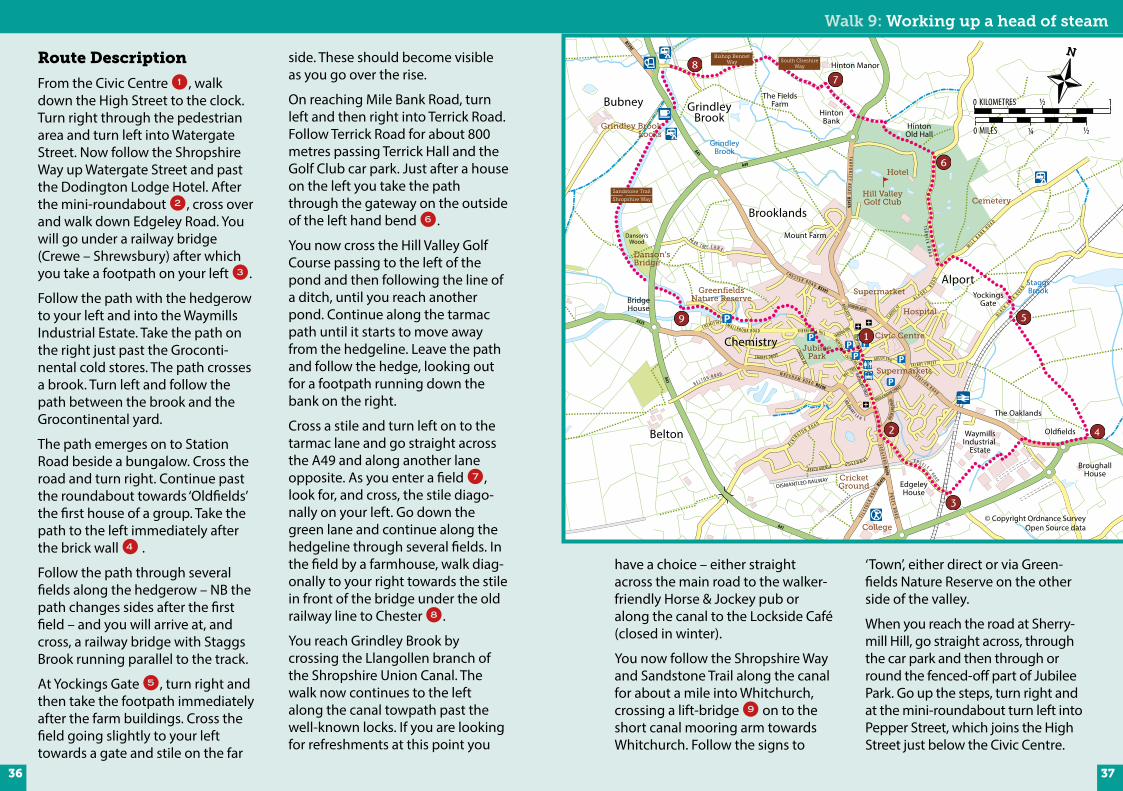
Route Description
From the Civic Centre 1, walk down the High Street to the clock. Turn right through the pedestrian area and turn left into Watergate Street. Now follow the Shropshire Way up Watergate Street and past the Dodington Lodge Hotel. After the mini-roundabout 2, cross over and walk down Edgeley Road. You will go under a railway bridge (Crewe – Shrewsbury) after which you take a footpath on your left 3.
Follow the path with the hedgerow to your left and into the Waymills Industrial Estate. Take the path on the right just past the Groconti-nental cold stores. The path crosses a brook. Turn left and follow the path between the brook and the Grocontinental yard.
The path emerges on to Station Road beside a bungalow. Cross the road and turn right. Continue past the roundabout towards ‘Oldfields’ the first house of a group. Take the path to the left immediately after the brick wall 4 .
Follow the path through several fields along the hedgerow – NB the path changes sides after the first field – and you will arrive at, and cross, a railway bridge with Staggs Brook running parallel to the track.
At Yockings Gate 5, turn right and then take the footpath immediately after the farm buildings. Cross the field going slightly to your left towards a gate and stile on the far
side. These should become visible as you go over the rise.
On reaching Mile Bank Road, turn left and then right into Terrick Road. Follow Terrick Road for about 800 metres passing Terrick Hall and the Golf Club car park. Just after a house on the left you take the path through the gateway on the outside of the left hand bend 6.
You now cross the Hill Valley Golf Course passing to the left of the pond and then following the line of a ditch, until you reach another pond. Continue along the tarmac path until it starts to move away from the hedgeline. Leave the path and follow the hedge, looking out for a footpath running down the bank on the right.
Cross a stile and turn left on to the tarmac lane and go straight across the A49 and along another lane opposite. As you enter a field 7, look for, and cross, the stile diago-nally on your left. Go down the green lane and continue along the hedgeline through several fields. In the field by a farmhouse, walk diag-onally to your right towards the stile in front of the bridge under the old railway line to Chester 8.
You reach Grindley Brook by crossing the Llangollen branch of the Shropshire Union Canal. The walk now continues to the left along the canal towpath past the well-known locks. If you are looking for refreshments at this point you
have a choice – either straight across the main road to the walker- friendly Horse & Jockey pub or along the canal to the Lockside Café (closed in winter).
You now follow the Shropshire Way and Sandstone Trail along the canal for about a mile into Whitchurch, crossing a lift-bridge 9 on to the short canal mooring arm towards Whitchurch. Follow the signs to
‘Town’, either direct or via Green-fields Nature Reserve on the other side of the valley.
When you reach the road at Sherry-mill Hill, go straight across, through the car park and then through or round the fenced-off part of Jubilee Park. Go up the steps, turn right and at the mini-roundabout turn left into Pepper Street, which joins the High Street just below the Civic Centre.
G R E EN EN D
BARGATES STHIGH STREET
MILL STREETW R E X H A M R O A D B5398
S E DG
F OR D
B5395
WATERGATE STREET
C ASTLE HILL
NEWTOWN
SHE RRYM ILL HILL
SHARPS D RIVE
LINDEN AV
C H E M ISTRY SM A L L B R O O K R O A D
P E A R T R E E L A N E
ROSEMARY L A N E
A L K I NG T O N R O A D
B E L T O N R O A D
T I LS T O
C K RO A D B
5476
E D G E L E Y R O A D
YARDINGTON
C H E S T E R R O A D B5395
TAR
PO
RLEY R
OA
D B5476
BRIDGEWATER STREET
LONDON ROAD
NEWPORT ROAD
S T A T I O N R O A D
TA L B OT S T R E E T
M I L E B A N K R O A D
A L P O R T R O A D
CLAYPIT ST
B L A C K P A R K R O A D
TE R RI C K
RO
AD
Chemistry
Brooklands
GrindleyBrook
Bubney
Belton WaymillsIndustrial
Estate
EdgeleyHouse
BroughallHouse
The Oaklands
Old�elds
College
DISMANTLED RAILWAY
BridgeHouse
The FieldsFarm
HintonOld Hall
Danson’sWood
Shropshire Way
Mount Farm
Hinton Manor
Hospital
Supermarkets
Civic Centre
Supermarket
Hill ValleyGolf Club
Grindley BrookLocks
Cemetery
A525
A49
A41
B5395
CricketGround
JubileePark
GreenfieldsNature Reserve
Danson’sBridge
Jackson’sBridge
A41
A525
A41
P R E E S R OA
D
B EECH AVENUEQ U E E N W A Y
AlportYockings
Gate
HintonBank
Hotel
GrindleyBrook
StaggsBrook
South CheshireWay
Bishop BennetWay
Sandstone Trail
0 ½ 1KILOMETRES
0 ½MILES ¼
© Copyright Ordnance Survey Open Source data
3736
Distance: 9.3 miles / 15km • Duration: about 4½ hoursStarting point: Whitchurch Civic Centre
A longish walk which takes in parts of other walks and the revised Shropshire Way with plenty of interesting houses
and farms along the way.
Walk 10: Farms & HallsThe Southern Circular
Walk 9: Working up a head of steam
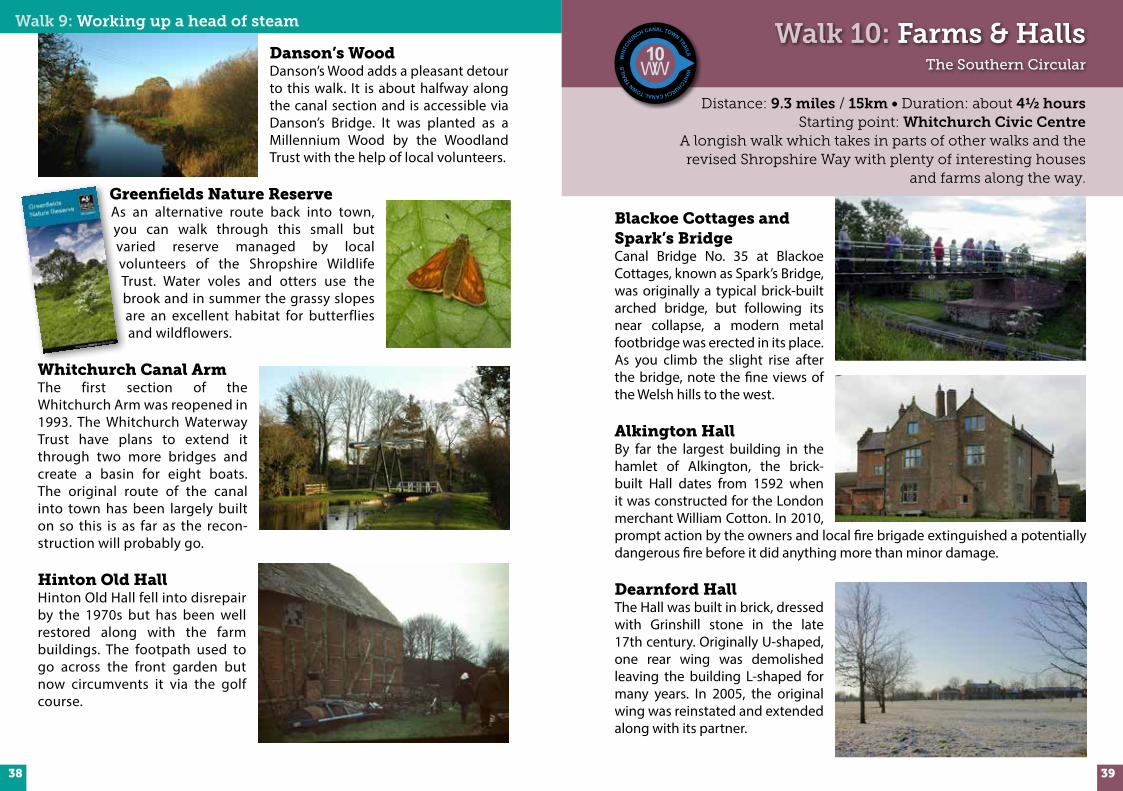
Danson’s WoodDanson’s Wood adds a pleasant detour to this walk. It is about halfway along the canal section and is accessible via Danson’s Bridge. It was planted as a Millennium Wood by the Woodland Trust with the help of local volunteers.
Greenfields Nature ReserveAs an alternative route back into town, you can walk through this small but varied reserve managed by local volunteers of the Shropshire Wildlife Trust. Water voles and otters use the brook and in summer the grassy slopes are an excellent habitat for butterflies and wildflowers.
Whitchurch Canal ArmThe first section of the Whitchurch Arm was reopened in 1993. The Whitchurch Waterway Trust have plans to extend it through two more bridges and create a basin for eight boats. The original route of the canal into town has been largely built on so this is as far as the recon-struction will probably go.
Hinton Old HallHinton Old Hall fell into disrepair by the 1970s but has been well restored along with the farm buildings. The footpath used to go across the front garden but now circumvents it via the golf course.
Blackoe Cottages and Spark’s BridgeCanal Bridge No. 35 at Blackoe Cottages, known as Spark’s Bridge, was originally a typical brick-built arched bridge, but following its near collapse, a modern metal footbridge was erected in its place. As you climb the slight rise after the bridge, note the fine views of the Welsh hills to the west.
Alkington HallBy far the largest building in the hamlet of Alkington, the brick-built Hall dates from 1592 when it was constructed for the London merchant William Cotton. In 2010, prompt action by the owners and local fire brigade extinguished a potentially dangerous fire before it did anything more than minor damage.
Dearnford HallThe Hall was built in brick, dressed with Grinshill stone in the late 17th century. Originally U-shaped, one rear wing was demolished leaving the building L-shaped for many years. In 2005, the original wing was reinstated and extended along with its partner.
3938
Walk 10: Farms & Halls – The Southern Circular
PEPPERST
Chemistry
Brooklands
Belton
Oak�elds
Waymills
Catteralslane
Edgeley
EdgeleyHouse
BroughallFields
The Fields
HeathlaneHeath RoadHouse Farm
The Oaklands
College
DISMANTLED RAILWAY
DISMANTLED RAILWAY
Hadley
WrexhamBridge
BlackhoeCottages
Danson’sWood
Mount Farm
Supermarkets
Supermarket
A41
COUNTRYPARK
Pan CastleMotte & Bailey
CricketGround
BrownMoss
JubileePark
Danson’sBridge
Spark’s Bridge
Shropshire Way
AlkingtonHall
ParkFarm
Blackhoe Farm
The Beeches
EdgeleyFarm
HeathLodge
Edgeley Hall
Red Brook
Shropshire Way
Sandstone Trail
DearnfordHall
DearnfordCottage
BARGATES ST
ST JOHN ST
WR E X H
A M R O A D B5398
S E D G F O R D B5395
WATER
GATE
STRE
ET
CASTLE HILLNEW
TOWN
SHERRYMILL HILL
SHARPS DRIVE LINDEN AV
C H E MISTRY SM
A L L B ROOK ROADP E A R T R E E L A N E
ROSEMARY LAN E
A L K I N G T O N R O A D
B E L T O N R O A D
A L K I N G T O N R O A D
T I L S T O C K R O A D B5476
C HE S T E R R O A
D B5395
BRIDGEWATER STREET
BROWNLOW S
TREE
T
LONDON ROAD
NEWPORT ROAD
STAT I ON
RO
AD
TA LBOT STREET
CLAYPIT ST
PR
EES RO
AD
A41
A525
A41
A525
A41
P R E E S RO A D
B EECH AVENUE
Q
U E E N W A Y
G REEN END
0 ½ 1KILOMETRES
0 ½MILES ¼
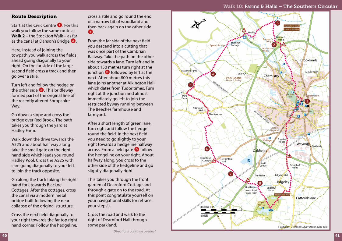
Route Description
Start at the Civic Centre 1. For this walk you follow the same route as Walk 2 – the Stockton Walk – as far as the canal at Danson’s Bridge 2.
Here, instead of joining the towpath you walk across the fields ahead going diagonally to your right. On the far side of the large second field cross a track and then go over a stile.
Turn left and follow the hedge on the other side 3. This bridleway formed part of the original line of the recently altered Shropshire Way.
Go down a slope and cross the bridge over Red Brook. The path takes you through the yard at Hadley Farm.
Walk down the drive towards the A525 and about half way along take the small gate on the right hand side which leads you round Hadley Pool. Cross the A525 with care going diagonally to your left to join the track opposite.
Go along the track taking the right hand fork towards Blackoe Cottages. After the cottages, cross the canal via a modern metal bridge built following the near collapse of the original structure.
Cross the next field diagonally to your right towards the far top right hand corner. Follow the hedgeline,
cross a stile and go round the end of a narrow bit of woodland and then back again on the other side 4.
From the far side of the next field you descend into a cutting that was once part of the Cambrian Railway. Take the path on the other side towards a lane. Turn left and in about 150 metres turn right at the junction 5 followed by left at the next. After about 800 metres this lane joins another at Alkington Hall which dates from Tudor times. Turn right at the junction and almost immediately go left to join the restricted byway running between The Beeches farmhouse and farmyard.
After a short length of green lane, turn right and follow the hedge round the field. In the next field you need to go slightly to your right towards a hedgeline halfway across. From a field gate 6 follow the hedgeline on your right. About halfway along, you cross to the other side of the hedgeline and go slightly diagonally right.
This takes you through the front garden of Dearnford Cottage and through a gate on to the road. At this point congratulate yourself on your navigational skills (or retrace your steps!).
Cross the road and walk to the right of Dearnford Hall through some parkland. © Copyright Ordnance Survey Open Source data
Directions continue overleaf
4140

Walk 10: Farms & Halls – The Southern Circular
Brown MossThe name 'moss' derives from the local word for a peat bog. Brown Moss is a flat site that was created at the end of the last Ice Age over 10,000 years ago. As glaciers retreated, pools were formed by the stranded ice rocks, forming kettle holes. Peat is still being created and Sphagnum moss, which is very important for the creation of peat, is found here in abundance.
This Shropshire Council managed Local Nature Reserve and Site of Special Scientific Interest is also a Special Area of Conservation and part of the inter-nationally designated Midland Meres and Mosses Ramsar site. There are lots of paths around the Moss and if you have time you could take a detour round the main pool before following the Shropshire Way back into Whitchurch.
You might also like to visit Melverley Farm, one of Shropshire Wildlife Trust's nature reserves, which is 2-3 km north-east, within easy walking distance. Hay meadows, high hedges and small fields take you into a different world.
A roughly circular walk of approximately 8 km (5 miles) is possible on footpaths and country lanes.
Continue towards a hedge 7 some 500 metres from the road and follow the left-hand side of it. Cross the railway line and go up the lane through the farm, across the dual carriageway and up the track opposite through the antiques centre.
At the end of the green lane 8, cross the stile on the right and walk diagonally to the left aiming for the corner of the hedge opposite.
Cross the stile on the right hand side and then three more before you emerge on to Brown Moss.
Take the path almost opposite and head towards the centre of the Moss. You should emerge from the trees into a more open grassy area where there is an oak bench dated 2006 celebrating 30 years of Whitchurch Walkers. From here you follow the Shropshire Way (Route 22) back into the centre of Whitchurch.
Whitchurch Walkers would like to thank the following for their contribution:
Neil and Ann Moore, Malcolm Monie, Gerald Moss – walk design and directions
Whitchurch ‘P3’ Group – maintenance and improvements to the local rights of way network
Whitchurch branch of Shropshire Wildlife TrustWhitchurch Town CouncilWalkers are Welcome in WhitchurchShropshire Council Market Towns Initiative ProgrammeShropshire Council Rights of Way team – advice and path maintenance
MA Creative Limited – graphic design – www.macreative.co.uk
Archive photos on pages 10,11,15 & 19 reproduced with permission from 'Whitchurch Remembered' published by Whitchurch History and Archaeology Group. Cambrian Railway photo p18 courtesy of Middleton Press. Other photos by Neil and Anne Moore, Gerald Moss, Malcolm Monie and Mike Ashton. Peter Dunhill – editing and co-ordination
Simon Moore – Whitchurch Walkers logo design
Philip Walker – Whitchurch Canal Town Trails waymarker design
Acknowledgements
Countryside Code
• Be safe – plan ahead and follow any signs• Leave gates and property as you find them• Protect plants and animals, and take your litter home• Keep dogs under close control• Consider other peopleIf you wish to offer feedback or report a problem with any rights of way go to www.shropshire.gov.uk/outdoorrecreation and follow the outdoor recreation feedback link. Alternatively ring 0345 678 9000.
42 43

Whitchurch Town CentreFinding your way
We suggest that you use this book in conjunction with Ordnance Survey Maps. Unfortunately, Whitchurch is right on a join so you will need:
1:25,000 Explorer Maps 241 ‘Shrewsbury’, and 257 ‘Nantwich & Crewe’.
1:50,000 Landranger Maps 117 ‘Chester & Wrexham’, and 126 ‘Shrewsbury & Oswestry’.
Note that the routes shown on OS maps may be different until they are updated to reflect recent changes.
Waymarking
Walks 1-5 use this type of waymarker
All the walks in this book can be viewed and downloaded from the Whitchurch Walkers website www.whitchurchwalkers.co.uk
Public transport In 2014, the following information was correct:
Rail, Whitchurch Station – Between 25 minutes and 2 hourly to/from Crewe and Shrewsbury (3-4 hourly on Sundays).
Buses to/from Whitchurch – No 41 & 41A to Chester every 2 hours No 511 to Wem & Shrewsbury, about every hour (weekdays only). No 146 to Wrexham (approximately every hour). No 72 & 73 to Nantwich (infrequent 4 per day for each service)Note – services on a Sunday can be limited or non-existent.
The website www.travelshropshire.co.uk offers excellent information and search facilities. Alternatively, ring 0871 200 2233.
WH
IT
CHURCH WALKS
WALK No. 5
Walks 6-10 use this type of waymarker
Car parking
Public House
Church
Toilets
Picnic area
Refreshments
Bus service or bus station
Walk Routes
Footpath
Bridleway
A-road
B-road
Minor road
Railway with station
Golf course
Nature reserve
Leisure & sports centre
Camping & caravan site
Built-up area
Woodland
Streams, ponds and lakes
Key to map symbols
G R E EN EN D
BARGATES
HIGH STREET
ST MARY
S S
T
BARK HILL
PEPPERST
MILL S
TREET
W R E X H A M R O A D B5364
S E D G F O R D B5395
WATERGATE D O D I N G T O N
C ASTLE HILL
NEWTOWN
SHERRYMILL HILL
S M A L L B R O O K R OA DROSEMARY LAN E
A L KI N
G T O N R O A D
B54
76
E D G E L E Y R O A D
YARDINGTON
C H E S T E R R O A D B5395
BRIDGEWATER STREET
BROWNLOW STREET
LONDON ROAD
NEWPORT ROAD
S T A T I O N R O A D
TA L B OT S T R E E T
P R E E S R A O D A41
Chemistry
Hospital(minor injuries)
Supermarket
Supermarket
Swimming PoolA495
GreenfieldsNature Reserve
Canal
CricketGround
JubileePark
CivicCentreCivic
Centre
HeritageCentre
© Copyright Ordnance Survey Open Source data
44 45