1 Greek Cadastre Quality Model and Quality Checking of spatial cadastral data Ioannis Kavadas Rural...
32
1 Greek Cadastre Quality Model and Quality Checking of spatial cadastral data Ioannis Kavadas Rural & Surveying Engineer, MSc, Ph.D. Candidate Ktimatologio S.A. Head of Project Quality Management & Control Department
-
Upload
julien-tasker -
Category
Documents
-
view
219 -
download
0
Transcript of 1 Greek Cadastre Quality Model and Quality Checking of spatial cadastral data Ioannis Kavadas Rural...

1
Greek CadastreQuality Model and Quality Checking
of spatial cadastral data
Ioannis KavadasRural & Surveying Engineer, MSc, Ph.D. Candidate
Ktimatologio S.A.Head of Project Quality Management & Control Department

Greek Cadastre Background
2Reykjavik, 31/05/2012 QKEN – Plenary meeting
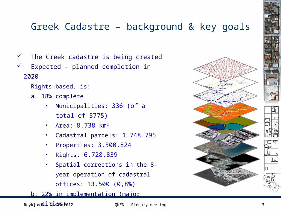
Greek Cadastre – background & key goals
The Greek cadastre is being created
Expected - planned completion in 2020
Rights-based, is:
a. 18% complete
• Municipalities: 336 (of a total of
5775)
• Area: 8.738 km2
• Cadastral parcels: 1.748.795
• Properties: 3.500.824
• Rights: 6.728.839
• Spatial corrections in the 8-year operation
of cadastral offices: 13.500 (0,8%)
b. 22% in implementation (major cities)
c. 19% has been launched
d. 41% will be launched in 2012
3Reykjavik, 31/05/2012 QKEN – Plenary meeting

Greek Cadastre – cadastral data acquisition (1)
4
The spatial cadastral data derived from:
the cadastral survey process digitizing the obvious materialized
parcel boundaries on orthophotos spatial cadastral data are included in
administrative acts after joining the geodetic reference system of National Cadastre
boundaries of coastal areas and forest areas
Reykjavik, 31/05/2012 QKEN – Plenary meeting

Greek Cadastre – cadastral data acquisition (2)
5
The spatial cadastral data derived from:
verification of spatial data using the data collected in the collection of owners statements – topographical diagrams
spatial data from property titles (area, length of parcel sides e.t.c.)
participation of the owners (indicate cp boundaries)
Reykjavik, 31/05/2012 QKEN – Plenary meeting
… location “Katsouli” of the territory of the Municipality of Salamis, not included in the urban development zones, shown with the upper case letters A-B-C-D-A on the topographic diagram that was drawn by the architect engineer E… M… and is attached to my November 19, 1993, contract, has an area of one hundred and eighty five and 90/100 (185.90) sq. meters and borders, according to the diagram, on the North and along the face C-D that has a length of fifteen and 60/100 (15.60) meters with the property of E… Ps…, on the South, along the face A-B that has a length of fifteen (15) meters with a four (4) meter wide road, on the East and along the face B-C that has a length of eleven and 80/100 (11.80) meters with a property of unknown owner, and on the West, along the face A-D that has a length of twelve and 50/100 (12.50) meters, with a four (4) meter wide road. The same land parcel is also shown…
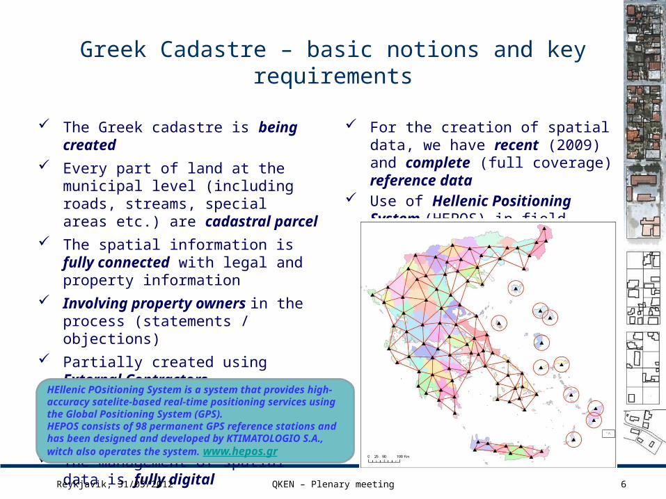
Greek Cadastre – basic notions and key requirements
6
The Greek cadastre is being created
Every part of land at the municipal level (including roads, streams, special areas etc.) are cadastral parcel
The spatial information is fully connected with legal and property information
Involving property owners in the process (statements / objections)
Partially created using External Contractors
If detected errors or non conformities in the data are corrected by the contractor
The management of spatial data is fully digital
For the creation of spatial data, we have recent (2009) and complete (full coverage) reference data
Use of Hellenic Positioning System (HEPOS) in field measurements
Reykjavik, 31/05/2012 QKEN – Plenary meeting
HEllenic POsitioning System is a system that provides high-accuracy satelite-based real-time positioning services using the Global Positioning System (GPS). HEPOS consists of 98 permanent GPS reference stations and has been designed and developed by KTIMATOLOGIO S.A., witch also operates the system. www.hepos.gr
Greek Cadastre General Conceptual Model
7Reykjavik, 31/05/2012 QKEN – Plenary meeting

Greek Cadastre – General Conceptual Model (1)
Reykjavik, 31/05/2012 QKEN – Plenary meeting 8
Feature types
Topological relationships
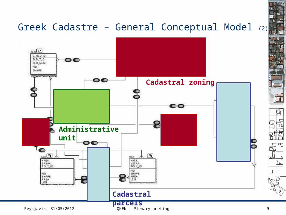
Greek Cadastre – General Conceptual Model (2)
Reykjavik, 31/05/2012 QKEN – Plenary meeting 9
Cadastral parcels
Cadastral zoning
Administrative unit

Greek Cadastre – Spatial feature catalog
10Reykjavik, 31/05/2012 QKEN – Plenary meeting
Layer Description Feature type INSPIRE object
PST Cadastral parcels Polygon Cadastral parcels
ASTOTA Municipality boundaries Polygon Administrative Unit (cz)
ASTTOM Cadastral sectors Polygon Cadastral zoning
ASTENOT Cadastral sections Polygon Cadastral zoning
MRT Mining areas Polygon Cadastral zoning
BLOCK_PNT XYZ Control points point Other
VSTIndependent buildings (Vertical
ownerships)Polygon Other
EAS Ways of passage (Servitude) Polygon Other
BLD Buildings point Other
ASTIK Urban areas Polygon Cadastral zoning
EIA Special property objects Polygon Cadastral parcels
EIA_PNT Special property objects point Cadastral parcels
Roads Road network Line Other
OIK Settlement boundaries Polygon Administrative Unit (cz)
CBOUND Boundaries of urban zone areas Polygon Cadastral zoning
DBOUNDAdministrative acts (consolidations, land
distributions, urban consolidation plans)Polygon Cadastral zoning
FBOUND areas Polygon Cadastral zoning
NOMI Land tenure (property possession) Polygon Cadastral zoning
POI Points of interest Point Geographical names
POL Parcel identification marks Point Other
ES
RI
sh
ap
efi
les

Greek Cadastre – Data model basic requirements and constraints
11
For all cadastral data are not overlapping entities within the same layer
The ASTOTA polygon must be composed entirely of ASTTOM polygons
The ASTOTA polygon must be composed entirely of PST polygons
The ASTOTA polygon should include entirely ASTIK polygons
The ASTENOT polygons should be included in the ASTTOM polygons
The ASTIK boundaries should not intersect with the boundaries of the PST polygons
The VST polygons should be included in the PST polygons
The EAS polygons should be included in the PST polygons
The BLD points should be included in the ASTOTA polygon
The MNT polygons should be included in the ASTOTA polygon
The EIA polygons should be included in the ASTOTA polygon
The EIA_PNT points should be included in the ASTOTA polygon
The CBOUND polygons should be included in the ASTOTA polygon
The DBOUND polygons should be included in the ASTOTA polygon
The FBOUND polygons should be included in the ASTOTA polygon
The NOMI polygons should be included in the ASTOTA polygon
The BLOCK_PNT, POI and POL points should be included in the ASTOTA polygon

Greek Cadastre GCM vs
INSPIRE GCM
12Reykjavik, 31/05/2012 QKEN – Plenary meeting
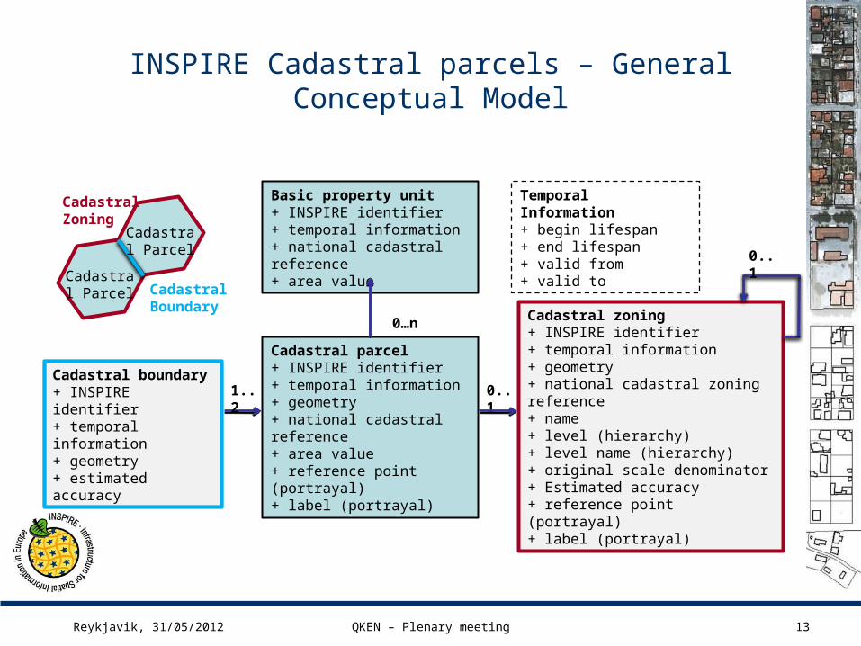
INSPIRE Cadastral parcels – General Conceptual Model
13
Basic property unit+ INSPIRE identifier+ temporal information+ national cadastral reference+ area value
Cadastral parcel+ INSPIRE identifier+ temporal information+ geometry+ national cadastral reference+ area value+ reference point (portrayal)+ label (portrayal)
0…n
Cadastral boundary+ INSPIRE identifier+ temporal information+ geometry+ estimated accuracy
1..2 0..1
Cadastral zoning+ INSPIRE identifier+ temporal information+ geometry+ national cadastral zoning reference+ name+ level (hierarchy)+ level name (hierarchy)+ original scale denominator+ Estimated accuracy+ reference point (portrayal)+ label (portrayal)
Temporal Information+ begin lifespan+ end lifespan+ valid from+ valid to
0..1
Cadastral Parcel
Cadastral Boundary
Cadastral Zoning
Cadastral Parcel
Reykjavik, 31/05/2012 QKEN – Plenary meeting
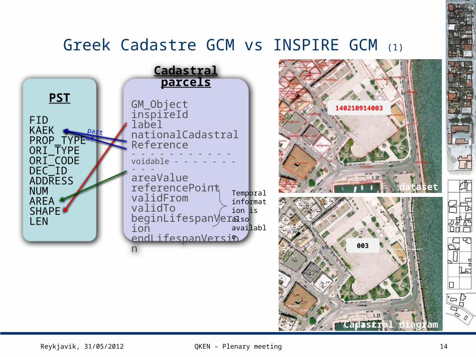
Greek Cadastre GCM vs INSPIRE GCM (1)
Reykjavik, 31/05/2012 QKEN – Plenary meeting 14
PST
FIDKAEKPROP_TYPEORI_TYPEORI_CODEDEC_IDADDRESSNUMAREASHAPELEN
Cadastral parcels
GM_ObjectinspireIdlabelnationalCadastralReference- - - - - - - - - - - voidable - - - - - - - - - - areaValuereferencePointvalidFromvalidTobeginLifespanVersionendLifespanVersion
Temporal information is also available
140210914003
003
part of
dataset
Cadastral diagram

Greek Cadastre GCM vs INSPIRE GCM (2)
Reykjavik, 31/05/2012 QKEN – Plenary meeting 15
ASTENOT
FIDCAD_ADMINPROP_TYPELOCALITYAREASHAPELEN
Cadastral zoning
GM_MultishapeinspireIdlabelnationalCadastralZoningReference- - - - - - - - - - - - voidable - - - - - - - - - - - - - estimateAccuracylevellevelNamenameoriginalMapScaleDenominator referencePointvalidFromvalidTobeginLifespanVersionendLifespanVersion
Temporal information is also available
identified in data model for every Cz
part of
140210914
09
14
dataset
Cadastral diagram

Greek Cadastre Cadastral parcels
Quality Model
16Reykjavik, 31/05/2012 QKEN – Plenary meeting

Greek QM for cadastral parcels (1)
17Reykjavik, 31/05/2012 QKEN – Plenary meeting
Full Inspection Sampling Sampling
If there are errors (error number> 0) the subset should be rejected, and a report with corrective actions prepared and sent to the contractor
FGDC : Geospatial Positioning Accuracy Standards - Part 3: National Standard for Spatial Data Accuracy
ISO 2859

Greek QM for cadastral parcels (2)
18Reykjavik, 31/05/2012 QKEN – Plenary meeting
PST (Cadastral Parcel)
DQ basic measure / error count: id 2 (ISO 19138)
Quality element Completeness
Quality sub element Commission
Quality measure Number of excess items
Scope All items classified as “cadastral parcel” in the dataset.
Measure Error count
Measure definition Number of items within the dataset that should not have been in the dataset.
Result value type Number (integer)
Result unit count

Greek QM for cadastral parcels (3)
19Reykjavik, 31/05/2012 QKEN – Plenary meeting
PST (Cadastral Parcel)1st quality evaluation method
DQ basic measure / error count: id 2
Evaluation method
description
Number of cadastral parcels, which are not presented in the dataset (in relation to cadastral parcels in the universe of discourse)
QC Range Full inspection
QC procedure Automatic
Reference data Municipality boundaries
Software Custom application, ArcGIS QCR type /
formatList / KAEK in MSExcel
Conformance level
Zero violations in dataset
Sample: 33 municipalities280.781 parcels
Requirement: Every part of land at the municipal level are cadastral parcel
Part of qcr checklist
Quality requirement: Completeness Conformance level: Absence of area gaps within the municipality boundariesResult: Accepted
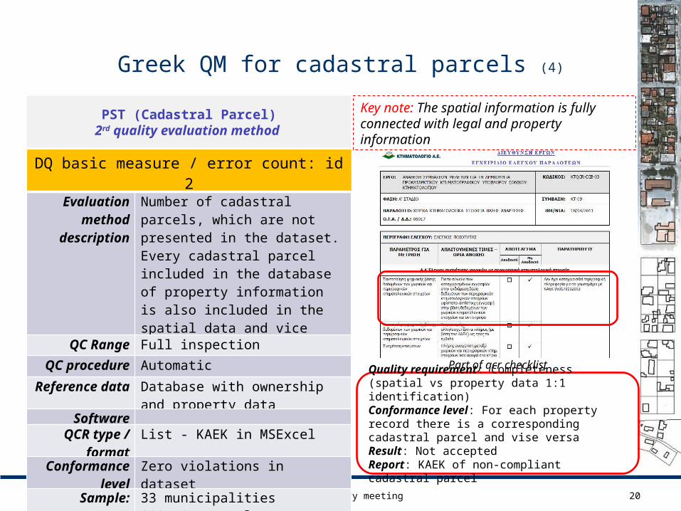
Greek QM for cadastral parcels (4)
20Reykjavik, 31/05/2012 QKEN – Plenary meeting
PST (Cadastral Parcel)2rd quality evaluation method
DQ basic measure / error count: id 2
Evaluation method
description
Number of cadastral parcels, which are not presented in the dataset.Every cadastral parcel included in the database of property information is also included in the spatial data and vice versa (1:1)
QC Range Full inspection
QC procedure Automatic
Reference data Database with ownership and property data
SoftwareQCR type /
formatList - KAEK in MSExcel
Conformance level
Zero violations in dataset
Sample: 33 municipalities280.781 parcels
Key note: The spatial information is fully connected with legal and property information
Part of qcr checklistQuality requirement: Completeness (spatial vs property data 1:1 identification)Conformance level: For each property record there is a corresponding cadastral parcel and vise versaResult: Not acceptedReport: KAEK of non-compliant cadastral parcel

Greek QM for cadastral parcels (5)
21Reykjavik, 31/05/2012 QKEN – Plenary meeting
PST (Cadastral Parcel)
SHAPE (Geometry)
DQ basic measure / error count: id 19 (ISO 19138)
Quality element Logical consistency QC procedure Automatic full inspection
Quality sub element
Format consistency Conformance level
Zero violations in dataset
Part of quality report
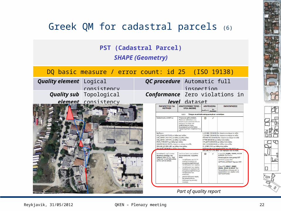
Greek QM for cadastral parcels (6)
22Reykjavik, 31/05/2012 QKEN – Plenary meeting
PST (Cadastral Parcel)
SHAPE (Geometry)
Part of quality report
DQ basic measure / error count: id 25 (ISO 19138)
Quality element Logical consistency QC procedure Automatic full inspection
Quality sub element
Topological consistency
Conformance level
Zero violations in dataset

Greek QM for cadastral parcels (7)
23Reykjavik, 31/05/2012 QKEN – Plenary meeting
DQ basic measure / Mean value of positional uncertainties: id 28 (ISO 19138)
Quality element Positional accuracy
Quality sub element Absolute accuracy
Quality measure Mean value of positional uncertainties / id 28
Scope All items classified as “cadastral parcels” set in the dataset.
Measure Root Mean Square Error (RMSExy)
Measure definition Geometric accuracy of cadastral parcels with regard to the adopted geodetic reference system (EGSA’87).
Result value type measure
Result unit -
PST (Cadastral Parcel)
SHAPE (Geometry)

Greek QM for cadastral parcels (8)
24Reykjavik, 31/05/2012 QKEN – Plenary meeting
PST (Cadastral Parcel)- SHAPE
DQ basic measure / Mean value of positional uncertainties: id 28
Evaluation method
description
Mean value of the positional uncertainties for a set of positions where the positional uncertainties are defined as the distance between a measured position and what is considered as the corresponding true position.
QC Range Sampling using FGDC standardsBased on “Geospatial Positioning Accuracy Standards - Part 3: National Standard for Spatial Data Accuracy”, Subcommittee for Base Cartographic Data / Federal Geographic Data Committee
QC procedure Field measurements
Reference data -
Software GPS receiver and Total Station / ArcGIS and Autocad
QCR type / format MSExcel file & Shapefile
Conformance level
Urban areas: RMSExy ≤ 0,56mAgricultural & other areas: RMSExy ≤ 1,41m
Sample: 33 municipalities2.556 control points

Greek QM for cadastral parcels (9)
25Reykjavik, 31/05/2012 QKEN – Plenary meeting
DQ basic measure / Relative horizontal error
Quality element Positional accuracy
Quality sub element Relative accuracy
Quality measure Relative horizontal error
Scope All items classified as “cadastral parcels” set in the dataset.
Measure Parcel’s shape compatibility (1st )Parcel’s boundary’s length compatibility (2nd and 3rd)
Measure definition Evaluation of the random errors in the horizontal position of one feature to another in the same dataset
Result value type measure
Result unit -
PST (Cadastral Parcel)
SHAPE (Geometry)
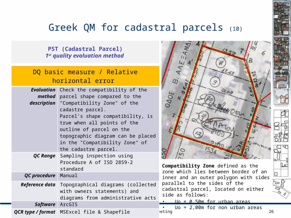
Greek QM for cadastral parcels (10)
26Reykjavik, 31/05/2012 QKEN – Plenary meeting
DQ basic measure / Relative horizontal error
Evaluation method
description
Check the compatibility of the parcel shape compared to the "Compatibility Zone" of the cadastre parcel.Parcel’s shape compatibility, is true when all points of the outline of parcel on the topographic diagram can be placed in the "Compatibility Zone" of the cadastre parcel.
QC Range Sampling inspection using Procedure A of ISO 2859-2 standard
QC procedure Manual
Reference data Topographical diagrams (collected with owners statements) and diagrams from administrative acts
Software ArcGIS
QCR type / format MSExcel file & Shapefile
Conformance level
LQ=8,0
Sample: 33 municipalities2400 parcels
PST (Cadastral Parcel)1st quality evaluation method
Compatibility Zone defined as the zone which lies between border of an inner and an outer polygon with sides parallel to the sides of the cadastral parcel, located on either side as follows:
• Uo = 0,50m for urban areas• Uo = 2,00m for non urban areas

Greek QM for cadastral parcels (11)
27Reykjavik, 31/05/2012 QKEN – Plenary meeting
DQ basic measure / Relative horizontal error
Evaluation method
description
Compare the length of the boundary of the parcel as measured in the field with the same length in the spatial database
QC Range Sampling inspection2~3 cadastral sections (blocks) per municipality.With the new technical specifications, we increased (three times) the number of the inspected parcels
QC procedure Field measurements
Reference data -
Software GPS receiver and Total Station / ArcGIS and Autocad
QCR type / format MSExcel file & Shapefile
Conformance level
Urban areas: Es ≤ 0,79mAgricultural & other areas: Es ≤ 1,99m
Sample: 33 municipalities1350 parcels
PST (Cadastral Parcel)2nd quality evaluation method
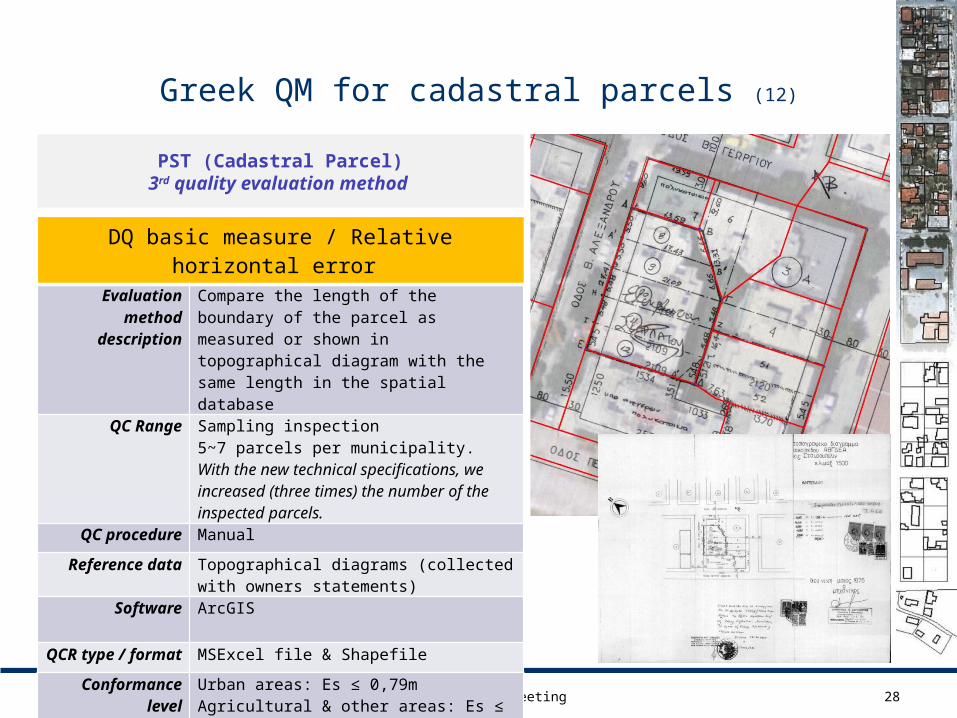
Greek QM for cadastral parcels (12)
28Reykjavik, 31/05/2012 QKEN – Plenary meeting
DQ basic measure / Relative horizontal error
Evaluation method
description
Compare the length of the boundary of the parcel as measured or shown in topographical diagram with the same length in the spatial database
QC Range Sampling inspection5~7 parcels per municipality.With the new technical specifications, we increased (three times) the number of the inspected parcels.
QC procedure Manual
Reference data Topographical diagrams (collected with owners statements)
Software ArcGIS
QCR type / format MSExcel file & Shapefile
Conformance level
Urban areas: Es ≤ 0,79mAgricultural & other areas: Es ≤ 1,99m
Sample: 33 municipalities224 parcels
PST (Cadastral Parcel)3rd quality evaluation method

Greek QM for cadastral parcels (13)
29Reykjavik, 31/05/2012 QKEN – Plenary meeting
PST (Cadastral Parcel)
DQ basic measure / error count: id 62 (ISO 19138)
Quality element Thematic accuracy
Quality sub element Classification correctness
Quality measure Number of incorrectly classified features
Scope All items classified as “cadastral parcel” in the dataset.
Measure Error count
Measure definition Number of incorrectly classified features
Result value type Number (integer)
Result unit count

Greek QM for cadastral parcels (14)
30Reykjavik, 31/05/2012 QKEN – Plenary meeting
PST (Cadastral Parcel)2nd quality evaluation method
DQ basic measure / error count: id 62
Evaluation method
description
Visual inspection based on the delineated boundaries of the properties as shown on orthophotos.
QC Range Full inspection
QC procedure Manual
Reference data Orthophotos
Software ArcGISQCR type /
formatShapefile
Conformance level
Zero violations in dataset
Sample: 33 municipalities280.781 parcels
Requirement: Every part of land at the municipal level are cadastral parcel
data inspection also for: Presence of blunder errors mainly in the
shape of parcels Existence of drawing faults Systemic movement of parcel boundaries Existence of discontinuities in the entities
The same evaluation method used also for the inspection of cadastral parcel completeness
Conclusions
The results of quality control performed in 6 resent contracts (33 municipalities / with new specifications) meet compliance criteria set in the specifications.
To accept the data needed 1 to 3 (max 5) re-submissions by the data producer with corrections or clarifications resulting from our quality checking.
The project's success is mainly based on following factors:
Using both the data producers and Ktimatologio S.A. detailed quality plan based on ISO 10005,
Mandatory implementation of internal quality checking by the data producer (similar with quality controls of Ktimatologio S.A.) and submit their results to us for checking and validation,
Implementation of quality checking from the Ktimatologio S.A using quality plan and detailed quality manual, trained staff and specialized software applications,
The effectiveness of quality checing that adopted by Ktimatologio S.A., which resulted very small percentages of appeals and requests for correction by owners - avg 1% (in total of 280.781 parcels) for spatial data during the suspension of data
31Reykjavik, 31/05/2012 QKEN – Plenary meeting

32
Thank you for your attention