1. Affordable Housing Financial Viability Assessment 2008 DPD and South Hams Affordable Housing DPD...
47
1 CORE STRATEGY REVISED PREFERRED OPTIONS SUMMARY OF RESPONSES TO THE EVIDENCE BASE / BACKGROUND DOCUMENTS (MAY / JUNE 2008) Upon publication of the Core Strategy: Revised Options in May 2008 the Council also published a number of supporting background documents and invited comments. The following is a summary of the comments made and the Councils response. It should be noted that comments were not received on all documents. 1. Affordable Housing Financial Viability Assessment 2008 1.1 A limited number of comments were received on this study, but they were detailed and from organisations with particular experience in this area of planning. Comments by LPD Projects: 1.2 ILPD Projects consider that the evidence contained in the Assessment is well prepared and contains the key considerations but the conclusions follow, what as best, is the exception site rather than the norm. Specific worked examples based on actual sites, within Mole Valley District will test whether this new policy can deliver the required sites. Property or land owners will only relocate or accept the re-use of some of their garden if they receive sufficient reward. Developers spend a disproportionate time and cost bringing forward small re-use urban sites. Building standards are rising increasing building costs, in addition there is now a planning tariff for infrastructure charges applied after 31st January. 1.3 A good typical development example is contained in figure 4 page 26 dealing with Value Area 3 with five 3 bedroom houses. It is suggested that there would be a land value of £712,473 today, where as, applying the proposed policy it will be £552,177. The calculation is based on land cost post the planning tariff so before 31st January 2008 the land would have been worth some £70,000 more. i.e. £772,000 or thereabouts. 1.4 If the figures are accepted, land with this form of development in the past, had about another £220,000 as a land budget. It is considered that having a 'land pot' that is two thirds of the previous land budget will not work and therefore Policy sub-section 2 for 1 to 9 gross units seeking a financial contribution of 20% of total units is not a robust policy set on credible evidence. Comments by the Home Builders Federation: 1.5 The HBF note that the financial viability study on which the percentage targets in policy CS/PO4 are based, uses “notional development scheme types agreed with the council” with relevant caveats but without real-world development examples. They consider that there is considerable difference between the two and, while the notional development scheme approach is interesting, it cannot reflect real world considerations, costs, problems and factors which affect development viability. 1.6 The HBF is concerned that this type of approach will not reflect the costs and difficulties associated with real world brownfield redevelopments (which will comprise the vast majority of development in the district) and the full costs e.g. land assembly,
Transcript of 1. Affordable Housing Financial Viability Assessment 2008 DPD and South Hams Affordable Housing DPD...
1
CORE STRATEGY REVISED PREFERRED OPTIONS
SUMMARY OF RESPONSES TO THE
EVIDENCE BASE / BACKGROUND DOCUMENTS (MAY / JUNE 2008)
Upon publication of the Core Strategy: Revised Options in May 2008 the Council also published a number of supporting background documents and invited comments. The following is a summary of the comments made and the Councils response. It should be noted that comments were not received on all documents.
1. Affordable Housing Financial Viability Assessment 2008 1.1 A limited number of comments were received on this study, but they were detailed
and from organisations with particular experience in this area of planning.
Comments by LPD Projects: 1.2 ILPD Projects consider that the evidence contained in the Assessment is well
prepared and contains the key considerations but the conclusions follow, what as best, is the exception site rather than the norm. Specific worked examples based on actual sites, within Mole Valley District will test whether this new policy can deliver the required sites. Property or land owners will only relocate or accept the re-use of some of their garden if they receive sufficient reward. Developers spend a disproportionate time and cost bringing forward small re-use urban sites. Building standards are rising increasing building costs, in addition there is now a planning tariff for infrastructure charges applied after 31st January.
1.3 A good typical development example is contained in figure 4 page 26 dealing with
Value Area 3 with five 3 bedroom houses. It is suggested that there would be a land value of £712,473 today, where as, applying the proposed policy it will be £552,177. The calculation is based on land cost post the planning tariff so before 31st January 2008 the land would have been worth some £70,000 more. i.e. £772,000 or thereabouts.
1.4 If the figures are accepted, land with this form of development in the past, had about
another £220,000 as a land budget. It is considered that having a 'land pot' that is two thirds of the previous land budget will not work and therefore Policy sub-section 2 for 1 to 9 gross units seeking a financial contribution of 20% of total units is not a robust policy set on credible evidence.
Comments by the Home Builders Federation:
1.5 The HBF note that the financial viability study on which the percentage targets in
policy CS/PO4 are based, uses “notional development scheme types agreed with the council” with relevant caveats but without real-world development examples. They consider that there is considerable difference between the two and, while the notional development scheme approach is interesting, it cannot reflect real world considerations, costs, problems and factors which affect development viability.
1.6 The HBF is concerned that this type of approach will not reflect the costs and
difficulties associated with real world brownfield redevelopments (which will comprise the vast majority of development in the district) and the full costs e.g. land assembly,

2
demolition, de-contamination, relocation associated with redevelopment of former uses and so on. Similarly it is unlikely to reflect the true costs of bringing forward urban infill on backland sites; in particular the ‘personal factors’ which affect how much a private individual would consider as a fair price to take into account the upheaval of moving or loss of amenity and other legal and taxation costs and dis-benefits of selling garden land or their current property to allow a site to be redeveloped. These less tangible costs are unlikely to come to light based on notional development type examples, therefore on its own the notional method is not sufficiently robust or credible to justify the application of specific and precise policy targets in the core strategy (or in assumptions about deliverability of sites in the SHLAA).
1.7 The HBF have also expressed concerns about the extent to which the study has
taken on board the need to provide for other planning obligations as set out in the council’s tariff which appear to have been included in the figures but not recognised in any real test compared to residual land values on sites submitted before 31st January.
1.8 The HBF suggest that these notional development scheme examples must be
supplemented by some actual examples of land and property transactions which have taken place in the district in recent times and there should be a comparative assessment between the costs and values pertaining to these real world schemes against the more theoretical approach apparently taken in the study.
1.9 Finally they consider that it is worth drawing attention to the consultants comments
on the credit crunch. In particular the particular need for flexibility in the application of these policy requirements as the situation even only a couple of months further on from when this study was published are far worse than could have been imagined such a short time ago.
Council’s Response:
1.10 The Council recognises that it is not in its best interests to increase the level of affordable housing provision either on site or via a financial contribution, to such a level where this would prevent development from coming forward.
1.11 In response to LDP Projects comments that the notional sites basis does not adequately reflect the actual cost of development, the Council would like to emphasise that the purpose of the assessment is to provide an overview and help the Council’s wider consideration of policy targets. The policy has a degree of flexibility and will not prejudice or prohibit site specific negotiations.
1.12 In terms of the methodology used in undertaking the assessment i.e. the use of notional sites, this allows the impact of viability at a particular/ potential future threshold point to be test. This aids the Council in developing policies which secure the maximum provision for affordable housing without rendering a development unviable.
1.13 The Council would like to point out that there is no Government guidance available on undertaking such assessments. The consultants who were appointed to undertake the work, Adams Integra, have used the methodology based on notional sites for a number of Local Authority assessments which have been used to support policies on affordable housing. The methodology has been tested at Public Examination through examination – Horsham Core

3
Strategy DPD and South Hams Affordable Housing DPD for example – and has been accepted by the Planning Inspectorate.
1.14 Adams Integra have experience in using actual sites i.e. real life examples. However, there are a number of issues when using this approach that do need to be considered. There can be difficulties and sensitive issues involved in securing and publishing information. It is therefore inevitable that a series of assumptions will need to be made in any event. Results from one site, or even a small group of sites, cannot be representative of the wide range of scenarios which will be found in practice across the District. Thus a site specific approach does not fit well with seeking to make a policy overview such as that required in the Core Strategy.
1.15 In response to LPD Projects’ concern that the proposed affordable housing requirement in respect of sites of 1-9 dwellings would render housing schemes of this size unviable, the Council would like to state that right the way through the assessment, Adams Integra acknowledged that viability can be significantly affected by requirements such as the planning tariff. LPD Projects is correct in stating that the viability issue is largely related to land owners’ expectations and ultimately their willingness to sell. The policy within the Core Strategy is therefore going to be as much about the Council adopting a practical view against a background of being obliged to optimise contributions towards meeting serious affordable housing needs and using a wider range of scenarios i.e. policy approaches, than is currently in place.
1.16 Regarding the affordable housing requirements on sites of 1 – 9 homes, there is no reason why a smaller site is any less viable, per se, then a larger one. In terms of smaller sites there may be the benefit of faster progress, lower risk, less overheads, fewer surveys and fewer infrastructure costs balanced against a lack of economy of scale. However, as the assessment shows there are two features of these smallest sites which mean they deserve a distinct approach from the larger sites. These are:
• they are being “captured” for the 1st time and therefore experience the steepest impact; and
• the sum of money available for land purchase gets smaller and well may be increasingly marginal as compared with existing use value/ owner’s aspirations etc.
1.17 These are the primary justification for the support of a sliding scale approach. It is designed to recognise these viability aspects and assist viability compared with outcomes from a straight imposition of a 30% or 40% affordable housing requirement.
1.18 In response to the comments made by the HBF, the Council would like to confirm that the assessment acknowledges the points raised (tangibles, owners’ expectations, etc). However, without still making a raft of assumptions, it is not possible to genuinely investigate these on a site specific basis giving outcomes which can then be applied to strategic level policy thinking and targets.
1.19 The HBF refers to flexibility, especially bearing in mind current market conditions. As previously stated, and as the assessment acknowledges, these are valid points and this is an area for the Council to take on board i.e.

4
continue to take a practical approach. The Council will need to monitor outcomes and market conditions and be prepared to react/ put contingency plans in place. It must also be recognised that the Core Strategy is a long-term approach to planning for the District and whilst the current market is an important issue to consider, it should not dictate the long-term vision for the District.
1.20 Both the HBF and LPD Projects refer to the planning tariff. The Council would like to confirm that this was taken into consideration and the Council agreed with the assumptions being made in the assessment with Adams Integra. The assumptions made were relevant at the time and were based on the Surrey Planning Collaboration Project - Planning Infrastructure Code of Practice. It is assumed the LPD Projects point is that the reduction in land value should be taken from a point prior to that being implemented. It is unsure that this is relevant however; as the appraisals carried out (as a starting point) are based on policies adopted at the time of the study and are compared against potential future policies, ie including the impact of the tariff. It would not be feasible, or indeed helpful, to compare results with all previous historical policy positions.
1.21 The Council has commissioned Adams Integra to undertake some supplementary work to help move the development of the policy forward in the light of the comments received and the changing housing market. This will include a review of house price data and an examination of two actual sites to see if the requirement for affordable housing and all other financial requirements involved i.e. the tariff, render a site unviable for development.
2. Mole Valley Appropriate Assessment
Comment by Natural England (NE):
2.1 NE welcomed the use of a 15km zone to check for possible impacts on European and international wildlife sites the joint working of the various Councils.
2.2 With regard to Table 3, EN hopes that ‘further work’ will be undertaken to ensure impact is managed and appropriate policies and appropriate policies contained within the LDF. As this work is necessary to avoid impact, EN require the work to take place before the Core Strategy is finalised.
Council’s Response:
2.3 Table 3 is a summary of the initial screening assessment undertaken and
agreed with Natural England before the preparation of the Core Strategy: Revised Preferred Options. The ‘further work’ referred to is the current Appropriate Assessment and the mitigation it proposes.
Comment by Natural England
2.4 It is unclear if a visitor survey of Box Hill is planned or being undertaken. It would be
useful to include the evidence, e.g. a summary of the 2006 survey undertaken by Professor Calver. Without assessing the evidence used to reach these conclusions they consider that it is difficult to assess validity of the appropriate assessment.
Council’s Response:
2.5 The Council did not undertake a survey of Box Hill and none are currently
planned by this Council or any other the surrounding Authorities. Although the

5
Surrey Hills AONB Board has considered undertaking the work; the site is owned by the National Trust and therefore if work is required some input from them would be necessary. The Councils are using the best available information but in response to this query have sought further data and contacted Professor Culver. This further information has been incorporated into the final study.
Comment by Natural England.
2.6 EN agree that Mole Valley presently has fair levels of accessible natural greenspace,
but consider it would be useful to reference or append the study referred to and supply a map of accessible natural greenspace in relation to the SAC showing where Natural England’s Accessible Natural Greenspace Standards (ANGSt) are met. It is also considered that the future impacts of housing on the provision of accessible natural greenspace need to be factored in. In relation to the proposed impact zone of 800m, Natural England are broadly supportive but would welcome the opportunity to have more detailed discussions with the authority about the scope of the impact zone.
Council’s Response:
2.7 The Council has now had this discussion with Natural England and they have
not sought to change their view and remain broadly supportive.
Comment by Natural England 2.8 Natural England supports the avoidance measure proposed but clarity is sought
about whether alternative accessible natural greenspace can be provided by developments in the authority’s area or whether any developer contribution form part of that made by developers to green infrastructure.
Council’s Response:
2.9 It is intended that the contributions are fed into existing sporting and
recreation facilities as it was not felt necessary or practical (considering the already very high levels of natural and semi-natural greenspace) to provide further land. The level of development is not significant and it is not felt that asking for additional greenspace is a realistic or effective approach towards protecting the SAC, especially considering that the attractiveness and draw of this area (designated as of national importance in terms of landscape quality) will be difficult to compete with through the creation of new sites.
Comment by Natural England
2.10 In the conclusion, monitoring is not mentioned. On-going monitoring of recreational
pressure would ensure that the appropriate assessment findings – of no significant effect – are correct.
Council’s Response:
2.11 This is noted and the Council will consider further what monitoring is already
undertaken which may assist or what further work is needed.

6
Comment by Natural England 2.12 Natural England questioned whether development is likely to increase traffic and
therefore deposition on roads within 200m of the SAC. They also raised the point that Bechstein’s bats are largely found, during the spring and summer, within ancient woodland. There is a presumption against the loss of ancient woodland in PPS9 and any loss would have to be reported through the LDF monitoring process (because ancient woodland is a Biodiversity Action Plan priority habitat). In addition to a policy protecting against the loss of trees and hedge lines, Natural England also suggest that there is also protection for ancient woodland as a minimum. Alternatively, as suggested above the policy could include all BAP habitats.
2.13 Natural England support the district-wide adoption of the policy approach in
paragraph 8.4. Finally, they consider that urban impacts (see last bullet point) such as fires can be linked to increased recreational pressure and are therefore within the control of the Core strategy. The avoidance measures taken for recreation pressures would apply.
Council’s Response:
2.14 The remaining comments are noted and will be taken on board in the revision
of the Appropriate Assessment.
Comments by Surrey County Council. 2.15 Consider that the 15km boundary used for the initial scoping could do with greater
justification. They also consider that some information on existing visitor numbers is required to form a baseline against which to monitor.
2.16 SCC suggests it may be worth noting that ancient woodland is currently identified in
the Ancient Woodland Inventory and on Magic above 2 ha in size. A new survey of ancient woodland below 2 ha will be carried out next year and is likely to identify more ancient woodland. It may be worth referring to this to ensure the protection policies cover the smaller ancient woodlands, when identified.
Council’s Response:
2.17 With the exception of the first point, the other comments are responded to
above. The 15km boundary for initial scoping was selected on the basis of work undertaken on the Thames Basin Heath and the Appropriate Assessment of Horsham District Council’s Core Strategy (one of the first to be undertaken). It is felt to be an acceptable distance considering the pressure on resources within the southeast.
3. Climate Change: Background Evidence Paper 3.1 No comments received.
4. Climate Change: Policy Background Paper 4.1 No comments received.

7
5. Community Facilities and Infrastructure Requirements: Position Statement
5.1 A number of updates to the Position Statement were received and these have been
incorporated into the revised document.
6. Housing Needs Study 6.1 No comments received.
7. Local Economy and Employment Land Review Position Statement
7.1 No comments were received
8. Mole Valley Town, District, Local and Village Centres Study 8.1 No comments were received
9. PPG17 Study – Assessment of Open Space, Sport and Recreation
9.1 No comments were received
10. Settlement Hierarchy 10.1 No comments were received.
11. Strategic Flood Risk Assessment
11.1 One individual made a site specific comment relating to flooding in a particular location. This has been noted within the revised SFRA.
Comments by the Environment Agency
11.2 The Environment Agency made extensive comments on the SFRA. The main issues are summarised below:
• The assessment needs a more detailed examination of the areas outside of the River Mole catchment.
• There needs to be reference to the Environment Agency Catchment Flood Management Plans.
• The information for the risk of ‘drains, culverts and sewers’ related flooding is focussed solely on historic incidents from Surrey County Council. It is likely that these will be focussed on highway issues. It is important that the SFRA captures all known incidents, but also attempts to predict where problems may arise in the future. However, no reports of historic flooding have been recorded. The EA are keen to discuss the use of Digital Terrain or Digital Elevation Modelling and GIS.
8
• Records of groundwater flooding as well as Groundwater Emergence Maps produced for Defra should be incorporated into the SFRA.
• Information should be included on flood warnings available for the District.
• Guidance is required within the SFRA for developers on the requirements for their flood risk assessments for the issues identified. This should include information on the requirements for a safe development that will not increase flood risk as well as issues such as, surface water drainage, floodplain storage compensation, safe access and egress etc. This clearly should be proportionate to the types of developments expected if it is possible, to prevent further development in flood risk areas through the sequential approach as suggested.
• The assessment should identify any areas where there are thought to be issues where further investigation is necessary such as critical drainage areas or other areas where a surface water management plan may be required.
Council’s response:
11.3 The Council has taken on board all of the comments made by the Environment Agency. Discussions are on-going and further work is now taking place to satisfy their concerns. This may include the need to commission further work in the near future, which will feed into the Land Allocations DPD. A detailed response to all of their points is therefore not necessary.

9
12. Strategic Housing Land Availability Assessment
Respondent Section Summary of response
Maureen and Bartol Brown
Appendix 5a – Sites with Potential (Chennels Nursery, Dorking)
A number of applications for residential development have been refused on this site over last 50 years. In autumn 1989 an appeal was also rejected. Residential development of the site: 1) Conflicts with the policy for the preservation of the Metropolitan Green Belt. The site performs a Green Belt function in safeguarding the countryside from encroachment.
2) Conflicts with the policy of the Planning Authority to preserve the natural beauty of the landscape in the Surrey Hills Area of Outstanding Natural Beauty.
3) Conflicts with the policy for the preservation of an Area of Great Landscape Value. There are further good reasons for removing Chennels Nursery site from the list of Sites with Potential: a) Concern about access: it is over a private road, Ridgeway Road is used by school children as part of a short cut to their schools (The Priory and Powell Corderoy), the alternative is the very busy Horsham Road. An increase in vehicular traffic from the Chennels Nursery and Marley Mead sites would make this short cut much less safe.
b) Dorking already suffers from serious congestion. Residential development should be concentrated in the centre of Dorking with its good access to the railways and bus services. Consideration should be given to converting empty offices.
c) Although it is noted in the SHLAA that there is a ‘need to conserve the character of the landscape’ the housing density already looks considerably in excess of that in the area.
d) The site has, to a very great extent, been reclaimed by nature. It is a haven for birds and animals. The site now has an affinity with the surrounding fields.
Mr and Mrs R Bennett
Appendix 5a – Sites with Potential (Dorking)
Concerned about volume of traffic on roads used by school children, impact on elderly people walking for their health and pleasure. There are popular walks for people from Goodwyns, North Holmwood, to and from the Nower. People use the area for picking blackberries, children learn to ride their bikes in Ridgeway Road. The ambience would be spoilt for so many in an area of Green Belt and Natural Beauty.
Mr and Mrs V Budden
Appendix 5a – Sites with Potential (Chennels Nursery,
We strongly object to identification of this site: 1) Access to the site would be over a private road (maintained by the Holloway Estate Residents’ Association). Who would be responsible for the maintenance and repair of the private road?
2) Between 7.30am and 9.15am the surrounding area both into Dorking Town Centre via Horsham

10
Respondent Section Summary of response
Dorking) Road and also on the Deepdene Bypass (A24) is gridlocked. More housing can only exacerbate this situation.
3) Ridgeway Road is used by school children on their way to and from The Priory School, extra traffic presents added danger.
4) In the late 1980’s an application for housing on the site was rejected on appeal. The reasons for that rejection should be reviewed and taken into account in assessing the suitability of the site.
5) Development on the Green Belt round the edges of Dorking is undesirable. Chennels Nursery is not only in the Green Belt but in the Area of Outstanding Natural Beauty and Great Landscape Value. If development in the Green Belt becomes essential it should be restricted to areas that are not also AONB / AGLV.
6) Appendix 5a states; “Development of the site would need to conserve the landscape character”. One of the main features of the landscape character is the trees, many of which are large. Retaining these would greatly limit the achievable housing density on the site.
Mickleham Parish Council
Appendix 5a – Sites with Potential (Glebe Field, Mickleham)
The site is not considered suitable for development. The following reasons are given: The issues with access to which the document refers are a much greater problem than is implied. Dell Close is a narrow, single-lane cul de sac with no separate footpath (all pedestrians must use the road). The road has to provide access for Dell Close residents, visitors to the Children's Recreation Ground, and for visitors to the Village Hall. Because of similar access problems on the Byttom Hill/School Lane side of the Children's Recreation Ground, Dell Close is also used for access by some parents and children going to and from St Michael's School in School Lane. Access to Dell Close could not be widened without demolishing houses (or parts of houses) at the junction with Old London Road, this would not conserve the small scale, traditional rural character of the area. There is ongoing local concern about road safety in Old London Road, particularly the junctions with Dell Close and with Swanworth Lane. SCC Highways has supported a case to lower the speed limit on Old London Road, but we are still waiting for this work to be done. Any further increases in traffic / population density within the small-scale village centre would be regarded as unacceptable by many / most local residents. There is particular concern because of the large numbers of schoolchildren in the locality going to and from Box Hill School and St Michael's School; other children using the Children's Recreation Ground and those involved in the preschool, nursery, and Sunday school activities at the Church, Village Hall and elsewhere

11
Respondent Section Summary of response
in the village. The site is within the Green Belt, the AGLV and the AONB, and is a short distance from the SAC, the SSSI, and the Mickleham Conservation area. Our view is that these designations should afford robust protection from inappropriate development. The Green Belt boundary only works because it is regarded as permanent, and is only to be moved where there is a convincing and overriding need to do so - such a need has not been demonstrated. Page 69 of the Core Strategy, Preferred Policy Approach CS/PO 15 says in para 3 "that there be a presumption against residential or employment development within 800m of the (SAC) site boundary, unless mitigation can be provided". Glebe Field is less than 800m from an SAC, and it is difficult to imagine how this unarguable fact could be mitigated, development on the site is contrary to this recently articulated policy, as well as being contrary to long-established policy re: the Green Belt. There is concern that development of this site would make it easier for developers to justify further inappropriate development and intensification elsewhere in the Parish, which would in the end destroy the character and appearance of the rural community, which all these policies were intended to protect.
Cllr Ben Tatham
Appendix 5a – Sites with Potential (Glebe Field, Dell Close, Mickleham)
Please record my objection to the inclusion of this site as a possible housing site for the reasons given in the letter from the Chairman of the Mickleham Parish Council. Also:
• the Green Belt policy only works because it is seen as unbreachable except for the most important and serious reasons: the use of this would open the floodgates
• Adequate sites will come forward from within the built up area so that there is no demonstrated need
• It is less than 800m from the SAC: why invent a new policy and then ignore it?
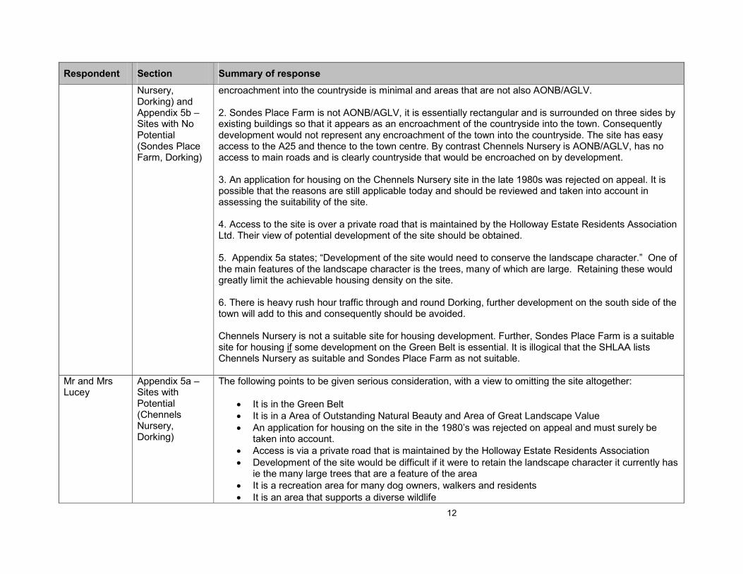
Mr Albert Bird Comments on Core Strategy Plan: SHLAA Appendix 5a – Sites with Potential (Chennels
Appendix 5a includes the Chennels Nursery site as one that is suitable for housing development. Appendix 5b includes Sondes Place Farm as a site that is not suitable for housing. I have the following comments: 1. Development on the Green Belt round the edges of Dorking is basically undesirable. it would result in a gradual creep of the town into the attractive countryside. Chennels Nursery is also in the Area of Outstanding Natural Beauty and Area of Great Landscape Value. Some small development in the Green Belt may become essential, but if that is so it should be restricted to areas where the impact of
12
Respondent Section Summary of response
Nursery, Dorking) and Appendix 5b – Sites with No Potential (Sondes Place Farm, Dorking)
encroachment into the countryside is minimal and areas that are not also AONB/AGLV. 2. Sondes Place Farm is not AONB/AGLV, it is essentially rectangular and is surrounded on three sides by existing buildings so that it appears as an encroachment of the countryside into the town. Consequently development would not represent any encroachment of the town into the countryside. The site has easy access to the A25 and thence to the town centre. By contrast Chennels Nursery is AONB/AGLV, has no access to main roads and is clearly countryside that would be encroached on by development. 3. An application for housing on the Chennels Nursery site in the late 1980s was rejected on appeal. It is possible that the reasons are still applicable today and should be reviewed and taken into account in assessing the suitability of the site. 4. Access to the site is over a private road that is maintained by the Holloway Estate Residents Association Ltd. Their view of potential development of the site should be obtained. 5. Appendix 5a states; “Development of the site would need to conserve the landscape character.” One of the main features of the landscape character is the trees, many of which are large. Retaining these would greatly limit the achievable housing density on the site. 6. There is heavy rush hour traffic through and round Dorking, further development on the south side of the town will add to this and consequently should be avoided. Chennels Nursery is not a suitable site for housing development. Further, Sondes Place Farm is a suitable site for housing if some development on the Green Belt is essential. It is illogical that the SHLAA lists Chennels Nursery as suitable and Sondes Place Farm as not suitable.
Mr and Mrs Lucey
Appendix 5a – Sites with Potential (Chennels Nursery, Dorking)
The following points to be given serious consideration, with a view to omitting the site altogether:
• It is in the Green Belt
• It is in a Area of Outstanding Natural Beauty and Area of Great Landscape Value
• An application for housing on the site in the 1980’s was rejected on appeal and must surely be taken into account.
• Access is via a private road that is maintained by the Holloway Estate Residents Association
• Development of the site would be difficult if it were to retain the landscape character it currently has ie the many large trees that are a feature of the area
• It is a recreation area for many dog owners, walkers and residents
• It is an area that supports a diverse wildlife
13
Respondent Section Summary of response
• There is a lack of access to transport, shops and other services
• Housing development would threaten the character of the area and the overall desirability of current housing may well be reduced if there is additional traffic and the natural habitat is harmed.
Mr Anthony Farino
HS-104 – Land adjacent Bookham Common
Aggrieved to discover that the potential sites presented to the Council in response to their invitation last November had been sorted into “sites with potential” and “sites with no potential” prior to any external consultation. As a landowning stakeholder, I am still awaiting an invitation to join the “partnership”, whose involvement is advocated from the outset of the Assessment. Consider that this pre-selection process is in conflict with information on the SHLAA set out on the Council’s website as follows: “A SHLAA must:
• Identify sites with potential for housing;
• Assess their housing potential; and
• Assess when they are likely to be developed The SHLAA does not make decisions about which sites should be allocated for development in the Local Development Framework. Rather, it provides evidence about the potential sites the Council can choose from…” “In looking for sites, other than excluding land within European or National designations such as Sites of Specific Scientific Interest (SSSI), and land within Flood Zones 2 & 3, the scope of the assessment has not been narrowed down by existing policies designed to constrain development, such as Green Belt policy. This is required by Government Guidance.” The assessment is in conflict with Government guidance on SHLAA procedure as set out in Annex C of PPS3 Housing, which states that the Assessment should merely “identify constraints that might make a site unavailable or unviable for development” or to “identify sustainability issues, and physical constrains that might make a site unsuitable for development”. Furthermore, the guidance subsequently asks you to ”identify what action could be taken to overcome constraints on particular sites”, but nowhere is the Planning Department asked to make a selection as this stage. Thus, the premature adjudication on these sites contravenes not only Government policy and Guidance, but also the ethos of Community Involvement as set out in PPS1. Indeed, this pre-assessment renders the entire exercise of public consultation and comment extremely unlikely on “sites with no potential”, and

14
Respondent Section Summary of response
therefore pointless. The following comments are made in relation to site HS-104: Land adjacent to Brockham Common Site suitability:
• Although a site may fall within the Green Belt boundary, this should not result in its exclusion, in Appendix 5a, you have identified many sites “with potential” that lie within the Green Belt. Site HS-104 lies on the edge of the designated urbanised area, and its southern boundary coincides with the Green Belt definition line.
• The site is not within the SSSI, therefore it is assumed that since it is adjacent to it that the site itself is not considered to be of high biodiversity. With regard to the protection of Bookham Commons from adverse effects, it should be noted that there are no designated restriction zones beyond the boundaries of this SSSI, in contrast to those surrounding SPAs and SACs. It also needs to be said that the road between HS-104 and the SSSI already serves a busy National Trust car park, the Bookham Grange Hotel with conference meetings and wedding receptions, the Mole Valley allotments, the ten dwellings immediately to the west, a further six dwellings within Bookham Common, and the sewage pumping station. Traffic movement to and from HS-104 would be a minimal addition. In fact, more damage is caused by the intensification of housing within the “urbanised zone”, which in recent years has caused a phenomenal increase in car-bourne visitor pressure on the Bookham Commons SSSI.
Object to the statement “appears to contain a significant number of trees” many trees surrounding the site, almost all of which are on the land of the adjoining owners:
• On the southern boundary, the heavily wooded railway embankment;
• On the eastern boundary, the densely wooded National Trust land in the form of a buffer strip average 30m depth, which, with the road and a further buffer strip of trees separates this site from the SSSI;
• On the northern boundary, the private land owned by Bookham Grange Hotel, beyond which likes yet another National Trust buffer strip of trees;
• And on the western boundary, the trees of the gardens of the previously-mentioned 10 dwellings. For this reason the site cannot be seen from any viewpoint, even in winter, your declaration that the development of HS-104 the statement that it would be “visually intrusive incursion into the countryside, damaging the Green Belt” is unfounded.
15
Respondent Section Summary of response
With regard to the site being “not well related to the settlement”, surely “relating to the settlement” simply means that any proposed development should respect the existing scale, density, and general ambience of the area as a whole. Disregarding the artificially created Green Belt boundary, which the SHLAA was instructed to ignore, it is clear from the Council’s plan of SH-104 that the sympathetic development of the site would simply be an extension or infill to the dwelling that lie to the west and the south. HS-04 is indeed over 800 metres from the schools and retail facilities, but so are the majority of residences in Bookham. The proximity to a school, is no guarantee that your child will be granted a place there. With regard to retail facilities there is a convenience store just 700m distant, open 7am to 10pm, seven days a week. But again, all families make the weekly trip to the supermarket by car at least once per week, simply because of the volume and weight of purchase, no matter how near the facility. Thus the point lacks strength also. Neither should we ignore the advent of “on-line” shopping in a serious Planning appraisal. Site Availability: The site is available Site Achievability: by your own admission, the site is within an area of high market demand and attractiveness. In addition, enquiries made to each Utility indicate that water, gas and electricity are readily available, while the main sewer from Bookham, 525 mm in diameter, passes alongside the site on route to the pumping station 1 kilometre away. Deliverability / Developability: This is challenged, it can be said that any piece of land in the kingdom has development potential. It follows that the “assessment” aspect of this policy programme is to identify the degree of the potential, when read against the criteria set out in the Council’s Core Strategy document Chapter 3, clause 3.37. This must be read together with the direction set out in Annex C of PPS3 and the practice guidance, from which the Council’s interpretation flows. Consider that HS-104 fulfils the criteria and therefore has development potential. What is at issue therefore, is to decide the type of development and the intensity that fulfils the best interests of the people. Most importantly of all, because of the physical and locational characteristics of site SH-104 described earlier, a development could be accomplished with no harm whatsoever to the immediate neighbours, or to the people of Bookham, both during the construction stage and thereafter. This is in direct contrast to those sties which you have declared to be suitable within the built up area. I cannot see how the inequity of the selection can be corrected, other than to re-introduce all sites that were put forward, but this time with descriptions only, and without planning officer comment, adverse or

16
Respondent Section Summary of response
otherwise.
Simon Slatford (RPS Planning) on behalf of Oracle Residential (Ashtead) Ltd
Parsons Mead, Ashtead
Oracle support the inclusion of the former Parsons Mead School Site (HS 05) as a site that can deliver housing in the first 5 years. However, we consider that the site should include the whole of the former school site, including the open land to the east, so that it can be considered as a comprehensive redevelopment proposal with the final level of development derived through consideration of a detailed scheme and the extent of the built area. Given national and regional policy guidance, it is important to be clear that the 100 dwelling is not a ceiling. In terms of delivery, Oracle own the land and are shortly due to submit a planning application for residential and community development/uses on the site. Having undertaken detailed assessments, they are satisfied that there are no physical constraints to the development of the site. A scheme has been prepared that clearly demonstrates that the site can accommodate at least 100 dwellings in a mix of dwelling types and sizes to meet local needs.
Michael Williams Planning on behalf of Landowners of Land at Kennel Lane, Hookwood
Kennel Lane, Hookwood
Site should be considered as having potential for the following reasons: The site directly adjoins the settlement edge of Hookwood, and is bounded by clear / defensible boundaries; it is of modest size and its development would have negligible impact on the countryside. Hookwood is an area of high market demand for housing – principally through its close proximity to Gatwick; moreover, the site is located within the Charlwood Ward, where 1,931 jobs are located – which is the sixth highest concentration of employment in the District. Within 500m of the site there is a very large Tesco store and further facilities are located close-by within Horley. The site at Kennel Lane is affected by the ESSO Petroleum / South East of England Oil Pipeline, a facility which links Fawley on the South Coast, with Gatwick, plus Purfleet, in the Thames Estuary with Gatwick. The pipeline is administered by Fisher German chartered Surveyors (www.fishergerman.co.uk) on behalf of the Government Pipelines and Storage System (GPSS). The agents require to be informed of any underground works within 50m of the pipe and in the same parcel of land. Generally, no work shall take place within 3m on either side of a pipeline without prior approval of the Pipeline Operator. Prior to the site works commencing the Pipeline Operator has to agree a written “task risk” a “method statement” and this must lead to written legal consent from the Operator to the works which may be planned close to the Pipeline. No buildings, structures or caravans are allowed within the pipeline

17
Respondent Section Summary of response
easement; and tree planting is restricted within the easement zone – ie. within 3m of each side of the pipe. If the contractor on an adjoining construction site needs to cross the oil pipeline it will be necessary to put in place a temporary concrete slab to prevent a reduction in earth cover over the pipe. Taking a conservative safety margin of 10m (compared to the standard 3m buffer distance) from the east flank of the pipeline, the net area for development is 0.4975ha, or 1.23 acres. Applying a density of 33 dwelling per hectare gives 16.5 dwellings on the land which is outside the pipeline’s safety zone. This is a useful contribution to the District’s requirements for new housing and we urge adoption of the amended from of CS/PO 01 (see Limehouse) to allow the early development of the site should the suggested monitoring process reveal the necessary need to release land from the Green Belt.
Mr Steve Brown (Woolf Bond Planning) on behalf of Martin Grant Homes
General comments and Land at Woodlands Road, Bookham
We note reference at paragraph 8.10 of the SHLAA concerning the annualised need for the provision of 1,334 affordable dwellings. This by far exceeds the annualised housing requirement set out in the South East Plan Panel’s report provides for only 188 dwellings per annum. In light of the identified affordable need we are concerned with the findings of the SHLAA which relies in the main on the delivery of dwelling completions from small sites within the urban areas to help meet identified needs. Experience suggests that urban redevelopment sites (other than those large sites in town centre locations) are generally small scale and provide for developments of less than 15 dwellings and therefore result in little if any affordable dwellings. The SHLAA appears to give little weight to the nature of the housing challenge. Assessing Suitability of Sites We object to the Council’s assessment of site HS-107 as having no development potential. We consider the site represents an appropriate development opportunity, within an accessible distance from both Effingham and Bookham. The Council’s “sieving” process rules the site out on the grounds that it is not suitable. However, there are no physical limitations to providing for development of the site. In all other regards the Council’s site assessment sheet confirms the suitability of the site for development having regard to availability, achievability and deliverability/ developability. We request that the site is included in the final SHLAA.
18
Respondent Section Summary of response
Woodlands Road, Bookham Our clients have a controlling interest in a 3.8ha brownfield site at Bookham, site HS-107 in the Council’s SHLAA. Consider the site should be considered further as:
• the site is outside the AONB and AGLV and adjoining one of the main built up areas.
• the site is well served by public transport routes and other local services and facilities, employment and retail.
• the site was identified some 20 years ago by the Council as a development opportunity for housing. However, this was not supported through the 1984 Local Plan Inquiry in part due to an over-supply of housing land at that time and hence the strategy failed to come to fruition. The identification of the site for development by the Council, albeit some 20 years ago, sets a precedent in terms of the acceptability in principle of the site for development.
• The site could accommodate a minimum of around 130 dwellings, making a material contribution to identified housing needs.
In summary, we consider that the emerging Core Strategy needs to provide for a degree of flexibility in seeking to meet the strategic housing requirement to 2026. There is no certainty that windfalls will continue to come forward at past rates and in addition, there is the need to provide for a material amount of affordable housing within the District. The spatial strategy underpinning the Core Strategy should allow for the release of sites for development adjoining the urban areas, particularly at sustainable locations such as Bookham. In accordance with the South East Plan there should be a local review of the Green Belt boundary to support additional housing allocations.
Hilary Porter – Leatherhead Residents Association
Leatherhead Hospital site
• Concern regarding the site at Leatherhead Hospital. Understand that the Trust would be interested in the possibility of finding a developer who would provide additional accommodation of buildings for the Hospital in addition to any housing development and additional parking facilities. Understand that the GP practice in Ashtead is nearing the end of the lease of their premises and has expressed an interest in moving to the Leatherhead Hospital site also understand that there is a GP practice in Leatherhead interested in making a similar move.
• Leatherhead Railway Station. Appears to incorporate part of the area already providing parking space for commuters and local businesses. In view of the imminent arrival of Unilever, there is a potential that their application for temporary use of three Leisure area parking facilities may need to

19
Respondent Section Summary of response
be extended, which will put increasing pressure on available parking facilities.
• Concern about potential increase in congestion of local roads with patients and staff attempting to access the hospital site through St. John's road where there is almost always only movement at any time of vehicles in one direction only. There is no frequent bus service providing access to the Leatherhead Hospital. The 408 is a two hourly service and does not run in the evenings.
• Concerned about validity of traffic survey undertaken in May (This was not undertaken by Mole Valley District Council, who is unaware of the survey).
Mr Rod Reeken
Chennels Nursery Site
The site lies within: a) an Area of Outstanding Natural Beauty; b) an area of Great Landscape Value; and c) the Green Belt
Any development would not be appropriate and should be opposed. Appreciate more housing is necessary within the MVDC area. However, the development of land that is deemed to satisfy the criteria of a) and b) and that is subject to the restrictions prescribed by c) would appear totally undesirable and against public policy. The conservation of natural habitats has an even higher priority than when the existing Plan was formulated. An application for housing on the site was in the late 1980’s rejected, the reasons do not appear to have been taken into account in the current assessment of the site’s suitability for development. There are also concerns, about the access to the site from the existing road infrastructure and the impact of additional traffic.
Mr A Farquhar on behalf of R Godwin
Godwins Nursery, Beare Green
Godwins Nursery comprises 1.05 hectares of buildings, glasshouses and growing area. It has a history of retail use and was closed recently and production stopped following the loss of the bedding plant contract with Mole Valley Council. It was uneconomic to continue. The Site is adjacent to the station and in a Village which can fulfil many sustainability criteria as set out in Revised Preferred Options Consultation. The District needs to find 1070 affordable homes The Village has a number of employment centres and good access to Dorking and London by train and bus (para 2.41). The report accepts that rural shops and parades have closed because they are no longer viable (para 2.48), villages like Beare Green should have some natural growth to maintain facilities.
20
Respondent Section Summary of response
The Structure Plan accepted that some limited development in rural settlements would be permitted and this is reflected in CS/PO1 and para 5.06. Beare Green is specifically listed and again in CS/PO2 paragraph 4. We believe that there should be a mix of open market and affordable housing which the housing policy, as currently written, does not allow. An owner of a property that has a commercial value is unlikely to release that property unless he gets it’s full commercial value which, to date, RSL’s have not had the funds to purchase such property. We wish to have further discussion with the Planning Department as to how rural sites will be deliverable. Object to the Draft Core Strategy as it does not release any open market housing in the rural area nor does it state how 1070 affordable homes can be delivered as no sites are identified and it is not known whether landowners will deliver such site.
Helena Hill Leatherhead Hospital Site
Concern over the 10 units identified as available for new housing at Leatherhead Hospital. Applaud the general policy of increasing affordable housing, which is one of the greatest needs in Mole Valley, but there is considerable volume of traffic at the corner of St. John’s Road opposite the hospital entrance, both to the hospital itself and turning into Poplar Road in both directions. Poplar Road is well recognised as hazardous and the Police are already consulting with residents about possible ways of controlling this. New houses near to this busy and dangerous junction seem an extraordinary planning proposal. Query what consultation there has been with the Policy and the Highways departments.
Mr Andrew Steen (Whites and Sons)
General comments and various sites
Some concern with the blanket exclusion of assessment of sites within Flood Zone 2, taking account of Planning Policy Statement 25: Flooding Annex D. Table D.1 states, regarding Flood Zone 2, that “the water compatible, less vulnerable and more vulnerable uses of land and essential infrastructure in Table D.2 are appropriate in this zone.” Table D.2 shows that buildings used for dwelling houses fall within the “more vulnerable” flood risk classification. From this, it is clear that housing land can be appropriate within Flood Zone 2. Site analysis The following table summarises our comments on relevant sites:

21
Respondent Section Summary of response
Sites with potential Reference Comment HS-013 Capel House Farm,,Capel
The site remains available. Comments made in the document are supported.
HS-024 Vincent Walk, Dorking
I have provided an additional plan that divides the site in two. The area marked in red would be available in the short term, within the first 5 years. The remainder is unlikely to become available in the short term. However, it may become available in the longer term and the comments in the document relating to potential for development in 6+ years appear reasonable. We act as Managing Agents on behalf of the owner.
HS-033 Clare Crescent, Leatherhead
This site is available for development and would be developable in 6+ years.
HS-034 R/o Randalls Road, Leatherhead
We support the Council’s view that this is a sustainable site, located close to existing services. It is available and achievable and would be developable in 6+ years.
HS-035 The Fairway, Leatherhead
This site includes HS-033 and is sustainable, available and achievable in 6+ years.
HS-042 Dell Close, Mickleham
This is a site within Mickleham put forward by another planning agent, but adjacent to a site put forward by ourselves (HS-128) that was not deemed suitable. We are concerned at this apparent conflict and have made further comments on that site

22
Respondent Section Summary of response
below.
HS-043 R/o six Bells PH, Newdigate
If deemed appropriate, this site could be brought forward within the first 5 year period. The site will be achievable and available within the 6+ years.
Sites with no potential HS-102 North Barnett Wood Lane, Ashtead
This site is in the gap between Ashtead and Leatherhead, bounded by the railway and M25. It would be available and achievable in 6+ years should the Council consider it a suitable site. The towns of Ashtead and Leatherhead are divided by the M25 and its slip road at this point. The gap on this side of the M25 is narrow and dominated by the development of Ashtead and the motorway. There is potential here for development to shield the impacts from the M25 from existing houses, and provide additional screening in the form of planting adjacent to motorway and railway. This should ensure satisfactory living conditions for the residents. We consider this site as suitable for development in the same manner as site HS-035 located on the other side of the motorway.
HS-114 Chapel Road, Charlwood HS-116 Rosemary Lane, Charlwood
This is a large site on the edge of Charlwood, a small settlement with some services and facilities and within close proximity of Gatwick and surrounding development area. Development here would support the retention and improvement of local facilities. If it is not considered appropriate to allow the development of the whole site, it would be possible to divide and develop a smaller area. The site falls within Noise Exposure Category 3 for the purposes of Planning Policy Guidance Note 24, where noise should be taken into account and appropriate conditions applied, but there is no objection in principle to development in this area. Copies of the Gatwick noise contour maps are attached. Further assessments would be required if the development of this site were to be considered suitable.

23
Respondent Section Summary of response
The site is available and achievable in 6+ years should the Council consider it suitable.
HS-127 Adj..Priest House, Leigh
This site is located close to the centre of the village, with easy access to local amenities that would be supported with additional development. The site is available and achievable for development.
HS-128 Eastfields Cottage, Mickleham
This site is adjacent to another mentioned above, HS-042, that is considered suitable for development. It is on the edge of a village with reasonable facilities and so would be a sustainable site for additional development in the same manner as the neighbouring site. The site was promoted for sheltered housing for older persons and provision of a healthcare centre. The site could be divided into two and it is suggested that the Council consider this option. The field closest to the Church could be considered for development, even if the remainder is not considered suitable at this stage. However, it is unlikely that this site would be sufficient size to be viable for sheltered housing for older persons or a healthcare centre. Development here would support the retention and improvement of local facilities. It is suggested by the Council that access from Dell Close may not be possible for the level of development proposed. Additional access could be taken from the access drive to Eastfield Cottage, if considered necessary. The type of housing proposed above would result in a reduced number of vehicle movements than open market housing and this should be taken into account and acknowledged in the SHLAA.
Additional sites Sewage Works, Brockham
The site was previously used as a sewage works and subject of permanent development. As such, it should be considered as previously developed land under the definition contained within PPS3 Annex B. An amended site plan is attached to this letter to demonstrate the full site available for development. The Council may consider that only part of the site is suitable for
24
Respondent Section Summary of response
development and it is suggested that the Council sub-divide the site appropriately if this is the case. Council comments suggest that the site is divided between Flood Zones 2 and 3. Flood zone 3 is not appropriate for residential development and any indicative calculation of capacity will need to take this into account. Flood Zone 2, under Annex D of PPS25, does have potential for development of dwelling houses, subject to a FRA. A FRA for this site is currently being prepared. A letter from the Environment Agency clarifies the areas of the site that are subject to a 1 in 100 year + 20% risk of flooding or greater and this is also enclosed with this letter. We would suggest that the remainder of the site is appropriate for development. The site will be subject of an Environmental Risk Assessment due to the previous uses on the site. This will be shared with the Council as soon as it is available.
Happy Eater Betchworth
This is a previously developed site with an existing building that has been vacant for some time. Redevelopment of the site will ensure the land can find a beneficial re-use.
Mr Doug Cramock on behalf of the Trustees
General comments and Sondes Place Farm, Dorking
The Trustees have some fundamental concerns with the document as it stands and these are summarised as follows: 1. Settlement Hierarchy We refer to this in the parallel representations to the Core Strategy but it is quite wrong for the SHLAA document not to be based on a sound settlement hierarchy intended to maximise sustainability. As things stand, there is little distinction made between sites in small settlements and those at the heart of sustainability in Mole Valley, at Dorking. Sites in numerous villages and small settlements have been deemed suitable without properly considering their sustainability credentials and how they should be ranked behind reasonable propositions in Dorking. In this respect the approach to the availability assessment has been somewhat naive and failing in soundness by not following national objectives or, indeed, the Council’s own stated aims of seeking to address climate change, minimise car travel and creating the right type of homes in the right locations. Re-

25
Respondent Section Summary of response
appraisal of the selection and weighting needs to take place with some villages closed to all development bar the occasional affordable homes scheme for local people only. Even amongst the larger settlements the strong leaning should be towards Dorking and the reality is it is placed in new homes terms well below the appreciably smaller Leatherhead. The SHLAA document needs an emphasis for Dorking and to re-focus on allowing for the continuation and creation of sustainable communities even if that means challenging and setting aside the notion that all development on greenfield land is intrinsically bad.
2. Pre-emption of LDF Site Selection This Council seems almost to have used the SHLAA exercise as a site selection one instead of the proper LDF approach of creating and publishing a development plan with allocations which can be put through Public Examination and Inspector based scrutiny. It is far too specific and judgemental without real analysis and comparative material. The SHLAA should be merely used to gauge that there are enough (or not enough) sites suitable for 10 + years ahead and that these are deliverable and developable. At this stage broad analysis is called for not detailed inclusion or exclusion of every, often small, site. The Government’s Guidance Note for SHLAAs underlines that the process is useful to allow planning authorities to consider options and relevant alternatives for accommodating new housing when plan making. It notes that “except for more clear-cut designations such as Sites of Special Scientific Interest, the scope of the Assessment should not be narrowed down by existing policies designed to constrain development, so that the local planning authority is in the best possible position when it comes to decide its strategy for delivering its housing objectives.” The Council rightly indicates that it’s SHLAA “study will be used as a basis from which to allocate sites for residential development through the LDF’s Land Allocation Document” – it should not do that document’s job, or it will make the subsequent process pointless. 3. Inappropriate site selections
Whilst we have expressed concerns over the level of detail of the site selections, given that this has been the approach which has been followed we ought to identify some issues on the parameters used. For example:
• as mentioned previously, rural locations and small settlements should be ruled out;
• reserve sites from the Local Plan should not automatically be first choice – a principal point of the
26
Respondent Section Summary of response
new plan system is to look afresh, challenge the past and consider most recent policy objectives, not merely to pick up old allocations;
• land within AGLVs is very questionable and certainly proposals with the AONB should only be supported in very exceptional circumstances, but in a number of cases this seems to have been glossed over and sites within these areas chosen;
• there seems little attempt to consider whether any of the favoured sites might be better used for employment or other beneficial purposes;
• there is no analysis of cost and market factors which are key test issues within the Government Guidance and which could readily make some of the selected sites undeliverable; and
• there appears to have been no eye kept on which sites coming forward would be most beneficial for the much needed provision of affordable housing.
4. Concerns at Sondes Place Farm If sites are to be analysed, and immediately selected or discarded, then that consideration has to be sound, thorough, comprehensive and consistent. Sadly, whilst Sondes Place Farm rightly passes the availability and achievability tests it seems to fall down on suitability in the Council’s eyes. The Council recognises the close proximity to facilities, bus routes and employment but questions how walking routes will work and is presently unsure how suitable access to the site would be achieved. No-one has come back to the site owners to give a view on these points. The uncertainty converts in the conclusion to “concerns” over access and apparently there are “issues” with accessing the very nearby facilities. The main concern however seems to be damage to the setting to the town. Perhaps the precise planning and development boundary selection does need some thought but it is clear that unlike many other sites this land has no landscape quality designation on it. The Council seems to have somewhat unthinkingly picked up on the Local Plan Inspector’s concerns over ‘green-wedge’ and prominence. However, there will be different ways of development possible than put forward at the Local Plan Inquiry and it is most important to consider that the Inspector then was looking for hardly any development sites. Only 3 very small allocations were deemed necessary at the time with just five reserved sites included across the whole District – so the chances of any sites being successfully promoted were very slim and it is easy to see why modest alleged difficulties could have been cited to help justify prevention of this (or other) land from coming forward. In short, the analysis of HS-119 and its surrounds is simply not good enough and the Council needs to look afresh at development siting, form, access, landscape and accessibility; and, as noted below, we shall
27
Respondent Section Summary of response
assist in this process. 5. Alternative development approaches at Sondes Place Farm The site delineation on the plan used for the present Site Ref HS-119 is by no means the only area within this land holding which could have been considered and should have been assessed on proper planning merits. Appraisal is presently underway but a submission to be made to you shortly will have considered matters such as:
• keeping built development off the highest ground;
• creating usable public open space on areas of most prominence;
• enclosing built development within a landscape framework;
• making best use of any site topography and land form to create new habitat and bio-diversity;
• creating the safest least obtrusive entrance(s);
• providing convenient linkages to facilities;
• exploring the potential to improve vehicular and other links to the adjoining school;
• ensuring that existing adjacent residents are not adversely affected by new building or activity on the site; and
• generally creating an attractive, safe and sustainable environment which would not damage the attributes of the town.
We shall be looking rigorously at the assumptions made in the present SHLAA papers for this site, and considered so many years ago by the Local Plan Inspector, and setting out fresh proposals to be shared shortly. In the meantime, for a whole host of reasons, your authority should not adopt the wider principles within the SHLAA, nor let the initially negative draft thoughts on HS-119 locality adversely colour judgement against what, in future, could be a superb sustainable extension to Mole Valley’s top ranking town of Dorking.
Ms Ackroyd & Mr Harvey
Appendix 5a) Sites with Potential (Chalcraft Nurseries, Chennels Nursery & Nutcomb Lane,
We do not think that policy protecting the long-standing Green Belt laws should be dismantled. Whilst we understand that central government has the call on this, Mole Valley stands to lose significant character through nibbling away at the margins of its towns, particularly those overlooking areas of outstanding natural beauty. It is worrying to see three sites in Dorking - HS 016/017/023 - marked out for potential development subject to policy changes. We urge MVDC to develop existing residential and brownfield sites, and keep the integrity of the Green Belt intact as to develop it can only serve to detrimentally affect the character of the town.
28
Respondent Section Summary of response
Dorking)
Holloway Estate Residents Association Ltd (HERA)
Chennels Nursery
a) HERA is disappointed that it has not formally been consulted about the RPOC and the earlier documents to which it relates.
b) We suggest that the consultation exercise which has been carried out by MVDC is fundamentally
flawed. MVDC has consulted “house builders, local planning agents and landowners” but appears to have little if any consultation with residents’ association and preservation societies. Despite reference to “selected Residents Associations” in paragraph 5.15, none features in the list of attendees as the Partnership Board meeting referred to in Appendix 2.
Indeed, it would appear that meetings with the “four main residents associations representing Ashtead, Fetcham, Bookham and Leatherhead, and with the Dorking and District Preservation Society” were not scheduled until after the publication of the SHLAA. Accordingly, their views cannot have been taken into account in the preparation of the SHLAA. Our grounds for objection to Chennels Nursery are as follows: - Planning Policy Chennels Nursery is located within the Metropolitan Green Belt (“MGB), an area designated as an Area of Outstanding Natural Beauty (“AONB”) and an Area of Great Landscape Value (“AGLV”). The MGB and AGLV designations have not come about by some quirk of history but because MVDC accepted, in 1983, the recommendations from the Inspector who conducted the Local Plan public inquiry to amend the Draft Local Plan to the effect that Chennels Nursery should not be a Reserve Housing site but should be included in the MGB. This decision by MVDC was consistent with its refusal of planning consent for residential development in 1957, 1958 and 1973, and the Inspector’s conclusions were adopted by MVDC when it refused a subsequent application in 1988 (Ref. MO 881161) for 27 bungalows and a support centre for profoundly handicapped children. At that time, and in their submissions to the planning committee, the MVDC planning officers stressed that the (then) planning document PPG 2 – Green Belts (1988) advised that “Green Belt boundaries once defined should be altered only exceptionally”, and that “detailed boundaries should not be amended or development allowed merely because land has come derelict”. The planning officers also agreed with “most of” the other objections lodged by HERA and by the Dorking & Leith Hill Preservation Society as

29
Respondent Section Summary of response
follows: - a) It conflicts with the Structure Plan and Local Plan Policies MGB, AONB and AGLV; b) Circular 14/84 and PPG2 state that once MGB boundaries are defined they should be protected and
maintained regardless of condition; c) Inspector’s Report on Local Plan Inquiry removed the site from the reserve housing sites; d) It will set a precedent; e) Increased …… traffic generation increasing danger to pedestrians and children and highway users; f) The road junction with Horsham Road is dangerous; g) It will be out of character with the area; h) The proposal will adversely affect the amenities of neighbouring properties; i) [Comment relating to support centre] j) Land is already available for future housing needs; k) The proposal causes overlooking and loss of privacy; l) [Devaluation of adjoining properties]; m) Overdevelopment of the site; n) Inadequate drainage; o) Refusal of permission on neighbouring site to include MGB land as private garden area; p) Previous refusals Dorking 1812 and Dorking 171/73; q) Effect on wildlife The application was refused by MVDC and, save for grounds (i) and (l) above, HERA submits that the similar objections apply to the current proposals relating to Chennels Nursery in the SHLAA. There has been no change to the fundamental principles of Green Belt policy since the earlier decisions. Whilst the revised PPG2 was published in 1995, this document reaffirms the importance of Green Belt policy and defines appropriate use with the Green Belt as being: - to provide opportunities for access to the open countryside for the urban population; - to provide opportunities for outdoor sport and outdoor recreation near urban areas; - to retain attractive landscapes, and enhance landscapes, near to where people live; - to improve damaged and derelict land around towns; - to secure nature conservation interest; and - to retain land in agricultural, forestry and related uses. The proposed residential use of the land would fall outside these categories and no case has been put forward to justify why an exception to Green Belt policy should apply. The identification of this site for

30
Respondent Section Summary of response
residential purposes is flawed and would be contrary to government advice as set out in paragraph 2.6 of PPG2. The proposed site has been accepted as Green Belt and the condition of the land has not changed since it was designated. The land is not derelict or damaged. Its importance is not only recognised by its Green Belt designation but also by its inclusion within the AONB and the AGLV. The development of this site would raise fundamental issues relating to the protection of the boundaries of the Green Belt on the edge of the development area of Dorking in he future and would be contrary to the objectives of Paragraph 6.1.11 of the Core Strategy ‘Revised Preferred Options Consultation document’ which seeks to locate ‘development towards the existing built up areas’ to ‘minimise the impact on key biodiversity and landscape features’ and ‘safeguard the Metropolitan Green Belt’. Proportionality In the immediate vicinity of, and requiring access over, Ridgeway Road are the development at Highacre (59 units or thereabouts) completed about ten years ago, and the Reserve Housing Site at Marley Mead on which 30 unite are proposed. A further 65 unites are now proposed at Chennels Nursery. It would appear from Table 6.2 in the RPOC that MVDC has identified the potential for 430 units in the Dorking area, it is not appropriate that almost 25% of the demand should be met in one location (Marley Mead / Chennels Nursery). Access Access to Chennels Nursery can only be achieved over Ridgeway Road, which is an unadopted private road maintained at the cost of members of HERA. The road is wholly inadequate in layout, width, lighting, drainage and construction to deal with additional traffic, and it has no pavements. Development of Chennels Nursery, especially after development of Marley Mead, would create an unacceptable increase in vehicular traffic over the roadway, and the absence of pavements will exacerbate the danger to pedestrians. The road is heavily used by children on the way to/from school and by the numerous elderly people who live in old-peoples’ homes in Ridgeway Road and Roman Roads. The development would create an unacceptable danger to pedestrians. Character of Area In 1980, MVDC stated in paragraph 5.57 of the Dorking Area District Plan Report (Topic Report 5

31
Respondent Section Summary of response
Environment) that the “development potential of the Knoll Road, Roman Road and Ridgeway Road area would appear to have been exhausted”. At the same time, MVDC stressed in its (then) Policy EV9 in the draft Local Plan (in the context of proposed development) the importance of considering “any likely change in the character of the area, the resultant increase in traffic generation and the effect on neighbouring properties”. These consideration continue to apply to any proposal to develop Chennels Nursery as much now (if not more so) as they did 25 years ago. Wildlife and Conservation Development of Chennels Nursery would conflict with Planning Policy Statement 7 (referred to in paragraph 6.4.3 of the RPOC), and with paragraphs 2 and 3 of Preferred Policy Approach CS/PO 13 set out in Paragraph 6.4. County Planning Context Development of Chennels Nursery would conflict with specific policies contained in the Surrey Structure Plan (referred to in paragraph 3.8 of the RPOC) relating to “locations that can be easily accessed without a car” and to the maintenance of the MGB. These policies are replicated in Chapter 5 of the RPOC, and in particular in Preferred Policy Approach CS/PO 1, and are supported by a majority of respondents as mentioned in paragraphs 5.0.10 and 5.0.11. Development of Chennels Nursery would conflict with specific policies contained in the Surrey Structure Plan (referred to in paragraph 3.8 of the RPOC) relating to “locations that can be easily accessed without a car” and to the maintenance of the MGB. These policies are replicated in Chapter 5 of the RPOC, and in particular in Preferred Policy Approach CS/PO 1, and are supported by a majority of respondents as mentioned in paragraphs 5.0.10 and 5.0.11.
Mr Anthony Farino
Site Reference HS- 038 Post Office Depot Leatherhead
Consider this is an unlikely location for a dense development. Questions of parking, access and egress, etc prevail, but also the loss of another employment site in a built up area.
Mr Colin Langley
Leatherhead Area Partnership
In 3.8, the Surrey Structure Plan (2004), the first bullet point states “New development should be directed to locations that can be easily accessed without the car or appropriate measures should be introduced to ensure adequate accessibility for those without a car”. In 7.2.5 (P80) “The decision as to where to locate new developments will be an important factor in reducing travel demand….. There is also a need to

32
Respondent Section Summary of response
improve the general level of accessibility to key services and facilities”. We welcome these statements. However, the SHLAA shows important sites that are not close to a frequent or regular bus service, so the car would be the only answer. Leatherhead Hospital is a prime example. The 408 bus service passes the bottom of Poplar Road once every two hours and there are just three 516 buses during the day. Combined they do not constitute an adequate service for the hospital or for any development at the site. The 479 buses cross the area from Ashtead to Bookham but stop running at approximately 18.30 and there is no service on Sundays. Areas south of the 479 route have either limited 408/516 service or no service at all. Residents in parts of Bookham and Ashtead who are any distance from the stations, and certainly in Fetcham, have no option than to use their cars. A regular service along the A24 to fill the gaps by the 479 service is needed.
Dorking and District Preservation Society
PPS3 stipulates that sites should be identified to deliver housing in the first 5 years. Further sites for a five year supply is required in two further 5 year periods years 6 to 10 and 11 to 15 but in respect of the latter 5 year period, broad locations for future growth should be indicated. According to the evidence approximately 18 years’ site-specific land supply is to be found and therefore the Society asks why look beyond the urban fringe to identify greenfield sites especially when some of these infringe MGB designation. It is not for Core Strategies to spell out an over-allocation of land supply. The Society notes that in PPS3 there is latitude in grouping a supply of sites in continuous phases of deliverable five year collections of sites. A safety net also is allowed in PPS3 Para 59, in which a realistic windfall allowance is acceptable, dependent on the SHLAA historic windfall delivery rates and expected future trends. In Mole Valley there is historic evidence to support such an approach. The Society in these circumstances does argue that to breach the MGB or build in the AONB would not be justified. The Surrey Structure Plan 2004, Policy LO4 covers the Countryside and the Green Belt. The primary aim is to protect the “openness and intrinsic qualities of the countryside” and states “Most development outside the urban areas should be in or near to local service centres and all development must respect the character of the countryside.” The Society believes that the SHLAA does not recognise the intrinsic character of surrounding countryside nor does it take into account the need to locate housing near to local service centres when listing the sites with a potential for housing development. Where the sites are located within the fringes of Dorking 20% infringe the designated MGB one of which (Marley Mead), disregards the function of the Surrey Hills AONB to protect the countryside for the sake of its intrinsic character and beauty. An amendment to PPG7 by Government in June 2000 stated that “The Government considers that the landscape beauty of AONB’s is in no way inferior to that of National Parks and therefore AONB’s should share the highest status of protection in relation to landscape and scenic beauty”. The realistic application of this advice seems to be ignored when Marley Mead, Ridgeway Road is

33
Respondent Section Summary of response
put forward as a potential site for housing. There will be an obvious harmful effect when houses are located within a scenic open field that is in part of the wider area of the Surrey Hills AONB with a character formed of gently undulating and open land interspersed with deciduous woodland. The Society in it’s publication “Preserving Dorking’s Integrity” (February 2008) suggested that the area around the periphery of Dorking provided the opportunity to develop and make use of the clearly identified footpath network that forms a circuit of the town, affording access to the open countryside beyond the urban limits of the town as well as inter-connecting the main green features of Betchworth Park, The Glory Wood, Bents Brook - North Holmwood, Spook Hill Common, Bury Hill, The Nower, Denbies Vineyard, Ranmore Common and Boxhill. This proposal fits neatly with the provisions of Surrey Structure Plan Policy LO4, under the title Urban Fringe, which states that “Measures to secure the enhancement of the character and management of countryside on the urban fringe, consistent with the appropriate use of such land, including recreational use, will be encouraged”. Taking the following sites within the SHLAA added together, all have MGB designation and are located on the edge of the of the built-up area of Dorking: HS - 016 Chalcraft Nurseries Reigate Road (also within an area of AGLV); HS - 017 Chennels Nursery, Ridgeway Road, (also within an area of AONB & AGLV); and HS - 023 Nutcombe Lane (west of Curtis Lane Industrial Area); Together these represent a total area of 6.6 hectares with a net potential of some 155 dwelling units. We consider this degree of expansion of the urban area of Dorking is very significant and will tend to undermine the evident, contained, balance of the town, harming its historic character. Under present policy designation in the MGB these sites are regarded as inappropriate. The guidance is clear. Approval should not be given for the construction of new buildings unless for defined uses, which does not include housing, except in very special circumstances. Where additional designation AONB & AGLV apply there will be added visual harm to the surrounding area. In the Society’s view all these sites on the edge of Dorking should not be developed, to do so will cause harm to the character of the town and will not be sustainable. In the main they do not possess adequate services nor have they appropriate infrastructure to ensure ease of access. Where AONB/AGLV designations apply our view is that this factor, acts counter to the argument that required housing numbers constitute very special circumstances. The site Ref HS-021 Marley Mead Ridgeway Road, although this site was taken out of the Green Belt in the last MVDC Local Plan, it is nevertheless in a protected area, designated AONB. There is added concern also that a number of sites located on the edge of the town namely a site HS - 019 Curtilages of Knole Croft, Woodlands and Merridale on the north side of Hampstead Lane to the north of The Nower (without any designation), HS - 022 Mole Hill, Reigate Road, although recently given planning permission for 6 houses, is within a Special Area of Conservation (SAC), and are sites which have a history of

34
Respondent Section Summary of response
contended planning permission because of their importance in protecting the Mole Gap - to Reigate Escarpment SAC. We have the following more detailed comment on a number of the sites giving reasons for our recommendation that they should be dropped from the potential housing list. Marley Mead (HS - 021) & Chennels Nursery (HS - 017) Concerned that, in Marley Mead and Chennels Nursery, land has been identified in the former site that was previously included in the Green Belt. However, in the case of both Marley Mead and Chennels Nursery they are classified as both AGLV and AONB with the latter site also designated Green Belt. Therefore for this reason alone we would like both sites to be removed from the list. At the very least it should be understood that it would be the very last site to be considered for development, not only because of its AONB/AGLV designation but also because of significant access problems. Traffic moving to or from Marley Mead would necessarily use Ridgeway Road, either at its eastern end where it joins Flint Hill, or at its western end where it joins Coldharbour Lane. (i) Flint Hill: The junction with Flint Hill is awkward. This is the main road out of town towards the south and it carries fairly heavy traffic. Ridgeway Road joins it at very nearly its highest point. The roadway of Flint Hill starts to go downhill on both sides, obscuring traffic approaching the junction from both sides. To improve sight-lines the entire level of the junction would need to be lowered, as well as widened. (ii) Coldharbour Lane: Traffic seeking to approach the western end of Ridgeway Road or to leave it by this route needs to travel along a relatively narrow road, which could not be widened without weakening the link between the Hampstead Road - Harrow Road West area with the Nower. The lower part of Coldharbour Lane is not for nothing known as ‘The Struggle’. It is too narrow to accommodate a pavement and vehicles have to pass each other with care. At the beginning and end of the school day the area is awash with children and cars trying to get to or leave The Priory and Powell Corderoy schools. It is difficult to see how the roads in this area could be altered to accommodate significantly increased traffic without causing appalling damage to the quality of the area. These considerations also apply to Chennels Nursery, should that area also be released for development. It is worth noting that there are at present approximately 40 homes on or around Ridgeway Road. Should both Chennels Nursery and Marley Mead sites be developed, this number would, on our figures, be increased to 135. Ridgeway Road would require up-grading and is likely would cease to be privately owned. Our view is that the same factors would probably still apply if either Chennels Nursery or Marley Mead were developed.

35
Respondent Section Summary of response
Chalcraft Nursery This site is designated AGLV. We note that of the 46 sites in Mole Valley that are listed, these are the only two to be so designated. It is designated AGLV principally because it is a critical part of the view southwards from the Salomons Memorial Viewpoint at the top on Box Hill. From the Viewpoint the buildings on Leslie Road lie right in front of it, but any buildings on the site of Chalcrafts Nursery will be significantly more prominent because they will stand on higher land. Since at least the 1960s it has been well understood that further building on the north- east side of Dorking, underneath Box Hill, should be kept to a minimum, in order not to damage the view from Dorking’s most famous beauty spot. To allow this to happen must be considered as creating a risk that damage will be done to Dorking’s tourist trade. All these sites are in the urban fringe and if developed will cause the urban area of Dorking, mainly to the west of the town to be extended into the open greenfield land within the urban fringe which, under MGB designation in this locality, serves to check the unrestricted sprawl of a nearby built-up area, safeguards surrounding countryside from further encroachment, preserves the special character of Dorking which is an historic town and contributes to the containment of the wider metropolitan area. The Society has clearly proposed that the green field fringe of Dorking with its footpath network should be used as a base for access to open countryside and a means to encourage active recreation and exploration that will benefit the population. This concept is in line with the Surrey Structure Plan (2004) Policy LO4. It is the opinion of this Society that there are no very special circumstances that would justify altering MGB boundaries when there is adequate land coming forward at 5 yearly intervals in the next 18 years without recourse to MGB designated land.
Mr David Edwards
Springfield Road, Westcott
Consider that some of the sites identified within the SHLAA within Dorking and Leatherhead are not as readily developable as is implied by the Council. Springfield Road, Westcott - whilst most of what is said is supported, an access solution had previously been discussed between our transport consultants; WSP and Surrey County Council. It is therefore regarded that this site is deliverable within the period 2007-2012 as opposed to 2021+. More detail will be provided at the consultation stage of the Land Allocations Plan Document when published.
36
Council’s Response: 12.1 The representations that have been submitted in respect of the Strategic
Housing Land Availability Assessment (SHLAA) fall into two categories. There are those that relate to matters of principle, including the methodology used to prepare the SHLAA, the inclusion of sites which are safeguarded from development under current planning policies and the distinction at this stage of preparing the SHLAA of those sites which are felt to have potential for housing development and those which do not. Secondly there are those representations which relate to specific aspects of individual sites.
12.2 The following comments set out the Council’s response to the representations
that relate to matters of principle. Comments on specific matters raised in respect of individual sites are set out in the subsequent schedule.
The Inclusion of Sites within the Green Belt, AGLV, and AONB
12.3 The Council acknowledges that many respondents objected to the inclusion of
sites which are located within the Green Belt, AGLV and/ or AONB. However, it should be noted that the Government does not expect local planning authorities to narrow down the scope of SHLAA’s by existing policies designed to constrain development.
Excluding Sites from the Outset – Appendix 5b ‘Sites considered to have no potential’
12.4 Comments were submitted suggesting that the Council’s approach to the
SHLAA is flawed as sites have been prematurely identified as having no potential for future housing supply. Some respondents stated that the Council’s approach was in conflict with Government guidance on undertaking the SHLAA and PPS3 Annex C.
12.5 The Council is satisfied that the approach taken to the SHLAA is robust. It is in
the spirit of Government guidance on undertaking an assessment and follows the methodology which was discussed and agreed with the Partnership Board consisting of GOSE, Home Builders Federation, and local developers. It was also discussed separately with representatives of the main residents associations in the District.
12.6 In accordance within Government guidance on undertaking a SHLAA the
Council has:
• identified sites with potential for housing (and therefore by default identified those with no potential);
• assessed their housing potential; and
• assessed when they are likely to be developed. 12.7 To be considered as a site with potential for future housing development the
Council has assessed the sites:
• suitability;
• availability; and
• achievability.
37
12.8 In terms of assessing ‘suitability’ sites have been assessed as to whether they offer a suitable location for development and would contribute to the creation of sustainable, mixed communities. Consideration has also been given to existing policy considerations, physical problems or limitations, potential impacts and the environmental conditions. This has not necessarily ruled them out as having development potential, but helped to identify what action or policy changes may be required.
12.9 The majority of the sites within the SHLAA identified as having no potential for
future housing development are considered to be in unsustainable locations. This is currently seen as a constraint which is unlikely to be overcome and if these sites were developed would be contrary to the objective of delivering sustainable development as advocated by PPS1.
12.10 The Council has had regard to paragraph 34 of the guidance which states ‘if it
is unknown when a site could be developed, then it should be regarded as not currently developable. This may be, for example, because one of the constraints to development is severe, and it is not known when it might be overcome’. Sites which fall into this category have been identified as not having any potential for future housing development and included in Appendix 5b of the SHLAA.
12.11 The Council is of the opinion that to include sites which it did not believe were
suitably located and where these issues were unlikely to be overcome, would be an overestimation of potential housing supply. This would therefore not be a sound evidence base for use in formulating the Locational Strategy Policy or Housing Provision Policy within the Core Strategy DPD. Moreover, it would create uncertainty for service providers who the Council rely on to provide advice about future service needs and require as accurate as possible information about the likely location of future development.
Rural Sites and Settlements
12.12 Comments were received that the site selection process was not based on a
sound settlement hierarchy and that the intention should be to maximise sustainability. It was stated that numerous village sites and small settlements had been deemed suitable without properly considering their sustainability credentials. It was suggested that rural locations and small settlements should be ‘ruled out’ and that the SHLAA document needed an emphasis towards more sustainable sites in Dorking. Conversely there were also those that felt that development in some of these locations will help to support the sustainability of existing communities.
12.13 As part of the assessment of the suitability of sites the Council assessed the
distances of each site to the nearest primary school, retail facilities, employment opportunities, bus stop and train station. Based on the results of this assessment some sites were identified as having no potential for future housing development as they were considered to be in unsustainable locations.
12.14 However, following comments regarding the link between the Settlement
Hierarchy and the SHLAA the Council has reviewed all of the sites. Linking the Settlement Hierarchy and the SHLAA, the Council has excluded sites from those with residential development potential on the grounds that they do not fall within a settlement which is within the higher levels of the hierarchy.

38
12.15 This provides a better alignment with the preferred options approach as set out
in Core Policy 1 ‘A Spatial Strategy’ of the Core Strategy. Within the next published version of the SHLAA, which will accompany the pre-submission version of the Core Strategy, the following rural settlement sites which were originally ‘included’ have now been identified as having no potential for future housing development:
• Land at Dell Close , Mickleham • Land rear of the Six Bells PH Newdigate
12.16 The Council has not however, ‘ruled out’ all rural locations and small
settlements. As identified in Core Policy 1 of the Core Strategy and the Settlement Hierarchy, some limited infilling and redevelopment will be permitted within certain rural settlements which have an identified level of community services and facilities which support the needs of the local residents.
Reserve Housing Sites
12.17 One respondent made the comment that Reserve Housing Sites from the Local
Plan should not automatically be first choice and that the point of the new plan system is to look afresh, challenge the past and consider most recent policy objectives, not merely to pick up old allocations.
12.18 The Council would like to confirm that it has used the SHLAA process to look
at the selection of sites from afresh and challenge past allocations. 12.19 Whilst the five Housing Reserve Sites were assessed as part of the SHLAA
process, the Council has not ‘merely picked up old allocations’. In accordance with the SHLAA guidance, the Council has assessed these reserve housing sites as they are an identified source of potential housing supply (See Table 3 within Stage 2 of the SHLAA process).
12.20 All of the Housing Reserve Sites were considered against the same criteria as
all other sites brought to the Council’s attention. In doing so the Council considered that one of the Reserve Housing Sites (land at Strood Green, Brockham) is no longer located within a sustainable location and has therefore been indentified as having no potential for future housing development.
12.21 Other than identifying sites which are considered as developable or deliverable
no indication has been given as to whether one site or another is more preferable than another for future development. This is not the purpose of the SHLAA, which is merely to indentify potential housing land and to assess whether there is a sufficient supply within the District to meet its housing requirement. The detailed assessment of potential sites and decisions about which should be allocated for development will be carried out as part of the process of preparing Land Allocations DPD.
Analysis of Cost and Market Factors
12.22 One respondent made the comment that there is no analysis of cost and
market factors which are key test issues within the Government guidance and which could readily make some of the selected sites undeliverable.
39
12.23 During the SHLAA Partnership Board Meeting held on the 10th June 2008 such factors were discussed. During the meeting, the Council was informed by the house builders and local property agents who are working on a day to day basis to assemble viable housing development sites, whether they believed that certain sites were deliverable or developable taking into consideration costs and market factors.
12.24 Following these discussions that Council has reviewed each site and some,
which were previously identified as having a potential for future housing development, are no longer considered as viable. These amendments will appear in the next published version of the SHLAA which will support the pre-submission Core Strategy document.
12.25 This approach is in accordance with the SHLAA guidance. Paragraph 41 states
that ‘the views of housebuilders and local property agents for example will also be useful where a more scientific approach (to testing viability) is not considered necessary’.
Consultation with County Highways
12.26 Some concerns were raised as to the involvement of County Highways with the
assessment of the sites. 12.27 The County Council’s Highways Department has been consulted and provided
comments on the suitability of all sites that were considered as part of the SHLAA process. The comments received will feed into the next published version of the SHLAA, which will accompany the pre-submission version of the Core Strategy.
12.28 Based on the comments received from County Highways, some sites which
were included as having some potential for future housing development are no longer be considered suitable or the capacity may have been reduced to take account of local highway circumstances. These include:
• Land rear of 5-33 Randalls Road, Leatherhead • 34-36 Randalls Road, Leatherhead • Land rear of Tesco Stores, Oxshott Road, Leatherhead • Land off Nutcombe Lane, Dorking • Land at Kennel Lane, Hookwood
12.29 In addition, the Council’s Environmental Health Officers have been consulted
on each of the SHLAA sites.
Members of the Partnership Board and Attendees to the Resident Association Meetings
12.30 Two respondents felt that they should have either sat on the Partnership Board
as a landowner within Mole Valley or as a Resident Association, and that public consultation with certain organisations occurred at a too late a period for any input to be included.
12.31 Although land owners were not included on the Partnership Board
(notwithstanding the comment in paragraph 5.14 of the SHLLA), the selection of ‘key stakeholders’ to sit in the Partnership Board was in accordance with paragraph 11 of the guidance which states ‘housing market partnerships
40
should include key stakeholders such as house builders, social landlords, local property agents, local communities and other agencies, such as English Partnerships’.
12.32 The decision was made not to invite individual landowners. It was felt that
owners of specific sites would be primarily interested in promoting the benefits of their own sites and would not be able to bring the breadth of experience and views which were being sought to assist the discussion regarding the methodology of the SHLAA process and the deliverability, developability and viability of a wide variety and number of sites. This is not to say that their views are not valuable and indeed it was one of the reasons that the SHLAA was published for wider consultation alongside the Core Strategy: Revised Preferred Options to allow representations of individual land owners.
12.33 A similar approach was taken in selecting resident associations to a joint
meeting with the Council to discuss the SHLAA. It was considered more appropriate to invite the five main resident associations which cover Dorking, Leatherhead, and Ashtead, Fetcham and Bookham rather than those associations whose remit extends to a single road for example. It was felt that the main Resident Associations would be able to comment on a wider geographical area and add more value to the process. The views of other representatives of the community are valued and were invited during the consultation on the SHLAA which was conducted alongside the consultation on the Revised Preferred Options.
12.34 In terms of meetings held prior to the SHLAA being published the Council
would like to reiterate that the meeting on the 9th April 2008 with the Partnership Board (not including Resident Associations), only discussed the methodology used and no sites were disclosed. The meeting was mainly to confirm that the Council had correctly interpreted the Government’s guidance on preparing SHLAAs.
12.35 During the consultation alongside the Core Strategy: Revised Preferred
Options, a further Partnership Board Meeting was held to discuss the individual sites. A similar meeting was held with the main Resident Associations, which also discussed the methodology, the process of the SHLAA, and how it fits in to the Core Strategy and wider LDF.
12.36 It is worth emphasising that the SHLAA is a ‘living-document’ which is
constantly evolving and being updated as new comments are received and as sites are submitted. The Council does not therefore consider that it is too late for individuals and organisations to comment on the SHLAA. As previously stated, all those comments received as part of the Core Strategy Revised Preferred Options Consultation are now being taken into consideration as part of preparing the SHLAA to support the pre-submission Core Strategy document.
The Need for Affordable Housing
12.37 In response to the SHLAA, some individuals submitted representations stating
that there is no link between the SHLAA and the level of affordable housing need within the District.
12.38 It is acknowledged that the need for affordable housing within the District is at
a high level and that there is a shortfall. Policies within the Core Strategy aim

41
to increase the provision of affordable homes within the District, either via a financial contribution or through on-site provision. Other considerations for increasing the provision of affordable housing could also include allocating small sites on the edge of rural villages solely for affordable housing within the Land Allocations DPD.
12.39 However, it should be emphasised that the core purpose of the SHLAA is to
help delivery of the housing requirements as set out in the South East Plan and not to identify how to meet the affordable housing need within the District.
Review of the Green Belt Boundary
12.40 One respondent suggested that the Council undertake a review of the Green
Belt boundary. 12.41 It is evident from the SHLAA process that a number of Green Belt sites have
been identified as having potential for housing development. It is recognised that it would be necessary to exclude these sites from the Green Belt to enable their development. This would only be undertaken as part of the process of preparing the Land Allocations DPD if it is evident that sufficient land to meet the District’s housing requirements cannot be allocated within the existing built-up areas of the District. Such small scale selective reviews are provided for in the South East Plan where housing needs cannot be met from within urban areas. (Policy LF1 – London Fringe Core Strategy).
12.42 Council’s response to specific comments on individual sites in the SHLAA Site
Site Summary of site specific comments
Council’s response
Chennels Nursery (HS - 017)
Access is over a private road and development would add to existing congestion in the area. Development previously rejected by the Council and dismissed on appeal.
The County Council’s Highways Department has not raised an objection to the site’s inclusion on vehicle access grounds. A planning application for residential development was refused by the Council on the grounds that it was contrary to planning policies. The current exercise is to establish whether the site has residential development potential without taking into account planning policy constraints. The site is to be included within the list of sites which have been identified as having no potential for future housing development.
Glebe Field, Dell Close, Mickleham (HS - 042)
Unacceptable vehicle access and road safety concerns Site within 800 metres of the
The access requirements of the County Council’s Highways Department cannot be achieved satisfactorily without harm to the

42
Special Area of Conservation. Conservation Area and Listed Buildings. The site’s proximity to the SAC does not exclude its development potential from consideration as measures to mitigate its impact on the SAC could have been considered. In view of the difficulties in achieving a satisfactory access to the site, it is not being included in the list of sites with potential for new housing. The site is to be included within the list of sites which have been identified as having no potential for future housing development.
Land adjacent to Bookham Common (HS - 104)
Site is well screened, well related to the existing pattern of development, is available, achievable, deliverable and developable. It should be included in the list of sites with housing development potential.
The site is not well located in relation to the local services and facilities in Bookham. The site is to remain within the list of sites which have been identified as having no potential for future housing development.
Kennel Lane, Hookwood (HS 030)
Site well related to Hookwood, but presence of oil pipeline will reduce potential developable area.
The County Council’s Highways department has indicated that a suitable access to the site cannot be achieved and in the absence of a suitable alternative the Council proposes to exclude the site from the list of sites with residential development potential. The site is to be included within the list of sites which have been identified as having no potential for future housing development.
Land at Woodlands Road, Bookham (HS - 107)
Site is within an accessible distance of Bookham and Effingham and there are no physical limitations to the site’s development
The site is not well related to services and facilities in Bookham or Effingham and its development would intrusive in the landscape and detached form the existing settlement pattern of the locality. Highways agreed with the

43
Council’s decision to ‘exclude’ the site as access to Guildford Road is considered unacceptable and the site is not particularly well located for everyday facilities. The site is to remain within the list of sites which have been identified as having no potential for future housing development.
Land at Leatherhead Hospital (HS - 037)
Concern about the impact of additional traffic that would be generated by any housing development on the already congested nature of the local road network. A view was expressed that the PCT do not wish to dispose any land at the site for none hospital related development
The County Council’s Highways Department has not indicated that there are any traffic implications that would preclude the site’s development. Discussions with the PCT have led the Council to believe that the identified land at the hospital may be available for development. The situation will be monitored. The site is to remain within the list of sites which have been identified as having potential for future housing development.
Land between railway line and Barnett Wood Lane, Ashtead (HS - 102)
Development of the site has the potential to screen the impact of the M25 from existing dwellings through additional screening and planting adjacent to the M25 and railway.
Development would result in a significant narrowing of the strategic Green Belt gap between Ashtead and Leatherhead. The Council’s Environmental Health Department has indicated the site is within 70m of the central reservation of the M25 and that the majority of the site is within Noise Zone D – where noise sensitive development such as residential use should not be permitted. The site is to remain within the list of sites which have been identified as having no potential for future housing development.
Land at Chapel Road, Charlwood (HS - 114)
Development would support the retention and improvement of local services.
Apart from the significant visual impact that development would have on the character and setting of the historic village of

44
Charlwood, the site is inadequately served by public transport and access to only a limited range of services. The site is to remain within the list of sites which have been identified as having no potential for future housing development.
Land off Rosemary Lane, Charlwood (HS - 116)
It would be possible to divide and develop a smaller part of the site. The site is not in an area precluded from development by reason of its exposure to aircraft noise.
The site is not considered to be in a suitable location for housing development having regard to the limited range of facilities in the village of Charlwood and poor access to bus and train services. For the purposes of implementing the provisions of PPG24, the Council uses forecast aircraft noise contours. These indicate that the site is within the 60-66 Leq noise contour within which there is a presumption against housing development outside of the existing settlement boundary. Highways have indicated that Rosemary Lane is not suitable to cater for an increase in traffic as it is very narrow in places and unlikely that it could be improved. The site is to remain within the list of sites which have been identified as having no potential for future housing development.
Land south of the Priests House, Leigh (HS - 127)
The site is close to the centre of the village and would support local amenities
There are only very limited facilities in Leigh and the provision of additional housing development on the site would be contrary to national planning advice which seeks to direct new housing development to areas with good public transport and accessibility to facilities. The site is to remain within the list of sites which have been identified as having no potential for future housing development.

45
Land at Eastfield Cottage, Mickleham
The village has reasonable facilities and it would be a sustainable site and help support local services. The site could be subdivided.
Development of the site would have a harmful effect on the setting of the village in a sensitive landscape location. Although the village has a limited range of facilities and a bus service, the site is in an unsustainable location for the scale of development likely to be proposed on the site. The site is to remain within the list of sites which have been identified as having no potential for future housing development.
Former sewage treatment works, Brockham
The site is available and development can be accommodated without impacting on Flood Zone 3.
The site is considered to have potential for housing development subject to its exclusion from the Green Belt, suitable measures to ensure trees covered by a TPO are not prejudiced and requisite measures to prevent flooding are put in place. The site is to be added to the list of sites which have been identified as having potential for future housing development.
Former Happy Eater site, Reigate Road, Betchworth.
This is a vacant, previously developed site.
Highways have indicated that this site is not suitable for residential development as it is located within an unsustainable location. The Council is also of the opinion that the site is located within an unsustainable location for residential development and the impact of developing the site would be unacceptable in terms of the impact to the Green Belt and open countryside. The site is to be added to the list of sites which have been identified as having no potential for future housing development.
Sondes Place Farm, Dorking (HS - 119)
Need to look afresh at access arrangements and impact of development on.
It is accepted that the SHLAA process is different to the consideration of the site’s

46
Circumstances of Local Plan Inspector’s decision different to current SHLAA process and should not be given such significant weight.
removal from the Green Belt which was what the Local Plan Inspector was assessing. However, it is the Council’s view that the site at Sondes Place Farm that is identified in the SHLAA is not suitable for development due to the harm it would cause to the setting of the town. Highways have also indicated that it is unlikely that a suitable access could be achieved to either West Bank due to road width or to the A25 as it is opposite another road. The site is to remain within the list of sites which have been identified as having no potential for future housing development
Post Office Sorting Office, Leatherhead (HS - 038)
Considered to be an unsuitable location for housing development and the loss of an employment facility in the built up area.
Although the site is located close to the town centre and public transport facilities which would be beneficial in terms of its continued use for employment uses, the site is located in a predominantly residential area, which on balance is considered to be the most appropriate use for the site. The site is to remain within the list of sites which have been identified as having potential for future housing development.
Marley Mead, Dorking (HS - 021)
Site is in the AONB and traffic would add to congestion and prejudice highway safety in the locality.
The site’s situation in the AONB was addressed by the Inspector who considered the site’s identification as a reserve housing site in the Mole Valley Local Plan. He concluded that the AONB status was not such a sufficiently serious difficulty to preclude its identification as a reserve housing site. There is no technical objection on highway grounds to the site’s inclusion in the SHLAA. The site is to remain within the

47
list of sites which have been identified as having potential for future housing development.
Chalcraft Nurseries (HS - 016)
Site is in the AGLV and visible from Box Hill
The Inspector who considered the draft Mole Valley Local Plan concluded that development of the site would appear incongruous in relation to the main urban area of Dorking and an encroachment into the countryside. However, the Inspector was considering the site in the light of a planning strategy which had demonstrated an adequate housing land supply without the need to allocate Green Belt sites. In the context of the SHLAA it is considered wholly reasonable to identify the site as having housing potential bearing in mind its relatively close proximity to the town centre and public transport facilities. The site is to remain within the list of sites which have been identified as having potential for future housing development.
13. Sustainability Appraisal Report for the Core Strategy 13.1 No comments were received, although Natural England suggested that a number of
guidance documents were considered in its preparation.
14. The East Surrey Gypsy and Traveller Accommodation Assessment 2007
14.1 No comments were received.
15. The East Surrey Strategic Housing Market Assessment 2007/8 15.1 No comments were received.