1-14 Meeting Materials January 23rd 2014 (Idaho Department of Water Resources)
370
Work Session in Preparation for IWRB Meeting No. 1-14 January 23, 2014 at 1:30 pm Idaho Water Center Conference Rooms 602 B,C,D 322 East Front Street, Boise, ID 83702 AMENDED WORK SESSION AGENDA 1. Western States Water Council Sustainability Presentation 2. Reasonably Anticipated Future Needs Water Rights Presentation 3. Executive Session – Board will meet pursuant to Idaho Code § 67-2345 (1) subsections (c) and (f), for the purposes of considering the acquisition of an interest in real property not presently owned by a public agency and to communicate with legal counsel regarding legal ramifications of and legal options for pending litigation, or controversies not yet being litigated but imminently likely to be litigated. Executive Session is closed to the public. Wednesday, January 22, 2014 6:30 pm: Dinner with Tony Willardson (Western States Water Council) at Riverside Grill (Reservations Only) AMERICANS WITH DISABILITIES The meeting will be held in facilities that meet the accessibility requirements of the Americans with Disabilities Act. If you require special accommodations to attend, participate in, or understand the meeting, please make advance arrangements by contacting Mandi Pearson, Administrative Assistant, by email [email protected] or by phone at (208) 287-4800.
-
Upload
acousticfreeze -
Category
Documents
-
view
207 -
download
0
description
Meeting materials relating to discussion on Water Curtailment January 23rd 2014.source: idwr.idaho.gov
Transcript of 1-14 Meeting Materials January 23rd 2014 (Idaho Department of Water Resources)

Work Session in Preparation for IWRB Meeting No. 1-14
January 23, 2014 at 1:30 pm
Idaho Water Center Conference Rooms 602 B,C,D
322 East Front Street, Boise, ID 83702
AMENDED WORK SESSION AGENDA
1. Western States Water Council Sustainability Presentation
2. Reasonably Anticipated Future Needs Water Rights Presentation
3. Executive Session – Board will meet pursuant to Idaho Code § 67-2345 (1) subsections (c) and (f), for the purposes of considering the acquisition of an interest in real property not presently owned by a public agency and to communicate with legal counsel regarding legal ramifications of and legal options for pending litigation, or controversies not yet being litigated but imminently likely to be litigated. Executive Session is closed to the public.
Wednesday, January 22, 2014
6:30 pm: Dinner with Tony Willardson (Western States Water Council) at Riverside Grill (Reservations Only)
AMERICANS WITH DISABILITIES
The meeting will be held in facilities that meet the accessibility requirements of the Americans with Disabilities Act. If you require special accommodations to attend, participate in, or understand the meeting, please make advance arrangements by contacting Mandi Pearson, Administrative Assistant, by email [email protected] or by phone at (208) 287-4800.

AGENDA
IDAHO WATER RESOURCE BOARD MEETING NO. 1-14
January 24, 2014 at 8:30 am Idaho Water Center
Conference Rooms 602 B,C,D 322 East Front St, Boise, ID 83702
1. Roll Call 2. Agenda and Approval of Minutes 11-13 3. Public Comment 4. Hearing Officer Appointment 5. Financial Program
a. Status Update b. Annual Financial Report c. South Liberty Irrigation Company
6. Water Transactions a. Morgan Creek b. South Leigh Creek
7. State Water Plan 8. Water District 02 WaterSMART Grant 9. ESPA Management
a. Update b. Request for Cloud Seeding Funding
10. IDWR Director’s Report 11. Other Non-Action Items for Discussion 12. Next Meetings and Adjourn
Americans with Disabilities The meeting will be held in facilities that meet the accessibility requirements of the Americans with Disabilities Act. If you require special accommodations to attend, participate in, or understand the meeting, please make advance arrangements by
contacting Department staff by email [email protected] or by phone at (208) 287-4800.
C.L. "Butch" Otter Governor
Roger W. Chase Chairman Pocatello District 4 Peter Van Der Meulen Vice-Chairman Hailey At Large Bob Graham Secretary Bonners Ferry District 1 Charles “Chuck” Cuddy Orofino At Large Vince Alberdi Kimberly At Large Jeff Raybould St. Anthony At Large Albert Barker Boise District 2 John “Bert” Stevenson Rupert District 3
322 East Front Street, Boise, Idaho 83720 Tel: (208) 287-4800 Fax: (208) 287-6700
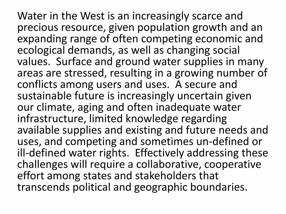
Water in the West is an increasingly scarce and precious resource, given population growth and an expanding range of often competing economic and ecological demands, as well as changing social values. Surface and ground water supplies in many areas are stressed, resulting in a growing number of conflicts among users and uses. A secure and sustainable future is increasingly uncertain given our climate, aging and often inadequate water infrastructure, limited knowledge regarding available supplies and existing and future needs and uses, and competing and sometimes un-defined or ill-defined water rights. Effectively addressing these challenges will require a collaborative, cooperative effort among states and stakeholders that transcends political and geographic boundaries.
• State primacy is fundamental to a sustainable water future. Water planning, policy, development, protection, and management must recognize, defer to, and support state laws, plans, and processes. The federal government should streamline regulatory burdens and support implementation of state water plans and state water management.
• Given the importance of the resource to our public health, economy, food security, and environment, water must be given a high public policy priority at all levels.

• An integrated and collaborative approach to water resources management is critical to the environmentally sound and efficient use of our water resources. States, tribes, and local communities should work together to resolve water issues. A grassroots approach should be utilized in identifying problems and developing optimal solutions.
• Any approach to water resource management and development should accommodate sustainable economic growth, which is enhanced by the protection and restoration of significant aquatic ecosystems, and will promote economic and environmental security and quality of life.

• There must be cooperation among stakeholders at all levels and agencies of government that recognizes and respects national, regional, state, local and tribal differences in values related to water resources and that supports decision-making at the lowest practicable level.


Sustainable Water Resources
Discussions of water sustainability offer most promise when they take place with an understanding of major driving forces like population, income, land use, climate change, and energy use. To help it navigate within such a context, SWRR identified a set of four sustainability principles for water resources management:
Sustainability Principles • The value and limits of water. Water supports all life
and provides great value. While water is abundant, people need to understand and appreciate that it is limited in many regions, that there are environmental and economic costs of depleting or damaging water resources, and that unsustainable water and land use practices pose serious risks to people and ecosystems. The consumption of renewable natural resources is sustainable if it does not exceed the rate of long term renewal and does not impair the health and productivity of ecosystems, communities or the economy.

• Shared responsibility. Water does not respect political boundaries. Sustainable management of water requires consideration of the needs of people and ecosystems up- and down-stream and throughout the hydrologic cycle, and avoiding extreme situations that may deplete water in some regions to provide supplies elsewhere.
• Equitable access. Sustainability suggests fair and equitable access to water, water dependent resources, and related infrastructure. Equitable access requires continuous monitoring to detect and address problems as they occur, and means to correct the problems.

• Stewardship. Meeting today’s water needs sustainably challenges us to continually address the implications of our water resources decisions on future generations and the ecosystems upon which they will rely. We must be prepared to correct policies and decisions if they create adverse unintended consequences.

Conclusions • The states have a primary and critical role in
western water management. • Good decisionmaking and risk management
require sound science and adequate data. • State and federal partnerships are essential. • Sustainable water use in the West will depend in
large part on technological initiative and innovation.
• Landsat TIR represents an important innovation. • The CWP and NSIP are critical programs for
measuring and monitoring streamflows. • Continuing Federal financial support is essential,
but state initiative and spending are critical.

Western State Water Council
Activities
Idaho Water Users Association January 22, 2014
Tony Willardson
Executive Director Western States Water Council

Western States Water Council • Advisor to 18 western
Governors on water policy issues
• Provides collective voice
• Fosters collaboration
• Formal affiliate of the Western Governors’ Association (WGA)

Common State Policy Interest
• Managing Growth • Drought Response • State Water Planning • State Information
Management Systems • Conjunctive Ground
and Surface Water Management
• Water Reuse Statutes • Exempt Wells
• Water Conservation • Water Use Data Exchange • Water Right Adjudications • Water Transfers • State Water Development
and Project Financing • Instream Flow/Estuary
Protections • State Water Quality
Protections

C
1. Growth and Water Policy
2. Meeting Future Water Demands
3. Water Infrastructure Needs and Strategies
4. Resolution of Indian Water Rights Claims
5. Climate Change Impacts
6. ESA & Protecting Aquatic Species

Assistant Secretary of the Army for Energy & Sustainability
Army Corps of Engineers Bureau of Land Management Bureau of Reclamation Environmental Protection Agency National Aeronautics and Space
Administration National Oceanic and Atmospheric Administration Natural Resources Conservation
Service U.S. Fish & Wildlife Service U.S. Forest Service U.S. Geological Survey U.S. Department of Energy

Federal/State Areas of Interest • Drought Response • Water Infrastructure
Development/Safety • Tribal Water Rights • Other Federal Water
Needs (BLM, USFS, FWS)
• International Treaties • Water & Energy Issues • Federal Hydropower
Licensing (small hydro)
• EPA Water Regulations • Point & Nonpoint Sources • Pesticides • Forest Roads • Water Transfers • Waters of the United
States • Corps Surplus Waters • USBR M&I Water Policy • ESA & State Water Rights

Water Policy and Growth Population growth is continuing at an
unprecedented rate in the West with ramifications not only for cities but rural communities and agricultural areas.
Changing demographics and values placed on various water uses are transforming the future of water management.
In the future, we may not be able to sustain unlimited growth and still maintain our current quality of life. Difficult political choices will be necessary….

Competing Uses for Limited Supply Energy
Instream Flows for Recreation and for The Environment
Municipal and Industrial
Agriculture

Water availability and water policy are rarely the determining factors in decisions about where and how to grow. or by the availability of water
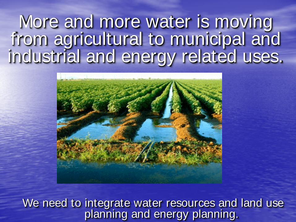
More and more water is moving from agricultural to municipal and industrial and energy related uses.
We need to integrate water resources and land use
planning and energy planning.

-Sandia National Laboratory-
Municipal, 3,181, 3%
Industry, 430, 0%
Thermoelectric, 386, 0%
Mining, 436, 1%
Livestock, 663, 1%
Irrigation, 87,557, 95%
2010 Water Consumption (MGD)

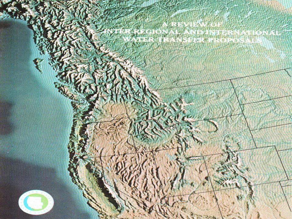
Water Transfers in the West:
Projects, Trends, and Leading Practices in Water Trading

Through the leadership of the Governors, WGA brings together Western states to:
Develop policy and address
important governance issues.
Advance the role of the states regionally and at the national level.
Develop and manage innovative programs related to natural resources, the environment, economic development, international relations and state governance.
The Western Governors’ Association
Western Governors believe states should
identify and promote innovative ways to
allow water transfers from
agricultural to other uses (including
urban, energy and environmental)
while avoiding or mitigating
damages to agricultural economies
and communities. Policy 11-7

Objectives
Share perspectives from state water managers on the role of transfers in the West’s water future.
Analyze state programs and provisions for administering
water transfers.
Examine a number of case studies in which multi-stakeholders have created a successful approach to transfers

Water Transfers
Sale, lease or donation
Voluntary
Intra-state
def.: Water Transfer
A water transfer is a voluntary
agreement that results in a
temporary or permanent change in
the type, time, or place of use of
water and/or a water right.
Water transfers can be local or
distant; they can be a sale, lease, or
donation; and they can move water
among agricultural, municipal,
industrial, energy, and
environmental uses.


Challenges Associated with Water Transfers
Impacts to Other Users
Food Production
Complex Institutions
Environment
Local Economies
Speculation
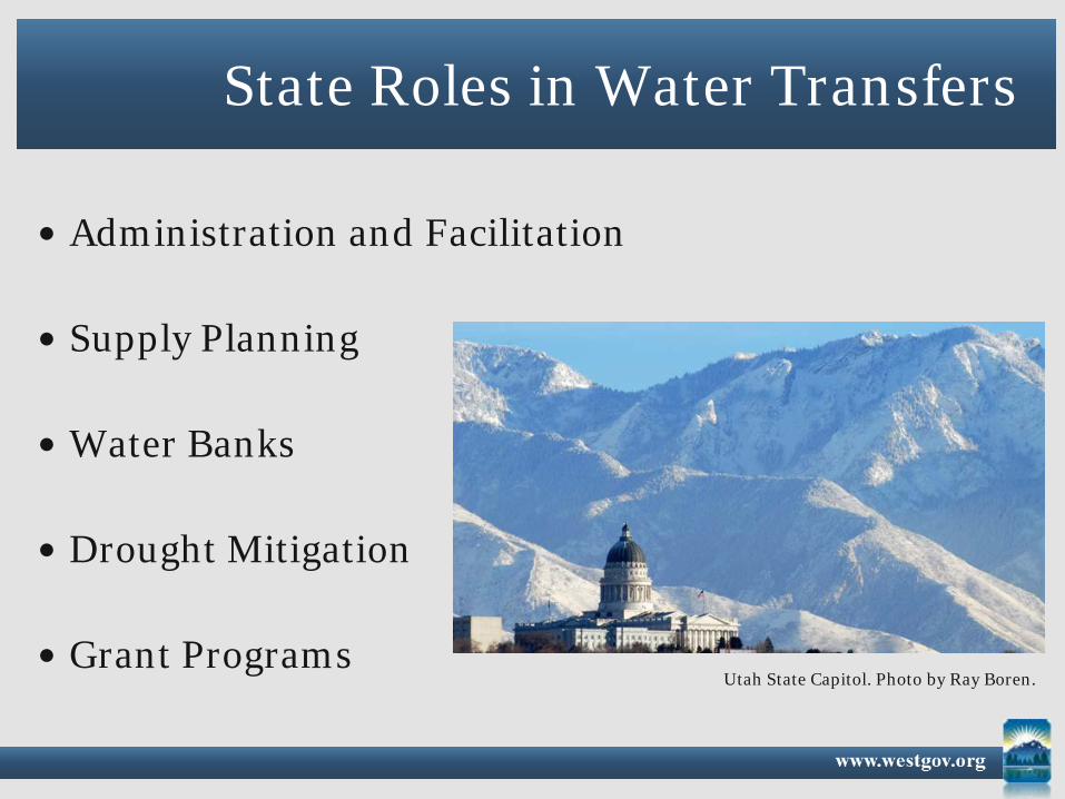
State Roles in Water Transfers
Administration and Facilitation
Supply Planning
Water Banks
Drought Mitigation
Grant Programs Utah State Capitol. Photo by Ray Boren.

State Perspectives
The current and future role of water transfers in the West. Figure by WGA/WSWC.

Barriers to Effective Transfers
Administrative Costs
Conveyance Systems
Consumptive Use (CU) Data
Rights Holder: Information and Experience
Third Party Impacts (Economic and Environmental)
Lack of ATMs: Alternative Transfer Mechanisms

Efficient Administration of Water Transfers
Objective: Streamline the water transfer process while still allowing for the fundamental and essential review to protect other water rights Basics:
1. Define Enforceable Property Rights
2. Provide Clear and Transparent Guidelines
on Water Transfers
3. Accelerate Transfer Review Processes

Major Irrigated areas in Idaho and
areas of METRIC application
Idaho from Landsat
Seasonal ET for SE Idaho
Vegetation, Water and ET are variable in space and
time

http://maps.idwr.idaho.gov/et/

Shortage Sharing and Intentionally
Created Surplus Water
Imperial Valley, CA via Landsat 7


Many effective programs are underway to measure aspects of our water resources. However, simply stated, quantitative knowledge of U.S. water supply is currently inadequate. A Strategy for Federal Science and Technology to Support Water Availability and Quality in the United States September 2007
National Science and Technology Council Subcommittee on Water Availability and Quality
(SWAQ)
The United States: • should accurately assess the quantity and
quality of its water resources; • should accurately measure how water is
used; • should know how water supply and use
change over time; • should measure water resources more
strategically and efficiently.

Priority Water Information Needs
• Gather and disseminate real-time data • Increase support and funding for data • Identify data gaps and ways to close gaps • Foster remote sensing capabilities • Reduce costs through technological
innovation

Atmospheric Rivers


Water Data Exchange (WaDE) What are the Big Picture Goals?
To better enable the states to share
important water data with each other, the public and federal agencies.
To improve the sharing of federal data with the states, to assist their planning
efforts

On a Smaller Scale… 1) Identify the variability between states’ data
management systems 2) Develop a common data schema (common
format for planning data) 3) Demonstrate how the data exchange will
work and its benefits 4) Encourage other partners to share data by adopting standardized formats


HOW DOES IT WORK?
Representational State Transfer (REST) Endpoint http://www.state.u

WHAT WILL IT PROVIDE?
Water Supply Summary: 24,000 acre-feet Regulatory Summary: - Groundwater Management Area - Minimum Instream Flow
Requirements
Water Use Summary: 2,850
acre-feet
Availability Summary: 7,550 acre-feet

REPORT – 2013 – Details Allocation Data - Owner - Beneficial Use - Status - Priority Date Diversions Uses (withdrawal/consumptive) Return Flows
FUTURE STEPS: States plugged
in, streamgauging,
etc. federal data too

WHY IS IT SO IMPORTANT?
With population growth, greater competition, energy security, food security, drought, climate change…
States and Federal agencies, utilities, farmers, journalists, urban planners, politicians, academics… anyone who wants to know more about water…

Tony Willardson, Executive Director Western States Water Council
801-685-2225 [email protected]
www.westernstateswater.org

A VISION ON WATER 1
Adopted by the 2
Western States Water Council 3
on October 7, 2011 4
5
Our Present Condition 6
Water in the West is an increasingly scarce and precious resource, given population growth and 7 an expanding range of often competing economic and ecological demands, as well as changing social 8 values. Surface and ground water supplies in many areas are stressed, resulting in a growing number of 9 conflicts among users and uses. A secure and sustainable future is increasingly uncertain given our 10 climate, aging and often inadequate water infrastructure, limited knowledge regarding available supplies 11 and existing and future needs and uses, and competing and sometimes un-defined or ill-defined water 12 rights. Effectively addressing these challenges will require a collaborative, cooperative effort among 13 states and stakeholders that transcends political and geographic boundaries. 14
Our Vision 15
• State primacy is fundamental to a sustainable water future. Water planning, policy, 16 development, protection, and management must recognize, defer to, and support state laws, 17 plans, and processes. The federal government should streamline regulatory burdens and support 18 implementation of state water plans and state water management. 19
• Given the importance of the resource to our public health, economy, food security, and 20 environment, water must be given a high public policy priority at all levels. 21
• An integrated and collaborative approach to water resources management is critical to the 22 environmentally sound and efficient use of our water resources. States, tribes, and local 23 communities should work together to resolve water issues. A grassroots approach should be 24 utilized in identifying problems and developing optimal solutions. 25
• Any approach to water resource management and development should accommodate sustainable 26 economic growth, which is enhanced by the protection and restoration of significant aquatic 27 ecosystems, and will promote economic and environmental security and quality of life. 28
There must be cooperation among stakeholders at all levels and agencies of government that 29 recognizes and respects national, regional, state, local and tribal differences in values related to water 30 resources and that supports decision-making at the lowest practicable level. 31
C:\USERS\MPEARSON\APPDATA\LOCAL\MICROSOFT\WINDOWS\TEMPORARY INTERNET FILES\CONTENT.OUTLOOK\XLMXU1A0\2011 VISION ON WATER (FINAL) CLEAN COPY.DOC

RAFN Municipal WRs – An Overview Presented by Mathew Weaver
January 23, 2014

Municipal Water Rights
1. Includes all beneficial uses
2. No Volume Limitation
3. Completely consumptive
4. Two Flavors: RAFN and non-RAFN

I.C. §42-202B (5): “Reasonably anticipated future needs” refers to the future uses of water by a municipal provider for municipal purposes within a service area which, on the basis of population and other planning data, are reasonably expected to be required within the planning horizon of each municipality within the service area not inconsistent with comprehensive land use plans approved by each municipality. Reasonably anticipated future needs shall not include uses of water within areas overlapped by conflicting comprehensive land use plans.
What is a RAFN Municipal Water Right?
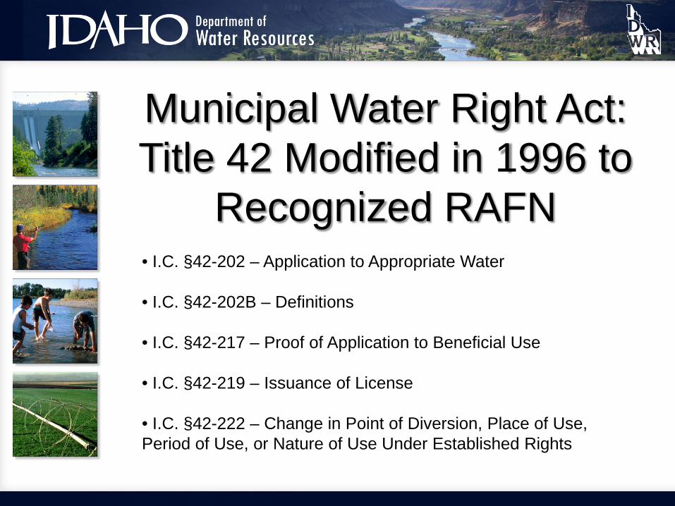
Municipal Water Right Act: Title 42 Modified in 1996 to
Recognized RAFN • I.C. §42-202 – Application to Appropriate Water • I.C. §42-202B – Definitions • I.C. §42-217 – Proof of Application to Beneficial Use • I.C. §42-219 – Issuance of License • I.C. §42-222 – Change in Point of Diversion, Place of Use, Period of Use, or Nature of Use Under Established Rights

RAFN Guidance Material 1. Idaho Code
2.Administrative Rules
3.Administrative Memorandums
a. Application Processing 63 (RAFN) b. Application Processing 18 (non-
RAFN) c. Application Processing 74 (RAFN)

The Unique Thing About RAFNs…

Elements of a RAFN WR 1. Municipal Provider Status
2. Service Area
3. Planning Horizon
4. Population Forecast
5. Future Water Demand

Municipal Provider 1. A municipality1 that provides water for municipal purposes to its
residents and other users within its service area. (e.g. incorporated city)
2. Any corporation or association holding a franchise to supply water for municipal purposes, or a political subdivision of the state of Idaho authorized to supply water for municipal purposes, and which does supply water, for municipal purposes to users within its service area. (e.g. water and sewer districts, United Water Idaho)
3. A corporation or association which supplies water for municipal purposes through a water system regulated by the State of Idaho as a “public water supply” as described in section 39-103(12), Idaho Code. (e.g. Subdivision HOA)
1 “Municipality” means a city incorporated under section 50-102, Idaho Code, a county, or the state of Idaho acting through a department of institution.

Municipal Provider
1 Amended Final Order, In the Matter of Application to Appropriate Water No. 63-32573 in the Name of M3 Eagle LLC, dated January 25, 2010.
Qualification standard for a municipal provided has been ruled upon by the Department. “The interim director interprets the verb [qualifies] to mean that the applicant must be a municipal provider as defined by Idaho Code 42-202B (5) at the time the application is considered by the Department.” 1 Emphasis added.

Service Area "Service area" means that area within which a municipal provider is or becomes entitled or obligated to provide water for municipal purposes. For a municipality, the service area shall correspond to its corporate limits, or other recognized boundaries, including changes therein after the permit or license is issued. The service area for a municipality may also include areas outside its corporate limits, or other recognized boundaries, that are within the municipality's established planning area if the constructed delivery system for the area shares a common water distribution system with lands located within the corporate limits. For a municipal provider that is not a municipality, the service area shall correspond to the area that it is authorized or obligated to serve, including changes therein after the permit or license is issued.

Service Area 1. Correspond to recognized boundaries
2. Agree with comprehensive land use plans
3. Not include overlap
4. Service areas are not static

Planning Horizon 1. Consistency with customary standards of
practice for water infrastructure planning
2. Consistency with the City’s Comprehensive Plan
3. Consistency with planning periods identified by other applicable planning documents adopted by the City
4. Consistency with regional planning studies

Summary of Published Recommended Planning Horizons Published Reference Planning Horizon (years)
Fair 1971 10 - 50 Prasifka 1988 10 - 100 Dzurik 1996 < 50
Boumann 1998 < 50 Stephenson 2003 10 - 20
AWWA 2007 20 - 40 Fair, Gordon M. Elements of Water Supply and Wastewater Disposal. 2nd Edition. New York, U.S.: John Wiley & Sons Inc, 1971. Prasifka, David W. Current Trends in Water-Supply Planning. New York, U.S.: Van Nostrand Reinhold Company, 1988 Dzurik, Andrew A. Water Resources Planning. Maryland, U.S.: Rowman & Littlefield Publishers, Inc., 1996. Boumann, Duane D. et al. Urban Water Management and Planning. United States: McGraw-Hill Companies, 1998. Stephenson, David. Water Resources Management. The Netherlands: Krips the Print Force, 2003. AWWA. Water Resources Planning AWWA Manual M50. 2nd Edition. American Water Works Association, 2007.

Summary of Actual Water Planning Documents and their Respective Adopted Planning Horizon Periods
Municipality Planning Horizon (years) Planning Document Type Ada & Canyon Counties 25 IDWR Water Demand Study
City of Coeur d'Alene 20 Comprehensive Water Plan City of Lewiston 20 Master Water Plan City of Meridian 50 Master Water Plan City of Nampa 20 Master Water Plan
City of Pocatello 10 Master Water Plan City of Rexburg 50 2008 Water System Tech. Memo
City of Twin Falls 30 Water Supply Improvement Plan Rathdrum Prairie Aq. 50 CAMP Water Demand Projections Study
Treasure Valley 50 CAMP Future Water Demand Study United Water Idaho 55 Water Demand Study
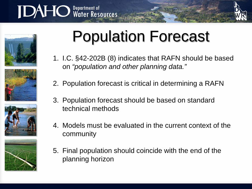
Population Forecast 1. I.C. §42-202B (8) indicates that RAFN should be based
on “population and other planning data.”
2. Population forecast is critical in determining a RAFN
3. Population forecast should be based on standard technical methods
4. Models must be evaluated in the current context of the community
5. Final population should coincide with the end of the planning horizon

Water Demand
1. Consider residential and non-residential water use
2. Per capita requirements method
3. Based on historical water use
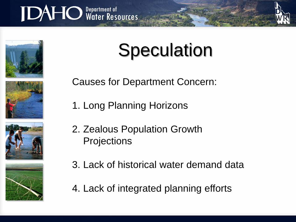
Speculation Causes for Department Concern: 1. Long Planning Horizons
2. Zealous Population Growth
Projections
3. Lack of historical water demand data
4. Lack of integrated planning efforts

Summary of WRs Identifying RAFN Use as of 5/17/2012
WR Number Basis Draft Div. Rate
(CFS) Current Owner 27-7000 Decreed N 0.50 SHOSHONE BANNOCK TRIBES 37-20853 Decreed N 0.13 STATE OF IDAHO 63-33022 License N 4.50 CITY OF NAMPA 95-8996 License N 0.18 HARMONS PROPERTY OWNERS ASSN 95-9009 License N 5.25 ROSS POINT WATER DIST 98-7825 License N 3.80 CITY OF BONNERS FERRY 63-32573 Permit N 23.18 CITY OF EAGLE 63-32644 Permit N 7.31 STAR SEWR & WATER DISTRICT 63-32835 Permit N 5.00 CITY OF NAMPA 65-22357 Permit N 8.60 TAMARACK RESORT LLC 65-23088 Permit N 8.09 CITY OF FRUITLAND 98-7843 Permit N 4.90 THREE MILE WATER DISTRICT
RAFN History: 6 water rights, 6 permits

RAFN Pros & Cons PROS
• Reserve a water right for future needs • Completed construction build out during development period not required • One WR application processes vs. Many
CONS • Detailed planning requirements • Extended Department review & processing timeline •Large target for protests

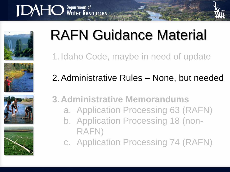
RAFN Guidance Material 1. Idaho Code, in need of update?
2.Administrative Rules – None, but needed
3.Administrative Memorandums
a. Application Processing 63 (RAFN) b. Application Processing 18 (non-RAFN) c. Application Processing 74 (RAFN)

Draft Legislation - 2012 • Department Recognizes Statute Challenges
• Draft Legislation – Department Initiative • Governor’s Office Recommended Working Group
• No Consensus Could be Found • Legislation Dropped • Next Step?

Concerns about Municipal Water Rights Act of 1996
Significant and irreconcilable time differences between when proof of beneficial use is due and the planning
horizon.

Proof Due
• Proof due in 5 years + up to 5-10 year extension
• Difficult to require a full 10-15 years before proof is due
• License is final representation of a water right
• Planning horizon may be 20 – 50 years
• No mechanism to adjust following the issuance of a license
• Development period continues after license issuance
Vs. Planning Horizon

Concerns about Municipal Water Rights Act of 1996
I.C. §42-219 (1)
A license may be issued to a municipal provider for an amount up to the full capacity of the system constructed or used in accordance with the original permit provided that the director determines that the amount is reasonably necessary to provide for the existing uses and reasonably anticipated future needs within the service…

Concerns about Municipal Water Rights Act of 1996
I.C. §42-202B (5): “Reasonably anticipated future needs” refers to the future uses of water by a municipal provider for municipal purposes within a service area which, on the basis of population and other planning data, are reasonably expected to be required within the planning horizon of each municipality within the service area not inconsistent with comprehensive land use plans approved by each municipality. Reasonably anticipated future needs shall not include uses of water within areas overlapped by conflicting comprehensive land use plans.

Concerns about Municipal Water Rights Act of 1996
Who should be considered a municipal provider?
RAFN Guidance Material 1. Idaho Code, maybe in need of update
2.Administrative Rules – None, but needed
3.Administrative Memorandums
a. Application Processing 63 (RAFN) b. Application Processing 18 (non-
RAFN) c. Application Processing 74 (RAFN)

RAFN Guidance Material 1. Idaho Code, maybe in need of update
2.Administrative Rules – None, but needed
3.Administrative Memorandums
a. Application Processing 63 (RAFN) b. Application Processing 18 (non-
RAFN) c. Application Processing 74 (RAFN)
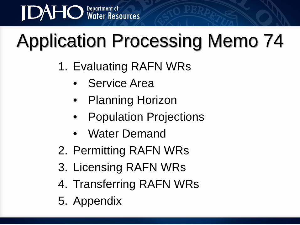
Application Processing Memo 74 1. Evaluating RAFN WRs
• Service Area • Planning Horizon • Population Projections • Water Demand
2. Permitting RAFN WRs 3. Licensing RAFN WRs 4. Transferring RAFN WRs 5. Appendix

Application Processing Memo 74 I.C. §42-219 (1)
A license may be issued to a municipal provider for an amount up to the full capacity of the system constructed or used …
Will Always Include: • Full Capacity Diversion
Works (surface and GW) • Storage facilities • Trunk lines (major supply
conduits)
Does Not Necessarily Include: • Service Laterals (i.e. stub
outs) • Main lines • Water quality treatment for
full capacity • Pumping for full capacity

Questions & Discussions
MEMORANDUM
TO: Regional Offices Water Allocation Bureau
FROM: Mat Weaver
RE: Recommendations for the Processing of Reasonably Anticipated Future Needs (RAFN) Municipal Water Rights at the Time of Application, Licensing, and Transfer
DATE: November 13, 2013
Application Processing No. 74 Permit Processing No. 20 License Processing No. 13 Transfer Processing No. 29
See attached RAFN Municipal Water Right Handbook
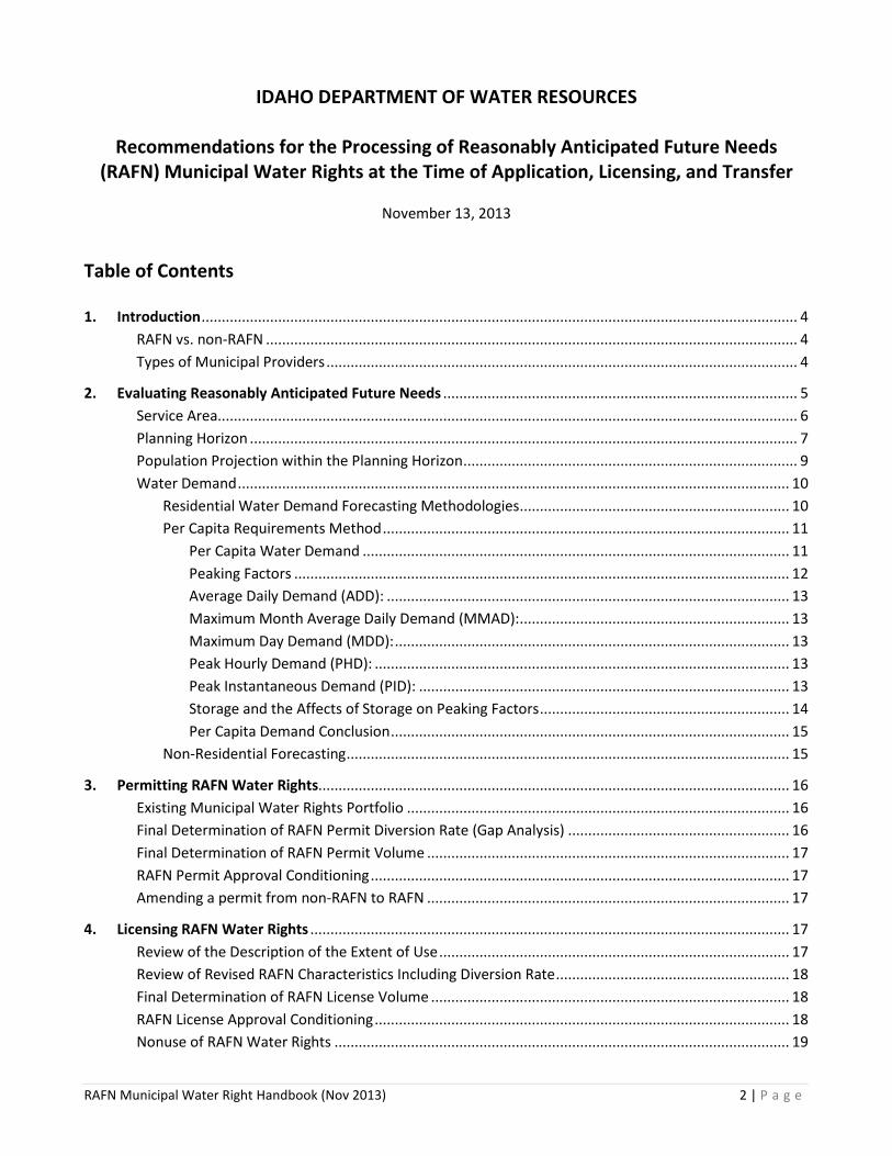
IDAHO DEPARTMENT OF WATER RESOURCES
Recommendations for the Processing of Reasonably Anticipated Future Needs (RAFN) Municipal Water Rights at the Time of Application, Licensing, and Transfer
November 13, 2013
Table of Contents 1. Introduction .................................................................................................................................................... 4
RAFN vs. non-RAFN .................................................................................................................................... 4 Types of Municipal Providers ..................................................................................................................... 4
2. Evaluating Reasonably Anticipated Future Needs ........................................................................................ 5 Service Area................................................................................................................................................ 6 Planning Horizon ........................................................................................................................................ 7 Population Projection within the Planning Horizon ................................................................................... 9 Water Demand ......................................................................................................................................... 10
Residential Water Demand Forecasting Methodologies ................................................................... 10 Per Capita Requirements Method ..................................................................................................... 11
Per Capita Water Demand .......................................................................................................... 11 Peaking Factors ........................................................................................................................... 12 Average Daily Demand (ADD): .................................................................................................... 13 Maximum Month Average Daily Demand (MMAD): ................................................................... 13 Maximum Day Demand (MDD): .................................................................................................. 13 Peak Hourly Demand (PHD): ....................................................................................................... 13 Peak Instantaneous Demand (PID): ............................................................................................ 13 Storage and the Affects of Storage on Peaking Factors .............................................................. 14 Per Capita Demand Conclusion ................................................................................................... 15
Non-Residential Forecasting .............................................................................................................. 15
3. Permitting RAFN Water Rights..................................................................................................................... 16 Existing Municipal Water Rights Portfolio ............................................................................................... 16 Final Determination of RAFN Permit Diversion Rate (Gap Analysis) ....................................................... 16 Final Determination of RAFN Permit Volume .......................................................................................... 17 RAFN Permit Approval Conditioning ........................................................................................................ 17 Amending a permit from non-RAFN to RAFN .......................................................................................... 17
4. Licensing RAFN Water Rights ....................................................................................................................... 17 Review of the Description of the Extent of Use ....................................................................................... 17 Review of Revised RAFN Characteristics Including Diversion Rate .......................................................... 18 Final Determination of RAFN License Volume ......................................................................................... 18 RAFN License Approval Conditioning ....................................................................................................... 18 Nonuse of RAFN Water Rights ................................................................................................................. 19
RAFN Municipal Water Right Handbook (Nov 2013) 2 | P a g e

5. Transfer of RAFN Water Rights .................................................................................................................... 19
Final Determination of RAFN Transfer Volume........................................................................................ 19 RAFN Transfer Approval Conditioning ..................................................................................................... 19
Appendix Item 1. Bibliography – Summary of Reference Citations ..................................................................................... 20 Item 2. Illustrative Example of Delineation of Maximum Allowable RAFN Service Area ..................................... 21 Item 3. Presentation and comparison of DEQ and IDWR methodologies for estimating residential use ........... 22 Item 4. Summary of Average Daily Non-Residential Water Demand Values ....................................................... 25 Item 5. Municipal Water Right Application Checklist ........................................................................................... 27 Item 6. Example Determination of RAFN for a Small Rural Municipality ............................................................. 29
RAFN Municipal Water Right Handbook (Nov 2013) 3 | P a g e

1. Introduction
This document is intended to provide guidance and support to Idaho Department of Water Resources (the Department) staff in evaluating and processing applications for reasonably anticipated future needs (RAFN) water rights and can be used to provide assistance to applicants seeking RAFN water rights throughout the application, permit, license, and transfer processes. Guidance does not have the force and effect of law. Rather, it is designed to serve as a primary reference tool to assist agency staff and to assist those impacted by agency actions to comply with the law. The appendix includes a number of resources and support items related to RAFN analysis including the following: “Municipal Water Right Permit Evaluation” checklist (Item 5), which can be utilized by the applicant when applying for RAFN water rights; methods for estimating residential and non-residential demand (Item 3); and a detailed example of the determination of RAFN for a small community that implements the methodology described in this document (Item 6).
RAFN vs. non-RAFN Prior to 1996, common law practices allowed municipalities to establish water rights greater than immediate needs. The 1996 Municipal Water Rights Act provided a statutory process for reserving a municipal water supply for reasonably anticipated future needs (RAFN). The 1996 Municipal Water Rights act was codified in Idaho Statutes in the form of amendments to Idaho Code (I.C.) §42-202, the addition of I.C. §42-202B, amendments to I.C. §42-217, amendments to I.C. §42-219, and amendments to I.C. §42-222. A key distinction of the RAFN right is the allowance of components of the water right, namely the diversion rate, to be perfected without physically completing diversion and use in establishing beneficial use during the development period of the permit.
There are times when a municipal provider will choose to file an application to appropriate water solely for use to meet needs in the near-term (up to five years) without the burden of demonstrating future needs over an established planning horizon. This type of municipal water right has been termed a non-RAFN municipal right. Municipal water rights that are not defined as RAFN in conditional language are by default non-RAFN water rights. Application Processing Memo #18 presents and discusses the distinctions between both types of municipal water rights and provides guidance to Department staff for processing permits and determining extent of beneficial use for licensing of non-RAFN municipal water right permits. It is not the intent of this document to repeat or duplicate the material presented in AP Memo #18. The focus of this document will be on RAFN municipal water rights. When a water right application has been determined to be for a non-RAFN municipal beneficial use, Department staff should consult AP Memo #18 for processing guidance. In addition to water rights with a designated municipal beneficial use, municipal providers may also own water rights for non-municipal uses such as domestic, irrigation, commercial, etc. These water rights are often associated with uses such as parks, golf courses, cemeteries, and buildings that are not directly connected to a municipal provider’s primary municipal water delivery system. These water rights are sometimes acquired from previous non-municipal water right holders with the acquisition of land by the municipality. In other instances they may have been developed directly by the municipal provider for a demand not distributed throughout the entire water service area, or not otherwise qualified as a municipal use. When conducting a review of a municipal provider’s suite of water rights, these water rights should be considered along with any existing water rights used for municipal needs, and any evaluation of RAFN should take into consideration beneficial use already being met by these types of water rights. Types of Municipal Providers Idaho Code §42-202 provides, in relevant part:
An application proposing an appropriation of water by a municipal provider for reasonably anticipated future needs shall be accompanied by sufficient information and documentation to establish that the
RAFN Municipal Water Right Handbook (Nov 2013) 4 | P a g e

applicant qualifies as a municipal provider and that the reasonably anticipated future needs, the service area and the planning horizon are consistent with the definitions and requirements specified in this chapter.
Idaho Code §42-202B(5) defines three types of municipal providers:
a) A municipality that provides water for municipal purposes (i.e. incorporated cities);
b) Any corporation or association holding a franchise to supply water for municipal purposes, or a political subdivision of the state of Idaho authorized to supply water for municipal purposes, and which does supply water, for municipal purposes to users within its service area (e.g. Water and Sewer Districts; United Water Idaho, a private company that supplies public drinking water to much of Ada County); or
c) A corporation or association which supplies water for municipal purposes through a water system regulated by the state of Idaho as a “public water supply” as described in I.C. § 39-103(12), Idaho Code. (e.g. developers; subdivision home owner associations).
As set forth in M3 Eagle Final Amended Order1 (M3 Final Amended Order) a corporation or association seeking to qualify as a municipal provider under subsection c above for RAFN must qualify as a municipal provider at the time application is considered by the Department. In other words, at the time of application, the applicant must already supply water for municipal purposes through a water system that is regulated by the state of Idaho as a public water supply. It is insufficient for the applicant to merely be “ready, willing, and able” to be a municipal provider once the permit is issued. 2. Evaluating Reasonably Anticipated Future Needs
This section outlines and develops a fundamental protocol that should be considered by the applicant and Department staff in evaluating reasonably anticipated future water needs for qualified municipal providers.
As discussed above, Idaho law allows a municipal provider to secure water rights for RAFN purposes without relying on immediate diversion and use to establish beneficial use. For a qualified municipal provider, a RAFN estimate has four fundamental components:
1. Service Area (I.C. §42-202B (9)), 2. Planning Horizon (I.C. §42-202B (7)), 3. Population Projections within the Planning Horizon, and 4. Water Demand (necessary to serve the population during the planning horizon throughout the
service area) This protocol explains each one of these four components in order, and then describes how they should be used to evaluate a municipal provider’s RAFN. It is important to recognize at the outset that a conservative standard may be appropriate in estimating future needs to justify a RAFN water right. There may be a difference between the supply of water sufficient to sustain an urban population and the supply desirable to keep costs low or to provide aesthetic amenities. A determination by the Department that a given projected use is not a reasonable component of an RAFN water right would not mean that the use could not be pursued under the statutory appropriation process for non-RAFN water rights.
1 Amended Final Order of the Department in the matter of application to appropriate water no. 63-32573 In the name of M3 Eagle LLC dated January 25, 2010.
RAFN Municipal Water Right Handbook (Nov 2013) 5 | P a g e

Service Area Idaho Code §42-202B (9) defines the service area for a municipality as follows:
"Service area" means that area within which a municipal provider is or becomes entitled or obligated to provide water for municipal purposes. For a municipality, the service area shall correspond to its corporate limits, or other recognized boundaries, including changes therein, after the permit or license is issued. The service area for a municipality may also include areas outside its corporate limits, or other recognized boundaries, that are within the municipality’s established planning area if the constructed delivery system for the area shares a common water distribution system with lands located within the corporate limits. For a municipal provider that is not a municipality, the service area shall correspond to the area that it is authorized or obligated to serve, including changes therein after the permit or license is issued.
For a municipal provider Idaho code requires the RAFN service area to be contained within the municipality’s “established planning area” (I.C. §42-202B (9)) minus “areas overlapped by conflicting comprehensive land use plans” (I.C. §42-202B (8)). For smaller widely separated communities the concern of overlapping comprehensive land use plans is not typically an issue. For these communities to justify a proposed future service area, the applicant should provide evidence of existing “corporate limits” and “other recognized boundaries” (I.C. §42-202B (9)). Idaho Code §50-102 requires the establishment of corporate limits (recorded metes and bounds description of the incorporated area) in association with the incorporation of a community. These limits are established with the counties within which the city is located. Copies of corporate limits should be provided by the applicant. As necessary, staff can cross check corporate limits by obtaining the boundary directly from the city, governing counties, or the state. In addition, the Department maintains a spatial data layer delineating all incorporated cities and their respective city limits within the State of Idaho. This data layer is based on U.S. Census data that is updated every ten years. This data layer can be a good place to start in determining corporate limits, but there is a chance it may not represent the most current boundary, and staff should always obtain a current delineation of the corporate limits from the RAFN applicant or permit holder at the time of permitting and licensing. Other recognized boundaries can include areas of impact, utility service planning areas, or other unique planning areas, provided they have been legitimately adopted by the city with verifiable records, as “established planning area[s]” consistent with I.C. §42-202B (9). Idaho Code §67-6526 in the Local Land Use Planning statutes requires that incorporated cities provide a map “identifying an area of city impact within the unincorporated area of the county”. In addition, I.C. §67-6508 requires the creation, adoption, and ongoing update of a comprehensive plan for any incorporated city. The comprehensive plan will typically include maps identifying incorporated limits, areas of city impact, and other legitimate planning boundaries. For types b and c municipal providers, the applicant may submit an approved preliminary plat or other approved planning type documents, Public Utility Commission approval documents, or the Idaho Department of Environmental Quality public drinking water system approval documents as evidence supporting the proposed delineation of a RAFN service area. Idaho Code §42-202B (8) states, “Reasonably anticipated future needs shall not include uses of water within areas overlapped by conflicting comprehensive land use plans.” When evaluating a proposed RAFN service area where two or more municipal providers abut one another, the applicant should research adjacent community planning areas to confirm that overlaps in competing planning areas specific to water service do
RAFN Municipal Water Right Handbook (Nov 2013) 6 | P a g e

not exist. If overlaps in comprehensive land use planning areas specific to water service do exist between two different municipal providers, the area of overlap cannot be included in the proposed RAFN service area under consideration. As an example, if a subdivision intersects the planning boundaries of two separate municipal providers, and both entities indicate in their comprehensive land use plans the intent to serve the same subdivision with water, then neither entity can include the subdivision in its water service area until the conflict has been resolved and one of the two entities relinquishes water service to the other. However, in another example, if an overlap exists in the comprehensive land use plans of two municipal providers, but only one plan addresses water service, and the other plan acknowledges that water service is provided by the other entity, then the area of overlap can be included in the service area of the entity providing water service. When the applicant is a municipality with multiple municipal water service providers within its city limits or area of impact, the applicant should normally exclude the service areas of other municipal providers from the RAFN service area under consideration. However, if the RAFN applicant presents a sound argument and supporting evidence for the inclusion of competing water service areas within its own service area, Department staff may include them in the final service area delineation. As an example, if the systems of two water service providers are cross connected to allow for one system to provide water to the other during times of emergency, during periods of routine maintenance, or in support of peak water demands, it would be appropriate to include this demand in the RAFN analysis of the municipality that is providing water to the second water service provider, provided the established need is not already covered by and existing water right. If the established need is covered by an existing water right, a unique combined used limitation condition detailing the water supply relationship should be considered. In conclusion, RAFN service areas should be delimited to include all existing contiguous and non-contiguous areas of water service (assuming they are combined) and adjacent areas poised for development and likely to occur within the established planning horizon time period. However, the proposed RAFN service area cannot include areas where water is not provided at the time of application if the proposed service area is outside currently adopted planning boundaries, is overlapped by adjacent land use planning boundaries, or is already included within the service area of a municipal water provider other than the municipal provider under consideration. The appendix includes an example of a visual delineation of a RAFN service area based on underlying appurtenant boundaries (appendix Item 2). Planning Horizon Idaho Code §42-202B (7) defines the planning horizon for a municipal provider as follows:
“Planning horizon” refers to the length of time that the department determines is reasonable for a municipal provider to hold water rights to meet reasonably anticipated future needs. The length of the planning horizon may vary according to the needs of the particular municipal provider.
A municipal provider’s planning horizon is the term of years over which it projects its population change and makes water service decisions based on its projection. At the time of application for RAFN municipal water use, the applicant will present a planning horizon time period. In most circumstances, the year in which the permit is issued shall be considered year one of the planning horizon. Department staff must evaluate, among other things, whether the proposed planning horizon is reasonable. Some items to consider include:
• The customary standards of practice for water infrastructure planning • The planning period identified in the City’s Comprehensive Plan • Planning periods identified by other applicable planning documents adopted by the City • Regional planning studies
RAFN Municipal Water Right Handbook (Nov 2013) 7 | P a g e

It is important to note that the maximum development period for beneficial use associated with a non-RAFN water right is five years, which can be extended an additional five to ten years for a total of ten to fifteen years. Therefore, a planning horizon of less than five years would not warrant a RAFN water right. The following table (Table 1) summarizes planning horizon durations as published in six water planning references. Table 1 - Summary of Published Planning Horizon Periods
Published Reference* Planning Horizon (years) Fair 1971 10 - 50
Prasifka 1988 10 - 100 Dzurik 1996 < 50
Boumann 1998 < 50 Stephenson 2003 10 - 20
AWWA 2007 20 - 40 *Refer to Bibliography (Appendix Item 1) for reference details.
Table 2 summarizes planning horizons associated with actual water resource planning documents in the State of Idaho. The references summarized in Table 2 represent a variety of planning documents with unique objectives and planning areas. Some of the values are more applicable than others for use in comparison to proposed RAFN planning periods. Table 2 - Summary of Actual Water Planning Documents and their Respective Adopted Planning Horizon Periods
Planning Area Planning Horizon (years) Planning Document Type Ada & Canyon Counties 25 IDWR Water Demand Study
City of Coeur d'Alene 20 Comprehensive Water Plan City of Lewiston 20 Master Water Plan City of Meridian 50 Master Water Plan City of Nampa 20 Master Water Plan
City of Pocatello 10 Master Water Plan City of Rexburg 50 2008 Water System Tech. Memo
City of Twin Falls 30 Water Supply Improvement Plan Rathdrum Prairie Aq. 50 CAMP Water Demand Projections Study
Treasure Valley 50 CAMP Future Water Demand Study United Water Idaho 55 Water Demand Study
The data presented in Tables 1 and 2 suggest that planning horizons between 10 and 55 years are the standard amongst the planning profession and in the actual adoption of planning documents within the State of Idaho. The Department must guard against over-appropriation of the resource and against speculative water right filings. Longer planning horizons increase the level of uncertainty associated with predicted values and must be considered by the Department with greater caution. Planning horizons of 15-20 years are generally reasonable and require little scrutiny unless there is substantiated competition for the resource or some other justification for additional scrutiny arises. Planning horizons greater than 20 years can be considered by the Department, but when proposed they should be supported by long-term planning documents such as those listed in Table 2 and by professionally prepared demographic studies substantiating the duration of the planning horizon period. Idaho Code §42-202B (8) provides additional guidance regarding the evaluation of planning horizons as follows:
RAFN Municipal Water Right Handbook (Nov 2013) 8 | P a g e

“Reasonably anticipated future needs” refers to future uses of water…reasonably expected to be required within the planning horizon of each municipality within the service area not inconsistent with comprehensive land use plans approved by each municipality.
As a final measure, the planning horizon period proposed by the applicant must not only be reasonable, but also consistent with the adopted Comprehensive Plan of the City. This can be interpreted to mean no greater in length than the planning horizon period associated with the Comprehensive Plan if no other pertinent planning documents exist. When another pertinent planning document exists, such as a master water plan, then the planning document should be consistent with the master plan for the coincident period of time shared between the planning horizons of both documents. Population Projection within the Planning Horizon2 Idaho Code §42-202B (8) indicates that RAFN should be based on “population and other planning data.” To establish its RAFN, a municipal provider must estimate its future population within its service area at the end of the planning horizon. For most municipalities, planning and demographic studies of one type or another have been completed, and often multiple relevant studies exist. At a minimum, Comprehensive Plans usually address population growth in some form as required by I.C. §67-6508 (b). The U.S. Census Bureau also provides population and demographic data for most municipalities in Idaho in a variety of formats. For communities where appropriate data exists, Department staff should expect the following components and considerations regarding population forecasts to be addressed and discussed in detail by the applicant.
1. A critical survey of existing contemporary population studies applicable to the local area to establish likely upper and lower boundaries for population growth.
2. Project population using standard technical methods, such as regression, extrapolation, or cohort survival models. To make extrapolation appropriate, one should account for geography, resource constraints, economic conditions, and other limiting factors or anticipated events, such as relocation of a commercial or industrial use.
3. Compare the results of the population projections from step 2 to the results of the critical survey from step 1 and apply professional judgment to evaluate whether the population projections are likely to occur within the planning horizon and are, therefore, reasonable.
Department staff should scrutinize population growth rates and projections that fall near or outside the upper boundary established in the critical survey. Staff should also scrutinize results based on short term trends in population growth. Where sufficient data exists population forecasts should be based on a minimum of thirty years of population data. The U.S. Census Bureau provides decadal populations for every county in Idaho. Since 1970 the population growth rate of the entire state of Idaho has been 1.91%. The maximum growth rate in that time was 3.72% in Teton County and the minimum growth rate was -1.20% in Shoshone County. Since 1970, growth rates in excess of 3.00% were only realized in five counties. Growth rates in excess of 2.50% were realized by less than 14% of Idaho counties. As such, applicants should provide extra justification for requested growth rates in excess of 2.50% annually. In some instances when municipal providers are providing water to a rural or unincorporated community, existing population data specific to the community might be difficult to acquire or may simply not exist. In other instances the applicant may lack sufficient experience and/or expertise to forecast populations without assistance. In these select cases, the applicant may rely on a population forecasting tool that has been developed by the Department in Microsoft Excel to assist in population forecasting3. The tool summarizes
2 The ‘Population Projection within the Planning Horizon’ section of the RAFN handbook was prepared in conjunction with and under the review of Don Reading, Ph.D., a consulting economist with Ben Johnson Associates, Inc. 3 The Microsoft Excel file is titled “PopForecastTool.xlsx” and is available to the applicant from the Department upon request.
RAFN Municipal Water Right Handbook (Nov 2013) 9 | P a g e

dynamic ranges of U.S. Census Bureau population data by county and supports the regression of exponential and linear growth type models to the county census data to allow for the projection or forecasting of future populations. In addition, the spreadsheet tool allows for the development of exponential and linear population growth rate models based on user input population data. Forecasting conducted with this tool is only appropriate as a means of last resort and should not be used for communities where specific data and/or population and demographic studies already exist. The tool may also be useful directly to Department staff as a means of roughly verifying the population forecasts made by an applicant, allowing Department staff the opportunity to “double check” a proposed growth rate or population forecast. For communities starting from a very small base population, the method of relying on historical or analogous growth rates may not be applicable. In these instances, reliable growth or build-out projections provided by the applicant may be considered by the Department. Water Demand Water demand is the final component of a RAFN that must be considered and evaluated by Department staff. Water demand represents the future projected water use in a community. Water use can broadly be placed into two categories: (1) residential use and (2) non-residential use. Residential use can be further broken down into in-home use, out of home use (landscape irrigation, car washing, etc), and fire protection. Non-residential use consists of irrigation of open common spaces (parks, golf courses, etc.), public facility use, industrial use, commercial use, and any and all other municipal uses. Unaccounted for water (UAW) makes up a third category of water. UAW is considered the difference between a water utility’s production and its water sales to consumers. Often municipal water providers authorize some types of UAW, including unmetered uses from fire hydrants, street washing, main flushing, sewer cleaning, and storm drain flushing, authorized unmetered connections, and reservoir seepage and evaporation. Examples of unauthorized UAW include water distribution system leakage, unauthorized use by theft, abandoned services, and inaccurate or incorrectly read meters. For typical public water supply systems some engineering references estimate a minimum of 2.0% UAW can be anticipated (Prasifka 1988). United Water Idaho maintains monthly accounting of non-revenue water with values typically reported between 3.0-5.0% (Carr 2009). California Department of Water Resources’ Urban Water Use in California Bulletin 166-3 reports that the largest percentage of cooperating agencies reported approximately 10.0% UAW in their water supply systems (CDWR 1994). UAW values greater than 5% should include a technical engineering discussion and historical diversion records supporting greater values. Residential Water Demand Forecasting Methodologies There are a number of standard recognized approaches for forecasting residential water demand (i.e. RAFN) including judgment based prediction, time extrapolation, disaggregate requirements analysis, single coefficient model development, multi-coefficient model development, econometric demand model development, or a hybrid of one or more of these approaches. Of these approaches, judgment based predictions or water demand based on time extrapolation forecasts are generally viewed as inadequate forecast approaches. Judgment based predictions are simply forecasts of water demand based on the recommendation of an “expert” familiar with the system, who in theory has an “intuitive” feel for water demand specific to the municipal system through prolonged experience with the system. Time extrapolation relies on the prediction of water demand where the only predicting variable is time. For example, 100,000 GPD were needed in the first 10 years, 200,000 GPD were needed in the second 10 year period, therefore 300,000 GPD will be needed in the third 10 year period. Both of these forecasting techniques lack a technical rigor that is appropriate and necessary when evaluating RAFN water right applications. Of the remaining methods, one of the most widely implemented approaches, and the one that is presented in detail in this document, is the per capita requirements method, which is a form of the single coefficient model
RAFN Municipal Water Right Handbook (Nov 2013) 10 | P a g e

approach. To determine RAFN utilizing this method projected per capita or per household water demand must be applied to the estimated future population within the service area at the end of the planning horizon. Per Capita Requirements Method Municipal water demand is often considered a function of population and per-capita consumption4 (Prasifika 1988). The per capita requirements method relies on the following components to estimate future water demand: (1) projected future number of people or residential services, (1a) if necessary a conversion factor between people and residences5, (2) average historical water use per capita, and (3) peaking factor(s). A combined future water demand is equal to the product of historical per capita demand, the total number of people or connections, and an appropriate peaking factor. Per Capita Water Demand
Per-capita water consumption is highly variable from region to region and even from one system to another within the same region. Factors that affect per capita water consumption include metering, lot size, climate, age of system, residential irrigation demand, fire protection demand, water rate structure6, and physical characteristics of the system. Table 3 summarizes various published values for estimating per capita consumption. Table 3 - Summary of Published Values of
Average Residential Daily Consumption
Published Reference*
Avg. Daily Consumption per
Person (GPD)
Avg. Daily Consumption per
Home (GPD) Linaweaver 1967 100 400
Fair 1971 100 – 150 -- Stephenson 2003 50 – 80 150 - 800 Boumann 1998 -- 200
Cook 2001 -- 194 *Refer to Bibliography (Appendix Item 1) for reference details. Residential irrigation can have a dramatic effect on per capita water demand. By some estimates water demand to meet peak residential irrigation needs can be 700% of average daily water demand without irrigation (Linaweaver 1967). Many municipal systems provide residential irrigation. However, a growing number of communities and municipalities do not support residential irrigation or have a separate utility specific to irrigation. It is important when evaluating the reasonableness of water demand values to know for certain whether residential irrigation is included in the demand.
4Strictly speaking the “per capita” metric refers to water use per individual person per unit time. The strict and rigorous use of this “per capita” definition is not always in evidence by water right applicants. Oftentimes municipalities do not know specifically how many people are served and thus employ the potentially more useful “per dwelling unit” metric. The terms “single family residence”, “single family service connection”, “single family dwelling unit” and “equivalent residential unit” can be synonymous with the term dwelling unit. An essential detail of the RAFN application should be the strict definition of the base water demand metric employed by the municipality. 5Population forecasts always predict a future population, depending on whether the city is forecasting water demand by person or by service connection the applicant will need to know the number of people per home in order to convert forecast population values into forecast service connections. The U.S. Census Bureau provides data on “persons per household” in their State and County QuickFacts data sets. 6 Water rate structures are the frame work in which municipal water providers set the prices for their retail water sales. Examples include flat rate and increasing block rate structures. In a flat rate structure the water user is charged a flat rate regardless of how much water is used. In an increasing block rate structure the unit price for water increases as the volume consumed increases, with prices being set for each block of water use. An increasing block rate structure is much more likely to communicate the value of water and encourage the efficient use of water amongst the users.
RAFN Municipal Water Right Handbook (Nov 2013) 11 | P a g e

Whenever possible, design flows for community water systems (municipal, community, or residential subdivisions) should be based on historical records or studies of similar water use in the area to be served—ideally historical records within the same system will be used. For established municipalities, historical records should be the primary means of evaluating and determining per capita requirements. When a wealth of historical records are available to draw upon, the applicant should rely on the most contemporary values, as they are most likely to reflect future water usage practices. Frequently, recent data reflect lower per capita usage than older data. This decreasing trend evident in many Idaho communities is consistent with national trends over the past three decades and is primarily due to a declining number of residents per household and an increasing pervasiveness of water-conserving (low flow) appliances in the home.7 It is not always possible, especially for newer communities, to estimate design flow from historical records as described above. On a case by case basis, the Department can accept calculated estimates for individual systems. There are several “per capita” estimation methods outlining practices and guidelines for estimating domestic design flows currently supported by the Idaho Department of Environmental Quality and the Department. Item 3 of the appendix includes a discussion and comparison of the various methodologies. Item 3 also describes and recommends a method than can be relied upon by the applicant to estimate demand as a last resort when actual historical data does not exist. It is worth emphasizing that the preference in determining per capita demand is always given to actual historical records and that it is only in rare instances that relying upon an artificial means of estimating water demand by the methodology presented in appendix Item 4 is appropriate. Peaking Factors In the long term, water demand requirements can vary widely, increasing and decreasing in direct correlation with changes to the population base that is served. Wide variation in water demand occurs in the short term as well. Based upon the transient needs of a static population base, water demand will vary seasonally, daily, and hourly. For example, water demand may be greater during the irrigation season as opposed to the non-irrigation season. Daily in-home demand also increases during times of high use at the start and end of the workday, with daily lows occurring during the middle of the night and early morning. These fluctuations in demand are normally estimated in terms of peaking factors or multipliers, which are often expressed as a percent of average demand. In general, distribution systems are traditionally designed to carry peak hour flows that typically amount to 200-300 percent of the average day demand, with higher rates usually associated with smaller systems (Robinson and Blair 1984).
When discussing peaking factors, it is important to distinguish between average daily demand (ADD), maximum day demand (MDD), maximum monthly average day demand (MMAD), peak hourly demand (PHD), and peak instantaneous demand (PID). All or some of these terms will often be used in the discussion of a municipal water supply system and as they are used by the Department these terms are defined below. Table 4 summarizes several published ranges of values for residential peaking factors.
7 A recent study has found that in identical households the average residential demand in North America has decreased by a total of 11,678 gallons annually since 1978 (0.5% decrease annually or 13.6% decrease compounded over 30 years). Contributing factors considered by the study included climate change, changes in water user classification systems, changes in income, changing demographics, and new water-conservation appliances. The study found that changes in demographics and new water-conservation appliances had the greatest statistically relevant contribution to decreasing water use per household (Rockaway 2011).
RAFN Municipal Water Right Handbook (Nov 2013) 12 | P a g e

Table 4: Summary of Published Peaking Factor Values Published Reference* MDD: ADD PHD: ADD
Dewberry 2002 1.5 - 3.0: 1 2.25 - 4.50: 1 Fair 1971 1.5 - 3.5: 1 1.5 - 3.5: 1
Harberg 1997 1.4 - 1.7: 1 2.0 - 4.0: 1 Linaweaver 1967 2.0: 1 5.0 - 7.0: 1 Lindeburg 1999 1.5 - 1.8: 1 2.0 - 3.0: 1
Mays 2000 1.5 - 3.5: 1 2.0 - 7.0: 1 *Refer to Bibliography (Appendix Item 1) for reference details.
Average Daily Demand (ADD): The average daily demand is the average of the daily volumes for a continuous 12 month design period expressed as a volume per unit time (typically gallons per day). Often municipal records will only contain monthly or yearly diversion values. In these instances average daily demand for the system is equal to annual diversion volume or the sum of the monthly diversion volumes for one year divided by the number of days in the year. Maximum Month Average Daily Demand (MMAD): The maximum monthly average daily demand is the average daily demand from the peak demand month, which is typically July or August when out of home residential water use is at its peak. This value can only be calculated when municipal records contain monthly diversion data. It is obtained by dividing the monthly diversion volume by the number of days in the month, for each month, and selecting the largest monthly value. Maximum Day Demand (MDD): The design maximum day flow is the largest volume of flow to be received during a continuous 24 hour period in a calendar year, expressed as a volume per unit time. In order to determine this value, diversion records must have a daily recording interval. Often daily records are not available. In these instances MDD values can be estimated by multiplying ADD or MMAD values by an appropriate peaking factor. If storage is used by the water provider to meet peak demands, then the MDD value represents the maximum diversion rate that should be authorized by the RAFN water right permit. Peak Hourly Demand (PHD): The design peak hourly flow is the largest volume of flow to be received during a one hour period expressed as a volume per unit time. In order to determine this value, diversion records must have an hourly recording interval. Municipal data with an hourly recording interval usually does not exist for the entire water system and may only exist for a representative sample of the service area for the specific requirement of determining peaking factors. In instances where hourly data does not exist at all, an alternative means of estimating the peaking factor must be employed. If storage is not used by the water provider, then the PHD value represents the maximum diversion rate that should be authorized by the RAFN water right permit. Peak Instantaneous Demand (PID): The peak instantaneous demand is a municipal water supply system’s anticipated maximum instantaneous water flow. PID is typically met through a combination of direct diversion from surface water and/or wells and the release of storage water. PID should not be confused with the maximum diversion capacity of some or all points of diversion associated with a municipal water supply system (flow into the system), which is an altogether different value that has historically been used by the Department during field examinations as a quantification of beneficial use. In municipal systems PID usually exceeds diversion capacity, with storage releases making up the difference. The PID design
RAFN Municipal Water Right Handbook (Nov 2013) 13 | P a g e

value can be appropriate in the sizing of water mains, storage capacity, and other appurtenances associated with a municipal water supply system, but it is not typically recognized in the field of water supply planning and forecasting as an appropriate design standard for projecting future system demand. As such, the use of PID in establishing a diversion rate in association with a RAFN application is generally considered unsound and unlikely to be approved by the Department. This position is consistent with the Idaho Rules for Public Drinking Water Systems, which require that public drinking water system be designed to provide either PHD or the MDD plus equalization storage (IDAPA 58.01.08 501.03). Ideally, an engineering report or comprehensive plan should be submitted to the Department, which includes the records, studies, and considerations used in arriving at design flows, including all relevant peaking factors. In the absence of historical data or studies, the peaking factor(s) used to determine the diversion rate of the RAFN permit could be estimated from an analogous system. To be considered analogous, water systems should have similar characteristics including demographics, housing sizes, lot sizes, climate, water rate structure, conservation practices, use restrictions, and soils and landscaping. If neither historical data nor an analogous system can be found to estimate peaking factors, then the default peaking factors summarized in Table 5 may be used by the applicant.
Table 5 - Department Standard Default Peaking Factors (PF)
Ratio PF MDD:ADD 2.0
MDD:MMAD 1.3 PHD:ADD 3.0
As an example on how to use the peaking factors in Table 5, if the applicant has a known ADD value, the MDD value can be determined by multiplying the ADD value by two. For peaking factors greater than described in Table 5, the applicant will need to provide a technical engineering discussion supporting the numbers. It is insufficient for an applicant to simply reference a published value or claim a value as a standard of engineering practice in defense of values greater than those presented in Table 5. Storage and the Affects of Storage on Peaking Factors Municipal water systems can apply a number of strategies to meet the system’s peak demand. Some municipalities rely exclusively on the source (surface water diversions and/or wells and booster pumps) to meet peak demand, while other municipalities may rely on a combination of source and storage facilities to meet peak demand. Storage is a component of a municipal system consisting of tanks and reservoirs that physically store water to provide water pressure, equalize pumping rates, equalize supply and demand during periods of high consumption, and provide water for fire fighting and other emergencies during periods of power outages8. In some places, authorities overseeing water system design mandate that storage be included in a water supply system and that peak demands be met partially by storage. As an example, the Washington State Department of Health requires that demands in excess of the MDD (i.e. PHD and PID) be met by storage (WSDOH 2009). In Idaho, the Idaho Department of Environmental Quality (DEQ) requires storage if source capacity is less than PHD, in these instances storage is required such that the difference between source demand and
8 The storage being discussed should not to be confused with a seasonal storage component of a water right, which is water stored for use at some time in the future and is described on the water right as storage.
RAFN Municipal Water Right Handbook (Nov 2013) 14 | P a g e

PHD is made up by equalization storage9. Some references consider it poor engineering practice for a public drinking water system to provide no storage capacity whatsoever (Lindeburg 1999).
It is important for the Department to identify to what extent storage will be utilized by a municipality to meet demand. The diversion rate associated with a RAFN should reflect whether source alone will meet PHD or whether a combination of source and storage will meet PHD.
Per Capita Demand Conclusion In conclusion, the following steps can be used to forecast the residential water demand utilizing the per capita demand forecasting approach:
1. Establish the ADD per capita water demand unit (person or residence) and quantity, preferably from historical diversion records.
2. Select the design demand value, typically PHD when source alone will meet the demand or MDD when a combination of source and storage will meet demand.
3. Multiply the ADD by the appropriate peaking factor to establish the per capita water demand design value.
4. Establish the projected future total population. 5. If needed divide the population projection by the “persons per home” value to arrive at the
total number of residences to be served. 6. Multiply the total number of people or residences by the per capita water demand design
value to determine the total system-wide residential demand. 7. Apply necessary unit conversions to obtain the permitted rate units of cubic feet per second
(CFS) Non-Residential Forecasting For many municipal systems residential water demand makes up the vast majority of total demand. As such, many water supply systems, especially smaller systems, are designed mostly to serve single family residences. If non-residential water is identified as being a significant portion of total demand it can be taken into consideration when establishing RAFN. Described below are two methods for estimating this demand. The first method utilizes the concept of an equivalent residential unit (ERU). An ERU is a unit of measure used to represent the amount of water consumed by a typical full-time single-family residence (WSDOH 2009). ERUs are synonymous with equivalent domestic units (EDU) as defined by the Idaho Department of Environmental Quality (IDAPA 58.01.08 033.42). ERUs can be used to equate non-residential uses and/or multi-family residential uses to the amount used by a single-family residence. ERUs associated with all non-residential uses are determined and added to the ERU count derived from actual single-family residences to arrive at a total demand. The disaggregate requirements forecasting technique is another common approach to estimating non-residential water demand. In disaggregate forecasting the water user identifies the demand of water associated with any non-residential uses such as irrigation, commercial facilities, industrial facilities, public facilities, recreation uses, etc. and sums them to arrive at a total non-residential water use demand. Historical records are often the best source, and the source preferred by the Department, for estimating the demand associated with non-residential uses. A qualified analogous system can be another recognized source of information for estimating disaggregate water demands.
9 Design File Note: Reservoir Sizing – Public Water Systems (April 30, 1998) states, “The source capacity of a water supply must at least equal [MDD]…If the source capacity is equal to or greater [than] [PHD], then no storage is needed other than pressure tanks to prevent frequent cycling. If the source capacity lies between [MDD] and [PHD], then storage is required as defined in this Guidance.”
RAFN Municipal Water Right Handbook (Nov 2013) 15 | P a g e

A tabular summary of average daily demands for a variety of disaggregate uses (Table 6) is presented in Appendix Item 4. Table 6 has been adapted from a number of sources and does not represent the final authority on the water demand values presented. It should be noted that the values in Table 6 are average daily values. It may be necessary to apply a peaking factor or multiplier to the values to obtain a MDD or PHD equivalent value. Other sources of disaggregated water demand values that may provide additional guidance include individual engineering references, individual water demand studies, the Uniform Plumbing Code, the American Water Works Association, and the Idaho Department of Environmental Quality. When properly referenced and applied, all of the sources previously described can be used if historical or analogous data are missing. Regarding RAFN demand for the irrigation of lawns within community open spaces, parks, golf courses, cemeteries, etc., and the evaporative loss of water associated with decorative and aesthetic ponds, demand can be established by the appropriate evapotranspiration (ET) values as published by ET_Idaho (Allen and Robison 2009). In recognition of the contribution of precipitation to irrigation requirement it is appropriate to use the precipitation deficit (Pdef) values in place of actual ET (ETact). Appropriate values would include utilizing data from the nearest ET_Idaho station and as available, using the categories of “Precipitation Deficit (Grass – Turf (lawns) – Irrigated)” for Pdef associated with lawns and grass and “Precipitation Deficit (Open water-shallow systems (ponds, streams))” for Pdef associated with municipal ponds and water features. When estimating diversion rates associated with Pdef it is appropriate to use the 20% exceedance (80th percentile) 3-day moving average rate from the month with the largest ET rates. In light of the conservative methods allowed in determining Pdef, quantification of the demand associated with ET loss from lawns and open water bodies should not include the use of peaking factors or multipliers. 3. Permitting RAFN Water Rights
For an application for RAFN to be accepted by the Department it must include a current application correctly and completely filled out, a municipal water right application checklist10 completely filled out, the appropriate fees, and a detailed narrative or report summarizing the methods used to determine RAFN. The report must specifically address the four fundamental components of RAFN as identified in section 2 of this document. Lastly, the application package must contain a summary of the applicant’s existing municipal water rights portfolio and some form of gap analysis11. Existing Municipal Water Rights Portfolio In order for an applicant to formulate a requested RAFN proposal, understanding of the future demand is only half the equation. The applicant must also understand the existing supply of water available to it. Therefore, an evaluation or accounting of all existing municipal water right permits, licenses, decrees, and claims is needed to establish the water supply authorized on paper. This includes the review of water right permits and water rights designated municipal, as well as existing permits and rights with other designations that are beneficially used under the contemporary “municipal purposes” umbrella as defined in I.C. §42-202B (6). Final Determination of RAFN Permit Diversion Rate (Gap Analysis) An application for RAFN should contain completed analyses of the future water demand (residential, non-residential, and UAW) and the existing water right portfolio. The final RAFN water right permit diversion rate is calculated by taking the combined projected demand of residential and non-residential water use, multiplied by a factor to account for UAW less the total diversion rate of water already provided in the applicant’s current
10 A copy of the municipal water right application checklist is included in the appendix as Item 6. 11 Gap analysis is used in this instance to refer to the analysis of the difference (gap) between what will be needed and what is currently provided for by the existing water right portfolio.
RAFN Municipal Water Right Handbook (Nov 2013) 16 | P a g e

water rights portfolio. Item 6 of the appendix is a detailed example of the determination of RAFN for a hypothetical RAFN application including analysis of service area, planning horizon, population projection, water demand, and existing water right portfolio. Final Determination of RAFN Permit Volume RAFN water right permits should not be limited by volume except in those instances where a volume limitation is necessary to protect the water supply source. RAFN Permit Approval Conditioning When issuing a RAFN water right permit the Department will include standard approval conditional language that identifies the permit for reasonably anticipated future needs (X64). All permits that do not have a condition designating RAFN status will be deemed as non-RAFN permits by the Department. All RAFN permits shall include approval conditions requiring the following:
• Filing of the proof of beneficial use no sooner than 4.5 years after the permit is issued (standard condition 236)
• Full construction and use of the municipal system by the date the permit holder submits proof of application of water to beneficial use (standard condition 909),
• Inclusion of an updated RAFN analysis with the submittal of the proof of beneficial use (standard condition 237),
• Submittal of a field examination and report conducted and prepared by a Certified Water Rights Examiner (CWRE) with the proof of beneficial use (standard condition 910).
Amending a permit from non-RAFN to RAFN Consistent with Application Processing Memo #18 (Administrative Memo adopted October 19, 2009) and Department policy, a permit issued to a municipal provider that does not provide for RAFN cannot be later amended to gain the benefits of a RAFN permit. 4. Licensing RAFN Water Rights
With the submittal of proof of beneficial use in association with a RAFN water right permit, the permit holder is required to submit a field examination report completed by a CWRE. As required by I.C.§42-217, the statement of completion for proof of beneficial use shall include a description of the extent of use and a revised estimate of RAFN, containing a revised description of the service area, a revised planning horizon, and appropriate supporting documentation. Appropriate supporting documentation means a revised analysis of the same RAFN support material submitted at the time of application reflecting the system as it exists at the end of the permit development period. Also included should be a revised gap analysis including an updated portfolio of existing water rights. If proof is not submitted by the proof due date and an extension to the permit development period has not been granted, as provided under Idaho Code §42-204, the permit shall lapse and be of no further force nor effect as required under Idaho Code 42-218a. Review of the Description of the Extent of Use At the time of licensing the Department must first review the “description of the extent of use”, including accompanying evidentiary material, and make a determination of the extent of beneficial use that has occurred and whether the permit should be licensed in part or in full. If the permitted amount has been beneficially used already, because the provider experienced unexpected rapid growth, no further review is needed and the full permitted amount can be licensed. Idaho Code §42-219(B) states “A license may be issued to a municipal provider for an amount up to the full capacity of the system constructed or used in accordance with the original permit…” (emphasis added). IDWR interprets the restrictive language in §42-219 to limit the authority of the agency to only license RAFN permits up to the full capacity of the system constructed or used. Full capacity constructed means significant
RAFN Municipal Water Right Handbook (Nov 2013) 17 | P a g e

infrastructure has been constructed to accommodate delivery of water throughout the service area. Full capacity constructed entails more than engineering plans or in place financing. Components of significant infrastructure will always include at least the following:
• For ground water diversions a constructed well or series of wells and their associated capacities, for surface water diversions constructed diversion facilities and their associated capacities, or for mixed sources some combination thereof.
• Storage tanks when included as an integral part of the design. • Trunk lines (major supply conduits) sized and constructed to anticipate service beyond the physically
constructed limits of the delivery system at the time proof of beneficial use is submitted. Significant infrastructure does not necessarily have to include the following:
• Service laterals (i.e. stub outs to lots that have not been built out) • Main line and/or lateral line extensions beyond the physically constructed limits of the delivery system
at the time proof of beneficial use is submitted. • Water quality treatment facilities for diversions in excess of the demand at the time proof of beneficial
use is submitted. • Pumping capacity for diversion in excess of the demand at the time proof of beneficial use is
submitted. Therefore, when reviewing the “description of the extent of use” and accompanying documentation, Department staff must review the improvements that have been made, which will typically lie somewhere between full system build out and no system build out, to determine to what extent the RAFN permit should be licensed. Review of Revised RAFN Characteristics Including Diversion Rate With the proof of beneficial use submittal the permit holder should submit a revised description of the RAFN specifically addressing each of the four fundamental components of a RAFN package: (1) service area; (2) planning horizon; (3) population projections within the planning horizon; and (4) water demand. Department staff shall review the revised RAFN in a manner similar to the application review process as detailed in sections 2 and 3. At the time of licensing, department staff can update the service area, the planning horizon, and diversion rate as appropriate based on the review of new material and the field examination report. Diversion rate and planning horizon can only be amended downward to reflect a revised lowered future water demand. If new RAFN analysis at the time of licensing indicates an increase in water demand the additional diversion rate and/or longer planning horizon associated with the increased demand must be pursued under a new application for permit or transfer. Final Determination of RAFN License Volume RAFN water right licenses should not be limited by volume except in those instances where a volume limitation is necessary to protect the water supply source. RAFN License Approval Conditioning When issuing a RAFN water right license the Department will include standard approval conditional language that identifies the license for reasonably anticipated future needs (X64). All licenses that do not have a condition designating RAFN status will be deemed as non-RAFN licenses by the Department. All RAFN licenses shall also include approval conditions requiring that all future needs must be constructed by the end of the planning horizon (109) and that the place of use (POU) associated with a RAFN water right shall not be changed to a location outside of the service area (110).
RAFN Municipal Water Right Handbook (Nov 2013) 18 | P a g e

Nonuse of RAFN Water Rights If sufficient proof of beneficial use is submitted before the end of the permit development period and the municipal water right is licensed for an amount of water for RAFN, the requirement that the system needed to provide water for the RAFN be fully constructed and used by the end of the municipality’s planning horizon will continue as a condition of the license. If the municipal provider fails to construct and use the complete system by the date the permit holder submits proof of application of water to beneficial use needed to provide water for the reasonably anticipated future needs by the end of the planning horizon for the municipality, or the anticipated future needs do not materialize by the end of the planning horizon, the quantity of water under the license may be subject to reevaluation of the amount of water required to meet the needs that actually exist at the end of the planning horizon. 5. Transfer of RAFN Water Rights
The portion of any water right described with a beneficial use of RAFN cannot be transferred or modified to have a beneficial use other than RAFN. However, water rights with beneficial uses other than RAFN can be transferred or modified to a RAFN use. Idaho Code §42-222 governs the transfer of water to and from RAFN status. When a transfer proposes changing the nature of use of a water right to municipal purposes for RAFN, the municipal provider shall provide to the Department sufficient information and documentation to establish the transfer applicant qualifies as a municipal provider at the time of application, is providing water to a municipality or municipalities, and that the RAFN, the service area, and the planning horizon are consistent with Idaho Code. Supporting documentation must be included with the transfer application including the same RAFN support material that would be submitted with an RAFN application as outlined and described in Section 2 of this document. A gap analysis including a current portfolio of existing water rights must also be included with the transfer application. Water rights or portions of water rights that identify RAFN as the beneficial use shall not be changed to a place of use outside the service area or to a new nature of use (I.C. §42-222). The effect of this statutory language eliminates the modification of a RAFN water right by transfer for anything other than the addition of a point or points of diversion. Final Determination of RAFN Transfer Volume RAFN water rights created by transfer from an existing non-RAFN municipal right should not be limited by volume except where a volume limitation existed in connection with the water right’s use prior to the transfer. A transfer to change the nature of use of an established water right from non-municipal to municipal purposes for RAFN shall limit the volume of water to the historic consumptive use established prior to the change. RAFN Transfer Approval Conditioning When issuing a RAFN water right transfer the Department will include standard approval conditional language that identifies the water right for reasonably anticipated future needs (X64). All transfers that do not have a condition designating RAFN status will be deemed as non-RAFN water rights by the Department. All RAFN transfers shall also include an approval condition requiring that the system must be fully constructed and used by the end of the planning horizon (109). Finally, all RAFN transfers shall include an approval condition limiting the RAFN to use within the service area and restricting a change in the purpose of use (110).
RAFN Municipal Water Right Handbook (Nov 2013) 19 | P a g e

Appendix Item 1 - Bibliography Allen, Richard G. and Clarence W. Robison, 2009. Evapotranspiration and Consumptive Irrigation Water Requirements for Idaho: Supplement updating the Time Series through December 2008, Research Technical Completion Report, Kimberly Research and Extension Center, University of Idaho, Moscow, ID.
Ameen, Joseph S. Community Water Systems Source Book. 3rd Edition. North Carolina, U.S.: Technical Proceedings, 1965.
AWWA. Water Resources Planning AWWA Manual M50. 2nd Edition. American Water Works Association, 2007.
Boumann, Duane D. et al. Urban Water Management and Planning. United States: McGraw-Hill Companies, 1998.
California Department of Water Resources. Bulletin 166-4, Urban Water Uses in California, August 1994.
Carr, David, 2009. Personal correspondence with David Carr Production Line Manager of United Water.
Cook, Z. et al. Domestic, Commercial, Municipal and Industrial Water Demand Assessment and Forecast in Ada and Canyon Counties, Idaho. Idaho Department of Water Resources, 2001.
DEQ. Design File Note: Design Flows – Public Water Systems. Idaho Department of Environmental Quality, December 2005.
Dewberry, S. O. Land Development Handbook Planning Engineering, & Surveying. 2nd Ed. New York, U.S.: McGraw-Hill, 2002.
Fair, Gordon M. Elements of Water Supply and Wastewater Disposal. 2nd Edition. New York, U.S.: John Wiley & Sons Inc, 1971.
FHA. Minimum Design Standards for Community Water Supply Systems, Federal Housing Administration, July 1965.
Harberg, R. J. Planning and Managing Reliable Urban Water Systems - American Water Works Association, 1997.
Linaweaver, F. P., et al. (1967) A Study of Residential Water Use. Johns Hopkins University, for the Federal Housing Administration and the Department of Housing and Urban Development.
Lindeburg, Michael R. Civil Engineering Reference Manual. 7th Edition. California, U.S.: Professional Publications, Inc, 1999.
Mays, Larry. Water Distribution Systems Handbook. New York, U.S.: McGraw-Hill, 2000.
Moyer, E.E., 1985. Economics of Leak detection: A Case Study Approach. Denver: AWWA.
Prasifka, D. W. Current Trends in Water Supply Planning. Van Nostrand Reinhold Company Inc., 1988.
Robinson, M.P., Blair, E.R., Jr., Pump Station Design: the benefits of computer modeling. Journal of the American Water Works Association (AWWA) 76(7): 70-77.
Rockaway, P.A. et. al. Residential water use trends in North America. Journal AWWA, 103:2, February 2011.
SPF et al. Rathdrum Prairie Aquifer Water Demand Projections. Submitted by SPF Water Engineering, LLC, AMEC Earth and Environmental, John Church, Idaho Economics, and Taunton Consulting for the Idaho Water Resources Board, April 9, 2010.
Stephenson, David. Water Resources Management. The Netherlands: Krips the Print Force, 2003.
WSDOH. Water System Design Manual. DOH 331-123. Washington State Department of Health, December 2009.
RAFN Municipal Water Right Handbook (Nov 2013) 20 | P a g e

RAFN Municipal Water Right Handbook (Nov 2013) 21 | P a g e

Appendix Item 3 Comparison of the Idaho Department of Water Resources and the Idaho Department of Environmental Quality Methodologies for Quantifying Residential In-Home Use The Department’s Administrative Memorandum Application Processing #22 (AP22) dated June 4, 1980, addresses the ‘Definition of Domestic’ and provides guidance, in the form of a chart (Figure 1), for quantifying the rate of flow necessary for the in-house culinary use for multi-household systems. The memo states, “The flow identified on this graph should be used as a guideline in determining and reviewing domestic use rates of flow on applications for permit with more than one hookup. Greater flow can be accepted if justified.” Figure 1 is titled “Maximum Instantaneous Water Requirements for Domestic Use” and depicts a power function relationship between the number of houses served (N) and the water demand (Q) in cubic feet per second (CFS). The following equation represents the relationship depicted on Figure 1 of AP22 and allows for the calculation of Q strictly as a function of N. Eqn. 1: Q (CFS) = 0.0473*(N)0.4817
AP22 does not make clear whether “maximum instantaneous water requirement” is equivalent to peak hour demand (PHD), peak instantaneous demand (PID), or some other value. Nonetheless, for communities ranging from 2 to 1,000 homes this has historically been the equation that Department staff used to quantify the permitted diversion flow rate specific to in-home domestic use when no other rate was justified. It does not account for demand associated with out-of-home uses, namely irrigation. The Idaho Rules for Public Drinking Water Systems administered by DEQ mandate the capacity of public drinking water systems to be a minimum of 800 gallon per day (GPD) per residence (IDAPA 58.01.08 552-01(a)). This is equivalent to 0.6 gallons per minute (GPM) and 0.001 CFS. The rules define this amount as the “design maximum day demand” (MDD) exclusive of irrigation and fire flow requirements (IDAPA 58.01.08 552-01(a.i)). The rules go on to say that the MDD may be “less than 800 GPD if the water system owner provides information that demonstrates to the [Department of Environmental Quality’s] satisfaction the maximum day demand for the system, exclusive of irrigation and fire flows, is less than 800 GPD per residence”. The value of 800 GPD per residence was likely initially derived from the Federal Housing Administration’s minimum design standards (FHA 1965). The rules do not address peaking factors. However, if we use the standard values from Table 5 we can determine a PHD of 1,200 GPD per residence (PHD = 1.5*MDD). The following figure compares the water demand functions for 1 to 1,000 homes as derived from AP22 and the Idaho Rules for Public Drinking Water Systems. At first glance it appears there is a conflict between AP22 and the Idaho Rules for Public Drinking Water Systems. This conflict could potentially lead to a deficient municipal water supply system with a combined water right diversion rate that is less than the diversion rate mandated by the Idaho Rules for Public Drinking Water Systems. However, such a conflict does not exist for two reasons. First the rules address the concept of ‘storage’ and the ability of storage to compensate for deficient capacity at the source (i.e. ‘maximum pump capacity’ IDAPA 58.01.08 003-71). Secondly, the 800 GPD in-home use value is only valid when MDD flows in the system are equal to or greater than 800 GPD. If actual MDD flows are less than 800 GPD they can be recognized as a valid demand for the system (IDAPA 58.01.08 552-01(a.iii)). One obvious deficiency in both methods is their lack in quantifying an irrigation demand component, leaving the task of determining total residential demand only partially completed. Another deficiency in the Idaho Rules for Public Drinking Water System is their treatment of demand as a linear function, as it is commonly
RAFN Municipal Water Right Handbook (Nov 2013) 22 | P a g e

accepted that for larger communities, demand is not linear with respect to number of homes (Ameen 1965).
It is desirable for the Department to have a single recommended method for quantifying residential demand that addresses both in-home and out of home uses including irrigation. Such a method was developed by the U.S. Department of Housing and Urban Development (DHUD) in their publication titled A Study of Residential Water Use (Linaweaver 1967). This method has the added advantage of being currently adopted and under implementation by the Idaho Department of Environmental Quality (DEQ 2005). The DHUD method is presented below in detail and it is recommended that this method be used by applicants and the Department in determining residential demand for those communities for which actual historical demand data does not exist. The DHUD method calculates the maximum daily demand (QMDD) and peak hourly demand (QPHD) as functions of average daily in-home use (QADD), consumptive use associated with residential irrigation, and the variability associated with the magnitude of the input factors influencing the demand and the diversity effect associated with the number of dwelling units or residences. The following equations (equations 2 through 8) have been derived from the DHUD publication with some modifications specific to Idaho and the Department. The following equations express the steps necessary to determine values for QMDD and/or QPHD. Eqn. 2: QMDD = QADD + C*(LS)*(Pdef) + 2*(σMDD), where QMDD: maximum daily demand (GPD) QADD: average daily in-home demand per residence (GPD) C: unit conversion constant LS: average irrigable area in acres per unit Pdef: precipitation deficit for irrigated turf grass, i.e. lawn (inches) σMDD: variability in magnitude of factors and the number of dwelling units Equation 3 allows for the calculation of QADD as a function of average home value from 1965. Equation 4 is
RAFN Municipal Water Right Handbook (Nov 2013) 23 | P a g e

used to adjust contemporary home values by inflation to determine historical home values from 1965. When desired for simplicity or lack of data, a QADD value of 250 GPD can be substituted for the results of Equation 3 if desired by the applicant. Eqn. 3: QADD = 3.46*V1965 + 157, where V1965: average market value in $1000 per residential lot in 1965. Eqn. 4: V1965 = V2010/(1.044)46, where V2010: average market value in $1000 per residential lot in 2010. Equation 5 is used to calculate the average irrigable area term (LS) and assumes that irrigation practices are uniform across the entire community. If a source other than the municipal water system is used for irrigation (i.e. surface water irrigation water rights) the Ls term should equal zero. Eqn. 5: LS = 0.803*(W)-1.26, where W = gross housing density in dwelling units per acre Equation 6 is used to calculate the variability term, σMDD. Eqn. 6: σMDD = [(1,090 + 166,000*LS
2) + (5,480,000/n)]1/2, where n: number of residences or residential lots The method presented herein also supports the calculation of a QPHD as a function of the QMDD value previously determined. The following equation allows for the calculation of QPHD. Eqn. 7: QPHD = 2.02*(QMDD) + 334 + 2*σPHD, where σPHD: variability in magnitude of factors and the number of dwelling units Equation 8 is used to calculate the variability term, σPHD. Eqn. 8: σPHD = [(2.02*(1,090 + 166,000*LS
2)) + (12,300,000/n)]1/2, where n: number of residences or residential lots
The method presented and described above is automated in a spreadsheet tool prepared by the Department titled “ResidentialDemandCalculator.xlsx” and is available from the Department upon request.
RAFN Municipal Water Right Handbook (Nov 2013) 24 | P a g e

Appendix Item 4
Table 6 - Summary of Average Daily Non-Residential Water Uses
Description of Water Use Water
Consumption Units Airport (per passenger) 3-5 GPD Apartment, multiple family (per residence) 50 GPD Bank (per SF) 0.05 GPD Barbershop (per chair) 55 GPD Bathhouse (per bather) 10 GPD Beauty Salon (per station) 95 GPD Boardinghouse (per boarder) 50 GPD Camp:
Construction, semi-permanent (per worker) 50 GPD Day, no meals served (per camper) 15 GPD Luxury (per camper) 100-150 GPD Resort, day and night (per camper) 50 GPD Tourist, central bath and toilet (per person) 35 GPD Car Wash (per SF) 4.9 GPD Cottage, seasonal occupancy (per resident) 50 GPD Club
Country (per resident member) 100 GPD Country (per nonresident member present) 25 GPD Highway Rest Area (per person) 5
Hotel Private baths (2 persons per room) 50-68 GPD
No private baths (per person) 50 GPD Institution other than hospital (per person) 75-125 GPD Hospital (per bed) 200-400 GPD Laundry/Laundromat
Self-serviced (gallons per customer) 50 GPD Self-serviced (gallons per machine) 400-500 GPD Livestock Drinking (per animal)
Beef, yearlings 20 GPD Brood sows, nursing 6 GPD Cattle or steers 12 GPD Dairy 20 GPD Dry cows and Heifers 15 GPD Goat or sheep 2 GPD Hogs/swine 4 GPD Horse or mules 12 GPD Livestock Facilities
Dairy Sanitation (milk room) 500 GPD Floor flushing (per 100 SF) 10 GPD Sanitary Hog Wallow 100 GPD Motel
Bath, toilet, and kitchen (per bed space) 65-100 GPD Bed and toilet (per bed space) 50 GPD
RAFN Municipal Water Right Handbook (Nov 2013) 25 | P a g e

Table 6 Continued - Summary of Average Daily Non-Residential Water Uses
Description of Water Use Water
Consumption Units Parks
Overnight, flush toilets (per camper) 25 GPD Trailer, individual bath units, no sewer _connection (per trailer) 25 GPD Trailer, individual baths, connected to sewer _(per person) 50 GPD Picnic Ground
Bathhouses, showers, and toilets (per picnicker) 20 GPD Toilet facilities only (gallons per picnicker) 10 GPD Poultry (per 100 birds)
Chicken 5-10 GPD Ducks 22 GPD Turkeys 10-25 GPD Restaurant
Toilet facilities (per patron) 7-10 GPD No toilet facilities (per patron) 2.5-3 GPD Bar and cocktail lounge (add. quantity per patron) 2 GPD Toilet facilities (per seat/chair) 24-50 GPD School
Boarding (per pupil) 75-100 GPD Community college (per student and faculty) 15 GPD Day, cafeteria, gym, and showers (per pupil) 25 GPD Day, cafeteria, no gym or showers (per pupil) 20 GPD Day, no cafeteria, gym, or showers (per pupil) 15 GPD Service Station
Service Station (per vehicle) 10 GPD Service Station (per SF) 0.18 GPD Store/Retail
Department, no food service (per SF) 0.04 GPD General (per bathroom stall) 400 GPD General (per SF) 0.05 GPD Shopping Center/Malls (per SF) 0.25 GPD Swimming pool (per swimmer) maintenance (per 100 SF) 10 GPD Theater
Drive-in (per car space) 5 GPD Movie (per auditorium seat) 5 GPD Worker
Construction (per person per shift) 50 GPD Day (school or offices per person per shift) 15 GPD Factory (gallons per person per shift) 15-35 GPD
Table 6 has been adapted from the following sources: Dewberry 2002, Prasifka 1988, and WSDOH 2009.
RAFN Municipal Water Right Handbook (Nov 2013) 26 | P a g e

Appendix Item 5 Municipal Water Right Application Checklist
RAFN Municipal Water Right Handbook (Nov 2013) 27 | P a g e

RAFN Municipal Water Right Handbook (Nov 2013) 28 | P a g e

Appendix Item 6 Example Determination of RAFN for a Small Rural Municipality Description of Municipality Gem City is in the process of acquiring grant money to create a master water plan and expand their existing municipal water system. It has taken this opportunity to apply for a permit for RAFN water rights by conducting a thorough analysis of the future projected demands and their existing water right portfolio. Gem City is located in Benewah County. Gem City currently uses storage to meet demands in excess of their maximum day demand (MDD) and plans to continue this practice into the future. Gem City has recently updated their comprehensive plan (comp plan) including updates to their incorporated city limits and their area of city impact as depicted in Appendix Item 3. The planning horizon associated with the recently adopted comp plan is 20 years. Gem City does not have a current master water plan. Gem City has rigorously defined their non-residential water use as follows: one hospital (20 beds), one barber shop (5 chairs), one beauty salon (5 stations), one car wash (1,000 square feet (SF)), one Laundromat (10 wash machines), one motel (30 bed spaces), three restaurants (combined seating 80), one elementary school with cafeteria and no gym or showers (100 students), one middle school with cafeteria, gym, and showers (60), and one high school with cafeteria, gym, and showers (60 students), one service station (1,000 SF), and 45,000 square feet of existing retail space. For the next 20 years Gem City has projected an additional development of 30,000 SF of retails space and two factories employing 30 people per shift per day apiece. Gem City has a single 2-acre park within the city limits and a 10-acre cemetery outside the city limits. U.S. Census Bureau data for Gem City for the last four censuses conducted is summarized in the following table. The U.S. Census Bureau also reports average persons per household for Gem City at 3.14 in the year 2000 and 2.81 in the year 2010. Gem City, ID Year Population*
1980 610 1990 804 2000 990 2010 1044 *US Census Data
Gem City’s monthly municipal water system diversion volumes for years 2005 and 2010 are summarized in the following figure. Gem City does not have a separate irrigation utility and all residential irrigation is provided for by the municipal water system. Gem City does not have diversion data with a finer recording interval than monthly. They have no understanding of their MDD:ADD or PHD:ADD peaking factors, nor adequate data to support the analysis and derivation of these values.
RAFN Municipal Water Right Handbook (Nov 2013) 29 | P a g e

The following table summarizes Gem City’s existing water rights portfolio. Gem City Water Right Portfolio
WR No. Beneficial Use Desc.
Diversion Rate (cfs)
Annual Diversion Vol.
(AF) 95-123 Municipal 0.20 N/A 95-1234 Municipal 0.20 N/A
Analysis – Service Area Gem City’s service area can include all areas within the existing area of city impact (largest planning boundary that has been adopted by the City). It can include areas outside of the city’s area of impact where water service is currently provided through interconnection. It cannot include proposed service areas outside the area of city impact where water service is not already provided. In addition, it cannot include the service area of other municipal water providers and it cannot include areas included in an overlapping comprehensive land use planning area as adopted by another municipality. For the sake of the example we will assume that appendix Item 3 illustrates the service area for the RAFN. Analysis – Planning Horizon Gem City has recently adopted a new comp plan with a 20 year planning horizon associated with the document. There are no other appurtenant planning documents such as a master water plan from which to reference an alternative planning horizon. Since a RAFN planning horizon cannot be inconsistent with comprehensive land use plans adopted by the City, the planning horizon is limited to 20 years. In addition, 20 years is consistent with the values presented in Tables 2 and 3 further confirming it as an appropriate value for
RAFN Municipal Water Right Handbook (Nov 2013) 30 | P a g e

use with this RAFN proposal. Analysis – Population Projections within the Planning Horizon Gem City does not have any studies of population growth or demographics specific for their community. Therefore, U.S. Census Data represents the only available data regarding the population and demographics of Gem City. To avoid skewing population predictions to ephemeral trends within the census data, it is appropriate to look at a minimum of three decades worth of census data. The following figure is an x-y scatter plot of Gem City population data and years (blue diamonds). Exponential (blue line) and linear (red line) relationships have been molded to the census data and are depicted on the figure illustrating two different models between population and time.
Statistically speaking both models can be considered highly significant with coefficient of determination (R2) values of 0.9513 for the linear model and 0.9282 for the exponential model. Presented independently either model could be considered reasonable. However, when the two models are presented together, allowing for comparison, the linear model establishes a better fit. As such, the linear relationship should be selected to forecast future populations. Since application for RAFN is being made in 2011 and the planning horizon has been established at 20 years, we are interested in forecasting the population for the year 2031 (or year 51 when 1980 = year 0). The following calculation establishes the future population at the end of the planning horizon. P2031 = 14.88*(51) + 638.8 = 1,398 people Analysis – Water Demand Gem City has presented data for two different water service years, 2005 and 2010. Consistent with state wide and national trends, even though the service population of the town went up from 2005 to 2010, the demand went down, slightly. Since 2010 best captures existing demand characteristics, which are most likely to translate forward in time, it is appropriate to use data from 2010 to establish water demand. Gem City has presented total diversion records and a breakdown of non-residential demand. They have not provided a breakdown of residential demand exclusive of non-residential demand nor have they presented
RAFN Municipal Water Right Handbook (Nov 2013) 31 | P a g e
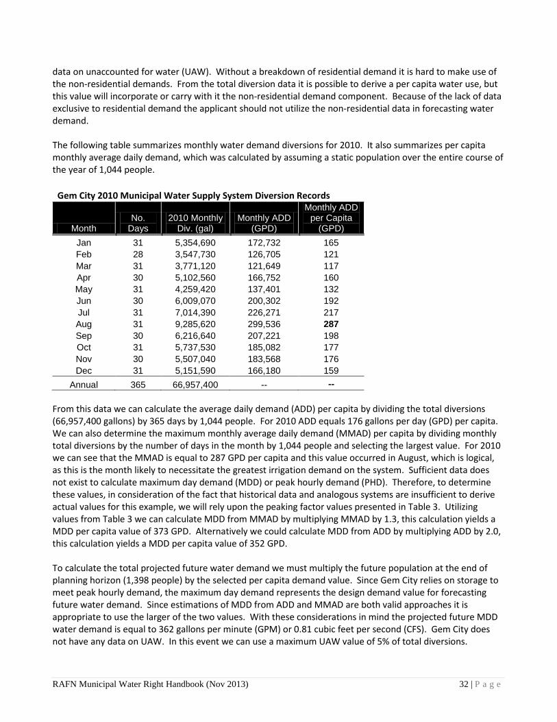
data on unaccounted for water (UAW). Without a breakdown of residential demand it is hard to make use of the non-residential demands. From the total diversion data it is possible to derive a per capita water use, but this value will incorporate or carry with it the non-residential demand component. Because of the lack of data exclusive to residential demand the applicant should not utilize the non-residential data in forecasting water demand. The following table summarizes monthly water demand diversions for 2010. It also summarizes per capita monthly average daily demand, which was calculated by assuming a static population over the entire course of the year of 1,044 people.
Gem City 2010 Municipal Water Supply System Diversion Records
Month No.
Days 2010 Monthly
Div. (gal) Monthly ADD
(GPD)
Monthly ADD per Capita
(GPD) Jan 31 5,354,690 172,732 165 Feb 28 3,547,730 126,705 121 Mar 31 3,771,120 121,649 117 Apr 30 5,102,560 166,752 160 May 31 4,259,420 137,401 132 Jun 30 6,009,070 200,302 192 Jul 31 7,014,390 226,271 217 Aug 31 9,285,620 299,536 287 Sep 30 6,216,640 207,221 198 Oct 31 5,737,530 185,082 177 Nov 30 5,507,040 183,568 176 Dec 31 5,151,590 166,180 159
Annual 365 66,957,400 -- -- From this data we can calculate the average daily demand (ADD) per capita by dividing the total diversions (66,957,400 gallons) by 365 days by 1,044 people. For 2010 ADD equals 176 gallons per day (GPD) per capita. We can also determine the maximum monthly average daily demand (MMAD) per capita by dividing monthly total diversions by the number of days in the month by 1,044 people and selecting the largest value. For 2010 we can see that the MMAD is equal to 287 GPD per capita and this value occurred in August, which is logical, as this is the month likely to necessitate the greatest irrigation demand on the system. Sufficient data does not exist to calculate maximum day demand (MDD) or peak hourly demand (PHD). Therefore, to determine these values, in consideration of the fact that historical data and analogous systems are insufficient to derive actual values for this example, we will rely upon the peaking factor values presented in Table 3. Utilizing values from Table 3 we can calculate MDD from MMAD by multiplying MMAD by 1.3, this calculation yields a MDD per capita value of 373 GPD. Alternatively we could calculate MDD from ADD by multiplying ADD by 2.0, this calculation yields a MDD per capita value of 352 GPD. To calculate the total projected future water demand we must multiply the future population at the end of planning horizon (1,398 people) by the selected per capita demand value. Since Gem City relies on storage to meet peak hourly demand, the maximum day demand represents the design demand value for forecasting future water demand. Since estimations of MDD from ADD and MMAD are both valid approaches it is appropriate to use the larger of the two values. With these considerations in mind the projected future MDD water demand is equal to 362 gallons per minute (GPM) or 0.81 cubic feet per second (CFS). Gem City does not have any data on UAW. In this event we can use a maximum UAW value of 5% of total diversions.
RAFN Municipal Water Right Handbook (Nov 2013) 32 | P a g e
Therefore, after accounting for UAW the projected future MDD water demand can be adjusted to 0.87 CFS (0.83 + 0.05*0.83). Review of Gem City’s existing water right portfolios indicates that the city already has 0.40 cfs of diversion rate. This value must be subtracted from the projected future MDD water demand to determine the diversion rate value that will be included on the new RAFN water right, in this instance the final RAFN diversion rate value will be 0.49 CFS (0.89 – 0.40).
RAFN Municipal Water Right Handbook (Nov 2013) 33 | P a g e

IDAHO WATER RESOURCE BOARD
MEETING MINUTES 11-13
Idaho Water Center
Conference Rooms 602 B, C, and D 322 East Front Street, PO Box 83720, Boise, Idaho 83720
November 19, 2013 Work Session
Chairman Roger Chase called the meeting to order at approximately 8:00 am. All Board members were present. During the Work Session the following items were discussed:
• Galloway Geotechnical Final Report and Operations Study Update by Jack Peterson, Cynthia Bridge Clark, Mark Mendenhall, Bill Harrison, and Jeremy Giovando
• ESPA Recharge Modeling by Michael McVay, Mathew Weaver, and Brian Patton
• Presentation by Great Feeder Canal Company • Water Transactions by Morgan Case • Albeni Falls Flexible Winter Operations by John J. Williams • Snake River Basin Adjudication by Clive Strong • Henrys Fork Basin Study by Cynthia Bridge Clark • Update on Boise Feasibility Study by Cynthia Bridge Clark and Ellen
Berggren • Salmon and Steelhead Above the Hells Canyon Complex by Lance
Hebdon • Rathdrum Prairie Aquifer- Proposal for Technical Analysis by Helen
Harrington and Dr. Dale Ralston • Other Items for Discussion
No action was taken by the Board during the Work Session.
November 20, 2013 IWRB Meeting
Chairman Roger Chase called the meeting to order at approximately 8:00 am. Bert Stevenson was absent. All other Board members were present.
Agenda Item No. 1, Roll Call Board Members Present Roger Chase, Chairman Albert Barker Peter Van Der Meulen, Vice Chairman Vince Alberdi Bob Graham, Secretary Chuck Cuddy
Jeff Raybould Bert Stevenson
C.L. "Butch" Otter Governor
Roger W. Chase Chairman Pocatello District 4 Peter Van Der Meulen Vice-Chairman Hailey At Large Bob Graham Secretary Bonners Ferry District 1 Charles “Chuck” Cuddy Orofino At Large Vince Alberdi Kimberly At Large Jeff Raybould St. Anthony At Large Albert Barker Boise District 2 John “Bert” Stevenson Rupert District 3
322 East Front Street, Boise, Idaho 83720 Tel: (208) 287-4800 Fax: (208) 287-6700

Staff Members Present Gary Spackman, Director Mat Weaver, Deputy Director Brian Patton, Planning Bureau Chief Helen Harrington, Planning Section Manager Harriet Hensley, Deputy Attorney General Clive Strong, Deputy Attorney General Garrick Baxter, Deputy Attorney General Cynthia Bridge Clark, Engineer Neeley Miller, Water Resource Planner Morgan Case, Staff Biologist Mandi Pearson, Administrative Assistant Jack Peterson, Senior Advisor Emeritus Guests Present Walt Poole, Idaho Fish and Game Peter Anderson, Trout Unlimited David Miles, City of Meridian Brenda Tominaga, Idaho Ground Water Association Jon Bowling, Idaho Power Bill Booth, Northwest Power & Conservation Council Jerry Rigby, Western States Water Council Hal Anderson, Idaho Water Engineering John Simpson, Barker, Rosholt & Simpson Ellen Berggren, US Army Corps of Engineers Marie Kellner, Idaho Conservation League Ryan Moss, Raft River Ground Water District Shelly Davis, Barker, Rosholt & Simpson John J. Williams, Bonneville Power Administration Bruce Smith, Moore Smith Buxton & Turcke Agenda Item No. 2, Executive Session
At approximately 8:00 am the Board resolved into Executive Session by unanimous consent pursuant to Idaho Code Section 67-2345 subsection (1)(f), for the purpose of communicating with legal counsel regarding legal ramifications of and legal options for pending litigation, or controversies not yet being litigated but imminently likely to be litigated. No action was taken by the Board during the Executive Session. The Board resolved out of Executive Session and into Regular Session at approximately 9:15 am. Agenda Item No. 3, Agenda and Approval of Minutes
There were no additions or deletions from the agenda. Mr. Cuddy made a motion that the minutes for meeting 10-13 be approved as printed. Mr.
Raybould seconded the motion. Voice Vote. All were in favor. Motion passed.
Agenda Item No. 4, Public Comment Chairman Chase opened up the meeting for public comment. Mr. Ryan Moss from the Raft River Ground Water District (GWD) presented a proposal for a recharge project. They have applied for the water right and the application for permit has been protested by Idaho Power. As part of the resolution of the protest, the GWD agreed to present the project to the Board. Mr. Moss described the project. There was discussion among the parties regarding the location of the recharge project, awareness of the project in the basin, the Idaho Power protest, and the Board’s review of recharge applications. Agenda Item No. 5, Western States Water Council (John Simpson, Jerry Rigby, WSWC) Mr. John Simpson provided an update to the Board on the natural flows and state primacy of water. There is a growing issue in the Missouri basin regarding how the US Army Corps of Engineers (Corps) is handling “surplus” water. Mr. Simpson discussed the position of the Western States Water Council (WSWC) on this issue.
Mr. Jerry Rigby described the importance of states’ rights. He reported on the rulemaking of the Clean Water Act. The WSWC has drafted two letters to the federal legislature stating that this issue
Meeting Minutes No. 11-13 Page 2 November 20, 2013

needs state involvement. There was discussion among the parties regarding WSWC’s involvement in this issue, as well as the Corps’ position on what they are calling “surplus water.” Mr. Rigby also discussed the WSWC’s position on a possible federal water policy. The WSWC is supporting a program called WADE that allows states to put their own water data onto a centralized computer system. Agenda Item No. 6, Committee Reports
a. Water Resource Planning (Helen Harrington, Staff) Ms. Harrington discussed the activities of the Water Resource Planning Committee. The Committee met on October 17th and again on November 18th. During the November 18th meeting, the Board listened to several presentations on sustainability. The Committee is also planning to further the discussion and develop a strategy and framework to work on revisions to the Idaho State Water Plan. Several items were discussed at the Committee meeting regarding the Rathdrum Prairie CAMP, including Advisory Committee membership and implementation funding.
b. Streamflow Enhancement and Minimum Streamflow (Helen Harrington, Staff) The Streamflow Committee met on November 18th. The Committee discussed and made recommendations on several transactions. Additionally, the Committee heard a summary of the Water Transactions program for the 2013 activities in the Upper Salmon basin and the Teton basin. Ms. Harrington discussed the Committee’s recommendations regarding the transactions in the Upper Salmon basin and the Teton basin, specifically the direction to Friends of the Teton River to demonstrate local, community, and water user support for the transaction.
c. Upper Snake Advisory (Mathew Weaver, Staff) Mr. Weaver provided a report on the Upper Snake Advisory Committee. The Committee last met
on October 10th. They heard reports from the Bureau of Reclamation on water supply in the system and from the Watermaster on the water supply from his perspective, the low reservoir content and the rental pool. Jon Bowling from Idaho Power gave a state of the operations from Idaho Power’s perspective. The Committee also heard from Chuck Brockway, Jr. regarding a Snake River natural flow forecasting tool. Liz Cresto gave a presentation on reach gains in the Blackfoot to Milner area. Agenda Item No. 7, Columbia River Treaty (Jim Yost, Northwest Power & Conservation Council) Mr. Jim Yost, on behalf of the Governor and the State, provided a status report on the negotiations on preparing a recommendation regarding the Columbia River Treaty. The sovereign review team has developed a recommendation for modification of the treaty. It contains three elements: Canadian entitlement, flood control, and ecosystem function. Mr. Yost discussed these elements in further detail. There was discussion among the parties regarding power exchange money and flood control provisions. Agenda Item No. 8, Albeni Falls Flexible Winter Operations- Idaho’s Position (Bill Booth, Northwest Power & Conservation Council) Mr. Bill Booth discussed Idaho’s position on the Albeni Falls Flexible Winter Operations. Idaho has a letter agreement with Bonneville Power in which the State determined to give the Flexible Winter Operations a five-year trial run. He discussed some of the concerns the State has regarding the issue. There is controversy regarding shoreline erosion impacts, and a study will be done to evaluate the impacts. BPA will provide $3 million to initiate an extensive river delta erosion mitigation project. During the five-year trail period, Idaho will not make any legal challenges to current operations at the Dam. The parties involved committed to work together cooperatively and to work closely with other parties in the region.
Meeting Minutes No. 11-13 Page 3 November 20, 2013

Agenda Item No. 9, Proposed Legislation (Garrick Baxter, Staff) Mr. Garrick Baxter discussed several pieces of proposed legislation by IDWR for the 2014 Legislative Session. Five pieces of legislation have been submitted to the Governor’s office. Mr. Baxter discussed four of the five pieces of legislation; Director Spackman would discuss the fifth later in the meeting. Mr. Baxter discussed the proposed remediation legislation. This legislation clarifies that an operator of a remediation project does not need to go through the water right application process with IDWR if the sole purpose of the diversion of water is to remove a hazardous substance or petroleum in response to state or federal regulatory requirements. There was discussion among the parties regarding notice of remediation projects to the Director, injection rules, and feedback from other entities. Mr. Baxter discussed proposed legislation that deals with the definition of injection wells. It clarifies the definition of an injection well by replacing the term “drilled” with “used.” Mr. Baxter discussed proposed legislation relating to moratorium areas. It provides the Director of IDWR with the authority to return pending applications to appropriate water to the applicants when the applications seek to divert water in an area where a moratorium order has been issued. There was discussion among the parties regarding the applicants’ right to challenge the order. Mr. Baxter discussed proposed legislation regarding recharge. This legislation addresses three main topics: 1) authorization of the Board to promulgate rules governing managed ground water recharge, 2) clarification that a new application for permit based on managed ground water recharge or aquifer credits must show reasonable certainty that the recharge or credits will provide a sufficient supply of water to sustain the new water use into the future, and 3) authorization of the Board to create an aquifer credit program. There was discussion among the parties regarding recent changes made to the legislation. Mr. Raybould made a motion that Idaho Water Resource Board supports the proposed recharge legislation. Mr. Van Der Meulen seconded the motion.
Roll Call Vote: Mr. Cuddy: Aye; Mr. Alberdi: Aye; Mr. Stevenson: Aye; Mr. Raybould: Aye; Mr. Van Der Meulen: Aye; Mr. Graham: Aye; Mr. Barker: Aye; Chairman Chase: Aye. Motion carried. Agenda Item No. 10, Financial Program
a. Status Update (Brian Patton, Staff) As of September 1, the Board had approximately $19 million in funds committed but not yet disbursed, about $15 million in loan principle outstanding, and a total uncommitted balance of about $5 million. There was discussion among the parties regarding a sources and uses statement and future projects. The PPRT Lateral Association loan has been paid in full. There was discussion among the parties regarding potential loans, interest rates, and the Pristine Springs sub-account.
b. Water Transactions Program (Morgan Case, Staff) Ms. Morgan Case discussed a funding resolution of $180,610 for a set of two-year subordination agreements to maintain flows of 25-35 cfs in the Lower Lemhi River to provide passage for Chinook salmon, steelhead, and bull trout. Funding is available through the BPA Idaho Fish Accord. Mr. Raybould moved for adoption of the resolution to make a funding commitment for the Lower Lemhi River 2014-2015 water right subordination agreements. Mr. Alberdi seconded the motion.
Roll Call Vote: Mr. Cuddy: Aye; Mr. Alberdi: Aye; Mr. Stevenson: Aye; Mr. Raybould: Aye; Mr. Van Der Meulen: Aye; Mr. Graham: Aye; Mr. Barker: Aye; Chairman Chase: Aye. Motion carried.
Ms. Case discussed a funding resolution for $60,000 to enter into a one-year minimum flow agreement to maintain 6 cfs in Pole Creek, tributary to the Salmon River. Funds will come through the Columbia Basin Water Transactions Program. Mr. Van Der Meulen moved for adoption of the
Meeting Minutes No. 11-13 Page 4 November 20, 2013

resolution to make a funding commitment for the Pole Creek Water Transaction. Mr. Stevenson seconded the motion.
Roll Call Vote: Mr. Cuddy: Aye; Mr. Alberdi: Aye; Mr. Stevenson: Aye; Mr. Raybould: Aye; Mr. Van Der Meulen: Aye; Mr. Graham: Aye; Mr. Barker: Aye; Chairman Chase: Aye. Motion carried.
Agenda Item No. 11, Planning Programs a. RP CAMP (Helen Harrington, Staff) Ms. Harrington introduced the newest member of the Planning Bureau, Remington Buyer. He is
the Water Supply Bank Coordinator. Ms. Harrington discussed the current work of the RP CAMP Advisory Committee. They are preparing a Request for Proposal (RFP) and association materials which will be used to solicit proposals. Staff is preparing the draft RFP, a cover sheet announcing the issuance, evaluation criteria and a process flow chart, which will be presented to the Water Resource Planning Committee and IWRB in January 2014. Ms. Harrington also discussed a presentation to the Advisory Committee by Mr. Mat Weaver regarding Reasonably Anticipated Future Needs (RAFN).
Ms. Harrington discussed the membership of the Advisory Committee. The Board received a request for a replacement of a member of the Committee, Mr. Hal Keever, who represented the timber industry. One of the existing members, Mr. Kermit Kiebert, was presented as an adequate representative of the timber industry. Mr. Raybould moved to accept the resignation of Mr. Keever and acknowledge that Mr. Kiebert will represent timber interests on the Advisory Committee. Mr. Graham seconded the motion. Voice Vote. All were in favor. Motion passed.
Ms. Harrington brought forward the request for funding for a project. Ralston Hydrologic Services, Inc. has proposed to undertake a technical study to evaluate feasibility of mitigating the extreme low flows and requested financial support in the amount of $70,000. There was discussion regarding the timeline of the project. Mr. Graham moved to accept the resolution to allocate funds to Ralston Hydrologic Services. Mr. Cuddy seconded the motion.
Roll Call Vote: Mr. Cuddy: Aye; Mr. Alberdi: Aye; Mr. Stevenson: Aye; Mr. Raybould: Aye; Mr. Van Der Meulen: Aye; Mr. Graham: Aye; Mr. Barker: Abstain; Chairman Chase: Aye. Motion carried. Agenda Item No. 12, Pristine Springs (Brian Patton, Staff) Mr. Patton provided an update on Pristine Springs. He discussed the Blue Lakes Pipeline construction progress. Completion of the project is expected by the end of the year. The parties also discussed negotiations with the College of Southern Idaho. Agenda Item No. 13, Water District 02 WaterSMART Grant Update (Neeley Miller, Staff)
Mr. Neeley Miller gave a status report on the WaterSMART Grant. The Grant was obtained to assist with the installation of measuring devices for the newly created Water District 02 (WD02). The Financial Assistance Agreement with the US Bureau of Reclamation (BOR) was finalized in early September. Cost-reimbursement contracts are now in place with 14 of the 15 non-federal entities participating in phase-one of the project. Purchasing and installation of measurement devices and telemetry equipment will begin in November 2013 and staff anticipates completion by spring/summer 2014. Staff is planning to work with WD02 and BOR to submit an additional grant application for another group of water users to help get the measurement devices in place. There was discussion among the parties regarding the percentage of installations covered by this grant.
Agenda Item No. 14, ESPA Update (Mat Weaver, Neal Farmer, Staff) Mr. Weaver provided an update on ESPA activity. He discussed the Lake Walcott Recharge
Project. A topographic survey, a bathometric survey, and boundary survey work have been completed
Meeting Minutes No. 11-13 Page 5 November 20, 2013

by W&H Pacific. They will prepare a legal description of the right-a-way easement needed to cross the wildlife refuge ground. Mr. Weaver discussed the status of the CH2M Hill Scope of Work tasks. Two of the tasks have been completed, two of the tasks are in progress, and three of the tasks are not yet started. He discussed in further detail the Task 3 Conveyance System Alternatives Economic Analysis and the Task 4 Concept Layout and Stakeholder Coordination. Mr. Weaver introduced Perrin Robinson of CH2MHill to help answer questions about the project. There was discussion among the parties regarding project details, winter recharge, ongoing cost, monitoring of groundwater quality, and building size. Mr. Neal Farmer discussed the hydrogeologic investigation work of the Lake Walcott Recharge Project. He described the test wells that were drilled to perform hydraulic testing on the unsaturated zone above the water table and the results of the investigation. Testing will continue. There was discussion among the parties regarding the test wells. Mr. Farmer also discussed recharge activities by Southwest Irrigation District and at the Mile Post 31 recharge site.
Mr. Weaver provided an update on AWEP projects. The A&B Irrigation District conversion project is the largest of the outstanding AWEP projects. A&B successfully passed a $7 million bond issue receiving 80% voter approval. $3.8 million of the bond is dedicated to the AWEP conversion project. Currently the environmental assessment and the preliminary design of the project are underway. Construction is scheduled to be initiated in the fall/winter of 2014, partially completed by the start of the 2015 irrigation season, and fully operational by the start of the 2016 irrigation season. Agenda Item No. 14, IDWR Director’s Report (Gary Spackman, Director) Director Spackman discussed the proposed legislation addressing the qualifications for the Director of IDWR. He drafted language by looking at a profile of the professions that are employed in the Department, including engineering, geology, hydrology, and hydrogeology. The proposed legislation also includes language regarding interpreting and applying water law and familiarity in water use practices in Idaho. There was discussion among the parties regarding the proposed qualifications for the Director. There was also some discussion among the parties regarding issues surrounding the Mountain Home Air Force Base and the Bear River basin. Agenda Item No. 15, Other Non-Action Items for Discussion Chairman Chase requested that staff get the proposed financial numbers for the legislature to all the Board members and also requested that the Board members get a list of the proposed legislation. Mr. Patton pointed out some materials that were included in the Board Meeting binders, including the ten-year report for the Columbia Basin Water Transactions Program, photo pages, and proposed dates for 2014 Board meetings. There was discussion among the parties regarding the 2014 dates. The proposed dates were tentatively approved. Agenda Item No. 16, Next Meeting and Adjourn
The next regularly scheduled meeting is set for January 23-24, 2014 in Boise. This meeting is scheduled to coordinate with the Idaho Water Users Association seminar. Mr. Raybould made a motion to Adjourn, and Mr. Barker seconded the motion. Voice Vote. All were in favor. Motion Carried. The IWRB Meeting 11-13 adjourned at approximately 1:00 pm. Meeting Minutes No. 11-13 Page 6 November 20, 2013

Respectfully submitted this _____ day of January, 2014. ________________________________________ Bob Graham, Secretary ________________________________________ Mandi Pearson, Administrative Assistant II Board Actions: 1. Mr. Cuddy made a motion that the minutes for meetings 10-13 be approved. Mr. Raybould
seconded the motion. Voice Vote. All were in favor. Motion carried.
2. Mr. Raybould made a motion that Idaho Water Resource Board supports the proposed recharge legislation. Mr. Van Der Meulen seconded the motion. Roll Call Vote. All were in favor. Motion carried.
3. Mr. Raybould moved for adoption of the resolution to make a funding commitment for the Lower Lemhi 2014-2015 water right subordination agreements. Mr. Alberdi seconded the motion. Roll Call Vote. All were in favor. Motion carried.
4. Mr. Van Der Meulen moved for adoption of the resolution to make a funding commitment for the Pole Creek Water Transaction. Mr. Stevenson seconded the motion.
5. Mr. Raybould moved to accept the resignation of Mr. Keever and acknowledge that Mr. Kiebert will represent timber interests on the Advisory Committee. Mr. Graham seconded the motion. Voice Vote. All were in favor. Motion passed.
6. Mr. Graham moved to accept the resolution to allocate funds to Ralston Hydrologic Services. Mr. Cuddy seconded the motion. Roll Call Vote. Mr. Graham abstained from voting. All others were in favor. Motion carried.
Meeting Minutes No. 11-13 Page 7 November 20, 2013


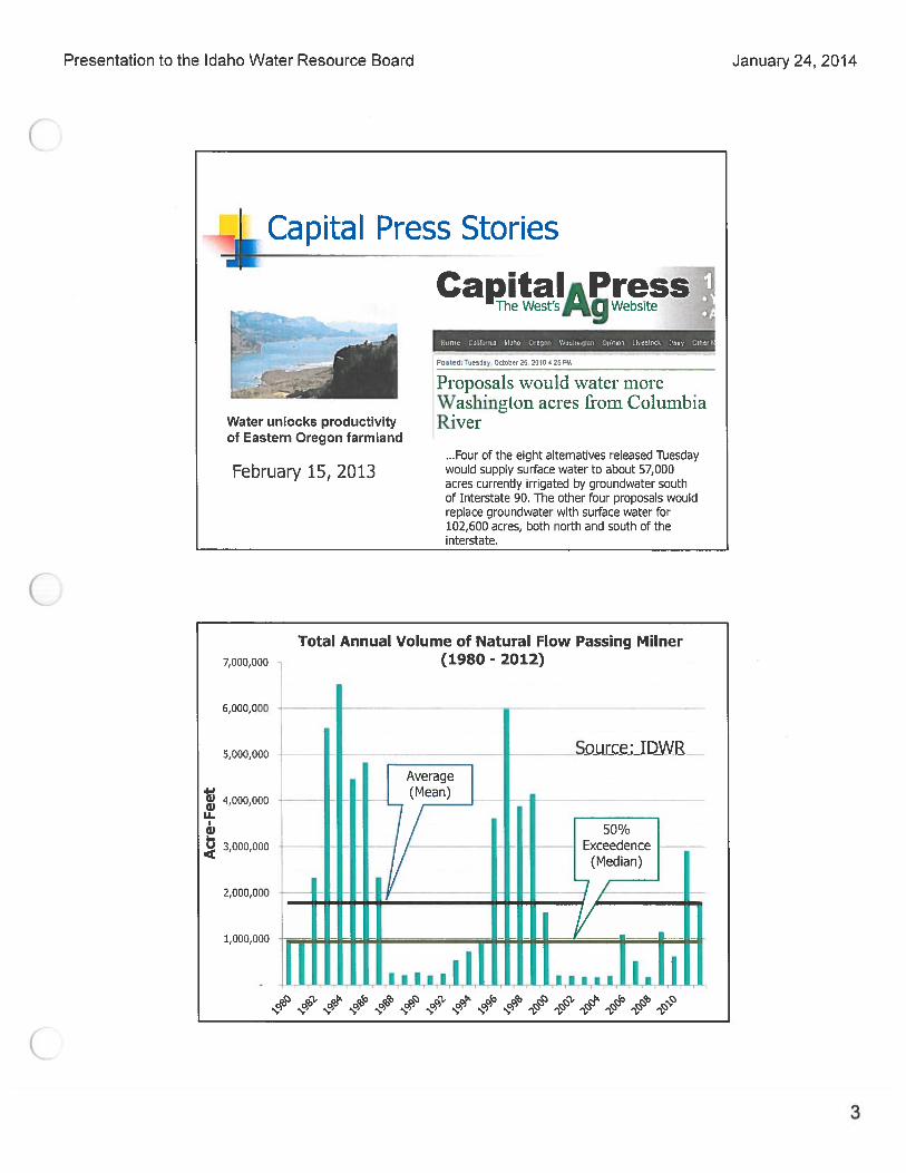


Memorandum To: Idaho Water Resource Board, Brian Patton
From: Tim Luke, IDWR Water Compliance Bureau Chief
Date: 11/29/2013
Re: Requested Hearing - Application for Permit No. S82-20044 to Alter a Stream Channel in the name of Gay Richardson
Action Item:
Appoint a hearing officer to review the decision of the Director to reject an application for permit to alter a stream channel.
Discussion On November 4, 2013, the Idaho Department of Water Resources (“IDWR”) rejected Application for Permit to Alter a Stream Channel No. S82-20044 (see attached Order). The application was originally filed on July 25, 2011 by Ed Kelly and Gay Richardson (Mr. Kelly has since passed away). The application proposed a commercial gold suction dredge mining operation on a section of the Red River about six miles upstream from the confluence of the American and South Fork Clearwater Rivers. The proposed mining site is known as the Genesis Placer Gold Claim and is located on land owned and managed by the United States Forest Service (“USFS”) Nez Perce National Forest. The mining site is also located within a designated recreational stream in the South Fork Clearwater River Basin Comprehensive State Water Plan (“Water Plan”). On November 15, 2013, IDWR received a request from applicant Gay Richardson for a hearing to review IDWR’s decision to reject application no. S82-20044. Idaho Code § 42-3805 provides that an applicant may request a hearing before the Idaho Water Resource Board (“Board”) within fifteen (15) days of the Director’s decision to reject an application for permit to alter a stream. The applicant’s request for hearing was submitted timely. Pursuant to Idaho Code § 42-1734A, IWRB adopted the Water Plan for the South Fork Clearwater River Basin in 2004. The Idaho legislature approved the Water Plan in 2005. The Water Plan designated the Red River from its headwaters to its confluence with the American River as a Recreational River. The Water Plan prohibits dredge or placer mining on the Red River, including recreational dredging, except where allowed through application for permit using IDWR Form 3804-B, also known as a Joint Application for Permits for a Stream Channel Alteration Permit. The Executive Summary of the Water Plan states that “numerous laws regulate or restrict dredge mining in the South Fork Clearwater River including the Clean Water Act and the Endangered Species Act…It is unlikely that a new recreational dredging operation could be conducted in the South Fork Clearwater River without adequate review and environmental safe guards.” Recommendation IDWR staff recommends the Board adopt the attached Resolution appointing Mathew Weaver as the hearing officer in this matter.
1

BEFORE THE IDAHO WATER RESOURCE BOARD IN THE MATTER OF THE JOINT APPLICATION ) FOR PERMIT NO. S-82-20044 TO ALTER A ) RESOLUTION STREAM CHANNEL IN THE NAME OF ) GAY RICHARDSON AND ED KELLY )
WHEREAS, on July 25, 2011 Gay Richardson and Ed Kelly (“Applicant”) (IWRB)
submitted an application to alter the stream channel for the purposes of conducting dredging operations between the high water marks and in the bed of Red River in Idaho County; and
WHEREAS, On July 29, 2013, Mr. Richardson notified the Department that Mr. Kelly
had passed away and that he wanted the Department to continue to process the Application for the permit; and
WHEREAS, on November 4, 2013 the Director of the Department of Water Resources
(“Department”) issued a decision rejecting the application based upon investigation by Department staff; and
WHEREAS, on November 12, 2013 the Department received notice a request from the
Applicant for a hearing before the Idaho Water Resource Board (“Board”) to review the decision of the Director to reject the application for a stream alteration permit; and
WHEREAS, it is necessary for the Board to appoint a hearing officer to preside over the hearing and issue a decision for the Board’s review; and
WHEREAS, the Chairman of the Water Resource Board has been delegated, by previous
resolution of the Board dated March 3, 1989, the authority to select and appoint hearing officers on behalf of the Board; and
NOW THEREFORE BE IT FURTHER RESOLVED the Idaho Water Resource Board hereby appoints Mathew Weaver as the hearing officer in the above proceeding if the matter cannot otherwise be satisfactorily resolved.
Adopted this ___ day of December, 2013. ____________________________________ ROGER CHASE, Chairman Idaho Water Resource Board
ATTEST: ___________________________ BOB GRAHAM, Secretary


State of Idaho
DEPARTMENT OF WATER RESOURCES 322 East Front Street• P.O. Box 83720 •Boise, Idaho 83720-0098 Phone: (208) 287-4800 •Fax: (208) 287-6700 •Website: www.idwr.idaho.gov
C.L. "BUTCH" OT1ER Governor
November 4, 2013
Gay Richardson PO Box 314 Elk City, ID 83525
GARY SPACKMAN Director
RE: Preliminary Order Rejecting Application for Stream Channel Alteration Permit No. S82-20044 for a Proposed Suction Dredge and Placer Mining Project on the Red River
Dear Mr. Richardson,
Enclosed please find a copy of the Preliminary Order ("Order") regarding the above referenced matter. This Order rejects your Application for Stream Channel Alteration Permit No. S82-20044 proposing a gold suction dredge and placer mining operation on the Red River near Elk City, Idaho.
Also enclosed is an informational sheet that explains options for responding to preliminary orders. Please note that you may file a petition for reconsideration, or exceptions and briefs, within fourteen ( 14) days of the service date of the Order, which is the date of this letter. The Department will act upon petitions or exceptions within twenty-one (21) days of their receipt. Pursuant to Idaho Code § 42-3805, you also have the option of requesting a hearing before the Idaho Water Resource Board within fifteen ( 15) days of the date of mailing of this Order. A request for hearing should be addressed to the Idaho Water Resource Board at the address shown in the above letterhead. The request may be marked to the attention of Helen Harrington, Idaho Department of Water Resources ("IDWR") Planning Section Manager.
Please contact this office if you have any questions concerning the attached Order.
Sincerely,
Tim Luke Water Compliance Bureau Chief
Enclosures: Preliminary Order Explanatory Information to Accompany A Preliminary Order
c: Helen Harrington, Manager, IDWR Planning Section Greg Taylor, IDWR Northern Region

BEFORE THE DEPARTMENT OF WATER RESOURCES
OF THE
STATE OF IDAHO
IN THE MATTER OF APPLICATION ) FOR STREAM CHANNEL ALTERATION) PERMIT NO. S82-20044 FOR SUCTION ) DREDGE MINING ON THE RED RIVER ) ~~~~~~~~~~~~~~~~)
PRELIMINARY ORDER
This matter having come before the Department of Water Resources ("IDWR" or "Department") as a result of the filing of a Joint Application for Permits for a Stream Channel Alteration Permit, IDWR Form 3804-B, ("Application"), the Department has concluded its investigation and makes the following Findings of Fact, Conclusions of Law, and Order:
FINDINGS OF FACT
1. On July 25, 2011, the Department received an Application from Ed Kelly and Gay Richardson (Applicants) for gold suction dredge mining on the Red River. The Department assigned the Application an identification number, S82-20044.
2. On July 29, 2013, Mr. Richardson forwarded e-mail correspondence to the Department advising that Mr. Kelley passed away in December, 2012. Mr. Richardson further advised the Department that he is the sole owner of the mining claim which is identified in the Application where the proposed mining project is located. Mr. Richardson expressed interest in pursuing the Application. The term "Applicants" is used in this Preliminary Order ("Order") to represent Mr. Kelley and Mr. Richardson when referencing the proposed mining project described in the Application although the Department currently recognizes Mr. Richardson as the remaining and sole Applicant.
3. The Application proposes mining for placer gold in a section of the Red River near Elk City, Idaho about 6 miles above the confluence with the American River and the South Fork Clearwater River.
4. The proposed mining site is on land owned and managed by the United States Forest Service ("USFS") Nez Perce National Forest. The mining site is known as the Genesis Placer Gold Claim which the Applicants identify as being located in Sections 6 and 7 of Township 28 North, Range 29 East, Idaho County. A drawing attached to the application shows that the placer claim is about 1,590 feet in length and that the river is approximately 25 feet wide, which represents an area of 39,750 square feet or 0.91 acres. However, explanatory information attached to the Application states that about half of the mining claim surface area will be mined, or about 0.46 acres, but the Applicants do not specify a particular 0.46 acres that will be mined.
5. The proposed mining site is located within a designated recreational stream within the South Fork of Clearwater River Basin Comprehensive State Water Plan ("Water Plan").
PRELIMINARY ORDER- Page I

6. The Application states that mining of placer gold will be accomplished using several dredges with suction hoses ranging from eight (8) inches to two (2) inches in diameter. The 8 inch size suction dredge will be used for removing overburden and processing gravels to bedrock for contained gold. The 5 and 2 inch dredges will be used for cleaning gold from bedrock crevices. The Application included no information regarding the motor or engine horsepower (HP) rating used with the different sized suction dredges.
7. The Applicants state that about 2,208 total cubic yards of gravel and bedrock overburden will be discharged or dredged at a rate of 9 cubic yards per day, eight hours per day (1.13 cubic yards per hour). The Applicants' estimate for dredging 2,208 cubic yards at 9 cubic yards per day equates to at least 245 days total.
8. The Applicants propose an immediate work date but state that they are unable to determine an estimated end date. No information is provided regarding the total estimated number of days of operation or any type of annual season(s) of use for the project.
9. The Applicants state that larger dredges provide a "mitigating measure" because "the gravel and rock vertical and horizontal matrix is put back in the river pretty much the way it came out." No other mitigating measures or plans were identified in the Application.
10. On September 18, 2012, Department staff conducted a site inspection with the Applicants and representatives from the Idaho Department of Fish and Game (IDFG) and USFS. At this meeting, the Applicants provided the following explanations regarding their proposed mining operation.
11. The Applicants wish to mine or operate in the river most of the year depending on weather and flow conditions. The Applicants stated that they thought they would need about five (5) years to complete the suction dredge and placer mining operation but provided no plan or basis for this time frame.
12. The Applicants stated that a 48 HP engine would be used with the 8 inch suction dredge and an 8 HP engine would be used on the 5 inch dredge. They were not certain of the motor rating for the 2 inch dredge.
13. The Applicants intend to prospect for specific "pay streaks" or vein like deposits along the stream bedrock. The Applicants estimated that they will remove approximately three feet of gravel and sediment, or overburden, above bedrock along various lines of direction across and along the river channel in order to mine gold from bedrock and bedrock crevices. The Applicants indicated that they would work one side of the channel in the lower portion of the claim up to an area where large rocks and boulders are located, and then work in the center of the channel to the top or upstream point of the claim.
14. The Applicants stated that the linear distance along the channel where they will work is the entire 1,590 foot length of the mining claim. The Applicants explained that when "pay streaks" are found, dredging will move in the direction and location of the streak found. Under this approach, the Applicants estimate that approximately half of the claimed channel would be mined.
PRELIMINARY ORDER- Page 2

15. The Applicants showed Department staff the approximate beginning and ending point of the mining claim where the gold dredging activity is planned. Marking the beginning and ending points with a GPS receiver, the Department determined that the length of channel is only about 1,400 feet, or a channel area of about 0.66 acres assuming a channel width of 25 feet. The river section is located within the NESW and SWSE of Section 6, Township 28 North, Range 29 East.
16. Boulders in the river channel will be moved using a pick-up truck and come-along in order to reach bedrock areas that may overlay a "pay streak". Any boulders moved in the river will remain in the river channel and generally be moved just a few feet. Some of the boulders observed during the site visit that could potentially be moved are very large in size and would require some mechanical means of movement such as a truck and winch as described in the Application. The Applicants stated that boulders would not be removed out of the channel or stacked on the stream banks.
17. On November 26, 2012, IDWR sent correspondence to a number of potentially interested stakeholders or parties requesting comments about the Applicants' proposed dredging operation. Recipients of this correspondence included local, State, Federal and Tribal agencies that may have some jurisdictional interest or concerns; state or regional gold prospector organizations; and state or regional environmental interest groups.
18. IDWR received comments from nine (9) interested parties between November 27 and December 28, 2012. Four (4) of the parties that submitted comments were from State or Federal agencies that provided information about their jurisdictional requirements and/or roles with respect to the Application. One (1) additional state agency provided some technical review of potential effects of the proposed mining operation on fish, wildlife and habitat but did not support or oppose the Application. Three (3) parties opposed the Application citing numerous concerns including potential impacts of the project on fish, wildlife, aquatic species, water quality, and the stream channel. One (1) party supported the Application.
19. Idaho Department of Lands (IDL) responded that a permit from IDL is not required for dredging operations along non-state owned streams or riverbeds using suction dredges with intake diameter of eight (8) inches or less.
20. Both the National Marine Fisheries Service ("NMFS") and the United States Fish and Wildlife Service ("FWS") responded that the Red River is designated as critical habitat for several fish species listed under the Endangered Species Act ("ESA"), including bull trout and Snake River steelhead. Both of these species are likely present within the area identified by the Application and may be impacted by the proposed mining operation and the USFS will have to consult with both NMFS and FWS under Section Seven (7) of the ESA before the USFS can approve a Plan of Operation for the proposed mining project.
21. NMFS and FWS commented that the applicants would need to submit a Plan of Operation to the USFS Nez Perce National Forest before work proposed under the application can commence. Additionally, the applicants will have to obtain a National Pollution Discharge Elimination System ("NPDES") permit from the United States Environmental Protection Agency ("EPA").
PRELIMINARY ORDER - Page 3
22. The Idaho Department of Fish and Game (IDFG) provided a technical review of potential effects of the proposed Application on wildlife, fish and habitat. IDFG stated that it was their opinion "that the proposed mining operation cannot occur in the Red River without adverse impacts to one or more life stages of ESA listed species and other sensitive species of concern including Pacific lamprey, westslope cutthroat trout, spring Chinook salmon, and other native fish and aquatic biota."
23. IDFG noted that the project is located between Gold Point and the South Fork Clearwater River, "which is the most active Chinook salmon spawning reach on the Red River." Chinook salmon arrive in Red River in late May and "remain until spawning in August and September." The project reach also provides "excellent spawning habitat" for steelhead trout, which "typically begin to enter the Red River in April and spawn in May and June." Chinook and steelhead juveniles, bull trout, Pacific lamprey and westslope cutthroat trout are present in the project reach year round.
24. IDFG is particularly concerned that the Applicants' proposal to move large boulders in the proposed "project reach to gain access to placer gold could significantly alter stream morphology and function in this reach. Change in stream form and function could permanently alter or destroy fish spawning, rearing and holding habitat in this reach and downstream."
25. IDFG commented that they, with other stakeholders, have implemented projects to restore the Red River upstream from the Applicant's proposed mining location, and the benefits to those restoration efforts "could be compromised by mining downstream."
26. IDFG also commented that the Water Plan "prohibits dredge or placer mining in Recreational Rivers to protect the public's interest in the special aquatic resource values in Red River, including fisheries."
27. Interested parties that opposed the proposed Application included the Idaho Conservation League ("ICL"), Friends of the Clearwater River ("FOC") and the Nez Perce Tribal Executive Committee ("NPT"). Each of these parties urged IDWR to deny the Application. Comments from these parties are summarized as follows:
A. The Red River is designated as a Recreational River in the State's Water Plan. The Water Plan prohibits dredge or placer mining on the Red River (including recreational dredging, except where allowed through application for permit, Form 3804-B). All dredge or placer mining should be denied to preserve and maintain the Recreational River designation and resource values identified by the Water Plan.
B. The proposed suction dredging operation proposes use of an eight (8) inch suction hose which exceeds the five (5) inch limitation allowed under IDWR's recreational mining permit. An 8 inch suction dredge is considered a commercial dredge operation which is not consistent with the State Water Plan, is not in the public interest and may require additional Federal permits. Due to the commercial nature and size of the proposed operation, including movement of large boulders, two of the three opposing parties suggested that a 404 Permit from the United States Army Corps of Engineers should be required. The ICL specifically commented that the Red River is an inappropriate "place for a commercial gold mining operation" and that
PRELIMINARY ORDER- Page 4

"the public benefit of the gold mining proposal is far outweighed by the benefits associated with clean water, recreation, fisheries, aesthetics and other Idaho core values."
C. The Red River provides important habitat for several threatened, endangered and sensitive species, including Chinook salmon, steelhead trout, bull trout, Pacific lamprey, Westslope cutthroat trout and other aquatic species. The proposed mining operation may negatively impact the habitat of these species in this reach of the Red River.
D. The USFS must complete a consultation process with the NMFS and FWS. The NPT specifically noted that the "USFS must consult with appropriate federal wildlife agencies under Section 7 of the ESA before allowing mining activities to proceed in critical habitat of a listed species. 16 USC§ 1536 (a)(2); 50 C.F.R. § 402.14(a)." Completion of the consultation process would likely require the USFS to conduct a National EPA ("NEPA") analysis which would include reinitiating the USFS 2000 Draft EIS. Additionally, the USFWS and NMFS would have to complete a Biological Opinion for ESA listed species and the USFS would have to issue an EIS Record of Decision. These actions would require significant time, resources and costs to the Federal agencies in order to comply with Federal law.
E. An NPDES permit must be obtained for the proposed mining project which will also necessitate the consultation process under Section 7 of the ESA.
F. The Application is incomplete. Specifically, the Application does not include proposed mitigation plans required by Section 25.b. of the application form and does not provide any proposal for protecting ESA listed species and their critical habitats. Additionally, the Application does not provide any specific dates for the in-stream mining work.
G. Federal, State, Tribal agencies and others have invested significant resources in restoring portions of the Red River. Allowing the proposed mining operation may negate some of the prior river channel restoration efforts. The NPT stated that "it makes no sense to allow disruption of the aquatic environment after great effort has been undertaken to restore habitat damaged by previous mining."
H. The NPT specifically commented that the Red River and Nez Perce National Forest is "part of the vast territory ceded by the Tribe" which "are subject to the exercise of the Tribe's treaty -reserved rights" and that "allowing suction dredging interferes with the Tribe's treaty-reserved fishing activities." The FOC comments also suggest that the NPT treaty rights be considered during any Application review and approval process.
28. Comments were received from Dale Tustison, Moose City Mining District, stating that small-scale miners display no discernible damage to the environment in any way beyond the momentary change to the streambed. Mr. Tustison requested that IDWR approve the Application.
CONCLUSIONS OF LAW
PRELIMINARY ORDER - Page 5

1. Idaho Code§ 42-3801 states:
The legislature of the state of Idaho hereby declares that the public health, safety and welfare requires that the stream channels of the state and their environments be protected against alteration for the protection of fish and wildlife habitat, aquatic life, recreation, aesthetic beauty, and water quality. No alteration of any stream channel shall hereafter be made unless approval therefor has been given as provided in this act.
2. Idaho Code § 42-3803(a) states, in pertinent part:
No person shall engage in any project or activity which will alter a stream channel without first applying to and receiving a permit therefore from the director.
3. Idaho Code§ 42-3804 states:
Upon the receipt of any application with accompanying plans, it shall be the duty of the director to examine same and to furnish copies of the application and plans to, and consult with, other state agencies having an interest in the stream channel to determine the likely effect of the proposed stream channel alteration upon the fish and wildlife habitat, aquatic life, recreation, aesthetic beauty, and water quality values of the stream. The director shall furnish a copy of each application and all accompanying materials to the IDL. Within twenty (20) days of the receipt of copies of such application and plans from the director, such other state agencies shall notify the director whether the proposed stream channel alteration will have an unreasonably detrimental effect upon these stream values and shall include with such notification recommendations of alternate plans, if any, determined by such agency to be reasonable to accomplish the purpose of the proposed stream channel alteration without adversely affecting such stream values.
4. Idaho Code § 42-3805 states, in pertinent part:
Based upon his own investigation and the recommendations and alternate plans of other state agencies, the director shall prepare and forward to the applicant his decision approving the application in whole or in part or upon conditions, or rejecting the application. Within fifteen (15) days of the date of mailing of the decision, the applicant shall notify the director if it refuses to modify its plans in accordance with such decision or that it requests a hearing before the [Idaho Water Resource] board thereon.
5. Stream Channel Alteration Rule 35.01 (IDAPA 37.03.07.035.01) states:
The following items shall be among those considered by the director prior to issuing a permit: a. What is the purpose of doing the work? b. What is the necessity and justification for the proposed alteration? c. Is the proposal a reasonable means of accomplishing the purpose? d. Will the alteration be a permanent solution? e. Will the alteration pass anticipated water flows without creating harmful flooding
or erosion problems upstream or downstream? f. What effect will the alteration have on fish habitat? g. Will the materials used or the removal of ground cover create turbidity or other
PRELIMINARY ORDER - Page 6

water quality problems? h. Will the alteration interfere with recreational use of the stream? L Will the alteration detract from the aesthetic beauty of the area? J. What modification or alternative solutions are reasonably possible which would
reduce the disturbance to the stream channel and its environment and/or better accomplish the desired goal of the proposed alteration?
k. Is the alteration to be accomplished in accordance with the adopted minimum standards?
1. Are there public safety factors to consider?
6. IDWR Stream Channel Alteration Rule 55 (IDAPA 37.03.07.055) provides minimum standards that apply to stream channel alterations in the state including proposed alterations using suction dredges.
7. IDWR Stream Channel Alteration Rule 64.01 (IDAPA 37.03.07.064.01) provides that minimum standards apply to suction dredges with a nozzle diameter of five (5) inches or less and rated at fifteen (15) HP or less. Rule 64.02 provides that "a permit for the operation of a suction dredge may authorize the use of the dredge within a drainage basin or a large portion of a drainage basin except as otherwise determined by the Director." The Department considers the use of suction dredges meeting the size requirements identified in Rule 64.01 to be a recreational mining activity for which specific instructions and guidelines have been provided by the Director in accordance with Rule 64.02. IDWR's Stream Channel Alteration by Recreational Mining Activities Program Instructions includes a list of streams and rivers that are both open and closed to recreational mining activities. The Red River is closed to recreational mining activity under the Department's instructions.
8. Idaho Code § 42-1734A states, in pertinent part:
The board shall, subject to legislative approval, progressively formulate, adopt and implement a comprehensive state water plan for conservation, development, management and optimum use of all unappropriated water resources and waterways of this state in the public interest. The comprehensive state water plan shall consist of: Part A -- statewide policies, goals and objectives; and Part B -- component water plans for individual waterways, river basins, drainage areas, river reaches, ground water aquifers or other geographic designations. As part of Part B of the comprehensive state water plan, the board may designate selected waterways as protected rivers as provided in this chapter.
9. Idaho Code§ 42-1734A(5) and (6) states, in pertinent part:
(5) In designating a natural river, the board shall prohibit the following activities: (a) construction or expansion of dams or impoundments; (b) construction of hydropower projects; (c) construction of water diversion works; ( d) dredge or placer mining; ( e) alterations of the stream bed; and (f) mineral or sand and gravel extraction within the stream bed.
PRELIMINARY ORDER - Page 7

(6) In designating a recreational river, the board shall determine which of the activities listed in subsection (5) of this section shall be prohibited and may specify the terms and conditions under which activities that are not prohibited may go forward.
10. Pursuant to Idaho Code § 42-l 734A, IWRB adopted the Water Plan for the South Fork Clearwater River Basin in 2004. The Idaho legislature approved the Water Plan in 2005. The Water Plan designated the Red River from its headwaters to its confluence with the American River as a Recreational River.
11. The Water Plan prohibits dredge or placer mining on the Red River, including recreational dredging, except where allowed through application for permit using IDWR Form 3804-B, also known as a Joint Application for Permits for a Stream Channel Alteration Permit. The Executive Summary of the Water Plan states that "numerous laws regulate or restrict dredge mining in the South Fork Clearwater River including the Clean Water Act and the Endangered Species Act. .. It is unlikely that a new recreational dredging operation could be conducted in the South Fork Clearwater River without adequate review and environmental safe guards."
12. The Department concludes that the proposed mining project conflicts with a number of existing State Rules, laws and policies, including:
A. The suction dredge and placer mining operation as proposed is prohibited by the IWRB Water Plan. The Water Plan prohibits recreational mining activity on the Red River unless authorized through an IDWR Stream Channel Alteration Permit. Recreational mining represents the minimum standards for use of suction dredge equipment.
B. The Applicants propose using equipment that exceeds the IDWR minimum standards for recreational mining outlined in the Stream Channel Alteration Rules. The Department concludes that the IWRB, in adopting the Water Plan, did not intend IDWR to consider approving the use of suction dredge equipment that exceeds the IDWR minimum recreational mining standards on the Red River or other Recreational designated streams in the South Fork Clearwater River Basin.
C. The proposed dredge mining operation does not satisfy certain review criteria of Stream Channel Alteration Rule 35.01, including:
i. The proposed project is not accomplished in accordance with the adopted minimum standards and is not a reasonable means of accomplishing the proposed project purpose. The proposal exceeds the minimum standards for suction dredging by using an 8-inch, 48HP suction dredge and moving large boulders with a cable attached to a pickup. The minimum standards allow dredges with nozzle sizes up to 5 inches and engines rated up to 15 HP. The Applicants propose dredging nearly one-half acre of river channel to a depth of 3 feet totaling more than 2,200 cubic yards of gravel and stream bedrock overburden. The movement of this amount of stream substrate over such a limited area is a significant level of disturbance which may have short term impacts on water quality and stream channel morphology, and both potential
PRELIMINARY ORDER - Page 8

short and long term impacts on endangered and sensitive fish species.
ii. The mining project as proposed will have an adverse impact on fish habitat. The IDFG and others have commented that one or more life stages of ESA listed fish species (bull trout and Snake River steelhead) and other sensitive fish species are present in the reach of the Red River where the mining project is proposed. There is virtually no period of time during the year where the life stage of one of these species might not be adversely impacted by the proposed suction dredge activity. The potential for impact is exacerbated by proposed use of the large 8 inch, 48 HP suction dredge and removal of 3 feet of stream substrate at any time of the year. A Draft Environmental Impact Statement- Genesis Placer Claim, Nez Perce National Forest Red River Ranger District, July 2000 ("DEIS") on file with IDWR summarized a number of potential impacts to fish. Additionally, various stakeholders have implemented projects in recent years at significant expense to restore the Red River upstream from the proposed project location to benefit fish and aquatic habitat. The benefits to those restoration efforts could be compromised by the proposed downstream mining operation.
iii. The proposed suction dredge activity and removal of stream substrate material will create temporary turbidity, water quality and erosion problems. Dredging can result in suspended sediment and a turbidity plume downstream of the operation which, depending on the stream substrate and water velocity, be carried downstream a significant distance. Comments from the ICL noted studies finding "that high concentrations of sediment can alter survival, growth and behavior of stream biota." Removal and redistribution of 3 feet of stream substrate with larger suction dredge equipment over a limited area could cause significant short term changes to stream morphology and function, and these alterations could cause unknown consequences like increased erosion and head-cuts. In the 2000 DEIS the USFS concluded that the proposed mining project will create temporary or short term turbidity, water quality and erosion problems but such problems are not permanent.
iv. The Applicants proposed no modification or reasonable alternative solutions which would reduce the disturbance to the stream channel and its environment and/or better accomplish the desired goal of the proposed alteration. No mitigating measures or plans were included or described in the application that would minimize impacts to the stream channel, the fishery, water quality and other aquatic resources. The USFS 2000 DEIS identified a clear mining alternative and a number of mitigating measures that the Applicants potentially could have included for consideration in their Application.
v. Public safety factors should be considered. There is a public roadway immediately adjacent to the proposed mining location. Mining as proposed could temporarily alter stream morphology and function which could result in some erosion to the adjacent roadway prism unless certain mining practices or mitigating measures are implemented. The proposal to move large boulders requiring the use of a pick-up truck from the roadway raises questions
PRELIMINARY ORDER- Page 9

concerning road and traffic safety that should likely be addressed by local road and law enforcement officials.
13. Based upon IDWR's investigation and the above statutory authorities, IDWR's Administrative Rules for Stream Channel Alteration, the prohibition of dredge and placer mining on the Red River as provided in the State's Water Plan, and the general lack of support for the proposed project among the other state resource agencies, the Director should consider rejecting the Application.
ORDER
NOW THEREFORE, pursuant to Idaho Code§ 42-3805, the Department does HEREBY reject Application for Stream Channel Alteration Permit No. S82-20044 .
. f4 Dated this~ day of November, 2013.
~-· //____ / j ~~~
~---·/· ~~ I ~c_ Tim Luke, Chief/ Water Compliance Bureau
PRELIMINARY ORDER - Page 10

CERTIFICATE OF SERVICE
I HEREBY CERTIFY that on this 4th day of November, 2013, the above and foregoing document was served on each individual or entity on the service list for this matter on file at the Idaho Department of Water Resources, 322 East Front Street, Boise, Idaho. Each individual or entity on the service list was served by placing a copy of the above and foregoing document in the United States mail, postage prepaid and properly addressed.
Document served: Order In the Matter of Application for Stream Channel Permit No. S82-20044
GAY RICHARDSON PO BOX 314 ELK CITY ID 83525
NEZ PERCE TRIBE, CHAIRMAN BAPTISTE ATIN DAVE JOHNSON & ZOE ANDERSON PO BOX 365 LAPWAI ID 83540
US FISH AND WILDLIFE SERVICE A TIN CLAY FLETCH ER IDAHO STATE OFFICE 1387 S VINNELL WAY STE 368 BOISE ID 83709
MOOSE CREEK MINING DISTRICT ATIN DATE TUSTISON 10811 SANDHURST DR BOISE ID 83709-0264
PRELIMINARY ORDER - Page 11
Sarah Garceau Technical Records Specialist Idaho Department of Water Resources
IDFG ATIN DAVE CADWALLADER 3316 16TH ST
LEWISTON ID 83501
IDAHO CONSERVATION LEAGUE 710 N 6TH ST
BOISE ID 83702
NOAA NMFS IDAHO HABITAT OFFICE ATIN DAVID MABE 10095 W EMERALD ST BOISE ID 83704-8901
REPRESENTATIVE PAUL SHEPHERD PO BOX 277 RIGGINS ID 83549
NEZ PERCE CLEARWATER FORESTS A TIN MEGAN LUCAS 104 AIRPORT RD GRANGEVILLE ID 83530
ID DEPARTMENT OF LANDS ATIN CRYSTAL DANNAR 913 3rd ST
KAMIAH ID 83536
FRIENDS OF THE CLEARWATER 116 E 3RD ST
MOSCOW ID 83843

EXPLANATORY INFORMATION TO ACCOMPANY A PRELIMINARY ORDER
(To be used in connection with actions when a hearing was not held)
(Required by Rule of Procedure 730.02)
The accompanying order or approved document is a "Preliminary Order" issued by the department pursuant to section 67-5243, Idaho Code. It can and will become a final order without further action of the Department of Water Resources ("department") unless a party petitions for reconsideration, files an exception and brief, or requests a hearing as further described below:
PETITION FOR RECONSIDERATION
Any party may file a petition for reconsideration of a preliminary order with the department within fourteen ( 14) days of the service date of this order. Note: the petition must be received by the department within this fourteen (14) day period. The department will act on a petition for reconsideration within twenty-one (21) days of its receipt, or the petition will be considered denied by operation of law. See Section 67-5243(3) Idaho Code.
EXCEPTIONS AND BRIEFS
Within fourteen (14) days after: (a) the service date of a preliminary order, (b) the service date of a denial of a petition for reconsideration from this preliminary order, or (c) the failure within twenty-one (21) days to grant or deny a petition for reconsideration from this preliminary order, any party may in writing support or take exceptions to any part of a preliminary order and may file briefs in support of the party's position on any issue in the proceeding with the Director. Otherwise, this preliminary order will become a final order of the agency.
REQUEST FOR HEARING
An Applicant aggrieved by any decision, determination, order or action of the Director may request a hearing before the Idaho Water Resource Board ("Board") pursuant to Section 42-3805, Idaho Code. A written petition stating the grounds for contesting the action by the director and requesting a hearing shall be filed within fifteen (15) days after receipt of the denial or conditional approval.
ORAL ARGUMENT
If the Director grants a petition to review the preliminary order, the Director shall allow all parties an opportunity to file briefs in support of or taking exceptions to the preliminary order and may schedule oral argument in the matter before issuing a final order. If oral arguments are to be heard, the Director will within a reaso~able time period notify each party of the place, date and hour for the argument of the case. Unless the Director orders otherwise, all oral arguments will be heard in Boise, Idaho.
Page 1 Revised Julv 1. 2010

CERTIFICATE OF SERVICE
All exceptions, briefs, requests for oral argument and any other matters filed with the Director in connection with the preliminary order shall be served on all other parties to the proceedings in accordance with IDAPA Rules 37.01.01302 and 37.01.01303 (Rules of Procedure 302 and 303).
FINAL ORDER
The Director will issue a final order within fifty-six (56) days of receipt of the written briefs, oral argument or response to briefs, whichever is later, unless waived by the parties or for good cause shown. The Director may remand the matter for further evidentiary hearings if further factual development of the record is necessary before issuing a final order. The department will serve a copy of the final order on all parties of record.
Section 67-5246(5), Idaho Code, provides as follows:
Unless a different date is stated in a final order, the order is effective fourteen (14) days after its service date if a party has not filed a petition for reconsideration. If a party has filed a petition for reconsideration with the agency head, the final order becomes effective when:
(a) The petition for reconsideration is disposed of; or (b) The petition is deemed denied because the agency head did
not dispose of the petition within twenty-one (21) days.
APPEAL OF FINAL ORDER TO DISTRICT COURT
Pursuant to sections 67-5270 and 67-5272, Idaho Code, if this preliminary order becomes final, any party aggrieved by the final order or orders previously issued in this case may appeal the final order and all previously issued orders in this case to district court by filing a petition in the district court of the county in which:
i. A hearing was held, IL The final agency action was taken, Ill. The party seeking review of the order resides, or iv. The real property or personal property that was the subject of the agency action is
located.
The appeal must be filed within twenty-eight (28) days of this preliminary order becoming final. See section 67-5273, Idaho Code. The filing of an appeal to district court does not itself stay the effectiveness or enforcement of the order under appeal.
Page 2 Revised Julv 1 . 20 JO


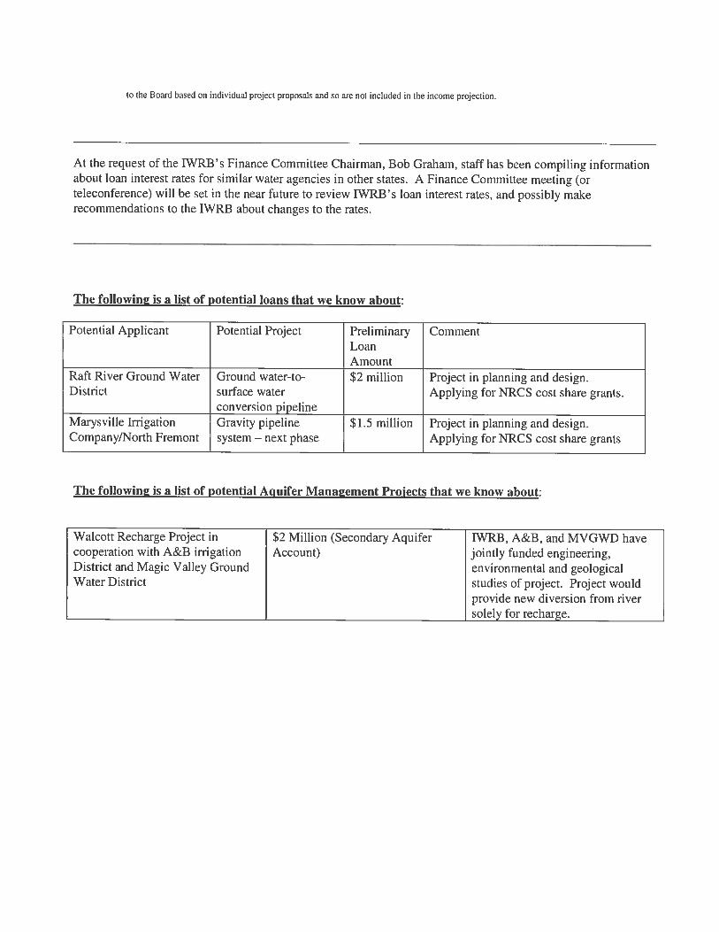


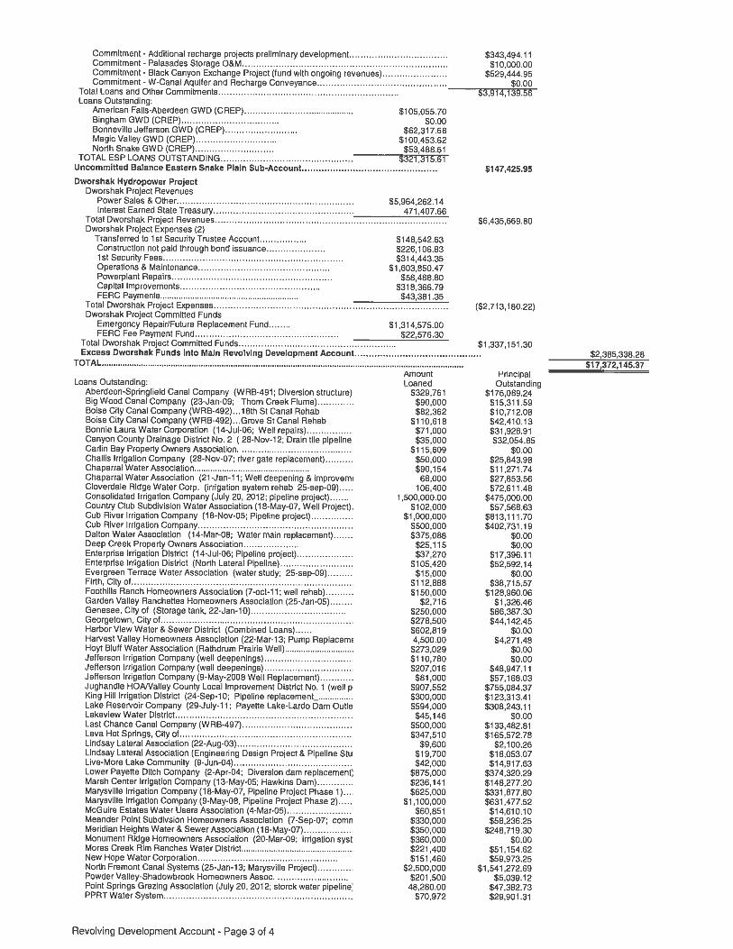


IDAHO WATER RESOURCE BOARD
January 24, 2014 The Honorable C.L. “Butch” Otter, Governor Members of the Idaho Legislature Statehouse Boise, ID 83720 Re: Water Resource Funding Program Annual Report Dear Governor Otter and Idaho Legislators:
The Idaho Water Resource Board (IWRB) is pleased to present the Fiscal Year 2013 Annual Report on the Board’s Water Resource Funding Program. In order to reduce costs, the full report is made available on-line at www.idwr.idaho.gov/waterboard. This program provides assistance to plan, design, construct, improve, and rehabilitate water resource projects that are in the public interest and in compliance with the State Water Plan. Sustainable water availability is perhaps the most important element of maintaining and expanding a strong, stable Idaho economy. The ongoing replacement and improvement of irrigation infrastructure is necessary to ensure continued agricultural production, which provides the economic foundation for the state. Idaho agriculture has now earned record cash receipts for a 3rd consecutive year. The Board works with Idaho’s communities to ensure adequate, sustainable, and safe water supplies for their residents and to provide for new businesses, industries, and economic development. During FY13 more than $6 million was authorized for 17 projects as described in this report. Significant projects the Board funded around the state include the replacement of the Consolidated Irrigation Company’s Canal near Preston with a pressurized pipeline allowing the addition of a 500 kW hydropower plant, construction of the Sunset Heights Water District exchange water delivery system so the District can comply with provisions in its SRBA water right decree, and the construction of the Milepost 31 Managed Aquifer Recharge site in cooperation with the American Falls Reservoir District No. 2.
The IWRB is striving to align its expenditures with state-priority water
management objectives laid out in the State Water Plan and its components. These include, among others, stabilization of the Eastern Snake Plain Aquifer, the development of new water storage projects, Idaho’s Swan Falls Agreement obligation to maintain minimum flows in the Snake River at the Murphy gaging station, and rehabilitation and improvement of existing water storage and delivery systems. All of these serve to sustain Idaho’s economy and provide opportunities for future economic development.
C.L. "Butch" Otter Governor
Roger W. Chase Chairman Pocatello District 4 Peter Van Der Meulen Vice-Chairman Hailey At Large Bob Graham Secretary Bonners Ferry District 1 Charles “Chuck” Cuddy Orofino At Large Vince Alberdi Kimberly At Large Jeff Raybould St. Anthony At Large Albert Barker Boise District 2 John “Bert” Stevenson Rupert District 3
322 East Front Street, Boise, Idaho 83720 Tel: (208) 287-4800 Fax: (208) 287-6700

The IWRB believes this program is an excellent example of a successful public/private partnership. With funding from the IWRB, private-sector contractors build the projects. When necessary, private-sector engineering consultants provide planning and design services. The IWRB strives to make opportunities available within this program for the services of private-sector financial institutions. When completed, the projects enhance Idaho’s water infrastructure and provide lasting, sustainable benefits across the state.
We very much appreciate the Governor and the Legislature for their continued support of the valuable service that the IWRB provides in assisting the planning, construction, and rehabilitation of Idaho’s water resources infrastructure.
Respectfully, Roger Chase Chairman

IDAHO WATER RESOURCE BOARD
WATER RESOURCE FUNDING PROGRAM
Fiscal Year 2013 Annual Report
Idaho Water Resource Board 322 East Front Street Boise, Idaho 83720
(208) 287-4800


Water Resource Funding Program
Fiscal Year 2013 Annual Report (July 1, 2012 to June 30, 2013)
IDAHO WATER RESOURCE BOARD
Roger Chase, Chairman Peter Van Der Meulen, Vice-Chairman
Bob Graham, Secretary Vince Alberdi Chuck Cuddy Jeff Raybould Albert Barker
John “Bert” Stevenson
Gary Spackman, Director Idaho Department of Water Resources
Prepared by Brian Patton
Cover Photograph: MilePost 31 Recharge Site, located on the Milner-Gooding Canal , developed through a partnership between the Idaho Water Resource Board and the American Falls Reservoir District No. 2.

"There shall be constituted a Water Resource Agency, composed as the Legislature may now or hereafter prescribe, which shall have power to construct and operate water projects; to issue bonds, without state obligation, to be repaid from revenues of projects; to generate and wholesale hydroelectric power at the site of production; to appropriate public waters as trustee for Agency projects; to acquire, transfer and encumber title to real property for water projects and to have control and administrative authority over state lands required for water projects; all under such laws as may be prescribed by the Legislature. Additionally, the State Water Resource Agency shall have power to formulate and implement a state water plan for optimum development of water resources in the public interest ... "
(Idaho Constitution Article XV Section 7)
IWRB FY13 Annual Report ii

Table of Contents
INTRODUCTION ....................................................................................................................... 1
THE NEED FOR A WATER RESOURCE FUNDING PROGRAM ........................................... 1
PROJECTS FUNDED DURING FISCAL YEAR 2013 ............................................................. 3
COMPONENTS AND OPERATION OF THE PROGRAM ....................................................... 5
ONGOING PROJECTS .......................................................................................................... 6
WATER PROJECTS AND IDAHO'S ECONOMIC DEVELOPMENT ....................................... 8
LOOKING AHEAD .................................................................................................................. 8
APPENDIX A: PROJECT REPORTS .......................................................................................10
APPENDIX B: ACCOUNT BALANCE SHEETS AS OF JUNE 30, 2013 ...................................16
APPENDIX C: YEAR-BY-YEAR SUMMARY OF FUNDS .........................................................24
IWRB FY13 Annual Report iii


INTRODUCTION The Idaho Water Resource Board (IWRB) provides assistance to plan, design, build, improve, and rehabilitate water projects that are found to be in the public interest and in compliance with the State Water Plan and to promote and achieve the efficient and effective use of Idaho's water resources. This report, required by Idaho Code § 42-1759, provides an overview of the program and its accomplishments and describes program activities during Fiscal Year 2013.
THE NEED FOR A WATER RESOURCE FUNDING PROGRAM Idaho, like all of the western states, was settled where water was available. The planning and development of adequate water supplies is an ongoing activity. Systems were built to bring water to farms and cities. Pipelines, dams, and canals were built and rebuilt. Historically, the overwhelming burden of this work fell on private individuals and cooperative groups until the federal government stepped in and assisted in the construction of irrigation, flood control, and rural and municipal drinking water projects. For the past several decades, federal budget deficits, environmental concerns, and other priorities have reduced federal spending for water projects. Thus, by necessity, the western states, including Idaho, have become more involved in the planning, financing, and construction of water projects for a variety of uses.
The demand for water continues to increase in Idaho, resulting in the need to construct new water systems, rehabilitate and expand existing water systems, and make more efficient use of existing water supplies. Many community water systems around the state were constructed years ago and now need rehabilitation or replacement. The rapid growth of the past several years is forcing many communities to find additional water supplies and upgrade their water systems to meet higher demand levis. Many small community water systems are struggling to comply with the provisions of the Safe Drinking Water Act. Because these regulations
often require expensive upgrades or new facilities, most small water systems are finding it difficult to finance the required improvements. Many irrigation systems around the state were built during pioneer days. Old systems can be inefficient in their conveyance or water. Improving or rebuilding these irrigation systems with current technologies can result in more efficient use of Idaho's water resources.
Photo: Reconstruction on the Blue Lakes Pipeline that delivers water to both Blue Lakes Trout Farm and the Board’s Pristine Springs project
IWRB FY13 Annual Report 1

Opportunities exist for, and the Board encourages, constructing "in-town" irrigation systems for residential lawn and garden irrigation, and the irrigation of parks, schoolyards, and cemeteries. These systems can reduce the demand on municipal water systems. Since most municipal systems provide some level of water treatment, it can be more cost-effective to use untreated surface water for outside irrigation uses and reserve the more expensive treated water for indoor uses. Many of the dams around the state are approaching or have exceeded 100 years in age and need replacement or major rehabilitation. This can be very costly and often the organizations responsible for the dams have limited ability to pay for the needed repairs. Devastating floods have occurred in Idaho during some years. Opportunities exist for projects, both structural and nonstructural, to reduce the damages caused be these floods. Some flood control projects can be combined with surface water storage or ground water recharge by diversion of flood flows into recharge basins. Hydroelectric power production opportunities remain at many existing dams, canal drops, and other water control structures that were built for irrigation, flood control, or other purposes. These hydroelectric projects serve to make Idaho more energy independent, are carbon-neutral, are renewable energy, and may provide revenues to the water users to help offset operation costs. The water resource funding program provides lasting benefits to Idaho in the areas of irrigation and community water supplies, flood control, and hydroelectric power, greatly enhancing Idaho's economy.
Photo: Canyon County Drainage District No. 2 replaced 1300 feet of failed drainage tile with a $35,000 loan provided by the Idaho Water Resource Board.
IWRB FY13 Annual Report 2

PROJECTS FUNDED DURING FISCAL YEAR 2013 During Fiscal Year 2013, The Idaho Water Resource Board authorized $6,349,218 in funds for the water projects listed below. More complete descriptions of these projects are included in Appendix A.
Project Loan IWRB Project Expenditure
Consolidated Irrigation Co. Pipeline with Hydro-Plant Project
$1,500,000
Point Springs Grazing Association Pipeline Project
$48,277
Kenney Creek Water Transaction* $10,220 Big Springs Creek and Upper Lemhi Water Transaction*
$69,439
Treasure Valley Water Quality Summit $500 Mile Post 31 Recharge Site $35,000 Canyon County Drainage District No. 2 Drainage Tile Project
$35,000
Lower Lemhi 2013 Annual Water Transactions* $88,344 Spring Creek Rental Water Transactions* $7,463 Spring Creek Water Donation Transactions* $3,481 North Fremont Canal System Marysville Gravity Pressure Pipeline Project-Phase 4
$2,500,000
Spokane River Conference $3,000 Harvest Valley HOA Pump Replacement Project
$4,500
Pristine Springs Project and Blue Lakes Pipeline Loan
$1,500,000 $170,000
Lower Lemhi Water Transactions* $239,850 Sunset Heights Water District Exchange Water Delivery System
$48,000
Lake Walcott Recharge Project $85,644 TOTALS $5,635,777 $712,941
Grand Total: $6,348,718
* The source of these funds is Bonneville Power Administration
IWRB FY13 Annual Report 3


IWRB FY13 Annual Report 4


COMPONENTS AND OPERATION OF THE PROGRAM The Water Resource Funding Program provides financial assistance to plan, design, construct, improve, expand, and rehabilitate the infrastructure necessary to deliver water to the people of Idaho and promote the efficient and effective use of Idaho's water resources. The financial assistance provided is in the form of loans, grants, and Board-issued revenue bonds. Projects proposed for funding through this program must be in the public interest, be in compliance with the State Water Plan, and be economically feasible, technically viable, and environmentally acceptable. One of the guiding principles of the program is that as much of the work as possible is performed by private-sector engineering and construction firms, helping to provide employment and economic stimulus throughout the state. Guidance and project oversight is provided by the Board's engineering staff to ensure that the projects are properly designed and constructed, address problems and needs, and ensure the Boards funds are efficiently utilized. Assistance is also provided in determining the scope of a proposed project and determining when the assistance of an engineering consultant is needed. When possible, projects with multiple uses are encouraged. On numerous occasions the Legislature has authorized to Board to undertake projects and studies with regional or statewide significance. The Water Resource Board Funding Program consists of the Revolving Development Account, Water Management Account, and the Water Resource Development Revenue Bond Program.
REVOLVING DEVELOPMENT ACCOUNT The Revolving Development Account was created by the Idaho Legislature in 1969 to support the development of Idaho's water resources through new construction, and through the rehabilitation or expansion of existing water projects. Funds from this account may used by the Water Resource Board for any water project in the public interest or may be loaned to appropriate entities to finance water projects. The Revolving Development Account balance sheet as of June 30, 2013, is included in Appendix B.
Photo: IWRB members examining core drilling investigation work at the proposed Galloway dam site to determine the site’s suitability for development of a large dam and reservoir project.
IWRB FY13 Annual Report 5

WATER MANAGEMENT ACCOUNT
The Idaho Legislature created the Water Management Account in 1978 to complement the Revolving Development Account. Loans and grants may be awarded to appropriate entities to finance water projects, and the Water Resource Board may expend money from this account to undertake appropriate projects that are in the public interest. Projects funded through the Water Management Account must fall into one of the following categories: reclamation, upstream storage, off-stream storage, aquifer recharge, reservoir site acquisition and protection, water supply, water quality, recreation, or water resource studies. In addition, this account serves as a mechanism for the Legislature to fund specific water projects or studies.
WATER RESOURCE DEVELOPMENT REVENUE BONDS The constitutional amendment that created the Idaho Water Resource Board authorizes the Board to issue Water Resource Development Revenue Bonds to finance the construction of water projects. The 1981 Legislature clarified the Board's authority to issue these bonds and loan the proceeds to finance water projects undertaken by local organizations within Idaho such as irrigation districts and water companies. The Board receives the proceeds from the bond sale, and then loans the funds to the project sponsor. The Bonds are issued by the Water Resource Board, usually enabling the project sponsor to obtain the advantages of tax-exempt financing. The bonds are secured by project revenues. The Board may also issue revenue bonds to finance projects undertaken by the Board. An example is the Board's Dworshak Hydropower Project, a 3 MW power plant on the water supply pipelines that deliver water from Dworshak Reservoir to the Dworshak and Clearwater Fish Hatcheries.
SECONDARY AQUIFER PLANNING, MANAGEMENT, & IMPLEMENTATION FUND The “Secondary Aquifer Fund” was created by the Legislature in 2010 to fund aquifer management projects statewide. To date, the projects have been focused on efforts to stabilize the Eastern Snake Plain Aquifer, including managed recharge.
ONGOING PROJECTS The Board has responsibility for owning and managing several ongoing water projects on behalf of the State of Idaho. Dworshak Small Hydropower Plant This 3 MW hydropower plant is located on twin pipelines that run from Dworshak Dam to supply two federally-constructed fish hatcheries below the dam. The Water Resource Board constructed the plant in 1999 - 2000. The energy is sold to the Bonneville Power Administration. Power sales revenues in excess of debt service, operations and maintenance, and repair and replacement reserve funds are used to finance other water projects around the state. Bell Rapids Water Rights As a result of a complex series of negotiations, in 2005 the Legislature directed the Water Resource Board to acquire the water rights from the Bell Rapids irrigation project near Hagerman. The water is leased to the U.S. Bureau of Reclamation for purposes specified in the Nez Perce Water Rights Agreement. IWRB FY13 Annual Report 6

Pristine Springs Project In 2008 the Water Resource Board acquired the Pristine Springs facility near Twin Falls. This purchase was undertaken in partnership with the North Snake and Magic Valley Ground Water Districts and the City of Twin Falls in order to resolve water use conflicts in the area and provide water for future municipal growth. The facility consists of a fish hatchery, 200 acres of irrigated pasture, and two small hydroelectric power plants with a combined capacity of 325 kW. Even after execution of the water use agreements with the ground water districts and the City, which reduced its available water supply, the facility still has fish production capability. The hatchery and agricultural ground are leased to the former operators. The energy from the hydropower plants is sold to Idaho Power. The Water Resource Board is currently evaluating long-term options for the facility. ESPA Recharge The Legislature has directed the Water Resource Board to undertake a program of aquifer recharge for the Eastern Snake Plain Aquifer (ESPA). The Board owns water rights for recharge from the Snake River and Wood River. In anticipation of recharge playing a central role in the ESPA Comprehensive Aquifer Management Plan (CAMP), the Board has been laying the groundwork for a large-scale, sustainable recharge program on the Eastern Snake Plain. Between 2009 and 2013, approximately 475,000 acre-feet of recharge into the ESPA was accomplished to help begin implementation of the ESPA CAMP. The Board utilized this operational experience, along with hydrologic modeling, to determine how to most effectively undertake recharge to accomplish aquifer stabilization.
Palisades Storage Contract In 2008, the Water Resource Board purchased a 5,000-acre-foot water storage contract in Palisades Reservoir from the FMC Corporation. Palisades is a large federally-owned and operated reservoir. The Board intends to utilize this storage to help in making additional water available in the eastern Snake Plain area
Photo: Test Drilling at the Walcott Recharge Site.
IWRB FY13 Annual Report 7

Upper Salmon Basin In cooperation with several state and federal agencies over the past several years, the Water Resource Board has entered into several short-term and long-term agreements with water right holders in the Upper Salmon Basin. The purpose of these agreements is to provide stream flows sufficient for endangered species needs while maintaining the agricultural economy of the area. These voluntary agreements may take the form of non-diversion agreements, water leases, conservation easements, and changes in diversion locations. Very few agreements result in actual dry-ups of land. The funding source for these agreements is the Bonneville Power Administration and federal Pacific Coast Salmon Recovery funds.
WATER PROJECTS AND IDAHO'S ECONOMIC DEVELOPMENT Water is essential for the stability and continued growth of Idaho's economy. Agriculture is a major part of the state's economy and has traditionally been a stabilizing influence to moderate the boom and bust cycles of the state's mining and timber industries. Idaho's newer high-tech industries are subject to boom and bust cycles, making agriculture's stabilizing influence all the more important. By assisting with the reconstruction and improvement of irrigation systems, the Water Resource Board is helping to ensure that the water supply, storage, and delivery infrastructure necessary for agricultural production will be in place for many years to come. Water is essential for the stability and growth of Idaho's communities. By assisting with the construction and improvement of community water supply, storage, treatment, and delivery projects, the Water Resource Board is helping make the state's communities attractive places to live. These projects foster economic development by providing a stable water supply for business and industry. A secondary benefit of these projects is the increased employment and material purchases involved in project planning, design, and construction. This helps to provide private-sector employment and economic stimulus throughout the state.
LOOKING AHEAD The Water Resource Board is assisting the people of Idaho with maintaining and improving the vital infrastructure required to manage the state's water resources. Local governments and cooperatives throughout the state have demonstrated their capability, with state assistance, to develop projects that address local water needs. There may be needs for the construction of state-sponsored projects that provide regional benefits, such as construction of additional above or below-ground water storage to alleviate conflicts and provide for growth. In addition, the Water Resource Board is cooperating with the Department of Water Resources to evaluate the impacts
Photo: Little Springs Creek in the Upper Salmon Basin
IWRB FY13 Annual Report 8

of climate change on water management in Idaho. Depending on the climate change-related effects on our water resources, modifications to water storage and delivery systems may be necessary, including enlarged surface and ground water storage capacity. The Water Resource Board is encouraging irrigation system improvements wherever possible, keeping in mind the importance of incidental recharge to our aquifer levels. Dam repair, municipal and community water system projects, and irrigation system improvements are anticipated in Fiscal Year 2014 and 2015. The Eastern Snake Plain Comprehensive Aquifer Management Plan, which has been approved by the Legislature and signed into law with the goal of stabilizing the Eastern Snake Plain Aquifer, will require the implementation of several aquifer management measures.
Photo: The North Fremont Canal System, Inc. received a $2,500,000 loan to construct Phase 4 of Marysville project to convert open canals to gravity-pressurized pipelines.
IWRB FY13 Annual Report 9


Appendix A: Project Reports
Fiscal Year 2013 Idaho Water Resource Board Funded Projects and Studies
IWRB FY13 Annual Report 10


CONSOLIDATED IRRIGATION COMPANY PIPELINE WITH HYDRO-PLANT PROJECT Project Sponsor: Consolidated Irrigation Company IWRB Funds: $1,500,000 (Loan) Account: Revolving Development Account Project Description: The Consolidated Irrigation Company requested $1,500,000 to convert 6 miles of unlined canal to 3.5 miles of pressurized pipeline with a small hydro-plant at the end. Consolidated Irrigation Company delivers water to 456 share holders irrigating 17,000 acres. The Consolidated Irrigation Company loan was approved at 5.5% interest for a term of 20 years, contingent upon the fact that no monies go out until concrete cost estimates and the power sales contract are obtained. POINT SPRINGS GRAZING ASSOCIATION PIPELINE PROJECT Project Sponsor: Point Springs Grazing Association IWRB Funds: $48,276.62 (Loan) Account: Revolving Development Account Project Description: The Point Springs Grazing Association requested $48,276.62 to replace an existing 6 miles of pipeline. The Association is a group of 6 ranchers that pasture cattle in the Meadow Creek Canyon. It grazes approximately 550 head of cattle during the summer months on 13,000 acres. The Point Springs Grazing Association loan was approved at 5.5% interest for a term of 10 years. KENNEY CREEK WATER TRANSACTION Project Sponsor: Idaho Water Resource Board IWRB Funds: $10,219.79 from the Bonneville Power Administration (Idaho Fish Accord) Account: Revolving Development Account Project Description: The Kenney Creek transaction is a 20-year agreement not to divert 0.14 cfs out of Kenney Creek with the Andrews family. The goal of the project is to reduce the diversion that might adversely impact the creek by putting a small pumping station on a wastewater ditch that runs along the Andrews property. Funds for the project come from the Bonneville Power Administration through the Idaho Fish Accord and are used to compensate the irrigator for power costs associated with operating the new pumping system. BIG SPRINGS CREEK AND UPPER LEMHI WATER TRANSACTION Project Sponsor: Idaho Water Resource Board IWRB Funds: $69,438.50 from the Bonneville Power Administration (Idaho Fish Accord) Account: Revolving Development Account Project Description: The Big Springs Creek (Upper Lemhi) transaction is a 20-year agreement not to divert 1.36-4.54 cfs out of Big Springs Creek and the Lemhi River with the Beyeler Ranches. In order to increase flows in Big Springs Creek and the Upper Lemhi River, Beyeler Ranches would consolidate some of its Lemhi River water rights and all of its Big Springs water rights into one diversion. Funds for the project come from the Bonneville Power Administration through the Idaho Fish Accord and are used to compensate the irrigator for power costs associated with operating the new pumping system. IWRB FY13 Annual Report 11

TREAUSRE VALLEY WATER QUALITY SUMMIT Project Sponsor: Idaho Water Resource Board IWRB Funds: $500 (Fund Allocation) Account: Revolving Development Account’s Rathdrum Prairie/Treasure Valley
CAMP Subaccount Project Description: The Treasure Valley Partnership requested $500 towards funding a Treasure Valley Water Quality Summit. Matching funds were also requested from other organizations. The Treasure Valley Water Quality Summit supports several actions delineated in the Recommended Treasure Valley Comprehensive Aquifer Management Plan, including: coordination and implementation through coordinating with water users and evaluating and addressing environmental issues; partnership among stakeholders to fund activities and leverage programs with CAMP implementation, and overall IWRB efforts to resolve potential conflicts through cooperation and collaboration rather than crisis and litigation. The IWRB approved the allocation of funds to the Treasure Valley Partnership for the Treasure Valley Water Quality Summit. MILE POST 31 RECHARGE SITE Project Sponsor: Idaho Water Resource Board IWRB Funds: $35,000 (Fund Allocation) Account: Secondary Aquifer Planning, Management, and Implementation Fund Project Description: The American Falls Reservoir District No. 2 requested to partner with the Board to construct the Mile Post 31 Recharge Site. Managed aquifer recharge is a major water management strategy spelled out in the ESPA CAMP. The Board approved the expenditure of up to $35,000 to assist the American Falls Reservoir District No. 2 with construction of the Mile Post 31 Managed Recharge Site, not to exceed 40% of actual project costs. CANYON COUNTY DRAINAGE DISTRICT NO. 2 DRAINAGE TILE PROJECT Project Sponsor: Canyon County Drainage District No. 2 IWRB Funds: $35,000 (Loan) Account: Revolving Development Account Project Description: The Canyon County Drainage District No. 2 (CCDD2) requested $35,000 to replace 1300 feet of failed drainage tile. The CCDD2 was formed in 1918 and services 2300 acres of agriculture and rural development in southwestern Idaho in Payette County and Washington County. The CCDD2 loan was approved at 5.5% interest for a term of 10 years. LOWER LEMHI 2013 WATER TRANSACTIONS Project Sponsor: Idaho Water Resource Board IWRB Funds: $88,343.65 from the Bonneville Power Administration (Idaho Fish Accord) Account: Revolving Development Account Project Description: The Lower Lemhi 2013 Annual Transaction was a set of eight annual agreements not to divert out of the Lemhi River to improve stream flow for anadromous and resident fish. The irrigators were paid $80.65 per cfs for each day that water was not diverted for irrigation use. During the 2013 irrigation season 822 acre-feet was used under these annual agreements to maintain the target flows in the river. The IWRB approved the funding for this project for $82,343.65 and $12,800 ($6,000) to come from the Idaho Fish Accords) to Water District 74 for administration of the easements. However, only $38,891.86 was actually spent on this project. IWRB FY13 Annual Report 12

SPRING CREEK RENTAL WATER TRANSACTION Project Sponsor: Idaho Water Resource Board IWRB Funds: $7,463.31 from the Bonneville Power Administration (Columbia Basin Water Transaction Program) Account: Revolving Development Account Project Description: The Spring Creek Rental Water transaction is an agreement between water right owners Richard LaVere Beard and Richard and Ella Beard and the IWRB. The water right owners proposed to lease their rights into the Water Supply Bank for a term of five years. The IWRB could then rent the water rights out for delivery to the Teton River minimum stream flow right. It is in the interest of the State of Idaho to increase stream flow in the Teton River and its tributaries to encourage recovery of Yellowstone cutthroat trout. Funds for the project come from the Bonneville Power Administration through the Columbia Basin Water Transaction Program. SPRING CREEK WATER DONATION TRANSACTIONS Project Sponsor: Idaho Water Resource Board IWRB Funds: $3,480.63 from the Bonneville Power Administration (Columbia Basin Water Transaction Program) Account: Revolving Development Account Project Description: The Spring Creek Water Donation transaction is an agreement between water right owners City of Tetonia and Mitchell Smaellie and the IWRB. The water right owners proposed to donate their rights to the IWRB to put into the Water Supply Bank for a term of five years. The IWRB could then rent the water rights out for delivery to the Teton River minimum stream flow right. It is in the interest of the State of Idaho to increase stream flow in the Teton River and its tributaries to encourage recovery of Yellowstone cutthroat trout. Funds for the project come from the Bonneville Power Administration through the Columbia Basin Water Transaction Program. NORTH FREMONT CANAL SYSTEMS MARYSVILLE GRAVITY PRESSURE PIPELINE PROJECT – PHASE 4 Project Sponsor: North Fremont Canal System, Inc IWRB Funds: $2,500,000 (Loan) Account: Revolving Development Account Project Description: The North Fremont Canal System, Inc. requested $2,500,000 construct Phase 4 of Marysville project to convert open canals to gravity-pressurized pipelines. The estimated cost of the project is around $9.2 million with the NRCS providing a cost share for the remainder of this project. The portion of the project called Phase 4 will encompass 34 shareholders servicing 4928 acres. The North Fremont Canal Systems loan was approved at 5.5% interest for a term of 15 years. SPOKANE RIVER CONFERENCE Project Sponsor: Idaho Water Resource Board IWRB Funds: $3,000 (Fund Allocation) Account: Revolving Development Account’s Rathdrum Prairie/Treasure Valley
CAMP Subaccount Project Description: The Spokane River Forum requested $3,000 to support the Spokane River Conference scheduled for March 26th and 27th, 2013. Matching funds were also requested from other organizations. The Treasure Valley Water Quality Summit supports several RP CAMP objectives including: prevention and resolution of water conflicts, protecting the aquifer through bringing the key agencies in an effort to address overlapping jurisdictions with the goal of improving efficiency and
IWRB FY13 Annual Report 13

sharing knowledge, and adaptive management, monitoring and data gathering. The IWRB approved the allocation of funds to the Spokane River Forum for the Spokane River Conference. HARVEST VALLEY HOME OWNERS ASSOCATION PUMP REPLACEMENT PROJECT Project Sponsor: Harvest Valley Home Owners Association IWRB Funds: $4,500 (Loan) Account: Revolving Development Account Project Description: The Harvest Valley Home Owners Association (HOA) requested $4,500 to their irrigation pump. The Harvest Valley HOA is made up of 81 homes in Phases 1 through 3 with additional homes expected for phases 4 and 5 as the economy improves. The Harvest Valley HOA loan was approved at 6 % interest for a term of 5 years. PRISTINE SPRINGS PROJECT AND BLUE LAKES PIPELINE LOAN Project Sponsor: Idaho Water Resource Board Various Ground Water/Irrigation Districts IWRB Funds: $170,000 (Fund Allocation) $1,500,000 (Loan) Account: Revolving Development Account Project Description: The ground water districts and other parties who own the Blue Lakes Trout Farm requested that the Board participate in rebuilding the pipeline that delivers water to both Blue Lakes Trout Farm and the Board’s Pristine Springs project. The IWRB approved an expenditure of 10% of the total project cost, not to exceed $170,000, as well as approved a loan in the amount of $1.5 million at 4% interest rate with a 5-year term to finance the balance of the pipeline replacement. LOWER LEMHI WATER TRANSACTIONS Project Sponsor: Idaho Water Resource Board IWRB Funds: $239, 850 from the Bonneville Power Administration (Idaho Fish Accord) Account: Revolving Development Account Project Description: These Lower Lemhi River water transactions are subordination agreements entered into with the current or subsequent water right owners of water rights 74-319B and 74-320 to subordinate their diversions from the Lemhi River to the IWRB’s Lemhi River minimum streamflow water right. The goal of these agreements is to maintain a minimum streamflow water right of 35 cfs in the Lower Lemhi River, as directed by the Idaho Legislature. Funds for the project come from the Bonneville Power Administration through the Idaho Fish Accord and are used to compensate the irrigator for power costs associated with operating the new pumping system. SUNSET HEIGHTS WATER DISTRICT EXCHANGE WATER DELIVERY SYSTEM Project Sponsor: Sunset Heights Water District IWRB Funds: $48,000 (Loan) Account: Revolving Development Account Project Description: The Sunset Heights Water District requested $48,000 to install an irrigation pump and pipeline to supply exchange water as stated in the SRBA. The Sunset Heights Water District has 57 members whose main water source is from a spring which it collects via pipelines and stores in two 20,000 gallon tanks before delivering it to the users. The Sunset Heights Water District loan was approved at 5.5% interest for a term of 10 years. IWRB FY13 Annual Report 14
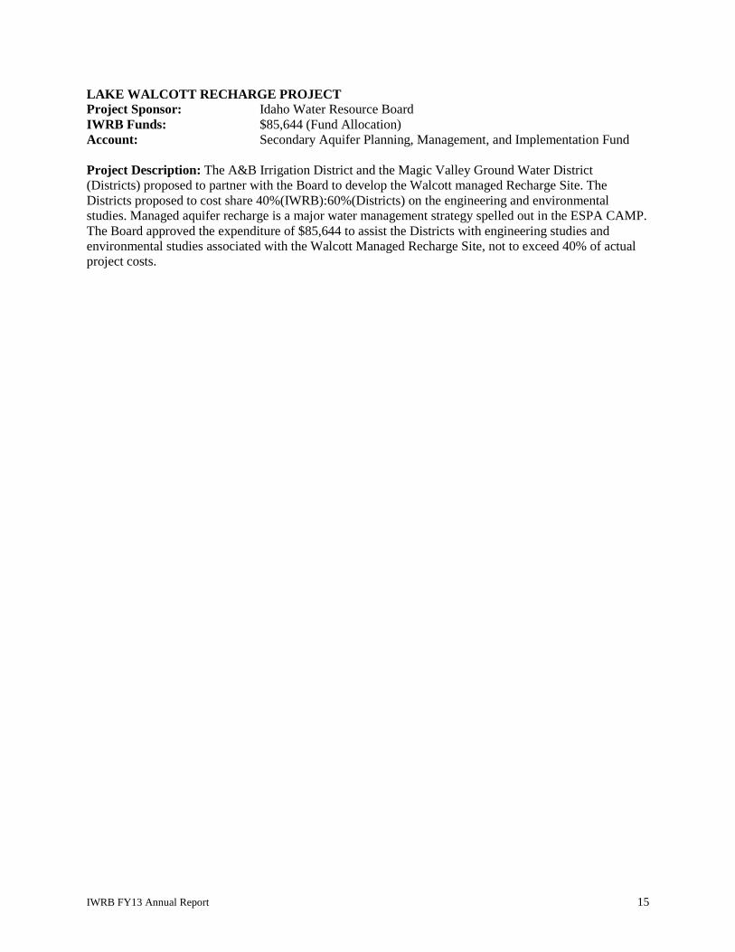
LAKE WALCOTT RECHARGE PROJECT Project Sponsor: Idaho Water Resource Board IWRB Funds: $85,644 (Fund Allocation) Account: Secondary Aquifer Planning, Management, and Implementation Fund Project Description: The A&B Irrigation District and the Magic Valley Ground Water District (Districts) proposed to partner with the Board to develop the Walcott managed Recharge Site. The Districts proposed to cost share 40%(IWRB):60%(Districts) on the engineering and environmental studies. Managed aquifer recharge is a major water management strategy spelled out in the ESPA CAMP. The Board approved the expenditure of $85,644 to assist the Districts with engineering studies and environmental studies associated with the Walcott Managed Recharge Site, not to exceed 40% of actual project costs.
IWRB FY13 Annual Report 15


Appendix B: Account Balance Sheets as of June 30, 2013
Revolving Development Account
Water Management Account
Secondary Aquifer Planning, Management, & Implementation Fund
IWRB FY13 Annual Report 16


IWRB FY13 Annual Report 17

IWRB FY13 Annual Report 18

IWRB FY13 Annual Report 19

IWRB FY13 Annual Report 20

IWRB FY13 Annual Report 21
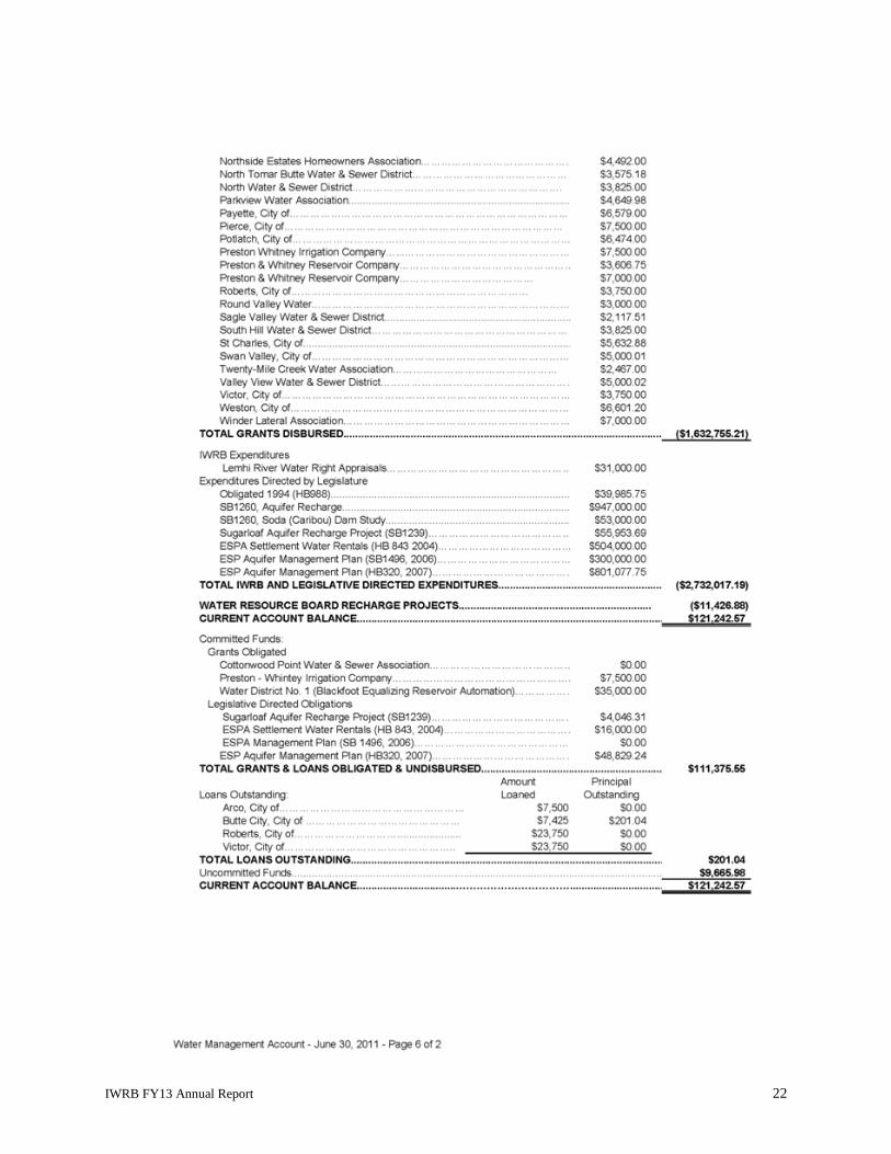
IWRB FY13 Annual Report 22

IWRB FY13 Annual Report 23


Appendix C: Year-By-Year Summary of Funds
IWRB FY13 Annual Report 24


$0
$5,000,000
$10,000,000
$15,000,000
$20,000,000
$25,000,000
$30,000,000
1970
1972
1974
1976
1978
1980
1982
1984
1986
1988
1990
1992
1994
1996
1998
2000
2002
2004
2006
2008
2010
2012
Revolving Development Account
IWRB Projects
Loans for Locally Sponsored Water Projects
Year
$0
$200,000
$400,000
$600,000
$800,000
$1,000,000
$1,200,000
1970
1972
1974
1976
1978
1980
1982
1984
1986
1988
1990
1992
1994
1996
1998
2000
2002
2004
2006
2008
2010
2012
Water Management Account
IWRB Projects
Loans for Locally Sponsored Water Projects & Studies
Grants for Locally Sponsored Water Projects & Studies
IWRB FY13 Annual Report 25


$0
$5,000,000
$10,000,000
$15,000,000
$20,000,000
$25,000,000
$30,000,000
$35,000,000
$40,000,000
1970
1973
1976
1979
1982
1985
1988
1991
1994
1997
2000
2003
2006
2009
2012
Water Resource Development Revenue Bonds
Bonds for IWRB Projects
Bonds for Locally Sponsored Water Projects
$0
$200,000
$400,000
$600,000
$800,000
$1,000,000
$1,200,000
$1,400,000
$1,600,000
$1,800,000
1970
1973
1976
1979
1982
1985
1988
1991
1994
1997
2000
2003
2006
2009
2012
Secondary Aquifer Planning, Management, and Implementation Fund
IWRB Projects
Loans for Locally Sponsored Water Projects
IWRB FY13 Annual Report 26


Memorandum To: Idaho Water Resource Board
From: Morgan Case
Date: January 24, 2014
Re: Water Transactions Program – 2014 Morgan Creek Transaction
The 2004 Snake River Water Rights (“Nez Perce”) Agreement commits the state to providing incentives for improving fish habitat which includes improving or protecting flow conditions to augment stream flows. Morgan Creek, a tributary to the Salmon River near Challis, is important for the spawning, migration and rearing of ESA-listed steelhead and bull trout. It also supports the rearing of ESA-listed juvenile Chinook salmon. Morgan Creek typically becomes dewatered below the lowest two diversions (SMC 2-4 and SMC 1) during the irrigation season, blocking access to those fish species. For the past eight years, the IWRB has held agreements not to divert with the two water users on those diversions from Morgan Creek. Rather than divert from Morgan Creek, they left at least 2 cfs in the creek during the low flow periods to maintain adequate flows in Morgan Creek to the confluence with the Salmon River. The water was instead pumped out of a Salmon River ditch that carries existing Salmon River water rights appurtenant to the same ground. In return, the irrigators were compensated based on the cost of pumping water from the Salmon River ditch. While the agreements have sustained a minimum flow over the past 8 years, the approach to flow restoration over that time has changed. Instead of addressing only flow limitations, Board staff works with Upper Salmon Basin partners to develop transactions that can complement projects addressing all limiting factors, while maintaining the local economy. Morgan Creek has been on a back burner the last 5 years, while work has focused on the Lemhi and Pahsimeroi River Basins. Staff proposes taking a fresh look at the opportunity for meaningful flow restoration in Morgan Creek over the next year. In the mean time, it is important to secure the gains that have already been made. The water users have expressed a willingness to develop another long-term flow restoration transaction and have agreed to enter into a one-year agreement not to divert while those discussions are underway. The proposed one-year agreement would be an extension of the same terms and pricing structure of the previous 5-year agreement. The Morgan Creek water users will be compensated only when they are required to pump to maintain the 2 cfs flow. The maximum payment is based upon a five percent increase from the 2013 payment, with the total not to exceed $8,000. On January 10, 2014, the IWRB Streamflow Enhancement and Minimum Streamflow Committee recommended this transaction be approved by the IWRB.
Action Item: Consideration of the attached funding resolution for $8,000 to enter into a one-year minimum flow agreement to maintain 2 cfs in Morgan Creek, tributary to the Salmon River. Funds will come through the Columbia Basin Water Transactions Program.


BEFORE THE IDAHO WATER RESOURCE BOARD IN THE MATTER OF THE ) A RESOLUTION TO MAKE 2014 MORGAN CREEK WATER ) A FUNDING COMMITMENT TRANSACTION CONTRACT ) ____________________________________)
WHEREAS, steelhead, bull trout, and juvenile Chinook salmon habitat in Morgan Creek is limited by low flow in the lower reaches of Morgan Creek; and
WHEREAS, Morgan Creek provides steelhead, bull trout, and juvenile Chinook salmon habitat and the 2004 Snake River Water Rights (“Nez Perce”) Agreement commits the state to providing incentives for improving fish habitat which includes improving or protecting flow conditions to augment stream flows; and
WHEREAS, it is in the interest of the State of Idaho to reconnect Morgan Creek to encourage recovery of ESA-listed steelhead, bull trout, and Chinook Salmon; and
WHEREAS, staff has developed a series of agreements not to divert water from Morgan Creek at the SMC-2/4 and SMC-1 diversions to improve stream flow for anadromous and resident fish; and
WHEREAS, staff has now negotiated one-year agreement with the Morgan Creek water users not to divert water at the SMC2/4 and SMC 1 diversions; and
WHEREAS, a proposal for $8,000 has been submitted to the Columbia Basin Water Transactions Program to be used to fund said agreements; and
WHEREAS, instead of diverting from Morgan Creek, the water users have agreed to pump from Salmon River sources that are not flow-limited and the funds paid under these agreements will approximate the power expenses incurred, by changing the points of diversion; and
WHEREAS, the Morgan Creek transactions are in the public interest and in compliance with the State Water Plan.
NOW THEREFORE BE IT RESOLVED that the IWRB authorizes the Chairman to enter into contracts with Ronald Jones and Donna Hughes, or their successors, for agreements not to divert out of Morgan Creek using an amount not to exceed $8,000.
NOW THEREFORE BE IT FURTHER RESOLVED that this resolution is subject to the condition that the IWRB receives the requested funding from the Bonneville Power Administration through the Columbia Basin Water Transaction Program in the amount of $8,000.
DATED this 24th day of January 2014.
____________________________________ ROGER CHASE, Chairman Idaho Water Resource Board
ATTEST: _________________________________
BOB GRAHAM, Secretary

MEMORANDUM
To: Idaho Water Resource Board
From: Sarah Lien, Friends of the Teton River
Date: January 10, 2014
Re: Water Transactions Program – Teton River Basin – South Leigh Creek Transactions
Action Item: Attached are two expenditure of fund resolutions. The first resolution authorizes the Board
to expend $704.00 to pay for the application and administrative fees associated with the donation of South
Leigh Creek water rights for a term of five years. The second resolution authorizes the Board to expend
$3,902.00 to fund the lease of South Leigh Creek water rights for a term of 1 year.
Background and Ecological Significance of South Leigh Creek
South Leigh Creek is a tributary to the Teton River located in the upper Teton Valley. The tributary runs
from east to west, originating in the Teton Range and flowing towards the Teton River. The tributary
offers excellent fish and wildlife habitat and supports a Yellowstone cutthroat trout (YCT) population.
Currently, irrigation withdraws result in the annual dewatering of the stream, and each year the stream is
subject to the futile call doctrine. Pervasive yearly dewatering serves to restrict fish movement and
migration, reduce valuable habitat, and elevate stream temperatures. Restoring flow to specific reaches in
South Leigh Creek will have a positive impact on the YCT fishery in that tributary, serving to create
valuable habitat, allowing for fish passage and migration, decreasing stream temperatures, and ultimately
helping to encourage the recovery of YCT populations in the upper Teton Valley.
YCT are currently listed as a "species of greatest concern" for the Teton River Basin in the Idaho
Comprehensive Wildlife Conservation Strategy (February 2006), and by consequence garner management
priority throughout their historic range, including the Teton Basin. South Leigh Creek is incredibly
valuable for YCT. The perennial, mountain section of South Leigh Creek houses a genetically pure
population of YCT.
A great deal of effort has been committed to restoring and improving fish habitat, and preventing fish
entrainment in irrigation diversions on South Leigh Creek. FTR has conducted three stream restoration
projects on South Leigh Creek, restoring and stabilizing over 1,350 feet of stream and re-vegetating over
6,755 square feet of stream bank. Substantial stream restoration work has also been conducted by private
landowners. Additionally, FTR worked with irrigators to rebuild the largest diversion on South Leigh
Creek, the Hog Canal diversion. The rebuild not only incorporated modern diversion works but solar
operated fish screens. Building from the success of that project, FTR is currently working with irrigators
to install fish screens on the Desert Canal. The project is tentatively scheduled for construction in the fall
of 2014.
South Leigh Creek is listed under Section 303(d) of the Clean Water Act. The stream has been listed for
sediment and a TMDL has been developed by the Idaho Department of Environmental Quality. Stream
restoration efforts have served to aid in the reduction of sediment transported in stream. Additionally,
IDEQ has determined that the stream does not support one of its designated beneficial uses, cold water
aquatic life. Flow restoration efforts in South Leigh Creek will help decrease stream temperature and
increase available habitat for aquatic species, both of which are important to ensuring that South Leigh
Creek once again supports its designated beneficial uses.
Overall, the flow restoration strategy on South Leigh Creek aims to provide additional in stream habitat
for native YCT, as flow is the primary limiting factor preventing development of a more robust YCT
population in this tributary. However, it is critically important that flow restoration efforts are conducted
in such a manner, and in close coordination with IDF&G, to ensure that the genetically pure population of
YCT is not jeopardized by non-native fish invasion. It is agreed that the transactions proposed below
reach those goals.
Description of Proposed Transactions
A. Dan and Patti Burr
Dan and Patti Burr have two water rights that they propose donating to the Idaho Water Transactions
Program for a period of 5 years. If approved, the water rights will be leased into the Idaho Water Supply
Bank, to be rented by the IWRB for delivery to the Teton River minimum stream flow right. Through
this transaction 6 acres of land will be fallowed throughout the five year term. This transaction will add
0.11 cfs of flow to South Leigh Creek.
These water rights have relatively junior priority dates. Water right number 22-13436 has a priority date
of June 10, 1897 and water right number 22-13437 has a priority date of June 1, 1898. It is anticipated
that these water rights will be in priority, and therefore deliverable to the Teton River minimum stream
flow right, when South Leigh Creek is hydraulically connected to the Teton River. As a consequence,
despite this being a futile call stream, leasing these water rights through the Idaho Water Transaction
Program should not impact the historic delivery of other water rights on the stream or result in injury to
other water right owners, and the leased rights should be conveyed to the Teton River minimum
streamflow reach without issue.
A proposal to fund these donations has been submitted to the Columbia Basin Water Transaction Program
in the amount of $704.00. The requested funds will be placed into the Board’s revolving development
water transaction subaccount to pay the fees associated with the lease/rental of water in the Idaho Water
Supply Bank, as follows: Water Right Application Fee ($500.00); 10% Administrative Fee ($179.00); and
Recording Fee ($25.00).
B. Osagia, LLC
Osagia, LLC has one water right that it proposes to enter into the Idaho Water Transactions Program for a
period of 1 year. Through this transaction 36 acres of land will be fallowed during the one year term.
This transaction will add 0.74 cfs of flow to South Leigh Creek.
The water right held by Osagia, LLC is one of 5 water rights with an April 1, 1889 priority date. These
five water rights are the most senior water rights on South Leigh Creek. As mentioned above, South
Leigh Creek has historically been deemed futile on an annual basis, and is therefore subject to the futile
call doctrine each year.
The Osagia, LLC water right has historically been diverted at the Desert Canal diversion, which is located
near the upper end of the annually dewatered stream reach, also referred to as the futile call reach. (See,

attached map entitled South Leigh Creek Transaction Map.) Because this transaction involves a water
right historically diverted at the upper end of a futile call reach, it is proposed that the IWRB enter into an
agreement not to divert with Osagia, LLC, formalized in part by leasing the water right into the Water
Supply Bank and restricting rental of the water right (as opposed to utilizing the Water Supply Bank to
rent the water to the Teton River minimum streamflow reach). This transactional structure will ensure
that the water right is legally deliverable to the historic point of diversion, at the Desert Canal, regardless
of whether the stream has been deemed futile or not. This structure satisfies the objectives of the Idaho
Water Transactions Program by ensuring that South Leigh Creek remains wetted to the Desert Canal
diversion and that the Osagia, LLC water right is left in stream, serving to increase available habitat for
Yellowstone cutthroat trout.
Bob Loucks valued the water right at $87.65/acre. The valuation is based upon the historical use of the
water rights, which included generating one cutting of hay and then pasturing the aftermath. The
valuation was presented to the water right owner and found acceptable. This is the same valuation and
pricing structure utilized to value the Spring Creek water transactions and serves to keep pricing
consistent in the upper Teton Valley.
Osagia, LLC also has a groundwater right appurtenant to this parcel of land, water right number 22-
13815. It is proposed that this water right also be leased into the Idaho Water Supply Bank for a one year
term, to protect the water right from claims of forfeiture and ensure that neither ground nor surface water
are utilized to irrigate the property. (See, attached email from Tony Olenichak.)
A proposal to fund these transactions has been submitted to the Columbia Basin Water Transaction
Program in the amount of $3,902.00. The requested funds will be placed into the Board’s revolving
development water transaction subaccount which will be used to compensate the water right owner and
cover the recording fee, as follows: Water Right Application Fee: ($500.00); 10% Administrative Fee
($221.00); Payment to Water Right Holder ($3,156.00); and Recording Fee ($25.00).
Monitoring and Contract Compliance
Monitoring and contract compliance will be conducted by the local water district (WD 01) and Friends of
the Teton River. It is anticipated that the point of diversion associated with these water rights, as well as
all other diversions on the tributary, will be monitored by WD 01 on a weekly basis to ensure that the
water rights remain in stream. Ecological and fisheries benefits will be monitored by Friends of the Teton
River, in conjunction with Idaho Department of Fish and Game.
Letters of Support and Public Outreach
Water District 01: The proposed transactions have been reviewed by Lyle Swank and Tony Olenichak of
WD 01. No concerns have been raised with the transactions from either a water delivery or an injury
perspective. Correspondence from Mr. Swank and Mr. Olenichak regarding this matter has been attached
to this briefing memorandum.
Idaho Fish and Game: Each of the water transactions has been reviewed by Dan Garren, Regional
Fisheries Manager for Idaho Fish and Game. Mr. Garren has submitted a letter of support which has been
attached to this briefing memorandum.
Informational Open House: FTR hosted an informational open house on Wednesday, December 4, 2013
in Driggs, Idaho at the Driggs City Center to provide members of the public with an opportunity to learn
about the proposed water leases discussed in this memorandum. The event was held in an effort to
educate the water users and citizens of Teton Valley about the Idaho Water Transaction Program
generally, and address any questions or concerns about the South Leigh water leases contemplated in this
memorandum. The event was publicized in the Teton Valley Citizen on November 27, 2013. The Teton
Valley Citizen is one of Teton Valley’s local newspapers. It is published weekly and made available to
the public free of charge at venues throughout Driggs, Victor, and Tetonia. Additionally, the event was
publicized in FTR’s weekly e-blast on Monday, December 2, 2013. FTR received no inquiries in regard
to the South Leigh Creek leases as a result of this outreach.
Streamflow Enhancement and Minimum Stream Flow Committee Recommendation: The
Streamflow Enhancement and Minimum Streamflow Committee met on January 10, 2014 to review and
make recommendations on several water transactions, including these. The committee recommended
both of these transactions for approval.

North Leigh Creek
IdahoWyom ing
Spring Creek!
!!
!!!
!
Bell-McCracken Ditch and PODBurr Parcel
Teton River
Middle Leigh Creek
City of Driggs
Desert Canal Ditch and POD
Osagia, LLC Parcel
North Beard Diversion
!
!
!!
!
!!!!!!!!!
!
City of Tetonia
Teton River Minimum Streamflow Reach
Hog Canal Diversion
Direction of Flow
South Leigh Creek
Hs-2
South Leigh Creek Transaction Map
±0 0.8 1.60.4Miles
Data Sources: NRCS; IDWR; US Census; FTR
Friends of the Teton RiverNovember 2013
£¤33
Idaho
Teton County
Futile Call ReachSeasonally Dewatered Reach

From: Olenichak, TonyTo: Case, MorganCc: Sarah Rupp; Swank, LyleSubject: RE: South Leigh Creek Water TransactionsDate: Thursday, November 07, 2013 5:16:54 PM
Case, Reviewing the information sent to me by Sarah Rupp indicates the two water rights 22-13436 and 22-13437 currently assigned to the Bell-McCracken Ditch on South Leigh Creek will be deposited into the Idaho Water Supply Bank and then rented by the IWRB for delivery to the Teton River point of diversion described in minimum stream flow right 22-7369. The intent of the transaction appears to be to increase the flow in South Leigh Creek in the reach from the Bell-McCracken Ditch on South Leigh Creek to the point(s) of diversion on the Teton River for water right 22-7369 resulting from not diverting water rights 22-13436 and 22-13437 through the Bell-McCracken Ditch for irrigation when they are in priority. It does not appear that this transaction would interfere with the delivery to other water rights on South Leigh Creek or the Teton River. Changing the point of diversion for water rights 22-13436 and 22-13437 so that these rights are not delivered to the Bell-McCracken Ditch may result in additional water in the reach from the Bell-McCracken Ditch to the Teton River but does not necessarily guarantee this result. If the flow at the mouth of South Leigh Creek is greater or equal to the flow rates of water rights 22-13436 and 22-13437, it wouldn’t be necessary for the Watermaster to curtail any other South Leigh Creek water rights to provide additional water to the lower reach on South Leigh Creek because the IWRB would be receiving its entire amount of South Leigh Creek water delivered to the Teton River for water rights 22-13436 and 22-13437, even if the South Leigh Creek channel was dry at some point between the Bell-McCracken Ditch and the mouth of South Leigh Creek. The transaction also includes depositing water right 22-13817 into the Idaho Water Supply Bank and then rented by the IWRB for the purpose of changing the nature of use from irrigation to insteam flow without changing the point of diversion. Water right 22-13817 is for diverting South Leigh Creek water for irrigation through the Desert Ditch. The intent of the transaction is to keep the flow rate and priority for water right 22-13817 assigned to the Desert Ditch ensuring that the water right flow rate will be delivered in the South Leigh Creek channel to the point where the Desert Ditch diverts water from the creek, as it has been delivered to that point in the past for irrigation. It does not appear that this transaction would interfere with the delivery to other water rights on South Leigh Creek. One final thought……Because the land irrigated by water right 22-13817 is also covered by ground water right 22-13815, and the proposal indicates the owner of the water rights will not irrigate the 36 acres described in both water rights, perhaps both water rights owned by Osagia, LLC for the 36 acres should be included in the transaction. Tony OlenichakProgram ManagerWater District #1

208-525-7171
From: Case, Morgan Sent: Tuesday, November 05, 2013 5:13 AMTo: Olenichak, TonySubject: South Leigh Creek Water Transactions Tony, As you are aware, Friends of the Teton River has been developing water transactions in the Teton River Basin in partnership with the IWRB. Sarah Rupp will be presenting two proposed transactions on South Leigh Creek to the IWRB Streamflow Enhancement and Minimum Stream Flow Committee on November 18th. As a local expert on water administration and delivery in the Upper Snake, I would like to request your opinion on the proposed transactions. I believe that Sarah spoke to you of the transactions in detail, but to refresh your memory... South Leigh Creek Burr - A five-year lease/rental of 0.11 cfs of water rights irrigating 5 acres. South Leigh Creek Osagia - A one-year agreement not to divert 0.74 cfs of water rights irrigating 36 acres. Thank you for your help. Morgan Case


BEFORE THE IDAHO WATER RESOURCE BOARD IN THE MATTER OF THE ) A RESOLUTION TO MAKE SOUTH LEIGH CREEK ) A FUNDING COMMITMENT WATER DONATION AGREEMENT ) ____________________________________)
WHEREAS, South Leigh Creek is a tributary to the Teton River that provides quality spawning and rearing habitat for Yellowstone cutthroat trout and other resident fish, but is flow and passage limited at certain times of the year; and
WHEREAS, it is in the interest of the State of Idaho to increase stream flow in the Teton River and its
tributaries to encourage recovery of Yellowstone cutthroat trout, which are currently designated as an Idaho Species of Greatest Conservation Need; and
WHEREAS, staff has developed a five-year donation agreement with Dan and Patti Burr to improve
stream flow for native fish in South Leigh Creek; and WHEREAS, the donated water rights shall be leased into the Board’s Idaho Water Supply Bank, to be
rented by the Idaho Water Resource Board (IWRB) for the beneficial use of instream flow in the Teton River, for a period of five years; and
WHEREAS, a proposal to fund the Dan and Patti Burr donation in the amount of $704.00 has been
submitted to the Columbia Basin Water Transaction Program, to be used to pay the Idaho Water Supply Bank Application Fee ($500.00), 10% Idaho Water Supply Bank Administrative Fee ($179.00), and Recording Fee ($25.00); and
WHEREAS, staff anticipates the funds being placed into the IWRB Revolving Development Account
for payment to the Idaho Water Supply Bank; and WHEREAS, the South Leigh Creek donation transaction is in the public interest and in compliance with
the State Water Plan. NOW THEREFORE BE IT RESOLVED that the IWRB authorizes the Chairman to enter into a lease/rental agreement with Dan and Patti Burr, and/or their successors for water rights 22-13436 and 22-13437 for delivery to minimum stream flow 22-7369, using an amount not to exceed $704.00. NOW THEREFORE BE IT FURTHER RESOLVED that this resolution is subject to the condition that the IWRB receives the requested funding from the Columbia Basin Water Transaction Program in the amount of $704.00.
DATED this 24th day of January, 2014.
____________________________________ ROGER CHASE, Chairman Idaho Water Resource Board
ATTEST: _________________________________
BOB GRAHAM, Secretary

BEFORE THE IDAHO WATER RESOURCE BOARD IN THE MATTER OF THE ) A RESOLUTION TO MAKE SOUTH LEIGH CREEK ) A FUNDING COMMITMENT WATER USE AGREEMENT ) ____________________________________)
WHEREAS, South Leigh Creek is a tributary to the Teton River that provides quality spawning and rearing habitat for Yellowstone cutthroat trout and other resident fish, but is flow and passage limited at certain times of the year; and
WHEREAS, it is in the interest of the State of Idaho to increase stream flow in the Teton River and its
tributaries to encourage recovery of Yellowstone cutthroat trout, which are currently designated as an Idaho Species of Greatest Conservation Need; and
WHEREAS, staff has developed a one-year water use agreement with Osagia, LLC to improve stream
flow for native fish in South Leigh Creek; and
WHEREAS, the water rights shall be leased into the Board’s Idaho Water Supply Bank, for a period of one year; and
WHEREAS, a proposal to fund the Osagia, LLC water use agreement in the amount of $3,902.00 has
been submitted to the Columbia Basin Water Transaction Program, to be used to pay the Idaho Water Supply Bank Application Fee ($500.00), 10% Administrative Fee ($221.00), Recording Fee ($25.00), and payment to the water right holder ($3,156.00); and
WHEREAS, staff anticipates the funds being placed into the IWRB Revolving Development Account
for payment to the water right holder; and WHEREAS, the South Leigh Creek transaction is in the public interest and in compliance with the State
Water Plan. NOW THEREFORE BE IT RESOLVED that the IWRB authorizes the Chairman to enter into water use agreement/lease with Osagia, LLC, and/or its successors for water rights 22-13815 and 22-13817, using an amount not to exceed $3,902.00. NOW THEREFORE BE IT FURTHER RESOLVED that this resolution is subject to the condition that the IWRB receives the requested funding from the Columbia Basin Water Transaction Program in the amount of $3,902.00.
DATED this 24th day of January, 2014.
____________________________________ ROGER CHASE, Chairman Idaho Water Resource Board
ATTEST: _________________________________
BOB GRAHAM, Secretary

Memorandum To: Idaho Water Resource Board
From: Helen Harrington
Re: Idaho State Water Plan Revision
Date: January 13, 2014
During the 2013 legislative session, some members of the House Resources & Conservation Committee proposed revisions to the Idaho State Water Plan (ISWP) adopted by the IWRB in 2012. The proposals would have revised twelve policies and eliminated two additional policies. The 2012 ISWP became effective during the 2013 legislative session without amendments. On May 17, 2013, the IWRB resolved to review the proposed revisions. The proposed revisions range from minor edits to more significant changes. The Water Resource Planning Committee met on December 12, 2013 to discuss a strategy for considering the proposed revisions and has recommended the following strategy:
1. Review all of the revisions proposed by some members of the House Resources & Conservation Committee.
2. Categorize the proposed revisions as follows: A. Reviewed, no revision recommended B. Reviewed and revised (as suggested or other revisions) C. Referred for further review and establish a timeframe for review
The committee recommended conducting its review of all of the proposed revisions as a group and establishing a schedule based upon the nature of any proposed revisions and committee work load. As required by Idaho Code § 42-1734A, any amendments adopted by the IWRB would be published and public hearings would be held with opportunity for the submission of testimony and written comments. The IWRB will then determine whether any amendments should be revised based upon public testimony and comments and submit any final amendments as a group to the legislature.

Memorandum
To: Idaho Water Resource Board (IWRB)
From: Neeley Miller, IDWR Planning Bureau
Date: January 9, 2014
RE: WaterSmart Grant Status Report
Background
At the January 2013 meeting of the Idaho Water Resources Board (IWRB or Board), Board members were briefed about the creation of Water District 02 (WD02) and a coordinated effort among district water users and both IDWR and IWRB staff to secure cost share funding through a US Bureau of Reclamation (BOR) WaterSmart grant to assist with the installation of measuring devices and telemetry equipment for diversions in the district.
WD02 was created in July, 2012. The district will provide for the administration of water rights from the Snake River between Milner and Swan Falls Dams. Measurement and regulation of diversions in the district is one of a number of tools that the State can employ to help maintain the IWRB’s minimum in-stream flow at the Murphy Gage in accordance with the Swan Falls Agreement.
In May 2013 the BOR announced that the IWRB Water Smart proposal for phase-one would receive funding in the amount of $151,425. In September we finalized the Financial Assistance Agreement with the BOR and all project regulatory compliance was completed under budget. The total budget for phase-one is $352,152, with $200,726 coming from water users and $151,425 coming from the BOR.
This fall cost-reimbursement contracts were put in place with all of the 15 non-federal entities participating in phase-one of the project. Purchasing and installation of measurement devices and telemetry equipment began in November 2013. Installation and calibration of equipment is on-going and will continue through spring/summer 2014.
Phase-two
IDWR and Board staff plans to work with the WD02 and BOR to submit one additional grant application (phase-two) in 2014 to address the remaining large diversions in the district. The grant application due date is January 23, 2014.
Similar to phase-one, the WaterSmart grant application for phase-two will require a 50+% match by the applicant. If the Board agrees to be the applicant the 50+% share of the cost will be carried by third party water users in WD02. The WaterSmart application will include letters of funding commitment from the water users committing to provide the 50+% match. The WaterSmart application is requesting approximately $300,000 in federal cost share, with the balance of the costs to be provided by the water users in WD02. The Board will have no financial obligation other than the cost of staff time to file the application and work with WD02 to administer the grant funds.
A requirement of the WaterSmart grant application is an official resolution adopted by the applicant’s governing body in support of the application.
Attached to this memo are: 1) Map of Water District 02, Snake River from Milner Damn to Murphy Gage, and 2) a resolution for your consideration.


BEFORE THE IDAHO WATER RESOURCE BOARD
IN THE MATTER OF THE PROPOSED ) WATERSMART APPLICATION TO ) RESOLUTION USBOR FOR MEASUREMENT DEVICES ) IN WATER DISTRICT 02 ) WHEREAS, the Idaho Department of Water Resources (IDWR) created Water District 02 on July 10, 2012 pursuant to Idaho Code § 42-604; and WHEREAS, Water District 02 has been created and held its first annual meeting on January 15, 2013, and it does not have a budget and is temporarily limited to an IDWR employee appointed watermaster; and WHEREAS, IDWR issued an order in 2013 requiring the installation of water measuring devices; and WHEREAS, the IWRB supports the installation of measurement devices in Water District 02 as evidenced by Policy 1H of the Idaho State Water Plan adopted by the Board in 2012 which states, “Quantification and measurement of Idaho’s water supply and use is essential for sound water resource planning, management, and administration”; and Whereas, the IWRB has an opportunity to assist Water District 02 and to apply for federal WaterSMART grants to offset costs to users and assist in the implementation of the Board’s policy IH; and WHEREAS, the IWRB authorized an application to the United States Bureau of Reclamation for a WaterSMART grant for Phase-One of the Irrigation Flow Measurement and Monitoring project in Water District 02 on January 25th 2013; and WHEREAS, the Board expects the affected water users to provide the remainder of the costs. NOW, THEREFORE, BE IT RESOLVED the Board authorizes application to the United States Bureau of Reclamation for a WaterSMART grant for measurement devices in Water District 02 and authorizes the Chairman to enter into an agreement with the Bureau of Reclamation for the WaterSMART grant. NOW, THEREFORE BE IT FURTHER RESOLVED that the affected water users shall provide the remainder of the project costs, and there shall be no financial obligation from the Board other than the cost of staff time. NOW, THEREFORE BE IT FURTHER RESOLVED that the WaterSMART grant funds will be deposited in the Board’s Revolving Development Account until expended for the measurement devices in Water District 02. DATED this 24th day of January, 2014.
______________________________ Roger Chase, Chairman
Idaho Water Resource Board
ATTEST____________________________ Bob Graham, Secretary


3

4
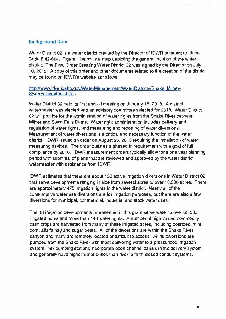
5

6

7

8
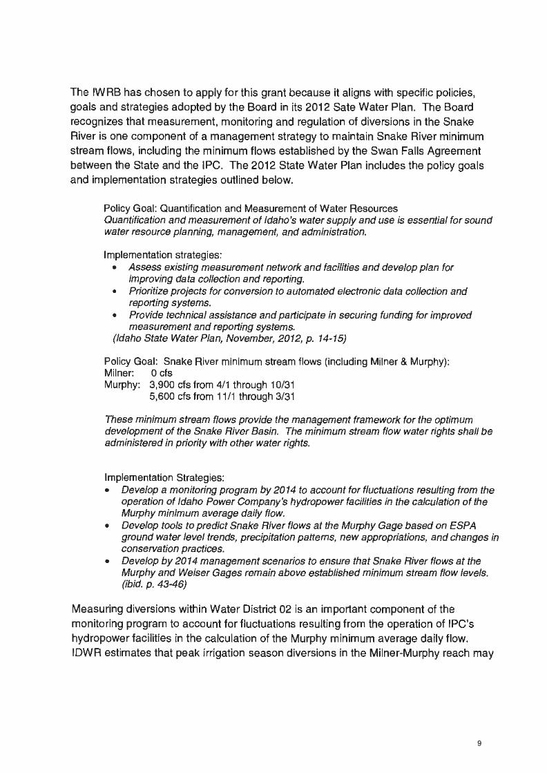
9

10

11

12

13

14

15

16

17

18

19

20

21

22

23

24

25

26

27

28

29

30

31
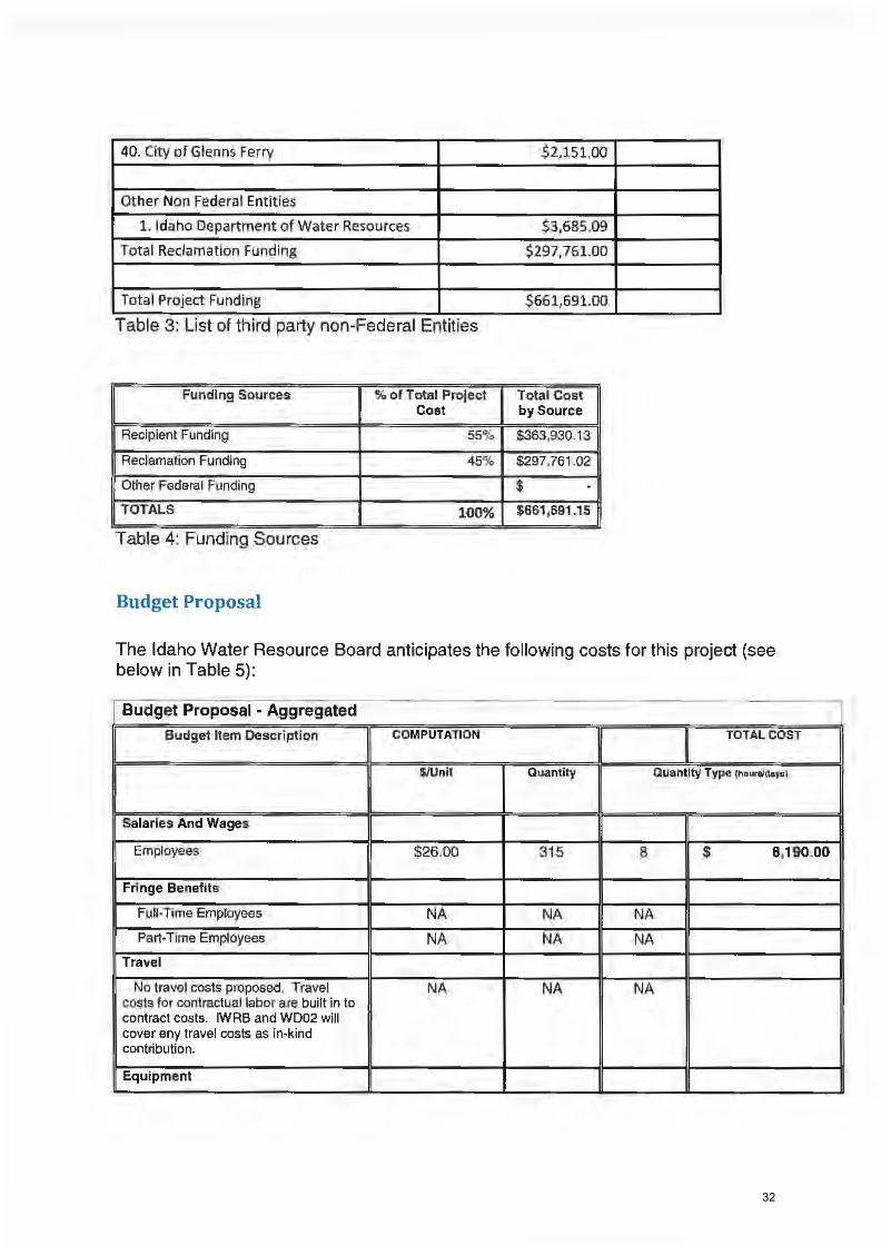
32
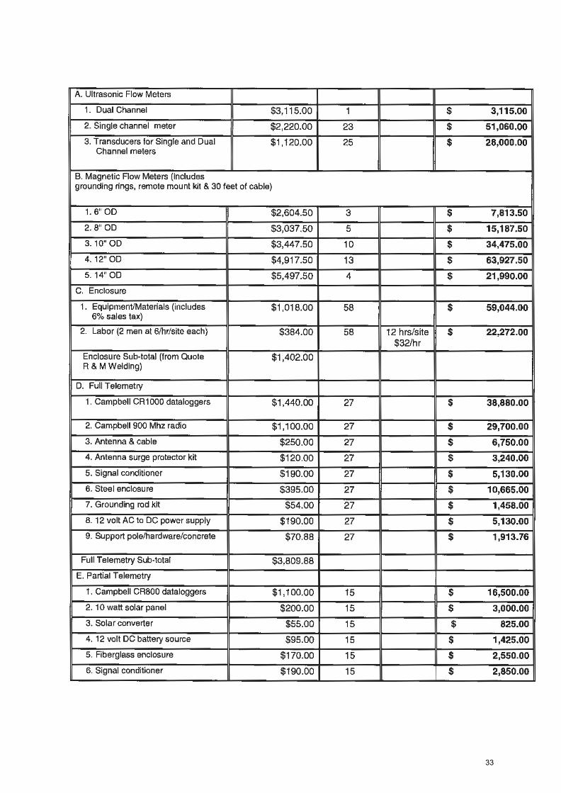
33

34

35

36

37

38

39

40

41

42
43

44

45

46

47

48

49

50

51

52

53

54

55

56
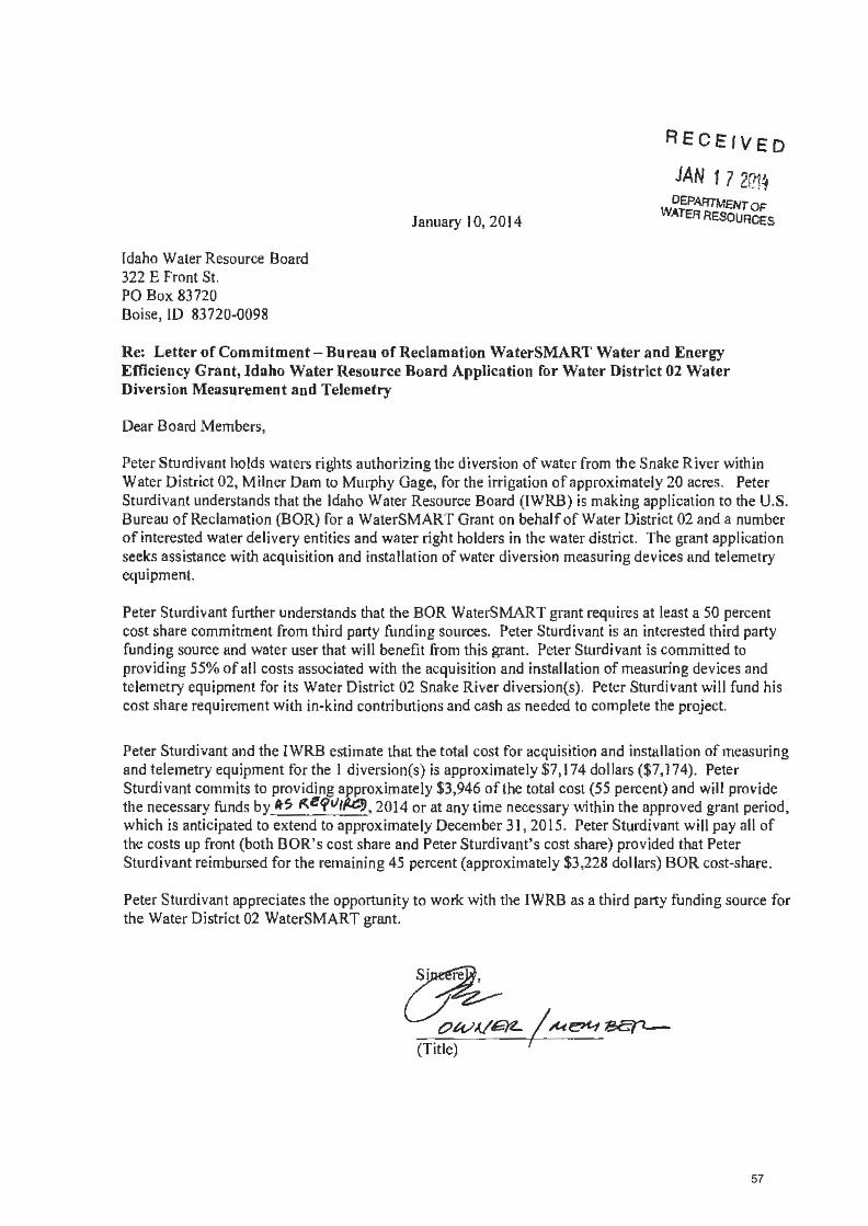
57

58

59

60

61

62

63

64

65

66

67

68

69

70

71

72

73

74

75

76


Abbreviated Meeting Notes
Water District 01
Upper Snake River Advisory Committee Meeting, October 10, 2013 (Teleconference Meeting)
3:05 PM – Introductions were made and an attendance list was circulated. The following people were in
attendance:
Mike Beus (USBR)
Roland Springer (USBR)
Jon Bowling (Idaho Power)
Brian Olmstead (TFCC)
Dale Swenson (FMID)
John Simpson (BRS)
Brian Patton (IWRB)
Mat Weaver (IWRB)
Liz Cresto (IDWR)
Lyle Swank (WD01)
Tony Olenichak (WD01)
Peter Anderson (TU)
Travis Thompson (BRS)
Roger Chase (IWRB)
Norm Semanko (IWUA)
Chuck Brockway, Jr. (Brockway Eng.)
Ken Fletcher (AFRD2)
Travis Blacker (Idaho Potato Com.)
Lanna ???
Randy Bingham (BID)
Dan Temple (A&B)
Rob Harris (HKHC)
Jerry Rigby (RAR)
3:06 PM – Mat Weaver with the Idaho Department of Water Resource (IDWR or Department) outlined
the agenda, which included:
• Introduction and Attendance
• Water Supply Update – Mike Beus (listed as cancelled but Mike Beus was able to attend and
report)
• WD01 Briefing – Lyle Swank
o WD01 Rental Pool Recap and Overview
• Idaho Power Company Operations Update – John Bowling
• Snake River Natural Flow Forecasting – Chuck Brockway, Jr.
• Reach Gains Review – Liz Cresto
• New Business
3:11 PM – Mike Beus with the United States Bureau of Reclamation (USBR or Bureau) gave a brief
presentation on the state of the reservoirs and the water supply. Mike started by presenting the
Bureau’s Hydromet – Reservoir Storage “Teacup” Diagrams for the Upper Snake. Mike noted that a wet
September with cold temperatures “wound down” the irrigation season. He also noted that observed
runoff was very close to the April Forecast; indicating that 2007 was a very similar year although not
quite as “good” as 2013.
In reporting on American Falls Reservoir (AFR) Mike indicated the Bureau tried to keep storage content
above 100K acre-feet, but “it was not meant to be”. In the end, total storage content was slightly above

50K acre-feet. Usually when AFR content is kept above 50K acre-feet, problems with turbidity due to
the mobilization of fine sediments from the reservoir floor are avoided. Unfortunately, this year, even
at 50K acre-feet, a large amount of fines were stirred up. However, because water temperatures stayed
low, it was not as detrimental to the trout as it might have been. Never the less, because of the storage
content levels and the turbidity levels, there was a lot of outcry from the public. As a result Mike
indicated the Bureau increased their monitoring and coordination with the public.
Regarding Palisades Reservoir Mike reported that they “nailed” the spring freshet and because AFR was
not full, they were able to make releases out of Palisades that mimicked a spring freshet below the dam.
Mike also indicated that storage content peaked in Palisades in April at 48% content, or approximately
576K acre-feet (unlike 2007 where storage peaked at a content of 1.1 million acre-feet). Continuing
with the comparison, Mike noted that unlike this year, Palisades had yet to start storing water by this
time in 2007.
Mike next displayed a storage hydrograph of Jackson Lake. He noted the inflow peak for Jackson
matched Palisades. He described considerations regarding the use and safety of marinas on Jackson
Lake that informed Bureau operations early in the year. He indicated that the Bureau was targeting a
winter release rate out of Jackson of approximately 280 cfs.
Mike reiterated the similarities between 2007 and 2013 water years. Indicating that system wide there
was less water in 2013, however the minimum content and the timing of minimum content were very
close. Mike ended his remarks by indicating that winter releases out of AFR were being set for
approximately 350 cfs and that to fill AFR good winter-time reach gains would be needed.
3:29 PM – Lyle Swank, Watermaster of Water District 01 (WD01), gave a brief recap of upper Snake
River water supply conditions from his perspective. He started by describing precipitation in SE Idaho
indicating that February to August precipitation was well below average. Because of the “hot and dry”
nature of the water year there was both a “supply and demand” problem. And, even though there was
a lot of precipitation in September (almost twice normal), it occurred after the peak demand. Lyle
referenced a cumulative precipitation graph for 2012 and 2013 noting they were both below average.
He also indicated that May to September temperatures were above the 30-year average (5 deg-F
warmer than normal).
Lyle also reported on reservoir content and operations. He noted that reservoirs were very low after
back to back high demand years. Content was the lowest it has been since the 2005 water year. He did
note however, that AFR had a lower total content in 2007. Lyle reported that Ririe Reservoir was now
able to store an additional 6K acre-feet due to revisions in flood practices by the Corps of Engineers.
Lyle reported that most canals were shutting down and that flows at Lorenzo were down to 500-600 cfs
due to a cut in releases from Palisades.
Lyle concluded by discussing the Rental Pool for WD01. Indicating that in 2013 the Rental Pool was
stressed as much as he would like to see. In addition, more impact fees were paid then had ever
previously occurred under the current rules.

1. John Simpson questioned why folks above AFR continued to divert water after the irrigation
season and wondered if the practice would continue. Lyle responded that WD01 would
discourage late season releases in its weekly reports, noting the practice was counterproductive
to maximizing the amount of water stored in the reservoirs for the following season. Even
though the practice of late season diversions is detrimental to maximizing the fill of the
reservoir system as whole, Lyle related that some individual water users do not benefit from
“not turning out” or conserving storage, because their storage space always fills, even in very
dry years. He also noted that Dry Bed, the largest diversion on the South Fork, had already
shutoff.
2. John Simpson also inquired as to the purpose of the late season releases after the irrigation
season. Lyle responded that the releases were used for the last cutting of hay and as a buffer
against freezing effects.
3:48 PM – Jon Bowling with Idaho Power Company (IPC) started his summary of IPC operations by
noting that fall Chinook operations would be starting on Monday October 16, when IPC would begin
releasing 8.9K acre-feet. Releases would continue through the season ending on or around 12/6. He
followed up by indicating that 2013 was a record Chinook run with fish counts not recorded since the
1940s. John asked what the plans were for release past Milner Dam. Mike Beus indicated that starting
in mid-October release out of AFR would be approximately 350 cfs, which, with the addition of
downstream reach gains, would result in spills past Milner equal to 400-500 cfs. Mike also indicated
that the filling of the Milner pool would be the only operation taking water below AFR.
3:54 PM – Chuck Brockway, Jr., with Brockway Engineering (Brockway) gave a presentation with slides
on a tool that they developed for the Twin Falls Canal Company (TFCC). The tool predicted available
water supply, storage use, and the date of first storage draw at various times during the irrigation
season. Brockway described the model and compared model predictions for 2013 to actual conditions.
Next steps for the tool include adding capabilities to make predictions as early as March 15, on-going
validation of the tool, and instrumentation of specific ground water wells relied on by the tool.
1. Lyle Swank asked how the tool compares to the existing practice of selecting analog years from
which to base forecasts for current year conditions. Brockway replied that he compared the
tool to Brian Olmstead’s historic approach of selecting analog years and that both methods gave
similar results.
2. John Simpson asked how the tool compares to the Department’s prediction of water supply as
outlined by the Methodology Order in the Surface Water Coalition’s Delivery Call. Liz Cresto
with IDWR replied that Brockway’s tool and the Methodology Order are not exactly analogous,
therefore it was hard to make comparisons, and the Department had yet to compare results
from the two methods.
4:18 PM – Liz Cresto, a Hydrologist with the Department, gave a presentation with slides on reach
gains from Blackfoot to Milner.

1. Roger Chase, Chairman of the Idaho Water Resource Board (IWRB), questioned if there was
reach gain data for the Blackfoot or Portneuf Rivers? Liz indicated there was not.
2. Travis Thompson questioned how Liz’s reach gain data differed from Mike Beus’ data, if at all.
Liz replied that her reach gain analysis was derived from WD 01 Water Right Accounting data.
Also, Mike’s analysis only looked at reach gains from Blackfoot to Neeley.
4:25 PM – Mat Weaver called for any new or additional business. A discussion was had on possible
future topics for the Ops Forum. The following topics were identified:
1. Brian Olmstead proposed discussions and/or presentations on means for measuring reservoir
content in American Falls Reservoir more accurately. It was suggested that we could review
operations from other states, operations on Brownlee Reservoir, review an existing study by the
USGS on the Blackfoot, and consider operations for multiple gages.
2. John Simpson suggested that we invite guest speakers back after their initial presentation so
that participants can ask follow up questions after having time to consider their presented
material.
4:36 PM – The group discussed the scheduling of the next committee meeting. It was decided to again
take a wait-and-see approach in determining when the next meeting would be needed. It was agreed
that depending on winter precipitation, the next meeting should occur in December or January. Mat
Weaver indicated he would send out a notice coordinating the next meeting in December.


State of Idaho DEPARTMENT OF WATER RESOURCES 322 East Front Street• P.O. Box 83720 •Boise, Idaho 83720-0098 Phone: (208) 287-4800 •Fax: (208) 287-6700 •Website: www.idwr.idaho.gov
C.L. ''BUTC1I" OT1ER Gove111or
Ms. Lorrie Lee, Regional Director Bureau of Reclamation Pacific Northwest Regional Office 1150 North Curtis Road, Suite 100 Boise, Idaho 83706
Dear Ms. Lee:
December 20, 2013
GARY SPACKMAN Director
I am writing to express my concern about the Bureau of Reclamation's current releases of storage water from Palisades Reservoir. Historically, the Department has not always carefully reviewed the Bureau of Reclamation's operations of the Upper Snake River Basin reservoirs. Given the Bureau of Reclamation's recent assertions that the water right accounting in Water District 01 does not properly account for the fill of the storage water rights, however, I have determined that I must more actively track the Bureau's reservoir operations to determine whether the operations comply with the provisions of the Bureau's state-based water rights.
Last week at the Committee of Nine Meeting, I listened to an explanation by the Bureau of Reclamation regarding its recent flow releases from Palisades Reservoir. I and other IDWR staff could not reconcile the explanation with our understanding of past Bureau of Reclamation operations. I asked IDWR staff to compare Palisades Reservoir releases of 2013 to Palisades Reservoir releases in prior years.

Ms. Lorrie Lee, Regional Director Bureau of Reclamation Page 2
I understand that in 2003 the Bureau of Reclamation fundamentally changed its operation of Palisades Dam by adopting the "Ecologically Based Systems Operation." Accordingly, IDWR staff compared 2013 releases to releases since 2003. In the chart below, the years 2003-2013 are sorted from the worst-to-best Palisades' storage content on November 1. The November 1 content of American Falls and Jackson Lake are also shown. The last column lists the average releases for the period November 11- December 19 for the years in question:
Sorted by year
Year PALaf AMFaf JCK af PAL
cfs
2007 45,060 252,051 282,987 823
2003 49,470 174,061 114,387 945
2012 97,643 335,040 585,054 902
2004 121,024 272,573 97,230 900
2013 137,670 245,052 156,702 1,278
2005 373,673 338,946 344,910 801
2008 404,826 479,835 635,664 830
2010 409,668 556,019 646,475 1,109
2006 596,865 506,855 629,173 1,704
2009 745,253 792,833 634,701 1,818
2011 1,042,605 716,220 625,557 3,468
The above table clearly establishes that the 2013 Palisades Reservoir releases are not consistent with past Bureau of Reclamation operations. The 2013 Palisades Reservoir storage content is the fifth worst, yet in only three years, all when the content of the three reservoirs was more than a million acre-feet greater than 2013, did flow releases exceed 2013 flow releases. In al I comparable years, releases were in the 800-900 cf s range.

Ms. Lorrie Lee, Regional Director Bureau of Reclamation Page 3
The Bureau of Reclamation's justification for the current releases, as reported to the Committee of Nine and the Watermaster, is that the Bureau is confident the extra releases have a low likelihood of being spilled past American Falls Reservoir. The Bureau's actions are not justifiable for the following reasons:
1. A fundamental tenet of reservoir system management is that water should be stored as high in the system as possible to maximize the ability to physically fill the system. Sending too much water to American Falls early in the storage season could reduce the quantity of storage water deliverable to spaceholders above American Falls Reservoir in this or a future year.
2. American Falls Reservoir is the easiest reservoir to fill within Water District 01. American Falls Reservoir does not need extra water now, and the potential exists that American Falls Reservoir will fill and spill in the spring of 2014 or in a future year when Palisades Reservoir is not full.
3. In contrast to the ease of filling American Falls Reservoir, Palisades Reservoir is difficult to fill. Releasing an extra 400 cfs for half a year robs Palisades Reservoir of over 144,000 acre-feet of water.
By releasing the water now, the Bureau has unnecessarily increased the risk that the reservoir system will not fill and that that water stored for irrigation and other purposes will need to be released past Milner and wasted. Given the current contents of the reservoir system and that this will likely be a year when every drop of water in the reservoir system will be needed, the Bureau's actions are not justified.
I conclude that Reclamation is releasing stored water from Palisades Reservoir to generate hydropower. To my knowledge there is no current flood control obligation. The Bureau's hydropower rights at Palisades Reservoir are subordinate to its storage rights. The Bureau has a legal duty to maximize storage of available flows for irrigation.
Absent an explanation demonstrating a legal justification for the current releases, Palisades Reservoir releases should be reduced to 800 cfs or lower to maximize the opportunity to fill the reservoir system.
Gary Sp ckman Director, Idaho Department of Water Resources
cc: Dave Gehlert, Kathleen Carr, Watermaster, Committee of Nine

United States Department of the Interior BUREAU OF RECLAMATION A E EI VE
IN Rm'.: :Huoz TO:
PRJ-23.00
Mr. Dan Shewmaker Chair, Committee of Nine 3528 E. 3600 N. Kimberly, ID 83341-5212
Mr. Mike Wilkins 170 N. 500 W. Rupert, ID 83350
Mr. Albe1i Lockwood 1721E.1200S. Eden, ID 83325
Mr. Alan Kelsch Vice-chair, Committee of Nine 7466 S. 15 W. Idaho Falls, ID 83402
Mr. Stan Hawkins P.O. Box 367 Ucon, ID 83454
Mr. Rodney Dailing 286 N 2400 E. St. Anthony, ID 83445
Pacific Northwest Regional Office 1150 North Curtis Road, Suite 100
Boise, ID 83706-1234 JAN ·1 0 2014
Mr. Gary Spackman
1 4
Director, Idaho Department of Water Resources P.O. Box 83720 Boise, ID 83 720-0098
Mr. Lyle Swank 900 North Skyline Drive, Suite A Idaho Falls, ID 83402-1718
Mr. Robert Harris P.O. Box 50130 Idaho Falls, ID 83405
Mr. Darrel Ker 4851N.44E. Idaho Falls, ID 83401
Mr. Jeff Reybould 301 N. 1500 E. St. Anthony, ID 83445
Mr. Neil Morgan 762 HWY 39 Blackfoot, ID 83221
Subject: Palisades Dam Winter Discharges, Minidoka Project
Dear Gentlemen:
We have received a number of comments and inquiries from various individuals regarding winter discharges fro1n Palisades Dain. I appreciate the concerns that have been expressed and vvant to share with you the basis for the current operation at Palisades Dam. I also want to take this opportunity to cha1i a path forward to enhance the level of collaboration and transparency on this important subject.
The Palisades Project is a congressionally mandated multi-purpose project with costs and benefits divided between irrigation storage, flood control, hydropower generation, recreation, and fish and wildlife. The current releases from Palisades Dam are intended to provide hydropower generation, while not unnecessarily jeopardizing physical fill of the reservoir system. As you are well aware, winter discharges from Palisades Dam provide an important renewable energy source that benefits not only the regional and local power system but also the Bureau of Reclamation reserve power contractors who rely upon low-cost power to pump irrigation water to their fields during the summer.

2
The current release of 1,200 cubic feet per second at Palisades Dam is reasonably certain to achieve maximum storage of watershed yield without causing additional releases of water below Milner Dam. These flows are based on current and forecast hydrologic conditions. According to our modeling analysis, the likelihood is extremely small that current releases will cause storage in American Falls Reservoir to be released past Milner Dam ahead of Palisades Reservoir filling. Consequently, all the releases at Palisades Dam are expected to be captured in American Falls Reservoir and available to satisfy downstream Minidoka Project inigation demands during the 2014 irrigation season. Reclamation will continue to closely monitor hydrologic conditions in the upper Snake River basin and will adjust releases as conditions warrant.
Given the current drought, I am sensitive to the concerns of our project irrigation and reserve power contractors. Your input and comments on how Reclamation can better balance its multi-purpose congressional mandates and accomplish its mission are always welcome. As a path forward, I would like to enhance the level of collaboration between Reclamation and the Committee of Nine on this important issue. I have directed Reclamation's reservoir operations staff to work with the Committee of Nine's USBR Reservoir & River Coordination Committee, which includes the District 01 Water Master, to meet regularly during the remainder of the storage season. This will provide a forum to share and explain our modeling analyses, make comparisons with historical operations, discuss changes in hydrologic conditions, and develop additional information useful to Reclamation in determining appropriate operational releases. To enhance transparency, I invite all interested stakeholders to attend these meetings.
If any of you would like to discuss this matter further, please feel free to contact me at 208-378-5012.
cc: Mr. Kent Fletcher Fletcher Law Office P.O. Box 248 Burley, ID 83318-0248
Mr. Jerry Rigby P.O. Box 250 Rexburg, ID 83440
Mr. John Simpson P.O. Box 2139 Boise, ID 83701
Mr. Travis Thompson P.O Box 485 Twin Falls, ID 833301
Regional Director
i
Sta te of Idaho
DEPARTMENT OF WATER RESOURCES Annual Report FY2013
November 2013

i
CONTENTS Preface ....................................................................................................................................... 1
Introduction .............................................................................................................................. 1
Organization ............................................................................................................................. 2
Agency Overview .................................................................................................................................. 2
Water Allocation Bureau ..................................................................................................................... 4
Water Rights Section ........................................................................................................................ 4
Water Right Transfers ....................................................................................................................... 4
Applications to Appropriate Water ................................................................................................... 6
Water Right Licensing ....................................................................................................................... 8
Ownership Change Notices ............................................................................................................... 9
Temporary Approval of Water Appropriation ................................................................................ 10
Temporary Water Right Changes .................................................................................................... 10
Water Supply Bank .......................................................................................................................... 11
Water Supply Bank Leases .............................................................................................................. 11
Water Supply Bank Rentals ............................................................................................................. 13
Adjudication Section ........................................................................................................................ 14
Snake River Basin Adjudication ....................................................................................................... 14
Northern Idaho Adjudication (NIA) ................................................................................................. 15
Safety of Dams Program ..................................................................................................................16
Water Compliance Bureau ................................................................................................................. 17
Water Distribution Section ............................................................................................................. 17
Water Measurement Program ........................................................................................................ 17
Water Districts Program ................................................................................................................. 18
Water Right Enforcement ............................................................................................................... 21
Ground Water Protection Section ................................................................................................... 21
Well Construction Program ............................................................................................................. 21
Underground Injection Control Program ........................................................................................ 22
Geothermal Resources Program ..................................................................................................... 22
Driller Licensing Program ................................................................................................................ 23

ii
Stream Channel Protection Unit .................................................................................................... 24
Joint Application for Stream Channel Alteration Permits ............................................................... 24
Letter Permit for Recreational Mining ............................................................................................ 25
Floodplain Management Unit ........................................................................................................ 25
Technical Services Bureau ................................................................................................................. 27
Geospatial Technology Section ...................................................................................................... 27
Hydrology Section ........................................................................................................................... 28
Idaho Water Resource Board ............................................................................................................. 31
Planning Bureau ................................................................................................................................. 33
Financial .................................................................................................................................. 35
Draft Legislation ..................................................................................................................... 37
References ............................................................................................................................... 39
CHARTS Chart 1: Active Transfer Applications Backlog FY2009 – FY2013 .......................................................... 5
Chart 2: Active Applications for Permit FY2011 – FY2013 ...................................................................... 7
Chart 3: Active Water Right Permit with Proof Submitted & Pending Licensing FY2009 – FY2013 .. 8
Chart 4: Pending Water Right Ownership Change Notices FY2010 – FY2013 ..................................... 9
Chart 5: Temporary Approval of Water Appropriation Applications Received FY2009‐FY2013 .......10
Chart 6: Temporary Water Right Changes Applications Received FY2010 – FY2013 ......................... 11
Chart 7: Water Supply Bank Lease Applications FY2011 – FY2013 ....................................................... 12
Chart 8: Pending Water Supply Bank Rental Applications FY2011 – FY2013 ...................................... 13
Chart 9: SRBA Claims Status Summary, end of FY2013 ........................................................................ 14
Chart 10: Well Construction Permits Issued FY2009 – FY2013 ............................................................ 21
Chart 11: IDWR Budget by Fund FY2013 ............................................................................................... 35
Chart 12: IDWR FTE by Region FY2013 ................................................................................................. 35
Chart 13: IDWR FTE by Regional and State Office Bureau FY2013 ..................................................... 36
Chart 14: IDWR Annual Rent by Region FY2013 .................................................................................. 36

iii
FIGURES Figure 1: IDWR Office Locations ............................................................................................................. 2
Figure 2: IDWR Organization Chart ....................................................................................................... 3
Figure 3: CSRBA claims under IDWR evaluation by IDWR administrative basin, end of FY2013 .... 15
Figure 4: Water District Activity FY2013 .............................................................................................. 20
Figure 5: Testing the Mile Post 31 Recharge Site, March 27, 2013 ....................................................... 33
Figure 6: IWRB members examining core drilling operations at Weiser‐Galloway Dam Site ......... 34
TABLES Table 1: Remaining Objections in SRBA FY2009 – FY2013 ................................................................... 14
Table 2: Safety of Dams Activity Calendar Years 2010 ‐ 2013 .............................................................. 16
Table 3: Geothermal Well Permits Issued FY2009 vs. FY2013 ............................................................ 23
Table 4: Driller and Operator Licenses Issued FY2009 ‐ FY2013 ........................................................ 23
Table 5: Joint Application Data FY2009 ‐ FY2013 ................................................................................. 24
Table 6: IWRB Projects and Funding FY2013 ....................................................................................... 32

1
PREFACE The purpose of this report is to fulfill the requirement of Idaho Code §42‐1704:
The director [of the Idaho Department of Water Resources] shall make and render to the
governor, annually, or oftener, if required, full and true reports of the work performed by
the department, which reports shall contain any recommendations he may have to make
in reference to legislation affecting the department.
This report provides an overview of the Idaho Department of Water Resources (IDWR) programs,
activities, and accomplishments during FY2013.
INTRODUCTION The Idaho Department of Water Resources (IDWR) actively guides, manages, and plans for the
use and conservation of Idaho’s water resources. IDWR serves the people of Idaho and protects
their welfare by:
administering the permit and license system for the establishment of water rights;
ensuring the distribution and use of the state’s water resources are fair and equitable in
accordance with vested water rights and Idaho law;
assisting the courts in adjudication of water rights through preparation of surveys and
reports of water uses;
supervising the licensing of water‐well drillers and the development of minimum water
well construction standards to protect ground water resources against waste and
depletion;
reviewing and approving engineering plans and specifications for construction of water
storage structures and inspection during and after construction to assure safety and
adequacy of design; and
collecting and disseminating data on the extent, location, and nature of the water
resources of the state.
By fulfilling these responsibilities, IDWR ensures water is conserved and available to sustain
Idaho's economy, ecosystem, and the resulting quality of life.
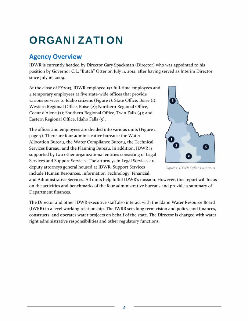
2
Figure 1: IDWR Office Locations
ORGANIZATION Agency Overview IDWR is currently headed by Director Gary Spackman (Director) who was appointed to his
position by Governor C.L. “Butch” Otter on July 11, 2012, after having served as Interim Director
since July 16, 2009.
At the close of FY2013, IDWR employed 152 full‐time employees and
4 temporary employees at five state‐wide offices that provide
various services to Idaho citizens (Figure 1): State Office, Boise (1);
Western Regional Office, Boise (2); Northern Regional Office,
Coeur d’Alene (3); Southern Regional Office, Twin Falls (4); and
Eastern Regional Office, Idaho Falls (5).
The offices and employees are divided into various units (Figure 1,
page 3). There are four administrative bureaus: the Water
Allocation Bureau, the Water Compliance Bureau, the Technical
Services Bureau, and the Planning Bureau. In addition, IDWR is
supported by two other organizational entities consisting of Legal
Services and Support Services. The attorneys in Legal Services are
deputy attorneys general housed at IDWR. Support Services
include Human Resources, Information Technology, Financial,
and Administrative Services. All units help fulfill IDWR’s mission. However, this report will focus
on the activities and benchmarks of the four administrative bureaus and provide a summary of
Department finances.
The Director and other IDWR executive staff also interact with the Idaho Water Resource Board
(IWRB) in a level working relationship. The IWRB sets long term vision and policy; and finances,
constructs, and operates water projects on behalf of the state. The Director is charged with water
right administrative responsibilities and other regulatory functions.

3
Figure 2: IDWR Organization Chart

4
Water Allocation Bureau The Water Allocation Bureau is one of two regulatory bureaus within IDWR and is responsible for
addressing all administrative water right proposals and recommending elements of water rights
during a water right adjudication.
Water Allocation Bureau staff is located at the state office and all regional offices. Staff members
in the regional offices carry out bureau programs as directed and supported by state office staff.
The Water Allocation Bureau is divided into three units: the Water Rights Section, the Water
Supply Bank Program, the Adjudication Section, and the Safety of Dams Program.
Water Rights Section The Water Rights Section oversees all aspects of water right permitting, licensing, and
transferring. The Water Rights Section considers applications for: water right transfers and
exchanges; new water rights; water right licenses; ownership changes; and temporary changes of
water appropriation. In addition, the Water Rights Section archives all current state water right
records.
Water Right Transfers
A water right transfer alters an existing water right by changing one or more features, including:
point of diversion,
place of use,
period of use, and/or
nature of use.
Applicants must submit an application, fee, and supporting documentation to initiate a water
right transfer.
Over the past five years, water right transfers and exchange application processing times have
improved and the number of pending applications has dropped (Chart 1, page 5).

5
Chart 1: Active Transfer Applications Backlog FY2009 – FY2013
In 2008, responding to the extensive backlog that had accumulated by 2007, IDWR prioritized the
processing of water right transfers and exchanges. By implementing the following measures, the
backlog was eliminated; pending applications now number in the normal range—about 100
(Chart 1):
Distributed approval authority to the regional offices, helping reduce workloads and
bottlenecks.
Empowered experienced managers to make timely decisions.
Retained experienced staff members in each IDWR office.
Communicated regularly and frequently among state office and regional staff members at
all levels, not just manager to manager.
Redesigned the transfer application form to collect more complete information.
Updated the main guidance memo and issuing others on relevant topics.
Implemented legislation that allows some transfers to be approved without advertisement.
Improved access to forms, tools, information, and examples for applicants and consultants
via the IDWR website.
Trained and empowering more hearing officers.
Upgraded Water Rights Section custom software.
The greatest challenge to reducing transfer approval times remains competition for staff time.
Staff members who process water right transfer applications also process applications for new
water rights, water right licenses, and Water Supply Bank leases and rentals. Many staff members
also address complaints, issue notices of violation, and collect field data. Attention to a particular
0
100
200
300
400
500
600
Protested Transfer Applications Unprotested Transfer Applications

6
backlog in just one program can draw resources from the other programs and contribute to
backlogs.
Also, many water right transfers and exchanges are technically and legally complex, especially in
the Eastern Snake River Plain. Consequently, retention of experienced staff members is critical to
the continued success of the program. Director Spackman has taken steps to recognize staff
efforts through salary equity (within budget limitations), but further steps may be necessary to
promote employee retention.
Funding for water right transfers and exchanges is provided mostly from IDWR’s general fund
appropriation, with some support from application fees submitted pursuant to Idaho Code §42‐
221.O. However, the application fee pays little more than IDWR’s cost for publishing notice of the
application.
Applications to Appropriate Water
A person proposing a new beneficial use of water must file an application to appropriate water
with IDWR. An applicant must submit a form and supporting documentation, including the
location, source and tributary, legal description, estimated cubic feet per second (cfs), point of
diversion, project/system description, project timeline, and map. IDWR staff must carefully
review the application to ensure the proposed project does not injure the environment or
neighboring water rights.
Chart 2 (page 7) illustrates the reduction of the overall backlog of applications to appropriate
water since late 2010. Over 600 of the applications represented in Chart 2 cannot be processed
because they seek to appropriate water in a formal moratorium area. Eastern and Southern
regions are most affected by the moratorium. Of the remaining applications, the overall backlog
has been reduced by about 200 since December of 2010.
IDWR proposed legislation for consideration by the 2014 Legislature that would streamline
IDWR’s processes for returning/rejecting applications to appropriate water held in moratorium
areas. (See “Draft Legislation” section beginning on page 37 of this report.)

7
Chart 2: Active Applications for Permit FY2011* – FY2013
As with transfers, the greatest challenge to further reduction of application approval times is
competition for staff time, including time entering application information. The staff members
who process applications to appropriate also process applications for transfer, water right
licenses, and Water Supply Bank leases and rentals, amongst other tasks.
Currently, IDWR receives paper applications and manually enters the information into the water
rights database. If IDWR implemented an online application component, many IDWR customers
would do their own data entry. After testing online filing with adjudication claims, it is clear,
however, the agency must overcome several obstacles before implementing an online system,
including:
internet security,
the added cost of processing credit card payments,
accepting online signatures, and
allowing for the submittal of deeds, maps, and other supporting documents.
Funding for applications to appropriate water is provided mostly from IDWR’s general fund
appropriation, with some support from application fees submitted pursuant to Idaho Code §42‐
221.A. However, the application fee pays little more than IDWR’s cost for publishing notice of the
application.
* Data not available before FY2011.
0
200
400
600
800
1000
1200
1400
1600
Dec‐10 Apr‐11 Aug‐11 Dec‐11 Apr‐12 Aug‐12 Dec‐12 Apr‐13 Aug‐13 Dec‐1
Eastern Southern Western Northern
Note: More than 600 of the applications represented below are held due to a moratorium and cannot be processed at this time.

8
Water Right Licensing
While not an official permitting activity, water right licensing is a critical component of the
overall water appropriation process. Licensing confirms that permit requirements are satisfied
and a permanent water right has been established. Delay in issuing licenses does not inhibit water
use, but the delay creates uncertainty about the quantification of the elements of water right and
the legal characterization of the water right. Historically, IDWR has assigned a lesser priority to
the issuance of licenses than the priority assigned to processing of applications to appropriate
water, applications for transfer, and (recently) to Water Supply Bank rentals. However, water
right licenses increasingly provide confidence to lenders and investors as security for operating
loans or investment capital. For this reason, the Director recently prioritized the licensing effort
by requiring IDWR staff members beyond the Water Rights Section to contribute time to the
effort.
Chart 3, below, illustrates improvement in issuance of water right licenses and reduction in the
decades‐long backlog.
Chart 3: Active Water Right Permit with Proof Submitted & Pending Licensing FY2009 – FY2013
The recent reduction of the licensing backlog is significant. However, elimination of the backlog
is likely to take many more years. In addition to the competition for staff time by more urgent
water rights programs, long travel times to conduct required beneficial use field examinations
also hampers licensing efforts. The Idaho Legislature helped alleviate the problem by allowing a
rule change that authorizes in‐office examinations for many small water uses. As a result, since
April 2012, over 100 water right licenses were issued without an on‐site visual inspection. The time
savings totaled at least two hours per examination, or approximately five employee‐weeks of
driving.
0
500
1000
1500
2000
2500
3000
3500
4000
Nov-08 May-09 Nov-09 May-10 Nov-10 May-11 Nov-11 May-12 Nov-12 May-13 Nov-13Eastern Southern Western Northern

9
Other challenges to the water right licensing effort include reduced staff, inexperienced or non‐
water rights staff, retaining experienced staff, and aging and limited equipment.
Funding for water right licensing is provided mostly from IDWR’s general fund appropriation,
with some support from examination fees submitted pursuant to Idaho Code §42‐221.K.
Ownership Change Notices
Similar to licensing, water right ownership change notices are not essential to the permitting
process. Documented recognition of water right ownership facilitates business transactions that
either require or are enhanced by the certainty of ownership. The review of ownership changes
requires significant processing effort. For each notice, IDWR must confirm that the evidence of
ownership is sufficient. Once confirmed, the information is entered into the water rights
database, and an acknowledgment is sent to the new water right owner.
Chart 4 illustrates improvement in the number of pending ownership changes. IDWR’s processing effort is somewhat cyclical, with most progress made during the winter months when staff members are not in the field.
Chart 4: Pending Water Right Ownership Change Notices FY2010† – FY2013
The greatest challenge in the ownership change program is having enough staff members to
address the large volume. Before 2009, IDWR temporary employees addressed a significant
portion of the ownership change workload. When budget cuts eliminated temporary employee
positions, IDWR reassigned the ownership change workload to permanent staff members.
Funding for water right ownership change notices is provided mostly from IDWR’s general fund
appropriation, with some support from filing fees submitted pursuant to Idaho Code §42‐248.
† Data not available before December 2010.
0
200
400
600
800
1000
Dec‐10 Apr‐11 Aug‐11 Dec‐11 Apr‐12 Aug‐12 Dec‐12 Apr‐13 Aug‐13 Dec‐1

10
Temporary Approval of Water Appropriation
A Temporary Approval of Water Appropriation allows water users to use small amounts of water
during a short term. Although the number of applications received has risen since FY2009 (Chart
5), IDWR responded quickly to these applications, with a median approval timeline of eight days
during FY2013. The simple nature of these applications makes the Temporary Appropriation
program an excellent candidate for a future online application process.
Chart 5: Temporary Approval of Water Appropriation Applications Received FY2009‐FY2013
Funding for temporary approval of water appropriation is provided mostly from IDWR’s general
fund appropriation, with some support from application fees submitted pursuant to Idaho Code
§42‐202A(2).
Temporary Water Right Changes
IDWR issues temporary water right changes to applicants when a drought emergency is declared.
These applications are always submitted during the busiest times of dry years, when IDWR staff is
usually involved in other water management issues arising from the lack of water supply.
Although the number of applications received increased (Chart 6, page 11), staff recognized the
time‐sensitive nature of these applications and processed un‐protested applications in less than
two days.
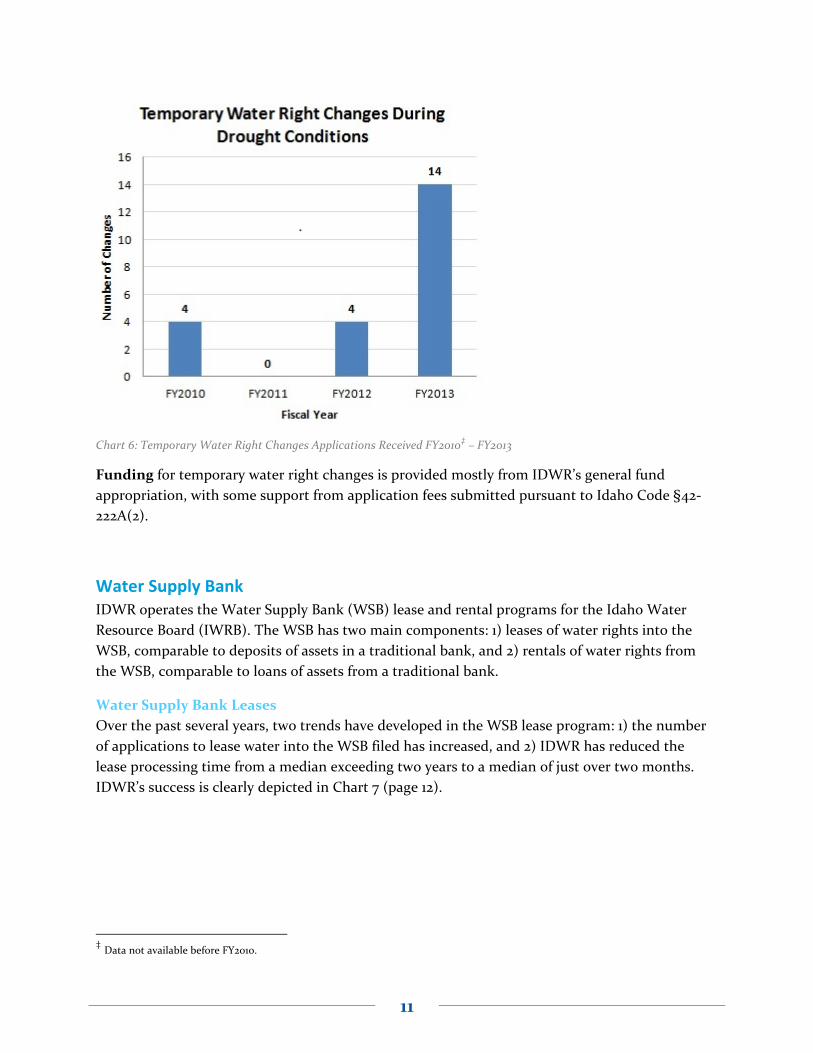
11
Chart 6: Temporary Water Right Changes Applications Received FY2010‡ – FY2013
Funding for temporary water right changes is provided mostly from IDWR’s general fund
appropriation, with some support from application fees submitted pursuant to Idaho Code §42‐
222A(2).
Water Supply Bank IDWR operates the Water Supply Bank (WSB) lease and rental programs for the Idaho Water
Resource Board (IWRB). The WSB has two main components: 1) leases of water rights into the
WSB, comparable to deposits of assets in a traditional bank, and 2) rentals of water rights from
the WSB, comparable to loans of assets from a traditional bank.
Water Supply Bank Leases
Over the past several years, two trends have developed in the WSB lease program: 1) the number
of applications to lease water into the WSB filed has increased, and 2) IDWR has reduced the
lease processing time from a median exceeding two years to a median of just over two months.
IDWR’s success is clearly depicted in Chart 7 (page 12).
‡ Data not available before FY2010.

12
Chart 7: Water Supply Bank Lease Applications FY2011§ – FY2013
Several factors contributed to the elimination of the WSB lease application backlog. The most
significant factor was Director Spackman’s decision to dedicate technical staff to the WSB
program. The Idaho Legislature then approved a filing fee for lease applications, partially funding
additional WSB staff. However, a gap still exists between the funding derived from WSB fees and
IDWR’s effort. The gap is covered to some extent by the IDWR general fund appropriation meant
for the other water rights programs. Funding for the WSB continues to be an ongoing subject of
discussion.
The lack of a comprehensive database management system is currently the most significant
impediment to additional efficiency gains in the WSB lease program. Other major water rights
programs are supported by a database management system and sophisticated custom software.
Without a database management system, staff members processing WSB leases must enter the
same data multiple times in multiple places.
The growing demand for the lease program is another ongoing challenge. The growth is driven by
several factors, including the need to protect newly decreed rights from forfeiture as the Snake
River Basin Adjudication (SRBA) winds down. Due to volatile influences, such as high commodity
prices in the farming sector, it is difficult to predict when and how much demand will continue.
Funding for Water Supply Bank leases is provided from a combination of lease application fees
submitted pursuant to IDAPA 37.02.03.025.02.f, rental fees submitted pursuant to IDAPA
37.02.03.035.01, and IDWR’s general fund appropriation.
§ Data not available before FY2011.
0
50
100
150
200
250
300
350
400
450

13
Water Supply Bank Rentals
As with WSB leases, WSB rental demand has increased over the past several years. IDWR
prioritizes the processing of requests to lease water rights from the WSB because the proposals for
rental and the associated use of water are often urgent. IDWR has reduced the median rental
processing time from over six months to less than two months. The reduction of outstanding
WSB rental applications is depicted in Chart 8.
Chart 8: Pending Water Supply Bank Rental Applications FY2011** – FY2013
The WSB rental program benefitted from the same staffing and funding changes as the WSB lease
program (see Water Supply Bank Leases). However, as with the WSB lease program, the rental
program also lacks a database management system and has undergone unanticipated growth (see
Water Supply Bank Leases). In addition, the WSB rental program would benefit from
improvements in the following areas:
Enhanced aquifer model analysis to improve efficiency of rental application processing
and verification.
Improved database and data entry standards to quickly and efficiently enter new
applications, amend updated applications, and process “compliance” applications.
Refined processes and procedures to eliminate both long‐term and short‐term backlogs,
especially during specific times of the year.
Funding for Water Supply Bank rentals is provided from a combination of lease application fees
submitted pursuant to IDAPA 37.02.03.025.02.f, rental fees submitted pursuant to IDAPA
37.02.03.035.01, and IDWR’s general fund appropriation.
** Data not available before FY2011.
0
10
20
30
40
50
60
70

14
Adjudication Section The Adjudication Section is charged with accepting, evaluating, and recommending the water
rights in the Snake River Basin Adjudication (SRBA) and the Northern Idaho Adjudication (NIA).
Adjudication staff assigned to the SRBA have worked out of the regional and state office in Boise,
while staff for the NIA work in the Coeur d’Alene office with support staff in Boise.
The purpose of a general water right adjudication is to completely and accurately determine and
record the existing water rights within a river basin. Following completion of water rights
adjudication, IDWR will have a complete and accurate compilation of all water rights and can
deliver water to water users who are entitled to the water when disputes about use and delivery
arise. Additionally, the water right compilation is needed to estimate how much water is available
for future development of water resources.
Funding for the adjudications is provided both from IDWR’s general fund appropriation and
water right claims filing fees. The fee portion for the NIA is now anticipated to cover less than 10%
of the total fees.
Snake River Basin Adjudication
The Snake River Basin Adjudication (SRBA), a massive administrative and legal process, began in
1987 and was designed to sort out nearly 160,000 individual claims for water rights in the Snake
River Basin area. As of the end of FY2013, 158,217—over 99%—of those claims have been
determined and decreed by the SRBA Court, Chart 9.
Chart 9: SRBA Claims Status Summary, end of FY2013
FY 2009 FY2010 FY2011 FY2012 FY2013
Remaining Objections in SRBA (start of the fiscal year) ~7267 ~6910 ~4355 ~2384 ~313Table 1: Remaining Objections in SRBA FY2009 – FY2013

15
Northern Idaho Adjudication (NIA)
In 2006, the Idaho Legislature authorized IDWR to proceed with planning and designing the
administrative mechanisms for commencing the first of three water right adjudications in
Northern Idaho. On November 12, 2008, the adjudication court ordered the commencement of a
general adjudication of the Coeur d'Alene/Spokane River water basin. This same order joined the
United States, the Tribes, the State, local governments, and property owners as parties to the
adjudication of all water rights in the Coeur d'Alene/Spokane River Basin Adjudication (CSRBA).
Commencement notices to property owners were sent over the next two years, informing each of
the need to file claims for water rights.
At close of FY2013, 10,810 CSRBA water right claims had been filed with IDWR. Currently, IDWR
Adjudication staff members are investigating these claims. IDWR has not yet recommended these
claims to the court to be decreed. Figure 3 shows the number of these claims per IDWR
administrative basin. Once preliminary recommendations for these claims have been reviewed by
the claimant and IDWR, IDWR will send a Director’s Report to the court recommending the
claims be legally decreed.
Figure 3: CSRBA claims under IDWR evaluation by IDWR administrative basin, end of FY2013
The entire NIA is anticipated to take several more years; the projected date for the final IDWR
recommendations to the court is November 2015.

16
Safety of Dams Program Per Idaho Code §42.1709‐1721, the IDWR Safety of Dams Program is responsible for all aspects of
the 450 water storage dams and 20+ mine tailings impoundment structures in Idaho, including:
reviewing and approving design plans for dam construction and repair;
regularly inspecting new and existing dams for safety;
consulting with dam owners and county emergency personnel to update emergency
action/operation plans;
offering engineering services within the scope of program duties; and
archiving information related to dams and water storage projects.
Safety of Dams staff members operate at all five IDWR offices, with the state office staff
overseeing regional office efforts.
Of the aforementioned activities, two of the most important are listed in Table 2: inspections of
existing dams and design review and approval for new construction and repair. Regular
inspections (which occur every 1 ‐5 years) and careful review of new construction plans not only
fulfill the requirements of Idaho Code §42‐1712 but ensure life and property are protected from a
catastrophic dam failure.
2010†† 2011 2012 2013
Inspections of Existing Dams 127 84 132 47
Design Review & Approval for New Construction/Repair 8 7 9
Table 2: Safety of Dams Activity Calendar Years 2010 ‐ 2013
However, the ability of IDWR personnel to schedule inspections in a timely manner for the full
inventory of dams has been delayed the past several years. First, program cuts in recent years
resulted in the loss of approximately two FTEs. Second, the qualified dam inspector at each
regional office spends a portion of their time on unrelated duties. In addition, many services
mandated per Idaho Code are still delayed or postponed indefinitely due to reduced staff.
At the same time, several processes and procedures have been streamlined to account for the loss
of Safety of Dam personnel. IDWR’s regional offices now issue storage certificates for all low‐
hazard dams, a task once administered solely by the state office. IDWR has also updated the
Safety of Dams database and provided access for data entry to all regional offices.
Funding for the Safety of Dams program is provided mostly through IDWR’s general fund
appropriation. The program also received an assistance grant via the National Dam Safety
Program Act administered by FEMA. IDWR used this grant to supplement purchases of
equipment and supplies and to offset costs related to dam safety inspections and registration fees
associated with continuing education/training.
†† Data unavailable before 2010. Data is divided by calendar year. Fiscal year data is unavailable.

17
Water Compliance Bureau The Water Compliance Bureau ensures the distribution and use of the state’s water resources are
fair and equitable in accordance with vested water rights and Idaho law by:
protecting ground water resources against waste and depletion,
investigating and enforcing violations of water rights and Idaho law,
minimizing environmental effects due to human disturbance, and
mitigating the effects of flooding on Idaho communities.
The Water Compliance Bureau was formed in FY2012 by merging the Water Distribution Section
and the Resource Protection Bureau and is divided into two sections and two program units: the
Water Distribution Section, the Ground Water Protection Section, the Stream Channel Protection
Unit, and the Floodplain Management Unit.
Water Compliance Bureau staff is located primarily in the state office, with select positions staffed
at regional offices. Staff in the regional offices implements bureau programs as directed and
supported by state office staff.
Water Distribution Section Per Idaho Code §42‐6020, the Water Distribution Section supervises the delivery of water from
the public resource by ensuring water is used in accordance with valid water rights and by
supervising the distribution of water to the water users by priority when there is insufficient water
to satisfy all water rights. The Water Distribution Section maintains three main programs to fulfill
this responsibility.
The Water Measurement Program provides support related to the control and
measurement of water diversion systems.
The Water Districts Program offers assistance to water districts, water measurement
districts, and ground water districts.
The Water Rights Enforcement Program conducts enforcement actions related to diversion
and water use violations.
Funding for the Water Distribution Section is provided from IDWR’s general fund appropriation
and fee account.
Water Measurement Program
Originally created to support measurement of ground water on the Eastern Snake Plain Aquifer
(ESPA), the Water Measurement Program now functions statewide establishing and maintaining
state water measurement and reporting standards. Staff works directly with water districts and
water measurement districts to implement measurement requirements and programs within the
state, including:
18
closed conduit and open channel measurement methods;
diversion and control works for surface and ground water diversions;
automation, data logging, and telemetry of water diversion and measurement systems;
and
development and maintenance of reporting systems for water diversion measurements.
During FY2013, the Water Measurement Program revised the measurement standards, providing
clarity and consistency for water users. Also, several new water measurement meters were
approved, so water users now have more options when installing IDWR‐mandated measuring
devices.
Water Districts Program
The IDWR Water Districts Program complies with Idaho Code §42‐604, which requires IDWR to
create state water districts for public streams or water supplies for which water rights have been
decreed by the courts. Idaho Code also authorizes IDWR, through the Water Districts Program,
to revise the boundaries of existing districts, combine two or more districts, and/or abolish
districts, if necessary.
Over 100 water districts have been created in Idaho; more than 70 of these districts are currently
active. Districts vary in both geographical size and number of water users. Larger districts include
large drainages and thousands of individual water users, while smaller districts may include only
one tributary stream with no more than a half dozen users. Each active water district in Idaho has
a watermaster who oversees water distribution within the district. Watermasters in Idaho are
considered state employees but are elected and compensated directly by district water users.
Proper water distribution under Idaho water law and the appropriation system is the primary goal
and responsibility of all Idaho watermasters. Daily water distribution, record keeping,
measurement, and general district management are the primary duties of each watermaster.
The Water Districts Program supports and supervises the active water districts and watermasters
by:
combining, dissolving, or creating new water, ground water, and water measurement
districts to facilitate improved water delivery;
developing standards for district operation;
facilitating watermaster and hydrographer training through publications and live sessions;
and
providing routine water, ground water, and water measurement district support by
mailing notices, updating water user information databases, and assisting in delivery
disputes.
Figure 4 (page 20) shows the active water districts in Idaho, including those that were created,
reactivated, or modified during FY2013.

19
Water Districts 02 (Snake River from Milner Dam to Swan Falls Dam) and 29O (Bannock
Creek) were created to ensure water use along these waterways is fair, equitable, and in
accordance with decreed water rights.
Water Districts 74F (Pratt Creek), 74J (Withington Creek), and 75E (Wallace Creek) were
each reactivated to improve water delivery due to water user complaints or conflicts.
Water District 170 (Upper Salmon River) was modified to include portions of the Upper
Salmon River drainage as one phase in an ongoing strategy to incorporate all areas of the
Upper Salmon River into water districts.
In May 2013, watermaster training seminars were held in Pocatello and Salmon, Idaho. The
seminars concentrated on training new watermasters in their duties, including measuring
diversions and understanding water rights. Experienced watermasters benefitted by learning of
updates in the Watermaster Handbook and newly approved measuring devices.
Water Right Enforcement
The Water Rights Enforcement Program addresses and aims to resolve water use violations. The
Water Rights Enforcement Program Coordinator works with state and regional office staff to
support all IDWR regulatory programs statewide: well construction, well driller licensing, stream
alteration, recreational mining, underground injection control, safety of dams, and water
appropriation and use. Necessary enforcement activities are coordinated with or initiated by the
enforcement unit, such as addressing complaints, conducting investigations, issuing notices of
violation, and conducting compliance conferences to resolve violations. This unit was added to
the IDWR Water Compliance Bureau to facilitate consistency in agency policies for regulatory
activities prescribed by State Law.
The unit’s administrative enforcement activities are conducted pursuant to Idaho Code §42‐1701B.
However, the unit is obligated to understand, administer, and enforce the statutes and rules that
govern individual IDWR regulatory programs.
Enforcement of the statutes and rules during FY2013 resulted in nine notices of violation (NOVs),
resulting in the collection of nearly $200,000.

20
Figure 4: Water District Activity FY2013
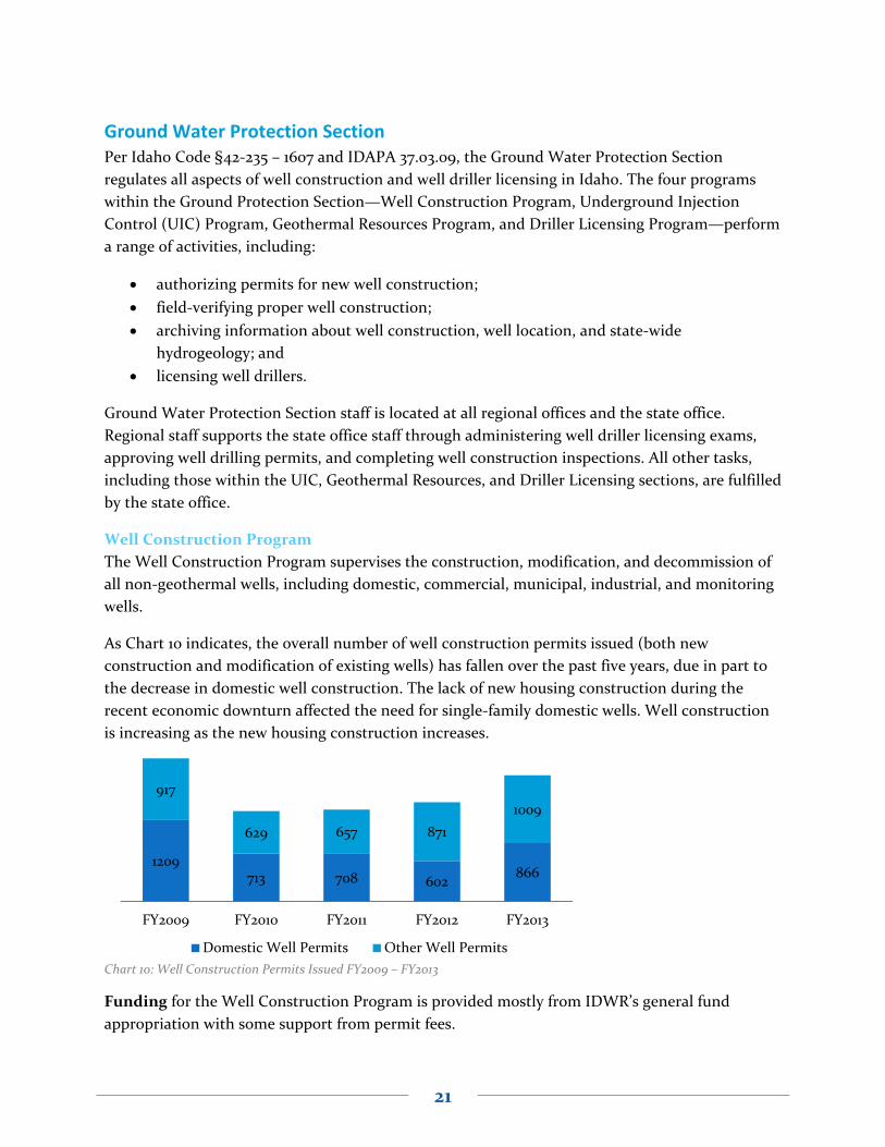
21
1209713 708 602
866
917
629 657 871
1009
FY2009 FY2010 FY2011 FY2012 FY2013
Domestic Well Permits Other Well Permits
Ground Water Protection Section Per Idaho Code §42‐235 – 1607 and IDAPA 37.03.09, the Ground Water Protection Section
regulates all aspects of well construction and well driller licensing in Idaho. The four programs
within the Ground Protection Section—Well Construction Program, Underground Injection
Control (UIC) Program, Geothermal Resources Program, and Driller Licensing Program—perform
a range of activities, including:
authorizing permits for new well construction;
field‐verifying proper well construction;
archiving information about well construction, well location, and state‐wide
hydrogeology; and
licensing well drillers.
Ground Water Protection Section staff is located at all regional offices and the state office.
Regional staff supports the state office staff through administering well driller licensing exams,
approving well drilling permits, and completing well construction inspections. All other tasks,
including those within the UIC, Geothermal Resources, and Driller Licensing sections, are fulfilled
by the state office.
Well Construction Program
The Well Construction Program supervises the construction, modification, and decommission of
all non‐geothermal wells, including domestic, commercial, municipal, industrial, and monitoring
wells.
As Chart 10 indicates, the overall number of well construction permits issued (both new
construction and modification of existing wells) has fallen over the past five years, due in part to
the decrease in domestic well construction. The lack of new housing construction during the
recent economic downturn affected the need for single‐family domestic wells. Well construction
is increasing as the new housing construction increases.
Chart 10: Well Construction Permits Issued FY2009 – FY2013
Funding for the Well Construction Program is provided mostly from IDWR’s general fund
appropriation with some support from permit fees.

22
Underground Injection Control Program
Per Idaho Code §42‐39 and IDAPA 37.03.03, the Underground Injection Control (UIC) program
was delegated to IDWR by Environmental Protection Agency (EPA) in 1985.
Injection wells are used as a means to dispose of or store fluids underground. In Idaho, excess
stormwater, agricultural water, and facility heating/cooling water are the most common fluids
disposed of with injection wells of various designs. IDWR regulates the construction, operation,
and abandonment of all injection wells through the UIC Program. Currently, IDWR has over
17,000 injection wells on record. Nearly 16,000 are shallow wells (≤ 18 feet deep) and the
remaining are deep wells (> 18 feet deep).
During FY2013, UIC staff approved 342 new or renewed applications. Before approving
construction, modification, or continued use of any injection well, UIC staff reviews the
applications, conducts field visits (if necessary), and informs the local general public of the
project.
In addition to managing the daily activities of the program, the two full‐time UIC staff also
refined and drafted legislation for the UIC Program in Idaho. Specifically, staff refined the existing
statutes on Class V injection well rules (Idaho Code §42‐3902 – 3908) to be consistent with federal
UIC rules (Class V injection wells include all existing injection wells in Idaho). They also drafted
new rules allowing and regulating Class II injection wells (related to the oil and gas industry) in
Idaho (IDAPA 37.03.03.045 – 060). The refined statutes and new rules were adopted by the Idaho
Legislature in the 2013 session.
Funding for the Underground Injection Control Program is partially funded through a federal
grant to IDWR as part of an EPA Program–State primacy partnership. The federal grant covers
75% of the partial funding with a 25% State match. The program is also partially funded by permit
fees.
Geothermal Resources Program
The Geothermal Resources Program regulates drilling, operation, maintenance, and
abandonment (decommissioning) of all geothermal resource wells in Idaho, as outlined in Idaho
Code §42‐4001 ‐ 4015. Geothermal wells are defined as any well having a bottom hole temperature
of 212 F or greater (Idaho Code §42‐4002). Therefore, the Geothermal Resources Program does
not regulate the more common low‐temperature geothermal wells used for heating purposes.
Low‐temperature geothermal wells have a bottom hole temperature greater than 85 F and lower
than 212 F and are regulated by the IDWR Well Construction Program.
State statute requires geothermal wells to undergo a formal permit process before approval is
given and drilling can commence. Upon receipt of the permit application, program staff reviews
the application and then conducts a thorough technical evaluation. A permit is then issued based
upon the geothermal resource rules found in IDAPA 37.03.04.
23
Due to the high‐risk and high construction cost of geothermal well projects, very few of these
wells are attempted much less permitted each year, as shown in Table 3.
FY2009 FY2013
Total Geothermal Well Permits Issued 9 4Table 3: Geothermal Well Permits Issued FY2009 vs. FY2013
Due to the infrequent nature of geothermal well projects, only one Ground Water Protection
Section staff member is tasked with reviewing and approving the applications. However, this
minimal staff creates the largest challenge faced by the Geothermal Resources Program: digitally
archiving the large and numerous documents of both recent and historical projects. The program
does not have the manpower, time, or equipment to handle the volume and cumbersome nature
of plans, blueprints, charts, and well logs.
Funding for the Geothermal Resources Program is provided from IDWR’s general fund
appropriation.
Driller Licensing Program
IDWR has statutory responsibility for regulating the drilling of wells and licensing of well drillers
and operators in Idaho (Idaho Code §42‐238). The Driller Licensing Rules, IDAPA 37.03.10,
establish the requirements and procedures for obtaining and renewing authorization to drill
wells. The Driller Licensing Program staff fulfills this responsibility by:
reviewing and processing licensing applications,
organizing required continuing education seminars,
coordinating the annual license renewal of hundreds of well drillers, and
data entering and maintaining individual driller and drilling company information.
Total driller licenses issued have fluctuated in recent years, although increasing overall (Table 4).
This fluctuation reflects the changing demand for domestic wells during the recent housing and
economic downturn. The program has kept up with demand by streamlining data‐entry
procedures and database software.
FY2009 FY2010 FY2011 FY2012 FY2013
Total Driller and Operator Licenses Issued 215 149 183 128 214Table 4: Driller and Operator Licenses Issued FY2009 ‐ FY2013
The main challenge for Driller Licensing staff is the delay incurred by incomplete applications.
Staff must contact each driller and wait for the missing information. Occasionally, additional
follow up with the individual drillers, drilling companies, and/or IDWR regional offices is
required. The license is processed and issued later than intended, potentially taking time and
energy away from other projects. Although Idaho Code does not set a processing deadline,
program staff attempts to process all complete applications within 14 days of receipt.
Funding for the Driller Licensing Program is provided from IDWR’s general fund appropriation
and fee account.

24
Stream Channel Protection Unit The IDWR Stream Channel Protection Unit evaluates potential alterations to stream channels for
the protection of fish and wildlife habitat, aquatic life, recreation, aesthetic beauty, and water
quality. Using Idaho Code §42‐3801 and the Idaho Stream Channel Protection Act requirements,
the Stream Channel Protection Unit approves or denies projects involving any work being done
inside the ordinary high‐water mark (generally, the streambed and stream bank) of a
continuously flowing stream.
Stream Channel Protection Unit support staff serves at the Northern, Eastern, and Southern
regional offices. The Stream Channel Protection Unit Coordinator serves at the state office and
oversees the regional office staff while also completing the daily functions for the state and
western region units.
Stream Channel Protection permits are issued for two different types of applications: Joint
Application for Stream Channel Alteration Permits (Joint Applications) and Letter Permit for
Recreational Mining (Letter Permit).
Funding for Stream Channel Protection Unit program is provided from IDWR’s general fund
appropriation and fee account.
Joint Application for Stream Channel Alteration Permits
The Joint Application permit form and process was developed in conjunction with the Idaho
Department of Lands (IDOL) and the US Army Corps of Engineers (USACE) because these
agencies also have jurisdictional permitting programs related to the protection of streams and
wetlands. The Joint Application allows the applicant to fill out and submit one application to the
appropriate agencies for subsequent approval(s). Upon receipt of a complete Joint Application,
the Stream Channel Protection Unit issues a permit within 60‐90 days. The timeline varies
depending on the complexity of the project and the number of parties affected by the project.
In the event of emergencies (such emergency flood mitigation), the applicant must submit a
separate Emergency Application. A permit for an emergency application can be authorized within
one to two days upon receiving a complete application and fee.
Table 5 below shows the number of Joint Applications IDWR received in FYs 2009 through 2013.
Some Joint Applications received very late in FY2013 will count as being received but were not
reviewed, processed, or permitted before the end of the fiscal year period.
FY2009 FY2010 FY2011 FY2012 FY2013
Joint Applications Received/Processed 340 182 183 282 244
Permits Issued 231 131 149 200 176 Table 5: Joint Application Data FY2009 ‐ FY2013
Processing timeline of Joint Applications five years ago was generally closer to 60 days. The
turnaround time is longer now because IDWR had five FTEs working in the program five years
ago as compared to approximately two‐and‐a‐half FTEs over the past two years.

25
Letter Permit for Recreational Mining
The Stream Channel Protection Act regulates the use of recreational mining equipment and
requires miners to obtain a Letter Permit for Recreational Mining (Letter Permit) from IDWR
before altering any portion of the streambed. Recreational mining equipment can be any
implement that is used to dig, scrape, dredge, or otherwise move stream bed materials from
below the ordinary high watermark (streambed or stream bank) in search of minerals.
Completed and signed letter permits are considered authorized by IDWR upon receipt of the
permit and fee. By signing the letter permit, the applicant indicates he/she has read and
understands the Recreational Mining Stream Channel Alteration instruction booklet and will
conduct operations in compliance with the stated instructions and rules. The Letter Permit
authorizes mining for a specific time frame within the larger recreational mining season of April 1
to March 31. The authorized time frame depends on the stream location and limitations outlined
in the recreational mining instructions.
Letter Permit submittals have increased over the past several years, with a record 911 permits
submitted in FY2013. The Stream Channel Protection Section has mitigated staff reductions and
increased applications by simplifying the letter permitting process. Less than five years ago each
letter permit required IDWR staff review; approval time took up to 10 days. Approval and
authorization upon receipt of the application and fee have saved both staff time and customer
wait times.
Floodplain Management Unit The Floodplain Management Unit, headed by the State Floodplain Coordinator, administers
National Flood Insurance Program (NFIP) in Idaho; maps flood risk; and educates local
governments, developers, and individuals planning land uses in flood hazard areas.
The Floodplain Management Unit also reviews city ordinances created to address floodplain
problems and encourages communities to adopt floodplain ordinances and qualify for the NFIP,
allowing citizens to qualify for FEMA flood insurance. Currently, nearly 200 Idaho communities
and/or counties participate in the NFIP. The Floodplain Management Unit also helps
communities plan for floods, conducts training of floodplain protection, and reviews work done
within floodplains to ensure that it will not cause an increase in flood levels if flooding occurs.
The IDWR Floodplain Management Unit helped fulfill these goals by hosting a Floodplain
Management Conference on August 2 and 3, 2013, in Boise. Over 70 attendees heard government
agencies and local experts present information on pre‐disaster mitigation, building codes, public‐
private partnerships, levee updates, and community preparedness. Attendees left with resources,
strategies, and a better understanding of how to protect their communities from floods.
The Floodplain Management Unit gained a better understanding of the state‐wide floodplain
managers by conducting a Floodplain Manager Survey. The survey revealed the knowledge,

26
expertise, duties, and goals of community floodplain managers. The survey results can be found
on IDWR’s website and will be used by IDWR to communicate relevant, flood‐related information
to each NFIP community.
Funding for Floodplain Management Unit program is provided mostly from a FEMA grant (75%)
and the remaining from IDWR’s general fund appropriation (25%).

27
Technical Services Bureau The Technical Services Bureau supports initiatives throughout IDWR and is divided into two
sections: the Geospatial Technology Section and the Hydrology Section. Although Technical
Services Bureau staff support various IDWR programs statewide, all Bureau employees work out
of the state office.
Geospatial Technology Section Idaho Code §39‐120 designates IDWR as the leader for natural resource geographical information
systems (GIS). The Geospatial Technology Section, using GIS software, provides expertise,
applications, data, and analyses that are used throughout IDWR to support business processes.
The section also provides web‐based tools and applications that are used by the public via the
IDWR website.
GIS data layers are used to evaluate well drilling applications, water right applications,
compliance issues, and to refine and improve ground water modeling. GIS analysts support the
attorney general’s office, the legislative redistricting commission, and many other state agencies
and local governments.
Specifically, the Geospatial Technology Section and GIS data layers assist:
Water Right agents by determining if a water right is within an administrative area that
requires additional consideration.
The public by allowing the submission of data via online applications such as the well
driller locator tool or the Northern Idaho Adjudication website.
IDWR Water Distribution staff by creating accurate water district boundaries with maps
and/or digital elevation models.
Safety of Dams, Hydrology, and Planning Section staff with spatial analysis by
approximating the volume and perimeter of a reservoir given a dam location and height.
All IDWR staff who use GIS software by troubleshooting and fixing GIS applications and
creating maps, figures, and charts for presentations.
Due to various entities’ reliance upon the section’s accuracy of information, most major projects
of FY2013 encompassed improving applications and databases, such as.
Hydrologic Database Integration: The hydrologic database is used by the hydrologists
and many other members of IDWR to assist with water rights, planning, modeling, and
other efforts. Data from several independent databases was integrated into the existing
hydrologic database. With this improvement, the section can now easily and efficiently
share once‐scattered information with IDWR staff, the public, and other agencies.

28
Interactive Map Improvements: The IDWR website provides various interactive maps
to the public and other agencies. These maps provide information regarding well drilling,
state‐protected streams, evapotranspiration, flood hazard, and general mapping tools.
Updating these online tools with new software and enhanced features allow the public to
retrieve accurate and detailed data.
GIS Toolbar Improvements: WREdit is the GIS toolbar used throughout IDWR for
specific business practices. During FY2013, functions were added for the water supply
bank, transfers, hydrologic database, and well drilling. These tools reduced application
processing time and assisted in efficient data discovery.
Funding for the Geospatial Technology Section is provided through various sources, including
IDWR general fund, grants, and/or the specific section requesting the project.
Hydrology Section The Hydrology Section provides detailed scientific data, information, expertise, data collection,
and technical support services regarding Idaho hydrology to many groups at IDWR, including the
Director, Water Allocation Bureau, regional offices, Idaho Water Resource Board (IWRB), and
Attorney General’s Office. Working exclusively from the state office, the Hydrology Section
develops a detailed understanding of Idaho hydrology through:
water supply assessments and forecasts,
litigation support,
reviews of water rights applications and transfers,
Comprehensive Aquifer Management Planning (CAMP) technical studies,
surface and ground water modeling,
water right accounting, and
scientific programming and website enhancements.
Using these tools, section hydrologists account for the delivery of reservoir storage and natural
stream flow according to Idaho’s water right priority system. Staff also develop and operate
ground water models of major aquifers within the state. Additionally, hydrology staff maintains
and operates a river and reservoir system operations model of the Snake River for planning
purposes. The data, models, and programs are used for predicting the water supply for the
upcoming irrigation season; planning for improved utilization of water resources; and quantifying
the effects of drought, recharge, and pumping on aquifer water levels and river flows. These
studies and modeling efforts are often a part of a collaborative process that is important to private
industry, agricultural interests, numerous organizations, IDWR, and other government agencies
in developing an understanding of the hydrology of Idaho.

29
An important and ongoing project for both state and regional office staff is the data collection
program, which monitors over 1,200 sites statewide:
Statewide Water Quality Monitoring Program (approximately 200 sites),
Geothermal well monitoring (20 wells),
Aquifer water level monitoring (804 wells), and
Stream, spring, and agricultural return‐flow monitoring (194 sites).
These regular tasks assisted Hydrology staff in accomplishing several major projects in FY2013.
First, in August 2012, the section initiated a ground water flow model development project for the
Wood River Valley. In collaboration with the United States Geological Survey (USGS), IDWR:
established a scope of work and schedule and entered into a Joint Funding Agreement
with the USGS.
conducted a synoptic water‐level measurement on more than 100 Wood River Valley
wells.
expanded the routine IDWR water‐level monitoring network from seven wells to 18 wells.
contracted with the USGS to conduct seepage surveys in August 2012, October 2012, and
April 2013.
published a fact sheet describing the goals of the project and the project timeline.
created a project webpage to disseminate presentations and other project information to
the public.
established a Modeling Technical Advisory Committee (MTAC) to provide transparency
and serve as a vehicle for stakeholder input.
In January 2013, the Hydrology Section, working with the Idaho Water Resources Research
Institute and under the guidance of the Eastern Snake Hydrologic Modeling Committee, finished
a major upgrade of the ground water flow model for the eastern Snake River Plain Aquifer. The
new model is the first major upgrade since 2005. The model was calibrated to over 43,000
observed aquifer water levels, over 2,000 river gain and loss estimates, and over 2,000 transient
spring discharge measurements. In addition to a final report, more than 20 design documents
were published, each documenting a specific aspect of model construction.
The Hydrology Section also participated in meetings, data gathering, and data analysis activities
for the Swan Falls Technical Working Group (TWG), a group of technical stakeholder
representatives assigned to help with implementation of the 1984 Swan Falls Agreement. To
achieve the implementation, the TWG:
conducted irrigation and non‐irrigation season seepage surveys,
developed alternative methods for factoring out the effects of Idaho Power Company
reservoir operations on flows measured in the Snake River at the near Murphy Gaging
Station, and

30
prepared a draft monitoring plan for evaluating compliance with provisions of the Swan
Falls Agreement (as embodied in partial decrees for hydropower water rights for the Snake
River below Milner dam).
Funding for the Hydrology Section is provided through IDWR’s general fund appropriation and
Comprehensive Aquifer Management Plan (CAMP).

31
Idaho Water Resource Board Per Idaho Code §42‐1732 – 1734, the Idaho Water Resource Board (IWRB) creates and implements
comprehensive basin planning, protected rivers designations, minimum stream flow programs,
water project financing, and water supply bank leases and rentals. There are eight members on
the Idaho Water Resource Board, appointed by the governor, who serve four‐year terms.
Although the IWRB is not an official section of IDWR, the Director supports the IWRB as needed
and assigns staff to help carry out these powers and duties. The IDWR Planning and Technical
Services Bureaus provide administration and staff support to the IWRB. The IWRB and IDWR are
also interrelated in areas such as court appeals, administrative rules adoption, water bank
administration, and water right negotiations with the Federal government and Indian Tribes.
In addition to formulating and implementing the state water plan and comprehensive basin plans,
which includes authorities to designate natural and protected rivers, the IWRB also provides
financial assistance for water development and conservation projects. The IWRB has two
accounts, water management and revolving development, from which it makes loans and grants.
A third account, the Aquifer Planning and Management Fund, was added by the Idaho Legislature
in 2008 (Idaho Code §42‐1780). This fund was established for technical studies, facilitation
services, hydrologic monitoring, measurement and Comprehensive Aquifer Planning and
Management. Idaho Code §42‐1779 authorized the IWRB to conduct a Comprehensive Aquifer
Planning program across the state. Table 6 lists the recent projects funded by the IWRB.
Project Loan Revenue Bond IWRB Project Expenditure
Lake Reservoir Company Lardo Dam Upgrade $594,000
Portneuf Irrigating Company Pipeline Project $1,300,000
Bear River Bond Pool Issuance $2,500,000
Big Springs Creek Ranch Water Transaction $222,371
Weiser‐Galloway Geologic and Operational Investigations and Analysis $2,000,000
Foothill Ranch HOA Well Repair and Water System Improvement $150,000
High Country Resource Conservation and Development Area Cloud Seeding Program $20,000
Jughandle Estates HOA New Well and Delivery System $907,552
Lower Lemhi Permanent Subordination Easement $421,200
Lower Lemhi 2012 Annual Water Transactions $88,344
Sulphur Creek Water Transaction $12,305

32
Bayhorse Creek Water Transaction $38,410
ESPA Managed Recharge Pilot Program $1,500,000
Mile Post 31 Recharge Site Engineering Design $6,000
Alturas Lake Creek Appraisal $9,000
Totals $2,951,552 $2,500,000 $4,317,630 Table 6: IWRB Projects and Funding FY2013
The IWRB can also issue debt in the form of revenue bonds, where the proceeds are loaned to the
entity requesting the financial assistance. The loan repayments then are the revenue used to repay
the debt service on the bonds.
Funding for the IWRB’s administrative needs is embedded within IDWR’s budget and consists
primarily of IDWR general fund appropriation.

33
Planning Bureau The Planning Bureau primarily supports Idaho Water Resource Board (IWRB) programs,
including the State Water Plan, water project development and funding, minimum stream flows,
natural and recreational river designations, and comprehensive basin and aquifer planning.
The Planning Bureau is responsible for overseeing and administering, on behalf of the IWRB,
several large‐scale initiatives, including implementing the Eastern Snake Plain Aquifer‐
Comprehensive Aquifer Management Plan (ESPA‐CAMP), evaluating new water storage reservoirs
throughout the state, and undertaking projects in the Upper Salmon River Basin to provide flows
needed for recovery of ESA‐listed anadromous fish species, including alleviating water use
conflicts between the needs of fish and irrigated agriculture.
The Planning Bureau accomplishes these over‐arching goals through various on‐going projects.
Water Project Financing: The IWRB Financial Program assists the development of water
resources of the state through financing the construction of water projects. This program
assists water users to keep water storage and delivery systems operating and in good
working order.
State Water Plan: The State Water Plan and component basin and aquifer plans, guide
decision‐makers and identify strategies to protect Idaho’s water resources for use by its
citizens and ensure water is available to meet current and future water demands.
Water Storage Studies: The IWRB investigates potential storage projects to make the
best use of available water supplies and provide maximum flexibility to manage and
operate water.
Besides fulfilling the daily requirements of the bureau,
the Planning Bureau staff at the IDWR state office in
Boise, along with IWRB members, completed a recharge
study and test to better protect and administer the
state’s water resources.
In September 2012, the IWRB partnered with the
American Falls Reservoir District 2 to construct a
diversion and recharge site at Mile Post 31 off the Milner
Gooding Canal. Construction began in November 2012
and was completed in the spring of 2013. The site was tested in March 2013 with the diversion of
approximately 2,800 acre‐feet at a rate of approximately 200‐250 cfs. This initial test indicates that
this site will be a good recharge site to add to the other recharge strategies currently in operation.
Recharge continues to be a robust element in a suite of tools for ESPA‐CAMP implementation.
Since 2008, the IWRB recharge program has resulted in 436,941 acre‐feet of recharge on the ESPA,
Figure 5: Testing the Mile Post 31 Recharge Site, March 27, 2013

34
which has aided in working toward aquifer stabilization, resolving long‐term water management
conflicts, and meeting the State’s obligations to maintain minimum flows at the Murphy Gage
which are dependent on spring discharges from the ESPA.
Additionally, the IWRB has a surface water storage study
underway, the Weiser‐Galloway Project, to evaluate the
feasibility of new surface storage in Idaho. The project
accomplished a key milestone through the completion of a
geologic investigation which indicates that a large dam can be
engineered and constructed at the site. The investigation
included core drilling of seven holes totaling about 1,540
linear feet together with associated engineering and
geotechnical analysis. This work was done in partnership with
the US Army Corps of Engineers and the US Bureau of
Reclamation. The final report and additional work on hydraulic, economic, and costs analyses are
continuing. In addition, studies are underway to evaluate raising Arrowrock Dam on the Boise
River for flood control and water supply, as well as the evaluation of several new storage
possibilities in the Henrys Fork area. New storage in Idaho will meet current and future water
demands, lessening the potential for water conflicts in the future.
Competing demands on Idaho’s water requires active and dynamic planning for the protection
and use of Idaho’s water and necessitates the guidance and prioritization which are provided by
the State Water Plan. The IWRB adopted a revised State Water Plan in November 2012. The 2012
amended State Water Plan was the first thorough revision of the State Water Plan since 1996. The
plan guides management of the water resources in Idaho and demonstrates that Idaho has a
vision for the protection and optimization of use of Idaho’s water.
Funding for the Planning Bureau is provided from various sources including IDWR general
funds, the Aquifer Planning and Management Fund, and grants.
Figure 6: IWRB members examining core drilling operations at Weiser‐Galloway Dam Site

35
FINANCIAL
Chart 11: IDWR Budget by Fund FY2013
Chart 12: IDWR FTE by Region FY2013

36
Chart 13: IDWR FTE by Regional and State Office Bureau FY2013
Chart 14: IDWR Annual Rent by Region FY2013

37
DRAFT LEGISLATION IDWR has submitted four legislative proposals for the upcoming 2014 legislative session. All four
proposals were submitted for review and approval through the Executive Agency Legislative
System and have been approved as of November 1, 2013. Another proposal is pending after
discussions with the Governor’s office staff. The proposals are currently in the process of final
agency review, and the last day to submit changes to the Division of Financial Management is
December 3, 2013. The five legislative proposals are listed and summarized below.
RS 22415 Amending Idaho Code Section 42‐201 ‐ Water Remediation
This proposed legislation would clarify that an operator of a remediation project, acting to remove
hazardous substances or petroleum from contaminated water, is not required to obtain a water
right, but is required to file with IDWR a notice of remediation prior to diverting water. This
legislation maintains the Director of IDWR’s jurisdiction over any diversion of water.
RS 22416 Amending Idaho Code Sections 42‐234 and 42‐1762 ‐ Managed Ground Water Recharge
This proposed legislation would authorize the Idaho Water Resource Board (IWRB) to
promulgate rules governing managed ground water recharge. This draft legislation would also
clarify that water users seeking new applications for permits based on managed ground water
recharge or aquifer credits must show with reasonable certainty that the recharge will sustain a
sufficient supply of water for their future use. Additionally, this draft legislation would authorize
the IWRB to create an aquifer credit program as part of its existing water supply bank and to
promulgate the aquifer credit program rules. The promulgation of the rules addressed in this
proposed legislation will be discretionary in all parts of the state except for the Eastern Snake
Plain Aquifer.
RS 22393 Amending Idaho Code Section 42‐3902 – Injection Well Definition Amendment
This proposed legislation would replace the term “drilled” with “used” in the definition of an
injection well to clarify IDWR’s authority to regulate underground oil and gas production wells
that are converted to injection wells and used for the injection of waste fluids.
RS 22395 Amending Idaho Code Section 42‐1805 – Returning Applications to Appropriate Water in Moratorium Areas
This proposed legislation is to reduce the number of applications to appropriate water being held
by IDWR in fully appropriated areas or areas that will become fully appropriated. The draft
legislation would authorize the Director of IDWR to return pending applications back to the
applicant when the application seeks to divert water in an area where a moratorium order has
been issued.

38
Proposal to Amend Idaho Code Section 42‐11701 – Amending Qualifications for Director of
the Department of Water Resources
This proposed legislation would enlarge the pool of professional candidates who can serve as the
Director of the Idaho Department of Water Resources.

39
REFERENCES Higginson, R. K. (1970) Twenty‐sixth Biennial Report of the Department of Reclamation, 1968 –
1970. Boise, Idaho: Idaho Department of Reclamation.
Idaho Department of Water Resources. (2013, October). www.idwr.idaho.gov
Idaho Department of Water Resources. (2013). Efficiency Report: Permitting Programs FY2008‐
FY2013, pp. 2‐21.
Idaho Department of Water Resources, Idaho Department of Financial Management. (2013).
Performance Measurement Report, pp.1‐6.
Idaho Department of Water Resources. (2013). Strategic and Organizational Plan FY2014‐FY2018,
pp. 4‐6.
Idaho Water Resource Board. (2012) Fiscal Year 2011 Annual Report. pp. 2‐4.