· Federal Aviation Administration Directory South Carolina Airport Manager's Directory Airport...
84
2017 SOUTH CAROLINA AIRPORT DIRECTORY AND PILOT’S GUIDE www.scaeronautics.com
Transcript of · Federal Aviation Administration Directory South Carolina Airport Manager's Directory Airport...

2 0 1 7SOUTH CAROLINA
AIRPORT DIRECTORYAND PILOT’S GUIDE
www.scaeronautics.com
SCA 2017 Pilot Directory Cover v2.qxp_Layout 1 1/5/17 3:50 PM Page 1

CONTENTS
Message from the Governor
Table of Contents
Message from the Director of the SC Aeronautics Commission
Federal Aviation Administration Directory
South Carolina Airport Manager's Directory
Airport Location Identifiers
Airports and Cities
Automated Weather Observation Stations
Key to Airport Information
Flight Plan
VFR Visibility and Cloud Minimums
Airports: Photographs and Facility Data(listed alphabetically by city)
III
I
II
IV
VI
VII
VIII
IX-X
XI-XII
Inside back cover
1-67
Temperature Conversion XIV
I
SC Aeronautics Commisssion Members
V
XIII

Greetings:
The South Carolina Aeronautics Commission (SCAC) has prepared and distributed the airport directory for the purpose of making your flights in South Carolina safer and more enjoyable.
The information contained was acquired during surveys and inspections conducted by SCAC staff. Airports listed in the directory are either publicly or privately owned and are available for public use. Updates to the directory are posted on our website at www.scaeronautics.com.
Due to constantly changing airport information, SCAC assumes no responsibility for any action taken by a pilot on the basis of information contained herein. The publisher assumes no responsibility for the accuracy of the information presented. Pilots are reminded that it is their responsibility to verify information by checking Federal Aviation Administration Notices to Airmen and the Aeronautical Information Manual.
SCAC welcomes any suggestions to improve the quality of the directory.
Safe flying,
James D. Stephens Director South Carolina Aeronautics Commission
2553 Airport Boulevard, West Columbia, South Carolina 29170 (803) 896‐6262 fax (803) 896‐6266
www.scaeronautics.com
II

III
III


FEDERAL AVIATION ADMINISTRATION OFFICES
Administrator
Regional Administrator
Federal Aviation Administration
800 Independence Avenue
Phone: (202) 267-3111
Southern Region Headquarters
Federal Aviation Administration
PO Box 20636
Atlanta, GA 30320-0631
Phone: (404) 305-5000
Washington, DC 20591
FAA Atlanta Airport District OfficeFederal Aviation Administration
1701 Columbia Avenue
Suite 2-260
College Park, GA 30337-2747
Phone: (404) 305-7150
FAX: (404) 305-7155
FAA Columbia Flight Standards District OfficesFederal Aviation Administration
125B Summer Lake Drive
West Columbia, SC 29170
Phone: (803) 765-5931
Flight Service StationLockheed Martin FSS
PO Box 10038
Macon, GA 31297
Phone: (478) 784-1155
Fax: (803) 253-3999
Phone: 1- (800) WX BRIEF
V
Phone: 1- (800) 835-5322

AIRPORT MANAGER'S DIRECTORYAirport Name Name PhoneAIKEN MUNI Stuart Bedenbaugh (803) 642-7654ALLENDALE COUNTY Betty Baker (803) 584-3801ANDERSON RGNL Justin Jullian (864) 260-4188BAMBERG COUNTY Joey Preston (803) 245-5191BARNWELL RGNL Tim Freer (803) 450-8015BEAUFORT COUNTY Jon Rembold (843) 255-2955BERKELEY COUNTY Stacy Thomas (843) 719-4750CHARLESTON AFB/INTL Paul Campbell (843) 767-7000CHARLESTON EXECUTIVE Paul Campbell (843) 767-7000CHERAW MUNI/LYNCH BELLINGER FIELD Mike Smith (843) 537-8400CHESTER CATAWBA RGNL Keith Roach (803) 385-6664CLIO CROP CARE Ken Hanke (843) 586-9225COLUMBIA METROPOLITAN Dan Mann (803) 822-7878CONWAY-HORRY COUNTY Scott VanMoppes (843) 448-1580DARLINGTON COUNTY JETPORT Barry Kennett (843) 393-9928DILLON COUNTY Winna Miller (843) 627-6153DONALDSON FIELD Danny Moyd (864) 277-3152DRY SWAMP Kurt Von Graff (803) 534-3157EDGEFIELD COUNTY Johnny Anderson (803) 279-4138FAIRFIELD COUNTY Brian Steed (803) 635-3086FAIRVIEW Greg Hall (864) 420-1400FLORENCE RGNL Connie Anderson (843) 519-0552GEORGETOWN COUNTY Rick Westfall (843) 545-3638GRAND STRAND Scott VanMoppes (843) 448-1580GREEN SEA Earl Shaw (843) 907-8466GREENVILLE DOWNTOWN Joseph Frasher (864) 242-4777GREENVILLE SPARTANBURG INTL David Edwards (864) 848-6272GREENWOOD COUNTY Rossie Corwon (864) 942-8556HAMPTON-VARNVILLE Dobie Hiers (803) 942-2702HARTSVILLE RGNL Hemming Hemmingsen (843) 383-1088HILTON HEAD Jon Rembold (843) 255-2955HOLLY HILL Lamar Day (803) 378-5239JIM HAMILTON L B OWENS Christopher Eversmann (803) 767-1789KIRK AIR BASE James Kirk (803) 286-8800LAKE CITY MUNI CJ EVANS FIELD Shawn Bell (843) 374-5421LANCASTER COUNTY-MC WHIRTER FIELD Paul Moses (803) 285-1513LAURENS COUNTY G. A. "Bud" Boyter (864) 923-9507LEE COUNTY-BUTTERS FIELD George Roberts (803) 484-3296LEXINGTON COUNTY AT PELION Michael Spires (803) 600-9242LOWCOUNTRY RGNL Thomas Rowe (843) 893-7346MARION COUNTY Margaret Pittman (843) 423-8265MARLBORO COUNTY JETPORT - H E AVENT FIELD Barry Avent (843) 479-4797MC CORMICK COUNTY Columbus Stephens (864) 852-2231MT PLEASANT RGNL-FAISON FIELD Paul Campbell (843) 761-7000MYRTLE BEACH INTL Scott VanMoppes (843) 448-1580NEWBERRY COUNTY Mike Pisano (803) 321-2180OCONEE COUNTY RGNL Jeff Garrison (864) 882-2959ORANGEBURG MUNI Ron Kohler (803) 534-5545PAGELAND Cecil Kimrey (843) 672-7292PICKENS COUNTY Carlos Salinas (864) 843-5803RIDGELAND Richard Dean (704) 572-2902ROBERT F SWINNIE Rick Westfall (843) 545-3638ROCK HILL/YORK CO/BRYANT FIELD Steven Gould (803) 329-5560SALUDA COUNTY Jill Warren (864) 445-2529SANTEE COOPER RGNL Vicky Williams (803) 433-3229SPARTANBURG DOWNTOWN MEMORIAL Darwin Simpson (864) 574-8552ST GEORGE Don Hay (843) 412-1999SUMMERVILLE Don Hay (843) 412-1999SUMTER Jeremy Bauer (803) 469-4639TWIN CITY Scott VanMoppes (843) 448-1580TWIN LAKES Bernard Loyer (803) 480-9569UNION COUNTY, TROY SHELTON FIELD Ronnie Wade (864) 429-1680WILLIAMSBURG RGNL Jack Whiteside (843) 355-9321WOODWARD FIELD Barry Catoe (803) 425-7238
VI

AIRPORT LOCATION IDENTIFIERS
ID Airport Name Associated City Page No.
1DS DRY SWAMP ORANGEBURG 50
33A FAIRVIEW LANDRUM 39
35A UNION COUNTY, TROY SHELTON FIELD UNION 64
3J0 HAMPTON-VARNVILLE HAMPTON 31
3J1 RIDGELAND RIDGELAND 55
51J LAKE CITY MUNI CJ EVANS FIELD LAKE CITY 36
52J LEE COUNTY-BUTTERS FIELD BISHOPVILLE 9
58J HUGGINS MEMORIAL TIMMONSVILLE 62
5J5 HOLLY HILL HOLLY HILL 34
5J9 TWIN CITY LORIS 41
6J0 LEXINGTON COUNTY AT PELION PELION 53
6J2 ST GEORGE ST GEORGE 59
6J4 SALUDA COUNTY SALUDA 57
6J6 EDGEFIELD COUNTY TRENTON 63
6J7 BRANHAMS DARLINGTON 20
99N BAMBERG COUNTY BAMBERG 5
9W9 CLIO CROP CARE CLIO 16
AIK AIKEN MUNI AIKEN 1
AND ANDERSON RGNL ANDERSON 3
AQX ALLENDALE COUNTY ALLENDALE 2
ARW BEAUFORT COUNTY BEAUFORT 7
BBP MARLBORO COUNTY JETPORT - H.E. AVENT FIELD BENNETTSVILLE 8
BNL BARNWELL RGNL BARNWELL 6
CAE COLUMBIA METROPOLITAN COLUMBIA 17
CDN WOODWARD FIELD CAMDEN 10
CEU OCONEE COUNTY RGNL CLEMSON 15
CHS CHARLESTON AFB/INTL CHARLESTON 11
CKI WILLIAMSBURG RGNL KINGSTREE 35
CQW CHERAW MUNI/LYNCH BELLINGER FIELD CHERAW 13
CRE NORTH MYRTLE BEACH NORTH MYRTLE BEACH 49
CUB JIM HAMILTON L.B. OWENS COLUMBIA 18
DCM CHESTER CATAWBA RGNL CHESTER 14
DLC DILLON COUNTY DILLON 22
DYB SUMMERVILLE SUMMERVILLE 60
EOE NEWBERRY COUNTY NEWBERRY 48
FDW FAIRFIELD COUNTY WINNSBORO 66
FLO FLORENCE RGNL FLORENCE 23
GGE GEORGETOWN COUNTY GEORGETOWN 24
GMU GREENVILLE DOWNTOWN GREENVILLE 27
GRD GREENWOOD COUNTY GREENWOOD 29
GSP GREENVILLE SPARTANBURG INTL GREER 30
GYH DONALDSON FIELD GREENVILLE 28
HVS HARTSVILLE RGNL HARTSVILLE 32
HXD HILTON HEAD HILTON HEAD ISLAND 33
HYW CONWAY-HORRY COUNTY CONWAY 19
JZI CHARLESTON EXECUTIVE CHARLESTON 12
LKR LANCASTER COUNTY-MC WHIRTER FIELD LANCASTER 37
LQK PICKENS COUNTY PICKENS 54
LRO MT PLEASANT RGNL-FAISON FIELD MOUNT PLEASANT 46
LUX LAURENS COUNTY LAURENS 40
MAO MARION COUNTY MARION 43
MKS BERKELEY COUNTY MONCKS CORNER 47
MNI SANTEE COOPER RGNL MANNING 42
MYR MYRTLE BEACH INTL MYRTLE BEACH 47
OGB ORANGEBURG MUNI ORANGEBURG 51
PHH ROBERT F SWINNIE ANDREWS 4
PYG PAGELAND PAGELAND 52
RBW LOWCOUNTRY RGNL WALTERBORO 65
S17 TWIN LAKES GRANITEVILLE 25
S19 MC CORMICK COUNTY MC CORMICK 44
S79 GREEN SEA GREEN SEA 26
SMS SUMTER SUMTER 61
SPA SPARTANBURG DOWNTOWN MEMORIAL SPARTANBURG 58
T73 KIRK AIR BASE LANCASTER 38
UDG DARLINGTON COUNTY JETPORT DARLINGTON 21
UZA ROCK HILL/YORK CO/BRYANT FIELD ROCK HILL 56
VII


IX
AUTOMATED WEATHER OBSERVING SYSTEM (AWOS)
Associated City Ident Freq Phone No
AIKEN AIK 118.025 (803) 643-8664
ALLENDALE AQX 118.950 (803) 584-3696
BARNWELL BNL 119.775 (803) 259-4536
BEAUFORT ARW 119.675 (843) 524-1000
BENNETTSVILLE BBP 123.825 (843) 479-5817
CAMDEN CDN 119.975 (803) 424-1979
CHARLESTON JZI 123.775 (843) 559-3123
CHERAW CQW 124.825 (843) 537-3301
CHESTER DCM 120.975 (803) 385-2011
CONWAY HYW 119.525 (843) 397-8046
DARLINGTON UDG 119.925 (843) 393-8220
GEORGETOWN GGE 118.275 (843) 527-3851
GREENVILLE GYH 127.325 (864) 277-5674
HARTSVILLE HVS 118.225 (843) 339-9625
HILTON HEAD ISLAND HXD 121.400 (843) 342-5072
KINGSTREE CKI 124.775 (843) 382-3000
LANCASTER LKR 120.825 (803) 286-6444
LAURENS LUX 123.975 (864) 682-3639
MANNING MNI 120.175 (803) 478-6060
MARION MAO 119.875 (843) 423-4231
MONCKS CORNER MKS 119.175 (843) 761-1486
MOUNT PLEASANT LRO 118.625 (843) 849-0438
MYRTLE BEACH MYR 124.500 (843) 238-0335
NEWBERRY EOE 124.275 (803) 276-2419
PICKENS LQK 120.000 (864) 843-5801
SPARTANBURG SPA 133.925 (864) 587-2529
SUMMERVILLE DYB 119.575 (843) 821-8403
SUMTER SMS 118.075 (803) 469-6750
WALTERBORO RBW 118.725 (843) 538-3575
WINNSBORO FDW 119.075 (803) 712-2577
AUTOMATED SURFACE OBSERVING SYSTEM (ASOS)
Associated City Ident Freq Phone No
ANDERSON AND 120.675 (864) 226-9522
CHARLESTON CHS N/A (843) 554-9862
CLEMSON CEU 119.275 (864) 882-0144
COLUMBIA CUB 119.675 (803) 929-0665
COLUMBIA CAE N/A (803) 822-4168
FLORENCE FLO 123.625 (843) 665-1306
GREENVILLE GMU 127.075 (864) 239-0014
GREENWOOD GRD 121.125 (864) 388-9115
GREER GSP N/A (864) 879-0614
NORTH MYRTLE BEACH CRE 119.625 (843) 361-2802
ORANGEBURG OGB 118.525 (803) 536-3901
ROCK HILL UZA 120.775 (803) 981-9388

AUTOMATED WEATHER OBSERVATION SYSTEM
What every pilot should know about AWOS
Wind
Visibility
Present weather
Sky conditions (ceilings)
Temperature and dew point
• Taken every second and a running two-minute average is updated every five seconds
• Four, one minute averages are used to determine the temperature
• Readings are taken every 30 seconds and averaged over a 30 minute period
• Ceiling measurements are rounded as follows:
o Nearest 100 feet up to 5,000 feet AGL
o Nearest 500 feet from 5,000 -10,000 feet AGL
o Nearest 1,000 feet above 10,000 feet
• Wind speeds of less than three knots are reported as calm
• If the difference between the highest five second average and two minute average
• Wind direction is reported from the nearest ten degree magnetic heading
• Readings are taken every fifteen seconds and are averaged over a ten minute period
• A precipitation sensor samples every fifteen seconds
exceeds five knots, gusts are reported
• Temperature and visibility measurements are used to determine precipitation type
Altimeter (barometric pressure)
• Pressure sensors take readings every ten seconds and a one minute average is calculated
Remarks
• A calculated density altitude report is provided, if density altitude is greater than 1,000
feet above the airport’s field elevation
• Occasionally, airport managers will provide recorded remarks regarding NOTAM’S or
local airport conditions
AWOS is maintained by the SCAC and is continuously monitored to ensure its operational
status. Individual sites are also maintained and calibrated on a regular basis to ensure reliability
and accuracy. As with an electronic device, care must be used when interpreting data. By
knowing how AWOS data is collected, a pilot can better understand the information they are
receiving.
X
The Automated Weather Observation System (AWOS) enhances safety by providing critical airport
weather information to pilots to be used for flight planning and in-flight decision making. The system
provides real-time weather observations including wind, visibility, current weather, sky conditions,
temperature, dew point, altimeter setting, and remarks, such as density altitude and local airport
conditions.
South Carolina has an integrated system of 29 AWOS sites at airports in South Carolina that are
maintained by the South Carolina Aeronautics Commissions (SCAC) office. An additional twelve
weather observation sites maintained by the Federal Aviation Administration (FAA) are located at
airports in South Carolina.
AWOS information can be accessed in a variety of ways, including radio frequency, telephone, and
weather terminals at airports with AWOS. All AWOS information is disseminated nationwide through
a system called NADIN, making it available to sources like Flight Service Stations, the National
Weather Service, and Weather Channels.

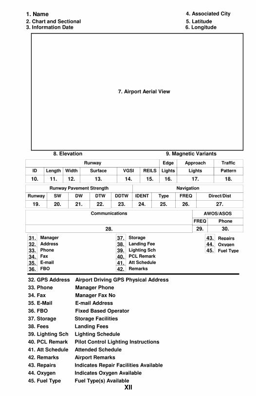
KEY TO AIRPORT INFORMATION
1. Name Airport FAA ID and Name
2. Chart FAA Chart and Sectional
3. Information Date Data Information Date
4. Associated City Airport FAA ID and Name
5. Latitude Airport Latitude
6. Longitude Airport Longitude
8. Elevation Elevation of the Hightest Point on Runway.
9. Magnetic Var Magnetic Variants in Degrees and Direction
7. Aerial View Aerial View of the Airport Runways and Approaches
10. ID Runway ID
11. Length Length of Pavement/Turf End-to-End
12. Width Width of Pavementt or Turf
13. Surface Runway Surface (asph, turf etc) Type
14. VGI Visual Glide Slope Indicators (noted for each end)
15. REILS Runway End Identifier Lights Sys (noted for each end)
16-17. Lights Lights to Aid Landing Craft
18. Pattern 15-RH Indicates 15 Has Right Hand Traffic Pattern
19. Runway Runway ID
20. SW Gross Weight for Single Wheel Aircraft
21. DW Gross Weight for Dual Wheel Aircraft
22. DTW Gross Weight for Dual Tandem Wheel Aircraft
23. DDTW
24. Ident Navigation Aid Indentification
25. Type Type of NAVAID (NBD VOR etc)
26. FREQ NAVAID Frequency
28. Communications (Towered Facility)
Tower Tower's Frequency
GRND Ground Control Frequency
CL DEL Clearance and Delivery Frequency
ATIS Automatic Terminal Information System Frequency
28. Communications (Non-Towered Facility)
CTAF Common Traffic Advisory Frequency
Unicom Unicom Frequency
GCO
RCO Remote Control Outlet Frequency
Air Traffic Control Service Frequency
ATC FAAID Air Traffic Control Service FAA Identification
29. AWOS Freq Automated Weather/Surface Observation System Frequency
30. AWOS Phone Automated Weather/Surface Observation System Phone
31. Manager Manager Name
Gross Weight for Double Dual Tandem Wheel Aircraft
27. DIRECT/DIST Direction and Distant to Airport
ATC FREQ
RCO Remote Control Outlet Frequency
BRNG/FREQ Approach/Departure Bearings and Frequencies
Air Traffic Control Service Frequency
ATC FAAID Air Traffic Control Service FAA Identification
ATC FREQ
XI
Ground Control Outlet Frequency
1. Name 4. Associated City
2. Chart and Sectional 5. Latitude
6. Longitude3. Information Date
8. Elevation 9. Magnetic Variants
7. Airport Aerial View
Length Width Surface VGSI REILSID
ApproachEdge
Lights Lights
Traffic
Pattern
Runway
11. 12. 13. 14. 15.10. 16. 17. 18.
Runway Pavement Strength
SW DW DTW DDTWRunway
20. 21. 22. 23.19.
Navigation
TypeIDENT Direct/DistFREQ
25.24. 27.26.
Communications
FREQ Phone
AWOS/ASOS
28. 29. 30.
Address
Phone
Fax
Manager
FBO
31.
32.
33.
34.
35.
36.
37.
38.
39.
Att Schedule
Lighting Sch
Landing Fee
Storage
Remarks
PCL Remark40.
41.
42.
43.
44.
45. Fuel Type
Oxygen
Repairs
43. Repairs Indicates Repair Facilities Available
44. Oxygen Indicates Oxygen Available
45. Fuel Type Fuel Type(s) Available
37. Storage
38. Fees Landing Fees
39. Lighting Sch Lighting Schedule
40. PCL Remark Pilot Control Lighting Instructions
Storage Facilities
42. Remarks Airport Remarks
E-mail Address35. E-Mail
Fixed Based Operator36. FBO
32. GPS Address Airport Driving GPS Physical Address
33. Phone Manager Phone
34. Fax Manager Fax No
41. Att Schedule Attended Schedule
XII
XIIIXIII

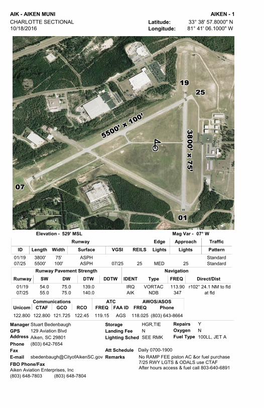
AIK - AIKEN MUNI AIKEN - 1Latitude: 33° 38' 57.8000" NLongitude: 81° 41' 06.1000" W
CHARLOTTE SECTIONAL 10/18/2016
529' MSLElevation - 07° WMag Var -
GPS AddressPhoneFaxE-mail
Stuart Bedenbaugh129 Aviation BlvdAiken, SC 29801(803) 642-7654
[email protected] Schedule
Lighting Sched
Daily 0700-1900
SEE RMKLanding Fee N
RepairsOxygenFuel Type
Storage YN100LL, JET A
HGR,TIEManager
No RAMP FEE piston AC &or fuel purchase7/25 RWY LGTS & ODALS use CTAFAfter hours access & fuel call 803-640-6891
FBO Phone/FaxRemarks
Length Width Surface VGSI REILSIDApproachEdge
Lights LightsTrafficPattern
Runway
01/19 3800' 75' ASPH Standard07/25 5500' 100' ASPH MED 2507/25 25 Standard
ATCFREQ FAA ID
CommunicationsCTAFUnicom GCO RCO FREQ
AWOS/ASOSPhone
122.800 122.800 121.725 122.45 AGS119.15 118.025 (803) 643-8664
Aiken Aviation Enterprises, Inc(803) 648-7803 (803) 648-7804
NavigationTypeIDENT Direct/DistFREQ
VORTAC 113.90 r102° 24.1 NM to fldIRQNDB 347 at fldAIK
Runway Pavement StrengthSW DW DTW DDTWRunway
01/19 54.0 75.0 139.007/25 55.0 75.0 140.0

AQX - ALLENDALE COUNTY ALLENDALE - 2Latitude: 32° 59' 42.4000" NLongitude: 81° 16' 12.9000" W
CHARLOTTE SECTIONAL 11/10/2016
162' MSLElevation - 06° WMag Var -
GPS AddressPhoneFaxE-mail
Betty Baker467 Airport LoopAllendale, SC 29827(803) 584-3801
[email protected] Schedule
Lighting Sched
Daily 0900-1700
SEE RMKLanding Fee N
RepairsOxygenFuel Type
Storage NN100LL, JET A
TIEManager
ACTVT MIRL - CTAF.SELF SERVE 100LL and JET AFBO Phone/Fax
Remarks
Length Width Surface VGSI REILSIDApproachEdge
Lights LightsTrafficPattern
Runway
17/35 5001' 75' ASPH MED17/35 Standard
ATCFREQ FAA ID
CommunicationsCTAFUnicom GCO RCO FREQ
AWOS/ASOSPhone
122.800 122.800 116.7T 132.5 JAX 118.950 (803) 584-3696122.1R
Allendale County(803) 584-3801 (803) 584-4447
NavigationTypeIDENT Direct/DistFREQ
VORTAC 110.40 r241° 50.4 NM to fldVAN
Runway Pavement StrengthSW DW DTW DDTWRunway
17/35 26.0 34.0
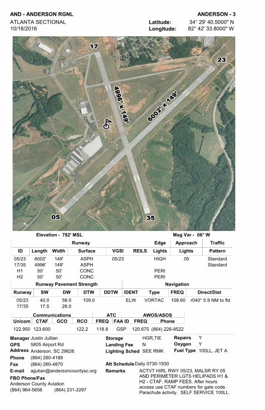
AND - ANDERSON RGNL ANDERSON - 3Latitude: 34° 29' 40.5000" NLongitude: 82° 42' 33.8000" W
ATLANTA SECTIONAL 10/18/2016
782' MSLElevation - 06° WMag Var -
GPS AddressPhoneFaxE-mail
Justin Jullian5805 Airport RdAnderson, SC 29626(864) 260-4188(864) [email protected]
Att Schedule
Lighting Sched
Daily 0730-1930
SEE RMKLanding Fee N
RepairsOxygenFuel Type
Storage YY100LL, JET A
HGR,TIEManager
ACTVT HIRL RWY 05/23, MALSR RY 05 AND PERIMETER LGTS HELIPADS H1 & H2 - CTAF. RAMP FEES. After hours access use CTAF numbers for gate code.Parachute activity. SELF SERVICE 100LL.
FBO Phone/FaxRemarks
Length Width Surface VGSI REILSIDApproachEdge
Lights LightsTrafficPattern
Runway
05/23 6002' 149' ASPH HIGH 0505/23 Standard17/35 4996' 149' ASPH Standard
H1 50' 50' CONC PERIH2 50' 50' CONC PERI
ATCFREQ FAA ID
CommunicationsCTAFUnicom GCO RCO FREQ
AWOS/ASOSPhone
122.950 123.600 122.2 GSP118.8 120.675 (864) 226-9522
Anderson County Aviation(864) 964-5656 (864) 231-2297
NavigationTypeIDENT Direct/DistFREQ
VORTAC 108.60 r040° 5.9 NM to fldELW
Runway Pavement StrengthSW DW DTW DDTWRunway
05/23 40.0 58.0 109.017/35 17.5 28.0

PHH - ROBERT F SWINNIE ANDREWS - 4Latitude: 33° 27' 06.1190" NLongitude: 79° 31' 34.2360" W
CHARLOTTE SECTIONAL 10/18/2016
26' MSLElevation - 08° WMag Var -
GPS AddressPhoneFaxE-mail
Rick Westfall11730 Gapway RdAndrews, SC 29442(843) 545-3638
[email protected] Schedule
Lighting Sched
UNATTENDED
SS-SRLanding Fee N
RepairsOxygenFuel Type
Storage NN100LL
TIEManager
Activate MIRL & PAPI Rwy. 18-36 - CTAF. Parachute activity.SELF SERVE 100LL
FBO Phone/FaxRemarks
Length Width Surface VGSI REILSIDApproachEdge
Lights LightsTrafficPattern
Runway
18/36 3001' 60' ASPH MED18/36 Standard
ATCFREQ FAA ID
CommunicationsCTAFUnicom GCO RCO FREQ
AWOS/ASOSPhone
122.900 MYR127.4
NavigationTypeIDENT Direct/DistFREQ
VORTAC 113.50 r043° 42.2 NM to fldCHSNDB 255 at fldPHH
Runway Pavement StrengthSW DW DTW DDTWRunway
18/36 11.0 22.0
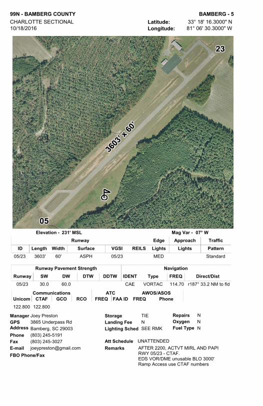
99N - BAMBERG COUNTY BAMBERG - 5Latitude: 33° 18' 16.3000" NLongitude: 81° 06' 30.3000" W
CHARLOTTE SECTIONAL 10/18/2016
231' MSLElevation - 07° WMag Var -
GPS AddressPhoneFaxE-mail
Joey Preston3865 Underpass RdBamberg, SC 29003(803) 245-5191(803) [email protected]
Att Schedule
Lighting Sched
UNATTENDED
SEE RMKLanding Fee N
RepairsOxygenFuel Type
Storage NNN
TIEManager
AFTER 2200, ACTVT MIRL AND PAPI RWY 05/23 - CTAF.EDS VOR/DME unusable BLO 3000'Ramp Access use CTAF numbers
FBO Phone/FaxRemarks
Length Width Surface VGSI REILSIDApproachEdge
Lights LightsTrafficPattern
Runway
05/23 3603' 60' ASPH MED05/23 Standard
ATCFREQ FAA ID
CommunicationsCTAFUnicom GCO RCO FREQ
AWOS/ASOSPhone
122.800 122.800
NavigationTypeIDENT Direct/DistFREQ
VORTAC 114.70 r187° 33.2 NM to fldCAE
Runway Pavement StrengthSW DW DTW DDTWRunway
05/23 30.0 60.0

BNL - BARNWELL RGNL BARNWELL - 6Latitude: 33° 15' 27.6039" NLongitude: 81° 23' 17.5882" W
CHARLOTTE SECTIONAL 10/18/2016
246' MSLElevation - 07° WMag Var -
GPS AddressPhoneFaxE-mail
Tim Freer155 Airport RdBarnwell, SC 29812(803) 450-8015(803) [email protected]
Att Schedule
Lighting Sched
Daily 0900-1700
SEE RMKLanding Fee N
RepairsOxygenFuel Type
Storage NN100LL, JET A, MOGAS
HGR,TIEManager
RWY 5/23 in fair conditionMIRL Rwy. 17-35 dusk - 10:00pm, after 10:00pm-CTAF, ODALS RWY. 17 -CTAF. After-hrs access bldg via keypad (instructions on keypad). Ramp access via unlocked pedestrian gate.SELF SERVICE MOGAS, 100LL and Jet-A
FBO Phone/FaxRemarks
Length Width Surface VGSI REILSIDApproachEdge
Lights LightsTrafficPattern
Runway
05/23 4526' 70' ASPH 23 - RH17/35 5119' 100' ASPH MED 1717/35 17 17 - RH
ATCFREQ FAA ID
CommunicationsCTAFUnicom GCO RCO FREQ
AWOS/ASOSPhone
122.800 122.800 121.725 JAX132.925 119.775 (803) 259-4536
Barnwell County(803) 259-1090 (803) 259-4596
NavigationTypeIDENT Direct/DistFREQ
VORTAC 114.70 r207° 39.6 NM tofldCAE
Runway Pavement StrengthSW DW DTW DDTWRunway
05/23 12.017/35 69.0 99.0

ARW - BEAUFORT COUNTY BEAUFORT - 7Latitude: 32° 24' 43.8000" NLongitude: 80° 38' 03.6000" W
CHARLOTTE SECTIONAL 11/10/2016
9' MSLElevation - 07° WMag Var -
GPS AddressPhoneFaxE-mail
Joel Phillips39 Airport CircleBeaufort, SC 29907(843) 255-2972
[email protected] Schedule
Lighting Sched
Daily 0800-1800
SEE RMKLanding Fee N
RepairsOxygenFuel Type
Storage NN100LL, JET A
TIEManager
MIRL PRESET LOW; INCR INTSTY CTAFAFTR-HRS RAMP ACCESS PED GATE.NO AFTR-HRS TRML ACCESS. AFTR-HRS CALLOUT FEE W/48HR NOTICESELF SERVE 100LL 24/7
FBO Phone/FaxRemarks
Length Width Surface VGSI REILSIDApproachEdge
Lights LightsTrafficPattern
Runway
07/25 3434' 75' ASPH MED07/25 07/25 07 - RH
ATCFREQ FAA ID
CommunicationsCTAFUnicom GCO RCO FREQ
AWOS/ASOSPhone
122.700 122.700 121.725 NBC125.125 119.675 (843) 524-1000
Beaufort County Airport(843) 255-2972
NavigationTypeIDENT Direct/DistFREQ
VORTAC 115.95 r067° 32.8 NM to fldSAV
Runway Pavement StrengthSW DW DTW DDTWRunway
07/25 35.0 52.0

BBP - MARLBORO COUNTY JETPORT - H E AVENT FIELD BENNETTSVILLE - 8Latitude: 34° 37' 18.1510" NLongitude: 79° 44' 03.6940" W
CHARLOTTE SECTIONAL 11/10/2016
147' MSLElevation - 08° WMag Var -
GPS AddressPhoneFaxE-mail
Barry Avent1231 State Road S-35-330Bennettsville, SC 29512(843) 479-4797(843) [email protected]
Att Schedule
Lighting Sched
MON-SAT 0800-1700 / SUN 1300-1700
SS-SRLanding Fee N
RepairsOxygenFuel Type
Storage NN100LL, JET A
HGR,TIEManager
$75 fee for fuel after hrs. 843-439-1269FBO Phone/Fax
Remarks
Length Width Surface VGSI REILSIDApproachEdge
Lights LightsTrafficPattern
Runway
07/25 5003' 74' ASPH MED07/25 07/25 Standard
ATCFREQ FAA ID
CommunicationsCTAFUnicom GCO RCO FREQ
AWOS/ASOSPhone
122.800 122.800 FLO118.6 123.825 (843) 479-5817
Rare Air Inc.(843) 479-2816
NavigationTypeIDENT Direct/DistFREQ
VORTAC 115.20 r354° 23.6 NM tofldFLONDB 230 at fldBES
Runway Pavement StrengthSW DW DTW DDTWRunway
07/25 28.0 43.0 70.0

52J - LEE COUNTY-BUTTERS FIELD BISHOPVILLE - 9Latitude: 34° 14' 40.1460" NLongitude: 80° 14' 09.7210" W
CHARLOTTE SECTIONAL 11/28/2016
211' MSLElevation - 08° WMag Var -
GPS AddressPhoneFaxE-mail
George Roberts145 Airport RdBishopville, SC 29010(803) 229-2679
[email protected] Schedule
Lighting Sched
UNATTENDED
SEE RMKLanding Fee N
RepairsOxygenFuel Type
Storage NN100LL
TIE, HGRManager
BCN - SS to SR, PAPI - SR to SSNIGHT ACTVT PAPI/MIRL W CTAF PCL SELF SERVICE 100LL
FBO Phone/FaxRemarks
Length Width Surface VGSI REILSIDApproachEdge
Lights LightsTrafficPattern
Runway
06/24 3200' 60' ASPH MED06/24 Standard
ATCFREQ FAA ID
CommunicationsCTAFUnicom GCO RCO FREQ
AWOS/ASOSPhone
122.900
NavigationTypeIDENT Direct/DistFREQ
VOR/DME 108.20 r178° 24.4 NM to fldCTF
Runway Pavement StrengthSW DW DTW DDTWRunway
06/24 12.5 25.0

CDN - WOODWARD FIELD CAMDEN - 10Latitude: 34° 17' 00.9000" NLongitude: 80° 33' 53.5000" W
CHARLOTTE SECTIONAL 10/18/2016
302' MSLElevation - 08° WMag Var -
GPS AddressPhoneFaxE-mail
Barry T. Catoe2203 Airline DrCamden, SC 29020(803) 425-7238
[email protected] Schedule
Lighting Sched
MON-FRI 0800-1800 / SAT-SUN 0800-1700
SEE RMKLanding Fee N
RepairsOxygenFuel Type
Storage YY100LL, JET A
HGR,TIEManager
MIRL RWY 06/24 PRESET LOW INTST; INCR MIRL INTST AND ACTVT REIL RWYS 06 & 24 - CTAF. AFTR HRS RAMP ACCESS PED GATE USE VFR SQUAWK CODE. CAMDEN JET CENTERAFTR HRS 803-713-4655. FULL/SELF SERVICE 100LL and JET-A
FBO Phone/FaxRemarks
Length Width Surface VGSI REILSIDApproachEdge
Lights LightsTrafficPattern
Runway
06/24 5000' 100' ASPH MED06/24 06/24 Standard14/32 2998' 100' ASPH Standard
ATCFREQ FAA ID
CommunicationsCTAFUnicom GCO RCO FREQ
AWOS/ASOSPhone
123.000 123.000 SSC125.4 119.975 (803) 424-1979
Camden Jet Center(803) 432-3095 (803) 432-1311
NavigationTypeIDENT Direct/DistFREQ
VOR/DME 108.20 r216° 26.3 NM to fldCTF
Runway Pavement StrengthSW DW DTW DDTWRunway
06/24 51.0 70.0 131.014/32 30.0 55.0 90.0

CHS - CHARLESTON AFB/INTL CHARLESTON - 11Latitude: 32° 53' 55.1000" NLongitude: 80° 02' 25.9000" W
CHARLOTTE SECTIONAL 11/10/2016
46' MSLElevation - 08° WMag Var -
GPS AddressPhoneFaxE-mail
Paul Campbell5500 International BlvdCharleston, SC 29418(843) 767-7000(843) [email protected]
Att Schedule
Lighting Sched
24/7
Landing Fee NRepairsOxygenFuel Type
Storage YY100LL, JET A1+
HGR,TIEManager
24 HR Tower - Class C AirspaceNo student touch & go's allowedIntensive military operationsARINC 129.375 (Atlantic Aviation ) 131.625 (Signature )NOISE ABATEMENT PROCEDURESRAMP FEE
FBO Phone/FaxRemarks
Length Width Surface VGSI REILSIDApproachEdge
Lights LightsTrafficPattern
Runway
03/21 7000' 150' CONC HIGH03/21 03/21 Standard15/33 9001' 150' CONC HIGH 15/3315/33 Standard
CommunicationsTower GRND CL DEL
ATCATISFREQ FREQ FREQ
AWOS/ASOSPhone
RCOFREQFAA ID BRNG/FREQ
APP/DEP
126.0 121.9 127.325 124.75 CHS120.7 122.1R N/A (843) 554-9862113.5T
Atlantic Aviation Services(843) 746-7600 (843) 746-7642
Signature Flight Support(843) 414-9200 (843) 414-9201
NavigationTypeIDENT Direct/DistFREQ
VORTAC 113.50 at fldCHSNDB 329 r153° 5.5 NM to fldCH
Runway Pavement Strength PCN Runway
03/21 71 /R/B/W/T15/33 73 /R/B/W/T

JZI - CHARLESTON EXECUTIVE CHARLESTON - 12Latitude: 32° 42' 03.7000" NLongitude: 80° 00' 11.7000" W
CHARLOTTE SECTIONAL 10/18/2016
19' MSLElevation - 08° WMag Var -
GPS AddressPhoneFaxE-mail
Paul Campbell2700 Fort Trenholm RdCharleston, SC 29455(843) 767-7000
[email protected] Schedule
Lighting Sched
Daily 0600-2200
SEE RMKLanding Fee N
RepairsOxygenFuel Type
Storage YN100LL, JET A
HGR,TIEManager
ACTVT MIRL RWY 04/22 & HIRL RWY 09/27 - CTAF. RAMP FEEAfter Hours access 843-746-7600
FBO Phone/FaxRemarks
Length Width Surface VGSI REILSIDApproachEdge
Lights LightsTrafficPattern
Runway
04/22 4313' 150' CONC MED04 Standard09/27 5350' 100' CONC HIGH09/27 Standard
ATCFREQ FAA ID
CommunicationsCTAFUnicom GCO RCO FREQ
AWOS/ASOSPhone
122.800 122.800 119.85 CHS120.7 123.775 (843) 559-3123
Atlantic Aviation(843) 559-2401
NavigationTypeIDENT Direct/DistFREQ
VORTAC 113.50 r176° 11.7 NM to fldCHS
Runway Pavement StrengthSW DW DTW DDTWRunway
04/22 45.0 56.009/27 60.0 100.0

CQW - CHERAW MUNI/LYNCH BELLINGER FIELD CHERAW - 13Latitude: 34° 42' 46.3000" NLongitude: 79° 57' 25.2000" W
CHARLOTTE SECTIONAL 10/18/2016
239' MSLElevation - 08° WMag Var -
GPS AddressPhoneFaxE-mail
Mike Smith75 Janice CircleCheraw, SC 29520(843) 537-8400(843) [email protected]
Att Schedule
Lighting Sched
MON-SAT 0800-1800; SUN 1300-1700
SEE RMKLanding Fee N
RepairsOxygenFuel Type
Storage YN100LL, JET A
TIEManager
ACTVT MIRL - CTAFFor fuel after hours (fee) - 843-537-9436
FBO Phone/FaxRemarks
Length Width Surface VGSI REILSIDApproachEdge
Lights LightsTrafficPattern
Runway
08/26 5000' 75' ASPH MED08/26 08/26 Standard
ATCFREQ FAA ID
CommunicationsCTAFUnicom GCO RCO FREQ
AWOS/ASOSPhone
122.800 122.800 FLO118.6 124.825 (843) 537-3301
Hall Aviation(843) 537-6423
NavigationTypeIDENT Direct/DistFREQ
VOR/DME 108.20 r080° 16.2 NM to fldCTF
Runway Pavement StrengthSW DW DTW DDTWRunway
08/26 30.0 48.0

DCM - CHESTER CATAWBA RGNL CHESTER - 14Latitude: 34° 47' 21.6000" NLongitude: 81° 11' 44.8000" W
CHARLOTTE SECTIONAL 11/10/2016
657' MSLElevation - 07° WMag Var -
GPS AddressPhoneFaxE-mail
Keith Roach571 Piper DrChester, SC 29706(803) 385-6664(803) [email protected]
Att Schedule
Lighting Sched
M-F0900-1800;SAT0800-2000;SUN1300 -
SEE RMKLanding Fee N
RepairsOxygenFuel Type
Storage NN100LL, JET A
HGR,TIEManager
REQUEST NO MID-FIELD FLY-OVER DUE TO PARACHUTE ACTIVITY SKYDIVE CAROLINA 803-581-5867ACTVT MIRL RWY 17/35 AND PAPI RWYS 17 & 35-CTAF. RWY 5 DSPLED THLD 875'RAMP ACCESS USE AWOS FREQ.FULL SERVICE 100LL and JET A
FBO Phone/FaxRemarks
Length Width Surface VGSI REILSIDApproachEdge
Lights LightsTrafficPattern
Runway
05/23 4123' 100' ASPH 05 - RH17/35 5000' 100' ASPH MED17/35 17 - RH
ATCFREQ FAA ID
CommunicationsCTAFUnicom GCO RCO FREQ
AWOS/ASOSPhone
122.700 122.700 CLT120.05 120.975 (803) 385-2011
Chester Aviation(803) 385-6664 (803) 385-6664
NavigationTypeIDENT Direct/DistFREQ
VORTAC 115.00 r212° 26.9 NM to fldCLTNDB 220 at fldDCM
Runway Pavement StrengthSW DW DTW DDTWRunway
05/23 4.0 12.017/35 30.0 44.0
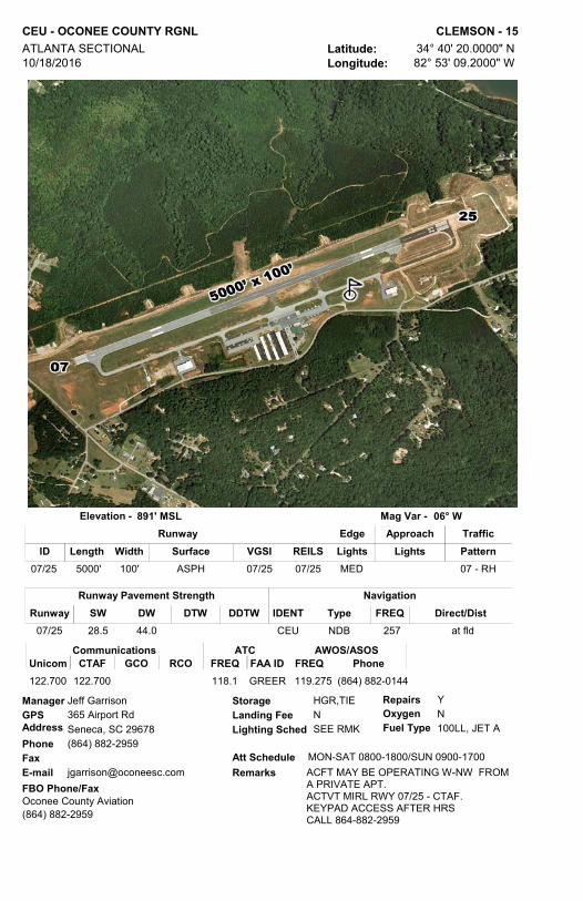
CEU - OCONEE COUNTY RGNL CLEMSON - 15Latitude: 34° 40' 20.0000" NLongitude: 82° 53' 09.2000" W
ATLANTA SECTIONAL 10/18/2016
891' MSLElevation - 06° WMag Var -
GPS AddressPhoneFaxE-mail
Jeff Garrison365 Airport RdSeneca, SC 29678(864) 882-2959
[email protected] Schedule
Lighting Sched
MON-SAT 0800-1800/SUN 0900-1700
SEE RMKLanding Fee N
RepairsOxygenFuel Type
Storage YN100LL, JET A
HGR,TIEManager
ACFT MAY BE OPERATING W-NW FROM A PRIVATE APT.ACTVT MIRL RWY 07/25 - CTAF.KEYPAD ACCESS AFTER HRSCALL 864-882-2959
FBO Phone/FaxRemarks
Length Width Surface VGSI REILSIDApproachEdge
Lights LightsTrafficPattern
Runway
07/25 5000' 100' ASPH MED07/25 07/25 07 - RH
ATCFREQ FAA ID
CommunicationsCTAFUnicom GCO RCO FREQ
AWOS/ASOSPhone
122.700 122.700 118.1 GREER 119.275 (864) 882-0144
Oconee County Aviation(864) 882-2959
NavigationTypeIDENT Direct/DistFREQNDB 257 at fldCEU
Runway Pavement StrengthSW DW DTW DDTWRunway
07/25 28.5 44.0

9W9 - CLIO CROP CARE CLIO - 16Latitude: 34° 33' 41.1000" NLongitude: 79° 32' 17.1000" W
CHARLOTTE SECTIONAL 11/28/2016
192' MSLElevation - 08° WMag Var -
GPS AddressPhoneFaxE-mail
Ken Hanke2750 Highway 9 EastClio, SC 29525(843) 586-9225
[email protected] Schedule
Lighting Sched
MON-FRI 0800-DUSK/ SAT 0800-1200
Landing Fee NRepairsOxygenFuel Type
Storage YNN
TIEManager
Private Apt. - Public UseFBO Phone/Fax
Remarks
Length Width Surface VGSI REILSIDApproachEdge
Lights LightsTrafficPattern
Runway
05/23 2598' 125' TURF Standard
ATCFREQ FAA ID
CommunicationsCTAFUnicom GCO RCO FREQ
AWOS/ASOSPhone
122.900
NavigationTypeIDENT Direct/DistFREQ
VORTAC 115.20 r019° 20.0 NM to fldFLO
Runway Pavement StrengthSW DW DTW DDTWRunway
05/23

CAE - COLUMBIA METROPOLITAN COLUMBIA - 17Latitude: 33° 56' 19.8000" NLongitude: 81° 07' 10.3000" W
CHARLOTTE SECTIONAL 10/18/2016
236' MSLElevation - 07° WMag Var -
GPS AddressPhoneFaxE-mail
Dan Mann3250 Airport BlvdColumbia, SC 29170(803) 822-7878(803) [email protected]
Att Schedule
Lighting Sched
24/7
SS-SRLanding Fee N
RepairsOxygenFuel Type
Storage YY100LL, JET A
HGR,TIEManager
FEE FOR COMMERCIAL AIRCRAFT ABOVE 15K lbs.ULTRALIGHTS PROHIBITEDNOISE ABATEMENT PROCEDURES UNICOM 122.9524 HR TOWER - CLASS C AIRSPACERWY 23 1000' DSPLED THLDRAMP FEE
FBO Phone/FaxRemarks
Length Width Surface VGSI REILSIDApproachEdge
Lights LightsTrafficPattern
Runway
05/23 8001' 150' ASPH-CONC HIGH 0505/23 23 Standard11/29 8601' 150' CONC HIGH 11/2911/29 Standard
H1 50' 50' CONC PERI
CommunicationsTower GRND CL DEL
ATCATISFREQ FREQ FREQ
AWOS/ASOSPhone
RCOFREQFAA ID BRNG/FREQ
APP/DEP
119.5 121.9 119.75 120.15 CAE119.5 122.65 110° - 289 ° 124.15 N/A (803) 822-4168290° - 109° 133.4
Bankair/Columbia Aviation(803) 822-8832 (803) 822-8775
Eagle Aviation(803) 822-5555 (803) 822-5545
.
NavigationTypeIDENT Direct/DistFREQ
VORTAC 114.70 r328° 5.9 NM to fldCAE
Runway Pavement StrengthSW DW DTW DDTWRunway
05/23 100.0 200.0 355.0 675.011/29 72.0 225.0 409.0 700.0

CUB - JIM HAMILTON - LB OWENS COLUMBIA - 18Latitude: 33° 58' 13.7000" NLongitude: 80° 59' 42.9000" W
CHARLOTTE SECTIONAL 11/10/2016
193' MSLElevation - 07° WMag Var -
GPS AddressPhoneFaxE-mail
Christopher Eversmann1400 Jim Hamilton BlvdColumbia, SC 29205(803) 767-1789
[email protected] Schedule
Lighting Sched
Daily 0600-2200
SEE RMKLanding Fee N
RepairsOxygenFuel Type
Storage YY100LL, JET A
HGR,TIEManager
Avoid noise sensitive area north of airport below 1500'.No northbound departure turn below 1500'.APU available. Ramp FeeService after hours 803-771-7915RWY 31 has 400' displaced thresholdACTVT MIRL AND REIL - CTAFwww.FlyKCUB.com
FBO Phone/FaxRemarks
Length Width Surface VGSI REILSIDApproachEdge
Lights LightsTrafficPattern
Runway
13/31 5011' 75' ASPH MED13/31 13/31 13 - RH
ATCFREQ FAA ID
CommunicationsCTAFUnicom GCO RCO FREQ
AWOS/ASOSPhone
122.800 122.800 124.4 CAE133.4 119.675 (803) 929-0665
Eagle Aviation(803) 771-7915 (803) 256-9425
Aircraft Maintenance Services(803) 243-1157
NavigationTypeIDENT Direct/DistFREQ
VORTAC 114.70 r025° 7.4 NM to fldCAE
Runway Pavement StrengthSW DW DTW DDTWRunway
13/31 44.5 66.0

HYW - CONWAY-HORRY COUNTY CONWAY - 19Latitude: 33° 49' 42.5550" NLongitude: 79° 07' 19.8348" W
CHARLOTTE SECTIONAL 10/18/2016
35' MSLElevation - 09° WMag Var -
GPS AddressPhoneFaxE-mail
Scott VanMoppes 1700 Airport RoadConway, SC 29527(843) 448-1580(843) [email protected]
Att Schedule
Lighting Sched
Daily 0900-1700
SEE RMKLanding Fee N
RepairsOxygenFuel Type
Storage YN100LL, JET A
TIEManager
ACTVT MIRL - CTAFAfter Hours access gate use UnicomSELF SERVICE 100LL and JET A
FBO Phone/FaxRemarks
Length Width Surface VGSI REILSIDApproachEdge
Lights LightsTrafficPattern
Runway
04/22 4401' 75' ASPH MED04/22 04 - RH
ATCFREQ FAA ID
CommunicationsCTAFUnicom GCO RCO FREQ
AWOS/ASOSPhone
122.700 122.700 MYR127.4 119.525 (843) 397-8046
Conway Aviation(843) 397-9111 (843) 397-3776
NavigationTypeIDENT Direct/DistFREQNDB 370 at fldHYW
VORTAC 117.60 r276º 19.9 NM to fldCRE
Runway Pavement StrengthSW DW DTW DDTWRunway
04/22 12.5 20.0
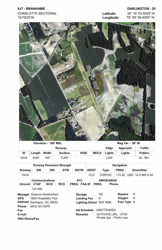
6J7 - BRANHAMS DARLINGTON - 20Latitude: 34° 16' 53.5000" NLongitude: 79° 55' 39.4000" W
CHARLOTTE SECTIONAL 10/18/2016
166' MSLElevation - 08° WMag Var -
GPS AddressPhone (843) 307-0070FaxE-mail
Dwayne Weatherford1829 Hospitality TrailDarlington, SC 29532
Att Schedule
Lighting Sched
UNATTENDED
SEE RMKLanding Fee N
RepairsOxygenFuel Type
Storage NNN
TIEManager
ACTIVATE LIRL - CTAF.Private Apt. - Public UseFBO Phone/Fax
Remarks
Length Width Surface VGSI REILSIDApproachEdge
Lights LightsTrafficPattern
Runway
16/34 3200' 100' TURF LOW 16 - RH
ATCFREQ FAA ID
CommunicationsCTAFUnicom GCO RCO FREQ
AWOS/ASOSPhone
122.900
NavigationTypeIDENT Direct/DistFREQ
VORTAC 115.20 r285° 14.0 NM to fldFLO
Runway Pavement StrengthSW DW DTW DDTWRunway
16/34
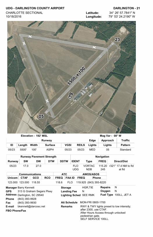
UDG - DARLINGTON COUNTY AIRPORT DARLINGTON - 21Latitude: 34° 26' 57.7841" NLongitude: 79° 53' 24.2190" W
CHARLOTTE SECTIONAL 10/18/2016
192' MSLElevation - 08° WMag Var -
GPS AddressPhoneFaxE-mail
Barry Kennett313 G Graham Segars PkwyDarlington, SC 29540(843) 393-9928(843) [email protected]
Att Schedule
Lighting Sched
MON-FRI 0800-1700
SEE RMKLanding Fee N
RepairsOxygenFuel Type
Storage NN100LL, JET A
HGR,TIEManager
RWY & TWY lights preset to low intensity; after 2300, use CTAF.After Hours Access through unlocked pedestrian gate.SELF SERVICE 100LL.
FBO Phone/FaxRemarks
Length Width Surface VGSI REILSIDApproachEdge
Lights LightsTrafficPattern
Runway
05/23 5500' 100' ASPH MED 0505/23 05/23 Standard
ATCFREQ FAA ID
CommunicationsCTAFUnicom GCO RCO FREQ
AWOS/ASOSPhone
123.000 123.000 118.55 FLO118.6 119.925 (843) 393-8220
NavigationTypeIDENT Direct/DistFREQ
VORTAC 115.20 r321° 17.4 NM to fldFLONDB 245 at fldUDG
Runway Pavement StrengthSW DW DTW DDTWRunway
05/23 17.0 27.0

DLC - DILLON COUNTY DILLON - 22Latitude: 34° 26' 56.6000" NLongitude: 79° 22' 06.9000" W
CHARLOTTE SECTIONAL 10/18/2016
133' MSLElevation - 09° WMag Var -
GPS AddressPhoneFaxE-mail
Winna Miller1088 Airport RdDillon, SC 29536(843) 627-6153(843) [email protected]
Att Schedule
Lighting Sched
UNATTENDED
SS-SRLanding Fee N
RepairsOxygenFuel Type
Storage NNN
TIEManager
RWY 7/25 in fair conditionFBO Phone/Fax
Remarks
Length Width Surface VGSI REILSIDApproachEdge
Lights LightsTrafficPattern
Runway
07/25 3000' 60' ASPH MED Standard
ATCFREQ FAA ID
CommunicationsCTAFUnicom GCO RCO FREQ
AWOS/ASOSPhone
122.900 FLO118.6
NavigationTypeIDENT Direct/DistFREQ
VORTAC 115.20 r051° 19.3 NM to fldFLO
Runway Pavement StrengthSW DW DTW DDTWRunway
07/25 10.0

FLO - FLORENCE RGNL FLORENCE - 23Latitude: 34° 11' 07.3000" NLongitude: 79° 43' 26.0000" W
CHARLOTTE SECTIONAL 11/28/2016
147' MSLElevation - 08° WMag Var -
GPS AddressPhoneFaxE-mail
Connie Anderson2100 Terminal DriveFlorence, SC 29506(843) 519-0552(843) [email protected]
Att Schedule
Lighting Sched
Daily 0630-2200
SEE RMKLanding Fee N
RepairsOxygenFuel Type
Storage YY100LL, JET A
HGR,TIEManager
Class "D" airspace 0730-2300 other times class" E"ASR - 0730-2300Unicom - 122.95WHEN Tower CLSD ACTVT HIRL RWY 09/27, PAPI RWYS 01, 19, 09 & 27, MALSR RWY 09 AND TWY LGTS - CTAF.
FBO Phone/FaxRemarks
Length Width Surface VGSI REILSIDApproachEdge
Lights LightsTrafficPattern
Runway
01/19 6000' 150' ASPH MED01/19 01/19 Standard09/27 6502' 150' ASPH HIGH 0909/27 27 Standard
CommunicationsTower GRND CL DEL
ATCATISFREQ FREQ FREQ
AWOS/ASOSPhone
RCOFREQFAA ID BRNG/FREQ
APP/DEP
75-255/135.25125.1 121.9 121.9 123.625 FLO125.1 122.6 256- 074/118.6 123.625 (843) 665-1306
Precision Air(843) 667-9627 (843) 667-9838
NavigationTypeIDENT Direct/DistFREQ
VORTAC 115.20 r232° 4.4 NM to fldFLO
Runway Pavement StrengthSW DW DTW DDTWRunway
01/19 87.0 139.0 238.009/27 97.0 156.0 261.0
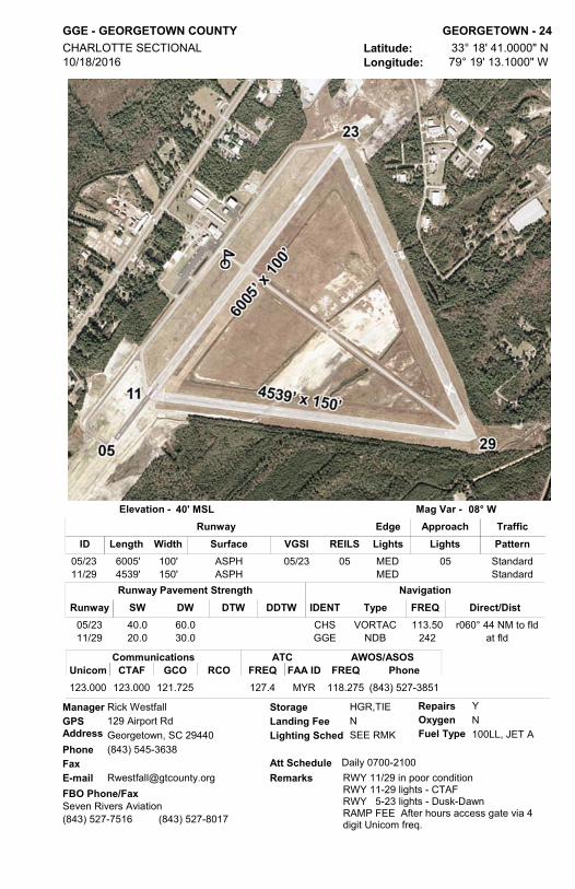
GGE - GEORGETOWN COUNTY GEORGETOWN - 24Latitude: 33° 18' 41.0000" NLongitude: 79° 19' 13.1000" W
CHARLOTTE SECTIONAL 10/18/2016
40' MSLElevation - 08° WMag Var -
GPS AddressPhoneFaxE-mail
Rick Westfall129 Airport RdGeorgetown, SC 29440(843) 545-3638
[email protected] Schedule
Lighting Sched
Daily 0700-2100
SEE RMKLanding Fee N
RepairsOxygenFuel Type
Storage YN100LL, JET A
HGR,TIEManager
RWY 11/29 in poor conditionRWY 11-29 lights - CTAF RWY 5-23 lights - Dusk-DawnRAMP FEE After hours access gate via 4 digit Unicom freq.
FBO Phone/FaxRemarks
Length Width Surface VGSI REILSIDApproachEdge
Lights LightsTrafficPattern
Runway
05/23 6005' 100' ASPH MED 0505/23 05 Standard11/29 4539' 150' ASPH MED Standard
ATCFREQ FAA ID
CommunicationsCTAFUnicom GCO RCO FREQ
AWOS/ASOSPhone
123.000 123.000 121.725 MYR127.4 118.275 (843) 527-3851
Seven Rivers Aviation(843) 527-7516 (843) 527-8017
NavigationTypeIDENT Direct/DistFREQ
VORTAC 113.50 r060° 44 NM to fldCHSNDB 242 at fldGGE
Runway Pavement StrengthSW DW DTW DDTWRunway
05/23 40.0 60.011/29 20.0 30.0

S17 - TWIN LAKES GRANITEVILLE - 25Latitude: 33° 38' 44.4890" NLongitude: 81° 52' 01.4030" W
ATLANTA SECTIONAL 11/28/2016
540' MSLElevation - 07° WMag Var -
GPS AddressPhoneFaxE-mail
Bernard Loyer61 Rachel AveTrenton, SC 29847(803) 480-9569
[email protected] Schedule
Lighting Sched
UNATTENDED
Landing Fee NRepairsOxygenFuel Type
Storage YNN
Manager
RWY 6 displaced thld 636'Flying Community/AirparkRunway CLOSED DUSK-DAWN
FBO Phone/FaxRemarks
Length Width Surface VGSI REILSIDApproachEdge
Lights LightsTrafficPattern
Runway
06/24 4000' 60' ASPH Standard
ATCFREQ FAA ID
CommunicationsCTAFUnicom GCO RCO FREQ
AWOS/ASOSPhone
122.900
Aero Aviation Maintenance(803) 663-1777
NavigationTypeIDENT Direct/DistFREQ
VORTAC 113.90 r108° 15.2 NM to fldIRQ
Runway Pavement StrengthSW DW DTW DDTWRunway
06/24 12.5

S79 - GREEN SEA GREEN SEA - 26Latitude: 34° 11' 08.0000" NLongitude: 79° 01' 14.1150" W
CHARLOTTE SECTIONAL 11/28/2016
95' MSLElevation - 09° WMag Var -
GPS AddressPhoneFaxE-mail
Earl Shaw3333 Mt Olive Church RdGreen Sea, SC 29568(843) 907-8466
Att Schedule
Lighting Sched
UNATTENDED
Landing FeeRepairsOxygenFuel Type
Storage NNN
TIEManager
Private Apt. - Public UseFBO Phone/Fax
Remarks
Length Width Surface VGSI REILSIDApproachEdge
Lights LightsTrafficPattern
Runway
08/26 3600' 100' TURF Standard
ATCFREQ FAA ID
CommunicationsCTAFUnicom GCO RCO FREQ
AWOS/ASOSPhone
122.900
NavigationTypeIDENT Direct/DistFREQ
VORTAC 117.60 r330° 26.7 NM to fldCRE
Runway Pavement StrengthSW DW DTW DDTWRunway
08/26
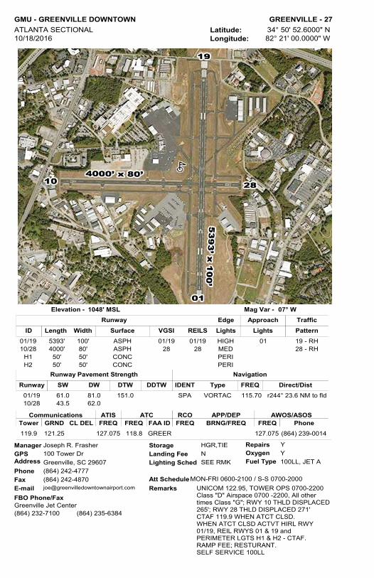
GMU - GREENVILLE DOWNTOWN GREENVILLE - 27Latitude: 34° 50' 52.6000" NLongitude: 82° 21' 00.0000" W
ATLANTA SECTIONAL 10/18/2016
1048' MSLElevation - 07° WMag Var -
GPS AddressPhoneFaxE-mail
Joseph R. Frasher100 Tower DrGreenville, SC 29607(864) 242-4777(864) [email protected]
Att Schedule
Lighting Sched
MON-FRI 0600-2100 / S-S 0700-2000
SEE RMKLanding Fee N
RepairsOxygenFuel Type
Storage YY100LL, JET A
HGR,TIEManager
UNICOM 122.95, TOWER OPS 0700-2200Class "D" Airspace 0700 -2200, All other times Class "G"; RWY 10 THLD DISPLACED 265'; RWY 28 THLD DISPLACED 271' CTAF 119.9 WHEN ATCT CLSD.WHEN ATCT CLSD ACTVT HIRL RWY 01/19, REIL RWYS 01 & 19 and PERIMETER LGTS H1 & H2 - CTAF. RAMP FEE; RESTURANT. SELF SERVICE 100LL
FBO Phone/FaxRemarks
Length Width Surface VGSI REILSIDApproachEdge
Lights LightsTrafficPattern
Runway
01/19 5393' 100' ASPH HIGH 0101/19 01/19 19 - RH10/28 4000' 80' ASPH MED28 28 28 - RH
H1 50' 50' CONC PERIH2 50' 50' CONC PERI
CommunicationsTower GRND CL DEL
ATCATISFREQ FREQ FREQ
AWOS/ASOSPhone
RCOFREQFAA ID BRNG/FREQ
APP/DEP
119.9 121.25 127.075 118.8 GREER 127.075 (864) 239-0014
Greenville Jet Center(864) 232-7100 (864) 235-6384
NavigationTypeIDENT Direct/DistFREQ
VORTAC 115.70 r244° 23.6 NM to fldSPA
Runway Pavement StrengthSW DW DTW DDTWRunway
01/19 61.0 81.0 151.010/28 43.5 62.0

GYH - DONALDSON FIELD GREENVILLE - 28Latitude: 34° 45' 29.9000" NLongitude: 82° 22' 35.1000" W
ATLANTA SECTIONAL 11/10/2016
956' MSLElevation - 07° WMag Var -
GPS AddressPhoneFaxE-mail
Danny Moyd399 Delaware StGreenville, SC 29605(864) 277-3152
[email protected] Schedule
Lighting Sched
Daily 0600-1900
SEE RMKLanding Fee N
RepairsOxygenFuel Type
Storage YY100LL, JET A
HGR,TIEManager
TOWER OPS 0700-2100 Class D Airspace. After hours Class G airspace CTAF 133.325Ramp Fee. ResturantACTVT HIRL RWY 05/23, PAPI RWYS 05 & 23, MALSR RWY 05 - CTAF.AvServe after hours 864-299-0314. Donaldson Jet Center After hours 864-277-8184. After-Hrs ramp access via monitored unlocked pedestrian gate.
FBO Phone/FaxRemarks
Length Width Surface VGSI REILSIDApproachEdge
Lights LightsTrafficPattern
Runway
05/23 8000' 150' CONC HIGH 0505/23 05 - RH
CommunicationsTower GRND CL DEL
ATCATISFREQ FREQ FREQ
AWOS/ASOSPhone
RCOFREQFAA ID BRNG/FREQ
APP/DEP
133.325 121.4 121.4 GYH133.325 127.325 (864) 277-5674
Stevens Aviation(864) 678-6025 (864) 678-6215
Donaldson Jet Center(864) 277-8184 (864) 277-1159
AvServe(864) 299-0314 (864) 299-0324
NavigationTypeIDENT Direct/DistFREQ
VORTAC 115.70 r235° 27.6 NM to fldSPA
Runway Pavement StrengthSW DW DTW DDTWRunway
05/23 94.0 121.0 199.0

GRD - GREENWOOD COUNTY GREENWOOD - 29Latitude: 34° 15' 01.4175" NLongitude: 82° 09' 28.1136" W
ATLANTA SECTIONAL 10/18/2016
631' MSLElevation - 07° WMag Var -
GPS AddressPhoneFaxE-mail
Rossie Corwon598 Terminal RdGreenwood, SC 29649(864) 942-8556(864) [email protected]
Att Schedule
Lighting Sched
M-F0730-1800/SA0800-1700/SU1100-1700
SEE RMKLanding Fee N
RepairsOxygenFuel Type
Storage YN100LL, JET A
TIEManager
Use CTAF for lights after 2300.After hours access via VOR freq.FBO Phone/Fax
Remarks
Length Width Surface VGSI REILSIDApproachEdge
Lights LightsTrafficPattern
Runway
05/23 3600' 60' ASPH Standard09/27 5001' 100' CONC MED 2709/27 09/27 Standard
ATCFREQ FAA ID
CommunicationsCTAFUnicom GCO RCO FREQ
AWOS/ASOSPhone
122.800 122.800 122.625 120.6 GREER 121.125 (864) 388-9115122.1R115.5T
Aeronautical Service of Greenwood(864) 942-9634 (864) 943-1518
NavigationTypeIDENT Direct/DistFREQ
VORTAC 115.50 at fldGRDNDB 239 267° 3.5 NM to fldGIW
Runway Pavement StrengthSW DW DTW DDTWRunway
05/23 22.0 22.009/27 89.0 122.0

GSP - GREENVILLE SPARTANBURG INTL GREER - 30Latitude: 34° 53' 44.4000" NLongitude: 82° 13' 07.9000" W
ATLANTA SECTIONAL 11/28/2016
964' MSLElevation - 07° WMag Var -
GPS AddressPhoneFaxE-mail
David Edwards2000 GSP DrGreer, SC 29651(864) 848-6272(864) [email protected]
Att Schedule
Lighting Sched
24/7
SEE RMKLanding Fee N
RepairsOxygenFuel Type
Storage YYJET A, 100LL
HGR,TIEManager
UNICOM 122.95TOWER OPS 0600-2345CTAF 120.1 WHEN TOWER CLSD.Class "C" airspace 0600 - 2345, other times class "E"WHEN TOWER CLSD ACTVT HIRL & MALSR RWY 22 - CTAF. RAMP FEE
FBO Phone/FaxRemarks
Length Width Surface VGSI REILSIDApproachEdge
Lights LightsTrafficPattern
Runway
04/22 11001' 150' ASPH-CONC HIGH 04/2204/22 04 - RH
CommunicationsTower GRND CL DEL
ATCATISFREQ FREQ FREQ
AWOS/ASOSPhone
RCOFREQFAA ID BRNG/FREQ
APP/DEP
120.1 121.9 121.9 134.25 GSP118.8W 122.2 West/118.8 N/A (864) 879-0614GSP119.4E 122.65 East/119.4
Cerulean Aviation(864) 655-5221 (864) 655-6222
NavigationTypeIDENT Direct/DistFREQ
VORTAC 115.70 r242° 16.6 NM to fldSPA
Runway Pavement StrengthSW DW DTW DDTWRunway
04/22 100.0 210.0 625.0 975.0

3JØ - HAMPTON-VARNVILLE HAMPTON - 31Latitude: 32° 51' 59.4000" NLongitude: 81° 04' 51.6000" W
CHARLOTTE SECTIONAL 10/18/2016
113' MSLElevation - 07° WMag Var -
GPS AddressPhoneFaxE-mail
Dobie Hiers745 Airport RdHampton, SC 29944(803) 942-2702
[email protected] Schedule
Lighting Sched
UNATTENDED
Landing Fee NRepairsOxygenFuel Type
Storage NN100LL
Manager
FBO Phone/FaxRemarks SELF SERVICE 100LL
Length Width Surface VGSI REILSIDApproachEdge
Lights LightsTrafficPattern
Runway
11/29 3580' 60' ASPH Standard
ATCFREQ FAA ID
CommunicationsCTAFUnicom GCO RCO FREQ
AWOS/ASOSPhone
122.900
NavigationTypeIDENT Direct/DistFREQ
VORTAC 115.95 r014° 43.5 NM to fldSAV
Runway Pavement StrengthSW DW DTW DDTWRunway
11/29 8.0
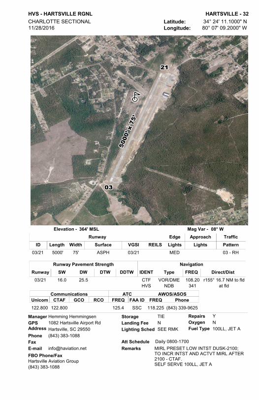
HVS - HARTSVILLE RGNL HARTSVILLE - 32Latitude: 34° 24' 11.1000" NLongitude: 80° 07' 09.2000" W
CHARLOTTE SECTIONAL 11/28/2016
364' MSLElevation - 08° WMag Var -
GPS AddressPhoneFaxE-mail
Hemming Hemmingsen1082 Hartsville Airport RdHartsville, SC 29550(843) 383-1088
[email protected] Schedule
Lighting Sched
Daily 0800-1700
SEE RMKLanding Fee N
RepairsOxygenFuel Type
Storage YN100LL, JET A
TIE Manager
MIRL PRESET LOW INTST DUSK-2100; TO INCR INTST AND ACTVT MIRL AFTER 2100 - CTAF.SELF SERVE 100LL, JET A
FBO Phone/FaxRemarks
Length Width Surface VGSI REILSIDApproachEdge
Lights LightsTrafficPattern
Runway
03/21 5000' 75' ASPH MED03/21 03 - RH
ATCFREQ FAA ID
CommunicationsCTAFUnicom GCO RCO FREQ
AWOS/ASOSPhone
122.800 122.800 SSC125.4 118.225 (843) 339-9625
Hartsville Aviation Group(843) 383-1088
NavigationTypeIDENT Direct/DistFREQ
VOR/DME 108.20 r155° 16.7 NM to fldCTFNDB 341 at fldHVS
Runway Pavement StrengthSW DW DTW DDTWRunway
03/21 16.0 25.5

HXD - HILTON HEAD HILTON HEAD ISLAND - 33Latitude: 32° 13' 27.7000" NLongitude: 80° 41' 50.9000" W
CHARLOTTE SECTIONAL 11/10/2016
19' MSLElevation - 07° WMag Var -
GPS AddressPhoneFaxE-mail
Jon Rembold120 Beach City RdHilton Head Island, SC 29926(843) [email protected]
Att Schedule
Lighting Sched
Daily 0600-2200
SEE RMKLanding Fee N
RepairsOxygenFuel Type
Storage YN100LL, JET A
TIEManager
300' DISP THLD BOTH RWYS. NOISE ABATEMENT PROCS. RAMP FEE. TOWER OPERATES 0700-2100ACTVT MIRL AND REIL CTAF 118.975AFTR-HRS ACCESS FEE BY PRIOR ARRNGMNT 843-689-3200
FBO Phone/FaxRemarks
Length Width Surface VGSI REILSIDApproachEdge
Lights LightsTrafficPattern
Runway
03/21 4300' 100' ASPH MED03/21 03/21 Standard
CommunicationsTower GRND CL DEL
ATCATISFREQ FREQ FREQ
AWOS/ASOSPhone
RCOFREQFAA ID BRNG/FREQ
APP/DEP
118.975 121.1 121.1 121.4 SAV125.3 122.55 121.400 (843) 342-5072
Signature Flight Support(843) 689-3200 (843) 681-3960
NavigationTypeIDENT Direct/DistFREQ
VORTAC 115.95 r085° 26.0 NM to fldSAV
Runway Pavement StrengthSW DW DTW DDTWRunway
03/21 55.0 75.0

5J5 - HOLLY HILL HOLLY HILL - 34Latitude: 33° 18' 01.5000" NLongitude: 80° 23' 39.6000" W
CHARLOTTE SECTIONAL 11/10/2016
96' MSLElevation - 08° WMag Var -
GPS AddressPhoneFaxE-mail
Lamar Day140 Airport RdHolly Hill, SC 29059(803) 378-5239
[email protected] Schedule
Lighting Sched
UNATTENDED
Landing Fee NRepairsOxygenFuel Type
Storage NNN
TIEManager
FBO Phone/FaxRemarks
Length Width Surface VGSI REILSIDApproachEdge
Lights LightsTrafficPattern
Runway
04/22 2900' 150' TURF Standard
ATCFREQ FAA ID
CommunicationsCTAFUnicom GCO RCO FREQ
AWOS/ASOSPhone
122.900
NavigationTypeIDENT Direct/DistFREQ
VORTAC 110.40 r171° 10.8 NM to fldVAN
Runway Pavement StrengthSW DW DTW DDTWRunway
04/22

CKI - WILLIAMSBURG RGNL KINGSTREE - 35Latitude: 33° 43' 02.0000" NLongitude: 79° 51' 25.1000" W
CHARLOTTE SECTIONAL 11/10/2016
67' MSLElevation - 08° WMag Var -
GPS AddressPhoneFaxE-mail
Jack Whiteside85 Aviation DrKingstree, SC 29556(843) 372-1119 Att Schedule
Lighting Sched
UNATTENDED
SEE RMKLanding Fee N
RepairsOxygenFuel Type
Storage NN100LL
TIEManager
ACTVT MIRL AND PAPI - CTAF.FUEL BY PRIOR ARRNGMNTCONTACT AP MGR 843-372-1119
FBO Phone/FaxRemarks
Length Width Surface VGSI REILSIDApproachEdge
Lights LightsTrafficPattern
Runway
14/32 5000' 75' ASPH MED14/32 Standard
ATCFREQ FAA ID
CommunicationsCTAFUnicom GCO RCO FREQ
AWOS/ASOSPhone
122.700 122.700 MYR127.4 124.775 (843) 382-3000
NavigationTypeIDENT Direct/DistFREQ
VORTAC 110.40 r070° 33 NM to fldVANNDB 404 at fldCKI
Runway Pavement StrengthSW DW DTW DDTWRunway
14/32 30.0 45.0

51J - LAKE CITY MUNI CJ EVANS FIELD LAKE CITY - 36Latitude: 33° 51' 12.9000" NLongitude: 79° 46' 05.2000" W
CHARLOTTE SECTIONAL 10/18/2016
80' MSLElevation - 08° WMag Var -
GPS AddressPhoneFaxE-mail
Shawn Bell236 Clifton RdLake City, SC 29560(843) 374-5421 Ext 248(843) 374-1704 Att Schedule
Lighting Sched
UNATTENDED
SEE RMKLanding Fee N
RepairsOxygenFuel Type
Storage NN
TIEManager
ACTVT MIRL - CTAF.RWY 1/19 IN FAIR CONDITION
FBO Phone/FaxRemarks
Length Width Surface VGSI REILSIDApproachEdge
Lights LightsTrafficPattern
Runway
01/19 3700' 75' ASPH MED01/19 Standard
ATCFREQ FAA ID
CommunicationsCTAFUnicom GCO RCO FREQ
AWOS/ASOSPhone
122.900 FLO118.60
NavigationTypeIDENT Direct/DistFREQ
VORTAC 115.20 r197° 23.4 NM to fldFLO
Runway Pavement StrengthSW DW DTW DDTWRunway
01/19 10.0

LKR - LANCASTER COUNTY-MC WHIRTER FIELD LANCASTER - 37Latitude: 34° 43' 22.4558" NLongitude: 80° 51' 16.5243" W
CHARLOTTE SECTIONAL 10/18/2016
486' MSLElevation - 08° WMag Var -
GPS AddressPhoneFaxE-mail
Paul Moses286 Aviation BlvdLancaster, SC 29720(803) 285-1513(803) [email protected]
Att Schedule
Lighting Sched
M-F 0700-1500
SEE RMKLanding Fee N
RepairsOxygenFuel Type
Storage YN100LL, JET A
HGR,TIEManager
ACTVT MIRL - CTAFRAMP FEE may be waived based on AC size and/or fuel purchasedTERMINAL ACCESS KEYPAD FIRST FIVE DIGITS UNICOM PLUS ASTERISK KEY.SELF SERVICE 100LL and JET A
FBO Phone/FaxRemarks
Length Width Surface VGSI REILSIDApproachEdge
Lights LightsTrafficPattern
Runway
06/24 6004' 101' CONC MED06/24 Standard
ATCFREQ FAA ID
CommunicationsCTAFUnicom GCO RCO FREQ
AWOS/ASOSPhone
122.725 122.725 121.725 CLT120.05 120.825 (803) 286-6444
Lancaster County Airport(803) 285-1513
NavigationTypeIDENT Direct/DistFREQNDB 400 at fldLKR
VORTAC 115.00 r175° 28.4 NM to fldCLT
Runway Pavement StrengthSW DW DTW DDTWRunway
06/24 44.0 60.0 118.0

T73 - KIRK AIR BASE LANCASTER - 38Latitude: 34° 40' 27.5410" NLongitude: 80° 40' 56.2470" W
CHARLOTTE SECTIONAL 11/28/2016
578' MSLElevation - 08° WMag Var -
GPS AddressPhoneFaxE-mail
James B. Kirk1007 Kirk Air Base RdLancaster, SC 29720(803) 286-8800 [email protected]
Att Schedule
Lighting Sched
MON-FRI/0800-DUSK
SEE RMKLanding Fee N
RepairsOxygenFuel Type
Storage YN100LL
TIEManager
water lanes not marked- lengths change with water levels, contact manager.FOR LIRL RY 15/33 CALL 803-286-8800.PVT-Public Use.100LL by prior arrangement
FBO Phone/FaxRemarks
Length Width Surface VGSI REILSIDApproachEdge
Lights LightsTrafficPattern
Runway
15/33 2600' 40' ASPH LOW Standard 11W/29W 2245' 600' WATER Standard
05W/23W 4400' 300' WATER Standard 16W/34W 3000 300' WATER Standard
ATCFREQ FAA ID
CommunicationsCTAFUnicom GCO RCO FREQ
AWOS/ASOS/WXPhone
122.900 https://goo.gl/bgouJf
NavigationTypeIDENT Direct/DistFREQ
VOR/DME 108.20 r277° 20.2 NM to fldCTF
Runway Pavement StrengthSW DW DTW DDTWRunway
15/33 8.0 11W/29W
05W/23W 16W/34W

33A - FAIRVIEW LANDRUM - 39Latitude: 35° 09' 26.4000" NLongitude: 82° 07' 25.5000" W
ATLANTA SECTIONAL 11/28/2016
1046' MSLElevation - 07° WMag Var -
GPS AddressPhoneFaxE-mail
Greg Hall80 Airport RdCampobello, SC 29322(864) 420-1400
[email protected] Schedule
Lighting Sched
UNATTENDED
SEE RMKLanding Fee N
RepairsOxygenFuel Type
Storage NNN
TIEManager
RWY 14/32 in poor conditionPrivate Apt. - Public UseFBO Phone/Fax
Remarks
Length Width Surface VGSI REILSIDApproachEdge
Lights LightsTrafficPattern
Runway
14/32 2770' 30' ASPH LOW 14 - RH
ATCFREQ FAA ID
CommunicationsCTAFUnicom GCO RCO FREQ
AWOS/ASOSPhone
122.900
NavigationTypeIDENT Direct/DistFREQ
VORTAC 115.70 r309° 12.2 NM to fldSPA
Runway Pavement StrengthSW DW DTW DDTWRunway
14/32 6.5

LUX - LAURENS COUNTY LAURENS - 40Latitude: 34° 30' 25.6000" NLongitude: 81° 56' 49.0000" W
CHARLOTTE SECTIONAL 11/10/2016
698' MSLElevation - 07° WMag Var -
GPS AddressPhoneFaxE-mail
G. A. "Bud" Boyter3965 Torrington RdLaurens, SC 29360(864) 923-9507
[email protected] Schedule
Lighting Sched
MON-SAT 0900-1700 SUN1300-1700
SEE RMKLanding Fee N
RepairsOxygenFuel Type
Storage NN100LL
TIEManager
ACTVT MIRL - CTAFSELF SERVICE 100LLFBO Phone/Fax
Remarks
Length Width Surface VGSI REILSIDApproachEdge
Lights LightsTrafficPattern
Runway
08/26 4051' 75' CONC MED08/26 08/26 Standard
ATCFREQ FAA ID
CommunicationsCTAFUnicom GCO RCO FREQ
AWOS/ASOS Phone
122.800 122.800 GREER120.6 123.975 (864) 682-3639
Laurens County Airport(864) 682-9620
NavigationTypeIDENT Direct/DistFREQ
VORTAC 115.50 r35° 18.4 NM to fldGRD
Runway Pavement StrengthSW DW DTW DDTWRunway
08/26 12.5

5J9 - TWIN CITY LORIS - 41Latitude: 34° 05' 18.3000" NLongitude: 78° 51' 53.7000" W
CHARLOTTE SECTIONAL 10/18/2016
99' MSLElevation - 09° WMag Var -
GPS AddressPhoneFaxE-mail
Scott VanMoppes1326 Tory Hill RdLoris, SC 29569(843) 448-1580(843) [email protected]
Att Schedule
Lighting Sched
UNATTENDED
DUSK-DAWNLanding Fee N
RepairsOxygenFuel Type
Storage NNN
TIEManager
ACTVT LIRL - CTAFFBO Phone/Fax
Remarks
Length Width Surface VGSI REILSIDApproachEdge
Lights LightsTrafficPattern
Runway
08/26 3694' 60' ASPH LOW26 Standard
ATCFREQ FAA ID
CommunicationsCTAFUnicom GCO RCO FREQ
AWOS/ASOSPhone
122.900 MYR119.2
NavigationTypeIDENT Direct/DistFREQ
VORTAC 117.60 r340° 17.9 NM to fldCRE
Runway Pavement StrengthSW DW DTW DDTWRunway
08/26 8.0

MNI - SANTEE COOPER RGNL MANNING - 42Latitude: 33° 35' 13.6000" NLongitude: 80° 12' 31.2000" W
CHARLOTTE SECTIONAL 11/28/2016
103' MSLElevation - 08° WMag Var -
GPS AddressPhoneFaxE-mail
Thomas Harvin8606 Highway 260Manning, SC 29102(803) 433-3223
[email protected] Schedule
Lighting Sched
MON-FRI 0800-1700
SEE RMKLanding Fee N
RepairsOxygenFuel Type
Storage YN100LL
TIEManager
MIRL PRESET LOW INTST DUSK-2300; TO INCR INTST - CTAF.SELF SERVICE 100LL
FBO Phone/FaxRemarks
Length Width Surface VGSI REILSIDApproachEdge
Lights LightsTrafficPattern
Runway
02/20 3602' 75' ASPH MED02/20 Standard
ATCFREQ FAA ID
CommunicationsCTAFUnicom GCO RCO FREQ
AWOS/ASOSPhone
122.800 122.800 SSC125.4 120.175 (803) 478-6060
Precision Air, Inc.(803) 478-4764 (803) 478-4760
NavigationTypeIDENT Direct/DistFREQ
VORTAC 110.40 r67° 13.8 to fldVANNDB 381 at fldMNI
Runway Pavement StrengthSW DW DTW DDTWRunway
02/20 30.0

MAO - MARION COUNTY MARION - 43Latitude: 34° 10' 52.2000" NLongitude: 79° 20' 05.0000" W
CHARLOTTE SECTIONAL 10/18/2016
92' MSLElevation - 09° WMag Var -
GPS AddressPhoneFaxE-mail
Margaret Pittman225 Airport CtMullins, SC 29574(843) 423-8265(843) [email protected]
Att Schedule
Lighting Sched
Daily 0700-1700
SS-SRLanding Fee N
RepairsOxygenFuel Type
Storage NN100LL, JET A
TIE, HGRManager
For fuel after hrs. 843-526-1409 or 843-464-8390 Mon-Sun, Sat-Sun call 843-423-6424 or 843-464-8390
FBO Phone/FaxRemarks
Length Width Surface VGSI REILSIDApproachEdge
Lights LightsTrafficPattern
Runway
04/22 4504' 100' ASPH MED04/22 04,22 - RH
ATCFREQ FAA ID
CommunicationsCTAFUnicom GCO RCO FREQ
AWOS/ASOSPhone
122.800 122.800 FLO135.25 119.875 (843) 423-4231
Marion County(843) 423-8265
NavigationTypeIDENT Direct/DistFREQ
VORTAC 115.20 r104° 16.3NM to fldFLO
Runway Pavement StrengthSW DW DTW DDTWRunway
04/22 30.5 46.5

S19 - MC CORMICK COUNTY MC CORMICK - 44Latitude: 33° 54' 29.1490" NLongitude: 82° 16' 00.9480" W
ATLANTA SECTIONAL 11/10/2016
459' MSLElevation - 07° WMag Var -
GPS AddressPhoneFaxE-mail
Columbus Stephens478 Airport RdMcCormick, SC 29835(864) 852-2231(864) [email protected]
Att Schedule
Lighting Sched
UNATTENDED
SEE RMKLanding Fee N
RepairsOxygenFuel Type
Storage NNN
TIEManager
BEACON AND MIRL OUT OF SERVICE INDEFINITELYNO NIGHT OPERATIONS
FBO Phone/FaxRemarks
Length Width Surface VGSI REILSIDApproachEdge
Lights LightsTrafficPattern
Runway
18/36 3598' 75' ASPH MED Standard
ATCFREQ FAA ID
CommunicationsCTAFUnicom GCO RCO FREQ
AWOS/ASOSPhone
122.900
NavigationTypeIDENT Direct/DistFREQ
VORTAC 115.50 r196° 21.3 NM to fldGRD
Runway Pavement StrengthSW DW DTW DDTWRunway
18/36 12.5

MKS - BERKELEY COUNTY MONCKS CORNER - 45Latitude: 33° 11' 07.8000" NLongitude: 80° 02' 10.5000" W
CHARLOTTE SECTIONAL 11/28/2016
73' MSLElevation - 08° WMag Var -
GPS AddressPhoneFaxE-mail
Stacy Thomas616 Whitesville RdMoncks Corner, SC 29461(843) 719-4751(843) [email protected]
Att Schedule
Lighting Sched
Daily 0800-1800
SEE RMKLanding Fee N
RepairsOxygenFuel Type
Storage YN100LL, JET A
HGR,TIEManager
ACTVT MIRL - CTAF.AFTER HRS SERVICE CONTACT FBOSELF SERVICE 100LL and JET ARWY 5 DSPLCD THLD 650'
FBO Phone/FaxRemarks
Length Width Surface VGSI REILSIDApproachEdge
Lights LightsTrafficPattern
Runway
05/23 4351' 75' CONC MED05/23 Standard
ATCFREQ FAA ID
CommunicationsCTAFUnicom GCO RCO FREQ
AWOS/ASOSPhone
123.050 123.050 CHS119.3 119.175 (843) 761-1486
Berkeley County Airport(843) 899-7711 (843) 719-4752
NavigationTypeIDENT Direct/DistFREQ
VORTAC 113.50 r05° 17.5 NM to fldCHS
Runway Pavement StrengthSW DW DTW DDTWRunway
05/23 35.0 52.0

LRO - MT PLEASANT RGNL-FAISON FIELD MOUNT PLEASANT - 46Latitude: 32° 53' 52.2000" NLongitude: 79° 46' 58.3000" W
CHARLOTTE SECTIONAL 10/18/2016
12' MSLElevation - 08° WMag Var -
GPS AddressPhoneFaxE-mail
Paul Campbell99 Faison RdMount Pleasant, SC 29418-1869(843) 767-7000
[email protected] Schedule
Lighting Sched
Daily 0600-2000
SEE RMKLanding Fee N
RepairsOxygenFuel Type
Storage NN100LL, JET A
TIEManager
RAMP FEEACTVT MIRL RWY 17/35 - CTAF.FBO Phone/Fax
Remarks
Length Width Surface VGSI REILSIDApproachEdge
Lights LightsTrafficPattern
Runway
17/35 3700' 75' ASPH MED17/35 35 - RH
ATCFREQ FAA ID
CommunicationsCTAFUnicom GCO RCO FREQ
AWOS/ASOSPhone
122.700 122.700 CHS135.8 118.625 (843) 849-0438
Charleston County Aviation Authority(843) 884-8837
NavigationTypeIDENT Direct/DistFREQ
VORTAC 113.50 r094° 12.9 NM to fldCHS
Runway Pavement StrengthSW DW DTW DDTWRunway
17/35 12.5

MYR - MYRTLE BEACH INTL MYRTLE BEACH - 47Latitude: 33° 40' 47.1000" NLongitude: 78° 55' 42.0000" W
CHARLOTTE SECTIONAL 11/28/2016
25' MSLElevation - 09° WMag Var -
GPS AddressPhoneFaxE-mail
Scott VanMoppes1100 Jetport RdMyrtle Beach, SC 29577(843) 448-1580(843) [email protected]
Att Schedule
Lighting Sched
Daily 0600-2300
SEE RMKLanding Fee
RepairsOxygenFuel Type
Storage YN100LL, JET A
TIEManager
UNICOM 122.95RAMP FEECLASS C AIRSPACE 0600-2300OTHER TIMES CLASS G; WHEN TOWERCLSD ACTVT HIRL - CTAF 128.45
FBO Phone/FaxRemarks
Length Width Surface VGSI REILSIDApproachEdge
Lights LightsTrafficPattern
Runway
18/36 9503' 150' ASPH HIGH 18/3618/36 18 - RH
CommunicationsTower GRND CL DEL
ATCATISFREQ FREQ FREQ
AWOS/ASOSPhone
RCOFREQFAA ID BRNG/FREQ
APP/DEP
128.45 120.3 120.3 123.925 MYR119.2 322-170/119.2 124.500 (843) 238-0335MYR127.4 171-321/127.4
Myrtle Beach Aviation(843) 839-6740 (843) 477-1769
NavigationTypeIDENT Direct/DistFREQ
VORTAC 117.60 r235° 13.0 NM to fldCRE
Runway Pavement StrengthSW DW DTW DDTWRunway
18/36 120.0 233.0 424.0 943.0
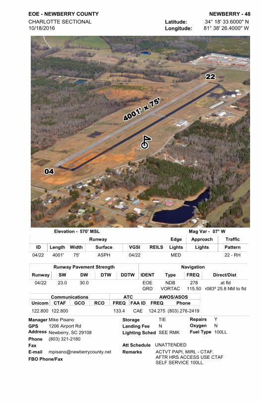
EOE - NEWBERRY COUNTY NEWBERRY - 48Latitude: 34° 18' 33.6000" NLongitude: 81° 38' 26.4000" W
CHARLOTTE SECTIONAL 10/18/2016
570' MSLElevation - 07° WMag Var -
GPS AddressPhoneFaxE-mail
Mike Pisano1206 Airport RdNewberry, SC 29108(803) 321-2180
[email protected] Schedule
Lighting Sched
UNATTENDED
SEE RMKLanding Fee N
RepairsOxygenFuel Type
Storage YN100LL
TIEManager
ACTVT PAPI, MIRL - CTAF.AFTR HRS ACCESS USE CTAFSELF SERVICE 100LL
FBO Phone/FaxRemarks
Length Width Surface VGSI REILSIDApproachEdge
Lights LightsTrafficPattern
Runway
04/22 4001' 75' ASPH MED04/22 22 - RH
ATCFREQ FAA ID
CommunicationsCTAFUnicom GCO RCO FREQ
AWOS/ASOSPhone
122.800 122.800 CAE133.4 124.275 (803) 276-2419
NavigationTypeIDENT Direct/DistFREQNDB 278 at fldEOE
VORTAC 115.50 r083º 25.8 NM to fldGRD
Runway Pavement StrengthSW DW DTW DDTWRunway
04/22 23.0 30.0

CRE - GRAND STRAND NORTH MYRTLE BEACH - 49Latitude: 33° 48' 42.3000" NLongitude: 78° 43' 26.2000" W
CHARLOTTE SECTIONAL 10/18/2016
31' MSLElevation - 09° WMag Var -
GPS AddressPhoneFaxE-mail
Scott VanMoppes2800 Terminal StNorth Myrtle Beach, SC 29582(843) 448-1580(843) [email protected]
Att Schedule
Lighting Sched
Daily 0700-2100
SEE RMKLanding Fee N
RepairsOxygenFuel Type
Storage NN100LL, JET A
HGR,TIEManager
Extensive banner tow operations from arpt along coastline 10 NM NE to 20 NM SW.Class D airspace 0700-2100 CTAF 124.6 Class G airspace when tower not operating.AFTER 0000 ACTVT HIRL; REIL RWY 05 AND MALSR RWY 23 - CTAF 124.6.For after hours access contact FBO. Unicom 122.95 Ramp Fee
FBO Phone/FaxRemarks
Length Width Surface VGSI REILSIDApproachEdge
Lights LightsTrafficPattern
Runway
05/23 5997' 100' ASPH HIGH 2305/23 05 23 - RH
CommunicationsTower GRND CL DEL
ATCATISFREQ FREQ FREQ
AWOS/ASOSPhone
RCOFREQFAA ID BRNG/FREQ
APP/DEP
124.6 121.8 119.625 MYR119.2 123.6 119.625 (843) 361-2802117.6T122.1R
North Myrtle Beach Aviation(843) 848-7400 (843) 848-7450
NavigationTypeIDENT Direct/DistFREQ
VORTAC 117.60 at fldCRE
Runway Pavement StrengthSW DW DTW DDTWRunway
05/23 76.0 112.0

1DS - DRY SWAMP ORANGEBURG - 50Latitude: 33° 23' 3.9100" NLongitude: 80° 54' 25.3900" W
CHARLOTTE SECTIONAL 11/28/2016
180' MSLElevation - 07° WMag Var -
GPS AddressPhoneFaxE-mail
Kurt Von Graff126 Dry Swamp RdCordova, SC 29039(803) 534-3157
Att Schedule
Lighting Sched
Daily DAWN-DUSK
Landing FeeRepairsOxygenFuel Type
Storage YN100LL
HGRManager
Private Airport - Public UseFBO Phone/Fax
Remarks
Length Width Surface VGSI REILSIDApproachEdge
Lights LightsTrafficPattern
Runway
02/20 2900' 60' TURF Standard
ATCFREQ FAA ID
CommunicationsCTAFUnicom GCO RCO FREQ
AWOS/ASOSPhone
122.900
NavigationTypeIDENT Direct/DistFREQ
VORTAC 110.40 r263° 23.8 NM to fldVAN
Runway Pavement StrengthSW DW DTW DDTWRunway
02/20

OGB - ORANGEBURG MUNI ORANGEBURG - 51Latitude: 33° 27' 24.9041" NLongitude: 80° 51' 33.8640" W
CHARLOTTE SECTIONAL 11/28/2016
195' MSLElevation - 07° WMag Var -
GPS AddressPhoneFaxE-mail
Ron Kohler1846 Airport RdOrangeburg, SC 29115(803) 534-5545(803) [email protected]
Att Schedule
Lighting Sched
MON-FRI/0700-1800 SAT 0800-1600
SEE RMKLanding Fee N
RepairsOxygenFuel Type
Storage YN100LL, JET A
HGR,TIEManager
ACTVT MIRL, ODALS RWYS 17, 35 AND REIL - CTAF 122.7. VASI RWY 05 AND PAPI RWYS 17 & 35 OPER CONT. AFTER HOURS ACCESSCONTACT FBO.SELF SERVICE 100LL and JET A
FBO Phone/FaxRemarks
Length Width Surface VGSI REILSIDApproachEdge
Lights LightsTrafficPattern
Runway
05/23 4508' 100' ASPH MED05 05/23 05 - RH17/35 5399' 100' ASPH MED 17/3517/35 17/35 Standard
ATCFREQ FAA ID
CommunicationsCTAFUnicom GCO RCO FREQ
AWOS/ASOSPhone
122.700 122.700 125.675 CAE124.15 118.525 (803) 536-3901
Orangeburg Municipal Airport(803) 534-5545 (803) 533-5928
NavigationTypeIDENT Direct/DistFREQ
VORTAC 110.40 r270° 20.6NM to fldVAN
Runway Pavement StrengthSW DW DTW DDTWRunway
05/23 30.0 50.017/35 30.0 72.0

PYG - PAGELAND PAGELAND - 52Latitude: 34° 44' 31.7000" NLongitude: 80° 20' 42.7000" W
CHARLOTTE SECTIONAL 10/18/2016
575' MSLElevation - 08° WMag Var -
GPS AddressPhoneFaxE-mail
Cecil Kimrey2976 Airport RdPageland, SC 29728(843) 672-7292(843) [email protected]
Att Schedule
Lighting Sched
UNATTENDED
SS-SRLanding Fee N
RepairsOxygenFuel Type
Storage NN100LL
TIEManager
ACTVT MIRL, REIL - CTAFGATE ACCESS USE CTAF FREQSELF SERVICE 100LL
FBO Phone/FaxRemarks
Length Width Surface VGSI REILSIDApproachEdge
Lights LightsTrafficPattern
Runway
06/24 3396' 60' ASPH MED06/24 Standard
ATCFREQ FAA ID
CommunicationsCTAFUnicom GCO RCO FREQ
AWOS/ASOSPhone
122.900 CLT120.05
NavigationTypeIDENT Direct/DistFREQNDB 270 at fldPYG
VOR/DME 108.20 r331º 6.5 NM to fldCTF
Runway Pavement StrengthSW DW DTW DDTWRunway
06/24 12.5

6JØ - LEXINGTON COUNTY AT PELION PELION - 53Latitude: 33° 47' 40.7000" NLongitude: 81° 14' 45.1000" W
CHARLOTTE SECTIONAL 10/18/2016
452' MSLElevation - 07° WMag Var -
GPS AddressPhoneFaxE-mail
Michael Spires106 AirportRdPelion, SC 29123(803) 600-9242(803) [email protected]
Att Schedule
Lighting Sched
UNATTENDED
SEE RMKLanding Fee N
RepairsOxygenFuel Type
Storage NN100LL
TIEManager
AFTER HOURS ACCESS CTAF+#ACTVT MIRL - CTAFRUNWAY IN FAIR CONDITIONSELF SERVICE 100LL
FBO Phone/FaxRemarks
Length Width Surface VGSI REILSIDApproachEdge
Lights LightsTrafficPattern
Runway
18/36 4335' 60' ASPH MED36 Standard
ATCFREQ FAA ID
CommunicationsCTAFUnicom GCO RCO FREQ
AWOS/ASOSPhone
123.000 123.000 CAE124.15
NavigationTypeIDENT Direct/DistFREQ
VORTAC 114.70 r251° 10.3 NM to fldCAE
Runway Pavement StrengthSW DW DTW DDTWRunway
18/36 12.5

LQK - PICKENS COUNTY PICKENS - 54Latitude: 34° 48' 35.9000" NLongitude: 82° 42' 10.4000" W
ATLANTA SECTIONAL 10/18/2016
1013' MSLElevation - 06° WMag Var -
GPS AddressPhoneFaxE-mail
Carlos Salinas298 Airport RdLiberty, SC 29657(864) 843-5803
[email protected] Schedule
Lighting Sched
Daily 0800-1700
SEE RMKLanding Fee N
RepairsOxygenFuel Type
Storage YN100LL, JET A
TIE Manager
NOISE ABATEMENT PROCS IN EFFECTACTVT MIRL - CTAF.AFTER HRS ACCESS USE CTAF FREQSELF SERVICE 100LL
FBO Phone/FaxRemarks
Length Width Surface VGSI REILSIDApproachEdge
Lights LightsTrafficPattern
Runway
05/23 5002' 100' ASPH MED05/23 Standard
ATCFREQ FAA ID
CommunicationsCTAFUnicom GCO RCO FREQ
AWOS/ASOSPhone
122.800 122.800 GREER118.8 120.000 (864) 843-5801
Pickens County Aviation(864) 843-5803
NavigationTypeIDENT Direct/DistFREQ
VORTAC 108.60 r10° 23.8 NM to fldELWNDB 408 at fldLQK
Runway Pavement StrengthSW DW DTW DDTWRunway
05/23 75.0 101.0

3J1 - RIDGELAND RIDGELAND - 55Latitude: 32° 29' 36.3000" NLongitude: 80° 59' 30.3000" W
CHARLOTTE SECTIONAL 7/21/2016
79' MSLElevation - 07° WMag Var -
GPS AddressPhoneFaxE-mail
Richard Dean1557 Grays HighwayRidgeland, SC 29936(704) 572-2902
[email protected] Schedule
Lighting Sched
UNATTENDED
SS-SRLanding Fee N
RepairsOxygenFuel Type
Storage YN100LL
TIEManager
ACTVT MIRL - CTAFSELF SERVICE 100LLFBO Phone/Fax
Remarks
Length Width Surface VGSI REILSIDApproachEdge
Lights LightsTrafficPattern
Runway
03/21 2692' 70' ASPH MED21 Standard
ATCFREQ FAA ID
CommunicationsCTAFUnicom GCO RCO FREQ
AWOS/ASOSPhone
122.700 122.700
NavigationTypeIDENT Direct/DistFREQ
VORTAC 115.95 r033° 23.3 NM to fldSAV
Runway Pavement StrengthSW DW DTW DDTWRunway
03/21 12.5
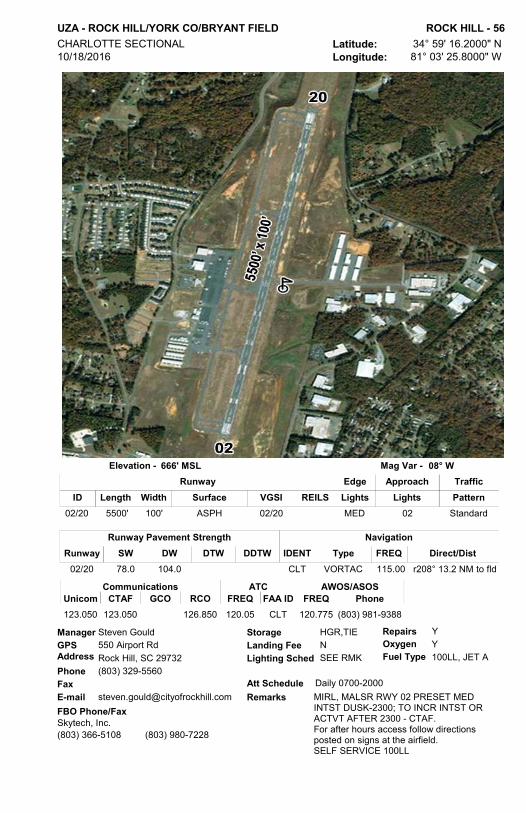
UZA - ROCK HILL/YORK CO/BRYANT FIELD ROCK HILL - 56Latitude: 34° 59' 16.2000" NLongitude: 81° 03' 25.8000" W
CHARLOTTE SECTIONAL 10/18/2016
666' MSLElevation - 08° WMag Var -
GPS AddressPhoneFaxE-mail
Steven Gould550 Airport RdRock Hill, SC 29732(803) 329-5560 [email protected]
Att Schedule
Lighting Sched
Daily 0700-2000
SEE RMKLanding Fee N
RepairsOxygenFuel Type
Storage YY100LL, JET A
HGR,TIEManager
MIRL, MALSR RWY 02 PRESET MED INTST DUSK-2300; TO INCR INTST OR ACTVT AFTER 2300 - CTAF.For after hours access follow directions posted on signs at the airfield.SELF SERVICE 100LL
FBO Phone/FaxRemarks
Length Width Surface VGSI REILSIDApproachEdge
Lights LightsTrafficPattern
Runway
02/20 5500' 100' ASPH MED 0202/20 Standard
ATCFREQ FAA ID
CommunicationsCTAFUnicom GCO RCO FREQ
AWOS/ASOSPhone
123.050 123.050 126.850 CLT120.05 120.775 (803) 981-9388
Skytech, Inc.(803) 366-5108 (803) 980-7228
NavigationTypeIDENT Direct/DistFREQ
VORTAC 115.00 r208° 13.2 NM to fldCLT
Runway Pavement StrengthSW DW DTW DDTWRunway
02/20 78.0 104.0

6J4 - SALUDA COUNTY SALUDA - 57Latitude: 33° 55' 36.4550" NLongitude: 81° 47' 40.6600" W
CHARLOTTE SECTIONAL 11/28/2016
539' MSLElevation - 07° WMag Var -
GPS AddressPhoneFaxE-mail
Jill Warren199 Saluda Airport RdSaluda, SC 29138(864) 445-2529 Ext 3(864) [email protected]
Att Schedule
Lighting Sched
UNATTENDED
SEE RMKLanding Fee N
RepairsOxygenFuel Type
Storage NN100LL
HGR,TIEManager
ACTVT MIRL & PAPI RY 19 - CTAF.AIRFIELD ROAD ACCESS BY PRIOR ARRANGEMENTSELF SERVICE 100LL
FBO Phone/FaxRemarks
Length Width Surface VGSI REILSIDApproachEdge
Lights LightsTrafficPattern
Runway
01/19 3189' 60' ASPH MED01/19 Standard
ATCFREQ FAA ID
CommunicationsCTAFUnicom GCO RCO FREQ
AWOS/ASOSPhone
122.900
NavigationTypeIDENT Direct/DistFREQ
VORTAC 115.50 r138° 26.5 NM to fldGRD
Runway Pavement StrengthSW DW DTW DDTWRunway
01/19 11.3

SPA - SPARTANBURG DOWNTOWN MEMORIAL SPARTANBURG - 58Latitude: 34° 54' 56.6000" NLongitude: 81° 57' 23.4000" W
CHARLOTTE SECTIONAL 10/18/2016
801' MSLElevation - 07° WMag Var -
GPS AddressPhoneFaxE-mail
Darwin Simpson500 Ammons RdSpartanburg, SC 29306(864) 574-8552(864) [email protected]
Att Schedule
Lighting Sched
Daily 0700-1900
SEE RMKLanding Fee N
RepairsOxygenFuel Type
Storage YN100LL, JET A
HGR,TIEManager
ACTVT HIRL, MALSR RY 05 - CTAF.For fuel after hrs. 864-574-8552FBO Phone/Fax
Remarks
Length Width Surface VGSI REILSIDApproachEdge
Lights LightsTrafficPattern
Runway
05/23 5202' 100' ASPH HIGH 0505/23 Standard
ATCFREQ FAA ID
CommunicationsCTAFUnicom GCO RCO FREQ
AWOS/ASOSPhone
123.000 123.000 120.55 GREER119.4 133.925 (864) 587-2529
City of Spartanburg(864) 574-8552
NavigationTypeIDENT Direct/DistFREQ
VORTAC 115.70 r194° 7.2 NM to fldSPANDB 248 r64° 1.7 NM to fldFRT
Runway Pavement StrengthSW DW DTW DDTWRunway
05/23 45.5 67.0

6J2 - ST GEORGE ST GEORGE - 59Latitude: 33° 11' 43.8000" NLongitude: 80° 30' 30.5000" W
CHARLOTTE SECTIONAL 10/18/2016
85' MSLElevation - 08° WMag Var -
GPS AddressPhoneFaxE-mail
Don Hay152 Airport RdSt. George, SC 29477(843) 412-1999(843) [email protected]
Att Schedule
Lighting Sched
UNATTENDED
SS-SRLanding Fee N
RepairsOxygenFuel Type
Storage NNN
TIEManager
ACTVT LIRL - CTAF 122.9GATE ACCESS *1941FBO Phone/Fax
Remarks
Length Width Surface VGSI REILSIDApproachEdge
Lights LightsTrafficPattern
Runway
05/23 3201' 60' ASPH LOW Standard
ATCFREQ FAA ID
CommunicationsCTAFUnicom GCO RCO FREQ
AWOS/ASOSPhone
122.800 122.800 CHS120.7
NavigationTypeIDENT Direct/DistFREQ
VORTAC 110.40 r196° 17.0 NM to fldVAN
Runway Pavement StrengthSW DW DTW DDTWRunway
05/23 21.0 30.0

DYB - SUMMERVILLE SUMMERVILLE - 60Latitude: 33° 03' 48.4000" NLongitude: 80° 16' 45.6000" W
CHARLOTTE SECTIONAL 10/18/2016
56' MSLElevation - 08° WMag Var -
GPS AddressPhoneFaxE-mail
Don Hay705 Greyback RdSummerville, SC 29483(843) 412-1999(843) [email protected]
Att Schedule
Lighting Sched
Daily 0800-1900
SEE RMKLanding Fee
RepairsOxygenFuel Type
Storage YN100LL, JET A
TIEManager
MIRL OPER DUSK-2200; AFTER 2200 ACTVT - CTAF.FBO Phone/Fax
Remarks
Length Width Surface VGSI REILSIDApproachEdge
Lights LightsTrafficPattern
Runway
06/24 3700' 75' ASPH MED 06 - RH
ATCFREQ FAA ID
CommunicationsCTAFUnicom GCO RCO FREQ
AWOS/ASOSPhone
123.000 123.000 CHS120.7 119.575 (843) 821-8403
Pelican Aviation, Inc.(843) 851-0970 (843) 851-0971
NavigationTypeIDENT Direct/DistFREQ
VORTAC 113.50 r315° 15.8 NM to fldCHSNDB 365 at fldDYB
Runway Pavement StrengthSW DW DTW DDTWRunway
06/24 19.5 31.0

SMS - SUMTER SUMTER - 61Latitude: 33° 59' 42.0920" NLongitude: 80° 21' 40.7840" W
CHARLOTTE SECTIONAL 10/18/2016
182' MSLElevation - 08° WMag Var -
GPS AddressPhoneFaxE-mail
Jeremy Bauer2900 Airport RdSumter, SC 29153(803) 469-4639(803) [email protected]
Att Schedule
Lighting Sched
Daily 0800-1800
SEE RMKLanding Fee N
RepairsOxygenFuel Type
Storage YN100LL, JET A
TIEManager
ACTVT MIRL, REILS RWY 5/23 - CTAF. PAPIS CONTINUOUS OPSRAMP GATE ACCESS USE CTAF FREQFOR JET-A AFTR HRS 803/983-6577SELF SERVICE 100LL
FBO Phone/FaxRemarks
Length Width Surface VGSI REILSIDApproachEdge
Lights LightsTrafficPattern
Runway
05/23 5501' 100' ASPH MED 2305/23 05/23 05 - RH14/32 3081' 120' TURF 32 - RH
ATCFREQ FAA ID
CommunicationsCTAFUnicom GCO RCO FREQ
AWOS/ASOSPhone
122.700 122.700 SSC125.4 118.075 (803) 469-6750
On Eagles Wings(803) 469-4639 (803) 469-6276
NavigationTypeIDENT Direct/DistFREQ
VORTAC 110.40 r014° 31.5 NM to fldVANNDB 252 at fldSMS
Runway Pavement StrengthSW DW DTW DDTWRunway
05/23 31.5 42.514/32

58J - HUGGINS MEMORIAL TIMMONSVILLE - 62Latitude: 34° 08' 08.0700" NLongitude: 79° 55' 17.0800" W
CHARLOTTE SECTIONAL 11/28/2016
143' MSLElevation - 08° WMag Var -
GPS AddressPhoneFaxE-mail
Bettie Huggins550 Runway DrTimmonsville, SC 29161(843) 346-3734
[email protected] Schedule
Lighting Sched
UNATTENDED
SEE RMKLanding Fee N
RepairsOxygenFuel Type
Storage NNN
HGR,TIEManager
ACTVT LIRL - CTAF.Private Apt. - Public UseFBO Phone/Fax
Remarks
Length Width Surface VGSI REILSIDApproachEdge
Lights LightsTrafficPattern
Runway
14/32 3090' 150' TURF LOW Standard
ATCFREQ FAA ID
CommunicationsCTAFUnicom GCO RCO FREQ
AWOS/ASOSPhone
122.900
NavigationTypeIDENT Direct/DistFREQ
VORTAC 115.20 r249° 14.4 NM to fldFLO
Runway Pavement StrengthSW DW DTW DDTWRunway
14/32
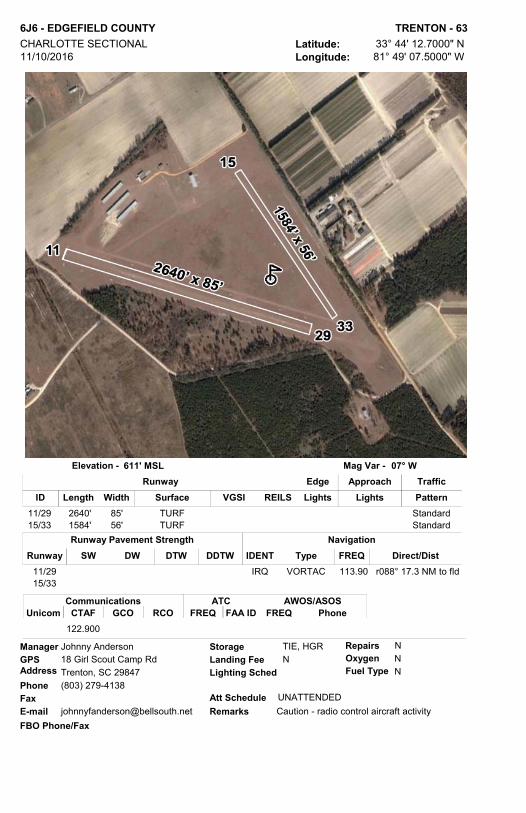
6J6 - EDGEFIELD COUNTY TRENTON - 63Latitude: 33° 44' 12.7000" NLongitude: 81° 49' 07.5000" W
CHARLOTTE SECTIONAL 11/10/2016
611' MSLElevation - 07° WMag Var -
GPS AddressPhoneFaxE-mail
Johnny Anderson18 Girl Scout Camp RdTrenton, SC 29847(803) 279-4138
[email protected] Schedule
Lighting Sched
UNATTENDED
Landing Fee NRepairsOxygenFuel Type
Storage NNN
TIE, HGRManager
Caution - radio control aircraft activityFBO Phone/Fax
Remarks
Length Width Surface VGSI REILSIDApproachEdge
Lights LightsTrafficPattern
Runway
11/29 2640' 85' TURF Standard15/33 1584' 56' TURF Standard
ATCFREQ FAA ID
CommunicationsCTAFUnicom GCO RCO FREQ
AWOS/ASOSPhone
122.900
NavigationTypeIDENT Direct/DistFREQ
VORTAC 113.90 r088° 17.3 NM to fldIRQ
Runway Pavement StrengthSW DW DTW DDTWRunway
11/2915/33

35A - UNION COUNTY, TROY SHELTON FIELD UNION - 64Latitude: 34° 41' 13.0300" NLongitude: 81° 38' 28.2000" W
ATLANTA SECTIONAL 11/28/2016
610' MSLElevation - 07° WMag Var -
GPS AddressPhoneFaxE-mail
Ronnie Wade198 Airport rdUnion, SC 29379(864) 429-1680(864) [email protected]
Att Schedule
Lighting Sched
MON-FRI 0800-1700
SEE RMKLanding Fee N
RepairsOxygenFuel Type
Storage YN100LL
HGR,TIEManager
MIRL AFTER 0000 - CTAFSELF SERVICE 100LLFBO Phone/Fax
Remarks
Length Width Surface VGSI REILSIDApproachEdge
Lights LightsTrafficPattern
Runway
05/23 3508' 60' ASPH MED05/23 Standard
ATCFREQ FAA ID
CommunicationsCTAFUnicom GCO RCO FREQ
AWOS/ASOSPhone
122.700 122.700 GSP119.4
NavigationTypeIDENT Direct/DistFREQ
VORTAC 115.50 r45º36.4 NM to fldGRDNDB 326 at fldUOT
Runway Pavement StrengthSW DW DTW DDTWRunway
05/23 12.5

RBW - LOWCOUNTRY RGNL WALTERBORO - 65Latitude: 32° 55' 15.6000" NLongitude: 80° 38' 26.2000" W
CHARLOTTE SECTIONAL 11/28/2016
101' MSLElevation - 07° WMag Var -
GPS AddressPhoneFaxE-mail
Thomas M. Rowe537 Aviation WayWalterboro, SC 29488(843) 893-7346(843) [email protected]
Att Schedule
Lighting Sched
Daily 0830-1800
SEE RMKLanding Fee N
RepairsOxygenFuel Type
Storage YN100LL, JET A
HGR,TIEManager
PARACHUTE ACTIVITY MIRL DUSK UNTIL 2200AFTER 2200 USE CTAF PAPI RWY 5&23. ODALS RWY 23.SELF SERVICE 100LL
FBO Phone/FaxRemarks
Length Width Surface VGSI REILSIDApproachEdge
Lights LightsTrafficPattern
Runway
05/23 6002' 100' ASPH-CONC MED 2305/23 23 Standard09/27 5408' 100' ASPH-CONC Standard17/35 5705' 100' ASPH-CONC Standard
ATCFREQ FAA ID
CommunicationsCTAFUnicom GCO RCO FREQ
AWOS/ASOSPhone
122.800 122.800 121.725 CHS120.7 118.725 (843) 538-3575
Lowcountry Regional Airport(843) 549-2549 (843) 549-1444
NavigationTypeIDENT Direct/DistFREQ
VORTAC 113.50 r278° 30.5 NM to fldCHS
Runway Pavement StrengthSW DW DTW DDTWRunway
05/23 70.0 101.009/27 17.0 40.017/35 33.5 50.5

FDW - FAIRFIELD COUNTY WINNSBORO - 66Latitude: 34° 18' 55.7000" NLongitude: 81° 06' 31.7000" W
CHARLOTTE SECTIONAL 11/10/2016
577' MSLElevation - 07° WMag Var -
GPS AddressPhoneFaxE-mail
Brian Steed1291 Runway RdWinnsboro, SC 29161(803) 635-3086(803) [email protected]
Att Schedule
Lighting Sched
ALL/ALL/0800-1800
SEE RMKLanding Fee N
RepairsOxygenFuel Type
Storage YN100LL, JET A
TIEManager
MIRL PRESET LOW INTST, ACTVT MIRL & VGSI - CTAF. RAMP ACCESS ORFUELAFTER HRS 803-315-3048RWY 4 DSPLCD THLD 230'
FBO Phone/FaxRemarks
Length Width Surface VGSI REILSIDApproachEdge
Lights LightsTrafficPattern
Runway
04/22 5242' 100' ASPH MED04/22 Standard
ATCFREQ FAA ID
CommunicationsCTAFUnicom GCO RCO FREQ
AWOS/ASOSPhone
123.050 123.050 121.725 CAE133.4 119.075 (803) 712-2577
S&S Aviation(803) 635-3086 (803) 635-1058
NavigationTypeIDENT Direct/DistFREQNDB 414 at fldFDW
VORTAC 114.70 r356° 27.6 NM to fldCAE
Runway Pavement StrengthSW DW DTW DDTWRunway
04/22 42.0 60.0

NOTES
______________________________________________________________________________________________________________________________________________________________________________________________________________________________________________________________________________________________________________________________________________________________________________________________________________________________________________________________________________________________________________________________________________________________________________________________________________________________________________________________________________________________________________________________________________________________________________________________________________________________________________________________________________________________________________________________________________________________________________________________________________________________________________________________________________________________________________________________________________________________________________________________________________________________________________________________________________________________________________________________________________________________________________________


2553 Airport BoulevardWest Columbia, South Carolina 29170
(803) 896-6262 / (800) 922-0574www.scaeronautics.com
SCA 2017 Pilot Directory Cover v2.qxp_Layout 1 1/5/17 3:50 PM Page 2