


Languages
Pages
Legal

4/23/2012
1
Regional Landscapes of the United States and Canada
The Empty InteriorThe Empty InteriorProf. Anthony Grande
©AFG 2012
Stretches from:
-- Alaska’s North Slope to the Mexican border
-- Interior Plains to the
EmptyInterior
-- Interior Plains to the Pacific mountain system.
Includes some the most rugged, harshest and isolated environments of North America.
2
THE EMPTY INTERIOR
3
OVERVIEW - Physical Geography
• Variations in topography and elevation: mountains, plateaus, salt flats.
• Contains both the highest (Mt. McKinley
+20,320 ft) and lowest (Death Valley -282 ft)
points of North America.
• Significant climatic variation because of great range of both latitude and altitude.
• Driest conditions in North America.
• Water problem: a growing imbalance between supply and demand.
4
OVERVIEW – Human Geography
• Low population densities with some large cities and areas of high growth: Salt Lake City, Las Vegas.
• Some regionally distinctive populations: a mix of ethnicities, a concentration of Native Americans andinfluence of the Mormon Church.
• Economic activities related to resource removal and recreation are key but unevenly distributed.
• In the U.S., a significant amount of federally owned lands.
• Region includes some of the most spectacular national parks of the U.S. and Canada. 5
Physiography - Mountains
• Major mountain ranges:– Rocky Mts. (Northern or Canadian Rockies,
Middle Rockies and Southern Rockies)
– Brooks Range; Alaska Range
F t• Features: – Continental Divide - backbone of North America
– Very steep slopes with jagged summits.
– Dramatic elevation changes: local relief over 3000 ft from base to summit.
– Shaped by water and ice.
– Barrier to movement. 6

4/23/2012
2
Physiographic Map of the
Rockies
There are vey few routes across the region from the High Plains to the West CoastCoast.
Canadian Rockies are very difficult to cross.
Gaps around the Middle Rockies through Wyoming and Colorado exist.
7
Canadian Rockies
8
Physiography - Plateaus
• Colorado Plateau: a dissected sedimentary plateau carved by rivers; “canyon lands” area over 5000 feet thick.
• Basin and Range: a fault-block deformedBasin and Range: a fault block deformed area of sedimentary rock layers; area of interior drainage.
• Columbia Plateau: basalt plateau formed from the gradual buildup of lava flows; over 2000 feet thick with narrow, deep canyons.
9
Grand Canyon
National Park
Canyonlands
National Park
Colorado Plateau(layers of sediment)
10
Colorado Plateau(layers of sediment)
Bryce Canyon
National Park
Monument Valley
Navajo Tribal Park
11
Basin and RangeTopography
80 broad, flat basins containing over 200 linear ridges.
No drainage outlet to the sea. Streams from surrounding high-Streams from surrounding highlands flow into it but none leave it.
12
4/23/2012
3
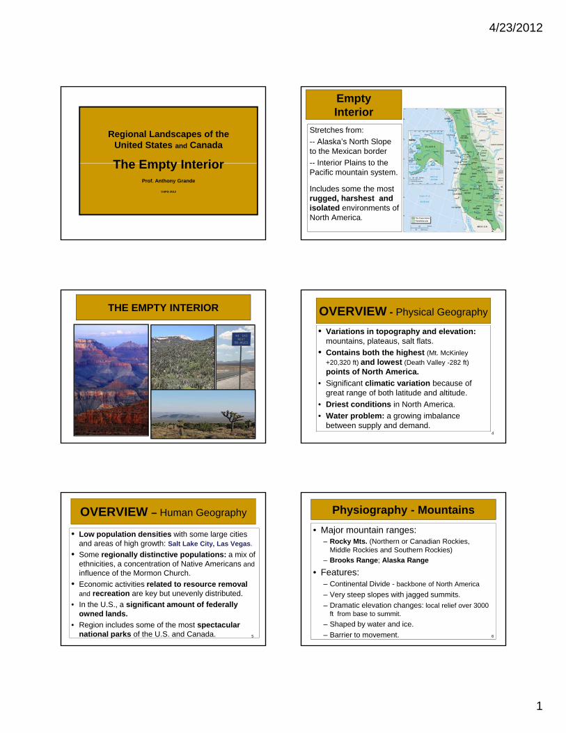
Basin and Range
• Lake Bonneville waslargest Ice Age lake (N.
Utah). Great Salt Lake and numerous salt flats are remnants.
Pleistocene lake locations.13
Columbia Plateau(lava flows)
Snake River Canyon
Hells Canyon
Craters of the Moon Nat’l Mon.
14
Climate
• Arid or semiarid throughout most of the area, especially in southern portion.– Vertical zonation of climate– Vertical zonation of vegetation; tree line dependent
on moisture– Snow is the chief form of precipitation.– Thunderstorms in summer.– Low lying areas are dry.– Heaviest precipitation on mid-slopes of mountains.
• People, wildlife and natural vegetation depend on water from exotic streams (a stream that originates in a wet area and flows through a desert). In driest areas these streams can be salty.
15
Climate Regions
Climate varies with latitude and
altitude.
Orographic precipitation isprecipitation is evident and rain shadow areas are pronounced.
Desert/semi-arid areas exist where moisture is blocked.
16
Rain Shadow of Sierra Nevada Mts.
17
Death Valley National Park
The hottest air temper-ature ever recorded in Death Valley was 134°F
on July 10, 1913 at Furnace Creek .
Hottest, driest and lowest area of the Western Hemisphere.
The highest groundtemperature recorded was 201°F at Furnace Creek on July 15, 1972. with an air temperature of 128°F.
18

4/23/2012
4
Population Density by county.
Population Distribution
Population Change by county. Population Aged 75 or older by county.
19
Las Vegas Urban Sprawl
20
Mormon Influence
• Church of Jesus Christ of Latter-Day Saints was founded in NYS (1830). Its adherents suffered repeated attacks and persecution.
• Migrated to West; settled in the Wasatch Valley b t W t h M t i d G t S lt L kbetween Wasatch Mountains and Great Salt Lake.
• Rapid population growth: high birth rate; migration and missionary outreach for converts.
• Innovative agriculturalists, esp. irrigation techniques.
• Strong central organization (theocracy).
• Tried but failed to create the State of Deseret; Utah Territory (est’d 1850) was admitted to the Union in 1896.
21
The Mormon Pioneer Trail
22
Mormon Concentration
MORMONMORMON
23
Salt Lake City
Mormon TempleTabernacle Square
24
“This is the Place” Monument
4/23/2012
5
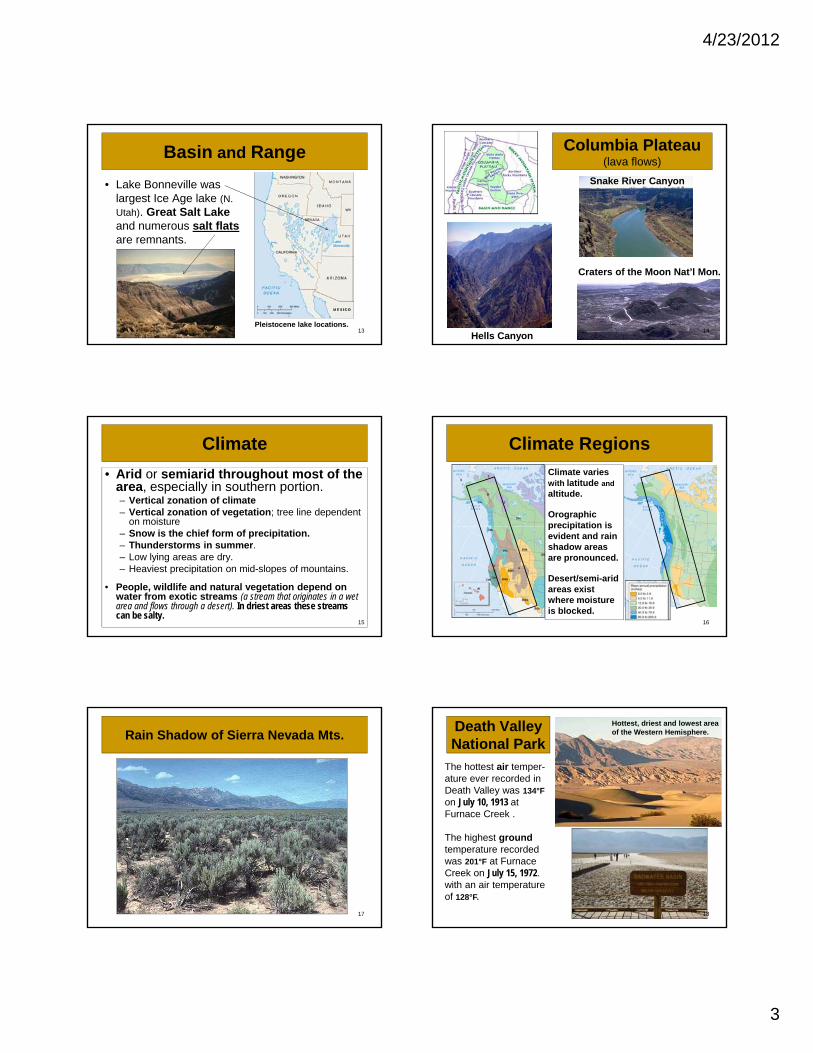
Irrigation and Agriculture
Naturally arid conditions do not support agriculture without irrigation.• Diversion of rivers
• Doctrine of Prior Appropriation: “first come, first served”
• Reclamation Act of 1902: support for water works.
• Water from the Colorado and Columbia-Snake river systems is essential to the region.
25
Colorado River
Region’s longest river – rises in the Middle Rockies and empties into the Gulf
f C lif i (M i )of California (Mexico)
26
MEXICO
Hoover Dam and Lake Mead
Colorado River Water Use
Intense competition for its water: By 1915 nearly its entire flow allocated mainly to Arizona and California. Now half goes to upstream states.
Population and economic booms in
27
Population and economic booms in Nevada, Arizona and southern California need water.
International agreement provides Mexico with a minimum flow to flush the delta region.
The allocation formula is now facing severe strains due to several years of below-average precipitation in the basin and high rates of population growth in the Southwest.
Glen Canyon Dam and Lake Powell
28
Evidence of drought
Columbia River Basin
An international project to provide water for irrigation, navigation, hydroelectric power and flood control.
29
Public Land Ownership
• Most land in the region is still under government control (90% of Nevada).
• Last of U.S. to be settled.
L l it bl f i• Largely unsuitable for agri-culture; grazing potential.
• Documented mineral and forestry resources.
• Areas of scenic beauty and historic interest worth pre-serving.
30
4/23/2012
6
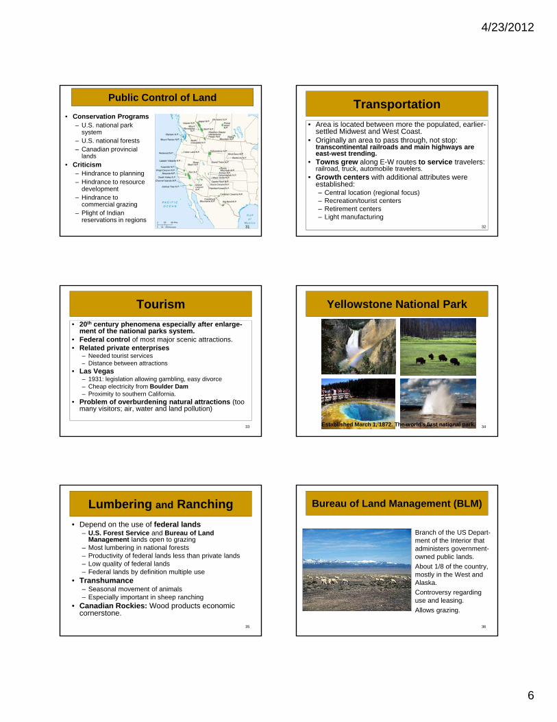
Public Control of Land
• Conservation Programs– U.S. national park
system– U.S. national forests– Canadian provincial
lands
• Criticism– Hindrance to planning– Hindrance to resource
development– Hindrance to
commercial grazing– Plight of Indian
reservations in regions31
Transportation
• Area is located between more the populated, earlier-settled Midwest and West Coast.
• Originally an area to pass through, not stop: transcontinental railroads and main highways are east-west trending.Towns grew along E W routes to service travelers:• Towns grew along E-W routes to service travelers: railroad, truck, automobile travelers.
• Growth centers with additional attributes were established:– Central location (regional focus)– Recreation/tourist centers– Retirement centers– Light manufacturing
32
Tourism
• 20th century phenomena especially after enlarge-ment of the national parks system.
• Federal control of most major scenic attractions.• Related private enterprises
– Needed tourist services– Distance between attractions
• Las Vegas– 1931: legislation allowing gambling, easy divorce– Cheap electricity from Boulder Dam– Proximity to southern California.
• Problem of overburdening natural attractions (too many visitors; air, water and land pollution)
33
Yellowstone National Park
34Established March 1, 1872. The world’s first national park.
Lumbering and Ranching
• Depend on the use of federal lands– U.S. Forest Service and Bureau of Land
Management lands open to grazing– Most lumbering in national forests– Productivity of federal lands less than private lands– Low quality of federal lands– Federal lands by definition multiple use
• Transhumance– Seasonal movement of animals– Especially important in sheep ranching
• Canadian Rockies: Wood products economic cornerstone.
35
Bureau of Land Management (BLM)
Branch of the US Depart-ment of the Interior that administers government-owned public lands.
• About 1/8 of the country, mostly in the West and Alaska.
• Controversy regarding use and leasing.
• Allows grazing.
36

4/23/2012
7
Mining
• Miners were the second largest group (after Mormons) to settle the region.– Variety of easily mined mineral deposits– Numerous mining towns grew near the deposits.
Today many serve as tourist attractions– Today many serve as tourist attractions
• Mining today.– Gold and silver still mined, but less important – Copper: most important mineral of the region, esp. in
Arizona and Utah– Lead and zinc: mined in U.S. but more important in
Canada.
37
Open Pit Copper MineBingham Canyon, Utah
Open pit mining is a means of extract-ing minerals from the earth by dig-ging a bowl-like pit
38
that gets wider and deeper with use.
It is used where the mineral is near the surface and/or if the ground is not unsuit-able for tunneling.
Oil Shale
Oil shale a sedimentary rock containing kerogena solid mixture of organic compounds from which from which liquid hydro-
39
q ycarbons called “shale oil” can be produced after heating.
Shale oil is a substitute for conventional crude oil and not a petroleum product.
Abandoned Mines, Colorado
40
Ghost town
A town or settlement that has been abandoned by humans.
41
Happens because the econ-omic activity that supported it (e.g., mining) has failed (or because of some human or nat-ural calamity forced people to leave the area).
SKI RESORTS Sun Valley, Idaho
42

4/23/2012
8
Aspen and Vail (Colorado)
43
The Military Landscape
The emptiness of the area is ideal for
• Military bases
• National training centers
• Bombing ranges and weapons testing centers
• Military manufacturing
Contains historic fortifications from days of exploration and westward expansion.
44
Nellis AFB and Area 51
45
Nevada Test Site
Craters created by underground detonations.
46
Yucca Mountain, NevadaProspective Nuclear Waste Repository
47
White Sands Proving Ground
• Site of the world’s first atomic bomb test (July 16, 1945).
• Conducted in the open atmosphere.
48
Top Related