


Languages
Pages
Legal


DRAFT

TULE WIND PROJECT
Draft Visual Resource Assessment | August 2010
DRAFT
PAGE 2
Introduction ...................................................................................... 2
Applicable Laws, Policies, Regulations, and Plans ...................... 2
Methodology .................................................................................... 7
General Approach ............................................................................................. 7
BLM VRM Approach ......................................................................................... 7
Scenic Quality ...................................................................................................................7
Viewer Sensitivity ............................................................................................................8
Distance Zones .................................................................................................................8
Affected Environment ..................................................................... 9
Regional Setting ............................................................................................... 9
Project Setting .................................................................................................. 9
Project Components ......................................................................................10
Environmental Setting/Key Observation Points ..........................................11
Environmental Impact of the Proposed Project ......................... 14
Approach to Impact Assessment ...................................................................14
BLM VRM Visual Contrast Rating ................................................................................16
Visual Impact Assessment ..............................................................................17
Short-Term ......................................................................................................................17
Site Decommissioning .................................................................................................17
Long-Term .......................................................................................................................17
Key Observation Points ................................................................................................18
Mitigation Measures .......................................................................22

TULE WIND PROJECT
Draft Visual Resource Assessment | August 2010
DRAFT
PAGE 3
List of Tables
Table 1: Class II Lamp Source and Shielding Requirements .......................... 4
Table 2: Scenic Quality Class Ratings .............................................................. 7
Table 3: Degree of Visual Impact Defi ned .....................................................15
Table 4: Degree of Visual Contrast Defi ned ..................................................16
List of Figures
Figure 1: Vicinity Map .....................................................................................10
Figure 2: Visual Impacts Map .........................................................................19
Figure 3: Visual Simulation – Town of Boulevard .........................................23
Figure 4: Visual Simulation – Boulevard Substation Tie-In .........................24
Figure 5: Visual Simulation – Boulevard Substation Tie-In .........................25
Figure 6: Visual Simulation – McCain Valley Road 1 .....................................26
Figure 7: Visual Simulation – McCain Valley Road 2 .....................................27
Figure 8: Visual Simulation – Lark Canyon OHV ...........................................28
Figure 9: Visual Simulation – Carrizo Gorge .................................................29
Figure 10: Visual Simulation – Ribbonwood Road .......................................30
Figure 11: Visual Simulation – Old Highway 80 ...........................................31
List of References ........................................................................... 32
List of Agencies and Persons Consulted ...................................... 33
Appendix A: Visual Resources Field Worksheets .......................34

TULE WIND PROJECT
Draft Visual Resource Assessment | August 2010
DRAFT
PAGE 1
IntroductionThe visual resource analysis describes the environmental setting and analyzes the impact of the proposed
project on the visual environment. Impacts of aesthetic changes associated with wind energy projects are
highly subjective and can be one of the greatest sources of objection to wind energy development projects.
As such, the impact of the proposed project on the existing environment has been examined through the
characterization of the aff ected environment and the systematic evaluation of the impacts of the project
within that environment. While perception of the proposed facilities within the aesthetic environment is largely
based on an individual’s visual experience, this visual resource evaluation was based on subjective guidance
developed to establish, evaluate, and recommend mitigation measures for the proposed project.
Applicable Laws, Policies, Regulations, and PlansThe following section outlines all Federal, state, and local laws, policies, and regulations which apply to the
study area and were considered in the development of this visual resources analysis.
FederalThe Federal Land Policy and Management Act of 1976 (FLPMA) requires BLM to protect the quality of scenic
values on public lands (43 U.S.C. 1701). BLM has developed an analytical process that identifi es, sets, and
meets objectives for maintaining scenic values and visual quality. The VRM system functions in two ways.
First, BLM conducts an inventory that evaluates visual resources on all lands under its jurisdiction (inventory/
evaluation). Once inventoried and analyzed, lands are given relative visual ratings (visual resource management
classifi cations). Class designations are derived from an analysis of scenic quality (rated by landform, vegetation,
water, color, infl uence of adjacent scenery, scarcity, and cultural modifi cation), a determination of viewer
sensitivity levels (sensitivity to changes in the landscape), and distance zones (relative proximity of views of
the proposed project; visual quality of a landscape, as well as user reaction, may be magnifi ed or diminished
by the visibility of the landscape in terms of distance). Management classes describe the diff erent degrees of
modifi cation allowed to the basic elements of the landscape (form, line, color, texture).
In accordance with the BLM Land Use Planning Handbook (H-1601-1), the BLM is required to designate VRM
Classes for all areas of BLM land, based on an inventory of visual resources and management considerations for
other land uses. The original VRM inventory in the existing Management Framework Plan for Eastern San Diego
County was completed in 1981 by BLM staff . Weaknesses were identifi ed in the original inventory necessitating
the completion of a new inventory based on new information and cultural modifi cations to the landscape.
The new inventory was updated as part of the current land use planning eff ort. The BLM Handbook on Visual
Resource Management (BLM VRM Manual 8410) was consulted during the preparation of the Eastern San Diego
County PRMP/FEIS. Specifi cally, the Handbook guidance regarding scenic quality (e.g., visual appeal), sensitivity
level (e.g., measure of public concern), and distance zones (e.g., visibility from travel routes or observation
points) were carefully considered and utilized.
BLM VRM Goals and Objectives VRM-01 -The Resource Management Plan/Record of Decision assigns VRM Classes ranging from Class I to
IV to all BLM lands in the planning area. All future projects and actions must adhere to the objectives of the
applicable VRM Classes:
• Class I. To preserve the existing character of the landscape. The level of change to the characteristic
landscape should be very low and must not attract attention.

TULE WIND PROJECT
Draft Visual Resource Assessment | August 2010
DRAFT
PAGE 2
• Class II. To retain the existing character of the landscape. The level of change to the characteristic
landscape should be low.
• Class III. To partially retain the existing character of the landscape. The level of change to the
characteristic landscape should be moderate.
• Class IV. To provide for management activities that require major modifi cation of the existing character
of the landscape. The level of change to the characteristic landscape can be high. The study area for the
proposed Tule Wind Project is located on Class IV land.
State
According to Appendix G of the State California Environmental Quality Act (CEQA) Guidelines, visual quality
and aesthetics impacts are considered potentially signifi cant if the project would:
• • Have a substantial adverse impact on a scenic vista;
• Substantially damage scenic resources, including but not limited to trees, rock outcroppings, and
historic buildings within a state scenic highway;
• Substantially degrade the existing visual character or quality of the site and its surroundings; and/or
• Create a new source of substantial light or glare which would adversely aff ect day or nighttime views
in the area.
Local
Polices, regulations, and ordinances that have been developed by the County of San Diego and Town of
Boulevard are referenced below.
County of San Diego
The San Diego County Light Pollution Code [(Title 5, Div.9, Sections 59.101-59.113 of the County Code of
Regulatory Ordinances) as added by Ordinance No 6900, eff ective January 18, 1985, and amended July 17,
1986 by Ordinance No. 7155 and April 20, 2005 by Ordinance No. 9716.
The Light Pollution Code (LPC), also known as the Dark Sky Ordinance, was adopted “to minimize light
pollution for the enjoyment and use of property and the night environment by the citizens of San Diego
County and to protect the Palomar and Mount Laguna observatories from the eff ects of light pollution that
have a detrimental eff ect on astronomical research by restricting the permitted use of outdoor light fi xtures on
private property” (Sec. 59.101). Parties involved in the development of LPC included representatives from the
San Diego County Department of Planning and Land Use, the Department of Public Works, as well as members
of the lighting industry, community planning and sponsor groups, representatives from both of San Diego
County’s observatories, and San Diego Gas and Electric Company (SDG&E). The LPC regulates applicants for
any permit required by the County for work involving outdoor light fi xtures, unless exempt. Exempt fi xtures
include certain ones existing prior to January 18, 1985, those producing light via fossil fuels, those on or
connected with facilities and land owned or operated by the federal government or the State of California,
holiday decorations, and U.S. or California illumination. Special provisions are made for airports in keeping with
FAA’s lighting requirements and the nearby correctional institution (Sec. 59.108). The Code was established to
limit harmful eff ects of outdoor lighting on the Palomar and Mount Laguna Observatories. The LPC designates
all areas within a 15-mile radius of each observatory as Zone A, with all other areas of the County designated

TULE WIND PROJECT
Draft Visual Resource Assessment | August 2010
DRAFT
PAGE 3
as Zone B. Zone A has more stringent lighting restrictions, including limits on decorative lighting, so that night
skies are dark enough for clear viewing through the telescopes at the observatories.
San Diego County General Plan, Conservation Element (Part X), Chapter 7 Astronomical Dark Sky
[http://www.ceres.ca.gov/planning/counties/San_Diego/plans.html]. The San Diego County General Plan
Conservation Element’s Chapter on Astronomical Dark Sky discusses the importance of maintaining dark skies
in the County. This chapter makes several fi ndings pertaining to suitable observatory site criteria. It also sets
out several policy and action programs designed to limit light pollution and ensure the protection of dark
skies, including minimizing the impacts of development on the useful life of the observatories, assisting in the
regulation of dark sky conservation, amending ordinances to control potentially signifi cant adverse eff ects to
Palomar and Mount Laguna Observatories, and designing future roadways and development in a way suitable
for the protection of dark skies near the observatories.
San Diego County Zoning Ordinance, Performance Standards [Section 6320, 6322 and 6324, http://
www.co.san-diego.ca.us/dplu/zoning/index.html]. Section 6320 of the Zoning Ordinance has performance
standards for glare for all commercial and industrial uses in residential, commercial and identifi ed industrial
zones. All commercial and industrial uses subject to these standards shall be operated in a manner that does
not produce glare, which is readily detectable without instruments by the average person beyond the stated
zones in this section. Section 6322 controls excessive or unnecessary outdoor light emissions which produce
unwanted illumination of adjacent properties by restricting outdoor lighting usage. Section 6324 establishes
limitations upon lighting permitted in required yards by Section 4835; of particular importance is the limitation
upon light trespass (not to exceed a value of 0.2 footcandles measured 5 feet onto the adjacent property).
Visual Policies and Plans
San Diego County Dark Skies Ordinance
The County of San Diego Light Pollution Code Division 9) applies to the proposed project and is intended
to restrict the permitted use of outdoor light fi xtures emitting undesirable light into the night sky that have
a detrimental eff ect on astronomical research. The project would require Class II lighting for outdoor lighting
used for but not limited to illumination for walkways, roadways, equipment yards, parking lots and outdoor
security. Table 3.2-1 presents the Class II Lamp Source and Shielding Requirements for the San Diego County
Division 9 Light Pollution Code.
Table 1. Class II Lamp Source and Shielding Requirements
Lamp Type Zone A Zone BLow Pressure Sodium Fully Shielded Fully Shielded
Others above 40501 Lumens Prohibited Prohibited
Others 40501 Lumens & Below Prohibited Allowed2
Source: http://www.co.san-diego.ca.us/dplu/docs/LightPollutionCode.pdf
1Examples of lamp types of 4550 Lumens & Below (The acceptability of a particular light is decided by its lumen output,
notwattage; check manufacturer’s specifi cations):
200 Watt Standard Incandescent and less
150 Watt Tungsten-Halogen (quartz) and less
75 Watt Mercury Vapor and less
50 Watt High pressure Sodium and less
40 Watt Fluorescent and less
TULE WIND PROJECT
Draft Visual Resource Assessment | August 2010
DRAFT
PAGE 4
2 Lights shall be shielded where feasible and focused to minimize spill light into the night sky or adjacent properties
Maximum of 8100 total lumens per acre or per parcel if under 1 acre.
Zone A means the circular area, fi fteen (15) miles in radius centered on the Palomar Observatory and
the circular area 15 miles in radius centered on the center of the Mount Laguna Observatory.
Zone B means all areas within the territorial limits of the unincorporated portion of the County of San Diego and
not included in the area defi ned as Zone A.
Fully shielded means outdoor light fi xtures shielded or constructed so that light rays emitted by the fi xture are
projected below the horizontal plane passing through the lowest point on the fi xture from which light is emitted.
Luminous tube lighting means gas-fi lled glass tubing, which when subjected to high voltage, become luminescent in
a color characteristic of the particular gas used, e.g. neon, argon, etc. (Amended by Ord. No. 8553 (N.S.).
San Diego County Resource Protection Ordinance No. 9716
The Resource Protection Ordinance (RPO) protects sensitive lands and prevents their degradation and loss.
This ordinance also preserves the ability of property owners to make reasonable use of their land subject to the
conditions of the RPO to increase the preservation and protection of the County’s unique topography, natural
beauty, diversity, and natural resources. A slope analysis completed for the project site indicates the County
portion of the site is relatively fl at and contains no steep slope lands.
San Diego General Plan Update Goals and Policies
The County of San Diego has developed goals and policies for conservation and open space and has specifi cally
addressed visual resources in the General Plan. Recognizing the unique natural and built environment in San
Diego County, the General Plan identifi es three distinctive scenic regions, scenic corridors composed of the
land adjacent to scenic highway corridors, and astronomical dark skies including criteria for maintaining dark
sky conditions in the county vital to the operation of Palomar and Mount Laguna Observatories. The following
goals have been developed for the County General Plan:
Conservation and Open Space Element
Goal COS-11 - Preservation of Scenic Resources pertains to the preservation of scenic resources, including
vistas of important natural and unique features, where visual impacts of development are minimized.
Policies
COS-11.1 - Resource Connections requires the protection of scenic highways, corridors, regionally signifi cant
scenic vistas, and natural features, including prominent ridgelines, dominant landforms, reservoirs, and scenic
landscapes.
COS-11.2 - Resource Connections promotes the connection of regionally signifi cant natural features,
designated historic landmarks, and points of regional historic, visual, and cultural interest via designated scenic
corridors, such as scenic highways and regional trails.
COS-11.3 - Development Siting and Design requires development within visually sensitive areas to minimize
visual impacts and to preserve unique or special visual features, particularly in rural areas, through the following:
• Creative site planning
• Integration of natural features into the project
• Appropriate scale, materials, and design to complement the surrounding natural landscape
• Minimal disturbance of topography

TULE WIND PROJECT
Draft Visual Resource Assessment | August 2010
DRAFT
PAGE 5
• Clustering of development so as to preserve a balance of open space vistas, natural features, and
community character.
• Creation of contiguous open space networks
COS-11.4 - Collaboration with Agencies and Jurisdictions requires coordination with adjacent federal
and State agencies and local jurisdictions to protect scenic resources and corridors that extend beyond the
County’s land use authority, but are important to the welfare of County residents.
COS-11.5 - Collaboration with Private and Public Agencies requires coordination with the California
Public Utilities Commission, power companies, and other public agencies to avoid siting energy generation,
transmission facilities, and other public improvements in locations that impact visually sensitive areas, whenever
feasible. Require the design of public improvements within visually sensitive areas to blend into the landscape.
COS-11.6 - Billboards prohibits new billboards and other forms of large-scale advertising and signage within
scenic corridors. Encourage the removal of existing billboards and other forms of large-scale advertising and
signage along State and County scenic highway corridors.
COS-11.7 - Underground Utilities require new development to place utilities underground and encourage
“undergrounding” in existing development to maintain viewsheds, reduce hazards associated with hanging lines
and utility poles, and to keep pace with current and future technologies.
The concept of “undergrounding” in the initial phases of a project not only increases the aesthetic value of the
surrounding viewshed, but can also reduce costs in the long run since less infrastructure is exposed to the elements.
Goal COS-12 - Preservation of Ridgelines and Hillsides requires that ridgelines and steep hillsides that are
preserved for their character and scenic value.
Policies
COS-12.1 - Hillside and Ridgeline Development Density protects undeveloped ridgelines and steep
hillsides by maintaining semi-rural or rural designations on these areas.
COS-12.2 - Development Location on Ridges requires development to preserve the physical features by
being located down and away from ridgelines so that structures are not silhouetted against the sky.
GOAL COS-13 - Dark Skies requires that preserved dark skies that contribute to rural character and are
necessary for the local observatories.
Policies
COS-13.1 - Restrict Light and Glare restricts outdoor light and glare from development projects in Semi-Rural
and Rural Lands and designated rural communities to retain the quality of night skies by minimizing light pollution.
COS-13.2 - Palomar and Mount Laguna minimizes, to the maximum extent feasible, the impact of
development on the dark skies surrounding Palomar and Mount Laguna observatories to maintain dark skies
which are vital to these two world-class observatories by restricting exterior light sources within the impact
areas of the observatories.
Mountain Empire Subregional Plan Boulevard (Draft)
Goal LU3.1 - requires the protection as a Dark Sky Community through preservation of the dark skies in Boulevard
to support the continued operation of the San Diego Astronomy Association and Tierra Del sol observatories
and to continue to attract stargazer, photographers, scientists, and researchers from around the world.

TULE WIND PROJECT
Draft Visual Resource Assessment | August 2010
DRAFT
PAGE 6
Policies
Policy LU 3.1.1 - encourages development to preserve dark skies with reduced lighting and increased shielding
requirements.
Policy LU 3.1.2 - encourages increased resources or methods for enforcement for the preservation of dark skies.
Methodology
General Approach
This visual resource analysis follows the BLM Visual Resource Management (VRM) system as an objective
methodology to assess the aesthetic conditions of the landscape, characterize the current viewing environment,
and evaluate the potential impacts of the proposed project on the environment. The analysis includes an
evaluation of existing visual conditions and an impact analysis that considers viewer sensitivity and visual contrast.
Where BLM VRM visual guidelines do not apply (e.g., non-BLM administered lands), an inventory of aesthetic
conditions was conducted using BLM visual resource inventory guidelines and County guidelines, to determine
public sensitivity toward the introduction of the proposed facilities.
BLM VRM Approach
BLM VRM guidelines were developed and implemented to be in keeping with the National Environmental Policy
Act of 1969, which requires Federal agencies to “assure for all Americans…aesthetically pleasing surroundings.”
Additionally, NEPA requires agencies to “utilize a systematic, interdisciplinary approach which would ensure the
integrated use of…environmental design in the planning and decision-making process.”
BLM VRM guidelines were used, where appropriate, in the analysis of the aff ected environment. BLM is required
to designate VRM classes for all areas of BLM land, based on three key elements: 1. scenic quality, 2. visual
sensitivity, and 3. distance zones.
Scenic QualityA scenic quality evaluation was used to determine the natural landscape based on the degree of distinctiveness,
which takes into consideration such factors as landform, vegetation, color, water, adjacent scenery, scarcity,
and cultural modifi cation. Scenic quality is determined by rating the distinctiveness and diversity of interest of
a particular natural landscape in the context of form, line, color, and texture.
Table 2: Scenic Quality Class Ratings
Scenic Quality Class Rating Defi nitionClass A - Unique Landscapes are represented by unique lands of outstanding or distinctive diversity
or interest, including high-relief mountains, escarpments, highly dissected canyons,
monumental landforms, and scenic riverways.
Class B – Above Average Landscapes are lands of above average diversity of interest and consist of rolling, vegetated
hills and valleys, mesas, buttes, and unique landforms that defi ne the environment.
Class C - Common Landscapes are primarily common and of minimal diversity, such as high desert
plateaus and desert plains areas with few distinguishing features.
Source: BLM Manual H-8410-1. Visual Resource Inventory. 1986

TULE WIND PROJECT
Draft Visual Resource Assessment | August 2010
DRAFT
PAGE 7
Viewer SensitivityA sensitivity analysis was used as a baseline to evaluate sensitive viewing for the study area. Given the public
concern for visual quality and preservation of aesthetic resources, views from highly visible and prominent
locations are considered highly sensitive.
Viewer sensitivity levels range from:
High Sensitivity
• Landforms that form community backdrops or are prominent at a regional scale;
• Areas with congressional or state designations or areas that could be perceived by the public as having
the same type of designations and protections (e.g., scenic roads);
• Areas that serve as recreational destinations for a variety of user groups and are used by out of area
visitors on a regular basis.
Moderate Sensitivity
• Areas that receive moderate to low levels of recreational use, or high levels of use that are primarily
higher speed, motorized vehicles, or are used nearly exclusively by local residents. These would include
well-used campgrounds, and hiking trails.
Low Sensitivity
• Areas that receive little if any recreational use, and are mostly used by local residents;
• Lands that are isolated, small parcels that have no legal public access, or are not recognizable by the
majority of the public as being public land;
• Areas of public land that is so fragmented by inholdings or convoluted ownership boundaries, that the
public land is not recognizable.
Distance ZonesTo study the impacts of the proposed project on the visual environment, distance zones were delineated and
factored into the visual analysis. Distance zones were developed by the BLM based on perception thresholds,
the scale and nature of objects being viewed, and the viewing environment. Both natural and human-made
elements become less obvious and less detailed at greater distances and perception of texture and color also
becomes less noticeable with increased distance.
The BLM Manual 8410-1, Visual Resource Inventory, defi nes distance zones as:
Foreground/Middleground• 0 to 5 miles
Background
• 6 to 15 miles
Seldom Seen
• Beyond 15 miles
TULE WIND PROJECT
Draft Visual Resource Assessment | August 2010
DRAFT
PAGE 8
Affected EnvironmentThe aff ected environment section provides a detailed inventory of the existing visual landscape and experience.
Regional Setting
The proposed wind energy facilities associated with the Tule Wind Project traverse BLM, Tribal land, State land,
and privately-owned land parcels under the jurisdiction of the County of San Diego. The project area is in the
expansive deserts east of southern California’s highly urbanized coastal area. The visual study area is located
entirely within the Basin and Range physiographic province in the Salton Trough which is characterized by desert
basins, jagged mountain ranges, and wide valleys bounded by alluvial slopes, or bajadas. Views from travel routes
tend to be of broad, sweeping desert, bordered by north-south trending rugged terrain in semi-arid landscape.
Other nearby, Federally-administered land includes the Cleveland National Forest to the northwest, and the
Anza Borrego National Forest to the east; both are more than 10 miles from the project site. The project area also
neighbors the Manzanita, Ewiiaapaayp, La Posta, and Campo Indian Reservations, and lies within the McCain
Valley Resource Conservation Area and Land Cooperative in the In-Ko-Pah Mountains.
Within the regional setting, the visual resources study area was defi ned by viewpoints from which the proposed
facilities would be seen. The viewshed is extensive given the openness of the landscape, the height of the
proposed structures, and the availability of viewpoints from travel routes, recreational areas, and the nearby
community of Boulevard, CA, however areas to the east on reservation land are not open to public access.
Project Setting
The project area is located in the eastern portion of San Diego County and lies in McCain Valley in the In-Ko-
Pah Mountains. It is north of Interstate 8 (I-8) and the community of Boulevard. The topography of the area is
gently-to-steeply sloping with an elevation ranging between 3,600 and 5,600 feet above mean sea level (asl).
The project area is accessible via I-8, State Route 94 (SR-94)/Ribbonwood Road, Old Highway 80, and McCain
Valley Road. Access into the landscape is limited due to varying topography characterized by fault-block terrain
and boulder-strewn landscape. The main project site access points are from Ribbonwood Road and McCain
Valley Road. The majority of land in the study area is administered by the BLM and has been classifi ed as VRM
Class IV landscape. BLM has defi ned the objectives for development on Class IV landscape as having “to provide
for management activities which require major modifi cations of the existing character of the landscape. The
level of change to the characteristic landscape can be high. These management activities may dominate the
view and be the major focus of viewer attention. However, every attempt should be made to minimize the
impact of these activities through careful location, minimal disturbance, and repeating the basic elements.”
Development within the region includes sporadic sprawling ranchland, and large lot residential, mostly
concentrated in the town of Boulevard. Existing wind turbines are located approximately 5 miles to the
southwest of the project area on the Campo Indian Reservation. Additionally, two BLM primitive campgrounds
(Lark Canyon and Cottonwood) are located within the project area and are accessible via McCain Valley Road.
Vegetation within the study area is typical of the region. The project area contains four major vegetation
communities: interior live oak woodland, southern mixed chaparral, disturbed southern mixed chaparral, and
big sagebrush scrub.
No visible fl owing water features are located within the project area, though ephemeral drainages may be
present seasonally or during precipitation. Tule Creek is the primary drainage feature in the project vicinity and
drains the central portion of McCain Valley, towards the southeast.

TULE WIND PROJECT
Draft Visual Resource Assessment | August 2010
DRAFT
PAGE 9
The preservation of dark sky conditions and the continued operation of the San Diego Astronomy Association
and Tierra Del Sol Observatories is a priority for the town of Boulevard and is included as a goal in the County of
San Diego General Plan. Dark skies are a valuable asset to the town of Boulevard and are a protected resource
within the area. Eff orts to reduce development, provide community education and outreach, and encourage
the proper use of lighting and light shielding is also included in the County of San Diego General Plan.
The community of Boulevard also values the rural character and scenic views available from travel routes within
the region. Specifi cally, Old Highway 80 has been designated by the State of California as an historic route and
portions of I-8 has been designated by San Diego County as a scenic route outside of the visual study area.
Project Components
The following describes the proposed project facilities, and impacts of the construction and operation of these
facilities is further explained in the impact analysis portion of this visual resource analysis.
The proposed wind turbine equipment will be located on a series of north-to-south and northwest-to-southeast
ridges. Currently, the layout includes a total of 134 potential wind turbine locations. There are 97 turbines located
on BLM land 17 on Tribal lands, 13 on private parcels (Hamann Properties) , and 7 on State lands.
A typical turbine will be a maximum of 492-feet tall (measured from the ground to turbine blade tip) and will
have three blades, oriented upwind. Turbines are mounted on a concrete pad, and are grouped in strings,
connected by an underground or overhead electrical cable system. Each turbine will have a turbine rotor and
nacelle mounted on top of its tubular tower.
To minimize visual impacts, all of the turbine components will be painted or fi nished using low-refl ectivity,
neutral white colors in compliance with FAA regulations. Per FAA, approximately one third to one half of the
turbine structures will be lit with synchronized red fl ashing lights.
The project’s electrical system will consist of an underground and overhead collector system, which will collect
electricity generated from each wind turbine, increase the voltage through a pad-mounted transformer
and deliver it to the project collector substation. Portions of the electrical collector system will be located
aboveground.
From the project collector substation, an overhead 138 kV transmission line will run south interconnecting to
the proposedSDG&E Boulevard Substation. Typical 138 kV transmission line poles will be constructed of steel
rather than wood due to the potential for wildfi res in this area. A total of 126 75-foot transmission line poles
are proposed.
The proposed collector substation will be surrounded by a 1-acre graveled, fenced area with transformer and
switching equipment, and an area to park utility vehicles, totaling 5 acres. In all cases the facilities will conform
to applicable SDG&E design standards.
The operations and maintenance facility for the project will include a pre-engineered metal building to house
operational services and critical spare parts and will be located next to the collector substation. The building
will be approximately 5,000 square feet in size and will be surrounded by a 4-acre cleared area, totaling 5 acres.
A temporary 10-acre parking lot will be located near Rough Acres Ranch and 19 2-acre equipment laydown
areas are to be located throughout project area to store materials and equipment.
Temporary access roads for the purposes of construction will be built or improved to a width of up to 36-feet to
allow large cranes to move between turbines. These roads will be restored to the standard 16 to 20 foot width
once the turbines have been installed.

TULE WIND PROJECT
Draft Visual Resource Assessment | August 2010
DRAFT
PAGE 10Vicinity Map
California
Project Site
Figure 1: Vicinity Map

TULE WIND PROJECT
Draft Visual Resource Assessment | August 2010
DRAFT
PAGE 11
Environmental Setting/Key Observation Points
KOP 1 - I-8 at Ribbonwood Road
Location: The interchange at I-8 provides access to
Ribbonwood Road which traverses north and south.
This interchange also provides access to SR-94 and Old
Highway 80 to the south.
Environmental Setting: At this viewpoint, both I-8
and Ribbonwood Road corridors are dominant in the
viewshed. To the north, common desert landscape
is visible and is bisected by a paved roadway which
traverses north and on rolling terrain. This roadway also
provides access to several residences located on large
lots with views of the proposed project area. This KOP
is located outside of BLM land.
Overall Scenic Quality Rating: Class C - Common
KOP 2 - Ribbonwood Road north of I-8
Location: Along the Ribbonwood Road alignment,
north of I-8, there are some low density private
residences and ranches. In this rural area, Ribbonwood
Road provides access to expansive ranch lands and
residences and a parcel of Campo land.
Environmental Setting: This area is located north of I-8
on Ribbonwood Road, views oriented to the northeast
show the alternative power lines that would serve the
project site. This area is characterized largely by open
swaths of desert landscape typical of the area as well
as some residences located on large lots. This KOP is
located outside of BLM land.
Overall Scenic Quality Rating: Class B – Above Average

TULE WIND PROJECT
Draft Visual Resource Assessment | August 2010
DRAFT
PAGE 12
KOP 3 - I-8 at McCain Valley Road
Location: There is no interchange located at McCain
Valley Road and I-8; however, McCain Valley Road is
accessible heading north off of Old Highway 80. In
this area, McCain Valley Road is paved and fl anked by
existing monopole transmission lines that parallel the
road to the north and south.
Environmental Setting: The Interstate-8 highway is
a dominant feature in this area; however, when the
viewer is oriented to the north, the area is characterized
by sprawling desert landscapes, with rolling hills and
ridgelines present. Several exposed soil trails and private
two-track roads are evident throughout the landscape.
Low-lying desert scrub brush is prevalent throughout
the area. This KOP is located outside of BLM land.
Overall Scenic Quality Rating: Class C - Common
KOP 4 - McCain Valley Road at Rough Acres Ranch
Location: This point is located approximately two miles
north of the intersection of I-8 and McCain Valley Road.
Rough Acres Ranch is signed and located to the west,
from McCain Valley Road, development on Rough
Acres Ranch is visible. At this point McCain Valley Road
becomes unpaved.
Environmental Setting: This area is characterized
by some ranch development and represents the
beginning of the area of primitive, recreational land
(e.g., unpaved roadway, large open vistas) where low-
lying desert scrub vegetation and rocky outcroppings
and ridgelines also start to defi ne the landscape. This
KOP is located outside of BLM land.
Overall Scenic Quality Rating: Class C - Common
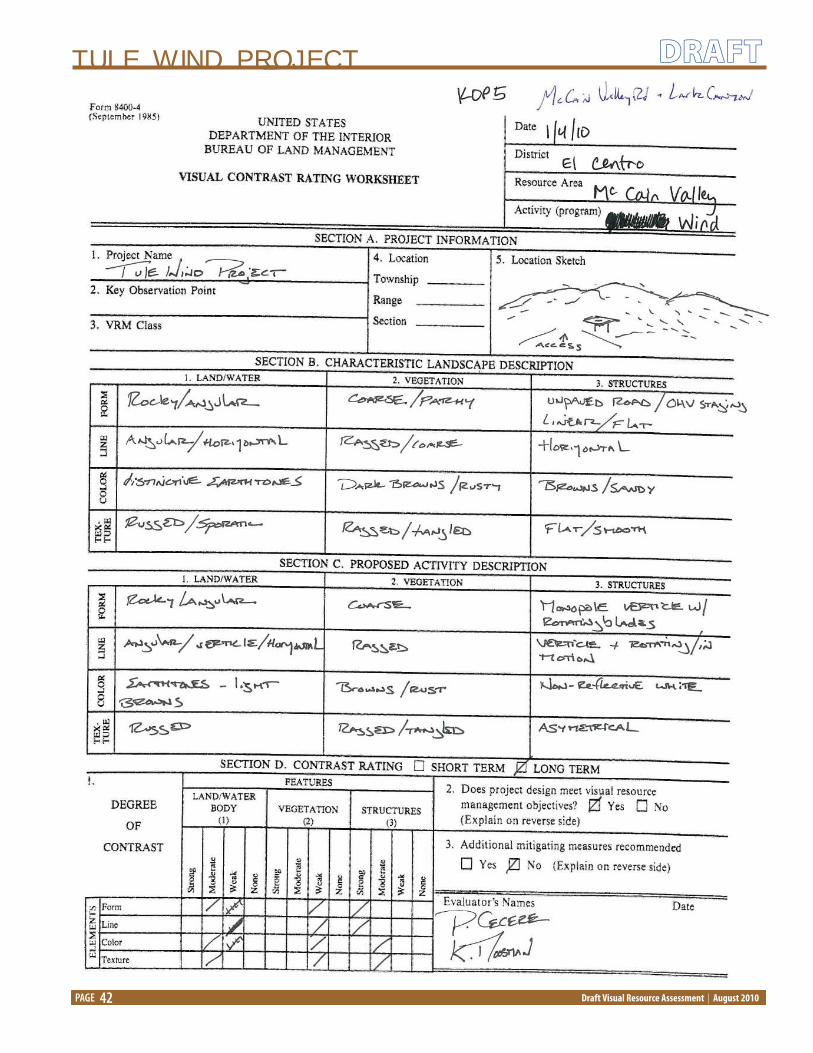
KOP 5 - McCain Valley Road at Lark Canyon OHV Area
Location: The Lark Canyon OHV area is located
approximately four miles north of the intersection of
McCain Valley Road with I-8.
Environmental Setting: This area is characterized by
exposed soil trails, rolling hills, and open views from
atop the ridgelines in the area. Vegetation is sparse in
this area due to a high volume of OHV use. This KOP is
located on BLM land.
Overall Scenic Quality Rating: Class C – Common

TULE WIND PROJECT
Draft Visual Resource Assessment | August 2010
DRAFT
PAGE 13
KOP 6 - McCain Valley Road at Carrizo Gorge Scenic Lookout
Location: Located approximately three miles from Lark
Canyon OHV area at the entrance to Carrizo Gorge.
Environmental Setting: From this vantage point, views
are obstructed by hills and ridgelines and exposed soil
roadways and trails are present. Vegetation is sporadic
in this area. From the Carrizo Gorge look out, located
less than one-half mile east of McCain Valley Road, a
panoramic view of the ravine is visible. This KOP is
located on BLM land.
Overall Scenic Quality Rating: Class B – Above Average
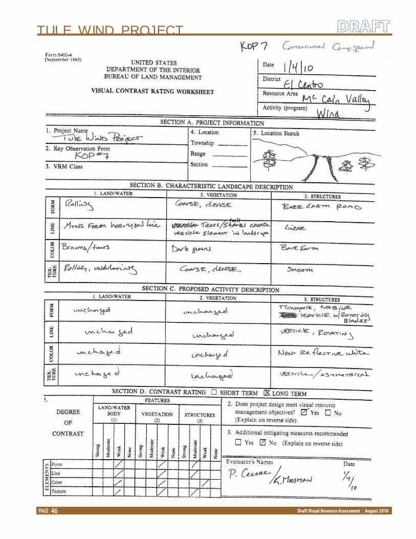
KOP 7 – Cottonwood Campground
Location: Cottonwood campground is located off of
McCain Valley Road in the McCain Valley Resource
Conservation Area.
Environmental Setting: TThe Cottonwood campground
has 25 campsites and is accessible by passenger
vehicle and horse. Several trailheads, which provide
access to overlooks and scenic views are located near
the campground. The Cottonwood campground
is characterized by large oak trees and undulating
topography typical of the region. This KOP is located
on BLM land.
Overall Scenic Quality Rating: Class B – Above Average
KOP 8 - McCain Valley Road at northern terminus
Location: The drivable portion of McCain Valley Road
ends at a point about six miles north of Carrizo Gorge.
Environmental Setting: This area is characterized by a
southerly view of McCain Valley Road. The exposed
soil road meanders through the landscape fl anked by
ridgelines to the east and west and varying densities
of desert scrub vegetation. Views to the north reveal
bajadas with rocky foothills and smooth, ridgelines.
This KOP is located on BLM land.
Overall Scenic Quality Rating: Class B – Above Average

TULE WIND PROJECT
Draft Visual Resource Assessment | August 2010
DRAFT
PAGE 14
KOP 9 - Old Highway 80 and Boulevard Substation
Location: This area is located along the Old Highway
80, a well traveled arterial road south of I-8 near Jewel
Valley Road.
Environmental Setting: This area is characterized
largely by residential development with some
retail development. Additionally, SDG&E operates
the Boulevard Substation and several corridors of
monopole wood transmission lines that run parallel to
Old Highway 80, leading to the Boulevard Substation.
Views in this area are of common desert landscape
with some human-made development evident. Direct
views of the project site are largely obstructed by
topography, vegetation, distance, and development.
Overall Scenic Quality Rating: Class C – Common
Environmental Impact of the Proposed ProjectThe following presents potential impacts on visual resources during each phase of the project.
Approach to Impact Assessment
The BLM’s visual contrast rating system and the identifi cation of Key Observation Points (KOPs) and critical
viewpoints within the study area were used to determine the potential visual impacts of the proposed facilities
on the existing environment. KOPs were identifi ed within the visual resource study area along commonly
traveled routes, likely observation points, and near residential and recreational areas. The BLM visual contrast
rating system was applied to assess both public and privately-owned land in order to provide a thorough
examination of visual contrast and visual impacts using the established system of analysis given the importance
of aesthetics in the region.
On lands not administered by the BLM such as County or privately-owned land, the visual impact analysis,
which closely followed BLM VRM guidelines, was used to determine the potential degree of impact to existing
views. This analysis was performed during fi eld reconnaissance and was documented using visual contrast
rating worksheets to provide a consistent evaluation of visual impacts to sensitive viewers.

TULE WIND PROJECT
Draft Visual Resource Assessment | August 2010
DRAFT
PAGE 15
Table 3: Degree of Visual Impact Defi ned
Rating General Defi nition Defi nition Specifi c to Visual Resources
Examples
Major Impacts that potentially
would cause signifi cant
change or stress to an
environmental resource
or use, or severe adverse
or exceptional benefi cial
eff ects.
Impacts resulting from
construction disturbances
and the long-term presence
of new facilities that would
substantially alter the scenic
value of the landscape and
would dominate views from
sensitive viewpoints.
• Structures that signifi cantly impeded
and obstruct scenic views.
• Construction that would irrevocably
damage scenic quality.
• Facilities that would be seen in the
foreground and middleground distance
zones in previously undisturbed, highly
scenic landscapes.
Moderate Impacts that potentially
would cause some
change or stress (ranging
between major change
and minor change) to an
environmental resource
or use, or readily apparent
eff ects to scenic quality.
Impacts that would
diminish the scenic quality
of the landscape and would
easily be noticeable from
sensitive viewpoints.
• Vertical utility structures that may
detract from existing scenic quality.
• Facilities would be visible in the
foreground to middleground distance
zones from sensitive viewpoints.
• Facilities parallel to highly scenic
landscapes that have not been
previously disturbed.
Minor Impacts that potentially are
detectable but slight.
Impacts that diminish
the scenic quality of the
landscape to a minimal
degree and are potentially
noticeable when viewed
from moderately sensitive
viewpoints.
• Facilities would be visible in
middleground or background distance
zones from moderate sensitivity
viewpoints, or parallel to existing
facilities in previously disturbed
landscape, or landscapes of common
scenic quality.
Negligible Impacts that potentially
cause an insignifi cant or
indiscernible change or
stress to an environmental
resource or use, impacts
range from immeasurable
and undetectable to low
levels of detection.
Impacts that would not
diminish the scenic quality
of the landscape.
• Temporarily displacing vegetation while
maintenance and/or construction occurs.
• Facilities would be visible in the
background distance zone, where new
facilities parallel existing facilities or
traverse previously disturbed landscape in
landscapes of common to minimal scenic
quality.
None No discernable or
measureable impacts
would result.
No discernable or
measureable visual contrast.
• No project activity would take place.
Source: BLM Manual 8431: Visual Contrast Rating (BLM 1986b); HDR Engineering, Inc.

TULE WIND PROJECT
Draft Visual Resource Assessment | August 2010
DRAFT
PAGE 16
BLM VRM Visual Contrast Rating
Visual contrasts are produced through a range of direct and indirect actions or activities. The BLM administers lands
that have valuable aesthetic or scenic qualities; these landscapes are also used for multiple activities that have
potential to disturb the surface of the landscape and impact scenic values. Activities, such as recreation, mining,
timber harvest, livestock grazing, road development, wind power, and others, may also interact or synergize in
complex ways, these interactions among other impacting activities may be contemporaneous or they may
represent more incremental and cumulative changes occurring over longer, possibly historic periods of time.
The basic design elements of form, line, color, and texture were used to determine visual contrast created by the
project. Visual simulations were rendered from selected KOPs which were determined to be critical views in areas
of visual sensitivity. The KOPs were selected with guidance from BLM and County visual resource professionals.
Visual contrast rating worksheets were proven during fi eld reconnaissance and provided a measure of the degree
of contrast that would potentially occur from the introduction of the proposed facilities into the existing landscape.
Visual contrast ranges from none to strong and is defi ned as:
Table 4: Degree of Visual Contrast Defi ned
Visual Contrast Rating Defi nitionNone The element contrast is not visible or perceived. Weak The element contrast can be seen but does not attract attention
Moderate The element contrast begins to attract attention and begins to dominate the
characteristic landscape
Strong The element contras demands attention, will not be overlooked, and is dominant in
the landscape
Source: BLM Manual 8431: Visual Contrast Rating (BLM 1986b)
TULE WIND PROJECT
Draft Visual Resource Assessment | August 2010
DRAFT
PAGE 17
Visual Impact Assessment
Short-Term
Construction ImpactsThe visual impacts resulting from the construction of the proposed facilities are considered short-term and
would include the implementation of mitigation measures (e.g., dust abatement, phased construction)
intended to minimize impacts to the aesthetic environment. During construction, the presence of large trucks,
cranes, mount towers, wind turbine components (i.e., nacelle, rotor, tower, and blades), and other large-scale
construction equipment will be present on the project site. Construction of the turbine foundation, ancillary
structures, trenching to bury electrical distribution lines, grading, surfacing, clearing, leveling, stock piling, and
staging/parking areas are considered a short-term, or construction-related, impact to visual resources.
Access roads connecting each turbine and collector transmission lines may need to be constructed (in
areas where no roads presently exist) or improved upon (in areas where existing roads are present). During
construction, access roads will be approximately 36-feet wide to accommodate construction equipment;
however, access roads will be reduced to between 16 and 20-feet when construction is completed. New roads
will create a linear, exposed soil route that follows the surface contour of the landscape. Active construction
including site preparation, excavation, turbine installation, and other visible activities are short-term in duration
and will only occur during the construction phase of project implementation.
Site Decommissioning After a minimum period of 30 years, the Tule Wind Project may be decommissioned. Visual impacts associated
with the decommissioning of the wind energy facilities will be similar to the short-term impacts created by
construction. Decommissioning will likely be phased and restoration of the landscape to pre-project conditions
will include re-contouring the land, grading, stabilizing slopes, and re-seeding and revegetation.
Long-TermOperation and Maintenance ImpactsGiven the height of the wind turbines, their placement on ridgelines, and the rural nature of the project site,
the turbines may be highly visible from certain viewpoints. Perception of the wind turbines ranges from
visually incongruent or “industrial” in nature, to visually interesting or intriguing given their appearance within
the region. Views of the wind turbines cannot be avoided or completely concealed because of their size and
exposed location. However, the distance from viewers, angle of observation, atmospheric conditions, and
existing topography of the landscape contributes to the reduced visibility of the wind turbines particularly
from the most highly sensitive viewpoints (e.g., I-8, residences on Ribbonwood Road, town of Boulevard, etc.).
The visual impact map identifi es the areas from which the most wind turbines would be visible.
Additionally, daily and seasonal lighting conditions can aff ect the prominence of the wind turbines, and
atmospheric conditions (e.g., light blue to overcast skies) combined with the turbine color (e.g., white, non-
refl ective surface) and their location along ridgelines reduces visibility of the structures with distance. The
most evident views will be at elevations similar to or lower than the structures, while from higher views the
structures will be less visible.
Transmission line facilities will be used to connect the project collector substation to the existing Boulevard

TULE WIND PROJECT
Draft Visual Resource Assessment | August 2010
DRAFT
PAGE 18
Substation. This 138kV transmission line corridor will be constructed of corten steel, self-weathering monopoles
with non-refl ective cable power lines. Self-weathering poles tend to blend into the landscapes that are
characterized predominantly by earth tones ranging from tan to dark greens and browns. As is the case with
other, similar transmission line corridors in the region, the self-weathering and non-refl ective power lines and
poles tend to blend into the landscape at middleground and background distances.
Shadow eff ects from the turbines occur only temporarily depending on season, tilt, orientation of nacelle,
atmospheric conditions, location of observer, and location of sun.
Ancillary structures (i.e., operations and maintenance facility, fencing, substations, collector lines, and access
roads) will be designed in keeping with applicable regulations and design standards and all reasonable eff orts
for the public to be involved and informed about visual site design will occur in keeping with local ordinance.
Visual simulations from critical views, selected with guidance from BLM and County visual resource professionals,
were rendered using modeling software (i.e., Google Sketch-Up) which places 3-dimensional computer
designed facilities within a digital model providing a conceptual image of approximately what the facilities will
look like within the existing environment.
In keeping with the San Diego County Dark Skies Ordinance, Class II lamp source and shielding requirements
will be used to illuminate walkways, roadways, equipment yards, parking lots and outdoor security. Fully
shielded low pressure sodium lighting will be used on outdoor fi xtures to reduce or eliminate detrimental
lighting impacts to nearby Astronomical Observatories which are located approximately 5 to 8 miles from the
project site. Conscious eff orts will be made to protect the current dark sky conditions from light pollution.
Currently, portions of Old Historic Route 80, SR 94 and I-8 have been designated by the San Diego County
as scenic highway corridor within the Mountain Empire Subregion General Plan, this designation serves as
a placeholder indicating that these routes should be further considered for state designation. Given this
designation, proposed changes to the viewing conditions along the corridors will be in keeping with County
regulations and the County’s goal to establish a network of scenic highway corridors within which scenic,
historical, and recreational resources are protected and enhanced.
Key Observation PointsImpacts from the proposed project on the following KOPs or critical views were determined through a
visual contrast evaluation which includes an analysis of scenic quality, viewer sensitivity, and distance zones.
Additionally, the number of potentially visible wind turbines was determined through the use of a digital
elevation model (DEM) of the earth’s surface. The DEM model does not take into consideration vegetation
overgrowth or human-made modifi cations, thus, the number of wind turbines visible could likely be less in
built conditions than DEM conclusions (Figure 2).
KOP 1 - I-8 at Ribbonwood Road
Visual Contrast: From the interchange at I-8 and Ribbonwood Road, the proposed transmission line corridor
would run parallel to the roadway to the north and south and head east about two miles north of this
point. I-8 is currently identifi ed in the draft General Plan as a scenic route; however, there is currently a wood
monopole 12kV powerline to the west of the roadway; therefore, the addition of larger, steel monopole
power line poles in the linear corridor would create a pattern or sequential eff ect which becomes more
readily discernable in the landscape. The proposed transmission line corridor would present the most
visual impact from this vantage point. Approximately 100 to 118 of the proposed wind turbines would be
visible from this vantage point within the middleground and background distance zones (1 to 5 miles). At

TULE WIND PROJECT
Draft Visual Resource Assessment | August 2010
DRAFT
PAGE 19
KumeyaayWind Project
VisualImpact Map
TULE WIND VISUAL IMPACTSViewshed Impacts from Tower Locations
Kumeyaay Wind Project
Figure 2: Vicinity Map

TULE WIND PROJECT
Draft Visual Resource Assessment | August 2010
DRAFT
PAGE 20
this distance, visual contrast created by the introduction of wind turbines and ancillary facilities into the
environment would be minimal given distance, topography, and atmospheric conditions.
Overall Visual Impact Rating: Minor
KOP 2 - Ribbonwood Road north of I-8
Visual Contrast: Approximately 8 to 12 wind turbines would be visible from this vantage point from views
predominantly oriented to the east and north. Distance and topography would slightly obstruct dominant
views of the wind turbines; however, typical viewers within this area are considered highly sensitive
because they experience views from their residences, thus increasing the visual impact of the wind facilities
from this vantage point. The alternative power line route would be visible from this vantage point as well
as portions of the proposed access road. These linear facilities would be located in the foreground and
middleground distance zones.
Overall Visual Impact Rating: Moderate
KOP 3 - I-8 at McCain Valley Road
Visual Contrast: In this area, McCain Valley Road is paved and lined on the east side with an existing wood
monopole transmission line. The placement of the proposed wind turbines become more dominant in the
landscape within this area as approximately 51 to 75 wind turbines would be evident in the foreground,
middleground and background. However, the landscape in this area is considered typical of the region
and has been designated as VRM Class IV by the BLM where major modifi cation of the existing landscape
may occur. Additionally, the majority of viewers would be traveling (by vehicle) on the I-8 in which direct
views of the proposed wind turbines would be temporary. The majority of viewers from this KOP would
be considered low sensitivity. The addition of the proposed 138kV steel monopole will likely run less than
2 miles parallel to the existing transmission line and will not be signifi cantly higher than the existing
structures. The introduction of the proposed transmission line will not impede present viewing conditions.
Overall Visual Impact Rating: Minor
KOP 4 - McCain Valley Road at Rough Acres Ranch
Visual Contrast: The visibility of approximately 51 to 75 of the proposed wind turbines in this area would
be apparent; however, the landscape is considered typical of the region and viewers from this area are
considered low sensitivity (e.g., travelers en route, employees of the ranch), thus lessening the likelihood
that the wind turbines would impede the viewing experience from this vantage point. The ancillary wind
energy production facilities would be located (e.g., the parking area, batch plant, and laydown area) in
this area. Given that this area currently supports ranch operations and there is an existing transmission
line corridor present, additional wind turbine facilities will likely not dominate the landscape, nor will they
impede present viewing conditions.
Overall Visual Impact Rating: Minor
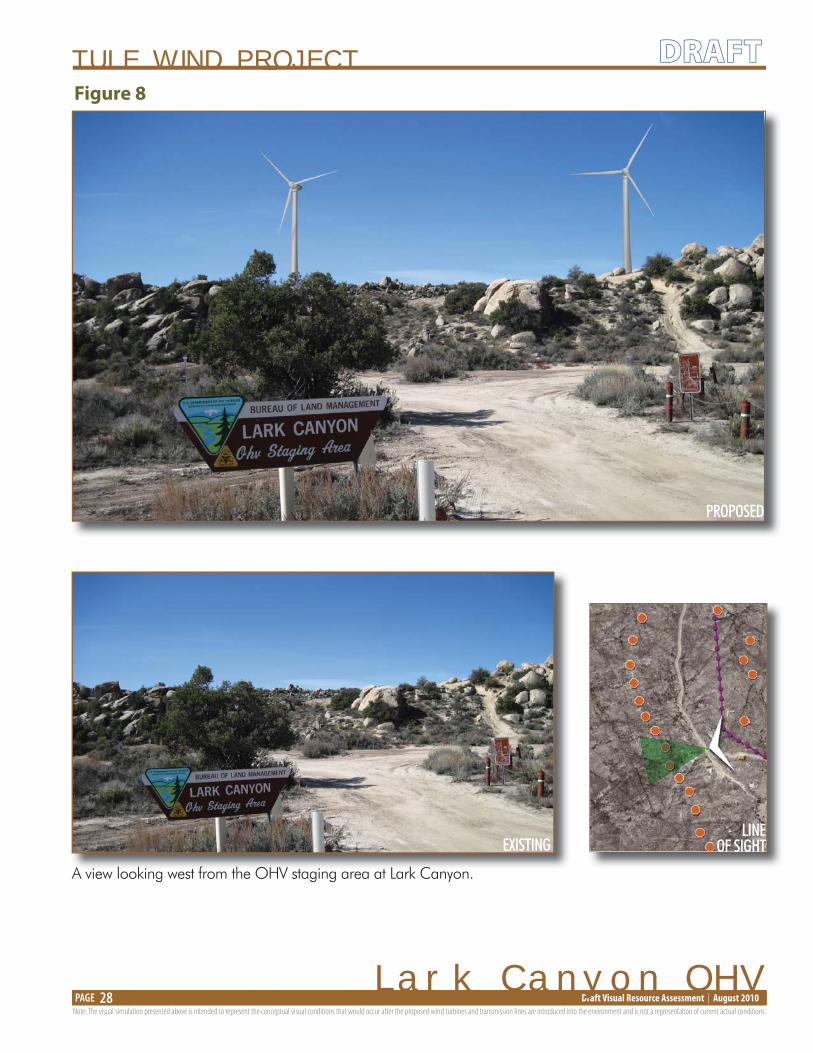
KOP 5 - McCain Valley Road at Lark Canyon OHV Area and Campground
Visual Contrast: Views of approximately 51 to 75 the proposed wind turbines would be evident from higher
vantage points in this area; however, the predominant viewer would likely be traveling by motorized vehicle
at speeds that would prohibit longer than momentary views of the proposed wind turbines. Views from the
Lark Canyon campground would reveal some of the proposed wind turbines, however, the campground
is located within stands of large oak trees and topographic obstruction would somewhat impede views of
the proposed wind turbines.

TULE WIND PROJECT
Draft Visual Resource Assessment | August 2010
DRAFT
PAGE 21
Overall Visual Impact Rating: Minor
KOP 6 - McCain Valley Road at Carrizo Gorge
Visual Contrast: Views of Carrizo Gorge are oriented away from the proposed wind turbines, thus, the
introduction of the structures in the landscape will not impede scenic views of the gorge. However, views to
the south, and west will reveal several strings of the wind turbines creating a dominant visual feature in the
landscape. Approximately 76 to 100 wind turbines would be visible from this vantage point. Additionally,
from this vantage the existing Campo Wind turbines are evident in the background. A visual simulation was
rendered at this point, to show the visual eff ects of the wind turbines from McCain Valley Road and Carrizo
Gorge. Viewers in this area are considered moderate sensitivity because they are likely interested in scenic
views to the north and east.
Overall Visual Impact Rating: Moderate
KOP 7 - Cottonwood Campground
Visual Contrast: The Cottonwood campground is accessible only by passenger vehicle and does not allow
OHV use. This campground is also located within a stand of large oak trees. Views of the proposed turbines
would be evident in the middleground and background. Approximately 51 to 75 wind turbines could be
visible from this area. Viewer sensitivity is considered moderate to high given that the primary viewers
would be people accessing and using the campgrounds.
Overall Visual Impact Rating: Moderate
KOP 8 - McCain Valley Road at northern terminus
Visual Contrast: The only human-made modifi cation currently in this area is McCain Valley Road and when
views are oriented to the southwest, the existing string of Campo wind turbines is evident. Also, given the
natural conditions of the landscape, the introduction of the proposed project wind turbine strings will be
noticeable, bordering on dominant in the landscape. Approximately 76 to 100 wind turbines would be
visible from this area. Viewers in this area would be considered moderate to high sensitivity because they
would be accessing the area to experience the natural environment.
Overall Visual Impact Rating: Moderate

TULE WIND PROJECT
Draft Visual Resource Assessment | August 2010
DRAFT
PAGE 22
KOP 9 - Old Highway 80 and Existing Boulevard Substation
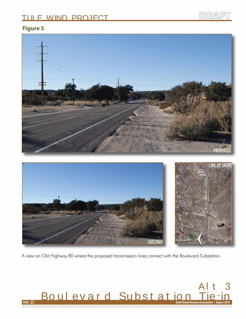
Visual Contrast: Existing views in this area reveal monopole transmission lines feeding into the Boulevard
Substation, thus the introduction of additional transmission lines will not likely impede views signifi cantly
more than present conditions. Old Highway 80 has been designated by San Diego County as an historic
route requiring repairs and improvements to be in keeping with the original concrete slab construction
of the road. The proposed transmission lines would not confl ict with the historic route designation
requirements. Approximately 10 to 20 wind turbines would be visible from this point. Old Highway 80
provides access to the town of Boulevard and viewers would be considered low sensitivity because they
would be en route with views obstructed by development and vegetation.
Overall Visual Impact Rating: Minor
The visual simulations are limited to a 100 degree view, which is slightly narrower than the average vision
span of 120 degrees. When considering additional factors such as peripheral vision, angle of view, lighting,
topography and location of viewer, more turbines may be visible than the visual simulations illustrate. Below is
a listing of the wind turbines that are visible in the visual simulations from each of the key observation points:
Visual SimulationFigure Number
Number of Wind TurbinesVisible in the Visual Simulation Turbines Visible
Figure 3 – Boulevard 4 R-11, R-12, G-18, G-19Figure 4 – Boulevard Substation Tie-In(Alternative 2)
0
Figure 5 – Boulevard Substation Tie-In(Alternative 3)
0
Figure 6 – McCain Valley Road 1 0Figure 7 – McCain Valley Road 2 3 R-13, R-8, R-9Figure 8 – Lark Canyon OHV 2 R-10, R-11Figure 9 – Carrizo Gorge 5 F-1, F-2, F-3, F-4, F-6
Figure 10 – Ribbonwood Road 8 R-11, R-12, G-12, G-13, G-14, G-15, G-16, G-17
Figure 11 – Old Highway 80 0
Mitigation MeasuresTo the extent possible, the project layout will be integrated with the surrounding landscape through the use of
non-refl ective paints, positioning of turbines and collector lines and road corridors in linear routes that follow
the natural contours of the landscape with minimal side hill cuts. Restoration eff orts will be made in areas that
support temporary construction. Additionally, the orientation of the wind turbine strings are planned to be
placed on natural forms in a complementary pattern as opposed to the existing Campo Wind turbines that are
placed in distinct, straight lines.
Turbine and transmission towers will be tubular rather than lattice design to eliminate bird perching and
nesting opportunities provided by the lattice structure.

TULE WIND PROJECT
Draft Visual Resource Assessment | August 2010
DRAFT
PAGE 23
EXISTING
PROPOSED
LINE OF SIGHT
Boulevard
A view oriented north toward McCain Valley from just south of I-8 near the town of Boulevard.
Note: The visual simulation presented above is intended to represent the conceptual visual conditions that would occur after the proposed wind turbines and transmission lines are introduced into the environment and is not a representation of current actual conditions.
Figure 3

TULE WIND PROJECT
Draft Visual Resource Assessment | August 2010
DRAFT
PAGE 24
EXISTING
PROPOSED
LINE OF SIGHT
Alt 2Boulevard Substation Tie-in
A view on Old Highway 80 where the proposed transmission lines connect with the Boulevard Substation.
Note: The visual simulation presented above is intended to represent the conceptual visual conditions that would occur after the proposed wind turbines and transmission lines are introduced into the environment and is not a representation of current actual conditions.
Figure 4
TULE WIND PROJECT
Draft Visual Resource Assessment | August 2010
DRAFT
PAGE 25
EXISTING
PROPOSED
LINE OF SIGHT
Alt 3Boulevard Substation Tie-in
A view on Old Highway 80 where the proposed transmission lines connect with the Boulevard Substation.
Note: The visual simulation presented above is intended to represent the conceptual visual conditions that would occur after the proposed wind turbines and transmission lines are introduced into the environment and is not a representation of current actual conditions.
Figure 5

TULE WIND PROJECT
Draft Visual Resource Assessment | August 2010
DRAFT
PAGE 26
A view looking north on McCain Valley Road from I-8.
EXISTING
EXISTING
PROPOSED
MCCain Valley Road 1
LINEOF SIGHTOOOOOOOOFO
Note: The visual simulation presented above is intended to represent the conceptual visual conditions that would occur after the proposed wind turbines and transmission lines are introduced into the environment and is not a representation of current actual conditions.
Figure 6

TULE WIND PROJECT
Draft Visual Resource Assessment | August 2010
DRAFT
PAGE 27
A view looking north on McCain Valley Road with Rough Acres Ranch to the west.
EXISTING
EXISTING
PROPOSED
LINEOF SIGHT
Note: The visual simulation presented above is intended to represent the conceptual visual conditions that would occur after the proposed wind turbines and transmission lines are introduced into the environment and is not a representation of current actual conditions.
MCCain Valley Road 2
Figure 7
TULE WIND PROJECT
Draft Visual Resource Assessment | August 2010
DRAFT
PAGE 28
EXISTING
PROPOSED
Lark Canyon OHV
A view looking west from the OHV staging area at Lark Canyon.
Note: The visual simulation presented above is intended to represent the conceptual visual conditions that would occur after the proposed wind turbines and transmission lines are introduced into the environment and is not a representation of current actual conditions.
LINEOF SIGHT
Figure 8

TULE WIND PROJECT
Draft Visual Resource Assessment | August 2010
DRAFT
PAGE 29
EXISTING
PROPOSED
LINE OF SIGHT
KumeyaayWind Project
Carrizo Gorge
A view looking southwest from McCain Valley Road at the entranceto the Carrizo Gorge Scenic Area. The existing Kumeyaay Wind Turbines are evident in the background. LLLLLLIIIIIINNNNNNEEEEEE OOOOOOFFFFFF SSSSSSIIIIIIGGGGGGHHHHHHTTTTTT
Note: The visual simulation presented above is intended to represent the conceptual visual conditions that would occur after the proposed wind turbines and transmission lines are introduced into the environment and is not a representation of current actual conditions.
Figure 9

TULE WIND PROJECT
Draft Visual Resource Assessment | August 2010
DRAFT
PAGE 30
EXISTING
PROPOSED
KumeyaayWind Project
Ribbonwood Road
This view is facing northeast along Ribbonwood Road. Views from this vantage reveal several wind turbines as well as the alternative transmission line. There are several residences located in this area with views affected by the proposed project facilities.
Note: The visual simulation presented above is intended to represent the conceptual visual conditions that would occur after the proposed wind turbines and transmission lines are introduced into the environment and is not a representation of current actual conditions.
Figure 10
LINE OF SIGHT

TULE WIND PROJECT
Draft Visual Resource Assessment | August 2010
DRAFT
PAGE 31
EXISTING
PROPOSED
KumeyaayWind Project
Old Highway 80
This view is facing east on Old Highway 80 near the intersection of Ribbonwood Road. From this area, the transmission line corridor connecting to the Boulevard Substation is visible.
Note: The visual simulation presented above is intended to represent the conceptual visual conditions that would occur after the proposed wind turbines and transmission lines are introduced into the environment and is not a representation of current actual conditions.
Figure 11
LINE OF SIGHT

TULE WIND PROJECT
Draft Visual Resource Assessment | August 2010
DRAFT
PAGE 32
List of ReferencesBLM Land Use Handbook (H-1601-1)BLM Visual Contrast Rating (H-8431-1)BLM Visual Resource Management Manual (H-8410-1)Eastern San Diego County PRMP/EISMountain Empire Subregional PlanSan Diego County Light Pollution CodeSan Diego County General PlanSan Diego County Zoning OrdinanceSan Diego County Resource Protection Ordinance No. 9716
List of Agencies and Persons ConsultedPatrick Brown, San Diego CountyJohn Dalton, BLMGregory Miller, BLMGregory Thomsen, BLM

TULE WIND PROJECT
Draft Visual Resource Assessment | August 2010
DRAFT
PAGE 33

TULE WIND PROJECT
Draft Visual Resource Assessment | August 2010
DRAFT
PAGE 34

TULE WIND PROJECT
Draft Visual Resource Assessment | August 2010
DRAFT
PAGE 35

TULE WIND PROJECT
Draft Visual Resource Assessment | August 2010
DRAFT
PAGE 36
TULE WIND PROJECT
Draft Visual Resource Assessment | August 2010
DRAFT
PAGE 37

TULE WIND PROJECT
Draft Visual Resource Assessment | August 2010
DRAFT
PAGE 38

TULE WIND PROJECT
Draft Visual Resource Assessment | August 2010
DRAFT
PAGE 39

TULE WIND PROJECT
Draft Visual Resource Assessment | August 2010
DRAFT
PAGE 40

TULE WIND PROJECT
Draft Visual Resource Assessment | August 2010
DRAFT
PAGE 41
TULE WIND PROJECT
Draft Visual Resource Assessment | August 2010
DRAFT
PAGE 42

TULE WIND PROJECT
Draft Visual Resource Assessment | August 2010
DRAFT
PAGE 43

TULE WIND PROJECT
Draft Visual Resource Assessment | August 2010
DRAFT
PAGE 44

TULE WIND PROJECT
Draft Visual Resource Assessment | August 2010
DRAFT
PAGE 45
TULE WIND PROJECT
Draft Visual Resource Assessment | August 2010
DRAFT
PAGE 46

TULE WIND PROJECT
Draft Visual Resource Assessment | August 2010
DRAFT
PAGE 47

TULE WIND PROJECT
Draft Visual Resource Assessment | August 2010
DRAFT
PAGE 48

TULE WIND PROJECT
Draft Visual Resource Assessment | August 2010
DRAFT
PAGE 49

TULE WIND PROJECT
Draft Visual Resource Assessment | August 2010
DRAFT
PAGE 50
Top Related