


Languages
Pages
Legal


Town of Ocean View Comprehensive Land Use Plan Update – ADOPTED July 13, 2010
1
Table of Contents & Comprehensive Mapping Elements
Title Page Number
Town Officials ........................................................ 02
County and State Officials ........................................................ 02
Acknowledgements ........................................................ 03
Introduction ........................................................ 04
Authority ........................................................ 05
Vision ........................................................ 06
Community ........................................................ 10
Population ........................................................ 12
Housing ........................................................ 14
Historic Resources ........................................................ 15
Land Use ........................................................ 16
Open Space / Recreation ........................................................ 25
Transportation ........................................................ 28
Services ........................................................ 32
Environment ........................................................ 37
Coordination ........................................................ 42
Economy ........................................................ 44
Implementation ........................................................ 45
Title ........................................................ Map Number
Aerial View ........................................................ 1
Roads / Boundary ........................................................ 2
State Strategies ........................................................ 3
Environmental Features ........................................................ 4
Existing Land Use 5
Future Land Use ........................................................ 6 A
Future Land Use – Town Center ............................................... 6 B

Town of Ocean View Comprehensive Land Use Plan Update – ADOPTED July 13, 2010
2
Officials
Town of Ocean View
President and Council: Gordon E Wood, Sr. Mayor
Michelle Steffens Councilwoman
Robert R. Lawless Mayor Pro Temp
Perry Mitchell Councilman
Jeoffy Christ Councilman
Planning Commission: Richard J. Logue Chairperson
Carol Goodhand Vice Chairperson
Eugene Brendel Commissioner
Eric D. Magill Commissioner
Lois Saraceni Commissioner
Town Manager: Conway Gregory
Administrative Official: Charles F. McMullen
Town Clerk: Marie C. Thomas
Chief of Police: Kenneth McLaughlin
Finance Director: Lee Brubaker
Town Solicitor: Dennis L. Schrader
County and State Officials
Sussex County County Council: Vance C. Phillips, Council President – 5
th District
George B. Cole, Vice President – 4th District
Joan Deaver, Council – 3rd
District
Michael H. Vincent, Council – 1st District
Samuel R. Wilson, Council – 2nd
District
County Administrator: David Baker
Assistant Administrator: Hal Godwin
Director of Planning: Lawrence Lank
State of Delaware
Governor: The Honorable Jack Markell
Lt Governor: The Honorable Matt Denn
Senate – 20th
District: The Honorable George H. Bunting
House – 38th
District: The Honorable Gerald R. Hocker
Director of State Planning: Constance C. Holland, AICP
Circuit Rider Planner – Sussex: Bryan Hall

Town of Ocean View Comprehensive Land Use Plan Update – ADOPTED July 13, 2010
3
Acknowledgements
The Town of Ocean View Comprehensive Plan was updated between June 2008 and December
2009 by the Town of Ocean View Planning and Zoning Commission with assistance from the
Town Manager, Administrative Officer and the Director of Public Works for the Town of Ocean
View, Allen Kersher P.E. and the Delaware Office of State Planning Coordination. The Town
would like to thank the following people for their work in developing and drafting this first
comprehensive land use plan:
Town of Ocean View Mayor and Council
The Town of Ocean View Planning and Zoning Commission
Staff of the Town of Ocean View
Bryan Hall, AICP, Principal Planner, Delaware Office of State Planning
Coordination
Delaware Office of State Planning Coordination Staff
Linda Raab, Consultant, University of Delaware, Institute for Public
Administration
Staff of the University of Delaware, Institute for Public Administration
Max B. Walton, Esquire – Connolly Bove Lodge & Hutz LLP
The Delaware Data-MIL Data Mapping & Integration Laboratory
Delaware Department of Transportation
Delaware Department of Natural Resources and Environmental Control
Delaware Office of Historical and Cultural Affairs

Town of Ocean View Comprehensive Land Use Plan Update – ADOPTED July 13, 2010
4
Introduction
The Town of Ocean View‘s
Comprehensive Plan was developed
for a variety of purposes. The Town
initiated the development of the Plan
update in June 2008. The updated
Comprehensive Plan will provide a
framework for development and
growth for the Town through 2014
and will be used to improve land
development codes for Ocean View.
The Comprehensive Plan serves as a
plan for the future of the Town and
as a unified advisory document to
address land use and growth issues
for the Town Council and the Planning and Zoning Commission. It should also be used to guide
future development decisions, re-zonings, annexations, and capital improvements throughout the
community. Ocean View will use this plan as a guide in considering new zoning codes, other
land use ordinances, and zoning maps.
The plan is also an informational document for the public. Citizens, business people and
government officials can turn to the plan to learn more about Ocean View and its potential
policies for future land use decisions. Potential new residents may use this document as an
informational resource about the Town, its characteristics, and facilities. This document contains
the most current information available on population, transportation, housing, employment, and
the environment.
Finally, the Ocean View Comprehensive Plan is a legal document. The State of Delaware Code
specifies that, ―…any incorporated municipality under this chapter shall prepare a
comprehensive plan for the city or town or portion thereof as the commission deems
appropriate.‖ The Code further specifies that, ―after a comprehensive plan or portion thereof has
been adopted by the municipality in accordance with this chapter, the comprehensive plan shall
have the force of law and no development shall be permitted except as consistent with the plan.‖
(Chapter 702, Title 22, Delaware Code). While zoning ordinances are required to be adopted
consistent with the future land use map attached to this Comprehensive Plan (Maps 6A and 6B),
recommendations in this Comprehensive Plan should not be considered mandatory, but instead
should be considered as concepts for consideration and review by the Town Council of Ocean
View.

Town of Ocean View Comprehensive Land Use Plan Update – ADOPTED July 13, 2010
5
The Authority of the Plan
Delaware law requires that municipalities engage in the comprehensive plan process to
encourage ―the most appropriate use of the fiscal and physical resources of the municipality and
coordination of growth, development and infrastructure investment actions with those of other
municipalities, counties and the State….‖ This plan complies with the requirements for a
municipal development strategy — for towns with a population of 2000 or less — as described in
Delaware Code.
The municipal development strategy for small communities such as Ocean View — with fewer
than 2000 people — is to be a ―document in text and maps containing at a minimum, a municipal
development strategy setting forth the jurisdiction‘s position on population, housing growth
within the community, expansion of its boundaries, development of adjacent areas,
redevelopment potential, community character, and the general uses of land within the
community and critical community development and infrastructure issues.‖ In addition, the
town‘s comprehensive planning process must demonstrate coordination with other
municipalities, the county and the state during the plan preparation. (Chapter 702, Title 22,
Delaware Code)
State law requires that planning be an ongoing process and that municipalities identify future
planning activities. This document is Ocean View‘s municipal development strategy as required
by law and it is intended to cover a ten-year planning period and be reviewed at least every five
years.
In March 2008, the Town Council for Ocean View contacted the Delaware Office of State
Planning Coordination (OSPC) to assist with the preparation of the Town‘s Comprehensive Plan
update. The OSPC assembled a team of staff to work with the Town of Ocean View, Town
Council, and Planning and Zoning Commission to cooperate on updating the Town‘s
Comprehensive Plan.
Severability Clause
Should a court decide that any section or provision of this comprehensive land use plan is
unconstitutional or invalid, it is the legislative intent that such decision shall not affect the
validity of this comprehensive land use plan as a whole or any part other then the part judged
unconstitutional or invalid.

Town of Ocean View Comprehensive Land Use Plan Update – ADOPTED July 13, 2010
6
VISION
IMPLEMENT A COMPREHENSIVE LAND USE PLAN THAT WILL ENHANCE
OCEAN VIEW’S QUALITY OF LIFE AND RETAIN ITS SMALL TOWN CHARM
WHILE COPING EFFECTIVELY WITH THE PRESSURES OF GROWTH
The current Comprehensive Land
Use Plan (CLUP) for Ocean View
was adopted in January 2004. The
Town, like many towns within
Sussex County, has experienced
significant growth over the past
several years; to better understand
this growth the Town has included
an excerpt from the most recent plan
which highlights the efforts taken to
develop a comprehensive plan and
address the needs of the community:
On September 3, 2002, the Town
Council discussed the idea of
revising the Town‘s Comprehensive Land Use Plan (CLUP) because the Town had received
several inquires about annexation of new subdivision outside the Town‘s current growth area and
comments on zoning changes and the ―Old Town versus New Town‖ concept. Members of the
Town Council and the Planning and Zoning Commission formed a committee to update the
Town‘s CLUP at its first meeting on October 17, 2002, and decided to prepare and send a
questionnaire to all property owners in the Town of Ocean View and made final adjustments to
and approved it at a November 6, 2002, workshop. The Town had an astounding response to the
questionnaire; over 52% of property owners responded. The answers were compiled by the
University of Delaware‘s Institute of Public Administration. Several public meetings were held
to discuss the questionnaire results in conjunction with updating the Plan.
The questionnaire revealed that many property owners were concerned about preserving the
small town atmosphere; the lack of mobility within the Town; creating sidewalks, bicycle paths,
and pedestrian walkways; controlling growth outside the Town‘s current boundaries; and
restricting the commercial district to Atlantic Avenue.
In summary, the most important considerations in updating the Comprehensive Plan are:
Determination of the proposed growth area for the Town
Consideration of density in the Town
Determination of the uses desired on the Route 26 (Atlantic Avenue) corridor

Town of Ocean View Comprehensive Land Use Plan Update – ADOPTED July 13, 2010
7
Development of a Multi-Modal Transportation Plan
Agreement of zoning map and Comprehensive Plan
Meeting any additional needs created by the rapid growth and desire to maintain the
small town atmosphere during the next decade
Protection of the inland bays
Based upon the summaries generated by residents, it is the opinion of The Town of Ocean View
that it has become one of the fastest growing municipalities in Sussex County. The growth of
Ocean View has been accelerated by the attraction of nearby beaches and inland bays and the
Town‘s quaint small-town charm and the push to establish residential developments inside
municipalities rather than in rural areas.
At the same time, the Town recognizes the State of Delaware is also experiencing phenomenal
growth. The summary of the Strategies for State Polices and Spending states that ―All across
Delaware, people are talking about growth.‖ Both the State Strategies and Sussex County‘s
Comprehensive Land Use Plan discuss environmentally sensitive developing areas. The Town
has the same environmental concerns since it is located in such an area as defined by Sussex
County and understands that it must introduce adequate land use planning and zoning legislation
to ensure the preservation of Ocean View‘s ―small town‖ character. Along with preserving the
community‘s character, the Town will also strive to protect and safeguard its sensitive
environment.
Some of the concerns expressed in the workshops were the same as the questionnaire responses,
and the Committee has made every effort to address all concerns and incorporate them into the
revised Plan. Now while the community considers updating the current comprehensive plan, the
Town is still confronting some of the same concerns, and responding to rapid growth. To further
understand the previous concerns identified in the 2004 Comprehensive Plan and those new
challenges; the Planning Commission in cooperation with residents of the community of Ocean
View held two public workshops. These were held on:
May 31, 2008
June 3, 2008
These meetings were attended by less then a dozen residents. This is a significant reduction of
interest from the previous plan development and this reduction is believed to be a result of the
changing community demographics and a presumed division amongst Town residents
determined by the subdivision in which they preside. Yet from these meetings attended by a few
the following comments were provided:
“We should consider the need to address drainage issues within the community and work
together to solve this issue.”
“We should address the impact of residents who live outside Town boundaries but use local
municipal services; creating an additional financial burden for Town residents.”
Town of Ocean View Comprehensive Land Use Plan Update – ADOPTED July 13, 2010
8
“We need to consider methods for evacuation of the community and region in the event of a
significant storm event.”
“The community should review and revise its annexation processes to better address the impact
of residential development, not only financially, but also as it affects community character.”
“What is too dense? This is no longer the Town I remember. How might the Town recapture its
character while allowing for improved services and opportunities for our residents?”
In addition, the Planning and Zoning Commission held a series of public hearings on:
July 30, 2008 March 1, 2009 August 3, 2009
August 21, 2008 May 28, 2009 August 27, 2009
In addition to local meetings and workshops, the Town Council and Planning and Zoning
Commission considered a variety of planning documents addressing future community concerns.
Based upon consideration of the 2003 Sussex County Comprehensive Land Use Plan, most lands
surrounding the Town are within Sussex County jurisdiction and are zoned
Agriculture/Residential 1 (AR-1). This zoning classification allows agricultural use and
residential use on lots as small as a half acre depending on subdivision size and the types of
public utilities available. Also according to the 2003 Sussex County Comprehensive Plan, the
Town is within the Environmentally Sensitive Development District. This district calls for
improvements to local waste water and water needs, and encourages more environmentally
friendly design to protect the community‘s significant natural resources.
However, both the Sussex County Comprehensive Plan and the Strategies for State Policies and
Spending designate the surrounding area as mostly rural; because of this designation, proposed
major infrastructure improvements should be done in accordance with Strategies for State
Policies and Spending to support growth within designated areas as defined by both the Town of
Ocean View and Sussex County.
From these meetings and the review of relevant planning documents, residents and Town
officials identified the following concerns:
Determination of an annexation area that creates logical Town boundaries. – The
current Town boundary is fragmented; the Town should work to establish easily
recognizable boundaries such as roads, rivers, canals, etc. to aid with future services
and development.
Address the large number of enclaves within the existing Town boundary. – An
enclave is an area of land that is surrounded by a municipality but not within its
boundaries. These areas receive municipal services yet may not pay taxes to support
these services. The Town should work with both affected property owners and Sussex
County to reduce the numbers of these enclaves within the Town.

Town of Ocean View Comprehensive Land Use Plan Update – ADOPTED July 13, 2010
9
Consideration of density in the Town. – Over the past several years the Town has
adopted and implemented many ordinances to diversify the housing types within the
community; these ordinances should be reviewed to determine their effectiveness and
consider future ordinances to potentially define a community center such as the
creation of a possible historic district.
Determination of the types of uses desired on the Route 26 (Atlantic Avenue)
corridor and work with State Officials to preserve this vital transportation
corridor. – Route 26 is the main street for the community and a major transportation
hub for the lower beach resort communities; the Town should consider action to
allow uses that promote the character of the community while allowing for the
necessary movement of the traffic.
Development of a Multi-Modal Transportation Plan. – While the community
acknowledges the importance of Route 26, the Town also recognizes the need for
alternative transportation options, such as walking, biking and mass transit such as
DART. The community will work with the Department of Natural Resources and
Environmental Control for the creation of an Assawoman Canal Biking/Hiking Trail
and with the Department of Transportation to further identify new mass transit
locations and improve and expand sidewalks within the community.
Review and Revision of the approved Zoning Map and Comprehensive Plan for
the Town. – The community appreciates the need to review and evaluate both the
Town‘s zoning map and Comprehensive Plan to address future concerns raised by
development or through the governing processes. The Town will consider the need
for additional regulations to promote historical resources, community character, and
future land use activities.
Protection of the inland bays and other natural resources. – The Town will work
with the Department of Natural Resources and Environmental Control and the
Delaware Forest Service to consider tree protection, total maximum daily loads for
the inland bay watershed, storm water run-off and flooding concerns, by identifying
needed projects and creating new ordinances.

Town of Ocean View Comprehensive Land Use Plan Update – ADOPTED July 13, 2010
10
COMMUNITY
The Town of Ocean View, Delaware,
is known for several things -- its
proximity to the Atlantic Ocean and
Indian River Bay, its sea-faring
origins, the birthplace of the broiler
poultry industry, and its small-town,
village-like atmosphere with quaint,
turn-of-the-century structures.
Now a community of 1,114 people and
growing, the territory known as Ocean
View was founded in 1688 as a 500-
acre tract of land given to Matthew
Scarborough by Lord Baltimore. In the
1800s, Ocean View became known as
Hall's Store after W.S. Hall opened a store on his farm near White's Creek.
The town was eventually incorporated as Ocean View on April 13, 1889 with the first town
meeting held on April 20, 1889. Sea Captain George W. West was elected the first town council
president. He was later replaced by Captain W. Tunnell.
Legend has it that a young man climbed a tree in town one day soon after the War Between the
States and claimed he could see the ocean. True or not, it's a nice story for how the town got its
name even though it's a mile away from the ocean in Bethany Beach.
A ship yard provided work in the 1800s. Called Pennewell's Landing, it was located at the end of
the Assawoman Canal leading into White's Creek. A post office was established on Central
Avenue in June 1833 and soon afterward; the area began to evolve into a village of farmers,
watermen, seafarers and families.
Businesses listed in the Sussex County Farm Directory of 1875-1877 in Ocean View included
J.M. Steel (blacksmith), Holt & Townsend (lumber), Js. F. Holt, G.W. Tunnell, McNeal &
Williams (merchants), Miss M. Townsend (Milliner), Jas. B. Davis (shoemaker), Lemuel H.
Derrickson and Geo. H. West (vessel captains), John W. Evans, James A. Firman, Joseph E.
Hall, James F. Holt, William H. Hudson, Benton Mitchell, Jacob Pusey, Nathaniel F. Quillen,
Thomas H. Richards, John Taylor, Peter Townsend and John M. Turner (farmers and fruit
growers).
A map of 1890, drawn by John T. West, showed 44 residential properties, four stores, the Ocean
View Presbyterian Church and Mariner's Ocean View Methodist Church. Common names
during that time were Betts, Burbage, Daisey, Evans, Rickards, Tunnell and West.
By 1895, the area's population was listed at 350 in the Sussex County Farm Directory of 1895-
97. Land was valued at $100 per acre and was said to be good for producing grain and fruit trees.

Town of Ocean View Comprehensive Land Use Plan Update – ADOPTED July 13, 2010
11
Sailors, life savers, masons, shopkeepers, carpenters, fishermen, mill operators and farmers were
among the occupations then.
Ocean View became the birthplace of the broiler chicken industry in 1923 when Cecile Steele
raised the first commercial flock of broiler-fryer chickens. Poultry is now one of Sussex County's
largest industries. The industry produces 500 million birds and employs more than 20,000 people
throughout the county. Also during this period, the Ocean View area was the largest strawberry
producing region in the country.
Ocean View held an annual Homecoming in the early 1900s with bands, ice cream, lemonade,
Cracker Jack, governors and senators. The tradition continued yearly until the 32nd
Homecoming,
which was the last one held just before World War II. Crowds at the annual gathering reached
5,000 before gas rationing during World War II ended the annual event.
The town drew large crowds again in 1989 when it celebrated its Centennial from June 12-15
with a major festival featuring food, music and activities. The town also hosted the 41st annual
Delmarva Chicken Festival during the Centennial celebration.
Largely a town of chicken houses and farms during World War II, Ocean View began to evolve
into a year-round family town after 1945 as farms were gradually replaced by homes and chicken
houses were abandoned.
Ocean View began to evolve again in the late 1980s, this time into a community of retirees. That
evolution is in full force now, as evidenced by the 2000 census.

Town of Ocean View Comprehensive Land Use Plan Update – ADOPTED July 13, 2010
12
POPULATION
The Town‘s population has grown dramatically in the past 15 years, going from 600 in the 1990
census to 1006 in the 2000 census, a growth rate of 67%. Then from the period of 2000 to 2006
the population rose to 1099 for a growth rate of 18%. This rapid growth contrasts vividly with
the Town‘s slower growth rate of 18% from 1960 (422) to 1980 (495) and a 22% growth rate
from 1980 to 1990 as shown below in Table 1.
TABLE 1: POPULATION GROWTH
YEAR POPULATION %
CHANGE
YEAR POPULATION %
CHANGE
1940 406 ****** 1980 495 17.0%
1950 450 10.0% 1990 606 18.3%
1960 422 (6.2%) 2000 1006 39.7%
1970 411 (2.6%) 2007 1114 9.6%
Source: U.S. Census Bureau, Population Division, July 10, 2008.
The 2000 Census shows that while Ocean View‘s population is predominantly white (98%), it
also has a population that is 1.4% African-American, .6% American Indian or Alaskan Native,
.7% Asian, and .1% other. Also based upon the 2000 Census, the median age of 50.6 was higher
than Sussex County‘s median age of 41.1 and the State of Delaware‘s 36. As a result of its
location, Ocean View has more residents over the age of 65 and fewer inhabitants under the age
of 18 than either Sussex County or the State of Delaware as shown in Table 2. These trends will
continue as long as many retirees move to the area.
TABLE 2: AGE GROUPS
Jurisdiction % under age 18 % over age 65
State of Delaware 24.8% 13.0%
Sussex County 22.5% 18.5%
Town of Ocean View 17.7% 27.8%
Source: U.S. Census Bureau, 2000 Census
According to the 200 Census, Ocean View‘s median household income ($47,500) is higher than
Sussex County‘s ($39,208) and the State of Delaware‘s ($47,381). The U.S. 2000 Census data
also show that Ocean View has fewer residents who fall below the poverty level (2.8%) than
Sussex County (10.5%) or the State of Delaware (9.2%). Population projections are difficult to

Town of Ocean View Comprehensive Land Use Plan Update – ADOPTED July 13, 2010
13
forecast; therefore, a low population is calculated based on the growth rate of 22% from 1980 to
1990 as shown in Table 3 below.
TABLE 3: LOW POPULATIONS
2000 2010 2020
Population 1006 1227 1497
% Change 22% 22% 22%
Table 4 projects the maximum population based on total build-out in 2013 with an average 200
certificates of occupancy issued until 2006 (based on the average number of certificates of
occupancy issued in 1999 - 2002) and 100 certificates issued thereafter until total build-out.
TABLE 4: MAXIMUM POPULATIONS
2000 2010 2020
Population 1006 1162 1322
Housing units 751 2351 2732
Occupied (61%) 458 1434 1667
Owner Occupied (90%) 888 2788 3240
Renter Occupied (10%) 118 368 426
Source: Base year information taken from U.S. Census Bureau with 2.16 used as the average
household size of owner-occupied units and 2.57 used for the average renter-occupied units.

Town of Ocean View Comprehensive Land Use Plan Update – ADOPTED July 13, 2010
14
HOUSING
Housing types in the Town are single-
family detached homes and multi-family
attached homes. The Town‘s diverse real
estate stock has been very well
maintained as proven by the 2000 U.S.
Census, which shows that the Town‘s
median assessed home value of $146,700
was higher than that of Sussex County
($122,400) and the State of Delaware
($139,400). The current approved zoning
is 69% single family detached homes,
28% multi-family attached homes, and
2% general business. The multi-family
attached homes are currently found in the Town‘s Residential Planned Communities (RPC‘s).
The 2000 U.S. Census data show 754 housing units in the Town of Ocean View; 97.4% of these
units were single-family detached structures. Table 5 shows the housing composition within the
Town of Ocean View per the 2000 U.S. Census.
TABLE 5: HOUSING COMPOSITION
Type of homes Number Percent Composition
Single Family – detached 734 97.4%
Attached units 9 1.2%
Mobile homes 11 1.4%
Source: U.S. Census Bureau, 2000 Census
Table 6: Housing Age shows that 47.9% of these homes were built since 1990.
TABLE 6: HOUSING AGE
Years Number Percentage Variation
2000 ~ 2008 923 122.4%
1990 ~ 2000 361 47.9%
1980 ~ 1989 160 21.2%
1970 ~ 1979 89 11.8%
1960 ~ 1969 40 5.3%
1940 ~ 1959 34 4.5%

Town of Ocean View Comprehensive Land Use Plan Update – ADOPTED July 13, 2010
15
HISTORICAL RESOURCES
The Town of Ocean View realizes that there is
a potential historic district north of Route 26
and understands that the protection of these
homes is an important aspect of preserving its
small town atmosphere. In 2005, The Town
provided financial support for the creation of a
historic preservation committee to work with
both State and County agencies to identify
historic buildings, preserving the Town‘s
history and to work with the Town to develop
regulations to preserve these cultural
resources. In 2008, the historic committee
evolved into the Ocean View Historical
Society, a 501(c) 3 corporation charged with educating residents and visitors on the history of the
community. To support these efforts, the Town has leased one of its buildings, the historic
Shores House, to the Ocean View Historical Society to establish a museum of local history. Both
the Town and the Historical Society will continue to work with both the State and County to
preserve the cultural and historical resources of the community and region.
To meet this objective, the Town in consultation with the Ocean View Historical Society has
defined a historic area within the municipal limits. The proposed historic area will encompass all
of Atlantic Avenue from the western boundary of the Town to West Avenue as well as all of
West Avenue north of the intersection with Atlantic Avenue. In addition, Central Avenue North
from Atlantic Avenue to the Assawoman Canal and Woodland Avenue north from Atlantic
Avenue will be included within this area. Finally, the area west on Daisy Avenue to Elliot
Avenue to the Assawoman Canal will be included within this area. The Town Council may
consider adopting special land use regulations for the historic area.
Recommendations for Consideration - Historical Resources
Concerns Strategies
Preservation of historical homes Gain a better understanding of the Town‘s
historic resources by surveying and
inventorying its architecture. Use the
completed survey and inventory to determine
preservation and development strategies.
Consider preservation of agricultural buildings
and archaeological sites when lands are being
developed.

Town of Ocean View Comprehensive Land Use Plan Update – ADOPTED July 13, 2010
16
LAND USE
GOAL: TO BALANCE GROWTH AND MAINTAIN THE SMALL TOWN
ATMOSPHERE
Currently, the Town of Ocean View encompasses approximately 1,600 +/- acres and is located 1
mile west of the Atlantic Ocean in the coastal area of Sussex County. About 372 acres are now
unimproved, yet 80% of the unimproved acres is anticipated to develop within the next 5 to 7
years and because of this expansion as a small resort-area town, Ocean View does not confront
the same redevelopment issues that larger municipalities face. The Town has no brown fields,
former industrial complexes, or large vacant shopping centers that require redevelopment. The
Town hopes to retain its small town charm by continuing to implement adequate safeguards
through zoning regulations and through future annexation procedures to ensure a balanced land
use throughout the community.
Responses to the Town‘s questionnaire of 2004 and the 2008 public workshops revealed that
property owners are in favor of growth for a number of reasons; e.g., control of development and
density and increasing the Town‘s revenue base. To meet the needs of current and future
residents, The Town must ensure that revenues from growth and development are sufficient to
cover the cost of municipal services that the Town must provide to the expanded population. As
the Town considers future growth, many feel —according to surveys and Town meetings – that
annexation should continue to be considered; however, the Town should evaluate the annexation
process to ensure that new residents receive relevant services without over-taxing existing Town
resources.
To further define the existing land uses, Table 7 shows the current land uses within the Town of
Ocean View:
TABLE 7: CURRENT LAND USES (approximate)
Land Use Current Acres Current Percent Total
Vacant 404.80 25.3%
Agricultural 1.60 0.1%
Residential 768.00 48.0%
Commercial 43.20 2.7%
Institutional 3.20 0.2%
Non-Conforming w/ Condition 4.80 0.3%
Utilities 1.60 0.1%
Open Space 1.60 0.1%
Town Center 371.20 23.2%

Town of Ocean View Comprehensive Land Use Plan Update – ADOPTED July 13, 2010
17
The Town of Ocean View contains a variety of land uses as described in this section as well as in
Map 5. Currently these land uses are considered by the Town as:
Vacant Lands – These are lands that are undeveloped and might include forests, wetlands; etc.
Agricultural – These are lands that are currently used to produce a variety of crops and support
the general farming activities within and around the Town.
Residential – These are currently developed lands in either single-family or multi-family homes.
Commercial – This defines much of the lands along Route 26 and a few scattered parcels
throughout the existing Town that generally support local business such as banks, restaurants,
doctor‘s offices, etc.
Planned Community – Over the past several years, the community has developed and utilized
zoning to support mixed use communities which provide a variety of housing types with
commercial activities to support these expansive neighborhoods. Since the last comprehensive
plan update, the Town has three of these planned communities that provide a mix of land use
opportunities while preserving the small town character and the areas rich natural resources.
Institutional – These parcels are few in number; however, represent focal points of the
community and include local churches, Town facilities, and Lord Baltimore Elementary School.
Non-Conforming Uses – Throughout the Town, there are selected parcels that allow for selected
activities that may conflict with adjacent land uses. These parcels are considered to be non-
conforming and property owners are restricted in the times and types of activities to preserve the
community character and address neighbors‘ concerns.
Utilities – These are lands used to support local infrastructure such sewer, water, phone, electric,
etc.
Open Space – These are park lands, trails, and community open space areas generally
maintained by the Town of Ocean View.
Town Center Area – Loosely defined in the 2004 Comprehensive Plan, this is the area within
the Town along Route 26, Central Avenue and Oak Avenue that encompasses certain
commercial business, institutional uses and older homes within the Town.
There are currently about 400 +/- acres of land that are vacant or in agricultural use inside the
Town boundaries of Ocean View, representing roughly one quarter of the total area of the Town.
While not all of this land is available for development due to environmental constraints, it does
represent a substantial amount of land that may be developed. The Town of Ocean View will

Town of Ocean View Comprehensive Land Use Plan Update – ADOPTED July 13, 2010
18
consider the development of these lands consistent with the Future Land Use Plan described in
this section and within the constraints of the utility infrastructure described in this update.
While the majority of land use is either residential or agricultural, there are several properties
devoted to commercial and institutional purposes. The future land uses for the Town are shown
on Map 6A and 6B. Following is a description of each land use category and the proposed
policies that will guide the Town when implementing land use regulations and future
development proposals in each area.
Future Land Use
Table 7.A describes the future land uses within the Town of Ocean View. Most notable when
considering the future land use is the increase in Residential, Commercial and Open Space Land.
Table 7.A Future Growth1
Land Use Acres Percent
Residential 1097.91 68.27%
Commercial 66.85 4.15%
Open Space Areas 267.21 16.63%
Utility Areas 1.80 0.1%
Institutional Areas 28.97 1.8%
Town Center Area 145.52 9.05%
Residential – The majority of the Town is designated for future residential land uses. This
includes all lands with existing single family homes and lands currently in agricultural
production. The Town intends that these areas will either remain as residential homes or be
developed from agricultural use into housing consistent with the character of the Town. General
policies that will guide residential land uses in Ocean View are:
The preservation and rehabilitation of existing homes in Ocean View will be encouraged.
Homeownership in Town will be encouraged.
1 While the Town has designated certain areas on its future land use maps (Maps 6A and
6B) as ―Open Space Areas,‖ ―Utility Areas,‖ ―Institutional Areas,‖ and ―Town Center Areas,‖
this Comprehensive Plan does not require the Town Council to zone with these specific
designations when rezoning in accordance with this Comprehensive Plan. These uses may be
placed in any zoning district which the Town Council designates as permissible under Ocean
View‘s zoning code or other applicable land use regulations.

Town of Ocean View Comprehensive Land Use Plan Update – ADOPTED July 13, 2010
19
Modest growth controls will be encouraged that encourage mixed uses and a mixed
housing stock.
Tree and natural resource preservation will be encouraged.
Commercial – The majority of commercial uses in Ocean View are located along Route 26 and
Central Avenue in roughly the central parts of Town. The future land use plan proposes
generally concentrating the Town‘s commercial activity in these areas. Future commercial uses
will generally be encouraged to occupy the central and northern end of Town. The following are
some general policies that will guide commercial properties in Ocean View:
Promote and encourage continued businesses within the Town.
Allow continued operation of existing commercial uses.
Promote restaurants, retail stores, and recreational uses that provide needed goods,
services, and jobs to the Town; but be aware that Town residents have advised that they
do not desire large-scale, regional retail uses.
Planned Community – As the Town grows through annexation, the Town will continue to use
different planned community regulations that support mixed used activities which provide
commercial activities to support the residential land use activities. In addition, the Town will
continue to review these existing regulations to address noticeable gaps that have caused
concerns to the Town and its residents over the past five years.
Open Space Areas – The Town recognizes the need for a mix of passive and active open space
to provide recreational opportunities and improve the health and vigor of our natural
environment. The Town will consider these future open space lands as part of any new
development project. In addition, the Town will continue to partner with State and County
agencies to acquire new lands for preservation and recreational activities. Open space areas are
permissible in some or all zoning districts as the Town Council directs by ordinance.
Utility Areas – To support both new and existing growth; the Town will continue to work with
private and public partners to identify new parcels and preserve those land used for utility
services to the Town and surrounding area. The Town will also work to review and revise local
ordinances to promote improved design of these facilities to minimize impacts to the community
as a whole. Utility areas are permissible in some or all zoning districts as the Town Council
directs by ordinance.
Institutional Areas – There are a number of institutional uses in Town. Institutional areas are
permissible in some or all zoning districts as the Town Council directs by ordinance. It is the
intent of the Town to encourage their continued operation and role in the community by
designating them for future institutional purposes. The institutional properties include several
churches, the Town Hall and Town Safety Building and various park facilities. Some general
policies that will guide institutional land uses in Ocean View are:

Town of Ocean View Comprehensive Land Use Plan Update – ADOPTED July 13, 2010
20
Existing institutional properties will be encouraged to continue their roles in the
community and be allowed to grow and expand in a reasonable fashion that is consistent
with the character of Ocean View.
Maintain the Town‘s underlying zoning for these parcels but ensure safeguards to allow
their continued use.
Town Center Area2 – The residents of Ocean View have a strong entrepreneurial spirit, which
is seen in the variety of home-based and traditional businesses throughout the Town; however
the Town lacks what many in the community consider a ―downtown‖ area of the community.
This comprehensive land use update proposes the potential creation of a Town Center Area for
locations along Route 26 and Central Avenue to allow for continued uses while providing
flexibility to support business opportunities desired by residents. Ocean View wants to
encourage businesses while enhancing a sense of community and ensuring they do not infringe
on the rights of other residents. Some general polices that will guide the Town Center Areas in
Ocean View are:
The Town Center is encouraged to promote entrepreneurship and self sufficiency among
the residents of Ocean View.
Business may be regulated by the future land use regulations in Ocean View, perhaps as a
―special exception‖ allowed in all zones.
In future land use regulations, the Town should consider defining some parameters to
guide the establishment and operation of mixed use businesses. The parameters may
include, but not be limited to, noise and parking regulations, storage requirements for
heavy equipment, and requirements for hours of operation. The goals should be to ensure
that cottage industries are compatible with their neighbors, but still have the flexibility to
operate and flourish economically.
Annexation
Annexation is a process through which land becomes incorporated into the municipality from
the surrounding county. The Town‘s Charter specifies procedures and criteria that every
property owner wishing to annex into the Town must follow. To be eligible for annexation,
the property must be contiguous to the existing corporate limits of the Town and in the
Town‘s proposed growth area. As part of any annexation proposal, a plan of services must
be submitted with the annexation application to the State Planning Office. This plan of
2 While the Town Center Area is encouraged by this Comprehensive Plan, the Town is not
required to adopt a Town Center zoning designation within its land use ordinances. Other zoning
classifications (including but not limited to residential, commercial, and planned community
designations) may be used to encourage flexible development strategies in the Town Center
Area.

Town of Ocean View Comprehensive Land Use Plan Update – ADOPTED July 13, 2010
21
services must include not only the amenities the Town will authorize but a detailed
explanation of the manner in which they will be provided and proof of the fiscal and
operating capabilities of the provider of the services. Annexations also require approval from
Sussex County (or the applicable sewer authority) on the availability of sewer, since a
portion of the annexation area is outside the current sewer service area. The Sussex County
Area Planning Study (SCAPS) is being updated, and sewer may become available in the
planning period. In addition to satisfying all requirements of the Town Charter and the Town
Code, annexations must also comply with all annexation requirements under State law,
including, but not limited to Title 22, Section 101 of the Delaware Code.3
The Town Council reviews and votes on annexation petitions. Under the Charter, if the
annexation is less than 5 acres, the property annexation is effective on the date of the Council
vote and cannot be contested. If the annexation is over 5 acres, a 31-day waiting period follows
the vote, and the annexation ordinance becomes effective if not contested. Annexations are not
subject to referendum unless 33% of the qualified voters petition for one. If a referendum is
held, the annexation ordinance is effective if the majority of the qualified voters vote for the
annexation.
In annexing any new parcels of land into the Town, the Town is committed to avoiding the
creation of new enclaves and to eliminate, if possible, existing enclaves during the negotiation of
any new annexation agreements. The Town will work with Sussex County Planning Department
during the annexation process to address potential or existing enclaves as well as any other
concerns raised through this process. In addition, when possible, the Town will endeavor to
annex roads and/or rights of way contiguous with the lands proposed to be annexed to provide
necessary jurisdiction to the Ocean View police department.
The Town has annexed over 812 acres into the southern end of Town since 1995. Table 8 gives
details on the larger annexations since 1995. Town-maintained streets increased from 9.54
miles in 1995 to 13.33 miles at present; this figure is expected to increase to over 22.63 miles.
TABLE 8: ANNEXATION DATA FROM 2004 TO 2008 SUBDIVSION OVER 10
PARCELS.
Name of Development Number of Parcels Number of Acres
Savannahs Landing 194 59.96
Hunters Run 88 40.62
Bear Trap 700 457.00
3 The Town may also require additional information in advance of annexation, including
but not limited to, a letter of intent from the public utility if water is being served, or a letter or
permit from the Delaware Department of Transportation (DelDOT) when the development‘s
entrance is on a State-maintained road.

Town of Ocean View Comprehensive Land Use Plan Update – ADOPTED July 13, 2010
22
Wedgefield/ Avon Park 179 62.2
Fairway Village 332 121.40
Canal Landing 337 71.61
Total 1830 812.79
The Town of Ocean View has developed a formal annexation strategy for phasing in
development for each annexed property. Accordingly, the Town Council has restricted the
number of units permitted each year in the Savannahs Landing, The Village of Bear Trap Dunes,
and Fairway Village subdivisions and will continue this limitation in the future. However, the
Town‘s citizens continue to express concerns about the future densities of any newly annexed
parcels. Map 6A illustrates the annexation area of the Town.
Land Issues For the Future:
The Town is looking at the south side of Town and at enclave parcels within the community for
possible growth and annexation will be considered as either commercial, residential, or planned
community land uses; with an emphasis on residential home types in keeping with the
community character and modest commercial uses to support the growing population. This area
considered for future annexation is to the South of Town and is now mostly farmland. The Town
wants the continued option of annexing these parcels in order to control their future density and
to provide the Town with a revenue stream to help defray the additional costs incurred by the
Town when these new residents use the Town streets and other amenities.
Concerns about development types accompany growth. The Future Land Use Map # 6A shows
that much of the commercial use for the Town will continue on Route 26. These commercial
uses can be found within the business area and are intended to consist primarily of neighborhood
service and retail type establishments to serve Ocean View residents but are not intended to
drastically increase vehicle traffic on the already congested Route 26. The Town will encourage
small retail shops, restaurants, and professional and medical offices. The Town will continue to
reserve the right to allow permitted uses with this district to allow residential use and will
consider amending the landscape requirements to allow multi- uses and improve the streetscape
of Route 26.
The Town currently believes that the present infrastructure is inadequate. Furthermore, the Town
realizes that there are sewer capacity limitations. An unwise increase in density, without
assuring adequate infrastructure, would adversely impact the Town‘s ability to meet its service
obligations to its citizens. Ocean View feels that it would not be advantageous to become a
designated Transfer of Development Rights receiving area for fear of abuse of this program by
obtaining inexpensive development rights from western Sussex County and transferring these to
Town, only adding to already existing concerns of unmanaged growth from residents.

Town of Ocean View Comprehensive Land Use Plan Update – ADOPTED July 13, 2010
23
Also, the Town recognizes the need to keep all subdivisions plans current. The Town subdivision
ordinance currently has a sun-setting provision in place that invalidates any subdivision plan
when construction does not commence within five (5) years following recordation of a final site
plan. In addition to adopting a sun-setting provision, the recently adopted subdivision and street
regulations require bonding and phasing of any new proposal. Also the Town now requires
developments to become interconnected with existing and future subdivision. Although the
Town does not have any newly constructed stubbed streets at this time, the Town currently
allows for the placement of short and long-term barricades to address concerns raised by the
public as part of this planning effort.
In addition to expanding the commercial uses within the business area, the Town will continue to
improve upon the planned community requirements to the existing and future developments that
are located on the south side of Route 26. These larger developments vary in lot size, coverage
and housing types and are intended to provide mixed housing types while preserving open space.
Property owners have also expressed concerns about affordable housing in Ocean View. The
allowance of multi-unit housing in the planned community zones had given hope that this may
be an avenue for more affordable housing; however, the increased property values in the Town
and the surrounding area have made the goal of providing affordable housing difficult. The
Town will work to potentially achieve this goal through the use of multi-use property zoning
proposed within the community, which would allow residential and general business on the same
parcel, and that should result in some affordable housing in the Town.
Recommendations for Consideration - Land Use Growth Management
Concerns Strategies
Preserve the small town atmosphere of the
Town of Ocean View
Consider maintaining the current zoning of R-1
single family detached homes through much of
the existing Town that has not been classified
as a mixed use community.
Create an attractive streetscape on Route 26. The Town plans to continue the process of
incorporating the new Route 26 design and
potentially develop a new ordinance into the
streetscape plan for Route 26 within the
municipality in cooperation with the State.
Limit the scope of commercial uses to the area
recognized as the business district and off
Route 26 and to future planned communities
within the future annexation area of the Town.
Consider updating current zoning codes and
map to reflect this limitation of this use.
Allow for additional single-family homes and
lower densities within defined areas of the
Consider amending ordinances to limit the
number of units per acre in planned community

Town of Ocean View Comprehensive Land Use Plan Update – ADOPTED July 13, 2010
24
Town. areas of the Town and allow a mix product
type to meet the demands for housing within
the community.
Lack of community design standards for
planned communities.
Consider adopting community design
ordinances, which would enhance the
community‘s character.
Town divided subdivisions; such as Country
Estates.
Work with the Town of Millville and Sussex
County to address these concerns through the
annexation process.

Town of Ocean View Comprehensive Land Use Plan Update – ADOPTED July 13, 2010
25
OPEN SPACE AND RECREATION
GOAL: ENHANCE AND MAINTAIN RECREATIONAL FACILITIES AND
PRESERVE THE OPEN SPACE WITHIN THE TOWN OF OCEAN VIEW
Recreation, both active and passive,
is becoming more important as
lifestyles change. Families need
places to go to ―get away from it
all.‖ Today‘s recreational needs are
met by facilities ranging from large
complexes and organized sports to
simple open areas where people can
relax.
The John T West Park is situated on
West Avenue in a central location
adjacent to the Town Hall and
provides a facility for picnicking
with outdoor grills and tables under a
pavilion. This wooded park is
impeccably maintained by the Town and gets constant use by youngsters who frolic on the
playground equipment. Made possible by a matching grant from Delaware‘s Department of
Natural Resources the park includes equipment for special needs children and a seniors‘ fitness
course. Finally, the park serves as a gathering place for residents of Ocean View and others
outside the Ocean View area. Numerous events take place at the park including summer
concerts and winter caroling.
In 2008, the Town joined with the Towns of Bethany Beach, South Bethany Beach and the Sea
Colony Community in applying for a $20,000 dollar matching grant through the Department of
Natural Resources to plan for the development of a natural pathway along Assawoman Canal
extending from Whites Circle to South Bethany. This trail system will provide passive recreation
activities for walkers, joggers and bicyclists along both sides of the canal. Park benches and
nature trail signage will accent the trail providing users with appropriate places to rest and enjoy
the beauty of the canal while learning about the history, wildlife and natural vegetation along the
canal and each of the four communities. The pathway will be constructed to American Disability
Standards and should be completed by 2011.
Also in 2008, the Town completed preliminary design work on a parcel owned by the Town
located at First Street and Central Avenue adjacent to the western edge of the John T West Park.
The Town has appropriated funds to connect the vacant lot into a passive recreational area that
will compliment the active recreation area already in place. The Town will construct several new
amenities such as a gazebo and walking trail to connect to the already existing facilities. In
addition, picnic tables and other amenities such as a reflection fountain and landscaping will
allow visitors to enjoy a restful and peaceful experience within the newly constructed facilities.
These new additions to the John T West Park should be completed by 2011.

Town of Ocean View Comprehensive Land Use Plan Update – ADOPTED July 13, 2010
26
In May and June 2008, the Division of Parks and Recreation conducted a telephone survey of
Delaware residents to gather information on outdoor recreation patterns and preferences as well
as other information on their landscape perception. These findings are the foundation of the
2008-2011 Statewide Comprehensive Outdoor Recreation Plan (SCORP) providing guidance for
investments in needed outdoor recreation facilities. Ninety One Percent of the respondents in
Eastern Sussex County said outdoor recreation is important to them. The creation of pathways or
trails along the Assawoman Canal should address the desire and need for walking, jogging and
bicycle paths. The expansion of the John T West Park to provide an area for more passive
recreation will address the need for more passive open space recreation. The Town will also
consider adding such recreational activities as horseshoe pits to the park to augment the existing
playgrounds, fitness equipment and volleyball courts.
Several neighborhoods within the Town provide amenities such as tot lots, swimming pools, and
tennis courts for their residents. These facilities are owned and maintained by the community
associations through dues paid by residents on an annual basis. The Town recognizes the
importance of these facilities to provide a mix of recreational opportunities to residents and
guests. The Town will work through continued management of these facilities through the
review and update of existing land use regulations and will endeavor to ensure proper
construction and ensure long-term maintenance. In addition, Ocean View is the site of one of
Delaware‘s premiere public golf courses, ―Bear Trap Dunes,‖ which provides enjoyment and a
mix of activities for Town property owners and residents at a fee. Finally, the premier attraction
of Ocean View and nearby towns is their proximity to the Atlantic Ocean and its public beaches
via Bethany Beach, South Bethany Beach or State of Delaware Seashore State Parks. The Town
will endeavor to develop a recreation plan that works with the Department of Natural Resources
and Environmental Control and other local communities to ensure that the Plan reflects their
open space preservation and outdoor recreation planning activities.
According to the responses given in the Town‘s 2004 survey, 94.4% of the respondents stated
that mature trees and new plantings and landscaping make Ocean View a desirable place to live.
That sentiment continues to be true today, as the Town has obtained the National Arbor Day
Foundation Tree City USA recognition for over 3 years. This National recognition requires the
Town to spend $2 per capita per resident annually on trees, have a tree board or commission,
celebrate Arbor Day and have a tree care ordinance. Based upon this recognition, the Town will
continue to work with the Delaware Forest Service to review and consider amending the
community forestry ordinance. If adopted, this ordinance will continue to address such concerns
as tree preservation along waterways and in new subdivisions, support for tree planting in
downtown areas and developments, and future liability issues that come from an older and
poorly maintained urban forest resource.
In order to protect and preserve open space the Town, will require Best Management Practices
(BMP‘s). Community BMP‘s such as waste-water treatment facilities, storm-water treatment
areas, and both tidal and non-tidal wetlands will generally be excluded from future subdivisions
required open space calculations that are necessary to meet the required open space for the
project.

Town of Ocean View Comprehensive Land Use Plan Update – ADOPTED July 13, 2010
27
Recommendations for Consideration - Open Space
Concerns Strategies
Preserve and enhance the current recreational
facilities and open spaces within the Town.
Continue to maintain and improve the John T
West Park and review the long range financial
plan to ensure that adequate funding is
budgeted. Work with the Department of
Natural Resources and Environmental Control
to develop a recreational plan for the Town of
Ocean View.
Future developments may not allow or limit
open space or recreation resources within the
Town.
Consider revising land use regulations to
further expand and clarify the types of required
recreational facilities and open space in future
developments.
Current development may eliminate parcels
that would be available for recreational
facilities.
Consider including funding in the Town‘s
Long Range Financial Plan to acquire land for
open spaces. Investigate possibility of State
grant to acquire land for open spaces and/or
recreational needs.
Rapid growth may cause destruction of trees
and vegetation.
Work with the Delaware Forest Service to
review and potentially amend ordinances for
preserving older trees and planting new ones.

Town of Ocean View Comprehensive Land Use Plan Update – ADOPTED July 13, 2010
28
TRANSPORTATION
GOAL: ENHANCE THE EXISTING TRANSPORTATION SYSTEM AND
CREATE ALTERNATIVE TRAVEL THROUGH A MULTI-MODAL
TRANSPORTATION NETWORK TO IMPROVE TRAVEL SAFETY
An adequate community transportation system
must ensure that pedestrian and vehicular traffic
flows safely and efficiently without serious
disruption to community lifestyle patterns.
This task becomes more difficult during the
seasonal influx of summer traffic to southern
Delaware resort areas. Land development and
population growth continues to add new service
demands to the present and future transportation
network.
The Delaware Department of Transportation currently maintains the following routes within the
Town of Ocean View:
Route / Road Number Road Name Location / Service Area
Delaware Route 26 Atlantic Avenue From Bethany to Millville
Road 361 West Avenue South of Route 26 (Atlantic
Avenue)
Road 357 Central Avenue North of Route 26 (Atlantic
Avenue)
Road 84 Central Avenue South of Route 26 (Atlantic
Avenue)
Road 352 Windmill Road South of Burbage Road
Road 368 Beaver Dam Road East of Central Avenue
Route 26 runs directly through the Town of Ocean View and is the major east-west route to
Bethany Beach and other Atlantic coast resorts. It therefore continues to experience excessive
seasonal congestion which has become year round congestion.
The Delaware Department of Transportation initiated a planning study of Route 26 in fall of
2004. Construction is planned to begin in September 2011 and be completed in late 2015. Detour
Routes improvements are scheduled to begin in September 2009 and be completed in late 2011.

Town of Ocean View Comprehensive Land Use Plan Update – ADOPTED July 13, 2010
29
The proposed improvements will also allow for increased accessibility from improvements to
being made to Route 26.
Phase 1
- Road 353 (Burbage Road) from State Route 17 to Road 352 (Windmill Road)
- Road 352 (Windmill Road) from State Route 26 to Road 84 (Central Avenue)
- Road 84 (Central Avenue) from Road 352 (Windmill Road) to 368 (Beaver Dam Road)
- Road 368 (Beaver Dam Road) from Road 84 (Central Avenue) to Road 361 (Muddy
Neck Road)
Phase II
- Road 365 (Powell Farm Road) from State Route 26 to Road 353 (Burbage Road)
- Road 353 (Burbage Road) from Road 365 (Powell Farm Road) to State Road 17
All new highway access, including driveways, commercial entrances, and subdivision entrances
on State-maintained roads, is subject to an entrance design review process by the Delaware
Department of Transportation.
The Town owns and maintains the balance of the remaining streets in the Town of Ocean View.
Street repairs are dealt with on an as-needed basis; however, the Town continues to implement a
paving management system to help plan for future repairs as well as implement maintenance
programs to preserve the streets. A greater concern to the Town of Ocean View is a shortage of
sidewalks in the older segment of the community; what sidewalks are in place are on Route 26
(Atlantic Avenue) or in the residential planned communities, such as Bear Trap Dunes. Ocean
View currently has no ordinances requiring sidewalks or bike paths. However, the Town hopes
to remedy this by potentially implementing new community design standards.
The Town will consider developing a comprehensive mobility plan that will work to design a
network of bike paths and sidewalks to increase pedestrian traffic throughout the community and
reducing vehicle traffic. This network will connect to the sidewalks and bike paths in the Town
of Bethany Beach and the current bike path on West Avenue and form a loop to South Bethany,
Sea Colony, Bethany Beach, and Ocean View. The Town completed a study in 2005 for
providing pedestrian walkways along Woodland Avenue from West Avenue to Daisy Avenue.
This study was designed to allow all citizens to access West Avenue loop as well as the
sidewalks leading to Lord Baltimore Elementary School. The plan that was developed provided
limited ability to widen several streets within the community and was later determined to be cost
prohibitive due to right-of-way acquisitions. To date the proposed project has not been
implemented.
Congestion on Route 26 continues to be a major concern of all the property owners and guests to
the Town. Ocean View‘s citizens also have concerns about the many intersections that cross
over Route 26. In response to these concerns, DelDOT completed a south-bound right turn lane
to Central Avenue and Route 26. New signal lights were also installed at both intersections. The
cut-through problem on Woodland Avenue was also addressed with the addition of a right turn
lane and the safety problem at Route 26 and West Avenue was addressed with a new signal light.

Town of Ocean View Comprehensive Land Use Plan Update – ADOPTED July 13, 2010
30
The Town continues to work with the State to identify other temporary solution for the serious
congestion at the intersection of Route 26 and Central Avenue until Route 26 is improved.
Emergency evacuation is also a concern due to the threat of coastal flooding. The improvements
to Route 26 will help alleviate these concerns but will not eliminate them because of the number
of people that may need to evacuate in a severe storm. The Town must work with other local
municipalities, the county, and the State to ensure a safe evacuation.
Recommendations for Consideration - Transportation
Concerns Strategies
Traffic congestion on Route 26. Continue to communicate with DelDOT on the
capital improvements project. Consider
allowing residential uses in any future general
business district because residential use would
create less traffic than business use. Endeavor
to improve intersections that cross over Route
26 to improve traffic flow and add
interconnecting parking lots along Route 26 to
reduce number of vehicles entering and exiting
on Route 26.
The lack of a safe pedestrian and bicycle
transportation system.
Consider developing a plan for a safe
pedestrian and bicycle transportation system.
Consider allocating funding for these projects
in the Town‘s long range financial plan
including construction costs and the costs of
acquiring right-of-ways. Research existing
outside funding sources such as Transportation
Enhancement Funds and require future
developments to improve existing
infrastructure. Potentially incorporate in the
land use code requirements for sidewalks and
bike paths within subdivisions and connectivity
to sidewalks and/or bicycle paths in adjacent
developments and to other public rights-of-
way.
Maintenance of the Town‘s street
infrastructure.
Continue to revise and consider implementing
a pavement management system and update
street ordinances to ensure that new roads will
be properly constructed, and existing roads will
be properly maintained.
Safe evacuation routes. DelDOT and public safety officials have
completed significant work to develop a formal

Town of Ocean View Comprehensive Land Use Plan Update – ADOPTED July 13, 2010
31
emergency evacuation plan for residents living
in South Coastal Sussex County. Ocean View
will consider adopting this plan.
Obtain State. Federal, and other funds for
future road improvements, sidewalks, and bike
paths.
Consider implementing a detailed capital
improvements program and budget that will
include funding reserve accounts for future
improvements. Continue effective management
of the Municipal Street Aid Fund. Research
other funding sources for road system
maintenance.

Town of Ocean View Comprehensive Land Use Plan Update – ADOPTED July 13, 2010
32
SERVICES
GOAL: ENHANCE THE CITIZENS’ QUALITY OF LIFE
Since 2004 the Town has expanded its services to meet the demands of its growing population,
Municipal services now include full-time police protection, street maintenance, and street
lighting; however, like many other jurisdictions struggles to meet the continued demands of a
growing and aging population. The Town will consider the following services and their needs as
part of future growth and development.
Public Sewer
The Town of Ocean View is part of the Bethany Sanitary Sewer District, which is administered
by Sussex County. The Town of Ocean View‘s sewer project was completed in 2001, and all
residents must connect to this system. In addition, Sussex County completed the expansion of
the South Coastal Regional Wastewater Facility that serves the Town of Ocean View and the
surrounding areas in 2006. This increased capacity from 6 MGD to 9 MGD. Since sewer
capacity will always be limited, the Town currently requires that an application for subdivision
or annexation must be accompanied by a letter stating sewer capacity is available for the
proposed land use application. This application process was developed and has been used on
several recent annexations within the past five years.
The Town‘s future growth area east of Central Avenue was included within the South Coastal
Planning Study, which currently allows an average of four units per acre. The Town will
continue to work with Sussex County to ensure that any new development projects do not exceed
the sewer capacity limitations for this area. The Town requires that any application for
subdivision or annexation must be accompanied by a letter stating sewer capacity is available for
the proposed land use application. To further support the County‘s waste-water management
efforts, the Town intends to continue prohibiting the construction of individual or community
On-Site Wastewater Treatment and Disposal Systems.
Public Water
Public water is currently available to the communities of The Village of Bear Trap Dunes, the
Cottages on White‘s Creek, Hunters Run, Savannahs Landing, Briarcliff, Wedgefield/Avon Park,
and the Town Center Area through Tidewater Utilities or the Town of Bethany Beach.
Tidewater Utilities and the Town of Bethany Beach currently hold Certificates of Public
Convenience and Necessity (CPCN‘s) for portions of the Town of Ocean View. The Town

Town of Ocean View Comprehensive Land Use Plan Update – ADOPTED July 13, 2010
33
completed negotiations in 2008 with Tidewater Utilities to purchase part of its CPCN to include
this area in a Town-owned water system. Tidewater was awarded the contract to supply water
to areas not served within the Town of Ocean View via a Town-owned water system. A
nonbinding referendum on this issue was approved by voters in February 2004, and the Town‘s
water system began operating on March 1, 2008
The Town also recognizes that the Water Allocation Program regulates water use by the Town
through Tidewater Utilities‘ Ocean View District, which serves 15,739 customers. Tidewater
produces the water, delivers it to the Town through its distribution network, and even bills the
customers. Although the Town states in its plan that it has had a Town-owned water distribution
system since March 1, 2008, this system does not provide any of the functions of a Town water
system.
The Water Allocation Program is currently working with Tidewater to increase its allocation to
serve an additional 8,600 customers by 2014. This increase takes into account the additional 300
residents projected by the Town. The water conservation program for the district as a whole is
working well, and we presently have no further concerns for the proposed Town water use.
Public Safety
Police
The Town of Ocean View has a police force of
seven full-time sworn police officers who
provide coverage at all times. In 2007, the
Town has completed a new police facility,
which meets its public safety needs for the
next 50 years. The officers currently provide
police protection within the Town of Ocean
View and assist surrounding areas as
requested by the Sussex County 911
Dispatcher. The number of calls made outside
the Town of Ocean View has increased in
recent years due to the rise in residential and
commercial development in the surrounding
areas and the Town continues to work to meet
this demand and wishes to work with
Delaware State Police to offset the increased
demand to the region.
Fire
Fire service is provided by the Millville Volunteer Fire Company which services Ocean View,
Millville, and surrounding areas. Currently the Company has approximately 150 members;
however, like many volunteer fire companies struggles to maintain this membership due to

Town of Ocean View Comprehensive Land Use Plan Update – ADOPTED July 13, 2010
34
changing community demographics. Emergency medical services are provided by Millville
Volunteer Fire Company‘s ambulance service and Sussex County‘s EMT. To assist with the
continued demands for these services the Town makes an annual donation to the fire company.
Electric and Telecommunication
Delmarva Power and Light and Delaware Electric Cooperative provide electrical service and
Mediacom provides cable television service to Ocean View property owners.
Trash Service
The Town does not provide trash service to its property owners. The Town has researched the
feasibility of offering trash service in the future but has not entered into any trash collection
agreements.
Storm-Water and Drainage
Adequate drainage and the proper maintenance of drainage systems within and around the Town
of Ocean View are vital to existing and proposed development, and the overall quality of life
within the Town. Along with tax ditches (which have an established right-of-way) are a network
of private ditches (without right-of-way) which convey surface water to existing tax ditches.
Well-organized and maintained tax ditches provide the drainage conveyance framework which
allows productive farmland and desirable residences.
It is recommended that existing tax ditch rights-of-way should be protected from development
encroachment to allow for routine maintenance and periodic reconstruction. Routine
maintenance primarily consists of mowing ditch bank vegetation and the removal of small
blockages. Periodic tax ditch reconstruction involves the removal of sediment from the ditch
bottom to reestablish the original design grade. The removed sediment -- called ―spoil‖ -- is
typically disposed of by spreading it within the tax ditch right-of-way. The placement of
permanent obstructions within tax ditch rights-of-way is prohibited. Any change to the location
of the tax ditch, or the existing tax ditch rights-of-way, will require a change to the tax ditch
court order.
To address future drainage concerns, the Town will endeavor to develop a master drainage plan.
This effort will fulfill a key element now missing in the current comprehensive plan. Tax Ditch
Organizations within the Town and the potential growth/ annexation areas are the Banks Bennett
Tax Ditch, Beaverdam Canal Tax Ditch, Deep Hole Tax Ditch, Derrickson Canal Tax Ditch,
Little Bay Tax Ditch, and the McCabe Tax Ditch. The Town‘s efforts in controlling drainage
may include the following:
The identification of existing open channels within the Town boundary, as well as future
annexation areas, since these channels may require future maintenance. Riparian buffers
along the channels provide a multitude of benefits to water quality and wildlife along

Town of Ocean View Comprehensive Land Use Plan Update – ADOPTED July 13, 2010
35
with recreational opportunities. The development of a master drainage plan could also
serve as a guide to link future development open space as greenways.
Explore the use of drainage ways (and other open space set asides for drainage
maintenance) for bicycle and pedestrian interconnections in new developments. For
developments on waterways (that are of sufficient size to kayak), consider an unimproved
launch area in the recreation open space plan. This would allow more residents to access
the waterways, in a non-mechanized manner, while keeping the cost of operations and
maintenance down.
Potentially pursue creation of drainage easements along waterways, ditches, and storm
drains where currently there are none. This would give the Town the ability to hire
contractors to remove blockages without the time-consuming task of the State obtaining
permission to trespass on the property to conduct surveys.
Consider reviewing, developing and evaluating new and existing regulations to support
those proposed or currently in place by the State of Delaware to address future storm
water issues.
Based upon these recommendations, the Town has identified areas within the community for
mitigation of flooding hazard. In 2007, the Town developed an engineering plan to improve the
Town‘s current systems. This plan calls for $1.25 million dollars to be invested in addressing
storm water management mitigation projects. In 2008, Mayor and Council approved $800,000
dollars in funding to address the major drainage projects within the municipality between 2009
and 2014; one of these projects along Hudson Avenue and Woodland Avenue was completed in
2008. Other projects are being planned for completion by 2014.
Recommendations for Consideration - Service Strategies
Concerns Strategies
Future growth area may not have sewer
capacity for the projected maximum allowable
number of units per acre.
Work closely with Sussex County and stage
growth so that development does not occur
before sewer capacity is in place to service it.
Providing public water to all property owners
in the Town of Ocean View.
Research funding sources to enable Town to
provide public water to property owners
currently not receiving service.
Trash service Research possibility of providing trash service
to the Town‘s property owners.
Police protection to surrounding area by the
Ocean View Police Department with Ocean
View taxpayers‘ money.
Work with the State to provide more State
police coverage to the unincorporated areas.
Work with Millville to help it start a police
force.

Town of Ocean View Comprehensive Land Use Plan Update – ADOPTED July 13, 2010
36
Town‘s ability to provide services to annexed
properties and new subdivisions.
Consider adopting an adequate public facilities
ordinance to help phase in infrastructure.
Will the water resources inside the Town be
sufficient to provide water for the future
population of 3,666 on a day of peak water
demand.
The Town will work with Tidewater Utilities
to obtain and develop a water resource study
for the area to address this concern.
The Town is able to assume an adequate
supply of safe affordable drinking water for the
community.
The Town should consider adopting a source
water protection ordinance to assure an
adequate supply of safe affordable drinking
water while addressing land use activities
within the community.

Town of Ocean View Comprehensive Land Use Plan Update – ADOPTED July 13, 2010
37
ENVIRONMENT
GOAL: PRESERVE THE TOWN’S NATURAL RESOURCES BY LIMITING GROWTH
IN ENVIRONMENTALLY SENSITIVE AREAS AND EDUCATE THE PUBLIC ON
THE EFFECTS OF POLLUTION ON THE AREA’S WATERSHEDS
Total Maximum Daily Loads for the Inland Bay Watershed
The Town of Ocean View is located within
the greater Inland Bays drainage. Under
Section 303(d) of the 1972 Federal Clean
Water Act (CWA), states are required to
identify all impaired waters and establish total
maximum daily loads (TMDLs) to restore
their beneficial uses (e.g., swimming, fishing,
and drinking water). A TMDL defines the
amount of a given pollutant that may be
discharged to a water body from point,
nonpoint, and natural background sources and
still allows attainment or maintenance of the
applicable narrative and numerical water
quality standards. A TMDL is the sum of the
individual Waste Load Applications for point
sources and Load Allocations for nonpoint sources and natural background sources of
pollution. A TMDL may include a reasonable margin of safety to account for uncertainties
regarding the relationship between mass loading and resulting water quality. In simplistic terms,
a TMDL matches the strength, location and timing of pollution sources within a watershed with
the inherent ability of the receiving water to assimilate the pollutant without adverse impact.
Moreover, reducing the pollutants to the level specified by the TMDL(s) will ensure that a water
body meets the water quality criteria and goals in the State Water Quality Standards.
A Pollution Control Strategy (PCS) is an implementation strategy that identifies the actions
necessary to systematically reduce the pollutant loading rate for a given water body, and meet
the TMDL reduction requirements specified for that water body. A variety of site-specific best
management practices (BMPs) will be the primary actions required by the PCS to reduce
pollutant loadings. The pollutants specifically targeted for reduction in the Inland Bays
watershed are nutrients (e.g., nitrogen and phosphorus) and bacteria. The PCS for the Inland
Bays was approved on November 11, 2008, and is now a regulatory directive containing
enforceable provisions.
The pollutants targeted for reduction in the Indian River Bay watershed are nutrients (e.g.,
nitrogen and phosphorus) and bacteria (Table 1). As mentioned previously, the PCS will require
specific actions that reduce nutrient and bacterial loads to levels consistent with the goals and

Town of Ocean View Comprehensive Land Use Plan Update – ADOPTED July 13, 2010
38
criteria specified in the State Water Quality Standards. The PCS for the Inland Bays was
approved on November 11, 2008, and is now an enforceable regulatory directive.
Inland Bays/Atlantic Ocean
Drainage (low reduction area)
N- reduction
requirements
P-reduction
requirements
Bacteria-
reduction
requirements
Indian River Bay watershed 40% 40% 40% Fresh; 17%
Marine
Table 1: TMDL nutrient (nitrogen and phosphorus) and bacteria reduction requirements for the
Inland Bays (low reduction zone).
Non-point sources of nitrogen and phosphorous come from a variety of land uses throughout the
watershed. These may include, but are not limited to, septic systems, agricultural runoff,
fertilizer runoff from residential lawns, and other land uses.
The public continues to support the protection of area waterways. The vast majority of
respondents (89%) ranked protecting the quality of the Indian River Bay in 2004 as important.
This sentiment is still true today; protecting the quality of the Indian River Bay is important in
shaping the growth of Ocean View and the surrounding areas.
―Regulatory Protection of wetlands is mandated under Section 404 provisions of the
Federal Clean Water Act. Certain other wetlands (mainly in tidal areas) are accorded
additional regulatory protection under provisions of Title 7, Delaware Code, and Chapter
66. Compliance with these statutes may require an Army Corps of Engineers approved
field wetlands delineation and/or an official DNREC wetland jurisdictional
determination."
Source Water Protection
The environmental features map in and around the Town of Ocean View. There are several
areas identified as excellent or good recharge areas. These areas may warrant special protection
because they help protect and replenish the area‘s groundwater supply, which serves as a source
of drinking water for area residents. Wetlands are also depicted on Map 10 in the Town of
Ocean View and in surrounding areas. As lands in and around Ocean View are developed,
wetland delineations should be conducted in areas that may contain wetlands. The Town should
make every effort to ensure the protection and preservation of wetlands and should consider the
creation of a source water protection ordinance to supplement existing and proposed subdivision
regulations.
As part of this effort, the Town may also consider recommendations for reducing impervious
surfaces within the municipal limits for improving storm-water management and drainage. These
recommendations might include:

Town of Ocean View Comprehensive Land Use Plan Update – ADOPTED July 13, 2010
39
Requiring the use of pervious paving materials, whenever practicable, in lieu of
conventional paving materials. The use of pervious paving materials is especially
beneficial for large commercial parking lot areas. Studies have shown a strong
relationship between increases in impervious cover to decreases in a watershed‘s overall
water quality. Reducing the amount of surface imperviousness through the use of
pervious paving materials (―pervious pavers‖) in lieu of asphalt or concrete, is an
example of practical BMPs that could easily be implemented to help reduce surface
imperviousness.
Potentially requiring an impervious surface mitigation plan for all residential and
commercial development exceeding 20% imperviousness. The impervious surface
mitigation plan should demonstrate that the impervious cover in excess of 20% will not
impact ground water recharge, surface water hydrology, and/or water quality of the site
and/or adjacent properties. If impacts to groundwater recharge, surface water hydrology
will occur, the plan should then demonstrate mitigation of said impacts and/or if impacts
cannot be mitigated, the site plan will be modified to reduce the impact of impervious
cover. Additionally, it is further recommended the pervious paving materials be required.
In commercial areas, it is strongly recommended that pervious paving materials be
required for at least 50% of the total paved surface area(s).
Define how developers may calculate surface imperviousness. The calculation for
surface imperviousness include all of the following forms of constructed surface
imperviousness: all paved surfaces (e.g., roads, sidewalks, and parking areas), rooftops,
and open-water storm water management structures.
Habitat Preservation
Cumulative forest loss and wetland
degradation in Delaware is of the utmost
concern to the Division of Fish and
Wildlife which is responsible for
conserving and managing the State‘s
wildlife (see www.fw.delaware.gov and
the Delaware Code, Title 7). Current State,
County, and local ordinances/regulations
do not adequately protect these resources.
Therefore, the State must rely on
landowners and/or the entity that approves
projects (i.e., counties and municipalities)
to consider implementing measures that
will aide in forest loss reduction, wetland
protection and water quality protection.

Town of Ocean View Comprehensive Land Use Plan Update – ADOPTED July 13, 2010
40
Whites Creek
The NHESP database does contain observations of state-rare plants and animals on the northern
end of Ocean View along White‘s Creek. In addition to state-rare species, Whites Creek also
hosts nesting Ospreys. Maintaining existing buffer zones in this area will help to preserve the
integrity of these wildlife habitats. Enhancing the buffer zones in this area will improve existing
wildlife habitat and may also provide the benefit of improved water quality in White‘s Creek.
Effect of Forest Loss/Fragmentation on wildlife resources
Over the last decade, forest loss has led to a corresponding loss of forest-dependent species. Due
to Delaware‘s position within the Atlantic flyway for migratory birds, it is extremely important
to conserve large tracts of forests.
Forest fragmentation resulting from development separates wildlife populations, and increases
―edge effects‖ that leave many forest-dwelling species vulnerable to predation and infiltration by
invasive species. When forested areas are cleared, wildlife must either co-exist with new human
residents or disperse into surrounding areas. Either scenario can result in human/animal conflicts
including interactions on the roadways. Greater pressure is placed on nearby protected lands such
as wildlife areas, State forests and State parks as displaced wildlife compete for finite resources.
Crowding wildlife into smaller and smaller ‗islands‘ of habitat can also lead to an increase in
disease related mortality.
Forests also provide environmental services that benefit humans directly such as water quality
protection (erosion control and sediment, nutrient, biological and toxics removal), climate
moderation, aesthetic value and recreational opportunities.
Wildlife Habitat Preservation
Of Delaware‘s many species of wildlife, some occur only in Sussex County. Portions of growth
area of the Town of Ocean view lie within three miles of the Assawoman Wildlife Area; the
following recommendations, if adopted, may minimize potential impacts to wildlife species:
Retain forest habitat for wildlife. Many species of wildlife require forest habitat for purposes of
breeding, sheltering and feeding. Clearing of forest habitat should be minimized to the extent
possible, to avoid adverse effects on wildlife. When clearing of forest habitat is unavoidable, the
applicant should attempt to retain larger, connected wooded parcels rather than unnecessarily
fragmenting large wooded habitat blocks. Forest restoration efforts should be targeted to areas
adjacent to already wooded parcels, to help establish larger parcels more likely to sustaining
wildlife populations.
1) Restoration should utilize the largest trees practicable. Trees to be planted should be
hard or soft-mast producing native species.
2) Forested riparian corridors should be retained. Retention of wooded riparian
corridors would enhance the ability of wildlife to move through the site even after the

Town of Ocean View Comprehensive Land Use Plan Update – ADOPTED July 13, 2010
41
development. The Town will consider requiring vegetated buffers (i.e., native trees)
adjacent to streams, ditches and ponds, to enhance their suitability as dispersal
corridors for wildlife.
3) Reduce habitat degradation resulting from building and use of permanent structures.
Habitat degradation associated with residential use of this growth area results from a
variety of changes in the quality of the habitat, including human disturbance (e.g.,
noise), changes in microhabitat conditions, road kill mortality and barriers to wildlife
movement, and indirect effects of land use changes (e.g., presence of domestic pets
such as dogs which may chase or kill resident wildlife). To avoid these potential
effects, the Town will consider recommending against placing structures and roads
near forested habitat.
4) Protect environmental health wildlife. Trash dumping into open space, and open-air
fires, should be prohibited, to preserve environmental quality air and water.
Controlling the availability of trash and other wastes possibly attractive to potential
predators of wildlife (e.g., foxes, owls feeding on rodents at trash sites), will reduce
the likelihood of indirect adverse effects on wildlife.
Recommendations for Consideration - Environmental Strategies
Concerns Strategies
Preservation of the Town‘s Natural Resources Continue to encourage property owners to
connect to the Bethany Beach Sanitary Sewer
District and educate them on the environmental
benefits of this connection. Educate the public
on the effects of fertilizers on the watersheds.
Consider revising the zoning code to reduce
the number of units per acre in some areas, but
allow for clustering to create more open space
and require preservation of wetlands. Consider
supporting water resource conservation
through land use controls which would include
groundwater aquifer recharge area protection.
Consider implementing an ordinance that
would require buffers zones along wetlands
and tidal waterways.

Town of Ocean View Comprehensive Land Use Plan Update – ADOPTED July 13, 2010
42
COORDINATION
GOAL: ENSURE COORDINATION BETWEEN FEDERAL, STATE, COUNTY AND
NEIGHBORING COMMUNITIES
The future of the Town of Ocean View is influenced by myriad forces beyond its control. It is
therefore critical that intergovernmental coordination continues to encourage economic
expansion and direct growth to appropriate areas. Such development and economic growth
often have impacts on transportation, water and wastewater, the environment, and other areas of
concern. Therefore, it is necessary that growth management strategies and policies promote and
encourage communication, cooperation, and coordination among all parties involved. As
intergovernmental agencies collaborate on issues of mutual interest, they become more aware of
each other‘s needs and priorities.
The Town must continue to communicate with Sussex County on many issues including, but not
limited to, efforts to coordinate new developments and annexations with the Planning and
Zoning Office and Utility Division. The Town will also continue to work with Sussex County
and the Town of Millville to eliminate the jurisdictional splitting of properties that now exists.
The Town of Ocean View recognizes that any land use decisions made under the jurisdiction of
Ocean View, Millville, and Sussex County impact all three jurisdictions. The potential
annexation area depicted on Map 3 shows that the area for possible annexation between the
current Town boundary and Substation Road is also in the ―area of concern‖ depicted in
Millville‘s comprehensive plan. Ocean View is committed to working with Millville to develop
a Memorandum of Understanding (MOU) between the towns regarding any annexation
proposals to either town in this area. This MOU, if executed, will continue to outline strategies
for coordination between the two towns on any annexation petition or development request in
this common area and will be reviewed again as part of this comprehensive plan update.
The Town of Ocean View continues to be interested in developing an MOU with Sussex County
to agree on a method of coordinating development projects under the County‘s jurisdiction in the
area surrounding Ocean View. The Town of Ocean View will work with Sussex County and the
State Planning Office to ensure the notification of all parties involved with annexations and
zoning changes. A plan of services that will include a letter from Sussex County or an
appropriate sewer provider about the availability of sewer for the proposed project will be
submitted to the State Planning Office for all annexations as part of these procedures.
Ocean View is currently working with Sussex County and the Delaware Emergency
Management Agency on a countywide hazard mitigation plan. Over the past several years the
Town has worked with the County to address the need for expanded emergency services. Also
the Town has worked with other local jurisdictions to address the need for continued ambulance
services within the resort region. Recently the Town finalized an agreement to address this
valuable service and will continue to work with these communities as defined by the recent
agreement. In addition, the Town will continue to work with Sussex County Engineering
Department as new lands are annexed into the community. Sussex County services such as sewer

Town of Ocean View Comprehensive Land Use Plan Update – ADOPTED July 13, 2010
43
and emergency services must provide a letter of concurrence to support any plan of services
submitted to the Office of State Planning Coordination prior to annexation of land, verifying that
sewer is available for land under consideration for annexation.
The Town‘s continues to participate in both the Sussex County Associations of Towns and the
Delaware League of Local Governments. Both professional associations help keep the Town
abreast of any regional concerns and strategies.
The Town will continue to work with the Town of Millville and the Indian River School District
to have the portion of Lord Baltimore Elementary School located within the incorporated limits
of the Town of Millville de-annexed from Millville and annexed into Ocean View. This will
permit the school structure and recreational fields to be fully located within Ocean View and
subject to the police protection by the Town of Ocean View Public Safety Department.
Finally, the Town communicates frequently with the State Planning Office on issues such as
rezoning, annexation, and the revision of this Plan. The Town also communicates with other
State and Federal agencies in its attempt to secure public water.
Concerns Strategies
Coordination of local and regional planning
efforts
Explore opportunities for cooperating with
adjacent municipalities to promote regional
needs. Coordinate capital improvement
programs to permit more efficient provision of
public infrastructure and eliminate duplication
of services. Endeavor to work successfully
with surrounding jurisdictions, Sussex County,
and State agencies on land use and hazard
mitigation plans and capital improvement
projects. Attempt to develop a Memorandum
of Understanding with Millville about the
Town of Ocean View‘s Growth and
Annexation Area.

Town of Ocean View Comprehensive Land Use Plan Update – ADOPTED July 13, 2010
44
ECONOMY
GOAL: TO MAINTAIN OR INCREASE THE CURRENT ECONOMIC STANDARDS
OF THE RESIDENTS IN TOWN
The Town now has a strong local economy due to development in the area and the influx of
retirees. Real estate and construction markets are slowing compared to the recent boom and
health and social service industries continue expanding due to the aging population of the
community. Demographics from the 2000 census of the Town show that only 51% of the
Town‘s residents are in labor force, and 33 minutes is the median travel time to work. Also,
local businesses in the Town of Ocean View currently have a total workforce of about 400
employees who work in a wide variety of businesses such as restaurants, banks, developers,
contractors, attorneys, doctors, small retail stores, and recreational activities. The Town‘s
largest employer, Carl M. Freeman Entities (Bear Trap Dunes), has about 50 employees in
various positions from golf course and club house employees to construction and real estate
professionals and management staff.
The 2000 census stated that the Town‘s median income was $47,500, and five families were at or
below the poverty level. Retirees will probably continue to constitute the largest population
growth segment. Therefore, employment opportunities need not grow with the rate of
residential growth; however should reflect those skilled labor jobs that would be available at a
part-time basis to support the increasing retirement segment of the Town. In addition, the
seasonal influx of tourists in neighboring beach communities will continue to provide
employment opportunities for younger residents and the influx of people migrating to the
community. The Town will encourage neighborhood businesses in any new development in
Zoning District 3 as well as on the Route 26 corridor, but has no formal plans for economic
development within the Town of Ocean View.

Town of Ocean View Comprehensive Land Use Plan Update – ADOPTED July 13, 2010
45
IMPLEMENTATION
To allow for the implementation of this Comprehensive Plan update the Town will consider the
following items:
To continue to evaluate polices and regulations to support the Comprehensive Land Use
Plan
Evaluate current codes and ordinances and determine whether or not they support the
revised Plan.
Revise current codes and ordinances, which conflict with the plan.
Evaluate the official zoning map.
Continue to review and revise the zoning map to comply with the plan within 18 months
of plan‘s adoption.
PROPOSED LAND USE PLAN ORDINANCE IMPLEMENTATION LIST
1. Rezone to comply with the Comprehensive Plan map.
2. Continue to review and if necessary reduce densities in the R Residential District. Possible
new densities, subject to Town Council‘s discretion, may be:
R-3 (Single-family) 4/acre R-3 (Townhouse) 4/acre
R-3 (Two-family) 4/acre R-3 (Multi-family) 5/acre
3. Consider allowing residential uses in conjunction with commercial uses in the Route 26
corridor and in the future annexation areas.
4. Continue to review and potentially redefine the planned community design standards to meet
the community goal of maintaining a small town atmosphere.
5. Continue to review and potentially allow mixed-use in general business district to promote a
diverse commercial center for the Town.
6. Consider creating an attractive streetscape on Route 26 by continuing the process of
incorporating new Route 26 design standards.
7. Coordinate with DelDOT on the capital improvements project to improve intersections that
cross over Route 26 to improve traffic flow and add interconnecting parking lots along Route
26 to reduce number of vehicles entering and exiting on Route 26.
Town of Ocean View Comprehensive Land Use Plan Update – ADOPTED July 13, 2010
46
8. Consider developing a plan for a safe pedestrian and bicycle transportation system by
requiring sidewalks and/or bicycle paths and connect these routes with current and future
routes wherever possible.
9. Work with DelDOT and public safety officials to develop a formal emergency evacuation
plan for residents living in South Coastal Sussex County to be adopted as part of the
implementation of this comprehensive plan update.
10. Work with the Town of Millville to address concerns that occur through the annexation
process which create Town divided subdivisions; such as Country Estates.
11. Consider preserving the historical areas by completing a survey and inventory to determine
preservation eligibility and through this effort preserve agricultural buildings and
archaeological sites within developed and undeveloped lands.
12. Work closely with Sussex County to ensure that future growth does not outpace sewer
capacity.
13. Consider installing a public water system to the served areas in the Town, which would
include fire hydrants. Develop funding sources to enable the Town to provide public water to
property owners currently not receiving service.
14. Work with the State to provide additional troopers to serve the unincorporated areas.
15. Consider adopting an adequate public facilities ordinance to ensure that public infrastructure
and services are in place before growth is allowed to take place.
16. Consider adopting a source water protection ordinance to assure an adequate supply of safe
affordable drinking water while addressing land use activities within the community.
17. Continue to maintain and improve the John T West Park and work with the Department of
Natural Resources and Environmental Control to potentially develop a recreational plan for
the Town of Ocean View that will allow for the purchase of future park lands.
18. Consider revising land use ordinances to require recreational facilities and open space in
future developments.
19. Work with the Delaware Forest Service to review and amend ordinances for preserving older
trees and planting new ones and to protect buffer zones along wetlands and tidal waterways.
20. Continue to work with the DNREC, the Towns of Bethany and South Bethany and the
communities of Sea Colony, Salt Pond and Bahamas Beach, etc. to promote and develop a
walking nature trail along the Assawoman Canal.

White Creek
OP26
Town of Ocean View
Map 1: Aerial View
Adopted July 2010
0 740 1,480 2,220 2,960370Feet
Town of Ocean ViewMajor RoadsRivers and Streams
µ
Sources:Aerial Imagery - National Agriculture Imagery Program (NAIP), USDA and FSA 2009.Municipal Boundaries - Office of State Planning Coordination (OMB), downloaded August 2010.Roads - Delaware Department of Transportation, 2008.Hydrology - National Hydrography Dataset (NDH) flowline, USGS and EPA.Note:This map is provided by the Institute for Public Administration (IPA) solely for display and reference purposes and is subject to change without notice. No claims, either real or assumed, as to the absolute accuracy or precision of any data contained herein are made by IPA, nor will IPA be held responsible for any use of this document for purposes other than which it was intended.
Sussex County, Delaware
^

n
White Creek
BEAVER DAM ROAD
WEST AVENUE
CENT
RAL A
VENU
E
OLD MILL ROADCLUB HOUSE ROAD
17V-2
RAILWAY ROAD
WILLOW OAK AVE
PARK
ER HO
USE R
OAD
WOOD
LAND
AVEN
UE
BETHANY LOOP
WINDMILL DRIVE
OGRE
DRI
VE
SUBSTATION ROAD
OCTOBER GLORY AVE
WHITES NECK ROAD
CEDA
R NE
CK R
OAD
FRED HUDSON ROAD
BIRCH STREET
DOUBLE BRIDGES ROAD
EAST RIGA DRIVE
WEST
RIG
A DRI
VE
16W-10
DAISEY AVENUE
CEDAR STREET
BETTS AVENUE
BURBAGE ROAD
BRIDGE LA
NE
MC C
OYS
WAY
CEDAR DRIVE
BALSA STREET
WEST DRAKE DRIVEATLANTIC AVE
MILDA DRIVE
NAOMI DRIVE
SYCA
MORE
ST
TURTLE DRIVE
CHAD PLACEDU
KES
DR
HICKMAN DRIVE
DAVID ROAD
CAROLINA DRIVEHA
LF M
OON D
RIVE
17V-15
LAKEVIEW DRIVE
17W-2
MAHOGANY STREET
PARK CIRCLE
TYLE
R DR
IVE
COLT LANE
HALL
HOLLY LANE
DEER LEAP
STREET
GRACELYN
ERIE AVENUE
HUDSON AVENUE
HOLLYWOOD DRIVE
OAK STREET
PINE GROVE LANE
HARBOR ROAD
WALKABOUT
KENT AVENUE
GARFIELD PKWY
DUKES DRIVE
ATLANTIC AVENUE
AVON PARK BLVD
VENTA DRIVE
17V-6 FOX TAIL
OYSTER SHELL COVE
MIMOSA STREET
ASSA
WOMAN AV
E
ALABAMA DRIVE
MAGNOLIA ST
17U-92
CLOVER LN DRIVE
GRAN
TS AV
ENUE
VELTA DRIVE
MITCHE
LL AV
ENUE
PINE STREET
WIND
MILL
LANE
CORAL LANE
17V-1
ELLIO
TT AV
ENUE
OCEA
N AIR
DRI
VE
BALTIMORE AVENUE
WINCHESTER DRIVE
PERGE DRIVE
GINK
GO S
TREE
T
YEADON DRIVE
SEABROOK LANE
WEDGEF
IELD B
LVD
CROM
WELL
JUDITHS RUN
D ST
CALGARY AVENUE
HAWKSBILL STREET
LISA AVENUE
OLD MILL RD
BRID
LE LA
BIRDHAVEN STREET
OSPREY LANE
THORNBERRY
AVONDALE
JUNIPER STREET
17v-17
PLANTATION CT
FOXFIRE DRIVE
EVANS AVE
INDI
AN H
ILL LA
NE
GARFIELD PARKWAY
OLD
SCHO
OL LA
NE
PORT ROYAL ROAD
HEMLOCK DRIVE
DOVER STREET
SYRACUSE STREET
PHILADELPHIA AVENUE
17W-500
EDIS
TO C
T
NEW CA
STLE
CT
HOLLY COURT
NORTH HORSESHOE DRIVE
MILL RUN DRIVE
TULIP POPLAR TURN
WILLIAM AVENUE
OAKLAND AVENUE
MORGANS TURN
SMITH DRIVE
CLAM SHELL LANE
NORTH PRIMROSE LANE
CANAL COURT
PINE
LA
LATH
BURY C
T
GLEN
DRI
VE
MYST
IC LA
NE
FRONTIER DRIVE
RADIA
L DRIV
E
CRIST
Y LAN
E
SALLYS
PAGE
T COU
RT
POPLAR COURT
N HAMPTON CIRCLE
LAUREL COURT
WATE
R MI
LL LA
NE
BERRY COURT
WESH
AMPT
ON LA
NE
SHERMAN DRIVE
17U-93
VIRGINIA CT
OAKWOOD AVENUE
DOVE CT
SUMTER CT
CYPR
ESS L
ANE
TUDOR COURT
WHITES NECK ROAD
OAK STREET
STREET
PINE STREET
ERIE AVENUE
OAK STREET
Town of Ocean View
Map 2: Roads and Boundaries
Adopted July 2010
0 610 1,220 1,830 2,440305Feet
Town of Ocean ViewCommunitiesMajor RoadsMinor Roads
n Lord Baltimore ElementaryParcel BoundariesBodies of WaterRivers and Streams
µ
Sources:Municipal Boundaries - Office of State Planning Coordination (OMB), downloaded August 2010.Roads - Delaware Department of Transportation, 2008.Hydrology - National Hydrography Dataset (NDH) flowlines and waterbodies, USGS and EPA.Communities - Sussex County Mapping and Addressing Department, 2008.Parcel Boundaries - Sussex County Mapping and Addressing Department, June 2010.Schools - Delaware Department of Education, downloaded March 2009.
Note:This map is provided by the Institute for Public Administration (IPA) solely for display and reference purposes and is subject to change without notice. No claims, either real or assumed, as to the absolute accuracy or precision of any data contained herein are made by IPA, nor will IPA be held responsible for any use of this document for purposes other than which it was intended.
Sussex County, Delaware
^

Environmentally Sensitive Developing Area
Environmentally Sensitive Developing AreaEnvironmentally Sensitive Developing Area
White Creek
BEAVER DAM ROAD
WEST AVENUE
CENT
RAL A
VENU
E
OLD MILL ROAD
CLUB
HOU
SE R
OAD
17V-2
RAILWAY ROAD
WILLOW OAK AVE
PARK
ER HO
USE R
OAD
WOOD
LAND
AVEN
UE
BETHANY LOOP
WINDMILL DRIVE
OGRE
DRI
VE
SUBSTATION ROAD
OCTOBER GLORY AVE
WHITES NECK ROAD
CEDA
R NE
CK R
OAD
BIRCH STREET
DOUBLE BRIDGES ROAD
EAST RIGA DRIVE
WEST
RIG
A DRI
VE
16W-10
DAISEY AVENUE
CEDAR STREET
BETTS AVENUE
BURBAGE ROAD
BRIDGE LA
NE
MC C
OYS
WAY
CEDAR DRIVE
BALSA STREET
WEST DRAKE DRIVEATLANTIC AVE
MILDA DRIVE
NAOMI DRIVE
SYCA
MORE
ST
TURTLE DRIVE
CHAD PLACEDU
KES
DR
HICKMAN DRIVE
DAVID ROAD
CAROLINA DRIVEHA
LF M
OON D
RIVE
17V-15
LAKEVIEW DRIVE
17W-2
MAHOGANY STREET
PARK CIRCLE
TYLE
R DR
IVE
COLT LANE
HALL
HOLLY LANE
DEER LEAP
STREET
GRACELYN
ERIE
AVEN
UE
HUDSON AVENUE
HOLLYWOOD DRIVE
OAK STREET
PINE GROVE LANE
HARBOR ROAD
WALKABOUT
KENT AVENUE
GARFIELD PKWY
DUKES DRIVE
ATLANTIC AVENUE
AVON PARK BLVD
VENTA DRIVE
17V-6 FOX TAIL
OYSTER SHELL COVE
MIMOSA STREET
ASSA
WOMAN AV
E
ALABAMA DRIVE
MAGNOLIA ST
17U-92
CLOVER LN DRIVE
GRAN
TS AV
ENUE
VELTA DRIVE
MITCHE
LL AV
ENUE
PINE STREET
WIND
MILL
LANE
CORAL LANE
17V-1
OCEA
N AIR
DRI
VE
WINCHESTER DRIVE
PERGE DRIVE
GINK
GO S
TREE
T
YEADON DRIVE
SEABROOK LANE
WEDGEF
IELD B
LVD
CROM
WELL
JUDITHS RUN
D ST
CALGARY AVENUE
HAWKSBILL STREET
LISA AVENUE
OLD MILL RD
BRID
LE LA
BIRDHAVEN STREET
OSPREY LANE
THORNBERRY
AVONDALE
JUNIPER STREET
17v-17
PLANTATION CT
EVANS AVE
INDI
AN H
ILL LA
NE
GARFIELD PARKWAY
OLD
SCHO
OL LA
NE
PORT ROYAL ROAD
HEMLOCK DRIVE
DOVER STREET
17W-500
EDIS
TO C
T
NEW CA
STLE
CT
HOLLY COURT
NORTH HORSESHOE DRIVE
MILL RUN DRIVE
TULIP POPLAR TURN
WILLIAM AVENUE
OAKLAND AVENUE
MORGANS TURN
SMITH DRIVE
CLAM SHELL LANE
NORTH PRIMROSE LANE
CANAL COURT
PINE
LA
LATH
BURY C
T
GLEN
DRI
VE
FRONTIER DRIVE
RADIA
L DRIV
E
CRIST
Y LAN
E
SALLYS
PAGE
T COU
RT
POPLAR COURT
N HAMPTON CIRCLE
LAUREL COURT
BERRY COURT
SHERMAN DRIVE
17U-93
VIRGINIA CT
OAKWOOD AVENUE
DOVE CT
SUMTER CT
CYPR
ESS L
ANE
TUDOR COURT
STRE
ET
WHITES NECK ROAD
OAK STREET
STRE
ET
Town of Ocean View
Map 3: Strategies for State Policies and Spending
Adopted July 2010
0 690 1,380 2,070 2,760345Feet
Town of Ocean ViewOut of PlayEnv. Sens. Dev. (Sussex)
Strategy LevelLevel 1Level 2Level 3Level 4Major RoadsMinor RoadsRivers and Streams
µ
Sources:Municipal Boundaries - Office of State Planning Coordination (OMB), downloaded August 2010.Roads - Delaware Department of Transportation, 2008.Hydrology - National Hydrography Dataset (NDH) flowlines and waterbodies, USGS and EPA.Strategies for State Policies and Spending - Office of State Planning Coordination (OMB), September 2004.
Note:This map is provided by the Institute for Public Administration (IPA) solely for display and reference purposes and is subject to change without notice. No claims, either real or assumed, as to the absolute accuracy or precision of any data contained herein are made by IPA, nor will IPA be held responsible for any use of this document for purposes other than which it was intended.
Sussex County, Delaware
^
Please refer to the Chapter titled, "Directing Growth"in the State Strategies Document for definitions on the four investmentlevels.

Assawoman Canal
Delaware Seashore - Fresh Pond
Delaware Seashore State Park
Mitchel Property
ASSAWOMAN WILDLIFE AREA
ASSAWOMAN WILDLIFE AREA
48
12
16
2024
12
16
12
12
8
12
4
4
4
16
12
12
8
12
16
12
1612
8
4
8
16
4
8
8
8
4
1616
20
8
12
4
20
8
4
8
8
8
16
20
8
4
12
8
16
8
16
12
12
8
8
12
16
8
4
16
8
4
8
12
16
12
16
8
16
4
8
8
16
4
16
8
1216
12
8
8
8
8
8
12
4
8
12
4
8
8
12
20
12
12
44
8
8
12
4
4
416
20
4
12
8
8
8
16
12
4
412
4
8
1212
4
4
8
16
16
16
16
4
12
16
4
12
8
4
12
8
12
12
8
4
16
12
812
8
8
16
12
8
8
8
8
4
8
8
168
8
12
16
12
8
4
12
12
8
16
8
8
16
8
4
1616
8
16
12
4
16
8
12
8
12
4
20
4
8
816
16
8
8
12
12
4
16
16
8
8
12
12
4
8
12
8
12
12
12
8
16
16
8
8
8
8
4
12
8
812
8
8
8
8
4
16
8
12
12
12
16
8
16
8
16
20
8
4
16
8
12
16
8
816
8
4
8
8
8
16
8
8
16
4
8
8
8
8
12
12
4
4
16
4
4
12
16
8
12
8
8
8
8
4
16
4
12
16
12
16
16
8
4
8
4
4
416
4
4
16
12
4
16
4
16
8
4
16
16
8
16
8
16
16
8
12
12
4
12
8
816
16
8
4
12
12
12
4
20
4
8
16
4
8
16
4
16
4
8
8
12
8
4
8
8
8
16
4
12
16
8
16
8
8
8
8
4
12
8
20
16
16
8
12
4
8
12
4
12
16
8
4
8
12
8
4
16
4
8
4
12
8
8
12
8
16
8
12
12
16 16
12
8
12
8
20
12
4
4
12
8
4
8
16
20
1216
8
12
12
12
20
16
4
16
16
12
8
204
16
8
8
8
4
16
4
8
12
4
16
4
16
8
16
12
12
8
8
12
12
16
12
12
12
4
12
4
8
12
8
12
16
12
12
8
8
4
412
8
4
16
8
128
8
12
16
16
12
20
4
12
8
4
12
8
12
12
4
4
12
12
12
12
12
12
16
8
16
4
12
4
8
4
4
8
4
12
12
8
12
4
8
16
4
12
16
16
20
12
20
16
16
16
12
812
12
12
8
4
4
4
12
16
8
4
8
4
8
8
16
8
8
12
12
12
8
16
8
12
4
4
4
8
12
12
1616
8
12
12
4
4 12
20
8
8
4
4
12
12
8
4
4
4
8
12
8
12
8
124
8
4
4
8
12
16
20
20
12
16
4
4
4
16
12
4
4
8
8
12
8
8
16
16 8
8
8
8
4
20
8
8
12
16
12
8
4
12
44
4
16
4
812
12
20
12
12
4
4
12
8
1212
8
12
8
4
4
12
12
4
20
8
20
16
12
20
4
12
8
12
1612
8
8
8
12
4
4
8
8
16
16
20
16
48
12
20
8
8
820
12
12
20
12
16
8
8
4
8
8
8
20
8
8
16
16
8
8
8
12
4
16
12
4
12
12
4
16
12
48
12
8
12
8
16
8
12
12
12
4
16
8
16 16
12
8
8
8
8
812
8
16
16
12
8
4
8
4
12
4
1612
12
8
8
8
8
4
4
8
12
8
12
8
16
4
20
4
16
8
8
20
8
20
8
12
8
16
8
4
16
4
4
12
8
4
12
8
8
4
8
12
4
12
4
12
12
8
4
12
4
16
4
4
8
8
8
16
12
16
4
8
12
12
8
8
16
12
4
8
16
12
12
8
4
8
20
16
4
4
8
8
8
12
8
4
16
8
12
8
16
8
16
4
12
8
8
8
8
20
16
4
48
8
16
8
12
8
8
4
4
8
8
16
8
4
8
12
8
8
16
12
8
8
8
4
4
12
16
12
8
12
12
8
8
8
12
8
8
8
12
8
16
8
4
16
12
4
8
4
12
8
8
12
12
164
8
4
8
812
8
8
20
12
4
16
8
8
12
16
8
4
12
12
8
8
4
4
4
12
4
12
16
4
16
16
12
12
8
8
8
8
4
816
8
12
16
12
4
12
20
8
20
12
8
12
8
4
4
4
4
8
8
8
16
4
8
8
12
12
8
8
416
White Creek
BEAVER DAM ROAD
WEST AVENUE
CENT
RAL A
VENU
E
OLD MILL ROAD
CLUB
HOU
SE R
OAD
17V-2
RAILWAY ROAD
PARK
ER HO
USE R
OAD
WOOD
LAND
AVEN
UE
WINDMILL DRIVE
OGRE
DRI
VE
WHITES NECK ROAD
CEDA
R NE
CK R
OAD
FRED HUDSON ROAD
BIRCH STREET
DAISEY AVENUE
CEDAR STREET
BETTS AVENUE
BURBAGE ROAD
MC C
OYS
WAY
CEDAR DRIVE
BALSA STREET
ATLANTIC AVE
MILDA DRIVE
CHAD PLACEDU
KES
DR
HICKMAN DRIVE
DAVID ROAD
HALF
MOO
N DR
IVE
17V-15
17W-2
TYLE
R DR
IVE
COLT LANE
HALL
HOLLY LANE
STREET
OAK STREET
PINE GROVE LANE
HARBOR ROAD
KENT AVENUE
GARFIELD PKWY
DUKES DRIVEATLANTIC AVENUE
DOROTHY CIRCLE
VENTA DRIVE
FOX TAIL
ASSA
WOMAN AV
E
17U-92
CORAL LANE
17V-1
ELLIO
TT AV
ENUE
BALTIMORE AVENUE
CALGARY AVENUE
BRID
LE LA
OSPREY LANE
HERON DRIVE
NEPTUNE III DRIVE
AVONDALE
SERRILL DRIVE
TERRAPIN
OLD
SCHO
OL LA
NE
BAUSKA DRIVE
PHILADELPHIA AVENUEED
ISTO
CT
NORTH HORSESHOE DRIVE
WILLIAM AVENUE
PINE
LAC ST
LAUREL COURT
THISTLE COURT
WATE
R MI
LL LA
NE
WESH
AMPT
ON LA
NE
BETSY LANEOAKWOOD AVENUE
TINGL
E STR
EET
OAK STREET
Town of Ocean View
Map 4: Environmental Features
Adopted July 2010
0 870 1,740 2,610 3,480435Feet
Town of Ocean ViewTidal WetlandsNontidal WetlandsWellhead Protection AreasExcellent Recharge AreasState ParksMajor RoadsMinor RoadsRivers and Streams4 Ft Contours
µ
Sources:Excellent Groundwater Recharge Areas - Delaware Geological Survey, 2001.Wetlands - Statewide Wetlands Mapping Project (SWMP), 2000.State Parks - DNREC, Parks and Recreation Department.4 Ft Contours - derived from 2 ft contour, LIDAR data, 2007. Municipal Boundaries - Office of State Planning Coordination (OMB), downloaded August 2010.Roads - Delaware Department of Transportation, 2008.Hydrology - National Hydrography Dataset (NDH) flowlines and waterbodies, USGS and EPA.Strategies for State Policies and Spending - Office of State Planning Coordination (OMB), September 2004.Note:This map is provided by the Institute for Public Administration (IPA) solely for display and reference purposes and is subject to change without notice. No claims, either real or assumed, as to the absolute accuracy or precision of any data contained herein are made by IPA, nor will IPA be held responsible for any use of this document for purposes other than which it was intended.
Sussex County, Delaware
^

White
Cree
k
BEAVER DAM ROAD
CENT
RAL A
VENU
E
WEST AVENUE
OLD MILL ROAD
17V-2
WILLOW OAK AVE
RAILWAY ROAD
CLUB HOUSE ROAD
WOOD
LAND
AVEN
UEPA
RKER
HOUS
E ROA
D
BETHANY LOOP
WINDMILL DRIVE
OGRE
DRI
VE
OCTO
BER
GLOR
Y AVE
BIRCH STREET
EAST RIGA DRIVE
WEST
RIG
A DRI
VE
FRED HUDSON ROAD
CEDA
R NE
CK R
OAD
16W-10
DAISEY AVENUE
CEDAR STREET
BETTS AVENUE
BRIDGE LA
NE
CEDAR DRIVE
BALSA STREET
WEST DRAKE DRIVEATLANTIC AVE
MILDA DRIVE
NAOMI DRIVE
SYCA
MORE
ST
TURTLE DRIVE
CHAD PLACE
DUKE
S DR
HICKMAN DRIVE
DAVID ROAD
17V-15
HALF MOON DRIVE17W-2
MAHOGANY STREET
PARK CIRCLE
TYLE
R DR
IVE
BURBAGE ROAD
OCEANSIDE PARKWAY
COLT LANE
HALL
HOLLY LANE
DEER LEAP
STREET
GRACELYN
ERIE AVENUE
HUDSON AVENUE
OAK STREET
JACKIE DRIVE
PINE GROVE LANE
HARBOR ROAD
WALKABOUT
KENT AVENUE
GARFIELD PKWY
DUKES DRIVE
ATLANTIC AVENUE
DOROTHY CIRCLE
AVON PARK BLVDVENTA DRIVE
17V-6 FOX TAIL
OYSTER SHELL COVE
CAROLINA DRIVE
MIMOSA STREET
ASSA
WOMAN AV
E
MAGN
OLIA
ST
CLOVER LN DRIVE
GRAN
TS AV
ENUE
VELTA DRIVE
MITCHE
LL AV
ENUE
PINE STREET
WIND
MILL
LANE
MAPLE WAY
ELLIO
TT AV
ENUE
OCEA
N AIR
DRI
VE
SUBSTATION ROAD
BALTIMORE AVENUE
DAINA DRIVE
WINCHESTER DRIVE
PERGE DRIVE
GINK
GO S
TREE
T
SEABROOK LANE
WEDGEF
IELD B
LVD
CROM
WELL
JUDITHS RUN
D ST
CALGARY AVENUE
HAWKSBILL STREET
LISA AVENUE
OLD MILL RD
BRID
LE LA
OSPREY LANE
DOUBLE BRIDGES ROAD
THORNBERRY
HERON DRIVE
AVONDALE
HICKORY STREET
JUNIPER STREET
17v-17
PLANTATION CT
FOXFIRE DRIVE
EVANS AVE
INDI
AN H
ILL LA
NEOL
D SC
HOOL
LANE
PORT ROYAL ROAD
HEMLOCK DRIVE
DOVER STREET
SYRACUSE STREET
PHILADELPHIA AVENUE
EDISTO CT
NEW CA
STLE
CT
NORTH HORSESHOE DRIVE
MILL RUN DRIVE
TULIP POPLAR TURN
HUNTERS RUN ALLEY
WILLIAM AVENUE
OAKLAND AVENUE
MORGANS TURN
SMITH DRIVE
CLAM SHELL LANE
NORTH PRIMROSE LANE
BRIARCLIFFE CT
PINE
LA
LATH
BURY C
T
GLEN
DRI
VEGARFIELD PARKWAY
FRONTIER DRIVE
CRIST
Y LAN
E
SALLYS
17W
-500
N HAMPTON CIRCLE
BERRY COURT
WESH
AMPT
ON LA
NE
KENT COURTMIDDLETON CT
LAKE COURT
AMANDAS WAY
VIRGINIA CT
OAKWOOD AVENUE
16V-98
CASTLE COURT
SANDBAR COURT
TINGL
E STR
EET
OAK STREET
PINE STREET
STRE
ET
17v-1
7
OAK STREET
STREET
FOXFIRE DRIVE
Town of Ocean View
Map 5: Existing Land Use
Adopted July 2010
0 840 1,680 2,520 3,360420Feet
Town of Ocean ViewResidentialPlanned CommunityCommercialSpecial UseInstitutionalOpen SpaceMajor RoadsMinor RoadsParcel BoundariesRivers and Streams
µ
Sources:Existing Land Use - 2007 Land Use/ Land Cover - developed from 2007 Aerial Photography, edited by Institute for Public Administration, University of Delaware, 2009. Note: No land use survey was completed.Parcel Boundaries - Sussex County Mapping and Addressing Department, June 2010.Municipal Boundaries - Office of State Planning Coordination (OMB), downloaded August 2010.Roads - Delaware Department of Transportation, 2008.Hydrology - National Hydrography Dataset (NDH) flowlines and waterbodies, USGS and EPA.Note:This map is provided by the Institute for Public Administration (IPA) solely for display and reference purposes and is subject to change without notice. No claims, either real or assumed, as to the absolute accuracy or precision of any data contained herein are made by IPA, nor will IPA be held responsible for any use of this document for purposes other than which it was intended.
Sussex County, Delaware
^

White CreekCE
NTRA
L AVE
NUE
BEAVER DAM ROAD
WEST AVENUE
DOUBLE BRIDGES ROAD
PARK
ER HO
USE R
OAD
17V-2
WILLOW OAK AVE
OLD MILL ROAD
WOOD
LAND
AVEN
UE
SUBSTATION ROAD
BETHANY LOOP FRED HUDSON ROAD
WIND
MILL
DRI
VE
OGRE
DRI
VE
CLUB HOUSE ROAD
RAILW
AY R
OAD
OCTOBER GLORY AVE
BIRCH STREET
BURBAGE ROAD
EAST RIGA DRIVE
CARO
LINA D
RIVE
WEST
RIG
A DRI
VE
16W-10
COLLINS STREET
DAISEY AVENUE
CEDAR STREET
BETTS AVENUE
BRIDGE LA
NE
MC C
OYS
WAY
CEDAR DRIVE
BALSA STREET
WEST DRAKE DRIVEATLANTIC AVE
ALAB
AMA D
RIVE
MILDA DRIVE
NAOMI DRIVE
SYCA
MORE
ST
TURTLE DRIVE
CHAD PLACE
DUKE
S DR
WHITES NECK ROAD
HICKMAN DRIVE
17V-15
LAKEVIEW DRIVE
17W-2
MAHOGANY STREET
PARK CIRCLE
OLD CHURCH CEMETERY ROAD
TYLE
R DR
IVE
HALF
MOO
N DR
IVE
FLORIDA DRIVE
WEST WAY RD
COLT LANE
HALL
HOLLY LANE
DEER LEAP
STREET
GRACELYN
HUDSON AVENUE
OAK STREET
PINE GROVE LANE
HARBOR ROAD
WALKABOUT
KENT AVENUE
GARFIELD PKWY
ATLANTIC AVENUE
WEST WAY ROAD
AVON PARK BLVD
17V-6 FOX TAIL
OYSTER SHELL COVE
MIMOSA STREET
ERIE AVENUE
16X-20
ASSA
WOMA
N AVE
MAGNOLIA ST
GEORGIA DRIVE
CLOVER LN DRIVE
GRAN
TS AV
ENUE
VELTA DRIVE
MITCHE
LL AV
ENUE
PINE STREET
WIND
MILL
LANE
CORAL LANE
17V-1
ELLIO
TT AV
ENUE
OCEA
N AIR
DRI
VE
BALTIMORE AVENUE
WINCHESTER DRIVE
LIZZARD HILL ROAD
GINK
GO S
TREE
T
SEABROOK LANE
EVAN
S AVE
NUE
CROM
WELL
JUDITHS RUN
D ST
CALGARY AVENUE
GREEN WAY
LISA AVENUE
BRID
LE LA
OSPREY LANE
THORNBERRY
HERON DRIVE
AVONDALE
SALT
PON
D RO
AD
LORD
BALTI
MORE DR
JUNIPER STREET
17v-17
FOXFIRE DRIVE
BETH
ANY D
RIVE
EVANS AVE
TREETOP LANE
INDI
AN H
ILL LA
NEOL
D SC
HOOL
LANE
PORT ROYAL ROAD
HEMLOCK DRIVE
JEREMYS BRANCH
DOVER STREET
SYRACUSE STREET
PHILADELPHIA AVENUE
17W-500
EDISTO CT
NEW CA
STLE
CT
HOLLY COURT
TIMBE
RVIE
W C
OURT
NORTH HORSESHOE DRIVELA
GOON
A DRIV
E
MILL RUN DRIVE
MARIN
A PAR
K DRIV
E
TULIP POPLAR TURN
WILLIAM AVENUE
OAKLAND AVENUE
MORGANS TURN
SPRING LAKE DRIVE
WILMINGTON AVENUE
CLAM SHELL LANE
ANNA
MAR
IA DR
IVE
PINE
LA
LATH
BURY C
T
GLEN
DRI
VE
MYST
IC LA
NE
CATTAIL ROAD
FRONTIER DRIVE
CRIST
Y LAN
E
SALLYS
N HAMPTON CIRCLE
JUNIPER COURT
ST GEO
RGE S
T
WATE
R MI
LL LA
NE
BERRY COURT
WESH
AMPT
ON LA
NE
6 STREETVIRGINIA CTDOVE CT
OAK STREET
PINE STREET
ATLANTIC AVE
PARK
CIRC
LE
OAK STREET
Town of Ocean View
Map 6a: Future Land Use
Adopted July 2010
0 1,000 2,000 3,000 4,000500Feet
Town of Ocean ViewResidentialCommercialOpen SpaceInstitutionalPlanned CommunityCommercial / ResidentialTown CenterHistoric DistrictMajor RoadsMinor RoadsRivers and StreamsSussex ParcelsPonds, Lakes and RiversAssawoman Wildlife Area
µSources:WORKING DRAFT Future Land Use, 08/05/10.Municipal Boundaries - Office of State Planning Coordination (OMB), downloaded August 2010.Roads - Delaware Department of Transportation, 2008.Hydrology - National Hydrography Dataset (NDH) flowlines and waterbodies, USGS and EPA.Assawoman Wildlife Area - DNREC, Division of Parks and Recreation, 2009.Note:This map is provided by the Institute for Public Administration (IPA) solely for display and reference purposes and is subject to change without notice. No claims, either real or assumed, as to the absolute accuracy or precision of any data contained herein are made by IPA, nor will IPA be held responsible for any use of this document for purposes other than which it was intended.
Sussex County, Delaware
Millville
Bethany Beach
26
26
^
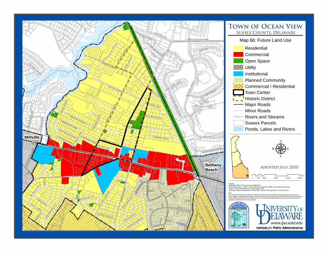
White Creek
17V-2
WOODL
AND A
VENU
E
BETH
ANY L
OOP
TYLE
R DR
IVE
DAISEY AVENUE
BETTS AVENUE
ATLANTIC AVE
17V-15
WEST
RIG
A DRI
VE
CEDA
R NEC
K ROA
D
HUDSON AVENUE
WALKABOUT
KENT AVENUE
GARFIELD PKWY
HOLLY LANE
ATLANTIC AVENUE
FRED HUDSON ROAD
17V-6
FOX TAIL
OYSTER SHELL COVE
ASSA
WOMAN AV
E
CENTRAL AVENUE
GRAN
TS AV
ENUE
ERIE AVENUE
EAST RIGA DRIVE
MITCHE
LL AV
ENUE
MAPLE WAY
ELLIO
TT AV
ENUE
TAYLOR DRIVE
SEABROOK LANE
WEST
AVEN
UE
JUDIT
HS RU
N
D ST
CASEYS WAY
OSPREY LANE
VENTA DRIVE
WEST DRAKE DRIVE
17v-17
EVANS AVE
LAKEVIEW DRIVE
OLD S
CHOO
L LAN
E
PORT ROYAL ROAD
SALLY
LANE
CALGARY AVENUE
NEW CASTLE CT
WILLIAM AVENUE
OAKLAND AVENUEMO
RGAN
S TUR
N
SUSSEX AVENUE
17V-13
COLUMBIA AVENUE
BRIARCLIFFE CT
PINE
LA
WOODS CIRCLE
GARFIELD PARKWAY
HICKMAN DRIVE
C ST
CRIST
Y LA
NE
WOODS LA
SEA HAWK LANE
CAROLINE STREET
SOFT SHELL COVE
LONG
VIEW DR
IVE
VIRGINIA CT
OAKWOOD AVENUE
TINGL
E STR
EET
WADE W
INN ST
REET
CANAL COURT
MARCIS COURT
TAYLOR DRIVE
17v-1
7
Town of Ocean View
Map 6b: Future Land Use
Adopted July 2010
0 420 840 1,260 1,680210Feet
ResidentialCommercialOpen SpaceUtilityInstitutionalPlanned CommunityCommercial / ResidentialTown CenterHistoric DistrictMajor RoadsMinor RoadsRivers and StreamsSussex ParcelsPonds, Lakes and Rivers
µSources:WORKING DRAFT Future Land Use, 08/05/2010.Municipal Boundaries - Office of State Planning Coordination (OMB), downloaded August 2010.Roads - Delaware Department of Transportation, 2008.Hydrology - National Hydrography Dataset (NDH) flowlines and waterbodies, USGS and EPA.Note:This map is provided by the Institute for Public Administration (IPA) solely for display and reference purposes and is subject to change without notice. No claims, either real or assumed, as to the absolute accuracy or precision of any data contained herein are made by IPA, nor will IPA be held responsible for any use of this document for purposes other than which it was intended.
Sussex County, Delaware
Millville
Bethany Beach
26
26^
Top Related