


Languages
Pages
Legal


MINISTRY OF ROAD TRANSPORT AND HIGHWAYS
NATIONAL HIGHWAY AND INFRASTRUCTURE DEVELOPMENT CORPORATION
THE PREPARATORY STUDY FOR NORTH EAST NETWORK CONNECTIVITY IMPROVEMENT
PROJECT (PHASE-3) IN INDIA
PRELIMINARY DESIGN WORK FOR DHUBRI-PHULBARI BRIDGE IN THE STATE OF
ASSAM / MEGHALAYA ON NH-127B (LENGTH OF 20KM)
ENVIRONMENT IMPACT ASSESSMENT MAY 2018
JAPAN INTERNATIONAL COOPERATION AGENCY (JICA)
PADECO CO. LTD.
NIPPON ENGINEERING CONSULTANTS CO., LTD.
PREPARED BY: ENVIRO INFRA SOLUTIONS PVT. LTD
301, 302, & 305, SHREE RAM BUSINESS CENTRE, PLOT NO. INS-12, SECTOR-9, VASUNDHARA, GHAZIABAD – 201012


TABLE OF CONTENTS
CHAPTER 1 Introduction ......................................................................................................... 1
1.1 Background of the project ........................................................................................... 1
1.2 Outline of the project .................................................................................................. 1
1.3 Purpose and Purpose of the Study ............................................................................... 3
1.4 Scope of the Study ...................................................................................................... 3
1.4.1 Geographical Extent ............................................................................................ 3
1.5 Principles of the Study ................................................................................................ 4
CHAPTER 2 Baseline Condition of the Natural and Social Environment ........................... 6
2.1 Natural Environment ................................................................................................... 6
2.1.1 Climate ................................................................................................................ 6
2.1.2 Land Use ............................................................................................................. 7
2.1.3 Geology and Geography.................................................................................... 10
2.1.4 Geohydrology .................................................................................................... 12
2.1.5 Ecology ............................................................................................................. 15
2.2 Living Environment .................................................................................................. 15
2.2.1 Water Quality .................................................................................................... 15
2.2.2 Air Quality ........................................................................................................ 16
2.2.3 Noise and Vibration ........................................................................................... 18
2.2.4 Soil Quality ....................................................................................................... 19
2.3 Socio-economic Environment ................................................................................... 20
2.3.1 Assam State ....................................................................................................... 20
2.3.2 Meghalaya State ................................................................................................ 24
CHAPTER 3 Legal Framework .............................................................................................. 27
3.1 Major Laws and Regulations Relevant to the Project ............................................... 27
3.1.1 The Environment (Protection) Act, 1986 .......................................................... 27
3.1.2 Notification of the Environmental Impact Assessment of Development
Projects .............................................................................................................. 27
3.1.3 Wildlife Protection Act, 1972 ............................................................................ 28
3.1.4 The Biological Diversity Act, 2002 ................................................................... 29
3.1.5 The Forest (Conservation) Act, 1980 (amended in 1988) ................................. 29
3.1.6 The Water (Prevention and Control of Pollution) Act, 1974 ............................. 29
3.1.7 The Air (Prevention and Control of Pollution) Act, 1981 ................................. 29
3.1.8 The Motor Vehicles Act, 1988 ........................................................................... 29
3.1.9 The Land Acquisition Act, Rehabilitation and Resettlement Act, 2013 ............ 30
3.2 JICA/WB/ADB’s Guidelines for Environment and Social Considerations .............. 30
3.2.1 JICA Environmental and Social Guidelines ...................................................... 30
3.2.2 World Bank’s Environment Safeguard Policy ................................................... 31
3.2.3 Safeguard Policy of Asian Development Bank ................................................. 32
3.3 Comparison of JICA/WB/ADB Guidelines and EIA Regulations of India .............. 33
3.4 Central Level Institutions .......................................................................................... 36
3.5 State Level Institutions .............................................................................................. 37
3.6 Requirements of Environmental Clearance ............................................................... 38
3.7 Environmental Standards of India ............................................................................. 39
CHAPTER 4 Analysis of Alternatives .................................................................................... 47

4.1 Alternatives Subject to Analysis ............................................................................... 47
4.2 Criteria for Analysis of the Alternatives .................................................................... 48
4.3 Results of the Analysis of Alternatives ..................................................................... 49
4.3.2 Comparison of bridge alignment options .......................................................... 51
CHAPTER 5 Scoping Analysis ................................................................................................ 54
5.1 Procedures of Scoping Analysis ................................................................................ 54
5.2 Scoping Matrix: Preliminary Analysis of the Environmental Impacts ...................... 54
5.3 TOR of Natural and Socio-economic Environment Survey ...................................... 59
CHAPTER 6 Anticipated Environmental Impacts ............................................................... 63
6.1 Impacts on the living environment ............................................................................ 63
6.1.1 Survey Results ................................................................................................... 63
6.1.2 Anticipated Impacts and Mitigation Measures .................................................. 72
6.2 Natural Environment ................................................................................................. 77
6.2.1 Survey Results ................................................................................................... 77
6.2.2 Anticipated Impacts and Mitigation Measures .................................................. 88
6.3 Major Impacts on Social Environment...................................................................... 91
6.4 Impact Analysis ......................................................................................................... 95
CHAPTER 7 Environmental Management Plan and Monitoring Plan ............................ 101
7.1 Environmental Management Plan ........................................................................... 101
7.2 Environment Monitoring Program ...........................................................................115
7.3 Institutional Arrangement .........................................................................................119
7.4 Grievance Redress Mechanism ................................................................................119
7.5 Monitoring Forms ................................................................................................... 120
7.6 Environmental Management Budget ....................................................................... 125
CHAPTER 8 Stakeholder Consultation ............................................................................... 126
8.1 1st Round Consultation ............................................................................................ 126
8.2 2nd
Round Consultation ........................................................................................... 131
CHAPTER 9 Conclusion and Recommendations ................................................................ 136
9.1 Key issues / Concerns Identified ............................................................................. 136
9.2 Summary of Key Benefits from the project ............................................................ 136
9.3 Recommendations/conclusion ................................................................................. 138
9.3.1 Recommendations ........................................................................................... 138
9.3.2 Conclusion....................................................................................................... 138

Figure 1-1 Project Location ........................................................................................................... 2 Figure 1-2 Project Site ................................................................................................................... 2 Figure 1-3: Geographical Extent of the Environmental Study ....................................................... 4 Figure 2-1: Wind Rose Diagram .................................................................................................... 7 Figure 2-2: Land Use of Assam and Meghalaya State ................................................................... 8 Figure 2-3: Land Use Pattern in 10km radius of the Project Area ................................................. 9 Figure 2-4: Geological map of Meghalaya .................................................................................. 10 Figure 2-5: Geological map of Assam ......................................................................................... 11 Figure 2-6: River Brahmaputra and Geohydrological Map of Dhubri District in Assam ............ 13 Figure 2-7: Geohydrological & River Map of West Garo Hills, Meghalaya ............................... 14 Figure 2-8: Map of Assam State ................................................................................................... 20 Figure 2-9: Map of West Garo Hills District ................................................................................ 24 Figure 3-1: Environmental Clearance Process for Category A Projects ...................................... 28 Figure 4-1: The Alternative Route connects Dhubri and Phulbari by widening of existing NH-31 B
and SH-46 through existing bridge near Goalpara ..................................................... 47 Figure 4-2: Alignment of Two / Four lane bridge between Dhubri and Phulbari ........................ 48 Figure 6-1: Sampling locations for ambient air quality and noise level ...................................... 63 Figure 6-2: Concentration of PM2.5 at locations along proposed Dhubri – Phulbari bridge on
NH-127B .................................................................................................................... 64 Figure 6-3: Concentration of PM10 at locations along proposed Dhubri – Phulbari bridge on
NH-127B .................................................................................................................... 64 Figure 6-4: Concentration of SO2 at locations along proposed Dhubri – Phulbari bridge on
NH-127B .................................................................................................................... 64 Figure 6-5: Concentration of NOX at locations along proposed Dhubri – Phulbari bridge on
NH-127B .................................................................................................................... 65 Figure 6-6: Concentration of CO at locations along proposed Dhubri – Phulbari bridge on NH-127B
65 Figure 6-7: Sampling locations for water and soil quality ........................................................... 66 Figure 6-8: Ambient Noise Quality Results at locations along proposed Dhubri – Phulbari bridge on
NH-127B .................................................................................................................... 71 Figure 6-9: Riverbed Topography around the Dhubri Bridge ...................................................... 87 Figure 7-1: Riverbed Topography around the Dhubri Bridge .................................................... 119 Figure 8-1: Starting location mentioned in the meeting ............................................................. 130 Figure 8-2: Ending location mentioned in the meeting .............................................................. 130 Figure 8-3: Stakeholders/Community Meetings ........................................................................ 135

LIST OF TABLES
Table 2-1: Meteorological Data Parameters at Dhubri district (January – December 2016) ......... 6 Table 2-2: Precipitation of West Garo Hills District in (mm) ........................................................ 7 Table 2-3: Breakdown of the Land Use Pattern in 10km radius of the Project Area ..................... 9 Table 2-4: Results of Water Quality Analysis .............................................................................. 16 Table 2-5: Results of Air Quality Analysis ................................................................................... 16 Table 2-6: Ambient Noise Level in the Study Area...................................................................... 19 Table 2-7: Results of Soil Quality Analysis ................................................................................. 19 Table 2-8: Demographics of Assam State and Districts in the Project Site .................................. 21 Table 2-9: Scheduled Caste and Scheduled Tribe in Assam State ............................................... 21 Table 2-10: Economic Trend in Assam State ............................................................................... 22 Table 2-11: Workers Ratio in Assam State ................................................................................... 22 Table 2-12: Demographics of Char Area in Dhubri / South Salmara-Mankachar district ........... 23 Table 2-13: Demographic Situation of Meghalaya State ............................................................. 24 Table 2-14: Population Ratio of Scheduled Caste and Scheduled Tribes .................................... 25 Table 2-15: Economic Trend of Meghalaya State ........................................................................ 25 Table 2-16: Workers Composition in Meghalaya State ................................................................ 25 Table 3-1: Comparison between JICA Guideline and Laws in India regarding EIA ................... 34 Table 3-2: Applicable Environmental Clearance.......................................................................... 39 Table 3-3: Standards for Ambient Air Quality ............................................................................. 40 Table 3-4 Ambient Air Quality Standard by WHO ...................................................................... 41 Table 3-5: Vehicle Emission Standards (1991 to Date) ................................................................ 42 Table 3-6: Water Quality .............................................................................................................. 42 Table 3-7: Water quality standard for international EHS Guideline ............................................ 43 Table 3-8: Fuel Quality ................................................................................................................ 44 Table 3-9: Noise Standard for Diesel Generator .......................................................................... 44 Table 3-10: Vehicle Emission Standards (1991 to Date) .............................................................. 45 Table 3-11: Noise Emission Standards ......................................................................................... 45 Table 3-12: Ambient Noise Standards .......................................................................................... 46 Table 4-1: Criteria for the Evaluation of the Alternatives ............................................................ 48 Table 4-2: Analysis of alternatives ............................................................................................... 50 Table 4-3: Location of Nodes for the Bridge Alignment Alternatives ......................................... 51 Table 4-4 Evaluation Criteria ....................................................................................................... 52 Table 4-5 Evaluation and Comparison of the Alternatives ........................................................... 53 Table 5-1: Scoping Matrix for the Proposed Bridge Option ........................................................ 55 Table 5-2: TOR of Natural and Socio-economic Environment Survey ........................................ 60 Table 6-1: Ambient Air Quality along proposed Dhubri – Phulbari bridge ................................. 63 Table 6-2: Water quality (Surface and Ground water) along proposed Dhubri – Phulbari Bridge on
NH-127B .................................................................................................................... 67 Table 6-3: Soil quality (Surface and Ground water) along proposed Dhubri – Phulbari Bridge on
NH-127B .................................................................................................................... 69 Table 6-4: Noise Levels along proposed Dhubri – Phulbari Bridge on NH-127B ....................... 71 Table 6-5: Typical Noise Levels of Construction Equipment ...................................................... 75 Table 6-6: Domesticated agro-biodiversity in the Study Area ..................................................... 78 Table 6-7: Plant Biodiversity in the Study Area ........................................................................... 79 Table 6-8: Invasive Alien Plants in the Study Area ...................................................................... 80 Table 6-9: Animal biodiversity in the Study Area ........................................................................ 81 Table 6-10: Hydraulic Parameters ................................................................................................ 87 Table 6-11: Distribution of vulnerable and other important species in the project area ............... 89 Table 6-12: Summary of Households Affected ............................................................................ 91 Table 6-13: Health and Safety Measures ...................................................................................... 94 Table 6-14: Scoping and Survey Result ....................................................................................... 95 Table 7-1: Environmental Management Plan for Pre-Construction Stage ................................. 102 Table 7-2: Environmental Management Plan for Construction Stage ........................................ 103

Table 7-3 Environmental Management Plan for Operation Stage ......................................... 113 Table 7-4: Environmental Monitoring Plan ............................................................................... 116 Table 7-5: Environmental Clearance .......................................................................................... 120 Table 7-6: Air Quality ................................................................................................................ 120 Table 7-7: Water Quality ............................................................................................................ 121 Table 7-8: Solid Waste ............................................................................................................... 121 Table 7-9: Noise and Vibration .................................................................................................. 121 Table 7-10: Topography and Geology ........................................................................................ 122 Table 7-11: Biodiversity ............................................................................................................. 122 Table 7-12: Resettlement ............................................................................................................ 123 Table 7-13: Land Use ................................................................................................................. 123 Table 7-14: Utilization of Local Resources ................................................................................ 124 Table 7-15: Unequal Distribution of Benefit and Damage ......................................................... 124 Table 7-16: Water Use ................................................................................................................ 124 Table 7-16: Gender ..................................................................................................................... 124 Table 7-17: Public Health ........................................................................................................... 124 Table 7-18: Occupational Health and Safety .............................................................................. 124 Table 7-19: Accident .................................................................................................................. 124 Table 7-20: Budget for EMP Implementation ............................................................................ 125 Table 8-1: Location and Dates of Stakeholder meetings ............................................................ 126 Table 8-2: Discussion in Stakeholder Meetings ......................................................................... 127 Table 8-3: Location and Dates of Community meeting ............................................................. 128 Table 8-4: Discussion in Community meetings ......................................................................... 128 Table 8-5: Location and Dates of Focus Group Discussions ..................................................... 130 Table 8-6: Topics in Focus Group Discussions .......................................................................... 131 Table 8-7: Details of the Second Round Consultation Meetings ............................................... 132 Table 8-8: Participation Details of the Second Round Consultations ........................................ 132

ABBREVIATIONS
ADT Average Daily Traffic
BRDB Border Roads Development Board
BRO Border Roads Organization
COD Chemical Oxygen Demand
CPCB Central Pollution Control Board
DOEF Departments of Environment and Forests
DOF Department of Forest
DPR Detailed Project Report
EIA Environmental Impact Assessment
EMP Environmental Management Plan
GHG Green House Gas
GOI Government of India
GSDP Gross State Domestic Products
IRC Indian Road Congress
MOEFCC Ministry of Environment, Forests & Climate Change
MORTH Ministry of Road Transport & Highways
NABL National Accreditation Board for Laboratories
NHAI National Highway Authority of India
NHIDCL National Highways and Infrastructure Development Corporation
NOAA National Oceanic and Atmospheric Administration
NOC No-objection Certificates
PAPs Project Affected Persons

PCU Passenger Car Unit
PIU Project Implementation Unit
PUC Pollution under Control Certificate
PWD Public Works Department
RAP Resettlement Action Plan
RO Regional Offices
ROB Road over Bridge
ROW Right of Way
SC Supervision consultants
SPCBs State Pollution Control Boards

1
CHAPTER 1 Introduction
1.1 Background of the project
In India, roads are one of most important modes of ground transportation as they constitute 85% of
passenger transportation and 60% of freight transportation in India. However, the development of
the road network in mountainous regions of the Northeastern Region of India has been much worse
than the rest of the country. This is due to financial and technical reasons. Thus, the Northeastern
Region has suffered greater economic disparity compared to other regions.
While 63.4% of the roads in India have been paved, only 28.5% of the roads in Northeastern
Regions are paved, out of which only 53% of the national highways are more than 2 lanes. This is
because the Northeastern Region is located far from the major areas of India. Furthermore, the
roads leading to neighboring countries have been underdeveloped due to security concerns.
The severe natural conditions of the Northeastern Region featured by steep mountains and a
prolonged monsoon season have also been obstacles for appropriately developing the road network.
Economic growth in this part of the country has therefore been very delayed. The regional
connectivity of the road network should promote cross-border trade and commerce and help
safeguard India’s international borders. This would lead to the formation of a more integrated and
economically consolidated South and Southeast Asia. In addition, there would be overall economic
benefits for the local population and would promote the integration of the peripheral areas.
The approximate aggregate length of 10,000km of road in the Northeastern Region has been
identified for development. The development of the road network envisages creating customized
and specialized skills addressing issues like the complexities of geographical terrains and the
extensive coordination with the central and state governments.
The Government of India (GOI) thus launched in recent years the “Special Accelerated Road
Development Program for Northeastern Region” for which improvement of the road network is of
great importance. The GOI stated in their “Twelfth Five Year Plan (from April, 2012 to March,
2017)” that the improvement of national highways in the Northeastern Region should interconnect
major cities within the region. It is within this context that the GOI requested that the Government
of Japan provides assistance in the carrying out of the design work of two/four lane bridge
including approaches over river Brahamputra between Dhubri on the north bank and Phulbari on
the south bank in the State of Assam / Meghalaya on NH-127B (length of 20km).
1.2 Outline of the project
The proposed Dhubri bridge will cross the Brahmaputra River and will be a 20-km long, four-lane
bridge connecting Dhubri in the Assam State on the north bank and Phulbari in the Meghalaya State
on the south bank. The construction site extends over two states, the Dhubri District on the north
bank and the South Salmara-Mankachar District on the south bank belong to Assam State and the
West Garo Hills Distrct belongs to Meghalaya State. It extends from the starting point (89 ° 55
'45.68 "E & 26 ° 2' 10.49" N) towards the southeast, crossing over the Brahmaputra River and some
of the sandbars reaches the south end point (90 ° 1 '59.11 "E & 25 ° 53' 25.98" N).
The locality is a flat lowland with an altitude of 35 m to 42 m. Approximately 500 km from the
mouth of Brahmaputra river, annual flow rate 571 × 109 m 3, flow rate 18,099 m 3 / s, flow rate
varies greatly in the rainy season dry season and place, but on average 1 m / s in the vicinity of
Duburi, the water depth at the deepest part across the bridge is about 10 m in the rainy season about
4 meters in dry season. The banks are naturally sloped towards the river. The yearly sediment load
of the Brahmaputra River is 800 million tons. The sandbars are made of sand accumulated by the
flooding of the river, and thierlocations and sizes are not constant due to hydrodynamic activity of
the river. Some of the sandbars are inhabited by the local people conducting mainly agriculture,
farming, fishing etc. Currently 20 to 30 small boats operate between Dhubri and Pulbari and to
carry people and goods, but the time required to cross the river is about 2.5 hours.

2
A new bridge connecting Dhubri and Phulbari across the Brahmaputra river will improve the
connectivity of the road and is the most important section. The construction of the new bridge will
further connect the southwestern region of Meghalaya State and other parts of India at the shortest
distance, and will greatly expand the transportation network of this region.
Figure 1-1 Project Location
Figure 1-2 Project Site

3
1.3 Purpose of the Study
As per the MOEF & CC EIA Notification, dated 14.09.2006 (as amended in August 2013), any
highway project falls under Category A if the project entails:
1) New National Highways; and
2) Expansion of National Highways greater than 100km involving additional right of way or land
acquisition greater than 40m on the existing alignments and 60m on re-alignments and bypasses.
The proposed Dhubri-Phulbari Bridge project does not require additional land acquisition beyond
60m and has length of approximately 20kmkm. and therefore, does not attract the provisions of the
EIA Notification of 2013.
While a DPR consultant undertook a preliminary environmental assessment during the preparation
of the DPR for Dhubri-Phulbari Bridge, the project does not require environmental clearance from
MOEF & CC. On the other hand, the project has been classified as Category A per JICA’s
Guidelines for the Environmental and Social Considerations and the project requires a full EIA
study including SIA and RAP surveys.
It is therefore the JICA Study Team’s obligation to carry out EIA/SIA/RAP studies, which
supplement the environmental studies carried out by DPR consultants. Thereby additional
requirements short of JICA’s guidelines are fulfilled.
The EIA/SIA/RAP studies carried out by JICA Study Team aimed to:
Review the environmental assessment undertaken as part of the DPR study;
Identify gaps between Indian laws and regulations relating to the EIA study and JICA
Guidelines for Environmental and Social Considerations;
Study the baseline of social and environmental conditions along the areas directly and
indirectly affected during design, construction operation and maintenance of the NH40
widening project;
Carry out environmental impact analysis with respect to the proposed project;
Identify environmental issues that require further studies;
Carry out an analysis of alternatives including a comparison with a “no project’ scenario;
Develop cost effective measures for mitigating adverse environmental and social impacts
and enhancing positive aspects;
Develop an Environmental Management Plan (EMP) for the mitigation of environmental
impacts and the monitoring of the implementation of mitigation measures during the
operation and maintenance period;
Consult and inform the project affected persons (PAPs) and other stakeholders concerned
with the project to encourage their active participation.
1.4 Scope of the Study
1.4.1 Geographical Extent
The geographical extent of this study is the area within a 10km radius of the proposed bridge
alignment as shown in the Figure below.

4
Source: JICA Study Team
Figure 1-3: Geographical Extent of the Environmental Study
1.5 Principles of the Study
(1) Study Components of Natural Environment and Socio-economic Environment
This bridge construction project entails to some extent a negative impact on the natural
environment as well as a social impact including a relatively large-scale resettlement. The survey
covers not only direct and immediate impact but also secondary and cumulative impacts in
accordance with JICA guidelines. The survey items include air, water, soil, waste, ecology,
involuntary resettlement, the poor, livelihood, occupational safety, etc.
(2) Legal Framework Related to the Project
The legal framework and principles adopted for environment and social consideration of the project
have been guided by the existing legislation and policies of the Government of India (GOI), the
State Government of Assam and Meghalaya. Since the project is considering getting assistance
from JICA, the regulatory/legal framework should be consistent with the national, state, local, as
well as JICA Guidelines for Environmental and Social Considerations.
(3) Scope of Resettlement
This project extends to two states, the Assam and Meghalaya states, across the Brahmaputra River.
The Char lands (sand bars) in the Brahmaputra River which belong to the Assam state will also be
within the scope of land acquisition and resettlement. The Char lands are unique in that the shapes
change according to the changes in water level. The area of the Char lands becomes smaller due to
a rise in water level during the rainy season (May to October) and expands in dry season
(November to April). In this survey, a census survey was carried out based on the list of villages

5
and land plots prepared by the district governments from the land acquisition map produced by
DPR consultant (prepared in June 2016). A Resettlement Action Plan (RAP) will be prepared in
accordance with relevant Indian laws and regulations, World Bank’s safeguard policy and JICA
guidelines.

6
CHAPTER 2 Baseline Condition of the Natural and Social Environment
2.1 Natural Environment
2.1.1 Climate
The Dhubri district enjoys a subtropical humid climate with temperatures ranging between 10.5°C
(minimum, in December/January) and 30°C (maximum, in July/August). A south west monsoon
activates from May and continues up to September/October. The average annual rainfall of the
district, as recorded in Dhubri, is 2,363mm with about 65% of rainfall occurring during the
monsoon. The monthly evapotranspiration is about 40% of the rainfall, with the highest in August
and lowest in January.
The West Garo Hills district has a mildly tropical climate. The climate of the district is largely
controlled by the southwest monsoon and seasonal winds. The district being relatively lower in
altitude compared to the rest of Meghalaya, experiences a fairly high temperature for most of the
year. The average rainfall is 4203.8 mm, of which more than two-thirds occurs during the monsoon,
with winter being practically dry. The district receives fairly high rainfall throughout the year. Most
of the precipitation occurs during the rainy season, i.e. between April and October, due to the
southwest monsoon. The average rainfall recorded at the Tura meteorological station is presented in
the Table below.
Generally, light to moderate winds prevail throughout the year with speeds ranging from 1 to
26.5kmph. Winds were light and moderate particularly during the morning hours, while during the
afternoon hours the winds were stronger. The wind rose diagram developed during October -
November (2016) shown in Figure 7-1 reveals that the pre-dominant wind direction occurs from the
north-east direction in the Dhubri district with an average wind speed of 7.2 kmph.
The following Table 7-2 shows the Meteorological Data Parameters in the Dhubri district (January
– December 2016).
The wind speed and direction data have been collected for Guwahati from the Indian Metrological
Department (IMD) during January - December 2016 and wind rose diagram has been prepared and
shown in Figure 7-1.
Table 2-1: Meteorological Data Parameters at Dhubri district (January – December 2016)
Date
Temperature, deg C
Humidity, % Pressure, hPa
Wind
Speed,
km/Hr
Predo-
Minant
Wind
Direction
Rainfall
mm
Min Max Avg Min Max Avg Min Max Avg Avg
January 9.3 26.3 17.8 63 86 74.5 1009.7 1013.6 1011.65 4.8 NE 6.7
February 10.2 30.2 20.2 52 76 64 1007.1 1013.4 1010.25 5.6 N 6.6
March 13.4 35.8 24.6 48 68 58 1003.9 1011.2 1007.55 7.7 E 42.5
April 17.2 36.7 26.95 62 74 68 1000.9 1008.6 1004.75 11 NE 133.2
May 19.2 35.3 27.25 75 82 78.5 998.3 1005.7 1002 10.1 NE 340.4
June 21.7 35.2 28.45 83 89 86 995.2 1002.3 998.75 8.6 E 514.2
July 22.8 34.1 28.45 54 87 70.5 994.7 998.2 996.45 6.9 E 432.5
August 23.4 34.2 28.8 52 85 68.5 996.2 997.6 996.9 6.6 NE 368.2
September 22.3 24.5 23.4 86 83 84.5 999.5 1003.2 1001.35 6.4 NE 263.7

7
October 19.5 32.6 26.05 78 84 81 1004.5 1006.1 1005.3 6.9 NE 140.5
November 14.1 29.3 21.7 72 82 77 1007.5 1011.3 1009.4 7.4 NE 18.7
December 10.5 25.8 18.15 66 86 76 1008.6 1013.2 1010.9 5.7 NE 3.4
Source: IMD
Source: IMD
Figure 2-1: Wind Rose Diagram
Table 2-2: Precipitation of West Garo Hills District in (mm)
Source: http://cgwb.gov.in/
2.1.2 Land Use
Current land use of the project’s surrounding areas in Assam and Meghalaya State is shown in the
following Figure. The majority of the areas in both Assam and Meghalaya State are agriculture land
(yellow), forest deciduous (light green) and wastelands/shrublands (pink).
Jan Feb Mar Apr May Jun Jul Aug Sep Oct Nov Dec Total
22.1 14.7 105 269 514 889 910 643 502 298 13.3 24.2 4203.8

8
Source: bhuvan.nrsc.gov.in
Figure 2-2: Land Use of Assam and Meghalaya State
Figure 7-4 and Table 7-3 show the land use of a 5km radius of the project site. The area is
composed of 45% agricultural land (yellow), 35% Brahmaputra River (light blue) and build up
areas including residential structures (red) remains at 4%. The starting point of the approach road in
the Dhubri District is planned to pass by the side of the residential area.

9
Source: Prepared by EIS based on Resourcesat I LISS-III
Figure 2-3: Land Use Pattern in 10km radius of the Project Area
Table 2-3: Breakdown of the Land Use Pattern in 10km radius of the Project Area
Sl.No. Land Use Class % of Class
1 Proposed bridge 0.5%
2 Other Water bodies 1.5%
3 Forest Plantation 2.0%
4 Agriculture Plantation 2.0%
5 Barren Unculturable Wasteland 3.0%
6 Built up Urban 2.0%
7 Built up Rural 2.0%
8 Agriculture Crop Land 45.0%
9 Forest Deciduous 7.0%
10 Brahmaputra River 35.0% Source: Prepared by EIS based on Resourcesat I LISS-III

10
2.1.3 Geology and Geography
The proposed bridge alignment passes over the river Brahmaputra between Dhubri on the north
bank and Phulbari on the south bank in the State of Assam and Meghalaya. The topography of the
Dhubri/ South Salmara - Mankachar district is very peculiar. It has many rivers, small ranges of
hillocks as well as several natural depressions. Physically, the greater part of the district is levelled
plain land. Whereas in the West Garo Hills district with its undulating topography, the district
constitutes the vast alluvial plains of the Brahmaputra River system. The monotony of the flat
alluvial tract is interrupted by the presence of Archaean inliers in the form of disconnected hillocks
referred to as inselbergs, and these occur especially in the eastern and southern parts of the district.
Source: Department of Mining & Geology, Government of Meghalaya
Figure 2-4: Geological map of Meghalaya

11
Source: Department of Mining & Geology, Government of Assam
Figure 2-5: Geological map of Assam

12
The Soil type of an area is dependent on factors like geology, relief, climate and vegetation. The
soil of the Dhubri/South Salmara - Mankachar district has been found to be heterogenous in
character. Most of the places, particularly the riverine identifies that loamy to sandy-loam soil is
predominant. In some areas, clay to heavy clay soil are also present. Soil reaction is acidic and
found to vary from 5.6 to 6.5 in pH scale. Whereas in greater parts of West Garo Hills district Soils
are sandy and silty loam, or clay loam. It is found to be highly acidic to slightly alkaline in nature,
is moderately permeable and characterised by the presence of low organic carbon and low soluble
salts. Soils restricted to inselberg areas are more clayey, lateritic, less permeable and are highly
acidic in nature. From an agricultural point of view, the soils in major parts of the area are suitable
for all sorts of crops cultivation.
In the proposed Dhubri – Phulbari bridge of the study area, loamy to sandy-loam soil is
predominant. In some areas, clay to heavy clay soil also present.
2.1.4 Geohydrology
The Dhubri / South Salmara-Mankachar district covers an area of 1664.10 sq.km. It is situated in
the extreme south-west corner of the state and has an international boundary with Bangladesh in the
west and south west and is bounded by the Kokrajhar district in the north, Goalpara district in the
east and north-east, the Garo Hills district of Meghalaya in the south and the Kochbehar and
Jalpaiguri districts of West Bengal in the north-west.
Surface Water source in the Dhubri / South Salmara - Mankachar District:
The district spreads on both sides of the Brahmaputra River. A number of perennial streams flow
through the district from north to south and join the Brahmaputra River. The major streams that
drain the area are the Gadadhar, Sankosh, Silai and Gouranga Rivers. A River map showing the
regions of Dhubri and South Salmara – Manakchar is given below in Figure. 7-7.
Ground Water source in the Dhubri / South Salmara - Mankachar District:
Ground water conditions in the district can be described using either of two distinct
hydrogeological units, i.e. conditions prevailing in the consolidated formations, and the conditions
prevailing in the unconsolidated formations. The net ground water availability estimated in the year
2009 is 1635.61 mcm. The existing gross ground water draft is 181.12 mcm and the stages of
development are 11% only. Future provision for domestic and Industrial use is 65.35mcm and for
Irrigation use is 1432.85 mcm. A Hydrogeological map showing the regions of Dhubri and South
Salamara - Manakchar is given below in Figure. 7-7.
Surface Water source in the West Garo Hills District:
The topography controls the drainage system as it divides the state into two watersheds, namely the
Brahmaputra system in the North and the Meghna /Surma system in the South. The Tura system
range from watersheds in the West Garo Hills district, from which the rivers flow towards the
Bangladesh plains in the south and the Brahmaputra valley in the north and west. A River map
showing the regions of West Garo Hills district is given below in Figure. 7-8.
Ground Water source in the West Garo Hills District:
Hydro-geologically, the district can be divided into three units, namely, consolidated, semi
consolidated and unconsolidated formations. The depth of the water level varies from 0.53 m bgl to
8.3 m bgl. The aquifer comprises sand and sand with gravel, while clay forms leaky aquitard. The
maximum cumulative aquifer thickness is encountered around Ichaguri, Borkona, Barengapara and
Betasing in alluvial areas of the West Garo Hills district. The granitic basement is encountered at a
very shallow depth (less than 50 m.bgl) in the northern part of the district, while in the western and
southern part of the district; basement has not even met a depth of 225 m.bgl. A Hydrogeological
map showing the regions of the West Garo district is given below in Figure. 7-8.

13
Source: http://dhubri.gov.in/DMPLan & http://cgwb.gov.in
Figure 2-6: River Brahmaputra and Geohydrological Map of Dhubri District in Assam
Study Area

14
Source: http://cgwb.gov.in & http://bhuvan.nrsc.gov.in/
Figure 2-7: Geohydrological & River Map of West Garo Hills, Meghalaya

15
2.1.5 Ecology
Interviews with the DPR Consultants and Dhubri District Forest Department have confirmed that
there are no national parks, nature reserves or protected forests around the planned site of
construction. The land portion of the Study area is mainly used as an agricultural land and
residential area, so there is no primary forest or pristine ecosystem. However, the Brahmaputra
River is a habitat for the Ganges river dolphins, and several of them were observed during the field
survey.
The Ganges River dolphin belongs to the Platanistidae Family, and inhabits freshwater areas.
Internationally it is a protected organism classified as Endangered in the IUCN Red List and further
described in the CITES Appendix I. In India, it is designated as a protected species (Schedule I) by
the Indian Wildlife Law (1972), and it is positioned as a National Aquatic Animal as a symbol of
India. Its habitat extends to four countries- India, Bangladesh, Nepal and Bhutan; and lives only in
limited areas of the Ganges River, Brahmaputra River, and its tributaries (the Meghna River,
Karnaphuli River, Sangu River, etc.). The number of inhabitants in the whole world was estimated
to be 4,000 to 5,000 in the 1980s, and 2000 in the 1990s; but it is estimated to have been about
1,200 in 2012, the decrease remarkable. The main reasons for the decrease in population are the
loss of species that act as prey to the dolphins due to poaching, bycatch, over catching, water
pollution, and division of habitat due to dam construction and topography modification of the river
through inflow / extraction of sediment.
(1) The Biological Diversity Act, 2002
The Biological Diversity Act is a law stipulated on the conservation, utilization, and benefit sharing
of genetic resourcest and the Biodiversity Board has been established for each state based on this
law. The main function of the Board is to give appropriate advice to the state government on issues
concerning biodiversity conservation. The designation of Biodiversity Heritage Sites is also
stipulated.
As a national policy for conserving biodiversity, the National Biodiversity Action Plan was
formulated in 2008, which covers the conservation of biodiversity, its sustainable use, the equal
distribution of profits arising from the use of biodiversity, the protected area network focused on
the conservation of species, and so forth. Furthermore, it recognize the importance of regulation
on the introduction of alien species, eradication of alien species, and consideration on biodiversity
in economic development projects. Assam State has formulated the state forest policy in 2004,
among which, in addition to conservation and recovery of forests, strengthening of protected area
network, conservation of wetlands, conservation of wetlands, conservation of wildlife as ways to
preserve biodiversity preservation of habitats of living beings, promotion of research and research,
etc. are listed.
For the sake of aquatic organisms living in the Brahmaputra river including in the Ganges Dynasty,
it is necessary to carefully examine the impact of the implementation of the project, especially after
conducting detailed surveys in the future.
2.2 Living Environment
2.2.1 Water Quality
There are many low wetlands around the planned construction site, and the Brahmaputra River
which also boasts abundant water flow also flows. The turbidity of the Brahmaputra River was very
high at the time of field survey in October 2016. As seen in other states in India, unprocessed
domestic wastewater flows into the Brahmaputra River, and there are the residents who are bathing
in the river and washing. As a result, some degree of artificial contamination (especially organic
matter, etc.) is occurring. Sampling and analysis of the surface water and groundwater was
conducted by the DPR survey in March 2016, and the results are shown below. The number of
microorganisms exceeds the environmental standard, but others are within the reference value.
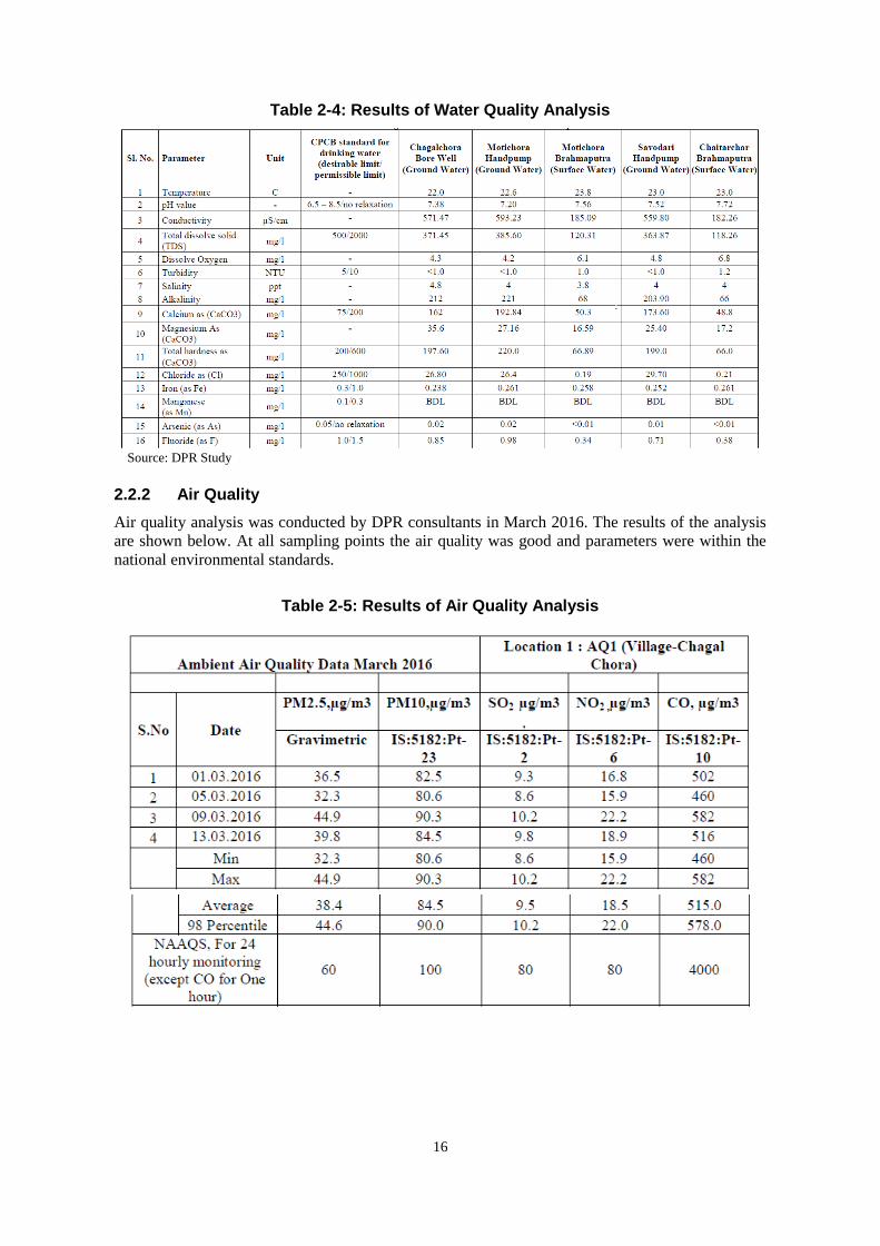
16
Table 2-4: Results of Water Quality Analysis
Source: DPR Study
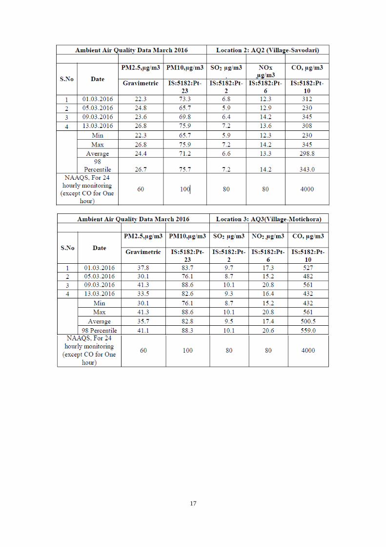
2.2.2 Air Quality
Air quality analysis was conducted by DPR consultants in March 2016. The results of the analysis
are shown below. At all sampling points the air quality was good and parameters were within the
national environmental standards.
Table 2-5: Results of Air Quality Analysis
17

18
Source: DPR Study
2.2.3 Noise and Vibration
According to the DPR Study, the ambient noise level in the study area is below the national
environmental standard. There is no data for vibration.

19
Table 2-6: Ambient Noise Level in the Study Area
Source: DPR Study
2.2.4 Soil Quality
During the DPR Study, soil samples were collected from 4 locations and analyzed. The result is
as follows.
Table 2-7: Results of Soil Quality Analysis
Source: DPR Study

20
2.3 Socio-economic Environment
This project is located in the Dhubri District and South Salmara-Mankachar District of Assam State
and the West Garo Hills District in Meghalaya State. The western end of the bridge is at Dhubri and
it goes across the Brahmaputra River and ends at Phulbari in the north of West Garo Hills. There
are Char lands formed in the Brahmaputra River by the sand/silt from the upper stream. This Char
land also belongs to the Dhubri and South Salmara-Mankachar Districts.
2.3.1 Assam State
1) Administrative Division
Assam State is located in the northeastern part of India and is bounded on the north by Bhutan and
the west by Bangladesh. The Dhubri and South Salmara-Mankachar Districts are situated in the
extreme western corner of Assam State. Administratively, the Dhubri District has two sub-divisions
namely Dhubri and Bilasipara along with eight revenue circles and seven tehsils. The South
Salmara-Mankachar District is a newly formed district carved out from the Dhubri District in 2015
and officially became an administrative district in February 2016. It was formerly a sub-division of
the Dhubri District. The South Salmara-Mankachar District has 2 revenue circles and 2 tehsils.
The distance from Dhubri town to the capital of Assam State, Dispur is approximately 290km. The
distance between Hasingmari town, the capital of South Salmara-Mankachar District located across
the Brahmaputra River, and Dispur is approximately 245km by the route through Meghalaya State.
Source: JICA Study Team
Figure 2-8: Map of Assam State
2) Demographic Situation
The total area of the Dhubri District is 2,176km2 with the population of 1,949,258. The population
density is 896 persons/km2, which is more than double compared to the Assam State average (398
people/km2). The population growth during 2001-2010 is 24.4% which is much higher than the
Assam State average (17.1%). The literacy rate of the Dhubri District is 58.3% which shows quite a
lower rate than that of the state average (72.2%).
The South Salmara-Mankachar District covers 568kmkm2, holding a population of 555,114. Out of
which, rural population consists of around 95%. The population density of the district is 869
South
Salmara-Mankachar
Dhubri

21
persons/km2, which is similar to the Dhubri District. The literacy rate is 39.9%, which is
significantly low compared to the state average as mentioned above.
The following Table shows the demographic data of Assam State and two districts in the project
sites.
Table 2-8: Demographics of Assam State and Districts in the Project Site
Item Assam State Dhubri District
South
Salmara-Mankachar
District
Area (km2) 78,438 2,176 568
Population (no.) 31,205,576 1,949,258 555,114
Male-female ratio (no.) (1,000 men) 958 953 ―
Population density (ppl/km2) 398 896 869
Population growth rate (2001-2010) 17.1% 24.4% ―
Urban population 14.1% 10.5% 4.7%
Literacy rate 72.2% 58.3% 39.9% Source: Census 2011
3) Ethnic Group and Religion
Assam State is home to the Assamese, Bodo and Ahom people. The official languages used in
Assam State are Assamese and Bodo. Other than that, Bengali is also used in the project area which
is similar to Assamese. The following Table shows the population ratio of the Scheduled Caste
(SC)1 and Scheduled Tribe (ST)
2 . The ratio is lower in the Dhubri District and South
Salmara-Mankachar District compared to the Assam state average. Based on the survey, it is
confirmed that minority groups, including the Bodo tribes3, are not included in the project affected
households.
Table 2-9: Scheduled Caste and Scheduled Tribe in Assam State
Item India average Assam State Dhubri District
South
Salmara-Mankachar
District
SC population 16.2% 7.2% 3.6% 1.4%
ST population 8.2% 12.5% 0.3% 1.8% Source: Census 2011
The Dhubri District has a large population of Muslims. Approximately 80% of the population is
Muslim and the remaining 20% is Hindu. The South Salmara-Mankachar District is also Muslim
dominant, composed of 95% Muslims and 5% Hindu.
4) Economy and Industry
The GSDP of Assam State in 2013-14 accounts for Rs. 885.4 billion and per capita GSDP is Rs.
50,558. The average annual growth rate during the past 10 years was approximately 6%. Industry
wise ratio of GSDP in 2013-14 shows that service sector accounts for 60%, agriculture and industry
sector shares 20% respectively. The shares of the agriculture and industry sectors have been
decreasing over the past 10 years while the contribution of the service sector is increasing.
1 Scheduled Caste (SC) refers to the group of people formerly known as Dalit (the lowest class in Hindu society)
designated by the Indian Constitution. 2 Scheduled Tribe (ST) is a group of tribes designated by the Indian Constitution who has a distinctive culture, are
geographically isolated and are socio-economically lagging. 3 For a reference, the Bodo tribe is one of the tribes designated in the sixth schedule in India having its roots in
Tibeto-burman languages and call themselves “Bodosa”. A majority of the Bodo tribe are Hindu. The Bodo tribe
continued armed conflict for their political independence, and Bodoland Autonomous Council was established in western
Assam in 1993, and Bodoland Territorial Autonomous District was established in 2003.

22
Sector-wise annual growth rate is 3.8% for agriculture, 2.8% for the industry sector and growth of
the service sector is the highest at 10.3%.
Table 2-10: Economic Trend in Assam State
Item 2004-05 2008-09 2013-14 Annual growth
(10year average)
GSDP (Rs. in billion) 534.0 640.3 885.4 6.6%
Ratio in GSDP Agriculture (%) 25.6 23.4 21.3 3.8%
Industry (%) 27.5 25.9 21.3 2.8%
Service (%) 46.9 58.1 57.5 10.3% Note: GSDP in Constant Price (2004-05)
Source: Planning Commission, Government of India
The composition of workers shows that majority of the workers in Assam State are engaged in
agriculture related work accounts for 56.2% out of which 25.6% are the landless agriculture labors.
At the project site, a majority of the population is cultivating paddies along with pulses and
vegetables, in the Char land jute is also one of the major crops. In this area, animal husbandry,
fishery and boat operation are also the income source for the population.
Table 2-11: Workers Ratio in Assam State
Item Assam State Dhubri District
Worker population (%) 38.4 34.4
Cultivator (%) 33.9 30.7
Agriculture worker (%) 15.4 25.6
Domestic worker (%) 4.1 4.2
Other worker (%) 46.6 39.7 Source: Directorate of Census Operations Assam, 2011
5) Char Lands
One of the peculiar features of the Brahmaputra River which flows in Assam State is the presence
of riverine silt islands (the Char lands). The geographical spread of the Char lands is over 14
districts of Assam State and the major part of the project area falls under these Char lands.
The landform of the Char lands changes according to the erosion and deposition of silts and sands
over the years. The areas also change in size and shape due to the changes of water level in the
rainy season (May to October) and dry season (November to April). The origin of the populations
in the Char lands dates back to the colonial period when the British administrators induced a large
number of agriculture labors from East Bengal (former Bangladesh). Due to this historical
background, the majority of the population in the Char lands is Muslim.
The official surveys focused on the Char lands were carried out in 1992-93 and 2003-04. According
to the survey in 2003-044 , the total population of the Char lands is 2,490,097 and the population in
Dhubri and the South Salmara-Mankachar District alone (former the Dhubri District) is 689,909.
The result of those surveys shows that the Char lands represents one of the most backwards areas in
the state showing high population growth, high poverty level and a low literacy rate. The population
of Below Poverty Line (BPL) is 69% and a literacy level is 14.6%; both of which have worsened in
10 years.
4 Socio-Economic Survey Report, 2003-04, Directorate of Char Areas Development, Govt. of Assam.

23
Table 2-12: Demographics of Char Area in Dhubri / South Salmara-Mankachar district
Year Population Population Growth Household BPL Household Literacy
1992-93 233,206 - - 54.2% 19.1%
2003-04 689,909 51.1% 109,748 69.0% 14.6% Source: Socio-Economic Survey Report, 2003-04, Directorate of Char Areas Development, Govt. of Assam
In some areas, there are land registration records and private lands are allocated to villagers in the
Char lands. However, the villagers in the Char lands are living in movable temporary structures so
that they’re able to shift their locations as necessary. Based on the interview survey conducted
during the site visits, villagers who live on the land that will be under water during the rainy season
will move their location to a neighboring area or other village in the Char land. During the dry
season, some come back to the original place and others continue to stay in the shifted land.
Temporary residents in the Char Land
Erosion of the Char Land
In terms of basic amenities in the villages of the Char lands, hand pumps are introduced in some
areas and some areas are sourcing the drinking water from the river. In a majority of the areas,
electricity and sewage systems are unavailable. Lower primary and middle schools are established
in the villages, however for higher education, the children must go to nearby towns. Medical
sub-centres were provided in some areas, however, there are only visiting doctors available. The
infrastructures and facilities are very much limited in those areas.
Hand pump in Char land
Primary School in Char land
24
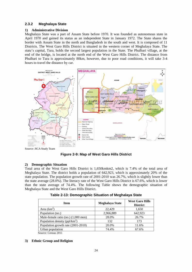
2.3.2 Meghalaya State
1) Administrative Division
Meghalaya State was a part of Assam State before 1970. It was founded as autonomous state in
April 1970 and gained its status as an independent State in January 1972. The State shares the
border with Assam State in the north and Bangladesh in the south and west. It is composed of 11
Districts. The West Garo Hills District is situated in the western corner of Meghalaya State. The
state’s capital, Tura, holds the second largest population in the State. The Phulbari village, at the
end of the bridge, is located at the north end of the West Garo Hills District. The distance from
Phulbari to Tura is approximately 80km, however, due to poor road conditions, it will take 3-4
hours to travel the distance by car.
Source: JICA Study Team
Figure 2-9: Map of West Garo Hills District
2) Demographic Situation
Total area of the West Garo Hills District is 1,650kmkm2, which is 7.4% of the total area of
Meghalaya State. The district holds a population of 642,923, which is approximately 20% of the
state population. The population growth rate of 2001-2010 was 26.7%, which is slightly lower than
the state average (28.0%). The literacy rate of the West Garo Hills District is 67.6%, which is lower
than the state average of 74.4%. The following Table shows the demographic situation of
Meghalaya State and the West Garo Hills District.
Table 2-13: Demographic Situation of Meghalaya State
Item Meghalaya State West Garo Hills
District
Area (km2) 22,429 1,650
Population (no.) 2,966,889 642,923
Male-female ratio (no.) (1,000 men) 28.0% 26.7%
Population density (ppl/km2) 132 173
Population growth rate (2001-2010) 20.0% 11.6%
Urban population 74.4% 67.6% Source: Census 2011
3) Ethnic Group and Religion
Phulbari

25
The main tribes in Meghalaya State are Kashi, Garo and Jaintia who reside in the hills of a different
area. The official languages in the state are Kashi, Garo and English. Around the project area, Garo
tribes are dominant in the hill area. However, since the end of the bridge locates at the border of
Assam State and it is plain area along the Brahamputra River, Muslims are the main residents.
Therefore, the common language used in the project area is Bangali.
Meghalaya State holds large populations of Scheduled Tribe (ST) which is a common feature of the
states in North Eastern India. The population of ST in Meghalaya State is 86.2% while Scheduled
Caste (SC) population is 0.6%, which is significantly low compared to the Indian average. In the
case of the West Garo Hills District, ST accounts for 73.7%, out of which 71.2% is the Garo tribe.
However, as described above, Garos are not included in the project affected people.
Table 2-14: Population Ratio of Scheduled Caste and Scheduled Tribes
Item Phulbari
Village
West Garo
Hills District
Meghalaya
State India (average)
SC population (%) 11.2% 1.4% 0.6% 16.2%
ST population (%) 1.3% 73.7% 86.2% 8.2% Source: Census 2011
Owing to the propagation of Christianity under the English colonial era, majority of the population
in Meghalaya State is Christians. In the West Garo Hills District, 61% is Christian, 19% is Hindu,
17% is Muslim and other religions such as Buddhist and Shikh constitute 4%.
4) Economy and Industry
The GSDP of Meghalaya State in the 2013-14 accounts for Rs. 65.6 billion and the annual average
growth rate in the past 10 years is 10.5%. The industry wise contribution to GSDP in 2013-14
shows that the service sector accounts for 54.1%, industry sector 31.4% and agriculture sector
14.6%. The trend over 10 years demonstrates that the contribution of agriculture sector in GSDP is
decreasing while the ratio of the service and industry sectors is increasing.
Table 2-15: Economic Trend of Meghalaya State
Item 2004-05 2008-09 2013-14 Annual growth
(10-year average)
GSDP (Rs. in billion) 65.6 90.0 134.7 10.5%
Ratio in GSDP Agriculture (%) 23.3% 18.6% 14.6% 2.9%
Industry (%) 26.1% 30.1% 31.4% 14.6%
Service (%) 50.6% 55.6% 54.1% 11.9% Note: GDP in Constant Price (2004-05)
Source: Planning Commission, Government of India
The composition of the working population in the West Garo Hills District is 39.8%, which is
almost the same as Meghalaya the state average. 62.8% of the workers are engaged in agriculture
related work. The agriculture in the West Garo Hills District is predominantly paddy cultivation and
animal raring is the secondary occupation in the area.
Table 2-16: Workers Composition in Meghalaya State
Item Meghalaya State West Garo Hills District
Worker population (%) 40.0 39.8
Cultivator (%) 41.7 47.2
Agriculture worker (%) 16.7 15.5
Domestic worker (%) 1.7 3.0
Other worker (%) 39.8 34.3 Source: Directorate of Census Operations Meghalaya, 2011

26
Since the project area is located at the north-western end of Meghalaya state and is distant from the
major cities, transportation infrastructures are not properly maintained and economic activities in
this area are limited.
27
CHAPTER 3 Legal Framework
3.1 Major Laws and Regulations Relevant to the Project
Within the framework of environmental laws of India, the Environmental (Protection) Act of 1986
and its enforcement rights have been given to the Ministry of Environment, Forest & Climate
Change (MOEFCC). It has overall authority over the administration and implementation of the EIA
related policies, laws and regulations, sustainable development and the pollution control in India.
MOEFCC identifies the need to enact new laws and to issue amendment to the existing
environmental legislations when required, in order to continue to conserve and protect the
environment in India. The Central Pollution Control Board (CPCB) and respective State Pollution
Control Board (SPCB) implement the acts. At state level, the Department of Environment and
Forest of Assam / Meghalaya perform a role similar to that of MOEFCC.
3.1.1 The Environment (Protection) Act, 1986
The Environment (Protection) Act, 1986 is the umbrella legislation which aims to protect the
environment of India. Subject to the provisions of the Act, the Central Government has the power
to take all measures as deemed necessary or expedient for the purpose of protecting and improving
the quality of the environment and preventing, controlling and abating environmental pollution.
The implementation of Environment (Protection) Rules, which was formulated in 1986, provides
various standards for the emission and discharge of environmental pollutants (Schedule I to IV).
The central government has delegated the power vested on it under the Section 5 of the Act to the
State Government. This law is applicable to this project for environment protection in general.
3.1.2 Notification of the Environmental Impact Assessment of Development Projects
The Environmental Impact Assessment Notifications in 2006 have been subject to amendments in
2009, 2012, 2013, and 2014. The Expert Appraisal Committee or State Level Expert Appraisal
Committee are given power to and are requested to establish recommendations for decision making
at the central government level. The Expert Appraisal Committee of the central government and the
State Level Expert Appraisal Committee are to meet once every month for screening, scoping and
the appraisal of development projects.
Those projects intended to promote economic development at the national level as well as projects
for each industrial sector in India are obliged to follow the EIA notification guidelines.

28
Source: Environmental Impact Assessment Guidance Manual for Highways, 2010
Figure 3-1: Environmental Clearance Process for Category A Projects
3.1.3 Wildlife Protection Act, 1972
Amendments were made to the Wildlife Protection Act in 1982, 1986, 1991, 1993, 2002, 2006 and
2013 in order to protect wildlife in India. Code of conduct in terms of wildlife protection, trade of
wildlife products, punishment for illegal hunting etc. have been amended from time to time.
29
3.1.4 The Biological Diversity Act, 2002
The Biological Diversity Act is a law stipulated on the conservation, utilization, and benefit sharing
of genetic resourcest and the Biodiversity Board has been established for each state based on this
law. The main function of the Board is to give appropriate advice to the state government on issues
concerning biodiversity conservation. The designation of Biodiversity Heritage Sites is also
stipulated.
As a national policy for conserving biodiversity, the National Biodiversity Action Plan was
formulated in 2008, which covers the conservation of biodiversity, its sustainable use, the equal
distribution of profits arising from the use of biodiversity, the protected area networkfocused on the
conservation of species, and so forth. Furthermore, it recognizes the importance of regulation on
the introduction of alien species, eradication of alien species, and consideration on biodiversity in
economic development projects. Assam State has formulated the state forest policy in 2004, among
which, in addition to conservation and recovery of forests, strengthening of protected area network,
conservation of wetlands, conservation of wetlands, conservation of wildlife as ways to preserve
biodiversity preservation of habitats of living beings, promotion of research and research, etc. are
listed.
3.1.5 The Forest (Conservation) Act, 1980 (amended in 1988)
The Forest (Conservation) Act, 1980 amended in 1988, pertains to the cases of diversion of the use
of forest area and the felling of roadside trees and those in the plantation areas. Depending on the
size of the area subject to clearing, a license for felling trees should be obtained. The level of
governments that is empowered to issue permission differs depending on the type of forest
clearance:
- If the area of forests subject to clearing exceeds 20ha (or 10ha in the hilly area) then prior
permission of the Central Government is required;
- If the area of forest clearance has a forest density of more than 40%, permission to undertake
any work is needed from the Central Government, irrespective of the area to be cleared;
- If the area of forest subject to clearing is between 5ha to 20ha, the Regional Office of Chief
Conservator of Forests is empowered to approve it; and
- If the area of forest subject to clearing is below or equal to 5ha, the State Government can issue
permission.
3.1.6 The Water (Prevention and Control of Pollution) Act, 1974
The Water (Prevention and Control of Pollution) Act, 1974 resulted in the establishment of the
central and state level Pollution Control Board (CPCB/SPCB). Their responsibilities include
managing water quality and effluent standards as well as prosecuting offenders and issuing licenses
for construction and the operation of certain facilities.
3.1.7 The Air (Prevention and Control of Pollution) Act, 1981
The CPCB and the SPCB are empowered to set air quality standards, monitor and prosecute
offenders under this Act. Powers have also been conferred to give instructions to the concerned
authority in charge of vehicle registration under the Motor Vehicles Act, 1988, with regards to
ensuring emission standards for automobiles.
3.1.8 The Motor Vehicles Act, 1988
The Indian Motor Vehicles Act empowers the State Transport Authority to enforce standards for
the control of vehicular pollution and prevention of air pollution. The authority also checks

30
emission standards of registered vehicles, collects road taxes, and issues vehicular licenses. In
August 1997, the Pollution under Control Certificate (PUC) program was launched in order to
control vehicular emissions in all states of India.
3.1.9 The Land Acquisition Act, Rehabilitation and Resettlement Act, 2013
The new “Rights to Fair Compensation and Transparency in Land Acquisition, Rehabilitation and
Resettlement Act, 2013 (LARR 2013)” replaced the Land Acquisition Act of 1894. It has so far
served as the basic policy document on which the GOI passes resolution to acquire land for
different projects, while traditionally it did not allow for compensation on a placement basis. The
LARR 2013 came into force on January 1st, 2014, and the Assam/ Meghalaya States put the act into
practice.
3.2 JICA/WB/ADB’s Guidelines for Environment and Social Considerations
3.2.1 JICA Environmental and Social Guidelines
Application of JICA’s Guidelines for Environment and Social Considerations (ESCs) is required if
a project is funded by JICA. If a significantly adverse impact on the environment or society has
been identified during a JICA-assisted project, the following has to be thoroughly considered and
studied.
(1) ESCs are Pre-Requisite
a. JICA will take necessary measures to ensure that the appropriate ESC is given;
b. When JICA reviews a project proposal and finds that the project could cause negative impacts
on the environment or society, JICA advises that the project proponents provide appropriate
ESC;
c. If the negative impact of the project cannot be avoided or mitigated to an acceptable level, JICA
will not support its implementation.
(2) Respect Human Rights
a. Development project should aim for fair distribution of its benefits and must not burden or
exclude certain stakeholders for the sake of others;
b. The project proponents must respect the rights of all people concerned, and pay special
attention to vulnerable social groups such as women, elderly, the poor, people with disabilities,
indigenous peoples, ethnic minorities, and other minority groups to ensure that they are
involved in decision-making processes and that they benefit from the project;
c. JICA’s ESC Guidelines define ‘stakeholders’ as local residents including non- titleholders who
are affected by the project as well as local NGOs. By involving local stakeholders from the
early stage of the project, the project proponents can receive their inputs and plan appropriate
measures to address their concerns, avoid conflict, and achieve higher results with their support.
For this reason, the project proponents should conduct a series of consultations with local
stakeholders in an interactive and meaningful manner. During this process, appropriate
consideration must be given to socially vulnerable people such as women, children, the elderly
and ethnic minorities.
(3) Avoid Adverse Impacts
a. Priority should be given to the avoidance of adverse impacts on the environment or society
when a project is planned;
b. Minimization or mitigation of impacts should be considered only if avoidance is not feasible

31
and if the benefit of the project outweighs the cost of mitigation measures;
c. The project proponents must assess the environmental and social impacts at the earliest possible
stage of planning, and implement ESC measures in accordance with the ESC Guidelines 9.
(4) Information on ESC Must be Disclosed to the Public
a. Information disclosure is key in ESC. Project proponents must proactively release relevant
information to the public;
b. Sharing information with a wide range of stakeholders from the early stage, the project
proponents can utilize their feedback to improve the plan/project. In addition, the project
proponents can ensure that unnecessary concerns and misunderstandings among the
stakeholders are ameliorated.
(5) Host Country’s Laws, Standards, Policies and Plans
a. A JICA-funded project must comply with the laws, standards, policies, and plans of the host
country;
b. If the standard set by the host country differs from the international standard, the project
proponents are advised to adopt an international standard that better serves the purpose of
attaining a higher level of ESC.
(6) The World Bank’s Safeguard Policies
ESC in a JICA project must be in line with the World Bank’s Safeguard Policies including:
a) Operational Policy on Environmental Assessment (OP 4.01);
b) Natural Habitats (OP 4.04);
c) Involuntary Resettlement (OP 4.12);
d) Indigenous Peoples (OP 4.10), and other relevant policies.
3.2.2 World Bank’s Environment Safeguard Policy
In respect to the Safe Guard Policies as listed above, the World Bank Performance Standards are
imposed on the borrowers in terms of the requirement of the environmental impact assessment and
resettlement action plan as guidelines for environmental study. It is a compulsory requirement for
financing economic development projects that developing countries borrow funds from the World
Bank. Major points of concern of its Performance Standards are summarized as follows:
a. PS 1: Assessment and Management of Environmental and Social Risks and Impacts
Performance Standard 1 underscores the importance of managing environmental and social
performance throughout the life of the project.
b. PS 2: Labour and Working Conditions
The requirements labour and working conditions set out in part guided by a number of
international conventions and instruments, including those of the International Labour
Organization (ILO) and the United Nations (UN).
c. PS 3: Resource Efficiency and Pollution Prevention
This Performance Standard outlines a project-level approach to resource efficiency and pollution
prevention and control in line with internationally disseminated technologies and practices. The
Performance Standard promotes the ability of private companies to adopt such technologies and

32
practices as far as their use is feasible in the context of a project that relies on commercially
available skills and resources.
d. PS 4: Community Health, Safety, and Security
Performance Standard 4 recognizes that project activities, equipment, and infrastructure can
increase community exposure to risks and impacts. In addition, communities that are already
subjected to impacts from climate change may also experience an acceleration and/or
intensification of impacts due to project activities. While acknowledging the public authorities’
role in promoting the health, safety, and security of the public, this Performance Standard
addresses the client’s responsibility to avoid or minimize the risks and impacts on community
health, safety, and security that may arise from project related-activities, with particular attention
to vulnerable groups.
e. PS 5: Land Acquisition and Involuntary Resettlement
Involuntary resettlement refers both to physical displacement (relocation or loss of shelter) and to
economic displacement as a result of project-related land acquisition and/or restrictions on land
use. However, where involuntary resettlement is unavoidable, it should be minimized and
appropriate measures to mitigate adverse impacts on displaced persons and host communities
should be carefully planned and implemented.
f. PS 6: Biodiversity Conservation and Sustainable Management of Natural Resources
This Performance Standard recognizes that protecting and conserving biodiversity, maintaining
ecosystem services, and the sustainable management of living natural resources are fundamental
to sustainable development. The requirements set out in this Performance Standard have been
guided by the Convention on Biological Diversity. This Performance Standard addresses how
clients can sustainably manage and mitigate impacts on biodiversity and ecosystem services
throughout the project’s lifecycle.
g. PS 7: Indigenous Peoples
Performance Standard 7 recognizes that Indigenous Peoples are social groups with identities that
are distinct from mainstream groups in national societies.
h. PS 8: Cultural Heritage
Consistent with the Convention Concerning the Protection of the World Cultural and Natural
Heritage, this Performance Standard aims to ensure that clients protect cultural heritage in the
course of their project activities.
3.2.3 Safeguard Policy of Asian Development Bank
(1) Latest Development of ADB Operations
The ADB’s Environment Policy mandates the consideration of environment in all aspects of ADB’s
operations. The “Environment Policy and Operations Manual (OM) 20: Environmental
Considerations in ADB Operations” outlines ADB’s environmental assessment procedures and
requirements. In 2003, ADB updated the old guidelines of 1993 and the contents are summarized as
follows:
a. Introduced a check-list system of the Rapid Environmental Assessment (REA) for determining

33
the environment category;
b. Introduction of the Country Environmental Analysis (CEA) as a requirement in preparation of
the Country Strategy and Program (CSP);
c. Introduction of the Strategic Environmental Assessment (SEA) as an optional tool for the
environmental assessment for program loans, sector development program loans, and sector
loans;
d. Establishing a new category FI for lending activities to financial intermediaries and other
intermediaries and outlining the environmental assessment requirements to apply to this
category;
e. Strengthening the requirements of Environmental Management Plans (EMP);
f. Recommending environmentally responsible procurement; and
g. Strengthening public consultation as an integral part of environmental assessment and
management.
(2) General Contents of EIA Study
a. Coordinate with environment and government concerned agencies;
b. Prepare a project description, define the study area, collect environmental baseline data,
prepare site maps, and other relevant maps for the study area;
c. Identify potential environmental impacts based on the information obtained on the proposed
project and the baseline environmental conditions of the study area;
d. Identify alternatives and analyse the environmental impacts of each alternative and propose
measures to avoid or prevent impacts;
e. Estimate the magnitudes of environmental impacts and assess the significance of the impacts;
f. Recommend environmental mitigation measures and estimate the mitigation costs;
g. Prepare an EMP to be implemented by the executing agency during project implementation,
operation and abandonment;
h. Prepare the EIA and SEIA reports;
i. Conduct public consultation and ensure information disclosure; and develop plans for public
consultation and information disclosure during project implementation;
j. Assess the executing agency’s capacity to undertake an environmental review of the
environmental assessment report and EMP recommendations, and recommend measures for
capacity building if necessary; and
k. Ensure that the proposed project, with EIA and EMP implementation, conforms to the
Government and ADB environmental assessment requirements, policies and regulations.
l. Economic assessment that should be carried out includes i) the costs and benefits of
environmental impacts; ii) the costs, benefits, and cost effectiveness of mitigation measures;
and iii) for environmental impacts that have not been expressed in monetary values, a
discussion of such impacts, if possible, in quantitative terms.
3.3 Comparison of JICA/WB/ADB Guidelines and EIA Regulations of India
The JICA guidelines, World Bank and ADB Operational Manual and Environmental Safeguard
policies, procedures & practices described in the Section 9.3.7 to 9.3.9 are compared to the
following Government of India’s guidelines in order to find the differences and elaborate on a way
to fill in the gaps if any.
“Environmental Guidelines for Selected Infrastructure Projects”;
“Project Terms of Reference (TOR)”;
“Environmental guidelines for Road/Rail/Highway Projects”, Government of India, 1989
“Handbook of environmental procedures and guidelines”, 1994, Government of India
“Guidelines for Environmental Impact Assessment of Highway Projects” (IRC:104-1988);
and
The Environmental (Protection) Act, 1986 and a series of its amendments as follows:
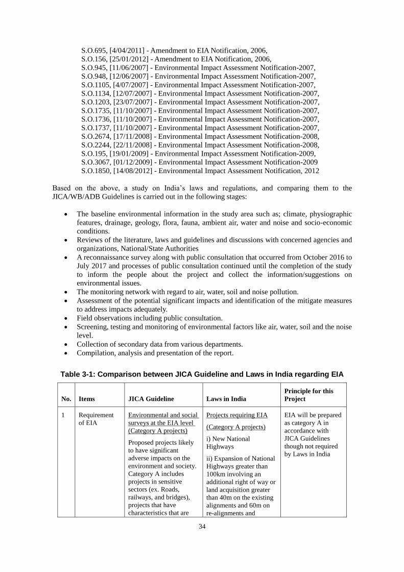
34
S.O.695, [4/04/2011] - Amendment to EIA Notification, 2006,
S.O.156, [25/01/2012] - Amendment to EIA Notification, 2006,
S.O.945, [11/06/2007] - Environmental Impact Assessment Notification-2007,
S.O.948, [12/06/2007] - Environmental Impact Assessment Notification-2007,
S.O.1105, [4/07/2007] - Environmental Impact Assessment Notification-2007,
S.O.1134, [12/07/2007] - Environmental Impact Assessment Notification-2007,
S.O.1203, [23/07/2007] - Environmental Impact Assessment Notification-2007,
S.O.1735, [11/10/2007] - Environmental Impact Assessment Notification-2007,
S.O.1736, [11/10/2007] - Environmental Impact Assessment Notification-2007,
S.O.1737, [11/10/2007] - Environmental Impact Assessment Notification-2007,
S.O.2674, [17/11/2008] - Environmental Impact Assessment Notification-2008,
S.O.2244, [22/11/2008] - Environmental Impact Assessment Notification-2008,
S.O.195, [19/01/2009] - Environmental Impact Assessment Notification-2009,
S.O.3067, [01/12/2009] - Environmental Impact Assessment Notification-2009
S.O.1850, [14/08/2012] - Environmental Impact Assessment Notification, 2012
Based on the above, a study on India’s laws and regulations, and comparing them to the
JICA/WB/ADB Guidelines is carried out in the following stages:
The baseline environmental information in the study area such as; climate, physiographic
features, drainage, geology, flora, fauna, ambient air, water and noise and socio-economic
conditions.
Reviews of the literature, laws and guidelines and discussions with concerned agencies and
organizations, National/State Authorities
A reconnaissance survey along with public consultation that occurred from October 2016 to
July 2017 and processes of public consultation continued until the completion of the study
to inform the people about the project and collect the information/suggestions on
environmental issues.
The monitoring network with regard to air, water, soil and noise pollution.
Assessment of the potential significant impacts and identification of the mitigate measures
to address impacts adequately.
Field observations including public consultation.
Screening, testing and monitoring of environmental factors like air, water, soil and the noise
level.
Collection of secondary data from various departments.
Compilation, analysis and presentation of the report.
Table 3-1: Comparison between JICA Guideline and Laws in India regarding EIA
No. Items JICA Guideline Laws in India
Principle for this
Project
1 Requirement
of EIA
Environmental and social
surveys at the EIA level
(Category A projects)
Proposed projects likely
to have significant
adverse impacts on the
environment and society.
Category A includes
projects in sensitive
sectors (ex. Roads,
railways, and bridges),
projects that have
characteristics that are
Projects requiring EIA
(Category A projects)
i) New National
Highways
ii) Expansion of National
Highways greater than
100km involving an
additional right of way or
land acquisition greater
than 40m on the existing
alignments and 60m on
re-alignments and
EIA will be prepared
as category A in
accordance with
JICA Guidelines
though not required
by Laws in India
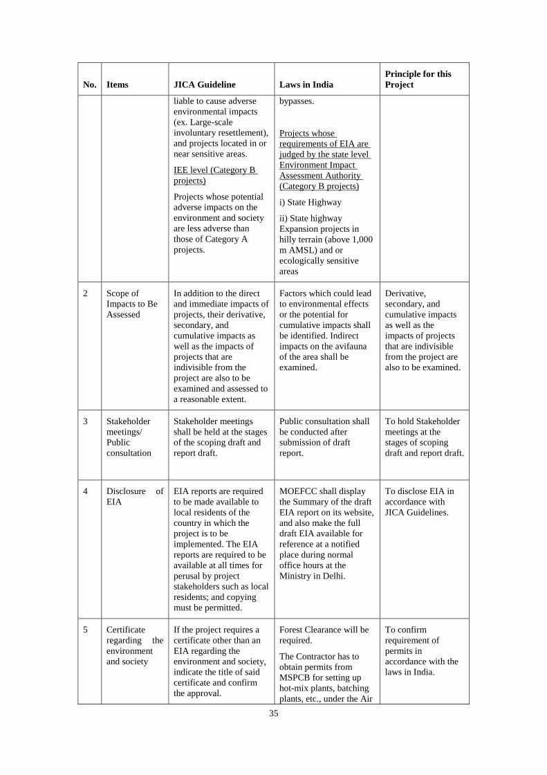
35
No. Items JICA Guideline Laws in India
Principle for this
Project
liable to cause adverse
environmental impacts
(ex. Large-scale
involuntary resettlement),
and projects located in or
near sensitive areas.
IEE level (Category B
projects)
Projects whose potential
adverse impacts on the
environment and society
are less adverse than
those of Category A
projects.
bypasses.
Projects whose
requirements of EIA are
judged by the state level
Environment Impact
Assessment Authority
(Category B projects)
i) State Highway
ii) State highway
Expansion projects in
hilly terrain (above 1,000
m AMSL) and or
ecologically sensitive
areas
2 Scope of
Impacts to Be
Assessed
In addition to the direct
and immediate impacts of
projects, their derivative,
secondary, and
cumulative impacts as
well as the impacts of
projects that are
indivisible from the
project are also to be
examined and assessed to
a reasonable extent.
Factors which could lead
to environmental effects
or the potential for
cumulative impacts shall
be identified. Indirect
impacts on the avifauna
of the area shall be
examined.
Derivative,
secondary, and
cumulative impacts
as well as the
impacts of projects
that are indivisible
from the project are
also to be examined.
3 Stakeholder
meetings/
Public
consultation
Stakeholder meetings
shall be held at the stages
of the scoping draft and
report draft.
Public consultation shall
be conducted after
submission of draft
report.
To hold Stakeholder
meetings at the
stages of scoping
draft and report draft.
4 Disclosure of
EIA
EIA reports are required
to be made available to
local residents of the
country in which the
project is to be
implemented. The EIA
reports are required to be
available at all times for
perusal by project
stakeholders such as local
residents; and copying
must be permitted.
MOEFCC shall display
the Summary of the draft
EIA report on its website,
and also make the full
draft EIA available for
reference at a notified
place during normal
office hours at the
Ministry in Delhi.
To disclose EIA in
accordance with
JICA Guidelines.
5 Certificate
regarding the
environment
and society
If the project requires a
certificate other than an
EIA regarding the
environment and society,
indicate the title of said
certificate and confirm
the approval.
Forest Clearance will be
required.
The Contractor has to
obtain permits from
MSPCB for setting up
hot-mix plants, batching
plants, etc., under the Air
To confirm
requirement of
permits in
accordance with the
laws in India.

36
No. Items JICA Guideline Laws in India
Principle for this
Project
and the Water Acts,
whose results shall be
reported to the Project
proponents.
6 Monitoring After projects begin,
project proponents etc.
monitor whether any
unforeseeable situations
occur and whether the
performance and
effectiveness of
mitigation measures are
consistent with the
assessment’s prediction.
They then take
appropriate measures
based on the results of
such monitoring.
In cases where sufficient
monitoring is deemed
essential, project
proponents etc. must
ensure that project plans
include feasible
monitoring plans.
Project proponents etc.
should make efforts to
make the results of the
monitoring process
available to local project
stakeholders.
Project proponents are
required to submit
environmental
management plan &
monitoring programme.
It shall be mandatory for
the project management
to submit every half a
year compliance reports
in respect to the
stipulated prior
environmental clearance
terms and conditions.
To implement
environmental
monitoring in
accordance with the
laws in India.
Source: JICA Study Team
3.4 Central Level Institutions
(1) National Highways Authority of India
The proposed Dhubri-Phulbari Bridge has been initiated and is being carried out by the National
Highways and Infrastructure Development Corporation Limited (NHIDCL), under the auspice of
the Ministry of Road Transport & Highways (MORTH). Though the primary responsibility of the
Project rests with the NHIDCL, there are various institutions involved in the Project and their level
of responsibilities in the project implementation are as follows:
The National Highway Authority of India (NHAI) and Regional Offices under the Ministry of Road
Transport and Highway (MORTH) promote the national highway development project while the
Border Roads Organization (BRO) under the Border Roads Development Board (BRDB) have
control over roads in border regions. The NHIDCL was established for promoting the development
of National Highways in North East and border areas of India, and started operation from January
1st , 2015.
The NHAI has been established under the National Highways Authority of India Act of 1988. It is
the main nodal agency responsible for developing, managing and maintaining India’s network of
national highways. It became an autonomous body in 1995. NHAI maintains 70,934km of national
highways and expressways across India.

37
The development of the Dhubri-Phulbari Bridge project has been promoted by NHIDCL, which is a
company fully owned by the Ministry of Road Transport & Highways of the Government of India.
The function of the NHIDCL is to promote the surveying, designing, building, operating,
maintaining and upgrading of national highways and the development of strategic roads such as
interconnecting roads in various parts of the country including those in areas with international
boundaries with the neighboring countries.
The company also proposes to improve road connectivity and the efficiency of the international
trade corridors by expanding about 500km of roads in the North Bengal and Northeastern Region of
India.
(2) Ministry of Environment, Forest, and Climate Change (MOEFCC)
The primary responsibility for administration and implementation of the Government of India’s
(GOI) policy with respect to environmental management, conservation, ecologically sustainable
development and pollution control rests with the Ministry of Environment, Forest and Climate
Change (MOEFCC). Established in 1985, the MOEFCC is the agency primarily responsible for the
review and approval of EIAs pursuant to GOI legislation.
(3) Central Pollution Control Board (CPCB)
Statutory authority attached to the MOEFCC, the main responsibilities of CPCB include the
following:
- Planning and implementing water and air pollution control programs;
- Advising the central government on water and air pollution control programs;
- Setting air and water standards; and
- Coordinating the various State Pollution Control Boards.
The role of the CPCB for this Project will only be in an advisory capacity while the Project shall
adhere to the norms and standards set up by the Meghalaya State Pollution Control Board
(MSPCB).
3.5 State Level Institutions
(1) Public Works Department
The Public Works Department (PWD) is the premier agency of the state government engaged in
planning, designing, construction, and maintenance of the government assets in the field of
infrastructure development. Assets in infrastructure development include roads, bridges, urban
centers, footpaths, new capital complexes, and airports. Assets such as hospitals, schools, colleges,
technical institutes, police buildings, prisons, and courts among others are also under the PWD’s
jurisdiction. PWD Assam / Meghalaya also sustains and preserves these assets through a system of
maintenance, which includes specialized services such as rehabilitation works, roads signage, and
aesthetic treatments like interiors, landscaping etc.
(2) MOEFCC Regional Offices
MOEFCC has set up regional offices that cover the Northeastern Region including Assam /
Meghalaya. It is located in Shillong, Meghalaya. This office is responsible for collecting and
furnishing information relating to the EIA of various projects in respect to pollution control
measures, methodology, and status, legal and enforcement measures and environmental protection
in special conservation areas such as wetlands, mangroves and biosphere reserves.
(3) State Pollution Control Board, Assam / Meghalaya State Pollution Control Board
The State Pollution Control Boards have the mandate for environmental management at the state
level, with emphasis on air and water quality. It is responsible for the planning and executing of

38
state-level air and water initiatives, advising the state government on air, water and industry
issues,establishing standards based on the National Minimum Standards, the enforcing and
monitoring of all activities within the state under the Air Act, the Water Act and other relevant acts
pertaining to pollution control.
They also conduct and organize public hearings for projects as defined by the various Acts and as
stipulated by the amendment related to the EIA Act. It also issues No-objection Certificates (NOC)
for environment clearance for industrial development defined in such a way as to include road
projects’ quarrying etc., which usually relate to water and soil contamination.
(4) Assam / Meghalaya State Forest and Environment Department
The Assam / Meghalaya Forest and Environment Department is responsible for the protection and
management of the forest areas in the states that are designated for protection, conservation and
production purposes. The Forest and Environment Department follows what is laid out in the Forest
Working Plans for the various forest divisions to manage and protect the forest resources. These
plans form the basis for managing the forest resources. is the department is responsible for granting
licenses for clearances of the forest areas for various projects, according to the provisions of the
Forest (Conservation) Act, 1980. The State Forest and Environment Department performs functions
similar to those of the MOEFCC at the state level but more specific to forestry activities including
social forestry and production forestry development and licensing.
3.6 Requirements of Environmental Clearance
Environmental Clearance is not required for this project as per the MoEFCC notification, 2013.
Other clearances required are as follows:
1) The Contractor has to obtain permits from State Pollution Control Board for setting up hot-mix
plants, batching plants, etc., under the Air and the Water Acts;
2) Clearance from the State Department of Mining is required for establishing quarries;
3) Clearance from the Water resource department/Authorities is required for establishment of new
tube-wells/bore-holes in case they are required during construction work;
4) The provisions as laid down in the Factories Act, 1948, Labor Act, 1988 and the Building and
Other Construction Workers (Regulation of Employment and Conditions of Service) Act, 1996
with respect to hygiene and health during the construction stage would apply to the project’s
implementation works; and
5) The provisions of the Hazardous Wastes (Management and Handling) Rules, 1989 and the
Chemical Accidents (Emergency Planning, Preparedness, and Response) Rules, 1996 may also
be applied during the construction and the operation period.

39
Table 3-2: Applicable Environmental Clearance
3.7 Environmental Standards of India
Based on the Acts and Rules above, CPCB has set up various environmental standards as follows:
1) National Ambient Air Quality Standards
2) Water Quality Criteria
3) Vehicular Exhaust
4) Auto Fuel Quality
5) Noise and Emission Limits for Diesel Engines for Generators
6) Noise Standards
In addition to the above, there are a large number of environmental standards set up for each sector
of the manufacturing industries. Since this is a road construction project consisting of the
construction of a new bridge, during the construction period, construction debris, soil contamination,
air and water pollution, noise and vibration are subject to monitoring in order to maintain emissions
and discharges within the standards set up by the CPCB. During the operation and maintenance
period, increasing traffic could cause noise and vibration. However, standards on the disposal of
construction debris, soil contamination, and vibration that could be caused by the Project are not
No. Activity Statute Requirement Competent Authority Responsible Agency for
Obtaining Clearance Time Required
1Road-side tree cutting
and clearing forest
ForestConservation
Act1980 & MOEF
Letter Dt.18.02.1998
Permission for Road-
side tree cutting
State and Central
Government MORTH 2-3 months
2
Filling of Roadside
water bodies (ponds and
borrow pits)
State FisheriesPolicy
Draft Wetlands
(Conservation &
Management)Rules,
2008
Permission for filling of
water bodies
State Irrigation
Department State
Fisheries Department
State Wetlands
Conservation
Committee
MORTH 2-3 months
1
Establishing stone
crusher, hot mix plant,
wet mix plant and
Diesel Generator Sets
Water Act of1974, Air
Act of 1981, Noise
Rules of 2000 and
Environmental
Protection Actionof
1986 and as Amended
Consent-forest
abolishment
States Pollution Control
Boards for respective
section
Contractor 4-6 months
2
Operating
stonecrusher, hot mix
plant, wet mix plant and
Diesel Generator Sets
Water Act of 1974, Air
Act of 1981, Noise
Rules of 2000 and
Environmental
Protection Action of
1986 and as Amended
Consent-for operation
States Pollution Control
Boards for respective
section
Contractor 4-6 months
3
Use and storageof
explosive for quarry
blasting work
India Explosive Act
1984
Explosive license for
use and storage
Chief Controller of
Explosives Contractor 2-3 months
4
Storage of fueloil,
lubricants, diesel etc. at
construction camp
Manufacture storage
and Import of
Hazardous Chemical
Rules 1989
Permission for storage
of hazardous chemical
States Pollution Control
Boards for respective
section and or Local
Authority (DC)
Contractor 4-6 months
5 Quarry Operation
State
MinorMineralConces
sion Rules, The Mines
Act of1952, Indian
Explosive Act of1984,
Air Act of1981 and
Water Act of 1974
Quarry Lease Deed and
Quarry License
State Department of
Mines and Geology Contractor 4-6 months
6Extraction of ground
water
Ground Water Rules of
2002
Permission for
extraction of ground
water for use in road
construction activities
State Ground Water
Board Contractor 4-6 months
7 Engagement of labor Labor Act Labor license Labor Commissioner Contractor 2-3 months
Source: JICA Study Team
Pre-Construction Stage (Responsibility: MORTH)
Construction Stage (Responsibility: Contractor)

40
clearly defined. The following is a set of environmental standards the Government of India has
imposed to date.
Table 3-3: Standards for Ambient Air Quality
Indian Ambient Air Quality Standards WHO Ambient Air Quality
Standards
S. No. Pollutant Time
Weighted
Average
Concentration in Ambient
Air
Averaging
Period
Guideline value in µg
/m3
Industrial
Residential,
Rural and
Other
Areas
Ecologically
Sensitive
Area
(notified by
Central
Government)
(1) (2) (3) (4) (5) (1) (2)
1. Sulphur
Dioxide (SO2),
µg /m3
Annual*
24 hours**
50
80
20
80
24 hours
10 minutes
125 (Interim target 1)
50 (Interim target 2)
20 (guideline)
500 (guideline)
2. Nitrogen
Dioxide (NO2),
µg /m3
Annual*
24 hours**
40
80
30
80
1-year
1-hour
40 (guideline)
200 (guideline)
3. Particular
Matter (size
less than
10µm) or PM10
µg /m3
Annual*
24 hours**
60
100
60
100
1-year
24-hour
70(Interim target 1)
50 (Interim target 2)
30 (Interim target 3)
20 (guideline)
150(Interim target 1)
100 (Interim target 2)
75(Interim target 3)
50 (guideline)
4. Particular
Matter (size
less than
2.5µm) or
PM2.5 µg /m3
Annual*
24 hours**
40
60
40
60
1 – year
24-hour
35(Interim target 1)
25 (Interim target 2)
15 (Interim target 3)
10 (guideline)
75(Interim target 1)
50 (Interim target 2)
37.5 (Interim target 3)
25 (guideline)
5. Ozone (O3)
µg/m3
8 hours**
1 hour**
100
180
100
180
8-hour
daily
maximum
160 (Interim target-1)
100 (guideline)
Source: Central Pollution Control Board, India

41
Table 3-4 Ambient Air Quality Standard by WHO

42
Source: IFC
Table 3-5: Vehicle Emission Standards (1991 to Date)
Source: Central Pollution Control Board, India
Note: Bharat indicates Indian nomenclature of vehicular emission which is the same as the Euro Stage.
Table 3-6: Water Quality

43
Source: Central Pollution Control Board, India
Compared to the EHS guideline set forth by the International Financial Corporation (IFC) shown in
table 2.1-4 below, the Class A Water Quality Standard of India is lacking a few items such as COD,
Total Nitrogen, Total Phosphorus, Oil and Grease. Other parameters are set at equal level or below
the EHS Guideline of IFC.
Table 3-7: Water quality standard for international EHS Guideline
Source: IFC
Total coliform organisms MPN/100ml shall be 50 or less
pH between 6.5 and 8.5
Dissolved oxygen 6 mg/l or more
Biochemical oxygen demand 2 mg/l or Less
Total coliform organisms MPN/100ml shall be 500 or
less
pH between 6.5 and 8.5 *Dissolved oxygen 5 mg/l or
more
Biochemical oxygen demand 3 mg/l or Less
Total coliform organisms MPN/ 100ml shall be 5000 or
less
pH between 6 and 9
Dissolved oxygen 4 mg/l or more
Biochemical oxygen demand 3 mg/l or less
pH between 6.5 and 8.5
Dissolved oxygen 4 mg/l or more *Free ammonia (as N)
1.2 mg/l or less
pH between 6.0 and 8.5
Electrical conductivity less than 2250 micro mhos/cm
Sodium absorption ratio less than 26
Boron less than 2mg/l
Outdoor bathing (organised) B
Designated best use Class Criteria
Drinking water source without conventional treatment
but after disinfectionsA
Drinking water source with conventional treatment
followed by disinfectionC
Propagation of wild life, fisheries D
Irrigation, industrial cooling, controlled waste disposal E
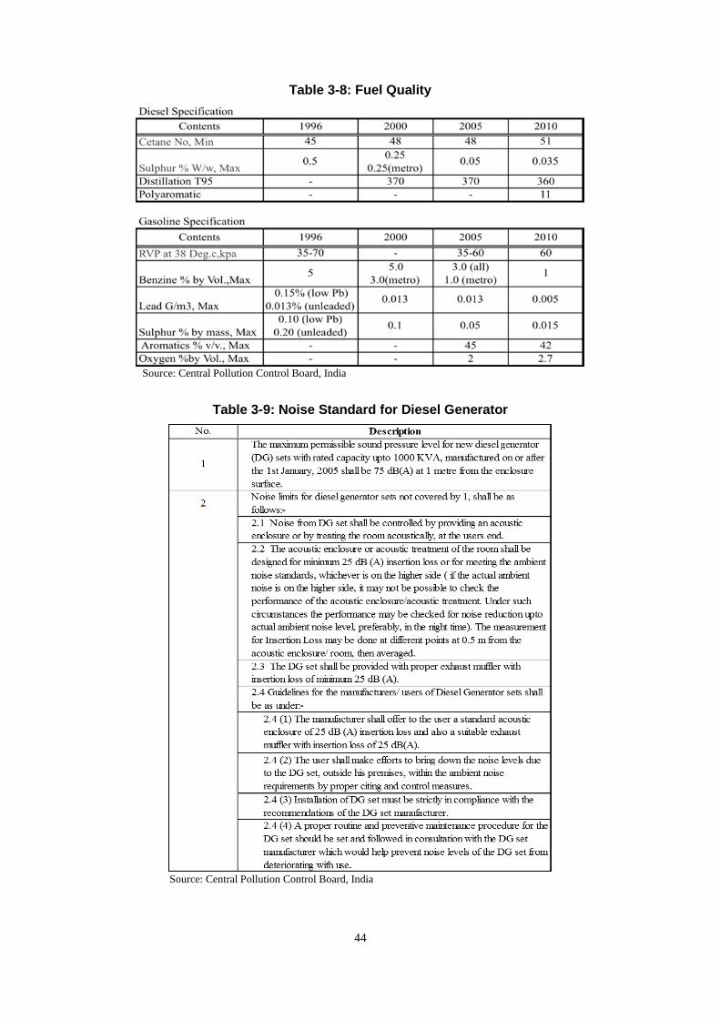
44
Table 3-8: Fuel Quality
Source: Central Pollution Control Board, India
Table 3-9: Noise Standard for Diesel Generator
Source: Central Pollution Control Board, India

45
Table 3-10: Vehicle Emission Standards (1991 to Date)
Source: Central Pollution Control Board, India
Note: Bharat indicates Indian nomenclature of vehicular emission which is the same as the Euro Stage.
Table 3-11: Noise Emission Standards
Source: Central Pollution Control Board, India
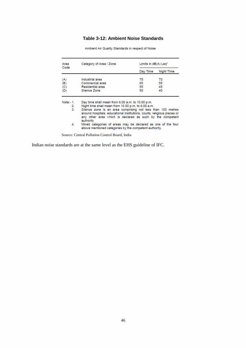
46
Table 3-12: Ambient Noise Standards
Source: Central Pollution Control Board, India
Indian noise standards are at the same level as the EHS guideline of IFC.
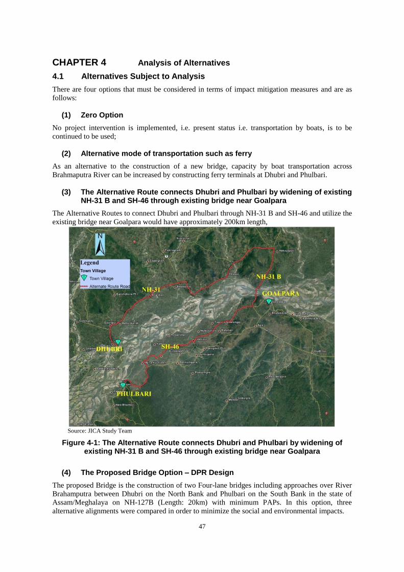
47
CHAPTER 4 Analysis of Alternatives
4.1 Alternatives Subject to Analysis
There are four options that must be considered in terms of impact mitigation measures and are as
follows:
(1) Zero Option
No project intervention is implemented, i.e. present status i.e. transportation by boats, is to be
continued to be used;
(2) Alternative mode of transportation such as ferry
As an alternative to the construction of a new bridge, capacity by boat transportation across
Brahmaputra River can be increased by constructing ferry terminals at Dhubri and Phulbari.
(3) The Alternative Route connects Dhubri and Phulbari by widening of existing NH-31 B and SH-46 through existing bridge near Goalpara
The Alternative Routes to connect Dhubri and Phulbari through NH-31 B and SH-46 and utilize the
existing bridge near Goalpara would have approximately 200km length,
Source: JICA Study Team
Figure 4-1: The Alternative Route connects Dhubri and Phulbari by widening of existing NH-31 B and SH-46 through existing bridge near Goalpara
(4) The Proposed Bridge Option – DPR Design
The proposed Bridge is the construction of two Four-lane bridges including approaches over River
Brahamputra between Dhubri on the North Bank and Phulbari on the South Bank in the state of
Assam/Meghalaya on NH-127B (Length: 20km) with minimum PAPs. In this option, three
alternative alignments were compared in order to minimize the social and environmental impacts.

48
Source: DPR Inception Report
Figure 4-2: Alignment of Two / Four lane bridge between Dhubri and Phulbari
4.2 Criteria for Analysis of the Alternatives
Criteria for the analysis of the selected four alternatives are shown in the following Table. These
criteria are based on the importance of the Project being a bridge project running through the
Dhubri, South Salmara-Mankachar districts in Assam State and Phulbari in Meghalaya State.
Table 4-1: Criteria for the Evaluation of the Alternatives
No. Alternative Models Criteria of Evaluation
1 Zero Option
(No project is implemented)
Connectivity
- Road Connectivity as a means of infrastructure for
communication or transportation of goods
- If current connectivity should be improved
- Contribution to the development of local/state economy
Environmental Pollution
- CO2 emission could increase/decrease with the road
- Noise and vibration
- Health conditions could be improved/worsened
Socio-economic Conditions
- Contribution to road accidents
- Contribution to improve/worsen living standard
- If resettlement was involved
- If land acquisition is involved
Natural Environment
- impacts on fisheries and other aquatic life
- Effects on the ecological conditions
Others
- If it is worth implementing the project despite effects on
2 Alternative mode of
transportation such as a
ferry
3 The Alternative Route
connects Dhubri and
Phulbari by widening of
existing NH-31 B and
SH-46 through existing
bridge near Goalpara
4 The Proposed Bridge Option
– DPR Design alignment
AD
5 The Proposed Bridge Option
– DPR Design alignment BE
6 The Proposed Bridge Option
– DPR Design alignment
BFE
49
the natural/social environment, or economic conditions
- Technical viability of the bridge construction
Source: JICA Study Team
4.3 Results of the Analysis of Alternatives
(1) Zero Option
The Zero option of the project is to take no project intervention. This option is assessed as follows:
a. Advantages
- There will be no involuntary resettlement involved in the Zero Option
- No tree cutting and agricultural areas lost to the road / bridge construction works
- No construction works and no pollution
- No impact on Aquatic Fauna
b. Disadvantages
- No road network between Dhubri and Phulbari
- Existence boat transportation takes more time and inconveniences the people
- No local area development
- No Economic development in project districts
(2) Alternative mode of transportation such as ferry
Alternative to the construction of a new bridge, capacity by boat transportation across Brahmaputra
River can be increased by constructing ferry terminals at Dhubri and Phulbari. However
constructing ferry terminals will require large-scale change in geology, topography and hydrology
of the existing river banks of the Brahmaputra which may cause negative impacts on the habitat of
the endangered river dolphins.
a. Advantage
- Provide transport connectivity to Dhubri and Phulbari
- Land acquisition and involuntary resettlement will be incurred but on a smaller scale
b. Disadvantage
- Significant negative impacts on the ecosystem of the Brahmaputra River by the
dredging of ferry terminals
- High maintenance and operation cost for ferry boats
- Susceptible to natural disasters such as flooding
- Travel time is dependent on ferry time schedule
(3) The Alternative Route connect Dhubri and Phulbari by widening of existing NH-31 B and SH-46 through existing bridge near Goalpara
The Alternative Routes to connect Dhubri and Phulbari through NH-31 B and SH-46 and utilize the
existing bridge near Goalpara will have approximately 200km length.
a. Advantages
- Better connectivity to villages / towns falling in the 200km alignment
- Overall economic development of the project area
- No impact on Aquatic ecology of Brahmaputra River
b. Disadvantage
- Very high resettlement as settlements are all along the existing highway
- Acquisition of land and cutting of large numbers of trees
- Construction works likely to cause significant traffic jams throughout the construction
period, dust during dry season and muddy roads during rainy season.
- Very high construction cost due to long length

50
(4) The Proposed Bridge Option – DPR Design
The proposed Bridge is the construction of two Four-lane bridges including approaches over
Brahamputra River between Dhubri on the North Bank and Phulbari on the South Bank in the state
of Assam/Meghalaya on NH-127B (Length: 20km) with minimum PAPs, this option is assessed as
follows:
a. Advantage
- Provide easy and short distance connectivity to Dhubri and Phulbari
- Less number of PAPs
- Overall infrastructure development and economic development of the area.
- Negative ecological impacts on Brahmaputra are smaller compared to other options.
- No need for deforestation
b. Disadvantage
- Involuntary resettlement of the local residents will be reduced, however, in acquisition of
approximate 65 Ha of land and significant number of PAPs.
- Construction works should cause significant traffic jams throughout the construction period,
dust during dry season and muddy roads during rainy season.
- Increase of traffic volume including heavy load vehicles likely to cause noise, air pollution,
and increase in traffic accidents along the road while some traffic is diverted to bypasses.
- Impact on aquatic fauna in Brahmaputra River during construction phase.
Given the above analysis results, the results of comparing and examining each option were ranked
and are shown in the table below. Furthermore, the score was allocated according to the rank, and
the option with the highest total score was selected as the best. The main objective of this project is
to bring positive influence on the regional economy, so the “impact on local economy” was given a
double score. As a result, The Proposed Bridge Option is recommended.
Table 4-2: Analysis of alternatives
Sr.
No
Factors Without
Project Impacts
With Project Impacts
Alternative mode of
transportation such
as ferry
The Alternative Route
connect Dhubri and
Phulbari by widening of
existing NH-31 B and
SH-46 through existing
bridge near Goalpara
With Proposed bridge
1 Involuntary
resettlement
+++
No involuntary
resettlement is
incurred.
++
Land acquisition and
involuntary
resettlement will be
incurred around ferry
terminal area but on
smaller scale.
--
Large scale of
involuntary resettlement
is expected due to
upgrading of 200km of
existing road.
+
Middle scale of
involuntary
resettlement is incurred
along the alignment of
the proposed bridge.
Score 4 1 3 2
Weighted
score
4 1 3 2
2 Impact on
natural
ecosystem
+++
No direct
impacts on
natural
ecosystem.
-
Significant negative
impacts are caused on
the ecosystem of the
Brahmaputra River by
dredging of ferry
terminals and
navigation channels.
+
Natural environment is
altered along the existing
road for 200km, but no
impacts on the
Brahmaputra River.
++
Some impacts are
caused on Brahmaputra
River ecosystem during
construction phase, but
there will be little
impact during operation
phase.
Score 4 2 1 3
Weighted
score
4 2 1 3
3 Pollution +
Present status is
continued.
-
Possibility of water
pollution such as oil
++
Air pollution and CO2
emission may decrease
+++
Overall air pollution
and CO2 emission will
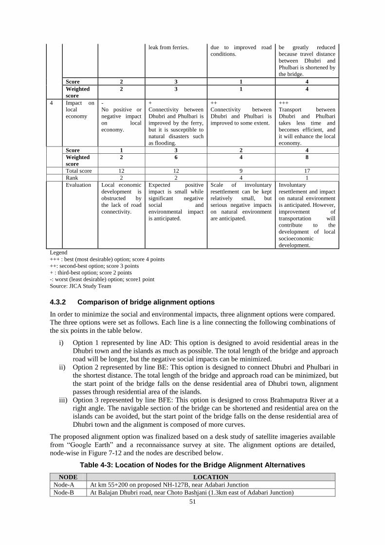
51
leak from ferries. due to improved road
conditions.
be greatly reduced
because travel distance
between Dhubri and
Phulbari is shortened by
the bridge.
Score 2 3 1 4
Weighted
score
2
3
1
4
4 Impact on
local
economy
-
No positive or
negative impact
on local
economy.
+
Connectivity between
Dhubri and Phulbari is
improved by the ferry,
but it is susceptible to
natural disasters such
as flooding.
++
Connectivity between
Dhubri and Phulbari is
improved to some extent.
+++
Transport between
Dhubri and Phulbari
takes less time and
becomes efficient, and
it will enhance the local
economy.
Score 1 3 2 4
Weighted
score
2
6
4
8
Total score 12 12 9 17
Rank 2 2 4 1
Evaluation Local economic
development is
obstructed by
the lack of road
connectivity.
Expected positive
impact is small while
significant negative
social and
environmental impact
is anticipated.
Scale of involuntary
resettlement can be kept
relatively small, but
serious negative impacts
on natural environment
are anticipated.
Involuntary
resettlement and impact
on natural environment
is anticipated. However,
improvement of
transportation will
contribute to the
development of local
socioeconomic
development.
Legend
+++ : best (most desirable) option; score 4 points
++: second-best option; score 3 points
+ : third-best option; score 2 points
-: worst (least desirable) option; score1 point
Source: JICA Study Team
4.3.2 Comparison of bridge alignment options
In order to minimize the social and environmental impacts, three alignment options were compared.
The three options were set as follows. Each line is a line connecting the following combinations of
the six points in the table below.
i) Option 1 represented by line AD: This option is designed to avoid residential areas in the
Dhubri town and the islands as much as possible. The total length of the bridge and approach
road will be longer, but the negative social impacts can be minimized.
ii) Option 2 represented by line BE: This option is designed to connect Dhubri and Phulbari in
the shortest distance. The total length of the bridge and approach road can be minimized, but
the start point of the bridge falls on the dense residential area of Dhubri town, alignment
passes through residential area of the islands.
iii) Option 3 represented by line BFE: This option is designed to cross Brahmaputra River at a
right angle. The navigable section of the bridge can be shortened and residential area on the
islands can be avoided, but the start point of the bridge falls on the dense residential area of
Dhubri town and the alignment is composed of more curves.
The proposed alignment option was finalized based on a desk study of satellite imageries available
from “Google Earth” and a reconnaissance survey at site. The alignment options are detailed,
node-wise in Figure 7-12 and the nodes are described below.
Table 4-3: Location of Nodes for the Bridge Alignment Alternatives
NODE LOCATION
Node-A At km 55+200 on proposed NH-127B, near Adabari Junction
Node-B At Balajan Dhubri road, near Choto Bashjani (1.3km east of Adabari Junction)

52
Node-C At College Road Junction with the bund road, near Bidyapara
Node-D At Agia-Tura NEC Road, 400 m from Phulbari Ghat towards Agia
Node-E At Agia-Tura NEC Road, 1km from Phulbari Ghat towards Agia
Node-F On Southern Bank of Brahmaputra, near Borokalia Surjyamara Source: DPR Inception Report
The methodology is adopted to review these three alignments by covering the following aspects.
Table 4-4 Evaluation Criteria
Parameter Evaluation Data collection
Social Aspects Affected structures Larger number will
cause larger impact
Satellite image and land
survey
Land to be acquired Larger number will
cause larger impact
Satellite image and land
survey
Permanent Char Land Larger number will
cause larger impact
Satellite image and land
survey
Environmental
Aspects
Total Length Larger number will
cause larger impact
Construction design by
DPR consultants Agriculture Land Larger number will
cause larger impact
Construction design by
DPR consultants Total Length over Brahmaputra River Larger number will
cause larger impact
Satellite image
Engineering
Aspects
Total Length Smaller number is
preferable
Construction design by
DPR consultants Length of bridge approach Smaller number is
preferable
Construction design by
DPR consultants Horizontal Geometry : Total no. of curves Smaller number is
preferable
Construction design by
DPR consultants Horizontal Geometry: Total length of
curves Smaller number is
preferable
Construction design by
DPR consultants
Indicative
Cost Aspects
Total Approximate Civil Construction Cost Smaller number is
preferable
Construction design by
DPR consultants
Social Aspects
The number of affected structures is considered as an equivalent to the scale of resettlement
expected from the Project. Size of Land to be acquired is indicative of the scale of possible losses of
livelihood considering that the population in the area is largely dependent on their land. The length
of alignment passing through Permanent Char Land is also included in the parameters to evaluate
the impact on Char people whose socio-economic status is lower than that of the inland
communities.
Environmental Aspects
Total length is indicative of negative impacts such as noise, vibration, and air pollution at
operation phase. As the total length increases, vehicles need to travel longer distances and larger
negative impacts are anticipated.
Agriculture Land that overlaps with the alignment will be lost due to the construction of the bridge
and cause negative environmental impacts such as loss of environmental services. Total Length
over the Brahmaputra River is indicative of negative impacts of the project on the river ecosystem
and endangered aquatic species such as Ganges river dolphins. The longer the length over
Brahmaputra River is, the larger the damage on the river ecosystem will be.
Engineering Aspects
With regard to the total length of the bridge, because of higher construction technologies and costs
of bridges compared with embankments, a shorter bridge length is rated favorable. With regard to
the length of the approach, because of the necessity of new road constructions of approaches to
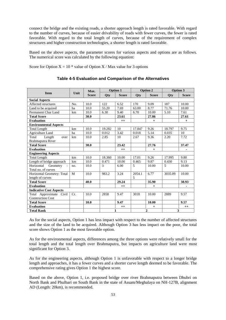
53
connect the bridge and the existing roads, a shorter approach length is rated favorable. With regard
to the number of curves, because of easier drivability of roads with fewer curves, the fewer is rated
favorable. With regard to the total length of curves, because of the requirement of complex
structures and higher construction technologies, a shorter length is rated favorable.
Based on the above aspects, the parameter scores for various aspects and options are as follows.
The numerical score was calculated by the following equation:
Score for Option X = 10 * value of Option X / Max value for 3 options
Table 4-5 Evaluation and Comparison of the Alternatives
Item Unit Max.
Score
Option 1 Option 2 Option 3
Qty Score Qty Score Qty Score
Social Aspects
Affected structures No. 10.0 122 6.52 170 9.09 187 10.00
Land to be acquired ha 10.0 55.20 7.69 63.00 8.77 71.76 10.00
Permanent Char Land km 10.0 6.30 9.40 6.70 10.00 5.10 7.61
Total Score 30.0 23.61 27.86 27.61
Evaluation ++ + +
Environmental Aspects
Total Length km 10.0 19.282 10 17.847 9.26 18.797 9.75
Agriculture Land ha 10.0 0.012 3.42 0.018 5.14 0.035 10
Total Length over
Brahmaputra River
km 10.0 2.85 10 2.67 9.36 2.20 7.72
Total Score 30.0 23.42 27.76 37.47
Evaluation ++ + -
Engineering Aspects
Total Length km 10.0 18.360 10.00 17.01 9.26 17.995 9.80
Length of bridge approach km 10.0 0.471 10.00 0.465 9.87 0.430 9.13
Horizontal Geometry :
Total no. of curves
no. 10.0 3 6.00 5 10.00 5 10.00
Horizontal Geometry: Total
length of curves
M 10.0 983.2 3.24 2054.1
5
6.77 3035.09 10.00
Total Score 40.0 29.24 35.90 38.93
Evaluation ++ + -
Indicative Cost Aspects
Total Approximate Civil
Construction Cost
Cr. 10.0 2858 9.47 3018 10.00 2889 9.57
Total Score 10.0 9.47 10.00 9.57
Evaluation ++ + ++
Total Rank 1 2 3
As for the social aspects, Option 1 has less impact with respect to the number of affected structures
and the size of the land to be acquired. Although Option 3 has less impact on the poor, the total
score shows Option 1 as the most favorable option.
As for the environmental aspects, differences among the three options were relatively small for the
total length and the total length over Brahmaputra, but impacts on agriculture land were most
significant for Option 3.
As for the engineering aspects, although Option 1 is unfavorable with respect to a longer bridge
length and approaches, it has a fewer curves and a shorter curve length deemed to be favorable. The
comprehensive rating gives Option 1 the highest score.
Based on the above, Option 1, i.e. proposed bridge over river Brahmaputra between Dhubri on
North Bank and Phulbari on South Bank in the state of Assam/Meghalaya on NH-127B, alignment
AD (Length: 20km), is recommended.

54
CHAPTER 5 Scoping Analysis
5.1 Procedures of Scoping Analysis
Depending on the scale and nature of works during the various stages of the project, there are
positive and negative impacts to the natural and social environment. These impacts are different in
the intensity, in the spatial reach, and in whether it is irrevocable or temporary.
The scoping matrix highlights anticipated impacts that occur on various environmental and social
components during the scoping stage of the project. The project may affect the aquatic ecosystem in
terms of the impacts to the natural environment. Also, the ROW for this project is 60m in width,
and social impacts such as land acquisition and resettlement are anticipated.
5.2 Scoping Matrix: Preliminary Analysis of the Environmental Impacts
The scoping matrix is shown in the table below. According to the JICA Guideline (2010), the
impacts are rated as follows:
“A” denotes that severe/irrevocable impact is expected (+: Positive impact, -: Negative
impact)
“B” denotes that significant impact is expected (+: Positive impact, -: Negative impact)
“C” denotes that impact is relatively small (+: Positive impact, -: Negative impact)
“D” denotes that impact with little significance occurs (+: Positive impact, -: Negative
impact)

55
Table 5-1: Scoping Matrix for the Proposed Bridge Option
Item
Scoping Analysis of the Anticipated Environmental Impacts
Pre
-co
nst
ruct
ion
Co
nst
ruct
ion
Sta
ge
Op
erati
on
Sta
ge
Rational of the Impact Assessment
Pollution
Air Pollution D B- B-
P: No impact is expected.
C: Some negative impacts are expected due to the operation of
construction equipment and vehicles. One example is dust
incidental to earthwork especially during the dry season.
O: Air pollution is expected to increase due to increase traffic
volume on the road.
Water
Pollution D B- D
P: No impact is expected.
C: Turbid water due to the earthworks, bridge pier construction
work and wastewater effluents from construction workers’
camps / yards are expected to pollute the Brahmaputra river to
some extent.
O: No impact is expected.
Wastes /
Hazardous
Materials
D B- D
P: No impact is expected.
C: Waste will be generated from construction workers’ camps.
Waste generated from construction and demolition work may
include hazardous materials that must be treated before final
disposal.
O: No impact is expected.
Soil
Contaminati
on
D B- D
P: No impact is expected.
C: Impacts on soil from deposition of pollutants from
construction materials in the construction site are expected to be
small. Since there is no major industrial activity along the road,
it is unlikely that soil along the road is already polluted.
O: No impact is expected.
Noise and
Vibration D B- B-
P: No impact is expected.
C: Noise and vibration generated by the operation of
construction equipment and vehicles, although they are
temporary. Construction schedule should take into account the
location of schools, hospitals and religious facilities that require
silence during parts of the day.
O: Noise and vibration level are likely to increase due to greater
traffic volume along the road. Specific measures may be
required to minimize impacts on schools, hospitals and religious
facilities.
Ground
Subsidence D D D P/C/O: No impact is expected.
Offensive
Odor D D D P/C/O: No impact is expected.
Bottom
sediment D C C
P: No impact is expected.
C/O: The piers may cause slight change in the hydrodynamics
and cause erosion of bottom sediment.

56
Item
Scoping Analysis of the Anticipated Environmental Impacts
Pre
-co
nst
ruct
ion
Co
nst
ruct
ion
Sta
ge
Op
erati
on
Sta
ge
Rational of the Impact Assessment
Natural Environment
Wildlife
Reserve/
protected
area
D D D
P: No impact is expected.
C: No protected area exists within 10km radius of project area.
O: No protected area exists within 10km radius of project area.
Eco-system/
Bio-diversity D A- B-
P: No impact is expected.
C: During the construction period, ecosystem in the project area
including local flora and fauna will be damaged to some extent.
O: Increase of traffic volume will cause negative impacts on the
ecosystem including fauna and flora along the project road.
Topography/
Geology D B- D
P: No impact is expected.
C: Changes in topographic conditions over the project area takes
place due to the need for cutting and filling work.
O: No impact is expected.
Hydrology D B- B-
P: No impact is expected.
C: Construction work may cause minor and temporary impacts
on hydrology because of pier construction, or the local use of
water.
O: Cutting and / or filling should result in minor changes of local
hydrology.
Eco-system/
Bio-diversity D A- B-
P: No impact is expected.
C: During the construction period, ecosystems in the project area
including local flora and fauna are damaged to some extent.
O: Increase of traffic volume will cause negative impacts on the
ecosystem including fauna and flora along the project road.
Social Environment
Involuntary
Resettlement A- D D
P: The project will likely affect over 700 families.
C: Resettlement will be completed before construction begins
and thus no resettlement is expected during operation.
O: No impact is expected, as relocation will be completed before
construction begins.
Poor People A- B+ B+/B
-
P: Given the limited coping capacity of the poor, it is necessary
to assess their vulnerability and develop appropriate mitigation
measures.
C: The poor can benefit from employment opportunities during
construction work.
P: In the long-term, economic development in the region is
likely to benefit the poor. However, the poor may not be able to
receive benefits from the project due to the lack of skills and
coping capacity.
Ethnic
Minorities/
Indigenous
People
C C C
P/C/O: According to initial site survey, there are no ST/SCs in
the project area. However, the presence of ethnic minorities will
be confirmed during the census survey.
Local A- B+ B+ P: Loss of income sources and livelihood due to involuntary

57
Item
Scoping Analysis of the Anticipated Environmental Impacts
Pre
-co
nst
ruct
ion
Co
nst
ruct
ion
Sta
ge
Op
erati
on
Sta
ge
Rational of the Impact Assessment
Economy
and
Livelihood
/B- /B- resettlement are expected to negatively affect the local economy
and livelihood.
C: Economic activity of fishermen may have negative impact
during construction period. On the other hand, employment
opportunities of various skill levels will be created by the
project.
O: Economic activity of boat operators may be affected. On the
other hand, by improving transportation network, access to
market and public facilities will be improved and positive impact
on regional development can be expected.
Land Use B- B- D
P: Land acquisition and involuntary resettlement are likely to
cause changes in the existing land use patterns.
C: Land use is expected to change for the construction of
construction yards and workers’ camps, however the impact is
temporary.
O: Land usage along the alignment will be permanently
changed, however a negative impact is not expected.
Construction yard will be restored to their original conditions by
the contractors.
Utilization of
Local
Resources
D B- D
P: No impact is expected.
C: The use of local resources such as sand, crushed stone, etc.
for the construction activities may have negative impact on the
local use.
O: No impact is expected as use of local resources is not
expected during operation.
Water Usage,
Water Rights
and
Communal
Rights
D D D P/C/O: No impact is expected.
Social
Infrastructure
and Services
B- B- B+/B
-
P: One school may be affected and require relocation.
C: If the school will be relocated to the area close to the
alignment, noise from increased traffic is expected.
O: If the school will be relocated to the area close to the
alignment, noise from increased traffic is expected. In the long
term, the project is expected to improve access to social
infrastructure and services by providing a better transport
network.
Social
Institutions
and Local
Decision-
making
Institutions
D D D
P/C/O: Land acquisition and involuntary resettlement will be
implemented based on existing social and local decision-making
institutions so no impact will be expected.
Unequal
Distribution B- B-
B-/B
+
P: Land acquisition and involuntary resettlement will lead to
unequal distribution of benefits and damage between those who

58
Item
Scoping Analysis of the Anticipated Environmental Impacts
Pre
-co
nst
ruct
ion
Co
nst
ruct
ion
Sta
ge
Op
erati
on
Sta
ge
Rational of the Impact Assessment
of Benefit
and Damage
are directly affected by the project and those who are not.
C: Those who are affected by Land acquisition and resettlement
should have preference in access to employment opportunities
by the construction work.
O: There is a possibility of uneven distribution of benefits
between bridge connection site and Char land. In the long term,
the project is expected to have a positive impact on the local
economy through an improved transportation network.
Local
Conflicts of
Interests
D D D P/C/O: No impact is expected.
Cultural and
Historical
Heritage
D D D P/C/O: The proposed bridge does not traverse or run near major
cultural or historical heritage sites.
Landscape D D D P/C/O: No impact is expected.
Gender B- B- D
P: Involvement of women should be ensured during the course
of the land acquisition and resettlement process.
C: Equal opportunity should be sought for employment during
construction work.
O: No impact is expected.
Children's
Rights B- D D
P: One school playground will be affected by land acquisition.
C/O: Child labor is unlawful according to Article 24 of the
Indian Constitution. Only adults are eligible for potential
employment opportunities created by the project.
Public
Health
(sanitation
and
infectious
diseases)
D B- D
P: No impact is expected.
C: Influx of construction workers is likely to increase the health
risk, particularly that of STD / STI and HIV / AIDS.
O: No impact is expected.
Occupational
Health and
Safety
(OHS)
D B- B-
P: No impact is expected.
C: Occupational health and safety of construction work should
be properly managed through adequate EMP.
O: Maintenance and repair work should take into account the
occupational health and safety of the workers.
Others
Accidents D B- B- P: No impact is expected.
C: Increased risk of accidents associated with construction
activities is expected due to the operation of heavy equipment
and vehicles.
O: Risks of accidents is expected to increase due to greater
traffic volume and speed.
Climate
Change
D D D P: No impact is expected.
C: The use of construction machines and operation of vehicles
will result in an increase of GHG emissions, though the impact
is small and short-term.
59
Item
Scoping Analysis of the Anticipated Environmental Impacts
Pre
-co
nst
ruct
ion
Co
nst
ruct
ion
Sta
ge
Op
erati
on
Sta
ge
Rational of the Impact Assessment
O: The new bridge will shorten the truck transportation distance
which reduces GHG emission. On the other hand, traffic volume
is expected to increase. However, it is not significant enough to
have impact on climate change and transboundary effects. Source: JICA Study Team
5.3 TOR of Natural and Socio-economic Environment Survey
TOR of the Natural Environment and Socio-economic Survey is shown in the table below.

60
Table 5-2: TOR of Natural and Socio-economic Environment Survey
Item Locations Items Subject to Investigation Method of Assessment and Estimation of Impacts
Air Quality 3-4 locations along the
bridge alignment
(approximately every
10km)
PM2.5, PM10, NOx, SO2 Review of DPR environmental study
Continuous 24 hours per location (1 weekday)
Accordance with environmental standards in India
General trend of increase in traffic and vehicles is taken into account and CO2 increase is
qualitatively analysed.
Water Quality 3-4 locations along the
bridge alignment Water temperature, turbidity
(NTU), pH、 BOD5, COD
Review of DPR environmental study
Accordance with environmental standards in India
Impacts during the construction period and operation and maintenance period are qualitatively
analysed based on construction plan and similar projects
Solid Waste Solid waste production and
disposal during the construction
period
Solid waste produced during
the maintenance works of the
Project
Review of DPR environmental study
Impacts during the construction period and operation and maintenance period are qualitatively
analysed based on construction plan and similar projects
Soil Contamination 3-4 locations along the
bridge alignment pH, Manganese, Iron, etc. Review of DPR environmental study
Soil sampling and laboratory analysis
Impacts during the construction period and operation and maintenance period are qualitatively
analysed based on construction plan and similar projects
Noise and Vibration 3-4 locations along the
bridge alignment Noise level Review of DPR environmental study
Accordance with environmental standards in India
Impacts during the construction period and operation and maintenance period are qualitatively
analysed based on construction plan and similar projects
Bottom Sediment Hydrodynamic analysis Review of DPR environmental study
Impacts during the construction period and operation and maintenance period are qualitatively
analysed based on construction plan and similar projects
Ecosystem/
Biological Diversity
Entire Project Area Presence/absence of rare
species
Field Survey
Document survey
Hearing Survey on local NGO/ experts.
Impacts during the construction period and operation and maintenance period are qualitatively
analysed based on construction plan and similar projects
Hydrogeography Entire Project Area Existing waterways such as
rivers, streams and agricultural
canals as well as sewage
channels
Review of DPR environmental study
Document survey
Field survey, map location study of the disaster-prone areas
Impacts during the construction period and operation and maintenance period are qualitatively
analysed based on construction plan and similar projects
Geography/ Entire Project Area Areas subject to cut and fill Review of DPR environmental study

61
Item Locations Items Subject to Investigation Method of Assessment and Estimation of Impacts
Geomorphology slope creation Document survey
Field survey
Impacts during the construction period and operation and maintenance period are qualitatively
analysed based on construction plan and similar projects
Involuntary
Resettlement
Within ROW Population, asset inventory,
livelihood
Resettlement and rehabilitation
cost
Census Survey
Focused Group Discussion
Estimate the quantitative impact of affected households, land and properties.
Estimate the cost of resettlement and rehabilitation, restoration program
Poor People Within ROW Livelihood and employment
status
Literacy
Census Survey
Socio-economic Survey
Estimate the impacts based on result of Field Survey, Review of Document plus Similar
Examples
Ethnic Minorities/
Indigenous People
Within ROW Ethnicity, Language
Livelihood
Census Survey
Socio-economic Survey
Estimate the impacts based on result of Field Survey, Review of Document
Local Economy and
Livelihood
Within ROW and area
surrounding the proposed
alignment
Regional economic situation
Social structure
Income and livelihood
Census Survey
Socio-economic Survey
Focused Group Discussion
Estimate likely impacts on the local economy based on Review of Document plus Similar
Examples
Estimate the impact on livelihoods based on the quantitative data of the socioeconomic status of
PAPs
Land Use Within ROW Land utilization
Extent of Impact by the project
Socio-economic Survey
Review project content
Estimate the impacts based on result of Field Survey, Review of Document plus Similar
Examples
Utilization of Local
Resources
Area surrounding the
proposed alignment Volume of local resource use
Extent of Impact by the project
Socio-economic Survey
Review project content
Estimate the impacts based on result of Field Survey and Review of Document
Social Infrastructure
and Services
Area surrounding the
proposed alignment Target facilities
Distant from ROW, location
Accessibility
Socio-economic Survey
Estimate the impacts based on information of utility infrastructure and public facilities (medical,
school, religious facilities)
Unequal Distribution
of Benefit and
Damage
Within ROW and area
surrounding the proposed
alignment
Livelihood of PAP and
surrounding area
Utilization of Affected Land
Census Survey
Focused Group Discussion
Estimate the impacts based on result of income sources of PAPs and other villagers plus Similar
Examples
Gender Within ROW and area
surrounding the proposed
alignment
Social Structure
Livelihood and employment
status
Socio-economic Survey
Focused Group Discussion

62
Item Locations Items Subject to Investigation Method of Assessment and Estimation of Impacts
Literacy Documents and reports of similar projects in the neighbouring areas.
Estimate the impacts based on result of Field Survey, Review of Document plus Similar
Examples
Children's Rights Within ROW and area
surrounding the proposed
alignment
Number of students
Facilities nearby
Socio-economic Survey
Estimate the impacts based on result of Field Survey plus Similar Examples
Public Health
(sanitation and
infectious diseases)
100m from the proposed
alignment Rate of disease, epidemic and
tendency
Review of documents of the similar projects.
Estimate the epidemic of diseases and tendency through Review of Document plus Similar
Examples
Occupational Health
and Safety (OHS)
Area surrounding the
proposed alignment Risk of Safety and Health,
countermeasure
Review of documents including EMP of the similar projects.
Estimate the impacts based on Similar Examples
Accidents Area surrounding the
proposed alignment Traffic demand
Accident risk and measures
Review of documents including EMP of the similar projects.
Estimate accident risk, tendency and measures based on Review of Plan plus Similar Examples
Source: JICA Study Team

63
CHAPTER 6 Anticipated Environmental Impacts
6.1 Impacts on the living environment
6.1.1 Survey Results
1) Air Quality
Ambient air samples were collected and analyzed at 4 locations along the proposed alignment of the
bridge in October 2016. The results are shown below. At all sampling locations, the concentrations
of air pollutants were below the national environmental standards.
Table 6-1: Ambient Air Quality along proposed Dhubri – Phulbari bridge
Chagal chora (Latitude 26°02'0.32"N & Longitude 89°56'15.67"E)
PM2.5,µg/m3 PM10,µg/m3 SO2 µg/m3 , NOx ,µg/m3 CO, µg/m3
Min 31.7 78.6 8.2 15.2 450
Max 42.6 86.3 10.2 22.4 750
Average 36.6 81.8 9.0 18.6 567.1
Katiaralaga (Latitude 250 57
' 49.90
" N & Longitude 89
0 58
'38.26
" E)
PM2.5,µg/m3 PM10,µg/m3 SO2 µg/m3 , NOx ,µg/m3 CO, µg/m3
Min 12.2 45.2 BDL 8.2 220
Max 18.3 56.4 BDL 10.4 290
Average 16.0 50.8 BDL 9.2 251.3
Bororavatari (Latitude 250 55
' 03.91" N & Longitude 90
0 00
' 53.50" E)
PM2.5,µg/m3 PM10,µg/m3 SO2 µg/m3 , NOx ,µg/m3 CO, µg/m3
Min 12.8 47.2 BDL 8.8 230
Max 19.6 59.4 BDL 11.6 310
Average 16.2 54.2 BDL 9.9 270.0
Phulbari (Latitude 250 53
' 21.04
" N & Longitude 90
0 02
' 13.40
" E)
PM2.5,µg/m3 PM10,µg/m3 SO2 µg/m3 , NOx ,µg/m3 CO, µg/m3
Min 35.2 79.6 8.9 16.2 460
Max 46.2 88.7 11.5 23.7 780
Average 40.7 83.2 10.1 19.6 576.3 Source: JICA Study Team
Source: JICA Study Team
Figure 6-1: Sampling locations for ambient air quality and noise level

64
Source: JICA Study Team
Figure 6-2: Concentration of PM2.5 at locations along proposed Dhubri – Phulbari bridge on NH-127B
Source: JICA Study Team
Figure 6-3: Concentration of PM10 at locations along proposed Dhubri – Phulbari bridge on NH-127B
Source: JICA Study Team
Figure 6-4: Concentration of SO2 at locations along proposed Dhubri – Phulbari bridge on NH-127B

65
Source: JICA Study Team
Figure 6-5: Concentration of NOX at locations along proposed Dhubri – Phulbari bridge on NH-127B
Source: JICA Study Team
Figure 6-6: Concentration of CO at locations along proposed Dhubri – Phulbari bridge on NH-127B
2) Water and Soil Quality
The monitoring of the water quality (surface and ground water) was performed at five identified
locations in October 2016, in accordance to the Indian Standard Drinking Water Specification – IS
10500: 2012 and the quality met the IS Standards except for the pH, which is mildly acidic in
Phulbari (dug well) and found to be 6.2 in pH scale. The bacteriological parameters are well within
the standard limit except at Bororavatari perhaps due to waste from human intervention in the form
of release of untreated waste. As for the soil quality, the results indicate no pollution.

66
Source: JICA Study Team
Figure 6-7: Sampling locations for water and soil quality

67
Table 6-2: Water quality (Surface and Ground water) along proposed Dhubri – Phulbari Bridge on NH-127B
Sl.
No.
Parameters Unit Limit
(as per IS:10500-2012)
Chagal Chora
(Latitude
26°02'0.58"N &
Longitude
89°56'15.22"E)
(Bore well)
Chaitarchar
(Latitude
25°55'49.65"N&
Longitude
89°59'30.77"E)
(Brahmaputra River)
Katiaralaga
(Latitude 250
57' 48.71" N &
Longitude 890
58'34.52" E)
(Hand pump)
Bororavatari
(Latitude 250
55' 00.77" N &
Longitude 900
01' 45.56" E)
(Jinger River)
Phulbari
(Latitude 250 53'
21.04" N &
Longitude 900 02'
13.40" E)
(Dug well)
Desirable
Limit
Permissible
Limit
1 pH - 6.5-8.5 No Relaxation 6.56 7.54 7.29 6.63 6.02
2 Colour Hazen 5 25 <5 <5 <5 <5 <5
3. Turbidity NTU 5 10 BDL 5.5 BDL 6.5 BDL
3 Dissolved Oxygen % By Mass 5 10 7.2 6.5 6.5 7.0 6.0
4 BOD
(at 270C 3-Days)
mg/l - - <2.0 3.8 <2.0 4.2 <2.0
5 COD mg/l - - BDL 10.6 BDL 16.0 BDL
6 TKN mg/l - - 3.1 3.2 2.5 3.5 2.0
7 Total Hardness
(as CaCO3)
mg/l 200 600 204.30 60.4 186.60 45.6 120
8 Calcium
(as CaCO3)
mg/l 75 200 168 44.40 153 34.6 94
9 Magnesium
(as CaCO3)
mg/l 30 100 38.3 16.0 33.6 11 26
10 Ammonia (NH3) mg/l BDL BDL BDL BDL BDL
11 Electrical
Conductivity
Microm/ho
s/cm
- - 649.87 184.17 660.99 177.91 598.06
12 Chloride (as Cl) mg/l 250 1000 23.99 0.5 27.3 4.49 50.99
13 Sulphate
(as SO4)
mg/l 200 400 46.52 8.4 38.4 19.6 41.0
14 Phosphates mg/l - - BDL BDL BDL BDL BDL
15 Nitrate (as NO3) mg/l 45 No Relaxation 10.68 3.8 8.32 2.6 9.6
16 Fluoride (as F) mg/l 1 1.5 0.45 0.32 0.31 0.28 0.23
17 Arsenic (As) mg/l - - <0.01 <0.01 <0.01 <0.01 <0.01
18 Lead (as Pb) mg/l - - <0.01 <0.01 <0.01 <0.01 <0.01
19 Mercury(as Hg) mg/l - - <0.001 <0.0001 <0.001 <0.001 <0.001

68
Sl.
No.
Parameters Unit Limit
(as per IS:10500-2012)
Chagal Chora
(Latitude
26°02'0.58"N &
Longitude
89°56'15.22"E)
(Bore well)
Chaitarchar
(Latitude
25°55'49.65"N&
Longitude
89°59'30.77"E)
(Brahmaputra River)
Katiaralaga
(Latitude 250
57' 48.71" N &
Longitude 890
58'34.52" E)
(Hand pump)
Bororavatari
(Latitude 250
55' 00.77" N &
Longitude 900
01' 45.56" E)
(Jinger River)
Phulbari
(Latitude 250 53'
21.04" N &
Longitude 900 02'
13.40" E)
(Dug well)
Desirable
Limit
Permissible
Limit
20 Phenols mg/l - - <0.01 <0.01 <0.01 <0.01 <0.01
21 Cyanides mg/l - - BDL BDL BDL BDL BDL
22 TDS mg/l 500 2000 422.41 119.71 429.64 115.64 388.74
23 Iron (as Fe) mg/l 0.3 1.0 0.165 0.24 0.18 0.54 0.14
24 Alkalinity
as (CaCO3)
mg/l 200 600 221 68 216 51 168
25 Sodium (as Na) mg/l - - 32.6 12 56.7 16.30 62.5
26 Potassium
(as K)
mg/l - - 1.8 1.33 3.5 2.2 3.8
27 Total Organic
Carbon (TOC) mg/l
- - 3.2 0.092 2.7 1.9 2.6
28 Zinc mg/l 5 15 <0.05 0.044 <0.05 <0.05 0.208
29 Cadmium mg/l 0.003 No Relaxation <0.001 <0.01 <0.001 <0.001 <0.001
30 Chromium mg/l 0.05 No Relaxation <0.05 <0.01 <0.05 <0.05 <0.05
31 Manganese (as Mn) mg/l 0.1 0.3 <0.1 <0.1 <0.1 <0.1 <0.1
32 Nitrite (as No2) mg/l <0.01 No Relaxation <0.01 <0.01 <0.01 <0.01 <0.01
Bacteriological Parameters
1. Fecal Coliform MPN/100
ml
Shall Not be Detectable Absent 168 Absent 210 Absent
2. Total Coliform MPN/100
ml
Shall Not be Detectable Absent 655 Absent 740 Absent
Source: JICA Study Team

69
Table 6-3: Soil quality (Surface and Ground water) along proposed Dhubri – Phulbari Bridge on NH-127B
S.No. PARAMETERTS TEST METHOD UNIT Chagal chora
(Latitude
26°01'59.13"N &
Longitude
89°56'16.42"E)
Katiaralaga (Latitude
250 57' 48.75" N &
Longitude
890 58'34.64" E)
Bororavatari
(Latitude
250 55' 07.21" N &
Longitude
900 00' 56.29" E)
Phulbari
(Latitude
250 53' 20.24" N &
Longitude
900 02' 14.60" E)
1. pH(1:5 suspension) IS:2720(Part-26) - 6.2 5.9 5.4 6.5
2. Electrical Conductivity at
25OC (1:2suspension.)
IS:2720(Part-21) µS/cm 449 490 378 461
3. Calcium Sulphates STP/SOIL mg/kg BDL BDL BDL BDL
4. Magnesium (as Mg) STP/SOIL mg/kg 132.85 123.4 145.6 115.0
5. Organic Matter IS:2720(Part-22) % by mass 6.36 5.12 5.76 6.67
6. Potassium (as K) STP/SOIL mg/kg 128.5 114.3 122.7 137.9
7. Water Holding Capacity STP/SOIL % by mass 31.1 22.8 29.36 26.71
8. Porosity STP/SOIL % by mass 23.3 17.3 22.82 32.7
9. Sand STP/SOIL % by mass 38.0 37.8 39.3 36.4
10. Clay STP/SOIL % by mass 54.6 55.2 52.7 54.4
11. Silt STP/SOIL % by mass 7.4 7.0 8.0 9.2
12. Sodium Sulphates STP/SOIL mg/kg 13.9 12.20 15.76 12.5
13. Sodium Absorption Ratio STP/SOIL - 4.12 4.49 4.51 5.23
14. Nitrogen STP/SOIL % by mass 0.062 0.057 0.051 0.076
15. Phosphorus STP/SOIL mg/kg 22.7 18.4 16.20 21.93
16. Bulk Density STP/SOIL gm/cc 1.30 1.37 1.52 1.45

70
S.No. PARAMETERTS TEST METHOD UNIT Chagal chora
(Latitude
26°01'59.13"N &
Longitude
89°56'16.42"E)
Katiaralaga (Latitude
250 57' 48.75" N &
Longitude
890 58'34.64" E)
Bororavatari
(Latitude
250 55' 07.21" N &
Longitude
900 00' 56.29" E)
Phulbari
(Latitude
250 53' 20.24" N &
Longitude
900 02' 14.60" E)
17. Texture STP/SOIL - Sandy Clay Sandy Clay Sandy Clay Sandy Clay
18. Moisture Retention
capacity
STP/SOIL %by mass 20.6 18.9 22.3 19.6
19. Infiltration Rate STP/SOIL mm/hr 23.4 21.0 19.66 24.2
20. Moisture STP/SOIL % 16.82 14.3 13.28 15.6
21. Sulphates STP/SOIL mg/1000g 13.4 15.7 17.9 14.62
22. Available Sulphur (as S) STP/SOIL mg/kg 0.081 0.072 0.060 0.078
23. Available Manganese (as
Mn)
STP/SOIL mg/kg 0.048 0.040 0.051 0.059
24. Available Iron(as Fe) STP/SOIL mg/kg 0.63 0.71 0.68 0.076
25. Exchangeable Sodium
Percentage
STP/SOIL mg/kg 0.076 0.052 0.067 0.059
Source: JICA Study Team

71
3) Noise Levels
Monitoring of the noise levels were done at four identified locations along the proposed Dhubri –
Phulbari bridge on NH-127B during October 2016, as per Ambient Air Quality standards with
respect to noise, (2000). Results of noise levels are presented in Table below, a map of ambient
noise locations is presented in Figure 7-21 and a location wise comparative chart for noise levels is
presented in Figure 7-21.
Currently there is no source of vibration in the project area. Therefore vibration data was not
measured.
Table 6-4: Noise Levels along proposed Dhubri – Phulbari Bridge on NH-127B
Sl.
No
Date of
Monitorin
g
Location
ZONE Standards
(Leq, dB(A) *Observed value
Leq, dB(A)
DAY NIGHT DAY NIGHT
1 04.10.2016 Chagal chora (Latitude
26°02'0.58"N & Longitude
89°56'15.22"E)
Residential
Zone
55 45 53.6 41.2
2 04.10.2016 Katiaralaga (Latitude 250
57' 48.75
" N & Longitude
890 58
'34.64
" E)
Residential
Zone
55 45 51.4 40.5
3 05.10.2016 Bororavatari (Latitude 250
55' 05.21 N & Longitude
900 00
' 54.81
" E)
Residential
Zone
55 45 52.7 40.8
4 05.10.2016 Phulbari (Latitude 250 53
'
20.91"
N & Longitude 900
02' 15.30
" E)
Commercial
Zone
65 55 62.4 48.2
Source: JICA Study Team
Source: JICA Study Team
Figure 6-8: Ambient Noise Quality Results at locations along proposed Dhubri – Phulbari bridge on NH-127B

72
6.1.2 Anticipated Impacts and Mitigation Measures
1) Air Quality
Impacts
During the construction phase, the short-term and localized degradation of air quality will occur
from dust generation due to the procurement and transportation of raw materials from quarries and
borrow pits, site clearance, use of heavy vehicles, machinery/ equipment, stone crushing handling
and the storage of aggregates and generation of fine particulate matter (smoke) in asphalt
processing. Dust would be generated from the haulage of materials and detouring of traffic on
non-permanent, temporary pavement etc. Hot mix plants contribute substantially to the
deterioration of air quality due to emissions of oxides of Sulphur, Hydrocarbons and particulate
matter. During the construction period, temporary impacts include the generation of Odor from
construction activities as well as from construction camps. During the construction of the road, the
movement of different types of construction machinery and vehicle will increase. This in another
way increases the fuel consumption. From the results of the ambient air quality monitoring
conducted along the road, it is noted that the monitoring parameters are within the standards as
prescribed by the Central Pollution Control Board. The concentration of the air pollutants will
further increase during construction period but for a limited period only. The impacts on the air
quality during construction will be mostly localized and concentrated within the ROW. The impacts
due to dust generation may be felt downwind of the site rather than the site itself due to local wind
patterns.
During the operation phase, the project road is mostly passing through the rural areas with alluvial
soil. Dust generation due to the movement of vehicles is envisaged along the project road, but not in
significant amount. Due to increase in speed and volumes of vehicular traffic on the project corridor,
marginal increase in the air pollutant levels is expected but not significant. Construction of the
bridge will attract larger communities to use this corridor which in-turn increases the fuel
consumption and can have direct impact on the national economy and local ecosystem.
Mitigation Measures
The hot mix plants, crushers and the batching plants will be sited at least 500m in the downwind
direction from the nearest settlements and forest areas. All precautions to reduce the level of dust
emissions from the hot mix plants, crushers and batching plants will be taken. The hot mix plant
will be fitted with a dust extraction system. Asphalt and concrete plants will be operated in
conformity with government pollution control legislation, and located away from the settlements as
far as possible. All vehicles, equipment and machinery used for construction will be regularly
maintained to ensure that the pollution emission levels conform to the SPCB norms. Regular
monitoring of particulate matter at crusher sites, during the construction, will be conducted. Regular
water sprinkling will be done on the cement and earth mixing sites, asphalt mixing site and
temporary service and access roads. After compacting the earthwork, water will be sprayed to
prevent dust emission. The vehicles delivering construction material will be covered to avoid
spilling. Planting of trees/vegetation on the periphery of the construction site will be taken.
During the operation stage of the project, vehicular emissions of critical pollutants (PM2.5, PM10,
CO, HC, SO2, and NOx) will be monitored and roadside tree plantation will be maintained. Over
the long-term, projected increase in traffic volume, particularly ones of heavy trucks, may pose
health threat to roadside community. The peak hourly estimated traffic volumes for the years 2020
and 2035 have been considered to project future air quality scenarios to provide an indication of
long-term variations in air quality. The future level of air pollution, modeled based on the projected
increase in traffic volume indicates that the level of pollution (CO and NOx levels) will remain
below the standard during the projected period (2035). Nevertheless, mitigation measures such as
introducing speed limit and other measures to control congestion in built-up area may be necessary
in the longer term. The RSPM values may increase as the traffic volume increases, however

73
implementation of new Euro Norms in vehicle & Air Pollution control measures will ensure that
values do not exceed the limit during operation stages.
Also, local communities should be well informed of the risk of air pollution. Awareness raising
campaigns may include distribution of facemask to mitigate risk of air pollution and other
information kits. Finally, relevant data (e.g. actual/projected traffic volume and likely emissions)
shall be shared with relevant State authorities so that mitigation measures can be developed.
2) Water Quality
Impacts
Bridge projects may marginally lead to increased run-off during construction stages, which will
increase sediment accumulation in nearby water bodies, the impacts due to the increased run-off
would be negligible due to the project road. During construction, the disposal of solid and liquid
waste from labor camps, fuel and lubricant spills, or leaks from construction vehicles, pollution
from fuel storage and distribution sites and that from hot-mix plants is likely to affect water quality
unless adequate mitigation measures are designed. Hence, change in natural drainage pattern is very
insignificant to the present state of the project. No chemical pollution is expected since no
hazardous materials will be used during the construction phase.
Use of water for construction activities such as compaction, suppression, concrete work may pose
pressure on local water supplies; the demand would be met from surface water bodies like ponds,
canal and rivers. Municipal water supply will be used only for drinking purposes (for construction
camps), if available, and if permitted by the local municipal authority. No local/municipal water
supply would be used for construction purposes.
Road and bridge projects may marginally lead to increased run-off during operational stages due to
increases in impervious surfaces and sediment will accumulate in water bodies.
In the operation stage, pollutants from vehicles, and accidental fuel spills may make their way into
the receiving environment. The major pollutants of concern are suspended solids, oil and grease,
lead etc. No adverse direct impact on the water quality (both underground and surface water bodies)
is expected during the operation period. The change in natural drainage pattern is expected to be
very insignificant from the present state of the project.
Mitigation Measures
To avoid contamination of the various water bodies and drainage channels, construction work close
to the watercourses or other water bodies will be avoided, especially during monsoon period. All
necessary precautions will be taken to construct temporary or permanent devices to prevent water
pollution due to increased siltation and turbidity. All wastes arising from the project will be
disposed of, as per the State Pollution Control Board/Central Pollution Control Board norms, so as
not to block the flow of water in the channels. The wastes will be collected, stored and taken to
approve disposal sites.
To avoid contamination of the water body and drainage channels from fuel and lubricants, the
vehicles and equipment will be properly maintained and refueled only at designated places. The
slopes of embankment leading to water bodies will be modified and re-canalized so that
contaminants do not enter the water body. Oil and grease traps will be provided at fueling locations,
to prevent contamination of water.
Discharge of oil and grease is most likely from construction vehicle parking areas, vehicle repair
areas and workshops. An oil interceptor shall be provided to ensure that all wastewater flows into
the interceptor prior to its discharge. The device has a chamber for separation of oil and water and
can handle 200 L/hour of wastewater. The oil float appearing on the surface is removed by periodic
cleaning once a week by skimming off the oil film from the surface.

74
The sewage system (including septic tanks and soak pits) for construction camps will be properly
designed and built so that no water pollution takes place in any water body or watercourse. The
workplace will have proper medical approval by local medical, health or municipal authorities. The
contractor will make arrangements for water required for construction in such a way that the water
availability and supply to nearby communities remains unaffected. Due to the non-availability of
water required for construction, if a new tube-well is to be bored, prior sanction and approval by the
Central Ground Water Board (CGWB) will be obtained. Wastage of water during the construction
will be minimized.
3) Wastes/Hazardous Materials
Types of construction waste which are expected to be generated include asphalt chunks, chunks of
concrete, surplus soil, construction scrap materials and organic waste generated by construction
workers. The amount and percentage composition of construction waste will depend on the final
design and the schedule of the construction, and thus generic mitigation measures proposed in EMP
should be updated once the final ROW drawing is completed. All other construction wastes are also
planned to comply with relevant central or State laws pertaining to waste management.
Candidate locations with sufficient and necessary conditions for spoil bank construction have been
screened with the following criteria:
To minimize the transportation of surplus soil, spoil banks should be located using the following
conditions:
Ground shape with concavity topography
Ground gradient less than 22 degrees which is assumed as an average angle for spoil banks
slope with necessary steps
Not in built-up area
Not in protected forest/private forest
4) Soil
Impacts
The contamination of soil during construction stage is primarily due to construction and allied
activities. The soil contamination may take place due to solid waste from the labor camps set-up
during the construction stage. This impact is significant at locations of construction camps;
stockyards, hot mix plants, etc. The sites where construction vehicles are parked and serviced are
likely to be contaminated because of leakage or spillage of fuel and lubricants. The contamination
of soils can also occur at the site of hot-mix plants from leakage or spillage of asphalt or bitumen.
At the site of batching plants, because of spillage of cement and leakage of curing agents, soil
contamination can occur. The contamination of soil may take place due to dumping of solid waste
in an unscientific manner, leaching of fuel/oil & grease from workshops, or petrol stations and DG
sets.
During the operation stage, soil pollution due to accidental vehicle spills or leaks is a low
probability but potentially disastrous to the receiving environment, should they occur. These
impacts can be long term and irreversible depending upon the extent of the spill.
Mitigation Measures
At construction yards, the vehicles/equipment will be maintained and refueled in such a fashion that
oil/diesel spillage does not occur and contaminate the surrounding soil. It will be ensured that the
fuel storage and refueling sites are kept away from drainage channels and important water bodies.
At wash-down and refueling areas, “Oil Water Separators” shall be provided. All spills and
discarded petroleum products shall be disposed of in accordance to the Hazardous Waste
Management and Handling Rules. Fuel storage and re-fueling areas will be located at least 500m

75
away from all water bodies near the road alignment. The fuel storage and refueling areas shall not
be located on agricultural lands or productive lands to avoid topsoil contamination. The earthwork
will be carried out strictly in accordance with the design so that no excess earth is borrowed. The
construction waste generated will be reused in the construction of the highway.
Bituminous waste will be used after milling and in the case of bituminous waste being required to
be disposed of it shall be disposed in a secured way by providing a 50mm thick layer of clay. The
solid waste generated during the construction phase, which includes municipal waste both organic
and inorganic in nature, shall be stored/treated/disposed of in accordance with Municipal Solid
Waste (Management & Handling) Rules. The hazardous waste may include oil waste, biomedical
waste, E-waste etc. This shall be disposed of in accordance with the Hazardous Waste
(Management, Handling & Trans boundary Movement) Rules, Biomedical Waste (Management
and Handling) Rules and E-Waste (Management and Handling) Rules respectively.
In the operation stage, the petrol pumps and vehicle washing area located along the ROW will be
monitored regularly for any spillage, and corrective remedial measures like the spread of sand, and
the provision of oil and grease separators for the passing of wash water from petrol pumps and
vehicle washing areas, before diverting it to water bodies. The solid waste generated from the way
side amenities will include Municipal Waste both organic and inorganic, hazardous waste (like used
batteries), will be treated in accordance with Municipal Solid Waste (Management & Handling)
Rule and Hazardous Waste (Management, Handling & Trans boundary Movement) Rules.
5) Noise and vibration
Impacts
During the construction, the major sources of noise pollution is the movement of vehicles
transporting the construction material to the construction yard and the noise generating activities at
the yard itself. Mixing, casting and material movement are primary noise generating activities in the
yard and will be uniformly distributed over the entire construction period. Construction activities
are expected to produce noise levels in the range of 80 - 95 dB (A). The major work will be carried
out during the daytime. The noise levels in the project area during the construction stage will be
intermittent and temporary in nature. Typical noise levels associated with the various construction
activities and construction equipment are presented in the table below.
Table 6-5: Typical Noise Levels of Construction Equipment
Construction Equipment Noise Level dB(A)
Bulldozer 80
Front end loader 72-84
Jack hammer 81-98
Crane with ball 75-87
Crane 75-77
Bulldozer 80
Backhoe 72-93
Front end loader 72-84
Cement & Dump trucks 83-94
Jack hammer 81-98
Scraper 80-93
Welding generator 71-82
Grader 80-93
Roller 73-75
Concrete mixer 74-88
Concrete pump 81-84
Concrete vibrator 76
Paver 86-88
Truck 83-94
Tamper 74-77
76
Air compressor 74-87
Pneumatic tools 81-98 Source: U.S. Environmental Protection Agency, noise from Construction Equipment and Operations. Building,
Equipment and Home Appliance.NJID. 300.1. December 31, 1971
At the moment, the noise level is within the desired level. The noise level will increase during the
construction period, which may have significant impact for a limited period on the surrounding
environment. The noise levels in the working environment are compared with the standards
prescribed by the Occupational Safety and Health Administration (OSHA-USA) which in-turn are
being enforced by the Government of India through Model rules framed under the Factories Act.
The acceptable limits for each shift being of 8 hours in duration, the equivalent noise level exposure
during the shift is 90 dB(A). Hence, noise generated due to various activities in the construction
camps may affect workers, if an equivalent 8-hour exposure is more than the safety limit. ACGIH
(American Conference of Government Industrial Hygienists) proposed an 8-hour Leq limit of 85
dB(A). Exposure to impulses or impact noise should not exceed 140 dB(A). The workers in general
are likely to be exposed to an equivalent noise level of 80-90 dB(A) in an 8-hour shift for which all
statutory precautions as per the law should be taken into consideration.
During the operation stage of the project, reduction of vehicular engine noise (as a result of reduced
congestion from the earlier, smoother flow of traffic due to 2 separate lanes), vehicular body noise
(as a result of reduced development roughness) and the reduction of blowing of horns will bring the
noise levels down, but as the volume of traffic, mainly heavy duty traffic, will increase in the future
due to rapid development and industrialization along the road corridor, the noise may increase
slightly.
Mitigation Measures
The high noise levels may cause discomfort for local residents and workers. Following mitigation
measures shall be adopted to keep the noise and vibration levels under control.
The plants and equipment used for construction will strictly conform to Central Pollution Control
Board (CPCB) noise standards. Vehicles, equipment and construction machinery shall be
monitored regularly with particular attention to silencers and mufflers to maintain noise levels to
a minimum;
Workers in the vicinity of high noise levels must wear ear plugs and helmets and should be
engaged in diversified activities to prevent prolonged exposure to noise levels of more than 90
dB(A);
In construction sites within 150 m of human settlements, noisy construction will be stopped
between 10 PM and 6 AM except in the case of laying of cement concrete pavement for which a
lower working temperature is a requirement;
Hot mix plants, batching or aggregate plants shall not be located within 500m of sensitive land
use for schools and hospitals;
For places close to the sensitive receptors such as hospitals and schools, noise barriers such as
earth, concrete, wood, metal or double-glazing of windows for façade insulation shall be used;
Phase demolition, earthmoving, and ground-impacting operations are not to occur in the same
time period. Unlike noise, the total vibration level produced could be significantly less when each
vibration source operates separately;
Construction machinery will be located away from the settlements;
Careful planning of machinery operation and scheduling of operations can reduce the noise levels.
Use of equipment, emitting noise not greater than 90 dB(A) for the eight-hour operations shift,
and the locating of construction yards at a distance of at least 500m from any residential areas can
be adhered to;
Use of noise shields to construction machinery and provision of earplugs to the heavy machine
operators are some of the mitigation measures, which should be followed by the contractors
during the civil works;

77
The noise control measures include limitations on allowable grades. Open-graded asphalt and
avoidance of surface dressings to reduce tire noise in sensitive areas. Maintenance of proper road
surface repairs will also help in reducing noise levels;
Use of air horns should be minimized on the highway during nighttime. During daytime hours,
use of horns should be restricted to the sensitive locations. This can be achieved through the use
of sign boards along the roadside;
Future development along the road should follow correct land use norms so that sensitive
receptors are not located along the road, specifically along the bypasses; and
The development of greenbelt along the main road can also bring about a considerable
reduction in noise levels. The area available on both sides of the road should be used to develop
greenbelt, comprised of selected species of trees with high canopies to provide added
attenuation of noise.
6) Bottom Sediment
Impacts
During the pre-construction phase, surveying of the riverbed during pre-construction activity could
affect the bottom sediment quality. However, the expected level of impact is low, temporary, and
limited.
During construction activity, when foundations and piers of the bridge are constructed, there may
be mobilization of the bottom sediments causing high, temporary, yet localized environmental
impacts. Constructed foundations and piers may produce scour around them when the velocity of
water becomes high due to flooding during and after construction. However, the expected level of
impact is low, temporary, and limited.
Mitigation Measures
Mobilization of bottom sediments will require the EPC Contractor to install turbidity curtains
around the foundation and pier under construction. Minimization of scour will require the EPC
Contractor to suspend construction during flooding. Those scours will naturally be filled up and
stabilize after the flooding. The EPC Contractor will monitor the velocity of water flow for a flood
warning.
6.2 Natural Environment
6.2.1 Survey Results
1) Ecology
The survey was conducted in October 2016. Primary information was collected by geo-spatial
survey using GPS for land use and land cover in the area and visual survey during site visit of the
floral and faunal biodiversity both in land and water, and threats to biodiversity.
The secondary source of data collection included on-site discussion with local people, boatmen,
fishermen, knowledgeable people, local NGO, the faculty of Department of Zoology, Guwahati
University, Guwahati, Assam, as well as information collection from published studies available as
research and development publications, reports and bulletin of individual faculty and research
institutions like Forest Department, BSI, ZSI, IUCN, CPCB, etc..
rs.
The area includes predominantly the flood plain or riparian ecosystem of the river Brahmaputra. In
certain places, island habitation or small villages, e.g., Armari, Balughat, etc., are evident in the
region.
Local people (rural inhabitants) practice conventional, natural living based on resources.
Agriculture of subsistence nature, and fishing are the major economic activities of these people.

78
Habitation towards Dhubri and South Salmara-Mankachar consists of land based plantation of
plantation crops and forest species, buildup areas and water bodies; while the area towards Phulbari
includes scattered patches of barren land or waste land, forestry plantations of sal, sagaun or teak
and occasionally eucalyptus. Natural forest is totally obscured in the bridge impact area. Deciduous
forest (Champion and Seth 1968) is recorded only in the West Garo Hills near Phulbari (beyond
15km distance).
Biodiversity of agricultural species of plants is enumerated in the following Table. A total of 37
species of diverse economic use were recorded in the island habitations predominantly including
vegetable crops (16 species). The Animal husbandry includes rearing of goats, cows and buffalo,
rarely pigs or ducks. Backyard poultry is also practiced on a small scale by some inhabitants. The
practice of aquaculture (rearing fishes and prawn) is altogether absent.
Table 6-6: Domesticated agro-biodiversity in the Study Area
Scientific Name Family Crop Type Local/ English
Name
Allium cepa Amaryllidaceae Vegetable Piyaj
Allium sativum Amaryllidaceae Spice Lahsun
Amaranthus sp. Amaranthaceae Vegetable Lalsag
Anacardium occidentalis Anacardiaceae Plantation Crop Kaju
Ananas comosus Bromeliaceae Fruit Pineapple
Areca catechu Arecaceae Plantation Crop Tambul
Artocarpus hetrophyllus Moraceae Vegetable Kathal
Brassica spp. Brassicaceae Oilseed Sarson
Capsicum annuum Solanaceae Vegetable Mirch
Carica papaya Caricaceae Fruit Papita
Cier aeriatinum Fabaceae Pulse Chana
Citrus media Rutaceae Fruit Nimbu
Cocos nucifera Arecaceae Fruit Narikol
Colocasia antiquoram Aracea Vegetable Kachchu
Corchorus capsularis Malvaceae Fibre Jute
Coriandrum sativum Apiaceae Condiment & Spice Dhania
Cucumis sativa Cucurbitaceae Fruit Kheera
Cucurbita pepo Cucurbitaceae Vegetable Kaddu
Daucus carrota Apiaceae Vegetable Gajar
Hevia brasiliensis Euphorbiaceae Plantation Crop Ruber
Lens esculenta Fabaceae Pulse Masur
Luffa spp. Cucurbitaceae Vegetable Lauki
Lycopersicon esculentum Solanaceae Vegetable Tamatar
Momordica charantia Cucurbitaceae Vegetable Karela
Musa indica Musaceae Fruit Kela
Oryza sativa Poaceae Cereal Dhan
Phaseolus mungo Fabaceae Pulse Urd
Psidum guajava Myrtaceae Fruit Amrud
Raphanus sativa Brassicaceae Vegetable Muli
Sesamum indicum Pedaliaceae Oilseed Til
Solanum melongena Solanaceae Vegetable Began
Solanum tuberosum Solanaceae Vegetable Aalu
Spinach oleracea Amaranthaceae Vegetable Palak
Trigonella foenium graecum Fabaceae Vegetable Methi
Triticum aestivum Poaceae Cereal Gehu

79
Zea mays Poaceae Cereal Makka
Zingiber officinalis Zingiberaceae Rhizome Adrakh Source: JICA Study Team
The diversity of flora (macrophytes) of terrestrial and aquatic ecosystems, in the wild, is listed in
Table 7-38. A total of 75 plant species were recorded, including herbs (34 species), shrubs (06
species), trees (21 species) and climbers (04 species). The area included 27 plant species as invasive
alien species, comprising of herbs (22), shrubs (03), small trees (01) and climbers (01) (Table 7-39).
The flood plain areas are occupied by native Saccharum spontaneum grass, which was well
established in the riparian ecosystem on account of the availability of a suitable habitat.
Table 6-7: Plant Biodiversity in the Study Area
Scientific Name Family Habit Local
Availability
IUCN *
Status
(A) ANGIOSPERMS
Acacia pennata Mimosaceae Herb Common LC
Ageratum conyzoides Asteraceae Herb Very
Common
NA
Albizzia procera Mimosaceae Tree Rare NA
Anthocephalus chinensis Rubiaceae Tree Common NA
Artocarpus integrifolia Moraceae Small Tree Common NA
Arundinella nepalensis Poaceae Herb Common NA
Arundo donax Poaceae Herb Common LC
Asparagus racemosus Liliaceae Trailing
Herb
Rare NA
Bauhinia acuminata Caesalpiniaceae Small Tree Common LC
Bombax ceiba Bambacaceae Tree Very
Common
NA
Cardamine impatiens Brassicaceae Herb Common NA
Cassia fistula Caesalpiniaceae Small Tree Common NA
Cassia tora Caesalpiniaceae Shrub Common NA
Chrysopogon fulvus Poaceae Herb Common NA
Cissampelos pariera Manispermaceae Herb Rare NANIC
Commelina bengalensis Commelinaceae Herb Very
Common
NANIC
Cyperus rotundus Cyperaceae Herb Abundant NANIC
Dendrocalamus
hamiltonii
Poaceae Herb Common NA
Dioscorea bulbifera Dioscoreaceae Climber Common NA
Erythrina variegata Papilionaceae Small Tree Rare NA
Eucalyptus tereticornis** Myrtaceae Tree Rare NA
Euphorbia emodi Euphorbiaceae Herb Common LC
E. hirta Euphorbiaceae Herb Common NA
Ficus hispida Moraceae Tree Common NA
Galium sp. Rubiaceae Herb Common NA
Gmelina arborea Verbenaceae Tree Common NA
Imperata cylindrica Poaceae Herb Common LC
Ipomoea aquatica Convolvulaceae Herb Common NA
I. cairica Convolvulaceae Creeper Very
common
NA
Justicia adhatoda Acanthaceae Shrub Common NA
Lagerstroemia
parviflora**
Lytharaceae Tree Rare NA
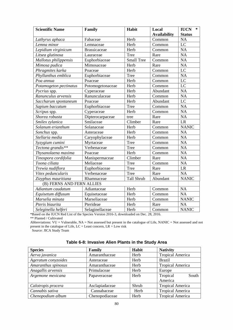
80
Scientific Name Family Habit Local
Availability
IUCN *
Status
Lathyrus aphaca Fabaceae Herb Common NA
Lemna minor Lemnaceae Herb Common LC
Lepidium virginicum Brassicaceae Herb Common NA
Litsea glutinosa Lauraceae Tree Rare NA
Mallotus philippensis Euphorbiaceae Small Tree Common NA
Mimosa pudica Mimosaceae Herb Rare NA
Phragmites karka Poaceae Herb Common LC
Phyllanthus emblica Euphorbiaceae Tree Common NA
Poa annua Poaceae Herb Common LC
Potamogeton pectinatus Potomogetonaceae Herb Common LC
Pycrius spp. Cyperaceae Herb Abundant NA
Ranunculus arvensis Ranunculaceae Herb Common NA
Saccharum spontaneum Poaceae Herb Abundant LC
Sapium baccatum Euphorbiaceae Tree Common NA
Scripus spp. Cyperaceae Herb Common NA
Shorea robusta Dipterocarpaceae tree Rare NA
Smilex zylanica Smilaceae Climber Rare LR
Solanum erianthum Solanaceae Herb Common NANIC
Sonchus spp. Asteraceae Herb Common NA
Stellaria media Caryophylaceae Herb Common NA
Syzygium cumini Myrtaceae Tree Common NA
Tectona grandis** Verbenaceae Tree Common NA
Thysanolaena maxima Poaceae Herb Common NA
Tinospora cordifolia Manispermaceae Climber Rare NA
Toona ciliata Meliaceae Tree Common NA
Trewia nudiflora Euphorbiaceae Tree Rare LR
Vitex peduncularis Verbenaceae Tree Rare NA
Zizyphus mauritiana Rhamnaceae Tall Shrub Abundant NANIC
(B) FERNS AND FERN ALLIES
Adiantum caudatum Adiantaceae Herb Common NA
Equisetum diffusum Equisetaceae Herb Common NA
Marselia minuta Marseliaceae Herb Common NANIC
Pteris biaurita Pterideae Herb Rare NA
Seleginella helferi Selaginellaceae Herb Common NANIC *Based on the IUCN Red List of the Species Version 2016-3, downloaded on Dec. 28, 2016.
** Planted / Cultivated
Abbreviations: VU = Vulnerable, NA = Not assessed but present in the catalogue of Life, NANIC = Not assessed and not
present in the catalogue of Life, LC = Least concern, LR = Low risk
Source: JICA Study Team
Table 6-8: Invasive Alien Plants in the Study Area
Species Family Habit Nativity
Aerva javanica Amaranthaceae Herb Tropical America
Ageratum conyzoides Asteraceae Herb Brazil
Amaranthus spinosus Amaranthaceae Herb Tropical America
Anagallis arvensis Primulaceae Herb Europe
Argemone mexicana Papaveraceae Herb Tropical South
America
Calotropis procera Asclapiadaceae Shrub Tropical America
Cannabis sativa Cannabaceae Herb Tropical America
Chenopodium album Chenopodiaceae Herb Tropical America

81
Species Family Habit Nativity
Cleome viscosa Capparaceae Herb Tropical America
Cuscuta reflexa Cuscutaceae Climber Mediterranean region
Datura metal Solanaceae Shrub Tropical America
Eichhornia crassipes Pontederiaceae Herb Tropical America
Euphobia hirta Euphorbiaceae Herb Tropical America
E. thymifolia Euphorbiaceae Hurb Tropical America
Galinsoga paviflora Asteraceae Herb Tropical America
Lantana camara Verbenaceae Shrub Tropical America
Oxalis corniculata Oxalidaceae Herb Europe
Parthenium hysterophorus Asteraceae Herb Tropical America
Physalis minima Solanaceae Herb Tropical America
Portulaca oleracea Portulacaceae Herb Tropical South
America
Prosopis juliflora Mimosaceae Small Tree Mexico
Saccharum spontaneum Poaceae Herb Tropical America
Side acuta Malvaceae Herb Tropical America
Solanum nigrum Solanaceae Herb Tropical America
Tridex procumbens Asteraceae Herb Tropical America
Typha angustifolia Typhaceae Herb Tropical America
Xanthium strumarium Asteraceae Herb Tropical America Source: JICA Study Team
The faunal diversity as recorded for the bridge influenced area is listed in Table below. Evidently,
177 animal species belonging to mammals (10), avifauna (68), reptiles (15) amphibians (04), fish
(70), and invertebrates (10) are recorded for the study site. The status of occurrence of these
speciesased on the field study and following the Wildlife Act (amended in 2013) as well as the
IUCN status are also in the Tables. The diversity of fish fauna as recorded for the area along with
the IUCN status and local availability is enlisted in Table below. Some migratory species were
found in the study area and indicated in bold letter in the table below. Ganges river dolphins are
known to have local migration pattern due to water level change between wet and dry season, but
they are seen in Dhubri area all year around, All of the other migratory species were birds, and no
seasonal variation was found in reptiles, amphibians, fish and invertebrate according to interview
and literature surveys.
Table 6-9: Animal biodiversity in the Study Area
Scientific Name Local /English Name Status*
WLA
IUCN**
Status
Mammals
Canis aureus Jackal LC
Cnnomys badius Bay Bamboo rat NANIC
Lepus nigricollis Hare Sch.III LC
Macaca mulatta Monkey LC
Mus musculus House mouse LC
Platanista gangetica ssp.
gangetica
Dolphin Sch. I EN
Pteropus giganteus Flying fox Sch. I LC
Trachypithecus pileatus Capped Langur Sch. I VU
Sus scrofa Wild Boar LC
Vulpes bengalensis Fox Sch. III LC
Birds
Actitis hypoleucos Common Sandpiper LC
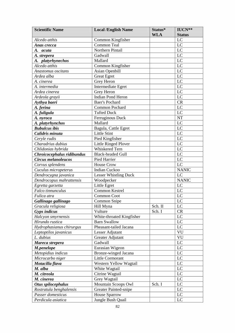
82
Scientific Name Local /English Name Status*
WLA
IUCN**
Status
Alcedo atthis Common Kingfisher LC
Anas crecca Common Teal LC
A. acuta Northern Pintail LC
A. strepera Gadwall LC
A. platyrhynechos Mallard LC
Alcedo atthis Common Kingfisher LC
Anastomus oscitans Asian Openbill LC
Ardea alba Great Egret LC
A. cinerea Grey Heron LC
A. intermedia Intermediate Egret LC
Ardea cinerea Grey Heron LC
Ardeola grayii Indian Pond Heron LC
Aythya baeri Baer's Pochard CR
A. ferina Common Pochard LC
A. fuligula Tufted Duck LC
A. nyroca Ferruginous Duck NT
A. platyrhynchos Mallard LC
Bubulcus ibis Bagula, Cattle Egret LC
Calidris minuta Little Stint LC
Ceryle rudis Pied Kingfisher LC
Charadrius dubius Little Ringed Plover LC
Chlidonias hybrida Whiskered Tern LC
Chroicocephalus ridibundus Black-headed Gull LC
Circus melanoleucos Pied Harrier LC
Corvus splendens House Crow LC
Cuculus micropeterus Indian Cuckoo NANIC
Dendrocygna javanica Lesser Whistling Duck LC
Dendrocopus mahrattensis Woodpecker NANIC
Egretta garzetta Little Egret LC
Falco tinnunculus Common Kestrel LC
Fulica atra Common Coot LC
Gallinago gallinago Common Snipe LC
Gracula religiosa Hill Myna Sch. II LC
Gyps indicus Vulture Sch. I CR
Halcyon smyrnensis White-throated Kingfisher LC
Hirundo rustica Barn Swallow LC
Hydrophasianus chirurgus Pheasant-tailed Jacana LC
Leptoptilos javanicus Lesser Adjutant VU
L. dubius Greater Adjutant VU
Mareca strepera Gadwall LC
M.penelope Eurasian Wigeon LC
Metopidius indicus Bronze-winged Jacana LC
Microcarbo niger Little Cormorant LC
Motacilla flava Western Yellow Wagtail LC
M. alba White Wagtail LC
M. citreola Citrine Wagtail LC
M. cinerea Grey Wagtail LC
Otus spilocephalus Mountain Scoops Owl Sch. I LC
Rostratula benghalensis Greater Painted-snipe LC
Passer domesticus House Sparrow LC
Perdicula asiatica Jungle Bush Quail LC

83
Scientific Name Local /English Name Status*
WLA
IUCN**
Status
Ploceus philippinus Baya LC
Pluvialis fulva Pacific Golden Plover LC
Podicep nigricollis Blacknecked grebe LC
Porphyrio porphyrio Purple Swamphen LC
Psittacula krameri manillensis Parrot Sch. I NA
Spatula clypeata Red-crested Pochard LC
S. querquedula Garganey LC
Sturnus contra Grey-headed Myna Sch.I NA
Tachybaptus ruficollis Little Grebe LC
Tringa stagnatilis Marsh Sandpiper LC
T. glareola Wood Sandpiper LC
T. nebularia Common Green Shank LC
T. ochropus Green Sandpiper LC
Vanellus vanellus Northern Lapwing LC
V. cinereus Grey-headed Lapwing LC
V. indicus Red-wattled Lapwing LC
Reptiles
Aspideretes gangaticus Gangetic softshell turtle Sch. I VU
Aspideretes hurum Indian peacock softshell turtle Sch. I VU
Bungarus fasciatus Common Indian Krait Sch. II LC
Chitra indica Narrow-headed softshell turtle EN
Crotalus sp. Viper LC
Cyclemys sp. Asian leaf turtle NT
Hemidactylus flaviviridis House Geeko NA
Lissemys punctata Indial flap-shelled turtle LC
Melanochelys tricarinata Tricarinate turtle Sch. I VU
Morenia petersi Indian eyed turtle VU
Naja naja Cobra Sch. II DD
Pangshura smithii Brown roofed turtle NT
Pangshura sylhetensis Assam roofed turtle EN
P. tentoria Indian tent turtle LC
Varanus bengalensis Common Indian Monitor Sch. I LC
Amphibians
Bufo melanostictus Common Asian Toad LC
Hoplobatrachus tigerinus Indian Bull Frog Sch. I LC
Polypedates sp. Frog LC
Spaerotheca brericeps Burrowing Frog NANIC
Fish
Ailia coila Gangetic ailia NT
Amphipnous cuchia Cuchia NA
Anabas testudineus Climbing perch DD
Aorichthys seenghala Giant river-catfish NA
A. aor Long-whiskered catfish LC
Apistogramma borelli Bareli NA
Aspidoparia moror Boreala NANIC
Badis badis Blue perch LC
Bagarius bagarius Devil catfish NT
Barillus bendalisis Barilius NANIC
B.barna Barilius NANIC
Batasio sp. Tengra NA
Catla catla Catla NA
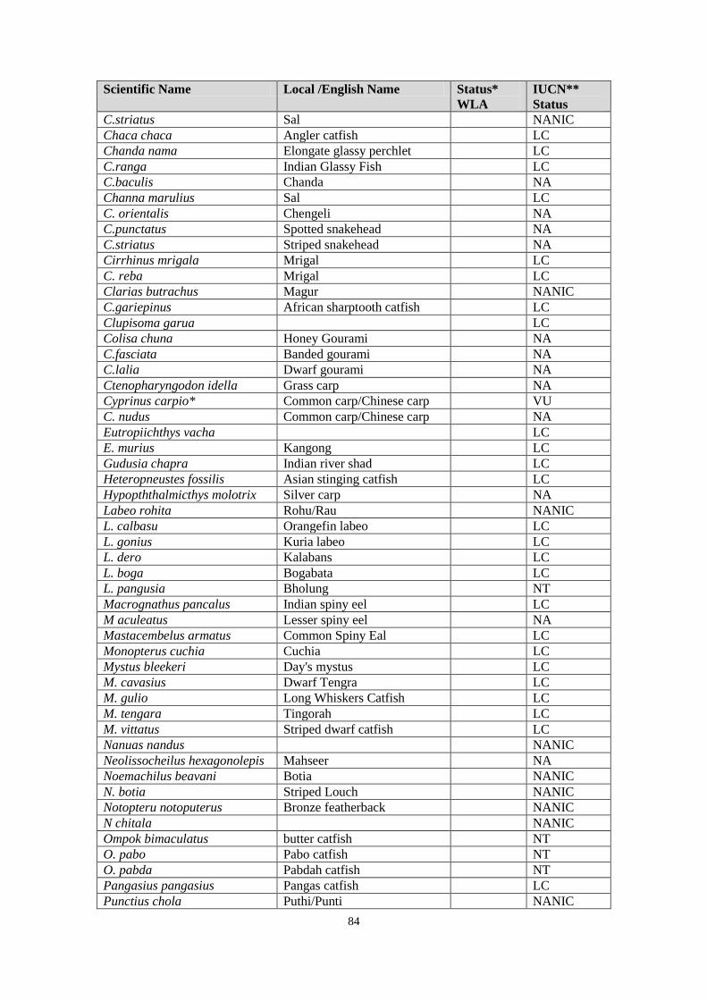
84
Scientific Name Local /English Name Status*
WLA
IUCN**
Status
C.striatus Sal NANIC
Chaca chaca Angler catfish LC
Chanda nama Elongate glassy perchlet LC
C.ranga Indian Glassy Fish LC
C.baculis Chanda NA
Channa marulius Sal LC
C. orientalis Chengeli NA
C.punctatus Spotted snakehead NA
C.striatus Striped snakehead NA
Cirrhinus mrigala Mrigal LC
C. reba Mrigal LC
Clarias butrachus Magur NANIC
C.gariepinus African sharptooth catfish LC
Clupisoma garua LC
Colisa chuna Honey Gourami NA
C.fasciata Banded gourami NA
C.lalia Dwarf gourami NA
Ctenopharyngodon idella Grass carp NA
Cyprinus carpio* Common carp/Chinese carp VU
C. nudus Common carp/Chinese carp NA
Eutropiichthys vacha LC
E. murius Kangong LC
Gudusia chapra Indian river shad LC
Heteropneustes fossilis Asian stinging catfish LC
Hypopththalmicthys molotrix Silver carp NA
Labeo rohita Rohu/Rau NANIC
L. calbasu Orangefin labeo LC
L. gonius Kuria labeo LC
L. dero Kalabans LC
L. boga Bogabata LC
L. pangusia Bholung NT
Macrognathus pancalus Indian spiny eel LC
M aculeatus Lesser spiny eel NA
Mastacembelus armatus Common Spiny Eal LC
Monopterus cuchia Cuchia LC
Mystus bleekeri Day's mystus LC
M. cavasius Dwarf Tengra LC
M. gulio Long Whiskers Catfish LC
M. tengara Tingorah LC
M. vittatus Striped dwarf catfish LC
Nanuas nandus NANIC
Neolissocheilus hexagonolepis Mahseer NA
Noemachilus beavani Botia NANIC
N. botia Striped Louch NANIC
Notopteru notoputerus Bronze featherback NANIC
N chitala NANIC
Ompok bimaculatus butter catfish NT
O. pabo Pabo catfish NT
O. pabda Pabdah catfish NT
Pangasius pangasius Pangas catfish LC
Punctius chola Puthi/Punti NANIC

85
Scientific Name Local /English Name Status*
WLA
IUCN**
Status
P. javanicus NANIC
P. sarana Fire fin barb NANIC
P. ticto NANIC
Rita rita Rita LC
Tenualosa ilisha (Hilsa ilisha) Ilis/Ilisha LC
Wallago attu Wallago NT
Invertebrates
Macrobrachium choprai Prawn NA
M. rosenbergii Prawn NA
Macrognathus aral Toru LC
Chilades Laius Lime blue NA
Graphium sarpedon sarpedon Common Bluebottle NA
Mycalensis perseus blasius Common Bushbown NANIC
Anopheles stepnensi Anepheles Mosquito NANIC
Culex quingquefaeciatus Culex Mosquito NANIC
Hippasa lycosina Grassland spider NA
Pholcus phalangiodes House Spider NANIC *According to Wildlife Act, 1972 amended in 2013.
**Based on the IUCN Red List of the Species Version 2016-3, downloaded on Dec. 29, 2016.
Bold: Migratory species
Abbreviations: VU = Vulnerable, NA = Not assessed but present in the catalogue of Life, NANIC = Not assessed and not
present in the catalogue of Life, LC = Least concern, LR = Low risk, NT = Near Threatened, EN = Endangered, CR =
Critically Endangered, DD = Data Deficient
Source: JICA Study Team
Dr. Abdul Wakid, a Project Scientist at the Wildlife Institute of India and Head (honorary) of the
Gangetic Dolphin Research and Conservation Division (GDRCD) of Aaranyak, an Assam based
leading environmental NGO, has 17 years of experience in the scientific study and conservation
activities of the Ganges River Dolphins in Assam State. He conducted a series of dolphin surveys in
the Brahmaputra river system, starting from 2005. In the last census conducted in 2012, Dr. Wakid
and his team estimated dolphin population in Brahmaputra river system as follows.
Brahmaputra river system (including 2 tributaries): 635 dolphins
Brahmaputra River (not including tributaries): 583 dolphins
Brahmaputra River between the Golpara Bridge and Bangradesh border: 92-96 dolphins
During the 2012 survey, Dr. Wakid recorded the highest density of the dolphin population in the
section between the Goalpara Bridge and the Bangladesh border, including the river stretches
within the proposed bridge construction site of the Dhubri District. Highest density of dolphin
population was recorded in the dolphin survey conducted in 2005. The breeding season for the
Gangetic dolphins of Brahmaputra River is recorded as February to June. Dolphins are found in and
around Dhubri area throughout the year but aggregate in the deep section of the river in the winter
and more spread to the side channels during the summer. The population has had an upward trend
since 2008 because of the lot of community engagement and awareness activities conducted since
2008.
2) Hydrology/geology/geography
A riverbed topographic map of the Brahmaputra River was created for the area of the 20km width
including the Bridge crossing section by the riverbed configuration survey. The survey included the
Gandadhar River on the north bank and the Jinjiram River on the south bank, and tributaries of the
Brahmaptra River, to consider any influence from those rivers.
Existing data and materials were collected from all available resources including the observation
data from the Brahmaputra and Barak Basin organization (B&BBO), Shillong of the Central Water

86
Commission (CWC), available literature to assess the catchment areas and hydraulic parameters,
interviews of local people, DPR of Naranarayan Bridge, and physical model studies conducted by
NEHARI (North Eastern Hydraulic and Allied Research Institute) on behalf of the Brahmaputra
Board. These data and materials were studied and analyzed to determine the HFL (High Flood
Level), LWL (Low Water Level), Maximum discharge, and other necessary parameters. Various
simulations were carried out using the US Army Corps of Engineers (USACE) Hydraulic
Engineering Centre’s River Analysis System (HEC-RAS).

87
Source: DPR
Figure 6-9: Riverbed Topography around the Dhubri Bridge
Building structures in a river may cause erosion of the bank and riverbed. There are two kinds of
erosions: contraction scour and local sour. The contraction scour occurs due to a reduction in the
flow area of the river when it approaches a bridge. Reduction in flow area is followed by an
increase in flow velocity which results in the removal of sediments and rocks. The local scour is
caused by increased velocity of water around a bridge pier and abutment and due to the formation
of vortices and wakes. The contraction scour and the local scour together constitute the total scour
around piers. Hydraulic parameters used for the analysis are shown in the table below.
Table 6-10: Hydraulic Parameters
Parameters Values
High Flood Level(HFL) 30.36 m
Low Water Level(LWL) 23.00 m
Average Riverbed Slope 1/14,700
Maximum discharge for 100 years return period 100,306 m3/s
Maximum discharge for 10 years return period 71,225 m3/s
Maximum water velocity at HFL 4.5 m/s
Source: DPR
The analysis of the impact of the contrition was conducted. The interval of the substructures of the
Project Bridge is 125m and there will be no impact due to the contraction of the river width.

88
6.2.2 Anticipated Impacts and Mitigation Measures
1) Ecology
Impacts
The main impact on flora involves the removal of trees and the grubbing of vegetative cover for
construction and a clear zone within the Right of Way (ROW) and for spoil bank. The types of
impacts on ecosystem and biodiversity can be as follows:
Loss of trees;
Compaction of vegetation, and
Pollution and dust accumulation on vegetation.
The construction phase of the bridge will lead to the release of some amount of debris which
needs be managed judiciously in order to maintain ecology of the area and aquatic life.
During the construction of the proposed dam, there is a high possibility of dolphins and their
habitats impacts due to high underwater noise, water quality change, habitat geomorphology changes,
prey-base depletion etc.
The existing Gangas river dolphin population suffers from habitat fragmentation by the
development activities such as the construction of dam. It is estimated to be one of the causes of
population decrease. In the case of this project, the dolphins and other aquatic species can pass under
the bridge and no habitat fragmentation will be caused.
Several endangered chelonian species are found in Dhubri area. These species can potentially
suffer from habitat change by the construction activities, but the main cause of decline of the turtles
is illegal hunting by humans for their meat. Therefore, in order to minimize the negative impacts on
the turtle species, habitat change should be kept at minimum and hunting activities must be
completely prohibited amongst the contractors. Noise from different equipment, vehicles, and
human traffic has the potential to disturb migratory birds, which may cause them to leave or change
their flight route until the activities are over.
No direct negative impact is anticipated on other species, but care should be taken to prevent
indirect negative impact such as the deterioration of habitat. There will be some temporary physical
disturbance to the aquatic environment during construction, but no chemical pollution will be
caused and therefore no irreversible damage will be caused for the aquatic species.
Mitigation Measures
The following mitigation measures are recommended.
<Pre-Construction phase>
No detailed survey has been done on the population of the dolphins in the Dhubri area, so it
is suggested that a scientific study is done before the construction begins as a baseline for
monitoring.
<Construction phase>
Land clearing activities at the construction site should be kept at an absolute minimum.
Construction vehicles, machinery and equipment will be moved or stationed in the (ROW)
to prevent compaction of vegetation. While operating on temporarily acquired land for
traffic detours, storage, material handling or any other construction related or incidental
activities, it will be ensured that the trampling of soil is avoided.
Anti-poaching measures during the construction phase should be strengthened to check for
any violation of existing regulations. Awareness campaign to be made among the workers to
aware them on the endangered and other important species. The species at higher risk of
being hunted are the softshell turtles as it is known to be a delicacy. No hunting of any kind
will be permitted and vigilant monitoring will be carried out amongst construction workers.
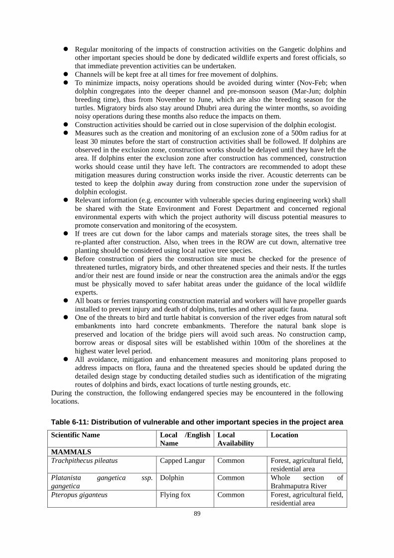
89
Regular monitoring of the impacts of construction activities on the Gangetic dolphins and
other important species should be done by dedicated wildlife experts and forest officials, so
that immediate prevention activities can be undertaken.
Channels will be kept free at all times for free movement of dolphins.
To minimize impacts, noisy operations should be avoided during winter (Nov-Feb; when
dolphin congregates into the deeper channel and pre-monsoon season (Mar-Jun; dolphin
breeding time), thus from November to June, which are also the breeding season for the
turtles. Migratory birds also stay around Dhubri area during the winter months, so avoiding
noisy operations during these months also reduce the impacts on them.
Construction activities should be carried out in close supervision of the dolphin ecologist.
Measures such as the creation and monitoring of an exclusion zone of a 500m radius for at
least 30 minutes before the start of construction activities shall be followed. If dolphins are
observed in the exclusion zone, construction works should be delayed until they have left the
area. If dolphins enter the exclusion zone after construction has commenced, construction
works should cease until they have left. The contractors are recommended to adopt these
mitigation measures during construction works inside the river. Acoustic deterrents can be
tested to keep the dolphin away during from construction zone under the supervision of
dolphin ecologist.
Relevant information (e.g. encounter with vulnerable species during engineering work) shall
be shared with the State Environment and Forest Department and concerned regional
environmental experts with which the project authority will discuss potential measures to
promote conservation and monitoring of the ecosystem.
If trees are cut down for the labor camps and materials storage sites, the trees shall be
re-planted after construction. Also, when trees in the ROW are cut down, alternative tree
planting should be considered using local native tree species.
Before construction of piers the construction site must be checked for the presence of
threatened turtles, migratory birds, and other threatened species and their nests. If the turtles
and/or their nest are found inside or near the construction area the animals and/or the eggs
must be physically moved to safer habitat areas under the guidance of the local wildlife
experts.
All boats or ferries transporting construction material and workers will have propeller guards
installed to prevent injury and death of dolphins, turtles and other aquatic fauna.
One of the threats to bird and turtle habitat is conversion of the river edges from natural soft
embankments into hard concrete embankments. Therefore the natural bank slope is
preserved and location of the bridge piers will avoid such areas. No construction camp,
borrow areas or disposal sites will be established within 100m of the shorelines at the
highest water level period.
All avoidance, mitigation and enhancement measures and monitoring plans proposed to
address impacts on flora, fauna and the threatened species should be updated during the
detailed design stage by conducting detailed studies such as identification of the migrating
routes of dolphins and birds, exact locations of turtle nesting grounds, etc.
During the construction, the following endangered species may be encountered in the following
locations.
Table 6-11: Distribution of vulnerable and other important species in the project area
Scientific Name Local /English
Name
Local
Availability
Location
MAMMALS
Trachpithecus pileatus Capped Langur Common Forest, agricultural field,
residential area
Platanista gangetica ssp.
gangetica
Dolphin Common Whole section of
Brahmaputra River
Pteropus giganteus Flying fox Common Forest, agricultural field,
residential area
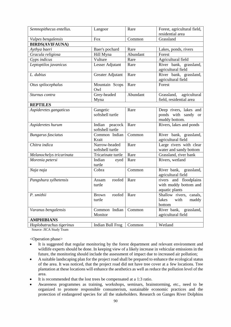
90
Semnopithecus entellus. Langoor Rare Forest, agricultural field,
residential area
Vulpes bengalensis Fox Common Grassland
BIRDS(AVIFAUNA)
Aythya baeri Baer's pochard Rare Lakes, ponds, rivers
Gracula religiosa Hill Myna Abundant Forest
Gyps indicus Vulture Rare Agricultural field
Leptoptilos javanicus Lesser Adjutant Rare River bank, grassland,
agricultural field
L. dubius Greater Adjutant Rare River bank, grassland,
agricultural field
Otus spilocephalus Mountain Scops
Owl
Rare Forest
Sturnus contra Grey-headed
Myna
Abundant Grassland, agricultural
field, residential area
REPTILES
Aspideretes gangaticus Gangetic
softshell turtle
Rare Deep rivers, lakes and
ponds with sandy or
muddy bottom.
Aspideretes hurum Indian peacock
softshell turtle
Rare Rivers, lakes and ponds
Bungarus fasciatus Common Indian
Krait
Common River bank, grassland,
agricultural field
Chitra indica Narrow-headed
softshell turtle
Rare Large rivers with clear
water and sandy bottom
Melanochelys tricarinata Tricarinate turtle Rare Grassland, river bank
Morenia petersi Indian eyed
turtle
Rare Rivers, wetland
Naja naja Cobra Common River bank, grassland,
agricultural field
Pangshura sylhetensis Assam roofed
turtle
Rare rivers and floodplains
with muddy bottom and
aquatic plants
P. smithii Brown roofed
turtle
Rare Shallow rivers, canals,
lakes with maddy
bottom
Varanus bengalensis Common Indian
Monitor
Common River bank, grassland,
agricultural field
AMPHIBIANS
Hoplobatrachus tigerinus Indian Bull Frog Common Wetland Source: JICA Study Team
<Operation phase>
It is suggested that regular monitoring by the forest department and relevant environment and
wildlife experts should be done. In keeping view of a likely increase in vehicular emissions in the
future, the monitoring should include the assessment of impact due to increased air pollution;
A suitable landscaping plan for the project road shall be prepared to enhance the ecological status
of the area. It was noticed, that the project road did not have tree cover at a few locations. Tree
plantation at these locations will enhance the aesthetics as well as reduce the pollution level of the
area.
It is recommended that the lost trees be compensated at a 1:3 ratio.
Awareness programmes as training, workshops, seminars, brainstorming, etc., need to be
organized to promote responsible consumerism, sustainable economic practices and the
protection of endangered species for all the stakeholders. Research on Ganges River Dolphins

91
needs be conducted to study in details the abundance, distribution, ecology and threats of the
Ganges River Dolphin in and around the construction sites. Community engagement and
awareness activities regarding the conservation of Gangetic dolphin also need to be done.
2) Hydrology
Impacts
Potential impact on hydrology will be minor, as the project does not involve the diversion or
re-routing of existing watercourses. However, the river flows in Brahmatupta and its tributary
Jhinjer will be slightly obstructed during the construction of piers of bridge, but for a limited period.
There is no other pond/canal that will be affected by the Project. Hence, a change in natural
drainage pattern will be very insignificant to the present state of the project.
During the operation stage, no impact is envisaged.
Mitigation Measures
The new bridge design is based on hydrological calculation results. Based on the obtained location
of water crossings and water discharge, the dimension and locations for drainage system are
determined. For cross drainage structure, the appropriate culvert type is selected by taking into
account the economy, construction workability, and maintenance ability.
3) Topography and Geology
Impacts
Change in topography (that of the existing) is envisaged to some extent at various places along the
entire length of the bridge and approach road while developing a 4-lane standard. The riverbed will
be excavated for the construction of substructures. The impact is temporary because the excavation
will be filled in after the construction of substructures. The change in topography will also happen
due to the operation of borrow areas. The construction of material handling yards and labor camps
will also alter the existing topography temporarily.
Mitigation Measures
During construction phase, the existing vegetation including shrubs and grasses along the route
(except within the strip directly under embankment or cutting) will be properly maintained. The
borrow areas shall be operated and closed as per the specifications for road and bridge construction
manual of MORTH. The borrow areas shall be filled with the rejected waste/material, spoil and
then finally a layer of topsoil shall be spread over it before carrying out plantation and turfing. For
turfing, plant species that are native to the area will be used. Temporary structures such as borrow
areas, material handling yards, and labor camps should be returned to their original states after
construction finishes. During the operation phase, maintenance of the embankment will be carried
out to avoid soil erosion. The slope protection/ retaining wall, if damaged due to land slide, will be
repaired promptly. The slope protection will also be established / strengthened regularly through the
plantation of shrubs and vegetation.
6.3 Major Impacts on Social Environment
(1) Involuntary Resettlement
As per the ROW design, the project will affect 761 households and 3,043 people. Out of which, 633
households (2,538 people) will be affected by their land only, and 127 households (500 people) will
be affected by the structure, meaning physically displaced households. One commercial shop will
be affected and one public structure (the government office) will be affected. No schools or
religious facilities will be affected.
Table 6-12: Summary of Households Affected
Item PAHs PAPs

92
Item PAHs PAPs
Total project-affected household 761 3,043
Household whose residential land will be affected (physically displaced) 127 500
Household whose agricultural land will be affected 633 2,538
Household whose commercial land will be affected 1 5 Source: JICA Study Team
Mitigation Measures
Affected households will be provided with adequate compensation and assistance. Based on the
census survey, the majority of affected households requested cash compensation and self-relocation.
However, if they request land compensation, the respective DCs in consultation with local
communities shall secure the land in the vicinity of the original place of residence to the extent
possible.
(2) The Poor
It should be noted that the poor are less exposed to big development projects and hence may feel
intimidated and unable to voice concerns, grievances and suggestions. The baseline survey has
identified the gap between official poverty level and poverty level as reported by the people. Their
income level is low and illiteracy rate is high, especially in Char land. Therefore, impact mitigation
measures and assistances shall be well considered recognizing the local situation.
Mitigation Measures
During the course of land acquisition and resettlement activities, adequate information sharing is a
must to include the poor in the process and it should be ensured that their grievances are heard and
redressed. A resettlement and restoration plan should be prepared considering their limited coping
capacity, as well as develop measures that lead to sustainable income generation for the affected
people rather than a one-off payment of compensation and assistance. Skill development shall be
also planned and implemented in a livelihood restoration program.
(3) Local Economy and Livelihood
Economic activities and livelihoods in the project area are mainly agriculture, animal rearing,
fishing and boat operation. People whose livelihoods that are likely to be affected by the project are
as follows.
1) Agriculture labours
In the project area, major crops are paddy and pulses and vegetables are the second crop. In Char
land, jute is also a common crop along with paddy and pulses. The land acquisition will not only
affect land owners but also agriculture laborers who are hired by the land owners on a temporary
basis during cultivation and harvest season. Those labourers are either relatives of the land owners
or villagers in the same or neighboring villages. Due to the land acquisition, loss of livelihood
associated with those agricultural lands is expected.
2) Boat operators
Based on the information provided by the boat operators association, a total of 2,000 boat operators
are registered in the Dhubri District and out of which around 250-300 operators are directly serving
between Dhubri and Phulbari. Others are operating to and from others parts of the district and
islands (Char lands) in the Brahmaputra River. According to Inland Waterway Transportation
(IWT), daily operations of direct boat services between Dhubri to Phulbari are 20 passenger boats
and 30-50 goods transportation boats.
Boat operators who are providing the service between Dhubri and Phulbari may experience loss of
business opportunities by the project. Considering that the continued demand is expected for the
passengers and goods transportation to and between the Char lands, boat operators servicing those

93
routes will not have a negative impact from the project. The impact on the loss of assets was also
pointed out by the boat owners. The project will consider compensation for those boats.
3) Fishermen
According to the meeting with fishermen in the project area, normally households engaging in
fishery also have agricultural land and their primary income source is agriculture. On the other hand,
there are around 100 fishermen along the alighnment whose livelihood depends primarily on fishery
activities. Fishing activities usually take place at night and they sell them to licensed traders in the
area. Fishermen are having their own boats without engines and their fishing ranges are normally
4-5km radius upstream, downstream and across the Brahamputra River, and thus fishing locations
are not fixed. Most fishermen are from the villages along the Brahamputra River and Char land and
only during the rainy season when the river becomes wider, will the people from other villages also
come for fishing.
Since there is no particular fishing ground mentioned along the alignment, permanent impact will
not be anticipated. During the construction stage, based on the fact that the fishermen move freely
in the Brahamputra River and that their activities take place at night when the construction work is
finished, the impact may not be significant. However, during the construction stage, considering
there will be vibration around pier construction areas and that the construction section will be
restricted during the construction period, travel distance may increase for fishermen and they may
face difficulty compared to during the pre-construction stage.
Mitigation Measures
In R&R, a combination of compensation and assistance will be prepared for those likely affected.
Since the project entails large scale construction, significant job opportunities will be generated.
Especially for the affected people in the project area, necessary trainings will be provided to meet
the eligibility of employment criteria. Moreover, the improvement of the transportation network is
expected to enhance accessibility to market, goods, increase employment opportunities and bring a
positive impact to the local economy. Necessary training will be also included in R&R to take
advantage of those opportunities.
(4) Land Use
Change of the land use will be expected along the alignment, most of which is agricultural land.
Although most of PAPs requested cash compensation over land compensation, if requested, DC
shall be responsible for identifying land for relocation. In this case, the development of a
resettlement site is required, which causes changes in land use pattern. In the case of the
construction of workers’ camp, land use will change in the short term.
Mitigation Measures
If land compensation were requested as a resettlement option, a resettlement site should be
identified by the DC as close to the existing village area as possible, and should ensure a proper
supply of basic utilities. As for the workers’ camp, the contractor should make lease agreements
with the land owners in consultation with the local community assisted by the DC. Prior to the
development of such sites, EIA should be carried out.
(5) Utilization of Local Resources
Excessive use of local resources especially the construction materials is expected. Assam and
Meghalaya State produces large amount of construction materials including crushed stones. In this
project, those materials will be procured from the existing public and private quarries. Aggregate
and landfill sand are also available from the surrounding areas of the project site. Local resources
should be procured in consultation and in agreement with the owners.
Mitigation Measures
94
If the excessive use of construction materials causes a price hike for local usage, although the
impact will be short-term, the source of construction materials should be coordinated accordingly.
(6) Social Infrastructure and Service / Sensitive Facilities
With the change of the starting point in the Dhubri District, there will be no impact on schools that
were initially a subject for relocation.
(7) Unequal Distribution of Benefits and Damages
Land acquisition and involuntary resettlement may lead unequal distribution of benefits between
those who are directly affected by the project and those who are not. Due to the nature of the bridge,
there is a possibility of an uneven distribution of benefits between the bridge connection site and
Char lands. However, people in Char lands will also benefit from the improved logistics network in
terms of easy access to materials, daily necessities and improved access to a market for their
produce.
Mitigation Measures
R&R will be designed and implemented to mitigate unequal distribution of benefits by providing
preferential opportunities to those who are directly affected. The project will pay special attention
to the people in Char lands to ensure that they will get benefits from the project. For this purpose,
an income restoration program will be prepared by taking into consideration their socio-economic
condition assisted by the external expert.
(8) Gender
There are a number of women headed households identified in the project site. Considering that the
target areas are Muslim communities, women may not be able to articulate their issues and
demands in the same way that the men can. It is also possible that participation in economic
activities and travelling distances may be limited for women.
Mitigation Measures
In order to reflect women’s needs, which may be different from those of men, the involvement of
women should be ensured in various stages of the project. Therefore, during RAP implementation,
a women representative should be invited and consulted with necessary assistance from village
chiefs and NGOs. If required, assistance would be provided to open accounts and receiving
compensation under their names. During the construction period, equal employment opportunities
should be sought for women and also preference should be given to women in choosing light
loaded work and day time work, if necessary.
(9) Children’s Rights
Although child labor is unlawful according to Article 24 of the Indian Constitution, it should be
ensured that child labor will be strictly prohibited.
Mitigation Measures
In order to ensure that only adults are eligible for potential employment opportunities created by the
project, the contract agreement with contractor should include the condition in its clause.
(10) Public Health and Occupational Health and Safety (OHS)
The health and safety measures at the design, construction, and operation phases are outlined in
Table below.
Table 6-13: Health and Safety Measures
Stage Health and Safety Measures
Construction Stage

95
Stage Health and Safety Measures
Health hazards
at workplace
Good and sufficient potable water (as per Indian Standard (IS) codes) shall be
provided to avoid water-borne diseases and to ensure the health of workers.
Adequate provision for drainage, sanitation and waste disposal shall be provided.
Preventive medical care shall be provided to workers.
Hygiene at
construction
camps
The contractor will provide and maintain temporary accommodation and ancillary
facilities for workers that meet standards and scales approved by the resident
engineer.
Drinking water, latrines and urinals shall be provided within the precincts of
accommodation, as per standards set by the Building and other Construction
Workers (Regulation of Employment and Conditions of Service) Act.
Garbage bins must be provided, regularly emptied and disposed of at landfill sites.
Health/social
hazards
Provide training on transmitted diseases to workers and villagers.
Segregation of male and female areas in the construction camp.
Risk from
operations
The contractor is required to comply with all the precautions as required for the
safety of the workmen as far as those applicable to this project.
The contractor shall supply all necessary safety appliances such as safety goggles,
gloves, helmets, masks, etc., to the workers and staff.
The contractor must comply with all regulations regarding safe scaffolding,
ladders, working platforms, gangways, stairwells, excavations, trenches and safe
means of entry and egress.
Fences are recommended between the road and quarry places. Malaria risks The contractor shall, at their own expense, conform to all anti-malarial instructions
given to them by the engineer including filling up any borrow pits that may have
been dug.
Operation Phase
Traffic accidents Establish traffic signs and enforce traffic control measures including speed limits in
the vicinity of schools and residential area. A traffic management plan shall be developed especially along congested locations.
Sidewalks and shoulders will be constructed at the congested locations to ensure
safety of pedestrians
Conduct traffic safety education by giving guidance to neighbors and schools for the
safe way of walking along the roads, crossing the roads and consider safe route to
school.To ensure the above, the physical facilities will be installed by contractors.
Safety education shall be continued in coordination with the schools and the police in
the neighborhood. These conditions will be included in the TOR of contractors.
Source: JICA Study Team
(11) Accidents
During the construction stage, traffic volume of heavy equipment and construction vehicles will
increase. During the operation stage, increase of traffic volume and speed might increase the risk of
accidents.
Mitigation Measures
During the construction stage, the construction section should be properly demarcated and signages
should be placed. Notice and necessary information shall be shared amongst surrounding villagers
prior to the construction activities. During the operation stage, traffic signs shall be installed,
especially in the built-up areas as well as at the junction of the existing road and approach road to
avoid traffic accidents. Sidewalks and pedestrian crossings will be equipped to ensure the safety
and movement of pedestrians.
6.4 Impact Analysis
Comparison between the scoping and survey results is shown below.
Table 6-14: Scoping and Survey Result

96
Item
Impact
Assessments of
Scoping
Impact
Assessments
of Study Result
Rational of the Impact Assessment
Pre
-co
nst
ruct
ion
Co
nst
ruct
ion
Sta
ge
Op
era
tio
n S
tag
e
Pre
-co
nst
ruct
ion
Co
nst
ruct
ion
Sta
ge
Op
era
tio
n S
tag
e
Pollution
Air Pollution D B- B- D B- B-
P: No impact is expected.
C: Some negative impacts are expected due to the
operation of construction equipment and vehicles.
One example is dust incidental to earthwork
especially during the dry season.
O: Air pollution is expected to increase due to
increase in traffic volume on the road.
Water
Pollution D B- D D B- D
P: No impact is expected.
C: Turbid water due to the earthworks, bridge pier
construction work and wastewater effluents from
construction workers’ camps / yards are expected to
pollute the Brahmaputra river to some extent.
O: No impact is expected.
Wastes /
Hazardous
Materials
D B- D D B- D
P: No impact is expected.
C: Waste will be generated from construction
workers’ camps. Waste generated from
construction and demolition work may include
hazardous materials that must be treated before
final disposal.
O: No impact is expected.
Soil
Contaminatio
n
D B- D D B- D
P: No impact is expected.
C: Impacts on soil from deposition of pollutants
from construction materials in the construction site
are expected to be small. Since there is no major
industrial activity along the road, it is unlikely that
soil along the road is already polluted.
O: No impact is expected.
Noise and
Vibration D B- B- D B- B-
P: No impact is expected.
C: Noise and vibration are expected to be generated
by the operation of construction equipment and
vehicles, although temporary. Construction
schedule should take into account the location of
schools, hospitals and religious facilities that
require silence during parts of the day.
O: Noise and vibration levels are likely to increase
due to greater traffic volume along the road.
Specific measures may be required to minimize
impacts on schools, hospitals and religious
facilities.
Bottom
sediment D C C D D D
P: No impact is expected.
C/O: The piers may cause slight changes in the
hydrodynamics and cause erosion of the bottom
sediment.
Natural Environment
Eco-system/Bi
o-diversity D A- B-
D B- B- P: No impact is expected.
C: During the construction period, ecosystems in
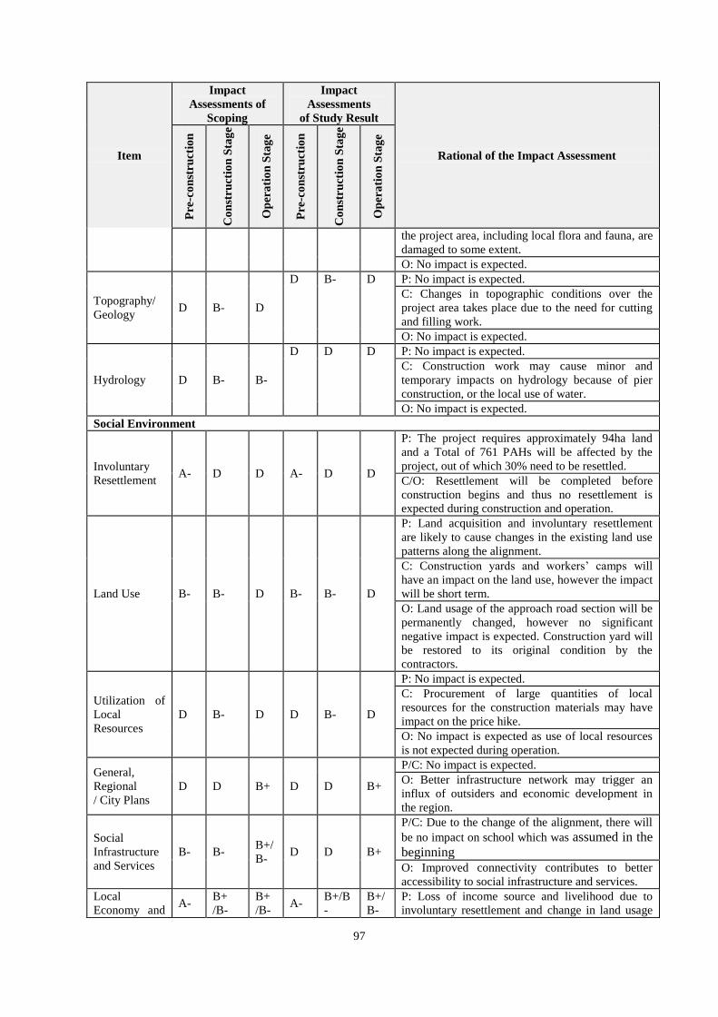
97
Item
Impact
Assessments of
Scoping
Impact
Assessments
of Study Result
Rational of the Impact Assessment
Pre
-co
nst
ruct
ion
Co
nst
ruct
ion
Sta
ge
Op
era
tio
n S
tag
e
Pre
-co
nst
ruct
ion
Co
nst
ruct
ion
Sta
ge
Op
era
tio
n S
tag
e
the project area, including local flora and fauna, are
damaged to some extent.
O: No impact is expected.
Topography/
Geology D B- D
D B- D P: No impact is expected.
C: Changes in topographic conditions over the
project area takes place due to the need for cutting
and filling work.
O: No impact is expected.
Hydrology D B- B-
D D D P: No impact is expected.
C: Construction work may cause minor and
temporary impacts on hydrology because of pier
construction, or the local use of water.
O: No impact is expected.
Social Environment
Involuntary
Resettlement A- D D A- D D
P: The project requires approximately 94ha land
and a Total of 761 PAHs will be affected by the
project, out of which 30% need to be resettled.
C/O: Resettlement will be completed before
construction begins and thus no resettlement is
expected during construction and operation.
Land Use B- B- D B- B- D
P: Land acquisition and involuntary resettlement
are likely to cause changes in the existing land use
patterns along the alignment.
C: Construction yards and workers’ camps will
have an impact on the land use, however the impact
will be short term.
O: Land usage of the approach road section will be
permanently changed, however no significant
negative impact is expected. Construction yard will
be restored to its original condition by the
contractors.
Utilization of
Local
Resources
D B- D D B- D
P: No impact is expected.
C: Procurement of large quantities of local
resources for the construction materials may have
impact on the price hike.
O: No impact is expected as use of local resources
is not expected during operation.
General,
Regional
/ City Plans
D D B+ D D B+
P/C: No impact is expected.
O: Better infrastructure network may trigger an
influx of outsiders and economic development in
the region.
Social
Infrastructure
and Services
B- B- B+/
B- D D B+
P/C: Due to the change of the alignment, there will
be no impact on school which was assumed in the
beginning
O: Improved connectivity contributes to better
accessibility to social infrastructure and services.
Local
Economy and A-
B+
/B-
B+
/B- A-
B+/B
-
B+/
B-
P: Loss of income source and livelihood due to
involuntary resettlement and change in land usage
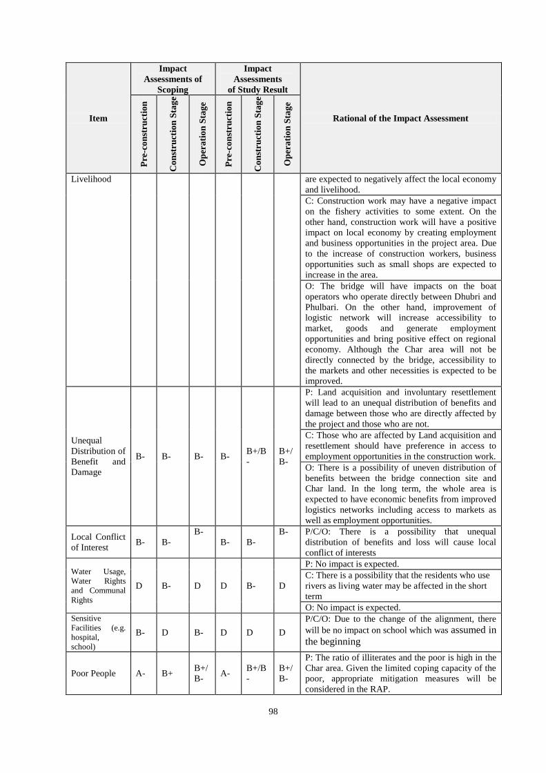
98
Item
Impact
Assessments of
Scoping
Impact
Assessments
of Study Result
Rational of the Impact Assessment
Pre
-co
nst
ruct
ion
Co
nst
ruct
ion
Sta
ge
Op
era
tio
n S
tag
e
Pre
-co
nst
ruct
ion
Co
nst
ruct
ion
Sta
ge
Op
era
tio
n S
tag
e
Livelihood are expected to negatively affect the local economy
and livelihood.
C: Construction work may have a negative impact
on the fishery activities to some extent. On the
other hand, construction work will have a positive
impact on local economy by creating employment
and business opportunities in the project area. Due
to the increase of construction workers, business
opportunities such as small shops are expected to
increase in the area.
O: The bridge will have impacts on the boat
operators who operate directly between Dhubri and
Phulbari. On the other hand, improvement of
logistic network will increase accessibility to
market, goods and generate employment
opportunities and bring positive effect on regional
economy. Although the Char area will not be
directly connected by the bridge, accessibility to
the markets and other necessities is expected to be
improved.
Unequal
Distribution of
Benefit and
Damage
B- B- B- B- B+/B
-
B+/
B-
P: Land acquisition and involuntary resettlement
will lead to an unequal distribution of benefits and
damage between those who are directly affected by
the project and those who are not.
C: Those who are affected by Land acquisition and
resettlement should have preference in access to
employment opportunities in the construction work.
O: There is a possibility of uneven distribution of
benefits between the bridge connection site and
Char land. In the long term, the whole area is
expected to have economic benefits from improved
logistics networks including access to markets as
well as employment opportunities.
Local Conflict
of Interest B- B-
B-
B- B-
B- P/C/O: There is a possibility that unequal
distribution of benefits and loss will cause local
conflict of interests
Water Usage,
Water Rights
and Communal
Rights
D B- D D B- D
P: No impact is expected.
C: There is a possibility that the residents who use
rivers as living water may be affected in the short
term O: No impact is expected.
Sensitive
Facilities (e.g.
hospital,
school)
B- D B- D D D
P/C/O: Due to the change of the alignment, there
will be no impact on school which was assumed in
the beginning
Poor People A- B+ B+/
B- A-
B+/B
-
B+/
B-
P: The ratio of illiterates and the poor is high in the
Char area. Given the limited coping capacity of the
poor, appropriate mitigation measures will be
considered in the RAP.

99
Item
Impact
Assessments of
Scoping
Impact
Assessments
of Study Result
Rational of the Impact Assessment
Pre
-co
nst
ruct
ion
Co
nst
ruct
ion
Sta
ge
Op
era
tio
n S
tag
e
Pre
-co
nst
ruct
ion
Co
nst
ruct
ion
Sta
ge
Op
era
tio
n S
tag
e
C: The poor may bear a higher burden due to their
limited capacity to cope. However, they can benefit
from employment opportunities during construction
work.
P: The poor may fail to benefit from the project due
to lack of skills and coping capacity, therefore
assistance to improve their skills and capacity will
be considered in the RAP. With that assistance, the
poor can also gain benefit from improved market
access and business opportunities in the long run.
Ethnic
Minorities/
Indigenous
People
C C C D D D P/C/O: Ethnic minority and Scheduled Tribes were
not identified in PAH/PAPs.
Gender B- B- D B- B+/B
- D
P: Numbers of women-headed households were
identified. Involvement of women should be
ensured during the course of the land acquisition
and resettlement process.
C: Equal opportunity in construction work should
be sought for women and job training should be
provided as necessary.
O: No impact is expected
Children's
Rights B- D D D D D
P: Due to the change of the alignment, there will be
no impact on school which was assumed in the
beginning
C: Child labor is unlawful according to Article 24
of the Indian Constitution. Only adults are eligible
for potential employment opportunities created by
the project. As for the precaution, the contract with
the contractors should include the clause to prohibit
hiring children for the construction works.
O: No impact is expected
Public Health
(sanitation and
infectious
diseases)
D B- D D B- D
P: No impact is expected.
C: Influx of construction workers is likely to
increase the health risk, particularly that of STD /
STI and HIV / AIDS.
O: No impact is expected
Occupational
Health and
Safety (OHS)
D B- B- D B- B-
P: No impact is expected.
C: Occupational health and safety of construction
work should be properly managed through
adequate EMP.
O: Hygiene and safety of workers should be
considered for those in charge of maintenance and
repair work.
Others
Accidents D B- B- D B- B-
P: No impact is expected.
C: An increased risk of accidents associated with
construction activities is expected due to the
operation of heavy equipment and vehicles.

100
Item
Impact
Assessments of
Scoping
Impact
Assessments
of Study Result
Rational of the Impact Assessment
Pre
-co
nst
ruct
ion
Co
nst
ruct
ion
Sta
ge
Op
era
tio
n S
tag
e
Pre
-co
nst
ruct
ion
Co
nst
ruct
ion
Sta
ge
Op
era
tio
n S
tag
e
O: Risks of accidents is expected to increase due to
greater traffic volume and speed. Traffic measures
shall be taken especially in the village area.
Source: JICA Study Team
101
CHAPTER 7 Environmental Management Plan and Monitoring Plan
7.1 Environmental Management Plan
Descriptions of the environment management measures during different stages of the project are
provided in the tables below. Regarding measures to mitigate impacts on aquatic organisms such as
Ganges dolphins, reference was made to experts on the ecology of Ganges dolphin and other
similar projects.

102
Table 7-1: Environmental Management Plan for Pre-Construction Stage
Sl. No Environmental
Impacts/Issues Mitigation Measures Location Time Frame
Responsibility
Implementation Supervision
P1 Bottom sediment Mobilization of bottom sediments will require
Contractor to install turbidity curtains. Brahmaputra
River
During boring
survey Contrcator
Project
Implementat
ion Unit (PIU)
P2
Resettlement of
Project Affected
Persons (PAP) /
Local Economy and
livelihood
All requirements of the RAP as applicable shall be complete before start of construction stage.
All areas
Before
construction
begins
Government of
Assam /
Meghalaya,
District Revenue
authorities and
District
Authorities,
NGO/Consultant
PIU, SC
P3
Land use / Identify
and prepare
relocation sites
The identification and selection of land use, land acquisition and/or lease during construction work shall be carried out with the assistance from respective DCs and in consultation with local residents.
In case of preparing relocation sites, necessary utilities such as water and electricity shall be provided.
Near the original
villages
Before
construction
stage District
Authorities/
Contractor
PIU
P4
Unequal distribution
of benefit and
damage
Support measures shall be implemented based on RAP
including the preferential provision of employment
opportunities to those directly affected.
Support measures for the char people will be planned with
the assistance from NGO and other experts so that they can
receive maximum benefit from the project.
Within
ROW
Before
construction
stage
District
Authorities,
NHIDCL, NGO PIU
P5 Local conflicts of
interest
Carry out close monitoring of RAP process to detect and
resolve the local conflicts at earlier stage.
All areas Before
construction
stage
District
Authorities,
NHIDCL, NGO PIU

103
Sl. No Environmental
Impacts/Issues Mitigation Measures Location Time Frame
Responsibility
Implementation Supervision
P6 Poor people /
Gender
Ensure the participation of the poor and women in the process
of land acquisition and resettlement.
Livelihood restoration plan will be considered taking in to
account the limited skills of the poor people including
illiterate population and different needs of women.
Information shall be shared to women and representatives of
women with the assistance from the village heads and NGOs.
Within
ROW
Before
construction
stage
District
Authorities,
NHIDCL, NGO
PIU
Source: JICA Study Team
Table 7-2: Environmental Management Plan for Construction Stage
Sl. No Environmental
Impacts/Issues Mitigation Measures
Location Time Frame Responsibility Implementation Supervision
Soil
C1 Soil Erosion in Borrow Pits (Impact on topography/ geology )
The depth of borrow pits shall be Restricted so that sides of the excavation shall have a slope not steeper than 1:4, from the edge of the final section of the bank. After construction, excavated land shall be filled back to the original condition.
On approved locations of borrow pits.
Construction Stage
Contractor and Supervision Consultant
Project Implementa
tion Unit (PIU)
C2 Loss of top soil in Borrow pits (Impact on topography/ geology )
Agricultural fields or productive land shall be avoided for borrowing earth.
Top soil shall be preserved as instructed by the state government and used for tree plantation.
On approved locations of borrow pits.
Construction Stage
Contractor and Supervision Consultant
PIU
C3 Compaction of Soil (Impact on topography/geology )
Construction equipment and vehicles shall be restricted to move only within designated area to avoid compaction of productive soil.
Throughout corridor.
Construction Stage
Contractor and Supervision Consultant
PIU
C4 Soil erosion in embankments (Impact on topography/geology)
Pitching shall be done for slope stabilization as per the IRC guidelines
At the embankments
Construction Stage
Contractor and Supervision Consultant
PIU

104
C5 Soil Pollution
Construction vehicles and equipment shall be operated and maintained in such a manner so that soil contamination due to its spillage shall be at a minimum.
Fuel storage shall only be done on wasteland and will be kept away from drainage channels and natural water bodies.
All spills and discharged petroleum products shall be disposed of in accordance to the Hazardous Waste Management and Handling Rules.
Near Labor camp and Sites of
installation of Construction machineries.
Construction Stage
Contractor and Supervision Consultant
PIU
C6 Soil Pollution from construction waste
Debris generated due to unused / waste material shall be suitably reusedin the proposed construction, suchas for filling materials for embankments.
. All spoils shall be disposed of as desired and the site shall be fully cleaned before handing over.
Construction waste including non-bituminous and bituminous waste shall be dumped in an approved landfill site identified byStatePollution Control Board (SPCB) or competent authority. All spoils shall be disposed of as desired and the site shall be fully cleaned before handing over.
Solid waste dump Site
identified and approved by
SPCB or competent authority.
Construction Stage
Contractor and Supervision Consultant
PIU
C7 Loss of top soil Topsoil shall be stripped, stored and laid on ground for landscaping purposes.
Throughout the area
Construction Stage
Contractor and Supervision Consultant
PIU
Water C8 Water pollution Construction vehicles / equipment shall be operated and
maintained in such a manner to avoid contamination of water bodies due to oil spillage.
Fuel storage shall only be done on wasteland and will be kept away from drainage channels and natural water bodies.
Oil and grease traps will be provided at fueling locations
Near labor camp and sites of the installation of Construction machineries.
Construction Stage
Contractor and Supervision Consultant
PIU
C9 Water pollution from labor camp.
Labor camp shall not be allowed near any of the water bodies. The proper sanitation facilities shall be provided.
Preapproved locations away from the water
bodies.
Construction Stage
Contractor and Supervision Consultant
PIU
C10 Deposition of dust in open wells near construction site
The mouth/opening of the well shall be covered with suitable material during any of the construction activity so as to prevent dust from entering in the well.
All the wells along the project
corridor.
Construction Stage
Contractor and Supervision Consultant
PIU

105
C11 Impact on Surface water quality due to eroded soils
• Construction work close to the watercourses or other water bodies will be avoided, especially during the monsoon period.
Increase coverage of open surface area by planting grass and creepers so that the washing away of materials from sloped surfaces would be reduced by a significant extent.
Silt curtain should be used for all underwater works.
All the respective locations
Construction Stage
Contractor and Supervision Consultant
PIU
Air
C12 Emission from construction vehicles and machinery.
All vehicles, equipment and machinery shall be selected to meet recognized international and national standards for emissions and shall be maintained and operated in a manner that ensures relevant air, noise and discharge rules.
Only unleaded petrol and low sulphur diesel or sulphur-free diesel shall be used as fuel for vehicles, equipment and machinery.
Air quality monitoring shall be conducted.
Wherever the hot mix plant and batching plant is setup.
Construction Stage
Contractor and Supervision Consultant
PIU
C13 Air pollution from various plants
affecting settlements
The asphalt plants, crushers and batching plants shall not be sited within at least 500m in leeward direction from the nearest human settlement.
Particulate Filters shall be installed.
Locations near Settlement
Construction Stage
Contractor and Supervision Consultant
PIU
C14 Dust The dust generated by vehicles on site shall be arrested using a water tanker fitted with a sprinkler capable of applying water uniformly with a controllable rate of flow to variable widths of surface but without any flooding.
Trucks shall be covered by the sheet.
Wherever the plants are
Set up and sensitive locations as
suggested in the monitoring plan.
Construction Stage
Contractor and Supervision Consultant
PIU
Waste
C15 Waste disposal Debris generated due to unused / waste material shall be suitably reused in the proposed construction, such as for filling materials for embankments.
Construction waste including non-bituminous and bituminous waste shall be dumped in an approved landfill site identified by State Pollution Control Board (SPCB) or competent authority. All spoils shall be disposed of as desired and the site shall be fully cleaned before handing over.
Solid waste dump Site identified and approved
by SPCB or competent authority.
Throughout the area
Construction Stage
Contractor and Supervision Consultant
PIU
Noise

106
C16 Noise levels from vehicles. Asphalt plants and equipment
・ The plants and equipment used for construction will strictly
conform to Central Pollution Control Board (CPCB) noise
standards. Vehicles, equipment and construction machinery
shall be monitored regularly with particular attention to
silencers and mufflers to maintain noise levels to a minimum;
・ Workers in the vicinity of high noise levels must wear ear
plugs and helmets and should be engaged in diversified
activities to prevent prolonged exposure to noise levels of
more than 90 dB(A);
・ In construction sites within 150 m of human settlements,
noisy construction will be stopped between 10 PM and 6 AM.
・ Hot mix plants, batching or aggregate plants shall not be
located within 500m of sensitive land use for schools
and hospitals;
・ For places close to the sensitive receptors such as
hospitals and schools, noise barriers such as earth,
concrete, wood, metal or double-glazing of windows for
façade insulation shall be used;
・ Phase demolition, earthmoving, and ground-impacting
operations are not to occur in the same time period.
Unlike noise, the total vibration level produced could be
significantly less when each vibration source operates
separately;
・ Construction machinery will be located away from the
settlements;
・ Careful planning of machinery operation and scheduling
of operations can reduce the noise levels.
・ Noise monitoring shall be conducted to check if the
noise level is within the environmental standards.
Throughout the project area
Construction Stage
Contractor and Supervision Consultant
PIU
Bottom Sediment
C17 ・ Slit curtain shall be installed to prevent move of the
sediment.
・ Construction works shall be suspended when flood warning
is issued.

107
Ecology C18 Tree cutting in
ROW •
•
•
・ Land clearing activities at the construction site should be
kept at an absolute minimum.
・ Construction vehicles, machinery and equipment will be
moved or stationed in the (ROW) to prevent compaction of
vegetation.
・ Water shall be sprinkled to prevent dust generation.
Throughout the project area
Construction Stage
Contractor and Supervision
Consultant Forest Dept.
PIU
C19 Endangered species ・ Relevant information (e.g. encounter with vulnerable
species during engineering work) shall be shared with the
State Environment and Forest Department and concerned
regional environmental experts.
・ Anti-poaching measures during the construction phase
should be strengthened to check for any violation of
existing regulations. Awareness campaign to be made
among the workers to aware them on the endangered and
other important species.
・ Construction vehicles must be operated at safe speed to
avoid collision with wildlife. Training should be
provided for the vehicle operators and warning signs should
be installed.
・ Change of geology and topography should be kept
minimum. Avoid constructing labor camps and construction
yards near the river banks.
・ To minimize impacts, noisy operations should be avoided
during breeding season of the dolphins (February-July).
・ River flow should not be blocked at all times for free
movement of dolphins.
・ Measures such as the creation and monitoring of an
exclusion zone of a 500m radius for at least 30 minutes
before the start of construction activities shall be
followed. If dolphins are observed in the exclusion
zone, construction works should be delayed until they
have left the area. If dolphins enter the exclusion zone
after construction has commenced, construction works
should cease until they have left.
・
Throughout the project
area
Construction Stage
Contractor and Supervision Consultant
PIU

108
C19 Endangered species (continued)
・ ・ All activities that increase soil erosion or contribute to
nutrients and pollutants to water need be minimized both on ・ -site and off-site by using measures such as silt curtain. ・ Construction activities should be carried out in close
supervision of the dolphin ecologist. ・ Construction works should be avoided or kept minimum in
vicinity of the dolphins’ favorable microhabitats (downstream of shallow areas/sandbars, tributary junctions)
・ Dolphins are likely to prefer water depth range between 4.1 to 6 m. Therefore, movement of sediment and influx of soil/silt etc. should be avoided to keep the favorable depth range.
・ In case rare birds of prey are observed near the construction area, the construction work will be avoided during their breeding season.
・ Before construction of piers the construction site must be
checked for the presence of threatened turtles, migratory birds,
and other threatened species and their nests. If the turtles
and/or their nest are found inside or near the construction area
the animals and/or the eggs must be physically moved to safer
habitat areas under the guidance of the local wildlife experts.
・ All boats or ferries transporting construction material and
workers will have propeller guards installed to prevent injury
and death of dolphins, turtles and other aquatic fauna.
・ One of the threats to bird and turtle habitat is conversion of the
river edges from natural soft embankments into hard concrete
embankments. Therefore the natural bank slope is preserved
and location of the bridge piers will avoid such areas. No
construction camp, borrow areas or disposal sites will be
established within 100m of the shorelines at the highest water
level period.
・ All avoidance, mitigation and enhancement measures and
monitoring plans proposed to address impacts on flora, fauna
and the threatened species should be updated during the
detailed design stage by conducting detailed studies such as
identification of the migrating routes of dolphins and birds,
exact locations of turtle nesting grounds, etc.
Throughout the project
area
Construction Stage
Contractor and Supervision Consultant
PIU

109
C20 Underwater noise impacts on aquatic species.
Use vibratory hammer. Under conditions where impact
hammers are required for reasons of seismic stability or
substrate type, it is recommended that the pile be driven as
deep as possible with a vibratory hammer prior to the use of
the impact hammer.
Monitor sound levels during pile driving to ensure that they
do not exceed the NOAA (National Oceanic and
Atmospheric Administration, USA) or any other
international recognized criteria.
Implement measures to attenuate the sound when sound
pressure levels exceed the NOAA or any other international
recognized criteria. Methods to reduce the sound pressure
levels include but are not limited to:
Installation of underwater enclosures to minimize sound
Surrounding the pile with an air bubble curtain system or
air-filled coffer dam.
Using a smaller hammer to reduce the sound pressure. The
sound produced in pile driving has a direct relationship to the
force used to drive the pile. A smaller hammer will have less
force on the pile therefore producing less sound.
Construction works should be ceased when the dolphins are
observed near the work area.
Social Environment
C21 Land Use When the workers’ camp was to be developed, the
contractor should make lease agreements with the land
owners in consultation with the local community assisted
by the DC. Prior to the development of such sites, EIA
should be carried out.
At respective planned construction sites
Construction Stage
Contractor and Supervision Consultant
PIU
C22 Utilization of Local Resources
If the excessive use of construction materials causes a price
hike for local usage, the source of construction materials
should be coordinated accordingly.
At respective planned construction sites
Construction Stage
Contractor and Supervision Consultant
PIU

110
C23 Local Economy and Livelihood / Unequal Distribution of Benefit and Damage / Local Conflict of Interest
PAP (including women and the poor) will be given priority to
be employed in the construction work. Information will be
widely shared to local residents for them to understand and
take advantages of the employment opportunities.
Provide vocational training that allows local residents to
satisfy the conditions to become workers.
Throughout the project area
Construction Stage
Contractor and Supervision Consultant,
NHIDCL, NGO
PIU
C24 Water use The contractor shall make arrangements for
To minimize the river pollution during construction,
mitigation measures will be applied such as installing a silt
fence in places close to the residential area.
At respective planned construction sites
Construction Stage
Contractor and Supervision Consultant
PIU
C25 Gender Equal employment opportunities should be sought for
women and also preference should be given to women in
choosing light loaded work and day time work, if necessary.
Throughout the project area
Construction Stage
Contractor and Supervision Consultant
PIU
Health and Hygiene
C26 Health hazard at Construction work sites
At every workplace, good and sufficient potable water (as per IS 10500) supply shall be ensured to avoid water-borne diseases and to secure the health of workers.
Adequate drainage, sanitation and waste disposal shall be provided at workplaces.
Preventive Medical care shall be provided to workers.
Wherever labor
camp is set up
Construction Stage
Contractor and Supervision Consultant
PIU
C27 Health hazard during construction work
Personal protective equipment shall be provided to workers as per the Factories Act.
Construction
work
Construction Stage
Contractor and Supervision Consultant
PIU
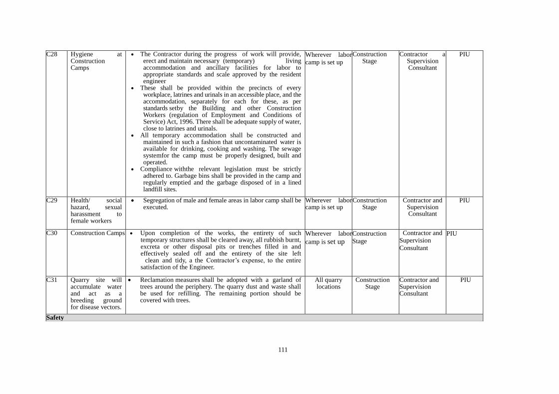
111
C28 Hygiene at Construction Camps
The Contractor during the progress of work will provide, erect and maintain necessary (temporary) living accommodation and ancillary facilities for labor to appropriate standards and scale approved by the resident engineer
These shall be provided within the precincts of every workplace, latrines and urinals in an accessible place, and the accommodation, separately for each for these, as per standards setby the Building and other Construction Workers (regulation of Employment and Conditions of Service) Act, 1996. There shall be adequate supply of water, close to latrines and urinals.
All temporary accommodation shall be constructed and maintained in such a fashion that uncontaminated water is available for drinking, cooking and washing. The sewage systemfor the camp must be properly designed, built and operated.
Compliance withthe relevant legislation must be strictly adhered to. Garbage bins shall be provided in the camp and regularly emptied and the garbage disposed of in a lined landfill sites.
Wherever labor
camp is set up
Construction Stage
Contractor and Supervision Consultant
PIU
C29 Health/ social hazard, sexual harassment to female workers
Segregation of male and female areas in labor camp shall be executed.
Wherever labor camp is set up
Construction Stage
Contractor and Supervision Consultant
PIU
C30 Construction Camps Upon completion of the works, the entirety of such temporary structures shall be cleared away, all rubbish burnt, excreta or other disposal pits or trenches filled in and effectively sealed off and the entirety of the site left clean and tidy, a the Contractor’s expense, to the entire satisfaction of the Engineer.
Wherever labor
camp is set up
Construction
Stage
Contractor and Supervision
Consultant
PIU
C31 Quarry site will accumulate water and act as a breeding ground for disease vectors.
Reclamation measures shall be adopted with a garland of trees around the periphery. The quarry dust and waste shall be used for refilling. The remaining portion should be covered with trees.
All quarry locations
Construction Stage
Contractor and Supervision Consultant
PIU
Safety
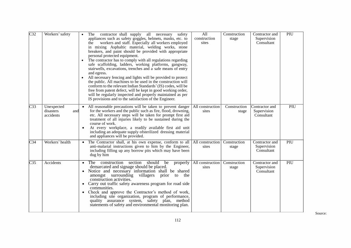
112
Source:
C32 Workers’ safety The contractor shall supply all necessary safety appliances such as safety goggles, helmets, masks, etc. to the workers and staff. Especially all workers employed in mixing Asphaltic material, welding works, stone breakers, and paint should be provided with appropriate personal protected equipment.
The contractor has to comply with all regulations regarding safe scaffolding, ladders, working platforms, gangway, stairwells, excavations, trenches and a safe means of entry and egress.
All necessary fencing and lights will be provided to protect the public. All machines to be used in the construction will conform to the relevant Indian Standards’ (IS) codes, will be free from patent defect, will be kept in good working order, will be regularly inspected and properly maintained as per IS provisions and to the satisfaction of the Engineer.
All construction
sites
Construction stage
Contractor and Supervision Consultant
PIU
C33 Unexpected disasters and accidents
All reasonable precautions will be taken to prevent danger for the workers and the public such as fire, flood, drowning, etc. All necessary steps will be taken for prompt first aid treatment of all injuries likely to be sustained during the course of work.
At every workplace, a readily available first aid unit including an adequate supply ofsterilized dressing material and appliances will be provided.
All construction sites
Construction stage
Contractor and Supervision Consultant
PIU
C34 Workers’ health The Contractor shall, at his own expense, conform to all anti-malarial instructions given to him by the Engineer, including filling up any borrow pits which may have been dug by him
All construction sites
Construction stage
Contractor and Supervision Consultant
PIU
C35 Accidents The construction section should be properly demarcated and signage should be placed.
Notice and necessary information shall be shared amongst surrounding villagers prior to the construction activities.
Carry out traffic safety awareness program for road side communities.
Check and approve the Contractor’s method of work, including site organization, program of performance, quality assurance system, safety plan, method statements of safety and environmental monitoring plan.
All construction sites
Construction stage
Contractor and Supervision Consultant
PIU
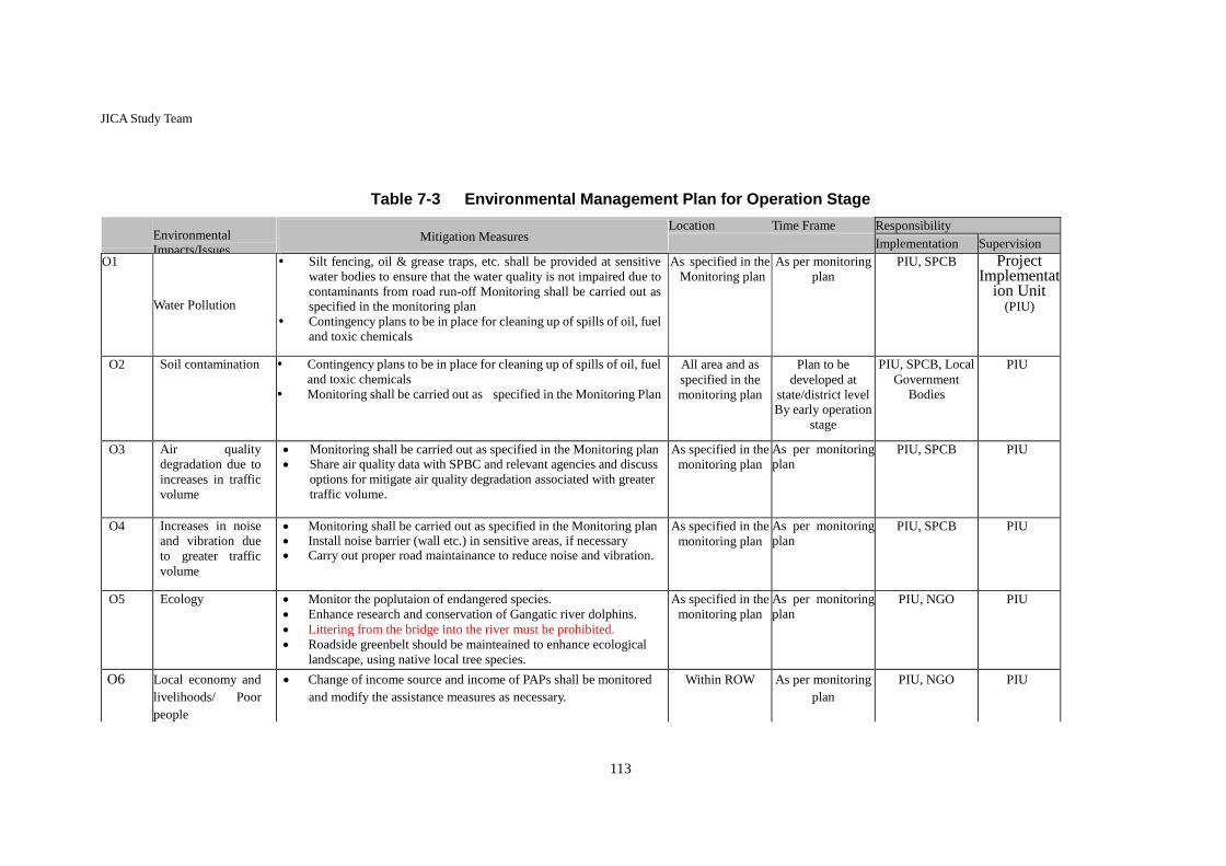
113
JICA Study Team
Table 7-3 Environmental Management Plan for Operation Stage
Environmental
Impacts/Issues
Mitigation Measures
Location Time Frame Responsibility
Implementation Supervision
O1
Water Pollution
••
Silt fencing, oil & grease traps, etc. shall be provided at sensitive
water bodies to ensure that the water quality is not impaired due to
contaminants from road run-off Monitoring shall be carried out as specified in the monitoring plan
Contingency plans to be in place for cleaning up of spills of oil, fuel
and toxic chemicals
As specified in the
Monitoring plan
As per monitoring
plan
PIU, SPCB Project Implementat
ion Unit (PIU)
O2 Soil contamination Contingency plans to be in place for cleaning up of spills of oil, fuel
and toxic chemicals
Monitoring shall be carried out as specified in the Monitoring Plan
All area and as
specified in the
monitoring plan
Plan to be
developed at
state/district level By early operation
stage
PIU, SPCB, Local
Government
Bodies
PIU
O3 Air quality
degradation due to
increases in traffic
volume
Monitoring shall be carried out as specified in the Monitoring plan Share air quality data with SPBC and relevant agencies and discuss
options for mitigate air quality degradation associated with greater
traffic volume.
As specified in the
monitoring plan
As per monitoring
plan PIU, SPCB PIU
O4 Increases in noise
and vibration due
to greater traffic
volume
Monitoring shall be carried out as specified in the Monitoring plan Install noise barrier (wall etc.) in sensitive areas, if necessary Carry out proper road maintainance to reduce noise and vibration.
As specified in the
monitoring plan
As per monitoring
plan PIU, SPCB PIU
O5 Ecology Monitor the poplutaion of endangered species.
Enhance research and conservation of Gangatic river dolphins.
Littering from the bridge into the river must be prohibited.
Roadside greenbelt should be mainteained to enhance ecological
landscape, using native local tree species.
As specified in the
monitoring plan
As per monitoring
plan PIU, NGO PIU
O6 Local economy and
livelihoods/ Poor
people
Change of income source and income of PAPs shall be monitored
and modify the assistance measures as necessary.
Within ROW As per monitoring
plan
PIU, NGO PIU

114
O7 Unequal
Distribution of
Benefit and Damage
/ Local Conflict of
Interest
Conduct interviews to DCs and village heads about dissatisfaction
or conflict of residents of the target area and explain and take
measures as necessary.
All area When issues are
identified
District
Authorities, PIU,
NGO
PIU
O8 Public Health /
Occupational
Health and Safety
(OHS)
Ensure the safety of the workers by providing safety guidance
to the maintenance and repair workers.
Area of
maintenance /
repair work
At the time of
maintenance /
repair work
PIU PIU
O9 Accidents Ensure the safety through traffic rules such as speed limit.
Traffic signs shall be installed, especially in the built-up
areas as well as at the junction of the existing road and
approach road to avoid traffic accidents.
Sidewalks and pedestrian crossings will be equipped to ensure the safety and movement of pedestrians.
All area As per
monitoring plan
PIU PIU
Source: JICA Study Team

115
7.2 Environment Monitoring Program
(1) Ambient Air Quality
Ambient air quality parameters recommended for monitoring road transportation developments are
PM10, PM2.5, Carbon Monoxide (CO), Oxides of Nitrogen (NOX), and Sulphur Dioxide (SO2).
These will be monitored at designated locations starting from the commencement of construction
activity. Data should be generated at all identified locations in accordance with the National
Ambient Air Quality Standards, 2009. The location, duration and the pollution parameters will be
monitored and the responsible institutional arrangements are detailed in the Monitoring Plan.
(2) Water Quality
The physical and chemical parameters recommended for the analysis of water quality relevant to
road / bridge development projects are: pH, turbidity, total solids, total dissolved solids, total
suspended solids, oil and grease, COD, chloride, lead, zinc and cadmium. The location, duration
and the pollution parameters to be monitored and the responsible institutional arrangements are
detailed in the Environmental Monitoring Plan. The monitoring of the water quality is to be carried
out at all identified locations in accordance with the Indian Standard Drinking Water Specification
– IS 10500: 2012.
(3) Noise
The measurements for monitoring noise levels would be carried out at all designated locations in
accordance with the Ambient Noise Standards formulated by the Central Pollution Control Board
(CPCB) in 1989. Noise should be recorded at an “A” weighted frequency using a “slow time
response mode” of the measuring instrument. The location, duration and the noise pollution
parameters to be monitored and the responsible institutional arrangements are detailed in the
Environmental Monitoring Plan.
(4) Biodiversity
The monitoring of ecosystem including the Ganges River Dolphins shall be carried out by
subcontracting a competent environmental NGO led by a qualified expert. A detailed dolphin
census survey shall be carried out before the onset of construction works, in which the estimated
number of the dolphins, demography, geographical distribution, and their behavioral pattern will be
studied in the project affected area. Using the data from the initial assessment as a baseline, the
monitoring of the dolphin population will be carried out thrice a year following the same survey
protocol. At the time of each survey, visual observation of the ecosystem will be also carried out for
presence/absence of other rare/endangered species.
The monitoring plan for the various performance indicators of the project in the construction and
operation stages is summarized in the table below.
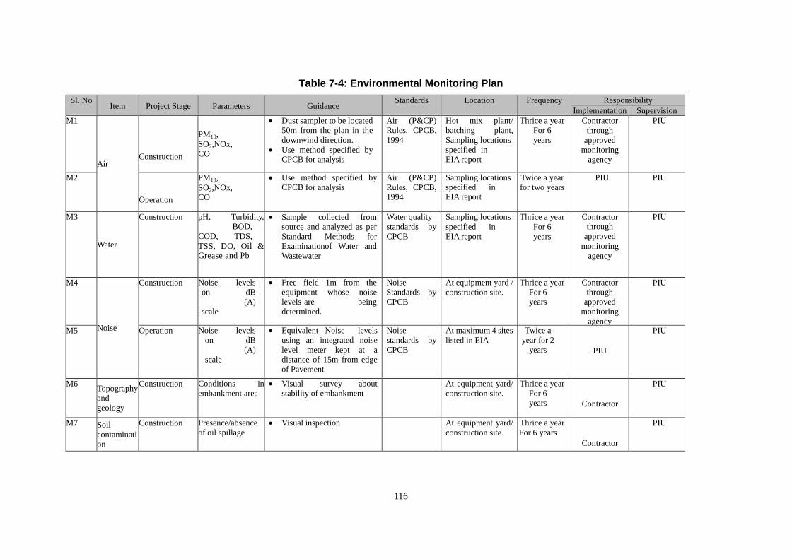
116
Table 7-4: Environmental Monitoring Plan
Sl. No Item Project Stage Parameters Guidance
Standards Location Frequency Responsibility
Implementation Supervision
M1
Air Construction
PM10,
SO2,NOx,
CO
Dust sampler to be located
50m from the plan in the
downwind direction.
Use method specified by CPCB for analysis
Air (P&CP)
Rules, CPCB,
1994
Hot mix plant/
batching plant,
Sampling locations
specified in
EIA report
Thrice a year
For 6
years
Contractor
through
approved
monitoring
agency
PIU
M2
Operation
PM10,
SO2,NOx, CO
Use method specified by
CPCB for analysis
Air (P&CP)
Rules, CPCB, 1994
Sampling locations specified in EIA report
Twice a year
for two years
PIU PIU
M3
Water
Construction pH, Turbidity,
BOD,
COD, TDS,
TSS, DO, Oil & Grease and Pb
Sample collected from
source and analyzed as per
Standard Methods for Examinationof Water and
Wastewater
Water quality
standards by
CPCB
Sampling locations
specified in
EIA report
Thrice a year
For 6
years
Contractor
through
approved
monitoring
agency
PIU
M4
Noise
Construction Noise levels
on dB
(A) scale
Free field 1m from the
equipment whose noise
levels are being determined.
Noise
Standards by
CPCB
At equipment yard /
construction site.
Thrice a year
For 6
years
required
by
the
engineer
Contractor
through
approved monitoring
agency
PIU
M5 Operation Noise levels
on dB
(A)
scale
Equivalent Noise levels
using an integrated noise
level meter kept at a
distance of 15m from edge
of Pavement
Noise
standards by
CPCB
At maximum 4 sites
listed in EIA
report for
noise monitoring
locations
Twice a
year for 2
years PIU
PIU
M6 Topography
and
geology
Construction Conditions in
embankment area
Visual survey about
stability of embankment
At equipment yard/
construction site.
Thrice a year
For 6
years
Contractor
PIU
M7 Soil
contaminati
on
Construction Presence/absence
of oil spillage
Visual inspection At equipment yard/
construction site.
Thrice a year
For 6 years
Contractor
PIU

117
Sl. No Item Project Stage Parameters Guidance
Standards Location Frequency Responsibility
Implementation Supervision
M9 Ecology Construction
and operation
Frequency of
dolphin sightings, Observation of
Vulnerable Species
(name and location
of the observed
species)
Name of the
Species:
Location of the
Observation
Observation from river bank
(from sunrise to sunset, 10 days), visual observation,
hearing to construction
workers/local residents
Baseline
survey will be
carried out
before
contruction
Dhubri, Phulbari Thrice a year for 6 years
during
construction
and twice a yeaer for 2
years during
operation
NGO, PIU PIU
M10 Livelihood Construction and
operation
Change of livelihood
Evaluate based on the
RAP monitoring results Census survey
carried out
during the RAP
preparation
Within ROW Twice a year
NGO PIU
M11 Land Use Construction Change of land use
Visual inspection Land use
before
construction
At construction yard
and labour camp
Twice a year Contractor PIU
M12
Utilization
of Local
Resources
Construction
Price of construction materials
Interview with local
construction company
NA
Dhubri, Phulbari
Twice a year Contractor PIU
M13
Unequal
Distribution
of Benefit
and
Damage
Construction and
operation Satisfactory level
Evaluate based on the
RAP monitoring results
NA
Dhubri, Phulbari Twice a year
NGO PIU
M14 Water use Construction Use of silt fence
Site inspection
NA
At the construction
site near residential
area
During
construction
near
residential
area
Contractor PIU
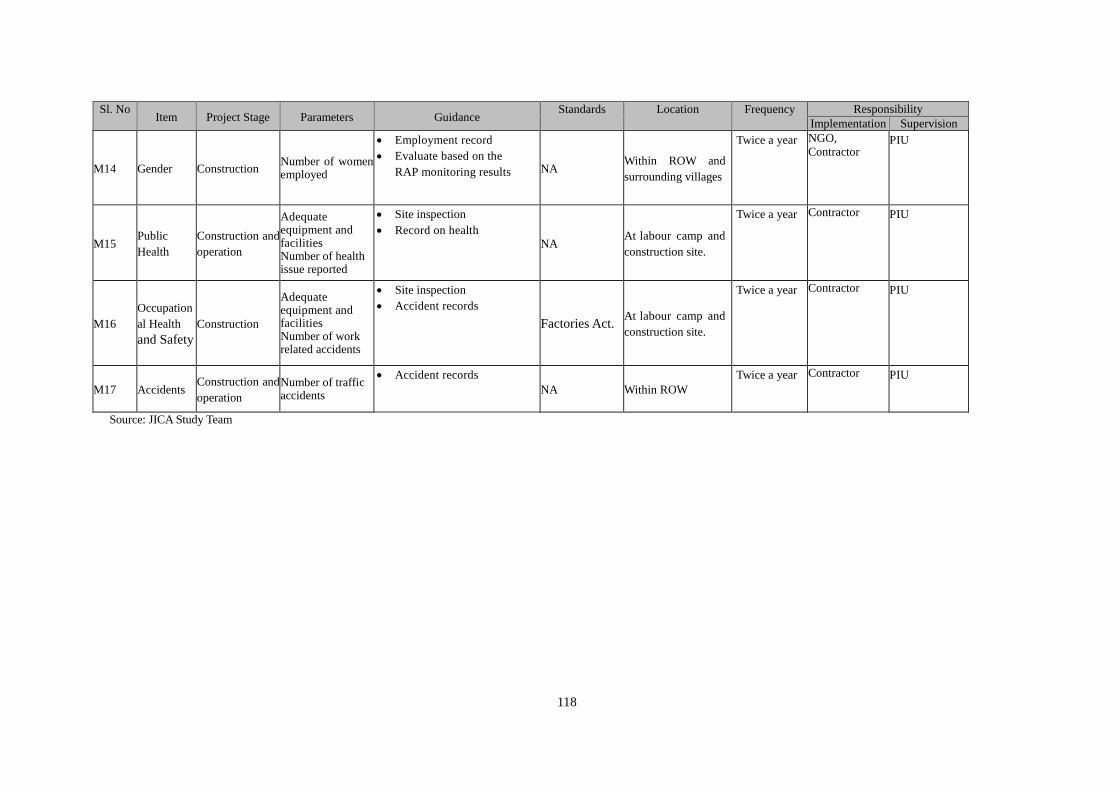
118
Sl. No Item Project Stage Parameters Guidance
Standards Location Frequency Responsibility
Implementation Supervision
M14 Gender Construction Number of women employed
Employment record
Evaluate based on the
RAP monitoring results NA Within ROW and
surrounding villages
Twice a year NGO,
Contractor PIU
M15 Public
Health
Construction and
operation
Adequate equipment and facilities Number of health issue reported
Site inspection
Record on health NA
At labour camp and
construction site.
Twice a year Contractor PIU
M16
Occupation
al Health
and Safety
Construction
Adequate equipment and facilities Number of work related accidents
Site inspection
Accident records
Factories Act. At labour camp and
construction site.
Twice a year Contractor PIU
M17 Accidents Construction and
operation
Number of traffic accidents
Accident records
NA Within ROW
Twice a year Contractor PIU
Source: JICA Study Team
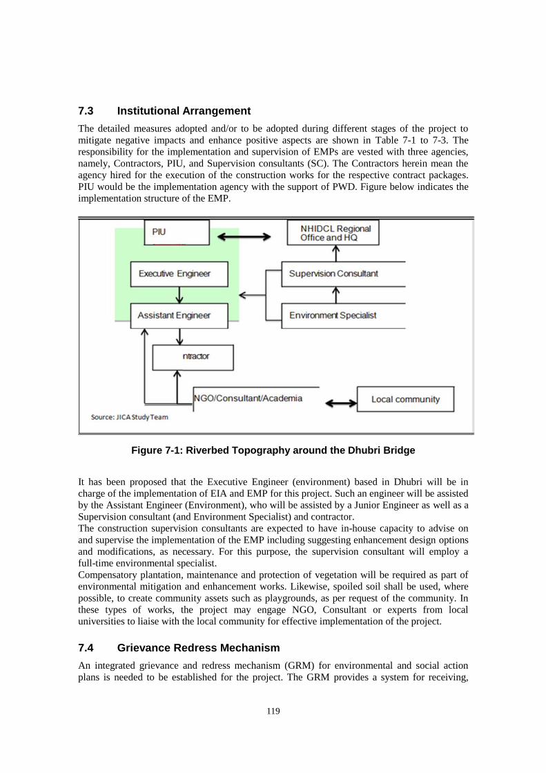
119
7.3 Institutional Arrangement
The detailed measures adopted and/or to be adopted during different stages of the project to
mitigate negative impacts and enhance positive aspects are shown in Table 7-1 to 7-3. The
responsibility for the implementation and supervision of EMPs are vested with three agencies,
namely, Contractors, PIU, and Supervision consultants (SC). The Contractors herein mean the
agency hired for the execution of the construction works for the respective contract packages.
PIU would be the implementation agency with the support of PWD. Figure below indicates the
implementation structure of the EMP.
Figure 7-1: Riverbed Topography around the Dhubri Bridge
It has been proposed that the Executive Engineer (environment) based in Dhubri will be in
charge of the implementation of EIA and EMP for this project. Such an engineer will be assisted
by the Assistant Engineer (Environment), who will be assisted by a Junior Engineer as well as a
Supervision consultant (and Environment Specialist) and contractor.
The construction supervision consultants are expected to have in-house capacity to advise on
and supervise the implementation of the EMP including suggesting enhancement design options
and modifications, as necessary. For this purpose, the supervision consultant will employ a
full-time environmental specialist.
Compensatory plantation, maintenance and protection of vegetation will be required as part of
environmental mitigation and enhancement works. Likewise, spoiled soil shall be used, where
possible, to create community assets such as playgrounds, as per request of the community. In
these types of works, the project may engage NGO, Consultant or experts from local
universities to liaise with the local community for effective implementation of the project.
7.4 Grievance Redress Mechanism
An integrated grievance and redress mechanism (GRM) for environmental and social action
plans is needed to be established for the project. The GRM provides a system for receiving,

120
evaluating and facilitating the resolution of affected people’s concerns, complaints, and
grievances about the project’s social and environmental performance. Due to the scale of the
project with one end of the bridge located in an urbanized section of Dhubri and adverse
impacts are anticipated, issues like poor legal records, voluminous titles and sometimes
conflicting holdings, intensive construction activities located near communities, traffic from
construction vehicles, and conflict between migrant and host communities are to be expected.
Grievances related to the implementation of the project, will be acknowledged, evaluated, and
responded to with corrective action proposed using understandable and transparent processes
that are gender responsive, culturally appropriate, and readily accessible to all segments of the
affected people. Records of grievances received, corrective actions taken and their outcomes
will be properly maintained.
The nature and significance will be evaluated by the receiving party. Any complaint which
concerns project construction activity, poses imminent serious risk to life and property, or will
result to irreversible damage to wildlife (dolphin) will be immediately forwarded to the PIU- for
action within 24-hours from receipt of complaint.
7.5 Monitoring Forms
The following Tables indicate JICA’s standardized monitoring form. Monitoring works should
be carried out every six months unless otherwise specifically noted.
Table 7-5: Environmental Clearance
During Construction Monitoring Item Conditions During the Reporting Period
Response to State Department’s
Comments/Guidance for Obtaining
Environmental Clearance
Source: JICA Study Team
Table 7-6: Air Quality
During Construction
Item
(Unit)
Measured
Value of
Baseline Data
(Max.)
Measured
Value of
Monitoring
(Max. Value)
Indian
Standard
Referred
Internationa
l Standard
Remarks (Location、Frequency and
Method of Measurement)
SO2 11.5 µg/m3 80µg/m
3 20µg/m
3 Chagal chora (Latitude 26°02'0.32"N &
Longitude 89°56'15.67"E)
Katiaralaga (Latitude 250 57' 49.90" N &
Longitude 890 58'38.26" E)
Bororavatari (Latitude 250 55' 03.91" N &
Longitude 900 00' 53.50" E) Phulbari (Latitude 250 53' 21.04" N & Longitude 900 02' 13.40" E) Thrice a year, Based on the National Ambient Air Quality Standard: NAAQS
NO2 23.7 µg/m3 80µg/m
3 200µg/m
3
CO 780 µg/m3 2000µg/m
3 -
PM10 88.7 100µg/m3 50µg/m
3
During Operation
Item
(Unit)
Measured
Value of
Baseline Data
(Max.)
Measured
Value of
Monitoring
(Max. Value)
Indian
Standard
Referred
Internationa
l Standard
Remarks (Location、Frequency and Method
of Measurement)

121
SO2 11.5 µg/m3 80µg/m
3 20µg/m
3 Chagal chora (Latitude 26°02'0.32"N &
Longitude 89°56'15.67"E)
Katiaralaga (Latitude 250 57' 49.90" N &
Longitude 890 58'38.26" E)
Bororavatari (Latitude 250 55' 03.91" N &
Longitude 900 00' 53.50" E) Phulbari (Latitude 250 53' 21.04" N & Longitude 900 02' 13.40" E) Twice a year, Based on the National Ambient Air Quality Standard: NAAQS
NO2 23.7 µg/m3 80µg/m
3 200µg/m
3
CO 780 µg/m3 2000µg/m
3 -
PM10 88.7 100µg/m3 50µg/m
3
Source: JICA Study Team
Table 7-7: Water Quality
During Construction
Item (Unit) Measured
Value
Indian
Standard
International
Standard
Remarks
(Location、Frequency and Method of Measurement)
pH 6.02-7.54 6.5-8.5 6-9 Chagal Chora (Latitude 26°02'0.58"N & Longitude
89°56'15.22"E) (Bore well)
Chaitarchar (Latitude 25°55'49.65"N& Longitude
89°59'30.77"E)(Brahmaputra River)
Katiaralaga (Latitude 250 57' 48.71" N & Longitude 890
58'34.52" E) (Hand pump)
Bororavatari (Latitude 250 55' 00.77" N & Longitude 900
01' 45.56" E) (Jinger River) P
hulbari (Latitude 250 53' 21.04" N & Longitude 900 02'
13.40" E) (Dug well)
Thrice a year, Based on the Indian Standard Drinking Water
Specification – IS 10500: 1991
Turbidity
(NTU)
6.5 10NTU 50mg/L
BOD/COD
(mg/L)
4.2/16.0 - 30/125
DO (% by
mass)
6.0-7.2 10 -
Heavy Metal <0.05 - -
Phenol <0.01 - -
Cyanide BDL - -
Source: JICA Study Team
Table 7-8: Solid Waste
During Construction Monitoring Item Types and amount of generated waste
Reused Debris
Disposed Debris Source: JICA Study Team
Table 7-9: Noise and Vibration
During Construciton
Item (Unit)
Measured
Value
(Min.
Value)
Measured
Value
(Max.
Value)
Indian
Standard
Referred
International
Standard
Remarks
(Location、Frequency and Method of
Measurement)
Noise Level
(dB)
40.5 62.4 Noise
Standard of
India 2000
Chagal Chora (Latitude 26°02'0.58"N &
Longitude 89°56'15.22"E)
Katiaralaga (Latitude 250 57' 48.75" N &
Longitude 890 58'34.64" E)
Bororavatari (Latitude 250 55' 05.21 N &
Longitude 900 00' 54.81" E) Phulbari (Latitude 250 53' 20.91" N & Longitude 900 02' 15.30" E),、Thrice a
Vibration
Level
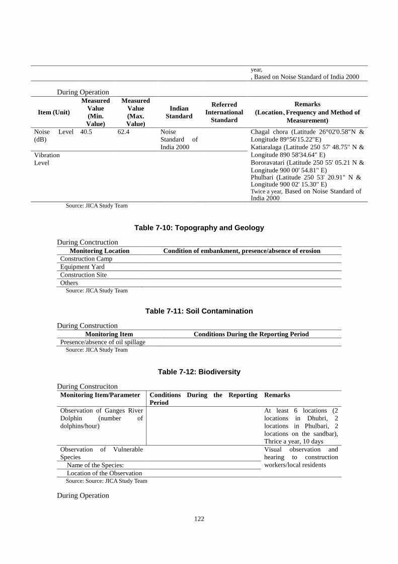
122
year,
, Based on Noise Standard of India 2000
During Operation
Item (Unit)
Measured
Value
(Min.
Value)
Measured
Value
(Max.
Value)
Indian
Standard
Referred
International
Standard
Remarks
(Location、Frequency and Method of
Measurement)
Noise Level
(dB)
40.5 62.4 Noise
Standard of
India 2000
Chagal chora (Latitude 26°02'0.58"N &
Longitude 89°56'15.22"E)
Katiaralaga (Latitude 250 57' 48.75" N &
Longitude 890 58'34.64" E)
Bororavatari (Latitude 250 55' 05.21 N &
Longitude 900 00' 54.81" E) Phulbari (Latitude 250 53' 20.91" N & Longitude 900 02' 15.30" E) Twice a year, Based on Noise Standard of India 2000
Vibration
Level
Source: JICA Study Team
Table 7-10: Topography and Geology
During Conctruction Monitoring Location Condition of embankment, presence/absence of erosion
Construction Camp
Equipment Yard
Construction Site
Others Source: JICA Study Team
Table 7-11: Soil Contamination
During Construction Monitoring Item Conditions During the Reporting Period
Presence/absence of oil spillage Source: JICA Study Team
Table 7-12: Biodiversity
During Construciton Monitoring Item/Parameter Conditions During the Reporting
Period
Remarks
Observation of Ganges River
Dolphin (number of
dolphins/hour)
At least 6 locations (2
locations in Dhubri, 2
locations in Phulbari, 2
locations on the sandbar),
Thrice a year, 10 days
Observation of Vulnerable
Species
Visual observation and
hearing to construction
workers/local residents Name of the Species:
Location of the Observation Source: Source: JICA Study Team
During Operation

123
Monitoring Item/Parameter Conditions During the Reporting
Period
Remarks
Observation of Ganges River
Dolphin (number of
dolphins/hour)
At least 6 locations (2
locations in Dhubri, 2
locations in Phulbari, 2
locations on the sandbar),
Twice a year, 10 days
Observation of Vulnerable
Species
Visual observation and
hearing to local residents
Name of the Species:
Location of the Observation Source: JICA Study Team
Table 7-13: Resettlement
Major items
of action Specific action steps (sub-items)
Prog
ress
in
quan
tity
Prog
ress
in %
Expect
ed Date
of
Compl
etion
Recruitment,
training and
deployment
Deployment of consultants and resettlement workers
(MM)
Training and mobilization (No. of trained personnel)
Review of
Resettlement
Action Plan
Review of RAP (%)
Finalization of PAPs (%)
Approval of RP with corrections (%)
Socioecono
mic Survey
Field Survey and collection of data, Data analysis (%)
Valuation of affected property and collection of data (%)
Produce data for comparison/evaluation (%)
Information
campaign
Distribute information brochure (No. distributed)
Public consultation meetings/FGD (Times)
Identification
of PAPs
Assigning ID numbers (No. of Person)
Payment Opening bank account (No. of Person)
Assist PAPs in collecting of cash compensation (No. of
Persons)
Confirm payment of transfer (No. of Persons)
Resettlement Coordination with DC on the new site (No. of Households)
Assist PAH for the resettlement (No. of Households)
Income
restoration
program
Training program, Assistant activities (No. of cases)
Field Survey and collection of socio-economic data after 5
years (%)
Grievance
Redress
Formation of GRC (%)
Receiving complaints / claims from PAPs (No. of cases)
Resolved complaints / claims from PAPs (No. of cases)
Supervision
and
Management
Supply of manpower (MM)
Number of meetings with relevant agencies (No. of
meetings)
Performance
Reporting
Inception / Monthly progress / Draft final report
Source: JICA Study Team
Table 7-14: Land Use

124
Monitoring Item Land use
(Before/After)
Size Agreed with land
owner (Yes/No)
Land acquired /
Lease / returned
Location
Source: JICA Study Team
Table 7-15: Utilization of Local Resources
Monitoring Item Price hike (Yes/No) If yes, description Name of Construction materials
Source: JICA Study Team
Table 7-16: Unequal Distribution of Benefit and Damage
Monitoring Item No. of samples No. of unsatisfied
PAPs
If unsatisfied, reasons
Satisfaction level *Based on RAP monitoring
Source: JICA Study Team
Table 7-17: Water Use
Monitoring Item Use of silt fence Turbidity
Location
Source: JICA Study Team
Table 7-18: Gender
Monitoring Item Description
Number of women employed
Source: JICA Study Team
Table 7-19: Public Health
Monitoring Item Description Equipment and facilities Adequate/Not adequate. If no, describe. Number and nature of health
issue reported
Source: JICA Study Team
Table 7-20: Occupational Health and Safety
Monitoring Item Description Equipment and facilities Adequate/Not adequate. If no, describe. Number and causes of work
related accidents
Source: JICA Study Team
Table 7-21: Accident
Monitoring Item Remark
Number of Injury/Fatalities
Location of the accident
Type and cause of the
accident

125
Source: JICA Study Team
7.6 Environmental Management Budget
The Proposed Budget for implementation of EMP is estimated below.
Table 7-22: Budget for EMP Implementation
No
.
Cost of Environmental / Mitigation Plan
Description Unit Qty
Unit Rate
(Rs.) Amount (Rs.)
A. Cost During Construction Phase
1 Environmental Monitoring
Air quality monitoring at 5 locations for 3
seasons for 6 consecutive years Nos. 90 8,000.00 720,000.00
Surface water quality monitoring at 5
locations for 4 seasons for 6 consecutive
years
Nos. 120 6,000.00 720,000.00
Noise quality monitoring at 10 locations for 3
seasons for 6 consecutive years Nos. 180 3,000.00 540,000.00
Flora and Fauna Study at 2 locations for 6
consecutive years Nos. 18 1,00,000.00 1,800,000.00
2 Dust suppression at site (2 trips/day for 300
days/year for 6 years) Nos. 3600 1,500.00 5400,000.00
3 Development of river funding near bridge
area, providing toilets etc. 10,00,000.00 1,000,000.00
Total cost during construction phase
10,180,000.00
B Institutional Cost
1. Expert Fees L.S 6,00,000.00
2. Staff Training L.S 4.00,000.00
3. Information Disclosure L.S 4,00,000.00
Total 14,00,000.00
C. Annual cost During Operation Phase
1 Environmental Monitoring
Air quality monitoring at 5 locations for 3
seasons for 2 years Nos. 30 8,000.00 2,40,000.00
Noise quality monitoring at 4 locations twice
a year for 2 years Nos. 16 3,000.00 48,000.00
Flora and Fauna Study at 2 locations for 2
consecutive years Nos. 4 1,00,000.00 4,00,000.00
Monitoring and maintenance efforts for
ensuring survival of planted trees for 2 years Nos. 1000
5,00.00 5,00,000.00
Total Cost During Operation Phase
11,88,000.00
Total Cost (A + B + C)
99,54,000.00
Contingency (10%)
9,95,400.00
Total (Rs.)
10,949,400.00 Source: JICA Study Team
126
CHAPTER 8 Stakeholder Consultation
Public consultations were arranged at the scoping phase and draft final report phase to ensure
the participation of the community in the planning process, and to gather issues, comments and
suggestions from the relevant stakeholders.
Consultation with the first stakeholder was held in two locations and followed by five
community meetings and three focus group discussions, in order to cover project area and to
have a comprehensive view on the project. Consultation with the second stakeholder was held in
four locations where a majority of the PAPs have easy access.
Information for those who remained un-surveyed due to absence during the census survey
period, information of stakeholder meeting and the summary of draft report, was shared by the
land acquisition officers of respective districts and assistance from the village chiefs and
neighboring residents. The same method will be employed for the information dissemination
during the hearing objection period.
8.1 1st Round Consultation
(1) 1st Round Consultation
The purpose of the stakeholders meeting at the scoping stage is to explain the project objective,
a summary of the project and scoping results of environmental and social impact from the
project in order to obtain comments and concerns from the likely affected communities. The
meetings were held in two locations, at the starting point on the Dhubri and Phulbari side.
The main discussion points were as follows.
1) Outline and purpose of the Project
2) Explanation on the alignment
3) Anticipated positive and negative impacts from the project
4) Conveyed that the results of the meeting (especially comments and concerns) will be
reflected in the project as necessary
The announcements of stakeholder meetings were informed by visiting land acquisition officers,
publishing in a local newspaper and distributing pamphlets through village chiefs and local
consultants (Enviro Infra Solutions Pvt. Ltd.: EIS). Stakeholder meetings were conducted with
the approval from the NHIDCL. Participants include land acquisition officers, village chief,
villagers, DPR consultant (AECOM), PWD officers etc. Assamese and Bengali were used in the
meeting which are the languages used in the target area. The details are shown below.
The details of 1st Round Consultations with Communities are summarized in Table 7-97 and
Table 7-98.
Table 8-1: Location and Dates of Stakeholder meetings
No. Date Location Total Male Female From
Char
Coverage
1 24/10/2016 Irrigation IB, Dept.
Of Water
Resources, Phulbari
68 68 0 2 Phulbari and South
Salmara-Mankachar
District
2 25/10/2016 EQRA Academy
School, Adabari
119 119 0 23 Dhubri District

127
Chomor, Dhubri Source: JICA Study Team
Table 8-2: Discussion in Stakeholder Meetings
No. Comments Answers
1 Compensation of land should be given
on the basis of current market price and
not by the price that is fixed by the
government
Community meetings shall be
conducted separately involving all the
affected villages and affected families.
Request compensation and income
generation method for boat owners and
boat operators
Provide proper connectivity of the
bridge to National Highway with
minimal disturbance in nearby villages
Amount of compensation will be calculated based
on the current market value
Community meetings will be conducted to cover
affected villages
Employment opportunities in other modes of
transportation (tuktuk, truck etc.) may increase
after the project. Thus, income generation method
with the provision of trainings will be considered in
an income restoration program.
Multiple alignments were considered and the
alignment with the least disturbance in the villages
was selected. Adequate compensation package will
be designed for those affected by the project.
2 Start point of bridge shall be shifted to
minimize the impact on local
residences.
Local people preferred compensation
in terms of land for their acquired land
Community meetings shall be
conducted to cover affected villages
Request separate compensation and
generation of alternative employment
to boat owners and boat operators as
proposed bridge will have a major
impact on their livelihood.
The proposed alignment was selected considering
the future connection to national roads. However,
the proposed starting point is still under discussion
and minimization of the impact will be considered.
DC is responsible for finding alternative land, in
consultation with the target community
Community meetings will be conducted to cover
affected villages
Alternative employment may be expected in other
modes of transportation. Assistance for the
transition of occupation will be considered in an
income restoration program.
Source: JICA Study Team
(2) Community Meeting
For the purpose of gathering comments from the communities in concerned areas, five
community meetings were organized. The locations of the meetings were identified based on the
concentration of PAPs along the alignment. Participants in the meetings were village chiefs and
villagers, including displaced persons and vulnerable groups.
The main points explained and discussed in the meetings were as follows:
1) Outline and Purpose of the Project
2) Recommended alignment
3) Anticipated positive and negative impact from the project
4) Socio-economic status of the concerned community
Summary of the results are shown in Table 7-99 and Table 7-100.

128
Table 8-3: Location and Dates of Community meeting
No. Date Location Total Male Female From
Char
Coverage
1 26/10/2016
@12.00
M. E. School,
Adabari, Dhubri
22 16 6 15 Starting point of
Dhubri
2 26/10/2016
@16:00
Ponchu Ghat in
Dhubri
17 17 0 9 Ferry point in
Dhubri
3 27/10/2016
@11:00
Phulbari 20 10 10 3 Lower Phulbari
4 27/10/2016
@13:30
South Salmara 15 15 0 5 South Salmara
5 27/10/2016
@16:30
Bauskata and
Bororavatari
22 22 0 20 Bauskata,
Bororavatari,
Phulbari Source: JICA Study Team
Table 8-4: Discussion in Community meetings
No. Comments Answers
1 Local people should be informed about
compensation packages, valuation
methods prior to land acquisition.
Preference shall be given to local
people to be employed in the
construction works.
Suggested that the location of start
point of the bridge should be shifted to
Chandachal Bridge, which is 500m
away from the present point to
minimize the impact.
Amount of compensation will be determined by
DC based on market value (details of the
compensation package and the amount will be
explained in separate meetings at the end of the
survey).
Mechanism for employing local people will be
proposed for the construction work which requires
unskilled labours.
The proposed alignment was selected considering
the future connection to national roads. However,
the proposed starting point is still under discussion
and minimization of the impact will be considered.
2 Concern that the aquatic biodiversity
will be deteriorated and whether
fishing environment will be disturbed.
Concern that boat operators will
become unemployed after completion
of the project.
New means of livelihood shall be
considered for affected people.
Preference shall be given to local
The impact on the fishery activities will be
assessed and mitigation measures will be
implemented if negative impact is to be expected.
Boat operation service to Char islands will
continue. Regarding the loss of business
opportunities, an adequate income restoration
program will be considered with input from boat
operator communities.
Employment in construction work and income

129
No. Comments Answers
people for construction work. restoration program for affected people will be
considered and proposed.
3 Suggested that end point of the bridge
be shifted to Bangshidua Bridge,
which is 300m north from the present
point for better connection to existing
road.
Will there be a possible interruption of
river corridor isolating habitats with
potential decrease in species numbers
and local biodiversity.
Affected people will increase as the alignment
moves closer to towns. The end point of the bridge
was well considered among several alternative
alignments and the one with least impact on
villages was selected.
Impacts on the river flow during the construction
period will be well considered and specific
construction method will be employed to minimize
the disturbance.
4 Do not have full information about
project affected persons and would
like to have clarification about the
alignment.
Fair and timely compensation shall be
paid to the affected people.
Clarification about the alignment will be explained,
and affected persons will be identified during
census survey.
Amount of compensation will be determined based
on market value. The consideration will be given to
avoid the delay of payment.
5 Concern that construction activities
could damage their crops.
Compensation shall be paid for
standing crops if the land will be
acquired before harvesting.
Ensure that individuals and groups
have opportunities to participate in the
construction of the bridge.
The land acquisition will be completed before the
construction so no damage to crops are expected
during construction work.
Standing crops will be subject to compensation.
Mechanism to give preference of employing
affected people and local people on construction
works will be considered.
Source: JICA Study Team
Starting and ending points, which were pointed out in the stakeholder meetings are as shown in
the map below. As for the starting point, the suggested location is the connection point to the
proposed NH-27. Final alignment was decided to connect to NH-27 without connecting existing
roads which was originally planned. The point mentioned for the ending point is the location
where a new bridge was recently built. However, it was explained that it is more reasonable to
connect to the existing road, considering the better connectivity.
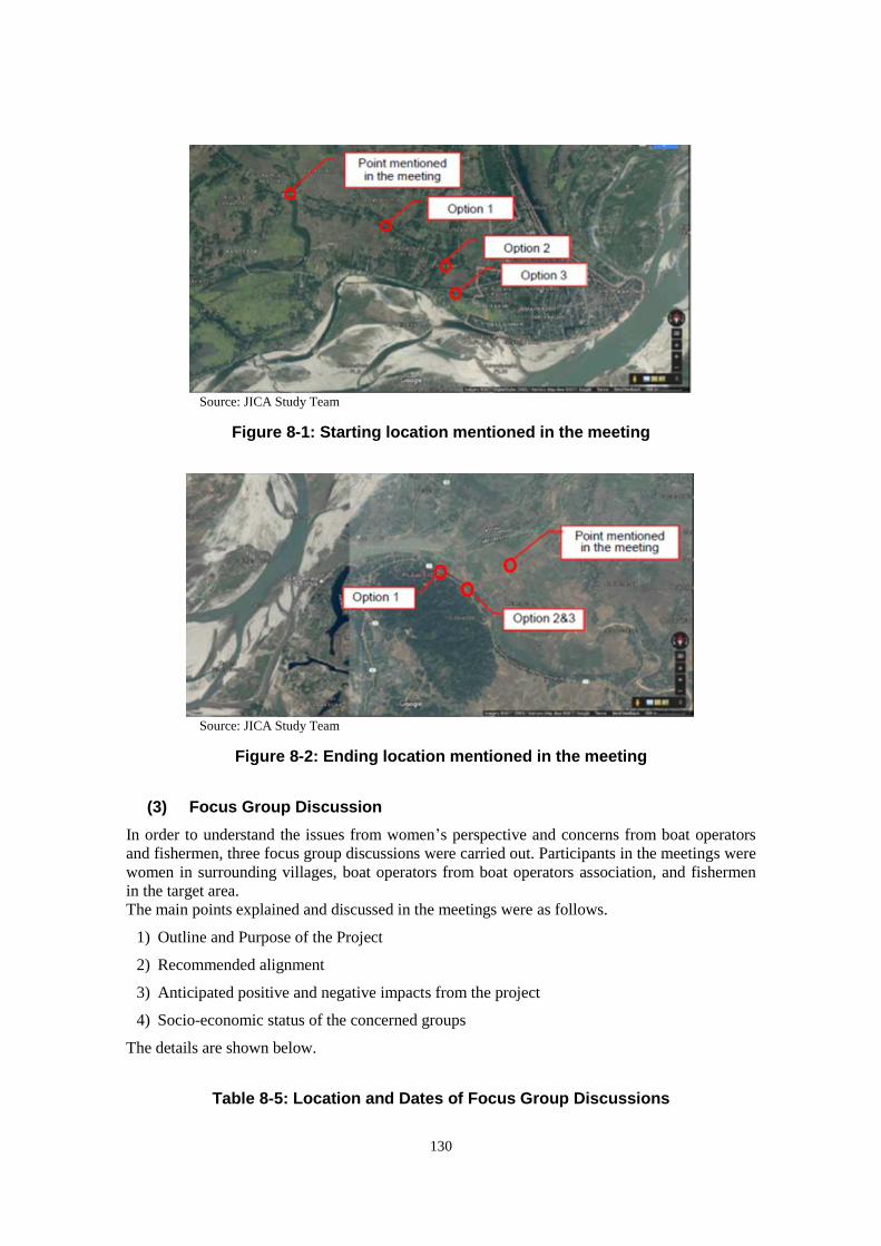
130
Source: JICA Study Team
Figure 8-1: Starting location mentioned in the meeting
Source: JICA Study Team
Figure 8-2: Ending location mentioned in the meeting
(3) Focus Group Discussion
In order to understand the issues from women’s perspective and concerns from boat operators
and fishermen, three focus group discussions were carried out. Participants in the meetings were
women in surrounding villages, boat operators from boat operators association, and fishermen
in the target area.
The main points explained and discussed in the meetings were as follows.
1) Outline and Purpose of the Project
2) Recommended alignment
3) Anticipated positive and negative impacts from the project
4) Socio-economic status of the concerned groups
The details are shown below.
Table 8-5: Location and Dates of Focus Group Discussions
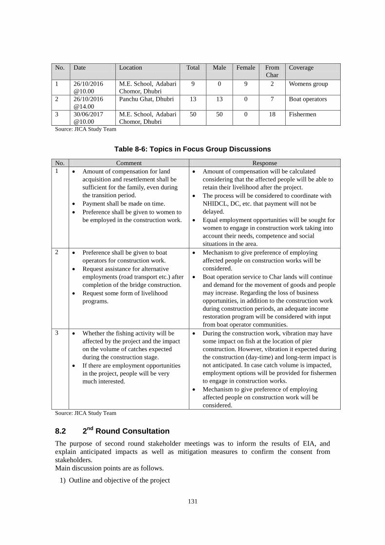
131
No. Date Location Total Male Female From
Char
Coverage
1 26/10/2016
@10.00
M.E. School, Adabari
Chomor, Dhubri
9 0 9 2 Womens group
2 26/10/2016
@14.00
Panchu Ghat, Dhubri 13 13 0 7 Boat operators
3 30/06/2017
@10.00
M.E. School, Adabari
Chomor, Dhubri
50 50 0 18 Fishermen
Source: JICA Study Team
Table 8-6: Topics in Focus Group Discussions
No. Comment Response
1 Amount of compensation for land
acquisition and resettlement shall be
sufficient for the family, even during
the transition period.
Payment shall be made on time.
Preference shall be given to women to
be employed in the construction work.
Amount of compensation will be calculated
considering that the affected people will be able to
retain their livelihood after the project.
The process will be considered to coordinate with
NHIDCL, DC, etc. that payment will not be
delayed.
Equal employment opportunities will be sought for
women to engage in construction work taking into
account their needs, competence and social
situations in the area.
2 Preference shall be given to boat
operators for construction work.
Request assistance for alternative
employments (road transport etc.) after
completion of the bridge construction.
Request some form of livelihood
programs.
Mechanism to give preference of employing
affected people on construction works will be
considered.
Boat operation service to Char lands will continue
and demand for the movement of goods and people
may increase. Regarding the loss of business
opportunities, in addition to the construction work
during construction periods, an adequate income
restoration program will be considered with input
from boat operator communities.
3 Whether the fishing activity will be
affected by the project and the impact
on the volume of catches expected
during the construction stage.
If there are employment opportunities
in the project, people will be very
much interested.
During the construction work, vibration may have
some impact on fish at the location of pier
construction. However, vibration it expected during
the construction (day-time) and long-term impact is
not anticipated. In case catch volume is impacted,
employment options will be provided for fishermen
to engage in construction works.
Mechanism to give preference of employing
affected people on construction work will be
considered.
Source: JICA Study Team
8.2 2nd Round Consultation
The purpose of second round stakeholder meetings was to inform the results of EIA, and
explain anticipated impacts as well as mitigation measures to confirm the consent from
stakeholders.
Main discussion points are as follows.
1) Outline and objective of the project
132
2) Reason of recommended alignment
3) Result of Environmental Assessment (anticipated positive and negative impacts)
4) Mitigation measures and monitoring plan
As for RAP, the result of the census survey and compensation policy, as well as rehabilitation
and income restoration program were explained to gain concent from PAPs.
Main discussion items are as follows.
1) Scale of impact based on result of census survey
2) Compensation policy
3) Rehabilitation and income restoration program
Information disclosure for the 2nd stakeholder meeting was carried out by visiting land
acquisition officers, publishing in a local newspaper, and distributing pamphlets through village
chiefs and local consultants (Enviro Infra Solutions Pvt. Ltd.: EIS). The participants include
NHIDCL, DPR consultant (AECOM), land acquisition officers from each DC offices, village
chiefs, villagers including PAPs, boat operators, fishermen, etc. Assamese and Bengali were
used in meetings which are the common languages in the target area.
Summary of the meetings is shown in the table below.
Table 8-7: Details of the Second Round Consultation Meetings
No. Date Location Total Male Female From
Char
Coverage
1 2017/7/4
@11:00
M.E. School,
Chagalchora II,
Dhubri
121 113 8 47 Adabari Part-II,
Airanjangla Part-I&II,
Bhassanir char Part-I,
Chagal chora
Part-I&II&III
2 2017/7/4
@15:00
Boat operator
office, Jogmaya
ghat, Dhubri
56 53 3 18 Kathiar Alga, Bauskata
Part-IV&VI, Basir Char,
Aminerchar, Chaiter Chor
Part-I
3 2017/7/5
@11:00
Phulbari Youth
Club, Phulbari
100 94 6 34 Phulbari, Baladoba,
Bauskata, Saboratary,
Chaiter Chor Part-I,
Hatsingwari
4 2017/7/5
@14:00
M.V. School,
Bororawatre
part-I, Dhubri
28 16 12 21 Bororawatre Part-I&II
Source: JICA Study Team
Table 8-8: Participation Details of the Second Round Consultations
No. Comment Answer
1 What kind of compensation and
assistance will be provided to
agriculture labourers?
How will the rate for land be
Agriculture labours will get at least minimum wage of
200 days. Employment opportunities will also be
provided during construction and will be entitled to get
training for business opportunity

133
No. Comment Answer
calculated?
What will be the process of land
acquisition and how to identify
the land owner?
If the new owner’s name is not
listed, will they get compensation
Will non-title holders get
compensation for land, structure
and employment opportunities?
Are there employment
opportunities for graduate
students?
Rate of the land will be calculated as per the latest land
revenue records in the area.
First, 3A notification will be issued and field verification
will be followed based on the government land record.
After the 3D notification, there will be a hearing
objection period before finalization.
Non-title holders will get compensation for structures
and standing crops, as well as are entitled for assistance.
Training will be provided and possibly issue certificates
for employment opportunities.
For graduates, there are National Skill Development
Programs where they can get special training. Even in
the construction work, they may get employed in a
position considering their capacity.
2 What kind of assistance will be
provided to the boat operators
and whether boat operators will
get employment opportunities?
One boat cost nearly Rs. 25-30
Lakh, after completion of this
project there will be no use of
these boats, will boat owners get
any compensation?
Will fisherman be affected by this
project?
Will fisherman get any
compensation?
Boat operators are also provided with opportunities to
engage in construction work. During the period,
vocational training opportunities will be offered to
prepare for the transition to new occupations.
The construction period is around six years. During this
period, the boat can be used for transportation of goods
and workers in addition to normal services. However,
considering that usage opportunities decrease after the
project, the boat will also be considered for
compensation.
During construction work, there will be impact on
fishermen in the project area, but fishing can continue
upstream and downstream of the river.
Employment opportunities will be provided to fishermen
during the construction work.
3 When and to whom will
employment opportunities be
offered. How should I apply?
Is there any plan to develop
bridge cum railway?
When and how will
compensation be provided?
What is the market rate of the
land and buildings to be decided
based on?
What should I do if there is a
problem with land ownership?
What kind of compensation can
be taken if leasing the land and
holding the building on that land?
Employment opportunities will be offered to residents of
the target area when construction work will be carried
out. NHIDCL will contract with contractors so the
application shall be submitted to the contractors.
NHIDCL is considering to state in the contract that
priority should be given to local employment as a
condition.
In this project, railway is not included in the plan.
First of all, DC will conduct a field survey and confirm
the affected land, affected people and the price. After the
compensation is paid to the affected people, land
acquisition will start.
Market rate for the land will be based on the zonal
valuation which is set by the land sale price. Buildings
are also calculated at market prices. The amount will be
decided based on a site investigation.
If there is a land ownership problem, DC office will be
the window agency. The land ownership will be
reviewed with documents and records.
There will be no compensation for the land, but
structures and crops will be compensated and assistances
will be provided. If you have been paying the lease fee of
land for a long time, the amount after land acquisition
will be refunded.
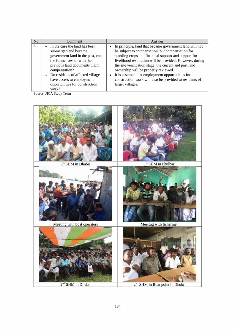
134
No. Comment Answer
4 In the case the land has been
submerged and became
government land in the past, can
the former owner with the
previous land documents claim
compensation?
Do residents of affected villages
have access to employment
opportunities for construction
work?
In principle, land that became government land will not
be subject to compensation, but compensation for
standing crops and financial support and support for
livelihood restoration will be provided. However, during
the site verification stage, the current and past land
ownership will be properly reviewed.
It is assumed that employment opportunities for
construction work will also be provided to residents of
target villages.
Source: JICA Study Team
1
st SHM in Dhubri 1
st SHM in Phulbari
Meeting with boat operators Meeitng with fishermen
2
nd SHM in Dhubri 2
nd SHM in Boat point in Dhubri

135
2
nd SHM in Phulbari 2
nd SHM in Char land
Source: JICA Study Team
Figure 8-3: Stakeholders/Community Meetings
136
CHAPTER 9 Conclusion and Recommendations
9.1 Key issues / Concerns Identified
Through the above exercise, the following key issues were identified:
There is no Wildlife Sanctuary along the alignment or within 10 km from the project
alignment.
There is no archeological protected/protected monuments exists along the bridge
alignment.
The area represents flood plain or riparian area of river Brahmaputra between Dhubri
and Phulbari and island with human habitations.
Occurrence of Ganges River Dolphin has been reported in Brahmaputra river.
Likely effect of land acquisition of approximately 65 Ha land & over the
properties/owners and their financial loss.
Air, Noise & Water pollution may increase during bridge construction and after
increase in traffic volume in future.
Project does not require Environmental Clearances from MoEFCC as per EIA
notification 2006 and its amendments till date.
During stake holder meeting and community survey, local people welcome the project
and would like earlier implementation of the project, however asked proper and timely
compensation, employment and suggestions regarding connectivity of the bridge with
National Highway.
9.2 Summary of Key Benefits from the project
Availability of adequate and quality infrastructure is a pre-requisite for rapid development of
any economy.
Improvement in the project road will result in the following benefits:

137
Providing better level of service in terms of road connectivity between Dhubri and
Phulbari.
Faster transportation will ultimately lead to massive savings in the form of reduced
wear and tear of vehicles, reduced vehicle operating costs (VOCs) and reduction in
transportation costs etc.
Introduction of additional safety measures like crash barrier, road illumination,
retro-reflective boards, delineators etc. will result in lesser accidents.
Increased passenger comfort due to proper road connectivity shall be an added
benefit.
It will increase access of the villages and other small settlements to urban areas, thus
providing connectivity of rural produce to urban markets, thereby enhancing the
reach and export of perishable cash crops, leading to better remuneration for the
producer.
The reach and export of perishable cash crops will have quite a positive impact and
this will prove to be a boon for the rural agricultural sector.
Providing connectivity to the urban infrastructure.
Rural industrial produce, whether from Commercial industries, small-scale
industries or medium-scale industries will have easy access to the urban markets.
Strengthening of rural economies: The rural sector / economy are sure to get
strengthened, though at a gradual pace.
Higher education: Education is considered to be one of the most dominant indicators
towards the development of a region. Though primary education facilities are present
along the villages, access to high schools, higher secondary schools and colleges is
not so easy at present. Provision of easy access to higher education can be directly
linked to the improved educational scenario.
Access to medical facilities: Villages in the project region are not yet well-equipped
with all types of medical facilities and services like Public Health Centres (PHCs),
dispensaries, hospitals. Due to inaccessibility, reaching even the nearest health centre
sometimes becomes a colossal task. Even the doctor's reluctance will be converted into
willingness to visit these areas after commissioning of bridge.
By reducing the transportation costs, it will be more feasible to transfer construction
materials which are important for many economic activities (house building, school
building, etc) to hinterland. This will in turn, lead to direct as well as indirect
strengthening of local economies.
During the execution of the project, i.e. during the construction period, employment
will be provided to workers from the local communities.
138
The educated as well as uneducated people from villages will obtain access to new
employment centers.
The proposed bridge will reduce the travel time and also very beneficial from the
safety point of view and all weather movements will take place.
Overall improved quality of life for the lesser developed areas in the neighborhood.
Value Addition
Aesthetic enhancement
Over bridges, raised carriageway.
Road connectivity between Dhubri and Phulbari.
Reduce travel time.
9.3 Recommendations/conclusion
Keeping in view the general scope for environmental as well as socio-economical
parameters and most importantly sustainable environment and economic development, the
following conclusions and recommendations have been drawn:
9.3.1 Recommendations
Proposed bridge is required for overall development of the North east region as it
provide connectivity to Dhubri (Assam) and Phulbari (Meghalaya).
Proper compensation shall be paid to the PAPs as per R&R policy 2013.
Bridge shall be properly connected at both end through National Highway.
Mitigation measures shall be undertaken to minimize the impact on aquatic life in
Brahmaputra river during construction.
One of the major issues that surfaced during the public consultation was to generate
alternate livelihood / employment program for boat owners.
9.3.2 Conclusion
The proposed bridge shall be commissioned at the earliest with minimum acquisition of
agricultural land to minimize the environmental impacts along the RoW. Mitigation
Measures shall be undertaken as suggested in EMP shall be implemented in true spirit to
minimize the impact on aquatic life in Brahmaputra river during construction. Proper
compensation shall be paid to project affected persons.
Top Related