


Languages
Pages
Legal


Swift Reservoir, Skamania
County, WA Community
Wildfire Protection Plan
Prepared by: Sara Zielin,
Skamania County Wildfire Prevention Coordinator and
Ole Helgerson, Washington State University Skamania County
Extension Director PO Box 790, Stevenson, WA 98648
Photo of Mount Saint Helen’s from Swift Reservoir. (Image: M. Jones, Matt Jones
Photography - http://www.flickr.com/photos/mattithyahu/247077808/).
Swift Reservoir, Skamania County, WA CWPP 2
TABLE OF CONTENTS I. Introduction and Mission of the Swift Reservoir, WA CWPP 4
II. Community Wildfire Protection Plans and the Healthy Forest Restoration Act. 4
III. Community Wildfire Protection Plan Requirements 6
IV. Planning Process 6
V. Community Profile 10
Climate 10
Forest Vegetation 10
Location 13
Population 13
Transportation 13
Critical Infrastructure 13
Fire History 13
Data Collection 14
VI. Wildfire Risk Assessment 14
Phase I
Risk of Ignition Risk 14
Hazards 16
Values Protected 19
Emergency Equipment and Staffing Inventory 19
Phase II
Gap Workshop 21
Map Workshop 21
VII. Projects 21
Fuel Mitigation Projects 21
Planning Projects 23
Education Projects 24
Equipment/Staff/Exercise Projects 25
Action Plan 26
Structure Ignitability (Living with fire, a guide for the homeowner) 27
VIII. Monitoring and Evaluation 27
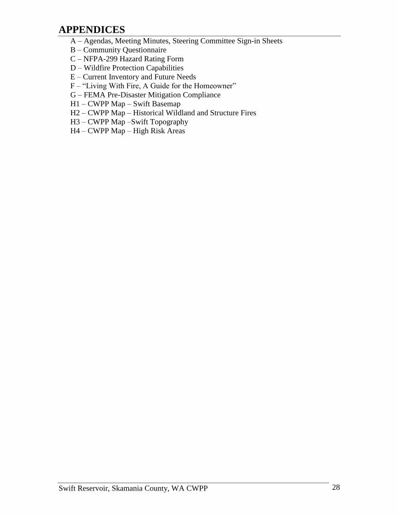
IX. Appendices 28
A – Agendas, Meeting Minutes, Steering Committee Sign-in Sheets
B – Community Questionnaire
C – NFPA-299 Hazard Rating Form
D – Wildfire Protection Capabilities
E – Current Inventory and Future Needs
F – “Living With Fire, A Guide for the Homeowner”
G – FEMA Pre-Disaster Mitigation Compliance
H1 – CWPP Map – Swift Basemap
H2 – CWPP Map – Historical Wildland and Structure Fires

Swift Reservoir, Skamania County, WA CWPP 3
H3 – CWPP Map –Swift Topography
H4 – CWPP Map – High Risk Areas
X. References 29
INTRODUCTION AND MISSION Introduction
Wildfire is a “fact of life” for rural communities in the state of Washington. It is a key
part of the forest ecosystems that comprise the twenty-two million acres of private, state,
and federal forests that cover nearly fifty percent of the state. Because it also threatens
human life and property, wildfire has long been suppressed. But in ecosystems adapted to
frequent fires, suppressing fire does not make the threat go away. To the contrary,
decades of successfully suppressing fire has led to a widespread decline in forest health.
Many drier forests are out of balance (overcrowded, weakened by disease, dominated by
the wrong species) and heavily loaded with woody fuel. Adding human population
growth to these factors creates a recipe for catastrophic wildfires. Fortunately, throughout
the West, state and federal agencies, local communities, private contractors, non-profit
groups, and individual citizens are now teaming up to reduce that risk (Washington DNR
2007).
The Swift Community Wildfire Protection Plan (CWPP) was prepared through a Title III
grant from Secure Rural Schools and Self Determination Act of 2000 in Skamania
County. The plan will serve as a chapter to the Klickitat and Skamania County, WA
CWPP and as a stand alone document. The primary purpose of this plan was to provide a
framework to emergency responders, property owners and interested parties within the
planning area that will increase the communities‟ capacity to be better prepared for a
wildfire. The plan identifies „communities at risk‟ (CAR) and other values that would be
vulnerable during a wildfire (Hulbert 2004).
Mission The Swift CWPP mission is to protect life, property and natural resources from wildfire.
To better support the CWPP‟s mission, the Swift CWPP Steering Committee has
developed projects that reinforce the protection mission. The following three goals were
developed to guide the Steering Committee‟s projects:
1. Improve survivability of people, homes, and the environment during wildfires.
2. Promote wildfire awareness and education for citizens located in „risk areas‟.
3. Engage in community-developed fuels treatment projects that reduce wildfire
vulnerability to CAR.
HEALTHY FOREST RESTORATION ACT AND CWPP’s The Healthy Forest Restoration Act (HFRA), signed into law by President Bush in 2003,
calls for the development of Community Wildfire Protection Plans. This section describes
these requirements.
Healthy Forests Restoration Act / Healthy Forests Initiative In 2002, President Bush announced the Healthy Forests Initiative (HFI) designed to
identify and remove barriers to the implementation of projects that were developed to

Swift Reservoir, Skamania County, WA CWPP 4
restore the health of the nation‟s forests (Douglas County 2005). Congress enacted the
HFRA Healthy Forests Restoration Act in November 2003. It provides new tools and
additional authorities to treat more acres more quickly to expedite restoration goals. It
strengthens public participation and provides incentives for local communities to develop
community wildfire protection plans. It limits the complexity of environmental analyses
for hazard reduction projects, provides a more effective appeal process and instructs the
courts that are being asked to halt projects, to balance the short-term affects of
implementing the projects against the harm from undue delay and long-term benefits of a
restored forest (Douglas County 2005).
Title I of the Act addresses vegetation treatments on certain types of National Forest
System and Bureau of Land Management (BLM) lands that are at risk of wildland fire or
insect and disease epidemics. More specifically, it:
Encourages streamlined environmental analysis of HFRA projects;
Provides for administrative review of proposed HFRA projects on National Forest
System lands before decisions are issued;
Contains requirements governing the maintenance and restoration of old-growth
forest stands when the USDA Forest Service (FS) and BLM conduct HFRA projects
in such stands;
Requires HFRA projects in the FS and BLM to maximize retention of larger trees in
areas other than old-growth stands, consistent with the objective of restoring fire-
resilient stands and protecting at-risk communities and Federal lands;
Encourages collaboration between Federal agencies and local communities when
community wildland fire protection plans are prepared;
Requires using at least 50% of the dollars allocated to HFRA projects to protect CAR
of wildland fire if identified in CWPPs;
Requires performance to be monitored when agencies conduct hazardous-fuel
reduction projects and encourages multiparty monitoring that includes communities
and other interested parties; and
Encourages courts that consider a request for an injunction on an HFRA-authorized
project to balance environmental effects of undertaking the project against the effects
of failing to do so.
Community Wildfire Protection Plan Title I of the HFRA encourages the development of CWPPs under which communities
will designate their Wildland Urban Interface (WUI), and where HFRA projects may take
place. Half of all fuel reduction projects under the HFRA will occur in the community
protection zone as defined by HFRA. HFRA also encourages biomass energy production
through grants and assistance to local communities to create market incentives for
removal of otherwise valueless forest material. The HFRA is linked to the Rural Schools
and Community Self-Determination Act of 2000, PL 106-393, through funding
provisions found in two separate Titles of PL 106-393. Title III provides counties with
funds for expenditure on projects that fall within certain categories, one of which is
county planning efforts to increase the protection of people and property from wildfire
(Douglas County 2005). The CWPP planning process under HFRA is clearly an
authorized use of Title III funds under PL 106-393 (Douglas County 2005), and
Skamania County utilized Title III funds to create the Swift CWPP.
Swift Reservoir, Skamania County, WA CWPP 5
CWPP REQUIREMENTS
The HFRA requires 3 components in a CWPP
1) Collaboration: A CWPP must be collaboratively developed by local and state
government representatives, in consultation with federal agencies and other interested
parties.
2) Prioritized Fuel Reduction: A CWPP must identify and prioritize areas for hazardous
fuel reduction treatments and recommend the types and methods of treatment that will
protect one or more at-risk communities and essential infrastructure.
3) Treatment of Structural Ignitability: A CWPP must recommend measures that
homeowners and communities can take to reduce the ignitability of structures throughout
the area addressed by the plan.
PLANNING PROCESS The planning process for the Swift CWPP follows recommendations from “Preparing a
Community Wildfire Protection Plan: a Handbook for Wildland-Urban Interface
Communities” and information gathered from successful CWPP‟s (National Association
of State Foresters 2004).
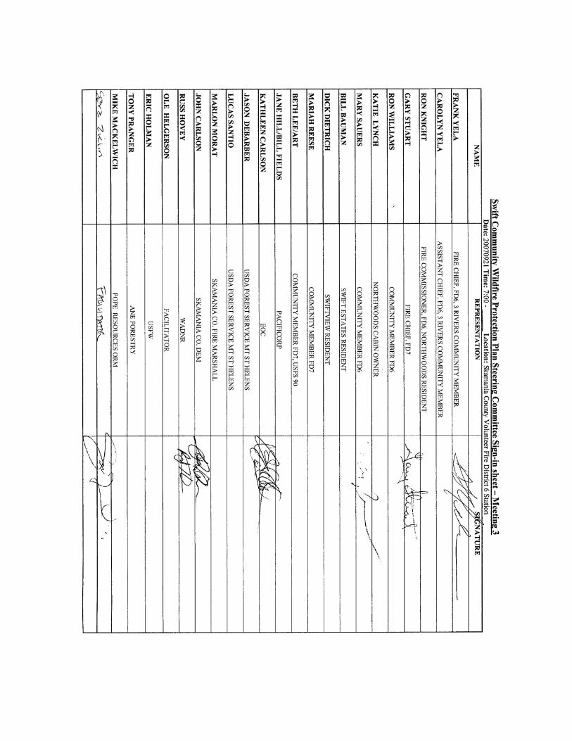
Step One: Convene Decision Makers, Federal Agencies and Interested Parties The Swift CWPP Steering Committee includes a core group (local government, local fire
authority and state agencies), federal agencies and interested parties/community
members. The core group is responsible for the development of a CWPP as described in
the HFRA and must mutually agree on the plan‟s final contents. The Swift Steering
Committee met three times to establish, review and critique the planning components
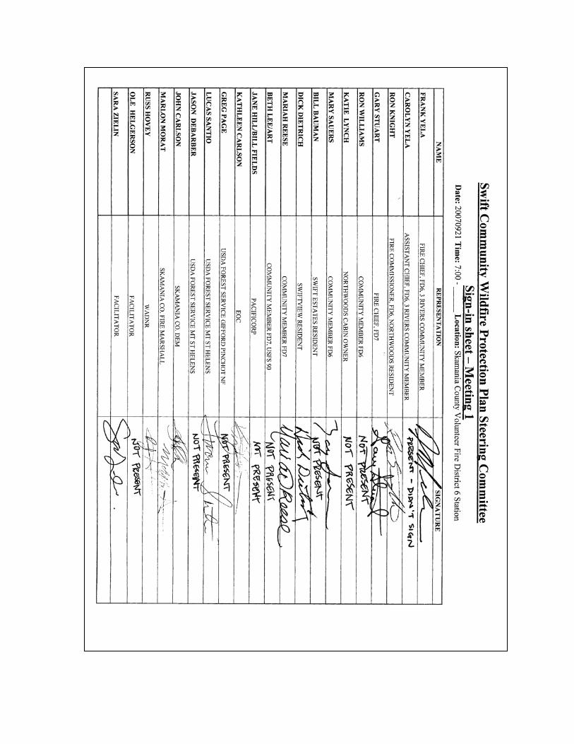
(Appendix A- Meeting Agendas, Minutes and Steering Committee Sign-in Sheets). The
Swift Steering Committee consists of:
Core group (Decision makers)
Frank Yela – Skamania County Fire District 6 (FD6) Volunteer Fire Department
Chief
Gary Stuart – Cowlitz-Skamania County Fire District 7 (FD7) Volunteer Fire
Department Chief
John Carlson – Skamania County Department of Emergency Management
Coordinator
Marlon Morat – Skamania County Fire Marshall and Building Inspector
Russ Hovey – Washington State Department of Natural Resources (WADNR)
Pacific Cascade Region Fire Program Specialist

Swift Reservoir, Skamania County, WA CWPP 6
Federal Agencies
Lucus Santio – FS, Gifford Pinchot National Forest (GPNF) – AMFO Mt. St.
Helen‟s NVM
Interested Parties/Community Members
Kathleen Carlson – CERT Representative
Carolyn Yela – Assistant Chief FD6 and Community Member
Ron Knight – Volunteer Fire Fighter FD6 and Community Member
Mariah Reese – Community Member FD7
Dick Dietrich – Volunteer Fire Fighter FD6
Beth Lee – Community Member FD7
Mary Sauer – Swift Communities Action Team (SCAT) Vice President
CWPP Team Facilitators
Ole Helgerson - WSU Extension Director and Area Forester
Sara Zielin - Skamania County Wildfire Prevention Coordinator
The following interest groups were invited to participate with the Swift CWPP but were
unable to attend planning meetings:
United States Fish and Wildlife Service
PacifiCorp
Pope Resources – Olympic Resource Management
ANE Forestry
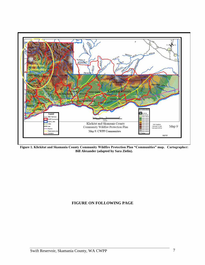
Step Two: Establish Planning Area
The Swift CWPP planning area was identified by the Klickitat and Skamania County,
WA Community Wildfire Protection Plan (Figure 1). The dual-county plan established
„communities‟ based on geographic, political and economic features. A large section of
FS land was included in the planning area because these lands significantly influence the
economy of the Swift CWPP area. This original community boundary was adjusted by
the Steering Committee to exclude the area that is outside of the Skamania County
boundary (Figure 2). The Swift CWPP planning area covers over 443 square miles and
nearly 280,000 acres.
Swift Reservoir, Skamania County, WA CWPP 7
FIGURE ON FOLLOWING PAGE
Swift
Reservoir
Community
Swift
Reservoir
Community
Figure 1. Klickitat and Skamania County Community Wildfire Protection Plan “Communities” map. Cartographer:
Bill Alexander (adapted by Sara Zielin).

Swift Reservoir, Skamania County, WA CWPP 8

Swift Reservoir, Skamania County, WA CWPP 9
Figure 2. Appendix H1- Swift CWPP Base Map (Cartographer: Sara Zielin).
Swift Reservoir, Skamania County, WA CWPP 10
Step Three: Community Outreach Community members from the Swift community served on the Steering Committee to
represent the public throughout the process. A questionnaire was created and dispersed
within the community in September 2007 (Appendix B – Community Questionnaire).
The survey results were reviewed by the committee, and applied to different aspects of
the plan. This plan was also open for public comment from December 12, 2007 until
January 10, 2008.
Step Four: Community Risk Assessment
The community risk assessment took place in two phases. The Swift Steering Committee
carried out phase one by reviewing basic risk factors such as: risk of ignition, hazards,
values protected and wildfire protection capabilities. The committee defined lists of
elements under each risk factor to more specifically describe risks within the planning
area.
In phase two, the committee further defined risk factors and identified site specific
problems by completing two workshops: 1) gap workshop and 2) map workshop.
The gap workshop identified constraints, 'bottle necks', missing links and/or gaps in the
fire fighting system within the Swift planning area. Solutions to the gaps were
established as fuel mitigation, planning, education and equipment, staffing and exercise
projects.
The map workshop assessed several different aspects of the Swift planning area such as
fire history, population density, fuel loads and future developments and identified „high
risk areas‟ and/or CAR that exist and then established fuel mitigation projects, classed by
risk to better protect life, property and natural resources.
Step Five: Establish Community Priorities and Recommendations Based on risks identified in Step Four, the committee discussed and defined each project
establishing a list of priority projects.
This section describes solutions to problems identified in the gap and map workshops and
documents projects supporting the goals and objectives of the Swift CWPP (...”to protect
life, property and natural resources”). Projects are divided into 4 categories: 1) Fuel
Mitigation 2) Planning Projects 3) Education Projects and 4) Equipment, Training and
Exercise Projects. Some projects tie to two or more categories. Other project categories
may be developed in the future.
Step Six: Develop an Action Plan and Assessment Strategy The Swift CWPP Steering Committee collectively agreed to meet annually at a minimum
and as needed otherwise to review the plan and make needed revisions. The core group
will oversee and approve any plan amendments as well as grant applications referencing
the Swift CWPP. The Title III Firewise Project offers initial CWPP project follow-up
and grant application assistance while legislated funding is still available. Because this is
not a permanent funding source, a fulltime position to develop CWPP projects and
prepare grants will be pursued.

Swift Reservoir, Skamania County, WA CWPP 11
Step Seven: Community Wildfire Protection Plan Approval The core group, considering feedback from the steering committee and public comment,
will determine the final plan. The Swift CWPP will seek the Skamania County Board of
Commissioner‟s approval.
COMMUNITY PROFILE
Climate The Swift CWPP planning area is located in northwest Skamania County, WA in the
Cascade Mountains. In general, Skamania County enjoys a mild but variable climate,
with the climate becoming drier and more continental as one travels from west to east.
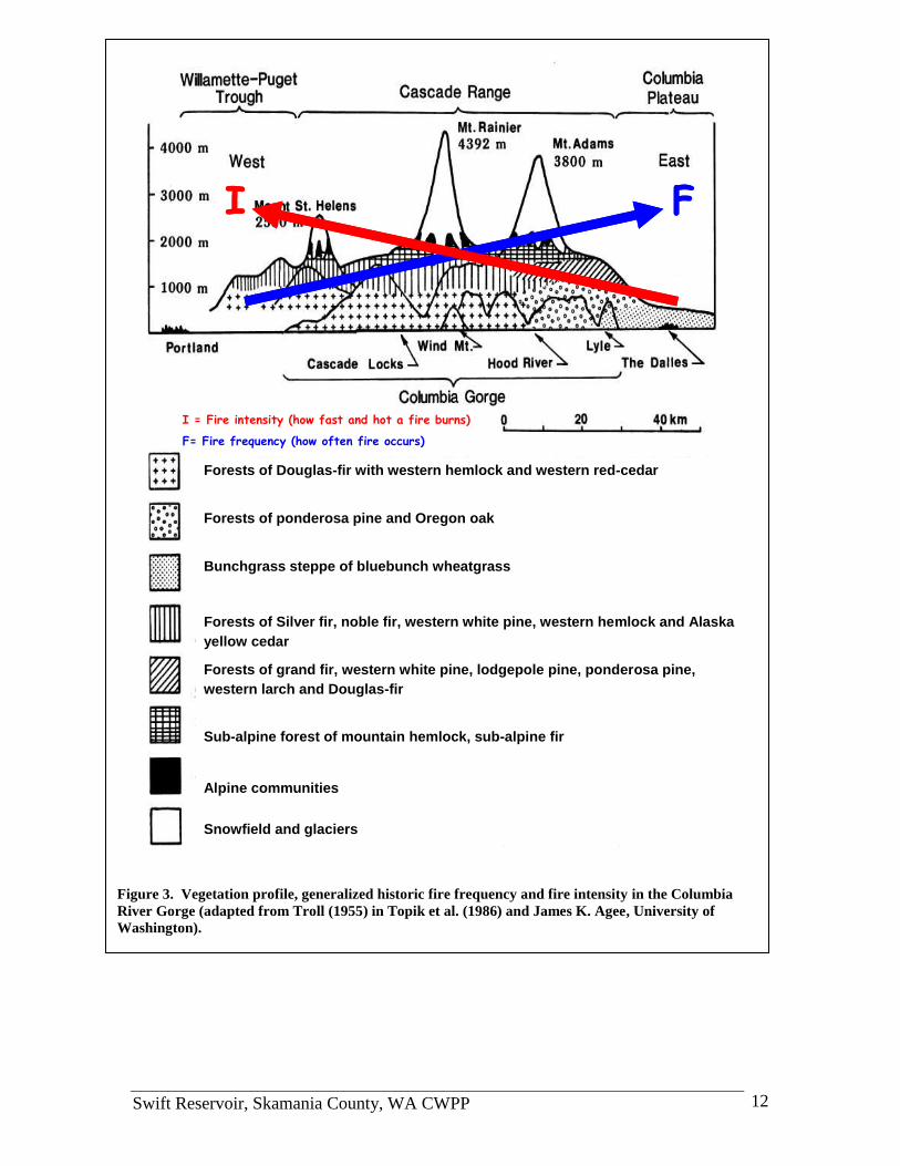
Forests and Vegetation Skamania County is predominantly forest covered. Forests range from mesic western
hemlock, western red cedar and Douglas-fir in the west, typical of the area encompassed
by the Swift CWPP area to more xeric Douglas fir-grand fir and Oregon oak-ponderosa
pine in the east (Figure 3).
FIGURE ON FOLLOWING PAGE
Swift Reservoir, Skamania County, WA CWPP 12
Forests of Douglas-fir with western hemlock and western red-cedar
Forests of ponderosa pine and Oregon oak
Bunchgrass steppe of bluebunch wheatgrass
Forests of Silver fir, noble fir, western white pine, western hemlock and Alaska
yellow cedar
Forests of grand fir, western white pine, lodgepole pine, ponderosa pine,
western larch and Douglas-fir
Sub-alpine forest of mountain hemlock, sub-alpine fir
Alpine communities
Snowfield and glaciers
FI
I = Fire intensity (how fast and hot a fire burns)
F= Fire frequency (how often fire occurs)
Forests of Douglas-fir with western hemlock and western red-cedar
Forests of ponderosa pine and Oregon oak
Bunchgrass steppe of bluebunch wheatgrass
Forests of Silver fir, noble fir, western white pine, western hemlock and Alaska
yellow cedar
Forests of grand fir, western white pine, lodgepole pine, ponderosa pine,
western larch and Douglas-fir
Sub-alpine forest of mountain hemlock, sub-alpine fir
Alpine communities
Snowfield and glaciers
FI FI
I = Fire intensity (how fast and hot a fire burns)
F= Fire frequency (how often fire occurs)
Figure 3. Vegetation profile, generalized historic fire frequency and fire intensity in the Columbia
River Gorge (adapted from Troll (1955) in Topik et al. (1986) and James K. Agee, University of
Washington).
Swift Reservoir, Skamania County, WA CWPP 13
Location The Swift CWPP planning area is located in the northwest corner of Skamania County
(see Figure 2). Major communities reside in the southern half of the Swift CWPP
planning area and are located on the north side of Swift Reservoir from the Cowlitz
County border to the northeast side of the reservoir (see Figure 8). Mount Saint Helen‟s
National Volcanic Monument is located in the northwestern section within the Swift
CWPP planning area. The 1982 established monument covers 110,000 acres following
the May 18, 1980 eruption (Witherspoon 2007). State lands are located in the southwest
section of the planning area and cover over 121,000 acres.
Population According to the Skamania County Planning Department, 339 cabins and structures exist
within the Swift planning area (as of May 2006), although all the owners of these cabins
and structures are not year round residents. The Swift area has high growth potential and
according to the Swift Subarea Plan the number of new recreational cabins possible are
by 2027 is 564, totaling 903 cabins (Swift Subarea Plan 2007). The population is
correspondingly expected to climb. Land Use Designation amendments being proposed
by the Subarea Plan will provide a framework for this impending growth.
Transportation All roads located within the Swift CWPP planning area are either owned and maintained
by the USDA FS or are private roads. Two primary paved routes access the area. The
primary access from the south through Skamania County is via the Wind River Road to
the Curly Creek Road and than to the USFS 90 Road. Wind River Road runs in a north-
south direction from State Route 14, through Carson, until it intersects the Curly Creek
Road that connects to the USFS 90 Road which is the main road located within the
CWPP planning area (Witherspoon 2007). Ingress and egress from Interstate 5 in the
west is through Cowlitz County to State Route 503 to the FS 90 Road.
Critical Infrastructure
Critical infrastructure in the Swift CWPP includes:
Fire, ambulance and police stations and equipment
Power lines (minimal)
Wells, water pumping and supply areas
Dams
Bridges
Commercial areas of economic value to the communities
Gas and fuel storage areas
Main highways
Fire History The Swift CWPP planning area lies with a mixed fire regime including smaller more
frequent fires and larger less frequent fires (Figure 3). Several larger fires have occurred
here (Figure 4). Historically known large wildfires have usually resulted from strong east
winds following periods of summer drought (Topik 1986). The Yacolt Fire stands out as
being the greatest fire to move through the area. The fire started near Stabler, WA on
Sept. 10, 1902. Driven by strong east winds, it killed 38 adult people and destroyed over
12 billion board feet of lumber on 238,900 acres. It stopped near the town of Yacolt in
Clark County when the wind died. In 2003, the Herman Creek fire in Cascade Locks,

Swift Reservoir, Skamania County, WA CWPP 14
OR burned 375 acres in about 4 hours driven by an east wind. Fire fighting there was
hampered by lack of knowledge of the terrain by the first responders that came from out
of the area. A structure was lost because it was regarded as too hazardous to protect.
Data Collection In 2003, a National Fire Plan funded project in Skamania, Hood River, Wasco and
Klickitat Counties targeted: 1) Locating and risk-ranking WUI structures using NFPA-
299 protocol (Appendix C - NFPA-299 Hazard Rating Form) into a Geographic
Information System (GIS) database; 2) working with rural volunteer fire districts to
identify and remedy equipment and training, and 3) educating rural dwellers in wildfire
survivability and damage prevention.
Using Title III funding, three of the four counties (Skamania, Hood River and Wasco)
completed the NFPA-299 survey in a GIS database. The NFPA-299 survey data
describes conditions affecting structure flammability. It provides information to
emergency planners and responders allowing safer response during wildfire (Columbia
Gorge 2003).
In Skamania County the project also collected data on fire hydrants, water sources, and
other features. Publicly available WADNR GIS data describes wildfire risk areas in
Skamania County (RAMS), public road networks and hydrology.
WILDFIRE RISK ASSESSMENT Risk assessments were performed by the Swift CWPP Steering Committee in two phases.
Phase I identified risk of ignition, hazards, values protected, and emergency equipment
and staffing inventory. Phase II included a “gap” workshop that defined response
capabilities in need of strengthening and a map workshop that designated areas of high
risk.
Phase I
Risk of Ignition Swift wildfire ignition risks include and are not limited to: structure fires, debris burning,
fireworks, recreational fires (camping and/or forest product camps), discarded cigarettes,
lightning, power lines, generators, candles, propane tanks, arson, off-highway vehicles,
logging, and welding.
Structure Fires
Structure fires will continue to occur within the planning area. With many new homes
being built within or adjacent to forest lands, the probability of a structure fire igniting
from a catastrophic wildfire, or vice-versa, is high especially during fire season.
Debris Burning
Debris burning is legal in Skamania County with a valid permit October 1 through June
30 unless otherwise noted by the Fire Marshall (Figure 5). The debris pile dimensions
must be no larger than 10 feet by 10 feet (horizontally) by 5 feet (vertically) and may not
to exceed a total of 100 square feet for multiple piles (Skamania County Ordinance
2006). WADNR burning regulations also apply to silvicultural practices within
Skamania County. Burn pile dimensions (regulated by WADNR) are 4feet by 4feet (rule
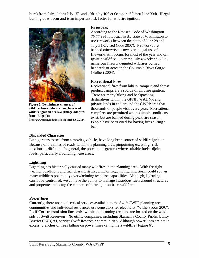
Swift Reservoir, Skamania County, WA CWPP 15
burn) from July 1st thru July 15
th and 10feet by 10feet October 16
th thru June 30th. Illegal
burning does occur and is an important risk factor for wildfire ignition.
Fireworks
According to the Revised Code of Washington
70.77.395 it is legal in the state of Washington to
use fireworks between the dates of June 29 and
July 5 (Revised Code 2007). Fireworks are
banned otherwise. However, illegal use of
fireworks still occurs for most of the year and can
ignite a wildfire. Over the July 4 weekend, 2005,
numerous firework-ignited wildfires burned
hundreds of acres in the Columbia River Gorge
(Hulbert 2004).
Recreational Fires
Recreational fires from hikers, campers and forest
product camps are a source of wildfire ignition.
There are many hiking and backpacking
destinations within the GPNF, WADNR and
private lands in and around the CWPP area that
thousands of people visit every year. Recreational
campfires are permitted when suitable conditions
exist, but are banned during peak fire season.
People have been cited for having fires during a
ban.
Discarded Cigarettes
Lit cigarettes tossed from a moving vehicle, have long been source of wildfire ignition.
Because of the miles of roads within the planning area, pinpointing exact high risk
locations is difficult. In general, the potential is greatest where suitable fuels adjoin
roads, particularly around high-use areas.
Lightning
Lightning has historically caused many wildfires in the planning area. With the right
weather conditions and fuel characteristics, a major regional lighting storm could spawn
many wildfires potentially overwhelming response capabilities. Although, lightning
cannot be controlled, we do have the ability to manage hazardous fuels around structures
and properties reducing the chances of their ignition from wildfire.
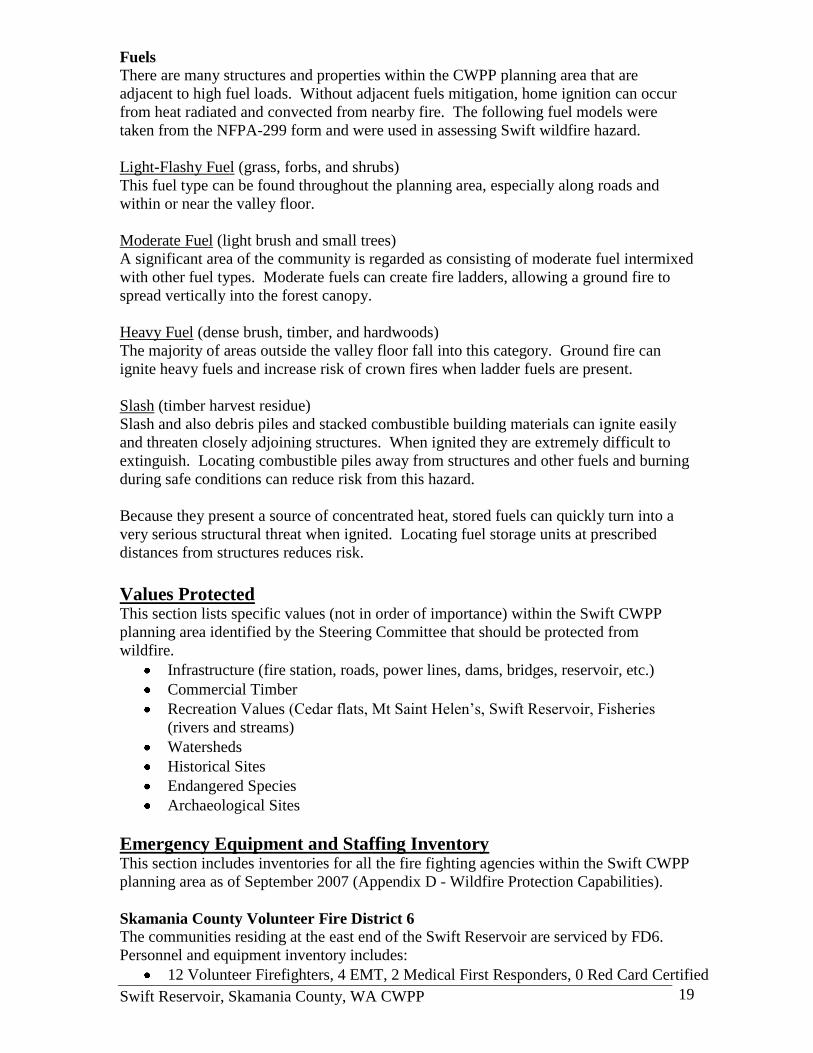
Power lines
Currently, there are no electrical services available to the Swift CWPP planning area
communities and individual residences use generators for electricity (Witherspoon 2007).
PacifiCorp transmission lines exist within the planning area and are located on the west-
side of Swift Reservoir. No utility companies, including Skamania County Public Utility
District (PUD) #1, service Swift Reservoir communities. Although power lines are not in
excess, branches or trees falling on power lines can ignite a wildfire (Figure 6).
Figure 5. To minimize chances of
wildfire, burn debris when chances of
wildfire ignition are low (Image adapted
from: Edgeplot
http://www.flickr.com/photos/edgeplot/356582184)

Swift Reservoir, Skamania County, WA CWPP 16
Generators, candles and propane tanks
Fuel generators are the primary source of
electricity to homeowners within the Swift
planning area. Although these machines are
a great source of power, fire hazards exist
with operation and fuel storage. Candles
and propane tanks also serve as risks of
ignition as electric power is not the main
source of energy and these methods are
used.
Arson
Arson caused seven fires within the planning
area between 1973 and 1998 according to
WADNR fire statistics GIS data (DNR GIS
2007). The acreage burned is minimal,
totaling approximately one acre. Causes of
arson include grudges, pyromania and other.
A person who would start a fire for
vengeance would likely be a person who
would not consider time of year, humidity,
wind and other aspects that would allow a
fire to become uncontrollable (Davis 2005). Although arson has not been the leading
cause of fire starts within the CWPP area it has the potential to cause a catastrophic
wildfire.
Off Highway Vehicles, Logging and Welding
These ignition sources were discussed by the Steering Committee and were regarded as
low risk. Even so, each source has caused small acreage fires and with the right
conditions could be the source of a major wildfire.
Hazards Fire season in the Swift area runs from approximately mid-May to October. After
ignition, major conditions affecting wildfire spread are: weather, topography and fuels.
Weather
Wind is an element of wildfire hazard because it pushes the flame front, increases the rate
of fire spread, and decreases moisture in both the air and fuel (Davis 2005). The most
prominent weather hazards that influence fire in the Swift area are extreme east and west
winds and low humidity. Strong east winds caused the extensive Yacolt Burn and the
smaller Herman Creek Fire
Wind driven wildfires can throw burning embers downwind up to a mile igniting spot
fires ahead of the main flame front. This presents a major hazard for many of the Swift
area structures and properties. Research indicates that flying embers ignite about one-half
of homes lost during wildfire.
Figure 6. Power lines similar to these broken
by a tree caused the 2003 Herman Creek Fire
(Image: S. Zielin, Skamania County).

Swift Reservoir, Skamania County, WA CWPP 17
Relative humidity and precipitation largely determine fuel moisture. Extended periods of
summer drought can increase wildfire, as lack of fall and winter precipitation and snow in
and around a community lead to drier fuels and increased risk of ignition (Davis 2005).
Topography Slope accelerates upward heat transfer in fires. The estimated rate of fire spread is twice
as fast up a 30 percent or greater slope as compared to a level surface. Along the Swift
Reservoir Watershed, densely vegetated slopes from 20 to 70 percent branch in all
directions (Figure 7). Although fire primarily burns uphill, structures at the base of
slopes are also at risk because fire can move downhill. Thus, structures built on slopes
are at risk from both directions (Davis 2005). For residents living in sloping topography,
consulting with the Swift CWPP core group or FD6 and FD7 Fire Chiefs is
recommended.
FIGURE ON THE FOLLOWING PAGE

Swift Reservoir, Skamania County, WA CWPP 18
Figure 7. Appendix H3 - Example canyon topography at a popular recreation area within the Swift CWPP planning area
(Cartographer: Sara Zielin).
Swift Reservoir, Skamania County, WA CWPP 19
Fuels There are many structures and properties within the CWPP planning area that are
adjacent to high fuel loads. Without adjacent fuels mitigation, home ignition can occur
from heat radiated and convected from nearby fire. The following fuel models were
taken from the NFPA-299 form and were used in assessing Swift wildfire hazard.
Light-Flashy Fuel (grass, forbs, and shrubs)
This fuel type can be found throughout the planning area, especially along roads and
within or near the valley floor.
Moderate Fuel (light brush and small trees)
A significant area of the community is regarded as consisting of moderate fuel intermixed
with other fuel types. Moderate fuels can create fire ladders, allowing a ground fire to
spread vertically into the forest canopy.
Heavy Fuel (dense brush, timber, and hardwoods)
The majority of areas outside the valley floor fall into this category. Ground fire can
ignite heavy fuels and increase risk of crown fires when ladder fuels are present.
Slash (timber harvest residue)
Slash and also debris piles and stacked combustible building materials can ignite easily
and threaten closely adjoining structures. When ignited they are extremely difficult to
extinguish. Locating combustible piles away from structures and other fuels and burning
during safe conditions can reduce risk from this hazard.
Because they present a source of concentrated heat, stored fuels can quickly turn into a
very serious structural threat when ignited. Locating fuel storage units at prescribed
distances from structures reduces risk.
Values Protected This section lists specific values (not in order of importance) within the Swift CWPP
planning area identified by the Steering Committee that should be protected from
wildfire.
Infrastructure (fire station, roads, power lines, dams, bridges, reservoir, etc.)
Commercial Timber
Recreation Values (Cedar flats, Mt Saint Helen‟s, Swift Reservoir, Fisheries
(rivers and streams)
Watersheds
Historical Sites
Endangered Species
Archaeological Sites
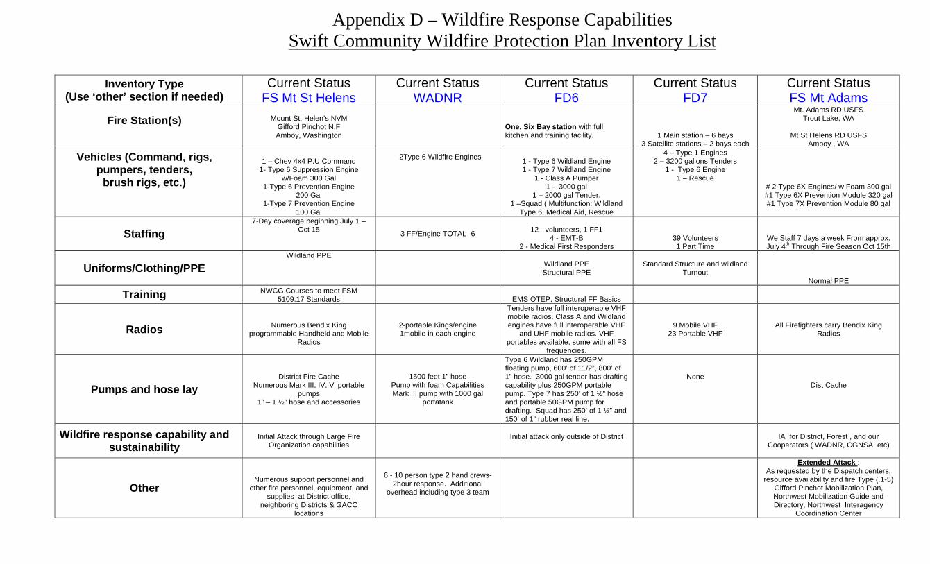
Emergency Equipment and Staffing Inventory
This section includes inventories for all the fire fighting agencies within the Swift CWPP
planning area as of September 2007 (Appendix D - Wildfire Protection Capabilities).
Skamania County Volunteer Fire District 6
The communities residing at the east end of the Swift Reservoir are serviced by FD6.
Personnel and equipment inventory includes:
12 Volunteer Firefighters, 4 EMT, 2 Medical First Responders, 0 Red Card Certified
Swift Reservoir, Skamania County, WA CWPP 20
1 – Six Bay Station (with full kitchen, training facility and self powered by power
generation and local well system)
1 – Type 6 Wildland Engine (drafting pump onboard)
1 – Type 7 Wildland Engine (drafting pump onboard)
1 – Class A Pumper (drafting capability)
1 – Tender 3000 gallon
1 – Tender 2000 gallon
1 – Squad (multi-function: wildland type 6, medical aid, rescue, drafting capability
Cowlitz-Skamania County Volunteer Fire District 7
The communities residing at the west end of Swift Reservoir are serviced by FD7.
Personnel and equipment inventory includes:
39 Volunteer Firefighters, 0 Red Card Certified
1 Part-time employee
1 – Six Bay Main Station
3 – Two Bay Satellite Stations
4 – Type 1 Engines
2 – Tenders 3200 gallons
1 – Type 6 Engine
1 – Rescue Vehicle
FD6 and FD7 have compiled an inventory list that documents the current status and
future needs of equipment, staffing and training (Appendix E - Current Inventory and
Future Needs). Wildland fire protection outside of the Fire District boundary is provided
by the GPNF and WADNR under mutual aid agreements. The following federal and
state fire fighting resources are not stationed within the planning area and estimated
response times are from 60 to 90 minutes, but may be longer.
Mt Adams Ranger District GPNF
The Mt. Adams Ranger District of the GPNF provides fire protection primarily on federal
lands in the Swift CWPP area with the following inventory depending on level and
location of wildfire:
Trout Lake, WA Duty Station
2 – Type 6 wildfire engines w/foam 300 gallons
1 – Type 6 prevention module 320 gallons
1 – Type 7 prevention module 80 gallons
11-14 on duty employees staffed per day from 7/4 – 10/15
Estimated 35 employees line qualified firefighters available as needed from
approximately 7/4 – 10/15
Mount Saint Helen’s National Volcanic Monument
The Mount Saint Helen‟s National Volcanic Monument of the GPNF provides fire
protection primarily on federal lands in the Swift CWPP area with the following
inventory depending on level and location of wildfire:
Amboy, WA Duty Station
1 – Type 6 suppression engine w/foam 300 gallons
1 – Type 6 prevention engine 200 gallons
1 – Type 7 prevention engine 100 gallons
1 Chevy 4X4 command rig
Swift Reservoir, Skamania County, WA CWPP 21
Seven day coverage from 7/1 – 10/15 (number of employees not available)
Washington State Department of Natural Resources
WADNR provides fire protection primarily on private and state lands and has the
following inventory depending on level and location of wildfire:
6 – Firefighters
2 – Type 6 wildfire engines
Phase II
Gap Workshop The purpose of the gap workshop was to identify any constraints, 'bottle necks', missing
links and/or gaps within the Swift planning area fire fighting system. Following are the
“gaps” identified by the Swift Steering Committee:
1. Lack of red card volunteers (130, 190 standards), bring training to FD6 and FD7
2. Lack of radio communication with DNR and Forest Service
3. Lack of evacuation routes; coordinate with Skamania County Sheriff‟s office
4. Limited water storage tanks and they‟re lacking known coordinate positions
5. No defined mutual aid distances
6. Lack of GIS and mapping accuracy, e.g. Northwoods fire hydrants
7. Limited Firewise education
8. Lack of multi-agency drills and coordination
9. Undefined MOU‟s with Forest Service
10. Lack of volunteers (FD6) and volunteer availability during week (FD7)
11. Equipment (older, serviceable, but would be nice to update)
12. Lack of fire service. Marble Mountain, Four Peaks and other “no man‟s land” not
in either Fire District, (ties to lack of volunteers, residents want fire protection but
do not seem willing to support volunteer fire districts)
Map Workshop The purposes of the map workshop are to 1) assess several different aspects of the Swift
planning area such as fire history, population density, fuel loads and future developments
and identify „high risk areas‟ and/or CAR that exist, and then 2) establish fuel mitigation
projects, classed by risk to better protect life, property and natural resources. Figure 8
depicts potential water tank sites and „high risk areas‟ that the Swift CWPP Steering
Committee outlined. The three major elements that drove the designation of the high risk
areas were human use, historical fires and fuel loads.
PROJECTS The following projects were identified to reduce the risk of wildfire and protect life,
property and natural resources within the Swift CWPP planning area. These projects are
subject to modification depending on changes in local priorities.
Projects were classed into four categories: 1) Fuel Mitigation Projects, 2) Planning
Projects, 3) Education Projects, and 4) Equipment, Training and Exercise Projects. Some
specific project types, such as landowner fuels mitigation have components in two or
more categories. Priority rankings reflect importance among all projects; not just within
a category.
Swift Reservoir, Skamania County, WA CWPP 22
Fuel Mitigation Projects The primary goal of fuel mitigation projects is to reduce wildfire risk by physically
reducing fuel densities in selected areas to specified levels. Specific target areas and fuel
densities will be assessed using computer models, NFPA-299 data, professional judgment
and other appropriate and available methods.
Project 1: Firewise homeowner protection – High Priority
Induce homeowners to create and maintain their own “firewise” landscape by advertising,
holding classes and demonstrations and using other suitable media. The “Living with
Fire” brochure (Appendix F – “Living With Fire, A Guide for the Homeowner”) indicates
fuel reduction treatments, types and methods that homeowners should implement. Fuel
treatments will also comply with Skamania County requirements.
Implementing “firewise” methods such as creating defensible space, thinning dense
vegetation, providing access, having established escape routes for homes and
neighborhoods to an adequate safety zones can greatly reduce a community‟s risk from
wildfire (Davis 2005).
Project 2: Fuel breaks around „communities at risk‟ – High Priority
The Steering Committee chose as risk criteria; existing population density, future
development, fire history (wildland and structure) and fuel loads. The Committee then
used professional judgment to establish boundaries encompassing high risk areas based
on these criteria. These areas were designated “Communities at risk” (CAR) and/or
“high risk areas” within the Swift planning area. The Committee suggested that strategic
fuel breaks be created by thinning, limbing or clearing mechanically or by hand to better
protect the following CAR (Figure 8):
Rain Creek
Beagle
Marble Creek
Elk
Marble Mountain
Drift Creek Cove
Swift Cove
Swift View
Swift Camp
Swift Estates
Three Rivers
Northwoods
Four Peaks

Swift Reservoir, Skamania County, WA CWPP 23
Project 3: High use recreation areas – Low Priority
Create defensible fuel zones and fire breaks around recreation areas and along roads
accessing high-use recreation areas to protect sites and users from wildfire. Recreation
sites to be protected are:
Drift Creek Cove
Swift Cove (lakeside)
Northwoods (common areas)
Swift Estates (boat docks)
Swift Creek Campgrounds
Eagle Cliffs Store (camping area)
Rain Creek
Three Rivers Recreation Area
Project 4: Establish a fuels disposal program – Moderate Priority
Establish an annual wood chipping day where residents can easily dispose of small trees
and brush removed as part of establishing defensible space around their homes. This
Figure 8. Appendix H4 – High Risk Areas within the Swift CWPP planning area (Cartographer: Sara Zielin).

Swift Reservoir, Skamania County, WA CWPP 24
would reduce wildfire risk from on-site burning and the amount of unwanted smoke.
Potential cooperators include Skamania County, WADNR, and USDA Forest Service
among others.
Planning Projects The primary goals of planning projects are to further refine education and fuels
mitigation projects and reduce or eliminate constraints in response and interagency
cooperation.
Project 1: Fire service annexation of “no man‟s” land - Moderate Priority
The land north of Swift Reservoir along the USFS 90 Road is rapidly developing and is
not serviced under either adjacent Fire District (Skamania County FD6 and Cowlitz-
Skamania FD7). Following are communities lacking Fire District service protection
within the Swift CWPP planning area (Figure 8):
Beagle
Elk
Marble Creek
Marble Mountain
Four Peaks
Drift Creek Cove
Project 2: Gate accessibility – High Priority
Many of the new developments in the Swift Reservoir area are gated and EMS
responders cannot access homes without a key or combination. The County Fire
Marshall suggests Knox-Box systems be installed on every gate within the county.
Project 3: Burn ban coordination with Skamania County Fire Districts and Gifford
Pinchot National Forest – Moderate Priority
Skamania County and the Gifford Pinchot National Forest both control burn bans on their
respective jurisdictions within Skamania County. However, when the County‟s burn ban
and the Gifford Pinchot‟s don‟t correspond, residents complain that fires are allowed on
Forest Service recreation sites but not on private property. This makes regulation of
illegal fires difficult and takes away from the two volunteer Fire Districts‟ resources.
This project would coordinate burn bans with USFS and Skamania County Fire Districts
so they‟re consistent throughout the Swift CWPP planning area.
Project 4: Various GPS data collection and map building – Moderate Priority
The Steering Committee regards updating and maintaining necessary GIS data
throughout the Swift CWPP planning area as essential for EMS responders to maintain an
effective firefighting system, to improve response times, and to continue to depend on
digital data. Main topics of concern are:
Continue NFPA299 Survey – This project is devoted to surveying new homes and
updating and maintaining the NFPA299 Survey data that has been surveyed in the
past throughout the planning area.
Locate and map water sources – Water source sites are essential to fighting fire
and locating new and mapping existing water source sites will give fire fighting
entities the necessary information to perform their jobs.
Locate and map gates – Many new developments are being constructed within the
planning area and most have locked gated entries. All of the gate locations are
Swift Reservoir, Skamania County, WA CWPP 25
not known and can prevent EMS responders from accessing homes especially
without the corresponding keys and/or codes in hand.
Obtain coordinates for helicopter landing zones (LZ) and staging areas – This
project includes recording GPS locations for known landing zones and staging
areas as well as locating new potential sites throughout the Swift CWPP planning
area. Some new potential zones and areas are as follows:
o Landing zones
FD6 boat ramp
FD7 Rain Creek (ex Bluebird Helicopter)
o Staging areas
FD6 Pine Creek
Project 7: Emergency Response Handbook – Moderate Priority
This guide for the Swift CWPP area is intended for outside responders. This document
would allow the user to identify terrain features such as public and private roads, bridges
and weight limitations, gates, road accessibility, power lines, gas lines, decommissioned
roads, and resources such as fire hydrants, water sources, staging areas, evacuation routes
and areas and other items deemed to be of use. A standardized GIS map will be prepared
for sake of continuity with WADNR, FS maps and other Skamania County CWPP plans.
Achieving this requires an on-going county GIS presence and establishing M.O.U.‟s as
needed between FS, WADNR, FD6 and FD7, local timber industries and adjoining
counties for sharing of GIS data and like resources.
Project 8: Establish Evacuation Plan – High Priority
Currently, the Swift area does not have an evacuation plan that includes a public
notification system and identifies escape routes, escape areas, staging areas, helicopter
landing zones (LZ) that will be utilized in the case of an emergency such as a wildfire.
The Steering Committee will review potential sites for designated emergency areas and
make land-use agreements with landowners and emergency agencies.
Project 9: Achieve Communication Interoperability – High Priority
Currently, Skamania Volunteer FD6 and Cowlitz-Skamania FD7 communicate on VHF
radios which are not compatible with other Skamania County Volunteer Fire Districts and
Sheriffs Office. The CWPP Steering Committee recommends that Skamania County
EMS, USDA FS and WADNR work together in achieving radio system interoperability
by methods such as by providing FD6, FD7, EMS, and Sherriff‟s Department access to
particular frequencies, necessary radios and/or gateway devices.
Education Projects
The primary goal of education projects is to raise public wildfire awareness to the point
where residents will take the initiative for creating and maintaining defensible space
around their own homes and structures.
Project 1: “Firewise” education programs at Swift and Vancouver – High Priority
Engage the Swift communities in “Firewise” education programs at both Swift and
Vancouver areas. The Steering Committee discussed the importance in educating the
community members about living in a “firewise” community. Many new subdivisions
are developing in Swift Reservoir area and new residents often have low awareness of
wildfire risk. Also, most people are not year round residents and holding programs in the
Vancouver area would increase people‟s availability to attend programs during the off
Swift Reservoir, Skamania County, WA CWPP 26
season months. Outreach methods may include holding an annual pancake feed in
coordination with Fire Districts 6 and 7, WADNR, Forest Service and established groups
such as Swift Communities Action Team (SCAT), Cougar Area Trail Seekers (CATS)
and community members within Swift CWPP planning area.
Project 2: Maintain a website – Low Priority
Create a website for Fire Districts 6 and 7 that will be a central location for the public to
get information on current fire risk, pile burning, fire hall notes, maintain a blog and links
to “firewise” websites.
Equipment, Staffing and Exercise Projects The primary goal of Equipment, Staffing and Exercise projects is to increase the wildfire
response capabilities of the CWPP planning area fire agencies by defining and addressing
equipment, staff and training needs.
Project 1: Volunteer Fire District Recruitment – High Priority
Volunteer Fire Districts depend on local citizen commitment. Currently Fire District 6
has eight volunteers (mostly available on weekends) and Fire District 7 has forty
volunteers (mostly available at night or on weekends). Thus, both Districts may be short
of staff during emergency situations. Holding a targeted recruiting event to motivate
community members to participate in the Fire Districts will give the Fire Chiefs and
Assistant Chiefs an opportunity to engage local citizens in serving their community.
Project 2: Red card training with FS and WADNR – High Priority
Skamania County Volunteer Fire Districts including FD6 and FD7 (Cowlitz-Skamania)
will coordinate with WADNR and FS on scheduling „red card‟ training to increase
volunteer fire fighters abilities to attend training.
Project 3: Grant writer for Fire District 6 and 7 – Moderate Priority
Volunteer Fire Districts depend on grants to help fund equipment and training needs.
Volunteers lack the adequate time needed to search and apply for useful grants. The
Steering Committee regards it necessary to hire a grant writer to take advantage of these
opportunities Fire District 6 and 7 can‟t manage on their own. This position would serve
both Fire District 6 and 7 and possibly other Skamania County Fire Districts.
Project 4: Organize and perform a multi-agency training/mock drills –Moderate Priority
Organize a mock drill with FD6 and FD7 and other Skamania County Volunteer Fire
Districts, FS, and WADNR, that tests the fire fighting systems and capabilities and
identifies problems within the system.
Project 5: Class A Fire Engine – Low Priority
Skamania County Volunteer Fire District 6 needs a Class A Fire Engine to better protect
the growing Swift communities.
The Swift Action Plan Education projects will teach “firewise” measures that homeowners can take to reduce
structure ignitability. The goal is to get community members to make it their personal
responsibility to take steps to protect themselves during wildfire. Phase 1 of the action
plan includes seeking a Wildfire Prevention Intern who will develop “firewise” education
Swift Reservoir, Skamania County, WA CWPP 27
classes, write grants pertaining to CWPPs and recruit a “firewise” volunteer cadre. The
position would serve FD6, FD7 and other Fire Districts. The Swift CWPP core group
will continue to work with Wildfire Prevention Coordinator in prioritizing work for
CWPP intern. Lastly, utilize the Skamania County Wildfire Prevention Coordinator for
CWPP support while funding still exists.
Structure Ignitability The Swift CWPP Steering Committee recommends that the homeowners within the
planning area use the “Living with Fire: A guide for the homeowner” brochure as an
initial guide to reducing structure ignitability (Appendix F).
MONITORING AND EVALUATING To help document changes, before and after photos should be taken of fuel mitigation
project areas. Pictures demonstrate the effectiveness of the project and subsequent
changes from year-to-year plan growth. Recording GPS coordinates of the photo
locations are strongly suggested (Hulbert 2004). Software such as Landscape Modeling
System (LMS) can help predict when re-treatment of forest fuels will be necessary.
A CWPP is a living document and annual re-evaluation will be performed by the Swift
Steering Committee. The Steering Committee will also convene to discuss CWPP
updates and to share any new project, grant developments and amendments as needed.
The Swift CWPP has recognized FEMA Pre-Disaster Mitigation (PDM) Plan
Requirements. The table in Appendix G, indicates how the Swift CWPP meets FEMA
PDM compliancy and what components are missing for future acceptance.
Swift Reservoir, Skamania County, WA CWPP 28
APPENDICES A – Agendas, Meeting Minutes, Steering Committee Sign-in Sheets
B – Community Questionnaire
C – NFPA-299 Hazard Rating Form
D – Wildfire Protection Capabilities
E – Current Inventory and Future Needs
F – “Living With Fire, A Guide for the Homeowner”
G – FEMA Pre-Disaster Mitigation Compliance
H1 – CWPP Map – Swift Basemap
H2 – CWPP Map – Historical Wildland and Structure Fires
H3 – CWPP Map –Swift Topography
H4 – CWPP Map – High Risk Areas

Swift Reservoir, Skamania County, WA CWPP 29
REFERENCES
Columbia Gorge Wildfire Prevention Coordinator Website. 2003. Retrieved May 30,
2007, from http://www.skamaniacounty.org/Wildfire/Web%20Page%20May%20
2007.htm
Davis, C., J. Esteves and M. Dearden. 2005. Trout Lake Community Wildfire Protection
Plan. Retrieved May 29, 2007, from
http://www.dnr.wa.gov/htdocs/rp/mitigation/klickitat/troutlake.pdf
DNR GIS Data. Retrieved June 28, 2007, from
http://www3.wadnr.gov/dnrapp6/dataweb/dmmatrix.html#Wildfire%20and%20Prevention.
Douglas County Planning Department. 2005. Retrieved June 6, 2007 from
http://www.co.douglas.or.us/planning/wildfire_plans/default.asp.
Hulbert, J. H. 2004. Community Wildfire Protection Plan: For the Cities of Bingen and
White Salmon. Retrieved May 29, 2007, from
http://www.dnr.wa.gov/htdocs/rp/mitigation/klickitat/whitesalmonbingen.pdf
Hulbert, J. H. 2005. Community Wildfire Protection Plan: For the City of Cascade
Locks. Retrieved May 30, 2007, from
http://www.oregon.gov/ODF/FIRE/docs/PREV/CascadeLocksFirePlanJanuary04.pdf
National Association of State Foresters. 2004. Preparing a Community Wildfire
Protection Plan: A Handbook for Wildland-Urban Interface Communities. Retrieved
May 29, 2007, from http://www.safnet.org/policyandpress/cwpphandbook.pdf
Revised Code of Washington. 2007. Retrieved May 29, 2007, from
http://apps.leg.wa.gov/RCW/default.aspx?cite=70.77.395
Skamania County Ordinances. Retrieved June 7, 2007, from
http://www.skamaniacounty.org/bpc/html/index.htm
Stevenson Chamber of Commerce. Retrieved May 29, 2007, from
http://www.skamania.org/county_stats.html
Topik, C, Halverson, N. M.; Brockway, D. G. 1986. Plant Association and Management
Guide for the Western Hemlock Zone. USDA Forest Service. Pacific Northwest Region,
R6-ECOL-230A http://www.treesearch.fs.fed.us/pubs/2374
Washington Department of Natural Resources. Retrieved June 28, 2007, from
http://www.dnr.wa.gov/htdocs/rp/01wildlandfiresum/nfplan02.pdf
Williams Northwest. Retrieved August 21, 2007, from
http://www.williams.com/williamsinwashington/index.asp
Witherspoon, K.A., M. J. Mazeski. Retrieved September 20, 2007, from
http://www.skamaniacounty.org/Planning/Swift%20Area/Swift%20Sub-Area.htm
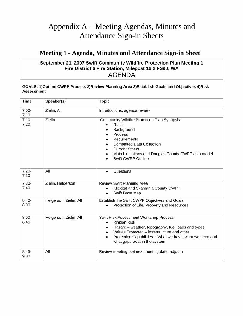
Appendix A – Meeting Agendas, Minutes and Attendance Sign-in Sheets
Meeting 1 - Agenda, Minutes and Attendance Sign-in Sheet
September 21, 2007 Swift Community Wildfire Protection Plan Meeting 1 Fire District 6 Fire Station, Milepost 16.2 FS90, WA
AGENDA
GOALS: 1)Outline CWPP Process 2)Review Planning Area 3)Establish Goals and Objectives 4)Risk Assessment
Time Speaker(s) Topic
7:00- 7:10
Zielin, All Introductions, agenda review
7:10- 7:20
Zielin Community Wildfire Protection Plan Synopsis
• Roles
• Background
• Process
• Requirements
• Completed Data Collection
• Current Status
• Main Limitations and Douglas County CWPP as a model
• Swift CWPP Outline
7:20- 7:30
All • Questions
7:30- 7:40
Zielin, Helgerson Review Swift Planning Area
• Klickitat and Skamania County CWPP
• Swift Base Map
8:40- 8:00
Helgerson, Zielin, All Establish the Swift CWPP Objectives and Goals
• Protection of Life, Property and Resources
8:00- 8:45
Helgerson, Zielin, All Swift Risk Assessment Workshop Process
• Ignition Risk
• Hazard – weather, topography, fuel loads and types
• Values Protected – infrastructure and other
• Protection Capabilities – What we have, what we need and what gaps exist in the system
8:45- 9:00
All Review meeting, set next meeting date, adjourn

Swift CWPP Minutes Meeting 1 – September 21, 2007
Meeting started at 7:00pm
• Introductions and agenda review • Meeting packets were handed out and included:
o “Resource List”- weblinks related to CWPP’s o Tentative CWPP document outline o Maps
Klickitat and Skamania County CWPP “communities” Swift CWPP planning area
o Wildfire Response Capabilities for FD6 and FD7 o Community Questionnaire o Tentative agenda for meeting 2
• Sara presented the general information pertaining to CWPP’s • Swift planning area was presented and discussed
o Reese and Yela thought the planning area was too large and should be consolidated to where communities are located
o J. Carlson explained how the Forest Service land to the north can affect the communities to the south and that keeping the planning area ‘as is’ would not have a negative affect
o Zielin explained how in future meetings we can outline WUI boundaries for the communities
o J. Carlson explained the big picture of how the Swift CWPP will serve as a chapter to the Klickitat and Skamania County CWPP and keeping the planning area as outlined in the broad brushed will be beneficial for continuity
o Group discussed referencing Cowlitz-Skamania FD7 as a resource to the Swift CWPP and all agreed on keeping the planning area as originally presented
• Objective and goals were presented and discussed o Yela agreed they should be as presented but in the order of Life, Natural
Resources and Property – all agreed • Phase I of the risk assessment was performed as a group, the group was asked to
brainstorm about the following four topics in respect to the Swift Planning Area: o Risk of Ignition
Man caused • Generators • Candles • Propane tanks • Slash/debris burning • Fireworks • Camp fires – recreational primitive camps a higher risk • Smoking/cigarettes • Forestry practices – logging, harvesting • Power lines – on the west end of Swift Reservoir • Structure fires
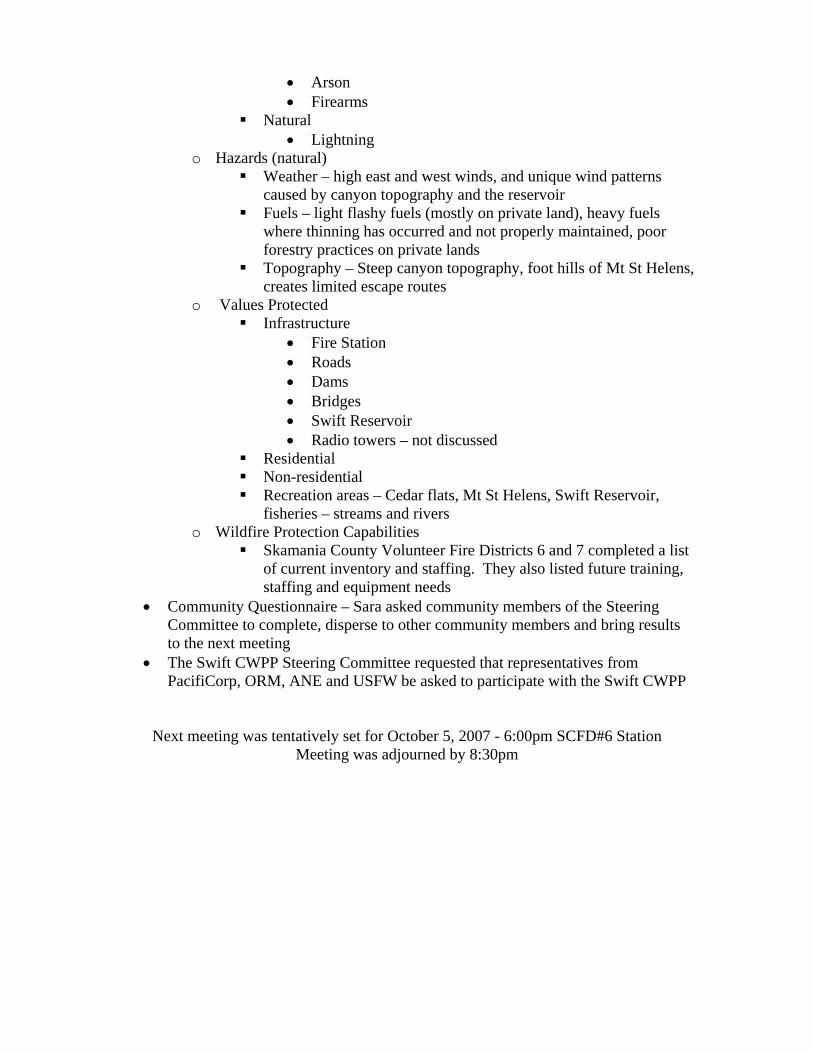
• Arson • Firearms
Natural • Lightning
o Hazards (natural) Weather – high east and west winds, and unique wind patterns
caused by canyon topography and the reservoir Fuels – light flashy fuels (mostly on private land), heavy fuels
where thinning has occurred and not properly maintained, poor forestry practices on private lands
Topography – Steep canyon topography, foot hills of Mt St Helens, creates limited escape routes
o Values Protected Infrastructure
• Fire Station • Roads • Dams • Bridges • Swift Reservoir • Radio towers – not discussed
Residential Non-residential Recreation areas – Cedar flats, Mt St Helens, Swift Reservoir,
fisheries – streams and rivers o Wildfire Protection Capabilities
Skamania County Volunteer Fire Districts 6 and 7 completed a list of current inventory and staffing. They also listed future training, staffing and equipment needs
• Community Questionnaire – Sara asked community members of the Steering Committee to complete, disperse to other community members and bring results to the next meeting
• The Swift CWPP Steering Committee requested that representatives from PacifiCorp, ORM, ANE and USFW be asked to participate with the Swift CWPP
Next meeting was tentatively set for October 5, 2007 - 6:00pm SCFD#6 Station Meeting was adjourned by 8:30pm

Meeting 2 - Meeting Agenda, Minutes and Attendance Sign-in Sheet
Swift Community Wildfire Protection Plan Meeting 2 Fire District 6 Station, Milepost 16.2 FS90, WA
AGENDA GOALS: 1) Identify Gaps 2) Identify Problem Areas 3) Review Community Concerns 4) Identify Projects 5) Prioritize Projects Time Speaker(s) Topic
6:00- 6:10
Zielin, All Introductions, agenda review, meeting minutes from 9/21/07
6:10- 6:20
Zielin Gap Identification Workshop • What limitations and/or constraints to our ability to fight
wildfire exist within the Swift CWPP planning area?
6:20- 7:00
Zielin, All Map Workshop • Population Density • Future Development • Fire History • Fuel Loads
7:00- 7:05
Zielin, Page Grants • Many types and requirements
7:05- 7:15
Community Community Questionnaire • Concerns from community
7:15- 7:45
Zielin Project Workshop • Fuel Mitigation Projects • Planning Projects • Education Projects • Equipment/Staffing/Exercise
7:45 - 7:55
Helgerson, All Prioritizing Projects • High Priority • Moderate Priority • Low Priority
7:55- 8:00
All Review meeting, set next meeting date, adjourn
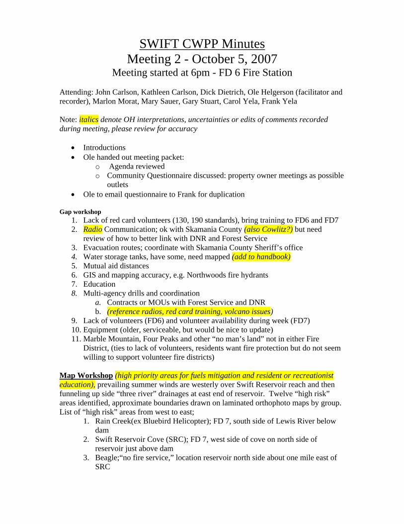
SWIFT CWPP Minutes Meeting 2 - October 5, 2007
Meeting started at 6pm - FD 6 Fire Station Attending: John Carlson, Kathleen Carlson, Dick Dietrich, Ole Helgerson (facilitator and recorder), Marlon Morat, Mary Sauer, Gary Stuart, Carol Yela, Frank Yela Note: italics denote OH interpretations, uncertainties or edits of comments recorded during meeting, please review for accuracy
• Introductions • Ole handed out meeting packet:
o Agenda reviewed o Community Questionnaire discussed: property owner meetings as possible
outlets • Ole to email questionnaire to Frank for duplication
Gap workshop 1. Lack of red card volunteers (130, 190 standards), bring training to FD6 and FD7 2. Radio Communication; ok with Skamania County (also Cowlitz?) but need
review of how to better link with DNR and Forest Service 3. Evacuation routes; coordinate with Skamania County Sheriff’s office 4. Water storage tanks, have some, need mapped (add to handbook) 5. Mutual aid distances 6. GIS and mapping accuracy, e.g. Northwoods fire hydrants 7. Education 8. Multi-agency drills and coordination
a. Contracts or MOUs with Forest Service and DNR b. (reference radios, red card training, volcano issues)
9. Lack of volunteers (FD6) and volunteer availability during week (FD7) 10. Equipment (older, serviceable, but would be nice to update) 11. Marble Mountain, Four Peaks and other “no man’s land” not in either Fire
District, (ties to lack of volunteers, residents want fire protection but do not seem willing to support volunteer fire districts)
Map Workshop (high priority areas for fuels mitigation and resident or recreationist education), prevailing summer winds are westerly over Swift Reservoir reach and then funneling up side “three river” drainages at east end of reservoir. Twelve “high risk” areas identified, approximate boundaries drawn on laminated orthophoto maps by group. List of “high risk” areas from west to east;
1. Rain Creek(ex Bluebird Helicopter); FD 7, south side of Lewis River below dam
2. Swift Reservoir Cove (SRC); FD 7, west side of cove on north side of reservoir just above dam
3. Beagle;“no fire service,” location reservoir north side about one mile east of SRC

4. Wapiti Ridge; “no fire service,” location reservoir north shore, about one mile east and south of Beagle, no road exit, steep entry road?
5. Elk; “no fire service,” north of reservoir about one mile east of Wapiti Ridge, no exit
6. Marble Mountain; “no fire service,” location north of Elk, extends about two miles to northeast, steep entry road, no exit
7. “Forest Service” (need name) Cove; location, bay on south side of reservoir land, Forest Service, no road access, boaters use beaches on cove for recreation, westerlies could quickly carry fire up steep slope on east side, significant ignition risk to Northwoods from flying embers
8. Swift View; FD6, 12 lots, location north shore of reservoir, potential high population density
9. Swift Camp; FD6, 93 lots, location north shore of reservoir, potential high population density
10. Swift Estates; FD6, 48 lots, location north shore of reservoir, potential high population density
11. Three Rivers, location, east end of reservoir, north side, potential high population density
12. Northwoods; location, east end of reservoir, south side, high residential density, existing fuels near structures
13. Need to get “Four Peaks” area identified on map Swift CWPP Project List (priorities refer to overall ranking all categories combined) Fuel Mitigation Projects (copy FD1 CWPP list)
1. Priority High. Create defensible space around homes according to “Firewise” or “living with Fire” standards
2. Priority High. Create fuel breaks around recreation areas and “risk” areas 3. Priority Medium. Woody debris disposal
Planning Projects (note: italics are potential projects I took from gap lit that did not seem to be covered, please review, oth)
1. Priority ________. Water sources, locate potential new sites 2. Priority ________. Water sources, map existing sites onto GIS layer 3. Priority ________. Evacuation routes; develop in coordination with Skamania
County Sheriff’s office 4. Priority ________. Correct GIS alignment problems with Northwoods fire
hydrants 5. Priority _______. new ideas?? 6. Priority Medium. Fire service access to “no man’s” land (lands undergoing
residential development between FD6 and FD7, e.g. Beagle, Elk, Wapiti Ridge, Marble Mountain, various “Swift” subdivisions, see notes from “map workshop”
7. Priority Medium. Map out Forest Service, DNR and private ownership on GIS to better define areas for fuels mitigation and initial response
8. Priority Medium. Burn ban coordination with Gifford Pinchot National Forest 9. Priority Medium. Continue NFPA299 survey.

10. Priority Medium. Obtain GIS coordinates for helicopter landing zones (LZs) and staging areas
a. Landing zone i. FD6 boat ramp name?
ii. FD7 Rain Creek (ex Bluebird Helicopter) iii. Others?
b. Staging areas i. FD6 Pine Creek
ii. Others ?? 11. Priority Medium. Emergency response handbook (see FD1 and FD4 CWPPs)
a. Include GPS coordinates and data (sizes & distances from?) for helicopter landing zones (LZs)and staging areas
Equipment, Staffing and Exercise Projects
1. Priorities Very High and High. Recruit more volunteers a. Very High. FD6, 8 volunteers at most on weekends, none during week
days. b. High. FD7, more than 40 volunteers, most not available during week days,
but weekend staffing is strong. 2. Priority High. Red card training; coordinate with WDNR joint FD6 and FD7
training?) 3. Priority Medium. Grant writer or other staff to facilitate paperwork
Education Projects
1. Priority High. “Firewise” resident education programs (link to debris burning, defensible space and???
a. Pancake feeds b. Vancouver meetings for Northwoods and other resident meetings
2. Priority Low. Web site a. Information for fire districts with blog, could adapt existing Skamania
County “firewise” web site? b. Information for public fire risk, pile burning, fire hall notes, links to
firewise Date, time and location set for meeting three; Friday, November 2, 1800-2000, FD6 Firehall. Agenda for meeting 3:
• review items defined in meetings 1 and 2 before drafting cwpp, • line out review process • define action steps • discuss FEMA compliance


Meeting 3 - Meeting Agenda, Minutes and Attendance Sign-in Sheet
November 2, 2007 Swift Community Wildfire Protection Plan Meeting FD 6 Fire Station, Skamania County, WA
AGENDA GOALS: 1) Review Projects, 2) Modify/Add/Remove Projects, 3) Re-Prioritize Projects, 4)
Create Action Plan, 5) Quickly debrief CWPP planning process Time Speaker(s) Topic
6:00- 6:10
Zielin, All Introductions, review agenda and meeting minutes from October 5, 2007
6:10- 7:00
Zielin, All Review and change project descriptions as needed • Fuel Mitigation • Planning • Education • Equipment/Staffing/Exercise
7:00- 7:20
All Add/Remove projects
7:20- 7:30
All Re-Prioritize projects as needed • New projects • Previous projects if necessary
7:30- 7:50
All, Zielin, Helgerson Create an action plan • CWPP draft review and signature process • CWPP sustainability • FEMA Pre-Disaster Mitigation Plan Compliancy
7:50- 8:00
All • Review meeting and overall CWPP process, • Adjourn meeting
THANK YOU FOR ALL OF YOUR HELP!!!
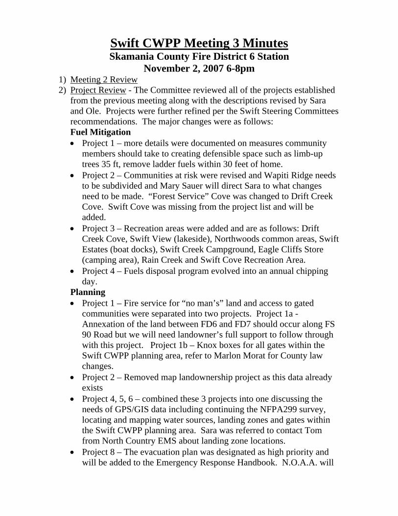
Swift CWPP Meeting 3 Minutes Skamania County Fire District 6 Station
November 2, 2007 6-8pm 1) Meeting 2 Review 2) Project Review - The Committee reviewed all of the projects established
from the previous meeting along with the descriptions revised by Sara and Ole. Projects were further refined per the Swift Steering Committees recommendations. The major changes were as follows: Fuel Mitigation • Project 1 – more details were documented on measures community
members should take to creating defensible space such as limb-up trees 35 ft, remove ladder fuels within 30 feet of home.
• Project 2 – Communities at risk were revised and Wapiti Ridge needs to be subdivided and Mary Sauer will direct Sara to what changes need to be made. “Forest Service” Cove was changed to Drift Creek Cove. Swift Cove was missing from the project list and will be added.
• Project 3 – Recreation areas were added and are as follows: Drift Creek Cove, Swift View (lakeside), Northwoods common areas, Swift Estates (boat docks), Swift Creek Campground, Eagle Cliffs Store (camping area), Rain Creek and Swift Cove Recreation Area.
• Project 4 – Fuels disposal program evolved into an annual chipping day.
Planning • Project 1 – Fire service for “no man’s” land and access to gated
communities were separated into two projects. Project 1a - Annexation of the land between FD6 and FD7 should occur along FS 90 Road but we will need landowner’s full support to follow through with this project. Project 1b – Knox boxes for all gates within the Swift CWPP planning area, refer to Marlon Morat for County law changes.
• Project 2 – Removed map landownership project as this data already exists
• Project 4, 5, 6 – combined these 3 projects into one discussing the needs of GPS/GIS data including continuing the NFPA299 survey, locating and mapping water sources, landing zones and gates within the Swift CWPP planning area. Sara was referred to contact Tom from North Country EMS about landing zone locations.
• Project 8 – The evacuation plan was designated as high priority and will be added to the Emergency Response Handbook. N.O.A.A. will

be contacted to discuss their emergency notification system and the Swift CWPP.
Education • Project 1 – Cougar Area Trail Seekers (CATS) and Swift
Communities Action Team (SCAT) will be added as a major contact for community members and this education project.
Equipment, Staffing and Exercise • Project 2 – Add Forest Service to title of project
3) Action Plan Review
o An action plan was discussed and it was decided that the Steering Committee would meet annually at a minimum.
o The Title III Wildfire Prevention Coordinator suggested her lead on planning projects, to initially get things started while the grant position still exists and as time allows.
o Title III 2008 – Announced the NWSA position added to the firewise project and the contributions this position will provide:
Perform Firewise education courses CERT/“Firewise” liaison Assist with spearheading Skamania County CWPP
projects 4) FEMA Compliancy – The Swift CWPP will attempt to be as FEMA compliant if feasible within the Swift CWPPs main objectives and goals 5) Finalizing CWPP – The Committee discussed the steps to finalize the Swift CWPP:
o Review Draft and suggest any changes o Allow time for public review and comment o Present public comment to Steering Committee o Make changes as recommended by Core Group o Core group signs final document o Send to DNR for approval

Appendix B – Community Questionnaire
The Swift Community Wildfire Protection Plan (CWPP) Questionnaire September 2007
The purpose of this survey is to involve the community members in the Swift Community Wildfire Protection Plan. One objective is to determine what natural and manmade features you believe are important to protect in the case of a wildfire. The map to the right depicts the planning area boundary. The Swift CWPP Steering Committee determined goals and objectives for our plan such as protecting life, property and natural resources. What we need from you are ideas about specific areas that you, as a member of the community, want to protect. For example: water sources, wilderness areas, recreation spots, unknown cemeteries, watersheds, hunting grounds, archaeological sites, roads, etc.
Please use the backside of this survey if
necessary
• As a community member what areas within the Swift planning area do you want protected in the event of a wildfire?
• What projects do you think could improve the community’s fire awareness and
responsiveness? • Do you support the idea of seeking grant funding to upgrade our local, state and
federal fire fighting organization’s equipment? • Any other suggestions, concerns, comments, or questions regarding the Swift
CWPP.
To stay connected to the Swift CWPP please fill out the following confidential information. Name(s) ________________________________________________________________ Address_________________________________________________________________ Phone___________________________________________________________________ Email___________________________________________________________________ Please return this survey to: Firewise, PO Box 790, Stevenson, WA 98648 OR email [email protected] OR call (509) 427-4130
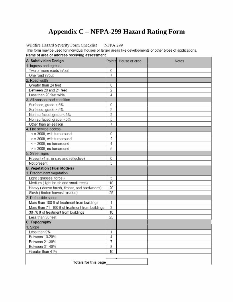
Appendix C – NFPA-299 Hazard Rating Form
Appendix D – Wildfire Response Capabilities Swift Community Wildfire Protection Plan Inventory List
Inventory Type (Use ‘other’ section if needed)
Current Status FS Mt St Helens
Current Status WADNR
Current Status FD6
Current Status FD7
Current Status FS Mt Adams
Fire Station(s)
Mount St. Helen’s NVM Gifford Pinchot N.F Amboy, Washington
One, Six Bay station with full kitchen and training facility.
1 Main station – 6 bays 3 Satellite stations – 2 bays each
Mt. Adams RD USFS Trout Lake, WA
Mt St Helens RD USFS
Amboy , WA
Vehicles (Command, rigs, pumpers, tenders,
brush rigs, etc.)
1 – Chev 4x4 P.U Command 1- Type 6 Suppression Engine
w/Foam 300 Gal 1-Type 6 Prevention Engine
200 Gal 1-Type 7 Prevention Engine
100 Gal
2Type 6 Wildfire Engines
1 - Type 6 Wildland Engine 1 - Type 7 Wildland Engine
1 - Class A Pumper 1 - 3000 gal
1 – 2000 gal Tender. 1 –Squad ( Multifunction: Wildland
Type 6, Medical Aid, Rescue
4 – Type 1 Engines 2 – 3200 gallons Tenders
1 - Type 6 Engine 1 – Rescue
# 2 Type 6X Engines/ w Foam 300 gal #1 Type 6X Prevention Module 320 gal #1 Type 7X Prevention Module 80 gal
Staffing
7-Day coverage beginning July 1 – Oct 15
3 FF/Engine TOTAL -6 12 - volunteers, 1 FF1
4 - EMT-B 2 - Medical First Responders
39 Volunteers 1 Part Time
We Staff 7 days a week From approx. July 4
th Through Fire Season Oct 15th
Uniforms/Clothing/PPE
Wildland PPE
Wildland PPE Structural PPE
Standard Structure and wildland Turnout
Normal PPE
Training NWCG Courses to meet FSM 5109.17 Standards
EMS OTEP, Structural FF Basics
Radios Numerous Bendix King
programmable Handheld and Mobile Radios
2-portable Kings/engine 1mobile in each engine
Tenders have full interoperable VHF mobile radios. Class A and Wildland engines have full interoperable VHF
and UHF mobile radios. VHF portables available, some with all FS
frequencies.
9 Mobile VHF 23 Portable VHF
All Firefighters carry Bendix King Radios
Pumps and hose lay
District Fire Cache Numerous Mark III, IV, Vi portable
pumps 1” – 1 ½” hose and accessories
1500 feet 1” hose Pump with foam Capabilities Mark III pump with 1000 gal
portatank
Type 6 Wildland has 250GPM floating pump, 600’ of 11/2”, 800’ of 1” hose. 3000 gal tender has drafting capability plus 250GPM portable pump. Type 7 has 250’ of 1 ½” hose and portable 50GPM pump for drafting. Squad has 250’ of 1 ½” and 150’ of 1” rubber real line.
None
Dist Cache
Wildfire response capability and sustainability
Initial Attack through Large Fire
Organization capabilities
Initial attack only outside of District
IA for District, Forest , and our
Cooperators ( WADNR, CGNSA, etc)
Other Numerous support personnel and
other fire personnel, equipment, and supplies at District office,
neighboring Districts & GACC locations
6 - 10 person type 2 hand crews- 2hour response. Additional
overhead including type 3 team
Extended Attack : As requested by the Dispatch centers,
resource availability and fire Type (.1-5) Gifford Pinchot Mobilization Plan, Northwest Mobilization Guide and Directory, Northwest Interagency
Coordination Center
Appendix E – Current Inventory and Future Needs
Wildfire Response Capabilities September 2007
Fire Organization: ___Skamania County Fire Protection District Six_____ Responder(s) name: ___Franklin L. Yela, Chief____________________
Inventory Type (Use ‘other’ section if needed)
Current Status (Include type and quantity)
Inventory Needed
(Include type and quantity)
Fire Station(s)
One, Six Bay station with full kitchen and training facility. Self sustained with self power generation and local well system.
Adequate
Vehicles (Command, rigs, pumpers, tenders, brush
rigs, etc.)
1 - Type 6 Wildland Engine (drafting pump onboard) Old but fully operable
1 - Type 7 Wildland Engine (drafting pump onboard) Apparatus fully operable but near
end of life. 1 - Class A Pumper (drafting capability)
Fully operable and in good condition 1 - 3000 gal Tender (drafting capable + pump onboard) 1978 Fully operable but
nearing end of life. 1 – 2000 gal Tender. Fully operable but
nearing end of life. 1 –Squad ( Multifunction: Wildland Type 6, Medical Aid, Rescue; Drafting capability)
Fully operable, good condition.
Replace Type 7 Engine with Type 7 / Command Vehicle Combo.
Replace 2000gal Water Tender with 2500-3000gal diesel unit with draft capabilities.
Replace 3000gal Water Tender with
Similar.
Staffing
12 - volunteers, 1 FF1 4 - EMT-B
2 - Medical First Responders Running recruit academy summer 2008
for 12 prospective volunteers.
Uniforms/Clothing/PPE
Wildland PPE Structural PPE
Need fire shelters and more Wildland PPE
Training
EMS OTEP, Structural FF Basics
Need Wildland FF training
Radios
Tenders have full interoperable VHF mobile radios.
Class A and Wildland engines have full interoperable VHF and UHF mobile radios. VHF portables available, some with all FS
frequencies.
Currently adequate
Pumps and hose lay
Type 6 Wildland has 250GPM floating pump, 600’ of 11/2”, 800’ of 1” hose.
3000 gal tender has drafting capability plus 250GPM portable pump.
Type 7 has 250’ of 1 ½” hose and portable 50GPM pump for drafting.
Squad has 250’ of 1 ½” and 150’ of 1” rubber real line.
Need replacement for 250GPM pump on 3000 gal Tender.
Wildfire response capability and sustainability
Initial attack only outside of District
Need more qualified volunteers.
Other

Wildfire Response Capabilities September 2007
Fire Organization: Cowlitz-Skamania Fire District #7__________________ Responder(s) name: Gary Stuart, Fire Chief_________________________
Inventory Type (Use ‘other’ section if needed)
Current Status (Include type and quantity)
Inventory Needed
(Include type and quantity)
Fire Station(s)
1 Main station – 6 bays 3 Satellite stations – 2 bays each
Need water and bathrooms for one satellite station
Vehicles (Command, rigs, pumpers, tenders, brush
rigs, etc.)
4 – Type 1 Engines 2 – 3200 gallons Tenders
1 - Type 6 Engine 1 – Rescue
Staffing
39 Volunteers 1 Part Time
Uniforms/Clothing/PPE
Standard Structure and wildland Turnout
Training
All staff need Red Card training
Radios
9 Mobile VHF 23 Portable VHF
Half of portables are not capable of narrow band
Pumps and hose lay
None
Wildfire response capability and sustainability
Other
Other
Other

Appendix F – Living With Fire, A Guide for the Homeowner
Available online at: http://extension.oregonstate.edu/emergency/livingwithfirepnw.pdf
Skamania County Wildfire Prevention
(509) 427-4130
Appendix G – FEMA Requirements Swift CWPP
FEMA Pre-Disaster Mitigation Plan Requirements
PDM Requirements check list
How Swift GWR plans to accomplish
Public Comment Opportunity Will do a press release announcing project and allow a sufficient timeframe of 30 days for public comment before approval
Neighboring Communities, local and regional agencies involved in hazard mitigation activities
Steering Committee includes representatives from the community (stakeholders, business owners, homeowners), Fire District 6 and 7, Skamania County, Washington DNR and Forest Service, see Appendix A for attendance list
Review and incorporate into other plans if applicable
Klickitat and Skamania County Plan reviewed, Trout Lake, White Salmon, Cascade Locks and Douglas County plans used as reference throughout planning process
Documentation of planning process including how prepared, who was involved and particularly public
This can be completed, use a timeline and append to show plan development, set up as table with dates in left column, actions taken in right column. Also documented in actual plan as 7 planning steps.
Local risk assessment that describes the type, location and extent of all natural hazards
Topography, aspect, slope? WA DNR RAMS system used for initial wildfire risk assessment, also risk models from Klickitat Skamania CWPP and local knowledge and professional judgment
Information on previous occurrences of hazardous events and the probability of future hazardous events
This can be completed by viewing fire history and current hazards that could potentially cause a catastrophic wildfire. Will reference DNR maps of fires as Appendix, reference that this is judged to underestimate actual occurrence and that human caused fire sources are greatest threat
Summary of each hazard from the risk assessment and a description of vulnerability in terms of: type and number of structures and critical infrastructure, potential dollar loss and land uses and development trends
Structures based on NFP299 GIS data ranking houses by risk; GIS identification of clusters of houses and important infrastructure in GWR community, dollar loss calculated by multiplying average cost of home in Skamania County to be calculated in future by estimated chance of loss in say five categories, e.g. 0.00, 0.25, 0.50, 0.75, 1.00, by number of houses in each category and by average value
Multi-jurisdictional plans will include details for each jurisdiction’s risks where they vary from the entire planning area
Wildfire response governed by Federal and Washington state policy with local MOU’s coordinating roles of local, state and federal agencies
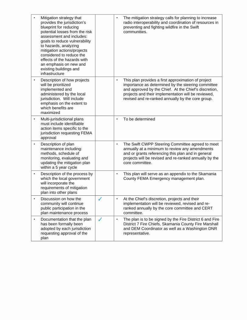
Mitigation strategy that provides the jurisdiction’s blueprint for reducing potential losses from the risk assessment and includes: goals to reduce vulnerability to hazards, analyzing mitigation actions/projects considered to reduce the effects of the hazards with an emphasis on new and existing buildings and infrastructure
The mitigation strategy calls for planning to increase radio interoperability and coordination of resources in preventing and fighting wildfire in the Swift communities.
Description of how projects will be prioritized implemented and administered by the local jurisdiction. Will include emphasis on the extent to which benefits are maximized
This plan provides a first approximation of project importance as determined by the steering committee and approved by the Chief. At the Chief’s discretion, projects and their implementation will be reviewed, revised and re-ranked annually by the core group.
Multi-jurisdictional plans must include identifiable action items specific to the jurisdiction requesting FEMA approval
To be determined
Description of plan maintenance including: methods, schedule of monitoring, evaluating and updating the mitigation plan within a 5 year cycle
The Swift CWPP Steering Committee agreed to meet annually at a minimum to review any amendments and or grants referencing this plan and in general projects will be revised and re-ranked annually by the core committee.
Description of the process by which the local government will incorporate the requirements of mitigation plan into other plans
This plan will serve as an appendix to the Skamania County FEMA Emergency management plan.
Discussion on how the community will continue public participation in the plan maintenance process
At the Chief’s discretion, projects and their implementation will be reviewed, revised and re-ranked annually by the core committee and CERT committee.
Documentation that the plan has been formally been adopted by each jurisdiction requesting approval of the plan
The plan is to be signed by the Fire District 6 and Fire District 7 Fire Chiefs, Skamania County Fire Marshall and DEM Coordinator as well as a Washington DNR representative.

##################################################################################################
0 4 8 12 16 202
Miles
Swift CWPP Basemap
LegendPublicRoads
PrivateRoads
House
Hazard Rating
# Extreme!
# High
# Moderate
# Low
FD6
FD7
Water
WA State DNR lands
Major Public Lands
Planning Area
Swift CWPPPlanning Area
Appendix H1 - CWPP Maps - Swift Basemap

##################################################################################################
©
©
©© ©©©©©
© ©©©©©©©© ©©
©©©© ©© © ©©©©©©©© ©©©©©© © ©© ©©©©©©©©© ©©©©
©© ©© ©©©©©
©©©©©
© ©©
©©©©
©
©©
©
©©©
©
©©
© ©©
©©
Lewis River
1902 Yacolt Fire
Cispus Fire
Unknown
1902 Yacolt Fire
Unknown
Unknown
"
0 5 10 15 202.5
Miles
Historical Wildland Fires and WADNR Fire Statistics
Legend
© WADNR 2007 Fire Stats
House
Hazard Rating
# Extreme!
# High
# Moderate
# Low
FD7
FD6
Swift Planning Area
County Boundary
Swift Wildland Fires
NAME
1902 Yacolt Fire
Cispus Fire
Dole Valley
Lewis River
Unknown
Private Roads
Public Roads
Water
Swift CWPP
Swift Planning Area
Appendix H2 - CWPP Maps - Swift Historical Fires
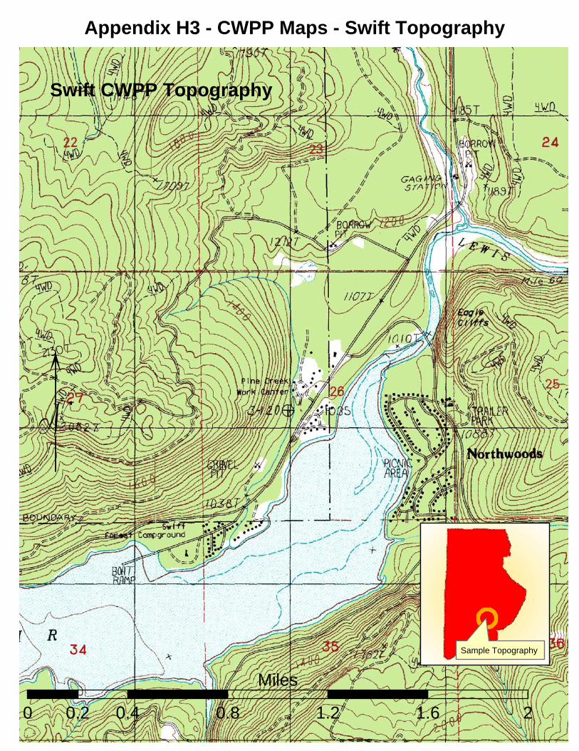
Swift CWPP Topography
0 0.4 0.8 1.2 1.6 20.2
Miles
Sample Topography
Appendix H3 - CWPP Maps - Swift Topography
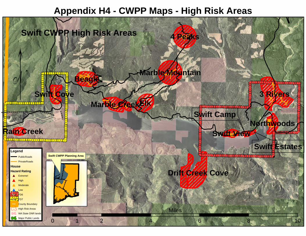
####
##############################################################################################©
4 Peaks
Marble Mountain
Drift Creek Cove
3 Rivers
Northwoods
Swift View
ElkMarble Creek
Beagle
Swift Cove
Rain Creek
0 2 4 6 8 101
Miles
Swift CWPP High Risk Areas
Swift Estates
Swift Camp
Swift CWPP Planning Area
Legend
PublicRoads
PrivateRoads
House
Hazard Rating
# Extreme!
# High
# Moderate
# Low
FD6
FD7
County Boundary
High Risk Areas
WA State DNR lands
Major Public Lands
Appendix H4 - CWPP Maps - High Risk Areas
Top Related