


Languages
Pages
Legal


Study of vulnerability and damage: the case study of
Castelnuovo after L’Aquila earthquake (Italy)
B. Ortolani, A. Borghini, S. Boschi, E. Del Monte & A. Vignoli Department of Civil and Environmental Engineering, University of Florence, Italy
SUMMARY
After the L’Aquila earthquake (04/06/2009), the authors surveyed the building stock of Castelnuovo, a hamlet in
the San Pio delle Camere Municipality (L’Aquila). The macroseismic effects reached intensity 9.5 (MCS scale)
at Castelnuovo. The shaking caused collapse of 50% of the whole built that includes 102 aggregates and 324
structural units.
First of all a brief description of the methodology (with reference to EMS-98 classification) used in the surveys
are presented. Then, the main results of the study, in terms of structural typologies and analysis of vulnerability
and damage, are defined. By means of the analysis of vulnerability and the geology characteristics of soil, an
evaluation of the damage is proposed.
Finally in the paper local seismic responses of masonry building aggregates are evaluated: the main results in
terms of qualitative classification of out-of-plane mechanisms for the panels are discussed.
Keywords: L’Aquila earthquake, EMS-98, vulnerability, damage, aggregates
1. INTRODUCTION
The seismic sequence that struck the province of L’Aquila began in December 2008. The main shock
was recorded at 03:32 a.m. of 04/06/2009 (epicenter coordinates N 42.342 and E 13.380, Fig.1.1.),
with macroseismic intensity varying between 8.0 and 9.0 of the MCS scale, equivalent to local
magnitude ML 5.8 and moment magnitude 6.3 MW.
Already in the past that area was interested by earthquakes with effects above the damage threshold.
The strongest historical earthquakes in the catalogue CPTI04 (Working Group CPTI, 2004) are those
of the September 9, 1349 (MW 6.5) and February 2, 1703 (MW 6.7). The shock of 04/06/2009 is not
comparable to these seismic events, which are related to energy releases much higher. However, a
comparison can be done with other earthquakes that have affected the area. The earthquakes of 1461
(MW 6.5), 1762 (MW 5.9), 1916 (MW 5.2) and 1958 (MW 5.2) in particular.
In this paper the activities carried out by the authors in the period of 2009-2011 in Castelnuovo are
described.
Castelnuovo (Fig.1.2.a.) is a hamlet in San Pio delle Camere Municipality (L’Aquila), situated at
about 20 km east of L’Aquila.
The macroseismic effects reached intensity 9.5 (MCS scale) at Castelnuovo and, in fact, the shake
caused collapse of the 50% of the buildings (Fig.1.2.b.), serious damage into most buildings and even
the death of 5 people.
The village is insert within the complex defense and sighting medieval system, located in the
L’Aquila’s valley. The whole subsoil of Castelnuovo is characterized by the presence of subterranean
tunnels dug into silt (Fig.1.2.c.). Access to tunnels generally corresponds to the ground floor of the
buildings directly from the street level. Originally, in fact, ground levels of the building were stables
for animals or agricultural storages.
The morphology of tunnels is variable in terms of length, section, number of levels and presence or
absence of fill.

Figure 1.1. Territorial framework and individuation of main shock epicenter
Figure 1.2. (a) Aerial photo of Castelnuovo before L’Aquila earthquake. (b) Aerial photo of Castelnuovo after
L’Aquila earthquake. (c) Example of subterranean tunnel
2. PROCEDURE ANALISYS ON URBAN SCALE
The activity carried out by the authors mainly consists in the survey of the built and of the collapse
mechanisms of the structures. This work has been extended to the entire village, including 102
aggregate buildings, composed by 324 structural units in total.
This activity was aimed to evaluate the seismic vulnerability and damage level, in order to make a
comparison with the seismic microzonation made by the Department of Civil Protection DPC
(Working Group MS–AQ, 2010).
In particular, the work has been made in two consequent steps (first step 2009-2010, second step 2010-
2011); these steps are characterized by different level of accuracy of the in-situ surveys (Borghini et
al., 2011).
In the first step (2009-2010), a preliminary screening of the building stock has been performed,
collecting all the necessary information to correlate the seismic vulnerability (referring to the
presumed conservation status of the buildings before the earthquake) with the level of damage caused
by the seismic event of 04/06/2009 and with the seismic microzonation mentioned above. The purpose
of the analysis was to investigate all the aspects that may have caused high damage level, looking to
the influences of seismic vulnerability and local amplification effects connected to the site
characteristics in particular.
In the second step (2010-2011), a detailed survey of all the buildings has been done, carefully
investigating all the information already collected in terms of geometry, structural typologies and
collapse mechanisms.

2.1. Relevance area
All the analysis explained above have been made on a specific relevance area, limited by the perimeter
of the historical city center (Fig. 2.1.), according to the "Decreto del Commissario Delegato per la
Ricostruzione della Regione Abruzzo n. 3" of 03/09/2010. Inside this area two different zones have
been highlighted because of their historical-architectural value, their uniform constructive features and
their level of damage: the area of "Castello" located on the top of the hill and the area situated at the
basis of the hill, realized in a subsequent period.
In order to give completeness to the work, the analysis has been extended also to the rest of the village
(the area outside the perimeter). The aim is that to have an element of comparison with more recent
constructions and which have a better conservation status.
Figure 2.1. Limits of the perimeter
The area inside the perimeter has an extension of about 6.25 hectares; in this zone 70 aggregates have
been identified, composed of 285 structural units in total. These buildings correspond to the 88% of
the entire building heritage of Castelnuovo.
2.2. Aggregate and structural units
First of all, before introducing the methodology used by the author for the surveys, it is necessary to
identify aggregate and the structural units (Fig. 2.2.). An aggregate is a group of structural units, not
necessarily homogeneous, interacting each other by links more or less effective. Generally in historical
center the aggregate coincides with the urban block.
The structural units are defined as those portions of buildings with structural continuity from top to the
bottom, characterized by a common manufacturing process, or by vertical and horizontal
homogeneous typological elements that contribute to the uniform distribution of vertical and
horizontal loads.
Figure 2.2. Example of an aggregate and structural units individuation
2.3. Survey operations
The surveys have been conducted according to the following procedure:
- critical reading of “Schede di Agibilità AeDES (GNDT, 2000);
- individuation of the aggregates;
- for each structural units these information have been indicated: data, geometric parameters, presence
of subterranean tunnels, type of vertical and horizontal structures, construction details, conservation
status and occupation one, failure mechanisms, class of vulnerability and damage level in accordance
with the EMS-98;
- survey of the masonry panels and sections;
- in-situ tests on mortar with Drilling Resistance Measurement System (DRMS), (Del Monte and
Vignoli, 2008);
- samples of mortar and stone elements for laboratory tests.
2.4. Vulnerability and damage
For the study of seismic vulnerability and damage European Macroseismic Scale (Grünthal, 1998) has
been adopted, called below EMS-98. That Scal has been chosen not only because it results the most
recent scale and probably the one will be used in the future in Europe, but also because of the quality
and details with which it describes construction types and damage levels (Giovinazzi and
Lagomarsino, 2001).
The EMS-98 defines 6 vulnerability classes (A, B, C, D, E and F representatives decreasing
vulnerability) in which different types of buildings but characterized by similar seismic behaviour are
grouped.
Damage, instead, is defined by 5 levels (identified by the initials D1, D2, D3, D4 and D5
representatives increasing damage levels) in addition to the situation of absence of damage (D0). Each
level is described in detail; also illustrative pictures are included in description. For all types of
structures (c.a. or masonry)structural elements damage and secondary elements damage are combined.
3. ANALISYS RESULTS
3.1. Historical evolution
The first Castelnuovo settlement dates back to the Medieval times and it’s located on the top of the
hill, even called “Castello”. The built is characterized by house-walls, where ground and underground
floors houses in the external perimeter are vaults, usually used as stables for animals or agricultural
storages generally not communicating with the upper floors.
Connective tissue has regular conformation: built distribution follows a perpendicular grid with equal
repeated dimension in isolates in which type cell measures about 7x5 meters.
Between nineteenth and twentieth century, village shows marked growth on South-West direction
following contour lines. From mid-nineteenth century onward new buildings are inserted in free places
existing in urban tissue or among the road which connects San Giovanni street (highway inside the
perimeter) at SS17.
3.2. Built characteristics
Buildings within the perimeter are characterized for 52.3% by three floors (two floors and an
underground floor), while buildings consisting of four floors are 12.3% which are mainly located
among San Giovanni and XXIV Maggio Streets and built about in the nineteenth century’s expansion.
The remaining part consists of one floor (9.1%) and two floors (26.3%). The average height of
interplane is about 2.70 meters.
From the statistical analysis of data collected emerges that type cell is characterized by vertical
structure in stone load-bearing masonry (86.3%), generally unorganized with two faces and low
quality mortar. There are no transversal links in this type of masonry.
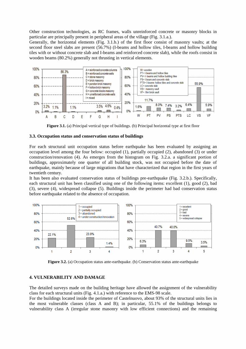
Other construction technologies, as RC frames, walls unreinforced concrete or masonry blocks in
particular are principally present in peripheral areas of the village (Fig. 3.1.a.).
Generally, the horizontal elements (Fig. 3.1.b.) of the first floor consist of masonry vaults; at the
second floor steel slabs are present (56.7%) (I-beams and hollow tiles, I-beams and hollow building
tiles with or without concrete slab and I-beams and reinforced concrete slab), while the roofs consist in
wooden beams (80.2%) generally not thrusting in vertical elements.
Figure 3.1. (a) Principal vertical type of buildings. (b) Principal horizontal type at first floor
3.3. Occupation status and conservation status of buildings
For each structural unit occupation status before earthquake has been evaluated by assigning an
occupation level among the four below: occupied (1), partially occupied (2), abandoned (3) or under
construction/renovation (4). As emerges from the histogram on Fig. 3.2.a. a significant portion of
buildings, approximately one quarter of all building stock, was not occupied before the date of
earthquake, mainly because of large migrations that have characterized that region in the first years of
twentieth century.
It has been also evaluated conservation status of buildings pre-earthquake (Fig. 3.2.b.). Specifically,
each structural unit has been classified using one of the following items: excellent (1), good (2), bad
(3), severe (4), widespread collapse (5). Buildings inside the perimeter had bad conservation status
before earthquake related to the absence of occupation.
Figure 3.2. (a) Occupation status ante-earthquake. (b) Conservation status ante-earthquake
4. VULNERABILITY AND DAMAGE
The detailed surveys made on the building heritage have allowed the assignment of the vulnerability
class for each structural units (Fig. 4.1.a.) with reference to the EMS-98 scale.
For the buildings located inside the perimeter of Castelnuovo, about 93% of the structural units lies in
the most vulnerable classes (class A and B); in particular, 55.1% of the buildings belongs to
vulnerability class A (irregular stone masonry with low efficient connections) and the remaining

38.2% of the buildings belongs to the vulnerability class B (irregular stone masonry with efficient
connections or regular masonry with low efficient connections).
Figure 4.1. (a) Vulnerability classes. (b) Damage levels
Also the level of damage (Fig. 4.1.b.) has been evaluated with the EMS-98 scale: for the buildings
located inside the perimeter it is possible to observe that 60.4% of the structural units has suffered
serious damages to the structural elements (D4 and D5 level of damage), with some cases
characterized by total collapses.
In particular, only 15.5% of the units has not suffered damages to the structural elements (D0 and D1
level) while 76.5% is characterized by considerable damages to structural parts (D3, D4 and D5). It is
important to underline that the concentration of serious damages (D4 and D5) is mainly located on the
top and central part of the village, where the older buildings were.
The extensive in-situ survey of aggregates allowed to systematize the possible activated mechanisms
of collapse in a reference abacus. Out-of-plane mechanisms are typical of buildings subjected to
horizontal actions orthogonal to their plane with lacking connections between floors and walls and
among perpendicular walls.
Figure 4.2. Out-of-plane mechanisms: (a) Overturning of a facade and collapse of the roof. (b) Corner collapse
and crumbling of panel. (c) Collapse of all panels. (d) Shear failure in the plane of panel
In the following, a description of the principal out-of-plane mechanisms is given; it is possible to
distinguish between: overturning of a monolithic wall (O), overturning of a monolithic wall with
corner (OC), vertical bending (overturning of a wall restrained at the top by a tie, VB), horizontal
bending (arch effect in the thickness of the façade of wall, HB), corner collapse (CO) and total
collapse of panel (C) (Valluzzi et al., 2004).
The percentages of out-of-plane mechanisms are shown in the first histogram above (Fig. 4.4.a.) for
stone masonry structural units with high damage level (D3, D4 or D5): the majority of activated
mechanisms is classified as overturning of a monolithic wall (36.1%) and it concerns both principal
and rear façade of buildings. An high percentage is referred to collapse of walls (54.0%) and it is
linked to the structural units with D5 assigned damage level. For each type of local mechanism the
number of floors involved is identified. It is significant to report only the result for overturning
mechanism because of the large involved data (Fig. 4.4.b.). 30.1% of cases is referred to a single floor

mechanism, 47.9% refers to a two floors mechanism and only 21.9% is referred to an entire wall (three
floors).
Figure 4.3. Photos of “Castello” after earthquake: high damage level compared to other areas of Castelnuovo
Figure 4.4. (a) Out-of-plane mechanism. (b) Floors involved in overturning mechanism
4.1. Correlation between the data
Analyzing the correlation between vulnerability and damage levels (Fig. 4.5.a.), as expected, emerges
that the most vulnerable buildings also have higher level of damage. In particular, 76.4% of the
buildings in vulnerability class A has suffered significant structural damage (D4 or D5 class).
The second histogram (Fig. 4.5.b.) shown that the buildings with a very bad conservation status ante
earthquake (53%) have suffered relevant damage (D4 or D5) in 88% of cases, while the buildings for
best-preserved this percentage drops to the 66%.
Figure 4.5. (a) Correlation vulnerability-damage. (b) Correlation conservation status-damage
In the context of stone disorganized masonry buildings, which are 86.3% of the buildings inside the
perimeter, level of damage and influence of subterranean tunnels have been assessed. For this type of

construction damage levels is significantly higher than for the generally buildings analyses before. In
particular:
- 68% of units has suffered significant structural damage (D4 and D5) compared to 60.4%;
- about 8% of the units has not suffered structural damage (D0 and D1) compared to 15.5%;
- about 85% of the units had suffered obvious damage compared to the 76.5%;
It is also necessary to underline that in some cases a primary role was done by the collapse of the
calotte of subterranean tunnels. In fact for stone masonry buildings the 79% of cases had D4 or D5
damage level, respect to the 61% related to the built within the perimeter.
Observing at the map of Castelnuovo (Fig. 2.1.) it’s possible to make a classification between the
buildings inside the perimeter distinguishing by aggregation type. There are, indeed, isolated buildings
(14.4%) consisting of single or double structural units, usually coinciding with an estate unit, row
buildings (67.4%) that usually have the main prospect facing into street and complex aggregates
(18.2%) consisting in irregular shapes generally staggered in accordance with the territory.
Within the stone masonry constructions 87.8% are non-insulated buildings, respectively, 70.7% row
aggregates and 17.1% complex aggregates (Fig. 4.6.). The structural units in the aggregates can have
corner position, external position or internal one. For stone masonry aggregates analyzed 6.9% are
angled structural units, 32.9% are external and 48.0% are internal ones (Fig. 4.7.a.). The percentages
reported confirm the bigger development of row buildings with shapes rather stretched and compact.
Figure 4.6. (a) Different type of buildings: isolated, row buildings and complex buildings
Analyzing the position occupied by structural units in which overturning mechanisms are activated, it
is possible to notice that these mechanisms involve aggregate buildings rather than isolated ones. More
precisely, within row and complex aggregates, the overturning occurs for 61.1% in the internal
structural units, in facades (Fig. 4.7.b.). These walls are particularly vulnerable to this type of
mechanism because of the limited connection with orthogonal walls and the lack of tie on the top.
Figure 4.7. (a) Aggregation of buildings. (b) Position of structural units involved in overturning

From the analysis of the original documents and in-situ surveys, it has been possible to go back to the
historical evolution of the aggregates.
With this process, the temporal constructive phases have been identified for the different parts of the
aggregate: the original elements have been recognized (the oldest ones of the entire building) as well
as the portions added during the evolution of the construction. This process implies that in an
aggregate only a few houses are constituted by close masonry cells. Only the perimeter walls carried
out contemporarily have, for instance, a correct organization of the angular connections (Carocci,
2001).
This “critical method” allows to highlight the structural discontinuity zones, that represent high
seismic vulnerability elements.
For the building stock of Castelnuovo it is possible to recognize the most ancient core of the
aggregates, which corresponds to the structural units made with the oldest construction methodology.
This methodology is characterized by irregular masonry textures, continuous walls from the top to the
bottom, ground level wall thickness that reaches 90 cm and vault structures at that level.
Aggregates reach the actual configuration with enlargements, creation of outbuildings and raising on
rear facades.
The following picture (Fig. 4.8.) shows the plans of ground level of three aggregates situated inside
the perimeter.
For each structural units construction evolution and damage level are indicated. It is important to
notice that original core of the aggregates have generally suffered common high damage level
(D4/D5), while the structural units built in succeeding times have shown lower damages to the
structural elements. The outbuildings and enlargements have usually low damage levels (D0/D1)
because they are made in reinforced concrete, their conservation status is excellent and, obviously,
they are separated from masonry structures.
Figure 4.8. Three aggregates: process evolution and damage level for each structural unit
Figure 4.9. Three aggregates: some photos after earthquake

5. CONCLUSION
From the analysis of the work carried out on the whole building stock of Castelnuovo it is possible to
affirm that reached damage level is mainly due to two factors: intrinsic vulnerability, related to the
stone masonry type with poor quality mortar and severe conservation status of buildings.
To confirm what mentioned above, it is observed that low vulnerable structures with a good
conservation status have shown a good seismic behavior.
From a scientific point of view the information collected form a varied and extremely useful database.
For each aggregate, starting by the structural survey and by the interpretation of the damage, it will be
possible to implement an analytical model and to make safety verifications, in order to identify
specific intervention techniques to plan the rehabilitation.
The application of this methodology on the whole built allows the deepening of vulnerability
assessment of masonry historical buildings in aggregate for better understanding the seismic behaviour
of single structural units within the aggregates.
REFERENCES
Borghini, A., Del Monte, E., Ortolani, B. and Vignoli, A. (2011). Studio degli effetti del sisma del 06/04/2009
sulla Frazione di Castelnuovo, Comune di San Pio delle Camere (AQ). XIV Convegno Nazionale ANIDIS
L’Ingegneria Sismica in Italia, Bari, Italia.
Carocci, F.C. (2001). Guiderlines for safety and preservation of historical centres in seismic areas. Historical
Constructions. P.B. Lourenço, P. Roca (Eds.), Guimarães, 2001.
C.M. 617/2009. (2009). Circolare Ministeriale n.° 617 del 02/02/2009. Istruzioni per l’applicazione delle “Nuove
Norme Tecniche per le Costruzioni” di cui al D.M. 14/01/2008.
D.M. (2008). Decreto Ministeriale del 14/01/2008. Nuove Norme Tecniche per le Costruzioni.
Del Monte, E. and Vignoli, A. (2008). In situ mechanical characterization of the mortar in masonry buildings
with DRMS. 1st International RILEM Symposium on site assessment of concrete, masonry and timber
structures, Varenna (CO), Italy.
DPC-ReLUIS (2010). Linee guida per il rilievo, l’analisi ed il progetto di interventi di riparazione e
consolidamento sismico di edifici in muratura in aggregato.
Giovinazzi, S. and Lagomarsino, S. (2001). Una metodologia per l’analisi di vulnerabilità sismica del costruito.
X Convegno Nazionale ANIDIS L’Ingegneria Sismica in Italia, Potenza – Matera, Italia.
GNDT (2000). Manuale per la compilazione della scheda di primo livello di rilevamento danno, pronto
intervento e agibilità per edifici ordinari nell’emergenza post-sismica (AeDES). Dipartimento della
Protezione Civile.
Grünthal, G. (1998). European Macroseismic Scale 1998 (EMS-98). Cahiers du Centre Européen de
Géodynamique et de Séismologie, 15, Luxembourg.
Valluzzi, M.R., Cardani, G., Binda, L. and Modena, C. (2004). Seismic vulnerability methods for masonry
buildings in historical centres: validation and application for prediction analyses and intervention proposals.
Thirteenth World Conference on Eartquake Engineering. Paper no.2765.
Working Group CPTI (2004). Catalogo Parametrico dei Terremoti Italiani versione 2004 (CPTI04), INGV,
Bologna. http://emidius.mi.ingv.it/CPTI04/.
Working Group MS-AQ (2010). Microzonazione sismica per la ricostruzione dell’area aquilana. Regione
Abruzzo Dipartimento della Protezione Civile, L’Aquila. Vol. III e Cd-rom.
Top Related