


Languages
Pages
Legal


Spatialtargetingofnaturalfloodriskmanagementwithinlargerivercatchments:AnestedapproachofSCIMAP-FloodandCRUM3 SimM.Reaney&CallumPearson,DepartmentofGeography,DurhamUniversity.sim.reaney@durham.ac.ukTomanagefloodriskwithinalargerivercatchment,suchastheRiverEden(2300km2),thereisaneedtoconsiderthespatialtargetingattwoscales:1,thewholeofthelargescalecatchmentand2,thelocalsub-basin.Withlargecatchments,therearemultiplepointsofimpactandhenceanactiontoreducefloodriskinonelocationmayincreasetheriskinanotherduetochangesinthetimingsub-catchmentfloodpeaksandassociatedsynchronisation.Therangeofrainfallpatternsandstormtrackswillgivedifferentfloodtimingdynamicsineachevent.Therefore,thereisaneedtoconsiderhowthesevariablesinteracttogiveintegratedspatialtargetingmapsforNFMwhichhasthegreatestchanceofreducingfloodriskoverarangeofpossiblefutureevents.Oncethekeylocationshavebeenidentified,thedetailsoftheeffectivenessofprocessedmitigationactionsonfloodmagnitudescanbecalculatedthroughtheapplicationofdetailedhydrologicalandhydraulicmodels.ThisreportthereforeproposesatwostageapproachtomanagingfloodriskwithintheRiverEdencatchment:
1. Theuseofspatiallydetailed,catchmentwide,riskbasedmapping,accountingforrainfallpatterns,sub-catchmentsynchronisationandmultiplepointsofimpact,toidentifykeysub-catchments
2. Theapplicationofdetailedphysicallybasedmodels,withinanuncertaintyframework,withintheseidentifiedlocationstodesignandtesttheproposedNFMscheme.
LandscapeScaleSpatialTargetingforNFM:SCIMAP-FloodThesuitabilityofasitefortheimplementationofnaturalfloodriskmitigationmeasuresisdeterminedby1,thetraveltimeofthefloodwaterstothepointofimpact,2,thespatialpatternoftherainfalldepthpattern,3,theeffectivenessofthelandcoveringeneratingrapidfloodflows(overland,drainsandnearsurfaceflows)and4,thestrengththeofthehydrologicalconnectivityfromthelandscapetotheriverchannels.ThisreportpresentstheinitialversionofthenewSCIMAP-FloodtoolforspatialtargetingofNFMmeasuresatthelandscapescale.ThisapproachisbasedontheSCIMAPfinesedimentriskmappingtool(Reaneyetal.2011)butexpandedtocapturefloodissues.TheSCIMAP-Floodtoolassignsriskweightstoeachofthefloodhazarddrivingfactorsandthencombinesthesetogiveapointscaleassessmentofthepotentialvalueofslowingflowsatthatlocationfordecreasingfloodpeaksatthepointofimpact.Thisassessmentisbasedonthecriticalsourceareaconceptwherebythereneedstobebothagenerationoffloodriskandanactivehydrologicalconnectiontotheriverchannel(Heathwaiteetal.2005).Thesourceriskisdeterminedasafunctionoftraveltimes,rapidrunoffgenerationpotentialandtherainfallpatternandthehydrologicalconnectivityisdeterminedbytheNetworkIndex(Laneetal.2004).ExampleresultsofSCIMAP-Floodareshowninthefigurebelow.
SCIMAP-FloodfortheRiverEdencatchmentforthesinglepointofimpactinCarlisle
DetailofthefieldscalenatureofSCIMAP-FloodfortheRiverRoecatchment
Actionclustersidentifiesareaswheretherearemultiplefloodsources.Shownforallpointsofimpact
SimReaneyandCallumPearson,DurhamUniversity
2
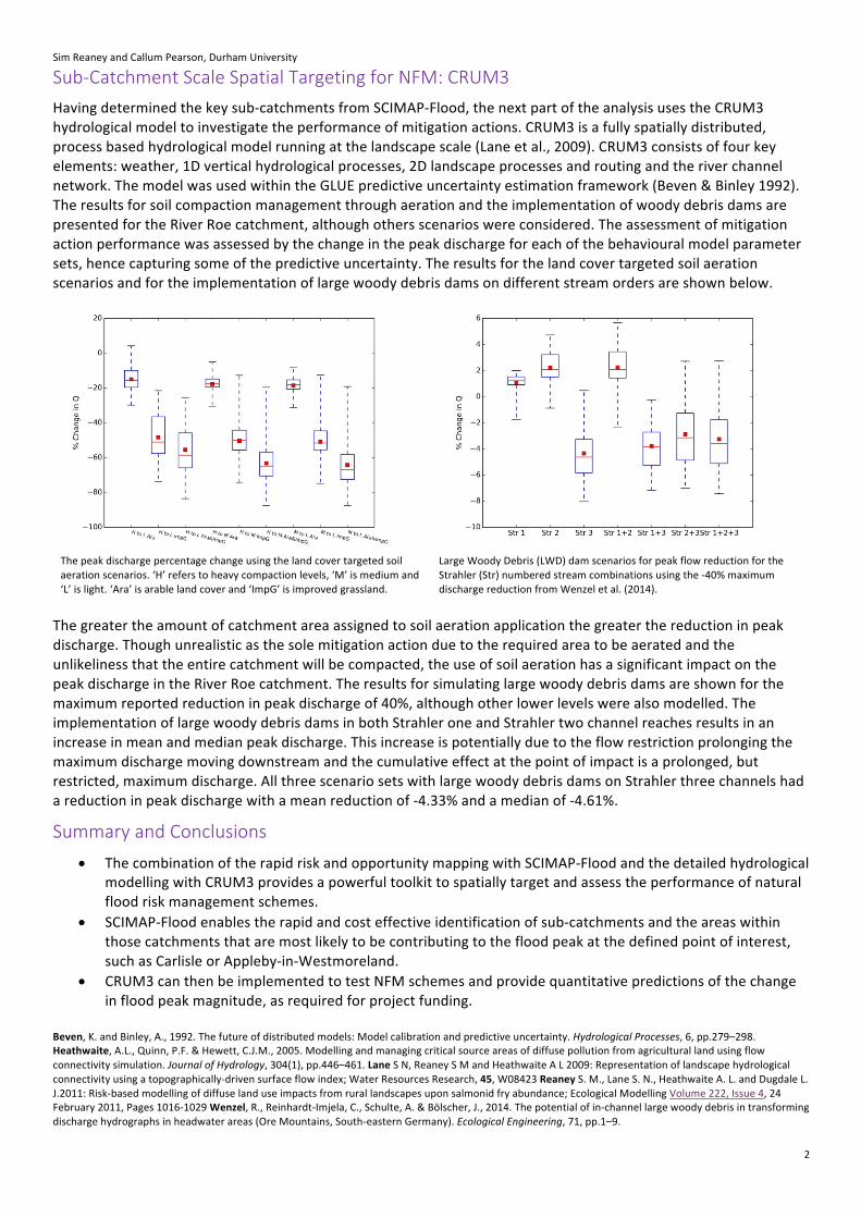
Sub-CatchmentScaleSpatialTargetingforNFM:CRUM3Havingdeterminedthekeysub-catchmentsfromSCIMAP-Flood,thenextpartoftheanalysisusestheCRUM3hydrologicalmodeltoinvestigatetheperformanceofmitigationactions.CRUM3isafullyspatiallydistributed,processbasedhydrologicalmodelrunningatthelandscapescale(Laneetal.,2009).CRUM3consistsoffourkeyelements:weather,1Dverticalhydrologicalprocesses,2Dlandscapeprocessesandroutingandtheriverchannelnetwork.ThemodelwasusedwithintheGLUEpredictiveuncertaintyestimationframework(Beven&Binley1992).TheresultsforsoilcompactionmanagementthroughaerationandtheimplementationofwoodydebrisdamsarepresentedfortheRiverRoecatchment,althoughothersscenarioswereconsidered.Theassessmentofmitigationactionperformancewasassessedbythechangeinthepeakdischargeforeachofthebehaviouralmodelparametersets,hencecapturingsomeofthepredictiveuncertainty.Theresultsforthelandcovertargetedsoilaerationscenariosandfortheimplementationoflargewoodydebrisdamsondifferentstreamordersareshownbelow.
Thepeakdischargepercentagechangeusingthelandcovertargetedsoilaerationscenarios.‘H’referstoheavycompactionlevels,‘M’ismediumand‘L’islight.‘Ara’isarablelandcoverand‘ImpG’isimprovedgrassland.
LargeWoodyDebris(LWD)damscenariosforpeakflowreductionfortheStrahler(Str)numberedstreamcombinationsusingthe-40%maximumdischargereductionfromWenzeletal.(2014).
Thegreatertheamountofcatchmentareaassignedtosoilaerationapplicationthegreaterthereductioninpeakdischarge.Thoughunrealisticasthesolemitigationactionduetotherequiredareatobeaeratedandtheunlikelinessthattheentirecatchmentwillbecompacted,theuseofsoilaerationhasasignificantimpactonthepeakdischargeintheRiverRoecatchment.Theresultsforsimulatinglargewoodydebrisdamsareshownforthemaximumreportedreductioninpeakdischargeof40%,althoughotherlowerlevelswerealsomodelled.TheimplementationoflargewoodydebrisdamsinbothStrahleroneandStrahlertwochannelreachesresultsinanincreaseinmeanandmedianpeakdischarge.Thisincreaseispotentiallyduetotheflowrestrictionprolongingthemaximumdischargemovingdownstreamandthecumulativeeffectatthepointofimpactisaprolonged,butrestricted,maximumdischarge.AllthreescenariosetswithlargewoodydebrisdamsonStrahlerthreechannelshadareductioninpeakdischargewithameanreductionof-4.33%andamedianof-4.61%.
SummaryandConclusions• ThecombinationoftherapidriskandopportunitymappingwithSCIMAP-Floodandthedetailedhydrological
modellingwithCRUM3providesapowerfultoolkittospatiallytargetandassesstheperformanceofnaturalfloodriskmanagementschemes.
• SCIMAP-Floodenablestherapidandcosteffectiveidentificationofsub-catchmentsandtheareaswithinthosecatchmentsthataremostlikelytobecontributingtothefloodpeakatthedefinedpointofinterest,suchasCarlisleorAppleby-in-Westmoreland.
• CRUM3canthenbeimplementedtotestNFMschemesandprovidequantitativepredictionsofthechangeinfloodpeakmagnitude,asrequiredforprojectfunding.
Beven,K.andBinley,A.,1992.Thefutureofdistributedmodels:Modelcalibrationandpredictiveuncertainty.HydrologicalProcesses,6,pp.279–298.Heathwaite,A.L.,Quinn,P.F.&Hewett,C.J.M.,2005.Modellingandmanagingcriticalsourceareasofdiffusepollutionfromagriculturallandusingflowconnectivitysimulation.JournalofHydrology,304(1),pp.446–461.LaneSN,ReaneySMandHeathwaiteAL2009:Representationoflandscapehydrologicalconnectivityusingatopographically-drivensurfaceflowindex;WaterResourcesResearch,45,W08423ReaneyS.M.,LaneS.N.,HeathwaiteA.L.andDugdaleL.J.2011:Risk-basedmodellingofdiffuselanduseimpactsfromrurallandscapesuponsalmonidfryabundance;EcologicalModellingVolume222,Issue4,24February2011,Pages1016-1029Wenzel,R.,Reinhardt-Imjela,C.,Schulte,A.&Bölscher,J.,2014.Thepotentialofin-channellargewoodydebrisintransformingdischargehydrographsinheadwaterareas(OreMountains,South-easternGermany).EcologicalEngineering,71,pp.1–9.
Top Related