


Languages
Pages
Legal


Soil Analysis and Native Plant Propagation: a case study on Laysan Island,
Papahānaumokuākea Marine National Monument.
Report for U.S Fish and Wildlife Service’s Inventory and Monitoring Initiative
By
U.S. Fish and Wildlife Service
Papahānaumokuākea Marine National Monument (PMNM)
UNESCO World Heritage Site
Honolulu, HI 96850

Introduction
For FY2012, Hawaiian Islands National Wildlife Refuge in Papahānaumokuākea Marine
National Monument (Monument) received $34,000 to fund a soils analysis project on Laysan Island. The
U.S. Fish and Wildlife Service (FWS) began native plant propagation on Laysan Island in 2000 in
accordance with the Laysan Island Ecosystem Restoration Plan (Morin and Conant 1998). One of the
main objectives of the plan is to, ”Recreate as nearly as possible the Laysan Island ecosystem that was
present prior to major human-caused habitat modification during the 1890s and 1900s, with the entire
island treated as an endangered ecosystem.” Unfortunately, efforts to successfully establish native plants
in their pre-1890s locations have been largely unsuccessful. One hypothesis is that it may be impractical
to attempt to restore vegetative communities in their historic locations as the soil composition has
changed significantly due to the devastating consequences of the removal of massive quantities of guano
from the island and the rabbit herbivory. Therefore, this project attempted to address this potential
complication.
Our objectives were as follows:
1) Collect soil samples via stratified random sampling for composition analysis.
2) Based on soil analysis, consult horticultural specialists to determine the best locations to outplant
specific native plant species.
3) Propagate 3 native Hawaiian plant species (Cyperus pennatiformes, Chenopodium oahuense, and
Santalum ellipticum) on Laysan Island in abundance and out-plant in the recommended areas
during the summer of 2012 to test horticulturist recommendations.
4) Develop a protocol for native plant propagation and outplanting for the Monument based on soil
composition and other propagation parameters.
Funding for this project also supported construction of two rain catchments, two shadehouses
(propagation structures similar to a greenhouse), and one hardening house to improve capabilities of the
propagation program. In addition, as this soils project is a new approach to native plant propagation
techniques on Laysan Island, a project-dedicated, temporary FWS Biological Technician (Bio Tech) was
hired to meet the demands of soil collection, plant propagation and out-planting, data entry and
management, and report writing to guarantee the most successful outcome.
Unfortunately, the Bio Tech hired for this project left without completing the required products
for each objective. This report provides a brief description of methods and results for Objectives 1-3. We
were unable to produce a protocol for native plant propagation and out-planting of the Monument based
on soil composition and other propagation parameters (Objective 4).
Methods and Results
1) Objective 1. Collect soil samples via stratified random sampling for composition analysis.
Methods (objective 1)
Strategy for representative sampling was based on a stratified random sampling scheme using the
island’s natural dune configuration, interior and exterior, predominant trade wind direction, and dominant
vegetation class. As a result, the island was divided into the four intercardinal directions and sixteen (16)
primary sampling groups were identified (Table 1; Figure 1). In addition, samples were collected from
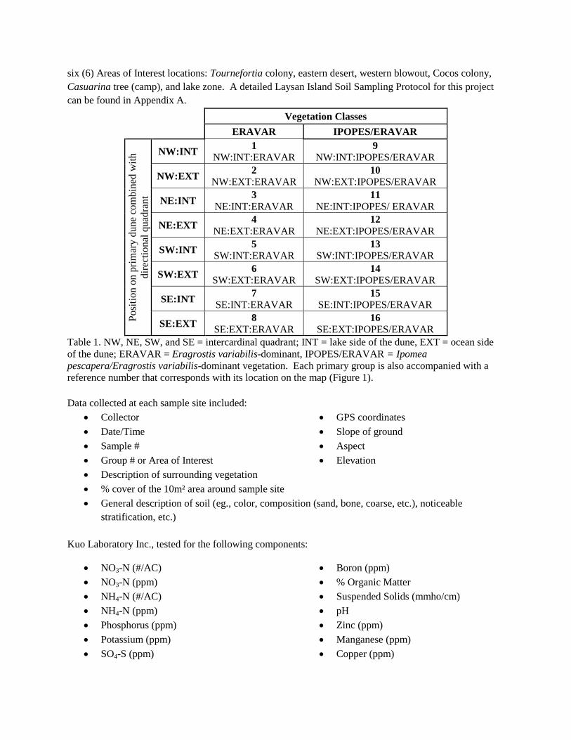
six (6) Areas of Interest locations: Tournefortia colony, eastern desert, western blowout, Cocos colony,
Casuarina tree (camp), and lake zone. A detailed Laysan Island Soil Sampling Protocol for this project
can be found in Appendix A.
Vegetation Classes
ERAVAR IPOPES/ERAVAR P
osi
tion o
n p
rim
ary
du
ne
com
bin
ed w
ith
dir
ecti
on
al q
uad
ran
t NW:INT
1 NW:INT:ERAVAR
9
NW:INT:IPOPES/ERAVAR
NW:EXT 2
NW:EXT:ERAVAR 10
NW:EXT:IPOPES/ERAVAR
NE:INT 3
NE:INT:ERAVAR 11
NE:INT:IPOPES/ ERAVAR
NE:EXT 4
NE:EXT:ERAVAR 12
NE:EXT:IPOPES/ERAVAR
SW:INT 5
SW:INT:ERAVAR 13
SW:INT:IPOPES/ERAVAR
SW:EXT 6
SW:EXT:ERAVAR 14
SW:EXT:IPOPES/ERAVAR
SE:INT 7
SE:INT:ERAVAR 15
SE:INT:IPOPES/ERAVAR
SE:EXT 8
SE:EXT:ERAVAR 16
SE:EXT:IPOPES/ERAVAR
Table 1. NW, NE, SW, and SE = intercardinal quadrant; INT = lake side of the dune, EXT = ocean side
of the dune; ERAVAR = Eragrostis variabilis-dominant, IPOPES/ERAVAR = Ipomea
pescapera/Eragrostis variabilis-dominant vegetation. Each primary group is also accompanied with a
reference number that corresponds with its location on the map (Figure 1).
Data collected at each sample site included:
Collector
Date/Time
Sample #
Group # or Area of Interest
GPS coordinates
Slope of ground
Aspect
Elevation
Description of surrounding vegetation
% cover of the 10m² area around sample site
General description of soil (eg., color, composition (sand, bone, coarse, etc.), noticeable
stratification, etc.)
Kuo Laboratory Inc., tested for the following components:
NO3-N (#/AC)
NO3-N (ppm)
NH4-N (#/AC)
NH4-N (ppm)
Phosphorus (ppm)
Potassium (ppm)
SO4-S (ppm)
Boron (ppm)
% Organic Matter
Suspended Solids (mmho/cm)
pH
Zinc (ppm)
Manganese (ppm)
Copper (ppm)

Iron (ppm)
Calcium (meq/100g)
Magnesium (meq/100g)
Sodium (meq/100g)
Effervescence
Total Bases (meq/100g)
Calcium/Total Bases (%)
Magnesium/Total Bases (%)
Potassium/Total Bases (%)
Sodium/Total Bases (%)
Figure 1. Division of Laysan Island into four intercardinal areas and sixteen correlating sample areas for
soil collection. The solid black line follows the dune apex that separates the interior and exterior
designations. SCATAC: Scaevola taccada; IPOPES: Ipomea pes-caprae; EARVAR: Eragrostis
varabilis.
Results (objective 1)
A total of one hundred soil samples were collected between 4 June and 3 July, 2012. All samples
were transported from Laysan Island to Honolulu, HI via NOAA vessel Oscar Elton Sette on July 10,
2012 and promptly shipped to Kuo Testing Labs in Othello, WA. Results from Kuo Testing Labs were
received by July 26, 2012 (Appendix B). Data recorded for each sample site (e.g., slope, soil description,
GPS location) can be found in Appendix C. In addition, some work had been attempted by the Bio Tech
to separate each lab test parameter for analysis in an Excel file (Appendix D). Appendix D is provided as
a Supporting Excel File to this report to preserve the work attempted by the Bio Tech and for future
attempts to analyze the data. A minimum of 342 hours were dedicated toward soil collection and protocol
development and implementation while on Laysan Island.
2) Objective 2. Based on soil analysis, consult horticultural specialists to determine the best
locations to out-plant specific native plant species.
Methods and results (objective 2)
Once we received the laboratory analysis results from Kuo Testing Labs, the Soils/Propagation
Bio Tech met with University of Hawaii, Manoa Associate Specialist (soils) Dr. Jonathan Deenik. With
guidance from Dr. Deenik and the Bio Tech, we were able to determine that most of the soil tested on
Laysan should be able to support healthy outplants. Additionally, the Bio Tech conveyed two areas that
may be better than anywhere else: inner northwest and inner southwest. Unfortunately, this information
was shared via satellite phone and with no clear explanation as to why these areas may be more suitable.
Attempts to reach Dr. Deenik and the Bio Tech post-season were unsuccessful. Independent examination
of the data post-season revealed no evidence to support focused outplanting in those areas over other
suitable locations. It is possible that the areas were selected due to ease of access from camp and
propagation houses (northwest area), and relatively low outplant history (southwest area) to more evenly
distribute propagated native plants around the island. Conversely, the desert area was deemed least likely
to support new native plant populations as samples contained almost no organic matter (Average %
Organic Matter = 0.09%), substantially less than any other location on the island. This information was
passed to the field crew on Laysan Island in September, 2012 to help guide outplanting locations before
the crew departed in early October.
3) Propagate 3 native Hawaiian plant species (Cyperus pennatiformes, Chenopodium oahuense, and
Santalum ellipticum) on Laysan Island in abundance and out-plant in the recommended areas
during the summer of 2012 to test horticulturist recommendations.
Methods (objective 3)
Originally, three plant species (listed above) were selected for propagation for this project. All
three are endemic to Laysan Island including one endangered species (Cyperus pennatiformes;
CYPPEN). Santalum ellipticum was dropped from the list as there were not enough ripe seeds at the
collection site on Oahu to support a successful propagation timeline prior to crew departure in March
2012. Chenopodium oahuense (CHEOAH) and CYPPEN proved to be excellent choices as both were
relatively easy to propagate and had an adequate seed source on Laysan Island.
Propagation methods from seed/cutting collections to outplanting were largely based on Lilleeng-
Rosenberger (2005). We utilized both seeds and cuttings to propagate CHEOAH. To propagate from
seeds, the small CHEOAH fruits were collected from healthy plants when ripe (dry and brown). Ripe
seeds are easily dislodged from the fruit when agitated (rubbed between hands) carefully over a strainer
separating the seeds from the fruit material. CHEOAH seeds can be stored for two years. However, we
utilized all the seeds collected during the summer. Seeds were sown into flats in shadehouses and
watered every other day. Sprouts were transferred into pots when at least four true leaves developed.
When the seedlings outgrew their pot, they were transferred to a hardening house to expose them to full

sun and other environmental conditions for two weeks prior to outplanting. If seedlings adapted poorly to
the harsher conditions, they were placed back in the shadehouse environment and allowed to develop
more before attempting to outplant.
Propagating CHEOAH from cuttings allowed for quicker turn-around from collection to
outplanting as the germination stage was bypassed. New-growth cuttings 4”-6” long were collected from
healthy source plants and placed in a Ziploc bag with a moist paper towel and transported to camp. All
leaves below 1.5” from the tip were removed; the remaining leaves were cut in half. Although Lilleeng-
Rosenberger suggests no rooting hormone is needed, we dipped the bottom end of the stems in rooting
hormone to increase the probability of successful root development. While seeds can be stored up to two
years, cutting must be sown within a week as long as they are kept moist and refrigerated. Processed
cuttings were placed into individual dibble tubes or pod trays. Once the cuttings developed a healthy root
base, they were transplanted into pots and outplanted under the same criteria as seedlings produced from
seeds. Generally, it takes 6 months from seed to outplant and 4 months from cutting to outplant for
CHEOAH.
We propagated CYPPEN by seed only. Taking cuttings from this Laysan endemic and federally
endangered plant species is more invasive than collecting from CHEOAH. Ripe spikelets (brown and
easily removed from spikes) were collected from healthy CYPPEN individuals, and then agitated to
separate the seeds from the seed coating. Seeds were soaked for 24 hours in freshwater prior to being
sown to help seeds germinate. Pre-soaked seeds were surface-sown into flats in shadehouses and watered
every other day. When sprout grew to approximately 6” tall, they were transferred into individual 4” – 6”
pots. Healthy seedlings can be moved to the hardening house when they outgrow their pot. Similar to
CHEOAH, if the CYPPEN seedlings adapt poorly to the harsher conditions of the hardening house, they
were moved back to the shadehouses to continue growing until hardy enough for outplanting.
Results (objective 3)
Collection and Propagation – approximately 37,000 CYPPEN seeds and 100,000 CHEOAH seeds and
581 cuttings were collected on Laysan and put into active propagation for this soils project (Appendix E
and F).
Outplanting – 171 CHEOAH and 177 CYPPEN were ready for outplanting at the time locations were
recommended (Appendix G). Sixty seven (67) and 104 CHEOAH were propagated from seed and
cuttings, respectively; 130 were outplanted in the northwest interior and 41 in the southwest interior areas
on 2 October, 2012. All 177 CYPPEN were outplanted in the northwest interior location on 4 October,
2012. Hundreds of CHEOAH and CYPPEN seedlings remained in propagation waiting for outplanting
by the incoming winter crew when the summer crew’s tour was completed in October.
Monitoring – As stated in the proposal for this grant, outplants were evaluated one year after outplanting
to determine their success. An attempt was made to relocate and evaluate the CHEOAH and CYPPEN
outplants during the USFWS Laysan Island camp closure in mid-September 2013. In addition, three
CHEOAH outplant groups (for the purpose of habitat restoration) in the northeast interior were evaluated
to perhaps make some comparison of success of CHEOAH outplants between recommended locations
and a separate location. These CHEOAH were outplanted on 23 July, 2013.
No CHEOAH outplants were observed in the northeast or southwest locations in September,
2013 (Table 2). In addition, outplant poles were not relocated to verify the location. There may be a
couple of explanations for this result. CHEOAH in the northeast had been subjected to flooding shortly
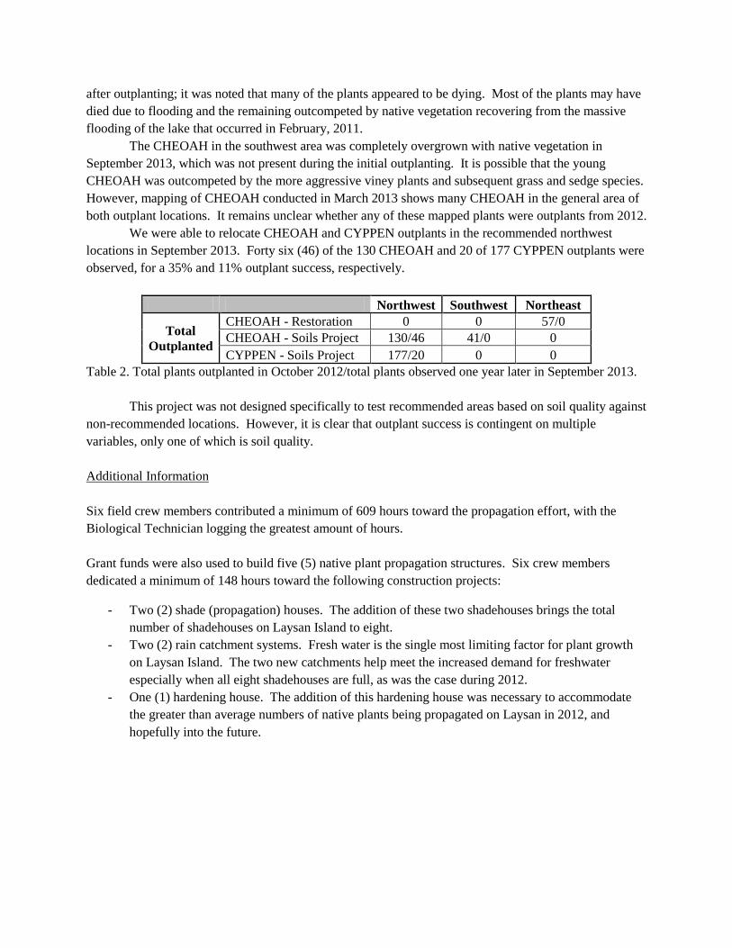
after outplanting; it was noted that many of the plants appeared to be dying. Most of the plants may have
died due to flooding and the remaining outcompeted by native vegetation recovering from the massive
flooding of the lake that occurred in February, 2011.
The CHEOAH in the southwest area was completely overgrown with native vegetation in
September 2013, which was not present during the initial outplanting. It is possible that the young
CHEOAH was outcompeted by the more aggressive viney plants and subsequent grass and sedge species.
However, mapping of CHEOAH conducted in March 2013 shows many CHEOAH in the general area of
both outplant locations. It remains unclear whether any of these mapped plants were outplants from 2012.
We were able to relocate CHEOAH and CYPPEN outplants in the recommended northwest
locations in September 2013. Forty six (46) of the 130 CHEOAH and 20 of 177 CYPPEN outplants were
observed, for a 35% and 11% outplant success, respectively.
Northwest Southwest Northeast
Total
Outplanted
CHEOAH - Restoration 0 0 57/0
CHEOAH - Soils Project 130/46 41/0 0
CYPPEN - Soils Project 177/20 0 0
Table 2. Total plants outplanted in October 2012/total plants observed one year later in September 2013.
This project was not designed specifically to test recommended areas based on soil quality against
non-recommended locations. However, it is clear that outplant success is contingent on multiple
variables, only one of which is soil quality.
Additional Information
Six field crew members contributed a minimum of 609 hours toward the propagation effort, with the
Biological Technician logging the greatest amount of hours.
Grant funds were also used to build five (5) native plant propagation structures. Six crew members
dedicated a minimum of 148 hours toward the following construction projects:
- Two (2) shade (propagation) houses. The addition of these two shadehouses brings the total
number of shadehouses on Laysan Island to eight.
- Two (2) rain catchment systems. Fresh water is the single most limiting factor for plant growth
on Laysan Island. The two new catchments help meet the increased demand for freshwater
especially when all eight shadehouses are full, as was the case during 2012.
- One (1) hardening house. The addition of this hardening house was necessary to accommodate
the greater than average numbers of native plants being propagated on Laysan in 2012, and
hopefully into the future.

Literature Cited
1. Lilleeng-Rosenberger, K.L. 2005. Growing Hawaii's Native Plants: A Simple Step-by-
Step Approach for Every Species.
2. Morin, Marie, and S. Conant. 1998. Laysan Island Ecosystem Restoration Plan.
University of Hawaiii at Manoa, Dept. of Zoology, Honolulu, HI, 96822
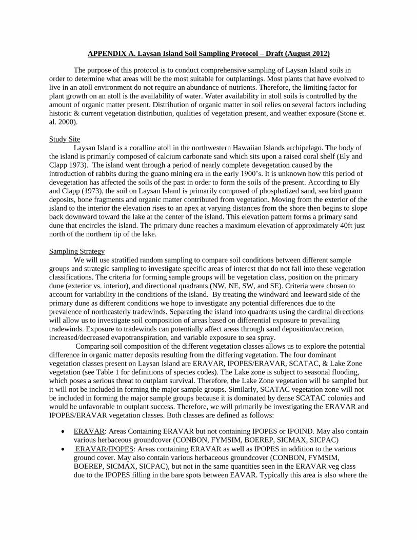
APPENDIX A. Laysan Island Soil Sampling Protocol – Draft (August 2012)
The purpose of this protocol is to conduct comprehensive sampling of Laysan Island soils in
order to determine what areas will be the most suitable for outplantings. Most plants that have evolved to
live in an atoll environment do not require an abundance of nutrients. Therefore, the limiting factor for
plant growth on an atoll is the availability of water. Water availability in atoll soils is controlled by the
amount of organic matter present. Distribution of organic matter in soil relies on several factors including
historic & current vegetation distribution, qualities of vegetation present, and weather exposure (Stone et.
al. 2000).
Study Site
Laysan Island is a coralline atoll in the northwestern Hawaiian Islands archipelago. The body of
the island is primarily composed of calcium carbonate sand which sits upon a raised coral shelf (Ely and
Clapp 1973). The island went through a period of nearly complete devegetation caused by the
introduction of rabbits during the guano mining era in the early 1900’s. It is unknown how this period of
devegetation has affected the soils of the past in order to form the soils of the present. According to Ely
and Clapp (1973), the soil on Laysan Island is primarily composed of phosphatized sand, sea bird guano
deposits, bone fragments and organic matter contributed from vegetation. Moving from the exterior of the
island to the interior the elevation rises to an apex at varying distances from the shore then begins to slope
back downward toward the lake at the center of the island. This elevation pattern forms a primary sand
dune that encircles the island. The primary dune reaches a maximum elevation of approximately 40ft just
north of the northern tip of the lake.
Sampling Strategy
We will use stratified random sampling to compare soil conditions between different sample
groups and strategic sampling to investigate specific areas of interest that do not fall into these vegetation
classifications. The criteria for forming sample groups will be vegetation class, position on the primary
dune (exterior vs. interior), and directional quadrants (NW, NE, SW, and SE). Criteria were chosen to
account for variability in the conditions of the island. By treating the windward and leeward side of the
primary dune as different conditions we hope to investigate any potential differences due to the
prevalence of northeasterly tradewinds. Separating the island into quadrants using the cardinal directions
will allow us to investigate soil composition of areas based on differential exposure to prevailing
tradewinds. Exposure to tradewinds can potentially affect areas through sand deposition/accretion,
increased/decreased evapotranspiration, and variable exposure to sea spray.
Comparing soil composition of the different vegetation classes allows us to explore the potential
difference in organic matter deposits resulting from the differing vegetation. The four dominant
vegetation classes present on Laysan Island are ERAVAR, IPOPES/ERAVAR, SCATAC, & Lake Zone
vegetation (see Table 1 for definitions of species codes). The Lake zone is subject to seasonal flooding,
which poses a serious threat to outplant survival. Therefore, the Lake Zone vegetation will be sampled but
it will not be included in forming the major sample groups. Similarly, SCATAC vegetation zone will not
be included in forming the major sample groups because it is dominated by dense SCATAC colonies and
would be unfavorable to outplant success. Therefore, we will primarily be investigating the ERAVAR and
IPOPES/ERAVAR vegetation classes. Both classes are defined as follows:
ERAVAR: Areas Containing ERAVAR but not containing IPOPES or IPOIND. May also contain
various herbaceous groundcover (CONBON, FYMSIM, BOEREP, SICMAX, SICPAC)
ERAVAR/IPOPES: Areas containing ERAVAR as well as IPOPES in addition to the various
ground cover. May also contain various herbaceous groundcover (CONBON, FYMSIM,
BOEREP, SICMAX, SICPAC), but not in the same quantities seen in the ERAVAR veg class
due to the IPOPES filling in the bare spots between EAVAR. Typically this area is also where the

viney plants SICMAX, SICPAC, & IPOIND also occur in greater densities than other places on
the island.
Table 1. Definitions for Species Codes.
Below Table 2 depicts the combination of criteria used to form 16 primary sampling groups and a
map (Figure 1) of vegetation distribution with a rough sketch of quadrant and dune divisions used to
define each primary sample group. This map was generated with vegetation maps from 2012 and it should
be noted that a current vegetation mapping will be conducted prior to sample collection. In addition to the
sample groups formed with the preceding criteria we will employ strategic sampling in several areas of
interest that do not fall into the dominant vegetation classes and have a limited distribution. These areas of
interest are described below.
TUOARG Colony: Area (approximately 15m x 150m) immediately surrounding the TUOARG
stand on the coast by the camp and stretching north. We will be collecting samples in this area
because the soils appear to be nutrient rich and it is a potential source of good soil that is easy to
access.
Eastern Desert: Large unvegetated area starting along the coast of the NE quadrant and stretching
south along the east side of the island. This is the largest separate area of interest. The 1998
Laysan Island restoration plan (Moran and Conant) calls for revegetating the desert with
outplantings. However, the desert soil does not appear to be hospitable for outplants. We will
collect samples here in order to investigate the suitability of desert soils for outplants.
Scientific Name Species Code Hawaiian Name Common Name
Boerhavia repens BOEREP Alena
Cyperus laevigatus CYPLAE Makaloa Smooth flatsedge
Eragrostis varabilis ERAVAR Kāwelu Bunchgrass Variable lovegrass
Heliotropium curassavicum HELCUR Kipukai Seaside heliotrope
Ipomea pes-caprae IPOPES Pōhuehue Beach Morning Glory
Beach Morning Glory
Ocean-blue morning glory
Naupaka kai
Naupaka kahakai
Sesuvium portulacastrum SESPOR 'Ākulikuli Sea purslane
Sicyos maximowiczii SICMAX 'Anunu Puaokama
'Anunu
Kupala
Tribulus cistoides TRICIS Nohu Jamaican fever plant
Casuarina equisetifolia CASEQU Paina Ironwood
Conyza bonariensis CONBON Lani wela Hairy Horseweed
Tournefortia argentea TOUARG Beach/Tree Heliotrope
Cocos nucifera COCNUC Niu Coconut tree
Fimbristylis cymosa FIMCYM Mau'u Button sedge
Tournefortia argentea TOUARG Beach/Tree Heliotrope
Cocos nucifera COCNUC Niu Coconut tree
Fimbristylis cymosa FIMCYM Mau'u Button sedge
Sicyos pachycarpus SICPAC
Ipomea indica IPOIND Koali’awa
Scaevola taccada SCATAC Beach Naupaka

Western blowout: An area in the southwest quadrant that remained unvegetated as areas
surrounding it regrew vegetation. It is currently very sparsely vegetated with ERAVAR, IPOPES,
& FYMSIM.
Cocos colony: Area (approximately 20m diameter) immediately surrounding and under the
COCNUC colony just northwest of the lake. This area is in the flood zone, but it is suspected to
be nutrient rich and we will collect samples here for future reference.
Camp CASEQU: Area (approximately 10m diameter) immediately surrounding and under the
CASEQU adjacent to camp. We will be collecting samples in this area because the soils appear to
be nutrient rich and it is a potential source of good soil that is easy to access.
Lake Zone: The vegetated zone surrounding the lake. We did not include this vegetation zone in
forming our sample groups due to current management decisions calling for a halt in outplanting
here. However, it is suspected that this area is nutrient rich and we will collect samples here for
future reference.
Vegetation Classes
ERAVAR
IPOPES/ERAVA
R
Po
siti
on o
n p
rim
ary d
une
com
bin
ed w
ith d
irec
tional
quad
rant NW:IN
T
1 NW:INT:E
RAVAR
9
NW:INT:IPOPES/
ERAVAR
NW:EX
T
2
NW:EXT:E
RAVAR
10
NW:EXT:IPOPES
/ERAVAR
NE:INT
3
NE:INT:ER
AVAR
11
NE:INT:IPOPES/
ERAVAR
NE:EX
T
4
NE:EXT:ER
AVAR
12
NE:EXT:IPOPES/
ERAVAR
SW:IN
T
5
SW:INT:ER
AVAR
13
SW:INT:IPOPES/
ERAVAR
SW:EX
T
6
SW:EXT:E
RAVAR
14
SW:EXT:IPOPES
/ERAVAR
SE:INT
7
SE:INT:ER
AVAR
15
SE:INT:IPOPES/
ERAVAR
SE:EXT
8
SE:EXT:ER
AVAR
16
SE:EXT:IPOPES/
ERAVAR
Table 2. NW, NE, SW, and SE = northwest quadrant, etc., INT = lake side of the dune, EXT = ocean side
of the dune. Each primary group is also accompanied with a reference number that corresponds with its
location on the map.

Figure 1. Division of Laysan Island into four intercardinal areas and sixteen correlating sample areas for
soil collection. The solid black line follows the dune apex that separates the interior and exterior
designations. SCATAC: Scaevola taccada; IPOPES: Ipomea pes-caprae; EARVAR: Eragrostis
varabilis.
Collecting samples
Sample sites within each group will be determined using a random grid sampling pattern. Each
sample group will be divided into a grid using intervals of 50m². Grids will be numbered and selected
using a random number generator. Samples will be collected from the center point of each grid. For
groups defined with the IPOPES/ERAVAR vegetation classification we will be collecting four samples
per group. For groups defined by the ERAVAR vegetation classification we will be selecting four sample
grids and collect two samples within selected grid, for a total of eight samples per group. In the ERAVAR
groups we will collect a sample near an ERAVAR clump and then in a clearing adjacent to the sampled
clump. This design is in order to investigate the potential variability in organic matter deposits in relation
to the proximity of the plant. The first sample will be collected one inch from the base of the ERAVAR
clump that is closest to the randomly selected sample point within the grid. Then the second sample will
be collect 1 meter from the original clump in a random direction. If the second sample point in the grid is
within 1 m of a neighboring ERAVAR clump then you must select an alternate random direction until the
1m distance criteria is met. If the 1m criteria cannot be met then sample at a point equidistant between
original sample clump and farthest neighboring clump.
Sampling methods for strategic areas of interest will vary due to the relatively small size and
irregular shape of some of the areas (see below). Four samples will be collected from each area and all
samples will be taken at a depth of 0”-6”.
Sampling methods for each strategic area of interest:

TUOARG Colony: Samples will be taken at a random distance from the northern start point
of the TUOARG colony. Two samples will be collected on either side of colony and they will
be collected directly below the outermost branches of the nearest TUOARG tree.
Eastern Desert: The eastern desert will be divided into a grid with 50m intervals then each
grid will be numbered. Grids to be sampled will be selected using a random number generator
Western Blowout: The western blowout will be divided into a grid with 20m intervals then
each grid will be numbered. Grids to be sampled will be selected using a random number
generator
Cocos colony: The Cocos colony occurs in a relatively small area (20m radius) in a roughly
circular pattern. The center point of the area will be determined using GIS mapping. Samples
will be taken at a random distance <20m from the center point in a randomly chosen
direction.
Camp CASEQU: Samples will be collected on the perimeter of the CASEQU tree at each of
the cardinal directions.
Lake Zone: Samples will be collected along four transects. There will be two transects on
both the east and west side of the lake. Transects will run from north to south equidistant
from the lake edge and the exterior edge of the lake vegetation. For each side (E & W) one
transect will start at a point aligned with the northern tip of the lake and another will start at a
point aligned with the southern tip of the lake. The transects will run through the middle of
the lake zone vegetation meeting at the halfway point of the length of the lake, producing four
transects that represent the NW, NE, SW, & SE, portions of the lake. One sample will be
taken in the middle of each transect.
All samples will be collected at a depth of 0”-6” using a makeshift soil coring device constructed
out of 1 ½” PVC pipe. Samples will be air dried and sealed in an air tight container and stored in a
refrigerator to be shipped out for analysis in June. Samples will be analysed for organic matter content,
extractable phosphorous (using olsen extraction ), base cations (Ca, Mg, K, Na using ammonium acetate
extraction), and pH. Analysis will be conducted by Kuo Labs, Inc. Data to be recorded at each sample site
include:
Collector
Date/Time
Sample #
Group # or Area of Interest
GPS coordinates
Slope of ground
Aspect
Elevation
Description of surrounding vegetation
% cover of the 10m² area around sample site
General description of soil (eg. color, composition (sand, bone, coarse, etc.), noticeable
stratification, etc.)

Date: 07/26/12 APPENDIX B. Kuo Testing Labs, Inc.Report No: S36752-1 337 South 1st
Project: Laysan Soils Project Othello, Washington 99344
Client: U.S. Fish & Wildlife, Honolulu, HI (509) 488-0112; Fax (509) 488-0118Sampler: Tawn Speetjens Email: [email protected]
Sample Date: June 2012 Web: www.kuotesting.comEmail To: [email protected]
SOIL ANALYSIS REPORT 65-75% 15-20% 2-9% <1.0%
Lab # Depth Field ID NO3-N NO3-N NH4-N NH4-N P K SO4 B Organic pH SS Zn Mn Cu Fe Ca Mg Na Effer- Total Ca / Total Mg / Total K / Total Na / Total
& Grid No. Bicar Acet -S Matter mmho/ meq/ meq/ meq/ vescence Bases Bases Bases Bases Bases
Inches #/AC ppm #/Ac ppm ppm ppm ppm ppm % cm ppm ppm ppm ppm 100g 100g 100g Meq/100g % % % %
PMNW
5388 0-6 1 46 23.0 5 2.3 101 32 12 0.71 0.96 7.8 0.40 1.7 1 0.3 4 6.6 0.8 0.12 Heavy 7.6 86.8 10.5 1.1 1.6
5389 0-6 2 12 6.0 2 0.8 58 10 7 0.27 0.30 8.2 0.22 0.8 1 0.1 1 5.0 0.5 0.07 Heavy 5.6 89.4 8.9 0.5 1.3
5390 0-6 3 15 7.3 2 1.0 115 8 10 0.56 0.62 7.9 0.25 1.4 1 0.2 2 5.2 0.4 0.04 Heavy 5.7 91.9 7.1 0.4 0.7
5391 0-6 4 42 21.0 3 1.3 130 30 13 0.78 1.04 7.9 0.36 1.8 1 0.3 2 6.1 0.7 0.10 Heavy 7.0 87.4 10.0 1.1 1.4
5392 0-6 5 4 1.8 1 0.5 17 4 6 0.25 0.10 8.8 0.23 0.3 1 0.1 1 4.7 0.5 0.10 Heavy 5.3 88.5 9.4 0.2 1.9
5393 0-6 6 4 2.0 2 0.8 40 8 6 0.24 0.22 8.3 0.19 0.9 1 0.1 1 4.9 0.5 0.09 Heavy 5.5 88.9 9.1 0.4 1.6
5394 0-6 7 3 1.5 1 0.3 21 12 5 0.20 0.08 8.7 0.18 0.3 1 0.1 1 5.7 0.4 0.08 Heavy 6.2 91.8 6.4 0.5 1.3
5395 0-6 8 30 14.8 2 0.8 53 12 8 0.18 0.41 8.3 0.29 0.8 1 0.1 1 5.6 0.4 0.07 Heavy 6.1 91.8 6.6 0.5 1.1
5396 0-6 9 26 12.8 4 2.0 72 15 10 0.64 0.45 8.0 0.31 1.2 1 0.2 2 5.6 0.6 0.08 Heavy 6.3 88.6 9.5 0.6 1.3
5397 0-6 10 37 18.5 4 1.8 47 21 7 0.29 0.28 8.3 0.26 0.6 1 0.1 1 5.9 0.5 0.11 Heavy 6.6 89.9 7.6 0.8 1.7
5398 0-6 11 13 6.3 3 1.3 46 17 10 0.26 0.13 8.5 0.28 0.5 1 0.1 1 6.6 0.4 0.09 Heavy 7.1 92.5 5.6 0.6 1.3
5399 0-6 12 15 7.5 2 1.0 58 13 6 0.27 0.36 8.1 0.25 0.7 1 0.1 1 5.2 0.5 0.04 Heavy 5.8 90.1 8.7 0.6 0.7
5400 0-6 13 4 2.0 2 0.8 31 12 6 0.22 0.55 8.7 0.18 0.3 1 0.1 1 5.7 0.4 0.05 Heavy 6.2 92.2 6.5 0.5 0.8
5401 0-6 14 7 3.3 3 1.3 41 10 6 0.22 0.54 8.6 0.23 0.4 1 0.1 1 5.3 0.4 0.07 Heavy 5.8 91.4 6.9 0.4 1.2
5402 0-6 15 5 2.3 3 1.5 56 7 5 0.26 0.90 8.6 0.21 0.4 1 0.1 1 6.0 0.4 0.05 Heavy 6.5 92.8 6.2 0.3 0.8
5403 0-6 16 8 4.0 2 0.8 41 4 6 0.23 0.10 8.7 0.23 0.4 1 0.1 1 5.5 0.4 0.04 Heavy 6.0 92.4 6.7 0.2 0.7
5404 0-6 17 19 9.3 5 2.3 11 10 10 0.55 0.77 7.9 0.35 1.6 1 0.4 2 5.2 0.5 0.08 Heavy 5.8 89.6 8.6 0.4 1.4
5405 0-6 18 45 22.5 4 2.0 95 13 11 0.54 0.83 7.7 0.54 1.3 1 0.2 1 5.9 0.6 0.10 Heavy 6.6 88.9 9.0 0.5 1.5
5406 0-6 19 16 8.0 4 2.0 64 7 8 0.20 0.35 8.1 0.27 0.5 1 0.1 1 4.5 0.4 0.04 Heavy 5.0 90.8 8.1 0.4 0.8
5407 0-6 20 32 16.0 4 2.0 114 17 12 0.81 1.78 7.8 0.40 1.7 1 0.3 2 6.6 0.6 0.11 Heavy 7.4 89.8 8.2 0.6 1.5
Page 1

APPENDIX C. LAYSAN ISLAND SOIL SAMPLING SITE DATA, 2012
Heading Definitions
% Cover Percent vegetative cover of the 102m area surrounding the sample site
Soil Description General description of the soil such as color, composition (sand, bone, coarse, etc.),
noticeable stratification, etc.
Veg. Pres. #2 The second most dominant vegetative species present at sample location
Veg. Pres. #3 The third most dominant vegetative species present at sample location
Other Veg. Any other vegetative species present minus the top three dominant species
Slope Slope of the ground at sample location, in degrees
Aspect Direction the slope face at sample location, in degrees
Veg. Pres. #1 The most dominant vegetative species present at sample location
Time Time sample was taken
Latitude Latitude for sample location in decimal degrees
Longitude Longitude for sample location in decimal degrees
INT/EXT Interior or Exterior island location
Sub-Sample # Four sub-samples were taken in each sample location
Date Date sample was collected
Sample # Sample ID
Veg. Class Vegetation Class, uses 6-letter species code for plants
DIR. Direction

APPENDIX C. LAYSAN ISLAND SOIL SAMPLING SITE DATA, 2012
Sample # Veg. Class DIR. INT/EXTSub.
Sample
#Date Time Latitude Longitude Slope
1 IPOPES NW INT 1 4-Jun-12 13:50 N25.77485 W171.73539 2
2 IPOPES NW INT 2 4-Jun-12 14:43 N25.77774 W171.73643 1
3 IPOPES NW INT 3 4-Jun-12 14:10 N25.77628 W171.73480 5
4 IPOPES NW INT 4 6-Jun-12 10:28 N25.76979 W171.73617 3
5 IPOPES NW EXT 1 8-Jun-12 9:30 N25.77313 W171.74076 6
6 IPOPES NW EXT 2 8-Jun-12 10:00 N25.77141 W171.74171 2
7 IPOPES NW EXT 3 11-Jun-12 10:30 N25.78053 W171.73324 0
8 IPOPES NW EXT 4 11-Jun-12 10:00 N25.77803 W171.73720 3
9 IPOPES NE INT 1 11-Jun-12 18:00 N25.77434 W171.72823 2
10 IPOPES NE INT 2 11-Jun-12 12:16 N25.77059 W171.72894 2
11 IPOPES NE INT 3 11-Jun-12 11:24 N25.77527 W171.72563 5
12 IPOPES NE INT 4 11-Jun-12 12:38 N25.77109 W171.72801 2
13 IPOPES NE EXT 1 11-Jun-12 12:53 N25.76927 W171.72780 3
14 IPOPES NE EXT 2 11-Jun-12 11:46 N25.77272 W171.72642 0
15 IPOPES NE EXT 3 11-Jun-12 11:59 N25.77164 W171.72701 3
16 IPOPES NE EXT 4 11-Jun-12 11:06 N25.77706 W171.72543 4
17 IPOPES SW INT 1 6-Jun-12 13:54 N25.76020 W171.73910 3
18 IPOPES SW INT 2 6-Jun-12 15:11 N25.75822 W171.73529 2
19 IPOPES SW INT 3 6-Jun-12 12:30 N25.76327 W171.73933 2
20 IPOPES SW INT 4 6-Jun-12 12:11 N25.76273 W171.73693 3
21 IPOPES SW EXT 1 8-Jun-12 10:37 N25.76835 W171.74159 2
22 IPOPES SW EXT 2 8-Jun-12 12:50 N25.75998 W171.74217 6
23 IPOPES SW EXT 3 8-Jun-12 11:50 N25.76574 W171.74009 3
24 IPOPES SW EXT 4 8-Jun-12 11:06 N25.76721 W171.73988 8
25 IPOPES SE INT 1 8-Jun-12 13:50 N25.75934 W171.73292 2
26 IPOPES SE INT 2 8-Jun-12 16:40 N25.76403 W171.73056 5
27 IPOPES SE INT 3 8-Jun-12 14:05 N25.76737 W171.72948 4
28 IPOPES SE INT 4 8-Jun-12 14:30 N25.76176 W171.73154 2
29 IPOPES SE EXT 1 8-Jun-12 13:51 N25.76804 W171.72763 4
30 IPOPES SE EXT 2 11-Jun-12 14:56 N25.76597 W171.72851 2
31 IPOPES SE EXT 3 11-Jun-12 14:06 N25.76469 W171.72929 0
32 IPOPES SE EXT 4 11-Jun-12 15:51 N25.76538 W171.72759 0
33 ERAVAR NW INT 1A 5-Jun-12 12:13 N25.77230 W171.73839 6
34 ERAVAR NW INT 1B 5-Jun-12 12:13 N25.77230 W171.73839 6
35 ERAVAR NW INT 2A 5-Jun-12 14:42 N25.76976 W171.74076 2
36 ERAVAR NW INT 2B 5-Jun-12 14:42 N25.76976 W171.74076 2
37 ERAVAR NW INT 3A 4-Jun-12 12:10 N25.77484 W171.73661 0
38 ERAVAR NW INT 3B 4-Jun-12 12:10 N25.77484 W171.73661 0
39 ERAVAR NW INT 4A 6-Jun-12 10:52 N25.77105 W171.73638 5
40 ERAVAR NW INT 4B 6-Jun-12 10:52 N25.77105 W171.73638 5
41 ERAVAR NW EXT 1A 4-Jun-12 15:15 N25.77699 W171.74001 0
42 ERAVAR NW EXT 1B 4-Jun-12 15:15 N25.77699 W171.74001 0
43 ERAVAR NW EXT 2A 5-Jun-12 14:20 N25.77103 W171.74156 3

Appendix C. Continued
Sample # Aspect Veg. Pres. #1 Veg. Pres. #2 Veg. Pres. #3 Other veg. % Cover
1 92 IPOPES ERAVAR Sicyos spp. 100
2 167 IPOPES ERAVAR BOEREP 95
3 75 IPOPES ERAVAR BOEREP Sicyos spp. 98
4 70 IPOPES ERAVAR Sicyos spp. 100
5 299 SCATAC IPOPES NAMSAN ERAVAR 15
6 311 IPOPES ERAVAR CONBON BOEREP, NAMSAN 45
7 0 IPOPES SCATAC NAMSAN 45
8 280 ERAVAR IPOPES BOEREP FIMCYM. CONBON 70
9 260 IPOPES ERAVAR Sicyos spp. 100
10 185 IPOPES ERAVAR 100
11 251 IPOPES ERAVAR Portulaca spp. 80
12 258 IPOPES ERAVAR 99
13 76 IPOPES Portulaca spp. 90
14 0 IPOPES ERAVAR 90
15 83 IPOPES Portulaca spp. 80
16 140 IPOPES Portulaca spp. ERAVAR 85
17 13 IPOIND ERAVAR CONBON 55
18 335 IPOPES ERAVAR BOEREP 98
19 119 ERAVAR IPOPES BOEREP CONBON 45
20 91 IPOPES ERAVAR BOEREP Sicyos spp. 98
21 235 ERAVAR IPOPES CONBON Portulaca spp. 75
22 210 IPOPES SCATAC 30
23 321 ERAVAR IPOPES CONBON BOEREP 70
24 265 ERAVAR IPOPES BOEREP CONBON 75
25 320 ERAVAR IPOPES BOEREP Portulaca spp. 70
26 263 IPOPES ERAVAR BOEREP Portulaca spp. 98
27 264 IPOPES ERAVAR 95
28 268 IPOPES ERAVAR 98
29 76 IPOPES ERAVAR 75
30 120 IPOPES ERAVAR Portulaca spp. 90
31 0 IPOPES ERAVAR Portulaca spp. BOEREP 85
32 0 IPOPES NAMSAN 15
33 82 ERAVAR BOEREP CONBON 50
34 82 ERAVAR BOEREP CONBON 50
35 61 ERAVAR CONBON BOEREP Portulaca spp. 45
36 61 ERAVAR CONBON BOEREP Portulaca spp. 45
37 0 ERAVAR FIMCYM CONBON 40
38 0 ERAVAR FIMCYM CONBON 40
39 115 ERAVAR BOEREP CONBON FIMCYM 55
40 115 ERAVAR BOEREP CONBON FIMCYM 55
41 240 ERAVAR CONBON Portulaca spp. 60
42 240 ERAVAR CONBON Portulaca spp. 60
43 297 ERAVAR CONBON Portulaca spp. 35

Appendix C. Continued
Sample # Soil Description
1 Light brown, dry, hydrophobic
2 Loose, Tan, dry & Sandy
3 Light brown, fine sand
4 Light brown, fine sand
5 Light tan, coarse sand
6 Light tan, coarse sand, darker below 4"
7 Tan, coarse sand
8 Tan, fine sand
9
10 Light brown, fine sand, darker below 4"
11 Tan, coarse sand, pockets of organic matter
12 Light brown, fine sand
13 Light brown, fine sand
14 Tan, darker below 5"
15
16 Coarse, pockets of organic matter
17 Light brown
18 Light bron, fine sand
19 Tan, large pieces of organic matter
20 Light brown
21 light brown with large pieces of organic matter
22 Light tan, coarse
23
24 Tan, visible organic matter pieces
25 Brown, egg fragments on surface
26 Very fine sand, brown
27 Fine sand, light brown
28 Tan, fine sand
29 Tan, fine sand, pockets of organic matter
30 Fine sand, light brown
31
32 Tan, coarse sand, pockets of organic matter
33 Tan, fine sand, darker below 4"
34 Tan, fine sand, darker below 4"
35 Light brown, fine sand w/ fine dust
36 Light brown, fine sand w/ fine dust
37 Tan, minimal organic matter
38 Tan, fine sand
39 Fine sand, tan, darkerer below 3"
40 Fine sand, tan, darkerer below 3"
41 Sandy, fine brown dust, w/ lighter top layer
42 Sandy, fine brown dust, w/ lighter top layer
43 Fine sand, fine brown powder

Appendix C. Continued
Sample # Veg. Class DIR. INT/EXTSub.
Sample
#Date Time Latitude Longitude Slope
44 ERAVAR NW EXT 2B 5-Jun-12 14:20 N25.77103 W171.74156 3
45 ERAVAR NW EXT 3A 5-Jun-12 13:50 N25.77157 W171.74037 3
46 ERAVAR NW EXT 3B 5-Jun-12 13:50 N25.77157 W171.74037 3
47 ERAVAR NW EXT 4A 5-Jun-12 12:50 N25.77394 W171.73959 10
48 ERAVAR NW EXT 4B 5-Jun-12 12:50 N25.77394 W171.73959 10
49 ERAVAR SW INT 1A 6-Jun-12 10:06 N25.76907 W171.73697 3
50 ERAVAR SW INT 1B 6-Jun-12 10:06 N25.76907 W171.73697 3
51 ERAVAR SW INT 2A 6-Jun-12 13:30 N25.76111 W171.73891 2
52 ERAVAR SW INT 2B 6-Jun-12 13:30 N25.76111 W171.73891 2
53 ERAVAR SW INT 3A 6-Jun-12 11:40 N25.76779 W171.73716 3
54 ERAVAR SW INT 3B 6-Jun-12 11:40 N25.76779 W171.73716 3
55 ERAVAR SW INT 4A 6-Jun-12 9:30 N25.76869 W171.73955 15
56 ERAVAR SW INT 4B 6-Jun-12 9:30 N25.76869 W171.73955 15
57 ERAVAR SW EXT 1A 6-Jun-12 14:14 N25.75929 W171.73990 8
58 ERAVAR SW EXT 1B 6-Jun-12 14:14 N25.75929 W171.73990 8
59 ERAVAR SW EXT 2A 5-Jun-12 15:50 N25.76781 W171.74034 8
60 ERAVAR SW EXT 2B 5-Jun-12 15:50 N25.76781 W171.74034 8
61 ERAVAR SW EXT 3A 6-Jun-12 13:00 N25.76290 W171.74111 0
62 ERAVAR SW EXT 3B 6-Jun-12 13:00 N25.76290 W171.74111 0
63 ERAVAR SW EXT 4A 5-Jun-12 15:20 N25.76885 W171.74116 4
64 ERAVAR SW EXT 4B 5-Jun-12 15:20 N25.76885 W171.74116 4
65 ERAVAR SE INT 1A 11-Jun-12 14:34 N25.76728 W171.72884 0
66 ERAVAR SE INT 1B 11-Jun-12 14:34 N25.76728 W171.72884 0
67 ERAVAR SE INT 2A 11-Jun-12 16:59 N25.76316 W171.73074 4
68 ERAVAR SE INT 2B 11-Jun-12 16:59 N25.76316 W171.73074 4
69 ERAVAR SE INT 3A 8-Jun-12 14:50 N25.76094 W171.73007 3
70 ERAVAR SE INT 3B 8-Jun-12 14:50 N25.76094 W171.73007 3
71 ERAVAR SE INT 4A 8-Jun-12 15:10 N25.76163 W171.72976 2
72 ERAVAR SE INT 4B 8-Jun-12 15:10 N25.76163 W171.72976 2
73 ERAVAR SE EXT 1A 11-Jun-12 16:18 N25.76351 W171.72993 3
74 ERAVAR SE EXT 1B 11-Jun-12 16:18 N25.76351 W171.72993 3
75 ERAVAR SE EXT 2A 11-Jun-12 15:09 N25.76587 W171.72817 0
76 ERAVAR SE EXT 2B 11-Jun-12 15:09 N25.76587 W171.72817 0
77 ERAVAR SE EXT 3A 8-Jun-12 15:50 N25.76285 W171.72986 3
78 ERAVAR SE EXT 3B 8-Jun-12 15:50 N25.76285 W171.72986 3
79 ERAVAR SE EXT 4A 11-Jun-12 15:27 N25.76614 W171.72775 2
80 ERAVAR SE EXT 4B 11-Jun-12 15:27 N25.76614 W171.72775 2
81 LZ VEG NW INT 1 18-Jun-12 13:48 N25.77545 W171.73432 0
82 LZ VEG NE INT 2 18-Jun-12 12:06 N25.77399 W171.72995 0
83 LZ VEG SW INT 3 18-Jun-12 11:21 N25.76119 W171.73606 2
84 LZ VEG SE INT 4 18-Jun-12 11:44 N25.76453 W171.73118 0
85 COCNUC INT 1 18-Jun-12 13:30 N25.77735 W171.73328 0
86 COCNUC INT 2 18-Jun-12 13:30 N25.77741 W171.73325 0

Appendix C. Continued
Sample # Aspect Veg. Pres. #1 Veg. Pres. #2 Veg. Pres. #3 Other veg. % Cover
44 297 ERAVAR CONBON Portulaca spp. 35
45 209 ERAVAR CONBON BOEREP Portulaca spp. 50
46 209 ERAVAR CONBON BOEREP Portulaca spp. 50
47 308 ERAVAR CONBON Portulaca spp. 60
48 308 ERAVAR CONBON Portulaca spp. 60
49 92 ERAVAR BOEREP CONBON FIMCYM 40
50 92 ERAVAR BOEREP CONBON FIMCYM 40
51 85 ERAVAR CONBON 35
52 85 ERAVAR CONBON 35
53 40 ERAVAR FIMCYM CONBON 35
54 40 ERAVAR FIMCYM CONBON 35
55 16 ERAVAR FIMCYM CONBON 20
56 16 ERAVAR FIMCYM CONBON 20
57 170 ERAVAR FIMCYM CONBON BOEREP 50
58 170 ERAVAR FIMCYM CONBON BOEREP 50
59 284 ERAVAR CONBON Portulaca spp. 45
60 284 ERAVAR CONBON Portulaca spp. 45
61 0 FIMCYM ERAVAR CONBON 45
62 0 FIMCYM ERAVAR CONBON 45
63 290 ERAVAR CONBON Portulaca spp. 40
64 290 ERAVAR CONBON Portulaca spp. 40
65 0 ERAVAR Portulaca spp. BOEREP 15
66 0 ERAVAR Portulaca spp. BOEREP 15
67 250 ERAVAR BOEREP 35
68 250 ERAVAR BOEREP 35
69 270 ERAVAR NAMSAN Portulaca spp. 10
70 270 ERAVAR NAMSAN Portulaca spp. 10
71 298 ERAVAR SCATAC NAMSAN 15
72 298 ERAVAR SCATAC NAMSAN 15
73 60 ERAVAR Portulaca spp. CONBON 30
74 60 ERAVAR Portulaca spp. CONBON 30
75 0
76 0
77 119 ERAVAR 55
78 119 ERAVAR 55
79 117 ERAVAR NAMSAN 10
80 117 ERAVAR NAMSAN 10
81 0 CYPLAE HELCUR 90
82 0 HELCUR Sicyos spp. SESPOR 65
83 284 CYPLAE 70
84 0 HELCUR CYPLAE Sicyos spp. ERAVAR, SESPOR 75
85 0 CYPLAE SESPOR HELCUR ERAVAR, IPOPES 15
86 0 CYPLAE SESPOR HELCUR ERAVAR, IPOPES 10

Appendix C. Continued
Sample # Soil Description
44 Fine sand, fine brown powder
45 Coarse sand, light brown dust
46 Coarse sand, light brown dust
47 Light brown w/ fine dust
48 Light brown w/ fine dust
49 tan, fine sand, w/ large pieces of organic matter
50 tan, fine sand, w/ large pieces of organic matter
51 Fine sand, tan, large pieces of organic matter below 4"
52 Fine sand, tan, darker below 2"
53 Tan, coarse sand, w/ some fine dust
54 Tan, coarse sand, w/ some fine dust
55 Light tan, fine sand
56 Light tan, fine sand
57
58
59 Coarse sand
60 Fine sand, fine brown powder
61 Coarse sand, light brown
62 Coarse sand, tan
63 Coarse sand on top, fine brown powder below.
64 Coarse sand on top, fine brown powder below.
65 Fine sand, light brown
66 Fine sand, light brown
67 Very fine, light brown
68 Very fine, light brown
69 Tan w/ pockets of organic matter
70 Tan, fine sand
71 Fine sand, tan, Light brown below 4"
72 Tan, fine
73 Loose, fine, dark tan
74 Loose, fine, dark tan
75
76
77
78
79 Tan, fine sand
80 Tan, fine sand
81
82 Dark brown, hard crust below 4"
83 Brown
84 Dark brown, mudlike below 4"
85 Dark brown, lighter below 4"
86 Dark brown, lighter below 4"

Appendix C. Continued
Sample # Veg. Class DIR. INT/EXTSub.
Sample
#Date Time Latitude Longitude Slope
87 COCNUC INT 3 18-Jun-12 13:30 N25.77737 W171.73333 0
88 COCNUC INT 4 18-Jun-12 13:30 N25.77733 W171.73331 0
89 TUOARG EXT 1 18-Jun-12 N25.77409 W171.73972
90 TUOARG EXT 2 18-Jun-12 15:00 N25.77660 W171.74038 4
91 TUOARG EXT 3 18-Jun-12 15:10 N25.77642 W171.74019 0
92 TUOARG EXT 4 18-Jun-12 15:26 N25.77624 W171.74009 3
93 CASEQU #1 N EXT 1 18-Jun-12 16:01 N25.77437 W171.73915 8
94 CASEQU #2 S EXT 2 18-Jun-12 16:19 N25.77419 W171.73923 6
95 CASEQU #3 E EXT 3 18-Jun-12 16:25 N25.77430 W171.73911 4
96 CASEQU #4 W EXT 4 18-Jun-12 16:09 N25.77428 W171.73928 10
97 Desert EXT 1 3-Jul-12 11:38 N25.77219 W171.72541 3
98 Desert EXT 2 3-Jul-12 10:51 N25.78049 W171.72646 4
99 Desert EXT 3 3-Jul-12 10:01 N25.78119 W171.73206 0
100 Desert EXT 4 3-Jul-12 11:17 N25.77661 W171.72420 4
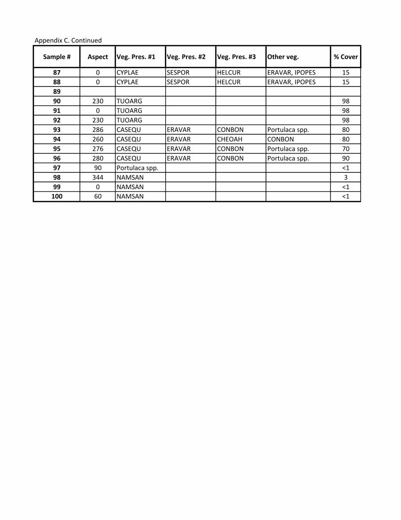
Appendix C. Continued
Sample # Aspect Veg. Pres. #1 Veg. Pres. #2 Veg. Pres. #3 Other veg. % Cover
87 0 CYPLAE SESPOR HELCUR ERAVAR, IPOPES 15
88 0 CYPLAE SESPOR HELCUR ERAVAR, IPOPES 15
89
90 230 TUOARG 98
91 0 TUOARG 98
92 230 TUOARG 98
93 286 CASEQU ERAVAR CONBON Portulaca spp. 80
94 260 CASEQU ERAVAR CHEOAH CONBON 80
95 276 CASEQU ERAVAR CONBON Portulaca spp. 70
96 280 CASEQU ERAVAR CONBON Portulaca spp. 90
97 90 Portulaca spp. <1
98 344 NAMSAN 3
99 0 NAMSAN <1
100 60 NAMSAN <1

Appendix C. Continued
Sample # Soil Description
87 Dark brown, lighter below 4"
88 Dark brown, lighter below 4"
89
90 Dark brown, coarse sand
91 Dark brown, coarse sand
92 Stratified dark and light
93
94
95
96
97
98 Coarse sand, tan
99 Coarse sand, tan
100 Fine sand, tan

Appendix D. Laysan Soil Analysis Metadata
This Appendix is available as a Supporting Excel File (Appendix D_Metadata_Laysan_Soils.xlsx). The
Workbook includes the following Worksheets:
-Metadata
-NO3-H
-NH4-N
-P-Bicar
-K_Acet (ppm)
-B (ppm)
-SO4-S (ppm)
-% O-Matter
-pH
-SS (mmho/cm)
-Zn (ppm)
-Mn (ppm)
-Cu (ppm)
-Fe (ppm)
-Ca (meq/100g)
-Mg (meq/100g)
-Na (meq/100g)
-Total Bases (meq/100g)
-65-75% Ca/total Bases (%)
-15-20% Mg/Total Bases (%)
-2-9% K/Total Bases (%)
-<1% Na/Total Bases (%)
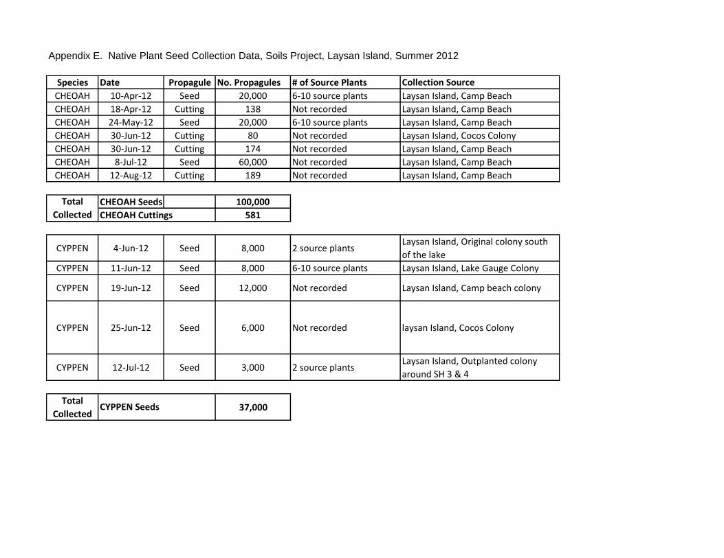
Appendix E. Native Plant Seed Collection Data, Soils Project, Laysan Island, Summer 2012
Species Date Propagule No. Propagules # of Source Plants Collection Source
CHEOAH 10-Apr-12 Seed 20,000 6-10 source plants Laysan Island, Camp Beach
CHEOAH 18-Apr-12 Cutting 138 Not recorded Laysan Island, Camp Beach
CHEOAH 24-May-12 Seed 20,000 6-10 source plants Laysan Island, Camp Beach
CHEOAH 30-Jun-12 Cutting 80 Not recorded Laysan Island, Cocos Colony
CHEOAH 30-Jun-12 Cutting 174 Not recorded Laysan Island, Camp Beach
CHEOAH 8-Jul-12 Seed 60,000 Not recorded Laysan Island, Camp Beach
CHEOAH 12-Aug-12 Cutting 189 Not recorded Laysan Island, Camp Beach
CHEOAH Seeds 100,000
CHEOAH Cuttings 581
CYPPEN 4-Jun-12 Seed 8,000 2 source plantsLaysan Island, Original colony south
of the lake
CYPPEN 11-Jun-12 Seed 8,000 6-10 source plants Laysan Island, Lake Gauge Colony
CYPPEN 19-Jun-12 Seed 12,000 Not recorded Laysan Island, Camp beach colony
CYPPEN 25-Jun-12 Seed 6,000 Not recorded laysan Island, Cocos Colony
CYPPEN 12-Jul-12 Seed 3,000 2 source plantsLaysan Island, Outplanted colony
around SH 3 & 4
Total
Collected37,000
Total
Collected
CYPPEN Seeds

Appendix E continued
Species Date Propagule Notes Database ASC. #
CHEOAH 10-Apr-12 Seed ASC.2012.0022
CHEOAH 18-Apr-12 Cutting ASC.2012.0039
CHEOAH 24-May-12 Seed ASC.2012.0027
CHEOAH 30-Jun-12 Cutting Collect by JV & AM ASC.2012.0040
CHEOAH 30-Jun-12 Cutting Collected by TRC, TMS, CM ASC.2012.0041
CHEOAH 8-Jul-12 Seed
CHEOAH 12-Aug-12 Cutting
CYPPEN 4-Jun-12 Seed ASC.2012.0032
CYPPEN 11-Jun-12 Seed ASC.2012.0033
CYPPEN 19-Jun-12 Seed ASC.2012.0034
CYPPEN 25-Jun-12 Seed
Seeds collected from CYPPEN
colony that resprouted after the
2011 flood. Collected by TRC &
AM.
ASC.2012.0037
CYPPEN 12-Jul-12 Seed ASC.2012.0036

Appendix F. Native Plant Propagation Data, Soils Project, Laysan Island, Summer 2012
3-step
Bleach
Treatment
Scarification Fungicide/
Sulfur
Powder
Fruit
Removed
Gibberelic
Acid
Freshwater
Pre-
soak/Hours
Rooting
Hormone
CHEOAH 17-Apr-12 Seeds into ground of
Shadehouse 4
73 NO NO NO NO NO 0 No
CHEOAH 18-Apr-12 2 pod trays containing 40
pods each
80 NO NO NO NO NO 0 YES
CHEOAH 18-Apr-12 (1) pod tray with 40 pods 40 NO NO NO NO NO 0 YES
CHEOAH 19-Apr-12 18 Dibble tubes 18 NO NO NO NO NO 0 YES
CHEOAH 21-Apr-12 4 flats 20,000 NO NO NO NO NO 0 NO
CHEOAH 12-Jul-12 6 flats 20,000 NO NO NO NO NO 0 NO
CHEOAH 30-Jun-12 (2)40 plug-plug trays, each
inside a humidifying chamber
80 NO NO NO NO NO 0 YES
CHEOAH 30-Jun-12 (96) dibble tubes and (1)
40plug-plug tray
174 NO NO NO NO NO 0 YES
CHEOAH 8-Jul-12 6 flats 60,000 NO NO NO NO NO 0 NO
CHEOAH 12-Aug-12 3 pod trays 120 NO NO NO NO NO 0 not recorded
CHEOAH 12-Aug-12 Dibble tubes 69 NO NO NO NO NO 0 not recorded
CYPPEN 26-Jun-12 2 flats 8,000 NO NO NO NO NO 24 hours NO
CYPPEN 26-Jun-12 2 Flats 8,000 NO NO NO NO NO 24 hours NO
CYPPEN 26-Jun-12 3 flats 12,000 NO NO NO NO NO 24 hours NO
CYPPEN 30-Jun-12 2 Flats 6,000 NO NO NO NO NO 24 hours NO
CYPPEN 18-Jul-12 1 Flat 3,000 NO NO NO NO NO 24 hours NO
Total Propagated CHEOAH Seeds 100,000 581 CYPPEN Seeds 37,000
Pre-treatment
CHEOH Cuttings
Species Date #/Type of Container# of
Propagules

Appendix F. continued
Species Date Other Sand Perlite Vermicu-
lite
Other Other-description
CHEOAH 17-Apr-12 35 35 0 30 Soil from TUOARG
colony
PROP.2012.0010
CHEOAH 18-Apr-12 Cut off all leaves except from
the top 1.5"
0 50 0 50 Soil from TUOARG
colony
PROP.2012.0011
CHEOAH 18-Apr-12 Cut off all leaves except for
the top 1.5" remaining leaves
were cut in half.
0 50 0 50 Soil from TUOARG
colony
PROP.2012.0013
CHEOAH 19-Apr-12 all leaves were removed
axcept for the top 1.5" of
cutting
50 0 0 50 Soil from TUOARG
colony
PROP.2012.0014
CHEOAH 21-Apr-12 Fruits were agitated to
remove seeds
35 35 0 30 soil from TUOARG
colony
~5000 seeds sown per flat. PROP.2012.0015
CHEOAH 12-Jul-12 Fruits were agitated to
remove seeds
35 35 0 30 Soil from TUOARG
colony
Seeds were sewn into 6
flats with ~3333 seeds per
flat.
PROP.2012.0036
CHEOAH 30-Jun-12 Cut off all leaves except for
the top 1.5"-2".
0 75 0 25 soil from TUOARG
colony
PROP.2012.0039
CHEOAH 30-Jun-12 0 75 0 25 Soil from TUOARG
colony.
PROP.2012.0040
CHEOAH 8-Jul-12 35 35 0 30 Soil from TUOARG
colony.CHEOAH 12-Aug-12
CHEOAH 12-Aug-12
CYPPEN 26-Jun-12Spikelets were agitated to
remove seeds35 35 0 30
Soil from TUOARG
colony
Seeds were sown into 2
flats (CYPPEN #001-002) PROP.2012.0026
CYPPEN 26-Jun-12Spikelets were agitated to
remove seeds.35 35 0 30
Soil from TUOARG
colony
Seeds were sown into two
flats (CYPPEN #003-004) PROP.2012.0027
CYPPEN 26-Jun-12Spikelets were agitated to
remove seeds.35 35 0 30
Soil from TUOARG
colony
Seeds were sown into 3
flats (#005-007) with PROP.2012.0028
CYPPEN 30-Jun-12Spikelets were agitated to
remove seeds.35 35 0 30
Soil from TUOARG
colony
Seeds were sewn into 2
flats(CYPPEN #008-009) PROP.2012.0031
CYPPEN 18-Jul-12Spikelets agitated to remove
seeds.35 35 0 30
Soil from TUOARG
colony
Seeds were sewn into 1
flat (CYPPEN #11) with PROP.2012.0037
Notes Database PROP #
Soil MixturePre-treatment
not recorded
not recorded

Appendix G. Native Plant Outplant Data, Soils Project, Laysan Island, Summer 2012
SpeciesOutplanting
NumberDate Category
Number of
PlantsRegion North West
CHEOAH CHEOAH 012 23-Jul-12 Restoration 20Behind dead PLUIND stand in
PLUIND zone 3.171.73446 25.77531
CHEOAH CHEOAH 013 23-Jul-12 Restoration 19Behind dead PLUIND stand in
PLUIND zone 3.171.72953 25.77284
CHEOAH CHEOAH 014 23-Jul-12 Restoration 18Behind dead PLUIND stand in
PLUIND zone 3.171.72876 25.77250
CHEOAH CHEOAH 016 2-Oct-12 Soils 41Behind dead PLUIND stand in
PLUIND zone 6.25.76208 171.73637
CHEOAH CHEOAH 017 2-Oct-12 Soils 46Behind dead PLUIND stand in
PLUIND zone 1.25.77551 171.73506
CHEOAH CHEOAH 018 2-Oct-12 Soils 40Behind dead PLUIND stand in
PLUIND zone 1.25.77567 171.73492
CHEOAH CHEOAH 019 2-Oct-12 Soils 44Behind dead PLUIND stand in
PLUIND zone 1.25.77493 171.73540
CYPPEN CYPPEN 001 4-Oct-12 Soils 26Between the Lake trail and the dead
stand in PLUIND zone 125.77427 171.73895
CYPPEN CYPPEN 002 4-Oct-12 Soils 6Between the Lake trail and the dead
stand in PLUIND zone 125.77518 171.73524
CYPPEN CYPPEN 003 4-Oct-12 Soils 85Between the Lake trail and the dead
stand in PLUIND zone 125.77533 171.73511

Appendix G continued
SpeciesOutplanting
NumberDate
CommentsDatabase Outplant ID
CHEOAH CHEOAH 012 23-Jul-12(10) 6" pots 2 per pot
OUT.2012.0023
CHEOAH CHEOAH 013 23-Jul-12(9) 6" pots 2 per pot(5 from PROP.0010, & 4 from
PROP.0009), & (1) 5" pot 1 per pot.OUT.2012.0024
CHEOAH CHEOAH 014 23-Jul-12
OUT.2012.0025
CHEOAH CHEOAH 016 2-Oct-12
(41) 4" pots 1 per pot ( 38 in square pots from
PROP.2012.0011 and 3 round pots from
PROP.2012.0010)
OUT.2012.0037
CHEOAH CHEOAH 017 2-Oct-12(46) 4" square pots 1/pot (PROP.2012.0015)
OUT.2012.0038
CHEOAH CHEOAH 018 2-Oct-12(40) 4" square pots 1/pot (PROP.2012.0039)
OUT.2012.0039
CHEOAH CHEOAH 019 2-Oct-12
(44) 4" pots 1/pot ( 26 square pots from
PROP.2012.0039 and 18 round pots from
PROP.2012.0010)
OUT.2012.0040
CYPPEN CYPPEN 001 4-Oct-12PROP.2012.0026
OUT.2012.0041
CYPPEN CYPPEN 002 4-Oct-12PROP.2012.0027
OUT.2012.0042
CYPPEN CYPPEN 003 4-Oct-12PROP.2012.0028
OUT.2012.0043
Northwest Southwest Northeast
CHEOAH - Restoration 0 0 57/0
CHEOAH - Soils Project 130/46 41/0 0
CYPPEN - Soils Project 177/20 0 0
Total
Outplanted
Top Related