


Languages
Pages
Legal


Version 1.0 FINAL 09/03/2013
Page 1 of 29
Surface Management Agency (SMA)
Dataset Name: NATL_LandStatus_Publish20130816
STANDARDIZED DATASET REPORT
September 3, 2013
Version 1.0
United States Department of the Interior
Bureau of Land Management
National Operations Center
Division of Resource Services
Denver Federal Center
Denver, Colorado 80225

Version 1.0 FINAL 09/03/2013
Page 2 of 29
Purpose of Standardized Dataset Report
This document describes the physical implementation of a Standardized National Dataset. The Department of the Interior (DOI) data standards process requires
certain pieces of information to be documented for a dataset to be considered valid. The Standardized Dataset Report is the tool the Bureau of Land Management
(BLM) uses to accomplish this documentation. The completed Standardized Dataset Report is distributed for review and comment on the content of the data set.
Comments are gathered and resolutions are developed through working with the appropriate data stewards and other Subject Matter Experts. Subsequent iterations
may occur depending on comments and complexity of the dataset. Once all comments are resolved, the Standardized Dataset Report is then finalized.
States may extend and expand upon this dataset in order to meet their specific needs, provided that when the data is pushed up to the national level, it meets the
minimum requirements as set forth in the Standardized Dataset Report.
Table of Contents
INTRODUCTION .......................................................................................................................................................................................... 4
Standardized Dataset Name: ................................................................................................................................................................ 4
Description of Standardized Dataset ................................................................................................................................................... 4
Standardized Dataset Rationale ........................................................................................................................................................... 4
Affected Groups .................................................................................................................................................................................... 5
Sponsor(s) ............................................................................................................................................................................................. 5
DATA STEWARD / CONTACT INFORMATION ................................................................................................................................... 5
OTHER MATERIAL .................................................................................................................................................................................... 5
STANDARDIZED DATASET CHARACTERISTICS .............................................................................................................................. 6
Overall Security .................................................................................................................................................................................... 6
Data Privileges ..................................................................................................................................................................................... 6
Data Collection & Maintenance Protocols .......................................................................................................................................... 7
Data Quality ......................................................................................................................................................................................... 8
Records Retention ................................................................................................................................................................................ 9
STANDARDIZED DATASET IMPLEMENTATION ............................................................................................................................... 9
Data Guidelines .................................................................................................................................................................................... 9

Version 1.0 FINAL 09/03/2013
Page 3 of 29
High-level Process Used To Create Dataset ........................................................................................................................................ 9
SMA Master Table Maintenance ........................................................................................................................................................ 12
Data Structures Implemented ............................................................................................................................................................. 16
Physical Design Considerations ........................................................................................................................................................ 16
Physical Database Diagram .............................................................................................................................................................. 17
Topology ............................................................................................................................................................................................. 17
DATASET IMPLEMENTATION DETAILS ........................................................................................................................................... 18
A. Surface Management Agency Withdrawal Areas (SMA_WithdrawalAreas) ................................................................................ 18
B. Special Public Purpose Withdrawal Areas (SPP_WithdrawalAreas) ........................................................................................... 20
C. Surface Management Agency (SurfaceManagementAgency) ........................................................................................................ 22
IDENTIFIED BUSINESS RULES ............................................................................................................................................................. 24
1. Federal Geographic Data Committee (FGDC) Standards ........................................................................................................... 24
2. Administrative Department/Agency relative to Holding Department/Agency .............................................................................. 24
3. Population of national administrative or holding agency when state administrative or holding agency is missing. ................... 25
APPENDIX A: DOMAIN VALUES .......................................................................................................................................................... 26
APPENDIX B: ATTRIBUTE METADATA TERMINOLOGY ............................................................................................................. 26
APPENDIX C: ITEMS TO ADDRESS IN NEXT ITERATION ........................................................................................................... 27
APPENDIX D: ITEMS TO ADDRESS FOR DATA STANDARD ......................................................................................................... 28
REVISION HISTORY ................................................................................................................................................................................. 28
VERSION <#> MODIFICATIONS .................................................................................................................................................... 29

Version 1.0 FINAL 09/03/2013
Page 4 of 29
INTRODUCTION
Completion and approval of this Standardized Dataset Report does not constitute a Bureau of Land Management (BLM) data standard.
This Report includes information on when a data standard and required data standard documentation will be developed.
Standardized Dataset Name:
NATL_LandStatus_Publish20130816.gdb
Description of Standardized Dataset
The purpose of this dataset is to fulfill the public and Government’s need to know which agency is managing Federal land in a given
area. For example, there may be a need to know what agency is managing a certain tract of land for the purpose of paying permit fees,
obtaining licenses, or becoming informed about current laws, regulations, and restrictions governing access to and use of the land. The
specific purpose of this dataset is to provide a tool to determine and illustrate the boundaries of a particular Federal agency’s
“managing” area and to quantify these areas in terms of geographic acreage.
These data are public information and may be used by various organizations, agencies, units of government (i.e., Federal, state, county,
and city), and other entities. The geographic acreages contained in this dataset are not derived from legal documents associated with
title documents or survey records. Rather, they are computed by mathematical programs and are described in detail in the
supplemental section of the definition document referenced at the end of this section.
Standardized Dataset Rationale
The SMA working team focused on implementation of a physical dataset utilizing a crosswalk table before the Data Standard is
developed. The Data Management goal for SMA data is to develop an SMA data standard. Due to time constraints, the decision was
made to develop as much documentation around the dataset as possible and create a standardized dataset.
No timetable has been established for development of the SMA Data Standard from the Standardized SMA Dataset.

Version 1.0 FINAL 09/03/2013
Page 5 of 29
Affected Groups
All state SMA data stewards and GIS Leads
Sponsor(s)
Beth Wenstrom, National SMA Data Steward, WO-300, [email protected], 202-912-7349
DATA STEWARD / CONTACT INFORMATION
Office Role Name Contact Information
WO-300 National SMA Data Steward Beth Wenstrom [email protected]
202-912-7349
WO-300 GIS Specialist Brian Mueller [email protected]
202-912-7319
OTHER MATERIAL
Other supporting material that aids in the understanding or use of the standardized dataset.
None documented at this time. No official documentation references provided by National Data Steward.

Version 1.0 FINAL 09/03/2013
Page 6 of 29
STANDARDIZED DATASET CHARACTERISTICS
Overall Security
a. Identify Security Level
PUBLIC for published national dataset.
b. Privacy Information
None
Data Privileges
Who has create, read, update, and/or delete (CRUD) privileges?

Version 1.0 FINAL 09/03/2013
Page 7 of 29
National GIS dataset:
All create, update, delete of SMA data will occur in the state SMA datasets. Each state is solely responsible for the maintenance of
their SMA data. The national SMA dataset is read-only.
QA/QC
No
YesState Lead:
Compile Reconcile
QA/QC
No
YesGeospatial
Data Steward:
Verify/Submit
Review & Edit Loop Review & Edit Loop
Create/Update Access
Field/District Office
Edit Access
State Office NOC
Read Only Access
SMA Master Table:
The current implementation requires the use of a cross-walk table known as the SMA Master Table. The SMA Master Table is to be
updated by the National SMA Data Steward and/or appointed representative(s). Please see SMA Master Table Implementation and
Maintenance section for specific process to maintain SMA Master Table.
Data Collection & Maintenance Protocols
a. Location Accuracy Requirements
The National SMA dataset is a compilation of state SMA datasets and six Federal agencies, US Forest Service, Bureau of Indian
Affairs, US Fish and Wildlife, National Parks Service, and National Landscape Conservation System. Various collection methods
and parameters were used by each source and both scale and accuracy may vary across the final National SMA dataset. The scale
for each individual source dataset is detailed in the metadata.
b. Data Content Accuracy Requirements
Version 1.0 FINAL 09/03/2013
Page 8 of 29
During this initial iteration the expected overall accuracy (correctness) of the final surface management agency polygons remains
undetermined at this time. This accuracy parameter is a target value and is dependent on data from a variety of sources.
Successive iterations will provide opportunities to characterize and improve data content accuracy.
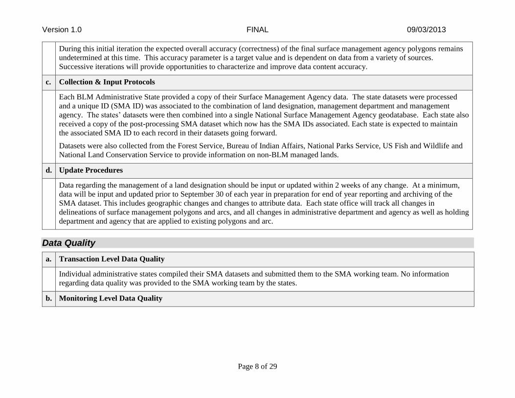
c. Collection & Input Protocols
Each BLM Administrative State provided a copy of their Surface Management Agency data. The state datasets were processed
and a unique ID (SMA ID) was associated to the combination of land designation, management department and management
agency. The states’ datasets were then combined into a single National Surface Management Agency geodatabase. Each state also
received a copy of the post-processing SMA dataset which now has the SMA IDs associated. Each state is expected to maintain
the associated SMA ID to each record in their datasets going forward.
Datasets were also collected from the Forest Service, Bureau of Indian Affairs, National Parks Service, US Fish and Wildlife and
National Land Conservation Service to provide information on non-BLM managed lands.
d. Update Procedures
Data regarding the management of a land designation should be input or updated within 2 weeks of any change. At a minimum,
data will be input and updated prior to September 30 of each year in preparation for end of year reporting and archiving of the
SMA dataset. This includes geographic changes and changes to attribute data. Each state office will track all changes in
delineations of surface management polygons and arcs, and all changes in administrative department and agency as well as holding
department and agency that are applied to existing polygons and arc.
Data Quality
a. Transaction Level Data Quality
Individual administrative states compiled their SMA datasets and submitted them to the SMA working team. No information
regarding data quality was provided to the SMA working team by the states.
b. Monitoring Level Data Quality

Version 1.0 FINAL 09/03/2013
Page 9 of 29
The plan at the time of writing of this document is to collect the states’ data monthly and refresh the National SMA publication
monthly. If it proves to be impractical to complete monthly updates, the State and National data stewards shall review the dataset
each time a new national SMA dataset is created but at a minimum annually prior to September 30 of each year for end of year
reporting and archiving. Discrepancies or deficiencies are to be reported to the appropriate State Office data steward for
clarification and update. The State and National data stewards will review any corrections to the data set again prior to December
15 of each year. Cooperating agencies and partners may choose to review portions of the data for accuracy of attributes.
Records Retention
STANDARDIZED DATASET IMPLEMENTATION
Data Guidelines
The attributes included in this implementation are the minimum attributes deemed necessary in a national surface management agency
dataset. Individual states/offices may add/remove attributes in their datasets but must maintain the SMA ID and HOLD ID attributes
identified in this dataset. Metadata for the additional attributes must be documented by that office.
The format for entering the date in the geodatabase (gdb) will be MM/DD/YYYY. The ESRI software displays the date field according to
how dates are formatted for display on the computer. The Federal Geographic Data Committee (FGDC)-compliant format for the date
field is YYYYMMDD. There are two methods in which the FGDC format could be used for storing the date. The date format on the
computer can be reset which may introduce unintended consequences within other programs, or the date field could be defined as a text
field which would leave ample room for errors being introduced to the data. Although the National Data Standards are intended to be
platform-independent, the ESRI GDB format is the current platform implemented throughout the Bureau of Land Management (BLM).
High-level Process Used To Create Dataset
The entire geodatabase for the Surface Management Agency dataset will be archived on an annual basis, by October 15, for the
previous fiscal year.
Note: Records issues will be handled according to official policy for Records Management.
Creation of Crosswalk Table, the SMA Master Table
The critical aspect to the National SMA standardized dataset is a crosswalk table referred to as the SMA Master Table. The crosswalk

Version 1.0 FINAL 09/03/2013
Page 10 of 29
table was created in an iterative process. A pull of administrative areas from the 2929 table in the LR2000 system provided the initial
set of BLM recognized land designations, departments and agencies. The SMA working team reviewed the data provided in the
LR2000 data pull and determined a number of records were not relevant to the SMA project and removed them. Examples of data
removed include airfields, airports, Forest Service Ranger Districts, and US Fish & Wildlife Management Areas. Each unique
combination of land designation (admin_unit_name in SMA Master Table), managing department (admin_dept_code in SMA Master
Table), and managing agency (admin_agency_code in SMA Master Table) was manually assigned a unique numerical identifier
known as the SMA ID. Further records were added to the SMA Master Table as individual states’ data was processed and new
combinations of land designation/managing department/managing agency were encountered. During processing, two additional
attributes were added to each state’s dataset: SMA ID and HOLD ID. As mentioned previously, SMA ID is a numeric identifier which
links back to the SMA Master Table and provides the Rosetta stone for identifying land designation, managing department and
managing agency. HOLD ID links back to the SMA Master Table and provides information on the land designation and the
department and agency that have been given authority to manage the land designation on behalf of the original managing department
and agency. During processing of each state’s dataset, new combinations of land designation, managing department and managing
agency were discovered, entered into the SMA Master Table and assigned a unique SMA ID.
The SMA Master Table and dataset contains information provided by other federal agencies. Bureau of Indian Affairs (BIA) data for
all of United States except California was provided by the Census Bureau. BIA data for California was provided by Pacific Region
Office of the BIA. Additional information regarding land designations, managing department and agency were provided by the Forest
Service (FS), National Parks Service (NPS), US Fish and Wildlife Service (USFWS), National Landscape Conservation System
(NLCS) and the Florida Natural Areas Inventory. Please refer to the feature class metadata embedded with the National SMA dataset
for further information on the source datasets.
At the end of processing of all the BLM states datasets and additional federal agency datasets, the SMA Master Table emerged which
contained approximately 4000 records reflecting approximately all the unique combinations of land designation, managing department
and agency contained in the National SMA standardized dataset. The SMA Master Table evolved as datasets were included and
during processing of the BLM states data for creation of the National SMA Publication dataset; no records were added to the SMA
Master Table indicating no new combinations were encountered.
Land designation names varied between states and agencies. Differences in names for the same land designation included differences
in capitalization, misspellings and parenthetical formatting. The original name found in the source dataset is stored in the
ORIG_NAME attribute of the SMA Master Table for historical and data verification purposes. A manually reformatted version of the
name is stored in the SMA Master Table in two attribute fields, ADMIN_UNIT_NAME and ADMIN_UNIT_TYPE, to reduce errors
and improve searchability. ADMIN_UNIT_NAME refers to the land designation name such as Rocky Mountain National Park or Red
Lake Reservation. ADMIN_UNIT_TYPE provides more information on what type of land designation such as National Park or
Reservation. The managing department (ADMIN_DEPT_CODE) and managing agency (ADMIN_AGENCY_CODE) were not
contained in the various federal agency source datasets. The data placed into the ADMIN_DEPT_CODE and

Version 1.0 FINAL 09/03/2013
Page 11 of 29
ADMIN_AGENCY_CODE was determined by the department and agency providing the source dataset. For example, if a land
designation such as Trinity Alps Wilderness was encountered in the dataset provided by the Forest Service, the record created in the
SMA Master Table would include a new SMA ID assigned by increasing by one the previous highest SMA ID in the SMA Master
Table, entering USDA into the ADMIN_DEPT_CODE field and FS into the ADMIN_AGENCY_CODE.
Return and Certification of State SMA Dataset
After processing, each state’s SMA dataset was returned with the new SMA ID and HOLD ID columns added and populated. Each
state was asked to review the updated dataset. After verifying the dataset was complete and accurate, a State Data Certification form
was signed and returned to the National SMA Data Steward, Beth Wenstrom.
Creation of National SMA Standardized Dataset
All states’ datasets were imported into ArcGIS 10.1 and used to create a single feature class, SurfaceManagementAgency. The SMA
ID attribute was translated using the SMA Master Table, and the admin_dept_code and admin_agency_code attributes were populated
in the SurfaceManagementAgency feature class. Prior to this translation, those attributes were empty and only the SMA ID was
populated.
Some state’s datasets contained land management information that extended past their administrative boundaries. Clipping was
employed to trim data to conform to recognized BLM Administrative State boundaries. An administrative boundaries layer provide by
Jeff Nighbert, OR State Office, was used to clean up areas that were contained in the one state’s data but were actually part of another
state’s area of responsibility. The coastal area boundaries were buffered to 3.5 miles. In Alaska, the 3.5 mile buffer started at the edge
of the outermost island. It is recognized that this approach ensures there are no overlaps but doesn’t protect against gaps caused when
a state’s dataset doesn’t contain data all the way to its state boundary. An example of this type of gap can be seen between the western
edge of the Eastern States data and the eastern edge of New Mexico, Wyoming and Montana/Dakotas states’ data. The Eastern State
dataset contained land management data which reached to the western edge of their boundary. Unfortunately, some of the western
states’ land management data did not extend to the eastern edge of their boundaries. This gap was filled using data provided by Jeff
Nighbert.
Data Attribution QA/QC of National SMA Standardized Dataset
A Total Quality Report generated by the Data Reviewer tool was submitted to the National SMA Data Steward for review.
Certification of National SMA Dataset by National SMA Data Steward
The National SMA Data Steward, Beth Wenstrom, reviewed the QA/QC report created above and signed the National SMA

Version 1.0 FINAL 09/03/2013
Page 12 of 29
SMA Master Table Maintenance
Standardized Dataset Certification Form.
During the initial creation of the National SMA dataset, SMA IDs were assigned to each record in each state’s SMA dataset
programmatically. Going forward, each state office will maintain their own SMA datasets in the format they have always been using
with the addition of the SMA ID. The SMA ID is a unique identifier and provides the ability to symbolize the SMA data. The list of
SMA IDs is stored in the SMA Master table which will be maintained at the NOC. The SMA ID is unique to the combination of Land
Designation (known as unit name in the SMA Master Table), Administrative Department and Administrative Agency.
When a state needs to add a new record to their data which has a new combination of land designation/unit name + administrative
department code + administrative agency code, the state SMA data steward will need to determine what SMA ID to assign to that
record. The flow chart (Figure 1 below) documents the decision process used to determine the SMA ID as well as directions on how to
request a new SMA ID be created if a particular combination of land designation/unit name + admin department code + admin agency
code doesn't exist in the SMA Master table. The flowchart also captures the decision process the National SMA data steward would
use to determine if the request is valid as well as the back and forth between the National data steward and state office requester if
there is disagreement as to whether the new SMA ID is needed.
Sub-processes were used wherever possible to minimize redundancy. These boxes point to other figures (Figure 2, Figure 3 or Figure
4) and the name of the appropriate sub-process.
In the instance that a land designation doesn’t already exist in the SMA Master Table, it is the responsibility of the National SMA data
steward to determine if the land designation exists in LR2000 (or its replacement). If the land designation exists in LR2000, the
National SMA data steward only needs to add the appropriate information into the SMA Master Table. If the land designation doesn’t
exist in LR2000 or its replacement, the National SMA data steward is responsible for working with the LR2000 system, or its
replacement, to have the land designation added because LR2000 it system of record for land designations. Note that the new entry
can be made into the SMA Master Table prior to LR2000 adding the new land designation but the addition does need to happen in a
timely manner.
Example:
A portion of Aqua Tibia Wilderness is now being managed by the Fish and Wildlife. The particular combination of Aqua Tibia +
DOI+ FWS does not exist in the SMA Master Table and must be added. The national SMA data steward is responsible for actually
updating the SMA Master table to include the new record. The process flowcharts below show the process used to determine if an

Version 1.0 FINAL 09/03/2013
Page 13 of 29
SMA ID already exists for the combination of unit name, administrative department and administrative agency. It also shows the
process to follow to determine if a new SMA ID needs to be created which will require some discussion between the State SMA data
steward and the National SMA data steward.
SMA
_ID
ADMIN_DEPT_
CODE
ADMIN_AGENCY
_CODE
UNIT_NAME (aka
Land Designation)
UNIT_TYPE HOLD_DEPT_
CODE
HOLD_AGENCY_
CODE
3405 DOI BLM Aqua Tibia
Wilderness
Wilderness <NULL> <NULL>
4211 USDA FS Aqua Tibia
Wilderness
Wilderness <NULL> <NULL>
3501 DOI BLM Aqua Tibia
Wilderness Study
Area
Wilderness
Study Area
<NULL> <NULL>
9999
*
DOI FWS Aqua Tibia
Wilderness Study
Area
Wilderness
Study Area
<NULL> <NULL>
* Example new record
Determine Correct SMA ID For New State SMA Dataset Record
StartUser wants to insert
new record into state data set
Determine Appropriate
SMA_ID(Figure-2)
Insert record into state data set using
SMA_ID identified in previous step
Update state SMA data set replicated
to NOCEnd
Figure 1: The entry point into the process for determining which SMA ID to assign to a record in a state’s SMA data.

Version 1.0 FINAL 09/03/2013
Page 14 of 29
Determine Appropriate SMA ID
Start
Is land designation in SMA Master
Table?
Is land designation managed by
same Dept. & Agency?
Use existing SMA ID
State SMA Data Steward Request New
SMA ID(Figure 3)
State SMA Data Steward Request New
SMA ID(Figure 3)
EndYes Yes
No No
Figure 2: Maps out the process for determining if an SMA ID already exists for the combination, and points user to subsequent process
(Figure 3) to request a new SMA ID if existing SMA ID doesn’t already exist.
State SMA Data Steward Requests New SMA ID
Start
Contact National SMA data steward
to request new SMA ID
National SMA data steward receives request for new
SMA ID
End
National SMA Data Steward
Evaluates Request
(Figure 4)
Figure 3: Illustrates the process for requesting a new SMA ID. The expectation is that this process is initiated after completing the
process steps outlines in Figure 2.

Version 1.0 FINAL 09/03/2013
Page 15 of 29
National SMA Data Steward Evaluates Request
Start
Is land designation in SMA Master
Table?
Is the record being added needed (ex:
requestor didn’t realize the
record already existed)?
Is the land designation there but in
another format (ex: different
spelling)?
Is land designation managed by
same Dept. & Agency as an
existing record in SMA Master
Table?
Provide this SMA ID to user along with
instructions to correct spelling.
Does requestor agree with
spelling change?
Requestor enters record into state
dataset with corrected spelling
and SMA ID provided by data
steward.
Discussion between data steward and
reqeustor
Do both parties agree?
Does solution require new
SMA ID?
Data steward updates SMA
Master Table with new land
designation which is associated to a new
SMA ID
Data steward informs requestor of
new SMA IDEndYesYes
No
Yes
Use existing SMA ID
Record not entered
No
Data steward informs requestor to use existing SMA ID for the new record.
Yes
No
Yes
No
No No
Yes
No
No
No
Yes
Figure 4: Illustrates the back and forth required between the National SMA data steward and the state SMA data steward to determine if a
new SMA ID is really needed. The discourse between the two parties is important to ensure that an appropriate SMA ID doesn’t already
exist. This will prevent creation of questionable or repetitive data in the SMA Master table. The expectation is that this process is
initiated by an action in Figure 3.

Version 1.0 FINAL 09/03/2013
Page 16 of 29
Data Structures Implemented
The data for inclusion in this data set shall be collected in a known datum and coordinate system. The data stored on the National
Operations Center (NOC) EGIS server in Denver shall be stored in geographic coordinates for national layers using the Bureau
standard NAD 83 datum rather than in a specific projection. While the standard datum is NAD 83, there are multiple realizations of that
datum in existence. The metadata for each data set shall contain more specific labeling of the datum as appropriate. Examples of this
would include: NAD 83 (2007) or NAD 83 (CORS 96) (1997). Every effort should be made to be as specific as possible in delineating
the appropriate datum.
Data Structures Implemented
There are three structures in this implementation:
A SMA_WithdrawalAreas Represents the polygon features for Federal lands which either: a) transfer total or partial
jurisdiction between Federal agencies; or b) close Federal land to operation of some or all
public lands laws and/or mineral laws.
B SPP_WithdrawalAreas Represents the polygon features for Special Public Purpose Withdrawal Areas.
C SurfaceManagementAgency Represents the polygon features that show the boundaries for Surface Management
Agency.
Physical Design Considerations
The SMA implementation is comprised of several polygon feature classes, rather than a single feature class. The rationale for splitting
the withdrawal areas into separate feature classes was because: a) There are numerous overlaps between the various types of withdrawal
areas; and b) the SMA withdrawal areas transfer jurisdiction to a particular area, while the SPP (Special Public Purpose) withdrawal
areas merely limit usage, but do not transfer jurisdiction. It was determined that separating these feature classes would make the dataset
easier to maintain and more user-friendly. The SurfaceManagementAgency polygon feature class represents the federal lands
administered by the various agencies. This feature class also depicts the private, state, and local government lands in addition to lands of
undetermined ownership.

Version 1.0 FINAL 09/03/2013
Page 17 of 29
Physical Database Diagram
Surface Management Agency (SMA) Boundaries
(File Geodatabase)
SMA_IDSOURCE_AGENCYSOURCE_DATEDE_UNIT_CODEADMIN_DEPT_CODEADMIN_AGENCY_CODEADMIN_UNIT_NAMEADMIN_UNIT_TYPE
SMA_WithdrawalAreas
FederalSurfacePublish
SMA_IDHOLD_IDDE_UNIT_CODEADMIN_DEPT_CODEADMIN_AGENCY_CODEADMIN_UNIT_NAMEADMIN_UNIT_TYPE
SurfaceManagementAgency
SMA_IDSOURCE_AGENCYSOURCE_DATEDE_UNIT_CODEADMIN_DEPT_CODEADMIN_AGENCY_CODEADMIN_UNIT_NAMEADMIN_UNIT_TYPE
SPP_WithdrawalAreas
Topology
Geodatabase topologies will be handled at the state level.

Version 1.0 FINAL 09/03/2013
Page 18 of 29
DATASET IMPLEMENTATION DETAILS
A. Surface Management Agency Withdrawal Areas (SMA_WithdrawalAreas)
The polygon features for Surface Management Agency Withdrawals are defined below.
Surface Management Agency Withdrawal Areas Attributes
GIS NAME ALIAS DATA
FORMAT REQUIRED?
DEFAULT
VALUE DOMAIN NAME DERIVED?
SMA_ID SMA_ID Long Integer YES NO
SOURCE_AGENCY SOURCE_AGENCY Char(50) YES NO
SOURCE_DATE SOURCE_DATE Date YES NO
DE_UNIT_CODE DE_UNIT_CODE Char(10) YES NO
ADMIN_DEPT_CODE ADMIN_DEPT_CODE Char(5) YES NO
ADMIN_AGENCY_CODE ADMIN_AGENCY_CODE Char(8) YES NO
ADMIN_UNIT_NAME ADMIN_UNIT_NAME Char(82) YES NO
ADMIN_UNIT_TYPE ADMIN_UNIT_TYPE Char(42) YES NO
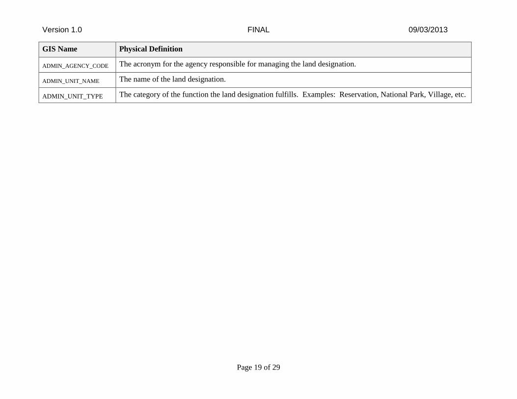
GIS Name Physical Definition
SMA_ID The unique identifier associated to the unique combination of administrative department, administrative
agency, and land designation.
SOURCE_AGENCY The name or acronym for the agency that provided the data.
SOURCE_DATE The date that the data was originally created in the source agency’s dataset.
DE_UNIT_CODE The code found in the LR2000 system/Corporate Metadata Repository. For units not yet in LR2000, the field
will hold all zeros.
ADMIN_DEPT_CODE The acronym for the department responsible for managing the land designation.
Version 1.0 FINAL 09/03/2013
Page 19 of 29
GIS Name Physical Definition
ADMIN_AGENCY_CODE The acronym for the agency responsible for managing the land designation.
ADMIN_UNIT_NAME The name of the land designation.
ADMIN_UNIT_TYPE The category of the function the land designation fulfills. Examples: Reservation, National Park, Village, etc.

Version 1.0 FINAL 09/03/2013
Page 20 of 29
B. Special Public Purpose Withdrawal Areas (SPP_WithdrawalAreas)
The polygon features for Surface Management Agency Withdrawals are defined below.
Special Public Purpose Withdrawal Areas Attributes
GIS NAME ALIAS DATA
FORMAT REQUIRED?
DEFAULT
VALUE DOMAIN NAME DERIVED?
SMA_ID SMA_ID Long Integer YES NO
SOURCE_AGENCY SOURCE_AGENCY Char(50) YES NO
SOURCE_DATE SOURCE_DATE Date YES NO
DE_UNIT_CODE DE_UNIT_CODE Char(10) YES NO
ADMIN_DEPT_CODE ADMIN_DEPT_CODE Char(5) YES NO
ADMIN_AGENCY_CODE ADMIN_AGENCY_CODE Char(8) YES NO
ADMIN_UNIT_NAME ADMIN_UNIT_NAME Char(82) YES NO
ADMIN_UNIT_TYPE ADMIN_UNIT_TYPE Char(42) YES NO
GlobalID GlobalID UUID YES NO
GIS Name Physical Definition
SMA_ID The unique identifier associated to the unique combination of administrative department,
administrative agency, and land designation.
SOURCE_AGENCY The name or acronym for the agency that provided the data.
SOURCE_DATE The date that the data was originally created in the source agency’s dataset.
DE_UNIT_CODE The code found in the LR2000 system/Corporate Metadata Repository. For units not yet in
LR2000, the field will hold all zeros.
ADMIN_DEPT_CODE The acronym for the department responsible for managing the land designation.
ADMIN_AGENCY_CODE The acronym for the agency responsible for managing the land designation.
ADMIN_UNIT_NAME The name of the land designation.

Version 1.0 FINAL 09/03/2013
Page 21 of 29
GIS Name Physical Definition
ADMIN_UNIT_TYPE The category of the function the land designation fulfills. Examples: Reservation, National
Park, Village, etc.
Version 1.0 FINAL 09/03/2013
Page 22 of 29
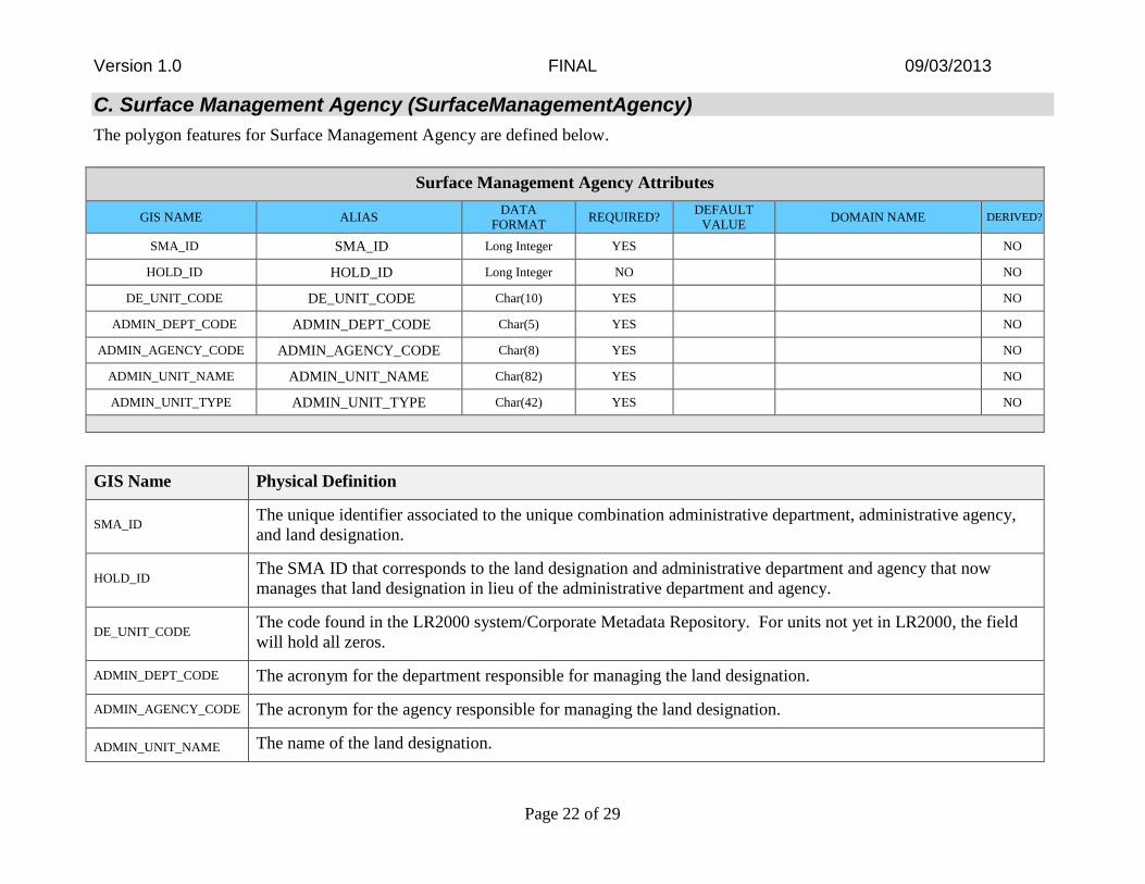
C. Surface Management Agency (SurfaceManagementAgency)
The polygon features for Surface Management Agency are defined below.
Surface Management Agency Attributes
GIS NAME ALIAS DATA
FORMAT REQUIRED?
DEFAULT
VALUE DOMAIN NAME DERIVED?
SMA_ID SMA_ID Long Integer YES NO
HOLD_ID HOLD_ID Long Integer NO NO
DE_UNIT_CODE DE_UNIT_CODE Char(10) YES NO
ADMIN_DEPT_CODE ADMIN_DEPT_CODE Char(5) YES NO
ADMIN_AGENCY_CODE ADMIN_AGENCY_CODE Char(8) YES NO
ADMIN_UNIT_NAME ADMIN_UNIT_NAME Char(82) YES NO
ADMIN_UNIT_TYPE ADMIN_UNIT_TYPE Char(42) YES NO
GIS Name Physical Definition
SMA_ID The unique identifier associated to the unique combination administrative department, administrative agency,
and land designation.
HOLD_ID The SMA ID that corresponds to the land designation and administrative department and agency that now
manages that land designation in lieu of the administrative department and agency.
DE_UNIT_CODE The code found in the LR2000 system/Corporate Metadata Repository. For units not yet in LR2000, the field
will hold all zeros.
ADMIN_DEPT_CODE The acronym for the department responsible for managing the land designation.
ADMIN_AGENCY_CODE The acronym for the agency responsible for managing the land designation.
ADMIN_UNIT_NAME The name of the land designation.

Version 1.0 FINAL 09/03/2013
Page 23 of 29
GIS Name Physical Definition
ADMIN_UNIT_TYPE The category of the function the land designation fulfills. Examples: Reservation, National Park, Village, etc.

Version 1.0 FINAL 09/03/2013
Page 24 of 29
IDENTIFIED BUSINESS RULES
The rules under which data are used and modified. There may be business rules that have not been identified yet. (See BLM Handbook
1283, Data Administration and Management Handbook, Chapter on Business Rules.)
1. Federal Geographic Data Committee (FGDC) Standards
FGDC standards that apply to Surface Management Agency (SMA) were not adhered to in the implementation of this dataset.
However, they will need to be adhered to once development of the SMA data standard is complete.
Business Rule Source and Description
Guidance
Type of Business Rule Current Implementation
Required Not Applicable
2. Administrative Department/Agency relative to Holding Department/Agency
The holding department and agency combination should never be a repeat of the administrative department and agency combination
for any particular SMA ID. The administration of a particular land designation is stored to the Department and Agency levels. It
doesn’t make sense to repeat the Department/Agency combination if a different group within the same Department/Agency
combination manages a land designation for another group within the same Department/Agency.
Business Rule Source and Description
Source: Consensus of working group.
Type of Business Rule Current Implementation
Guideline (Optional) Manual Process

Version 1.0 FINAL 09/03/2013
Page 25 of 29
3. Population of national administrative or holding agency when state administrative or holding agency is missing.
If the administrative agency or holding agency is null in the state SMA dataset, leave that field null in the national dataset. Do not
populate with the administrative or holding department code.
Business Rule Source and Description
Source: Other
Data Management best practices
Type of Business Rule Current Implementation
Guideline (Optional) Manual Process

Version 1.0 FINAL 09/03/2013
Page 26 of 29
APPENDIX A: DOMAIN VALUES
No domain values were implemented in the Surface Management Agency National Standardized Dataset.
APPENDIX B: ATTRIBUTE METADATA TERMINOLOGY
The following matrix describes the metadata for the DatasetImplementationDetails.
Attribute Metadata
Field
Metadata Definition Example
GIS Name The abbreviated name of the field as it appears in the database RCVR_TYPE
Alias An alternative name that is more descriptive and user-friendly
than the Logical or GIS Field Name
GPS RECEIVER TYPE
Data Format Specific type of data allowed/# of characters or
numbers/Precision & Scale
Char(15)
Required? If an attribute does or does not have to have a value. If “YES”,
the attribute is required, if “NO”, the attribute is optional.
NO
Default Value Value that will apply if no other value is specified; included in
domain value list.
N/A
Domain Name Name of the table for that attribute, containing the Code,
Description, and Definition for each value in the table
DOM_RCVR_TYPE
Derived? If the attribute value is derived from the value of one or more
other attribute values (YES) otherwise, (NO) the value is not
derived. The description of how the attribute is derived will be
included in the Definition/Design Consideration.
NO
Logical Attribute Name The business name of the attribute which includes the entity
name, and representation term
Global Positioning System
Receiver Type Name
Version 1.0 FINAL 09/03/2013
Page 27 of 29
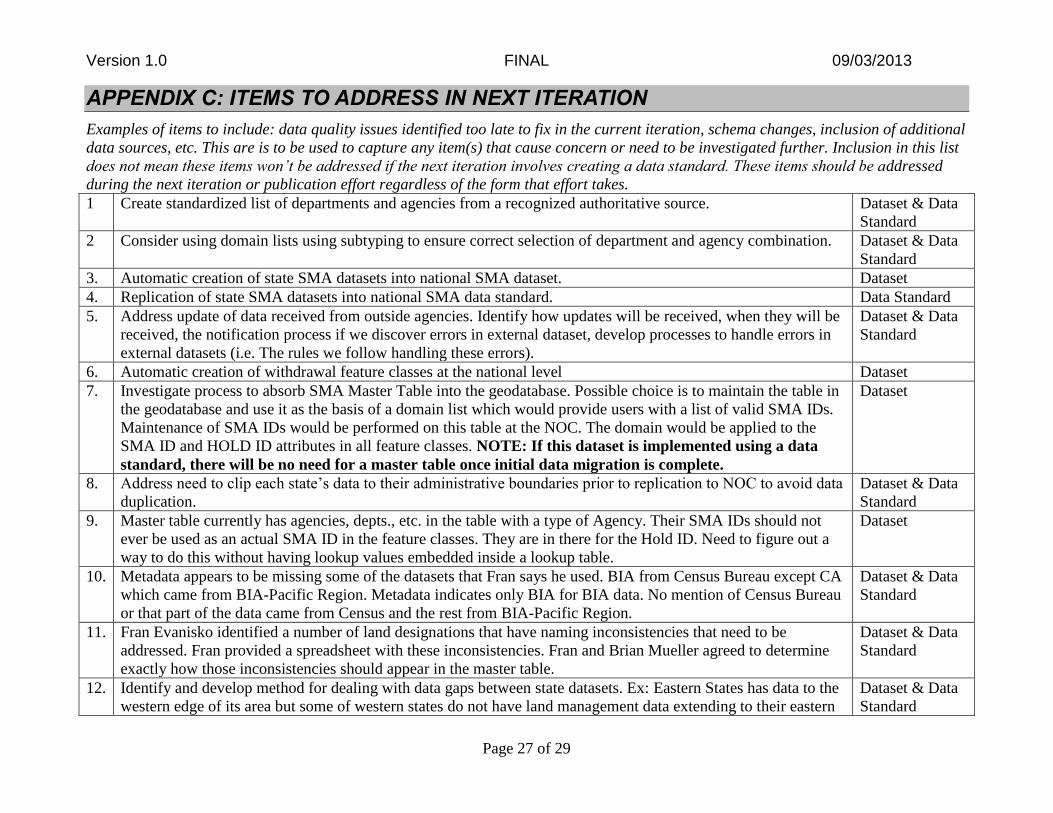
APPENDIX C: ITEMS TO ADDRESS IN NEXT ITERATION
Examples of items to include: data quality issues identified too late to fix in the current iteration, schema changes, inclusion of additional
data sources, etc. This are is to be used to capture any item(s) that cause concern or need to be investigated further. Inclusion in this list
does not mean these items won’t be addressed if the next iteration involves creating a data standard. These items should be addressed
during the next iteration or publication effort regardless of the form that effort takes.
1 Create standardized list of departments and agencies from a recognized authoritative source. Dataset & Data
Standard
2 Consider using domain lists using subtyping to ensure correct selection of department and agency combination. Dataset & Data
Standard
3. Automatic creation of state SMA datasets into national SMA dataset. Dataset
4. Replication of state SMA datasets into national SMA data standard. Data Standard
5. Address update of data received from outside agencies. Identify how updates will be received, when they will be
received, the notification process if we discover errors in external dataset, develop processes to handle errors in
external datasets (i.e. The rules we follow handling these errors).
Dataset & Data
Standard
6. Automatic creation of withdrawal feature classes at the national level Dataset
7. Investigate process to absorb SMA Master Table into the geodatabase. Possible choice is to maintain the table in
the geodatabase and use it as the basis of a domain list which would provide users with a list of valid SMA IDs.
Maintenance of SMA IDs would be performed on this table at the NOC. The domain would be applied to the
SMA ID and HOLD ID attributes in all feature classes. NOTE: If this dataset is implemented using a data
standard, there will be no need for a master table once initial data migration is complete.
Dataset
8. Address need to clip each state’s data to their administrative boundaries prior to replication to NOC to avoid data
duplication.
Dataset & Data
Standard
9. Master table currently has agencies, depts., etc. in the table with a type of Agency. Their SMA IDs should not
ever be used as an actual SMA ID in the feature classes. They are in there for the Hold ID. Need to figure out a
way to do this without having lookup values embedded inside a lookup table.
Dataset
10. Metadata appears to be missing some of the datasets that Fran says he used. BIA from Census Bureau except CA
which came from BIA-Pacific Region. Metadata indicates only BIA for BIA data. No mention of Census Bureau
or that part of the data came from Census and the rest from BIA-Pacific Region.
Dataset & Data
Standard
11. Fran Evanisko identified a number of land designations that have naming inconsistencies that need to be
addressed. Fran provided a spreadsheet with these inconsistencies. Fran and Brian Mueller agreed to determine
exactly how those inconsistencies should appear in the master table.
Dataset & Data
Standard
12. Identify and develop method for dealing with data gaps between state datasets. Ex: Eastern States has data to the
western edge of its area but some of western states do not have land management data extending to their eastern
Dataset & Data
Standard

Version 1.0 FINAL 09/03/2013
Page 28 of 29
boundaries.
13. Address geometry errors found during processing. The find geometry error function in ArcGIS works well to
identify the errors. However, fix geometry errors function doesn’t fix the geometry error sufficiently to prevent a
“blow up” later in Fran’s processing. Need to identify the errors and convince each state to manually fix each
geometry error.
Dataset & Data
Standard
14. Address missing data for National Monuments. This dataset only shows one monument in the SPP Withdrawals
feature class.
Dataset & Data
Standard
15. Fran made some entries into the SMA Master Table at Beth Wenstrom’s direction. Need to determine if those
entries matched what was in the BIA-Pacific Region or Census data. If not, need to document the changes made
and logic for making those changes. Applies to both metadata documents as well as Dataset
Implementation.High Level Process Used To Create Dataset section of this document.
Dataset
APPENDIX D: ITEMS TO ADDRESS FOR DATA STANDARD
1. Complete the required documents necessary for a Data Standard including Data Standard Report, Implementation Guide, Domain
Guide, QA/QC plan, Metadata.
2. Implement a standard geodatabase schema and work with each state office to implement so all states are using the same core
geodatabase schema for their SMA data.
REVISION HISTORY
VERSION NO. VERSION TYPE DATE PURPOSE
0.1 Original
0.2 Revision 8/30/2013 incorporate Implementation Guidelines into SDR
1.0 Revision 9/12/2013 Incorporated reviewers comments, marked document as final

Version 1.0 FINAL 09/03/2013
Page 29 of 29
VERSION <#> MODIFICATIONS
SECTION PAGE DESCRIPTION OF EDIT CHANGE REQUESTED
<what was the submitted change request>
Top Related