


Languages
Pages
Legal


Special Investment RegionsOF GUJARAT
Accelerating Growth
Gujarat Industrial Development Corporation2nd Floor, Block No. 4, Udyog Bhavan, Sector -11, Gandhinagar - 382017, Gujarat, India.
Phone: +91 79 23250636/37 | Fax: +91 79 23250587 | E-mail: [email protected] | www.gidc.gov.in(A Government of Gujarat Undertaking)
(A Government of Gujarat Undertaking)

"Welcome toIndia's most business friendly state"
GPCPIR DAHEJ
HALOL
SAVLI
DHOLERA
ANJAR
ALIYABET
NAVLAKHI
OKHA
CHANGODAR
SANTALPUR
VIRAMGAM
PIPAVAVSIMAR
Special Investment Regionsof Gujarat
Narendra ModiChief Minister, Gujarat
ujarat is a state best known for its
entrepreneurial spirit. �e state has become the
epicenter of economic activity in the country. It has
emerged as one of the most prosperous and promising
states of India. �e state has consistently exhibited
higher growth rate than the national average. In fact, it
is growing faster than some of the Asian economies.
�e last few years have seen Gujarat transform and
compete with developed nations on equal footing.
Besides labour harmony, infrastructure development,
socio-economic reforms, investor friendly climate,
transparent policies and prudent �scal management,
which have contributed to the growth of the state
economy, it is the entrepreneurial nature of the people
which has gone a long way in making the Gujarat story
a successful one.
G

SIR Act 2009• It enables State Government to establish, develop, operate and regulate SIRs.
• Government is empowered to declare Investment Region or Industrial Area.
• SIRs have a minimum area of 100 sq. km. (10,000 ha.); Industrial Area a minimum of 50 sq. km. (5,000 ha.).
• A 4-tier administrative mechanism set up for establishment, operation and management of SIRs.
The administrative mechanism comprises
• An Apex Authority- Gujarat Infrastructure Development Board, the highest policy making body. It will also act as the single window system and the first contact for setting up any economic activity or amenity in the SIR.
• Regional Development Authority (RDA) for each SIR – to address ground level issues of development & regulation. The RDA will make its own regulations for building, construction and development.
• Project Development Agency - to implement large and important projects within the SIR.
• Project specific Special Purpose Vehicles.
It provides an e�ective framework for private sector participation
in infrastructure by drawing upon the Gujarat Infrastructure
Development Act (GID Act),1999
Special Investment Region (SIR) Regulatory and Policy Framework
SIR Development Stages & StatusPCPIR Halol-Savli Santalpur Aliya Bet Changodar Pipavav Viramgam Okha Navlakhi Simar Anjar
Selection of Consultants
Preparation of FeasibilityReport and Concept plan
SIR Noti�cation
RDA Noti�cation
Detailed Development Plan
EIA Study
Operationalized
Stage of Development
Completed Sent to Government In Process Under Progress
GIDC SIR LocationsRegion
PCPIR
Halol-Savli
Santalpur
Changodar
Pipavav
Simar
Navlakhi
Okha
Anjar
Viramgam
Aliyabet
Refinery downstream, high performance chemicals, pigments and coating, nanotechnology, bio- refineries, mineral resource based products
Engineering, automobile ancillaries, engineering plastics, electrical and electronics
Agro based (spices and seed processing, vegetable and fruit processing, dairy, cotton ginning), contract farming, solar power, logistics
Agro based, steel & metal, plastic, pharmaceutical and oil & gas
Logistics based industries, pre-cast structure, spinning
Engineering, energy, port & port related activities, food & fish processing, cement
Ceramic, engineering & automobiles, food processing, electronics, textile, chemical and petrochemicals
General manufacturing, pharmaceutical, CRO, biotechnology and biopharma, auto and auto ancilliaries, mineral based industries, tourism
Port and port based industries, mineral, agro based and engineering
Automobile, engineering, healthcare, pharmaceuticals, fertilizers
Entertainment (eco zone, film city, amusement zone, golf course), aquaculture, marine engineering
453
123
186
319
145
83
182
196
630
138
169
Area (sq km) Potential Sectors Special Investment RegionsThe Government of Gujarat enacted the SIR Act in 2009 in its initiative
to create large size Investment Regions / Industrial Areas and develop
them as Global Hubs for economic activity supported by world class
infrastructure. Gujarat is the only state in India to have enacted a
Special Investment Regions Act.
SIRs are global investment destinations, with the objective of
achieving high economic growth for the country with massive
employment generation. SIRs host industries across various sectors
supported by modern infrastructure, premium civic amenities,
centers of excellence and proactive policy framework.
9 of the 12 SIRs of Gujarat lie within the immediate in�uence areaof Delhi - Mumbai Industrial Corridor (DMIC)
38% of the Dedicated Freight Corridor (DFC) passes through Gujarat
18 out of 26 districts fall within the In�uence Area of DMIC
Major cities on DMIC : Ahmedabad, Vadodara, Surat
60% of Total Investment in the DMIC is likely to be in Gujarat
Estimated Employment : 8 lakh
DMIC in Gujarat
DMIC AlignmentDMIC In�uence AreaCities
Investment RegionInvestment AreaIndustrial Area

UtilitiesWater
Existing
• GIDC supplies 33 MGD raw water drawn from Narmada river.
• GWSSB provides drinking water through Narmada Canal.
• O&M through Dahej Industries Association.
Proposed
• 100 MGD additional water supply network. • Separate water supply network of 35
MGD in SEZ.• Desalination Plants & Water Recycling.
Power
Existing
• Power available from Gujarat Urja Vikas Nigam Ltd. from 220 KV sub-station, linked with the state grid by 220 KV circuit line.
Proposed
• 1500 MW gas based by Torrent Power (construction started).
• 2640 MW coal based by Adani Power (construction started).
Gas
Existing
• GSPL state-wide gas grid handles over 13 MMSCMD through its 2200 km network. This covers the PCPIR.
• Gujarat Gas network close to GPCPIR, at Ankleshwar (3 MMSCMD).
Proposed
• All gas suppliers to extend network.
PC
PIR
PC
PIRPetroleum, Chemical & Petrochemical
Investment RegionPetroleum, Chemical & PetrochemicalInvestment Region
BHARUCH
GPCPIR DAHEJ
LocationGujarat PCPIR (GPCPIR) is a specifically delineated Investment Region planned for the establishment of production facilities for petroleum, chemicals and petrochemicals. PCPIR located at Dahej, is spread over the blocks of Vagra and Bharuch, South Gujarat. It is surrounded by the Gulf of Khambhat in the west, Narmada river & Aliyabet island in the south, villages of Vagra and Bharuch block in the east and Bharuch-Dahej railwayline in the north.
ConnectivityLogistics
Proposed
• 80 hectare chemical logistic park planned in PPP mode. Land earmarked.
• JV Company of GIDC and IL&FS IDC formed to select developer.
• Will be the only chemical logistic park in India.
• GIDC to form SPV Company in JV with Kribhco Infrastructure Ltd. (KRIL) to develop a CFS in PCPIR.
Location
Area
Focus Sector
Investment Already Made & Committed
Infrastructure Development
Anchor Tenant
Dahej in Bharuch district, South Gujarat
453 sq. km.
Chemical & Petrochemical
Rs.90,000 crore (USD 20.5 bn)
Rs.3,200 Crore (USD 727 mn)
ONGC Petro additions Limited (OPaL)
PCPIR Snapshot
Road
Existing
• 50 km of four-lane Dahej-Bharuch State Highway connecting six lane Delhi-Mumbai National Highway and National Expressway.
Proposed
• Ahmedabad-Vadodara National Expressway to be extended to Mumbai (PCPIR loop planned).
• 6 laning of Dahej-Bharuch road.• Up-gradation of 8 km of port linkage.• 42 km of State Highways within PCPIR
to be upgraded to four lane.• Construction of 25 km of coastal roads.• Up-gradation of Dahej-Vagra-Bharuch
Road. • Escape Route (for security purpose).• Link Road linking PCPIR to NH-8.
Rail
Existing
• Connected to Delhi – Mumbai Broad Gauge railway line at Bharuch.
Proposed
• Bharuch-Dahej rail line (62 km) – Conversion to broad gauge (under construction).
• Delhi-Mumbai Dedicated Freight Corridor (DFC) will touch the PCPIR on the eastern side.
Airport
Existing• 250 km from international airport at
Ahmedabad.• 90 km from domestic airport at
Vadodara.• 85 km from domestic airport at Surat.
Proposed
• Greenfield airport for PCPIR. • Airstrip at Ankleshwar.
Port
Existing
• Old Port of Gujarat Maritime Board.
• Liquid Chemical Terminal (1.80 MMTPA) of GCPTCL.
• LNG port (10 MMTPA) of LNG Petronet.• Liquid Fuel jetty (3.50 MMTPA) of
Reliance.• Solid cargo jetty (4.50 MMTPA) of Birla
Copper.• Solid cargo port of Adani Group (3
MMTPA). To be expanded to 12 MMTPA.
Proposed
• 40 MMTPA ports by Sandesara Group (Solid Cargo, Liquid Cargo and Container Port).
• Marine Shipbuilding Park by GMB.• Ro-Ro Ferry Service and Common User Jetty
by GMB with investment of Rs. 250 crore.

PC
PIR
PC
PIRPetroleum, Chemical & Petrochemical
Investment RegionPetroleum, Chemical & PetrochemicalInvestment Region
Employment Generation• Existing industrial units have given direct employment to 13,220 persons and indirect employment to 46,270 persons.
• Additional 30,000 direct employment will be created in the upcoming units. This will provide 90,000 indirect job opportunities.
• Additionally, thousands of persons are employed in construction activities of industrial units, residential townships, infrastructural works etc.
• The large scale economic and industrial activities undertaken in PCPIR would also generate self-employment opportunities.
Leading Companies in PCPIR
Gujarat PCPIR BoundaryExisting GamtalVillage BoundarySurvey boundary & numberExisting SH-8GIDC Estate RoadsRailway StationDahej Samni Rail LineDahej SezGIDC Estate (Vilayat)GIDC Estate (Dahej 1)GIDC Estate (Dahej 1)ONGC WellGas Pipe Line
RiverSeaLake/PondSSNN CanalSubmerged LandHigh Tide Line (HTL)CRZ (200m)CRZ (500m)JettySalt PanGIDC Plat BoundaryPower Plant & Large Scale PCP Industries
Large Scale PCP IndustriesSmall Scale PCP IndustriesService and ancillary PCP IndustriesCRZ Permitted IndustriesResidentialGamtal Bu�erCity Level Commercial areaCity Level Institutional AreaCity Level Recreational AreaUtilityEcoparkWarehousing & Oil TerminalLogistics
EcozoneBhukhi Khadi River DevelopmentPort DevelopmentProposed 250M Wide RoadProposed 150M Wide RoadProposed 120M Wide RoadProposed 80M Wide RoadProposed 60M Wide RoadProposed 45M Wide RoadProposed 30M Wide RoadGIDC Utility CorridorProposed Kalpsar CanalForest Agricultural
Proposed Landuse ZoneLegend
Detailed Development Plan
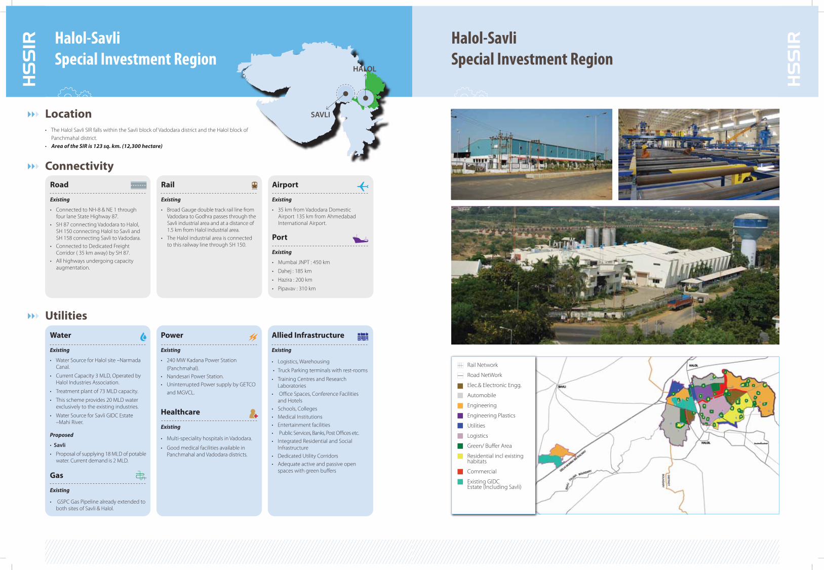
Rail Network
Road NetWork
Elec.& Electronic Engg.
Automobile
Engineering
Engineering Plastics
Utilities
Logistics
Green/ Bu�er Area
Residential incl existing habitats
Commercial
Existing GIDCEstate (Including Savli)
UtilitiesWater
Existing
• Water Source for Halol site –Narmada Canal.
• Current Capacity 3 MLD, Operated by Halol Industries Association.
• Treatment plant of 73 MLD capacity.
• This scheme provides 20 MLD water exclusively to the existing industries.
• Water Source for Savli GIDC Estate –Mahi River.
Proposed
• Savli
• Proposal of supplying 18 MLD of potable water. Current demand is 2 MLD.
Gas
Existing
• GSPC Gas Pipeline already extended to both sites of Savli & Halol.
Power
Existing
• 240 MW Kadana Power Station (Panchmahal).
• Nandesari Power Station.• Uninterrupted Power supply by GETCO
and MGVCL.
Healthcare
Existing
• Multi-speciality hospitals in Vadodara.
• Good medical facilities available in Panchmahal and Vadodara districts.
Allied Infrastructure
Existing
• Logistics, Warehousing
• Truck Parking terminals with rest-rooms
• Training Centres and Research Laboratories
• Office Spaces, Conference Facilities and Hotels
• Schools, Colleges • Medical Institutions • Entertainment facilities • Public Services, Banks, Post O�ces etc.• Integrated Residential and Social
Infrastructure• Dedicated Utility Corridors• Adequate active and passive open
spaces with green bu�ers
HS
SIR Halol-Savli
Special Investment RegionHalol-SavliSpecial Investment Region
Location • The Halol Savli SIR falls within the Savli block of Vadodara district and the Halol block of
Panchmahal district.• Area of the SIR is 123 sq. km. (12,300 hectare)
HALOL
SAVLI
ConnectivityRoad
Existing
• Connected to NH-8 & NE 1 through four lane State Highway 87.
• SH 87 connecting Vadodara to Halol, SH 150 connecting Halol to Savli and SH 158 connecting Savli to Vadodara.
• Connected to Dedicated Freight Corridor ( 35 km away) by SH 87.
• All highways undergoing capacity augmentation.
Rail
Existing
• Broad Gauge double track rail line from Vadodara to Godhra passes through the Savli industrial area and at a distance of 1.5 km from Halol industrial area.
• The Halol industrial area is connected to this railway line through SH 150.
Airport
Existing
• 35 km from Vadodara Domestic Airport 135 km from Ahmedabad International Airport.
Port
Existing
• Mumbai JNPT : 450 km
• Dahej : 185 km
• Hazira : 200 km
• Pipavav : 310 km
HS
SIR

HS
SIR Halol-Savli
Special Investment RegionHalol-SavliSpecial Investment Region
Engineering
• Building Materials
• Machines and Machine Parts
• Metallurgical Industries
• Fabrication
Automobile OEMs & Ancillaries
• Engine parts
• Drive transmission & steering parts
• Equipment & others
Engineering Plastics
• Plastics used in automobiles
• Plastics used in Electric & Electronics
• Plastic products used in Agriculture
• Plastic Re-processing
Electrical & Electronics Industries
• Power driven pumps, Electric Motors
• Switch Gears, Transformers
• Power Transmission Equipments
• Power Plants
Potential Sectors
HS
SIR
Existing Major Units
Asta India

Location • The SIR is strategically located near Ahmedabad, on Ahmedabad-Kandla Highway• Industrial stretch starting about 10 km away at Sarkhej and extends upto GIDC, Kerala
(beyond Bavla Town)• Total industrial agglomeration spreads to nearly 20 km. • 400 industrial units located in the SIR• Area of the SIR is 319 sq. km. (31,900 hectare)
CH
SIR Changodar
Special Investment RegionChangodarSpecial Investment Region
CH
SIR
CHANGODAR
Connectivity
Existing Industrial estates within the
Changodar SIR
• Panchratna Industrial Estate
• Changodhar Industrial Estate
• Ashwamegh Industrial Estate
• Maha Gujarat Industrial Estate
• New Ahmedabad Industrial Estate
• Saket Industrial Estate
• Gopi Industrial Estate
• Subhlaxmi Industrial Estate
• Radhe Industrial Estate
Existing SEZs
• Zydus Pharmez
• Gujarat Pharma Techno Park
• Gallops SEZ (Engineering)
• Dishman Pharma
• Dishman Engineering
• Nova
• Ancillary industries for automobiles• Logistics hub• Agro-Biotech enterprise park • Industrial Training Institutes• Corporate park• Hospitality services• Educational park • Central business district
Potential Sectors
Industrial
Residential
Commercial
CBD
Amenities
Mixed Use
Institutional
Green Open/Recreational
Good Agriculture
River
Recreational Green
Logistic Hub
Sports Club
Proposed SEZ
Existing Railway line
Existing GAMTAL
Existing Pond
Existing Major Units
Road
Existing
• NH 8A connectivity to state capital and business districts of Ahmedabad.
• Linkage from SH-17.• Connected to Bagodra - Baroda six
lane road.
Proposed
• Proximiy to proposed Ahmedabad - Dholera Expressway.
• 10 lane Expressway (central spine) between Ahmedabad and Dholera.
• Dedicated Freight Corridor from Kalol to Mehmedavad and Baroda.
• Central Spine from SP ring road (Bakrol Chokadi) to Dholera.
Rail
Existing
• Site passing along the western railway route of Ahmedabad-Baroda-Mumbai.
Proposed
• Proximity to proposed Gandhinagar – Ahmedabad – Dholera metro rail.
• Broad gauge connectivity between Dholera and DFC.
• Metro rail connectivity to Ahmedabad and Gandhinagar for high speed connectivity.
Airport
Existing
• Close proximity (28 km) to Ahmedabad International Airport.
Proposed
• International Airport at Federa, 17 km from Dholera.
Port
Existing
• Logistically connected to JNPT. • NH 8A directly connects to the ports of
Pipavav, Kandla and Mundra.
Proposed
• Connectivity to Kandla port by the proposed Ahmedabad - Maliya road.
• Connectivity to Pipavav port by Expressway.
AdequatePower and Gas
Available

PS
IR PipavavSpecial Investment Region
PipavavSpecial Investment Region P
SIR
PIPAVAV
Location • The proposed SIR is located in the Amreli district of Gujarat, on the Arabian Sea.
• The site in Rajula taluka, Amreli has Bhavnagar district in the north east, Jafrabad and Savar Kundla taluka in the North West and Arabian Sea in the South.
• Pipavav port lies in Rajula taluka and is ambitiously named as the ‘gateway to North-West India’. It also houses India’s largest private sector port and world’s third largest container terminal operating port.
• Area of the SIR is 145 sq km (14,500 hectare)
ConnectivityRoad
Existing
• National Highway 8E passes through the district - connects Amreli district to Junagadh and Bhavnagar.
• Also connected through SH 31 to Gadhada, SH 25 to Rajkot, SH 110 to Jetpur, SH 30 to Baghsar, SH 96 from Visavadhar to Gariadhar, SH 104 from Una to Derdi.
• Pipavav-Surendranagar freight corridor connects the site to Surendranagar which is further linked to Ahmedabad.
Rail
Existing
• 264 Km Broad Gauge from Pipavav port to Surendernagar.
Port
Existing
• Pipavav, Jafrabad & Victor are sea ports within Amreli district. Pipavav port is one of the largest cargo handling terminals in the country.
Airport
Existing
• The nearest international airport is at Ahmedabad (335 km).
• Domestic airports at Bhavnagar (140 km), Junagadh (260 Km), Rajkot (480 km) and Diu (90 km) all connected with Mumbai International Airport.
Water
Existing
• The Gujarat Water Supply and Sewerage Board (GWSSB) provides drinking water to the area.
• Sumps at Samdhiyala and Victor have a capacity of 1.5 lakh litres and 20 lakh litres respectively. Kadiyali has a reservoir of 6 MLD.
Proposed
• Gujarat Water Infrastructure Limited (GWIL) has proposed an underground sump (4 MLD) which will provide water for industrial purpose.
Power
Existing
• Power is supplied from a 400KV substation at Jetpur to 220KV substations in Savar Kundla, Kansari, Timbadi and Dhasa zones respectively.
• The Savar Kundla line steps down to two 66KV sub stations at Dungar and Rajula which supplies electricity to the entire taluka.
Proposed
• 66 KV substation is being commissioned at Kadiyali.
• In addition, Videocon and Torrent have proposed two power plants of 2,000 MW and 3,000 MW respectively.
Gas
Proposed
• Gujarat State Petroleum Corporation (GSPC) to set up a power plant in Rajula taluka.
Resources
• Limestone, Blackstone, Sand, Clay, Rajula building stone and Soda ash, Groundnut, Cotton, Sesame, Jowar, Onions.
Utilities
• Cement, Glass, Ceramic • Prefabricated structures• Agro and Food Processing• Textile • Marine Biotechnology• Logistics
• Thermal Power Plant• Engineering• Food Processing• Chemical• Ship Building• Iron and Steel
Potential Sectors Existing Major Units
Delineated Site
Taluka Boundary
National Highway
State Highway
Major District Road
Other District Road
Railways
Water Body
Light Engg. Zone
Heavy Engg. Zone
Mineral Zone
Textile Zone
Agro & Food Processing Zone
Logistic Zone
Miscellaneous
Pre Fabrication
Recreational Zone
Residential Zone
Gamtal
Institutional Zone
Reserve Forest
Eco Sensitive Area/ Salt Pan
Coastal Regulation Zone
Orchards
Mines
Port

SS
IR SantalpurSpecial Investment Region
SantalpurSpecial Investment Region
SS
IR
SANTALPUR
Location • The SIR is located on the extreme east of Santalpur taluka, 15 km from Radhanpur town.
• The site comprises 14 populated villages surrounding Varahi village along the NH-15.
• 115 km from Mehsana and 125 km from Palanpur.
• Santalpur taluka borders the Little Rann of Kutch.
• Area of the SIR is 141 sq km (14,100 hectare)
Utilities
Water
Existing
• Current water supply managed and operated by WASMO.
• Proposed Sardar Sarovar Narmada Canal based water supply project.
Gas
Existing
• GSPL Gas supply network till Mehsana (115 km from site).
Proposed
• Extension to SIR by 2011.
Power
Existing
• 66 KV sub stations at Varahi, Santalpur(30 km from site on NH-15), Radhanpur (15 km from site).
• 220 KV sub station at Sinad, near Radhanpur.
• 220 KV transmission grid (from Mehsana) passes through site.
Allied Infrastructure
• Integrated township • Institutional area• Educational institutions• Research laboratory• Testing and certification centre for agro
products• Cold Storages• Logistic facilities• Warehousing
ConnectivityRoad
Existing
• NH 15 runs across the SIR.• SH-127 connects Suigam to Santalpur
and touches NH 15 at Sidhada, passing just outside the delineated site.
Airport
Existing
• 175 km from Ahmedabad International Airport.
• 120 km from Domestic airstrip at Deesa (currently not used).
Rail
Existing
• Rail connectivity through Broad Gauge railway line from Radhanpur to Kandla port, running parallel to NH 15.
• Palanpur junction (125 kms away) on Dedicated Freight Corridor (DFC) caters to tra�c to the Kandla Port, Mundra Port and Gandhidham area.
Proposed
• Double tracking of railway line connecting Kandla port to entire North Gujarat.
Port
Existing
• Kandla Port (190 km) is the connecting hub for northern, western and central India.
• The port currently handles traffic of 46 MMTPA, which is likely to increase upto 68 MMTPA by 2011-2012.
• Proximity to Mundra port.
Area for Agri Park
Miscellaneous Industries
Residential Area
Milk Processing
Vegetable and Fruit Processing
Logistics
Spice Processing
Cotton Ginning & Spinning
Green/ Bu�er Area
Agriculture Area
Cold Storage
Research Area
Commercial
Utility
Water bodies
Habitation area
Solar Power
Potential Sectors• Spices and Seeds Processing • Vegetable and Fruit Processing • Dairy Processing• Cotton Ginning, Pressing and Cotton
Yarn Spinning • Solar Power Generation
Major Units (near the SIR)

VS
IR
VS
IRViramgamSpecial Investment Region
ViramgamSpecial Investment RegionViramgam
Location • The proposed SIR is located in the Viramgam taluka of Ahmedabad district and is located 65 kms from Ahmedabad city.• It is bound by Sanand Taluka in the East, Mehsana district in the North, Surendranagar
district in the west and Bavla taluka in the South.• Area of the SIR is 189 sq. km. (18,900 hectare)
ConnectivityRoad
Existing
• Ahmedabad is linked to Viramgam by the SH-17.
• Ahmedabad district is connected by NH 8 to Delhi and Mumbai.
• NH 8 also connects Ahmedabad district to major cities like Gandhinagar, Vadodara, Bharuch, Anand and Surat in Gujarat as well as Jaipur, Udaipur and Ajmer in Rajasthan.
• Ahmedabad is also linked by the NH 8A and SH 17 to Saurashtra and Kutch.
Proposed
• Upgradation of SH 17 to 8 lane and the conversion of 2 lane SH 136 to 6 lane.
Rail
Existing
• Viramgam taluka has the advantage of a Broad Gauge railway network which connects Ahmedabad to Kutch (Mundra and Kandla ports).
Airport
Existing
• The Sardar Vallabhbhai Patel Airport (Ahmedabad Airport) at a distance of 70 kms.
Proposed
• International airport in Dholera SIR.
Port
Existing
• Mundra port is linked by NH 8A and is 350 kms from Viramgam taluka.
• Road/rail linkage to the Kandla port.
Potential Sectors
Auto & Auto Components
Heavy Engineering
Light Engineering
Electronics
Engineering Plastics
Agri and Pharma Biotechnology
Industry Sub Sector Product Category
Auto & Auto Components
Engineering
Biotechnology
Passenger Vehicles (2,3,4 wheelers), Commercial Vehicles
Machinery & Components
Medical & Surgical instruments, Process Control Instruments,
Roller Bearings, Industrial Fasteners
Consumer Electronics, Computers,
Communication & Broadcasting Equipments, Defence & Strategic Electronic, Components, Nano Technology
Thermosets and Thermoplastics
Agri and Pharma Biotechnology
Existing Major Units
UtilitiesWater
Existing
• Ground water is the current source of water for industries.
Proposed
• Raw water from Narmada Canal to be supplied to the industrial zones.
• 7 MGD Water treatment plant.
• 5 Reservoirs proposed within the delineated site.
Power
Existing• Transmission circle in Surendranagar
supplies power to west Ahmedabad district including Viramgam.
• The nearest 220 KV substation is at Viramgam. At present there is a 66 KV feeder line laid till Jakhwada village.
Proposed
• Power supply by state entity and dedicated power plant within SIR to cater to power demand.
Gas
Existing
• Existing Gas Pipeline up to Tata Nano plant in Sanand, Ahmedabad district.
Natural Resources
• Foodgrains, Spices, Fruits, Vegetables, Medicinal Plants, Cotton, Bio resources.
Raw Materials
• Forged Iron, Speciality Chemicals.
W
N
E
S
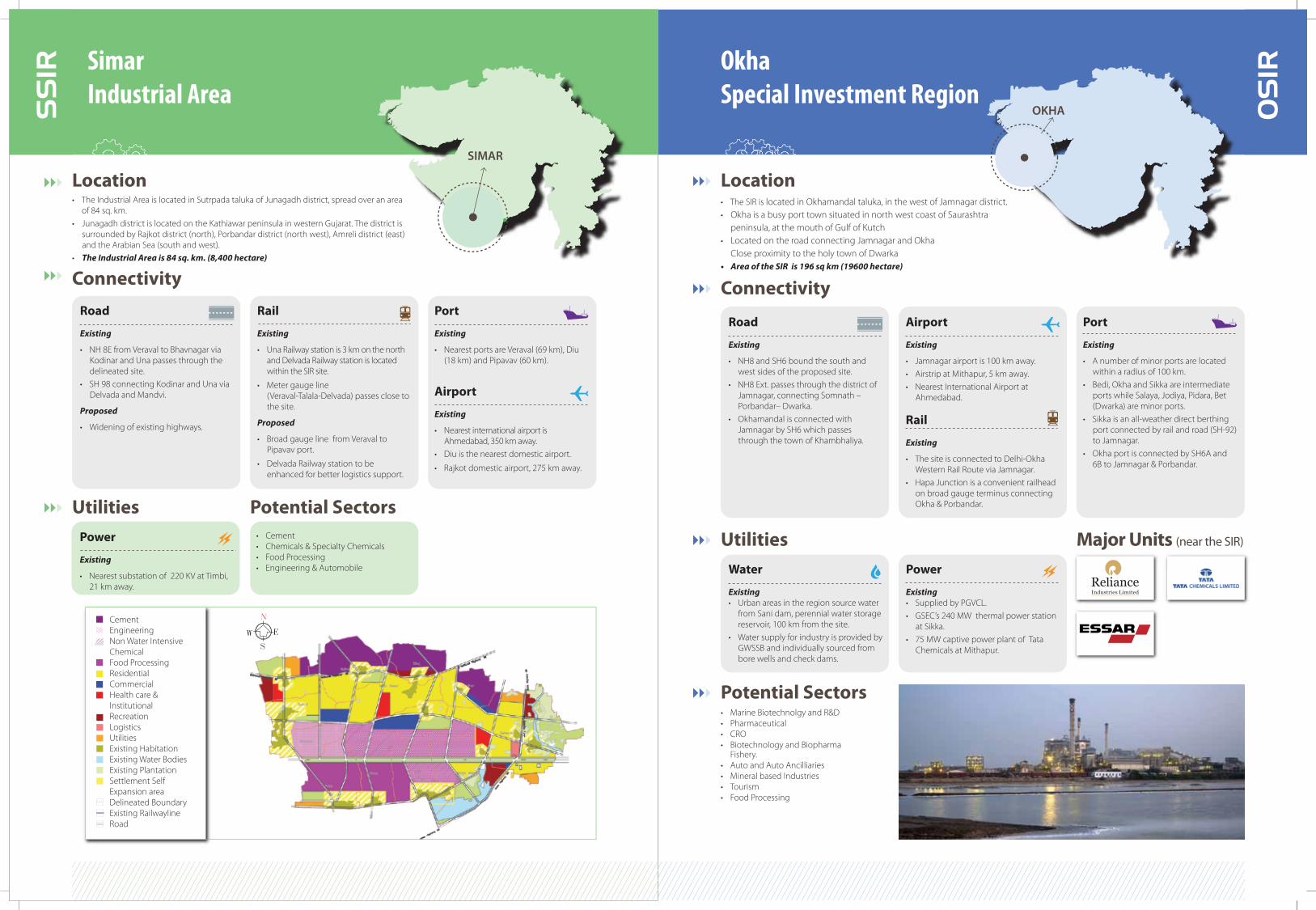
OS
IROkhaSpecial Investment Region
Location • The SIR is located in Okhamandal taluka, in the west of Jamnagar district.• Okha is a busy port town situated in north west coast of Saurashtra
peninsula, at the mouth of Gulf of Kutch• Located on the road connecting Jamnagar and Okha Close proximity to the holy town of Dwarka• Area of the SIR is 196 sq km (19600 hectare)
Utilities
OKHA
Connectivity
SS
IR SimarIndustrial Area
Location• The Industrial Area is located in Sutrpada taluka of Junagadh district, spread over an area
of 84 sq. km.• Junagadh district is located on the Kathiawar peninsula in western Gujarat. The district is
surrounded by Rajkot district (north), Porbandar district (north west), Amreli district (east) and the Arabian Sea (south and west).
• The Industrial Area is 84 sq. km. (8,400 hectare)
Road
Existing
• NH 8E from Veraval to Bhavnagar via Kodinar and Una passes through the delineated site.
• SH 98 connecting Kodinar and Una via Delvada and Mandvi.
Proposed
• Widening of existing highways.
Rail
Existing
• Una Railway station is 3 km on the north and Delvada Railway station is located within the SIR site.
• Meter gauge line (Veraval-Talala-Delvada) passes close to the site.
Proposed
• Broad gauge line from Veraval to Pipavav port.
• Delvada Railway station to be enhanced for better logistics support.
Port
Existing
• Nearest ports are Veraval (69 km), Diu (18 km) and Pipavav (60 km).
Airport
Existing
• Nearest international airport is Ahmedabad, 350 km away.
• Diu is the nearest domestic airport.
• Rajkot domestic airport, 275 km away.
UtilitiesPower
Existing
• Nearest substation of 220 KV at Timbi, 21 km away.
Potential Sectors• Cement• Chemicals & Specialty Chemicals• Food Processing• Engineering & Automobile
CementEngineeringNon Water Intensive ChemicalFood ProcessingResidentialCommercialHealth care & InstitutionalRecreationLogisticsUtilitiesExisting HabitationExisting Water BodiesExisting PlantationSettlement Self Expansion areaDelineated BoundaryExisting RailwaylineRoad
SIMAR
Major Units (near the SIR)
Water
Existing• Urban areas in the region source water
from Sani dam, perennial water storage reservoir, 100 km from the site.
• Water supply for industry is provided by GWSSB and individually sourced from bore wells and check dams.
Power
Existing• Supplied by PGVCL.• GSEC’s 240 MW thermal power station
at Sikka.• 75 MW captive power plant of Tata
Chemicals at Mithapur.
Potential Sectors• Marine Biotechnolgy and R&D• Pharmaceutical• CRO• Biotechnology and Biopharma Fishery. • Auto and Auto Ancilliaries• Mineral based Industries• Tourism• Food Processing
Connectivity
Road
Existing
• NH8 and SH6 bound the south and west sides of the proposed site.
• NH8 Ext. passes through the district of Jamnagar, connecting Somnath – Porbandar– Dwarka.
• Okhamandal is connected with Jamnagar by SH6 which passes through the town of Khambhaliya.
Airport
Existing
• Jamnagar airport is 100 km away.• Airstrip at Mithapur, 5 km away. • Nearest International Airport at
Ahmedabad.
Rail
Existing
• The site is connected to Delhi-Okha Western Rail Route via Jamnagar.
• Hapa Junction is a convenient railhead on broad gauge terminus connecting Okha & Porbandar.
Port
Existing
• A number of minor ports are located within a radius of 100 km.
• Bedi, Okha and Sikka are intermediate ports while Salaya, Jodiya, Pidara, Bet (Dwarka) are minor ports.
• Sikka is an all-weather direct berthing port connected by rail and road (SH-92) to Jamnagar.
• Okha port is connected by SH6A and 6B to Jamnagar & Porbandar.

Major Units (near the SIR)
AS
IR Anjar Special Investment Region
Location • The SIR is located in Anjar and Bhachau talukas in the eastern part of Kachchh district,
north of Kandla Port
• Site is surrounded by the towns of Bhuj, Anjar, Gandhidham and Bhachau.
• Site is well connected by national and state highways • Area of the SIR is 690 sq km (69000 hectare)
ANJAR
UtilitiesWater
Existing
• Water supply by GWSSB.
• Water sourced from Narmada canal or local ground water sources.
Proposed
• Desalination for large scale water supply.
Power
Existing
• Power supplied by lignite power station at Panandhro.
• Anjar has a substation connected by 220 KV lines.
Proposed
• Harnessing wind and tidal energy.
NS
IRNavlakhiSpecial Investment Region
Location • Located in Rajkot district, in Morbi and Maliya talukas• Area of the SIR is 182 sq. km. (18200 hectare)
Road
Existing• Three major corridors in the region are
NH 8A and SH – 42 & 46. All the villages are accessible by one of the three.
Port
Existing
• Kandla port is 30 km away.• Mundra port is 60 km away.• Both Kandla & Mundra ports are
accessible by NH 8A.
Air
Existing
• Airport at Bhuj (40 km) and Kandla (14 km).
Connectivity
NAVLAKHI
Utilities
Water
Existing
• Supply of Narmada water.
Power
Existing
• 66 KV substation at Khirai village in Maliya taluka.
• Nearest 220 KV substation at Morbi.• Two 66KV sub stations at Dungar and
Rajula supply electricity to the entire taluka.
Proposed
• GMDC to invest in a 100 MW Wind Farm.
• GMDC has installed Wind Turbine Generators of 19.5 MW capacity, at Varshamedhi in Maliya taluka.
W
N
E
S
CeramicEngineeringNon WaterIntensive ChemicalFood ProcessingElecticalResidentialCommercialHealth care & InstitutionalRecreationParksLogisticsUtilitiesExisting HabitationExisting Water BodiesExisting Double CropSettlement SelfExpansion areaDelineated BoundaryExisting RailwaylineRoad
ConnectivityRoad
Existing
• SH- 22 connecting Maliya and Jodiya.• SH - 24 passes through the SIR
connecting Navlakhi to Morbi via Dahisara.
Air
Existing
• Nearest international airport is Ahmedabad (247 km).
• Rajkot domestic airport is 67 km away.
Port
Existing
• Close to Kandla, Mundra, Sikka and Navlakhi ports.
Rail
Existing
• Nearest railway station is Wankaner which connects Morbi to Ahmedabad and Rajkot.
• Broad gauge railway line passes through the SIR which connects Navlakhi to Morbi and Maliya.

AS
IR AliyabetSpecial Investment Region
ALIYABET
Location • The SIR is located on the Aliyabet peninsula at the con�uence of river Narmada and
the Arabian Sea in Gulf of Khambhat, in Bharuch district • Site is flanked by Petroleum, Chemical & Petrochemical Investment Region (PCPIR)
to the north.• Area of the SIR is 168 sq. km. (16800 hectares)
Road
Existing
• 28 km from NH 8 (Ankleshwar).• 6 km from SH 21.
Proposed
• Road up to NH8 to be made 4-lane.
Air
Existing
• Nearest airport is at Vadodara (108 kms).• Independent airstrip is proposed for
Aliyabet.
Rail
Existing
• Nearest railway station is at Ankleshwar.
Connectivity
Utilities
Potential Sectors
Water
Existing
• Sourced from Narmada river, Ukai canal water network.
Gas Supply
Existing
• Dahej Uran pipeline.
Power
Existing
• 220 KV (GETCO) power line through Hansot Taluka.
• Solar powered lighting system for individual households & street lights.
• Film City & Entertainment • Aquaculture • Water Sports & Recreation• Marine Engineering
Aliya Bet IslandVillage LocationState HighwayMajor District RoadOther District RoadTaluka BoundaryVillage BoundaryCreek/ Water BodyBank of Narmada
River/ SeaSubmerged AreaMangroveForest ZoneEntertainment ZoneAquaculture ZoneEntertainment & Ecodevelopment Zone
Top Related