


Languages
Pages
Legal


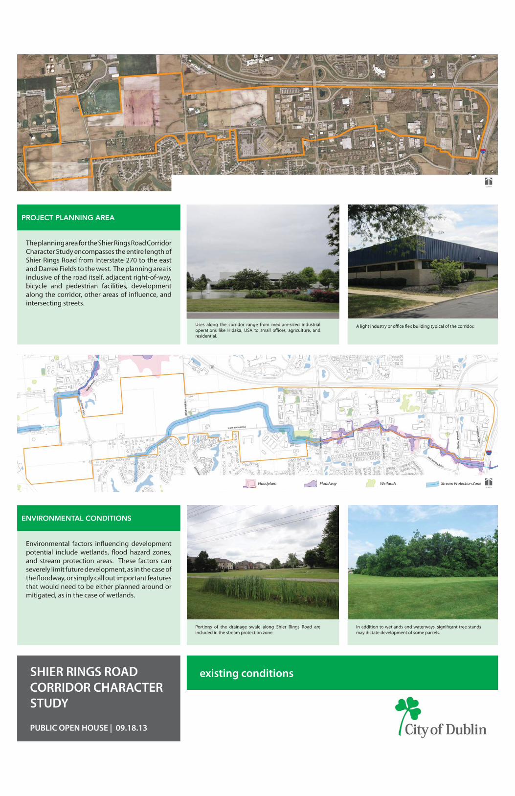
existing conditionsSHIER RINGS ROAD CORRIDOR CHARACTER STUDY
PUBLIC OPEN HOUSE | 09.18.13
Figure 3.2 Avery/Shier Rings Plan
1
2
3
4
5
6
7
8
Area plan concepts are general guides to indicate potential development options. Plans are schematic only, and the actual mix of land uses, locations and configurations of buildings, parking areas and access points will be determined through the public review process. Properties retain all existing rights.
5
171
Adopted: Ordinance #58-07 December 10, 2007 Revised:
Map 4.5 Thoroughfare Plan
2007 Dublin Community Plan
Avery Road at Shier Rings Road l
CITY OF DUBLIN COMMUNITY PLAN
The 2007 Dublin Community Plan anticipates future needs with respect to land use, transportation, utility infrastructure, parks and open space and community facilities.
The plan serves as the City’s primary planning guide and is utilized to evaluate private development requests and make public decisions regarding development, redevelopment, capital improvements, economic incentives and other matters aff ecting the lives of residents and corporate citizens
CENTRAL OHIO INNOVATION CORRIDOR BUSINESS NEIGHBORHOODS
Encompassing most of Dublin’s employment core along I-270 and U.S. 33, the Central Ohio Innovation Corridor is home to most of Dublin’s major corporations and technology based fi rms.
The COIC is geographically divided into seven diff erent business neighborhoods based upon the general character of development, focus on particular businesses types, various zoning regulations, development review processes and future planning eff orts.
WEST INNOVATION DISTRICT SPECIAL AREA PLAN
The West Innovation District (Economic Advancement Zone) is a critical component of the COIC. Located at the west end of the Corridor along U.S. 33, the EAZ is Dublin’s targeted area for future technology-related development.
This planning study addresses future land use, building character and scale, transportation networks, parks and open space as well as multi-modal facilities.
Additional zoning ordinance documents have also been adopted that regulate the standards for development within the West Innovation District.
AVERY ROAD SPECIAL AREA PLAN
The Avery Road Area includes a variety of uses, architectural styles, building materials and site development standards that refl ect decades of development prior to annexation.
As Avery Road is widened to an arterial with median treatment, the need to provide a consistent appearance and identity will be important.
SHIER RINGS ROAD CORRIDOR CHARACTER STUDY
PUBLIC OPEN HOUSE | 09.18.13
existing conditions
PROJECT PLANNING AREA
The planning area for the Shier Rings Road Corridor Character Study encompasses the entire length of Shier Rings Road from Interstate 270 to the east and Darree Fields to the west. The planning area is inclusive of the road itself, adjacent right-of-way, bicycle and pedestrian facilities, development along the corridor, other areas of infl uence, and intersecting streets.
ENVIRONMENTAL CONDITIONS
Environmental factors infl uencing development potential include wetlands, fl ood hazard zones, and stream protection areas. These factors can severely limit future development, as in the case of the fl oodway, or simply call out important features that would need to be either planned around or mitigated, as in the case of wetlands.
NORTH
WetlandsFloodplain Floodway Stream Protection Zone
Uses along the corridor range from medium-sized industrial operations like Hidaka, USA to small offi ces, agriculture, and residential.
A light industry or offi ce fl ex building typical of the corridor.
Portions of the drainage swale along Shier Rings Road are included in the stream protection zone.
In addition to wetlands and waterways, signifi cant tree stands may dictate development of some parcels.
NORTH
existing conditionsSHIER RINGS ROAD CORRIDOR CHARACTER STUDY
PUBLIC OPEN HOUSE | 09.18.13
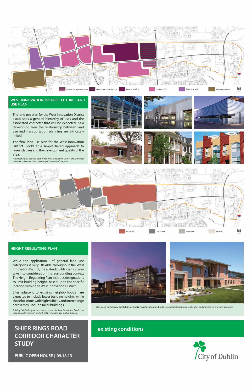
WEST INNOVATION DISTRICT FUTURE LAND USE PLAN
The land use plan for the West Innovation District establishes a general hierarchy of uses and the associated character that will be expected. As a developing area, the relationship between land use and transportation planning are intricately linked.
The fi nal land use plan for the West Innovation District looks at a simple tiered approach to research uses and the development quality of the area.Future land uses done as part of the West Innovation District are shown for reference only and will not be changed as a part of this plan.
NORTH
WetlandsFloodplain Floodway Stream Protection ZoneNORTH
Mixed use techResearch fl ex Mixed residentialResearch offi ce
HEIGHT REGULATING PLAN
Sites along the freeway like Dublin Methodist Hospital frontage should incorporate larger building heights and massing for a greater presence.
NORTH
WetlandsFloodplain Floodway Stream Protection ZoneNORTH
2-3 stories3-4 stories 2 stories4+ stories
While the application of general land use categories is very fl exible throughout the West Innovation District, the scale of buildings must also take into consideration the surrounding context The Height Regulating Plan includes designations to limit building height based upon the specifi c location within the West Innovation District.
Sites adjacent to existing neighborhoods are expected to include lower building heights, while those locations with high visibility and interchange access may include taller buildings.Building height designations done as part of the West Innovation District are shown for reference only and will not be changed as a part of this plan.
Research support servicesResearch support services
SHIER RINGS ROAD CORRIDOR CHARACTER STUDY
PUBLIC OPEN HOUSE | 09.18.13
The development plan concepts and cross sections are meant to provide general guides to indicate potential development and infrastructure options. Plans are schematic only, and the actual mix of land uses, locations and confi gurations of infrastructure will be determined through future public review, fi nal design and engineering processes. Properties retain all existing rights.
existing conditions
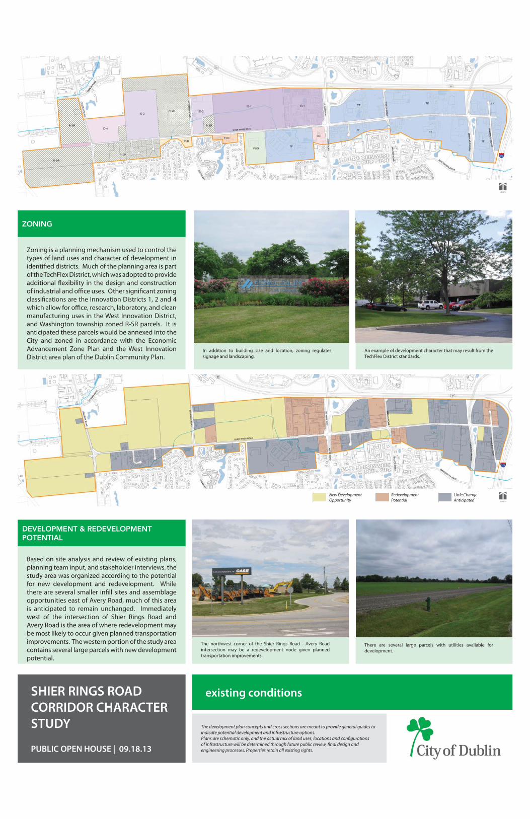
ZONING
Zoning is a planning mechanism used to control the types of land uses and character of development in identifi ed districts. Much of the planning area is part of the TechFlex District, which was adopted to provide additional fl exibility in the design and construction of industrial and offi ce uses. Other signifi cant zoning classifi cations are the Innovation Districts 1, 2 and 4 which allow for offi ce, research, laboratory, and clean manufacturing uses in the West Innovation District, and Washington township zoned R-SR parcels. It is anticipated these parcels would be annexed into the City and zoned in accordance with the Economic Advancement Zone Plan and the West Innovation District area plan of the Dublin Community Plan.
DEVELOPMENT & REDEVELOPMENT POTENTIAL
Based on site analysis and review of existing plans, planning team input, and stakeholder interviews, the study area was organized according to the potential for new development and redevelopment. While there are several smaller infi ll sites and assemblage opportunities east of Avery Road, much of this area is anticipated to remain unchanged. Immediately west of the intersection of Shier Rings Road and Avery Road is the area of where redevelopment may be most likely to occur given planned transportation improvements. The western portion of the study area contains several large parcels with new development potential.
In addition to building size and location, zoning regulates signage and landscaping.
An example of development character that may result from the TechFlex District standards.
The northwest corner of the Shier Rings Road - Avery Road intersection may be a redevelopment node given planned transportation improvements.
There are several large parcels with utilities available for development.
NORTH
WetlandsFloodplain Floodway Stream Protection ZoneNORTH
Redevelopment Potential
New Development Opportunity
Little Change Anticipated
NORTH
SHIER RINGS ROAD CORRIDOR CHARACTER STUDY
PUBLIC OPEN HOUSE | 09.18.13
NORTH
WetlandsFloodplain Floodway Stream Protection Zone
The development plan concepts and cross sections are meant to provide general guides to indicate potential development and infrastructure options. Plans are schematic only, and the actual mix of land uses, locations and confi gurations of infrastructure will be determined through future public review, fi nal design and engineering processes. Properties retain all existing rights.
existing conditions
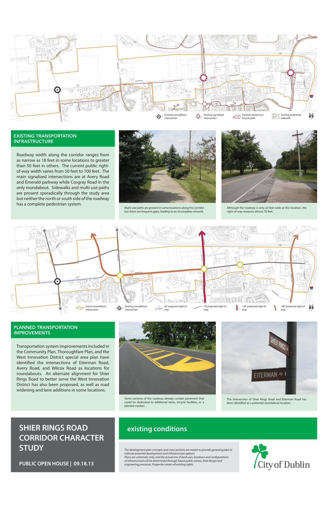
EXISTING TRANSPORTATION INFRASTRUCTURE
Roadway width along the corridor ranges from as narrow as 18 feet in some locations to greater than 50 feet in others. The current public right-of-way width varies from 50 feet to 100 feet. The main signalized intersections are at Avery Road and Emerald parkway while Cosgray Road in the only roundabout. Sidewalks and multi-use paths are present sporadically through the study area but neither the north or south side of the roadway has a complete pedestrian system.
PLANNED TRANSPORTATION IMPROVEMENTS
Transportation system improvements included in the Community Plan, Thoroughfare Plan, and the West Innovation District special area plan have identifi ed the intersections of Eiterman Road, Avery Road, and Wilcox Road as locations for roundabouts. An alternate alignment for Shier Rings Road to better serve the West Innovation District has also been proposed, as well as road widening and lane additions in some locations.
Multi-use paths are present in some locations along the corridor but there are frequent gaps, leading to an incomplete network.
Although the roadway is only 23 feet wide at this location, the right-of-way measure almost 70 feet.
Some sections of the roadway already contain pavement that could be dedicated to additional lanes, bicycle facilities, or a planted median.
The intersection of Shier Rings Road and Eiterman Road has been identifi ed as a potential roundabout location.
NORTH
124’ proposed right of way
60’ proposed right of way
70’ proposed right of way
100’ proposed right of way
Existing roundabout intersection
Future roundabout intersection
NORTH
WetlandsFloodplain Floodway Stream Protection ZoneNORTH
Existing shared use/ bicycle path
Existing signalized intersection
Existing pedestrian sidewalk
Existing roundabout intersection
Top Related