


Languages
Pages
Legal


AD-A237 595AftIII11 11 11 111111~IIIl11
Naval Oceanographic and SP 011:441 :91Atmospheric Research Laboratory November 1990
*SEVERE WEATHER GUIDEMEDITERRANEAN PORTS
32. TARANTO-DT I-C
%J U L 03 1991) I
069arfaram*wo 9~ssach Laborat
91-03775

CONTENTS
Foreword and Acknowledgments.............. . .. .. .. . ...
Preface..............................V
Record of Changes..................... . . ... . . .. . . I......
1. General Guidance..................... . . ... . . .. .. . . ...
1.1 Design........................ . .. ... . .. .. . . ...
1.1.1 objectives................... . . ... .. . . ...
1.1.2 Approach..................... . .. .. .. . . ...
1.1.3 Organization..................1-2
1.2 Contents of Specific Harbor Studies.........1-3
2. Captain's Summary. ... ....... ...... ... 2-1
3. General Information....................3-1
3.1 Geographic Location.................3-1
3.2 Qualitative Evaluation of the port of Taranto .. . 3-4
3.3 Currents and Tides..................3-5
3.4 Visibility...................... -
3.5 Seasonal Summary of Hazardous Weather Conditions .. 3-5
3.6 Harbor Protection..................3-9
3.6.1 Wind and Weather................3-10
3.6.2 Waves.....................3-10
3.6.3 Wave Data Uses and Considerations.......3-16
3.7 Protective and Mitigating Measures..........3-17
3.8 Indicators of Hazardous Weather Conditions.......3-18
3.8.1 Scirocco....................3-18
3.8.2 Bora.......................3-19
3.8.3 Mistral....................3-20
3.9 Summary of Problems, Actions and Indicators . . . . 3-22
References.........................3-27
Port Visit Information....................3-27
Appendix A -- General Purpose Oceanographic Information .. A-1
i
FOREWORD
This handbook on Mediterranean Ports was developed
as part of an ongoing effort at the Atmospheric Direc-
torate, Naval Oceanographic and Atmospheric Laboratory
(NOARL), Monterey, to create products for direct appli-
cation to Fleet Operations. The research was conducted
in response to Commander Naval Oceanography Command
(COMNAVOCEANCOM) requirements validated by the Chief of
Naval Operations (OP-096).
As mentioned in the preface, the Mediterranean
region is unique in that several areas exist where
local winds can cause dangerous operating conditions.
This handbook will provide the ship's captain with
assistance in making decisions regarding the
disposition of his ship when heavy winds and seas are
encountered or forecast at various port locations.
Readers are urged to submit comments, suggestions
for changes, deletions and/or additions to Naval
Oceanography Command Center (NAVOCEANCOMCFN), Rota with
a copy to the oceanographer, COMSIXTHFLT. They will
then be passed on to NOARL, Monterey for review and
incorporation as appropriate. This document will be a
dynamic one, changing and improving as morp and b-+4 +--r
information is obtained.
ACKNOWLEDGMENTS
The support of the sponsors -- Naval Oceanography
Command, Stennis Space Center, MS: and Fieet Numerical ton Fr IIOceanography Center, Montcrey, CA (Program Element ;p. !
O&M,N) -- is gratefully acknowledged. : IU t, C? or/
A' mdo
Di 1.
L_
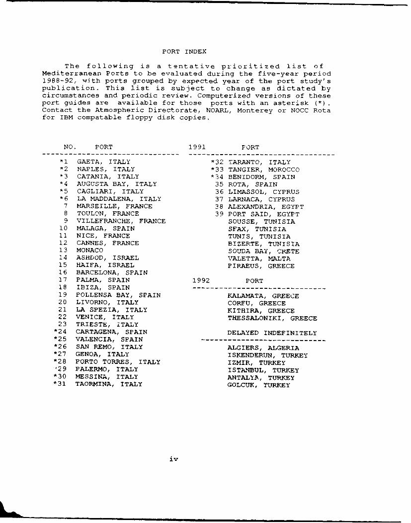
PORT INDEX
The following is a tentative prioritized list ofMediterranean Ports to be evaluated during the five-year period1988-92, w.ith ports grouped by expected year of the port study'spublication. This list is subject to change as dictated bycircumstances and periodic review. Computerized versions of theseport guides are available for those ports with an asterisk (*).Contact the Atmospheric Directorate, NOARL, Monterey or NOCC Rotafor IBM compatable floppy disk copies.
NO. PORT 1991 FORT
*1 GAETA, ITALY *32 TARANTO, ITALY*2 NAPLES, ITALY *33 TANGIER, MOROCCO*3 CATANIA, ITALY *34 BENIDORM, SPAIN*4 AUGUSTA BAY, ITALY 35 ROTA, SPAIN*5 CAGLIARI, ITALY 36 LIMASSOL, CYPRUS*6 LA MADDALENA, ITALY 37 LARNACA, CYPRUS7 MARSEILLE, FRANCE 38 ALEXANDRIA, EGYPT8 TOULON, FRANCE 39 PORT SAID, EGYPT9 VILLEFRANCHE, FRANCE SOUSSE, TUNISIA
10 MALAGA, SPAIN SFAX, TUNISIA11 NICE, FRANCE TUNIS, TUNISIA12 CANNES, FRANCE BIZERTE, TUNISIA13 MONACO SOUDA BAY, CRETE14 ASHDOD, ISRAEL VALETTA, MALTA15 HAIFA, ISRAEL PIRAEUS, GREECE16 BARCELONA, SPAIN17 PALMA, SPAIN 1992 PORT18 IBIZA, SPAIN19 POLLENSA BAY, SPAIN KALAMATA, GREECE20 LIVORNO, ITALY CORFU, GREECE21 LA SPEZIA, ITALY KITHIRA, GREECE22 VENICE, ITALY THESSALONIKI, GREECE23 TRIESTE, ITALY
*24 CARTAGENA, SPAIN DELAYED INDEFINITELY*25 VALENCIA, SPAIN --*26 SAN REMO, ITALY ALGIERS, ALGERIA*27 GENOA, ITALY I SKENDERUN, TURKEY*28 PORTO TORRES, ITALY IZMIR, TURKEY1 9 PALERMO, ITALY ISTANBUL, TURKEY
*30 MESSINA, ITALY ANTALYA, TURKEY*31 TAORMINA, ITALY GOLCUK, TURKEY
iv
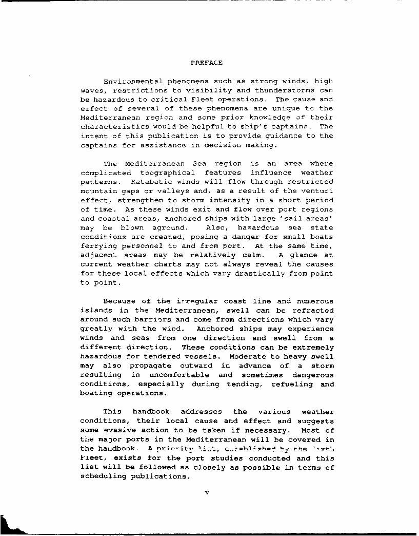
PREFACE
Environmental phenomena such as strong winds, high
waves, restrictions to visibility and thunderstorms can
be hazardous to critical Fleet operations. The cause and
effect of several of these phenomena are unique to the
Mediterranean region and some prior knowledge of their
characteristics would be helpful to ship's captains. The
intent of this publication is to provide guidance to the
captains for assistance in decision making.
The Mediterranean Sea region is an area where
complicated toographical features influence weatherpatterns. Katabatic winds will flow through restrictedmountain gaps or valleys and, as a result of the venturi
effect, strengthen to storm intensity in a short period
of time. As these winds exit and flow over port regionsand coastal areas, anchored ships with large 'sail areas'may be blown aground. Also, hazardous sea state
conditions are created, posing a danger for small boatsferrying personnel to and from port. At the same time,adjacenti' areas may be relatively calm. A glance at
current weather charts may not always reveal the causesfor these local effects which vary drastically from point
to point.
Because of the irregular coast line and numerous
islands in the Mediterranean, swell can be refractedaround such barriers and come from directions which varygreatly with the wind. Anchored ships may experiencewinds and seas from one direction and swell from a
different direction. These conditions can be extremelyhazardous for tendered vessels. Moderate to heavy swellmay also propagate outward in advance of a storm
resulting in uncomfortable and sometimes dangerous
conditions, especially during tending, refueling andboating operations.
This handbook addresses the various weatherconditions, their local cause and effect and suggests
some evasive action to be taken if necessary. Most of
the major ports in the Mediterranean will be covered in
the handbook. r iw-r-it: , '.izt, UY ! the xyhkleet, exists for the port studies conducted and this
list will be followed as closely as possible in terms of
scheduling publications.
v
RECORD OF CHANGES
CHANGE DATE OF DATE PAGE ENTERED BYNUMBER~~ENEP CD F-" NTRD NME
_ _ _ I _
I _ _ _ _
VI-'

1. GENERAL GUIDANCE
1.1 DESIGN
This handbook is designed to provide ship capLains
with a ready reference on hazardous weather and wave
conditions in selected Mediterranean harbors. Section 2,
the captain's summary, is an abbreviated version of
section 3, the general information section intended for
staff planners and meteorologists. Qnce section 3 has
been read, it is not necessary to read section 2.
1.1.1 Objectives
The basic objective is to provide ship captains witha concise reference of hazards to ship activities that
are caused by environmental conditions in variousMediterranean harbors, and to offer suggestions for
precautionary and/or evasive actions. A secondaryobjective is to provide adequate background informationon such hazards so that operational forecasters, or otherinterested parties, can quickly gain the local knowledgethat is necessary to ensure high quality forecasts.
1.1.2 Approach
Information on harbor conditions and hazards wasaccumulated in the following manner:
A. A literature search for reference material was
performed.B. Cruise reports were reviewed.C. Navy personnel with current or previous area
experience were interviewed.D. A preliminary report was developed which
included questions on various local conditions
in specific harbors.E. Port/harbor visits were made by NOARL person-
nel; considerable information obtained throughinterviews with local pilots, tug masters, etc;and local reference material was obtained.
F. The cumulative information was reviewed,
combined, and condensed for harbor studies.
1-i

1.1.3 Organization
The Handbook contains two sections for each harbor.
The first section summarizes harbor conditions and is
intended for use as a quick reference by ship captains,
navigators, inport/at sea OOD's, ana other interested
personnel. This section contains:
A. a brief narrative summary of environmental
hazards,
B. a table display of vessel location/situation,
potential environmentai hazard, effect-pre-
cautionary/evasion actions, and advance
indicators of potential environmental hazards,
C. local wind wave conditions, and
D. tables depicting the wave conditions resulting
from propagation of deep water swell into
the harbor.
The swell propagation information includes percent
occurrence, average duration, and the period of maximum
wave energy iithin height ranges of greater than 3.3 feet
and greater than 6.6 feet. The details on the generation
of sea and swell information are provided in Appendix A.
The second section contains additional details and
background information on seasonal hazardous conditions.
This section is directed to personnel who have a need for
additional insights on environmental hazards and related
weather events.
1.2 CONTENTS OF SPECIFIC HARBOR STUDIES
This handbook specifically addresses potential wind
and wave related hazards to ships operating in variousMediterranean ports utilized by the U.S. Navy. It does
not contain general purpose climatology and/or compre-
hensive forecast rules for weather conditions of a more
benign nature.
The contents are intended for use in both pre-visit
planning and in situ problem solving by either mariners
or environmentalists. Potential hazards related to
both weather and waves are addressed. The oceanographic
1-2

information include rather unique information relating todeep water swell propagating into harbor shallow waterareas.
Emphasis is placed on the hazards related to wind,wind waves, and the propagation of deep water swell intothe harbor areas. Various vessel locations/ situationsare considered, including moored, nesting, anchored,arriving/eparting, and small boat operations. Thepotential problems and suggested pre-cautionary/evasiveactions for various combinations of environmentalthreats and vessel location/situation are provided.Local indicators of environmental hazards and possibleevasion techniques ar. summarized for various scenarios.
CAUTIONARY NOTE: In September 1985 Hurricane Gloria rakedthe Norfolk, VA area while several US Navy ships wereanchored on the muddy bottom of Chesapeake Bay. Oneimportant fact was revealed during this incident: Mostall ships frigate size and larger dragged anchor, somemore than others, in winds of over 50 knots. As winds andwaves increased, ships 'fell into' the wave troughs,BROADSIDE TO THE WIND and became difficult or impossible
to control.
This was a rare instance in which several ships ofrecent design were exposed to the same storm and mucheffort was put into the documentation of lessons learned.Chief among these was the suggestion to evade at searather than remain anchored at port whenever winds ofsuch intensity were forecast.
1-3
2. CAPTAIN'S SUMMARY
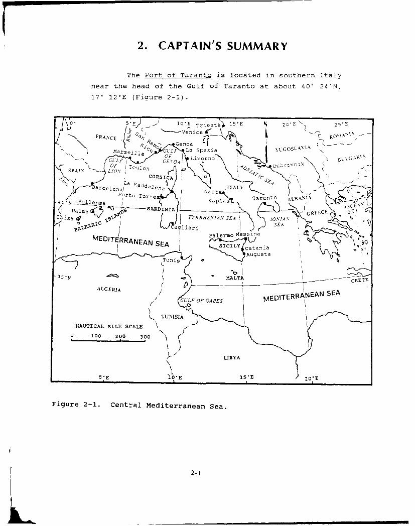
The Port of Taranto is located in southern Italy
near the head of the Gulf of Taranto at about 400 24'N,
170 121E (Figure 2-1).
10CE Triest415
FR A C IScj -- venicep ~ Genoa
M~arseille c~c GULF La spezia yljGOSLAN'1 AOF Livorno
CORSICA -" /c2'
Barcelonaj 'aae~ a) ITALYC
' 'rt oreTaranto ALAI
-P0 11TenR aEIIAEGSEAPalma SARINIA S F:bzaV ' -A )IRHA'A,, EA1 JN RKC
SEA
Paem M00s20i30
FigureF 2-1 Centra MediterraneaN Sea.
LIY
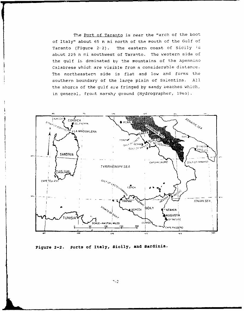
The Port of Taranto is near the "arch of the boot
of Italy" about 65 n mi north of the vrouth of the Gulf of
Taranto (Figure 2- 2). The eastern coast of Sicily i-s
abL.ut 225 n rd southwest of Taranto. The western side of
the gulf iE. dominated by the mountains of the Apennino
Calabrese which are visible from a considerable distance.
The northeastern side is flat and low and forms the
southern boundary of the large plain of Salentina. All
the shorcs of the gulf ai-e fringed by sandy beaches which,
in general, fron~t marshy ground (Hydrographer, 19b5).
AACC CORSICA4" ~SOLEWAA ROM
L4 LA M A DDA LENA T
09NT
C~rI p NlO IAF )FTAAA
TYRRHENIAN SEA
CAPE CuLAO G
- ETRAPANI-
SCIACCA 'TANIA
TUNISIAAUST- SALE-NAJTIAL MLSCOMISOV"
CAPE PASS ACI
Figure 2-2. Ports of Italy, Sicily, and Sardinia.
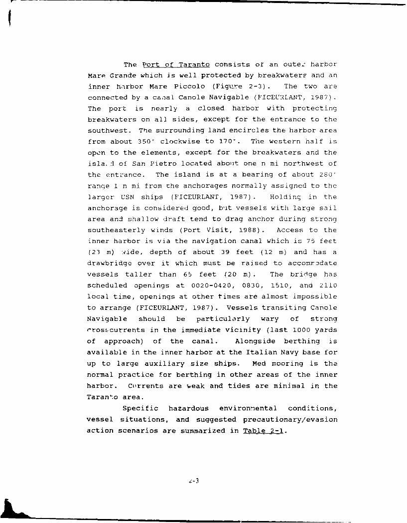
The Port of Taranto consists of an outez harbor
Mare Grande which is well protected by breakwaters and an
inner harbor Mare Piccolo (Figlire 2-3). The two are
connected by a canal Canole Navigable (FICEURLANT, 1987).
The port is nearly a closed harbor with protecting
breakwaters on all sides, except for the entrance to the
southwest. The surrounding land encircles the harbor area
from about 350' clockwise to 1700. The western half is
open to the elements, except for the breakwaters and the
isla. I of San Pietro located about one n mi northwest of
the entrance. The island is at a bearing of about 280'
range 1 n mi from the anchorages normally assigned to the
larger USN ships (FICEURLANT, 1987) . Holdinq in the
anchorage is considered good, but vessels with large sail
area and shallow draft tend to drag anchor during strong
southeasterly winds (Port Visit, 1988) . Access to the
inner harbor is via the navigation canal which is 75 feet
(23 m) wide, depth of about 39 feet (12 m) and has a
drawbridge over it which must be raised to accomrodate
vessels taller than 65 feet (20 m). The bridge has
scheduled openings at 0020-0420, 0830, 1510, and 2110
local time, openings at other times are almost impossible
to arrange (FICEURLANT, 1987). Vessels transiting Canole
Navigable should be particularly wary of strong
crosscurrents in the immediate vicinity (last 1000 yards
of approach) of the canal. Alongside berthing is
available in the inner harbor at the Italian Navy base for
up to large auxiliary size ships. Med mooring is the
normal practice for berthing in other areas of the inner
harbor. Currents are weak and tides are minimal in the
Taranto area.
Specific hazardous environmental conditions,
vessel situations, and suggested precautionary/evasion
action scenarios are summarized in Table 2-1.
L-3
NAUTICAL MILE SCALE
0 1:1 3!4 1 311.2 2
DEPTH CO YTOLS F \ 5 tETEA 5
% WEST PORT
.~1O. IMARE PICCOLO*40'29'N
____ ~ ~ ~ ~ Pq ________________ 42§
s-10 -
S NAVIGATIONIC /CANAL\
I Scca~ TARANTOdells Sir ens
Lo Scsnno MARE GRANDE
SAN-),I.S TaTrs n IIa 40 27TN
30 ~.O~O~. .PAOLO/
GOLFO DI TARANTO K
17TE: 17 16'E
Figure 2-3. Port of Taranto, Italy.
2-4

Table 2-1. Summary of hazardous environmental conditionz for tne Port of T-
VESSEL LOCATION,' [FEHAZARDOUS CONDITION INDICATORS OF POTENTIAL HAZARD SITUATION AFFECTED EFFE
1. Strong SE wind. Scirocco event. Advance Warning (1) Anchored in outer harbor. (a) Shps with* 40-50 kt . Abnormal rising temperature Be er r
Occurs 4 to 5 times per winter * Increasing clouds to the south Inner ac* SE wgves refract into outer harbor * Fatting barometer
Reach 6-10 ft (2-3 m) from the Sw * Low pressure center to northwest (b) Wind and seasAre 90
° out of phase with wind * Rise in water level Deploy s-
Fog and rain with east to south winds Be awareespecialty in May and June atongs d,
(2) Arriving/departing. (a) Waves w l l rL "Beware
(t) VisibiLity* Se.ate
(3) Pass3qe through canal. (a) Strong csc-Passage C,
(4) Moored - inner harbor. (a) Nornalls useAdd incs
(5) Smatl boat opera!,ons. (a) Generaly c,-. Cross -'C
2. Strong Y1W wind. Mistral event. Advance Warning (1) Anchored in outer harbtr. (a) Wnrds mere* 40 kt, waves limited by short fetch . Mistral outbreak advancing from Gulf of . lskanc-* Occurs during January and February Lion to Western Italy Ir-er e,* Near freezing winter temperatures * Lasts for several days but light at night.
Wind chit[ below freezing (b) Wind chit
(2) Arriving/departinS. (a) Daytme c-w-c. Eart, nec'
(b) Wind chill -
(3) Passage through canal. (a) Cross w7r C. Early n
(b) wind chill ,
(4) Moored - nner harboc. (a) Daytime o''5-. Add tine
(b) WInd ch!rl , ,
(5) Small boat operations. (a) Wind and wir-" Use caut,." Issue C(Vt
2-5
L ~ 'lnnnnm ni|nnmm

Lronmental conditions for the Port of Taranto, Italy.
VESSEL LOCATION/ EFFECT - PRECAUTIONARY/EVASIVE ACTIONSSITUATION AFFECTED I
(1) Anchored in outer harbor (a) Ships with large sail area and sha low draft tend to drag anchor.* Better protection in eastern outer harbor* Inner harbor offers best protection
(b) Wind and seas 90 degrees out of phase with swell.
* Deploy second anchor
Be aware of different responses by various length vessels during
atongside/welt deck operations.
(2) Arriving/departing. (a) Waves will refract into harbor ent-ance.. Beware of cross winds, following seas entering, read seas departing.
(b) Visibility reducd in rain and fog.* B,4rc of many unt;ghtcd moor'ng .:Oi'y.
(3) Passage through canal. (a) Strong cross wind plus crosscurrent in vicinity of canal.
Passage during strong winds hazardous.
(4) Moored - inner harbor. (a) Normally use Med mooring.* Add tines or move to alongside berth
(5) Small boat operations. (a) Generally cancelled during strong events due to high waves.* Cross wind/wave patterns added hazard.
(1) Anchored in outer harbor. (a) Winds more than waves wilt affect anchored ships.
* Island of San Pietro may afford Limited protection* Inner harbor better protected
(b) Wind chill may be hazard during winter.
(2) Arriving/departing. (a) Daytime winds biggest problem.* Early morning or after sunset tighter winds
(b) Wind chill may be hazard during winter.
(3) Passage through canal. (a) Cross wind and currents, and low SOA cause ship handling problems.. Early morning at after sunset passage reduces wind effect.
(b) Wind chill may be hazard during winter.
(4) Moored - inner harbor. (a) Daytime winds problem for Med moored vessels.* Add lines or move to alongside berth
(b) Wind chill may be hazard during winter.
15) Small boat operations. (a) Wind and wind chill primary problems.* Use caution in boat handling
* issue cold weather gear

Table 2-1. (Continued)
HAZARDOUS CONDITION INDICATORS OF POTENTIAL HAZARD VESSEL LOCATION/ EFFSITUATION AFFECTED
3. Strong SW wind, Lebeccio event. Advance Warning (1) Anchored in outer harbor. (a) E* 30-40 kt, limited fetch (25-30 nmi) * Strong in daytime, calming after sunset* Generally spring or fall events * Generally of I or 2 day duratioi
(2) Arriving/departing. (a) Fo,
(3) Passage through canal. (a) Fo,
(4) Moored - inner harbor. (a) Ma,
(5) Smal boat operations. (a) ,
4. NE wind. Flow off Adriatic Sea. Advance Warning (1) Anchored in outer harbor. (a) sh a" 25-30 kt with sudden onset * Developing high pressure over northern* Lasts for several days Italy and/or tow passing eastward south of
Strongest in afternoon area. (2) Arriving/departing, (a) OSLight to calm at night . Sudden onset most likely to occur in
* Occurs September through March morning.Winter freezing temperatures . May kast severa days, but light at nightWind chills 0 to -101F * Belt of clouds form on hills north of inner (3) Passage through canal. (a) S..oJ
harbor and remain for duration of event.
(4) Moored - inner harbor. (a) M!n
(5) Snmll boat operations. (a) Ra
2-7
>3ble 2-1. (Continued)
VESSEL LOCATION/ EFFECT - PRECAUTIONARY/i v.IVE ACTIONSSITUATION AFFECTED
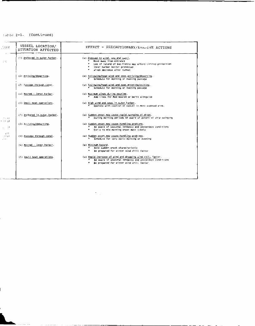
(I) Anchored in outer harbor. (a) Exposed to wind, sea and swell.. Move away from entrance. Lee of island of San Pietro way afford limited protection* Inner harbor better protected* Winds decrease after sunset
(2) Arriving/departing. (a) Fotlowing/head wind and seas arriving/departing.. Schedule for morning or evening passage
(3) Passage through carat. (a) Following/head wind and seas entering/exiting.* Schedule for morning or evening passage
(4) Moored - inner harbor. (a) Maximum winds duing daytime.* Add Lines for Med moored or berth alongside
(5) Small boat operations. (a) High wind and seas in outer harbor.* Operate with caution or cancel in most exposed area.
(1) Anchored in outer harbor. (a) Sudden onset may cause rapid swinging of ships.
During morning periods be aware of potential ship swinging
f1(2) Arriving/departing. (a) Sudden onset may cause handling problems.
* Be aware of seasonal tendency and yesterdays conditions* Early to mid morning onset most likely
(3) Passage through canal. (a) Sudden onset may cause handling problems.* Schedule for very early morning or evening
(4) Moored - inner harbor. (a) Minivmm hazard.* Note sudden onset characteristic
a Be prepared for winter wind chill factor
(5) Small boat operations. (a) Rapid increase of wind and dropping wind chill factor.* Be aware of seasonal tendency and yesterdays conditions* Be prepared for winter wind chill factor
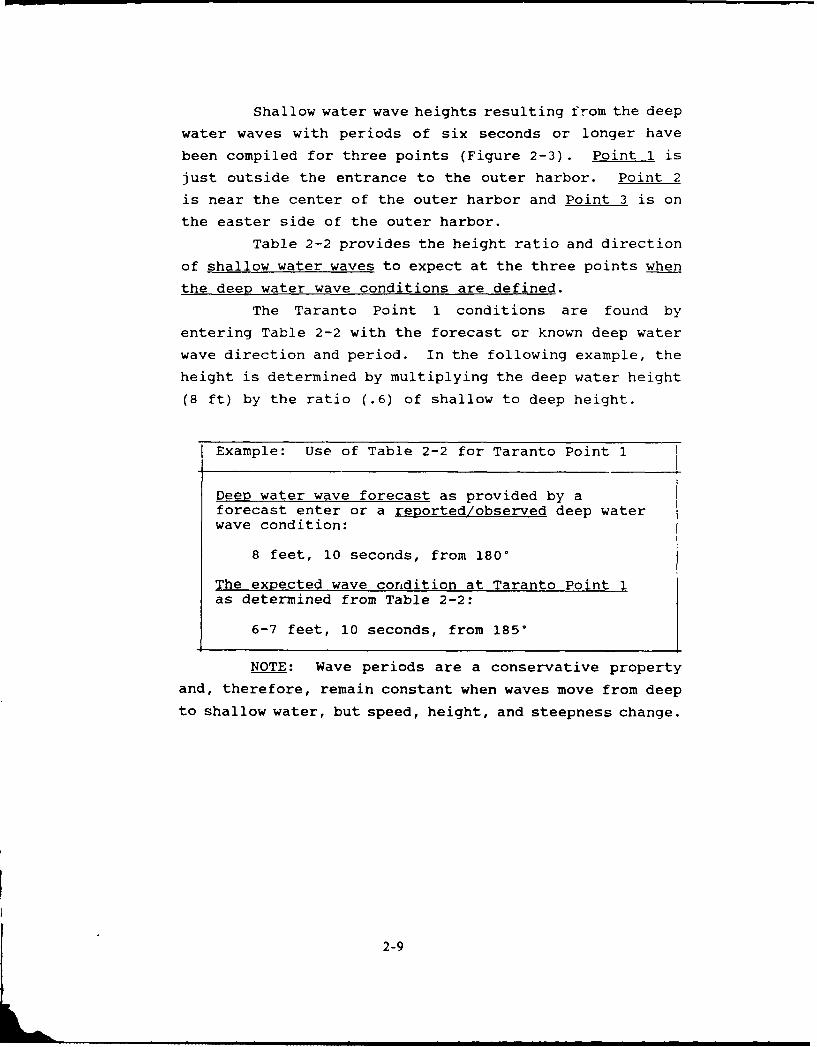
Shallow water wave heights resulting from the deep
water waves with periods of six seconds or longer have
been compiled for three points (Figure 2-3). Point 1 is
just outside the entrance to the outer harbor. Point 2
is near the center of the outer harbor and Point 3 is on
the easter side of the outer harbor.
Table 2-2 provides the height ratio and direction
of shallow water waves to expect at the three points when
the deep water wave conditions are defined.
The Taranto Point 1 conditions are found by
entering Table 2-2 with the forecast or known deep water
wave direction and period. In the following example, the
height is determined by multiplying the deep water height
(8 ft) by the ratio (.6) of shallow to deep height.
Example: Use of Table 2-2 for Taranto Point 1
Deep water wave forecast as provided by aforecast enter or a reported/observed deep waterwave condition:
8 feet, 10 seconds, from 180 °
The expected wave condition at Taranto Point 1as determined from Table 2-2:
6-7 feet, 10 seconds, from 185 °
NOTE: Wave periods are a conservative property
and, therefore, remain constant when waves move from deep
to shallow water, but speed, height, and steepness change.
2-9
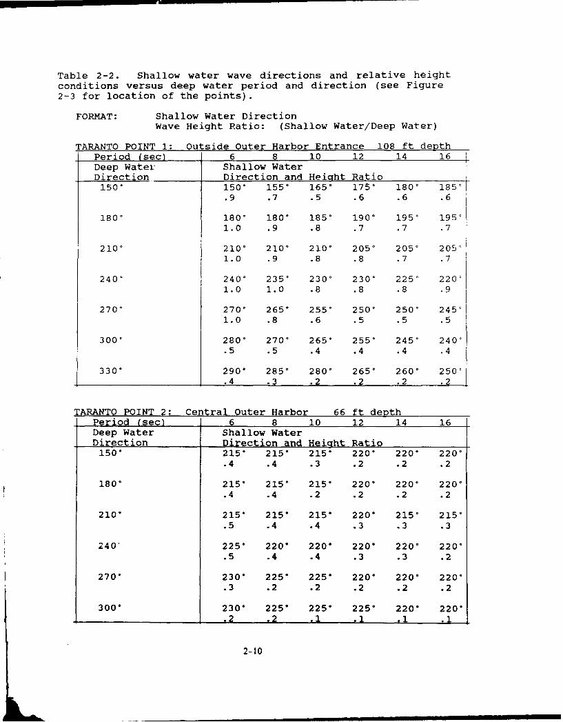
Table 2-2. Shallow water wave directions and relative heightconditions versus deep water period and direction (see Figure2-3 for location of the points).
FORMAT: Shallow Water DirectionWave Height Ratio: (Shallow Water/Deep Water)
TARANTO POINT 1: Outside Outer Harbor Entrance 108 ft depthPeriod (sec) 6 8 10 12 14 16Deep Water Shallow WaterDirection Direction and HeiQht Ratio150 ° 150 ° 155* 165* 1750 180 ° 185'
.9 .7 .5 .6 .6 .6
1800 180, 180 ° 185 ° 190 ° 1950 19511.0 .9 .8 .7 .7 .7
210 ° 210 ° 210 ° 2100 2050 2050 205'1.0 .9 .8 .8 .7 .7
240' 240' 235' 230* 230 ° 225 ° 220'1.0 1.0 .8 .8 .8 .9
270' 270 ° 265 ° 2550 250 ° 250 ° 245'1.0 .8 .6 .5 .5 .5
300 ° 280 ° 270 ° 265* 255 ° 2450 240'
.5 .5 .4 .4 .4 .4
3300 290 ° 285 ° 280 ° 265 ° 2600 250'
.4 .3 .2 .2 .2 .2
TARANTO POINT 2: Central Outer Harbor 66 ft depthPeriod (sec) 6 8 10 12 14 16Deep Water Shallow WaterDirection Direction and Height Ratio150 ° 215 ° 215" 215" 220 ° 220 ° 2200
.4 .4 .3 .2 .2 .2
180 ° 215 ° 215 ° 215 ° 220 ° 220" 220'.4 .4 .2 .2 .2 .2
210 ° 215" 215" 215" 220* 215 ° 215 °
.5 .4 .4 .3 .3 .3
240' 225" 220" 220" 220" 220" 220*.5 .4 .4 .3 .3 .2
270" 230" 225" 225" 220" 220 220 °
.3 .2 .2 .2 .2 .2
300" 230" 225" 225" 225* 220* 220 °
.2 .2 .1 .1 ,i .1
2-10

Table 2-2 (Continued).
TARANTO POINT 3: East Side of Outer Harbor 42 ft depthPeriod (sec) 6 8 10 12 14 16Deep Water Shallow WaterDirection Direction and Height Ratio1500 2400 2400 2400 2450 2500 260'
.2 .2 .15 .15 .1 .1
1800 2400 240' 240 ° 2450 2500 260'.25 .2 .15 .15 .1 .1
2100 245' 2500 2500 2500 2500 2600.35 .25 .2 .15 .15 .1
2400 235 ° 2350 240' 2450 2500 2600.3 .2 .2 .15 .15 .1
2700 2400 2400 245 ° 2500 2500 2600.2 .15 .15 .15 .15 .1
300* 2400 2450 2500 2500 2600 260'
.15 .15 .1 .1 .1 .1
The local wind-generated wave conditions for the
anchorage area identified as Points 1, 2, and 3 are given
in Table 2-3. All heights refer to the significant wave
height (average of the highest 1/3 waves). Enter the
local wind speed and direction in this table to obtain the
minimum duration in hours required to develop the
indicated fetch limited sea height and period. The time
to reach fetch limited height is based on an initial flat
ocean. When starting from a pre-existing wave height, the
time to fetch limited height will be shorter.
2-11
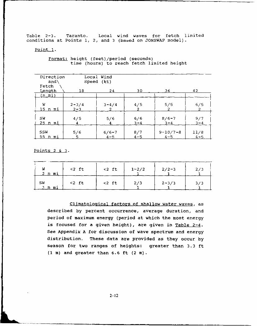
Table 2-3. Taranto. Local wind waves for fetch limited
conditions at Points 1, 2, and 3 (based on JONSWAP model).
Point 1.
Format: height (feet)/period (seconds)time (hours) to reach fetch limited height
Direction Local Windand\ Speed (kt)
Fetch \Length 18 24 30 36 42(n mi)
W 2-3/4 3-4/4 4/5 5/5 6/515 n mi 2-3 2 2 2 2
SW 4/5 5/6 6/6 8/6-7 9/725 n mi 4 4 3-4 3-4 3-4
SSW 5/6 6/6-7 8/7 9-10/7-8 11/855 n mi 5 4-5 4-5 4-5 4-5
Points 2 & 3.
W <2 ft <2 ft 1-2/2 2/2-3 2/32 n mi 1 1 1
SW <2 ft <2 ft 2/3 2-3/3 3/3-3 n mi I _1__1 1 1 1
Climatological factors of shallow water waves, as
described by percent occurrence, average duration, and
period of maximum energy (period at which the most energy
is focused for a given height), are given in Table 2-4.
See Appendix A for discussion of wave spectrum and energy
distribution. These data are provided as they occur by
season for two ranges of heights: greater than 3.3 ft
(1 m) and greater than 6.6 ft (2 m).
2-12

Table 2-4. Shallow water climatology as determined from deepwater wave propagation. Percent occurrence, average duration orpersistence, and wave period of maximum energy for wave heightranges of greater than 3.3 ft (1 m) and greater than 6.6 ft (2 m)by climatological season.
TARANTO POINT 1: WINTER SPRING SUMMER AUTUMN
>3.3 ft (1 m) NOV-APR MAY JUN-SEP OCT
Occurrence (%) 22 12 7 25
Average Duration (hr) 16 16 29 15
Period Max Energy(sec) 8-9 8-9 6-8 8
>6.6 ft (2 m) NOV-APR MAY JUN-SEP OCT
Occurrence (%) 4 1 1 3
Average Duration (hr) 11 9 18 11
Period Max Energy(sec) 9 9-10 11-12 9
TARANTO POINT 2: WINTER SPRING SUMMER AUTUMN>3.3 ft (1 m) NOV-APR MAY JUN-SEP OCT
Occurrence (%) 5 3 0 4
Average Duration (hr) 14 10 NA 9
Period Max Energy(sec) 8 8 NA 8
>6.6 ft (2 m) NOV-APR MAY JUN-SEP OCT
Occurrence (%) <1 0 0 0
Average Duration (hr) 8 NA NA NA
Period Max Energy(sec) 9 NA NA NA
TARANTO PT 3Deep water waves (swell) propagating into the outer
harbor are not expected to reach Point 3 at heights greaterthan 3.3 ft (1 m). Note, however, that combined wind waves(sea) and swell can result in waves greater than 3.3 ft atPoint 3. For example, if both swell and seas were 3 ft,the combined waves would exceed 4 ft (J32 + 32 = 4.2 ft).This condition would be most likely under southwesterlyflow where the open sea swell enters the harbor withminimum refraction, the fetch length within the harbor ismaximum relative to Point 3, and the swell and sea wavesdirection are closely aligned.
2-13
SEASONAL SUMMARY OF TARANTO HAZARDOUS WEATHER CONDITIONS
Confused, rough choppy wave conditions will occur
throughout the outer harbor when strong southerly wind generated
swell is refracted through the harbor entrance and approaches a
900 out-of-phase direction with local wind waves.
WINTER (November through February):* Scirocco winds: Worst conditions, SE'ly 40-50 kt, four
to five events per winter. Swell and seas out of phasein outer harbor, cause great disturbance to ships, boatinggenerally cancelled.
* Anomalous radar and radio propagation during Sciroccoevents. Helicopters may lose contact at 1 to 2 miles.Ship to shore communications may be disrupted even withinthe outer harbor.
* Winter winds generally northerly, events last for severaldays, strongest in daytime and light at night.
* Mistral: NW 30-40 kt, waves fetch limited.* Bora: NE'ly 25-35 kt, sudden onsets from light to 25+ kt.
SPRING (March through May)* Strong wind events generally from SW, short duration (1
or 2 days) and dropping off at night. Can generateunfavorable wave conditions for boating in outer harborduring early spring.Fog and rain with southeasterly winds, visibility nearzero for a few hours during morning likely a couple timesper year in May early June.
* Anomalous radar and radio propagation during Sciroccoevents. Helicopters may lose contact at 1 to 2 miles.Ship to shore communications may be disrupted even withinthe outer harbor.
SUMMER (June through September)* Daily weak south to southwest sea breeze* Thunderstorms two to four days per month, generally weak.
AUTUMN (October)* Prevailing winds return to northerly directions.* Thunderstorm activity limited to one or two days.* Daily maximum/minimum temperature drop about 10°F from
summer, now average 72 ° and 58°F.
NOTE: For more detailed information on hazardous weatherconditions, see previous Table 2-1 in this section and HazardousWeather Summary in Section 3.
2-14
References
FICEURLANT, 1987: Port Directory for Taranto (1986), Italy.
Fleet Intelligence Center Europe and Atlantic, Norfolk, VA.
Hydrographer, 1965: Mediterranean Pilot Vol. II. 9th Edition.
Hydrographic Department, London.
Port Visit Information
May 1988: NOARL Meteorologists R. Fett and D. Perryman met with
Chief Pilot Augusto De Bellis to obtain much of the information
included in this report.
2-15

3. GENERAL INFORMATION
This sectifl is int. nded for Fleet meteorolog ists/
oceanographers and staff plarnars. Paragraph 3.5 provides
a general discussion of hazards and Table 3-5 provides a
summary of vessel locatiors/situations, pot,,.ntial hazards,
effects, precautionary/evasive actions, and advance
indicators and other information.
3.1 Geographic Location
The Port of Taranto is located in southern Italv
near the head of the Gulf of Taranto at about '0 24'N,
17' 12'E (Figure 3-1).
C, , 1OETrieEt 4 15*E 20E
FRA NCE
Spezi3 l:GOSLAVIA
~irele OF ;Livorno AI
SPAIN LIOA U>
P1 J rc"I 2
n madena ITALY
Pcro ore e Taranto ALB I
SICILY- ollenia N
SE
MEDITE iMRRATAERRSE PalSEA
A0 SI00L F-tani
L9Auut
WUTCA MILE SCLE TNII
Figure 3-1. Central Mediterranean Sea.
3-1
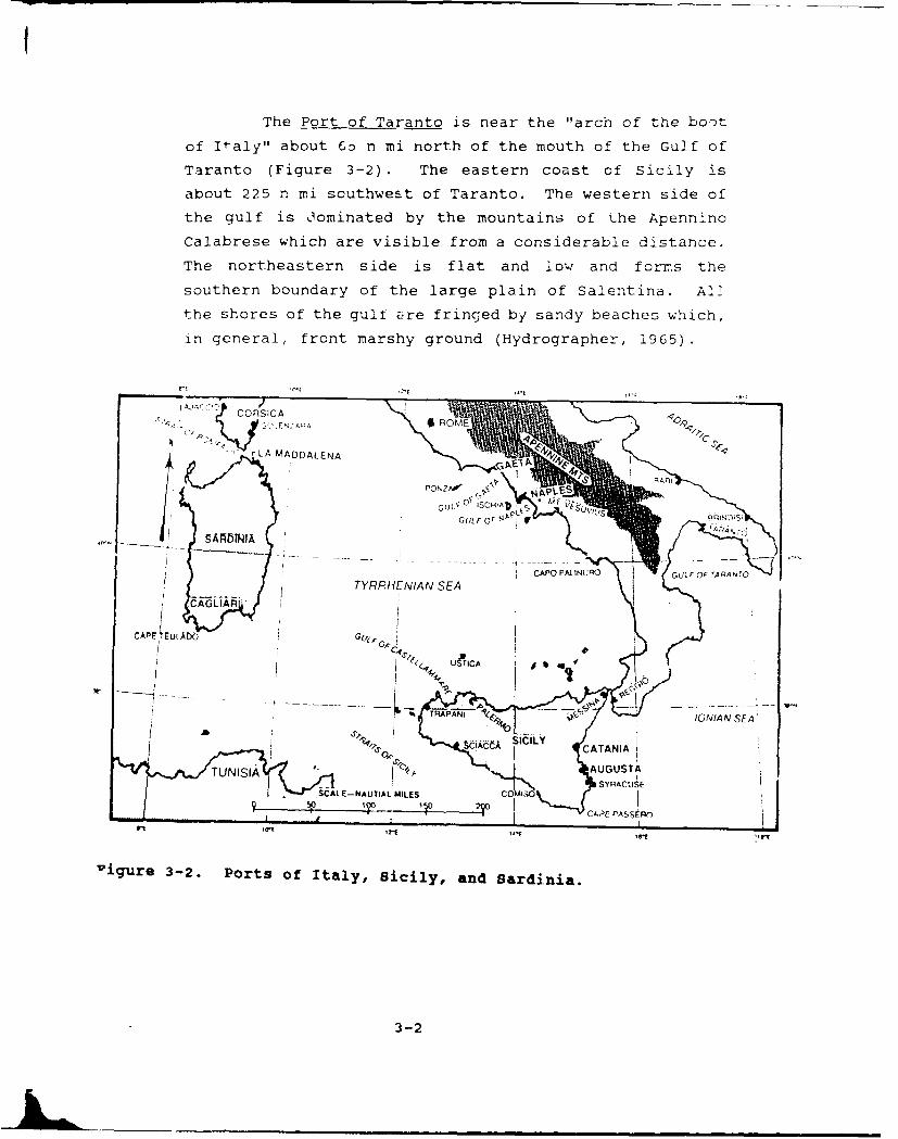
The Port of Taranto is near the "arch of the boot
of Italy" about 6o n mi north of the mouth of the Gulf of
Taranto (Figure 3-2) . The eastern coast of Sicily is
about 225 n mi southwest of Taranto. The western side of
the gulf is Oominated by the mountains of the Apennino
Calabrese which are visible from a considerable distance.
The northeastern side is flat and low and forns the
southern boundary of the large plain of Salentina. All
the shores of the gull are fringed by sandy beaches which,
in general, front marshy ground (Hydrographer, 1965).
CATRRHNIAASE
j r [LA MA DDALENA ." E" jl ,? i
TRAP~F~(~R A -
SSCALE-NAUTIAL MILES AUG US
CAAASSiC)
Tigure 3-2. Ports of Italy, icilyO, anS ardinia.
3-2
SI I Y CA A IT NI I AUiGUS.. . ...

The Port of Taranto consists of an outer harbor
Mare Grande and an inner harbor Mare Piccolo (Figure
3-3). The two are connected by a narrow canal Canole
Navigable (FICEURLANT, 1987). The port is nearly a closed
harbor with protecting breakwaters on all sides of the
outer harbor except for the entrance to the south-e.
The inner harbor is surrounded by land except for the
canal. The town of Taranto lies at the head of Mare
Grande and extends across the neck of land separating the
two harbors. The outer harbor is large, extending
slightly over 3 n mi from the entrance on the southwest
to the canal to the northeast. The southeast-northwest
length is over 4 n ri. The port is primarily a naval
base. The Italian Navy's principal southern base is in
Mare Piccolo. Numerous alongside berths are available at
the Italian Navy piers for ships through large auxiliary
size (FICEURLANT, 1987).
NAUTICAL WLE SCAE
I MARE PICCOLO
- "'NAVIGATION
, .... MARE GRANDE,
"- AN[ s 27,NPIETO
-r
GOtFO 01 1 ARANTO
17'16'E
Figure 3-3. Port of Taranto, Italy.
3-3
3.2 Qualitative Evaluation of the Port of Taranto
The harbor is protected from all ocean sea waves
except for the southwesterly wind-driven sea and swell
which enters the outer harbor through the relatively wide
entrance. The surrounding land is relatively flat so
there are no significant funneling or other terrain
influences on the winds. Land surrounds the inner harbor
completely and the outer harbor from about 350 ° clockwise
to 1700. The western half of the outer harbor is open to
the elements, except for the breakwaters and the island
of San Pietro located about one n mi northwest of the
entrance. The island is at a bearing of about 2800 range
1 n mi from the anchorages normally assigned to the larger
USN ships (FICEURLANT, 1987). High winds can raise wind
waves of 3 ft (1 m) or more in the outer harbor. Deep
water swell, while significantly reduced, does propagate
through the entrance as a general southwest swell in the
outer harbor. With strong southeasterly winds the
combination of cross swell with wind and wind waves
produces conditions hazardous enough to cancel small boat
operations and most other operations for anchored ships.
Holding conditions are considered good, but under
40+ kt winds ships with large sail areas and/or shallow
draft have been known to drag anchor. Conditions are
generally less hazardous on the east side of the outer
harbor.
Entry to the inner harbor through the canal should
be approached with caution. Strong cross-currents are
experienced in the final 1000 yds of approach. During
high wind conditions passage through the canal is not
recommended. The low flat terrain surrounding the inner
harbor provides little protection from winds.
3-4
3.3 Currents and Tides
Currents are weak and tides are minimal in
the Taranto area. However, currents in and near the
canal are irregular both in strength and direction. A
rising water level of one or two feet often precedes
the arrival of strong southeasterly winds.
3.4 Visibility
During spring and early summer southeasterly winds
frequently bring rain and fog. Early to mid-morning
visibility will be reduced to near zero two or three
times each year. Conditions typically improve after
about three hours. The normal Mediterranean summer-
time haze conditions are to be expected. Slant range
visibilities are most affected during hours of sun-
light.
3.5 Seasonal Summary of Hazardous Weather Conditions
A seasonal summary of the various known
environmental hazards that may be encountered in
the Port of Taranto follows.
A. Winter (November through February)
The seasonal weather patterns of the Taranto area
are controlled to a large extent by the monsoonal
behavior of both the Eurasia land mass to the north
and the Sahara Desert to the south. During winter
high pressure dominates these two land masses and the
storm track is found over the relatively warm waters
between them; unsettled, windy weather is common
(Brody and Nestor, 1980).
Strong southerly Scirocco winds are the cause of the
most extreme weather conditions at Taranto. In winter,
four or five Scirocco events will develop that result
in 40+ kt winds and heavy southerly swell. The swell
refracts into the outer harbor throu-gh the southwest
entrance resulting in a near 901 out of phase swell
wave train with the southeasterly wind and wind waves.
The primary synoptic pattern that causes Sciroccos is
low pressure over the Mediterranean that extends
3-5

southward into North Africa. Two patterns that are
likely to cause a Scirocco are: 1) A cyclone forming
over North Africa and tracking northward such thatTaranto remains in the warm sector and 2) a cold frontapproaching from the western Mediterranean that extends
southward over the Mediterranean into North Africa
thereby placing Taranto in the warm air ahead of the
front.
The prevailing winter winds are northerly over theTaranto area. The most frequent strong wind events are
associated with Bora outbreaks of northeasterly wind
off the Adriatic. These winds flow over the flat lands
to the east of Taranto. They typically :rrive with asudden onset of 25+ kt. This is most likely to occurin mid to late morning as thb offshore northerly winds
tend to be strongest during the day time and quitelight at night. ".ight time land surface cooling and
development or low level inversions/stable layers arethe typical cause of the drop off of northerly winds at
nignt. Mistral events Lring northwesterly 30-40 ktwinds to the area. The Mistral reaches Taranto only
under the strongest events. The main, necessary
synoptic features are strong eastern Atlantic blockingand a deep 500 mb trough over the central Mediterranean
that extends into northern Africa. With this pattern
Genoa lows will move southeastward into the Ionian Seaand following their passage to the east Mistral condi-
tions may occur. Extended periods of a week or more of
bad weather will be experienced in the Taranto areawhen a Genoa low stalls west of southern Italy, and a
series of secondary lows form over the Ionian Sea.
Under this pattern Taranto will experience prolonged
rainy, squally conditions with winds switching from
southerly ahead of each low to northerly as it passes.
The Taranto area is somewhat arid, averaging 18
inches (483 mm) of precipitation a year. In the cold
season, October through March, precipitation aver-ages 1.3 inches per month with average frequency of
3-6
occurrence being about 7 days per month. Snow showers can
be expected on a couple days during January and February.
Rainfall during June through mid September is at a minimum
averaging less than 1/2 inch per month in the form of
afternoon showers.
The Mediterranean climate is reflected in the mild
temperatures. Daily mean maximum and minimum range from
54/43-F (12/6-C) in December to 86/72°F (30/22°C) in July
and August. Mean annual extremes range from 95°F (35°C)
to 30°F (-l°C). Several days per month for December
through February will experience freezing or near freezing
temperatures in the morning hours. Periods of Bora winds
bring the lowest temperatures and cause for concern for
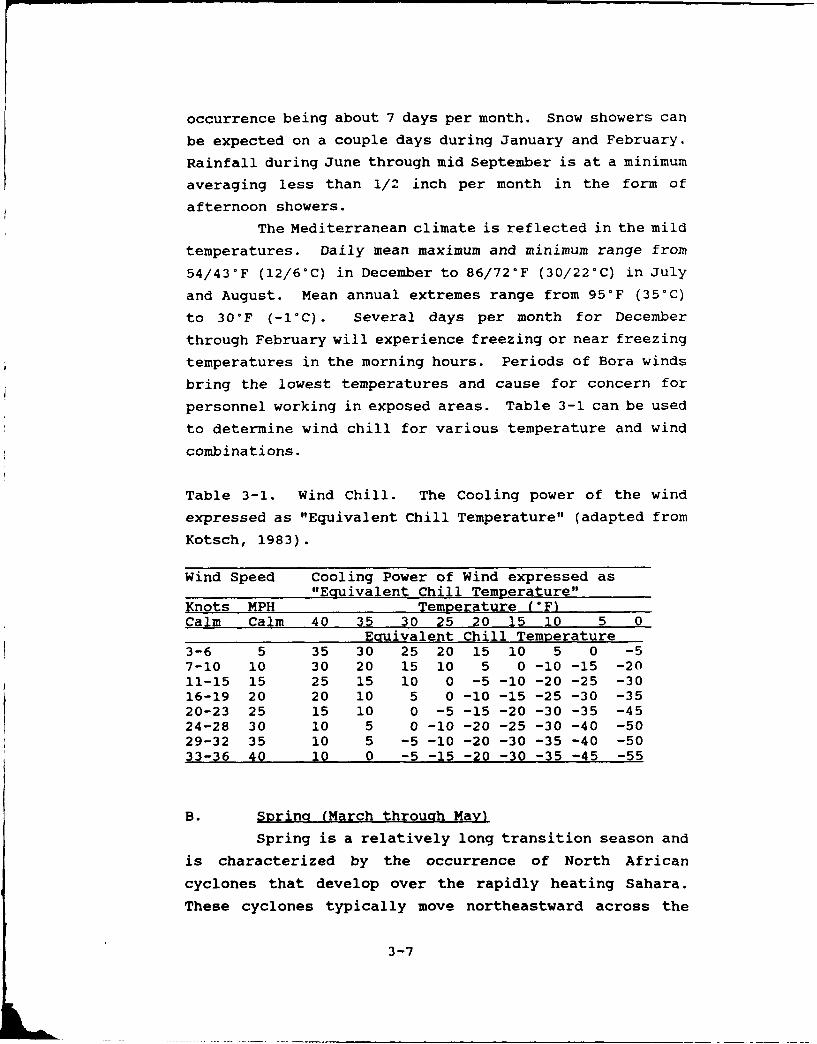
personnel working in exposed areas. Table 3-1 can be used
to determine wind chill for various temperature and wind
combinations.
Table 3-1. Wind Chill. The Cooling power of the wind
expressed as "Equivalent Chill Temperature" (adapted from
Kotsch, 1983).
Wind Speed Cooling Power of Wind expressed as"Ecquivalent Chill Temperature"
Knots MPH Temperature (°F)Calm Calm 40 35 30 25 20 15 10 5 0
Euivalent Chill Temperature3-6 5 35 30 25 20 15 10 5 0 -57-10 10 30 20 15 10 5 0 -10 -15 -2011-15 15 25 15 10 0 -5 -10 -20 -25 -3016-19 20 20 10 5 0 -10 -15 -25 -30 -3520-23 25 15 10 0 -5 -15 -20 -30 -35 -4524-28 30 10 5 0 -10 -20 -25 -30 -40 -5029-32 35 10 5 -5 -10 -20 -30 -35 -40 -5033-36 40 10 0 -5 -15 -20 -30 -35 -45 -55
B. Spring (March through Mayl
Spring is a relatively long transition season and
is characterized by the occurrence of North African
cyclones that develop over the rapidly heating Sahara.
These cyclones typically move northeastward across the
3-7

Mediterranean bringing Scirocco conditions to the Ionian
Sea and Gulf of Taranto area. The lowest monthly average
sea-level-pressure of the year, 1012 mb, occurs at Taranto
in April. Scirocco events bring low stratus, fog and
drizzle, with resultant poor visibilities in the northern
Mediterranean. Extremely anomalous radar and radio
propagations are likely because of the strong low level
inversion over the water. Helicopters arp ljahl1= +- 'No
out of radio contact at a range of a mile or two and ship
to shore communication ranges are similarly limited.
Strong turbulence associated with wind shear above the low
level inversion is frequently experience. An indication
of the turbulences may be deduced from barograph traces
which commonly show violent "pumping" under regions with
strong turbulence (Reiter, 1971).
The strongest spring wind events occur as short
periods of southwesterlies, usually lasting less than a
day. They drop off significantly at night. During these
conditions wind driven sea and swell enter the outer
harbor through the southwest facing entrance. Conditions
are better within the outer harbor on the eastern side.
Precipitation drops off from winter amounts
decreasing from about 1 1/2 inches in March to an icn in
April and May. Precipitation in the form of light rain
falls about 5 days a month. Average daily maximum/minimum
temperatures rise from 58/46°F (15/8°C) in March to
72/59-F (22/15-C) in May.
C. Summer (June throuQh September)
Scirocco events continue through June and result
in hot muggy conditions in the Taranto area at this time
of year. During the summer the land mass to the north is
relatively warm while the Sahara is hot in comparison to
the water area. Therefore weak high pressure with
settled, warm, dry weather and light winds is the rule.
Daily light south to southwest sea breezes prevail.
3-8
Relatively weak thunderstorms occur over the higher
terrain with effects at the harbor generally limited to
a shift to light to moderate northerly winds for a few
hours.
Daily mean maximum/minimum temperatures reach
86/72°F (30/22-C) in July and August. Precipitation
reaches a mnimum in July averaging les6 than 1/10 ir ,
then increasing to a little over an inch on average in
September.
Visibility is in general slightly restricted by
the typical Mediterranean summer haze. Daytime slant
ranges can be reduced to near zero under certain sun angle
conditions.
D. Autumn (October)
Autumn usually lasts only for the month of October
and is characterized by an abrupt change from settled
summer-type weather to stormy winter-type weather. Long
term weather parameter records, such as pressure andtemperature, reflect a sharp drop on about 20 October.
Prevailing winds shift to the offshore northerly
directions.
Average daily maximum/minimum temperatures are
71/59-F (22/15-C), about a 8 or 9°F drop from September.
Precipitation doubles from September to about 2 inches
and an average of 7 days with precipitation.
3.6 Harbor Protection
The nearly closed harbor of Taranto is well
protected from most wave conditions. The western portion
of the outer harbor is fully exposed to wind and elements.
The eastern portion provides some protection while the
inner harbor is surrounded by land with only canal
openings to the outer harbor. The flat low land
surrounding Taranto provides limited protection from the
wind. It is, however, one of the few Mediterranean ports
3-9
where terrain influences of wind such as funneling or
influencing the direction of flow is not a factor.
3.6.1 Wind and Weather
Strong winter southeasterlies (40+ kt) cause major
disruptions to operations in the outer harbor. Ships with
large sail area and/or shallow draft have caused anchor
dragging problems. Southerly swell refracts through the
harbor entrance resulting in a near 90 ° cross wave train
with the wind and wind waves. Southwesterly winds of
30+ kt, most likely to occur in spring, result in wind
driven swell and seas propagating into the outer harbor
through the southwest facing entrance. Winter time
northeasterlies flow across the low flat land to the east
of Taranto and have a tendency to arrive with a sudden
onset of 25+ kt winds. The onset is most likely to occur
during mid to late morning. All of the winter offshore
northerly winds tend to become nearly calm at night.
During spring southeasterly winds tend to bring
overcast stratus and rainy foggy weather to Taranto with
accompanying low visibilities. During early and late
summer Scirocco events result in hot muggy weather at
Taranto.
In general winters are cool with windy and highly
variable weather while summer is mild with light winds
and stable weather conditions.
3.6.2 Waves
Wind waves of 3 to 4 ft can be raised in the outer
harbor by 40+ kt winds. Deep water swell enters the outer
harbor through the entrance as southwesterly waves. Swell
heights in the outer harbor near the entrance may reach
6-7 ft (2 m) under strong southerly wind conditions. Wave
conditions are generally lower on the eastern side of the
3-10
outer harbor and within the totally enclosed smaller inner
harbor.
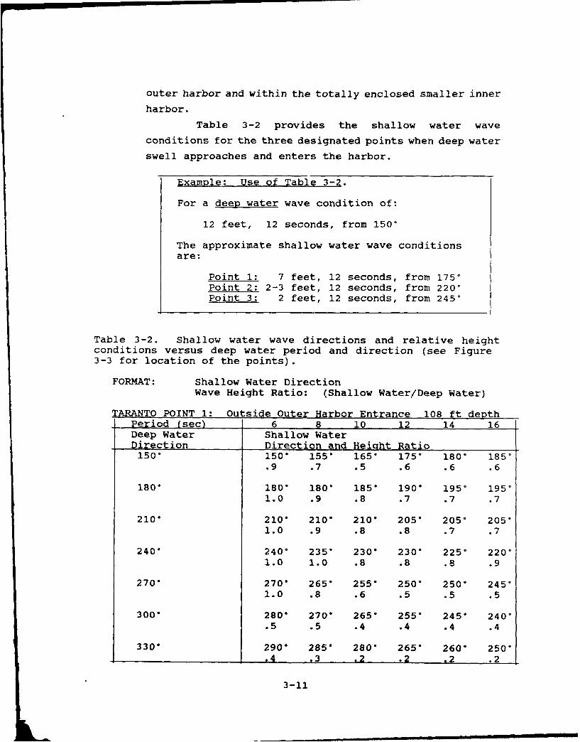
Table 3-2 provides the shallow water wave
conditions for the three designated points when deep water
swell approaches and enters the harbor.
Example: Use of Table 3-2.
For a deep water wave condition of:
12 feet, 12 seconds, from 150 °
The approximate shallow water wave conditionsare:
Point 1: 7 feet, 12 seconds, from 1750Point 2: 2-3 feet, 12 seconds, from 220 °
Point 3: 2 feet, 12 seconds, from 245*
Table 3-2. Shallow water wave directions and relative heightconditions versus deep water period and direction (see Figure3-3 for location of the points).
FORMAT: Shallow Water DirectionWave Height Ratio: (Shallow Water/Deep Water)
TARANTO POINT 1: Outside Outer Harbor Entrance 108 ft depthPeriod (sec) 6 8 10 12 14 16Deep Water Shallow WaterDirection Direction and Height Ratio150" 150" 155* 165* 175* 180* 185 °
.9 .7 .5 .6 .6 .6
180" 180" 180" 185* 190* 195* 195 °
1.0 .9 .8 .7 .7 .7
210" 2100 2100 210 ° 205" 205* 205*1.0 .9 .8 .8 .7 .7
240o 240* 235" 230o 230* 225* 220 °
1.0 1.0 .8 .8 .8 .9
270o 270" 265' 255o 250 250* 245 °
1.0 .8 .6 .5 .5 .5
300' 280" 270' 265" 255" 245* 240*.5 .5 .4 .4 .4 .4
330" 2900 285" 280" 265" 260o 250".4 .3 .2 .2 .2 .2
3-11
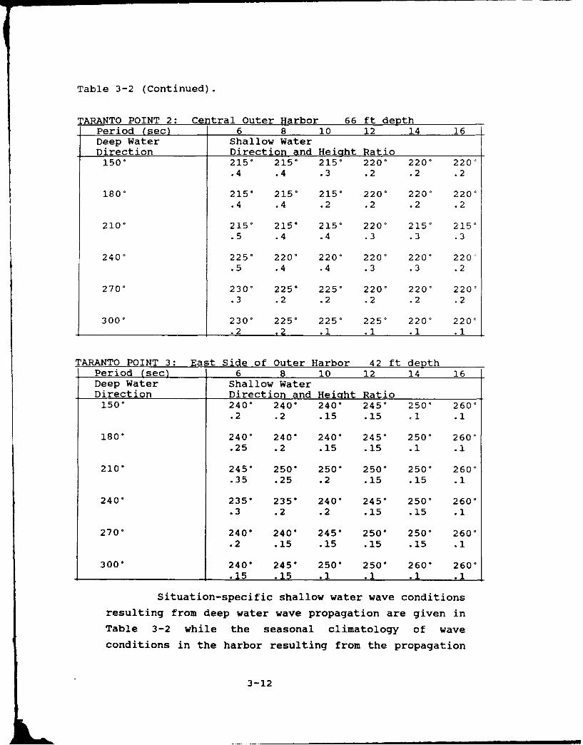
Table 3-2 (Continued).
TARANTO POINT 2: Central Outer Harbor 66 ft depthPeriod (sec) 6 8 10 12 14 16Deep Water Shallow WaterDirection Direction and Height Ratio1500 2150 215* 2150 2200 220' 2200
.4 .4 .3 .2 .2 .2
1800 2150 2150 2150 2200 220 ° 220 °
.4 .4 .2 .2 .2 .2
2100 2150 215 215 2200 215 215.5 .4 .4 .3 .3 .3
240 ° 225 ° 220* 220 ° 220' 220 ° 220'.5 .4 .4 .3 .3 .2
2700 2300 2250 2250 2200 2200 220'.3 .2 .2 .2 .2 .2
3000 2300 2250 2250 2250 2200 2200.2 .2 .1 .1 .1 .1
TARANTO POINT 3: East Side of Outer Harbor 42 ft depthPeriod (sec) 6 8 10 12 14 16Deep Water Shallow WaterDirection Direction and Height Ratio1500 240* 240* 240" 2450 2500 2600
.2 .2 .15 .15 01 .1
180* 2400 240" 240* 2450 2500 2600.25 .2 .15 .15 .1 .1
210* 245* 250* 250 ° 2500 250* 2600.35 .25 .2 .15 .15 .1
240" 235" 235" 240* 245 ° 2500 2600.3 .2 .2 .15 .15 .1
270" 240" 240" 245" 250* 250 ° 2600
.2 .15 .15 .15 .15 .1
300* 240" 245" 250" 250* 260 ° 260*.15 .15 .1 .1 .1 .1
Situation-specific shallow water wave conditions
resulting from deep water wave propagation are given in
Table 3-2 while the seasonal climatology of wave
conditions in the harbor resulting from the propagation
3-12

of deep water waves into the harbor are given in Table
3-3. If the actual or forecast deep water wave conditions
are known, the expected conditions at the three specified
harbor areas can be determined from Table 3-2. The mean
duration of the condition, based on the resulting shallow
water wave heights, can be obtained from Table 3-3.
Example: Use of Tables 3-2 and 3-3.
The forecast for wave conditions tomorrow(winter case) outside the harbor are:
10 feet, 10 seconds, from 240'
Expected shallow water conditions and duration:
Point 1 Point 2height 8 feet 4 feetperiod 10 seconds 10 secondsdirection from 230* from 2200duration 11 hours 14 hours
Interpretation of the information from Tables 3-2
and 3-3 provides guidance on the local wave conditions
expected tomorrow at the various harbor points. The
duration values are mean values for the specified height
range and season. KnowledQe of the current synoptic
pattern and forecast/expected duration should be used when
available.
Possible applications to small boat operations are
selection of the mother ships anchorage point and/or areas
of small boat work. The duration information provides
insight as to how long before a change can be expected.
The local wave direction information can be of use in
selecting anchorage configuration and related small boat
operations, including tending activities.
3-13
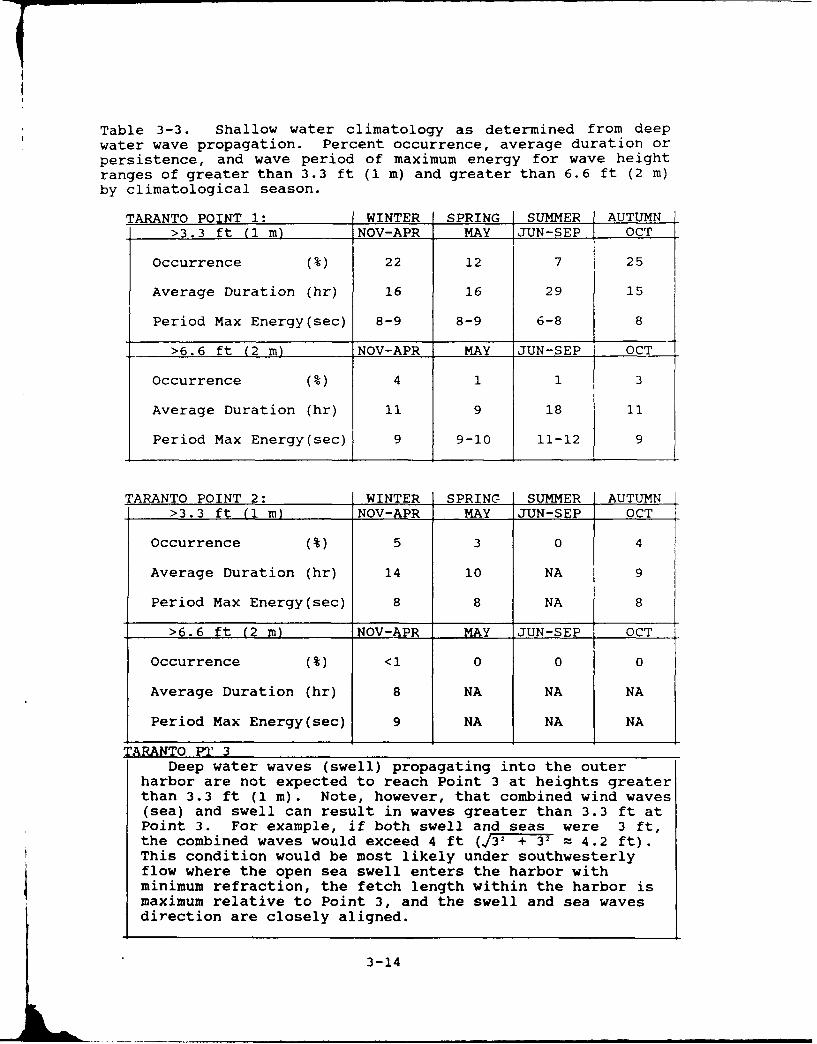
Table 3-3. Shallow water climatology as determined from deep
water wave propagation. Percent occurrence, average duration orpersistence, and wave period of maximum energy for wave heightranges of greater than 3.3 ft (1 m) and greater than 6.6 ft (2 m)by climatological season.
TARANTO POINT 1: WINTER SPRING SUMMER AUTUMN>3.3 ft (1 m) NOV-APR MAY JUN-SEP OCT
Occurrence (%) 22 12 7 25
Average Duration (hr) 16 16 29 15
Period Max Energy(sec) 8-9 8-9 6-8 8
>6.6 ft (2 m) NOV-APR MAY JUN-SEP OCT
Occurrence (%) 4 1 1 3
Average Duration (hr) 11 9 18 11
Period Max Energy(sec) 9 9-10 11-12 9
TARANTO POINT 2: WINTER SPRING SUMMER AUTUMN
>3.3 ft (1 m) NOV-APR MAY JUN-SEP OCT
Occurrence (%) 5 3 0 4
Average Duration (hr) 14 10 NA 9
Period Max Energy(sec) 8 8 NA 8
>6.6 ft (2 m) NOV-APR MAY JUN-SEP OCT
Occurrence (%) <1 0 0 0
Average Duration (hr) 8 NA NA NA
Period Max Energy(sec) 9 NA NA NA
TARANTO PI' 3Deep water waves (swell) propagating into the outer
harbor are not expected to reach Point 3 at heights greaterthan 3.3 ft (I m). Note, however, that combined wind waves(sea) and swell can result in waves greater than 3.3 ft atPoint 3. For example, if both swell and seas were 3 ft,the combined waves would exceed 4 ft (j32 + 3= 4.2 ft).This condition would be most likely under southwesterlyflow where the open sea swell enters the harbor withminimum refraction, the fetch length within the harbor ismaximum relative to Point 3, and the swell and sea wavesdirection are closely aligned.
3-14

Local wind wave conditions are provided in Table
>-4 for Taranto Harbor Points 1, 2, and 3. The time to
reach the fetch limited height assumes an initial flat
ocean. With a pre-existing wave height, the times are
shorter.
Table 3-4. Taranto. Local wind waves foi fetch linited
conditions at Points 1, 2, and 3 (based on JONSWAP model).
Point 1.
Format: height (feet)/period (seconds)time (houi-) :o reach fetch limited height
Direction Local Windand\ Speed (kt)
Fetch \Length 18 24 30 36 42(n mi)
W 2-3/4 3-4/4 4/5 5/5 6/515 n mi 2-3 2 2 2 2
SW 4/5 5/6 6/6 8/6-7 9/725 n mi 4 4 3-4 3-4 3-4
SSW 5/6 6/6-7 8/- 9-10/7-8 11/855 n mi 5 4-5 4-5 4-5 4-5
Points 2 & 3.
W <2 ft <2 ft 1-2/2 2/2-3 2/32 ri mi 1 1 1
SW <2 ft <2 ft 2/3 2-3/3 3/33 n mi IL1 1
3-15
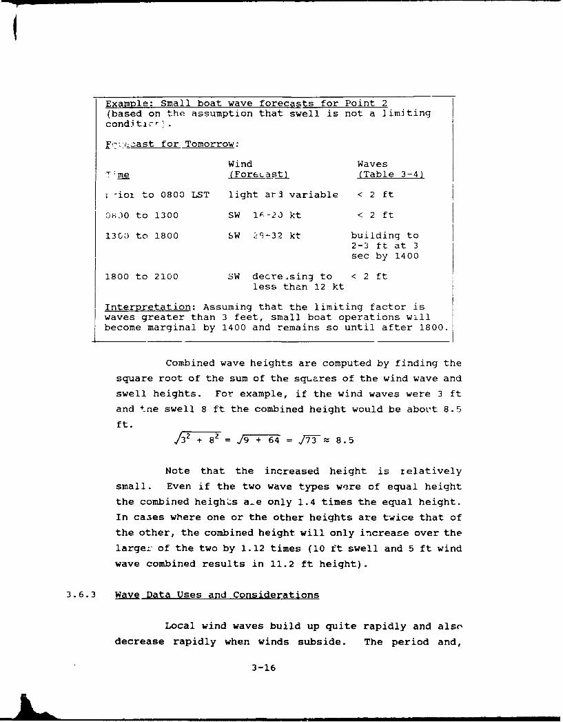
Example: Small boat wave forecasts for Point 2(based on the assumption that swell is not a limitingconditlcr
F'> cast for Tomorrow:
Wind WavesTime (Fore(ast) (Table 3-4)
-ioi to 0800 LST light arl variable < 2 ft
06,30 to 1300 SW IF-20 kt < 2 ft
1300 to 1800 SW 29-32 kt building to2-3 ft at 3sec by 1400
1800 to 2100 SW decreasing to < 2 ftless than 12 kt
Interpretation: Assuming that the limiting factor iswaves greater than 3 feet, small boat operations willbecome marginal by 1400 and remains so until after 1800.
Combined wave heights are computed by finding the
square root of the sum of the squares of the wind wave and
swell heights. For example, if the wind waves were 3 ft
and tne swell 8 ft the combined height would be about 8.5
ft.
/3 ' 8 =19 +6 64 = 17-3 z 8. 5
Note that the increased height is relatively
small. Even if the two wave types were of equal height
the combined heigh'..s a-e only 1.4 times the equal height.
In cases where one or the other heights are twice that of
the other, the combined height will only increase over the
larger of the two by 1.12 times (10 ft swell and 5 ft wind
wave combined results in 11.2 ft height).
3.6.3 Wave Data Uses and Considerations
Local wind waves build up quite rapidly and also
decrease rapidly when winds subside. The period and,
3-16
therefore, length of wind waves is generally short
relative to the period and length of waves propagated into
the harbor (see Appendix A). The shorter period and
length result in wind waves characterized by choppy
conditions. When wind waves are superimposed on deep
water waves propagated into shallow water, the waves can
become quite complex and confused. Under such conditions,
when more than one source of waves is influencing a
location, tending or joint operations can be hazardous
even if the individual wave train heights are not
significantly high. Vessels of various lengths may
respond with different motions to the diverse wave lengths
present. The information on wave periods, provided in the
previous tables, should be considered when forecasts are
made for joint operations of various length vessels.
3.7 Protective/MitiQatinQ Measures
As discussed in Sections 3.2 and 3.6 some ships
are subject to dragging anchor and alongside or well deck
operation may be hazardous in the outer harbor under
strong wind situations. Protective and/or mitigating
measures include use of a second anchor or moving to the
more protected eastern side of the outer harbor. Small
boat operations are likely to have to be cancelled during
40+ kt wind events. Winter time strong northerly wind
events are quite frequent and tend to last for 4 or 5
days. However, the offshore northerly winds drop off to
near calm at night and into early morning. Be aware of
the tendency for the northeasterlies to commence with a
sudden onset of 25+ kt around mid-morning. Scheduling
wind critical operations/movements in early morning will
likely reduce the hazards.
Highly variable and strong cross currents occur
in the last 1000 yds of approach and within the canal.
Strong winds will compound this problem. Med moored
3-17

vessels in the inner harbor should consider moving to
alongside berths when strong wind events are expected.
3.8 Indicators of Hazardous Weather Conditions
The strong wind events of Taranto all have well
documented large scale circulation causative patterns.
Close attention must be given to synoptic pattcrns
particularly during the cold season when conditions are
most variable and rapidly changing. All the strongest
wind events are associated with cyclones, and in most
cases migratory centers. Cyclogenesis in the Gulf of
Genoa, Balearic Island area, over North Africa or any
approaching migratory cyclone should be closely monitored.
About the only local region cyclogenetic condition is when
a southeastward running Genoa low stalls west of southern
Italy and secondary lows form over the Ionian Sea. The
500 mb pattern should provide evidence of when this type
of cyclogenetic event is likely. When the flow through
the 500 mb trough is strong the surface low will most
likely continue moving eastward. With diffluent flow east
of the 500 mb trough or when a strong jet maximum has
passed through the trough, cyclogenesis east of the trough
is likely. In general cyclogenesis will always occur on
the cold air side of the jetstream.
Several local and synoptic indicators of
approaching high winds are severe weather conditions have
been identified for the Taranto area.
3.8.1 Scirocco
Southerly Scirocco winds occur when Taranto is in
the warm sector of a cyclone. A stricter definition would
require the southerly flow to extend out of North Africa,
but generally any strong southerly wind is locally
referred to as a Scirocco. The svnoptic indicators
3-18

include: A deep 500 mb trough extending southward over
North Africa with the trough line to the west of area
of concern, plus being located in the warm sector of an
approaching cyclone that has formed over North Africa
or whose circulation extends from over North Africa.
Lows that pass through the area, but without the south-
erly flow in their warm sector originating over the
aeserc, do ,u*C cause true Scirocco conditions, hot and
dusty near Africa, with development of a strong near
surface inversion as the air moves northward over the
relatively cooler water. As this surface layer in-
creases in depth its moisture content increases, clouds
form and the cloudy, drizzly weather of northern Medi-
terranean Sciroccos develops. Local indicators at
Taranto of an approaching Scirocco include: rising
water levels in the harbor, anomalously rising warm
temperatures and increasing clouds from the south.
Once under the influence of a Scirocco an indication of
strong turbulence above the low level inversion is a"pumping" action shown in the pressure trace.
3.8.2 Bora
Bora winds reach Taranto as northeasterly flow
across the land to the east from off the Adriatic. The
basic Bora synoptic pattern has an intensive high
pressure to the north over central Europe resulting in
strong, cold, downslope wind along the coast of Yugo-
slavia. For a strong Bora to reaci Taranto and south-
ward into the Ionian Sea it usually requires the pas-
sage of a deep winter cyclone eastward across the
Ionian Sea. The resulting steepened gradient between
the high to the north and the low passing eastward to
the south results in the maximum southward extent of
the Bora wind regime. A local indicator of imminent
onset of a Bora at Taranto is the formation of clouds
over the low hills around the inner harbor. The clouds
will persist for the duration of the Bora event.
3-19

3.8.3 Mistral
Large amplitude 500 mb flow is necessary for Mistral
winds to reach Taranto. Typically this occurs with a
strong eastern Atlantic blocking high and a deep trough
over Europe and the centra± MediLtrranean. Under this
pattern a strong northwesterly jetstream will be fund
over France and the Gulf of Lion, giving further support
for extensive southeastward extension of the Mistral. A
southeastward movement of a Genoa low indicates the
potential of both strong southerlies in advance of the
low and northerlies following its passage. The following
is an abbreviated list of Mistral guidelines adapted from
Brody and Nestor (1980). For a more complete listing,
refer to the Severe Weather Guide for Marseille (#7) or
Toulon (#8), France or the original reference.
I. Causes
The Miztral is the result of a combination of the
following factors:
(a) The basic circulation that creates
a pressure gradient from west to east along the coast of
southern France. This pressure gradient is normally
associated with Genoa cyclogenesis.
(b) A wind increase over the open
water resulting from the reduction in the braking effect
of surface friction (as compared to the braking effect
over land).
2. Onset
(a) Mistral onset in the Gulf of Lion
occurs almost simultaneously with the formation of Genoa
lows.
(b) If a 500 mb trough extends from
central Europe southward over North Africa, a surface low
from Algeria may propagate northward, intensify in the
Gulf of Genoa, and initiate a Mistral.
3-20
(c) Wave clouds, such as observed on high-reso-
lution Defense Meteorological Satellite Program (DMSP)
satellite imagery, are observed over the Massif Central
of southern France approximately 6 hours before the
start of a Mistral.
3. Intensity
(a) Strongest winds associated with a Mistral do
not occur until after the passage of the 500 mb trough.
This usually occurs well after the surface cold frontal
passage.
(b) Satellite observations indicating a strong
Mistral will exhibit the following features: cloudy
over France and clear over the water area south of the
1,000 ft water depth contour; clear over the Gulf of
Lion except for a cloud mass paralle± to the coast,
lying 75-150 n mi offshore; and/or wispy cloud streaks
extending from 3150 to 3600 into offshore clouds.
(c) Wave clouds extending from Sardinia to
Tunisia, viewed on satellite imagery, are generally
associated with gale force Mistral situations.
(d) If the 500 mb winds reported at either
Bordeaux (07510) or Brest (07110) are northwesterly at
65 kt or greater, storm force winds are indicated for
the Gulf of Lion.
(e) A difference in surface barometric pressure,
with lower pressure to the east, between Perpignan
(LFMP/07747), Marseille (LFML/0650) and Nice
(LFMN/07690) will give a gauge as to Mistral intensity
using the following table (Brody and Nestor, 1980);
remembering Mistral winds are highly variable near the
coast due to terrain effects:
3-21
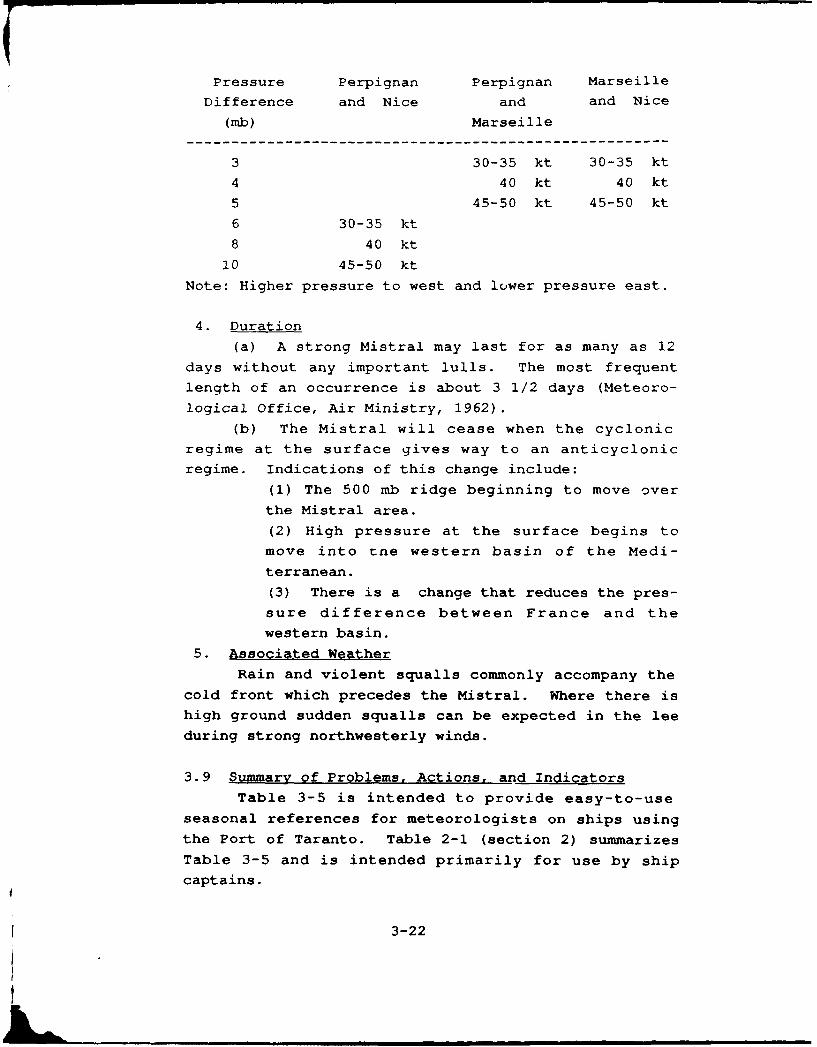
Pressure Perpignan Perpignan Marseille
Difference and Nice and and Nice
(mb) Marseille
3 30-35 kt 30-35 kt
4 40 kt 40 kt
5 45-50 kt 45-50 kt
6 30-35 kt
8 40 kt
10 45-50 ktNote: Higher pressure to west and lower pressure east.
4. Duration
(a) A strong Mistral may last for as many as 12
days without any important lulls. The most frequentlength of an occurrence is about 3 1/2 days (Meteoro-
logical Office, Air Ministry, 1962).
(b) The Mistral will cease when the cyclonic
regime at the surface gives way to an anticyclonic
regime. Indications of this change include:
(1) The 500 mb ridge beginning to move over
the Mistral area.(2) High pressure at the surface begins to
move into tne western basin of the Medi-
terranean.(3) There is a change that reduces the pres-
sure difference between France and thewestern basin.
5. Associated Weather
Rain and violent squalls commonly accompany the
cold front which precedes the Mistral. Where there ishigh ground sudden squalls can be expected in the lee
during strong northwesterly winds.
3.9 Summary of Problems, Actions, and Indicators
Table 3-5 is intended to provide easy-to-use
seasonal references for meteorologists on ships using
the Port of Taranto. Table 2-1 (section 2) summarizes
Table 3-5 and is intended primarily for use by ship
captains.
3-22
Table 3-5. Potential problem situations at Port of Taranto, Italy -
VESSEL LOCATION/ POTENTIAL HAZARD EFFECT - PRECAUTIONARY/EVASIVE ACTIONSSITUATION AFFECTED
1. Anchored - Outer harbor, a. SE'y win - Most hazardous conditions a. Causes major disturbance to sh ps and traffic in Outer harbor, a. St,experienced at Taranto. Winds of 40-50 kt. Swell Sh&Ltow draft/large sail area ships tend to drag anchor. Long period fronts,
Occurs in Winter refracts into Outer harbor, results in swell swell and short period wind waves cause different responses in various Lows dinearly 90* out of phase with wind and wind waves. length vessels, alongside or welt deck operations hazardous, high o,
Conditions better on eastern side of harbor. Consider deploying Meditesecond anchor, moving to eastern side of harbor or if conditions experitpermit through canal to inner harbor. (Bora)
southeipro ton
days),leveland hilevel
Occurs in Winter b. NWly win - Mistral events. Winds 30-40 kt. b. Winds are strongest during daytime, light at night and may last b. Stlate Autumn Only wave action is fetch limited wind waves for two or three days. Shallow dreft/large sail area ships may drag when eearly Spring generated inside harbor. Winter temperatures anchor. Winter temperatures approtch freezing and wind chill near and ce
approach freezing, wind chill effects of concern. O'F. Delay daytime wind critical operations if possible. Beware of devetc;
wind chill factor.
Most likely in Spring c. SW'tY wind - Infrequent event during spring c. High seas enter outer harbor through entrance. Maximum wind c. StAlso in Autumn or fall. Open sea waves enter outer harbor, during daytime decreasing after sunset. Move to eastern side of Genoa.
Maximum winds 30-40 kt during daytime, decrease harbor or to inner harbor. Europeafter sunset. The t,
Occurs in Winter d. NELY wind - Frequent winter condition. d. Sudden onset of 25- kt, most I~kely to occur during morning, can d. Stlate Autumn Sudden daytime onset of 25+ lt uind. Strongiest in cause rapid swinging of ships and/or sudden hazardous conditions for Winterearly Spring daytime, light at night. Winter freezing operations in progress. Winter frezinc, temperatures and wind chill the Ta
temperatures, wind chill reaches 0 to -10F. to -10F with snow showers result in exposure problem for personnel. strongLight snow row - experienced a couple times a Winds become light at night but condition may persist for several the weyear (Dece ber, a-iuary, February). days. Be aware of winter synoptic patterns that cause north- precip
easterlies. Consider possible effects of sudden onset of winds, hills
Prepare personnel for freezing temperature/wind chill.
2. Arriving/Departing. a. SE'ty wind - Most hazardous condition for a. Strong cross wind and seas out of phase with swell results in a. StOR arriving/departing or passage through canal, difficult ship handling. Problem compounded for canal transit due to fronts
Passage through Canal. Swell refracts through entrance and into outer narrow passage and restricted speed (6 kt). Be aware of conditions, Lows dharbor as southwesterly waves which are nearly 90
° adjust schedule if possible. Delay canal transit, high o
Occurs in Winter out of phase with wind and wind waves. Mediteexperi(ora)southeproIon
eastwadays).leveland hilevel
Most likely in Spring b. SW ty wind - Results in following/head wind b. Following or heed strong winds and/or waves cause ship handling b. SiAlso in Autumn and waves through entrance and canal, and/or ride problems. These events are of short duration ard wind Genoa.
drops off after sunset. Use precautions or delay movement. EuropeThe tr
Prevailing Condition Winter c. N - All wave growth is fetch limited c. Offshore northerly winds prevail during the cold season. Strong c. SiLate Autumn so wind is primary problem. Morning temperatures northerly winds are more frequent than southerly wind events. Sudden WinterEarly Spring near freezing, wind chill may be near O'F all day onset and cold gusty nature are the major problems. In winter watch the Ts
during winter, for synoptic patterns that cause strong wind events and be prepared strongfor winter conditions. the we
precirhills
3-23f

ituations at Port of Taranto, Italy - ALL SEASONS
SECAUTIONARY/EVASIVE ACTIONS ADVANCE INDICATORS AND OTHER INFORMATIONABOUT POTENTIAL HAZARD
- rbance to shps and traffic in outer harbor, a. Strong SE'Lies (Scirocco) are associated with warm sector of migratory Lows and,- zres ships tend to drag anchor. Long period fronts. The source of Lows is generally the Gulf of Genoa or Balearic region.
.d wind waves cause different responses in various Lows develop following onset of Mistral in western Mediterranean. With blockingside or welt deck operations hazardous. high over the eastern Atlantic and a deep trough over Europe and centraleastern side of harbor. Consider deploying Mediterranean, Genoa tows are likely to move SE-wrd into Ionian Sea. Taranto will
SE-i to eastern side of harbor or if conditions experience SE'ty winds (Scirocco) while in the warm sector and north to NE'-y- ixner harbor. (Bora) following eastward passage of low to south. When primary low stalls west of
southern Italy and secondary lows form over Ionian Sea, Taranto .xpericicesprolonged bad weather and alternating S-ly to Niy winds as secondary Lows move
an eastward. Scirocco events nost frequent March through June. Periods of Slky (2-5days), not as strong as winter events, occur when Genoa Lows move NE'wrd. Upperlevel trough typically over western Mediterranean, Atlantic blocking high absentand higher pressure over NE-ern Mediterranean region. Rising temperature and waterlevel and fatting pressure are indicators.
is during daytime, light at night and may last b. Strong NW'lies (Mistral) occur during January and February. Reach Taranto areaSt. Shallow dreft/large sail area ships may drag when eastern Atlantic blocking high is strong with deep 500 mb trough over Europe
t-cratures approach freezing and wind chill near and central Mediterranean. irough tine will be over or east of Italy. A wella, ind critical operations if possible. Beware of developed NE'ly jetstream will be present over France and Gulf of Lion area.
N.,nA,-.r harbor through entrance. Maximum wind c. Strong SW'lies (Libeicco) occur when migratory lows move NE'wd from Gulf ofmesing after sunset. Move to eastern side of Genoa. Occurs with spring and autumn cyclogenesis when cold winter high over
Europe is not well developed. Ridges and troughs at 500 mb have low amplitude.The trough wil[ be located over western Europe.
S, kt, most likely to occur during morning, can d. Strong NE'lies (Bora) follow eastward passage of cyclone across Ionian Sea.ships and/or sudden hazardous conditions for Winter anticyclone north of the Mediterranean results in prevailing N'ly winds in
ot Winter freezing temperatures and wind chill the Taranto area. Passage of cyclones to the south and east result in periods ofi.e's result in exposure problems for personnel. strong gusty N'Ly winds and squalty weather. When the migratory Lows approach from-ght but condition may persist for several the west (Balearic region) or south (North Africa) the cloud cover andf re, synoptic patterns that cause north- precipitation are more extensive than with Genoa lows. Belt of clouds form onlaossible effects of sudden onset of winds, hills north of inner harbor and last for duration of event.
r 1reezing temperature/wind chill.
on ard seas out of phase with swell results in a. strong SE'lies (Scirocco) are associated with warm sector of migratory lows and' t. Problem compounded for canal transit due to fronts. The source of tows is generally the Gulf of Genoa or Balearic region.tricted speed (6 kt). Be aware of conditions, Lows develop following onset cf Mistral in western Mediterranean. With blockingable. Delay canal transit, high over the eastern Atlantic and a deep trough over Europe and central
Mediterranean, Genoa lows are likely to move SE'wrd into Ionian Sea. Taranto willexperience SE'ty winds (Scircco) white in the warm sector and north to NE'ly(Bora) following eastward passage of tow to south. When primary tow stalls west ofsouthern Italy and secondary lows form over Ionian Sea, Taranto experiences
he prolonged bad weather and alternating S-ly to N'ty winds as secondary lows moveeastward. Scirocco events most frequent March through June. Periods of S'ly (2-5
SE days), not as strong as winter events, occur when Genoa Lows move NE'wrd. Upperou level trough typically over western Mediterranean, Atlantic blocking high absentait and higher pressure over NE-ern Mediterranean region. Rising temperature and wateren level and fatting pressure are indicators.Scias Strong winds and/or waves cause ship handling b. Strong SW'lies (Libeicco) occur when migratory lows move NE'wd from Gulf ofh t nbese events are of short duration and wind Genoa. Occurs with spring and autumn cyclogenesis when cold winter high overpre. Use precautions or delay movement. Europe is not welt developed. Ridges and troughs at 500 mb have tow amplitude.alt The trough will be located ovr western Europe.
SW- winds prevail during the cold season. Strong c. Strong NE'lies (Bora) follow eastwerd passage of cyclone across Ionian Sea.urs e frequent than southerly wind events. Sudden Winter anticyclone north of tt~e Mediterranean results in prevailing N'ty winds inot ature are the major problem. In winter watch the Taranto area. Passage of cyclones to the south and east result in periods of
t that cause strong wind events and be prepared strong gusty N-ly winds and squally weather. When the migratory lows approach fromthe west (Balearic region) or south (North Africa) the cloud cover and
NE precipitation are more extensive than with Genoa lows. Belt of clouds form oncyc hills north of inner harbor and last for duration of event.
Ian
:y N
lateonIof V
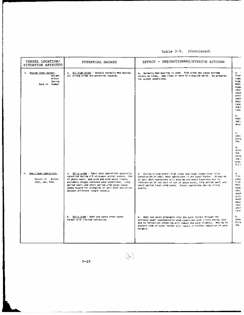
Table 3-5. (Continued)
VESSEL LOCATION/ POTENTIAL HAZARD EFFECT - PRECAUTIONARY/EVASIVE ACTIONSSITUATION AFFECTED
3. Moored inner harbor, a. All high winds - Vessels normally Med moored, a. Normally Med mooring is used. High winds may cause extreme a.Autumn all strong winds are potential hazards. strain on tines. Add Lines or move to alongside berth. Be prepared fron!Winter for winter conditions. LowsSpring high
Rare in Summer Mediexpei( Bor.soutiproeastidaysLeveand Iteve
b.whenanddeve
C.Gen,EuroThe
d.Wint,thestrotheprechill
4. Small boat operations. a. SE'ly winds - Small boat operations generally a. During strong event; high winds and rough choppy seas force a.
cancelled during 4-5 strongest winter events. Out cancelation of small boat operations in the outer harbor. Alongside fronOccurs in Winter of phase swell, and wind and wind waves create or well deck operations will also be extremely hazardous due to Lows(Dec, Jan, Feb) extremely choppy confused wave conditions. Long interaction of two sets of out of phase waves, long period swell and high
period swell and short period wind waves cause short period local wind waves. Cancel operations during strong Mediadded hazard for alongside or well deck operations events. expe
between different Length vessels. (Borsoutiprot,east!daysleveand I
eve
b. SWtlv wind - Open sea waves enter outer b. Open sea waves propagate into the outer harbor through the b.harbor with limited refraction, entrance urider southwesterly wind conditions with Little energy lost Geno.
due to refraction (shoaling will reduce the wave heights). Moving to Euroi
eastern side of outer harbor wilt result in further reduction of wave Theheights.
3-25
Loh,

?able 3-5. (Continued)
PRECAUTIONARY/EVASIVE ACTIONS ADVANCE INDICATORS AND OTHER INFORMATIONABOUT POTENTIAL HAZARD
DV mooring is used. High winds may cause extreme a. Strong SE-lies (Scirocco) are associated with warm sector of migratory lows andid Lines or move to alongside berth. Be prepared fronts. The source of tows is generally the Gulf of Genoa or Balearic region.
tons. Lows develop following onset of Mistral in western Mediterranean. With blockinghigh over the eastern Atlantic and a deep trough over Europe and central
The Mediterranean, Genoa tows are likely to move SE'wrd into Ionian Sea. Taranto will
to experience SE'Ly winds (Scirocco) white in the warm sector and north to NE'ty
(Dora) following eastward passage of tow to south. When primary Low stalks west of
-ieai southern Italy and secondary lows form over Ionian Sea, Taranto experiences
SE prolonged bad weather and altereating S'ly to N'ty winds as secondary lows move
eastward. Scirocco events most frequent March through June. Periods of Sty (2-5
Ita. days), not as strong as winter events, occur when Genoa lows move NE'wrd. Upper
bad level trough typically over western Mediterranean, Atlantic blocking high absent
Sci and higher pressure over NE'ern Mediterranean region. Rising temperature and water
as level and fatting pressure are indicators.
ighb. Strong NW'lies (Mistral) occur during January and February. Reach Taranto area
fa~l when eastern Atlantic blocking high is strong with deep 500 mb trough over Europeand central Mediterranean. Trough line will be over or east of Italy. A well
g developed NE'ly jetstream will be present over France and Gulf of Lion area.
at HfNE c. Strong SW'lies (Libeicco) occur when migratory lows move NE'wd from Gulf of
Genoa. Occurs with spring and autumn cyclogenesis when cold winter high overEurope is not well developed. Ridges and troughs at 500 mb have tow amplitude.
The trough will be located over western Europe.
d. Strong E'lies (Bora) follow eastward passage of cyclone across Ionian Sea.Winter anticyclone north of the Mediterranean results in prevailing Lly winds inthe Taranto area. Passage of cyclones to the south and east result in periods oRstrong gusty NIy winds and squatly weather. When the migratory tows approach from
the west (Balearic region) or south (North Africa) the cloud cover and
to o precipitation are more extensive than with Genoa tows. Belt of clouds form on
r qhilts north of inner harbor and last for duration of event.
t entn events high winds and rough choppy seas force a. Strong SE'ties (Scirocco) are associated with warm sector of migratory tows and
r-; bat operations in the outer harbor. Alongside fronts. The source of tows is generally the Gulf of Genoa or Balearic region.arises will also be extremely hazardous due to Lows develop following onset of Mistral in western Mediterranean. With blocking
g S" sets of out of phase waves, tong period swell and high over the eastern Atlantic and a deep trough over Europe and central
The wind waves. Cancel operations during strong Mediterranean, Genoa lows are likely to move SE'wrd into Ionian Sea. Taranto willexperience SE'ly winds (Scirocco) while in the warm sector and north to NE'Ly(Bora) following eastward passage of low to south. When primary low stalls west ofsouthern Italy and secondary tows form over Ionian Sea, Taranto experiences
prolonged bad weather and alternating S-ly to N'Iy winds as secondary lows move
toi eastward. Scirocco events most frequent March through June. Periods of St . (2-5
days), not as strong as winter events, occur when Genoa lows move NE'wrd. U, r
boo level trough typically over western Mediterranean, Atlantic blocking high absentand higher pressure over NE'ern Mediterranean region. Rising temperature and water
ot level and falling pressure are indicators.
igh tpe propagate into the outer harbor through the b. Strong SW'Iies (Libeicco) occur when migratory lows move NE'wd from Gulf of
fo( 'rwesterty wind conditions with tittle energy lost Genoa. Occurs with spring and autirn cyclogenesis when cold winter high over(shoaling wilt reduce the wave heights). Moving to Europe is not well developed. Ridges and troughs at 500 mi have low amplitude.
, te harbor wilt result in further reduction of wave The trough will be located over western Europe.
not
I -O
References
Brody, L.R. and M.J.R. Nestor, 1980: Regional Forecast-
ing Aids for the Mediterranean Basin, NAVENVPREDSCHFAC
Technical Report TR 80-10. Naval Oceanographic and
Atmospheric Research Laboratory, Atmospheric
Directorate*, Monterey, California 93943-5006.
FICEURLANT, 1987: Port Directory for Taranto (1986),
Italy. Fleet Intelligence Center Europe and Atlantic,
Norfolk, VA.
Hydrographer, 1965: Mediterranean Pilot Vol. II. 9th
Edition. Hydrographic Department, London.
Kotsch, W.J. 1983: Weather for the Mariner Naval
Institute Press, Annapolis, Maryland
Reiter, E. R., 1971: Digest of Selected Weather Problems
of the Mediterranean. Navy Weather Research Facility,
Norfolk, Virginia.
Shaver, D. W., Undated: Comments on Weather in the
Mediterranean. Unpublished manuscript. Naval Oceano-
graphic and Atmospheric Research Laboratory, Atmospheric
Directorate*, Monterey, CA 93943-5006.
Port Visit Information
May 1988: NOARL Meteorologists R. Fett and D. Perryman
met with Chief Pilot Augusto De Bellis to obtain much of
the information included in this revort.
* Formerly the Naval Environmental Prediction Research
Facility.
3-27
APPENDIX A
General Purpose Oceanocqraphic Information
This section provides general information on
wave forecasting and wave climatology as used in this
study. The forecasting material is not harbor specific.
The material in paragraphs A.1 and A.2 was extracted
from H.O. Pub. No. 603, Practical Methods for Observing
and Forecasting Ocean Waves (Pierson, Neumann, and
James, 1955) . The information on fully arisen wave
conditions (A.3) and wave conditions within the fetch
region (A.4) is based on the JONSWAP model. This model
was developed from measurements of wind wave growth over
the North Sea in 1973. The JONSWAP model is considered
more appropriate for an enclosed sea where residual wave
activity is minimal and the onset and end of locally
forced wind events occur rapidly (Thornton, 1986), and
where waves are fetch limited and growing (Hasselmann,
et al., 1976). Enclosed sea, rapid onset/subsiding
local winds, and fetch limited waves are more
representative of the Mediterranean waves and winds than
the conditions of the North Atlantic from which data was
used for the Pierson and Moskowitz (P-M) Spectra
(Neumann and Pierson 1966). The P-M model refined the
original spectra of H.O. 603, which over developed wave
heights.
The primary difference in the results of the
JONSWAP and P-M models is that it takes the JONSWAP
model longer to reach a given height or fully developed
seas. In part this reflects the different starting wave
conditions. Because the propagation of waves from
surrounding areas into semi-enclosed seas, bays,
harbors, etc. is limited, there is little residual wave
action following periods of locally light/calm winds and
A-i
the sea surface is nearly flat. A local wind developed
wave growth is therefore slou r than wave growth in the
open ocean where some residual wave action is general!%
always pre ant. This slower wave development is a built
in bias in the formulation of the JONSWAP model which is
based on data collected in zn enclosed sea.
A.1 Definitions
Waves that arp being generated by local winds
are called "SEA". Waves that have traveled out of the
generating area are known as "SWELL". Seas are chantic
in period, height and direction while s"yell approaches a
simple sine wave pattern as its distance from the
generating area increases. An in-between state exists
for a few hundred miles outside the generating area and
is a condition that reflects parts of both ot the above
definitions. In the Mediterranean area, because its
fetches and open sea expanses are limited, SEA or IN-
BETWEEN conditions will prevail. The "SIGNIFICANT WAVE
HEIGHT" is defined as the average value of the heights
of the one-third highest waves. PERIOD and WAVE LENGTH
refer to the time between passage of, and distances
between, two successive crests on the sea surface. The
FREOUENCY is the reciprocal of the period (f = liT)
therefore as the period increases the frequency
decreases. Waves result from the transfer of energy
from the wind to the sea surface. The area over wnich
the wind blows is known as the FETCH, and the length of
time that the wind has blown is the DURATION. The
characteristics of waves (height, length, and period)
depend on the duration, fetch, and velocity of the wind.
There is a continuous generation of small snort waves
from the time the wind starts until it stops. With
continual transfer of energy from the wind to the sea
A-2

surface the waves grow with the older waves leading the
growth and spreading the energy over a greater range of
frequencies. Throughout the growth cycle a SPECTRUM of
ocear waves is being developed.
A.2 Wave Spectrum
Wave characteristics are best described by means
of their range of frequencies and directions or their
spectrum and the shape of the spectrum. If the spectrum
ef the waves covers a wide range of frequencies and
directions (known as short-crested conditions), SEA
conditions prevail. If the spectrum covers a narrow
range of frequencie and directions (long crested
conditions), SWELL conditiors prevail. The wave
spectrum depends on the duration of the winu, length of
the fetch, and un the wind velocity. At a given wind
speed and given state of wave development, each spectrum
has a band of frequencies where most of the total energy
is concentrated. As the wind speed increases the range
of significant frequencies extends more and more toward
lower frequencies (longer periods). Te frequency of
maximum energy is given in equation 1.1 where v is the
wind speed in knots.
fm x = 2.476 (1.1)v
The wave energy, being a function of height squared,
increases rapidly as the wind speed increases and the
maximum energy band shifts to lower frequencies. This
results in the new developing smaller waves (higher
frequencies) becoming less significant in the energy
spectrum as well as to the observer. As larger waves
develop an observer will pay lass and less attention to
the small waves. At the low frequency (high period) end
A-3

the energy drops off rapidly, the longest waves are
relatively low and extremely flat, and therefore also
masked by the high energy frequencies. The result is
that 5% of the upper frequencies and 3% of the lower
frequencies can be cut-off and only the remaining
frequencies are considered as the "significant part of
the wave spectrum". The resulting range of significant
frequencies or periods are used in defining a fully
arisen sea. For a fully arisen sea the approximate
average period for a given wind speed can be determined
from equation (1.2).
T = 0.285v (1.2)
Where v is wind speed in knots and T is period in
seconds. The approximate average wave length in a fully
arisen sea is given by equation (1.3).
L = 3.41 T2 (1.3)
Where L is average wave length in feet and T is average
period in seconds.
The approximate average wave length of a fully arisen
sea can also be expressed as:
L .67"L" (1.4)
where "L" = 5.12T 2 , the wave length for the classic sine
wave.
A.3 Fully Arisen Sea Conditions
For each wind speed there are minimum fetch (n
mi) and duration (hr) values required for a fully arisen
sea to exist. Table A-I lists minimum fetch and
duration values for selected wind speeds, values of
significant wave (average of the highest 1/3 waves)
A-4
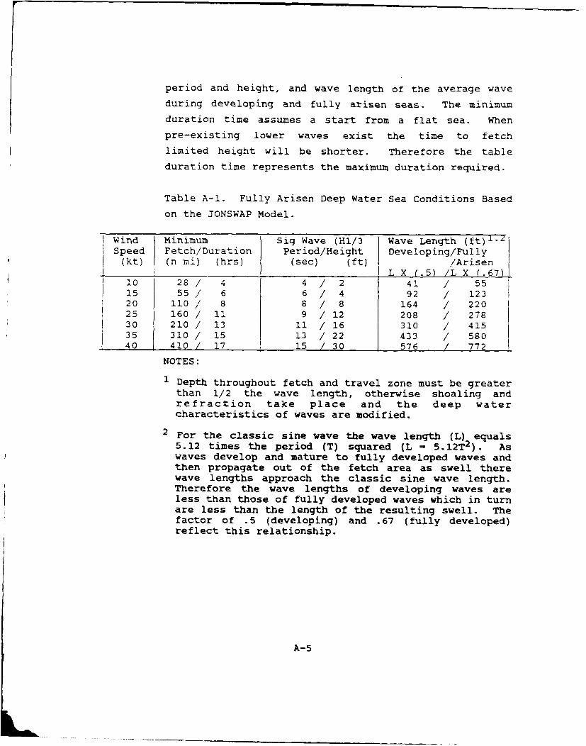
period and height, and wave length of the average wave
during developing and fully arisen seas. The minimum
duration time assumes a start from a flat sea. When
pre-existing lower waves exist the time to fetch
limited height will be shorter. Therefore the table
duration time represents the maximum duration required.
Table A-1. Fully Arisen Deep Water Sea Conditions Based
on the JONSWAP Model.
Wind Minimum Sig Wave (Hl/3 Wave Length (ft) 1 -
Speed Fetch/Duration Period/Height Developing/Fully(kt) (n mi) (hrs) (sec) (ft) /Arisen
L X (.5) /L X (.67)10 28/ 4 4 / 2 41 / 5515 55/ 6 6 / 4 92 / 12320 110/ 8 8 / 8 164 / 22025 160/ 11 9 /12 208 / 27830 210 / 13 11 / 16 310 / 41535 310/ 15 13 /22 433 / 58040 410 17 15 /30 576 / 772
NOTES:
1 Depth throughout fetch and travel zone must be greaterthan 1/2 the wave length, otherwise shoaling andrefraction take place and the deep watercharacteristics of waves are modified.
2 For the classic sine wave the wave length (L) equals5.12 times the period (T) squared (L = 5.12T2). Aswaves develop and mature to fully developed waves andthen propagate out of the fetch area as swell therewave lengths approach the classic sine wave length.Therefore the wave lengths of developing waves areless than those of fully developed waves which in turnare less than the length of the resulting swell. The
factor of .5 (developing) and .67 (fully developed)reflect this relationship.
A-5
A.4 Wave Conditions Within The Fetch ReqionWaves produced by local winds are referred to as
SEA. In harbors the local sea or wind waves may create
hazardous conditions for certain operations. Generally
within harbors the fetch lengths will be short and
therefore the growth of local wind waves will be fetch
limited. This implies that there are locally determined
upper limits of wave height and period for each wind
velocity. Significant changes in speed or direction
will result in generation of a new wave group with a new
set of height and period limits. Once a fetch limited
sea reaches its upper limits no further growth will
occur unless the wind speed increases.
Table A-2 provides upper limits of period and
height for given wind speeds over some selected fetch
lengths. The duration in hours required to reach these
upper limits (assuming a start from calm and flat sea
conditions) is also provided for each combination of
fetch length and wind speed. Some possible uses of
Table A-2 information are:
1) If the only waves in the area are locallygenerated wind waves, the Table can be usedto forecast the upper limit of sea conditionsfor combinations of given wind speeds andfetch length.
2) If deep water swell is influencing the localarea in addition to locally generated windwaves, then the Table can be used todetermine the wind waves that will combinewith the swell. Shallow water swellconditions are influenced by local bathymetry(refraction and shoaling) and will beaddressed in each specific harbor study.
3) Given a wind speed over a known fetch lengththe maximum significant wave conditions andtime needed to reach this condition can bedetermined.
A-6
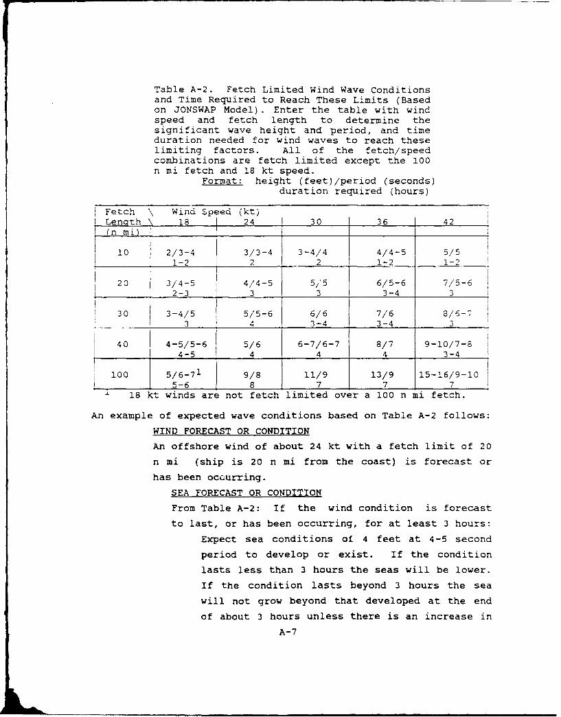
Table A-2. Fetch Limited Wind Wave Conditionsand Time Required to Reach These Limits (Basedon JONSWAP Model). Enter the table with windspeed and fetch length to determine thesignificant wave height and period, and timeduration needed for wind waves to reach theselimiting factors. All of the fetch/speedcombinations are fetch limited except the 100n mi fetch and 18 kt speed.
Format: height (feet)/period (seconds)duration required (hours)
Fetch \ Wind Speed (kt)LenQth - 18 24 30 36 42(n mi)
10 2/3-4 3/3-4 3-4/4 4/4-5 5/51-2 2 2 1-2 1-2
20 3/4-5 4/4-5 5/5 6/5-6 7/5-62-3 3 3 3-4 3
30 3-4/5 5/5-6 6/6 7/6 8/6-73 4 3-4 3-4 3
40 4-5/5-6 5/6 6-7/6-7 8/7 9-10/7-8S4 - 5 4 4 4 3-4I1i00 5/ 6-71 9/8 11/9 13/9 15-16/9-10
5-_ 6 8 7 7 7
18 kt winds are not fetch limited over a 100 n mi fetch.
An example of expected wave conditions based on Table A-2 follows:
WIND FORECAST OR CONDITION
An offshore wind of about 24 kt with a fetch limit of 20
n mi (ship is 20 n mi from the coast) is forecast or
has been occurring.
SEA FORECAST OR CONDITION
From Table A-2: If the wind condition is forecast
to last, or has been occurring, for at least 3 hours:
Expect sea conditions of 4 feet at 4-5 second
period to develop or exist. If the condition
lasts less than 3 hours the seas will be lower.
If the condition lasts beyond 3 hours the sea
will not grow beyond that developed at the end
of about 3 hours unless there is an increase in
A-7

wind speed or a change in the direction that
results in a longer fetch.
A.5 Wave Climatology
The wave climatology used in these harbor
studies is based on 11 years of Mediterranean SOWM
output. The MED-SOWM is discussed in Volume II of the
U.S. Naval Oceanography Command Numerical Envi-onmental
Products Manual (1986). A deep water MED-SOWM grid
point was selected as representative of the deep water
wave conditions outside each harbor. The deep water
waves were then propagated into the shallow water areas.
Using linear wave theory and wave refraction
computations the shallow water climatology was derived
from the modified deep water wave conditions. This
climatology does not include the local wind generated
seas. This omission, by design, is accounted for by
removing all wave data for periods less than 6 seconds
in the climatology. These shorter period waves are
typically dominated by locally generated wind waves.
A.6 Propagation of Deep Water Swell Into Shallow Water Areas
When deep water swell moves into shallow water
the wave patterns are modified, i.e., the wave heights
and directions typically change, but the wave period
remains constant. Several changes may take place
including shoaling as the wave feels the ocean bottom,
refraction as the wave crest adjusts to the bathymetry
pattern, changing so that the crest becomes more
parallel to the bathymetry contours, friction with the
bottom sediments, interaction with currents, and
adjustments caused by water temperature gradients. In
this work, only shoaling and refraction effects are
A-8
considered. Consideration of the other factors are
beyond the resources available for this study and,
furthermore, they are considered less significant in the
harbors of this study than the refraction and shoaling
factors.
To determine the conditions of the deep water
waves in the shallow water areas the deep water
conditions were first obtained from the Navy's
operational MED-SOWM wave model. The bathymetry for the
harbor/area of interest was extracted from available
charts and digitized for computer use. Figure A-1 is a
sample plot of bathymetry as used in this project. A
ray path refraction/shoaling program was run for
selected combinations of deep water wave direction and
period. The selection was based on the near deep water
wave climatology and harbor exposure. Each study area
requires a number of ray path computations. Typically
there are 3 or 4 directions (at 30" increments) and 5 or
6 periods (at 2 second intervals) of concern for each
area of study. This results in 15 to 24 plots per
area/harbor. To reduce this to a manageable format for
quick reference, specific locations within each study
area were selected and the information was summarized
and is presented in the specific harbor studies in
tabular form.
A-9
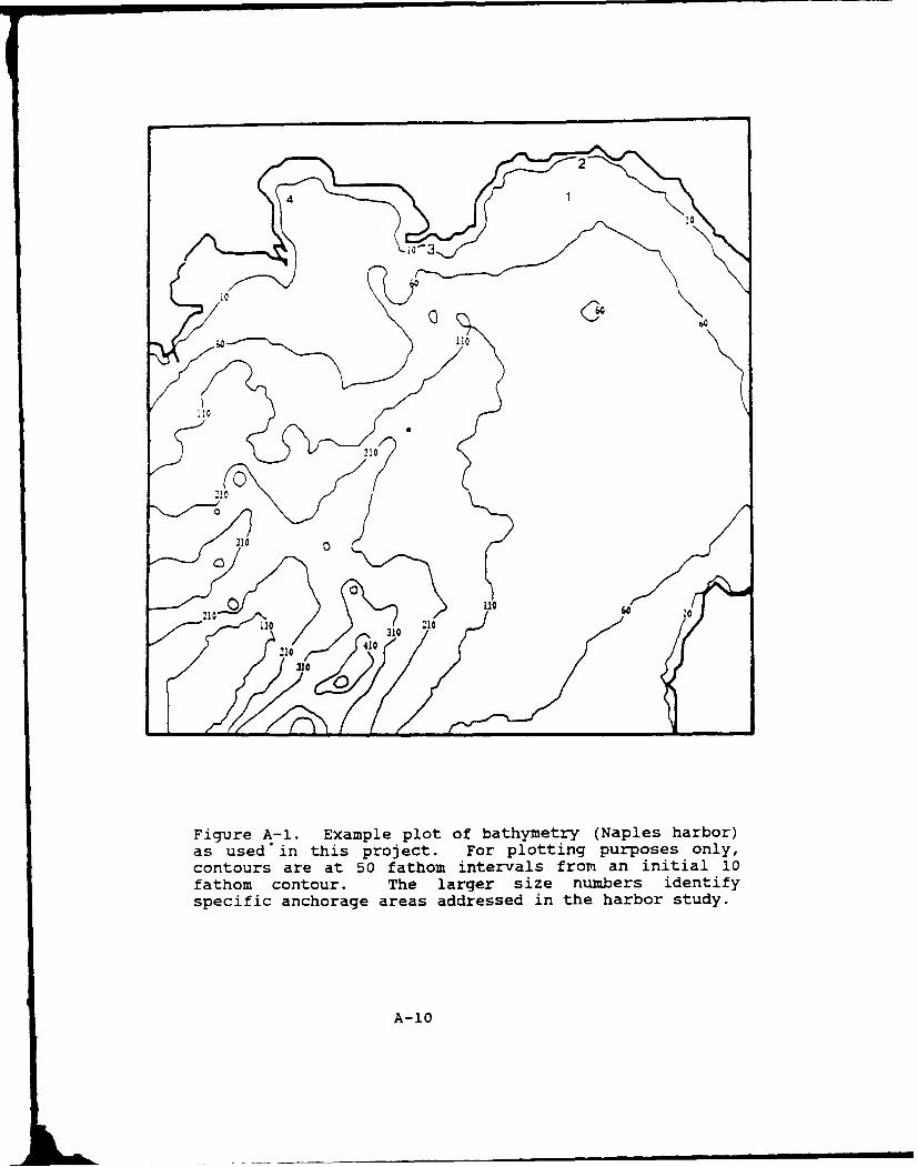
U2
730
06
Figure A-i. Example plot of bathymetry (Naples harbor)as used'in this project. For plotting purposes only,contours are at 50 fathom intervals from an initial 10fathom contour. The larger size numers identifyspecific anchorage areas addressed in the harbor study.
A-0
31

REFERENCES
Hasselmann, K. D., D. B. Ross, P. Muller, and W. Sell,
1976: A parametric wave prediction model. J. Physical
Oceanography, Vol. 6, pp. 208-228
Neumann, G., and W. J. Pierson Jr., 1966: Principles of
Physical Oceanoqraphy. Prentice-Hall, Englewood Cliffs.
Pierson, W.J. Jr., G. Neumann, and R. W. James, 1955:
Practical Methods for Observing and Forecasting Ocean
Waves, H.O. Pub. No. 603.
Thornton, E. B., 1986: Unpublished lecture notes for
OC 3610, Waves and Surf Forecasting. Naval Postgraduate
School, Monterey CA.
U. S. Naval Oceanography Command, 1986: Vol. II of the
U.S. Naval OceanoQraphy Command Numerical Environmental
Products Manual.
A-11

DISTRIBUTION
SNDL
21A1 CINCLANTFLT2 1A3 CINCUSNAVEUR22A1 COMSECONDFLT22A3 COMS IXTHFLT23B3 Special Force Commander EUR24A1 Naval Air Force Commander LANT24D1 Surface Force Commander LANT24E Mine Warfare Command24G1 Submarine Force Commander LANT26QQ1 Special Warfare Group LANT28A1 Carrier Group LANT (2)28B1 Cr-uiser-Destroyer Group LANT (2)28D1 Destroyer Squadron LANT (2)28Ji Service Group and Squadron LANT (2)28KI Submarine Group and Squadron LANT28LI Amphibious Squadron LANT (2)29A1 Guided Missile Cruiser LANT29BI Aircraft Carrier LANT29D1 Destroyer LANT (DO 931/945 Class)29E1 Destroyer LANT (DO 963 Class)29F1 Guided Missile Destroyer LANT29G1 Guided Missile Frigate (LANT)2911 Frigate LANT (FF 1098)29J1 Frigate LANT {FF 1040/1051 Class)29KI Frigate LANT {FF 1052/1077 Class)29L1 Frigate LANT (FF 1078/1097 Class)29N1 Submarine LANT #SSN}29Q Submarine LANT SSBN29R1 Battleship Lant (2)29AA1 Guided Missile Frigate LANT (FFG 7)29BB1 Guided Missile Destroyer (DDG 993)31A1 Amphibious Command Ship LANT (2)31B1 Amphibious Cargo Ship LANT31GI Amphibious Transport Ship LANT31H1 Amphibious Assault Ship LANT (2)3111 Dock Landing Ship LANT31JI Dock Landing Ship LANT31MI Tank Landing Ship LANT32A1 Destroyer Tender LANT32C1 Ammunition Ship LANT32G1 Combat Store Ship LANT32H1 Fast Combat Support Ship LANT32N1 Oiler LANT32Q1 Replenishment Oiler LANT32S1 Repair Ship LANT32X1 Salvage Ship LANT
Dist-1
32DD1 Submarine Tender LANT32EEI Submarine Rescue Ship LANT32KK Miscellaneous Command Ship32QQ1 Salvage and Rescue Ship LANT32TT Auxiliary Aircraft Landing Training Ship42NI Air Anti-Submarine Squadron VS LANT42PI Patrol Wing and Squadron LANT42BBI Helicopter Anti-Submarine Squadron HS LANT42CC1 Helicopter Anti-Submarine Squadron Light HSL LANTC40 Monterey, Naples, Sigonella and Souda Bay onlyFD2 Oceanographic Office - NAVOCEANOFD3 Fleet Numerical Oceanography Center - FLENUMOCEANCENFD4 Oceanography Center - NAVEASTOCEANCENFD5 Oceanography Command Center - COMNAVOCEANCOM (Rota)
copy to:
21A2 CINCPACFLT22A2 Fleet Commander PAC24F Logistics Command24HI Fleet Training Command LANT28A2 Carrier Group PAC (2)29B2 Aircraft Carrier PAC (2)29R2 Battleships PAC (2)31A2 Amphibious Command Ship PAC (2)31H2 Amphibious Assault Ship PAC (2)FA2 Fleet Intelligence CenterFC14 Air Station NAVEURFDI Oceanography CommandUSDAO France, Israel, Italy and Spain
Dist-2
USCT1CET C41a Director, Institute ofAtn: Weather Div. (CCJ3-W) Coastal Eng. Rach. Can Physical OceanographyMacDil AF-B, FL 33608-7001 Kian Bldg. Haraldsgade 6Ft. Belvoir, VA 22060 2200 Copenhagen N.Chief of Naval Research
DenmarkLibrary, Code 01232L Central Intelligence AgencyBajiston Tower #1 Attn: OC Standard Dist. The British Library800 Quincy St. Washington, DC 20505 Science Reference Library (A)Arlington, VA 22217-5000
25 Southapton Bldg3.
Defense Logistics Studies Chancery LaneOffice of Naval Research Information Exchange London WC2A 1AKCode 1122 Mm, Marine eteo. Army Logistics Manage. Can.Arlington, VA 22217-5000 Ft. Lee, VA 23801 Commander in Chief
Attn: Staff Meteorologist ,Commandant Commanding Officer Oceanography OfficerScdq. U.S. Marine Corps USCG RESTRACEN Northwood, Middlesex RA6 3HPWashington, DC 20380 Yorktown, VA 23690 England
Officer in Charge NAA Meteorologie National.NAVOCAOMET Oceanographic Serv3. Div. SbttvDocumentationNaval Educ. & Trng. Center 6010 Executive Blvd. 2, Avenue RappNewport, RI 02841-5000 Rockville, M 20852 75340 Paris Cedex 07
CofaurandIng Officer National Climatic Center FranceNaval Research Lab Attn: L. Preston D542X2 Mte-rologic National.Attn: Llbrar-, Code 2620 Federal Bldg. - Library 1 Quai BranlyWashington, DC 20390 Asheville, NC 28801 75, Paris (7)
C"airnnan NOAA Rach. Facilities Center FranceOceanography Dept. P.O. Box 520197 OzeanographischeU.S. Naval Academy Miami, FL 33152 Forschungsantalt BundeswehrAnnapolis, I 2.1402
Lornsenstrasse 7, KielNXVrCOL Chief, Lnternationl Affairs Federal Republic of GermanyNational Weather ServiceMeteorology Dept. Code 63 8060 13th Street Institut fur Maereskunde DerMonterey, CA 93943-5000 Silver Spring, MD 20910 Onversitat Hamburg
Hembhuderstrasse 71Naval War College Scripps Institution of 2000 Hamburg 13Attn: Geophys. Officer Oceanography Library Fedeszal Pepubllc of Germany?Q.VS Dept. Doc-nts/eport3 SectionNewport, RI 02841 La Jolla, CA 92037 Consiglio Nazionale Dell*
Ricerche(Xt SpMIARSYS4 Oceanroutes, Inc. Istituto Talassografico DiCode 3213, Navy Dept. 680 R. Maude Ave. Trieste, Vial* R. Gessi 2Washington, DC 20363-5100 Sunnyvale, Ch 94086-3518 34123 Trieste, Italy
USAFEHC/TS Istituto Otiveritario Navale Centro Nazional. Di Mteorolo.Scott AFB, IL 62225 Facilta Di Scienze Nautiche E C]imatologia Aeronautic&
Istituto Di Meteorolgia E Piazzale Degli Archivi 34Commmadilng Offlcer Oceanoqfia, 80133 Napoli 00144 Roma, ItalyUSCG Rsch. & Dev. Center Via Am, Acton, 38 ItalyGroton, CT 06340
A NOAL-W Director, SACIANT ASWAt Coe 2 Attn 0. Perryman Research Centre
Attn: Code 12SP Moterey, CA 939 6 Vial* San Bartolomeo, 400SSC, MS 39529-5004 93943-5006 1-19026 La Spezia, Italy
NOARLAttn: Code 125L (10)SSC, MS 39529-5004
Dist-3

Mr. Dick Gilmore Director Office of Naval Research2145 N. Fairway Ct. NAVSURFWEACEN, White Oaks Code 1122AT, Atmos. SciencesOak Harbor, WA 98277 Navy Science Asst. Program Arlington, VA 22217-5000
Silver Spring, MD 20903-5000Director of Naval Oceano. Jef% del, Servicio do Apl/ca.
& Meteorology 3350TH Tech. Tng Group Aeronauticas y MaritimasMinistry of Defence TTGJ/2/STOP 623 Instituto Nacional do MateoroOld War Office Bldq. Chanute AFB, IL 61868 Ca.le UniversitariaLondon, S.W.I. England Apartado 285, 28071 Madrid
U. S. Army Research Office Espana SPAINBelgian Air Staff Attn: Geophysics Div.VS3/CTL-MET P.O. Box 12211 The Joint Staff (J-3/ESD)£verstraat 1 Research Triangle Park, NC Environmental Services Div.1140 Brussels Operations DirectorateBelgium Director Washington, DC 20318-3000
Library, Tech. Info. Cen.Library, Institute of Army Eng. Waterways Station Danish Defence Weather Sorv.
Oceanographic Sciences Vicksburg, MS 39180 Chief of DefenceAttn: Director P.O. Box 202WormiLey, GodalmIng Director, Env. & Life Sci. DK-2950 vedbaek DEMARKSurry GU8 5UB, England Office of Undersec of Defense
for Rach. & Env. E&LS SuperintendentService Hydrographique EtT Rm. 3D129, The Pentagon Libra y ReportsOceanographique De La Marine Washington, DC 20301 U.S. Naval AcademyEstablissaent Principal Annapolis, MD 21402Rue Du Chatellier, B.P. 426 Director, Tech. Information29275 - Brest Cedex, France Defense Adv. PRSh. Projects Director of Research
1400 Wilson Blvd. U.S. Naval AcademyDirection Do La Meteorologie Arlington, VA 22209, Annapolis, MD 21402Attn: J. Dettwiller, MN/RE77 Rue De Sevres Chief, Marine Sci. Section NAVPGSCOL92106 Boulogne-BillancourLt U.S. Coast Guard Academy Attn: LibraryCedex, France New London, CT 06320 Monterey, CA 93943-5002
Institut fur Moereskunde Commander CoanderAn Der Univ rsitat Kiel XAVSURJWEAC, Code R42 Naval Safety CenterDusternbrooker Wag 20 Dr. Katz, White Oaks Lab Naval Air Station23 Kiel Silver Spring, MD 20903-5000 Norfolk, VA 23511Federal Rpublic of Germany
Drector, Atlantic Marine Federal Coord. for Meteero.Director, Deutaches Center, NOAA Servo. & Sup. Rich. (OFQM)
Hydrographisches Institut Coast G Geodatic Survey, 11426 Rockville Pike, Ra 300Tauschsatelle, Postfach 220 9 W. York St. Rockville, M 2085202000 Hamurg 4 Norfolk, VA 23510Federal Republic of Geoaany Director
Asst. for Env. Sciences National Oceano. Data CenterComander, D.R. Taylor Asst. SE10MV MR&D) E/0C23, NOAA
Naval Ship Center Room 5E731, The Pent.aqon Washington, DC 20235Surface Ship Dynamics Br. Washimton, DC 20350
Attn: S. BalesBethesda, MD 20084-5000 Head, Office of Oceeno. Science Applications
& Liunology Intl. Corp. (SAIC)
Smithsonian lnstitution 205 Montecito Ave.ComNandi Officer Washingon, DC 20560 Monterey, C 93940Naval Unit
LUN/STOP 62
O'anute AFB, IL 61868-5000
Dist-4

S Form Approved
REPORT DOCUMENTATION PAGE OMB No , 07o0-0188PwoIsc reoortIng buren for thts cOIIClion Of ilformtion IS OstmAJte to Average I howl, Dii rf on$ n* i the tin. for firie ng InSlfuC1lOno. e4iiCl/tnf 0uiStfllQ CI& S OurC0.gatttefng Ono maintaining the usla headed. one contoieting and reviewing tne collection of Information. Sins comments regarding tis. punter, Ostimate or arty omthe ac att.4 cOSection o inlotmation. m nCudir suggetsio or reducing thi burden. to Waingltlo oui ners F.-ce:. 0.,ctor te for Informt on Ope...t*orn A ci Rions 1215 .ietfsrDanS Highway, Suite 1204. Arlington dA Z2202-4302. and to t I Off" of Management An ejaget. F iorarvo.- loouction Protect (0704-018M. Wiahingion. DC 2O 5M
1. Agency Use Only (Leave blank). 2. Report Date. 3. Report Typ e and Dates Cove red.
4. Title and Subtitle. 5. Funding Numbers.
Severe Weather Guide - Mediterranean Ports - 32. Taranto P .r, .... . O&M,11
SProect NO. ---
6. Author(s).
R.E. Englebretson and R.D. Gilmore (SAIC) USX NO
D.C. Perryman (NOARL) &=#2Son DN656794
7. Performing Organization Name(s) and Address(es). 8. Performing Organization
Naval Oceanographic and Atmospheric Research Laboratory, Report Number.
Atmospheric Directorate, Monterey, CA 93943-5006 NOARL Special Project
Sc.ance Applications International Corporation (SAIC) 011:441:91205 Montecito Ave., Monterey, CA 93940
9. Sponsoring/Monitoring Agency Name(s) and Address(es). 10. Sponsoringil:tnitoring AgencyReport Number.
Naval Oceanography Command NOARL Special ProjectStennis Space Cent2r, MS 39529-5000 011:441:91
11. Suppiementary Notes.
12a. DistributionlAvallabllity Statement. 12b. Distribution Code.
Approved for public release; distribution is unlimited.
13. Abstract (Maximum 200 wofds).
This handbook for the port of Taranto, one in a series of severe weather guidesfor Mediterranean ports, provides decision-making guidance for ship captains whosevessels are threatened by actual or forecast strong winds, high seas, restrictedvisibility or thunderstorms in the port vicinity. Causes and effects of suchhazardous conditions are discussed. Precautionary or evasive actions are suggestedfor various vessel situations. The handbook is organized in four sections for readyreference: general guidance on handbook content and use; a quick-look captain'ssummary; a more detailed review of general information on environmental conditions;and an appendix that provides oceanographic information.
14. Subject Terms 15. Number of Pages.Storm haven Mediterranean meteorology 64Taranto port Mediterranean oceanography 16. Price Code.
17. Security Classification 18. Security Classlilicatlon 19. Security Ciass;:l3!ion 20. Limitation of Abstract.
of Report, of This Page. of Abstract.
UNCLASSIFIED UNCLASSIFIED UNCLASJIFIED Same as reportNSN4 ?54O-Oi,_2-50iC) Stnew Pomi MS fItir -89
Top Related